Embed Size (px)
Citation preview

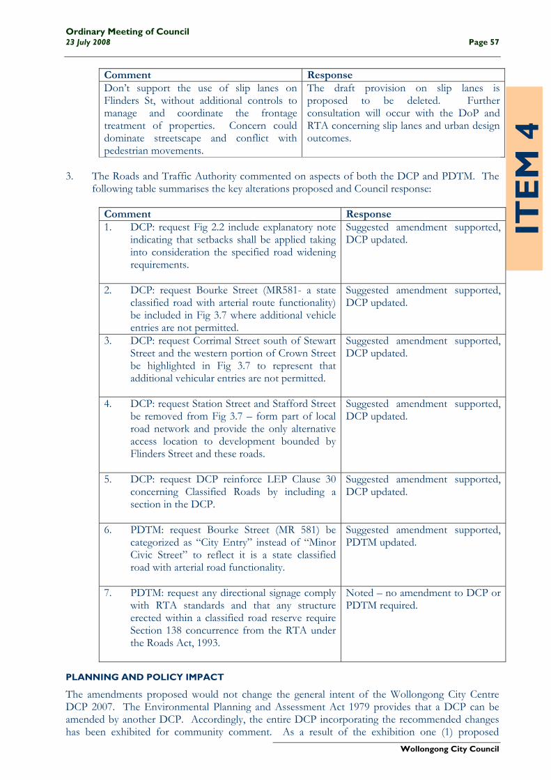
Ordinary Meeting of Council 23 July 2008 Page 55
Wollongong City Council
ITE
M 4
REF: CM123/08
WOLLONGONG CITY CENTRE DEVELOPMENT CONTROL PLAN 2007 Report of Manager City Planning (KA) 7/07/08 SU23956
PRECIS
The Wollongong City Centre Development Control Plan (DCP) came into force on 2 February 2007. A review of the DCP has been undertaken following one (1) year of operation in order to identify any inconsistencies; problems in interpretation; and suggestions for changes and improvements. On 3 March 2008 Council resolved to endorse the draft DCP for consultation and exhibition. Supporting the draft DCP is a technical manual reference document, the Public Domain Technical Manual. Both documents were exhibited between 3 May and 30 May 2008.
As a consequence of the exhibition, three (3) submissions were received. The purpose of this report is to provide Council with feedback from the exhibition and seek endorsement for the adoption of the updated Wollongong City Centre Development Control Plan and Public Domain Technical Manual.
RECOMMENDATION
1 The amended Wollongong City Centre Development Control Plan 2007 be adopted and its adoption be notified in the local newspapers, in accordance with the Environmental Planning and Assessment Regulations 2000.
2 The Public Domain Technical Manual be adopted. 3 Letters be sent to persons who made submissions, thanking them for their input and advising
of Council’s decision. BACKGROUND
The Wollongong City Centre Local Environmental Plan (LEP) 2007 and Wollongong City Centre Development Control Plan (DCP) 2007 were endorsed by Council on 23 October 2006 and came into effect on 2 February 2007. The Wollongong City Centre Local Environmental Plan 2007 is being reviewed through Amendments No. 1 and No. 2 to correct minor errors in the LEP. A review of the Wollongong City Centre DCP was subsequently undertaken in order to identify any inconsistencies; problems in interpretation; and suggestions for changes and improvements. The review proposed the following minor changes to the DCP: changes to and clarification of building setbacks; addition of controls in relation to traffic issues; addition of control in relation to kitchen ventilation systems; inclusion of references to Australian Standards; addition of definitions; clarification of parking rates; addition of sections from DCP 49 for Mixed Use Developments and Residential Flat
Buildings; reference to “Recreational Waterways” zone removed; reference to “City Edge” zone changed to read “Mixed Use (City Edge)”; addition of (draft) Public Domain Technical Manual to Appendix 1; and minor wording/spelling/formatting changes to text and maps.

Ordinary Meeting of Council Page 56 23 July 2008
Wollongong City Council
ITE
M 4
The review was reported to Council on 3 March 2008 and Council resolved to endorse the draft DCP for consultation and exhibition. Supporting the draft DCP is a technical manual reference document, the Public Domain Technical Manual (PDTM) that specifies the design and construction requirements for the public domain in the City Centre. On 14 April 2008 the Executive Management Committee resolved to exhibit the two (2) documents concurrently.
CONSULTATION AND COMMUNICATION
Both documents were exhibited for public comment between 3 May and 30 May 2008. The community was provided with a number of mechanisms to obtain information about the draft plan and technical manual, and a variety of opportunities to provide feedback. Key components of the Communication Plan included: • Hard copies of the two (2) documents were available in all Council libraries and at Council’s
Administration Building (Levels 3 and 4); • A CD containing the relevant documents was made available; • All relevant documents were made available on Council’s website; • Consultation with adjacent Councils, relevant authorities and relevant Council divisions – a
letter and CD containing the documents was distributed; and • Notification of the exhibition period in the Illawarra Mercury and local newspapers. As a consequence of the exhibition, three (3) submissions were received. 1. Campbelltown City Council acknowledged the exhibition and made no comment on the
proposed DCP changes or on the Public Domain Technical Manual. 2. The Department of Planning (DoP) indicated support for the majority of the proposed DCP
changes, made comments in relation to three (3) proposed amendments and made no comment on the technical manual.
Comment Response Concern expressed in relation to 10.36m setback proposed along both sides of Corrimal St north of Market Street, and along Kembla Street to George Hanley Drive, in terms of urban design impacts (not specified). Noted that LEP doesn’t currently identify road widening along this section of Corrimal Street.
10.36m setback endorsed by EMC on 26 November 2007. In principle agreement reached between RTA and WCC, through Corrimal St Working Party, that this measure is necessary. Engineering drawings are being developed as the basis for a road widening scheme to be implemented. Once gazetted by the RTA amendments will be made to the LEP.
Don’t support corner splays 6m x 6m in commercial core, mixed use (city edge) and enterprise corridor zones – built form should define street edge and development should square off corners.
Splay corners are required to assist with the turning of large vehicles. The promotion of public transport use is a key sustainability principle for development of the city centre. Urban design outcomes need to be developed in the context of traffic practicalities related to public transport use.
Ordinary Meeting of Council 23 July 2008 Page 57
Wollongong City Council
ITE
M 4
Comment Response Don’t support the use of slip lanes on Flinders St, without additional controls to manage and coordinate the frontage treatment of properties. Concern could dominate streetscape and conflict with pedestrian movements.
The draft provision on slip lanes is proposed to be deleted. Further consultation will occur with the DoP and RTA concerning slip lanes and urban design outcomes.
3. The Roads and Traffic Authority commented on aspects of both the DCP and PDTM. The
following table summarises the key alterations proposed and Council response:
Comment Response 1. DCP: request Fig 2.2 include explanatory note
indicating that setbacks shall be applied taking into consideration the specified road widening requirements.
Suggested amendment supported, DCP updated.
2. DCP: request Bourke Street (MR581- a state classified road with arterial route functionality) be included in Fig 3.7 where additional vehicle entries are not permitted.
Suggested amendment supported, DCP updated.
3. DCP: request Corrimal Street south of Stewart Street and the western portion of Crown Street be highlighted in Fig 3.7 to represent that additional vehicular entries are not permitted.
Suggested amendment supported, DCP updated.
4. DCP: request Station Street and Stafford Street be removed from Fig 3.7 – form part of local road network and provide the only alternative access location to development bounded by Flinders Street and these roads.
Suggested amendment supported, DCP updated.
5. DCP: request DCP reinforce LEP Clause 30 concerning Classified Roads by including a section in the DCP.
Suggested amendment supported, DCP updated.
6. PDTM: request Bourke Street (MR 581) be categorized as “City Entry” instead of “Minor Civic Street” to reflect it is a state classified road with arterial road functionality.
Suggested amendment supported, PDTM updated.
7. PDTM: request any directional signage comply with RTA standards and that any structure erected within a classified road reserve require Section 138 concurrence from the RTA under the Roads Act, 1993.
Noted – no amendment to DCP or PDTM required.
PLANNING AND POLICY IMPACT
The amendments proposed would not change the general intent of the Wollongong City Centre DCP 2007. The Environmental Planning and Assessment Act 1979 provides that a DCP can be amended by another DCP. Accordingly, the entire DCP incorporating the recommended changes has been exhibited for community comment. As a result of the exhibition one (1) proposed

Ordinary Meeting of Council Page 58 23 July 2008
Wollongong City Council
ITE
M 4
amendment is recommended to be deleted. It is recommended that the revised DCP be adopted (Attachment 1). The DCP will come into force when notified in the local papers.
It is also recommended that the Public Domain Technical Manual be adopted (Attachment 2). All other headings have been considered but are not relevant.
Name Position Title Date Signature This report provides Administrators with all the relevant information and is correct at the time of writing.
This information has been relied upon in preparing the report and its recommendations. Signed by:
Kathryn Adams Strategic Project Officer 10/7/08
Andrew Carfield Manager City Planning 10/7/08
Peter Kofod Executive Manager Governance and Planning
10/7/08
David Farmer General Manager 15/7/08
ATTACHMENTS
1. Revised Draft Wollongong City Centre Development Control Plan (Separate Attachment)2. Revised Draft Public Domain Technical Manual (Separate Attachment)

Wollongong C I T Y C E N T R E P L A N
RevitalisingRevitalising
Development Control Plan


Growing the city centre to reflect Wollongong’s unique setting.
Wollongong City Centre Plan Development Control Plan ISBN 0 7347 5766 2
NSW Department of Planning 2007 www.planning.nsw.gov.au/wollongong
DP 06_028C
Disclaimer While every reasonable effort has been made to ensure that this document is correct at the time of printing, the State of New South Wales, its agents and employees, disclaim any and all liability to any person in respect of anything or the consequences of anything done or omitted to be done in reliance upon the whole or any part of this document.
Front Cover Photograph by DeeKramer.com
Coloured Drawings by Tim Throsby
This document was prepared by the Regional Cities Taskforce, a group that included planners and urban designers from the Department of Planning and the local council for each of the six regional cities.
For enquiries regarding this document please contact:
* Chief Executive Officer, Wollongong City Council Locked Bag 8821, Wollongong NSW 2500
www.wollongong.nsw.gov.au
Phone: (02) 4227 7111
7 Fax: (02) 4226 7277

1.0 IntroductIon 2
1.1 The purpose of this Development Control Plan 4
1.2 Name of plan and commencement 4
1.3 Land and development covered by this plan 4
1.4 Relationship with other planning documents 4
1.5 Repeal of plans and savings clause 4
1.6 The consent authority 5
1.7 Explanatory notes 6
1.8 Monitoring and review 6
1.9 City centre character areas 6
2.0 BuIldIng form 10
2.1 Building to street alignment and street setbacks 10
2.2 Street frontage heights in commercial core 13
2.3 Building depth and bulk 14
2.4 Side and rear building setbacks and building separation 16
2.5 Mixed use buildings 19
2.6 Deep soil zone 20
2.7 Landscape design 20
2.8 Planting on structures 21
2.9 Sun access planes 22
2.10 Development on classified roads 26
3.0 PedestrIan amenIty 28
3.1 Permeability 28
3.2 Active street frontages 30
3.3 Safety and security 32
3.4 Awnings 33
3.5 Vehicle footpath crossings 35
3.6 Pedestrian overpasses and underpasses 36
3.7 Building exteriors 37
3.8 Advertising and signage 38
3.9 Views and view corridors 40
4.0 access, ParkIng and servIcIng 42
4.1 Pedestrian access and mobility 42
4.2 Vehicular driveways and manoeuvring areas 42
4.3 On-site parking 43
4.4 Site facilities and services 46
5.0 envIronmental management 48
5.1 Energy efficiency and conservation 48
5.2 Water conservation 49
5.3 Reflectivity 50
5.4 Wind mitigation 50
5.5 Waste and recycling 50
6.0 resIdentIal develoPment controls 52
6.1 SEPP 65 and residential flat design code 52
6.2 Housing choice and mix 52
6.3 Dwelling houses 53
6.4 Multi-dwelling housing 53
6.5 Dual occupancy 53
6.6 Basements 53
6.7 Communal open space 54
6.8 Private open space 55
6.9 Overshadowing 56
6.10 Solar Access 56
6.11 Natural Ventilation 56
6.12 Storage 57
7.0 controls for sPecIal areas 58
7.1 Special areas with heritage items 59
7.2 Special areas and controls 61
7.3 Non-residential development in the enterprise corridor zone 66
7.4 Special area design guidelines 68
7.5 Design excellence 68
8.0 exPlanatory notes 70
8.1 When is a development application (DA) required? 70
8.2 Submitting a development application 70
8.3 Glossary 71
aPPendIx 72
Contents

Figure 1.1: Map of DCP area
Figure 1.2: Character areas
Figure 2.1: Building lines and street setbacks
Figure 2.2: Specific street alignment and street setbacks
Figure 2.3: Permissible street frontage heights
Figure 2.4: Commercial core street alignment
Figure 2.5: Residential building’s landscape setback
Figure 2.6: Building bulk controls
Figure 2.7: Building depth controls
Figure 2.8: Rear setbacks for all development in commercial core
Figure 2.9: Side setbacks for all development in the commercial core
Figure 2.10: Side setbacks for all development in all zones except in the commercial core
Figure 2.11: Rear setbacks for all development in all zones except in the commercial core
Figure 2.12: Separation for multiple buildings on a single site in the commercial core
Figure 2.13: Mixed use buildings
Figure 2.14: Communal public space
Figure 2.15: High quality landscape
Figure 2.16: Planting on roofs
Figure 2.17: Special building envelope
Figure 2.18: Sun Access – MacCabe Park
Figure 2.19: Sun Access – MacCabe Park
Figure 2.20: Sun Access – Crown Street North
Figure 2.21: Sun Access – Pioneer Park
Figure 2.22: Sun Access – Market Square
Figure 3.1: Permeability
Figure 3.2: Lanes and arcades
Figure 3.3: Active street frontages
Figure 3.4: Active street frontages locations
Figure 3.5: Awnings
Figure 3.6: Awnings locations
Figure 3.7: Restrictions on vehicular entries
Figure 3.8: Driveway crossings dimensions
Figure 3.9: Building exterior materials
Figure 3.10: Under awning signage
Figure 3.11: Signage zones
Figure 3.12: Significant views
Figure 7.1: Areas with special controls/principles
Figure 7.2: St Michael’s Cathedral
Figure 7.3: West Crown Street shops
Figure 7.4: View up Market Street
Figure 7.5: East Crown Street shops
Figure 7.6: Market Square
Figure 7.7: National Mutual Building in Keira Street
Figure 7.8: Area 7 – Enterprise Corridor
Figures

4 W o l l o n g o n g C I t y C e n t r e D C P 2 0 0 7
1.1 tHe PurPose oF tHIs DeveloPment Control Plan
This Development Control Plan (DCP) has been prepared in accordance with Part 3 Division 6 of the Environmental Planning and Assessment Act 1979 (the Act) and with Part 3 of the Environmental Planning and Assessment Regulation 2000. The DCP provides more detailed provisions than in the Wollongong City Centre Local Environmental Plan 2007 (LEP) for development in the city centre that will:
• contributetothegrowthandcharacterofWollongong; and
• protectandenhancethepublicdomain.
Under Section 79C of the Act, the consent authority is required to take into consideration the relevant provisions of this DCP in determining an application for development in the Wollongong city centre.
1.2 name oF Plan anD CommenCement
This plan is called the Wollongong City Centre Development Control Plan 2007.
The plan was adopted by Council on 23rd October 2006 and came into effect on 2nd February 2007.
1.3 lanD anD DeveloPment CovereD By tHIs Plan
This plan applies to all the land covered by Wollongong City Centre Local Environmental Plan 2007 (refer Figure 1.1).
This plan applies to all development permissible on the land covered by this plan under Wollongong City Centre Local Environmental Plan 2007.
1.4 relatIonsHIP WItH otHer PlannIng DoCuments
Wollongong City Centre Local Environmental Plan 2007 is the principal environmental planning instrument applying to the city centre. This DCP contains detailed provisions that supplement the provisions of the LEP. If there is any inconsistency between this DCP and the LEP, the LEP will prevail.
The DCPs, technical policies, guidelines and codes of Wollongong City Council shown in Appendix 1 also apply to the city centre. In the event of an inconsistency between this DCP and any other DCP, policy or code, this DCP shall prevail in relation to development in the city centre.
State Environmental Planning Policies (SEPPs) apply to the Wollongong city centre where relevant. The statutory provisions of the SEPPs and REP will prevail over this DCP, unless otherwise stated.
The NSW Government’s Illawarra Strategy and the Wollongong City Centre Plan provide the strategic planning framework and context to this DCP. The Wollongong City Centre Plan includes this DCP and the following documents:
• WollongongCityCentreVision;
• WollongongCityCentreLocalEnvironmentalPlan 2007; and
• WollongongCityCentreCivic Improvements Plan.
1.5 rePeal oF Plans anD savIngs Clause
This plan repeals any other development control plan, technical policy, guideline or code of Wollongong City Council that is not listed in Appendix 1, insofar as it applies to the Wollongong city centre.
This plan does not apply to any development application lodged but not finally determined before the commencement of this plan.
1. Introduction

5W o l l o n g o n g C I t y C e n t r e D C P 2 0 0 7
1.6 tHe Consent autHorIty
Wollongong City Council is the consent authority for all development in the city centre, except for Major Infrastructure and Other Projects as provided under Part 3A of the EP&A Act 1979.
Compliance with the provisions of this DCP does not necessarily guarantee that consent to a Development Application (DA) will be granted.
Each DA will be assessed having regard to the aims and objectives of the Environmental Planning and Assessment Act 1979, other matters listed in Section 79C of the Act, the Wollongong City Centre LEP, this DCP, and any other policies adopted by the consent authority.
Consistent application of the provisions of this DCP will be given high priority by the consent authority.
FIgure 1.1: maP oF DCP area
CROWN STREETCROWN STREET
BURRELLI STREET
MARKET STREET
SMITH STREETVICTORIA STREET
CAMPBELL STREET
GIPPS STREET
BOURKE STREET
DEN
ISO
N S
TREE
T
NEW DAPTO ROAD
KE
IRA
STR
EET
MA
RIN
E D
RIV
E
FLIN
DE
RS
STR
EET
ATC
HIS
ON
STR
EET
GLA
DST
ON
E A
VEN
UE
CO
RR
IMA
L ST
RE
ET
HA
RB
OU
R S
TRE
ET
KE
MB
LA S
TRE
ET
AREA TO WHICH THE DCP APPLIES
DCP Area
Figure 1.1
0 200 008004001
6 W o l l o n g o n g C I t y C e n t r e D C P 2 0 0 7
1. Introduction1.7 exPlanatory notes
Terms used in this DCP are defined in the Wollongong City Centre Local Environmental Plan 2007 and in the Glossary in Section 8.3.
Section 8 also provides guidance to applicants for the lodgement of development applications. Further advice on lodgement procedures can be obtained from Council’s Development Assessment and Compliance Division and additional explanatory notes and policies issued by Council.
1.8 monItorIng anD revIeW
The consent authority is required to keep Local Environmental Plans and Development Control Plans under regular and periodic review under section 73 of the Act. The consent authority is committed to this process to ensure that the Plans continue to be useful and relevant planning instruments.
The consent authority is to review the Local Environmental Plan and Development Control Plan at five yearly intervals in order to:
a) assess the continued relevance and responsiveness of the Plan’s provisions;
b) measure the achievement of the objectives of the Plan;
c) identify the need for changes to the provisions to better achieve the objectives of the Plan; and
d) ensure the availability of adequate development capacity under the Plan’s provisions.
1.9 CIty Centre CHaraCter areas
The future character of the Wollongong city centre is set out within the Wollongong City Centre Plan that includes the Vision, Local Environmental Plan, Civic Improvements Plan and this Development Control Plan.
The area covered by the LEP has the following land use zones;
Commercial Core, Mixed Use (City Edge), Enterprise Corridor, General Residential, Working Waterfront, Special Activities
(Hospitals and Medical Research and Development), Infrastructure, Tourist, Public Recreation and Private Recreation.
The character objectives for these land use zones are described below, and the development controls within this DCP aim to develop and reinforce the characteristics of each area, enhance the vibrancy and activity along streets and provide for sustainable growth within the city centre. See Figure 1.2.
Commercial Core – provides for a wide range of retail, business, office, civic and cultural, entertainment and community uses, including tourism and leisure uses, and residential uses within mixed use developments.
The commercial core is the ‘heart of the city’, where the focus is on high quality buildings, streetscapes, public art, outdoor eating and a collection of attractive public spaces such as a new forecourt to the railway station, rejuvenated MacCabe Park and Crown Street Mall, new civic square on Crown Street and an attractive collection of laneways and arcades. The primary retail focus is Crown Street Mall. The core retail area along Crown Street is generally characterised by street enclosing buildings forming continuous building facades that provide for an active street frontage to all commercial core streets. Streets are to have continuous awnings to give weather protection to concentrated pedestrian street activity.
mixed use (City edge) – west of the railway station, this area provides for a mixture of compatible land uses to the commercial core, including commercial, retail, cultural, entertainment, tourism, leisure, recreation, social, educational, health and high density residential development,
The upgrading of the railway station will offer a safe and attractive street environment and railway/ bus interchange facility. The scale of new development is to have a transition in scale between the high form at the station to a medium rise to the north and south of Crown Street. Pedestrian activity will focus around the railway station, in Crown Street and along Gladstone Avenue towards the TAFE campus. New development is to have active frontages and continuous awnings to protect pedestrian activity.
East of Corrimal Street, the Mixed Use

7W o l l o n g o n g C I t y C e n t r e D C P 2 0 0 7
(City Edge) provides for a mixture of compatible land uses to the commercial core, including commercial and retail, cultural and entertainment, tourism, leisure and recreation, social, educational, health and higher density residential development. The area is characterised by the relaxed beach character with residential buildings sitting in landscape with more generous street setbacks. Buildings along Corrimal Street (between Market and Stewart Streets) and Crown Street (nb. northern side, east of Corrimal Street) are to be built to street alignment and have awnings and active street frontages.
North of Market Street and south of Stewart Street is a transition area between the commercial core and predominately residential areas to the north and south. It allows for high density residential development that can take advantage of views towards the escarpment and the foreshore, with retail and business uses encouraged at ground level along major streets. Building heights allow for view sharing and retention of significant views, with higher buildings located on the lower lying land along Burelli Street.
special activities – Hospitals and medical research and Development is an area clustered around the Wollongong Hospital and along Crown Street, west of the railway station.
This area has an excellent potential to become a hub of innovation, education and research in the city centre. The area can be supported by student and nursing staff accommodation, medical centres, doctors’ surgeries, specialist rooms and associated uses. The upgrading of the railway station will offer a safe and attractive street environment and railway/bus interchange facility. The scale of new development is to be of a transition scale between the high buildings at the station to medium rise buildings to the north and south of Crown Street.
enterprise Corridor – will promote business activity along Flinders Street, particularly business uses requiring larger footprint buildings and good vehicular access and exposure. The area will cater also for the complementary business, office, retail and light industrial uses. The importance of Flinders Street (the Princes Highway) as a business address is reinforced by increasing the scale and activation of buildings along the street, with service uses such as parking and goods
storage away from street frontages. Residential development incorporated in mixed use developments, is encouraged within walking distance of the North Wollongong rail station and in areas abutting the general residential zone to the east. The character of the area will be of an attractive city boulevard lined with trees and high quality buildings of medium scale with large showroom windows fronting the street with landscaped setbacks.
tourist and Private recreation – this area is largely occupied by existing entertainment and sporting uses (WIN Stadium). The precinct is to be activated by complementary uses that address the street and promote extended use of the area during non-event times. Complementary uses include tourist development, tourist facilities (restaurants, gyms) and convention centres. Improved integration of the area with the city is envisaged, with specific requirements for improved pedestrian linkages between the foreshore and the Mixed Use (City Edge) along Burelli, Stewart and Bank Streets and activation of Crown and Harbour Streets. The future vision for the area will be focusing on the ‘city beach’ character along the eastern edge of the city centre with alfresco dining and tourist uses facing the beach frontage.
general residential – the general residential zone in Wollongong city centre is ideally located within easy walking distance to both the commercial core and the major recreational areas along the foreshore. The topography of the area allows for good view opportunities towards the escarpment and foreshore. Scale and form of new residential development should be compatible with the character of the locality, providing for higher density residential use, local convenience shops and longer stay tourist accommodation in serviced apartments.
Development controls aim to promote high levels of residential amenity, high quality landscaping and onsite open space provisions, combined with setbacks and building depth controls to ensure that building bulk and scale is compatible with good residential amenity, view sharing and a sustainable living environment.
Working Waterfront and Public recreation – the waterfront area encompasses the working waterfront land use zone and those parts of the public recreation zone fronting the foreshore. The area offers recreational activities to the

8 W o l l o n g o n g C I t y C e n t r e D C P 2 0 0 7
city, neighbouring residential areas and the wider Illawarra community. The natural and historic attributes of the area, including the State significant Belmore Basin Heritage Conservation Area, lighthouse, North Beach and natural features of the foreshore are to be protected commensurate with an increase in tourist and visitor use.
Scale and bulk of development is to consider the natural topography of the setting, with buildings of small scale, sympathetic to the setting.
Foreshore improvement works and enhanced community facilities and buildings are planned to improve visitor amenity and provide for a vibrant beachside and maritime environment. Boating and marine activities within the working waterfront zone combined with specialist shops and food outlets are encouraged in this area.
1. Introduction

9W o l l o n g o n g C I t y C e n t r e D C P 2 0 0 7
FIgure 1.2: lanD ZonIng maP
Wollongong
Gwynneville
North Wollongong
Coniston
Mangerton
West Wollongong
Keiraville
Keiraville
Mangerton
Fairy Meadow
WOLLONGONG CITY CENTRELOCAL ENVIRONMENTAL
PLAN 2007
CITY STRATEGY
Projection: GDA 1994 Zone 56Scale 1:16000 @ A4
Council File No. SU22711
0 100 200 300 400 50050
Meters
Wollongong City Centre
AMENDMENT No. 1
LAND ZONING MAP
Gis ref: Amendment No 1_Zoning.mxd
Statement of relationship with other plans:This plan amends Wollongong City Centre Local Environmental
Plan 2007 in respect to land shown in this plan.
LegendB3 Commercial Core
B4 Mixed Use
B6 Enterprise Corridor
IN4 Working Waterfront
R1 General Residential
RE1 Public Recreation
RE2 Private Recreation
SP1 Special Activities Hospital and Medical Research
SP2 Infrastructure
SP3 TouristCertificate Plan No. 01/07
Drawn by J Lewis Date 06.02.08
Planning Officer: Jon Bridge
Manager Land Use PlanningDavid Green
Certified in Accordance with theEnvironmental Planning & Assessment
Act 1979 & Regulations
10 W o l l o n g o n g C i t y C e n t r e D C P 2 0 0 7
2. Building formBuilding form and character refers to the individual elements of building design that collectively contribute to the character and appearance of the built environment. The Wollongong City Centre LEP includes provisions for land use, building heights and sun access planes, floorspace ratio and design excellence. The development provisions in this section of the DCP on building form are intended to encourage high quality design for new buildings, balancing character of Wollongong with innovation and creativity. The resulting built form and character of new development should contribute to an attractive public domain in central Wollongong and produce a desirable setting for its intended uses.
The controls in this section aim to:
• Establishthescale,dimensions,formandseparation of buildings appropriate for the setting in the city centre;
• AchieveattractiveandsustainableWollongong city form within the city context;
• Provideastrongdefinitionofthepublicdomain;
• Achieveactivestreetfrontageswithgoodphysical and visual connections between buildings and the street;
• Ensurethereisconsistencyinthemainstreet frontages of buildings having a common alignment;
• Provideforpedestriancomfortandprotection from weather conditions;
• Definethepublicstreettoprovidespacesthat are clear in terms of public accessibility and safety, and are easy to maintain;
• Ensurebuildingdepthandbulkisappropriate to the environmental setting and landform, allows for view sharing and provides good internal building amenity;
• Ensurebuildingseparationisadequatetoprotect amenity, daylight penetration and privacy between adjoining developments;
• Encouragemixedusedevelopmentwithresidential components that achieve active street fronts and maintain good residential amenity;
• Achieveanarticulationandfinishofbuildingexteriors that contributes to a high quality and sustainable urban environment; and
• Provideforhighqualitylandscapetocontribute to the amenity of the city centre and a sustainable urban environment.
2.1 BuilDing to street alignment anD street setBaCks
Streetsetbacksandbuildingalignmentsestablish the front building line. They help to create the proportions of the street and can contribute to the public domain by enhancing streetscape character and the continuity of streetfacades.Streetsetbackscanalsobeused to enhance the setting and address for the building. They provide for landscape areas, entries to ground floor apartments and deep soilzones.Streetsetbacksaremeasuredfromthe street boundary to the outside face of the external wall of the building.
In the commercial core, buildings are to be built up to the street alignment to reinforce the urban character and improve pedestrian amenityandactivityatstreetlevel.Abovestreet frontage height, tall buildings are to be setbacktoprovideforsunlighttostreets,anddaylight to pedestrian areas and lower levels of other buildings. They offer comfortable wind conditions, view corridors, an appropriate building scale for pedestrians, and good growing conditions for street trees. In the residential locations and some Mixed Use (City Edge)locations,buildingsaretobesetbacktoaconsistent building line.
Thedefinitionof“buildinglineorsetback” is provided in the Wollongong City Centre LEP 2007.
objectives
• Toprovideahierarchyofstreetedgesfromcommercialcorewithnostreetsetbacksto residential locations with landscaped setbacks.
• Toestablishthedesiredspatialproportionsofthestreetanddefinethestreetedge.
• Tocreateacleartransitionbetweenpublicand private space.

11W o l l o n g o n g C i t y C e n t r e D C P 2 0 0 7
• Tolocateactiveuses,suchasshopfronts,closer to pedestrian activity areas.
• Toassistinachievingvisualprivacytoapartments from the street.
• Tocreategoodqualityentryspaces to lobbies, foyers or individual dwelling entrances.
• Toallowanoutlookto,andsurveillance of, the street.
• Toallowforstreetlandscapecharacter,where appropriate.
• Tomaintainsharedviewstotheocean.
• Tomaintainsunaccesstothe public domain.
Controls
a) StreetbuildingalignmentandsetbacksarespecifiedinFigure2.1andFigure2.2and,in the following table. These street building linesandsetbacksalsoapplytobasementportions of buildings.
Zone Building line or setback from street alignment
Commercial Core Build to the street alignment or specified setback with 4m minimum further setback above street frontage height
Mixed Use (City Edge) Build to 3m from the street alignment Except in Crown Street (nb. northern side only east of Corrimal Street) and Corrimal Street (between Market and Stewart Streets), where building frontage is to be built to street alignment. A 10.36m setback applies in Corrimal Street between Market and Smith Streets.
General Residential 4m minimum setback Except in Bourke Street between Kembla and Cliff Road where building frontage is to be built to street alignment. Except in Corrimal Street north of Market Street, and Kemba Street north of Corrimal Street to George Hanley Drive, where a 10.36m setback applies.
Enterprise Corridor 4m minimum setback in Flinders Street Except in Station Street where building frontage is to be built to street alignment.
Special Activities: 4m minimum setback for residential Hospitals & development. Medical Research & Development
stre
et f
ront
age
stre
et f
ront
age
stre
et f
ront
age
4m 3m 4m
In the commercial core buildings are generally to be built to the street alignment, unless an alternative built to line is specified. Upper levels, above the street frontage height, are to be set back a minimum of 4m.
In the city edge buildings are to be built to the specified front setback(0m, 3m or 4m) to reinforce the street edge.
In the residential areasbuildings are to be built to a minimum street setback of 4 metres.
Figure 2.1: Building lines and street setbacks
stre
et f
ront
age
stre
et f
ront
age
stre
et f
ront
age
4m 3m 4m
In the commercial core buildings are generally to be built to the street alignment, unless an alternative built to line is specified. Upper levels, above the street frontage height, are to be set back a minimum of 4m.
In the city edge buildings are to be built to the specified front setback(0m, 3m or 4m) to reinforce the street edge.
In the residential areasbuildings are to be built to a minimum street setback of 4 metres.
Figure 2.1: Building lines and street setbacks
Figure 2.1: Building lines and street setbacks
in the commercial core buildings are generally to be built to the street alignment, unless an alternative built to line is specified. upper levels, above the street frontage height, are to be set back a minimum of 4 metres.
in the mixed use (city edge) zone buildings are to be built to the specified front setback to reinforce the street edge.
in the general residential zone buildings are to have a minimum street setback of 4 metres.
b) Notwithstanding the above, development is to meet the street building line andsetbackforspecificstreetsasshowninFigure2.2.
c) Balconies may project up to 600 mm into front buildingsetbacks,provided the cumulative width of all balconies at that particular level totals no more than 50% of the horizontal width of the building façade, measured at that level. Balconies are not permitted to encroach above the public road reserve.
d) Minor projections into front building linesandsetbacksfor sun shading devices, entry awnings and cornices are permissible (see also Building Exteriors at section 3.7).
e) The commercial core, mixed use (city edge) and enterprise corridor zones are subject to a requirement for corner properties to provide a 6m x 6m corner splay.

12 W o l l o n g o n g C i t y C e n t r e D C P 2 0 0 7
2. Building form
CROWN STREETCROWN STREET
BURRELLI STREET
MARKET STREET
SMITH STREETVICTORIA STREET
CAMPBELL STREET
GIPPS STREET
BOURKE STREETD
ENIS
ON
STR
EET
NEW DAPTO ROAD
KE
IRA
STR
EET
MA
RIN
E D
RIV
E
FLIN
DE
RS
STR
EET
ATC
HIS
ON
STR
EET
GLA
DST
ON
E A
VE
NU
E
CO
RR
IMA
L ST
RE
ET
HA
RB
OU
R S
TRE
ET
KE
MB
LA S
TRE
ET
SPECIFIC STREET ALIGNMENTS AND SETBACKS
3m (build to front setback)
0m (build to street alignment)2m (build to street alignment)
4m (build to front setback)
10.36m
DCP Area
Figure 2.2
0 200 008004001
CROWN STREETCROWN STREET
BURRELLI STREET
MARKET STREET
SMITH STREETVICTORIA STREET
CAMPBELL STREET
GIPPS STREET
BOURKE STREET
DEN
ISO
N S
TREE
TNEW DAPTO ROAD
KE
IRA
STR
EET
MA
RIN
E D
RIV
E
FLIN
DE
RS
STR
EET
ATC
HIS
ON
STR
EET
GLA
DST
ON
E A
VE
NU
E
CO
RR
IMA
L ST
RE
ET
HA
RB
OU
R S
TRE
ET
KE
MB
LA S
TRE
ET
SPECIFIC STREET ALIGNMENTS AND SETBACKS
3m (build to front setback)
0m (build to street alignment)2m (build to street alignment)
4m (build to front setback)
10.36m
DCP Area
Figure 2.2
0 200 008004001
FigUre 2.2 SPeCiFiC Street AlignMent AnD Street SetBACKS
explanatory note: setbacks shall be applied taking into consideration the specified road widening requirements i.e. setbacks shall be from the edge of the road widening, not the existing road reserve.

13W o l l o n g o n g C i t y C e n t r e D C P 2 0 0 7
2.2 street Frontage heights in CommerCial Core
Buildings built to the street alignment and with a height to street width ratio of approximately 1:1giveasenseofenclosuretothestreetthatis appropriate for a city centre. In Wollongong, streets in the commercial core are generally 20 metres wide, generating a preferred street front heightofbetween12mand24m,subjecttocontext and sun access requirements.
Controls setting street front heights apply within the commercial core where buildings are to be built to the street alignment.
objectives
• Toachievecomfortablestreetenvironmentsfor pedestrians in terms of daylight, scale, sense of enclosure and wind mitigation as well as a healthy environment for street trees.
• ToreinforcetheintrinsiccharacterofWollongong city centre while enabling flexibility in building design.
• ToenhancethedistinctivecharacterofSpecialAreaswithcompatibledevelopment.
• Toprotectsolaraccesstokeystreetsandpublic spaces.
Controls
a) The street frontage height of buildings in the commercial core are not to be less than12morgreaterthan24mabovemeanground level on the street front as shown inFigure2.3.
b) Notwithstanding the above, the street front height of new buildings are to be consistent with the sun access controls in Clause 2.9.
Figure 2.4: in the Commercial Core buildings are to be built to street alignment with upper level set back.
12m min
24m max
stre
et f
ront
age
stre
et f
ront
age
Figure 2.4: Permissible street frontage heights
Figure 2.3: Permissible street frontage heights

14 W o l l o n g o n g C i t y C e n t r e D C P 2 0 0 7
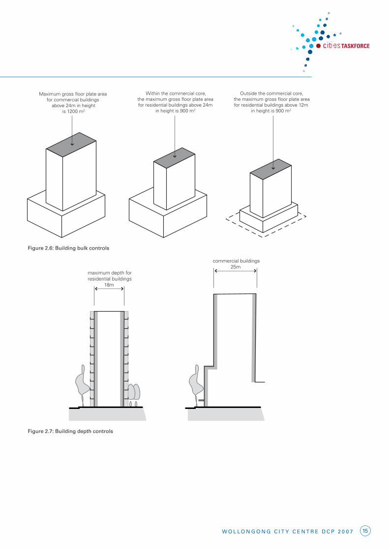
2. Building form2.3 BuilDing DePth anD Bulk
Wollongong features a temperate climate and pleasant outdoor conditions for much of the year. Controlling the size of upper level floor plates in new buildings allows for good internal amenity access to natural light and ventilation and mitigates potential adverse effects that tallandbulkybuildingsmayhaveonthepublicdomain.
Building depth is related to building use. Typically, mixed use buildings have larger commercial floor plates combined with smaller residential floors. The following controls arethereforeclassifiedintoresidentialorcommercial at the detail level.
objectives
• Topromotethedesignanddevelopmentofsustainable buildings.
• Toachievethedevelopmentoflivingandworkingenvironmentswithgoodinternalamenityandminimisetheneedforartificialheating, cooling and lighting.
• Toprovideviableanduseablecommercialfloor space.
• Toachieveusableandpleasantstreetsandpublic domain at ground level by controlling the size of upper level floor plates of buildings.
• Toachieveacityskylinesympathetictothetopography and context.
• Toallowforviewsharingandviewcorridors.
• Toreducetheapparentbulkandscaleofbuildingsbybreakingupexpansesofbuilding wall with modulation of form and articulation of facades.
Controls
a) The maximum floorplate sizes and depth of buildingsarespecifiedinFigures2.6and2.7,and in the following table (which does not apply to building frontages up to the street front height in the commercial core):
Building use Maximum floor Maximum plate size building depth (gross floor area) (excludes balconies)
Non-residential 1,200m2 Commercial Core above 24m height 25m
Residential and serviced apartments in 900m2 commercial core above 24m height 18m
Residential and serviced apartments outside the 900m2 commercial core above 12m height 18m
b) Atstreetfrontageheightlevels,andwheredevelopment is built from street edge to street edge, articulate buildings using atria, light wells and courtyards to improve internal building amenity and achieve substantial daylighting at every level, andcrossventilationand/orstackeffectventilation.
c) Allpointsonanofficefloorshouldbenomorethan10mfromasourceofdaylight(eg.window,lightwellorskylight)inbuildingslessthan24minheight,andnomorethan12.5mfromawindowinbuildingsover24minheight.
Figure 2.5: in residential locations buildings to have landscaped setback.
15W o l l o n g o n g C i t y C e n t r e D C P 2 0 0 7
maximum depth forresidential buildings
18m
maximum depth forcommercial buildings
25m
Figure 2.6: Building depth
Maximum gross floor plate area for commercial buildings
above 24m in height is 1200 m2
Within the commercial core,the maximum gross floor plate area for residential buildings above 24m
in height is 900 m2
Outside the commercial core,the maximum gross floor plate areafor residential buildings above 12m
in height is 900 m2
Firgure 2.5: Building bulk controls
Figure 2.7: Building depth controls
Figure 2.6: Building bulk controls

16 W o l l o n g o n g C i t y C e n t r e D C P 2 0 0 7
2. Building form2.4 siDe anD rear BuilDing
setBaCks anD BuilDing seParation
Sideandrearsetbacks,whereprovided,allow ventilation, daylight access and view sharing, increase privacy, and reduce adverse wind effects. Building separation increases in proportion to building height to ensure appropriate urban form, amenity and privacy for building occupants. In residential buildings and serviced apartments, separation between windows on side and rear facades and other buildings is particularly important for privacy, acousticamenityandviewsharing.Setbacksfor residential development in the commercial core are different to other zones to reflect the different settings and forms of buildings in the different zones.
Forcommercialbuildings,separationdistancesare smaller due to the reduced requirement for privacy, noise and daylight access.
Separation for mixed use buildings containing residential and commercial uses is to be in accordancewithspecifieddistancesforeachcomponent use.
Thedefinitionof“buildinglineorsetback” is provided in the Wollongong City Centre LEP 2007.
objectives
• Toensureanappropriatelevelofamenityfor building occupants in terms of daylight, outlook,viewsharing,ventilation,windmitigation, and privacy.
• Toachieveusableandpleasantstreetsand public domain areas in terms of wind mitigation and daylight access.
Controls
Note:Forthepurposeofthissection,commercial buildings means all non-residential buildings (including hotel accommodation, but not serviced apartments). Principal windows and balconies means the main window of a living room or main bedroom, or the edge of primary balcony of a dwelling.
a) Theminimumbuildingsetbacksfromtheside and rear property boundaries are specifiedinFigures2.8to2.11,andinthefollowing table:
b) Formultiplebuildingsonthesamesiteinthe commercial core and mixed use (city edge) zones, minimum separation distances areshowninFigure2.12.
c) Inmixedusebuildings,setbacksforthe residential component are to be the distancesspecifiedaboveforresidentialdevelopmentinthespecifiedzone.
d) Ifthespecifiedsetbackdistancescannotbeachieved when an existing building is being refurbished or converted to another use, appropriate visual privacy levels are to be achieved through other means, for example, the construction of screens. These will be assessed on merit by the consent authority.
e) Sideandrearsetbackscanbereducedbyarchitectural features (such as bay windows, or splayed windows which achieve oblique outlooks)providedthat:
• aminimumseparationbetweenthemainwalls of 6 metres is maintained,
• separationisbetweensectionsofbuilding walls that include only service room windows, and
• viewsareavailableobliquelytositeboundaries.

17W o l l o n g o n g C i t y C e n t r e D C P 2 0 0 7
Zone Building condition Minimum Minimum side setback rear setback
Commercial core Up to street frontage height 0m 0m
Residential uses (habitable rooms) between street frontage height and 45m 12m 12m
All uses (including non-habitable residential) between street frontage height and 45m 6m 6m
All uses above 45m 14m 14m
All other zones Residential uses up to 12m in height – habitable rooms with openings and balconies 6m 9m – non-habitable rooms and habitable rooms without openings 3m 4.5m
Residential uses between 12m & 24m – habitable rooms with openings and balconies 9m 9m – non-habitable rooms and habitable rooms without openings 4.5m 4.5m
Residential uses above 24m – habitable rooms with openings and balconies 12m 12m and up to 45m – non-habitable rooms and habitable rooms without openings 6m 6m
All residential uses above 45m 14m 14m
Commercial uses up to 24m 3m 9m
Commercial uses above 24m 6m 12m
height 45m
street frontage height
side
bou
ndar
y
minimum14m
minimum 12m for buildings withhabitable rooms or residential balconies
minimum 6m for all other development
Figure 2.8: Side setbacks for all development in the commercial core
Figure 2.8: side setbacks for all development in the commercial core
Figure 2.9: rear setbacks for all development in the commercial core
height 45m
rear
bou
ndar
yminimum
14m
Figure 2.7: Rear setbacks for all development in the commercial core
minimum 12m for buildings with habitable rooms or residentail balconies minimum 6m for all other development.