Embed Size (px)
Citation preview

OPUS Overview and Updates
Dr. Neil D. Weston
National Geodetic Survey, NOAA
ION GNSS 2012 / CGSIC, Nashville September 17, 2012

OPUS, the On-line Positioning User Service, is a
growing set of applications offering web-based access to
the tools and resources provided by the NGS.
• OPUS-S . . . . . . . static processing
• OPUS-DB. . . . . . data base and publishing
• OPUS Projects… manage and process networks
Reviewing each of these individually…
What is OPUS

Overview
• Online Positioning User Service (OPUS) to:
– Provide access to the US National Spatial Reference System (NSRS).
– Provide accurate, reliable and consistent geodetic coordinates.
– Provide coordinate accuracies to within a centimeter.
– Provide GPS solutions in a timely fashion.
OPUS-S Concepts
• Compute rover (user’s receiver) location.
• Retrieve ancillary information.
– Broadcast and precise ephemeris files from IGS Central Bureau.
– CORS and IGS site coordinates from NGSIDB.
• Performs five independent double-difference solutions in the IGS08 reference frame.
• Compare and average the best three sets of results.

OPUS-S Concepts
• Generate NAD83 coordinates using HTDP3.2
• Email solution to the user.
• Archive solution, update logs and plot rover position on dynamically generated maps.

IGSCB
Precise ephmeris
and broadcast files
NGSIDB
CORS and IGS site
coordinates
Rover
coordinates
OPUS processing using Pages
Five independent double-difference solutions
IGS08 reference frame
NAD83 coordinates via HTDP
Solution report
Users email address
Rover name
Processing statistics
IGS, NAD83 coordinates
Base stations used
Dynamic maps
Email solution
Update logs
Archive solution

OPUS Coordinates
• IGS08 coordinates - at day of observation.
• NAD83 (2011) coordinates – epoch Jan 1, 2010
• UTM coordinates with appropriate zone.
• SPC - State plane coordinates.
• Orthometric heights – Geoid12A.

Options:
Projects &
Publishing Mark Description
Online Positioning User Service
OPUS-DB geodesy.noaa.gov/OPUS/
JGE 2011v1
IGS & NGS base stations
& site information files
IGS antenna calibrations
& satellite orbits
& reference frames
UNAVCO’s teqc converter
PAGES baseline processor
Geophysical models
NGS geodetic toolkit
Geodetic
Standard Data
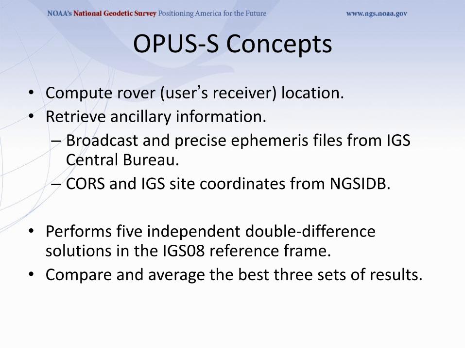
Publishing OPUS Solutions Upload to OPUS using options > publish
•4+ hour GPS data file
– Verify antenna type, height, and plumb, fixed height tripod recommended
•Permanent mark of public interest
– Durable, stable setting with good satellite visibility
– Description & photos to aid future recovery
•High-quality OPUS-S solution
– ≥ 70% observations used
– ≥ 70% ambiguities fixed
– ≤ 3 cm RMS
– ≤ 4 cm peak-to-peaks, lat. & lon.
– ≤ 8 cm peak-to-peak, ellipsoid height

OPUS-DB Publishing vs Bluebooking
• Benefits
– Fast, cheap, easy
– Homogeneous, consistent, reliable
– Maintained from RINEX data; can re-process
• Limitations
– GPS data only
– Tied to NSRS via CORS
– No redundancy
– Reduced oversight
– Field logs not archived

Publishing Criteria:
• NGS-calibrated GPS antenna
• > 4 hour data span
• > 70% observations used
• > 70% fixed ambiguities
• < 0.04m H peak-to-peak
• < 0.08m V peak-to-peak

OPUS-DB - Published Solutions

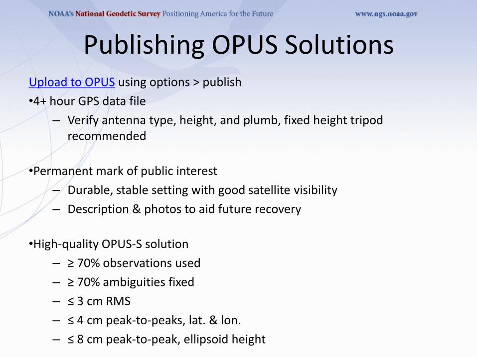
OPUS Projects
• A Little OPUS-Projects History.
• What Is OPUS-Projects?
• The OPUS-Projects Interface.
• How Good Can I Do With OPUS-Projects?

OPUS Projects - History
The success of OPUS clearly demonstrated the value
of web-based tools for some activities. This begged the
question, could a web-based utility be made for a more
complex task such as an airport or height
modernization survey?
In these cases, one or more survey crews would be
occupying one or more marks over several hours or
days in a manner consistent with predefined project
specifications.

OPUS Projects - History
The “wish list” for such a web-based utility included:
• Visualize and organize multiple, related data
submissions.
• Process all or subsets of the data according to user
specifications.
• Offer the results in useful forms and formats.
• Do all this as simply as possible.

OPUS Projects - History
But do we really need another OPUS flavor?
The practical answer is probably yes.
The NGS and other groups have a history of
project’s whose specifications can’t be entirely
supported by OPUS.
The academic answer is probably yes.
As good as OPUS does, and that is very good,
sacrificing simplicity for flexibility can improve results
- at least in some cases.

What Is OPUS Projects
OPUS-Projects gives users web-based access to simple
visualization, management and processing tools for
multiple sites and multiple occupations.
These tools include:
• The advantages of data uploading through OPUS.
• Data visualization and management aids.
• Enhanced data processing using the PAGES suite.
• Solution visualization aids.
• Seamless connectivity with other OPUS tools.

What Is OPUS Projects
OPUS-Projects exists in a hierarchical structure
1. Create . . . . . . . . creates a project.
2. Upload . . . . . . . . data submission.
3. Session . . . . . . . session review & processing.
4. Manage . . . . . . . network adjustments.
5. OPUS-Projects czar for general support.

What Is OPUS Projects
Processor or Manager
Data & Metadata
Network Solution Manager
Publish To OPUS
Session Solution
Session Solution
Session Solution
Session Solution
Copy To User
Your OPUS Project
Copy To User
Copy To User
OPUS Solution

OPUS Projects Interface
It’s probably easier to show the interface than
describe it, so let’s walk through some of the basic
steps in creating and reviewing a project.
Please be aware …
OPUS-Projects is actively being developed. The information shown here reflects many, but not all of the recent and pending changes.

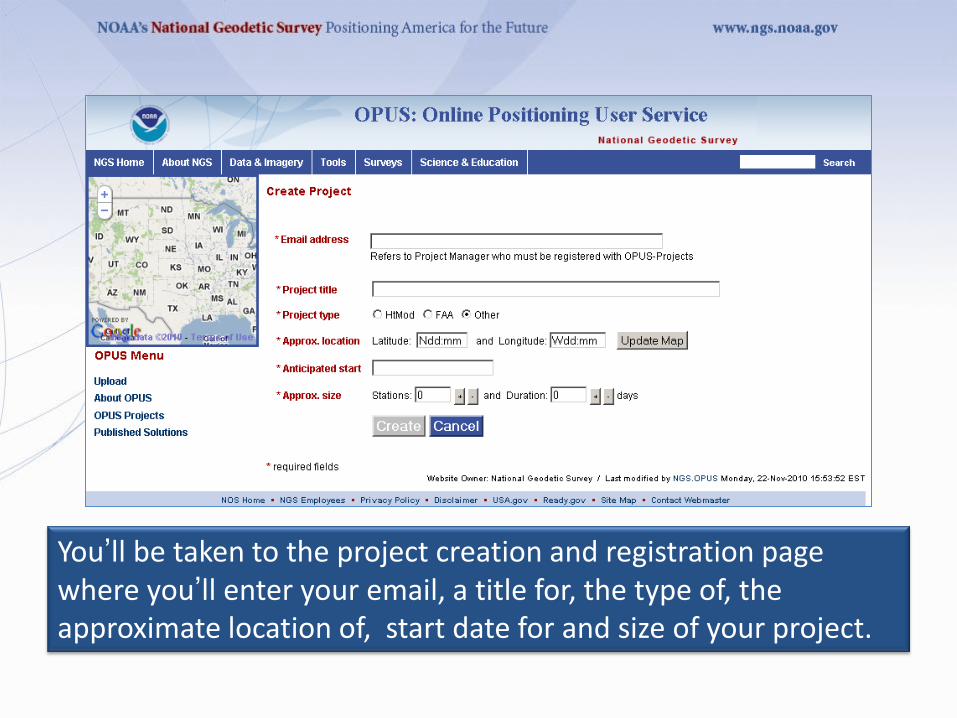
You’ll be taken to the project creation and registration page where you’ll enter your email, a title for, the type of, the approximate location of, start date for and size of your project.

After a moment, the introduction to your newly created project is displayed. You’ll also receive an email with this information.

Uploading Data to a Project
The second step is to “Upload” data files to your project.
At this time, this is done through OPUS-S implying the
same restrictions:
• Your data must be dual frequency pseudorange and phase
P1 (or C1), P2, L1 and L2.
• A minimum 2-hours data span for each submission.
• A collection rate of 1, 2, 3, 5, 10, 15 or 30 seconds.

View and Process a Session
OPUS-Projects groups the data into sessions.
Sessions are groups of site occupations that overlap
significantly in time. Note that
• a site may appear in more than one session.
• as new data are submitted, the definitions of the
sessions may change.
Now that some data has been submitted to the project,
processing can begin.

This time we’ll enter through the Session login on the OPUS-Projects gateway page.


Processing Strategy
Single 24hr Hub station •Is connected to each IGS station •Gets placed accurately in IGS frame •Provides consistent reference for each remote station •Is suitable for projects up to several hundred km with > 2-4hr of data •Tightly constrain IGS, loosely constrain hub

Below the summary by occupation are the coordinate and status summary tables.

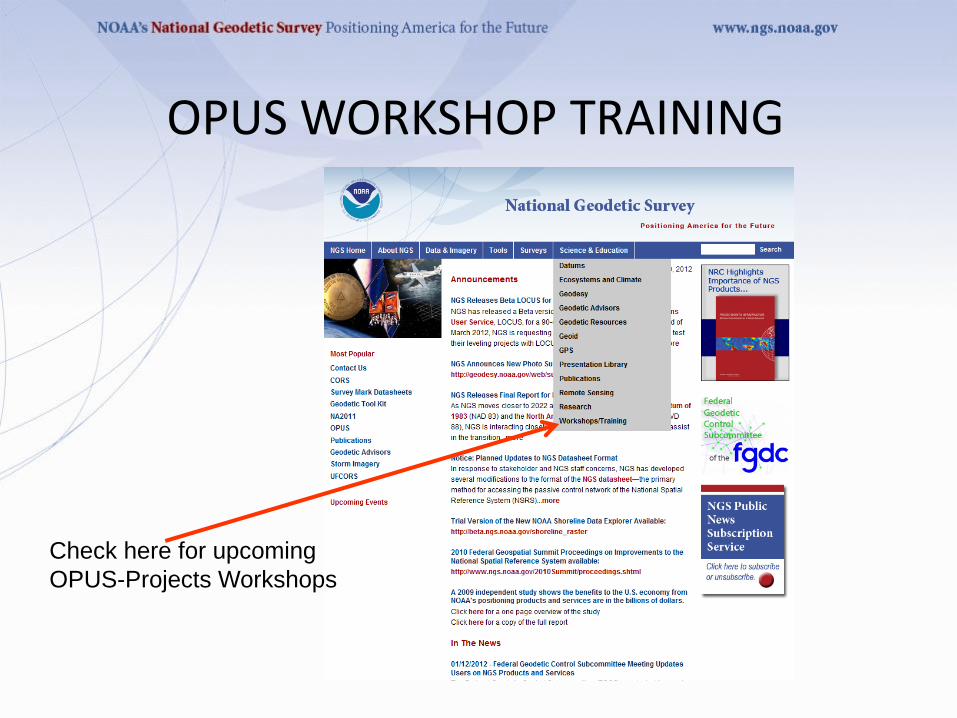
Check here for upcoming
OPUS-Projects Workshops
OPUS WORKSHOP TRAINING