Embed Size (px)
Citation preview

PAGE i
NARROMINE TO NARRABRI OPTIONS REPORT
TABLE OF CONTENTS
Page number
Executive Summary ............................................................................................................................................................ 1
Background ..................................................................................................................................................................... 1
Option development and assessment ............................................................................................................................ 1
Community and stakeholder engagement ...................................................................................................................... 3
The Study Area ................................................................................................................................................................ 3
Next steps ....................................................................................................................................................................... 5
1. Introduction ............................................................................................................................................................... 6
1.1. Need for the project ........................................................................................................................................... 6
1.2. Purpose of this report ......................................................................................................................................... 6
1.3. Inland Rail objectives .......................................................................................................................................... 7
2. Approach .................................................................................................................................................................... 8
2.1. Background ......................................................................................................................................................... 8
2.2. Option development and assessment ................................................................................................................ 8
2.2.1. Constraints, design and technical considerations ..................................................................................... 10
2.2.2. MCA criteria .............................................................................................................................................. 10
2.2.3. Service Offering ......................................................................................................................................... 11
2.2.4. Comparative capital cost estimates .......................................................................................................... 11
2.3. Community and stakeholder engagement ........................................................................................................ 11
3. Option Evaluation ..................................................................................................................................................... 12
3.1. Initial MCA – October 2016 ............................................................................................................................... 12
3.2. Second MCA– December 2016 ......................................................................................................................... 18
3.3. Third MCA – May 2017 ..................................................................................................................................... 20
3.3.1. Narromine to Burroway ............................................................................................................................ 20
3.3.2. Recommendation – Narromine to Burroway ............................................................................................ 25
3.4. Burroway to Curban .......................................................................................................................................... 26
3.4.1. Recommendation – Narromine to Burroway ............................................................................................ 30
3.5. Curban to Mt Tenandra ..................................................................................................................................... 31
3.5.1. Recommendation – Curban to Mt Tenandra............................................................................................. 36
3.6. Mt Tenandra to Baradine .................................................................................................................................. 36
3.6.1. Recommendation –Mt Tenandra to Baradine ........................................................................................... 39

PAGE ii
NARROMINE TO NARRABRI OPTIONS REPORT
3.7. Baradine to Narrabri ......................................................................................................................................... 40
3.7.1. Recommendation – Baradine to Narrabri ................................................................................................. 44
4. The Study Area ......................................................................................................................................................... 45
4.1. Description ........................................................................................................................................................ 45
4.2. Next steps ......................................................................................................................................................... 47
TABLES
Table 1 Initial MCA – additional options ........................................................................................................................... 13
Table 2 Discounted options ............................................................................................................................................... 13
Table 3 Options considered for further investigation - December 2016 MCA .................................................................. 18
Table 4 Discounted options ............................................................................................................................................... 18
Table 5 Narromine to Burroway option characteristics .................................................................................................... 20
Table 6 Narromine to Burroway options ........................................................................................................................... 22
Table 7 Burroway to Curban option characteristics .......................................................................................................... 26
Table 8 Burroway to Curban options ................................................................................................................................ 28
Table 9 Curban to Mt Tenandra option characteristics ..................................................................................................... 31
Table 10 Curban to Mt Tenandra options ......................................................................................................................... 33
Table 11 Mt Tenandra to Baradine option characteristics ................................................................................................ 36
Table 12 Mt Tenandra to Baradine option ........................................................................................................................ 38
Table 13 Baradine to Narrabri option characteristics ....................................................................................................... 40
Table 14 Baradine to Narrabri options .............................................................................................................................. 42
FIGURES
Figure 1 Narromine to Narrabri – Project Sections and the May 2017 MCA Options ........................................................ 2
Figure 2 The Study Area ...................................................................................................................................................... 4
Figure 3 Process to assess State Significant Infrastructure projects in New South Wales .................................................. 5
Figure 4 Narromine to Narrabri project location 2010 Concept Alignment ....................................................................... 6
Figure 5 Service Offering Objectives ................................................................................................................................... 7
Figure 6 Option development and assessment timeline .................................................................................................... 8
Figure 7 Narromine to Narrabri – Project Sections and May 2017 MCA Options ............................................................... 9
Figure 8 October – December 2016 MCA Options Outcome ............................................................................................ 12
Figure 9 Discounted options from initial MCA – Narromine to Curban ............................................................................ 15

PAGE iii
NARROMINE TO NARRABRI OPTIONS REPORT
Figure 10 Discounted options from initial MCA – Curban to Gwabegar ........................................................................... 16
Figure 11 Discounted options from initial MCA – Baradine to Narrabri ........................................................................... 17
Figure 12 December 2017 MCA outcome ......................................................................................................................... 19
Figure 13 Narromine to Burroway options ....................................................................................................................... 21
Figure 14 Burroway to Curban options ............................................................................................................................. 27
Figure 15 Curban to Mt Tenandra options ........................................................................................................................ 32
Figure 16 Mt Tenandra to Baradine .................................................................................................................................. 37
Figure 17 Baradine to Narrabri options ............................................................................................................................ 41
Figure 18 The Study Area .................................................................................................................................................. 46
Figure 19 Process to assess State Significant Infrastructure in New South Wales ............................................................ 47
PAGE 1 OF 47
NARROMINE TO NARRABRI OPTIONS REPORT
EXECUTIVE SUMMARY
This Options Report summarises the process, inputs and decisions made by the Australian Rail Track Corporation
(ARTC) to assess alternative options and identify the Study Area for the Melbourne to Brisbane Inland Rail (Inland Rail)
between Narromine and Narrabri.
Background
The Narromine to Narrabri section of Inland Rail is one of the three ‘missing link’ projects in New South Wales (NSW).
Located in mid north western NSW, it is approximately 307 km in length and the is the longest greenfield section of the
Inland Rail programme to be delivered.
The original Study Area between Narromine and Narrabri was identified in ARTC’s 2010 Inland Rail Alignment Study,
which informed the development of the Inland Rail Business Case in 2015.
The Phase 1 Concept Assessment commenced in early 2016. This involved the development of the 2016 Concept
Alignment based on the ARTC 2010 Inland Rail Alignment Study. The 2016 Concept Alignment informed initial
discussions with the community and stakeholders including local councils, landowners, and farmers’ representatives.
Feedback from these discussions highlighted the expectation that ARTC should consider alternative options utilising
the existing Coonamble rail line and traversing parts of the Pilliga State Forest as part of the Phase 1 Concept
Assessment.
Option development and assessment
In response to community and stakeholder feedback, approximately fifty alternative options were developed. ARTC
has implemented a process to evaluate and refine alignments across the entire Inland Rail Programme to ensure a
consistent approach to the ‘like for like’ comparison of alternative options. The Australian Government and ARTC
endorsed a process to consider the comparative performance of options against three factors:
their ability to meet the Service Offering, which is the level of service required by rail operators and freight customers
costs, comprising the construction estimate, and track and maintenance and train operating costs for customers and
Multi-Criteria Analysis (MCA).
MCA workshops were held in October 2016, December 2016 and May 2017 and utilised the following programme-
wide Inland Rail MCA criteria. These compared the various options to the 2016 Concept Alignment, to quantify their
comparative merit. The following criteria were considered:
Technical viability: alignment, impact on public utilities and services, geotechnical conditions, impacts on existing roads and rail networks, flood immunity/hydrology, future proofing.
Safety: operational safety, public safety, road safety interfaces, emergency response, construction safety.
Operations: effect/impact on travel time, effect on reliability and availability, network interoperability and connectivity.
Constructability: construction duration, construction access, construction complexity, resources/material sources, interface with operational railway, staging opportunities.
Environmental: ecological impacts (flora, fauna and habitats), visual impacts, noise and vibration impacts, flooding and waterway impacts, effect on air quality, effect on greenhouse gas emissions.
Community and property: property impacts, Indigenous and non-Indigenous heritage, impact on community, community responses, current and future land use impacts.
Approvals and risk: planning and approval timescale, support of local, state and federal governments, other statutory and regulatory approvals, service authorities.
PAGE 2 OF 47
NARROMINE TO NARRABRI OPTIONS REPORT
The outcome of the initial MCA in October 2016 was presented to the community and stakeholders in November 2016.
Community and stakeholder feedback, together with further engineering design and field work, informed further
refinements to the options, with the second MCA workshop held in December 2016.
Alternative options varied in length across the Study Area, and connected in various combinations. ARTC therefore
adopted a locality based approach to option evaluation, with the project broken into sections to enable comparison on
a like for like basis at each MCA workshop.
In March and April 2017, ARTC undertook a further round of extensive consultation with communities and
stakeholders on both the 2016 Concept Alignment and the shortlisted options. A further MCA workshop was held by
ARTC in May 2017 to consider the additional feedback and to select a Study Area for the Phase 2 Feasibility
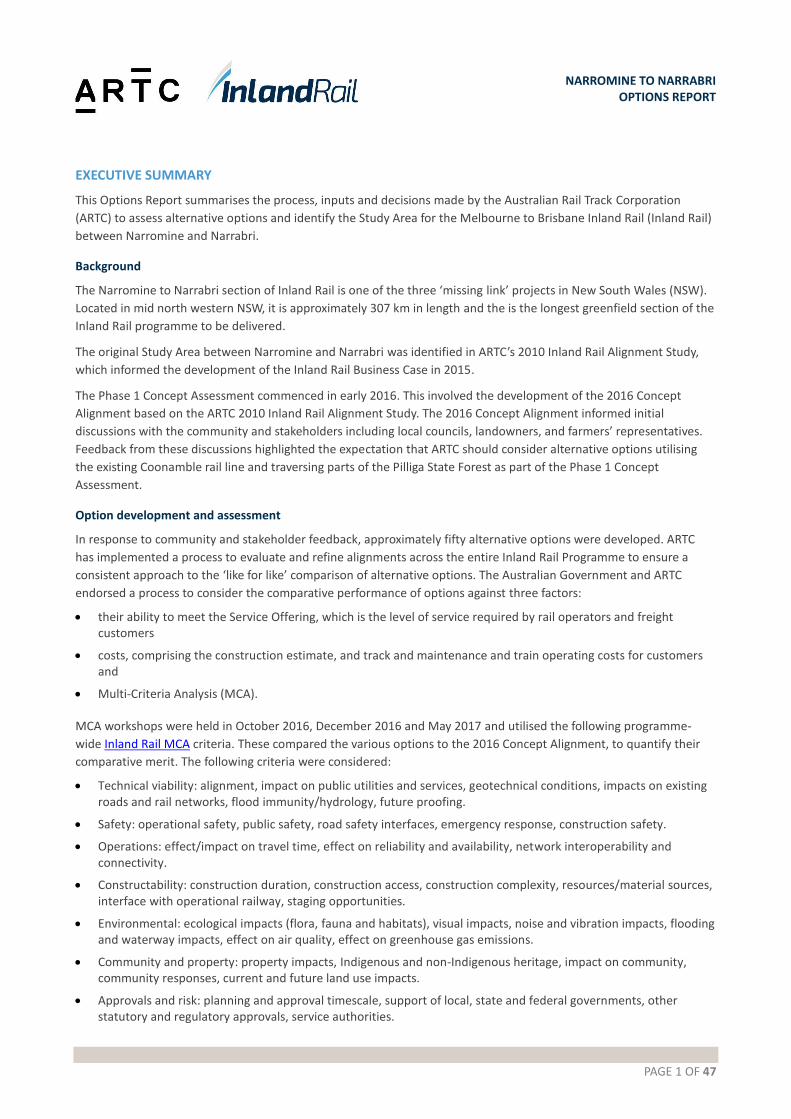
Assessment. The project sections and the proposed alignments considered in the May 2017 MCA are shown in Figure 1
below.
Figure 1 Narromine to Narrabri – Project Sections and the May 2017 MCA Options
PAGE 3 OF 47
NARROMINE TO NARRABRI OPTIONS REPORT
Community and stakeholder engagement
Alternative options were presented in information sessions in November 2016, and landowner meetings in March-
April 2017. Over 450 community members were consulted, with the following identified as key themes or issues:
avoid houses and groups of houses; areas of new small lifestyle acreages may experience greater disturbance than the larger properties by a rail line
minimise impacts to cropping and higher intensity agricultural areas
follow property boundaries to minimise property severance, but be aware that some properties operate across multiple boundaries and span roads, and operational severance should also be a consideration
aim to utilise existing rail lines, road corridors, property boundaries as much as possible
concerns around flooding risk and ground conditions
be aware that there are close-knit communities along the routes with instances of related landowners and multi-generational farmers; adopt an appropriate community and stakeholder engagement approach to suit.
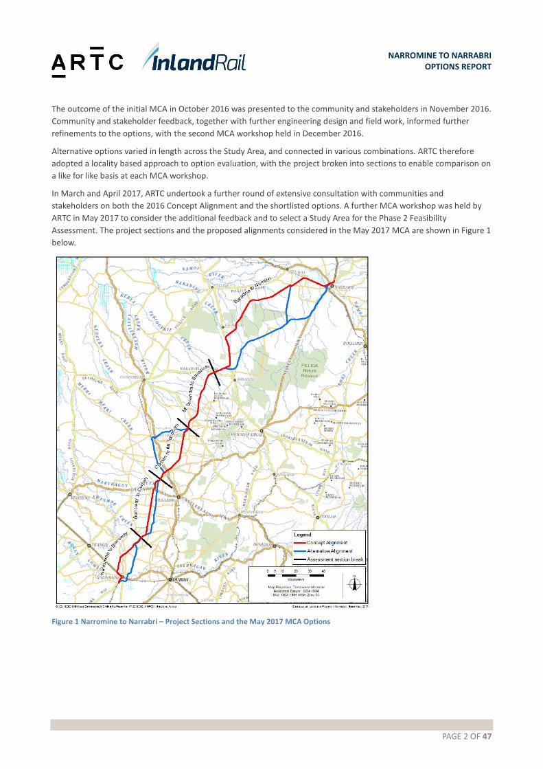
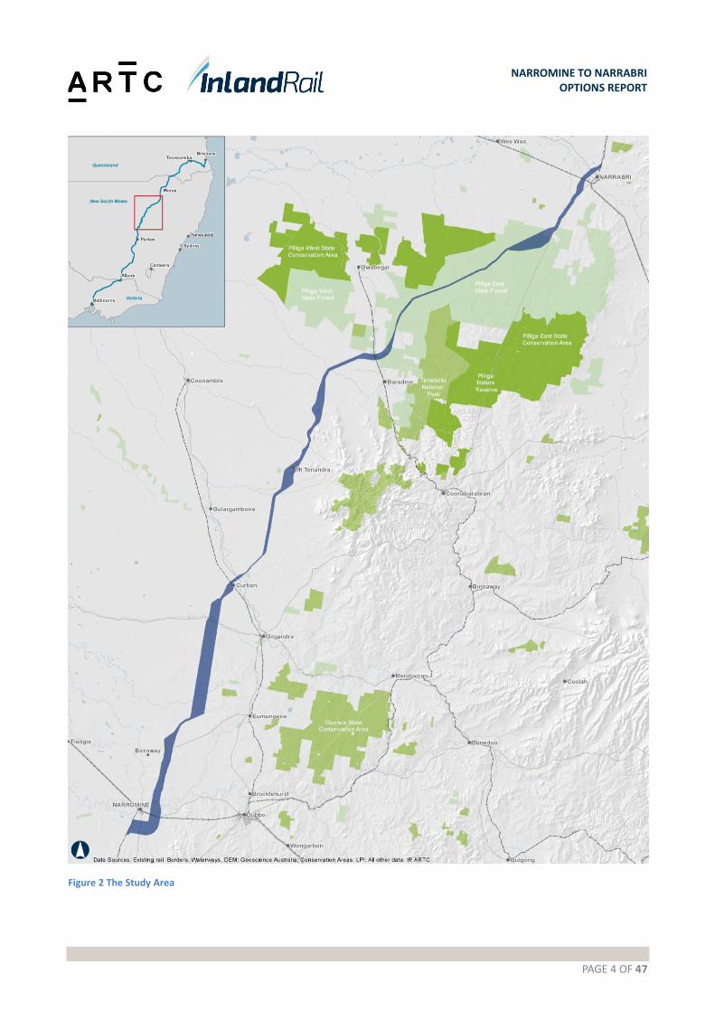
The Study Area
The Study Area illustrated in Figure 2 was identified as a result of the May 2017 MCA workshop. The Study Area
generally has a standard width of 2km for the majority of its length, and localised wider or narrower sections to allow
for additional alignment refinement in response to further studies and investigations and consultation to be carried
out during the Phase 2 Feasibility Assessment. It contains the following sections options:
Narromine: the Narromine east option
Narromine to Curban: the Eumungerie Road option between Narromine and Burroway, then a combination of the 2016 Concept Alignment and the Gilmores Road Alternative between Burroway and Curban
Curban to Mt Tenandra: the 2016 Concept Alignment
Mt Tenandra to Baradine: the 2016 Concept Alignment, with some potential for minor departures subject to further investigations and stakeholder engagement
Baradine to Narrabri West: Pilliga State Forest Option: Corridor runs through the Pilliga state forest until Newell Highway, then runs along Newell highway and then branching off to the north to connect onto the 2016 alignment west of Narrabri.
ARTC’s decision to identify this Study Area was based on the following factors:
There is a positive impact on the Service Offering with a reduction of 4 minutes 38 seconds in transit time, over 3 hours and 10 minutes, for the total Narromine to Narrabri section. This is approximately a 2.5% decrease.
There is a 3.3% capital cost saving on an estimated $1.5billion dollar project.
The overall MCA scoring is positive.
The corridor takes into account feedback from the local and broader community and affected landholders.
The investigation areas include better geotechnical conditions and will provide opportunity for capital cost savings and reduced maintenance costs.
The hydrology and flooding issues will be reduced.
The corridor allows for further refinement in areas where additional investigation and consultation is required.
Stakeholder and community engagement allowed for a closer look at constraints and opportunities for improvement
along the project length. In locations where there is a clear advantage to deviating from the 2016 Concept Alignment,
the alternate option has been adopted as part of the Study Area.
PAGE 4 OF 47
NARROMINE TO NARRABRI OPTIONS REPORT
Figure 2 The Study Area
PAGE 5 OF 47
NARROMINE TO NARRABRI OPTIONS REPORT
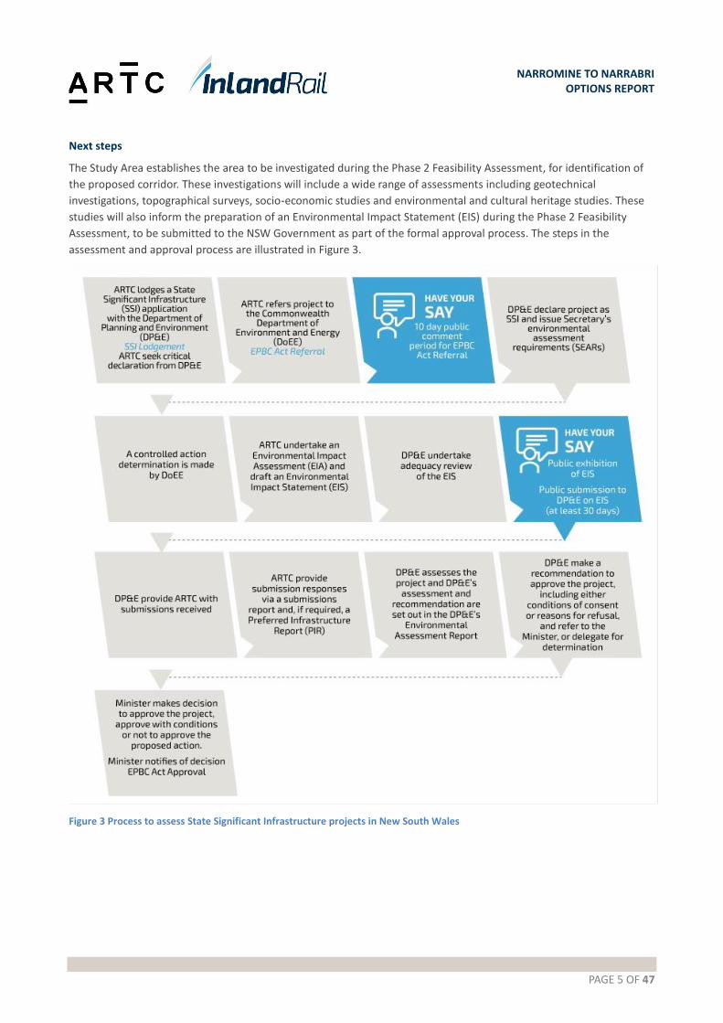
Next steps
The Study Area establishes the area to be investigated during the Phase 2 Feasibility Assessment, for identification of
the proposed corridor. These investigations will include a wide range of assessments including geotechnical
investigations, topographical surveys, socio-economic studies and environmental and cultural heritage studies. These
studies will also inform the preparation of an Environmental Impact Statement (EIS) during the Phase 2 Feasibility
Assessment, to be submitted to the NSW Government as part of the formal approval process. The steps in the
assessment and approval process are illustrated in Figure 3.
Figure 3 Process to assess State Significant Infrastructure projects in New South Wales

PAGE 6 OF 47
NARROMINE TO NARRABRI OPTIONS REPORT
1. INTRODUCTION
The Melbourne to Brisbane Inland Rail is a once-in-a-generation project connecting regional Australia to domestic and
international markets.
It will complete the ‘spine’ of the national freight network between Melbourne and Brisbane via regional Victoria, New
South Wales and Queensland. It’s the largest freight rail infrastructure project in Australia and is expected to be
operational in 2024-2025.
Australian Rail Track Corporation (ARTC) was requested to develop a business case, update the cost estimate and to
commence environmental approvals, design, engineering, corridor protection and early works. The Australian
Government has committed $9.3B in funding to deliver Inland Rail.
The Inland Rail Programme has been divided into 13 individual projects of which the Narromine to Narrabri Project is
one. An overview of the project (showing the 2010 Concept Alignment) is shown in Figure 4.
Figure 4 Narromine to Narrabri project location 2010 Concept Alignment
1.1. Need for the project
The Narromine to Narrabri section is one of the three ‘missing link’ projects in NSW. Located in mid north western
NSW, it is approximately 307 km in length and is the longest greenfield section of the Inland Rail Programme to be
delivered.
1.2. Purpose of this report
This report describes the development and selection of the Study Area for the Narromine to Narrabri section of Inland
Rail, providing an overview of alternative options considered along with the criteria and considerations that have
informed the options assessment. It also describes how stakeholder and community feedback has been taken into
consideration in both the identification of alternative options and the options analysis.
PAGE 7 OF 47
NARROMINE TO NARRABRI OPTIONS REPORT
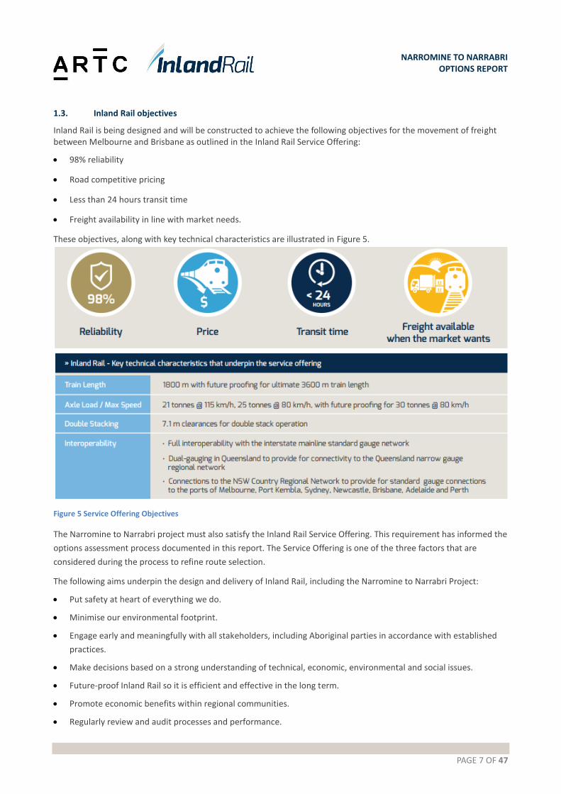
1.3. Inland Rail objectives
Inland Rail is being designed and will be constructed to achieve the following objectives for the movement of freight between Melbourne and Brisbane as outlined in the Inland Rail Service Offering:
98% reliability
Road competitive pricing
Less than 24 hours transit time
Freight availability in line with market needs.
These objectives, along with key technical characteristics are illustrated in Figure 5.
Figure 5 Service Offering Objectives
The Narromine to Narrabri project must also satisfy the Inland Rail Service Offering. This requirement has informed the
options assessment process documented in this report. The Service Offering is one of the three factors that are
considered during the process to refine route selection.
The following aims underpin the design and delivery of Inland Rail, including the Narromine to Narrabri Project:
Put safety at heart of everything we do.
Minimise our environmental footprint.
Engage early and meaningfully with all stakeholders, including Aboriginal parties in accordance with established
practices.
Make decisions based on a strong understanding of technical, economic, environmental and social issues.
Future-proof Inland Rail so it is efficient and effective in the long term.
Promote economic benefits within regional communities.
Regularly review and audit processes and performance.
PAGE 8 OF 47
NARROMINE TO NARRABRI OPTIONS REPORT
2. APPROACH
2.1. Background
The original Study Area between Narromine and Narrabri was identified in ARTC’s 2010 Inland Rail Alignment Study,
which informed the development of the Inland Rail Business Case in 2015.
The Phase 1 Concept Assessment commenced in early 2016. This involved the development of the 2016 Concept
Alignment based on the ARTC 2010 Inland Rail Alignment Study. The 2016 Concept Alignment informed initial
discussions with the community and stakeholders including local councils, landowners, and farmers’ representatives.
Feedback from these discussions highlighted the expectation that ARTC should consider alternative options utilising
the existing Coonamble rail line and traversing parts of the Pilliga State Forest as part of the Phase 1 Concept
Assessment.
2.2. Option development and assessment
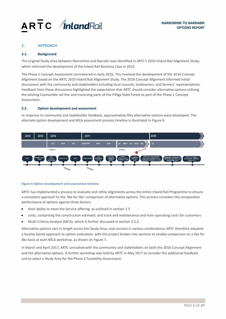
In response to community and stakeholder feedback, approximately fifty alternative options were developed. The
alternate option development and MCA assessment process timeline is illustrated in Figure 6.
Figure 6 Option development and assessment timeline
ARTC has implemented a process to evaluate and refine alignments across the entire Inland Rail Programme to ensure
a consistent approach to the ‘like for like’ comparison of alternative options. This process considers the comparative
performance of options against three factors:
their ability to meet the Service offering, as outlined in section 1.3
costs, comprising the construction estimate, and track and maintenance and train operating costs for customers
Multi-Criteria Analysis (MCA), which is further discussed in section 2.2.2.
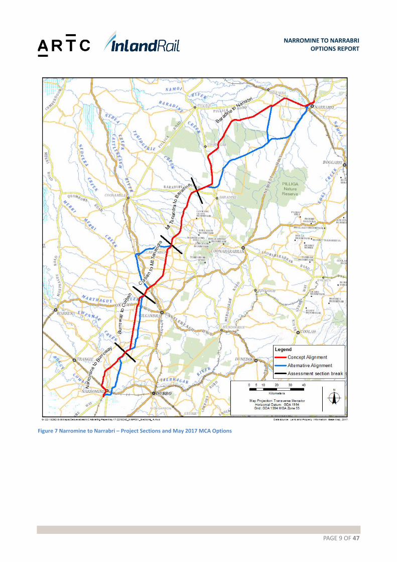
Alternative options vary in length across the Study Area, and connect in various combinations ARTC therefore adopted
a locality based approach to option evaluation, with the project broken into sections to enable comparison on a like for
like basis at each MCA workshop, as shown on Figure 7.
In March and April 2017, ARTC consulted with the community and stakeholders on both the 2016 Concept Alignment
and the alternative options. A further workshop was held by ARTC in May 2017 to consider the additional feedback
and to select a Study Area for the Phase 2 Feasibility Assessment.
PAGE 9 OF 47
NARROMINE TO NARRABRI OPTIONS REPORT
Figure 7 Narromine to Narrabri – Project Sections and May 2017 MCA Options

PAGE 10 OF 47
NARROMINE TO NARRABRI OPTIONS REPORT
2.2.1. Constraints, design and technical considerations
The 2016 Concept Alignment and alternative options were developed with consideration of environmental, physical
and operational considerations. This included desktop assessment, with targeted field work to confirm the desktop
assessments of the following:
Aboriginal and historic heritage
topography, geology, and soils
land ownership and use
biodiversity
noise and vibration
air quality
contamination
surface water and flooding.
Design and technical considerations include:
engineering design criteria
design life
flood immunity and drainage
geotechnical considerations and ground conditions
property and land use impacts.
2.2.2. MCA criteria
MCA workshops held in October 2016, December 2016 and May 2017 utilised the following programme-wide Inland
Rail MCA criteria. These compared the various options to the 2016 Concept Alignment, to quantify their comparative
merit. The following criteria were considered:
Technical viability: alignment, impact on public utilities and services, geotechnical conditions, impacts on existing roads and rail networks, flood immunity/hydrology, future proofing.
Safety: operational safety, public safety, road safety interfaces, emergency response, construction safety.
Operations: effect/impact on travel time, effect on reliability and availability, network interoperability and connectivity.
Constructability: construction duration, construction access, construction complexity, resources/material sources, interface with operational railway, staging opportunities.
Environmental: ecological impacts (flora, fauna and habitats), visual impacts, noise and vibration impacts, flooding and waterway impacts, effect on air quality, effect on greenhouse gas emissions.
Community and property: property impacts, Indigenous and non-Indigenous heritage, impact on community, community responses, current and future land use impacts.
Approvals and risk: planning and approval timescale, support of local, state and federal governments, other statutory and regulatory approvals, service authorities.
The MCA process relies on a combination of qualitative and quantitative value judgements. Some values and criteria
are subjective by nature, or require value judgments based on prediction of likely sensitive or degree of impact.
Sensitivity testing is therefore undertaken as part of the process, to evaluate the influence, if any, subjective
assessments have on the consensual outcome.

PAGE 11 OF 47
NARROMINE TO NARRABRI OPTIONS REPORT
2.2.3. Service Offering
The length and predicted travel time was used to evaluate the comparative performance of alternative options in
relation to the Service Offering.
2.2.4. Comparative capital cost estimates
A preliminary bill of quantities was developed for each option, based on the engineering and investigative work
undertaken. These were then rated, to prepare high-level, comparative construction-cost estimates as inputs to the
decision process for a Study Area.
2.3. Community and stakeholder engagement
Alternative options were presented in information sessions in November 2016, and landowner meetings in March-
April 2017. Over 450 community members were consulted, with the following identified as key themes or issues:
avoid houses and groups of houses; areas of new small lifestyle acreages may experience greater disturbance than the larger properties by a rail line
minimise impacts to cropping and higher intensity agricultural areas
follow property boundaries to minimise property severance, but be aware that some properties operate across multiple boundaries and span roads, and operational severance should also be a consideration
aim to utilise existing rail lines, road corridors, property boundaries as much as possible
concerns around flooding risk and ground conditions
be aware that there are close-knit communities along the routes with instances of related landowners and multi-generational farmers; adopt an appropriate community and stakeholder engagement approach to suit.
This feedback was taken into consideration throughout the various MCA workshops.
PAGE 12 OF 47
NARROMINE TO NARRABRI OPTIONS REPORT
3. OPTION EVALUATION
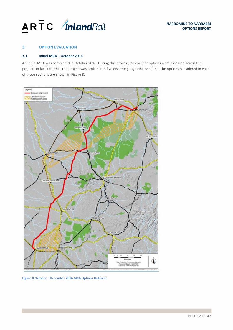
3.1. Initial MCA – October 2016
An initial MCA was completed in October 2016. During this process, 28 corridor options were assessed across the
project. To facilitate this, the project was broken into five discrete geographic sections. The options considered in each
of these sections are shown in Figure 8.
Figure 8 October – December 2016 MCA Options Outcome

PAGE 13 OF 47
NARROMINE TO NARRABRI OPTIONS REPORT
Options considered in the October 2016 MCA are shown in Figures 9-11. A summary of the options considered for further investigation and the discounted options are shown in Tables 1 and 2 below.
Table 1 Initial MCA – additional options
Section Initial MCA – additional options
Narromine Two options were shortlisted in Narromine, the Narromine West option (based on the original 2016 Concept Alignment) and the Narromine East option (a combination of two sections of alternate option, 101 and 107).
Narromine to Curban
Three options were shortlisted in this area, including the 2016 Concept Alignment, the Coonamble line option (option 101) and the combined Narromine East/2016 Concept Alignment (option 107).
Curban to Kenebri
The 2016 Concept Alignment forms the basis of both shortlisted options in this section, with one adopting the Coonamble line to Gulargambone (option 206).
Kenebri to Narrabri
Four options were shortlisted between Kenebri and Narrabri. These were the 2016 Concept Alignment, the Pilliga Forest Way option (combination of option 403 and 404), the direct route (option 408 and 409) and the Yarrie Lake/ 2016 Concept Alignment option (option 403/404 combined with option 401).
Narrabri The 2016 Concept Alignment and the Narrabri East option (connecting to the Pilliga options) were shortlisted at the northern end of the Study Area.
Table 2 Discounted options
Description Rationale
Option 102 follows the Mitchell Highway to the east of Narromine for approximately 6 km before branching north over open country to join the Coonamble line at Eumungerie.
Greater potential for flooding issues and an increased likelihood of soft soils, as it runs in a valley next to a watercourse.
Option 103 follows the Mitchell Highway to the east of Narromine for approximately 20 km before crossing the Macquarie River at Rawsonville and continuing north, joining the Coonamble line 15km south of Eumungerie.
Utilises a greater length of existing railway, resulting in marginally less property impacts, however it was a longer corridor than other options traversing this section.
Option 104 is similar to 103, but continues east at Rawsonville to join the Coonamble line earlier, approximately 8 km north of Dubbo.
Ruled out due to its length and comparative travel times, similar to 103.
Option 105 is similar to 104, with an alternative crossing point on the Macquarie River.
Ruled out due to its length and comparative travel times, similar to 103.
Option 106 maximised the use of existing rail corridor by following the Main Western line to Dubbo and then the Coonamble line to Curban. Rail bypass would be required at Dubbo to avoid tight radii and restrictions on the existing track through the centre of Dubbo.
Longest option, addition approximately 22 minutes journey time. Interaction with existing rail traffic on the Main Western and Coonamble lines with higher potential for impacts to reliability.
Options 201-205 – Considered the use of the existing Coonamble line and then traversing north east.
These options were discounted due to the additional transit time it presented between Narromine to Narrabri.

PAGE 14 OF 47
NARROMINE TO NARRABRI OPTIONS REPORT
Description Rationale
Option 402 - Similar start to 401, but takes more direct line through bushland between Rail Survey Road and Pilliga Forest Way. Exits forest to north before Newell Highway and follows existing track to north, over Yarrie Lake Road to join the Walgett Line to the west of Narrabri.
Ruled out due to higher impact to environmental and heritage
Option 405 - Similar start to other options along Cumbill Road and then parallels Pilliga Forest Way (403,404) on slightly higher ground. Crosses over Newell Highway and approaches Narrabri from the south parallel to Westport Road.
Similar in length to options 403 and 404, but
would require more significant cleared to
undertake construction. Potential impacts on
productive forestry areas and large lot
residential zoning on approach to Narrabri.
Option 406 - Similar to 405, but approach to Narrabri further to the east, along Jacks Creek.
Similar in length to options 403 and 404, but would require more significant cleared to undertake construction. Potential higher impacts on productive forestry areas and large lot residential zoning.
Option 407 - Enter the forest along Cumbill road and then take a direct line from Etoo Creek to the Newell Highway. These alignments are the shortest. 407 exits the forest to the north, similar to 402, to join the Walgett line and approach Narrabri from the west.
Potential for steeper gradients requiring
more extensive cut to fill.

PAGE 15 OF 47
NARROMINE TO NARRABRI OPTIONS REPORT
Figure 9 Discounted options from initial MCA – Narromine to Curban
PAGE 16 OF 47
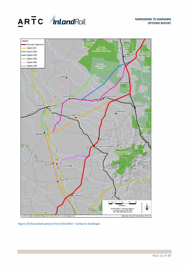
NARROMINE TO NARRABRI OPTIONS REPORT
Figure 10 Discounted options from initial MCA – Curban to Gwabegar

PAGE 17 OF 47
NARROMINE TO NARRABRI OPTIONS REPORT
Figure 11 Discounted options from initial MCA – Baradine to Narrabri
PAGE 18 OF 47
NARROMINE TO NARRABRI OPTIONS REPORT
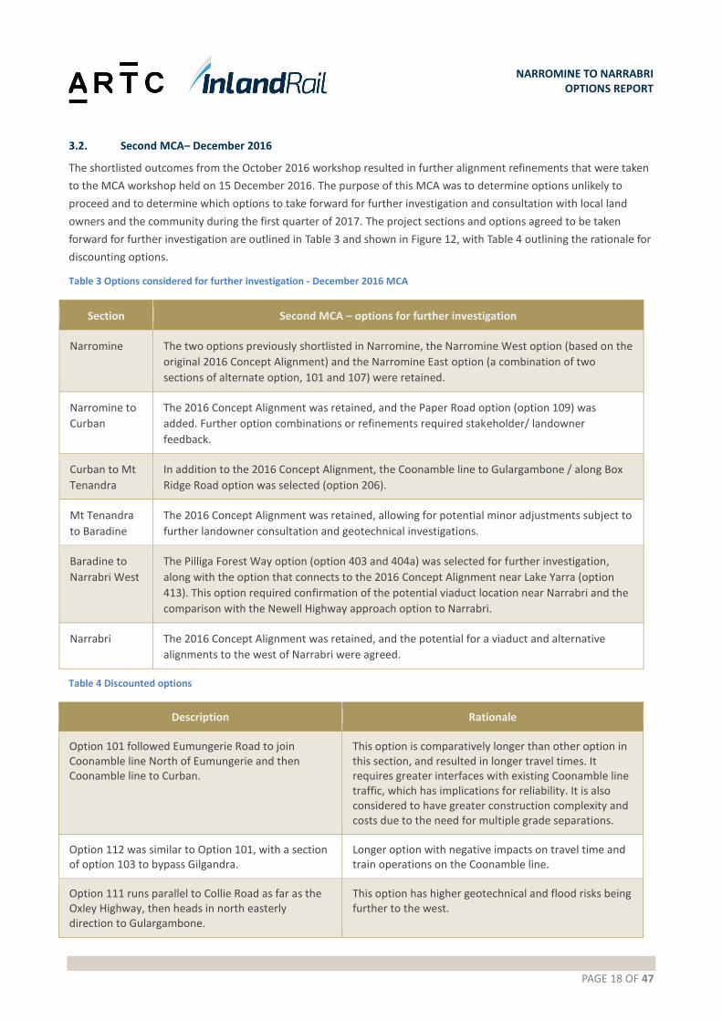
3.2. Second MCA– December 2016
The shortlisted outcomes from the October 2016 workshop resulted in further alignment refinements that were taken
to the MCA workshop held on 15 December 2016. The purpose of this MCA was to determine options unlikely to
proceed and to determine which options to take forward for further investigation and consultation with local land
owners and the community during the first quarter of 2017. The project sections and options agreed to be taken
forward for further investigation are outlined in Table 3 and shown in Figure 12, with Table 4 outlining the rationale for
discounting options.
Table 3 Options considered for further investigation - December 2016 MCA
Section Second MCA – options for further investigation
Narromine The two options previously shortlisted in Narromine, the Narromine West option (based on the
original 2016 Concept Alignment) and the Narromine East option (a combination of two
sections of alternate option, 101 and 107) were retained.
Narromine to
Curban
The 2016 Concept Alignment was retained, and the Paper Road option (option 109) was
added. Further option combinations or refinements required stakeholder/ landowner
feedback.
Curban to Mt
Tenandra
In addition to the 2016 Concept Alignment, the Coonamble line to Gulargambone / along Box
Ridge Road option was selected (option 206).
Mt Tenandra
to Baradine
The 2016 Concept Alignment was retained, allowing for potential minor adjustments subject to
further landowner consultation and geotechnical investigations.
Baradine to
Narrabri West
The Pilliga Forest Way option (option 403 and 404a) was selected for further investigation,
along with the option that connects to the 2016 Concept Alignment near Lake Yarra (option
413). This option required confirmation of the potential viaduct location near Narrabri and the
comparison with the Newell Highway approach option to Narrabri.
Narrabri The 2016 Concept Alignment was retained, and the potential for a viaduct and alternative
alignments to the west of Narrabri were agreed.
Table 4 Discounted options
Description Rationale
Option 101 followed Eumungerie Road to join Coonamble line North of Eumungerie and then Coonamble line to Curban.
This option is comparatively longer than other option in this section, and resulted in longer travel times. It requires greater interfaces with existing Coonamble line traffic, which has implications for reliability. It is also considered to have greater construction complexity and costs due to the need for multiple grade separations.
Option 112 was similar to Option 101, with a section of option 103 to bypass Gilgandra.
Longer option with negative impacts on travel time and train operations on the Coonamble line.
Option 111 runs parallel to Collie Road as far as the Oxley Highway, then heads in north easterly direction to Gulargambone.
This option has higher geotechnical and flood risks being further to the west.

PAGE 19 OF 47
NARROMINE TO NARRABRI OPTIONS REPORT
Figure 12 December 2017 MCA outcome
PAGE 20 OF 47
NARROMINE TO NARRABRI OPTIONS REPORT
3.3. Third MCA – May 2017
An MCA workshop was held on 11 May 2017 to review additional alignment options developed between Narromine
and Narrabri and consider stakeholder and community feedback obtained on the options received during meetings
with stakeholders, property owners and tenants through March to April 2017. The MCA workshop outcomes, which
had regard to the extensive public consultation process, resulted in:
the elimination of options that were considered unlikely to proceed due to their lower comparative merit
agreement on options to be used to identify the Study Area.
A summary of the inputs, considerations, and decisions for each section is provided below.
3.3.1. Narromine to Burroway
The two shortlisted route options considered between Narromine and Burroway were the 2016 Concept Alignment
and the Option A - Eumungerie Road, shown in Figure 13. The key characteristics of each are summarised in Table 5
with a description of the attributes of each option in Table 6.
Table 5 Narromine to Burroway option characteristics
Metric 2016 Concept Alignment Option A - Eumungerie Road option
Alignment Length: 41.9 km
Transit time: 25 minutes
Length: 42.9 km
Transit time: 25 minutes
Geotechnical Conditions Brownfield reconstruction: 8.1 km
Estimated Local Structural Fill: 47%
Brownfield reconstruction: 0km
Estimated Local Structural Fill: 72%
Length of flood plain
crossing (1:100 year)
15.9 km 1.6 km (viaduct length subject to
confirmation through further flood
modelling)
Level crossings Private level crossings: 13
Public level crossings: 15
Private level crossings: 7
Public level crossings: 15
Properties impacted by
the rail alignment
Private properties: 22
Publicly owned properties: 7
Private properties: 36
Publicly owned properties: 4

PAGE 21 OF 47
NARROMINE TO NARRABRI OPTIONS REPORT
Figure 13 Narromine to Burroway options
PAGE 22 OF 47
NARROMINE TO NARRABRI OPTIONS REPORT
Table 6 Narromine to Burroway options
Attributes 2016 Concept Alignment Option A - Eumungerie Road option
General The 2016 Concept Alignment leaves the existing
Parkes to Narromine railway south of
Narromine and joins the existing Cobar Branch
Line for approximately 4 km before heading
north across open farmland towards Burroway.
A local realignment of the Mitchell Highway
would be required to enable the construction of
a grade separated crossing (road over rail) at an
acceptable angle.
As the 2016 Concept Alignment approaches the
Macquarie River, it passes through a variety of
irrigated cropping farm land, including cotton
and oranges. After crossing the river near
Burroway, land use changes to wheat and
grazing.
The Eumungerie Road option leaves the
Parkes to Narromine Railway to the south
of Narromine and heads in an easterly
direction for approximately 5 km, before
turning north and crossing the Dubbo to
Narromine Railway and the Macquarie
River. Further investigations and
stakeholder consultation would be
required to confirm the bridge location.
North of the river, this option passes
through farmland for approximately 5 km
before joining Eumungerie Road. Part of
this farmland has recently been rezoned
for residential use. This option then runs
parallel to Eumungerie Road for 18 km,
before turning north west and crossing
cropping farmland for approximately 5 km
to join the 2016 Concept Alignment along
Cobboco Road.
Ground
conditions
(Geotechnical)
Alluvial soils are expected to be encountered
within the Macquarie River valley.
Embankments constructed from local materials
would require flatter batter slopes, and
approximately 1m depth of structural fill would
be required below the capping layer.
The poorer ground conditions in the Macquarie
River flood plain result in the risk of requiring
deeper track formation, increased quantity of
imported structural fill for a length of
approximately 21 km.
The first 11km of this option traverse
areas of alluvial soils, similar to the 2016
Concept Alignment, before encountering
better geotechnical conditions following
Eumungerie Road over sandstone. Nearby
granite and existing Council quarry offer
the potential for borrow pits.
The poorer ground conditions in the
Macquarie River/Backwater Cowal
floodplain to the east of Narromine result
in the risk of requiring deeper track
formation and increased quantity of
imported structural fill for a length of
approximately 10km.
Flood Risk The 2016 Concept Alignment crosses the
Macquarie River flood plain. It is anticipated
that viaduct structures will be required to raise
the track above the 1:100 year flood level and
to provide conveyance for flood flows to contain
upstream afflux levels within acceptable limits.
Further analysis and engineering will be
required to minimise flood risk and afflux.
This option crosses flood prone land to the
south east of Narromine, requiring flood
relief structures, however these are not
anticipated to be as extensive as
structures within the larger Macquarie
River flood plain required for the 2016
Concept Alignment.
This option then leaves the Parkes to
Narromine railway and heads east across
the relatively flat flood plain area

PAGE 23 OF 47
NARROMINE TO NARRABRI OPTIONS REPORT
Attributes 2016 Concept Alignment Option A - Eumungerie Road option
associated with the Backwater Cowal and
Macquarie River.
It is expected that the section of track to
the south of the Macquarie River would
require a number of flood relief culverts.
The number and size of culverts would
however be expected to be less than for
2016 Concept Alignment.
Once the alignment crosses the Macquarie
River, it rapidly gains higher ground along
the ridge line that runs parallel to
Eumungerie Road, for approximately 30
km. This section is well above the
Macquarie River flood plain and would not
be at risk from flooding from the river.
This option provides a better opportunity
to select an alignment above the 1:100
year flood level than the 2016 Concept
Alignment.
Major
Structures
This option requires grade separation and
localised realignment of the Mitchell Highway,
enabling a road bridge over the rail.
It also requires up to 1.1 km of viaduct
structures across the Macquarie River flood
plain, including the crossing of the river.
This option requires grade separation of
the new rail over the Mitchell Highway
and the Dubbo to Narromine railway.
It also requires a bridge over the
Macquarie River, and also potential
viaducts on either side over the flood
plain.
Tomingley Road and Eumungerie Road
may require grade separation (road over
rail).
Railway
operations -
interoperability
This option connects with the Cobar Branch Line
to the west of Narromine. To provide
connectivity between traffic in the Up direction
on the Cobar Branch Line and Brisbane, a new
triangle would be required with a north fork.
This would also impact on the grade separation
of the Mitchell Highway, resulting in a longer
structure.
If Inland Rail passes over the Dubbo to
Narromine line, there would be no
connectivity between the two lines unless
a new triangle is constructed on the
Parkes to Narromine line, south of
Narromine.
Interoperability with the Cobar Line and
Narromine – Dubbo Line would be
possible.
Constructability Construction access to the area between
Narromine and Burroway is satisfactory, with an
existing network of public and private roads.
Construction haul roads would be required
along the alignment to connect with major
materials supply routes.
There is also the opportunity to win structural
The southernmost 11 km of this option is
likely to have soft alluvial soils and could
be affected by wet weather or flooding.
Over this length, fill material for
construction of the track formation would
need to be imported from quarries or
borrow pits to the south and east of
PAGE 24 OF 47
NARROMINE TO NARRABRI OPTIONS REPORT
Attributes 2016 Concept Alignment Option A - Eumungerie Road option
fill over sandstone areas (approximately 20 km
in length).
Narromine. This is likely to include some
general fill to elevate the railway above
the 1:100 year flood level, plus all
structural fill.
The next 20 km of this option runs parallel
to Eumungerie Road and would have good
access from this sealed road. Eumungerie
Road is a dedicated heavy vehicle freight
route and traffic control would be
required to manage access and egress
points. New haul roads would be required.
The northernmost 10 km crosses through
open farmland with generally good ground
conditions.
Opportunity to win structural fill over
sandstone areas (approximately 30 km in
length).
Environment The majority of the 2016 Concept Alignment
passes through cropping land. Rapid field
surveys have been undertaken and it significant
impacts to flora or fauna are not anticipated.
A number of Aboriginal sites listed on the
AHIMS database are located in the vicinity of
this option. There is also potential for Aboriginal
archaeological heritage to be found at creek
crossings, especially around the banks of the
Macquarie River.
The majority of the Eumungerie Road
option traverses open farmland that is
used for wheat, grazing or irrigated crops.
Critically endangered ecological
communities are located in the reserve
area to the south of the Macquarie River,
traversed by this option.
Preliminary Aboriginal heritage studies
also indicate that there are likely to be
Aboriginal archaeological heritage present
around the Macquarie River.
Properties
impacted
110
Or 29 properties (excluding existing rail
corridor)
The 2016 Concept Alignment passes through
irrigation properties within the Macquarie River
flood plain. Adjustments to irrigation bores and
channels are likely to be required to
accommodate Inland Rail.
126
40 properties
Community and
stakeholders
Concerns raised by landowners associated with
this option included:
reduction in property values and
compensation
impacts on irrigation schemes
impacts on farming operations
noise and vibration
flooding
Concerns raised by landowners associated
with this option included:
reduction in property values and
compensation
impacts on irrigation schemes
impacts on farming operations
noise and vibration
visual impacts
PAGE 25 OF 47
NARROMINE TO NARRABRI OPTIONS REPORT
Attributes 2016 Concept Alignment Option A - Eumungerie Road option
impacts on lifestyle and community. flooding
impacts on threatened species and
Aboriginal artefacts
impacts on lifestyle and community.
Public utilities
and services
The existing Parkes to Narromine railway passes
under a 132kV overhead electricity line to the
south of Narromine. This line may need to be
raised to accommodate double stacked
containers.
The Eumungerie Road option passes under
two 132kV overhead electricity lines that
are located close to the proposed bridge
that would take Inland Rail over the
Mitchell Highway and the existing Dubbo
to Narromine railway. These lines may
need to be raised or diverted to
accommodate Inland Rail. Alignment
would need to avoid electricity substation.
3.3.2. Recommendation – Narromine to Burroway
Option A has been recommended as the Study Area for Narromine to Burroway This recommendation is made for the
following reasons:
Strengths
Overall MCA scoring was positive.
The route was preferred by the broader community in general, as it reduces property severance by following
Eumungerie Road or if routed to the back of properties reduces level crossings.
By avoiding Narromine, the route will minimise future environmental and social issues that may exist with a route
closer to town.
The geotechnical conditions are better and will provide more opportunity for capital cost savings and reduced
maintenance costs.
The hydrology and flooding issues are reduced.
Weaknesses
The impact on the Service Offering is only an additional 24 seconds.
Option A is 2.4% more in capital value across the total project estimate
Opportunities
The Study Area:
Includes a zone up to 5km wide at the Southern end to:
o allow for a connection to the Inland Rail Parkes to Narromine project
o avoid or minimise the flooding effects of the Backwater Cowal
o target a better crossing point of the Dubbo to Narromine line, the Mitchell Highway and Macquarie River
Follows the Western side of Eumungerie Road with a corridor up to 2.5km wide to provide for an option along the
back- boundaries of adjacent properties
PAGE 26 OF 47
NARROMINE TO NARRABRI OPTIONS REPORT
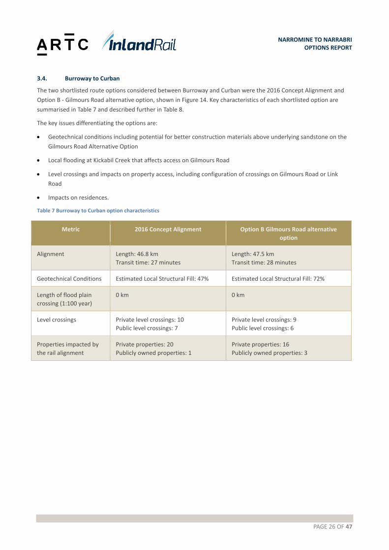
3.4. Burroway to Curban
The two shortlisted route options considered between Burroway and Curban were the 2016 Concept Alignment and
Option B - Gilmours Road alternative option, shown in Figure 14. Key characteristics of each shortlisted option are
summarised in Table 7 and described further in Table 8.
The key issues differentiating the options are:
Geotechnical conditions including potential for better construction materials above underlying sandstone on the
Gilmours Road Alternative Option
Local flooding at Kickabil Creek that affects access on Gilmours Road
Level crossings and impacts on property access, including configuration of crossings on Gilmours Road or Link
Road
Impacts on residences.
Table 7 Burroway to Curban option characteristics
Metric 2016 Concept Alignment Option B Gilmours Road alternative
option
Alignment Length: 46.8 km
Transit time: 27 minutes
Length: 47.5 km
Transit time: 28 minutes
Geotechnical Conditions Estimated Local Structural Fill: 47% Estimated Local Structural Fill: 72%
Length of flood plain
crossing (1:100 year)
0 km 0 km
Level crossings Private level crossings: 10
Public level crossings: 7
Private level crossings: 9
Public level crossings: 6
Properties impacted by
the rail alignment
Private properties: 20
Publicly owned properties: 1
Private properties: 16
Publicly owned properties: 3
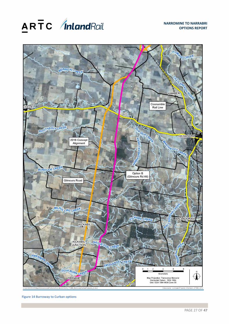
PAGE 27 OF 47
NARROMINE TO NARRABRI OPTIONS REPORT
Figure 14 Burroway to Curban options
PAGE 28 OF 47
NARROMINE TO NARRABRI OPTIONS REPORT
Table 8 Burroway to Curban options
Attributes 2016 Concept Alignment Option B - Gilmours Road alternative option
General The 2016 Concept Alignment leaves
Cobboco Road and passes over open
farmland to connect with Old Mill Road.
It follows Old Mill Road for
approximately 4 km before turning north
and to following property boundaries to
Gilmours Road. The alignment follows
Gilmours Road for approximately 24 km
and then continues over Leeches Creek
Road and across open farmland to the
Oxley Highway. A new grade separation
would be required to take the Oxley
Highway over Inland Rail.
After the Oxley Highway, the route heads
in a north easterly direction to run
alongside the back boundaries of
properties fronting Berida-Bullagreen
Road and to avoid a residence near the
road. On reaching Berrida Road, the
alignment generally follows the road
around to the existing Coonamble Line at
Curban.
This option runs parallel to Gilmours Road,
generally following rear property boundaries,
crown (paper) roads and Nancarrows Road. The
Gilmours Road Alternative Option was developed
to reduce impacts on property access from
Gilmours Road by aligning the rail line with the
back property boundaries and ‘paper’ roads. While
construction access would be marginally more
difficult, this option is considered likely to result in
long term safety improvements through reduced
traffic over private level crossings.
Ground
conditions
Geotechnical conditions are generally
reasonable.
The underlying geology appears to have a greater
proportion of sandstone, which is likely to translate
to better ground conditions, when compared to
the 2016 Concept Alignment
This may also result in more opportunities for
borrow pits.
Flooding and
hydrology
In general, the increase in the predicted
1:100 year flood level following
construction of Inland Rail can be
managed to be less than 100 mm and in
many cases, less than 10 mm.
Flooding impacts would be generally similar for
each option with a potential marginal reduction in
flooding for the Gilmours Road Alternative Option
as it crosses creeks higher in the catchments.
Major
structures
This option requires grade separation of
the Oxley Highway. It is anticipated that
a new bridge will be constructed to take
the highway over the rail line.
This option requires grade separation of the Oxley
Highway. It is anticipated that a new bridge will be
constructed to take the highway over the rail line.
Rail operations
There are no connections to existing
railways in this section.
There are no connections to existing railways in
this section.
Constructability Generally follows the alignments of Construction of the railway will require dedicated
PAGE 29 OF 47
NARROMINE TO NARRABRI OPTIONS REPORT
Attributes 2016 Concept Alignment Option B - Gilmours Road alternative option
existing roads along Cobboco Road, Old
Mill Road and Gilmours Road.
Whilst Gilmours Road presents an
opportunity for light vehicles servicing
the construction project, as a public road
it would not be suitable for a haul road.
Therefore, a new haul road would be
required for construction plant.
Capping and ballast would need to be
imported
haul roads to manage cut to fill earthworks and to
import structural fill, capping, ballast, sleepers and
rail. Whilst Gilmours Road presents an opportunity
for light vehicles servicing the construction project,
as a public road it would not be suitable for a haul
road. Therefore, a new haul road would be
required for construction plant.
Geotechnical conditions may be marginally better
than on the 2016 Concept Alignment, with a
greater proportion of sandstone underlying the
alternative option. This could result in some
advantages for constructing construction access
and for winning structural fill material for the rail
embankment.
Capping and ballast would need to be imported.
Environment There are threatened fauna and
threatened flora records in the area. The
recorded threatened fauna sightings
relate mainly to birds and it is likely that
some of these species would be
encountered on either the 2016 Concept
Alignment or the Gilmours Road
Alternative Option.
Registered Aboriginal sites in the vicinity
primarily relate to scarred or modified
trees and scattered artefacts found
around creek banks.
Land generally to the north of the Oxley
Highway is subject to a Native Title Claim
from the Gomeroi People (ref
NC2011/006). This claim covers a large
area, extending northwards to the
Queensland border.
An additional Native Title Claim has also
been lodged by the Ngemba, Ngiyampaa,
Wangaapuwan and Waylwan people
(NC2012/001). This covers an area west
of the Castlereagh Highway to Cobar.
Local heritage items are associated with
the Berida Woolshed Group to the north
of the Oxley Highway.
The Gilmours Road alternative passes though
previously undisturbed areas, particularly in the
‘paper’ road sections. A visual inspection of the site
and reference to aerial photographs indicates that
there would be some clearing of native vegetation
required for the alignment. Environmental surveys
will be completed in the next phase of the project
to assess the impacts of the route in this area and
any mitigating measures required.
There is also an increased potential for finding
Aboriginal archaeological heritage in previously
undisturbed areas.
Property 39 (21 properties within 2 km corridor) 25 (19 properties within 2 km corridor)
Level Crossings The 2016 Concept Alignment crosses 10
private accesses, where which would
need to be provided as level crossings.
The Gilmours Road alternative option generally
follows back property boundaries and crown roads.
Nine new level crossings would be required to

PAGE 30 OF 47
NARROMINE TO NARRABRI OPTIONS REPORT
Attributes 2016 Concept Alignment Option B - Gilmours Road alternative option
It is expected that access tracks
connecting to Gilmours Road would be
the primary access points for properties.
preserve access, but the number of trips over these
crossings is expected to be less than for level
crossings located on the 2016 Concept Alignment
that are generally on the primary access roads to
properties. The Gilmours Road alternative option
would therefore have a reduced safety risk for
these private level crossings.
Community and
stakeholders
ARTC has consulted with over 90% of the landowners between Burroway and Curban on both the
2016 Concept Alignment and the Gilmours Road Alternative Option. The general feedback is that
local residents do not want Inland Rail to pass near their properties, irrespective of the alignment
chosen, and would like to see the alignment moved to the east to join the existing Coonamble
Line.
Public Utilities
and services To be investigated next phase. To be investigated next phase.
3.4.1. Recommendation – Narromine to Burroway Option B - Gilmours has been recommended as the preferred option for Burroway to Curban.
This recommendation is made for the following reasons:
Strengths
Overall MCA scoring was positive
Option B is 2.0% less in capital value across the total project estimate
The geotechnical conditions are better to the east and will provide more opportunity for capital cost savings and
reduced maintenance costs
The hydrology and flooding issues are reduced.
Weakness
The impact on the Service Offering is only an additional 1 minute and 20 seconds
Opportunities
By setting a wider Study Area the opportunity for the community to engage in the development of alignment
refinements is greatly increased
Refinements will occur after further site work and consultation is carried out in Phase 2, the results of which will
provide the community with an open and robust process.

PAGE 31 OF 47
NARROMINE TO NARRABRI OPTIONS REPORT
3.5. Curban to Mt Tenandra
The two options considered between Curban and Mt Tenandra were the 2016 Concept Alignment and the Option C -
Box Ridge Road option, shown in Figure 15.
Key characteristics of each option are summarised in Table 9 and described further in Table 10.
The key issues differentiating the options are:
Box Ridge Road Option is 16.4 km longer, resulting in an additional transit time of approximately 9 minutes.
The 2016 Concept Alignment crosses productive cropping land. The Box Ridge Road Option is an alternative route
developed to reduce property severance and associated impacts on farming operations.
Geotechnical conditions appear to be better on the 2016 Concept Alignment. Preliminary investigations suggest
that the 2016 Concept Alignment has approximately half the exposure to black soils than the Box Ridge Road
Option (indicatively 8 km versus 16 km). There are also better opportunities to win structural fill materials locally
on the 2016 Concept Alignment.
Operational interfaces with the Country Regional Network ( CRN ) network would need to be resolved between
ARTC and Transport for New South Wales (TfNSW) if approximately 25 km of this line are to be used by the Box
Ridge Road Option. Assessments indicate that the service offering would not be met due to the complexity of
operations on this existing line
Box Ridge Road has a wide road reserve that could accommodate Inland Rail. The benefits of reduced property
acquisition however need to be balanced against clearing of native vegetation, productive forests and impacts on
travelling stock routes.
Once leaving the Coonamble line the Box Ridge Road option passes through the Pilliga West National Park / State
conservation area with comparatively great flood risk, particularly between Pilliga and Wee Waa.
Flood immunity to be provided for the existing Coonamble Line is assumed as either ‘no worse than existing’ or
the 1:100 year flood level.
Table 9 Curban to Mt Tenandra option characteristics
Metric 2016 Concept Alignment Option C - Box Ridge Road option
Alignment Length: 44.3 km
Realignment of Coonamble line: 3.1 km
Transit time: 26 minutes
Length: 60.7 km
Realignment of Coonamble line: 0 km
Transit time: 35 minutes
Geotechnical Conditions Brownfield reconstruction: 0 km
Estimated Local Structural Fil: 15%
Brownfield reconstruction: 24.7 km
Estimated Local Structural Fill: 0%
Length of flood plain
crossing (1:100 year)
0 km 0 km (subject to confirmation through
further flood modelling)
Level crossings Private level crossings: 9
Public level crossings: 9 plus 1 grade
separation
Private level crossings: 14
Public level crossings: 11 plus 1 grade
separation
Properties impacted by
the rail alignment
Private properties: 27
Publicly owned properties: 2
Private properties: 17
Publicly owned properties: 7

PAGE 32 OF 47
NARROMINE TO NARRABRI OPTIONS REPORT
Figure 15 Curban to Mt Tenandra options

PAGE 33 OF 47
NARROMINE TO NARRABRI OPTIONS REPORT
Table 10 Curban to Mt Tenandra options
Attributes 2016 Concept Alignment Option C - Box Ridge Road option
General The 2016 Concept Alignment adopts the
shortest route between Curban and Mt
Tenandra, whilst generally following road
and property boundaries. This area is
locally recognised as having very fertile
soils with high cropping yields and is
consequently intensively farmed for
wheat.
This option follows the existing Coonamble Line
and Box Ridge Road. It is approximately 16.4 km
longer than the 2016 Concept Alignment, but
follows the exiting Coonamble Line and then Box
Ridge Road. There may be opportunities for
theoption to be located within the Box Ridge Road
reserve, thus reducing private property acquisition
Two sub-options exist within the Box Ridge Road
Option at Gulargambone to cross from the
Coonamble Line to Box Ridge Road. Route statistics
presented in this report are for the longer, most
northerly option.
Ground
conditions
The 2016 Concept Alignment generally
crosses alluvial soils comprising
Kandosols and Vertisols. The first section
of the alignment traverses
predominantly weathered sedimentary
rocks and red or brown earths. The
second section crosses clayey black soils
in the vicinity of Seven Mile Road. These
fall primarily within geotechnical units I
and II and would be anticipated to be
reactive with poor engineering
properties.
Geotechnical conditions are expected to
be better than the Box Ridge Road
option.
The first 25 km of this alignment follow the existing
Coonamble Line to the north of Curban. It is
anticipated that soils under the railway line have
been modified by the construction of the railway
and that some consolidation would have taken
place over time. However, the track formation is
unlikely to be suitable for Inland Rail traffic and will
require reconditioning.
The alignment leaves the Coonamble line near
Gulargambone and crosses the Castlereagh River
and the highway. Geotechnical conditions for the
river crossing and road grade separation are
anticipated to be poor, but similar to those likely to
be encountered for the crossings at Curban.
Between Gulargambone and Mt Tenandra, the
route follows Box Ridge Road. The underlying
ground conditions are expected to be poor with
clayey ‘black’ soils that are often gilgaid.
Geotechnical conditions are expected to
deteriorate from east to west.
Flooding and
hydrology
The Curban to Mt Tenandra section
involves a major crossing of the
Castlereagh River at Curban. This option
will need to address flooding issues
associated with the crossing of the river
and sheet flow from the Warrumbungles.
The section of track that follows the Coonamble
Line predominantly follows the watershed
between the Castlereagh River and creeks draining
to the Macquarie Marshes. There are some local
cross drainage channels over this length, but no
major creeks or rivers are crossed.
It is expected that a viaduct structure will be
required over the Castlereagh flood plain.
A recent flood study for Gulargambone suggested
that the Castlereagh River breaks its banks in
events greater than the 1:20 year ARI. If this option
proceeds, a decision is required on the flood
PAGE 34 OF 47
NARROMINE TO NARRABRI OPTIONS REPORT
Attributes 2016 Concept Alignment Option C - Box Ridge Road option
immunity to be provided for the existing
Coonamble line as either ‘no worse than existing’
or the 1:100 year ARI event.
From the Coonamble Line along Box Ridge Road,
the alignment crosses fewer creeks than the 2016
Concept Alignment, but lower down in the
catchments. It would therefore be expected that
fewer structures would be required, but these
would be larger.
Structures The major structures in this section are a
bridge over the Castlereagh River and a
grade separation of the Castlereagh
Highway.
The major structures on the Box Ridge Road option
are a bridge/viaduct over the Castlereagh River and
a grade separation of the Castlereagh Highway.
The bridge/viaduct over the Castlereagh River is
likely to be larger than for the 2016 Concept
Alignment as it crosses further downstream and
the floodplain is less constrained.
The grade separation of the Castlereagh Highway is
likely to be similar to the 2016 Concept Alignment.
Rail operations Inland Rail connects with the Coonamble
Line at Curban, with the Inland Rail to be
developed as the main line in this
location. This will require realignment of
the Coonamble Line to provide at-grade
junctions. The alignment crosses the
Coonamble Line approximately 800 m
north of the Curban siding to allow for a
future shunting neck to be constructed
following construction of Inland Rail. This
alignment also avoids the level crossing
and residence on the corner of Bardens
Road and Berida Road.
To provide full interoperability in
accordance with the Service Offering
additional triangles would be required or
provision would need to be made for
shunting movements on the Coonamble
Line to enable trains to reverse direction.
At Curban, the Box Ridge Road option would
connect to the Coonamble Line, with the Inland
Rail becoming the main line. A turnout would be
provided for local traffic travelling between
Coonamble and Dubbo.
At Gulargambone, Inland Rail would continue as
the main line towards Box Ridge Road and a
turnout would be provided for traffic heading
between Dubbo and Coonamble.
Connectivity has been provided similar to the 2016
Concept Alignment.
This option results in greater operational
complexity, which also impacts on the ability to
achieve the service offering in this section.
Constructability The 2016 Concept Alignment between
Curban and Mt Tenandra is generally flat
with a grade separation of the
Castlereagh Highway and a
bridge/viaduct over the Castlereagh
River. The key issues are expected to be
ground conditions, water management
and materials availability.
The Box Ridge Road option follows the Coonamble
line and would involve reconditioning
approximately 25 km of existing track, installing
new rail and sleepers and re-ballasting. Access for
construction traffic would be along Bardens Road
and the Gular Rail Road which may need to be
upgraded in places to provide all-weather access.
The Castlereagh Highway also connects Curban to

PAGE 35 OF 47
NARROMINE TO NARRABRI OPTIONS REPORT
Attributes 2016 Concept Alignment Option C - Box Ridge Road option
Ground conditions over the second two
thirds of the alignment are expected to
be poor with a higher proportion of
clayey soils. Haul roads would need to be
constructed for all weather access, to
mitigate potential delays due to wet
weather.
Gulargambone. This is a good quality sealed road.
From Gulargambone, Box Ridge Road provides
good access for light vehicles. Haul roads for off-
road vehicles would need to be constructed along
the alignment. Ground conditions are expected to
be generally poor over black soils.
It is likely that some general fill would need to be
imported to construct the track formation and all
structural fill would need to be imported by on-
road plant.
Environment There have been previous sightings of
threatened fauna relating to birds and it
is likely that some of these species would
be encountered on the 2016 Concept
Alignment.
Registered aboriginal sites around
Paddy’s Creek and Magie Melon Creek
has evidence of a camp ground and
burial site. Other registered sites relate
to scarred or modified trees.
Land generally to the north of the Oxley
Highway is subject to a Native Title Claim
from the Gomeroi People (ref
NC2011/006). An additional Native Title
Claim has also been lodged by the
Ngemba, Ngiyampaa, Wangaapuwan and
Waylwan people (NC2012/001). The area
between the Castlereagh Highway and
the river is shown on Gilgandra Shire
Council’s LEP as Woodvale Park Private
Cemetery.
The Box Ridge Road option has the potential to
reduce impacts on private property by aligning the
rail corridor within the road reserve.
This would however need to be balanced against
the greater impacts on native vegetation and
travelling stock routes within the road reserve.
A rapid field survey noted the presence of Weeping
Myall Woodlands and Poplar Box Grassy
Woodland. The former is listed as a critically
endangered ecological community under the EPBC
Act. The latter has been accepted for nomination
as a threatened ecological community, under the
EPBC Act but is still under assessment by the
Department of Environment and Energy.
Number of
properties
37 80
Community and
stakeholders
Impacts on wheat producers including
severance of smaller farming operations.
Potential clearing of native vegetation if route is
within Box Ridge Road reserve. Could be
avoided/mitigated if alignment is along boundary,
but within adjacent properties.
Community feedback supports Box Ridge Road
option.
PAGE 36 OF 47
NARROMINE TO NARRABRI OPTIONS REPORT
3.5.1. Recommendation – Curban to Mt Tenandra
The recommendation is made to nominate the 2016 Concept Alignment as the Study Area for Curban to Mt Tenandra.
This recommendation is made for the following reasons:
Strengths
The Concept Alignment compared with Option C provided a run time saving 9 minutes and 35 seconds
The Concept Alignment compared with Option C provided a capital cost benefit of 2.24%
Option C scored a negative MCA value against a base case comparison of 0.
Weaknesses
Preference from community consultation for Option C.
Opportunities
The Study Area will avoid Gulargambone and will allow the project to refine the alignment along the route with further investigations and engagement with the local community and stakeholders.
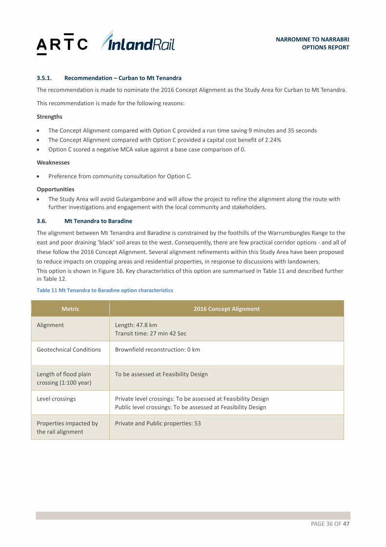
3.6. Mt Tenandra to Baradine
The alignment between Mt Tenandra and Baradine is constrained by the foothills of the Warrumbungles Range to the
east and poor draining ‘black’ soil areas to the west. Consequently, there are few practical corridor options - and all of
these follow the 2016 Concept Alignment. Several alignment refinements within this Study Area have been proposed
to reduce impacts on cropping areas and residential properties, in response to discussions with landowners.
This option is shown in Figure 16. Key characteristics of this option are summarised in Table 11 and described further in Table 12.
Table 11 Mt Tenandra to Baradine option characteristics
Metric 2016 Concept Alignment
Alignment Length: 47.8 km
Transit time: 27 min 42 Sec
Geotechnical Conditions Brownfield reconstruction: 0 km
Length of flood plain
crossing (1:100 year)
To be assessed at Feasibility Design
Level crossings Private level crossings: To be assessed at Feasibility Design
Public level crossings: To be assessed at Feasibility Design
Properties impacted by
the rail alignment
Private and Public properties: 53

PAGE 37 OF 47
NARROMINE TO NARRABRI OPTIONS REPORT
Figure 16 Mt Tenandra to Baradine
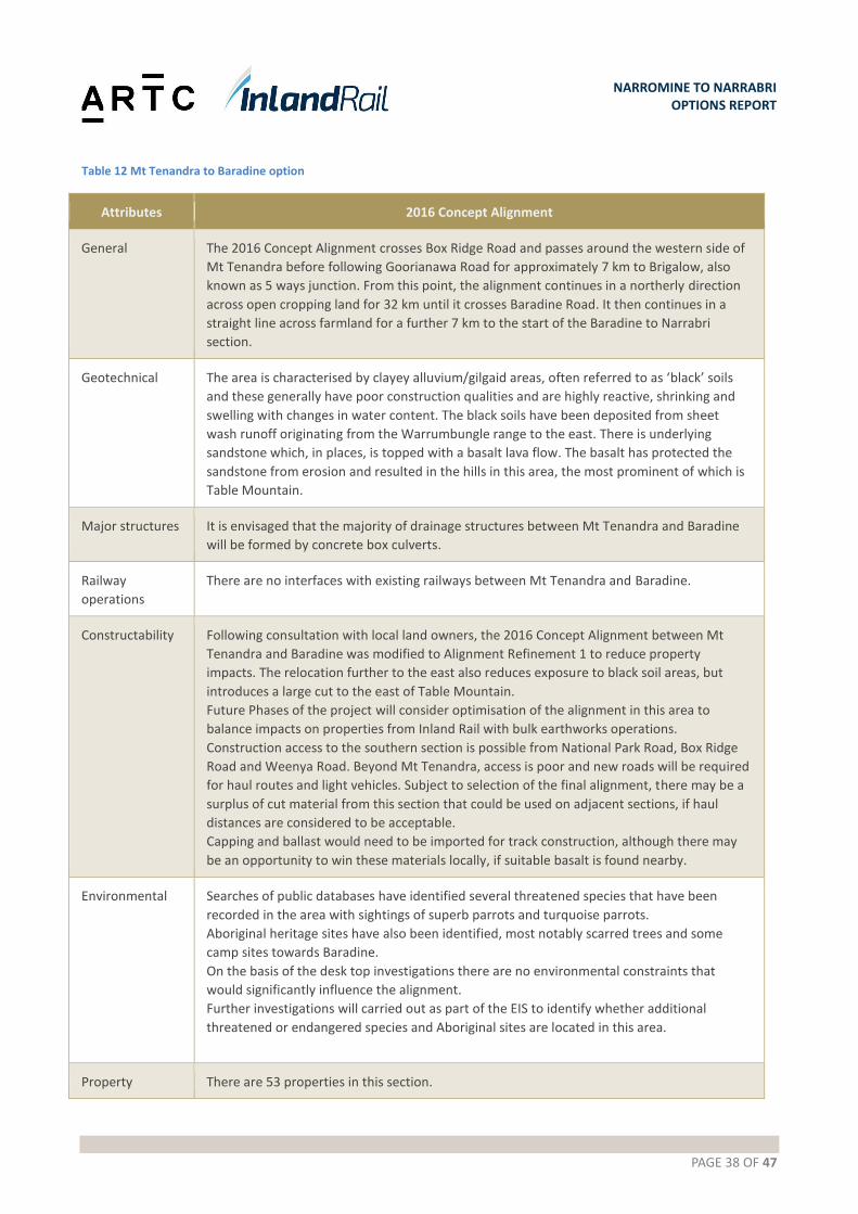
PAGE 38 OF 47
NARROMINE TO NARRABRI OPTIONS REPORT
Table 12 Mt Tenandra to Baradine option
Attributes 2016 Concept Alignment
General The 2016 Concept Alignment crosses Box Ridge Road and passes around the western side of
Mt Tenandra before following Goorianawa Road for approximately 7 km to Brigalow, also
known as 5 ways junction. From this point, the alignment continues in a northerly direction
across open cropping land for 32 km until it crosses Baradine Road. It then continues in a
straight line across farmland for a further 7 km to the start of the Baradine to Narrabri
section.
Geotechnical The area is characterised by clayey alluvium/gilgaid areas, often referred to as ‘black’ soils
and these generally have poor construction qualities and are highly reactive, shrinking and
swelling with changes in water content. The black soils have been deposited from sheet
wash runoff originating from the Warrumbungle range to the east. There is underlying
sandstone which, in places, is topped with a basalt lava flow. The basalt has protected the
sandstone from erosion and resulted in the hills in this area, the most prominent of which is
Table Mountain.
Major structures It is envisaged that the majority of drainage structures between Mt Tenandra and Baradine
will be formed by concrete box culverts.
Railway
operations
There are no interfaces with existing railways between Mt Tenandra and Baradine.
Constructability Following consultation with local land owners, the 2016 Concept Alignment between Mt
Tenandra and Baradine was modified to Alignment Refinement 1 to reduce property
impacts. The relocation further to the east also reduces exposure to black soil areas, but
introduces a large cut to the east of Table Mountain.
Future Phases of the project will consider optimisation of the alignment in this area to
balance impacts on properties from Inland Rail with bulk earthworks operations.
Construction access to the southern section is possible from National Park Road, Box Ridge
Road and Weenya Road. Beyond Mt Tenandra, access is poor and new roads will be required
for haul routes and light vehicles. Subject to selection of the final alignment, there may be a
surplus of cut material from this section that could be used on adjacent sections, if haul
distances are considered to be acceptable.
Capping and ballast would need to be imported for track construction, although there may
be an opportunity to win these materials locally, if suitable basalt is found nearby.
Environmental Searches of public databases have identified several threatened species that have been
recorded in the area with sightings of superb parrots and turquoise parrots.
Aboriginal heritage sites have also been identified, most notably scarred trees and some
camp sites towards Baradine.
On the basis of the desk top investigations there are no environmental constraints that
would significantly influence the alignment.
Further investigations will carried out as part of the EIS to identify whether additional
threatened or endangered species and Aboriginal sites are located in this area.
Property There are 53 properties in this section.
PAGE 39 OF 47
NARROMINE TO NARRABRI OPTIONS REPORT
Attributes 2016 Concept Alignment
Community and
stakeholders
Between February and April 2017, ARTC consulted with landowners whose properties could
be affected by the 2016 Concept Alignment. Land between Mt Tenandra and Baradine is
primarily used for cropping and grazing, with the main crop being wheat.
Phase 1 consultations have resulted in the development of alignment refinements to
mitigate impacts on cropping areas and farming activities. These changes may also help to
realise engineering improvements by relocating the alignment further to the east over areas
mapped as sandstone, thus reducing the track length over potential black soil areas.
3.6.1. Recommendation –Mt Tenandra to Baradine
The recommendation is made to nominate the 2016 Concept Alignment as the Study Area for Mt Tenandra to
Baradine, incorporating a wider Study Area to undertake alignment refinements in Phase 2.
This recommendation is made for the following reasons:
Strengths
There is no impact on the Service Offering or Capital Cost.
The geotechnical conditions are better to the east and will provide more opportunity for capital cost savings and
reduced maintenance costs.
The hydrology and flooding issues are reduced.
Weaknesses
Nil
Opportunities
A widened Study Area allows for more engaged consultation to investigate an alignment outcome in Phase 2 that
meets landowner expectations.

PAGE 40 OF 47
NARROMINE TO NARRABRI OPTIONS REPORT
3.7. Baradine to Narrabri
Three shortlisted route options were considered between Baradine and Narrabri, the 2016 Concept Alignment, the
Pilliga Forest Way option and the Twenty Foot Road option.
These options are shown in Figure 17. Key characteristics of each shortlisted option are summarised in Table 13 and
described further in Table 14.
Table 13 Baradine to Narrabri option characteristics
Metric 2016 Concept Alignment Option D - Pilliga Forest
option
Option E - Twenty Foot
Road option
Alignment Length: 130.9 km
Transit time: 75 minutes
Length: 117.9 km
Transit time: 69 minutes
Length: 122.0 km
Transit time: 70 minutes
Geotechnical
Conditions
Brownfield reconstruction:
32 km
Poor geotechnical conditions
for 100km
Brownfield reconstruction: 0
km
Better geotechnical
conditions in the higher
catchment.
Brownfield reconstruction:
13.8 km
Relatively good soils in Pilliga
State Forest
Length of flood plain
crossing (1:100 year)
6.8 km 6.8 km 6.3 km
Level crossings Private level crossings: 29
Public level crossings: 23
Forest track crossings: 5
Private level crossings: 17
Public level crossings: 9
Forest track crossings: 28
Private level crossings: 29
Public level crossings: 13
Forest track crossings: 23
Properties impacted
by the rail alignment
Private properties: 66
Publicly owned properties: 8
Private properties: 36
Publicly owned properties:
14
Private properties: 31
Publicly owned properties:
19
Key issues differentiating the options are:
Geotechnical conditions including:
- Suitability of in-situ soils for construction of the railway embankment
- Proximity to potential borrow pits for structural fill
- Trafficability for construction plant on haul roads
Potential cumulative environmental impacts resulting from vegetation clearing in the Pilliga State Forest The Pilliga State Forest covers an area of 164,000 ha and includes approximately 33,400 ha of conservation area, which has cultural and environmental significance. The 2016 Concept Alignment avoids this area.
Property acquisition, including acquisition of small hobby farms on the 2016 Concept Alignment
Interaction with Santos’ proposed Narrabri Gas Project, including a ‘pinch-point’ constraint on the Newell Highway
Connectivity to the Narrabri viaduct
Potential flood impacts from Bohena Creek.
Interoperability with the Walgett line.
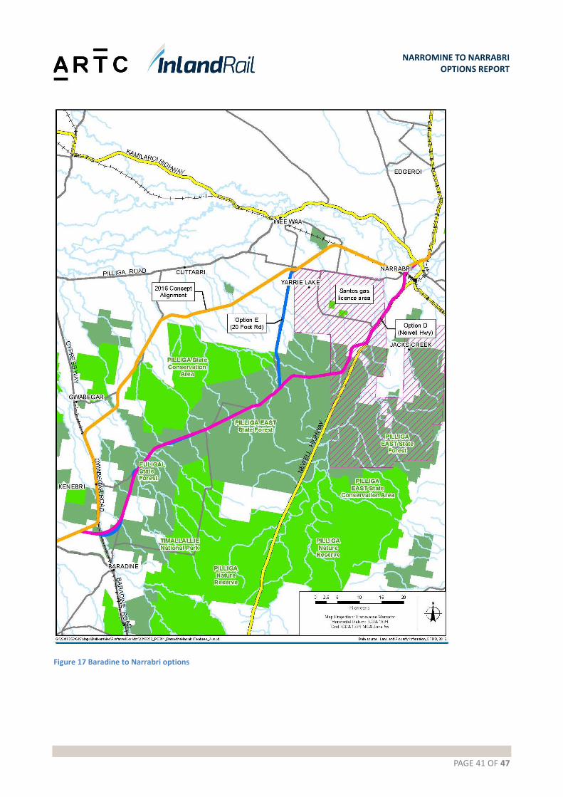
PAGE 41 OF 47
NARROMINE TO NARRABRI OPTIONS REPORT
Figure 17 Baradine to Narrabri options
PAGE 42 OF 47
NARROMINE TO NARRABRI OPTIONS REPORT
Table 14 Baradine to Narrabri options
Attributes 2016 Concept Alignment Option D - Pilliga Forest/
Newell Highway option
Option E - Pilliga Forest/
Twenty Foot Road option
General From Baradine, the 2016 Concept Alignment follows the Gwabegar rail corridor for 20 km, then heading in a north easterly direction passing between the Quegobla and Euligal State Forests. It then follows Gwabegar Road for approximately 18 km before turning west just north of the Pilliga State Conservation Area. It follows a cadastral boundary for around 6 km before running north east for 27 km to Yarrie Lake Road, where grade separation is required. After Yarrie Lake Road, it continues in a north easterly direction until the existing Narrabri – Walgett railway line, west of the Culgoora siding and level crossing. It then follows the existing rail corridor for 14 km before heading north easterly over the Namoi River/Narrabri Creek floodplain on viaduct. At the northern end, this will provide a grade separation over the Kamilaroi Highway, before joining the Narrabri – Moree railway to the north of the Newell Highway overbridge.
The alignment would leave the 2016 Concept Alignment approximately 10 km north of Baradine and head east along a ‘paper’ road, cross over the disused Gwabegar rail line and Baradine Creek before passing through Baradine State Forest and veering north east parallel to Cumbil Road, an unsealed forest road. The alignment follows Cumbil Road for around 14 km before joining Pilliga Forest Way and crossing over Etoo Creek. It then generally follows Pilliga Forest Way in a north easterly direction for 40 km until the junction with Twenty Foot Road to the north. At one point in this section, the Forest Road ‘dog-legs’ to the north and east. It is proposed that in this section, the Inland Rail alignment maintains a straight line and follows the hypotenuse on the triangle. This should be confirmed following receipt of detailed topographic survey for this area. At the junction with Twenty Foot Road, this option continues generally along the Pilliga Forest Way for 19 km and to then follow the western side of the Newell Highway for around 21 km before branching off to the north to connect with the Narrabri Viaduct.
The alignment would leave the 2016 Concept Alignment approximately 10 km north of Baradine and head east along a ‘paper’ road, cross over the disused Gwabegar rail line and Baradine Creek before passing through Baradine State Forest and veering north east parallel to Cumbil Road, an unsealed forest road. The alignment follows Cumbil Road for around 14 km before joining Pilliga Forest Way and crossing over Etoo Creek. It then generally follows Pilliga Forest Way in a north easterly direction for 40 km until the junction with Twenty Foot Road to the north. At one point in this section, the Forest Road ‘dog-legs’ to the north and east. It is proposed that in this section, the Inland Rail alignment maintains a straight line and follows the hypotenuse on the triangle. At the junction with Twenty Foot Road, this option follows Twenty Foot Road to the north.
Ground conditions
Poor geotechnical conditions over approximately 100 km. fill for construction of haul roads
Relatively good soils expected in Pilliga State forest. CBRs 3%-8%+
Better geotechnical conditions likely higher in the catchment. Cut to fill

PAGE 43 OF 47
NARROMINE TO NARRABRI OPTIONS REPORT
Attributes 2016 Concept Alignment Option D - Pilliga Forest/
Newell Highway option
Option E - Pilliga Forest/
Twenty Foot Road option
and rail formation. Approx. 18 km of track reconstruction along disused Gwabegar Line. Approx. 14 km of full depth track reconditioning along the Walgett Line.
expected for approx. 32 km across Pilliga. Sandy textured and alluvial soils are located along the Newell Highway. May require blending with higher quality material for track formation.
earthworks providing opportunities to win structural fill for track formation. Geotechnical conditions deteriorate along Twenty Foot Road and the 2016 Concept Alignment. Approx. 14 km of full depth track reconditioning along the Walgett Line.
Flooding and hydrology
Potential flooding from local creeks. Crosses further downstream in the catchment, therefore flow volumes expected to be higher than options, leading to larger culvert/bridge structures.
Section through Pilliga similar to Pilliga State Forest option. Potential for flooding from Bohena Creek along Newell Highway and Long Creek.
Potential flooding from local creeks. Crosses higher in catchment, smaller structures expected. Primarily forested/grazing areas. Low potential for afflux to affect properties. Joins 2016 Concept Alignment before Yarrie Lake Road.
Major structures Bohena Creek overbridge on Walgett Line (existing structure may be suitable).
Bohena Creek overbridge (new structure).Bohena Creek scour protection/retaining wall.
Bohena Creek overbridge on Walgett Line (existing structure may be suitable).
Rail operations Initial 18 km run along disused Gwabegar Line. Interface with Walgett Line – 14 km within existing rail corridor.
Realignment of Walgett line required to form new junction with Inland Rail.
Interface with Walgett Line – 14 km within existing rail corridor.
Constructability Poor ground conditions requiring imported structural fill for haul roads or high wet weather delay risks. Rail embankment with 1V:4H batters. Approx. 1 m depth of imported structural fill. The existing line is disused and would need to be fully reconstructed to the standard for Inland Rail. Curve easing would be required in several locations to maintain a target minimum radius of 1200 m. This would trigger some property acquisition outside of the existing rail
Relatively good ground conditions through Pilliga State forest. Conditions deteriorate along Newell Highway, but better than Twenty Foot Road. Good access from Newell Highway. Traffic control required.
Relatively good ground conditions with suitable structural fill being available from cuttings or borrow pits. Conditions deteriorate along Twenty Foot Road.

PAGE 44 OF 47
NARROMINE TO NARRABRI OPTIONS REPORT
Attributes 2016 Concept Alignment Option D - Pilliga Forest/
Newell Highway option
Option E - Pilliga Forest/
Twenty Foot Road option
corridor.
Environment Rapid field surveys identified some threatened ecological communities (TECs) particularly native grasses along Walgett Line.
Preliminary field survey indicated native vegetation, but not TECs within Pilliga State Forest.
Preliminary field survey indicated native vegetation, but not Threatened Ecological Communities within Pilliga State Forest. Threatened Ecological Communities identified along Walgett Line.
Number of properties
74 properties within 2 km corridor (excluding existing rail corridor).
50 properties within 2 km corridor.
50 properties within 2 km corridor (excluding existing rail corridor).
Community and stakeholders
This section passes within 400 m of a CSIRO telescope forming part of the Australian Telescope Compact Array
Engagement was undertaken with relevant State and Federal agencies around the Study Area proposal.
Engagement was undertaken with relevant State and Federal agencies around the Study Area proposal.
3.7.1. Recommendation – Baradine to Narrabri
The recommendation is made to nominate Option D as the Study Area for Baradine to Narrabri.
This recommendation is made for the following reasons:
Strengths
There is a transit time saving 6 minutes and 20 seconds
Option D is 5.4% less in capital value across the total project estimate
Option D scored positively in the MCA
There is support for the route in the direct and broader community and stakeholder groups.
By avoiding the higher production land and minimising property severance the project will maintain positive
community and stakeholder support for this section.
Weaknesses
Option D traverses through State Forest.
Opportunities
The nominated corridor around the proposed Santos project will allow the alignment to be refined in that area
with further investigations and engagement with Santos.
PAGE 45 OF 47
NARROMINE TO NARRABRI OPTIONS REPORT
4. THE STUDY AREA
4.1. Description
The Study Area illustrated in Figure 18 was identified following the May 2017 MCA workshop. It consists of the
following options:
Narromine: the Narromine east option
Narromine to Curban: the Eumungerie Road option between Narromine and Burroway, then a combination of the 2016 Concept Alignment and the Gilmores Road Alternative between Burroway and Curban
Curban to Mt Tenandra: the 2016 Concept Alignment
Mt Tenandra to Baradine: the 2016 Concept Alignment, with some potential for minor departures subject to further investigations and stakeholder engagement
Baradine to Narrabri West: Pilliga State Forest Option: Corridor runs through the Pilliga state forest until Newell Highway, then runs along Newell highway and then branching off to the north to connect onto the 2016 alignment west of Narrabri. The Study Area allows for localised alignment refinements, which may be developed in response to further studies and investigations to be carried out during the Phase 2 Feasibility Assessment.
The Study Area accommodates a nominal 2km width, and in areas where local opportunities exist the Study Area has
been widened to allow for further investigation in Phase 2.
In summary across the Narromine to Narrabri project the route selection process resulted in a combination of 2016
Concept alignment and alternative options, with the following final outcome against the 2016 Concept Alignment
Baseline:
Strengths
There is a transit time saving 4 minutes and 38 seconds
A 3.2% reduction in capital costs associated with delivering the project
An overall positive MCA score
General support for the route in the direct and broader community and stakeholder groups.
Opportunities
Phase 2 Design allows for further investigation and resulting in a refinement to the Study Area
Continued engagement and consultation with landowners and stakeholders to assist in the development of the
alignment in Phase 2.
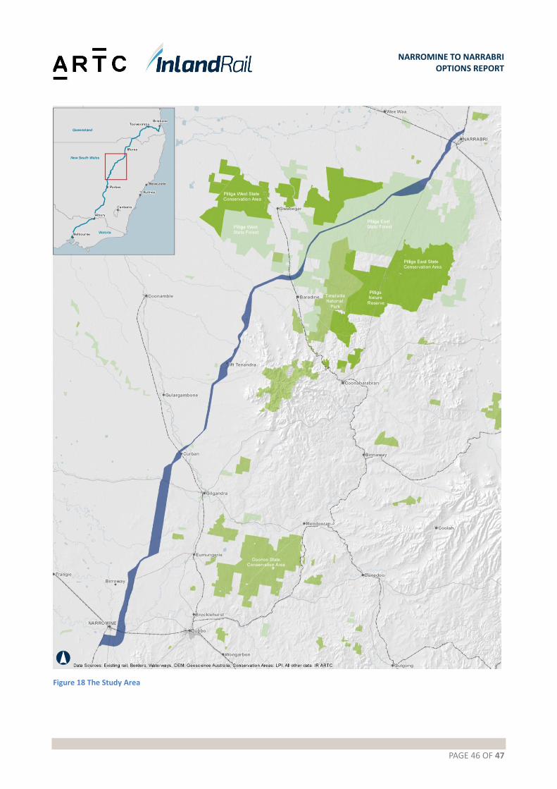
PAGE 46 OF 47
NARROMINE TO NARRABRI OPTIONS REPORT
Figure 18 The Study Area

PAGE 47 OF 47
NARROMINE TO NARRABRI OPTIONS REPORT
4.2. Next steps
The Study Area establishes the area to be investigated during the Phase 2 Feasibility Assessment, for identification of
the proposed corridor. These investigations will include a wide range of assessments including geotechnical
investigations, topographical surveys, socio-economic studies and environmental and cultural heritage studies. These
studies will also inform the preparation of an Environmental Impact Statement (EIS) during the Phase 2 Feasibility
Assessment, to be submitted to the NSW Government as part of the formal approval process. The steps in the
assessment and approval process are illustrated in Figure 19.
Figure 19 Process to assess State Significant Infrastructure in New South Wales