Embed Size (px)
Citation preview

Sax, Maze, Souleyrette, Hawkins, Carriquiry 1
TRB 2010 Annual Meeting
Optimum urban clear-zone distance 1
Christian R. Sax1, Thomas H. Maze2, Reginald R. Souleyrette3, Neal Hawkins4 and Alicia L. Carriquiry5 2
1Kimley-Horn & Associates (corresponding author) 3 801 Cherry Street, Unit 11, Fort Worth, TX 76102 4 Phone: (817) 335-6511 5 Fax: (817) 335-5070 6 E-mail: [email protected] 7 (former Iowa State University Graduate Student) 8 9 2 Iowa State University 10 Civil, Construction, and Environmental Engineering 11 Center for Transportation Research and Education 12 Institute for Transportation 13 (deceased) 14 15 3Iowa State University 16 Civil, Construction, and Environmental Engineering 17 Center for Transportation Research and Education 18 Institute for Transportation 19 2711 South Loop Dr., Suite 4700, Ames IA 50010 20 Phone: (515) 294-5453 21 Fax: (515) 294-0467 22 E-mail: [email protected] 23 24 4Iowa State University 25 Center for Transportation Research and Education 26 Institute for Transportation 27 2711 South Loop Dr., Suite 4700, Ames IA 50010 28 Phone: (515) 294-7733 29 Fax: (515) 294-0467 30 E-mail: [email protected] 31 32 5Iowa State University 33 Department of Statistics 34 102 Snedecor, Ames, IA 50014 35 Phone: (515) 294-8103 36 Fax: (515) 294-4040 37 E-mail: [email protected] 38 39 Revised Date: October 30, 2009 40 41 Number of words in text: 4,736 42 Number of Figures (8@250): 2,000 43 Number of Tables: (3@250): 750 44 Total word equivalent 7,486 45
46
TRB 2010 Annual Meeting CD-ROM Paper revised from original submittal.

Sax, Maze, Souleyrette, Hawkins, Carriquiry 2
TRB 2010 Annual Meeting
1
Abstract 2
In urban communities, there are often limited amounts of right-of-way available for establishing a setback 3 distance from the curb for fixed objects. Urban road designers must weigh the cost of purchasing 4 additional right-of-way for clear-zones against the risk of fixed object crashes. From 2004 to 2006, fixed 5 object crashes comprised fifteen percent of all fatal urban crashes and three percent of all crashes in the 6 state of Iowa. Many states use AASHTO recommendations as minimum clear-zone standards, while 7 others states have increased the required minimum clear-zone distance but little research exists to support 8 the specification of these minimums. This paper summarizes a study on the effects of the clear-zone on 9 safety performance of urban curbed streets. The study included synthesizing selected state practices and 10 investigated the benefits of a various clear-zone widths based on thirteen urban corridors in Iowa. The 11 results suggest that a four to five foot clear-zone could be effective in reducing 90 percent of urban fixed 12 object crashes and recommends that additional research be conducted to account for variations in speed, 13 traffic and other corridor characteristics. 14
Key Words: crashes – safety - fixed object offset –urban clear-zone – curbed streets 15
16
TRB 2010 Annual Meeting CD-ROM Paper revised from original submittal.

Sax, Maze, Souleyrette, Hawkins, Carriquiry 3
TRB 2010 Annual Meeting
Introduction 1
In urban communities, there are often limited amounts of right-of-way available to establish a clear run-2 out zone. On roadway projects, the clear-zone recommended by the administering jurisdiction is 3 sometimes not implemented because of the presence of established buildings, trees, or other fixed objects, 4 any of which may be too difficult or too costly to remove. These obstacles present hazards to drivers 5 when the fixed objects are located too close to the roadway to allow drivers to recover if they run off the 6 road. 7
In Iowa, fixed object collisions on urban curbed roads constitute approximately three percent of crashes, 8 statewide. While only six percent of urban crashes are fixed object crashes, these collisions result in 9 fifteen percent of urban fatalities Table 1 compares the number of total crashes, urban crashes, and urban 10 fixed object crashes in Iowa from 2004 to 2006. 11
Table 1. Iowa crashes, average annual crashes from 2004 to 2006 12
Fatal Major Injury
Minor Injury
Possible Injury
Property Damage Only
Total
Total Crashes 380 1,643 5,498 10,263 39,756 57,540Urban Crashes* 66 584 2,649 6,429 22,797 32,525Urban Fixed Object Crashes 10 51 186 357 1,240 1,844
% of all Crashes 3% 3% 3% 3% 3% 3%% of all Urban Crashes 15% 9% 7% 6% 5% 6% 13
*Urban crashes are those crashes that take place on curbed roads. 14
Fixed objects near the traveled roadway are clearly hazardous to errant vehicles. However, these same 15 objects may provide a protective barrier for pedestrians when a sidewalk is located behind the fixed 16 objects (such as street trees). Logically, fixed object crashes may be reduced when fixed objects are 17 located further back from the roadway edge. Few previous studies are available which address this 18 reduction (Turner and Barnett, 1989, is a notable exception) and none attempt to quantify it (19). Turner 19 and Barnett made helpful recommendations about how the design engineer can effectively 20 reduce the number of hazardous poles in the clear zone. Although their guidelines can be 21 followed and may result in a reduced number of crashes, they did not attempt to identify the 22 severity or the frequency of crashes that would be avoided, and hence did not identify the safety 23 benefits of following their guidance. Therefore, while design engineers can calculate the cost of 24 removing utility poles from the edge of the roadway, they have no measure of the benefits 25 resulting from the relocation expenditure. 26
The AASHTO Green Book, (1) recommends a minimum 18 inch urban fixed object setback, although 27 many agencies provide design guidance that specifies greater distances. When designing urban roadway 28 reconstruction or improvement projects, the engineer should weigh the costs of clearing aboveground 29 utilities, buildings, walls, and other fixed objects against the benefits of providing additional space for 30 errant vehicles to recover. Unlike many rural areas, the context of an urban corridor is often unique, 31 which complicates the evaluation of the tradeoff between construction and ROW acquisition costs and 32 potential highway safety savings. 33
TRB 2010 Annual Meeting CD-ROM Paper revised from original submittal.

Sax, Maze, Souleyrette, Hawkins, Carriquiry 4
TRB 2010 Annual Meeting
In several states, the minimum recommended standard for lateral offset from the curb is ten feet. In Iowa, 1 state maintained urban roads designed or redesigned with less than 10 ft of clearance require a “design 2 exception” report . To support such an exception, economic analysis is preferred. However, while the 3 costs of providing additional clear-zone (removing fixed objects) can be estimated, safety benefits of 4 protecting, relocating, or removing fixed objects to a certain distance are not so easily quantified. In some 5 cases, providing wider clear-zones may be contraindicated by traffic calming treatments and context-6 sensitive design considerations. 7
The relationship between urban clear zone and safety costs has not been quantified by previous research. 8 The purpose of this research reported in this paper was to investigate this relationship. Following a brief 9 summary of surveyed state practices, an analysis of the relationship between fixed object offset and safety 10 performance is presented. Several measures of urban clear zone fixed object presence were developed 11 and used in the analysis, including minimum, average, 15th percentile distance of setback and fixed object 12 density. The effects of intersection influence and speed limit are also discussed. An example economic 13 analysis is presented to establish an optimal setback distance based on Iowa crash data. “Cumulative 14 percent” graphs are used to identify the lateral distance within which most urban fixed object crashes and 15 their associated costs occur. To isolate the effect of urban clear zone from other variables, and to identify 16 important causal variables, a mixed linear safety performance function was estimated and is summarized. 17 Finally, conclusions and limitations of the research are presented. 18
State Synthesis 19
To evaluate the administration of clear-zones within various states, a survey was sent to 20 state agencies. 20 The survey included six questions regarding federal aid projects and six questions regarding state aid 21 projects. Respondents were also asked to provide additional contacts at the local level who could be 22 interviewed about design exception practices. Results revealed that many standards are currently in use, 23 ranging from minimum clearance of 1 to 35 ft (2-17). 24
The State of Iowa’s clear-zone standards require a generous amount of setback in comparison to many of 25 the states surveyed for this project. Iowa’s desirable setback distance is 12 ft, and the minimum setback 26 requirement is 10 ft (6). Eight of the states surveyed had desirable setback requirements similar to Iowa’s 27 minimum setback requirement of ten feet. Of those states, three had a minimum requirement of only 1.5 28 feet from the face of curb. A more complete description of the survey methodology and results is 29 included in the project report (20). 30
Data Collection 31
To conduct the evaluation of the significance of the clear-zone, a project database was created. The 32 project database included data from eleven corridors in the Des Moines metropolitan area and two 33 corridors in the Waterloo/Cedar Falls area with speed limits ranging from 30 to 40 mph, volumes from 34 4,600 to 24,200 ADT, and 2 to 5 lanes (see Table 2). At each of the corridor sites, the lateral offset 35 distance to each fixed object in the right-of-way was measured from the face of the curb using a laser 36 distance meter. The location of each object was also collected using a global positioning system (GPS) 37 device. 38
TRB 2010 Annual Meeting CD-ROM Paper revised from original submittal.

Sax, Maze, Souleyrette, Hawkins, Carriquiry 5
TRB 2010 Annual Meeting
Table 2. Corridor Characteristics 1
Corridor City
Basic No. of Lanes
Speed Limit
Avg. AADT
Williston Ave Waterloo, IA 2 30 4660 E 4th St Waterloo, IA 2 30 5900 Hubbell Ave Des Moines, IA 4 40 10450 Beaver Ave Des Moines, IA 2-3 30 12350 SW 9th St Des Moines, IA 3-4 35 12840 Euclid Ave Des Moines, IA 4 35 14071 2nd Ave Des Moines, IA 4 30 14760 E University Ave #1 Des Moines, IA 4 35 14900 University Ave Des Moines, IA 4 35 15033 NE 14th St Des Moines, IA 4 35 16874 E University #2 Des Moines, IA 4 35 19850 Army Post Rd Des Moines, IA 4-5 35 21675 Merle Hay Road Des Moines, IA 4-5 35 24200
2
Fixed object crashes from the years 2001 to 2006 were extracted from the Iowa DOT’s crash database. 3 The Iowa DOT’s geographic information management system (GIMS) was used to obtain a data set of 4 centerlines for public roads, to represent the corridors and geographically select the crashes of interest 5 (18). Due to the precision of the crash locations, some crashes occurring on intersecting streets, up to 150 6 feet away, may have been selected into the data base. The fixed object crashes used in this research were 7 each documented in the crash database with at least one harmful event including a collision with a fixed 8 object. Fixed objects studied in this research include a bridge/bridge rail/overpasses, underpass/structure 9 supports, culverts, ditches/embankments, curbs/islands/raised medians, guardrails, concrete barriers, trees, 10 poles, sign posts, mailboxes, impact attenuators, and other fixed objects (although clearly not all of these 11 are common in urban corridors). A GIS environment was used to analyze the relationship between the 12 presence of fixed objects and safety performance at three levels of spatial aggregation. 13
Analysis 14
Descriptive analyses were conducted to better understand the relationship of clear-zone distance to safety 15 performance. Three levels of spatial aggregation (segments, blocks, and 15 m sections) were used to 16 analyze the data for the 13 corridors. Segments were considered as multi-block parts of corridors with 17 similar road and traffic attributes. 18
Three measures of urban clear zone are proposed in this study. These include: minimum setback, average 19 setback, and 15th percentile setback (the offset distance that 85 percent of fixed objects are behind). The 20 effects of several fixed object descriptors were studied, and include: intersection area of influence, 21 violations to the area of influence, speed limit, and fixed object density. Three additional analyses were 22
TRB 2010 Annual Meeting CD-ROM Paper revised from original submittal.

Sax, Maze, Souleyrette, Hawkins, Carriquiry 6
TRB 2010 Annual Meeting
conducted to try and identify the most cost effective urban clear zone or setback distances: cumulative 1 percent crashes, cumulative percent cost, and incremental benefit. The three measures of clear zone 2 provided were considered: minimum setback, average setback, and 15th percentile setback. These 3 measurements are used as a proxy for involved fixed objects, as setback distances of objects that have 4 actually been struck in previous crashes are not known. 5
While all three levels of spatial aggregation were used in each analysis, only the ones demonstrating the 6 clearest relationships are presented in this paper. Figures 1 through Figure 3 illustrate the relationship 7 between the fixed object setback and the average number of fixed object crashes per year. The trend lines 8 in each of these figures indicate that the average number of fixed object crashes decreases as the setback 9 distance increases. Minimum setback demonstrates the most consistent trend (in statistical terms, the 10 least heteroskedasticity or unequal variability of the observations across the range of the predictor 11 variable). 12
Minimum Setback 13
To determine the effect of the clear-zone the minimum setback was first evaluated. The minimum setback 14 is defined as the setback distance of the object that is closest to the face of the curb over the length of the 15 section. In the segment based analysis, there was a clear relationship between the minimum setback and 16 the average number of fixed object crashes. Figure 1 illustrates this relationship. This figure shows that 17 as the minimum setback is increased, the average number of fixed object crashes per year decreases. 18
19 Figure 1. Safety impact resulting from minimum setback 20
21
90% Confidence boundary
TRB 2010 Annual Meeting CD-ROM Paper revised from original submittal.

Sax, Maze, Souleyrette, Hawkins, Carriquiry 7
TRB 2010 Annual Meeting
Average Setback 1
The average setback was next evaluated. The average setback is defined as the average distance between 2 the face of the curb and all the fixed objects in the segment. In the segment based analysis, average 3 number of fixed object crashes demonstrated somewhat of a decreasing relationship to the average 4 setback (see Figure 2). 5
6 Figure 2. Safety impact resulting from average setback 7
15th Percentile Setback 8
The third measurement of the clear-zone, 15th percentile distance, was used to determine if the crash 9 relationship could be better understood when the nearest few objects were ignored. The 15th percentile 10 setback used in this analysis is the offset distance that 85 percent of fixed objects are behind. For 11 example, if the 15th percentile setback is 6 ft for a segment with 100 fixed objects, 85 of those fixed 12 objects would have an offset greater than 6 ft, and 15 of those fixed objects would have an offset less than 13 six feet. Figure 3 shows a similar decreasing relationship between the average number of fixed object 14 crashes per year and the 15th percentile setback.. 15
Intersection Area of Influence 16
To determine if there was a change in the number of fixed object crashes near an intersection fixed object 17 crashes occurring near intersections were compared with those occurring on mid blocks. The intersection 18 area of influence in this analysis is defined as the area that is within 150 ft of the center of the 19 intersection. This is the distance used by Iowa DOT safety engineers to spatially identify intersection 20 related crashes, and is the area where most intersection-related maneuvers (speed changes) take place. It 21 is also a distance beyond which some of the older crash data in the database may not be precisely located. 22 Clearly, this distance is affected by traffic volumes, capacities and speeds, but the inclusion of those 23 variables were beyond the resources of the project. The TRB Access Management Manual also provides 24
90% Confidence boundary
TRB 2010 Annual Meeting CD-ROM Paper revised from original submittal.

Sax, Maze, Souleyrette, Hawkins, Carriquiry 8
TRB 2010 Annual Meeting
an alternative approach (21). Using the ten-feet definition, proximity to intersection was found to be a 1 significant factor in the number of fixed object crashes. 2
3 Figure 3. Safety impact resulting from 15th percentile setback 4
Sections within an intersection’s area of influence have a greater average number of fixed object crashes 5 per year (0.0115 fixed object crashes per year) than other sections (0.0053 fixed object crashes per year). 6 This demonstrates that intersections have an impact on the number of fixed object crashes, presumably 7 due to reduced setbacks permitted for signing, signal mast poles and related roadside furniture. In this 8 study the intersection area of influence was found to contain 83 percent more fixed objects than mid block 9 sections. As there are nearly twice as many intersection than mid block fixed object crashes, this finding 10 is as expected. 11
Violation of Area of Influence 12
In order to find out if number of violations of clear zone minimums has any impact of the number of fixed 13 object crashes, analyses were conducted for a range of offset distances and spatial aggregations. For this 14 purpose, violations were defined as the number of fixed objects with setback less than a minimum 15 distance. For example, a section may have objects located at three different distances: four objects at two 16 feet, three objects at five feet, and two objects at eight feet. At a minimum area of influence of two feet, 17 this hypothetical section would have no violations. For an area of influence of five feet, it would have 18 four violations. Figure 4 displays the relationship between average number of fixed object crashes per 19 year and number of violations of a five-foot clear zone area. The increasing and nonlinear relationship 20 shown is similar to most other offset distances. 21
22
90% Confidence boundary
TRB 2010 Annual Meeting CD-ROM Paper revised from original submittal.

Sax, Maze, Souleyrette, Hawkins, Carriquiry 9
TRB 2010 Annual Meeting
1 Figure 4. Safety and number of five-foot clear-zone violations 2
Speed Limit 3
Each of the three levels of spatial aggregation (segments, blocks, and 15 m sections) were evaluated to 4 determine whether the number of fixed object crashes was correlated to the speed limit. While a weak 5 positive relationship was found to exist between speed limit, and the number of fixed object crashes at 6 block and 15 meter section aggregation, no meaningful relationship was found at the segment level. 7 There were just too few segment-level observations, especially at the 40 mph speed limit. The effect of 8 speed was also considered as a model variable (see below section on Mixed Linear Model Analysis). 9
Fixed Object Density 10
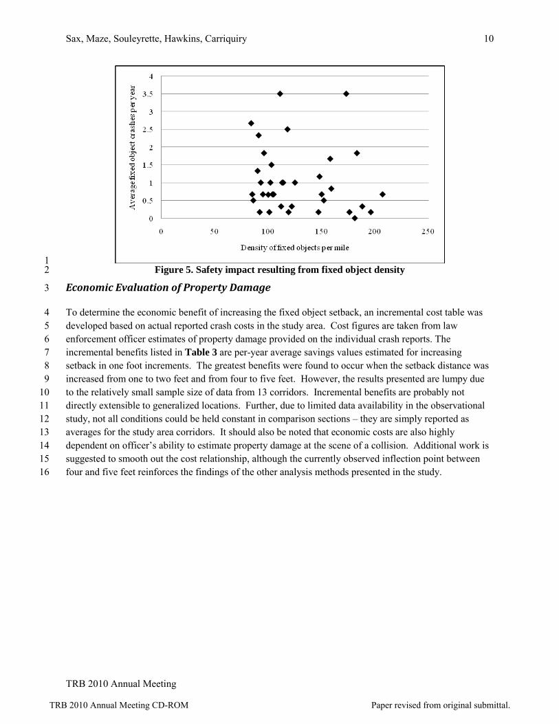
The effect of density of fixed objects along the roadside on the number of fixed object crashes was 11 analyzed. Fixed object density was defined as the number of fixed objects per linear mile, as measured 12 along the centerline of the roadway. All fixed object setback distances were used. The maximum 13 distance to a fixed object was 30 feet and objects beyond 30 feet lateral offset (from back of curb) were 14 not measured or included. None of the three spatial aggregation levels of analysis showed any consistent 15 relationship between fixed object density and the number of fixed object crashes (see Figure 5). 16
TRB 2010 Annual Meeting CD-ROM Paper revised from original submittal.
Sax, Maze, Souleyrette, Hawkins, Carriquiry 10
TRB 2010 Annual Meeting
1 Figure 5. Safety impact resulting from fixed object density 2
Economic Evaluation of Property Damage 3
To determine the economic benefit of increasing the fixed object setback, an incremental cost table was 4 developed based on actual reported crash costs in the study area. Cost figures are taken from law 5 enforcement officer estimates of property damage provided on the individual crash reports. The 6 incremental benefits listed in Table 3 are per-year average savings values estimated for increasing 7 setback in one foot increments. The greatest benefits were found to occur when the setback distance was 8 increased from one to two feet and from four to five feet. However, the results presented are lumpy due 9 to the relatively small sample size of data from 13 corridors. Incremental benefits are probably not 10 directly extensible to generalized locations. Further, due to limited data availability in the observational 11 study, not all conditions could be held constant in comparison sections – they are simply reported as 12 averages for the study area corridors. It should also be noted that economic costs are also highly 13 dependent on officer’s ability to estimate property damage at the scene of a collision. Additional work is 14 suggested to smooth out the cost relationship, although the currently observed inflection point between 15 four and five feet reinforces the findings of the other analysis methods presented in the study. 16
TRB 2010 Annual Meeting CD-ROM Paper revised from original submittal.

Sax, Maze, Souleyrette, Hawkins, Carriquiry 11
TRB 2010 Annual Meeting
Table 3. Incremental benefit in segment analysis 1
2 $40,1233 $10,1344 $3,7725 $35,3396 $8,35078 $4,1299
1011 $1,250
Setback Average Incremental Benefit from next lowest setback
2 Cumulative Percent of Crashes and their Costs 3
A “cumulative percent” graph was prepared to determine the minimum setback beyond which safety (as 4 measures by fixed object crashes) improves only marginally. Inspection of the graphs indicated that this 5 distance is somewhere around five feet. That is, 90 percent of fixed object crashes in the study group 6 occurred on segments with 5 feet or less of clear-zone when cumulative fraction of fixed object crashes 7 are plotted against “minimum setback.” Figure 6 demonstrates that widening the clear-zone beyond five 8 feet will likely have only a marginal safety benefit. Further, there is a steep, nearly linear relationship 9 between incidence of fixed object crashes and minimum setback for segments with clear-zones of less 10 than two feet. 11
12 Figure 6. Cumulative percent of fixed object crashes by minimum setback (analysis by segment) 13 14
A similar analysis performed for cumulative crash costs indicates that 90 percent of fixed object crash 15 costs are incurred by segments with less than four feet of clear-zone. 16
TRB 2010 Annual Meeting CD-ROM Paper revised from original submittal.

Sax, Maze, Souleyrette, Hawkins, Carriquiry 12
TRB 2010 Annual Meeting
Crash Model 1
To isolate the effect of urban clear zone from other variables, a mixed linear safety performance function 2 was estimated for the study segment data. Minimum setback was chosen as the independent measure of 3 urban clear zone distance. In this model, the square root of the average number of crashes in a segment 4 was specified as the response variable and the explanatory variables were specified as the following: 5 minimum setback, Average Annual Daily Traffic (AADT), number of intersections, segment length, 6 speed (as a binary variable: 30 or 35+), density, Area of Influence (AOI) of 2 ft, (AOI) of 5 ft, and 7 corridor (as a random variable). Estimation of model parameters was carried out using the method of 8 maximum likelihood, assuming that the square-root transformed crash frequencies were normally 9 distributed (we verified that the assumption of normality held by inspecting histograms). The two 10 components of variance – within corridor and between corridor – were estimated using the method of 11 restricted maximum likelihood. All calculations were performed using SAS Version 9.1. 12
Model Results 13
Upon investigating the results obtained from fitting this model, it was decided that speed should be 14 eliminated because not all speeds are represented in all corridors. Further, we decided to include corridor 15 as a fixed classification effect rather than as a random effect because the intra-class correlation (the 16 correlation between observations in the same corridor) was negligible. The revised model was fitted and 17 we found that: 18
• As the minimum setback increases, the average number of crashes decreases (p-value 0.075, 19 weakly significant). 20
• As the number of intersections in a corridor increases, the average number of crashes increases 21 (p-value 0.0045, highly significant). 22
• As the number of violations at two feet increases, the average number of crashes increases (p-23 value 0.021, significant). 24 25
Other effects in the model were not significant. In particular, results indicated that: 26 • As segment length increases, the number of crashes decreases, but not significantly so (p-value 27
0.21). 28 • As the density of fixed objects increases, the number of crashes decreases, but again not 29
significantly so (p-value 0.42). 30 • As the number of violations at five feet increases, the number of crashes appears to decrease but 31
the decrease is not statistically significant (p-value 0.46). 32 33 Finally, as AADT increases, the number of crashes decreases and the effect is highly significant (p-value 34 0.006). The direction of this effect is "backwards", or at least not intuitive at first glance. The un-35 anticipated direction of this association may be due to missing confounders such as perhaps intersection 36 controls or signalization present in high traffic segments and not present elsewhere. 37
The fit of the model was investigated by looking at how well the model predicts the average number of 38 crashes at each segment and whether the assumptions behind the model (e.g., independent error terms, 39
TRB 2010 Annual Meeting CD-ROM Paper revised from original submittal.

Sax, Maze, Souleyrette, Hawkins, Carriquiry 13
TRB 2010 Annual Meeting
random residuals distributed symmetrically around zero, no outliers) are met. Figure 7 shows that the 1 predicted number of crashes is reasonable given what we have observed at each segment. 2
3 Figure 7. Predicted versus Observed 4
5
Figure 8 shows the standardized residuals plotted against the predicted values. The horizontal reference 6 line is at 0. Residuals are all between -3 and 3, they are nicely distributed around zero and they show no 7 obvious tendencies. 8
TRB 2010 Annual Meeting CD-ROM Paper revised from original submittal.

Sax, Maze, Souleyrette, Hawkins, Carriquiry 14
TRB 2010 Annual Meeting
1 Figure 8. Standardized Residuals versus predicted average number of crashes 2
3
Modeling Injury Severity and Crash Costs 4
The study also attempted to model injury. There was only one fatal crash on any of the segments during 5 the study period. On four segments, only one major injury crash was reported over six years. The 6 maximum frequency of major injury crashes in the dataset was four. Fatal and major injury crashes were 7 therefore combined for analysis. Because there were very few frequencies above one crash, the responses 8 were dichotomized so that the new binary response variable took on the value zero if there were no fatal 9 or major injury crashes observed at a site and one if there was at least one fatal or one major injury crash 10 at the site during the study period. 11
A logistic regression model was fitted to the binary response variable, with the same set of independent 12 variables that was included in the model for (transformed) average total crashes. It was found that the 13 only factors that appear to be associated with the probability of observing a fatal or a major injury crash 14 are segment length (p-value = 0.08) and number of intersections (p-value = 0.02). 15
While there were more minor injury crashes in the dataset, there were only five sites at which the 16 frequency of minor injury crashes was three or larger. Frequencies of three and higher were then 17 aggregated into a single category, so that five sites were classified as having at least three minor injury 18 crashes during the study period. A regression model was fitted to the multinomial response variable (with 19 four categories) again including the same set of explanatory variables in the model. No significant 20 associations between the probabilities of the different levels of the multinomial variable and the 21 explanatory variables were found, with one exception. As might have been anticipated, segment length 22
TRB 2010 Annual Meeting CD-ROM Paper revised from original submittal.

Sax, Maze, Souleyrette, Hawkins, Carriquiry 15
TRB 2010 Annual Meeting
was weakly (p-value = 0.09) associated with the probability of the higher frequencies of minor injury 1 crashes. 2
Finally, the average (per year) property damage estimated at each site was taken into account. Because 3 property damage was not distributed symmetrically, a square root transformation was used to improve the 4 distributional shape of the variable. A standard linear regression model was fitted to this variable, with 5 the same set of explanatory variables that we used in the models for the other types of crashes. It was 6 found that the number of intersections, the number of violations of a two-foot clear-zone and corridor 7 were strongly associated with the average cost of property damage. Average cost of property damage 8 increased when the number of intersections in a segment increased (p-value = 0.044) and when the 9 number of violations of a two-foot clear-zone increased (p-value = 0.045). Differences between corridors 10 were also observed. 11
Conclusions 12
The synthesis of practice developed in the first phase of this research indicates that the 20 state agencies 13 surveyed provide and follow an array of urban clear-zone guidance. Some states followed the minimum 14 operational setback recommended by AASHTO, while other states have created their own guidance, 15 which is currently being followed by design engineers. Some states went as far as to ignore the presence 16 of the curb and to require the use of the AASHTO-recommended setback distances for non-curbed roads. 17
The descriptive analysis and model resulting from this study add to the earlier work by Turner and 18 Barnett (19), which is believed by to have been the impetus for the 10 ft minimum setback requirement in 19 Iowa and other states. The findings of this research are as follows: 20
• An increase in the minimum setback distance results in a decrease in the average number or fixed 21 object crashes. 22
• As the number of intersections in a segment increases the average number of fixed object crashes 23 also increases. This is not a surprising result. 24
• Within 150 ft of an intersection, roadways were found to have a statistically higher number of 25 fixed object crashes at the 90 percent confidence interval. This is again not surprising if it is 26 plausible to assume that some of these crashes may be the result of a primary collision between 27 two vehicles at the intersection or higher driver workload in the vicinity. 28
• A weak relationship was found between the number of fixed object crashes and the posted speed 29 limit on the roadway. 30
• There is no statistically significant or apparent relationship between the density of fixed objects 31 and the number of fixed object crashes. 32
• If reducing the number of fixed object crashes is a primary goal, a five foot clear-zone may be an 33 efficient clear zone, as 90 percent of study area crashes occurred on segments with less than five 34 feet of setback. 35
• Similarly, if reducing the cost of fixed object crashes is a primary goal, a four foot clear-zone 36 may be an efficient clear zone, as 90 percent of study area crash costs were incurred on segments 37 with less than four feet of setback. 38
TRB 2010 Annual Meeting CD-ROM Paper revised from original submittal.

Sax, Maze, Souleyrette, Hawkins, Carriquiry 16
TRB 2010 Annual Meeting
• Incremental cost analysis indicates that the greatest marginal benefits accrue when setback 1 distance is increased from one to two feet and from four to five feet from the face of curb. 2
What is the optimal fixed object setback on urban curbed roads? The research reported in this paper 3 suggests a natural break in the fixed object crash frequency and costs at a setback distances around four to 4 five feet. From the study data, there appears to be very little benefit of increasing the fixed object setback 5 above five feet from the face of the curb. For existing corridors with fixed objects less than two feet from 6 the face of curb, and where ROW is not available or it is too expensive to obtain four or five feet of clear-7 zone, an increase to two feet could have significant economic benefits in terms of reduced crash costs. 8
Limitations 9
The scope of this study was limited to the evaluation of thirteen corridors in Iowa. Obviously, more 10 conclusive results may be attained by increasing the number of observations, and it is hoped that 11 additional work in other areas may be added to these results and contribute the professional knowledge of 12 the relationship between urban clear zone distance and safety. In this study there were very few 13 observations on roadways with a speed limit of 40 mph, which contributed to lack of reliable findings in 14 the speed limit analysis. Quantification of additional corridor characteristics (e.g., turning percentages, 15 access point density, vehicle mix and winter weather conditions) may also provide additional insight into 16 the crash behavior on urban curbed roads. Curb type may also be a factor in influencing actual events. 17 Pedestrian safety afforded by fixed objects located between the roadway and sidewalk was not studied, let 18 alone liveability measures (walkability?) of an urban area. 19
The coding capabilities of the methods used for this project were also limited. Buildings and fences were 20 represented during data analysis by two points at either end of the object’s area, not by a line that 21 represents the edge of the object. Because of this limitation, the effects of buildings and fences may have 22 been underrepresented during the analysis. 23
Finally, statistical manipulation was necessary to evaluate serious crashes, and for these types of crashes, 24 this study did not have enough data to produce a clearly extensible model. The findings of this study are 25 therefore limited to “all” or combined crashes. Additional work is needed to better understand the 26 relationship between urban clear zones and serious crashes, which are increasingly and deservedly 27 gaining the focused attention of the highway safety community. 28
Acknowledgements 29
This study was funded by the Iowa Highway Research Board. Opinions expressed are those of the 30 authors and do not necessarily reflect the policies of the Iowa Department of Transportation or local units 31 of Iowa Government represented by the Board. The authors wish to thank Neal Hawkins of the Center 32 for Transportation Research at Iowa State University for his advice on data collection and general 33 guidance. 34
TRB 2010 Annual Meeting CD-ROM Paper revised from original submittal.

Sax, Maze, Souleyrette, Hawkins, Carriquiry 17
TRB 2010 Annual Meeting
References 1
1. AASHTO. 2004. A Policy on Geometric Design of Highways and Streets (The Green Book). 2 Washington, DC: American Association of State Highway and Transportation Officials. 3
2. Caltrans. 2008. Highway Design Manual. Sacramento, CA: California Department of 4 Transportation. 5
3. Caltrans. 2008. Design Information Bulletin 79-03. Sacramento, CA: California Department of 6 Transportation. 7
4. IDOT. 2005. Bureau of Local Roads and Streets Manual. Springfield, IL: Illinois Department 8 of Transportation. 9
5. INDOT. 2005. Indiana Design Manual. Indianapolis, IN: Indiana Department of 10 Transportation. 11
6. Iowa DOT. 2008. Design Manual. Ames, IA: Iowa Department of Transportation, Office of 12 Design. 13
7. KDOT. 2003. Bureau of Local Projects Development Manual for Non-National Highway 14 System Local Government Road and Street Projects. Topeka, KS: Kansas Department of 15 Transportation. 16
8. MDOT. 2003. Road Design Manual. Lansing, MI: Michigan Department of Transportation. 17
9. Mn/DOT. 2008. Road Design Manual. Minneapolis, MN: Minnesota Department of 18 Transportation. 19
10. Mn/DOT. 2008. Minnesota Administrative Rules. Section 8820. Minneapolis, MN: Minnesota 20 Department of Transportation. 21
11. NCDOT. 2008. Design Guidelines. Raleigh, NC: North Carolina Department of Transportation. 22
12. Ohio DOT. 2006. Location and Design Manual. Columbus, OH: Ohio Department of 23 Transportation. 24
13. Oregon DOT. 2003. Highway Design Manual. Salem, OR: Oregon Department of 25 Transportation. 26
14. SDDOT. 2007. Road Design Manual. Pierre, SD: South Dakota Department of Transportation. 27
15. TXDOT. 2006. Roadway Design Manual. Austin, TX: Texas Department of Transportation. 28
16. WisDOT. 2004. Facilities Development Manual. Madison, WI: Wisconsin Department of 29 Transportation. 30
TRB 2010 Annual Meeting CD-ROM Paper revised from original submittal.

Sax, Maze, Souleyrette, Hawkins, Carriquiry 18
TRB 2010 Annual Meeting
17. WSDOT. 2007. Design Manual. Olympia, WA: Washington State Department of 1 Transportation. 2
18. Iowa DOT. 2008. GIS and Spatial Technologies. http://gis.iowadot.gov/default.htm. Accessed 3 Aug. 26, 2008. 4
19. Turner, D. S. and T. Barnett. 1989. Case Study: Poles in the Urban Clear Zone. Transportation 5 Research Record 1233: 155–163. 6
20. Maze, Thomas H., Christian Sax, Neal Hawkins. 2008. Clear Zone – A Synthesis of Practice and 7 an Evaluation of the Benefits of Meeting the 10 ft Clear Zone Goal on Urban Streets. IHRB 8 Project TR-560, MTC Project 2006-05, CTRE Project 06-261. Center for Transportation 9 Research and Education, Iowa State University. Available at 10 http://www.ctre.iastate.edu/reports/clear_zone_report.pdf, accessed October 29. 2009. 11
21. Transportation Research Board of the National Academy of Sciences. 2003. Access Management 12 Manual. Available from http://books.trbbookstore.org. Accessed October 30, 2009. 13
TRB 2010 Annual Meeting CD-ROM Paper revised from original submittal.