Embed Size (px)
Citation preview

Opportunity.Collaboration.Vision.
Opportunity Collaboration Vision The challenge of sea level rise provides opportunity to transform Norfolk into
a resilient waterfront community
Collective brainpower drives adaptation solutions and new ways of thinking
Norfolk is THE coastal community of the future
VISION2100

Designing the Coastal Community of the Future
By working with residents,
the City of Norfolk is
building a long-term
strategy to address the
flooding challenges due to
sea level rise. How we use
land today helps ensure
the opportunity that
Norfolk will be a dynamic,
water-based community
into the next century.
Enhancing Economic Engines
Red areas are home to key economic assets that are essential to the city’s future. Land use policy and infrastructure investments to protect these areas should encourage additional dense mixed-use development in these areas.
Designing New Urban Centers
Green areas are at low-risk of coastal flooding and have great potential for high density, mixed-use and mixed income development. These areas are prime opportunities for creating walkable, bikeable, transit-rich communities. The City should encourage transformational development in these areas.

Establishing Neighborhoods of the Future
Purple areas are established neighborhoods at less-risk of coastal flooding. The City should make investments that improve connections between these areas and key economic assets to ensure that these neighborhoods continue to thrive.
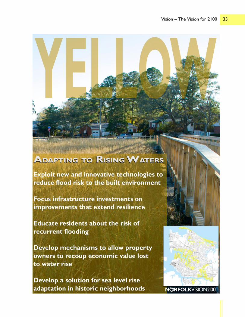
Adapting to Rising Waters
Yellow areas are established neighborhoods that experience more frequent flooding. The City should explore new and innovative technologies to help reduce flood risk and focus on investments on extending the resilience of key infrastructure.

CITYWIDE – Designing the coastal community of the future
Action 1: Focus major infrastructure investments in the most resilient areas
Action 2: Improve transportation connections
Action 3: Be a model for responsibly addressing resilience
Action 4: Create tools and incentives to develop a more resilient housing market
Action 5: Seize the economic opportunities of emerging resilience-based industries
RED AREAS – Enhancing economic engines
Action 1: Expand the flood protection system
Action 2: Build a comprehensive, 24-hour transportation network
Action 3: Transform less-intense uses into a denser, mixed-use pattern
Action 4: Diversify the housing options available to residents
Action 5: Strengthen and increase economic diversity
YELLOW AREAS – Adapting to rising waters
Action 1: Exploit new and innovative technologies to reduce flood risk to the built environment
Action 2: Focus infrastructure investments on improvements that extend resilience
Action 3: Educate residents about the risk of recurrent flooding
Action 4: Develop mechanisms to allow property owners to recoup economic value lost to water rise
Action 5: Develop a solution for sea level rise adaptation in historic neighborhoods
GREEN AREAS – Designing new urban centers
Action 1: Outline a transit-centric land use and infrastructure pattern to support new urban centers
Action 2: Build the infrastructure necessary to support new urban centers
Action 3: Make realizing the long-term vision for these areas the central factor in all development decisions
Action 4: Capitalize on the opportunity to create a model urban form of development in these areas
PURPLE AREAS – Establishing neighborhoods of the future
Action 1: Improve connections to the city’s key assets
Action 2: Prioritize infrastructure investments that enhance neighborhood attractiveness
Action 3: Maintain housing affordability while improving economic value
Action 4: Redevelop underperforming commercial and multifamily residential properties
action items:

i Acknowledgements and Contents
This document provides a complete accounting of the Vision 2100 planning effort, which resulted from the combined efforts of many members of the City of Norfolk staff, elected and appointed officials, and interested residents and community groups. Among them include staff from the Departments of City Planning, Communications and Technology, and Neighborhood Development, and from the Resilience Office and the City Manager’s Office; members of the Norfolk City Council and Norfolk City Planning Commission; and more than 500 participants from the general public. Without the collaboration of all of these individuals, this vision would not have been possible. Additionally, none of this work would have been possible without the assistance and inspiration of the Rockefeller Foundation.
ii Acknowledgements and Contents
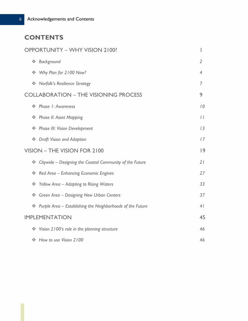
CONTENTS
OPPORTUNITY – WHY VISION 2100? 1
Background 2
Why Plan for 2100 Now? 4
Norfolk’s Resilience Strategy 7
COLLABORATION – THE VISIONING PROCESS 9
Phase 1: Awareness 10
Phase II: Asset Mapping 11
Phase III: Vision Development 13
Draft Vision and Adoption 17
VISION – THE VISION FOR 2100 19
Citywide – Designing the Coastal Community of the Future 21
Red Area – Enhancing Economic Engines 27
Yellow Area – Adapting to Rising Waters 33
Green Area – Designing New Urban Centers 37
Purple Area – Establishing the Neighborhoods of the Future 41
IMPLEMENTATION 45
Vision 2100’s role in the planning structure 46
How to use Vision 2100 46

1 Opportunity – Why Vision 2100?
Opportunity.
VISION2100

2 Opportunity – Why Vision 2100?
OPPORTUNITY – WHY VISION 2100? Norfolk’s comprehensive plan, plaNorfolk2030, details the City’s vision and provides city leaders with guidance across a full range of topics, ranging from transportation and economic development to historic preservation and environmental sustainability. However, its 20-year timeframe, combined with the fact that the City is 97% developed, limits plaNorfolk2030’s potential for inspiring bold change. Indeed, the plan’s vision statement focuses on the steps needed to preserve and maintain the elements that make Norfolk a great city today. Given the growing challenges of sea level rise, aging infrastructure, population growth, and an uncertain regional and global economy, a vision focused on preserving the City as it is today does not provide the broad guidance that will be needed to both weather and meet the challenges of tomorrow. Vision 2100 seeks to fill that gap.
BACKGROUND In 2013, the City of Norfolk was selected by the Rockefeller Foundation to be among the 33 global cities in the first cohort of the 100 Resilient Cities (100RC) network. This high honor recognized the City’s longstanding leadership in addressing the potential impacts of climate change – sea level rise in particular – in the coastal environment. Membership in the 100RC network enables city leaders to access the enormous resources of the Rockefeller Foundation as they work to develop a concrete strategy for guiding the City through the oncoming challenges. Accessing those resources led directly to the initiation of the Vision 2100 process.
The initial concept for Vision 2100 resulted from a 100RC conference convened specifically to discuss ways to incorporate resilience into the comprehensive plan and the zoning ordinance. Norfolk’s planning and resilience staff had become mired in a singular challenge – faced with far

3 Opportunity – Why Vision 2100?
too limited resources to harden all of its 144 miles of coastline against the threat of sea level rise, how could the City determine which of its many stable, well-kept coastal neighbor-hoods were to be “protected” and which the City would “retreat” from? City leaders had begun to view the solution as only including those two options. The conference’s participants, presented with this dilemma, chose not to provide an answer.
Instead, the participants suggested that Norfolk was not facing a dilemma at all, it was facing an opportunity – an opportunity to reimagine the City for the 22nd Century. They noted that while some areas of the City were at risk, many others, due to their elevation and the existing flood control infrastructure, were not. They further noted that many of the City’s higher-ground areas are developed at less-than-ideal densities and with less-than-ideal uses, covered with sprawling parking lots and underutilized retail and warehouse buildings. It was suggested that while a strategy was needed for maintaining the at-risk areas, a concurrent strategy was also needed for re-imagining – even intensifying – the higher ground.
Norfolk’s staff returned to the City with a new challenge – creating a vision for its long-term future that looked at the entire City, not just those areas at risk due to sea level rise, but also those that could bear the burden of redevelopment and all of the areas in between. They were challenged with not only identifying how and where shoreline protection strategies could to be employed but also with identifying how and where the best elements of the City – the things that make Norfolk great – could be replicated on higher ground. Thus, Vision 2100 was born.

4 Opportunity – Why Vision 2100?
WHY PLAN FOR 2100 NOW? Being more than 80 years in the future – far further out than the typical 20-30 year land use planning horizon – 2100 is hard for today’s Norfolk residents to imagine. Why look so far into the future? There are three reasons for doing so:
1. Norfolk’s world is changing. The prospect of sea level rise is a major consideration but so are the rapidly-changing global economy and the ever-evolving world political and military situations.
2. Norfolk’s population is growing and should continue to do so through 2100 and beyond.
3. Norfolk’s present-day infrastructure is aging and the 50- to 100-year infrastructure investments needed to respond to the changing world and support a growing population need to be well planned for both today and tomorrow.
Vision 2100 addresses each of these interrelated issues by providing a framework to guide decision making in the future.
The Changing World. Sea level rise projections are still in their infancy. While it is understood that the relative sea levels along Norfolk’s coastline are rising – due to both global water rise and local land subsidence – the rate and extent of the rise remains uncertain.
Sea level projections for 2100 range from a rise of 1.6 feet above present-day levels – corresponding to the observed rise during the 20th Century – to as much as 7.5 feet above present-day levels. Some have even suggested that those figures are too conservative, suggesting a rise of ten feet or more could be possible. Such projections, though, are likely

5 Opportunity – Why Vision 2100?
outliers and are therefore too extreme for the purposes of Vision 2100, which attempts to identify strategies that can be applied today that would impact Norfolk in 2100 and beyond.
Looking only at the two most conservative sea level rise projections, positing a potential rise between 1.6 and 2.6 feet by 2100, Norfolk could be expected to experience an inundation of 3-5% of its currently-dry land – meaning that about 1,500 acres would be under water – for at least some portion of the day – on a daily basis. More significantly, such a projected rise in relative sea levels could place 27-48% of the City in a high-risk (AE or greater) flood zone, meaning over 13,000 acres of land would be within the area designated by FEMA as having a 1% annual chance of inundation by flood waters – at much greater risk of experiencing a flood during one of the many hurricanes or nor’easters that affect the region. For comparison, about 5,400 acres, 15%, are in a high-risk flood zone today.
Population Growth. Norfolk’s population is growing. After declining from its 1970 peak of 307,951 to 234,403 in 2000, Norfolk has slowly added residents, reaching a 2015 estimated population of 246,393. Given the broad, and growing, national trend of American inner cities gaining population relative to their suburbs, Norfolk’s population should continue to grow.
The official population projections for Virginia estimate Norfolk’s population reaching 260,000 by 2040. Going further into the future, depending on the data source and extrapolation method, Norfolk’s population could be somewhere between 275,000 and 300,000 by 2100.
Accommodating such a population, at current household sizes, would require as many as

6 Opportunity – Why Vision 2100?
20,000 additional housing units beyond the current housing stock, a figure that does not account for the regular ongoing replacement that is required to maintain the quality of any city’s overall housing stock. While these figures don’t consider the potential impact of sea level rise or another similar shock or stress that could cause the population to decline once more, it is clear that Norfolk will continue to grow well into the future.
Infrastructure Needs. Finally, Norfolk is in need of substantial infrastructure investments. Dozens of Norfolk’s community facilities are over 50 years old, including nine of the City’s 14 fire stations and more than 25 public schools. Renovating or replacing those facilities is very expensive – the cost of building a new elementary school can easily exceed $25 million and the cost of major renovations can match or exceed this amount.
Constructing new facilities to support the projected population growth will require even more investments, primarily in the form of new transportation and utility infrastructure to support higher densities in designated areas. The Tide light rail alignment, completed in 2011, cost $318 million to construct 7.4 miles.
THE DIFFERENCES BETWEEN SHOCKS AND STRESSES The primary purpose of Vision 2100 is to provide a new resilient framework to guide decision-making in the future. The vision’s guidance will help Norfolk weather both the shocks and the stresses that the City will have to face in the coming decades. But what is meant by shock, and what is meant by stress? 100RC defines each:
Shocks are single-event disasters, such as fires, earthquakes, or storms. A major hurricane striking Norfolk would be considered a shock, as its direct impacts would exit with the storm, leaving the City to recover in relative calm.
Stresses pressure a city on a daily or recurring basis, such as an overtaxed transportation system, endemic violence, or high unemployment. The daily or bi-monthly impacts of tidal flooding in certain areas of Norfolk would be considered a stress, as they have an ongoing impact that will continue to occur without mitigation.

7 Opportunity – Why Vision 2100?
At least one future extension is anticipated within the City, the cost of which could possibly exceed $1 billion.
NORFOLK’S RESILIENCE STRATEGY Vision 2100 is part of an overall City strategy to address these challenges and more. It is one of the early steps and it aims to provide guidance for many other initiatives, but it is not the only effort underway to address resilience challenges in Norfolk.
In late 2015, as part of its commitment to the 100RC initiative, Norfolk completed a resilience strategy. This strategy is built around three main goals – one addressing coastal/environmental issues, one addressing economic issues, and one addressing social issues. Those goals are:
1. Design the Coastal Community of the Future
2. Create economic opportunity by advancing efforts to grow existing and new sectors
3. Advance initiatives to connect communities, deconcentrate poverty, and strengthen neighborhoods.
Under each goal is a set of strategies and actions outlining how to meet that goal. Vision 2100 is addressed by the first goal, part of a strategy calling for the City to ‘collectively create a vision for the future’. But the relationship between Vision 2100 and the resilience strategy goes beyond that single action. The stated purpose of Vision 2100 is ‘designing the coastal community of the future’. But even more, Vision 2100 attempts to provide guidance for achieving all three of the resilience strategy’s goals. While it’s main focus is coastal resilience, its actions also address economic and social resilience.

8 Opportunity – Why Vision 2100?

9 Collaboration – The Visioning Process
VISION2100
Collaboration.

10 Collaboration – The Visioning Process
COLLABORATION – THE VISIONING PROCESS The planning process for Vision 2100, due to its unusual scale and scope, quickly evolved into a partnership between multiple city departments, including City Planning, Neighborhood Development, Communications and Technology, and the Resilience Office. This collaboration allowed each department to assist and influence the development of Vision 2100 while also collecting valuable information that could be utilized for other processes – helping to avoid “meeting fatigue” for both city staff and residents. In order to ensure that the vision reflects the dreams and desires of Norfolk’s residents, and to build complete community ownership of the ultimate vision, the study process was broken into three phases; awareness, asset mapping, and vision development. Citizen engagement was at the center of each phase.
PHASE I: AWARENESS The main of objective of the first phase of the planning process was to raise awareness of the project, link Vision 2100 to other outreach efforts and initiatives, and begin to collect initial input on Norfolk’s key assets. This campaign kicked off in mid-2015, using a combination of social and traditional media outlets, as well as face-to-face outreach. Residents were asked to post pictures on social media of their favorite Norfolk people, places and events using #sharenorfolk. Staff appeared on local talk shows, attended festivals and community gatherings, and even called community leaders personally, just to share information about the Vision 2100 effort and ask for ongoing involvement. They reached out to Norfolk’s youth, engaging elementary school-aged children at a United for Children summer program at one of the City’s elementary schools. There children were asked about what they love about their neighborhood and what they want Norfolk to be like when they grow up. While many of the children hoped for Norfolk to become home

11 Collaboration – The Visioning Process
to a superhero or two, much of the input received during this phase envisioned a greener, more resilient city and highlighted the many great things the City has to offer to its residents today.
In addition to building awareness and collecting input from the broader Norfolk community, Phase I also included efforts to increase awareness within City Hall. Beginning with City Council and the City Planning Commission, staff visited numerous boards and commissions, as well as regular departmental meetings, to make sure all of the City was speaking from the same script regarding Vision 2100. The focus of this effort was to break down the traditional functional silos and embark on a collaborative effort from a unified city government. In fact, while Phase I was largely a Planning Department effort, due to the outreach within the organization Phase II evolved into a multi-departmental effort, as outlined below.
PHASE II: ASSET MAPPING In the winter of 2016 the City’s Planning, Neighborhood Development and Communications departments joined forces with the Resilience Office to launch workshops and an online campaign to ask residents “What Do You Love?” about Norfolk. The effort sought to assess and map Norfolk’s most important assets – the people, places, things, and events that make Norfolk strong and a great place to live.
Why asset mapping? Over time, all communities change. In order for a community to retain its identity through such change, the elements that make it a great place to live, work, or play – its assets – must be protected, strengthened, or nurtured, or they must be replicated elsewhere in the community. An asset mapping exercise –

12 Collaboration – The Visioning Process
identifying and locating those features on a map – is the first step in ensuring the preservation or replication of a community’s assets. Vision 2100 is all about preparing Norfolk for change. As such, mapping the City’s assets was a great place to start.
It is important to recognize, however, that assets are not just locations on a map. While the individual buildings or spaces in a community are very much key to its identity, they are not the whole story. Often it is what happens in those buildings and spaces – the experience – rather than the physical spaces themselves that make a place great. Communities compete for diverse residents including millennials, retirees, and families. People choose where they live, assessing multiple factors such as housing and neighborhood character. Their choice includes a decision on the experience they believe they are buying. With that in mind, any asset mapping process must account for the non-locational elements – the people and the events – that make a community great, as well as the places and things that can be readily identified on a map.
With those factors in mind, city staff began the asset mapping process. In order to reach as broad an audience as possible, the City undertook a multi-pronged approach to outreach. The process began with an invitation to community leaders to join staff at a weekend breakfast where staff could solicit their help in getting the word out about Vision 2100. Additionally, a social and traditional media campaign was begun to keep those who had responded during Phase I involved. Finally, staff kicked off a series of six hands-on asset mapping workshops, spread throughout the City, paired with an online exercise for those who could not attend a meeting. In total, there were over 500 participants with nearly

13 Collaboration – The Visioning Process
4,000 unique data points collected about Norfolk’s assets. All data was made broadly available for use by any of the partners in the process, and for informational purposes for the public.
Key to the asset mapping process, perhaps more so than the number of residents it engaged and the data it created, was the positive attitude it injected into the process. At all stages in the asset mapping process, participants were strongly encouraged to remain positive; asset mapping is about identifying a community’s strengths, not dwelling on its challenges. That positive attitude then carried forward into the final phase of the Vision 2100 planning process.
PHASE III: VISION DEVELOPMENT Following the conclusion of the asset mapping process in late spring 2016, staff shifted to the final visioning phase. The visioning process spanned three community meetings over four months.
For the first community meeting, staff asked participants to choose which assets had the most economic, cultural, or community identity “value” to the City. Participants were given a map pre-populated with the geographic assets (“places”) that were identified in the asset mapping exercises and had to work collaboratively as a team to arrive at consensus about top assets – thus introducing the concept of limited resources. In addition to ranking assets, they were further asked to identify which areas of the City had great potential for development or re-development. As with asset mapping, an online exercise was made available to supplement meeting participation. Counting both in-person and online participants, there were about 230 participants in this portion of the community

14 Collaboration – The Visioning Process
visioning process.
In preparation for the second community visioning meeting, planning staff prepared a “vision areas” map based on the input received to date, as well as on staff’s understanding of the flooding challenges the City is expected to face in the future. This map would form the foundation for the Vision 2100 strategy’s overall vision, providing rough geographic boundaries within which its different strategies could apply. Areas of the City rich in assets or with great potential to host future assets were grouped, as were areas not presently or projected to be rich in assets. Similarly, areas
WHICH ASSETS PROVIDE WHAT VALUE? One of the interesting outcomes of the first Vision 2100 community visioning meeting is that the participants identified the specific value or values many of the City’s key assets provide to the City. This data can provide city leaders with additional information to consider when determining where to allocate resources. Below are the top locations in Norfolk identified by type of value:
# Economic Value Cultural Value Identity Value Potential Value
1 Downtown Commercial
Downtown Museums/ Theaters
Ghent Historic District/ The Hague
Military Circle/ JANAF Commercial
2 Colley/21st Street Commercial NEON Arts District Norfolk Botanical
Garden 35th Street Commercial
3 Norfolk Int’l Airport Norfolk Botanical Garden Ocean View Beaches Wards Corner
Commercial
4 Downtown Financial District
Virginia Zoo/Lafayette Park
Colley/21st Street Commercial
Little Creek Road Commercial
5 Wards Corner Commercial
Attucks Theater/ Cultural Center
Naval Station Norfolk/Little Creek Ocean View Beaches
6 Tide Light Rail Scope/Chrysler Hall Town Point Park/ Nauticus/Half Moone
Riverview Commercial
7 Port of Virginia Norfolk Public Library Old Dominion University
Military Highway Commercial
8 Military Circle/ JANAF Commercial Slover Library Virginia Zoo/Lafayette
Park Norfolk Public Schools
9 Naval Station Norfolk/Little Creek
Ghent Historic District/ The Hague
Eastern Virginia Medical Center
Norfolk Recreation Centers
10 Eastern Virginia Medical Center
West Freemason Historic District
Downtown Museums/ Theaters
Virginia Beach Blvd. Commercial

15 Collaboration – The Visioning Process
at risk of flooding due to rising sea levels were categorized separately from those areas that are at less risk.
These groupings resulted in four vision areas, identified solely by the colors found on the map in order to avoid confusing terminology. The individual colors themselves do not carry any special meaning. “Red” areas were identified as being rich in assets and at higher natural risk – with much of that risk accounted for with existing or planned flood control structures. “Yellow” areas were identified as having fewer key assets and higher risk. “Green” areas were identified as lower risk locations with great potential for transformation – a potential home for many new assets. Finally, “Purple” areas
HOW WERE THE VISION AREA BOUNDARIES DETERMINED? Drawing the vision areas map was perhaps the most challenging aspect of the Vision 2100 process. Once the vision areas concept was in place – a daunting challenge of its own – it was time to determine boundaries. Three main elements were considered:
Sea level rise projections: These helped establish a dividing line between the higher risk red and yellow areas and the lower risk green and purple areas.
Physical assets: These, particularly where assets were clustered, helped determine whether an area belonged in the asset-rich red and green areas or the less-intensely-developed yellow and purple areas.
Development patterns: These, particularly groupings of certain types of uses or certain forms of development, helped locate edges and transition zones between vision areas.
Needing to provide a concept for the community to respond to in the second visioning meeting, staff set out to prepare an initial draft map. Once again, collaboration was key. Representatives of multiple city departments worked together over a series of worksessions – using blank maps and markers – to hand-draw a concept map. That concept map was then digitized and presented to the participants of the second visioning meeting. Boundaries were kept fuzzy to represent the uncertainty of planning at such a broad scale.
Following the meeting – where participants were asked to describe these areas – the map was again revised. The boundaries were re-drawn with greater precision, though still with fuzzy boundaries, and certain key locations were shifted from one vision area to another. Finally, this revised map was brought back to the public at the third visioning meeting for one last review, after which it became final.

16 Collaboration – The Visioning Process
were identified as lower risk locations without many key assets. Gaps were maintained between each area, and boundaries were kept fuzzy in order to represent the uncertainty inherent in working at such time scales with so many varied approaches.
Participants in the second community visioning meeting were asked to help describe each vision area, both in the present day and in the future. Their words assisted staff in narrowing the boundaries, articulating a vision, and identifying key strategies for each vision area. Additionally, participants were asked to provide guidance on a set of strategic locations that were ripe for transformation and could serve as prototypes for future development.
LIST OF KEY MEETINGS AND PRESENTATIONS Throughout the Vision 2100 planning process, staff spoke about the project to a wide array of groups, either during a formal Vision 2100 meeting or as a guest at another group’s meeting. Below are a selection of the most notable meetings and presentations:
Group/Meeting Date City Planning Commission Presentation December 7, 2015 Asset Mapping Leadership Breakfast Kickoff – Crossroads School January 9, 2016 Asset Mapping Meeting #1 – First Baptist Lambert’s Point January 21, 2016 Asset Mapping Meeting #2 – Huntersville Multipurpose Center February 4, 2016 Asset Mapping Meeting #3 – Mary D. Pretlow Library February 18, 2016 Norfolk Redevelopment and Housing Authority Tenant Management Council Asset Mapping Meeting – Calvert Square Family Resource Center February 19, 2016
Asset Mapping Meeting #4 – Norview Community Center February 27, 2016 Re:Vision Norfolk Asset Mapping Meeting March 8, 2016 Hampton Roads Chamber of Commerce Presentation March 22, 2016 Asset Mapping Overview and Visioning Kickoff April 19, 2016 Visioning Meeting #1 – Attucks Theater May 19, 2016 City Council Presentation June 14, 2016 Visioning Meeting #2 – Attucks Theater June 16, 2016 Hampton Roads Planning District Commission Regional Environmental Committee Presentation July 7, 2016
Norfolk Watershed Management Task Force Presentation August 3, 2016 Visioning Meeting #3 – Attucks Theater August 18, 2016 NASA Sea Level Change Team Presentation September 7, 2016 Norfolk Environmental Commission Presentation September 20, 2016

17 Collaboration – The Visioning Process
Participation was strong once again, as more than 100 people provided in-person or online input. The combined input from the first two community visioning meetings, plus the six asset mapping workshops, resulted in a complete set of draft goals and actions – the heart of Vision 2100. Divided amongst the four vision areas and a citywide component, these goals and actions would outline the vision and provide a roadmap for implementing it. With almost 100 participants present, the third and final community visioning meeting focused on reviewing the draft vision. Staff provided an overview of the process, re-visiting the asset mapping exercises and the complete vision development process, and outlined the draft actions in detail. Participants were then asked to respond to the draft vision – What was right? What was wrong? What was missing? – and select the most important actions for the City to focus on in each area. The answers to those questions would then be used to expand and strengthen the vision’s actions and its implementation component. This final meeting was again supplemented by an online exercise, with more than 150 additional participants.
DRAFT VISION AND ADOPTION Following completion of the vision development phase – once a vision was crafted that could be supported by the public – staff began the task of drafting a complete Vision 2100 document. More thorough descriptions of each vision area were written, a complete accounting of the planning process was drafted, and steps for implementation were prepared.
But Vision 2100 cannot succeed without becoming an integral part of city policy. In order ensure its role in the City’s decision-making processes, it needed to be adopted – as an integral component of plaNorfolk2030. The adoption process was begun in the early fall of

18 Collaboration – The Visioning Process
2016. Staff conferred once more with City Planning Commission and City Council and continued outreach to key stakeholder groups. Finally, a draft vision document was completed and distributed in advance of the public hearings required for adoption.

19 Vision – The Vision for 2100
Vision.
VISION2100

20 Vision – The Vision for 2100
VISION – THE VISION FOR 2100 The following pages present the vision for Norfolk in 2100 and beyond. The vision is divided into five sub-sections – one addressing the citywide vision, followed by one sub-section for each of the four vision areas. Each sub-section is built around a brief aspirational vision statement which is followed by a set of four-to-five action steps necessary to accomplish that vision statement. Read together, they combine to form a simple but comprehensive vision for addressing the challenges of sea level rise.

21 Vision – The Vision for 2100

22 Vision – The Vision for 2100
CITYWIDE – DESIGNING THE COASTAL COMMUNITY OF THE FUTURE Norfolk’s relationship to the water is key to its identity as a city; it has always been a coastal community. Norfolk was founded as a port city – its location at the mouth of the Chesapeake Bay, astride a vital shipping lane and the Elizabeth River provided an ideal anchorage for shipyards and port facilities. With water-based industry holding such a key place in its economy, colonial-era Norfolk was designed with water-accessibility in mind. Those industries still occupy much of the City’s waterfront today – in fact, Norfolk is now home to the world’s largest naval station – though they are not the only users attracted to the water. The water is also integral to many of Norfolk’s neighborhoods. It provides opportunities for recreation and opportunities to view nature. Norfolk’s 144 miles of shoreline weaves its way past thousands of homes that treat the rivers and bays as their very own backyard.
On the other hand, the water has also brought many of Norfolk’s greatest disasters. The dates of great floods and the names of great storms are readily accessible in the memories of long-time residents. Residents know by heart those locations to avoid at high tide, as many isolated areas see small-scale flooding more or less regularly. Long-time residents will tell you that the flooding has gotten worse; that it’s happening more regularly today than it did in past years. Whether the result of global sea level rise, local land subsidence, or something else entirely, that fact – increased flooding – makes it evident that Norfolk’s relationship with the water is evolving still.
Since that relationship can be expected to evolve further in the future, maintaining Norfolk’s status as a thriving waterfront community – the coastal community of the future – requires a bold new set of strategies. First and foremost, new investments should be targeted to the most resilient areas. Buildings should be built to last – 100 years or more – and they should be located in places that will be able to support them in 100 years and beyond. That does not mean, however, that less resilient areas are to be abandoned or left unattended. On the contrary, while
VISION AREAS Vision 2100 divides the City into four vision areas and provides a set of goals and actions for each (beginning on page 24). The best way to understand the distinction between the four vision areas is to imagine their placement on two competing axes: a vertical axis representing the number of key citywide assets in the present or future and a horizontal axis representing the risk presented by sea level rise or other recurrent flooding risks. The strategy set forth for each vision area is intended to respond to the unique challenges brought about by the unique set of circumstances in each.

23 Vision – The Vision for 2100
many areas of the City will need to adapt in the coming decades – working to responsibly address the impacts of rising waters – it is imperative that efforts are taken to ensure the safety and viability of even the most at-risk areas for as long as practicable. Completing the actions below will help ensure the evolution of Norfolk into the coastal community of the future.
ACTION 1: FOCUS MAJOR INFRASTRUCTURE INVESTMENTS IN THE MOST RESILIENT AREAS While civic and public facilities should be accessible to all communities, they should be concentrated in more resilient areas. Schools, water treatment facilities, recreation centers, and libraries are all examples of long-term municipal investments, many having 100-year plus lifespans. Locational priority for such facilities should be given to those areas not at great risk of long-term flooding.
ACTION 2: IMPROVE TRANSPORTATION CONNECTIONS In support of future investments, both public and private, in Norfolk’s most resilient areas, a full range of transportation options – including high capacity transit, auto, bicycling and walking – needs to be in place to support the transformation proposed for those areas. Improving the connectivity between those resilient areas and all other areas of the City should also be a priority. Those connections should be resilient themselves – able to withstand the day-to-day challenges of a rising water environment – to ensure that residents throughout the City can easily access all key assets.
ACTION 3: BE A MODEL FOR RESPONSIBLY ADDRESSING RESILIENCE It is imperative that every Norfolk resident, business, and organization implement innovative strategies to prevent flooding, whether or not an individual property is directly impacted by sea level rise. Even those living and working in areas at less risk for flooding should embrace responsible development practices such as enhanced stormwater reduction, green building techniques and green infrastructure development in support of overall city needs and goals.
Buildings should be built to last – 100 years or more…

24 Vision – The Vision for 2100
Innovative strategies like green roofs, rain gardens, permeable pavements, and bioswales are designed to capture and thereby clean rainwater where it falls, while rain barrels and cisterns collect rainfall for re-use and reduce runoff. Together, these strategies lead to a less concrete, more green cityscape. Through widespread implementation, they will add to the capacity of the City to effectively manage stormwater quantity and quality.
In addition to good land use practices, which can help the City manage water and runoff more effectively, quality building construction can also help residents avoid losses due to flooding. Incorporating design elements such as waterproofed first floors and building materials that can withstand water infiltration helps to create neighborhoods that can better withstand the impacts of sea level rise.
ACTION 4: CREATE TOOLS AND INCENTIVES TO DEVELOP A MORE RESILIENT HOUSING MARKET To build a resilient housing market that can withstand increased threats of flooding and create economic opportunity for all the City’s residents, Norfolk’s zoning and incentive programs should encourage more development in areas at lower risk of flooding, discourage new and higher-intensity development in areas at greater risk of flooding, and encourage developments that deconcentrate poverty resulting in mixed-income neighborhoods. Following are some of the tools that could support these efforts, each of which is being considered as part of the City’s ongoing zoning ordinance rewrite:
Transfer of Development Rights (TDR) is a voluntary, incentive-based program that allows landowners to sell development rights from their land to a developer or other interested party who can then use these rights to increase the density of development at another designated location. Such a market does not exist in Norfolk today and would have to be established and maintained in order for a TDR program to function. While TDR is authorized in Virginia, Norfolk would need to enact significant code changes to implement
…less concrete, more green…

25 Vision – The Vision for 2100
such a program. Density bonuses are a zoning tool that permits developers to build more housing units,
taller buildings, or more floor space than normally allowed, in exchange for provision of a defined public benefit, such as a specified number or percentage of affordable units included in the development. Density bonuses (referred to as “density incentives” in Virginia Code) are authorized in Virginia, but Norfolk would need to set standards in both its comprehensive plan and its zoning ordinance.
Inclusionary zoning requires a given share of new construction to be affordable by people with low to moderate incomes. Communities in Northern Virginia have inclusionary zoning regulations that could be used as models for a program in Norfolk.
ACTION 5: SEIZE THE ECONOMIC OPPORTUNITIES OF EMERGING RESILIENCE-BASED INDUSTRIES Efforts to address resilience will lead to new technology and industry. In fact, the City is helping to launch in 2016 the Coastal Resilience Laboratory and Acceleration Center, an independent 501(c)(3) organization that can serve as the nexus for solutions to resilience-related challenges. Norfolk should continue to facilitate the growth of this new industry by providing support, such as tax credits and other financial incentives.
26 Vision – The Vision for 2100

27 Vision – The Vision for 2100

28 Vision – The Vision for 2100
RED AREAS – ENHANCING ECONOMIC ENGINES
As a port city whose economy, identity – and many of its key assets – are centered on its waterfront, pulling away from the water is not an option for much of Norfolk. The City’s connection to the water is too important. In fact, throughout the asset mapping exercises conducted in early 2016 the concept of water – whether referencing the waterfront, specific waterways or beaches, or just water in general – was among the top assets identified. Access to the water was seen as a vital part of Norfolk’s identity. It is evident, given these facts, that balancing protection from the water with access to the water is an integral part of Norfolk’s future. This reality has long been part of Norfolk’s strategy to address flooding. The most notable flood control structure in the City – a flood wall in Downtown that was completed in 1970 – holds the water back while at the same time maintaining accessibility to the Downtown waterfront. While the method of holding the water back may change as new technologies and techniques evolve, the concept of balancing protection and access in asset-rich areas remains an essential strategy for the Norfolk of the future.
Vision 2100’s red areas, Norfolk’s major economic engines, are where finding that balance is most important. Home to many key assets – like a vibrant and growing downtown, Naval Station Norfolk, and various ports and shipyards, universities, and medical facilities – that cannot be feasibly relocated or recreated elsewhere in the City, they are priority areas for major flood-control investments. Several of those key assets must also maintain access to the water to preserve their viability or their identity. Further, since major infrastructure investments will be necessary to ensure that these assets – and the neighborhoods in which they sit – are protected long into the future, these are logical areas for new public and private investment.
Finding the balance between protection and access is not the only factor in ensuring the long-term resilience of the red areas. To be truly resilient these areas need to be livable. With density comes the opportunity for the mixing of uses, bringing retail sales and service uses within walking distance of residents. Supporting that use mix requires an array of transportation options – walking, bicycling, transit, and auto. To be resilient these areas need to also be affordable.
…balancing protection from the water with access to the water…

29 Vision – The Vision for 2100
Ensuring affordability in these areas will be key to maintaining their long-term viability. Already home to some of the City’s most expensive neighborhoods, additional density could help reduce housing costs. Finally, to be truly resilient, the job market in these areas also needs to diversify. While Norfolk’s economic engines are strong, by virtue of their focus on a few key business sectors, they are susceptible to market shocks and long-term stresses. Strengthening the engines requires strategic diversification.
ACTION 1: EXPAND THE FLOOD PROTECTION SYSTEM Additional flood protection is vital to ensure the continued viability of the key economic, institutional, and cultural assets found in these areas. Downtown Norfolk has been protected by a flood wall – which prevents most high water events from flooding downtown businesses and residences using tide gates and pump stations – since the 1970s, with further improvements to the system being planned. Such protection should be extended, through a combination of hard and green infrastructure, throughout the red areas, functionally keeping the water away from the key assets concentrated there. In addition, strategies need to be developed to address flooding due to heavy rainfall events. These improvements should emphasize holding the water closer to where it falls to reduce the impacts of runoff downstream. The City is beginning to explore these strategies through a National Disaster Resilience Competition grant-funded project in the Chesterfield Heights neighborhood, and is working with partners, such as the U. S. Navy and the Army Corps of Engineers, to increase flood protection in other portions of the red areas. Those efforts must continue into the future.
ACTION 2: BUILD A COMPREHENSIVE, 24-HOUR TRANSPORTATION NETWORK All portions of the red areas should be accessible to the complete range of travel modes and the public realm in those areas should be designed or redesigned in such a manner to encourage street-level activity to the extent possible. Since most of these areas are already fully accessible to drivers, future investments should focus on improving walkability, bikeability, and transit
Higher-density development…allows for the most efficient use of urban land

30 Vision – The Vision for 2100
accessibility. Additionally, efforts should be made to ensure the resilience of the system, concentrating improvements in the most secure locations available and on ensuring accessibility in all conditions.
ACTION 3: TRANSFORM LESS-INTENSE USES INTO A DENSER, MIXED-USE PATTERN Higher-density development, like much of that found in the red areas, allows for the most efficient use of urban land – increasing utilization of public infrastructure ranging from utilities, to sidewalks, to public transit. Since protecting all of the assets concentrated in the red areas from coastal and rainwater flooding will require significant new investments, additional development density – particularly residential development – should be encouraged, while adhering to the current, often historic, character. Wherever possible, incentive programs should be used in conjunction with code changes to encourage the best possible development form.
ACTION 4: DIVERSIFY THE HOUSING OPTIONS AVAILABLE TO RESIDENTS Many of the neighborhoods located in the red areas – particularly those on or near the waterfront – are among the City’s most expensive. Consequently, these neighborhoods are some of the City’s least economically diverse. Developer incentives such as density bonuses and code requirements such as inclusionary zoning should be implemented where appropriate to expand the range of housing types and improve the affordability of these neighborhoods, with the overall goal of creating mixed-income communities.
ACTION 5: STRENGTHEN AND INCREASE ECONOMIC DIVERSITY The red areas are home to several strong industry sectors. Downtown Norfolk is the business, financial, and cultural center of the region and home to one of the City’s strongest retail centers as well as a significant government presence. Major institutions – Old Dominion University, Tidewater Community College, Norfolk State University and the Eastern Virginia Medical Center – employ thousands and provide service to thousands more area residents. Naval Station Norfolk
…the public realm should be designed…to encourage street-level activity

31 Vision – The Vision for 2100
is the largest employer in Norfolk and home to thousands of uniformed personnel and their families. Various points along the Elizabeth River waterfront are home to shipyards and port facilities that provide employment to thousands more workers. While these locations provide Norfolk with a strong economic base, a truly resilient Norfolk requires even more economic diversity. While headway has been made in recent years in the office, dining, and entertainment sectors – adding economic diversity, particularly downtown – the City must encourage the expansion of other economic sectors in the red areas, including the arts and culture, to better facilitate economic resilience.
32 Vision – The Vision for 2100
33 Vision – The Vision for 2100

34 Vision – The Vision for 2100
YELLOW AREAS – ADAPTING TO RISING WATERS Norfolk residents have not been waiting for the City to solve flooding issues. Individual residents, neighborhood groups, and volunteer associations have already taken steps to begin addressing the challenges of recurrent flooding. Many homeowners have invested their own resources to transform crumbling bulkheads into resilient living shorelines. Neighborhood groups have also mustered their collective energies to plant and maintain miles of shoreline wetland plants. Regional volunteer associations have added their own resources to the mix, bringing their expertise and their manpower to help meet the City’s challenges. Together, Norfolk’s residents understand the challenge and are proactively taking the lead. They are living with the water every day, and finding their own solutions.
Vision 2100’s yellow areas, where there is a long history of living with the water, are home to many great waterfront areas, including many of the City’s most historically significant neighborhoods. These areas host many of Norfolk’s key identity assets, particularly those that relate to nature. The Ocean View beaches, the Virginia Zoo, and the Hermitage Museum are just a few of the notable assets located in the yellow areas. Portions of historic neighborhoods like Lafayette-Winona, Riverview, and Colonial Place – all listed on the National Register of Historic Places – are in the yellow areas, along with portions of designation-eligible neighborhoods like Larchmont, Campostella Heights, and Ingleside, to just name a few. Each also provides an excellent example of how a community can proactively address the issues of flooding. These locations, and other assets and historic neighborhoods in the yellow areas, all need additional protection from rising waters. Balancing that demand for flood mitigation with the need for preservation makes the yellow areas particularly challenging. Certain hardscape solutions that might be appropriate in the red areas may prove too costly – in both the financial realm and in their impact on the natural and built environment – to implement in the yellow areas. Consequently, other more innovative solutions are needed, and the efforts already underway provide great examples for others to follow.
Due to the risks that these areas face, it is important that the City be judicious about the investments made in them. Private property owners should be just as deliberate about how they
…Norfolk’s residents understand the challenge and are proactively taking the lead

35 Vision – The Vision for 2100
invest their resources. Fortunately, there are presently few key city facilities in the yellow areas. Most of Norfolk’s schools, libraries, and fire stations are located on higher ground. That pattern should be extended into the future. But given the frequent exposure these areas have to the water – and the desire for these areas to maintain views of and access to the water – the maintenance of city resources cannot be forgotten. Key thoroughfares, transit lines, and public utilities crossing these areas must be near the top of the list of at-risk resources to be addressed. On the private property side, development intensity should be reduced wherever feasible. At present, the yellow areas are largely developed with single-family neighborhoods, lessening that challenge. Property owners should be encouraged to invest in the smaller-scale techniques available to slow the water’s rise and help it absorb into the landscape – living shorelines, rain gardens, and green roofs are but a few of these techniques. Their use should be incentivized and their installation should be streamlined.
ACTION 1: EXPLOIT NEW AND INNOVATIVE TECHNOLOGIES TO REDUCE FLOOD RISK TO THE BUILD ENVIRONMENT Reducing flood risk to the built environment can be accomplished in multiple ways. In the most vulnerable locations, such as those in the highest-risk flood zones, the City should emphasize the concept of not increasing density – and even support proposals that actively reduce densities. But the yellow areas are home to many great neighborhoods where reducing density may not be advisable. Therefore, the yellow areas are where innovative new technologies will be needed. The City should support – and actively participate in – efforts to identify more resilient housing types that can better weather recurrent flooding; and the yellow areas should serve as the proving ground for those ideas. Additionally, the City should continue to support the community groups who have worked so hard to enhance the shoreline and property owners who have invested in adding resilient elements to their homes and businesses. Finally, the City should continue to evaluate the potential for larger-scale flood mitigation measures – such as flood gates – in targeted locations where their impacts could be most significant.
ACTION 2: FOCUS INFRASTRUCTURE INVESTMENTS ON IMPROVEMENTS THAT EXTEND RESILIENCE In a rising-water environment, maintenance of public infrastructure is critical. This infrastructure – roads, utility lines, and emergency services in particular – is key to providing service to residents and businesses throughout the City. Therefore, the City should focus its efforts on maintaining the key infrastructure currently in place in the yellow areas and making it more resilient. Roads and utility lines – crucial links between the City’s key assets – should be improved to limit the impacts of flooding. Civic buildings should be provided with the highest possible levels of flood protection and the sites they sit on should be re-designed to lessen the impacts even further. Where facilities cannot be reasonably protected from the impacts of rising water, they should be relocated to higher ground in locations that can continue to provide needed services well into the future.

36 Vision – The Vision for 2100
ACTION 3: EDUCATE RESIDENTS ABOUT THE RISK OF RECURRENT FLOODING Clear and detailed information about both existing and changing levels of flood and inundation risk at locations throughout Norfolk will aid property owners and residents in understanding the changing challenges in their community. The City should develop community education programs detailing flood risks and the mitigation steps that are recommended for residents to pursue. These education efforts should be promoted across a variety of platforms and technologies to help ensure wide dissemination.
ACTION 4: DEVELOP MECHANISMS TO ALLOW PROPERTY OWNERS TO RECOUP ECONOMIC VALUE LOST TO WATER RISE Some portions of the yellow areas will remain vulnerable to flooding no matter the steps taken by the City and others to reduce its impacts. For these properties, there are several present and potential programs that can help lessen the burden on property owners. Flood insurance administered by the National Flood Insurance Program (NFIP) – a program in which the City actively participates – is the most common tool used to restore value to property owners affected by a flood. It operates as a typical insurance program, providing payment to property owners to repair damages. Other tools, however, may be available that will allow lost value to be recaptured before an event takes place. A TDR program is one such potential tool, which allows property owners to capture the market value of property and then transfer that value to another property owner elsewhere in the City. Other potential tools may include relaxing regulations on accessory or seasonal uses, which would allow a property to be utilized for additional economic purposes. Such mechanisms should be explored in order to allow property owners in the yellow areas to recoup value wherever possible.
ACTION 5: DEVELOP A SOLUTION FOR SEA LEVEL RISE ADAPTATION IN HISTORIC NEIGHBORHOODS As a historic port city, Norfolk is home to many neighborhoods that have both historic value and are at risk due to rising waters. Several of those neighborhoods derive much of their historic value from their relationship to the water. Adaptation typically requires modifying the built environment while historic preservation typically requires the environment to remain intact. Adaptation strategies often require changing the relationship of an area to the water it is being protected from, presenting a challenge in several historic neighborhoods. Since this challenge is so prominent in Norfolk, the City should lead the national discussion around finding the balance between these two opposing goals.
“…invest in the smaller-scale techniques available to slow the water’s rise…”

37 Vision – The Vision for 2100

38 Vision – The Vision for 2100
GREEN AREAS – DESIGNING NEW URBAN CENTERS Norfolk is one of the nation’s oldest cities, with a history extending back nearly 400 years. Throughout this long history the City has experienced many challenges – brought by war, disease, fire, and storm – showing great resilience and a talent for re-invention. Norfolk had to recover from being burned during the Revolutionary War; one of only a few cities to be burned during that war and subsequently re-built. Other major challenges have included disease – over 2,000 yellow fever deaths in 1855, fire – nearly the entire re-built waterfront consumed in 1804, and hurricanes – severe storms in 1821, 1879, 1933, 1954, and 2003, among many others. Norfolk has recovered and re-built stronger following each of these events. Sea level rise and other future threats will present many challenges, but Norfolk, as always, is primed to respond and move forward.
Vision 2100’s green areas are key in responding to these challenges. Home to key assets – including Norfolk International Airport, the Norfolk Botanical Garden, Bon Secours DePaul Medical Center, and Sentara Leigh Hospital – as well underperforming areas, the green areas are higher ground that present enormous opportunities for the City to once again display its talent for re-invention. During the mid-2016 community visioning meetings, several areas were identified as having the greatest potential for new development or redevelopment. Those areas included Military Circle, the Military Highway and Little Creek Road corridors, Ward’s Corner, West Ocean View, and the former Ford Plant site. Each of those potential assets were later incorporated into the green areas.
Those potential assets, along with the assets already in place in the green areas, represent the City’s opportunity sites for additional new development. The roads in these areas are wide. The parking lots are generally empty. The buildings are largely underutilized. With proper planning and investment, the green areas can easily house many of the 30,000-60,000 new residents that could live in Norfolk by 2100, as well as any residents that need to re-locate from more at-risk areas of the City. More significantly, they can be transformed into a series of new urban centers providing new homes, businesses, and jobs, connected by new transit lines. In order to realize that transformation, several definitive steps must begin today. First, more detailed planning is
…Norfolk as always is primed to respond [to challenges] and move forward

39 Vision – The Vision for 2100
needed in the areas with the greatest potential for transformation. Once a vision is established, the City must invest in – or partner with others to achieve investment in – the infrastructure necessary to support such transformation. That infrastructure includes not only transformative elements like light rail but also less glamorous improvements like storm drains and pedestrian crosswalks. In the short-term, the City must also support smart decisions and investments on the part of the private sector. New development that supports the long-term vision is vital – new development that stands in the way of the long-term vision may simply add to the challenge.
ACTION 1: OUTLINE A TRANSIT-CENTRIC LAND USE AND INFRASTRUCTURE PATTERN TO SUPPORT NEW URBAN CENTERS Given the current low-value use of many large properties, coupled with an overall low-risk of flooding, the green area presents a unique opportunity to create communities that are walkable and bikeable and have an appropriate mix of uses and amenities. In order to realize this vision, careful planning must take place in advance of significant development. A series of area plans or objectives is needed to guide this decision-making. The Military Circle Area Plan discussed above provides a model for such efforts.
ACTION 2: BUILD THE INFRASTRUCTURE NECESSARY TO SUPPORT NEW URBAN CENTERS In order to create new urban centers, the City will need make smart decisions about the development of supporting infrastructure, such as transit, roads, and parks. Funding mechanisms need to be identified and rights-of-way will need to be maintained or created. For example, when contemplating new development opportunities or land use changes, the City will need to negotiate with applicants to ensure that land for future right-of-way, open space or other public needs is retained, donated or acquired.
MILITARY CIRCLE/MILITARY HIGHWAY PLANNING EFFORTS The recent study examining the potential redevelopment of Military Circle and the surrounding commercial areas is just the type of effort that is needed to outline the transformation anticipated in the green areas. Built on the idea of extending light rail through the area on its way to Naval Station Norfolk, the study establishes a transformational vision of Military Circle as a new urban center with higher-density mixed-use buildings centered on new transit stops. This study can serve as a model for additional studies that will be needed at other locations.

40 Vision – The Vision for 2100
ACTION 3: MAKE REALIZING THE LONG-TERM VISION FOR THESE AREAS THE CENTRAL FACTOR IN ALL DEVELOPMENT DECISIONS Transformation of the green area will take a generation or two. It will be important to know how to respond to land use requests that may not agree with the very long-term vision for this area. Some uses – requiring limited construction or investments that can be amortized over a shorter period of time – may be appropriate in the interim, until the long-term vision comes to fruition. For example, a car wash might be considered an interim use while an apartment complex is more of a long-term investment.
ACTION 4: CAPITALIZE ON THE OPPORTUNITY TO CREATE A MODEL URBAN FORM OF DEVELOPMENT IN THESE AREAS Given that much of the future development in the green area will create new communities, Norfolk has a chance to “get it right,” more or less starting from scratch. Mixed-use, mixed-income communities with complete streets and utilizing green building techniques must be embraced in these opportunity areas. In many other areas of Norfolk, existing development constrains the City’s ability to provide all the amenities, such as bike lanes, wide sidewalks, and outdoor dining, which define a great community. The green areas present an opportunity to carefully design public spaces and amenities.

41 Vision – The Vision for 2100

42 Vision – The Vision for 2100
PURPLE AREAS – ESTABLISHING THE NEIGHBORHOODS OF THE FUTURE Norfolk is a city of neighborhoods. The 2016 asset mapping exercises saw more than 40 separate neighborhoods – out of approximately 125 that are registered with the City – named as assets; a remarkable testament to the pride Norfolk’s residents have in their communities. In explaining why they chose to name those neighborhoods, participants spoke of their great neighbors, the quality of the housing, and the proximity to shopping and restaurants – almost regardless of the neighborhood they were referencing. They also spoke of physical elements such as walkability, neighborhood parks, and recreational amenities, and events such as neighborhood picnics, festivals, and other events, as sources of pride. Norfolk residents eloquently described the key elements of Norfolk’s neighborhoods today. Those elements should remain key aspects of neighborhoods of Norfolk’s future.
Vision 2100’s purple areas encompass many of those stable neighborhood areas and have many of those assets. These areas have the additional advantage of being at less risk due to sea level rise. They are Norfolk’s neighborhoods of the future. Large portions of neighborhoods as diverse as Bayview, Fairmount Park, Broad Creek, Park Place, and East Beach are found in the purple areas. The purple areas are home to many historic neighborhoods, including several on the National Register. They are also home to some of the City’s newest neighborhoods – areas that have seen much new investment in recent years. Many of these neighborhoods boast of another great virtue – affordability.
Given the stability of these areas, and the fact that they are so loved by their residents, the purple areas are not suitable for large-scale transformation. They are instead ideal locations for the smaller-scale enhancements that will make them even stronger and more marketable in the future. Connections – whether via improved roadways or new transit routes – to other areas of the City, particularly focused on the key assets found in the red and green areas, should be prioritized. More sidewalks are needed, as are enhanced neighborhood parks, libraries, and community centers. Some struggling commercial and multifamily properties may require re-investment or even limited transformation. But overall these areas should be prized for their stability and the value that stability will bring to the Norfolk of the future.
Norfolk is a city of neighborhoods…

43 Vision – The Vision for 2100
ACTION 1: IMPROVE CONNECTIONS TO THE CITY’S KEY ASSETS The future success of the communities in the purple area will be their proximity to the asset-rich areas (red and green areas). Residents in the purple area rely on services and goods, jobs and entertainment provided in the red and green areas. Physical connections, whether by transit, bicycle, sidewalk or car, are needed to guarantee the success of the purple area.
ACTION 2: PRIORITIZE INFRASTRUCTURE INVESTMENTS THAT ENHANCE NEIGHBORHOOD ATTRACTIVENESS Much of the purple area was developed prior to being annexed into the City of Norfolk. Consequently, much of the purple area lacks proper sidewalks, gutters, bicycle paths, and other aspects of the urban landscape. Additionally, the purple areas are somewhat lacking elements like parks, libraries, and community centers that attract new residents to a community and improve economic competitiveness. Since the purple areas are unlike the red and green areas in that they should not attract large-scale, market-driven redevelopment – where new developments should be providing such amenities – the City should prioritize its improvements to the purple areas.
ACTION 3: MAINTAIN HOUSING AFFORDABILITY WHILE IMPROVING ECONOMIC VALUE The purple areas present a unique challenge in that they provide a great deal of affordable housing today that – given their resilience to rising waters – should be in much greater demand in the future. That rising demand will place new pressures on these areas to maintain affordability in the face of rising values. The City should work with the community to monitor any changes in affordability and develop tools to support affordability goals.
ACTION 4: REDEVELOP OF UNDERPERFORMING COMMERCIAL AND MULTIFAMILY RESIDENTIAL PROPERTIES While the purple areas are largely made up of single-family neighborhoods, they are home to several underperforming commercial areas and multifamily communities. As underperforming assets located in areas that should see increasing property values, they should be ripe for redevelopment in the future. Any redevelopment of these areas should complement and support the surrounding neighborhoods in use and scale.
…these areas should be prized for their stability…

44 Vision – The Vision for 2100
45 Implementation
implementation
VISION2100

46 Implementation
IMPLEMENTATION Implementation is a vital component of every vision. Without a clearly-defined strategy for integrating a vision into the organization’s decision-making process, the vision will simply sit on the shelf. Vision 2100 provides a vision of how Norfolk responds to sea level rise and other challenges going forward, but it also provides a strategy for how to get there. Realizing the vision will require implementing that strategy.
VISION 2100’S ROLE IN THE PLANNING STRUCTURE Vision 2100 is not Norfolk’s comprehensive plan. It is not intended to provide the sort of comprehensive land use guidance provided by plaNorfolk2030, the City’s adopted plan. plaNorfolk2030 addresses a much broader range of topics than Vision 2100 – it speaks to the City’s physical, social, and economic development and provides guidance on every city service.
Vision 2100 has a much narrower scope. It is a vision, not a plan. The guidance it provides is not comprehensive; it simply provides an additional long-range vision to supplement that of plaNorfolk2030. Since its vision is supplemental to plaNorfolk2030, Vision 2100 will become a part of the comprehensive plan and will be implemented through its framework.
HOW TO USE VISION 2100 The vision statements, goals, and actions in this document provide a vision for Norfolk in the year 2100 – Vision 2100 – and provide broad guidance to the City’s decision makers. They complement the more specific guidance provided by plaNorfolk2030. While the actions found throughout plaNorfolk2030 are each assigned a specific lead responsible for implementing them – along with rough timeframes for completion and cost categories – the actions of Vision 2100 are
47 Implementation
not tied to a specific timeframe or cost. Instead, they complement those detailed actions by providing an extra layer of big-picture guidance that can help the City’s leaders make those most challenging of decisions.
Even though specific responsibilities are not assigned for implementation of Vision 2100, the City must put in place the mechanisms that will promote the actions needed for implementation. Listed below are the methods that will be used to implement Vision 2100.
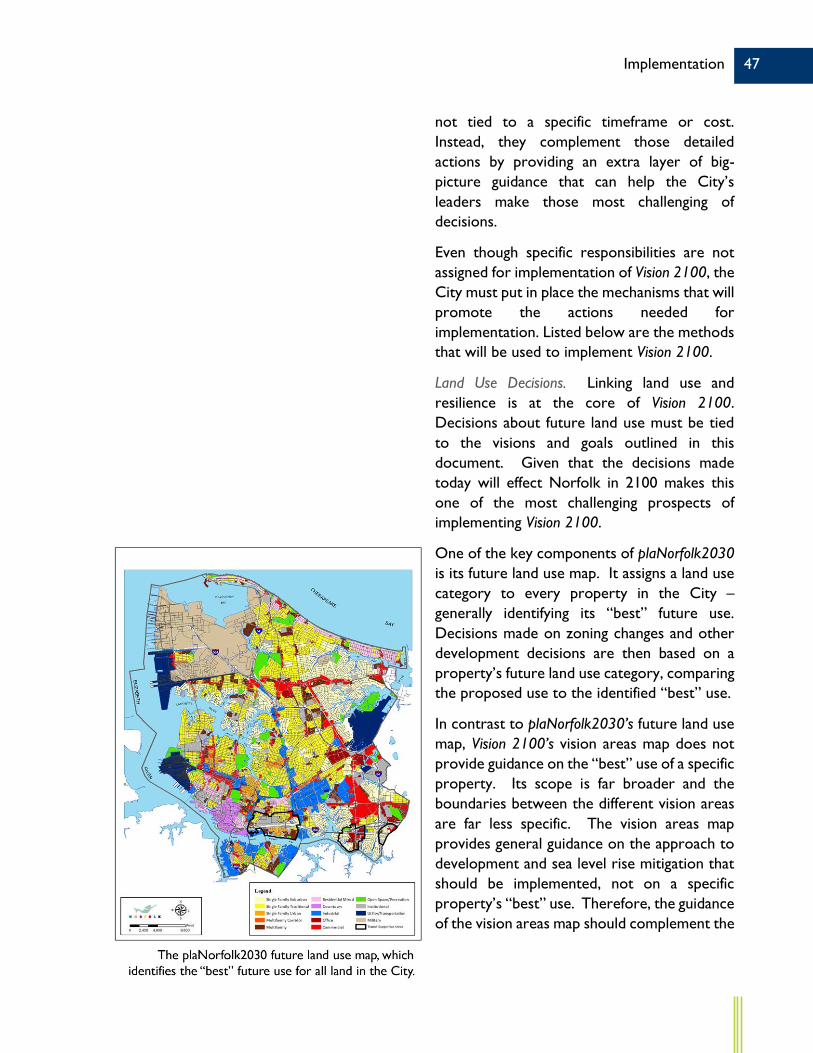
Land Use Decisions. Linking land use and resilience is at the core of Vision 2100. Decisions about future land use must be tied to the visions and goals outlined in this document. Given that the decisions made today will effect Norfolk in 2100 makes this one of the most challenging prospects of implementing Vision 2100.
One of the key components of plaNorfolk2030 is its future land use map. It assigns a land use category to every property in the City – generally identifying its “best” future use. Decisions made on zoning changes and other development decisions are then based on a property’s future land use category, comparing the proposed use to the identified “best” use.
In contrast to plaNorfolk2030’s future land use map, Vision 2100’s vision areas map does not provide guidance on the “best” use of a specific property. Its scope is far broader and the boundaries between the different vision areas are far less specific. The vision areas map provides general guidance on the approach to development and sea level rise mitigation that should be implemented, not on a specific property’s “best” use. Therefore, the guidance of the vision areas map should complement the

48 Implementation
guidance of the future land use map. The information from each document should be used together in the decision making process.
City Work Program and Budgets. The wise allocation of city resources is also key to Vision 2100’s success. One way the City allocates resources is through department work programs and operating budgets. Another method is the capital improvement program (CIP), which determines where capital funds will be spent. Vision 2100 should influence the development of each of those documents; general consistency between those documents and Vision 2100 should be maintained.
Other City Functions and Tools. In addition to individual land use decisions, budgets, and work programs, Vision 2100 should provide guidance to several other activities, including:
Future Area Plans. Transformation and intensification of a specific area must be guided by a carefully crafted area plan, outlining appropriate future land uses and necessary infrastructure. The recommendations of Vision 2100 should be considered in the development of those plans, as they will be especially important tools for guiding future development in the green and red areas.
Zoning and Regulatory Tools. One of the most important aspects of Vision 2100 is that it represents a change in thinking about how to approach the challenges of the future. In part, that change of approach means providing incentives and market-based solutions to encourage resilient decisions. Implementing such an approach will require many revisions to Norfolk’s regulatory scheme.

49 Implementation
Stakeholder Relationships. It was only following an unprecedented collaborative planning process – involving multiple city departments and agencies, residents, and stakeholder groups – that Vision 2100 was able to be completed. Its implementation will require even more collaboration. In order to fully realize Vision 2100’s goals, the City will need to partner with all of its stakeholders to ensure that they incorporate its vision of resilience into their work programs going forward.
Neighborhood Outreach and Neighborhood Strategic Planning. Ongoing neighborhood engagement is an essential part of implementing Vision 2100. Of particular importance are outreach efforts to assist neighborhood groups in coordinating flood mitigation strategies in the yellow areas and neighborhood empowerment strategies in the purple areas.
Resilience. Ongoing efforts to address resilience, including social, economic and physical resilience, are essential to realizing Vision 2100. A variety of efforts – ranging from stormwater engineering projects in at-risk neighborhoods to affordable housing strategies in underperforming neighborhoods – are underway now. These and future efforts will need to consider the recommendations of Vision 2100 as they work to improve Norfolk’s resilience.

50 Implementation