Embed Size (px)
Citation preview
Open Geospatial ConsortiumDate: 2012-??-??
External identifier of this OGC® document: <http://www.opengis.net/doc/template/standard/1.0>
Internal reference number of this OGC® document: 12-nnnr1
Version: 0.3.0
Category: OGC® Best Practice
Editor: <Name(s) of Editor or Editors>
Best Practices for using OGC WMS with Time-Dependent or Elevation-Dependent Data
Copyright notice
Copyright © 2012 Open Geospatial ConsortiumTo obtain additional rights of use, visit http://www.opengeospatial.org/legal/.
Warning
This document is not an OGC Standard. It is distributed for review and comment. It is subject to change without notice and may not be referred to as an OGC Standard.
Recipients of this document are invited to submit, with their comments, notification of any relevant patent rights of which they are aware and to provide supporting documentation.
Document type: OGC® <Publicly Available Best PracticeDocument subtype: <interface, encoding, application profile, profile>Document stage: DraftDocument language: English
i. AbstractThis document proposes a set of Best Practices and some guidelines for implementing and using the OGC Web Map Service (WMS) to serve maps which are time-dependent or elevation-dependent. In particular, clarifications or restrictions on the use of WMS are defined to allow unambiguous and safe interoperability between clients and servers, both in the context of expert meteorological and oceanographic usage and in other communities using meteorological and oceanographic information in conjunction with their own domains’ data. This Best Practice applies specifically to WMS version 1.3, but many concepts and recommendations herein will be applicable to other versions of WMS or to other OGC services, in particular Web Coverage Service.
Where strict normative conformance has been identified, this is indicated, with reference to the original standard.
ii. KeywordsThe following are keywords to be used by search engines and document catalogues:
ogcdoc, WMS, 1.3, web map service, meteorology, oceanography, time, elevation.
iii. PrefaceAttention is drawn to the possibility that some of the elements of this document may be the subject of patent rights. The Open Geospatial Consortium shall not be held responsible for identifying any or all such patent rights.
Recipients of this document are requested to submit, with their comments, notification of any relevant patent claims or other intellectual property rights of which they may be aware that might be infringed by any implementation of the standard set forth in this document, and to provide supporting documentation when possible.
iv. Submitting organizationsThe following organizations submitted this Document to the Open Geospatial Consortium Inc.
DWD (Deutscher Wetterdienst)
ECMWF (European Centre for Medium-range Weather Forecasts)
Météo-France
Technische Universität Dresden
UK Met Office
US NOAA
US Navy
v. SubmittersAll questions regarding this submission should be directed to the editor or the submitters:
Name Company
Chris Little UK Met Office
Marie-Françoise Voidrot-Martinez Météo-France
Jeff de La Beaujardière US NOAA
Stephan Siemen ECMWF
More generally, these Best Practices are the result of discussions within the OGC Meteorology/Oceanography Domain Working Group (MODWG) and the OGC Technical Committee.
1. Introduction
The meteorological and oceanographic communities have been exchanging information internationally for at least 150 years and very well understand the importance of geospatial interoperability standards encompassing standardized data formats, interfaces, processes; shared conceptual models and stable, sustainable, maintenance processes and institutions.
Because of the demanding nature of meteorological and oceanographic data processing, the communities have evolved domain specific solutions. As computers have become more powerful, it has become feasible to use general geospatial software for day-to-day operational purposes, and interoperability problems have arisen. There is also an increasing need to combine meteorological and oceanographic with other forms of geospatial data from other domains, in ways convenient for those domains.
This document describes and justifies a set of Best Practices for implementing Web Map Service (WMS) servers and clients to meet the interoperability requirements of the meteorological and oceanographic communities and to allow the economies of using Commercial Off-The-Shelf geospatial software.
2. Scope
This document specifically addresses the existing WMS Version 1.3 standard and implementations.
The possibility of re-using these Best Practices for future versions of WMS and other OGC standards is/could be also considered.
This Best Practice assumes that WMS supports only named Layers and Styles, and does not include a mechanism for user-defined symbolization of feature data.

3. Conformance
This Standard defines XXXX.
Requirements for N standardization target types are considered:
AAAA
BBBB
Conformance with this standard shall be checked using all the relevant tests specified in Annex A (normative) of this document. The framework, concepts, and methodology for testing, and the criteria to be achieved to claim conformance are specified in the OGC Compliance Testing Policies and Procedures and the OGC Compliance Testing web site1.
In order to conform to this OGC™ interface standard, a software implementation shall choose to implement:
a) Any one of the conformance levels specified in Annex A (normative).
b) Any one of the Distributed Computing Platform profiles specified in Annexes TBD through TBD (normative).
All requirements-classes and conformance-classes described in this document are owned by the standard identified as Error! Unknown document property name. .
4. References
The following normative documents contain provisions that, through reference in this text, constitute provisions of this document. For dated references, subsequent amendments to, or revisions of, any of these publications do not apply. For undated references, the latest edition of the normative document referred to applies.
OpenGIS® Web Map Server Implementation Specification Version 1.3.0. Date 2006-03-15. http://portal.opengeospatial.org/files/?artifact_id=14416
ISO 8601:2004, Data elements and interchange formats — Information interchange — Representation of dates and times
5. Terms and Definitions
This document uses the terms defined in Sub-clause 5.3 of [OGC 06-121r8], which is based on the ISO/IEC Directives, Part 2, Rules for the structure and drafting of International Standards. In particular, the word “shall” (not “must”) is the verb form used to indicate a requirement to be strictly followed to conform to this standard.
For the purposes of this document, the following additional terms and definitions apply.
1 www.opengeospatial.org/cite

4.1clientsoftware component that can invoke an operation from a server4.2geographic informationinformation concerning phenomena implicitly or explicitly associated with a location relative to the Earth [ISO 19101]4.3interfacenamed set of operations that characterize the behaviour of an entity [ISO 19119]4.4layerbasic unit of geographic information that may be requested as a map from a server4.5mapportrayal of geographic information as a digital image file suitable for display on a computer screen4.6operationspecification of a transformation or query that an object may be called to execute [ISO 19119]4.7portrayalpresentation of information to humans [ISO 19117]4.8requestinvocation of an operation by a client4.9responseresult of an operation returned from a server to a client4.10servera particular instance of a service4.11servicedistinct part of the functionality that is provided by an entity through interfaces [ISO 14252]
6. Abbreviated terms
COTS Commercial Off The Shelf software
GIF Graphics Interchange FormatGIS Geographic Information SystemJPEG Joint Photographic Experts GroupOGC Open GIS ConsortiumPNG Portable Network GraphicsSVG Scalable Vector GraphicsURL Uniform Resource LocatorWebCGM Web Computer Graphics MetafileWMS Web Map Service
7. Conventions
This sections provides details and examples for any conventions used in the document. Examples of conventions are symbols, abbreviations, use of XML schema, or special notes regarding how to read the document.
8. Requirements for WMS MetOcean services
This section will highlight requirements WMS services need to fulfill to offer …
WMS 1.3 predefines two dimensions (time and elevation) and offers a generic way to add further dimensions.
1. TIME : <Dimension name="time">
GetMap request includes TIME=T
2. ELEVATION: <Dimension name="elevation">
GetMap request includes ELEVATION=Z
3. Provider-defined "sample dimensions": <Dimension name="something">
GetMap request includes DIM_something=value
8.1 Handling of timeWMS 1.3 specification requirements that time shall be normally be expressed in ISO 8601 format. From this follows:
• Date/time format: ccyy-mm-ddThh:mm:ss.sssZ, to appropriate precision• Required attribute: units="ISO8601“• This includes the time zone
Climatological intervals and temporal references will be the subject of future work and may not use strict ISO 8601. Multiple times may be expressed either as a list or as a start/end/interval, as shown in WMS 1.3 Table C.2.
MetOcean DWG Best Practices:• <Dimension name="time"> always applies to validity time (of observation or
forecast)• Express each map as a single Layer with 0+ temporal axes• Avoid multiple independent layers with time encoded in Layer Name.
8.1.1 WMS Layer with no defined TimeThese can be layers of topographic or for climatological normals (e.g. Standard Normals of maximum temperature in Germany for the period between 1961 and 1990).
MetOcean DWG Best Practices:
• Server:
– Do not declare a TIME value for this layer– Avoid inheritance of TIME from parent layers
• Client:– TIME may be included in GetMap request– TIME in GetMap request is ignored for this layer
* WMO defines normals as "period averages computed for a uniform and relatively long period comprising at least three consecutive 10-year periods".
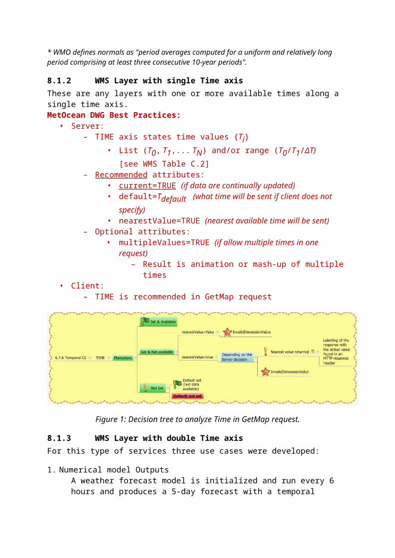
8.1.2 WMS Layer with single Time axisThese are any layers with one or more available times along a single time axis.MetOcean DWG Best Practices:
• Server:– TIME axis states time values {Ti}
• List (T0, T1,... TN) and/or range (T0/T1/ΔT) [see WMS Table C.2]– Recommended attributes:
• current=TRUE (if data are continually updated)• default=Tdefault (what time will be sent if client does not specify)• nearestValue=TRUE (nearest available time will be sent)
– Optional attributes:• multipleValues=TRUE (if allow multiple times in one request)
– Result is animation or mash-up of multiple times• Client:
– TIME is recommended in GetMap request
Figure 1: Decision tree to analyze Time in GetMap request.
8.1.3 WMS Layer with double Time axisFor this type of services three use cases were developed:
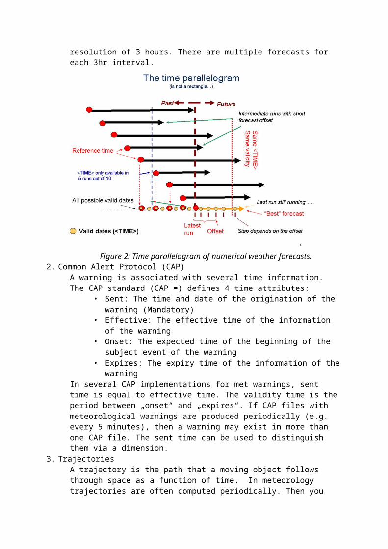
1. Numerical model OutputsA weather forecast model is initialized and run every 6 hours and produces a 5-day forecast with a temporal resolution of 3 hours. There are multiple forecasts for each 3hr interval.
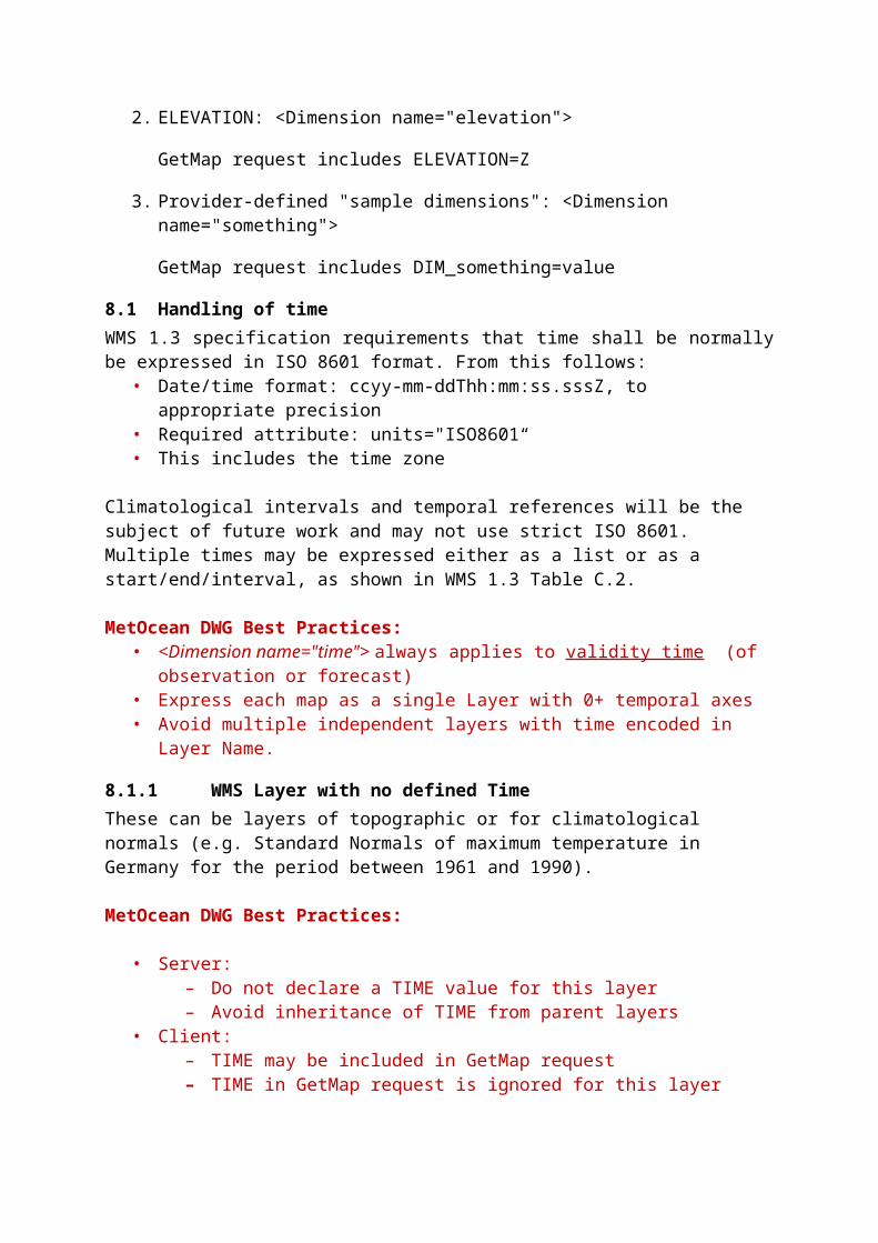
Figure 2: Time parallelogram of numerical weather forecasts.2. Common Alert Protocol (CAP)
A warning is associated with several time information. The CAP standard (CAP =) defines 4 time attributes:
• Sent: The time and date of the origination of the warning (Mandatory)• Effective: The effective time of the information of the warning• Onset: The expected time of the beginning of the subject event of the
warning• Expires: The expiry time of the information of the warning
In several CAP implementations for met warnings, sent time is equal to effective time. The validity time is the period between „onset“ and „expires“. If CAP files with meteorological warnings are produced periodically (e.g. every 5 minutes), then a warning may exist in more than one CAP file. The sent time can be used to distinguish them via a dimension.
3. TrajectoriesA trajectory is the path that a moving object follows through space as a function of time. In meteorology trajectories are often computed periodically. Then you have a set of trajectories with different starting times. The start time can be used to distinguish them via a dimension
MetOcean DWG Best Practices:• Server:
– <Dimension name=“time"> : validity times – <Dimension name=“reference_time"> shall be used for forecasts analysis or
initialisation time– <Dimension name=“reference_time"> may be used for other meanings if
appropriate– Server may define additional time axes <something>_time for non-model data.
• <Dimension name=“sent_time"> reference time for warnings • <Dimension name=“start_time"> reference time for trajectories
– Sending a change request to update the Best Practices in parallel would be appreciated
• Client: TIME and DIM_XXX_TIME are recommended in GetMap request
Figure 3: Decision tree for XXX_Time in GetMap request.
8.2 Handling of elevationAs a reminder these are the general rules of vertical axes (elevation) in WMS 1.3:
– Each Layer may have 1 ELEVATION axis <Dimension name="elevation">
– ELEVATION axis must have a well-defined vertical CRS (coord. ref. syst.)
Mandatory attribute : verticalCRSid (label or URL) - see Clause 6.7.5
– Elevations shall be expressed in units of this CRS
Required attribute : unitSymbol corresponds to these units
– ELEVATION axis (if present) shall enumerate 1+ available values
– Multiple elevations may be expressed either as a list or as a min/max/interval, as shown in WMS 1.3 Table C.2.
– Express each map as a single Layer with 0 or 1 elevation axes
– Avoid multiple independent layers with elevation encoded in Name.
9. <Clauses not Containing Normative Material>
Paragraph
9.1 Clauses not containing normative material sub-clause 1Paragraph
9.1.1 Clauses not containing normative material sub-clause 2Paragraph
10. <Clauses containing normative material>
Paragraph
10.1 <Requirement Class A or Requirement A>Paragraph – intro text. The following table is an example only. Modify as necessary.
Requirements Classhttp://www.opengis.net/spec/ABCD/m.n/req/req-class-aTarget type TokenDependency http://www.example.org/req/blahDependency urn:iso:ts:iso:19139:clause:6Requirement http://www.opengis.net/spec/ABCD/m.n/req/req-class-a/req-name-1
requirement descriptionRequirement http://www.opengis.net/spec/ABCD/m.n/req/req-class-a req-name-2
requirement descriptionRequirement http://www.opengis.net/spec/ABCD/m.n/req/req-class-a /req-name-3
requirement description.
10.2 Requirement Class B or Requirement B
Req 1 <Example – remove from document> When a WCS server encounters an error while performing a GetCapabilities operation, the server shall return an exception report message as specified in Clause 8 of [OGC 06-121r8]. http://opengis.net/spec/WCS/2.0/core/exception.
11. Media Types for any data encoding(s)
A section describing the MIME-types to be used is mandatory for any standard involving data encodings. If no suitable MIME type exists in http://www.iana.org/assignments/media-types/index.html then this section may be used to define a new MIME type for registration with IANA.

Annex A: Conformance Class Abstract Test Suite (Normative)
A.1 Conformance class: AAAA (repeat as necessary)
<Example – remove from document>
Annex B: Revision history
Date Release Author Paragraph modified Description
2012-07-10 0.1.0 CTL All First introductory text

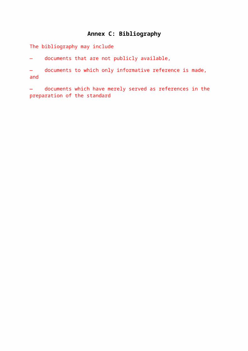
Annex C: Bibliography
The bibliography may include
— documents that are not publicly available,
— documents to which only informative reference is made, and
— documents which have merely served as references in the preparation of the standard
Annex of notes, reminders, etc. To be deleted when complete.
Get reviews from Adrian Custer, Joan Maso, WMS telcos, Jeremy Tandy and co.
DECISION: Intercept WMS 1.3. Make new one for WMS2.0.
Triage features into: stay same, need to change, don’t know
Pick up details and examples from MoD Profile
Legend: problematic
DECISION: MUST support PNG for transparency as a minimum. SVG nice. Same as WMS 1.3
DIMENSIONS
Names and title
Keyword list
Styles?
Queryable layers LATER?
Bounding box
CRS
Scale
Data URL ?
Null/negative responses.

Table 1 UNCHANGED
Table 2 UNCHANGED
Table 3 — The parameters of a GetCapabilities request URL
Request parameter Mandatory / optional
Description Met Ocean Profile
VERSION=version O Request version M
SERVICE=WMS M Service type No change
REQUEST=GetCapabilities
M Request name No change
FORMAT=MIME_type O Output format of service metadata
?
UPDATESEQUENCE=string
O Sequence number or string for cache control
?
Table 4 — Use of UpdateSequence parameter UNCHANGED
Client request UpdateSequence value
Server metadata UpdateSequence value
Server response Met Ocean profile
None any most recent service metadata No change
Any none most recent service metadata No change
equal equal Exception: code=CurrentUpdateSequence
No change
Lower higher most recent service metadata No change
higher lower Exception: code=InvalidUpdateSequence
No change
Table 5 — Relationship between ISO 19128 and ISO 19115 metadata fieldsISO 19128 layer property ISO 19115 Metadata element RelationshipTitle CI_Citation.title equivalent Check
WMO core
ProfileAbstract MD_DataIdentification.abst
ract equivalent Check
WMO core Profile
Keyword element inKeywordList
MD_TopicCategoryCode equivalent if “vocabulary” attribute of 19128 <Keyword> element is “ISO 19115:2003”. Other vocabularies are permitted by 19128.
Check WMO core Profile
EX_GeographicBoundingBox
EX_GeographicBoundingBox
equivalent No change
CRS MD_CRS Value of CRS in 19128 is a text string that identifies a coordinate reference system defined by another authority. Value of MD_CRS in 19115 is a list of projection, ellipsoid and datum identifiers.
??
BoundingBox EX_BoundingPolygon 19128:BoundingBox is strictly a box (lower left and upper right corners in a specified CRS). 19115:EX_BoundingPolygon may be a polygonal boundary.
??
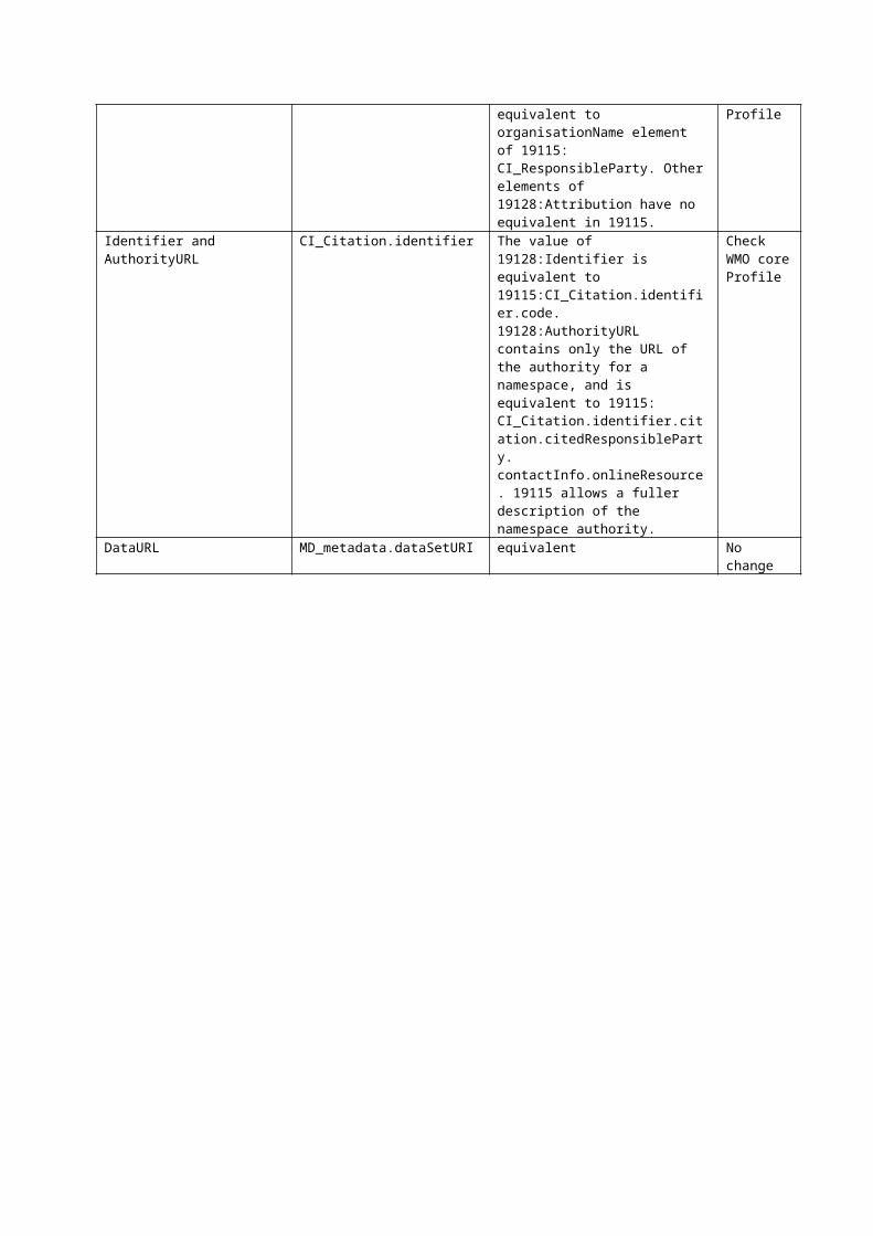
Attribution CI_ResponsibleParty Title element of 19128:Attribution is equivalent to organisationName element of 19115: CI_ResponsibleParty. Other elements of 19128:Attribution have no equivalent in 19115.
Check WMO core Profile
Identifier and AuthorityURL
CI_Citation.identifier The value of 19128:Identifier is equivalent to 19115:CI_Citation.identifier.code. 19128:AuthorityURL contains only the URL of the authority for a namespace, and is equivalent to 19115: CI_Citation.identifier.citation.citedResponsibleParty. contactInfo.onlineResource. 19115 allows a fuller description of the namespace authority.
Check WMO core Profile
DataURL MD_metadata.dataSetURI equivalent No change
Table 6 — Layer attributes
Attribute Allowed values Meaning (0 is default value) Met Ocean Profile
queryable
0, false, 1, true 0, false: layer is not queryable. 1, true: layer is queryable. ??
cascaded 0, positive integer
0: layer has not been retransmitted by a Cascading Map Server. n: layer has been retransmitted n times.
No change
Opaque 0, false, 1, true 0, false: map data represents vector features that probably do not completely fill space. 1, true: map data are mostly or completely opaque.
No change
noSubsets
0, false, 1, true 0, false: WMS can map a subset of the full bounding box. 1, true: WMS can only map the entire bounding box.
No change
fixedWidth
0, positive integer
0: WMS can produce map of arbitrary width. nonzero: value is fixed map width that cannot be changed by the WMS.
No change
fixedHeight
0, positive integer
0: WMS can produce map of arbitrary height. nonzero: value is fixed map height that cannot be changed by the WMS.
No change
Table 7 — Inheritance of Layer propertiesElement Number Inheritance Met Ocean
ProfileLayer 0+ no No
changeName 0/1 a no No
changeTitle 1 no No
changeAbstract 0/1 no No
changeKeywordList 0/1 no No
changeStyle 0+ add No
changeCRS 1+ b add No
changeEX_GeographicBoundingBox
1 b replace No change
BoundingBox 1+ b replace No change
Dimension 0+ replace No change
Attribution 0/1 replace No change
AuthorityURL 0+ add No change
Identifier 0+ no No change
MetadataURL 0+ no No change
DataURL 0/1 no No change
FeatureListURL 0/1 no No change
MinScaleDenominator,MaxScaleDenominator
0/1 replace No change
Attributes listed in Table 6
0/1 replace No change
a See 7.2.4.6.3 regarding distinction between named and unnamed layers.b May be 0 only if a value is inherited from an enclosing Layer element; see 7.2.4.6.6 through 7.2.4.6.8
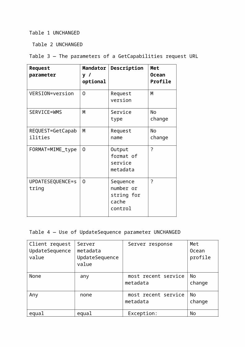
Table 8 — The Parameters of a GetMap requestRequest parameter Mandatory
/ optional Description Met Ocean Profile
VERSION=1.3.0 M Request version. No changeREQUEST=GetMap M Request name. No changeLAYERS=layer_list M Comma-separated list of one
or more map layers.No change
STYLES=style_list M Comma-separated list of one rendering style per requested layer.
No change
CRS=namespace:identifier M Coordinate reference system. No changeBBOX=minx,miny,maxx,maxy
M Bounding box corners (lower left, upper right) in CRS units.
No change
WIDTH=output_width M Width in pixels of map picture. No changeHEIGHT=output_height M Height in pixels of map
picture.No change
FORMAT=output_format M Output format of map. No changeTRANSPARENT=TRUE|FALSE O Background transparency of
map (default=FALSE).??
BGCOLOR=color_value O Hexadecimal red-green-blue colour value for the background color (default=0xFFFFFF).
??
EXCEPTIONS=exception_format
O The format in which exceptions are to be reported by the WMS (default=XML).
No change
TIME=time O Time value of layer desired. ??ELEVATION=elevation O Elevation of layer desired. ??Other sample dimension(s) O Value of other dimensions as
appropriate.?? Add more detail e.g. 2nd timeprobability threshold
Table 9 — The Parameters of a GetFeatureInfo RequestRequest parameter Mandatory
/ optional Description Met Ocean Profile
VERSION=1.3.0 M Request version. No changeREQUEST=GetFeatureInfo M Request name. No changemap request part M Partial copy of the Map
request parameters that generated the map for which information is desired.
No change
QUERY_LAYERS=layer_list M Comma-separated list of one or more layers to be queried.
No change
INFO_FORMAT=output_format M Return format of feature information (MIME type).
?? XML+Schema?
FEATURE_COUNT=number O Number of features about which to return information (default=1).
No change
I=pixel_column M i coordinate in pixels of feature in Map CS.
No change
J=pixel_row M j coordinate in pixels of feature in Map CS.
No change
EXCEPTIONS=exception_format
O The format in which exceptions are to be reported by the WMS (default= XML).
??

B.2 Map CS (CRS:1)Table B.1 — Definition of map coordinate systemElement name Entry Comment Met Ocean
ProfileCoordinate system identifier CRS:1 See 6.7.2Coordinate system type CartesianDatum identifier computer
displayDatum type engineeringCoordinate system dimension 2Coordinate system axis name iCoordinate system axis direction east Some maps, especially over
the poles, may not have a well-defined linear axis direction.
Coordinate system axis unit identifier
pixel
Coordinate system axis name jCoordinate system axis direction south Some maps, especially over
the poles, may not have a well-defined linear axis direction.
Coordinate system axis unit identifier
pixel
Coordinate system remarks Origin is in upper left. Axis values are non-negative integers.
B.3 Layer CRS using WGS 84 longitude-latitude (CRS:84)Table B.2 — Definition of Layer CRS using WGS 84 longitude-latitudeElement name Entry Comment Met Ocean
ProfileCoordinate reference system kind code
1 Single (not compound) CRS
Coordinate reference system identifier
CRS:84
Coordinate reference system valid area
world
Datum identifier WGS 84Datum type geodeticPrime meridian identifier GreenwichPrime meridian Greenwich longitude
0 degree
Ellipsoid identifier WGS 84Ellipsoid semi-major axis 6378137.0 m ?? Cross
checkEllipsoid shape trueEllipsoid inverse flattening 298.257223563 ??Cross
checkCoordinate system identifier Geodetic Coordinate
SystemCoordinate system type geodeticCoordinate system dimension 2Coordinate system axis name longitude The first (x) axis is
longitude in this CRS.
Coordinate system axis direction eastCoordinate system axis unit identifier
degree
Coordinate axis minimum value −180 degreesCoordinate axis maximum value 180 degreesCoordinate system axis name latitude The second (y) axis
is latitude in this CRS.
Coordinate system axis direction northCoordinate system axis unit identifier
degree
Coordinate axis minimum value −90 degreesCoordinate axis maximum value 90 degreesNOTE CRS:84 is permitted to be used at large scales (>10m/pixel) for describing or requesting map layers in any lon/latCRS that is equivalent to within ~1m.
Add something like B.6

Table C.1 — Contents of a dimension elementField
Mandatory / optional
Meaning Met Ocean Profile
name M Attribute stating name of dimensional axis. No changeUnits M Attribute indicating units of dimensional axis. No changeunitSymbol O Attribute specifying symbol.Default O Attribute indicating default value that will be used if
GetMap request does not specify a value. If attribute is absent, then shall respond with a service exception if request does not include a value for that dimension.
M?
multipleValues
O Boolean attribute indicating whether multiple values of the dimension may be requested. 0 (or “false”) = single values only; 1 (or “true”) = multiple values permitted. Default = 0.
nearestValue O Boolean attribute indicating whether nearest value of the dimension will be returned in response to a request for a nearby value. 0 (or “false”) = request value(s) must correspond exactly to declared extent value(s); 1 (or “true”) = request values may be approximate. Default = 0.
current O Boolean attribute valid only for temporal extents (i.e. if attribute name="time"). This attribute, if it either 1 or “true”, indicates (a) that temporal data are normally kept current and (b) that the request parameter TIME may include the keyword “current” instead of an ending value (see C.4.1). Default = 0.
M?
Extent M Text content indicating available value(s) for dimension.
No change