Embed Size (px)
Citation preview

UNITED STATES DEPARTMENT OF THE INTERIOR
GEOLOGICAL SURVEY
Open-File Report 79-1002
1979
COAL RESOURCES OF
THE JOES VALLEY RESERVOIR QUADRANGLE
SANPETE AND EMERY COUNTIES, UTAH
By
AAA Engineering and Drafting, Inc.
This report has not been edited for conformity with U.S. Geological- Survey editorial standards or strati graphic nomenclature.

CONTENTS
Page
Introduction 1
Purpose 1
Location 1
Accessibility 2
Physiography 2
Climate 3
Land Status 3
General Geology 5
Previous Work 5
Stratigraphy 5
Structure 7
Coal Geology 8
Hiawatha Coal Bed 8
Upper Hiawatha Coal Bed 9
Cottonwood Coal Bed 9
Blind Canyon Coal Bed 11
Bear Canyon Coal Bed 11
Upper Bear Canyon Coal Bed 12
Upper Grimes Wash Coal Bed 12
Chemical Analyses of the Coal 12
Mining Operations 13
Coal Resources 13
Coal Development Potential 17
Development Potential for Surface Mining Methods 17
CONTENTS (Cont)
Page
Development Potential for Subsurface Mining and In Situ Coal Gasification Methods- 17
9H^^j
ILLUSTRATIONS
Figure 1. Boundary and coal data map, Joes Valley Reservoir quadrangle,Sanpete and Emery Counties, Utah 4
2. Composite columnar section, Joes Valley Reservoir quadrangle, Sanpete and Emery Counties, Utah 6
3. Isopach and structure contour map of the Hiawatha coal bed, Joes Valley Reservoir quadrangle, Sanpete and Emery
u to n l
4. Overburden isopach map of the Hiawatha coal bed, JoesValley Reservoir quadrangle, Sanpete and Emery Counties,Utah------------------------ ______ _ _ ____________ _ __ "I RUUUil _____ _ _____________ _____________ _____________ | j
5. Areal distribution and identified resources map of theHiawatha coal bed, Joes Valley Reservoir quadrangle, Sanpete and Emery Counties, Utah 16
6. Coal development potential map for subsurface mining methods, Joes Valley Reservoir quadrangle, Sanpete and Emery Coun- u i es 3
TABLES
Table 1. Average coal analysis, Southwest Quarter of the Hiawatha 15-minute quadrangle, Emery County, Utah 12
2. Coal Reserve Base data for subsurface mining methodsfor Federal coal lands (in short tons) in the Joes Valley Reservoir quadrangle, Sanpete and Emery Counties, Utah 17

INTRODUCTION
Purpose
This report was compiled to support the land planning work of the
Bureau of Land Management and to provide a systematic coal resource inven
tory of Federal coal lands in Known Recoverable Coal Resource Areas (KRCRA's)
in the Western United States. It supplements the land planning require
ments of the Federal Coal Leasing Amendments Act of 1976 (Public Law 94-377)
sec. (3)(B) which states, in part, that "Each land-use plan prepared by the
Secretary [of the Interior] (or in the case of lands within the National
Forest System, the Secretary of Agriculture pursuant to subparagraph (A)(i))
shall include an assessment of the amount of coal deposits in such land,
identifying the amount of such coal which is recoverable by deep mining
operations and the amount of coal which is recoverable by surface mining
operations."
Published and unpublished public information were used as data sources
for this study. No new drilling or field mapping was done to supplement
this study. No confidential or proprietary data were used.
Location
The Joes Valley Reservoir quadrangle lies on the west side of the
central part of the Wasatch Plateau coal field in Sanpete and Emery Coun
ties in south central Utah. The city of Manti is the county seat of Sanpete
County and lies 14 miles (23 km) west of the quadrangle. The city of Castle
Dale, the county seat of Emery County, is located 12 miles (19 km) east and
3 miles (5 km) south of the quadrangle. Other towns in the vicinity include
Ephraim which is 11 miles (18 km) west, Orangeville is 11 miles (18 km) east,
and Huntington is 15 miles (24 km) east of the quadrangle.

Accessibility
Utah Highway 29 runs through the central part of the quadrangle from
east to west. This highway provides access from Castle Dale and Orangeville
on the east side of the Wasatch Plateau to the town of Ephraim and Sanpete
Valley on the west side. The highway is paved from Orangeville to the west
side of Joes Valley Reservoir. The highway is a light-duty gravel road
west of Joes Valley Reservoir. Gravel roads also run north and south from
Joes Valley Reservoir to the boundaries of the quadrangle. Several
unimproved dirt roads and jeep trails provide access to some of the
canyons and ridges in other parts of the quadrangle including Wagon
Road Ridge, Dragon Ridge, Reeder Canyon, Reeder Ridge, 01 sen Bench, and
Clay Bench.
The nearest railroad is a branch line of the Denver and Rio Grande
Western Railroad which runs through Sanpete Valley on the west side of the
Wasatch Plateau. This railroad passes through Manti and Ephraim and joins
the main line of the railroad at Thistle Junction approximately 44 miles
(71 km) north of the quadrangle. The railroad provides connections to
Salt Lake City, Utah and Denver, Colorado.
Physiography
The Wasatch Plateau is a high and deeply dissected tableland. The
eastern margin of the Plateau is approximately 80 miles (129 km) long and
consists of spars!ey vegetated sandstone cliffs and steep shale slopes cut
by numerous steep-walled canyons. The sedimentary rocks are gently dipping,
generally less than 10 degrees.
The Joes Valley Reservoir quadrangle lies in the central part of the
Wasatch Plateau. Surface elevations in the quadrangle range from 6,740 ft

(2,054 m) where Cottonwood Creek leaves the east side of the quadrangle in
Straight Canyon to 10,800 ft (3,292 m) on Clay Bench in the northwest
corner.
Lower Joes Valley is a north-south trending faul,t valley in which
Joes Valley Reservoir is impounded. The earth-fill dam is located at the
head of Straight Canyon and the spillway elevation of the dam is 6,990
ft (2,131 m) above sea level. The reservoir provides water storage, flood
control, and recreational facilities for the region. Almost the entire
quadrangle area drains into Joes Valley Reservoir. The reservoir discharges
into Cottonwood Creek which flows eastward through Orangeville and Castle
Dale into the San Rafael River.
Climate
The climate of the Wasatch Plateau varies with altitude from semi-arid
in the lowest elevations to alpine in the highest. The normal annual
precipitation in the Joes Valley Reservoir quadrangle ranges from 15 inches
(38 cm) in Straight Canyon on the east side of the quadrangle to approxi
mately 38 inches (97 cm) in the northwest corner of the quadrangle (U.S.
Department of Commerce, (1964)).
Temperatures on the high plateau are cool in the summer and cold in
the winter. Maximum summertime temperatures are expected to reach 85
degrees F (29 degrees C) and minimum winter temperatures may drop to -30
degrees F (-34 degrees C) or lower.
Land Status
The east side of the Joes Valley Reservoir quadrangle includes part
of the Wasatch Plateau Coal Recoverable Resource Area (KRCRA) (see figure
1). Approximately 2,600 acres (1,052 ha) lie within the KRCRA and include

EXPLANATION
_____KRCRA_____
KNOWN RECOVERABLE COAL RE SOURCES AREA BOUNDARY - Label within KRCRA boundary
NON-FEDERAL COAL LAND - Land within the KRCRA boundary for whu
SECTION OF LAND - Showing lots and lot
NOTE BLM Coal Ownership Data current as of September 22, 1977.
REFERENCEU S Bureau of Mines and U.S Geological Surve
1976, Coal resource classification system of the U S. Bureau of Mines and U.S. Geological Survey U S Geol Survey Bull 1450-B. 7p.
KRCRA
MAP SHOWING LOCATION OF THE JOES VALLEY RESERVOIR QUADRANGLE (SHADED) AND THE BOOK CLIFFS AND WASATCH PLATEAU KNOWN RECOVERABLE COAL RESOURCE AREAS (STIPPLED). UTAH
See figure 5 for Reserve Bute tonnoget.
Figure I. Boundary and coal data map, Joes Valley Reservoir Quadrangle, Sanpete and Emery Counties, Utah.

2,400 acres (971 ha) of unleased Federal land and 200 acres (81 ha) of
non-Federal land. There were no Federal coal leases in the KRCRA at the
time the land status was reviewed for this report (1977).
GENERAL GEOLOGY
Previous Work
Spieker (1931) mapped and described the geology and coal occurrences
in the Wasatch Plateau. The stratigraphy of the area was described by
Lupton (1916), Spieker and Reeside (1925), Spieker (1949), Katich (1954),
and Hayes and others (1977). Doelling (1972) compiled the geology and
available coal data for the coal field. Reports on recent drilling in
the area were prepared by Blanchard, Ell is, and Roberts (1977) and Davis
and Doelling (1977).
Stratigraphy
The coal beds of economic importance in the Wasatch Plateau field
are Upper Cretaceous in age, and are confined to the Blackhawk Formation
of the Mesaverde Group. This group includes, in ascending order: Star
Point Sandstone, Blackhawk Formation, Castlegate Sandstone, and Price River
Formation. The Upper Cretaceous Mancos Shale underlies the Starpoint
Sandstone.
The North Horn Formation of Upper Cretaceous and Pal eocene ages over
lies the Price River Formation and is in turn overlain by the Flagstaff
Limestone of Pal eocene age (see figure 2).
The oldest strati graphic unit exposed in the quadrangle is the Black-
hawk Formation which crops out on the east side of the quadrangle in Straight
Canyon and along the faulted sides of Lower Joes Valley. It is also exposed
in the upthrown fault blocks in the northwest quarter of the quadrangle
(Hintze and Stokes, 1964). The Blackhawk Formation consists of alternating
beds of shale, siltstone, sandstone, and coal. Recent drilling in the

COAL
BEDNAME
LITHOLOGIC DESCRIPTION
tr<h- cr
oUJ
acro
1. Limestone, white and light-gray, thin-bedded, lacu strine; some thin beds of gray shale and dense white volcanic ash.
2. Shale, variegated; subordinate sandstone and thinbeds of white and light-gray freshwater limestone.
3. Sandstone, light- gray, medium-to coarse-grained, fluvial; some conglomerate and gray shale.
4. Sandstone, weathers light-gray and yellow - brown, medium- to coarse- grained, fluvial; some conglom erate, light-gray containing pebbles of white quartz - ite and limestone in a coarse.sandy matrix; minor shale, gray, sandy; cliff forming.
5. Sandstone,, shale, siltstone and coal; sandstone, light- to medium- gray, weathers to tan, yellow- brown, fine grained; shale, light-gray to black, carbonaceous; silt -stone, light-to medium-gray, carbonaceous; coal in lower part.
6. Sandstone, light- gray, tine-to coarse-grained.
Meters Feet0
50-
100-
150-
200-
250-
300-1
0
- 200
-400
-600
-800
U 1000
Vertical scale
FIGURE 2. Composite columnar section, Joes Valley Reservoir Quadrangle,
Sanpet.e and Emery Counties, Utah. 6

adjoining quadrangle to the east indicates that the formation is up to
1,039 ft (317 m) thick (Davis and Doelling, 1977). The coal beds occur
in the lower 200 to 300 ft (61 to 91 m) of the formation.
In this area the Blackhawk is unconformably overlain by the Castlegate
Sandstone which was formerly classified as a member of the Price River
Formation (Spieker, 1931). The unconformity represents a change from the
lagoonal and literal environments of the Blackhawk to fluvial continental
of the Castlegate. The Castlegate occurs as a massive cliff of medium-
to coarse-grained sandstone and minor interbedded shale partings and con
glomerate lenses. It ranges in thickness from 150 to 500 ft (46 to 152
m). The overlying Price River Formation ranges from 400 to 800 ft (122
to 244 m) thick and is lithologically similar to the Castlegate Sandstone
but is not as massive appearing and is less resistant than the Castlegate.
The North Horn Formation overlies the Price River Formation and is
composed of variegated shale, sandstone, and limestone. The North Horn
Formation is overlain by the Flagstaff Limestone which consists of yellowish-
gray to cream, evenly-bedded, resistant limestone. The Flagstaff Limestone
caps the high ridges on the west side of the quadrangle including Clay
Bench, 01 sen Bench, and Wagon Road Ridge. Several small fault blocks in
Lower Joes Valley are also capped with the limestone.
Structure
The prominent structural feature in the quadrangle is the north-south
trending graben called Lower Joes Valley. The graben is a long down-dropped
block bounded by normal faults in the Joes Valley fault zone. This is
one of the major fault zones in the Wasatch Plateau and is at least 70
miles (113 km) in length and 2 miles (3 km) in width. Along the east

boundary fault of the graben in section 20, T. 17 S., R. 6 E. the Flagstaff
Limestone abutts against upper Blackhawk strata. A measured section here
has proved a stratigraphic displacement of 2,300 ft (701 m) (Davis and
Doelling, 1977, p. 9).
On the southeast side of the quadrangle the rocks dip from 3 to 5
degrees to the west. On the northeast side of the quadrangle the rocks
have a similar inclination to the southwest and south (Davis and Doelling,
1977).
The dip of beds in the narrow blocks and slices in the fault zone
may exhibit dips greater than 5 degrees.
COAL GEOLOGY
Seven named and several unnamed coal beds occur in the adjoining quad
rangle to the east (AAA Engineering and Drafting, Inc., 1979a). Many of
the beds are thin and lenticular with limited area! extent. In ascending
order, the named coal beds are the Hiawatha, Upper Hiawatha, Cottonwood,
Blind Canyon, Bear Canyon, Upper Bear Canyon, and Upper Grimes Wash. The
coal beds occur in the Lower 300 ft (91 m) of the Blackhawk Formation which
consists of alternating beds of sandstone, siltstone and shale. Many of
the siltstones and darker shales are carbonaceous and contain leaf imprints
of sequoias, ferns, and willows (Davis and Doelling, 1977).
Hiawatha Coal Bed
The Hiawatha coal bed is the most persistent and well-developed coal
bed known in the explored areas of the adjoining quadrangles to the east
and south. In those areas the bed ranges in thickness from about 1 ft (0.3
m) to over 18 ft (5.5 m) in measured sections and drill holes. One hole
was drilled 3,000 ft (914 m) east of the Joes Valley Reservoir quadrangle

in NW% NW% Section 3, T. 18 S., R. 6 E. encountered the Hiawatha coal bed
where it was 7.3 ft (2.2 m) thick. An isopach map of the bed (AM Engineering
and Drafting, Inc., 1979a) indicates that the coal thickness continues
westward into this quadrangle but thins southward and thickens northward.
The isopach lines have been projected into the Joes Valley Reservoir quad
rangle as shown on figure 3. Another hole was drilled approximately 8,000
ft (2,438 m) east of the quadrangle in the SE% SE% Section 3, T. 17 S.,
R. 6 E. The coal bed is 9.4 ft (2.9 m) thick at that point and apparently
thins northward. The projected Reserve Base area for this bed underlies
a small part of the northeast corner of this quadrangle (figure 5).
Upper Hiawatha Coal Bed
The Upper Hiawatha coal bed is thin and lenticular in the outcrop
area of the adjoining quadrangle to the east. The bed occurs from 15 to
30 ft (4.6 to 9.1 m) above the Hiawatha bed and generally consists of two
or more thin beds split by partings. The bed is Reserve Base thickness
in only one measured section at the Black Diamond mine on the north side
of Straight Canyon where the bed is 6.0 ft (1.8 m) thick. The coal bed
thins rapidly westward from the mine and is missing in the hole drilled
3,000 ft (914 m) east of the Joes Valley Reservoir quadrangle. It is
expected that the Upper Hiawatha coal bed will be thin or absent in this
quadrangle.
Cottonwood Coal Bed
The Cottonwood coal bed is thin and lenticular in measured sections
in the adjoining quadrangle to the east in the upper Cottonwood Canyon
area. There the bed is less than 5 ft (1.5 m) thick and occurs about 30
ft (9.1 m) above the Hiawatha bed. The Cottonwood bed "may be continuous
33
EXPLANATION
_ 5
ISOPACHS-Showing thickness of coal, in feet. Long dashed where inferred. Isopach interval 1 foot.
6250
6300
STRUCTURE CONTOURS-Drawn on top of coal bed. long dashed where vertical accuracy possibly not within 25 feet; Contour interval is 50 feet (15.2m). Datum is mean sea level.
T
FAULT-Bar and ball on down thrown side.
INSUFFICIENT DATA LINE-Coal thickness cannot be determined beyond line shown because of insufficient data.
SECTION OF LAND
To convert feet to meters, multiply feet by 0.3048.
MILE
Figure 3. Isopach and structure contour map of the Hiawatha coal bed, Joes Valley Reservoir Quadrangle, Sanpete and Emery Counties, Utah.
10

with the Upper Hiawatha bed, and it is here separately identified largely
because of its consistent and apparently restricted appearance in Cottonwood
Canyon" (Spieker, 1931, p. 154). There is no evidence that this bed is
present in the Joes Valley Reservoir quadrangle.
Blind Canyon Coal Bed
The Blind Canyon coal bed occurs from 55 to 70 ft (16.8 to 21.3 m)
above the Hiawatha coal bed and is lenticular in the Cottonwood Canyon
area in the adjoining quadrangle to the east (MA Engineering and Drafting,
Inc., 1979a). It is now known to be continuous with the Blind Canyon bed
of Huntington Canyon to the northeast. The bed is generally thin and split
by partings. However, at widely separated points in the north and south
parts of the adjoining quadrangle the coal is 6.0 and 7.5 ft (1.8 and 2.3
m) thick. Spieker (1931) suggests that the bed exposed in the south part
is evidence of a lens which extends under the eastern edge of North Horn
Mountain. There is no evidence that this lens continues far enough west
ward to reach the Joes Valley Reservoir quadrangle.
Bear Canyon Coal Bed
The Bear Canyon coal bed occurs in several measured sections and two
drill holes in the adjoining quadrangle to the east (AM Engineering and
Drafting, Inc., 1979a). The bed lies from 90 to 110 ft (27 to 34 m) above
the Hiawatha coal bed and is generally thin in that quadrangle where the
bed is probably continuous between Grimes Wash and Cottonwood Canyon (Spieker,
1931, p. 156). The bed is 6.6 ft (2.0 m) thick in a drill hole near the
center of the south edge of that quadrangle. In the hole drilled 3,000
ft (914 m) west of the Joes Valley Reservoir quadrangle the bed was en
countered as two beds 1.6 and 0.5 ft (0.5 and 0.2 m) thick split by a 2.7-ft
(0.8-m) rock interval. The bed is expected to be thin or absent in this
quadrangle.
11

Upper Bear Canyon Coal Bed
The Upper Bear Canyon coal bed occurs from 120 to 150 ft (37 to 46
m) above the Hiawatha bed in the adjoining quadrangle to the east (AAA
Engineering and Drafting, Inc., 1979a). In the Cottonwood Canyon area
the Upper Bear Canyon bed is not known to be more than 3.5 ft (1.1 m) thick.
It is expected to be thin or absent in the Joes Valley Reservoir quadrangle.
Upper Grimes Wash Coal Bed
The Upper Grimes Wash coal bed is generally less than 3 ft (0.9 m)
thick in the adjoining quadrangle to the east (AAA Engineering and Drafting,
Inc., 1979a) and occurs about 190 ft (58 m) above the Hiawatha coal bed.
The bed is present on the east side of Cottonwood Canyon but is apparently
absent on the west side. There is no evidence that the bed is present
in the Joes Valley Reservoir quadrangle.
Chemical Analyses of the Coal
Doelling (1972, p. 207) tabulated the ranges and the averages of coal
analyses of samples from the Hiawatha coal bed in the adjoining quadrangle
to the east. A summary of the analyses is shown in the following table.
Table 1. Average coal analyses, Southwest Quarter of the Hiawatha 15-crinute Quadrangle* Emery County, Utah.*
MoistureVolatile matterFixed carbonAshSulfurBtu/lb**
No.Analyses
271616201823
PercentAverage
4.741.646.46.50.57
12,905
as- receivedRange
1.5-13.237.9-43.743.2-48.74.2-8.8
0.38-0.711,376-13,452
*Doelling (1972, p. 207)**To convert Btu/lb to Kj/kg multiply by 2.326
12
Based on the average analysis shown above, the Hiawatha coal is ranked
as high volatile B bituminous (American Society of Testing and Materials,
1977).
Mining Operations
Coal has been produced from several mines in the adjoining quadrangle
to the east at various times since 1898. At this writing (1979) one mine,
the Trail Mountain mine, was active in that quadrangle. No coal is known
to have been mined in the Joes Valley Reservoir quadrangle.
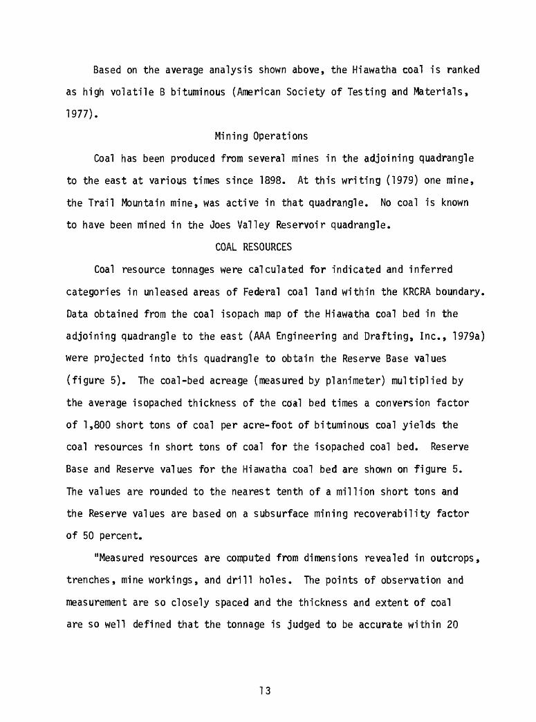
COAL RESOURCES
Coal resource tonnages were calculated for indicated and inferred
categories in unleased areas of Federal coal land within the KRCRA boundary.
Data obtained from the coal isopach map of the Hiawatha coal bed in the
adjoining quadrangle to the east (AAA Engineering and Drafting, Inc., 1979a)
were projected into this quadrangle to obtain the Reserve Base values
(figure 5). The coal-bed acreage (measured by pianimeter) multiplied by
the average isopached thickness of the coal bed times a conversion factor
of 1,800 short tons of coal per acre-foot of bituminous coal yields the
coal resources in short tons of coal for the isopached coal bed. Reserve
Base and Reserve values for the Hiawatha coal bed are shown on figure 5.
The values are rounded to the nearest tenth of a million short tons and
the Reserve values are based on a subsurface mining recoverability factor
of 50 percent.
"Measured resources are computed from dimensions revealed in outcrops,
trenches, mine workings, and drill holes. The points of observation and
measurement are so closely spaced and the thickness and extent of coal
are so well defined that the tonnage is judged to be accurate within 20
13

percent of true tonnage. Although the spacing of the points of observation
necessary to demonstrate continuity of the coal differs from region to
region according to the character of the coal beds, the points of observation
are no greater than h mile (0.8 km) apart. Measured coal is projected
to extend as a % mile (0.4 km) wide belt from the outcrop or points of
observation or measurement.
"Indicated resources are computed partly from specified measurements
and partly from projection of visible data for a reasonable distance on
the basis of geologic evidence. The points of observation are % (0.8 km)
to \h miles (2.4 km) apart. Indicated coal is projected to extend as a
^-mile (0.8-km) wide belt that lies more than % mile (0.4 km) from the
outcrop or points of observation or measurement.
"Inferred quantitative estimates are based largely on broad knowledge
of the geologic character of the bed or region and where few measurements
of bed thickness are available. The estimates are based primarily on an
assumed continuation from Demonstrated coal for which there is geologic
evidence. The points of observation are 1% miles (2.4 km) to 6 miles
(9.6 km) apart. Inferred coal is projected to extend as a 2%-mile (3.6
km) wide belt that lies more than 3/4 mile (1.2 km) from the outcrop or
points of observation or measurement." (U.S. Bureau of Mines and U.S.
Geological Survey, 1976).
Coal Reserve Base tonnages per Federal section shown on figure 5 total
approximately 7.6 million short tons (6.9 million metric tons) for the
isopached coal bed in the unleased Federal coal lands within the KRCRA
boundary in the Joes Valley Reservoir quadrangle. These data are summarized
in the following tabulation.
14
EXPLANATION
WOO
800
OVERBURDEN ISOPACHS-Showing thickness of overburden, in feet, from the surface to top of the Hiawatha coal bed. Isopach interval 200 feet (61.0 m). Dashed where inferred.
INSUFFICIENT DATA LINE-Overburden cannot be determined beyond line shown because of insufficient data.
FAULT - Bar and ball on downthrown side.
To convert feet to meters, multiply feet by 0.3048.
MILE
Figure 4. Overburden isopach map of the Hiawatha coal bed, Joes Valley Reservoir Quadrangle, Sanpete and Emery Counties, Utah.
15

EXPLANATION
KRCRA
T. I7S. R.6E.
RB R(50%)
0.4 0.2
Inf
1/4 1/2
Ml
SCALE RB R(50%)
0.8 0.4
5 4 KRCRA
T. 18 S R.6E. Inf
RB R(50%)
1.1 0.5
5 2 2.6\
KRCRA
RB R(50%)
FIGURE 5. Areal distribution and identified resources map of the Hiawatha coal bed,
Joes Valley Reservoir Quadrangle, Sanpete and Emery counties, Utah.
16
KRCRA BOUNDARY-Label within boundary.
________5-1____
ISOPACH-Showing thickness of coal, in feet. Arrow7 points toward area where coal bed is 5 feet or more thick.
INSUFFICIENT DATA LINE-Coal resources were not calculated for areas beyond line shown be cause of insufficient data.
RB R(50%) (Measured)
<0.i <0.1 (Indicated) 0.8 0.4 (Inferred)
IDENTIFIED COAL RESOURCES-Showing totals for Reserve Base (RB) and Reserves (R), in mil lions of short tons, for each section or part of section of non-leased Federal coal land within the KRCRA. Reserve (R) tonnage is calculated by mul tiplying the Reserve Base (RB) tonnage by the appropriate recovery factor. Dash indicates no resource in that category.
Point of measurement
BOUNDARY LINES-Enclosed areas of measured, indicated, and inferred coal resources of the coal bed. Dashed where projected from adjacent quadrangles.
To convert short tons to metric tons, multiply short tons by 0.9072.
To convert feet to meters, multiply feet by 0.3048

Table 2. Coal Reserve Base data for subsurface mining methods for Federal coal lands (in short tons) in the Joes Valley Reservoir Quadrangle, San- pete and Emery Bounties, Utah.
(To convert short tons to metric tons, multiply by 0.9072)
Coal Bed Name
Hiawatha
High development potential
3,600,000
Moderate development potential
4,000,000
Low development potential
-0-
Total
7,600,000
AM Engineering and Drafting, Inc. has not made any determination
of economic mineability for any of the coal beds described in this report.
COAL DEVELOPMENT POTENTIAL
Development Potential for Surface Mining Methods
No development potential for surface mining methods exists in the
area of this quadrangle because the depth to the Hiawatha coal bed is more
than 200 ft (61 m) below ground surface (figure 4).
Development Potential for Subsurface Mining
and In Situ Coal Gasification Methods
The coal development potential for the subsurface mining of coal is
shown on figure 6. The areas where coal beds 5 ft (1.5 m) or more in
thickness are overlain by less than 1,000 ft (305 m) of overburden are
classified as having a high development potential for subsurface mining.
Areas where such beds are overlain by 1,000 to 2,000 ft (305 to 610 m)
and 2,000 to 3,000 ft (610 to 914 m) of overburden are classified as having
a moderate and low development potential respectively. Areas that contain
no known coal in beds 5 ft (1.5 m) or more thick, but coal-bearing units
are present at depths of less than 3,000 ft (194 m) are classified as areas
17

EXPLANATION
KRCRA
KRCRA BOUND ARY-Label within boundary.
NON-FEDERAL COAL LAND-Land for which the Federal Government does not own the coal rights, and for which the coal- development potential is not rated.
AREA OF HIGH-DEVELOPMENT PO TENTIAL-Area contains coal in beds 5 feet (1.5m) or more thick between the coal outcrop and a depth of 1,000 feet (304.8 m).
AREA OF MODERATE COAL-DEVELOP MENT POTENTIAL-Area contains coal in beds 5 feet (1.5m) or more thick at depths ranging from 1,000 to 2,000 feet (304.8 to 609.6 m).
AREA OF UNKNOWN COAL-DEVELOP MENT POTENTIAL-Area contains no known coal in beds 5 feet (1.5m) or more thick, but coal-bearing units are present in area at depths of less than 3,000 feet (914.4 m).
FIGURE 6. Coal development potential map for
subsurface mining methods,Joes Valley Reservoir Quadrangle, Sanpete and Emery counties, Utah.
18
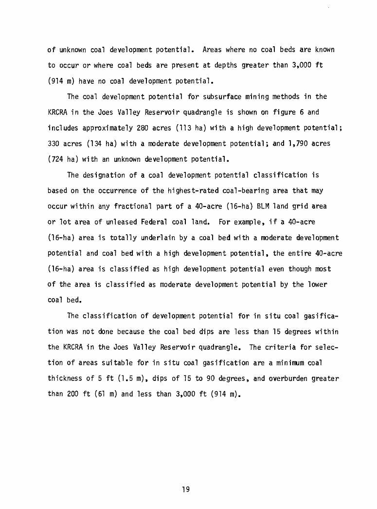
of unknown coal development potential. Areas where no coal beds are known
to occur or where coal beds are present at depths greater than 3,000 ft
(914 m) have no coal development potential.
The coal development potential for subsurface mining methods in the
KRCRA in the Joes Valley Reservoir quadrangle is shown on figure 6 and
includes approximately 280 acres (113 ha) with a high development potential;
330 acres (134 ha) with a moderate development potential; and 1,790 acres
(724 ha) with an unknown development potential.
The designation of a coal development potential classification is
based on the occurrence of the highest-rated coal-bearing area that may
occur within any fractional part of a 40-acre (16-ha) BLM land grid area
or lot area of unleased Federal coal land. For example, if a 40-acre
(16-ha) area is totally underlain by a coal bed with a moderate development
potential and coal bed with a high development potential, the entire 40-acre
(16-ha) area is classified as high development potential even though most
of the area is classified as moderate development potential by the lower
coal bed.
The classification of development potential for in situ coal gasifica
tion was not done because the coal bed dips are less than 15 degrees within
the KRCRA in the Joes Valley Reservoir quadrangle. The criteria for selec
tion of areas suitable for in situ coal gasification are a minimum coal
thickness of 5 ft (1.5 m), dips of 15 to 90 degrees, and overburden greater
than 200 ft (61 m) and less than 3,000 ft (914 m).
19
REFERENCES
AAA Engineering and Drafting, Inc., 1979a, Coal resource occurrence and coal development potential maps of the Southwest Quarter of the Hiawatha 15-minute quadrangle, Emery County, Utah: U.S. Geol. Survey Open-File Report 79-900.
AAA Engineering and Drafting, Inc., 1979b, Coal resource occurrence and coal development potential maps of the Ferron Canyon quadrangle, Sanpete and Emery Counties, Utah: U.S. Geol. Survey Open-File Report 79-1003.
American Society for Testing and Materials, 1977, Standard specificationsfor classification of coals by rank, in Gaseous fuels, coal, andcoke; atmospheric analysis: ASTM Publication D 388-77.
Blanchard, L. F., Ell is, E. G., and Roberts J. V., 1977, Lithologic and geophysical logs of holes drilled Wasatch Plateau KRCRA, Carbon, Emery, and Sevier Counties, Utah: U.S. Geol. Survey Open-File Report 77-133.
Davis, F. D., and Doelling, H. H., 1977, Coal drilling at Trail Mountain, North Horn Mountain, and Johns Peak areas, Wasatch Plateau, Utah: Utah Geol. and Min. Survey Bull. 112.
Doelling, H. H., 1972, Wasatch Plateau coal field, in_ Doelling, H. H.,Central Utah coal fields: Utah Geol. and Min. Survey Mon. Ser. no. 3.
Hayes, P. T., and others, 1977, Summary of the geology, mineral resources, engineering geology characteristics, and environmental geochemistry of east-central Utah: U.S. Geol. Survey Open-File Report 77-513.
Hintze, L. F., and Stokes, W. L., 1964, Geologic map of Utah, southeast quarter: Utah Geological and Mineral Survey.
Katich, P. J., Jr., 1954, Cretaceous and early Tertiary stratigraphy of central and south-central Utah with emphasis on the Wasatch Plateau area: Intermtn. Association of Petroleum Geologists Guidebook, 5th Ann. Field Conf.
Spieker, E. M., 1931, The Wasatch Plateau coal field, Utah: U.S. Geol. Survey Bull. 819.
Spieker, E. M., 1949, The transition between the Colorado Plateaus and the Great Basin in central Utah: Guidebook to the Geology of Utah No. 4, Utah Geol. Society.
Spieker, E. M., and Reeside, J. B., Jr., 1925, Cretaceous and Tertiaryformations of the Wasatch Plateau, Utah: Geol. Soc. of America Bull., v. 36.
U.S. Bureau of Mines and U.S. Geological Survey, 1976, Coal resource classi fication system of the U.S. Bureau of Mines and U.S. Geological Survey: U.S. Geol. Survey Bull. 1450-B.
20

U.S. Department of Commerce, (1964), Normal annual precipitation in inches, 1931-1960, State of Utah: U.S. Dept. of Commerce Weather Bureau Map WR-1210-A.
21