Embed Size (px)
Citation preview

Soil Resources of Khunti District,Jharkhand
Project Report.(For official use only)
Jharkhand
Prepared For
Jharkhand Space Application Centre,Dept of Information Technology
Prepared By
REMOTE SENSING INSTRUMENTS
Dept. of Information TechnologyGovt. of Jharkhand,RANCHI‐834004
O S S G S U S(An ISO 9001:2008 Company)
Plot#7,Type‐I, Industrial Estate, Kukatpally,HYDERABAD‐500072
March 2009

REMOTE SENSING INSTRUMENTSHYDERABAD, INDIA.REMOTE SENSING INSTRUMENTSHYDERABAD, INDIA.
TABLE OF CONTENTS
Chapter No. Description Page No. Preface Acknowledgements Executive Summary
1 Introduction 1 2 Geographical Setting
2.1 Location and Extent 2.2 Physiography and Relief 2.3 Drainage 2.4 Climate 2.5 Geology 2.6 Natural Vegetation
3
3 Agriculture, Present Land Use and Socio-economic features
9
4 Methodology 4.1 Introduction 4.2 Satellite Data Used 4.3 Ancillary Data 4.4 Pre-field Interpretation 4.5 Sample Design and Ground truth Collection 4.6 Soil Chemical Analysis and Post-Field
Interpretation
11
5 Soils 5.1 General 5.2 Soil – Landform relationship 5.3 Soil Distribution and Classification 5.4 Description of Mapping units and Soil Series
18
6 Soil Degradation Status 49 7 Interpretation of Soils and Land Resources
Management 7.1 Land capability classification 7.2 Land and Irrigability Aassessment 7.3 Soil Suitability grouping for sustainable
agriculture a) Under rainfed agriculture b) Irrigated agriculture
7.4 Cropping system and recommended crops 7.5 Horticulture Development 7.6 Hydrological groupings of soils, water
harvesting, its storage and management
52
8 References List of Tables List of Figures List of Plates List of Appendix-I Appendix-II
85

REMOTE SENSING INSTRUMENTSHYDERABAD, INDIA.REMOTE SENSING INSTRUMENTSHYDERABAD, INDIA.
LIST OF TABLES Page No.
1 Toposheet Coverage 3
2 Physiography / Landscape Visa – a – vis Elevations 5
3 Climatic Data 6
4 Common Species Found In the Study Area 8
5 Details of Imagery 11
6 Pre-Field Mapping Legend 13
7 Physiography, Soils, Land Capability and Land Irrigability Classes 20
8 Nature and Extent of sheet erosion in Khunti district 50
9 Areal extent of different Land capability classes 55
10 Description of different Land capability classes 56
11 Areal extent of Different Land Irrigability Classes 68
12 Suitability For Rainfed Agriculture 75
13 Hydrological Soil Groupings 84
LIST OF FIGURES
Page No. Fig. – 1 Location Map 4
Fig. - 2 Ombrothermic Diagram` 7
Fig - 3 Soil map of the study area on the scale 1:50,000 23
REMOTE SENSING INSTRUMENTSHYDERABAD, INDIA.REMOTE SENSING INSTRUMENTSHYDERABAD, INDIA.
LIST OF PLATES Page No Plate-1 Landscape of Alluvial plain 164
Plate-2 Profile of Gangatoli Series- Fine Oxyaquic Haplustalfs 164
Plate-3 Profile of Nawatoli Series- Fine Kanhaplic Haplustalfs 165
Plate-4 Landscape of Low Lands 166
Plate-5 Profile of Chama Series, Fine loamy Typic Dystrustepts 166
Plate – 6 Landscape of Upper Pediplain 167
Plate - 7 Profile of Bathantoli Series- Fine loamy Ultic Haplustalfs 167
Plate – 8 Landscape of Lower Pediplain 168
Plate – 9 Profile of Patrotoli Series- Fine Ultic Haplustalfs 168
Plate – 10 Landscape of Narrow Valleys 169
Plate – 11 Profile of Patrotoli Series- Fine loamy Oxyaquic Ustifluvents 169
Plate – 12 Landscape of Pediplain 170
Plate – 13 Profile of Nagri Series- Fine loamy Typic Haplustepts 170
Plate – 14 Landscape of Narrow Valleys 171
Plate – 15 Profile of Dolaicha Series- Fine Ultic Haplustalfs 171
Plate – 16 Landscapes of Uplands on Crystalline, Limestone, 172
Calcareous rocks
Plate – 17 Profile of Jonha Series -Fine Udic dystrustepts 172
Plate – 18 Landscape of Upper Pediplain on Phyllite, Mica, Schist 173
Plate – 19 Profile of Hemromtoli Series- Fine loamy Typic Dystrustepts 173 Plate – 20 Landscape of Broad Valley 174
Plate – 21 Profiles of Tanbang Series- Coarse Loamy Udic Haplustepts 174
Plate – 22 Landscape of Low Lands 175
Plate – 23 Profile of Rargaon Series- Fine Udic Haplustepts 175

REMOTE SENSING INSTRUMENTSHYDERABAD, INDIA.REMOTE SENSING INSTRUMENTSHYDERABAD, INDIA.
CONTRIBUTORS NAME DESIGNATION Dr. B R M Rao Sr Consultant&Ex-Group Director, Earth Resources Group (NRSC) Prof. L.M.Pandey Advisor, RSI Rajpal Singh Sr Scientist (Agriculture) M.Ram Prasad GIS Engineer
REMOTE SENSING INSTRUMENTSHYDERABAD, INDIA.REMOTE SENSING INSTRUMENTSHYDERABAD, INDIA.
PREFACE Jharkhand is a prosperous state with rich natural resources and extensive variability in
terrain characteristics and associated ecosystems. The state extends over a
geographical area of 79,714 sq.km, and currently supporting a projected human
population of 2, 69,09,428. The state frequently faces natural calamities such as
drought, floods besides the local-specific hazards of industrial emissions and pollutants,
epidemics, fires, accidents etc. The hazards/disasters, which occur often, though
confronted and managed, but needs proper planning, organisation and implementation
strategy. Such situations can certainly be improved if cause and effect relationships are
analysed and understood properly for gearing up the administration and the
infrastructure for drawing appropriate action plain. This calls for a critical evaluation of
the existing situation in terms of the status of the natural resources and its spatial
distribution in relation to socio-economic conditions.
In order to assess the implications of occurrence of natural hazards, one needs a critical
analysis of the situation for which an information base is essential. Such information
base should comprise both spatial and non-spatial data related to natural resources,
infrastructure and the associated socio-economic parameters. The creation of database
would involve generation, compilation, storage and retrieval facilities, which have, direct
and indirect bearing on the disaster under study.
The generation of spatial information on natural resources has become handy with the
advent of satellite remote sensing which coupled with GIS technology has enchanced
the data storage, retrieval and data analysis. Further, creation of computerised data
base adds a new dimension to the dissemination of information in the form of
networking for the free flow of data and information exchange for speeding up
implementation programmes.
In view of the fact that the modern information technology such as Remote Sensing and
Geographic Information System (GIS) have a prominent role to play in terms of data
collection, formatting, storage, manipulation, transmission, updating, analysis and query

REMOTE SENSING INSTRUMENTSHYDERABAD, INDIA.REMOTE SENSING INSTRUMENTSHYDERABAD, INDIA.
development and network / communication link-age, the Government of Jharkhand has
entrusted Jharkhand space applications centre, Ranchi, the task of creation of soil
database for the state.
The generation of database comprises both spatial and non-spatial data. The spatial
data consists of data on natural resources such as geology, soils, geomorphology, land
use/land cover and hydro geomorphology derived from remote sensing satellite imagery
and drainage, relief and slope, watersheds, road network, etc. derived from Survey of
India toposheets as well as from the maps made available from the concerned
Departments. In addition, non-spatial data related to socio-economic situation and
collateral data related to the resources would also be added to the database.
For generating database related to the natural resources, it has been decided to use
satellite remote sensing (IRS P6) imageries for obvious reasons of finer spatial
resolution, geocoded false colour composite (FCC) imageries generated from LISS III
sensor.
The satellite based derived information in combination with the ground support data is
an excellent input, which can be updated from time to time. The satellite derived
thematic maps relating to geology, soil, geomorphology, land use, land cover, etc. for
each of the districts in Jharkhand are prepared on Survey of India toposheet base which
are later computerised. For mapping of various themes, JSAC has identified the
following thematic mapping specialists, who are recognised by the Department of
Space, Government of India:
• RSI
• INRIMT
• ADCC
• PAN INDIA

REMOTE SENSING INSTRUMENTSHYDERABAD, INDIA.REMOTE SENSING INSTRUMENTSHYDERABAD, INDIA.
The database thus generated would be extremely useful to the district authorities for
planning and decision-making. JSAC hopes that the database created for each of
the districts would be put to effective use for better management of resources in the
context of disaster management and overall development of the Jharkhand state.
JSAC, Ranchi
(A.T.JEYASEELAN)
Director

REMOTE SENSING INSTRUMENTSHYDERABAD, INDIA.REMOTE SENSING INSTRUMENTSHYDERABAD, INDIA.
ACKNOWLEDGEMENT
On behalf of Remote sensing instruments (RSI) Hyderabad, I express my heart felt
gratitude to Sri A.T.Jeyaseelan, Director, and scientists JSAC Ranchi for giving an
opportunity to associate myself and my colleagues in the valuable endeavour of
generating data base on soils and land under the data base generation. I am sure that
the work done will be useful and fulfill the requirements. Throughout the study the
officials of JSAC have been very helpful and have offered their valuable suggestions.
I am thankful to all of them.
I shall be failing in my duty if I do not appreciate the help rendered by my collegaues at
RSI worked with great team spirit to complete this project.
for REMOTE SENSING INSTRUMENTS
B.V.RAMANA KUMAR General Manager
REMOTE SENSING INSTRUMENTSHYDERABAD, INDIA.REMOTE SENSING INSTRUMENTSHYDERABAD, INDIA.
EXECUTIVE SUMMARY
Remote Sensing Intruments (RSI), Hyderabad carried out Soil Resources Survey of
Ranchi district under the data base programme at the instance of Jharkhand Remote
Sensing Applications Centre, Ranchi. A total area of 2628.31 sq.km has been covered
under these investigations. Remote sensing data products in the form of Geo-coded
FCCs of IRS P6, LISS III system have been used as base with support information from
Survey of India Topographical maps at 1:50,000 scale. The SOI toposheets were useful
for annotations, location identification and for abstracting some topographical and
geodetic information. The study area is covered between the latitude 23030’/230 45’N
and longitude 840 45’/850 45’E. Altogether, the area is covered in 10 SOI toposheets.
The district of Khunti encompasses one sub-division, namely Khunti and 5 blocks,
namely Arki, Karra, Murhu, Rania and Torpa.
.
Soil maps have been generated by interpretating the satellite data for delineating
different mapping units, which have been confirmed by ground truth and soil chemical
analysis. Soil data have been evaluated for derivation of different thematic information
such as land Capability; Land irrigability, Hydrological Soil Groups, Crop Suitabliity etc.
The entire information is compiled in the form of a report and presented in the next few
Chapters. The information compiled would be very useful in assessing the existing soil
and land use and provides certain way outs to overcome the productivity constraints
and soil degradation.
The salient findings are presented in the following paragraph:
1. Agriculture land, including irrigated agriculture, accounts for 58 % of the area of
Khunti district. This includes steep slopes, gravelly areas and eroded areas to
some extent. Cultivation of the above categories of degraded lands without
proper soil coservation measures result in further degradation of the land.
2. Irrigated area constitutes only 34.62 % of the total cultivated area.

REMOTE SENSING INSTRUMENTSHYDERABAD, INDIA.REMOTE SENSING INSTRUMENTSHYDERABAD, INDIA.
3. Paddy and pulses are the main crops grown, both in Kharif and Rabi seasons.
Other crops being bajra, wheat, redgram, groundnut etc.
4. In the study area thirty-six mapping units (Mus) have been identified
encompassing thirty-five soil series. Mapping units and soil series have been
described in detail in the text.
5. The terrain is covered under the granite gneiss mostly with patches of Schist.
6. 1259.39 sq.km area is nearly level to gently sloping with slope gradients of 0-3%.
About 387.89 sq.km has slopes ranging from 3- 5% and 548.02 sqkm falls under
the 5-10%. In addition soils with gravelly layers at surface have an area of
233.64 sq.km.
7. Erosion is found to be severe in 958.27-sq.km area and moderate in 1480.79
sq.km area. Only 359.62-sq.km areas has slight ersion and are mostly located in
valley areas, which are well bunded.
8. Area extending over 1176.35 sq.km was classified under Land capability class II
implying that these are good lands with minimum limitations. Around 708.81-
sq.km area is classified under LCC III and 162.99-sq.km areas under LCC IV.
These are arable lands but limitations of soil texture, slope, gravelliness; soil
depth etc. increase as number of the class increases. LCC VI lands occupy
750.53 sq.km, which are not arable but suitable for development under grass
cover.
9. Land irrigability classification reveals that 1163.76-sq.km areas are good for
irrigation (LIC-2) and 650.37-sqkm areas are under moderate (LIC-3) category
and 234.02-sq.km areas is marginal. Balance area is not fit for irrigation. Input
costs increase from LIC-2 to 6. Under this system sustainability under irrigation is
essentially looked into.
10. Based on soil characteristics crop suitability and the associated limitations have
been worked out and presented in the report.

REMOTE SENSING INSTRUMENTSHYDERABAD, INDIA.REMOTE SENSING INSTRUMENTSHYDERABAD, INDIA.
The entire data is presented in the form of text, tables and figures. Descriptions of
landscapes and soilscapes have been presented elaborately at various places in the
text. Inferences and suggestions have been incorporated at appropriate places.
The report and maps, thus, provide exhaustive information and could be efficiently used
for evolving Disaster Management plans.

1
REMOTE SENSING INSTRUMENTSHYDERABAD, INDIA.REMOTE SENSING INSTRUMENTSHYDERABAD, INDIA.
CHAPTER – 1 INTRODUCTION
Soil is a non-renewable natural resource and plays a very important role in all the
human related developmental activities. It is, therefore, necessary to have
scientific information about the nature and qualities of the soils of an area for
planned development. The qualities of soil are derived from a set of
morphometric, physical, chemical and physio-chemical characteristics. These
characteristics are expressed in taxonomy classes as depicted on soil maps with
locational references. The soil map, thus, provides information as nature and
distribution of the soils of an area to understand their problems, potentials and
management needs.
Field traversing procedures, which are tedious, slow, subjective and limited only
to the accessible areas, carries out traditional soil mapping. With the advent of
remote sensing technology, these shortcomings have been overcome. The
advantages of remote sensing in terms of speed, efficiency, freedom from
subjectivity and cost effectiveness have anchored the use of remote sensing
techniques in soil mapping as an indispensable tool.
Realising the usefulness and advantages of the remote sensing technology for
soil mapping and deriving of soil resources information for eleven districts ( out of
24) in Jharkhand under the activity of data base management, it was decided to
utilise the latest satellite imageries. For this purpose, Jharkhand Space
Applications Centre (JSAC), Ranchi has identified the different vendors namely
M/s. RSI, INRIMT, Hyderabad, ADCC Nagpur and pan-india Gurgaon to carry
out the task.
For soil mapping of four districts, multi-date data of IRS-P6, geocoded false
colour composite imageries were used, by adopting visual interpretation
techniques. The soil profile studies, correlation and classifications were carried

2
REMOTE SENSING INSTRUMENTSHYDERABAD, INDIA.REMOTE SENSING INSTRUMENTSHYDERABAD, INDIA.
out in the field followed by field validation of the soil maps. The ground
observations correspond to nearly 10-15% of the total area of the district, which
has been utilised as ground truth in addition to collateral data from other sources.
The soil mapping activities have been taken up to meet the following specific
objectives:
1. Preparation of soil maps on 1:50,000 scale, illustrating nature and
distribution of the soils.
2. To evaluate taxonomic soil units for land capability, irrigability, crop
suitability, drought susceptibility and hydrologic soil classifications in
addition to pragmatic thematic categorisation, such as soil depth, slope,
soil degradation, chemical composition etc.
It is hoped that the information contained in this document and attached maps
would serve the overall need of the development plans of the district.

3
REMOTE SENSING INSTRUMENTSHYDERABAD, INDIA.REMOTE SENSING INSTRUMENTSHYDERABAD, INDIA.
CHAPTER – 2 GEOGRAPHIC SETTING
2.1 Location & Extent: Ranchi is the capital of Jharkhand and the district is located on the west-central
side of Jharkhand state and covers geographical area of 2628.31 sq.km (Fig-1).
The district is situated between 220 0’-23045’ North latitudes and 840 45’ – 860 0’
E Longitudes. The study area is covered by 10 survey of India Topographical
maps; and the details of the same are furnished in Table.1.
Table – 1: Toposheet Coverage: ------------------------------------------------------------------------------------------------------------ Sl. No. Toposheet N. Latitudes E. Longitudes ------------------------------------------------------------------------------------------------------------ 1 73 A/16 230 0’ – 230 15’ 84045’ – 850 0’
2 73 B/13 22045’ – 2300’ 84045’ – 8500’
3 73 F/2 22030’ – 22045’ 8500’–-850 15’
4 73 E/2 23030’ – 23045’ 8500’–-85015’
5 73 E/3 23015’ – 23030’ 8500’ – 84015’
6 73E/4 2300’ – 23015’ 84045’ – 8500’
7 73F/1 22045’ – 2300’ 8500’ – 85015’
8 73 E/8 2200’ – 23015’ 85015’ – 85030’
9 73E/12 2300, -23015’ 85030’ – 85045’
10 73 F/5 22045’ – 2300’ 85015’–-85030’
------------------------------------------------------------------------------------------------------------

4
REMOTE SENSING INSTRUMENTSHYDERABAD, INDIA.REMOTE SENSING INSTRUMENTSHYDERABAD, INDIA.
FIG 1: Location map of the study area
2.2. Physiography & Relief: Based on the variations in lithology, the survey area could be divided into
different landscapes, namely alluvium, laterite, granite / granite gneiss, schist,
epidiorite metavolcanic metabasic rocks and crystalline limestone, calcareous
rocks. High relief areas such as structural hills, ridges, dykes, denudational hills,
residual hills, and dissected hills developed were noticed in on granite gneiss.
These high relief areas are mostly found in the north, south and eastern parts of
the study area. Physiograhic units such as pediplains, lowlands, foot slopes,
valleys occurring under different landscapes with moderate to low relief are also
found in different parts of the district. The elevations of different physiographic
units occurring in the study area are given in Table – 2. The hilly areas are
found to occur in the altitude range of 680-580 mts and valleys are found at the

5
REMOTE SENSING INSTRUMENTSHYDERABAD, INDIA.REMOTE SENSING INSTRUMENTSHYDERABAD, INDIA.
altitude range of 440-260 mts. The other physiographic units are found at the
intermediate altitudes / elevations.
Table – 2: Physiography / Landscape visa-vis Elevations ------------------------------------------------------------------------------------------------------------ Physiography / Elevations (mts) Mean Sl. No. Landscape (contours) Value (mts) ------------------------------------------------------------------------------------------------------------ Hills 680 – 580 630 1
Inselbergs 500 – 380 440 2
Pediments 520 – 380 450 3
Lowlands 500 – 260 380 4
Uplands 460 – 360 410 5
Valleys 440 – 260 350 6
Pediplains 600 – 280 480 7
------------------------------------------------------------------------------------------------------------
2.3. Drainage: Swarnrekha river originates near Ratu. It flows in eastern direction until it
descends at Hundru fall, then it enters into the Singhbhum district, Sankh river
originates in the northwestern part of the district near the Rajadera plateau.
South Koel rises near Mandar and flows towards north in Khunti district.
Details furnished above provide a general appraisal of the external drainage
facilities existing in Khunti district. Internal drainage is moderate on the upper
reaches of the landscape and moderate to poor in the lower elements of
topography.
2.4. Climate: The climate of Khunti district comes under subtropical semi-arid type. The
mean annual temperature is 24.500C and the mean summer temperature is
280C (Table-3). The mean winter temperature is 190C. As the difference
between mean summer and mean winter temperature is more than 50C, the
6
REMOTE SENSING INSTRUMENTSHYDERABAD, INDIA.REMOTE SENSING INSTRUMENTSHYDERABAD, INDIA.
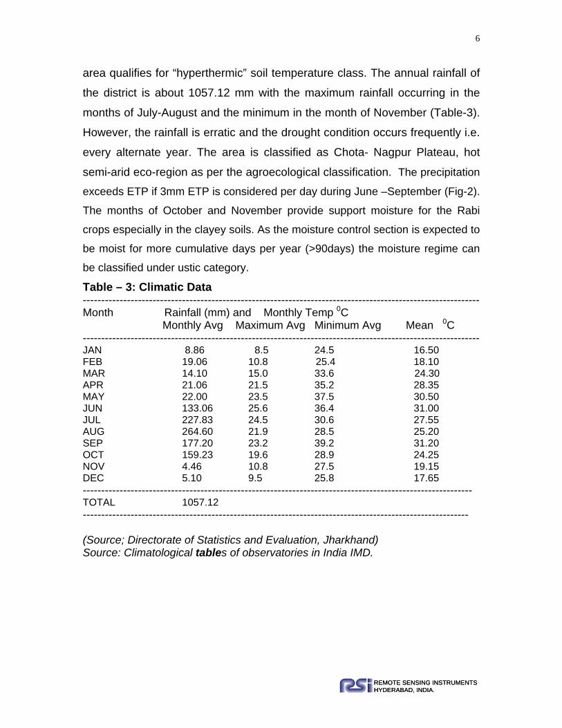
area qualifies for “hyperthermic” soil temperature class. The annual rainfall of
the district is about 1057.12 mm with the maximum rainfall occurring in the
months of July-August and the minimum in the month of November (Table-3).
However, the rainfall is erratic and the drought condition occurs frequently i.e.
every alternate year. The area is classified as Chota- Nagpur Plateau, hot
semi-arid eco-region as per the agroecological classification. The precipitation
exceeds ETP if 3mm ETP is considered per day during June –September (Fig-2).
The months of October and November provide support moisture for the Rabi
crops especially in the clayey soils. As the moisture control section is expected to
be moist for more cumulative days per year (>90days) the moisture regime can
be classified under ustic category.
Table – 3: Climatic Data ------------------------------------------------------------------------------------------------------------ Month Rainfall (mm) and Monthly Temp 0C Monthly Avg Maximum Avg Minimum Avg Mean 0C ------------------------------------------------------------------------------------------------------------ JAN 8.86 8.5 24.5 16.50 FEB 19.06 10.8 25.4 18.10 MAR 14.10 15.0 33.6 24.30 APR 21.06 21.5 35.2 28.35 MAY 22.00 23.5 37.5 30.50 JUN 133.06 25.6 36.4 31.00 JUL 227.83 24.5 30.6 27.55 AUG 264.60 21.9 28.5 25.20 SEP 177.20 23.2 39.2 31.20 OCT 159.23 19.6 28.9 24.25 NOV 4.46 10.8 27.5 19.15 DEC 5.10 9.5 25.8 17.65 ---------------------------------------------------------------------------------------------------------- TOTAL 1057.12 --------------------------------------------------------------------------------------------------------- (Source; Directorate of Statistics and Evaluation, Jharkhand) Source: Climatological tables of observatories in India IMD.

7
REMOTE SENSING INSTRUMENTSHYDERABAD, INDIA.REMOTE SENSING INSTRUMENTSHYDERABAD, INDIA.
FIG 2: Ombrothermic diagram:
2.5. Geology: Granite Gneiss constitutes the geological formation in Khunti district to a major
extent with Phyllite and Mica Schist occurring as minor intrusions towards
southwest on the borders of the district. Chhotanagpur Gneissic Complex covers
the area. The Chhotanagpur Gneissic Complex forms part of Archaean system.
The granite gneiss is a banded / streaky, locally known as porphyritic, bearing
potassic granite with biotite, hornblende and garnet. It contains enclaves of
phyllite, metabasalt, quartzite and calcareous gneiss. The composite gneiss is
represented by highly heterogeneous migmatite, developed in the contact zone
between granite and metabasalt / phyllite. Besides these, massive younger
granite with alkali feldspar, mica and tourmaline occur as a component of

8
REMOTE SENSING INSTRUMENTSHYDERABAD, INDIA.REMOTE SENSING INSTRUMENTSHYDERABAD, INDIA.
chhotanagpur Gneisses in the area. In addition metabasic rocks and crystalline
limestone, calcarious rocks also occur in the area. In addition, sandstone also
occurs with interbands of siltstone, shale fire clay and coal.
2.6. Natural Vegetation: Shrubs and bushes are seen occurring in patches mainly in hilly/rocky areas and
stony wastes. Species like Accasia catechu (Khair), Zizyphys jujuba (Ber),
Accasia arabica (Babul) etc, are commonly seen through out the area. Some
patches have been developed by Forest Department of Jharkhand state under
afforestation programme. Trees like neem (Aadrachcta Indica); Shisam
(Dalbergia Latifolia) and Shuras (Albizzia Lebbeck) have been planted by them.
Some of the common species found in the survey area are listed below (table.4) Table – 4: Common Species Found in the Study Area: ------------------------------------------------------------------------------------------------------------ Sl No. Common Name Botanical Name ------------------------------------------------------------------------------------------------------------ 1 Khair Accasia Catechu
2 Ber Zizyphus Jujuba
3 Neem Azadirachcta Indica
4 Palas Butea Frondosa
5 Arjun sadhada Terminalia Arjuna
6 Bhava Cassia Fistula
7 Videshi Babul Prosopis Juliflora
8 Moha Bassaia Latifolia
9 Hiver Accasia Leucopholea
10 Henkal Gymnosporia Montana
11 Ranber Zizyphus Vulgerias
12 Karwand Carissa Carandas
------------------------------------------------------------------------------------------------------------
Species, which are commonly encountered, are only listed above. Apart from the
above species, grasses like Kusal, Sheda and Marvel are also encountered.

9
REMOTE SENSING INSTRUMENTSHYDERABAD, INDIA.REMOTE SENSING INSTRUMENTSHYDERABAD, INDIA.
CHAPTER – 3
Agriculture, Present land use and Socio-economic features:
There are three main crop seasons viz. Kharif, Rabi and summer (garma). Major
Kharif crops are rice, maize, bajra, vegetables, til etc. Aghani crops are also
sown in the district. It is sown in the beginning of monsoon just like the Kharif
crops, but the harvesting season is different. September-October is the
harvesting season for Kharif where as January–February is for the Aghani.
Major crops grown in Rabi season are wheat, gram, mustard and pulses. Rice,
maize, groundnut and vegetables are main summer crops.
Land use/land cover of the district consists of mainly agriculture and forestry.
The other land use categories like wasteland, non-agricultural lands, pasture,
cultivable wasteland and fallow land also occur in the district. Agriculture is
practiced mainly in plains. However, cultivation is also taken up to some extent in
gently sloping areas and in moderately steeply sloping areas.
The piedmont plains and flood plains are intensively cultivated and irrigated by
river and canal systems. Thus the land use pattern is dynamic phenomenon and
mostly varies from area to area. Some villages are cultivating the agricultural
crops and some other prefer for horticultural crops. In few cases, agro-forestry is
also practiced to enhance the soil fertility.
The Khunti district is mostly dominated with cereals, vegetables and fruit crops. In
this district most of the people depend on agriculture and animal husbandry.
They have different beliefs and taboos related to their tradition. In other words two
third of the people are involved in agricultural practices.
10
REMOTE SENSING INSTRUMENTSHYDERABAD, INDIA.REMOTE SENSING INSTRUMENTSHYDERABAD, INDIA.
Forest types: The forest types identified in the district are:
a) Dry Deciduous Forest: This type of forests consists of Bamboobs,
Amaltas, Semal, Plas, Khour, Mahua, Asan, etc. Sabai and Khus grasses
are also found.
b) Dry Peninsular Forest: This forest consists of trees like sal, jack trees,
bamboo thickets, etc.
c) Moist Peninsular Forest: Such type or forests are available at higher
elevation and rainfall occurrence is more than 2000 mm. Sal is the most
common tree in such forests.

11
REMOTE SENSING INSTRUMENTSHYDERABAD, INDIA.REMOTE SENSING INSTRUMENTSHYDERABAD, INDIA.
CHAPTER – 4 METHODOLOGY
4.1 Introduction: Detailed Reconnaissance soil survey was framed for mapping soils in Khunti
district, Jharkhand. The details of the methodology are given as under.
4.2 Satellite Data Used: Geo-coded IRS-P6, LISS-III data (UTM WGS 84 Projection) in the form of FCCs
have been used for carrying out soil mapping of Khunti district. The satellite data
was available in 10 sheets for the month of April 2005. Thus, latest data have
been used. Survey of India Topographical maps has been used as collateral data
for extracting geographical information.
Details of the imagery used are furnished in table.5.
Table – 5: Details of Imagery: ------------------------------------------------------------------------------------------------------------
Sl No. Toposheet Agro-ecological Zone no 1 73 A/16 45
2 73 B/13 45
3 73 F/2 45
4 73 E/2 45
5 73 E/3 45
6 73E/4 45
7 73F/1 45
8 73 E/8 45
9 73E/12 45
10 73 F/5 45
------------------------------------------------------------------------------------------------------- Date of Imagery: 15th April 2005
Imaging System: IRS – P6, LISS – III
4.3 Ancillary Data: Initially, base maps have been prepared from Survey of India Topographical
maps, which were used for preliminary interpretation of satellite data. Other
collateral data like geological maps, reports and literature locally collected

12
REMOTE SENSING INSTRUMENTSHYDERABAD, INDIA.REMOTE SENSING INSTRUMENTSHYDERABAD, INDIA.
climatic data, statistical data published by dept. of agriculture, Jharkhand govt,
district gazetteers; climatological tables of IMD, district census handbook of
director of census operations, Jharkhand were also used.
4.4. Pre-field Interpretation: As already indicated in the earlier section, hard copies of the imageries supplied
by the JSAC have been laid over the SOI toposheet and adjusted to match
specific control points. Though the data was geocoded, segment wise adjustment
was required because of variations in physiography. By constant reference to the
topography in SOI toposheets, delineations were made. Colour tones, textures
and patterns formed the basis for polygon segregation. The differential colour
tones, patterns, textures, shapes, sizes, location aspects and other relevant
components available in the imagery have been taken as varied manifestations
of different soil types. But, the physiography is taken as a primary reference.
Though similar tonal and textural patterns occur in the lower elements near
streams or rivers and uplands and hilly areas, separate units have been
recognised. 36 Mapping units have been identified. Lithological, physiographic
and landscape variations inferred from imagery and toposheets have been
related to expected soilscapes. Erosional features could be well identified and
could be delieneated in the satellite data products and separately demarcated.
Table.6 furnishes the mapping unit wise physiography and description of each
unit with image characteristics. This legend formed the basis for carrying out
ground checks and the map has been presented to JSAC for first QAS.After
thorough discussion with the scientists of JSAC, the polygon maps have been
modified and ground truth was collected.

13
REMOTE SENSING INSTRUMENTSHYDERABAD, INDIA.REMOTE SENSING INSTRUMENTSHYDERABAD, INDIA.
Table –6: Pre–field Mapping Legend: Landscape / Physiography MU DESCRIPTION Alluvium Alluvial Plain 301) Nearly level, 0-1% slope dull gray to gray tone, under cultivation
302) Very gently sloping, 1-3% slope, yellowish white to grayish white tone, under cultivation Laterite Plateau top
303) Very gently sloping, 1-3% slope, dull green, under rainfed agriculture. Valley / Depressed land
307) Narrow, elongated and irregular concave shape, 3-5% and 5-10% slopes, intermixed with scrub lands and agricultural lands, light cyan with yellow, brown and red mottles tone. Granite and Granite Gneiss
Denudational hill
310) Steep to very steepy sloping, 30-35% and >35%, dense mixed forest, reddish yellow brown mottled tone Residual hill
311) Very steep slopes, (35%) mostly barren rocky area, open scrub, dark brown with red mottled tone. Dissected hills
312) Moderately steep to steep, 15-25%, mostly barren rocky area, fairly dense scrub lands, brown with reddish wash tone. Pediment / inselberg complex
313) Inselberg, mainly composed of rocky knobs / stony waste, 5-15% slopes, dull brown to brown tone, small extent
314) Buried pediment (soil depth >100cm), occasional exposure of rocks, dense forest / scrub, reddish wash with brown mottled tone.
315) Pediment inselberg complex, mainly
exposures of rocks, boulders, open scrub lands,

14
REMOTE SENSING INSTRUMENTSHYDERABAD, INDIA.REMOTE SENSING INSTRUMENTSHYDERABAD, INDIA.
316) Shallow buried (soil depth <50cm) gently to moderately sloping
3-10%, dense / moderately dense scrub, with isolated small green, patchy within hill slopes,grayish green tone to brownish green tone vegetation
Disected Pediment
317) Slightly dissected shallow buried pediment, agricultural lands, intermixed with scrub lands Undulating pediment
318) Upper pediment, 3-10%, convex shaped undulating, mainly rainfed agricultural lands, yellowish tone to greenish yellow tones
319) Middle pediment, 1-3% slopes, plain land, mainly rainfed agricultural lands, yellowish green tone
320) Lower pediment, 0-1% slopes fringes of courses, mostly rainfed agricultural lands, medium cyan tone.
321) Lower pediment, 1-3% slopes, near the stream courses, intermixed with irrigated and
rainfed agricultural lands. Valleys
322) Narrow valley (200m-300m width), elongated shaped, 1-3% slopes and terraced, moderate smooth cyan tone
323) Broad valleys (300m-500m width), elongated shaped, 0-1% slopes, smooth cyan tone.
324) Gullied land dark brown with red tones, with 3-10% slopes, at places terraced.
Buried pediment
325) Deep buried > 150cm pediment, gently sloping, 1-3% slopes, light cyan and light yellowish green tones, irregular shape, agricultural land mainly paddy 326) Narrow valley, sloping, 1-3% slopes, terraced, cyan tone, agricultural land mainly paddy.
327) Broad valley fill areas, 1-3% slopes, cyan with red, brown mottled tone

15
REMOTE SENSING INSTRUMENTSHYDERABAD, INDIA.REMOTE SENSING INSTRUMENTSHYDERABAD, INDIA.
Schist 328) Structural hills moderately steep to very
steep, 15-35% slopes, fairly dense mixed forest, dull brown to dull blue with red wash tone 329) Uplands, moderately to strongly sloping,
10-15% slopes, fairly dense mixed forest / scrub, brown to blue with red wash tone
Phyllite, mica schist 330) Lowlands, moderately sloping, 5-8%, mostly with rock exposures, sparse scrub, dull blue
tone with red dotted mottles, at places rainfed agriculture
331) Structural hill, steep to very steeply sloping,
25-35% slopes, fairly dense scrub / vegetation, brown to dull blue with red dotted tone
332) Undulating buried pediment, about 15%
slopes, dark brown with red mottled tone, open scrub.
334) Narrow valley, gently sloping, 3-5% slopes, mottled texture, under paddy cultivation
Dolerite dyke/Quartzite
338) Lowlands, gently sloping about 3% slope, light dull greenish brown tone, mostly rainfed Epidiorite / Metavolcanic rocks – mainly instrusives 339) Ridges, narrow elongated shape, moderately
steep to steep, 25-35% slopes, open scrub, dark tone with red mottles.
340) Structural hill, steep slopes, 25-35%, bright magenta tone, open scrub areas.
agriculture. Metabasic rock 341) Upland, moderate to strongly sloping, 10-15%, open scrub, red dotted mottle patern
342) Ridges / low hills, steep slopes, 15-25%,
irregular shape, bright red / magenta tone, wavy pattern, fairly dense scrub. 343) Upland in between ridges and low hills, irregular shape, moderately sloping, 5-10%, mostly covered with dense scrub / vegetation red mottled tone

16
REMOTE SENSING INSTRUMENTSHYDERABAD, INDIA.REMOTE SENSING INSTRUMENTSHYDERABAD, INDIA.
Crystalline Limestone, calcareous rocks
344) Low land, gently sloping, 3-5%, dull bluish brown tone, intermixed of scrub and agricultural land
345) Narrow, elongated, strongly to steeply sloping ridges, 25-30% slopes, light gray to light brown tone, some what smooth texture, scrub areas
Sample Design and Ground Truth Collection: After the pre-field interpretation, fieldwork has been planned very intricately. Sites
for profile excavation; shallow pit study and spot observations have been
demarcated on the map. Care has been taken to cover all the mapping units, at
least twice in each toposheet. Sample areas have been selected based on
variations in the map and complexity of the terrain. The observation points are
serially numbered segment wise in each toposheet. Toposheet was divided into 9
segments based on 5’lat-long divisions for this purpose. Five-minute Latitude
divisions within the first 5-minute longitude, carry the numbers A1-A3. Like wise
B1-B3 and C1-C3 were identified. The observation points in each segment were
separately numbered but overall serial numbering has been maintained for the
entire survey area to avoid confusion at a later date.
Profiles pits were exposed at representative sites and soil samples have been
collected from representative profile as included in the Soil Survey Manual (1970)
of IARI, Govt of India. Morphology has been described following the standards of
FAO; representative soil samples have been collected from each horizon of
representative profiles, replicating atleast twice, for each soil series. Soil colours
have been noted as per the Munsell Colour Chart (1994). Mapping units have
been checked at several places and more intense studies carried out in selected
sample areas to (i) establish the relationship between the soils and the
corresponding mapping units.
Soil samples collected from representative soil profiles have been analysed for
different Physical, Chemical and Physiochemical properties of soils for

17
REMOTE SENSING INSTRUMENTSHYDERABAD, INDIA.REMOTE SENSING INSTRUMENTSHYDERABAD, INDIA.
continuation of classification made as per the USDA Soil Taxonomic System
(USDA, 1996). The details of analysis carried out are as follows.
Light tables have been used for illumination and magnifying glasses for detection
of minor details. Section wise interpretation had to be carried out, duly matching
the details and adjusting the shift in the imagery from section to section. The
polygon map, thus derived was checked for quality assurance at JSAC and
further checked in the field for validity of delineations.
4.6. Soil Chemical Analysis & Post-Field Interpretation: Soil chemical analysis was carried out as per the procedure described in soil
chemical analysis by M.L.Jackson (1965). The analysis include pH, EC, OC,
Mechanical analysis, CEC, BS, Exchangeable cations and ESP.The analytical
data was used to confirm the classification of soils made in the field as per soil
Taxonomy (USDA, 1997).
The analytical data of each horizon of all typical profiles was provided in
Appendix along with the morphological description. After finalising the
classification in light of the chemical data, the soil composition of each mapping
unit was finalized. Ultimately 35-soil series occuring in 36 mapping units were
finalized.
4.7.Soil map and slope maps along with the other site characters have been
utilized for deriving information on following theme:
1. Land capability
2. Land Irrigability
3. Erosion
4. Soil suitability
a) Rainfed agriculture b) Irrigated agriculture

18
REMOTE SENSING INSTRUMENTSHYDERABAD, INDIA.REMOTE SENSING INSTRUMENTSHYDERABAD, INDIA.
CHAPTER – 5 SOILS OF KHUNTI DISTRICT
5.1. General: Variations in geological and geomorphological setups have their influence on the
formation of different landscapes and soils. Soil is very important for plant
growth. Soil genesis deals with the processes involved in the formation of soil
from its parent material as influenced by the climatic, micro-biotic actions as
conditioned by the gradient over a period of time. As such, soil is the product of
interaction of these natural agencies.
The geological formation in the study area mainly consists of granite and granite
gneiss, phyllite mica schist, sandstone with interbands of shale, sandstone etc,
and crystalline limestones, calcareous rocks etc. Though climatic conditions, as
reflected by temperature and rainfall distribution, have casted their influence in
erosion and landform development, soil formation in the area is mainly controlled
by the physiographic variations. Relationship between landforms and soils is
dealt in a separate sub section under this chapter.
5.2. Soil- Landform Relationship: Combining the information derived from image interpretation, toposheets and
field survey, and eight major physiographic units, namely hills, Inselbergs,
pediplains, pediments, low lands, Uplands, and valleys were identified (Table-7).
They are further divided into 36 mapping units based on the variations within the
physiographic units with respective slope and land use. As enunciated in earlier
section, lithology and relief mainly control soil development in Khunti district. In
general, it has been observed that in chotanagpur gneissic complex areas, as
one reaches the lower elements of topography, the soil depth increases. As the
slope gradient increases erosion accelerates and soil depth decreases. Table-7
gives the relationship between the physigraphy and soils.

19
REMOTE SENSING INSTRUMENTSHYDERABAD, INDIA.REMOTE SENSING INSTRUMENTSHYDERABAD, INDIA.
5.3. Soil Distribution and Classification: During the course of image interpretation and field check, thirty-six soil mapping
units have been identified based on the variations in physiography, image
characteristics and differences identified during the field traverse. Thirty-five soil
series could be associated with these mapping units. The details of mapping
units and soil series are given below:
Soil series is broadly defined as a group of soils having soil horizons similar in
differentiating characters and arrangement in soil profile, except for the texture of
the surface soil, and develop from a particular type of parent material (Soil survey
staff, 1966). Soils within a series are essentially homogeneous in all soil profile
characters except for texture of the ‘A’ horizon, topographic position and depth to
bed rock where these features do not modify greatly the kind and arrangement of
soil horizons.
Soil depth, thickness and arrangement of hoizons are the main factors that
discriminate one series from the other. As the scale of mapping is 1:50,000 and
the Remote Sensing technology is deployed in differentiating the mapping units,
association of two or three soil series is encountered in most of the cases single
series is encountered very rarely.
Information on soil depth and slope grade would enable feasibility assessment
for levelling, terracing, deep ploughing etc. For example, if soil depth is less than
50cm and slope is over 5%, levelling with heavy machinery would bring subsoil
strata to the surface and the precious surface soil would be lost.

20
REMOTE SENSING INSTRUMENTSHYDERABAD, INDIA.REMOTE SENSING INSTRUMENTSHYDERABAD, INDIA.
Table – 7: Physiography, Soils, Land Capability and Land Irrigability Classes:
Mapping Unit
Physiography Soil Series Soil Composition Land
Capability Sub-class
Land Irrigability Sub-class
Area (sq.km.)
Alluvium:
301
Nearly level plain Sangur
Fine loamy Fluvaquentic Epiaquepts
IIIs 3d 16.53
302 Very gently sloping plain Gangatoli
Fine Oxyaquic Haplustalfs IIs 3d 3.63
Laterite:
303
Very gently sloping Plateau top Nawatoli
Fine Kanhaplic Haplustalfs
lls 3d 5.88
307
Valley / Dipressed land Sukrahatu
Fine Oxyaquic Ustifluvents
llls 3t 0.71
Granite & Granite Gneiss Lanscape Hills:
310 Denudational hill Teontoli
Loamy Skeletal Typic Ustorthents VIt 6t 34.17
311 Residual hill Tirha Loamy skeletal Lithic Ustorthents VIt 6t 15.18
312 Dissected hills Karantoli Loamy skeletal Typic Ustorthents VIt 6t 75.53
313 Inselberg Tetra Loamy skeletal Typic Ustorthents VIt 6t 22.98
Pediment / Inselberg Complex:
314 Low lands Chama, Karantoli
Fine loamy Typic Dystrustepts IIIt 4t 67.95
315
Pidmont Inselberg Complex
Teontoli, Karantoli
Loamy Skeletal Typic Ustorthents VIt 6t 75.77
316 Denudational hill Teontoli
Loamy Skeletal Typic Ustorthents Vit 6t 15.55
317 Footslopes Tangartoli, Hundratoli
Fine loamy Typic Haplustepts

21
REMOTE SENSING INSTRUMENTSHYDERABAD, INDIA.REMOTE SENSING INSTRUMENTSHYDERABAD, INDIA.
Mapping Unit
Physiography Soil Series Soil Composition Land
Capability Sub-class
Land Irrigability Sub-class
Area (sq.km.)
Undulating Pediplain:
318 Upper Pediplain Kundo
Fine loamy Ultic Haplustalfs IIIet 3t 238.20
319 Middle Pediplains Balia
Fine loamy Typic Rhodustalfs Iis 2t 737.65
320
Lower Pediplains-Gently sloping
Lodhma, Jamtoli
Fine Ultic Haplustalfs IVw 4d 21.66
321 Lower Pediplains Salangapos
Fine Ultic Haplustalfs IIIs 3d 29.64
Valleys:
322 Narrow Valley Banrotoli, Patrotoli
Fine loamy Typic Endoaquepts IVw 4d 141.00
323 Broad Valleys Patrotoli
Fine loamy Oxyaquic Ustifluvents Iiw 4d 3.08
Very gently to gently sloping pediplains:
324 Plains Nagri & Bathantoli
Fine loamy Typic Haplustepts Iis 2d 5.97
325 Narrow Valley Dolaicha Fine Ultic Haplustalfs Iis 2d 77.84
326 Broad valley Lohana Fine Ultic Haplustalfs Iis 2d 8.22
Schist Landscape:
327 Hills: - Structural hills Kudda
Fine Typic Haplustepts VIt 6t 271.93
328 Uplands Bartuwa Loamy skeletal Lithic Ustorthents VIt 6t 99.48
329 Lowlands Dumbartoli Fine loamy Udic Ustorthents Iis 2d 4.03
Landscape on Phyllite, Mica schist:
330 Structural hill Joranga Loamy skeletal Udic Haplustepts VIt 6t 67.31
331
Undulating buried pediment Hemromtoli
Fine loamy Typic dystrustepts Iis 2s 39.79
332 Deep buried pediment Rargaon
Fine loamy Udic Haplustepts IIIs 3d 49.88
334 Broad valley Tanbang Coarse loamy Udic Haplustepts Iis 2s 1.46

22
REMOTE SENSING INSTRUMENTSHYDERABAD, INDIA.REMOTE SENSING INSTRUMENTSHYDERABAD, INDIA.
Mapping Unit
Physiography Soil Series Soil Composition Land
Capability Sub-class
Land Irrigability Sub-class
Area (sq.km.)
Landscape on Dolerite dyke/Quartzite
338 Ridges / Dykes Jarerel
Loamy skeletal Typic Haplustepts VIt 6t 23.04
Landscape on Epidiorite/Metavolcanic rocks-mainly intrusives
339 Ridges/Low hills Dolda
Fine Loamy Typic Ustorthents VIt 6t 10.41
340 Pediments/Uplands Pahantoli
Fine Typic Haplustepts VIt 6t 6.7
Landscape on Metabasic Rocks
341 Ridges/Low hills Dolda
Fine Loamy Typic Ustorthents VIt 6t .39
342 Uplands Ronhe Fine Lithic Ustorthents VIt 6t 32.09
343 Lowlands, Gently sloping Binda
Fine Loamy Udic Haplustepts IIe 2c 288.80
Landscape on Crystalline Limestone, Calcareous rocks
344 Ridges / Dykes Hariharpur
Loamy skeletal Typic Dystrustepts IIIst 3t 139.79
345
Gently to moderately sloping upland Jonha
Fine Udic Rhodustalfs IIIs 3s 166.11
Note: Minerology class is mixed in all the mapping units and temperature class is” hyperthermic”.

23
REMOTE SENSING INSTRUMENTSHYDERABAD, INDIA.REMOTE SENSING INSTRUMENTSHYDERABAD, INDIA.
5.4. Descriptions of the Mapping Units and Soil Series: Descriptions of mapping units and the soil series encountered within a mapping
units are provided in this section. Extent of area of the each mapping unit is given
in Table No.7 Location details of mapping units have been provided, toposheet
wise, in the form of a polygon map and distribution of soil series in the form of soil
code map Fig-3. These two maps are separately supplied to JSAC. Soil series
indicated under each mapping unit are the major ones occupying maximum areas
within the unit. Other soil series occupying less than 15% area are taken as
intrusions. In most cases such intrusions occupy less than 5-10% area at any
given place.
Fig.3. Soil map of the study area on the scale 1:50,000 (Based on visual interpretation of IRS-P6 LISS-III)
(For legend refer table no-6.)

24
REMOTE SENSING INSTRUMENTSHYDERABAD, INDIA.REMOTE SENSING INSTRUMENTSHYDERABAD, INDIA.
their cumulative area never crosses 20% of total area. Though the soil taxonomic
classification is provided in the next section of this chapter, textural class and sub
group are mentioned, in each case, in this section for general understanding. The
series have been described in the landscape basis.
5.4.1. Alluviual Landscape: This unit occurs along the river South Koel flowing in
north-south direction. It consists of nearly level to very gently sloping plain.
However, in Khunti district both of the above lands are encountered. The soils are
covered under paddy cultivation in Kharif season. The description of the mapping
units and associated soils are given under.
5.4.1.1. Nearly level alluvial plain: MU-301: These are the nearly level plains
with slopes varying from 0-1%. The area under this unit is 16.53- sqkm
constituting 0.62% of geographical area of the district. Paddy is taken up as Kharif
crop in this area. The soil series associated with this unit is Sangur and
description of the same is given hereunder.
Sangur: Soils are deep, dark gray sandy clay loam in the surface and change to
dark grayish brown sandy clay loam in the subsurface. The soil is nutral on the
surface with pH 7 and it increases with the depth in the subsurface. They have nil
to slight erosion, imperfectly drained and the water table is found at a depth of
170 cm. The mapping unit has very few limitations and qualifies for land capability
class-IIIw and land irrigability class 3d. The soils are very deep with heavy
textures. 5.4.1.2. Very gently sloping alluvial plain: MU-302: These are very gently
sloping areas occurring along the river. They are having 1-3% slope but are
levelled for cultivation of paddy in Kharif season. It is manifested on the image in
dark gray colour with smooth texture.
The soil series associated with this unit is Gangatoli. Soils are deep, grayish
brown loam in the surface and change to brown sandy clay loam in the
subsurface. The soil is acidic on the surface with pH 5.7, but the subsurface soil
has normal soil reaction. They have nil to slight erosion, imperfectly drained and

25
REMOTE SENSING INSTRUMENTSHYDERABAD, INDIA.REMOTE SENSING INSTRUMENTSHYDERABAD, INDIA.
the water table is found at a depth of 140 cm. The mapping unit has very few
limitations and qualifies for land capability sub class-IIs and land irrigability class
2d. The extent of area covered by this unit is 3.63sq.km constituting 0.13 % of the
district. The soils are very deep with heavy textures.
5.4.2. Lateritic Landscape: This unit is found in the northwestern and
southwestern parts of the district. This landscape consists of nearly level to gently
sloping plateau tops, steeply sloping side slopes, ridges and mounds and
footslopes. The plateau tops have laterite cappings at places, which support poor
vegetation cover. The detailed description of the landforms along with the soils
associated with them is given below:
5.4.2.1. Plateau top: The plateau top can be devided into two units namely nearly
level and gently sloping and the details of the same along with the associated soil
series are given below:
5.4.2.2. Nearly level plateau top: MU-303: The slope varies from 0-1% and
exibit capping at some places; the soil series associated with this unit is Nawatoli
series. The soils are deep, brown silty clay loam on the surface and yellowish
brown to brownish yellow clay in the subsurface. The soils are acidic with pH
ranging from 5.2 to 5.5. They have few limitations with respect to soil and
topography categorized under Land capability class-IIs and Irrigability class
3td.The extent of area covered under this unit is 5.88sqkm. Constituting 0.22%
geographical area of the district.
5.4.2.3. Valleys/ Depressed land: MU-307: These units consist of narrow
elongated and irregular concave shaped drainage courses with slopes varying
from 3-5% and 5-10% intermixed with scrublands and agriculture lands. They are
identified by light cyon colour mixed with yellow brown and red mottled tones. At
some places theses lands are also terraced. The extent of area covered by this
unit is 0.71 sq.km accounting for .02% of the geographical area of the district. The
soil series associated withis units is Sukrahatu and descriptions are given below:

26
REMOTE SENSING INSTRUMENTSHYDERABAD, INDIA.REMOTE SENSING INSTRUMENTSHYDERABAD, INDIA.
Sukrahatu: Soils under this series are dark brown (7.5 YR3/3m) clay at surface
and brown silty clay loam to clay in sub-surface horizons, which are deep. Solum
extends up to 82 cm. pH of these soils is 5.2 at the surface and further increases
at the subsurface horizon to 6.4 and deccreases in the lower horizon 5.9. Soils
are free from neutral salts. Base saturation is low with values ranging from 49-
73%.
5.4.3. Granite and Granite gneiss landscape: This unit occurs extensively in the study area except in the eastern side with
granite as the main rock type and phyllite and mica schist occurring as minor
intrusions. Chota –Nagpur Gneissic complex covers the area. Several landforms
have been identified in this landscape viz; denudational hills, residual hills,
dissected hills, pediment/inselberg complex, undulating plains and valleys. The
soils occurring in these units are described below:
5.4.3.1. Denudational hills: MU-310: These are denudational hills; mostly occur in the highest elevation of the terrain.
This unit occurs in the chotanagpur gneissic complex. These areas are severely
eroded. Streams and streamlets emanate from this landscape. One soil series i.e.
Teontoli occupies 60% of the area and remaining area is occupied by rocky i.e
40%. Descriptions of the soil series are provided here under. Total area occupied
by this unit is 34.17 sq.km and constitutes 1.30% of the total area. These are
classified under Loamy skeletal Typic Ustorthents.
Teontoli (TT): Soils of Teontoli series are brown (7.5YR4/4m) in colour with
graverlly sandy loam texture at the surface and gravelly sandy clay loam in the
sub surface. These are moderately deep with solum depth of 36cm. Coarse
fragments occur through out the profile, which are more than 35%. These soils
are encountered on very steep slopes (>35%).

27
REMOTE SENSING INSTRUMENTSHYDERABAD, INDIA.REMOTE SENSING INSTRUMENTSHYDERABAD, INDIA.
pH of these soils is in the range of 5.5 to 6.1. Organic carbon is low (0.42%) at
the surface decreasing to 0.35% in the lowest horizon. Base saturation is between
64-68% in the profile. Total area occupied by this unit is 244 sq.km and
constitutes to 6.4% of the total area. These are classified under Loamy skeletal,
Typic Ustorthents.
5.4.3.2. Residual hills: MU-311: These are hilly areas of Granite and Granite Gneiss. These soils are severely
eroded (e3) and rocky. About 80% of the area is barren rocky without vegetation
except for bushes and grasses. Total area covered by this unit is 15.18 sq.km,
accounting for 0.57% of the gross area. Residual hills have above 8% slope and
support soil cover over 20% of the area where the soil series Tirha is identified.
Description of Tirha series is provided hereunder.
Tirha: Soils of Tirha series are shallow, dark yellowish brown (10YR3.5/4m)
gravelly sandy loams. Gravel percent is over 35. The solum is underlaid by lithic
contact, which is hard to dig with spade. The slope varies from 25-35% and is
covered with scrub vegetation. These soils are severely eroded. Gravels, cobbles
and stones cover the surface. pH of these soils is around 6.5. Organic carbon is at
0.4%. Base saturation is low (68%). The total area covered by these soils comes
to 29 sq.km, constituting 0.77% of the gross area. These are classified under
Loamy skeletal family of Lithic Ustorthents.
5.4.3.3. Dissected hills: MU-312: These are hilly areas of Granite and Granite
Gneiss. These soils are severely eroded (e3) and rocky. About 40% of the area is
barren and rocky and is devoid of vegetation except for some scrubs. Total area
covered by this unit is 75.53 sq.km, constituting 2.8% of the gross area. Dissected
hills have 15-25% slopes and support soil cover where one soil series, Karantoli is
recognised; occurring upto 60% of the landscape. Description of Karantoli series
is given hereunder.

28
REMOTE SENSING INSTRUMENTSHYDERABAD, INDIA.REMOTE SENSING INSTRUMENTSHYDERABAD, INDIA.
Karantoli (K): Karantoli soils are moderately deep with effective depth in the
range of 30-35 cm. Textures are gravelly sandy loams, with gravel more than
35%. The area is severely eroded. The slope vareis between 15-20%. Solum is
underlaid by weathered Granitic murrum occurring mostly within 30cm. Murrum
extends upto 100cm. These soils are under rainfed scrub vegetation.
Most of the area is left barren. These soils have pH 5.4, which is slightly acidic in
nature, and EC is less than 0.02 m.mhos/cm. Organic carbon content is low with
value of 0.53%. Base saturation is low (65%). The total area covered by this
series comes to 145 sq.km (3.8% of gross area). These are classified under
Loamy skeletal family of Typic Ustorthents.
5.4.4.4. Footslopes, Pediments and Inselbergs Lanscape: It consists of
different mapping units viz.upland areas, dissected pediment and foot slopes and
toe slopes. The details of units have been given below: 5.4.4.5. Inselberg MU-313: It’s mainly composed of of rocky knobs/stony waste,
and reflects brown colour on the image.
This unit is characterised by slope varying from 5-10% and severe erosion. Soils
are skeletal in nature. Rock strata are encountered within 70cm and are exposed
on surface at some places. Total area occupied by this mapping unit is 22.98
sq.km (0.87%).
Tetra (TE): Tetra soils are shallow, yellowish brown (10YR4.5/4m) gravelly loamy
sand with gravel percent exceeding 35. The structure is weak sub angular blocky,
collapsing under slight pressure because of gravel. These soils are encountered
on 5-10% slope gradients and are severely eroded. Barren rock is encountered at
many places.
The pH is 6.7 and organic carbon is 0.38%, which is at low level. These soils have
base saturation of 66%.

29
REMOTE SENSING INSTRUMENTSHYDERABAD, INDIA.REMOTE SENSING INSTRUMENTSHYDERABAD, INDIA.
These areas are mostly under wastelands. They are presently used as grazing
lands. Though weathered Granite murrum is encountered within 25cm, no rock is
encountered within 50cm. The total area occupied by this series is computed to
16 sq.km (0.4% gross area).
These soils are best suited for grasslands. These soils are classified under Loamy
skeletal family of Typic Ustorthents. 5.4.4.6. Toe slopes MU-314: This mapping unit represents toe slopes within the
landscapes. Mostly 3-5% slopes are encountered and erosion is severe. These
areas are under scrublands or under forest plants. Total area occupied by this
mapping unit computes to 163.79sq.km (2.58%). Two soil series viz Chama and
Karantoli are identified to be associated in this mapping unit. Karantoli soils
occupy 40% of the MU, Chama soils occupy 40% and the balance 20% by rocky.
Description of Karantoli is already given in earlier sections and the discription of
Chama series is as follows.
Chama (C): Chama soils are very deep; redish brown (5YR4/4m) sandy loam at
the surface and dark reddish brown (5YR3/3m) sandy clay loam at sub-surface.
The structure is subangular blocky. These soils are encountered on 3-5% slope
gradients and are severely eroded. Barren rocky areas are encountered at many
places.
The pH ranges between 5-6, indicating that the soils are acidic in nature. Organic
carbon is at 0.6%. These soils have base saturation of less 34% at the surface
and 43% in the sub-surface.
These areas are mostly under forest. The total area occupied by this series is
computed to 11 sq.km (0.3% gross area).
These soils are best suited for growing forest. These soils are classified under
Fine loamy Typic Dystrustepts.

30
REMOTE SENSING INSTRUMENTSHYDERABAD, INDIA.REMOTE SENSING INSTRUMENTSHYDERABAD, INDIA.
5.4.4.7. Pediment / inselberg complex MU-315: Both Pediment and inselberg
occurs in close proximity to each other. The slopes of inselbergs vary between
15-25% and Pediments between 5-10%. These areas support good forest and
scrub. Total area computed under this mapping unit is 357.20 sq.km (2.88%).
Two soil series viz. Teontoli and Karantoli are seen associated in this mapping
unit. They occupy 40% each. Descriptions of these two series were provided with
earlier section.
MU-316: Uplands: These areas are occurring in Chotanagpur Gnessic complex in pediplain areas.
Slope gradient varies from 5-10%. These are severely eroded landscapes
supporting moderately deep skeletal soils. Mostly these areas are under scrub
vegetation. At some places they are under dry land agriculture.
Total area occupied by this mapping unit is 108.74sq.km, computing to 0.59%
gross area of the district. One soil series is identified in this area, i.e. Teontoli.
Detailed discussion of this soil has been presented in the earlier section. 5.4.4. 8.MU-317: Dissected pediments/foot slopes: These lands occur in and around the hilly topography and are moderate to
severely eroded. Mostly these areas are under scrub lands intermixed with
agricultural lands. As could be visualised, in kharif season, patches of cultivated
areas would exist in between pediments and hills. The total area occupied by this
mapping unit is 0.33 sq.km, computing to 0.01% of gross area. Two soil series
viz. Tangartoli and Hundratoli are identified in this unit occupying 60 & 40% of the
total area, respectively. Descriptions of these two series are provided here under.
Tangartoli (TA): Tangartoli soils are very deep, dark brown (7.5YR3/4m) sandy
loams at surface and dark reddish brown (5YR3/3.5m) clay loam at sub-surface.
The solum rests on hard murrum. These soils are found in moderately sloping
areas on 5-7% slopes and are moderately eroded. Solum depth is between 100-

31
REMOTE SENSING INSTRUMENTSHYDERABAD, INDIA.REMOTE SENSING INSTRUMENTSHYDERABAD, INDIA.
160cm. These areas are mostly barren and crops like Jowar, Red gram, Castor
etc. are grown wherever the lands are suitable for cultivation of crops.
pH of these soils is 6.1 on the surface and 5.9 in the sub suraface indicating they
are slightly acidic side. OC is at 0.88% and is moderately high. Soils are low in
base saturation (69%). The soils have light texture on the surface (sandy loam)
and heavy texture in the lower layer (Clay loam, clay).
Hundratoli (HU): Hundratoli soils are the associates of Tangartoli in mapping
unit-317, occupying 40% of the area. These are reddish brown (5YR4/4m) sandy
loams at surface and red (2.5YR4/6m) loam at sub-surface having solum depths
of 50-60cm. Weathered granite is encountered down below. These areas possess
3-5% slopes and are subjected to moderate erosion.
pH is around 5 which is at acidic side and EC is less than 0.0.04 mhos/cm. OC is
less than 0.3%. Base saturation was almost same in the A1 and B1 horizons.
Sand percent ranges between 57-81 in the profile. In the areas with some soil
cover, Jowar, red gram and groundnut are grown. The total area occupied by this
series computes to 140sq.km (3.7%). These soils are classified Fine loamy family
of Typic Dystrustepts.
5.4.4.9. Undulating Pediplain: This landform has different physiographic units
such as upper pediplain, middle pediplain and the lower pediplain. The details of
the above mapping units and the soils associated with this unit is given below: 5.4.4.10. Upper Pediplain MU-318: It is convex in shape, and can be identified
by its, yellowish to greenish yellow colour on the image.
These pediplains occur on the upper reaches of the undulating pediplains, mostly
occurs as a water divider. They occur as irregular patches. Moderately active
agriculture is observed in this area. Some pockets are gravelly but mostly free

32
REMOTE SENSING INSTRUMENTSHYDERABAD, INDIA.REMOTE SENSING INSTRUMENTSHYDERABAD, INDIA.
from coarse fragments. These areas have 3-5% local gradients but general
gradients are 2-3%. The total area occupied by this unit computes to 238.20
sq.km forming 9.06% of gross area. Three soil series viz. Majhauli, Bathantoli and
Kundo are identified to occupy this unit with 50, 25, 25% area coverages,
respectively. Descriptions of these three soil series are provided hereunder.
Bathantoli (B): Bathantoli soils are deep, strong brown (7.5YR4/6m) silty loam at
surface and dark reddish brown (5YR3/3m) sandy clay loam at sub-surface with
effective depths of 96cm. These soils occupy 25% of the mapping unit. They
occur on 3-5% slope gradients and are subjected to moderate erosion. Some of
these areas receive irrigation water from small tanks or from bore wells.
Wherever irrigation is available paddy is taken but otherwise Jowar, pulses are
mainly grown. Cutans are encountered in sub surface horizons.
pH of these soils is 5.6 on the surface and decreases to 5 in the lower horizon.
These soils are acidic in nature. OC is 0.6% at surface and gradually decreases
to 0.21% in the lower horizon. Base saturation is low with values ranging from 46
on the surface to 59 in the sub surface. Clay varies from 22 to 32% and increases
with depth. These soils occupy 142-sq.km areas and constitute 3.77% gross area.
These are classified under Fine loamy Ultic Haplustalfs.
Kundo (KN): Kundo soils are moderately deep, yellowish red (5YR5/6m) sandy
loam at surface and partially weathred rock at sub-surface with effective depth of
30cm. These soils occupy 25% of the mapping unit. They occur on 5-10% slope
gradients and subjected to severe erosion.
pH of these soils is around 7.5 ESP is low. OC is 0.24% at surface. Base
saturation is high (71%). Clay percent is 21.The upper horizon is fine sub surface
is blocky. These soils occupy 140 sq.km accounting for 3.7% gross area. These
are classified under Loamy skeletal Typic Ustorthents.

33
REMOTE SENSING INSTRUMENTSHYDERABAD, INDIA.REMOTE SENSING INSTRUMENTSHYDERABAD, INDIA.
5.4.4.11. Middle Pediplain: MU-319: Gently sloping, mainly rainfed agricultural
lands with yellowish green colour.
These pediplains occur on middle reaches of the undulating pediplains, mostly
above the tanks. They occur as irregular patches. Moderately good active
agriculture is observed in this area. Some pockets are gravelly but mostly free
from coarse fragments. These areas have 3-5% local gradients but general
gradients are 2-3%. The total area occupied by this unit computes to 737.65
sq.km forming 28.06% of gross area. Two soil series viz. Balia and Majhauli are
identified to occupy this unit at 50 & 40% area coverages, respectively.
Descriptions of these three soil series are provided hereunder. Description of
Majhauli is already provided in erlier section.
Balia (BA): Balia soils are very deep, reddish brown (5YR4/4m) sandy loam at
the surface and dark reddish brown (2.5YR3/4m) sandy clay at the sub-surface
with effective depth of >170cm. These soils occupy 50% of the mapping unit.
They occur on 3-5% slope gradients and subjected to moderate erosion. Some of
these areas receive irrigation water from small tanks or from bore wells.
Wherever irrigation is available paddy is taken but otherwise Jowar, pulses are
mainly grown. The structures is weak fine sub angular blocky. Cutans are
encountered in sub surface horizons.
pH of these soils is 5 in the surface and increases to 5.8 in the B2T.However the
pH in B12 is low (5.1).The soils are acidic in nature and respond well for lime
treatment. OC is 0.4% at surface and gradually decreases up to 0.27% in the
lower layers. Base saturation is low (60-67%). Percent clay ranges between 21-
45%, and increases with depth. These soils occupy 90 sq.km forming to 2.4%
gross area. These are classified under Fine loamy family of Typic Rhodustalfs.

34
REMOTE SENSING INSTRUMENTSHYDERABAD, INDIA.REMOTE SENSING INSTRUMENTSHYDERABAD, INDIA.
5.4.4.12. Lower Pediplain-Gently sloping: MU-320: Gently sloping plain with
different tones due to the presence of different crops and other vegetation. These
pediplains occur on lower reaches of the undulating pediplains, mostly occurs
nearer to rivers and nalas. They occur as irregular patches. Intensive agriculture
is observed in this area. These areas have 1-3% slope. The total area occupied
by this unit is 21.66 sq.km forming 0.82% of gross area. Three soil series viz.
Lodhma, Salangapos and Jamtoli are identified to cover this unit with 40, 40, 20%
area coverages, respectively. Descriptions of these three soil series are provided
hereunder.
Lodhma (LD): These soils are very deep, grayish brown (2.5Y5/2m) clay loam at
surface and light brownish gray to light olive brown (2.5Y6/2, 2.5Y5/3m) clay
laoms in the lower layers. Coarse fragments (3-8%) are present throughout the
profile. Slope varies from 1-3%. These soils are slightly eroded. Patchy thin
cutans are encountered in last two horizons indicating the presence of argillic
horizon pH of these soils is 5.2 at surface and increases to 6.1 in the lowest layer
indicating that the soils are more acidic at surface than sub-surface. Organic
carbon is 0.68% at surface and 0.3% down below. Base saturation is low and
ranges between 48%-65% through out the profile. The texture is clay loam but the
texture becomes heavier with depth. The total area covered by these soils is 142
sq.km forming 3.7% of gross area. These soils are classified under fine Ultic
Haplustalfs.
Salangapos (S): Salangapos soils are deep, dark yellowish brown (10YR3.5/4m)
silty loam at surface and dark brown (10YR3/3m) sandy clay loam at sub-surface
with effective depth of 82cm. These soils occupy 40% of the mapping unit. They
have slope gradient of 2-3% and subjected to slight erosion. Some of these areas
receive irrigation water from tanks or from streams/rivers. Paddy is the main crop
taken up in this area. Patchy thin cutans are observed in sub surface horizons.
The soils are acidic in nature.pH of these soils is 5.5 in the surface and increases
to 5.9 in the sub surface. OC is 0.45% at the surface and gradually decreasing up
to 0.3% in the lower layer. Base saturation is found lowest at the surface (49%)

35
REMOTE SENSING INSTRUMENTSHYDERABAD, INDIA.REMOTE SENSING INSTRUMENTSHYDERABAD, INDIA.
and increased gradually along with the depth. The texture varies from silt loam to
sandy clay with percent clay ranging between 24 to 38%, and increases with
depth. These soils occupy 454-sq.km area and cover 12% of the gross area.
These are classified under Fine loamy Ultic Haplustalfs.
Jamtoli (JA): Jamtoli soils are very deep, light yellowish brown (2.5Y6/4m) clay
loam at surface and olive brown (2.5Y4/4m) clay at sub-surface with effective
depth of >140cm, below which the water table exists. These soils occupy 20% of
the mapping unit. They occur on 2-3% slope gradients and subjected to moderate
erosion. These are occurring in patches in Undulating pediplains. Patchy thin
cutans are seen in sub surface horizons.
pH of these soils is 4.6 at the sub surface and 6.6 in the lower horizons, which
indicates acidic nature at surface. OC is 0.65% at surface and 0.24% to 0.41% in
the sub-surface horizones. Base saturation is very low at surface (36%) and 69 to
71% in sub-surfacce (69 to 71%) horizon. Clay % varies from 34% to 46% with
maximum clay content in the middle layer. These soils occupy 71 sq.km
computing to 1.9% gross area. These are classified under Fine family of Ultic
Haplustalfs.
5.4.4.13. Lower Pediplain- Nearly level: MU-321: It is nearly level plain area
occurring between upper pediplain and stream courses.
These pediplains occur on lower reaches of the undulating pediplains, mostly
occur nearer to rivers and nalas. They occur as irregular patches. Intensive
agriculture is observed in this area. These areas have general slope gradient of 0-
1%. The total area covered by this unit is to 29.64 sq.km forming 1.12% of gross
area. Only one soil series i.e. Salangapos is identified. Description of this soil
series is already provided in earlier sections.

36
REMOTE SENSING INSTRUMENTSHYDERABAD, INDIA.REMOTE SENSING INSTRUMENTSHYDERABAD, INDIA.
5.4.4.14. Valleys: These valleys are found along the rivers Swarnrekha in the
East and South Koel in the northwest. Both narrow valleys and broad valleys are
encountered in this landform and description of it is given as under:
5.4.4.15. Valleys-narrow: MU-322: These landscapes are narrow, elongated
and represent the valleys emanating from hills and within plains. These valleys
receive soil washed from surrounding landscapes. At places these are, severely
eroded because of high slope gradient. Few patches are irrigated under small
tanks, but other wise agriculture is only under rain fed conditions. Total area
occupied by this mapping unit comes to 141 sq.km, forming 5.36% gross areas.
Two soil series, Banrotoli and Patrotoli are recognised within this mapping unit.
They cover in the proportion of 60 and 40% of the area respectively. Descriptions
of these two series are provided here under.
Banrotoli (BT): Soils of this series are very deep, brown (10YR4/3m) clay loam
at surface and dark gray (10YR4/1m) loam in sub-surface horizons. Solum
extends up to 110cm and after 110cm water table is found. On computing the
shallow pit data, most of the observations clustered within 140cm depths and
hence Banrotoli soils are grouped under deep category. The surface and sub
surface layers are acidic with pH ranging from 5.1 to 5.8.However, the lower
layers have slightly high pH ranging from 6.3 to 6.4. The distribution of organic
carbon is also irregular with maximum found in the second layer. It ranges from
0.2 to 0.06. Base saturation is very irregular within the profile with lowest value in
the surface. Banrotoli soils represent 135 sq.km of mapping unit.322, forming
3.6% gross area. These are classified under Fine loamy family of Typic
Endoaquepts.
Patrotoli (PT): These soils occupy 40% of the landscape under MU-322. Soils
under this series are dark grayish brown (10YR3/3m) sandy clay loams at
surface and brown sandy loams to sandy clay loams in sub-surface horizons,
which are very deep. Solum extends up to 110cm. Coarse fragments range

37
REMOTE SENSING INSTRUMENTSHYDERABAD, INDIA.REMOTE SENSING INSTRUMENTSHYDERABAD, INDIA.
between 5-10% in sub-surface horizons. pH of these soils is uniform through out
the profile with values ranging from 6 to 6.1. Soils are free from neutral salts.
Base saturation is low with values ranging from 53-60% and it was found to
decrease with depth gradually.
Total area occupied by these soils is 124 sq.km, computing to 3.3% gross area.
These soils are classified under Fine loamy Oxyaquic Ustifluvents.
5.4.4.16. Valleys-Broad MU-323: Broad valley is elongated in shape, nearly
plain, fine textured with cyan tone. These landscapes are broad, elongated and represent the valleys emanating
from hills and plains. These valleys receive soil washed from surrounding
landscapes. At places these are severely eroded because of higher slope
gradient. Most of these areas are under irrigation from tanks, but other wise it is
rainfed agriculture. Total area occupied by this mapping unit comes to 3.08
sq.km and constitutes 0.11% gross area. One soil series, Patrotoli is recognised
within this mapping unit. Descriptions of this series are already provided in the
earlier sections.
Very Gently-to-Gently Sloping Pediplains: The slope varies from 1-3%. In this landscape three mapping units are identified
viz pediplains, narrow valleys and broad valleys. Description of these mapping
units is provided here under. 5.4.4.17. Pediplains MU-324: These pediplains occur on lower reaches of the
topography of Khunti district. They occur as irregular patches. Intensive
agriculture is observed in this area. These areas have 1-3% slope. The total area
occupied by this unit is 5.97 sq.km forming 0.22% of gross area. Three soil series
viz. Nagri, Majhauli and Bathantoli are identified to occupy with 50, 30 and 20%
of the area, respectively. Description of the Majhauli and Bathantoli are already

38
REMOTE SENSING INSTRUMENTSHYDERABAD, INDIA.REMOTE SENSING INSTRUMENTSHYDERABAD, INDIA.
provided in earlier sections. Descriptions of the Nagri soil series are given here
under.
Nagri (N): These soils are very deep, yellowish brown (10YR5/4m) clayey in
texture at surface and dark brown to light brownish gray (10YR3/3,10YR6/2m)
silty clay loam to loam in sub-surface horizons. Slopes of 1-3% converted to 0-1%
slopes by levelling. These soils are slightly eroded.
pH of these soils is 5.9 at the surface indicating the surface soils are acidic.
However, pH was found to increase with the depth with maximum of 8.4 at lowest
horizon. EC varies from 0.023 to 0.032 mhos/cm. Organic carbon is 0.60% at
surface and found to decrease with minimum of 0.12 % in the lower horizon. Base
saturation was found to increase with depth with 71% in the surface and 79 % in
lowest horizon. Significant variations were noticed in texture with in the profile.
Heavy texture (clay) was found in the surface and textures have been found to be
lighter (loam) in lower layers. . The total area occupied by these soils computes
to 6 sq.km forming 0.1% of gross area. These soils are classified under Fine
loamy family of Typic Haplustepts.
5.4.4.18. Narrow valleys MU-325: They are gently sloping and are characterized
by agriculture and can be identified by curvilinear nature and cyan colour in the
image.
These landscapes are narrow, elongated and represent the valleys emanating
from local uplands. These valleys receive soil washed from surrounding
pediplain. Most of the areas are irrigated under small tanks, but other wise
agriculture is only under rain fed conditions. Total area occupied by this mapping
unit comes to 5.97 sq.km, computing to 0.22% gross area. One soil series,
Dolaicha is recognised within this mapping unit. Descriptions of this soil series
are provided here under.
39
REMOTE SENSING INSTRUMENTSHYDERABAD, INDIA.REMOTE SENSING INSTRUMENTSHYDERABAD, INDIA.
Dolaicha (DA): Soils of this series are very deep, olive yellow (2.5YR6/6m) silty
clay loam at surface and light olive brown (2.5YR5/6m) clay in sub-surface
horizons. Solum extends, mostly up to 125cm and after 125cm partially weatherd
parent material is encountered. On computing the shallow pit data, most of the
observations clustered at more than 150cm depth and hence Dolaicha soils are
grouped under very deep (d5) category. In these areas ground water depth is
shallow. If water is available paddy is grown. pH is around 5.2 in the surface and
increases with the depth with a maximum 7 in the lowest horizon (B3). OC
ranges between 0.56% at the surface decreasing to 0.48% in sub surface. Base
saturation is moderate in the Ap and B2 horizon layer with values ranging from
59%-69% and it was found to decrease with the depth with a minimum of 46 % in
the lowest layer. These are classified under Fine family of Ultic Haplustalfs.
5.4.4.19. Valleys-Broad MU-326: These landscapes are broad, elongated and
represent the valleys emanating from local uplands. These are valleys receiving
soil washed from surrounding pediplain. Most of the areas are irrigated under
small tanks and rivers. Main crop is paddy. Total area occupied by this mapping
unit comes to 8.22 sq.km, computing to 0.31% gross area. One soil series,
Lohana is recognised within this mapping unit. Description of this soil series is
provided here under.
Lohana (LA): Soils of this series are very deep, brown (10YR4/3m) clay loam at
surface and grayish brown (2.5Y5/2m) silty clay in sub-surface horizons. Solum
extends, mostly up to 160cm. On computing the shallow pit data, most of the
observations clustered at more than 150cm depths and hence Lohana soils are
grouped within very deep (d5) depth class. In these areas ground water depth is
shallow. If water is available paddy is grown. Patchy thin cutans are observed in
sub-surface horizons. pH is 6 in A horizon but in B-horizon pH was found to vary
between 6.0 to 7.3 and the values are found to increase with depth. However the
maximum value (7.3) was found in B12 horizon. EC is very low (0.087 mhos/cm)
at the surface. OC ranged between 1% to 0.72% with the maximum value in the

40
REMOTE SENSING INSTRUMENTSHYDERABAD, INDIA.REMOTE SENSING INSTRUMENTSHYDERABAD, INDIA.
top layer with. Base saturation is low at surface (51%)and increased with depth
with a maximum of 83% in the last horizon. These are classified under Fine Ultic
Haplustalfs.
5.4.5.Schist Landscape: This type of formation is seen in patches in different
parts of the district except in the central part. In the landscape different landforms
namely structural hills, uplands and lowlands are found to occur. 5.4.5.1. Structural Hills MU-327: These are structural hills, mostly forming at
the highest altitute of the Schist terrain. These areas are severely eroded.
Streams and streamlets emanate from this landscape. Total area occupied by
this mapping unit comes to 271.31 sq.km, forming to 10.34% gross area. One
soil series i.e. Kudda occupies 60% of the area and remaining area is covered by
barren rocky i.e 40%. Description of the soil series is provided here under.
Kudda (KD): Soils of Kudda series are dark grayish brown (10YR3.5/2m)
graverlly clay loam at surface and very dark grayish brown (10YR3/2m) gravelly
clay at sub surface horizon. These are moderately deep-to-deep with solum
depth of 72cm. Coarse fragments occur through out the profile, which are less
than 15%. These soils are encountered on very steep slopes (>35%).
The soil is acidic and the pH is 5.5 at the surface and increase to 6 in the
subsurface. Organic carbon is 0.84% at surface reducing to 0.80% in the lower
horizon. Base saturation is low. These soils are classified as fine Udic
Haplustepts.
5.4.5.2. Up lands MU-328: This mapping unit represents upland within the
Schist area. This unit is undulating with 10-15% slope and has severe erosion
problems. These areas are under scrublands or under forest plants. Total area
occupied by this mapping unit computes to 99.48 sq.km (3.78% gross area). One
soil series Bartuwa is identified to be associated with this mapping unit. Bartuwa

41
REMOTE SENSING INSTRUMENTSHYDERABAD, INDIA.REMOTE SENSING INSTRUMENTSHYDERABAD, INDIA.
soils occupy 70% of the MU, and the balance 30% rocky exposures. Description
of Bartuwa series is as follows.
Bartuwa (BR): Bartuwa soils are shallow, brown (10YR3.5/3m) gravelly loam at
surface with partially whethered parent material in the sub-surface. These soils
are encountered on 10-15% slope gradients and are severely eroded. Barren
rocky area is also encountered at many places. These areas are mostly under
forest. The total area covered by this series is found to be 70 sq.km (1.8%).
The pH is 5.8, which indicates that the soil is acidic in nature. Organic carbon is
0.6% and base saturation is 68%. These soils are classified under Loamy
skeletal Typic Ustorthents.
5.4.5.3. Lowlands MU-329: These areas are occurring in Schist landscape. The
slope gradient is 5-8%. These are slightly eroded landscapes supporting very
deep soil cover. Mostly they are under scrub vegetation. At places they are under
dry land agriculture. Total area occupied by this mapping unit is 4.03 sq.km,
computing to 0.15% gross area of the district. One soil series is identified in this
area, i.e. Dumbartoli.
Dumbartoli (DU): Dumbartoli soils are very deep, yellow (10YR7/6m) sandy clay
loam at surface; dark grayish brown to very dark grayish brown (10YR4/2,
10YR3/20m) loam at sub-surface. These soils are encountered on 5-8% slope
gradients and are moderately eroded. Barren rocky areas are also encountered
at few places as intrusions.
The pH is 6.2, which indicates slightly acidic in nature. Organic carbon content is
0.23%, which is at low level. These soils have base saturation of 69%. These
areas are mostly under scrub forest and partly dry land agriculture.
These soils are best suited for dryland agriculture. They are classified under Fine
loamy Udic Ustorthents.

42
REMOTE SENSING INSTRUMENTSHYDERABAD, INDIA.REMOTE SENSING INSTRUMENTSHYDERABAD, INDIA.
5.4.5 Phyllite, Mica Schist Landscape: It consists of variety of landforms,
namely structural hills, upper pediplain, lower pediplain narrow valleys and broad
valleys, mostly occurring in the south eastern side of the district along the river
Swarnarekha. The extent of area covered by this landscape is568.91sq.km. The
description of the individual mapping units and the associated soils are given
below:
5.4.5.1: Structural hills: MU-330: They are steep to very steeply sloping with
slopes varying from 25-35%. They are covered with fairly dense
scrub/vegetation. They are identified on the image by their characteristic brown
to dull blue colour with red dotted tone. The extent of area covered by this unit is
67.31sq.km. The soil series associated with this unit is Joranga and the
description of it is given below:
Joranga: Soils of Joranga series are brown (7.5YR3.5/4m) gravelly silty clay
loam at the surface and clay loam in the subsurface. Gravel percent is over 45%.
The slope varies from 20-25% and is covered with forest. These soils are severely
eroded. Gravels, cobbles and stones cover the surface. pH of these soils is
around 5.7. Organic carbon varies between 0.89 to 1.23%. Base saturation
ranges from 66%to 70%. 5.4.5.2 Upper pediplain MU-331: This unit is undulating with slopes varying
from 10-15%. It is covered mostly by open scrub. It can be identified on the
image with dark brown colour mixed with red mottled tone. The extent of area
covered by this unit is 39.79sq.km (1.71%). The soil series associated with this
unit is Hemromtoli and the description of the same is given below. Hemromtoli: Soils of Hemromtoli series are dark grayish brown (10YR3/2m)
sandy loam. The slope varies from 12-13% and is under paddy cultivation. These
soils are moderately eroded. pH of these soils is around 5.4. Organic carbon is
1.14% at the surface and decreased with depth with a minimum of 0.78 in the last
horizon. Base saturation ranges from 50%to 58%.

43
REMOTE SENSING INSTRUMENTSHYDERABAD, INDIA.REMOTE SENSING INSTRUMENTSHYDERABAD, INDIA.
5.4.5.3. Lower pediplain MU-332: This landform is very gently sloping with
slopes varying from 1-3%. This unit occurs in between pediplain and narrow
valley. It is identified on image by medium cyon to greenish cyon tone with
prominent drainage marks and the area is under rainfed cultivation. The extent of
area covered by this unit is 49.88 (1.81%). The soil series associated with this
unit is Rargaon and the description of the same is given below:
Rargaon: Soils of Rargaon series are moderately deep, brown (7.5YR4/4m) silty
clay loam at surface and reddish brown (5YR4/4m) gravelly silty clay loam at sub
surface. Coarse fragments occurs through out the profile which are less than
10% at surface and around 35% in sub-surface. These soils are encountered on
gently sloping areas with slope gradient of 1-3%.
The soils are slightly acidic in nature and pH varies between 6.3 and 6.4. Organic
carbon is higher (1.21%) at the surface and decrease to 0.85% in the lowest
horizon. Base saturation varies between 66-75% with maximum value found in
the surface. 5.4.5.4.Broad valleys MU-334: They are very gently sloping with slopes varying
from 1-3%. They can be identified on the image by mottle tone and prominant
parcelling pattern. Broad valleys are mostly under paddy cultivation. The extent
of area covered by this unit is 23.04 sq.km constituting 0.87%. The soil series
associated with this unit is Tanbang and the same is described below:
Tanbang: Soils of this series are very deep, yellowish brown (10YR4.5/4m)
sandy loam at the surface and yellowish brown (10YR5/4m) sandy loam in sub-
surface horizons. Solum extends, mostly up to 160cm. If water is available
paddy is grown. Patchy thin cutans are observed in sub-surface horizons. pH is
around 5.8 at the surface. In B-horizon, pH was found to vary between 6.0 to 6.2
and the values are found to increase with depth. However, the maximum value
(6.2) was found in B12 horizon. EC varied from .018 to .023 mhos/cm, OC ranged
bet ween 0.62% to 0.38% with the maximum value in the top layer. Base

44
REMOTE SENSING INSTRUMENTSHYDERABAD, INDIA.REMOTE SENSING INSTRUMENTSHYDERABAD, INDIA.
saturation is low at surface (64%)and increased with depth with a maximum of
67% in the last horizon.
5.4.7:Dolerite (Dyke) / Quartzite Landscape: 5.4.7.1.MU-338: Dykes are narrow elongated high relief areas mostly occurring
at higher altitude (500m above msl). These areas are severely eroded. Total area
occupied by this mapping unit comes to 10.41 sq.km, forming 0.39% of the total
geographical area of the district. One soil series i.e. Jarerel occupies an area of
30% and the remaining area is occupied by barren rocky area. Description of the
soil series is given here under.
Jarerel (J): Soils of Jarerel series are red (2.5YR5/8m) colour graverlly clay loam
at surface and red (2.5YR4/6m) gravelly loam at sub surface horizon. These are
shallow to moderately deep with solum depth of 30-40cm. Coarse fragments
occurs through out the profile which are less than 15% at surface and around
35% in sub-surface. These soils are encountered on hills with slope gradient of
20-25%.
The soils are slightly acidic in nature and pH of these soils varies between 6.3
and 6.4. Organic carbon is very less (0.23%) at the surface and increase to
0.65% in the lowest horizon. Base saturation varies between 64 at the surface
and 61% at sub-surface. These soils are classified as Loamy skeletal Typic
Haplustepts.
5.4.8.Landscape on Epidiorite / Metavolcanic rocks-mainly intrusive: This
geological formation is seen in all parts of the district in patches except in the
central part. The landforms associated with this formation are structural hills,
which are steeply sloping and upland with moderate slopes. The details of the
landforms and associated soils with them are given below:
5.4.8.1. Structural Hills: MU-339: These are structural hills, mostly occuring in
the highest elevation of the Epidiorite/Metavolconics geological formation. These

45
REMOTE SENSING INSTRUMENTSHYDERABAD, INDIA.REMOTE SENSING INSTRUMENTSHYDERABAD, INDIA.
areas are severely eroded. Streams and streamlets emanate from this
landscape. Total area occupied by this mapping unit comes to 6.70 sq.km,
forming 0.25% of the gross area. One soil series i.e. Dolda covers 30% of the
area and the remaining area is occupied by rocky exposures. A description of the
soil series is provided here under.
Dolda (D): Soils of Dolda series are light reddish brown (5YR5.5/4m) with
gravelly silty loam texture at the surface and has lithic contact at 15 cm. coarse
fragments occur through out the profile, which are more than 35%. These soils
are encountered on 15-20% slopes.
The pH of these soils is around 5.5, which indicates slight acidity in nature.
Organic carbon is 0.78% at the surface. Base saturation very less (48%). These
soils are classified as Loamy skeletal Typic Ustorhents.
Uplands / Pediments: MU-340: This mapping unit represents upland/pediments
within the Epidiorite / Metavolconics area. Mostly 5-10% slopes are encountered
and erosion is moderate. These areas are under scrub lands or under forests. At
some places pulses are grown. Total area covered by this mapping unit is
0.39sq.km (0.01% gross area). Two soil series Pahantoli and Dolda are identified
to be associated with this mapping unit. Pahantoli soils occupy 70% of the MU,
and the balance 30% by Dolda series. Description of Dolda series is already
provided in earlier section. Description of remaining soil series is given here
under.
Pahantoli (PA): Pahantoli soils are very deep, red (2.5YR5/8m) sandy clay at
surface and red (2.5YR4/6m) clay in sub-surface, partially weathered parent
material in the last horizon. These soils are encountered on 5-10% slope
gradients and are moderately eroded. Barren rocky areas are encountered at few
places.
The soils are moderately acidic in the surface (pH5.1) and slightly acidic (pH6.2-
6.4) in the sub surface horizon. Organic carbon is 0.48% at the surface and
decreases with depth. These soils have base saturation of 64% at surface and

46
REMOTE SENSING INSTRUMENTSHYDERABAD, INDIA.REMOTE SENSING INSTRUMENTSHYDERABAD, INDIA.
increased with depth and found highest value in the lower layer (71%). These
areas under agriculture interfered with scrub vegetation. The total area occupied
by this series is computed to 89 sq.km (2.3% gross area). These soils are
classified under Fine Typic Haplustepts.
5.4.9. Landscapes on Metabasic rocks: This geological formation is seen in
eastern and southern parts of the district in patches. The landforms associated in
these landscapes are ridges, low hills with steep slopes, upland in between the
ridges and the lowlands. The soils associated with these landforms are described
below:
5.4.9.1. Ridges: MU-341: These are high relief areas with steep slopes, bright
red/magenta colour on the image curvilinear in shape and covered with fairly
dense scrub.
These areas occur mostly in the high altitute areas (500m msl). These areas are
severely eroded. Total area occupied by this mapping unit comes to 32.09sq.km,
(1.2%). One soil series i.e. Dolda occupies 30% of the area and remaining area
is occupied by rockout crops. Description of the soil series is already provided in
earlier sections.
5.4.9.2. Uplands MU-342: These areas have moderate slopes, mostly covered
with dense scrub/ vegetation identified by red mottled tone on the image.
This upland occurs in between ridges of the metabasic rocks. These units have
slope gradients of 5-10% and erosion is severe. These areas are under
scrublands or under forest plants. At some places pulses are grown. Total area
occupied by this mapping unit is 308.90 sq.km (4.03%). One soil series, Ronhe is
identified to be associated in this mapping unit. Description of Ronhe soil series
is provided here under.

47
REMOTE SENSING INSTRUMENTSHYDERABAD, INDIA.REMOTE SENSING INSTRUMENTSHYDERABAD, INDIA.
Ronhe (R): Ronhe soils are deep, yellowish red (5YR5/6m) sandy loam at
surface and reddish brown (5YR4/4m) clay loam in sub-surface with partially
weathered parent material below. These soils are encountered on 5-10% slope
gradients and are severely eroded. Barren rocky areas are encountered at few
places. The pH is less than 6.0 through out the profile, which indicates acidity.
Organic carbon content is low (0.2%). These soils have base saturation of
around 63%.
These areas are mostly under agriculture intermixed with scrub vegetation.
These soils are classified under Fine loamy family of Typic Haplustalfs.
5.4.9.3 Lowlands MU-343: They are gently sloping with slopes varying from 3-
5% and they can be identified on the image by dull blueish brown color. This unit
has intermixture of scrub vegetation and agriculture. The extent of area covered
by this unit is 1.68sq.km (0.06%). The soil series associated with this unit is
Binda and the description of the same is given below: Binda: Soils of this series are very deep, grayish brown (7.5YR4/4m) sandy loam
at surface and brown (7.5YR 3.5/4m) sandy clay loam in sub-surface horizons.
Solum extends, mostly up to 175cm. pH is around 5.8 in the surface but in B-
horizon pH is found to vary between 6.1 to 6.5. The values are found to increase
with depth. However the maximum value (6.5) was found in B21 horizon. EC is low
(0.022 mhos/cm) at the surface. OC ranged between 0.45% to 0.27% with the
maximum value in the top layer. Base saturation is higher at the surface (73%)
and decreased with depth.
5.4.10. Landscape on Crystalline Limestone, Calcareous rocks: This
formation is seen in the south central parts of the distrct in a limited area. The
landform associated with this landscape is ridges that are gently to strongly
sloping and uplands that are gently to moderately sloping. The details of the solis
occurring in these units are given below:

48
REMOTE SENSING INSTRUMENTSHYDERABAD, INDIA.REMOTE SENSING INSTRUMENTSHYDERABAD, INDIA.
5.4.10.1. Ridges MU-344: These are narrow elongated highly relief areas,
mostly occurring in high altitude (500m msl). These areas are severely eroded.
This unit is occurring as an intrusion in this district. Total area occupied by this
mapping unit comes to 0.24 sq.km, (.009%). One soil series i.e. Hariharpur
occupies 30% of the area and the remaining 70% area is covered by rock
outcrops. A description of the soil series is provided here under.
Hariharpur (HA): Soils of Hariharpur series are reddish brown (5YR4/4m),
gravelly sandy loam at the surface and dark rddish brown (5YR3/3m), gravelly
sandy clay loam in the sub surface horizon. These are moderately deep with
solum depth of 50 cm. Coarse fragments occur through out the profiles, which
are less than 15% at surface and around 35% in sub-surface. These soils are
encountered on 15-25% slopes.
The pH of these soils is around 6.8. Organic carbon is 0.87% at the surface and
0.83% in the last horizon. Base saturation is 56% in the surface and increases
with the depth (66%). These are classified as Loamy skeletal Typic Dystrustepts.
5.4.10.2.Gently to moderately sloping upland MU-345: This unit has slopes
varying from 5-10%. This unit can be identified by dull bluish tone and coarse
texture. It is covered by open scrub. The extent of area under this unit is
3.01sq.km constituting 0.11% of the total geographical area of the district. The soil
series associated with this unit is Jonha and description of the series is given
below.
Jonha: Soils of Jonha series are yellowish red (5YR5/6m) in colour with sandy
clay texture at surface and clay with sub surface. These are deep soils with solum
depth of 100 cm. These soils are encountered on gentl slopes. pH of these soils
is in the range of 5.2 to 6.3. Organic carbon is lower (0.21)% at surface
decreasing to 0.06% in the lowest horizon. Base saturation is higher at the lowest
horizon (68%) and lower at the surface (55%).

49
REMOTE SENSING INSTRUMENTSHYDERABAD, INDIA.REMOTE SENSING INSTRUMENTSHYDERABAD, INDIA.
CHAPTER - 6 SOIL DEGRADATION STATUS
Soil degradation can be defined as the deterioration of soil quality and the partial
or entire loss of one or more functions of the soil as a result of one or more
degradative processes. There are three principal types of degradation: physical,
chemical and biological. There are different processes of land degradation
namely water erosion, wind erosion, water logging, salinisation and alkalization,
acidification, glacial, anthropogenic etc. The most dominant types of degradation
found in Khunti are physical degradation and chemical degradation. The details
of the same are given below:
Physical: It is the process of erosion and depletion of soil. It includes the
compaction and hard setting, Laterization, desertification, erosion and depletion,
wind erosion and water erosion. Among various types of degradation, erosion
due to water and barren rocky/stony waste are the most dominant types of
physical degradation in Khunti area.
Chemical: It is the process of fertility imbalance and due to leaching loss of the
nutrient. Fertility imbalance, elemental, acidification, sodification, accumulation
of toxic compound are some of the degradation types that can occur.
Acidification is noticed in Khunti in some of the areas and is discussed in detail
as under.
Water Erosion: There are different types of water erosion are existing in the
district. However, sheet erosion is the most dominant found in this area. The
displacement of soil material by water can result in either loss of topsoil or terrain
deformation or both. The soil erosion is initiated when raindrops fall onto the bare
soil surface. The impact of raindrops breaks up the soil aggregation on soil
suface and splashes particles into the air. On sloping land relatively more of the
detached material will fall down the slope resulting in its runoff. This
subsequently led to different types of water erosion depending on the gravity of
the problem, susceptibility of land and continuity of the process.

50
REMOTE SENSING INSTRUMENTSHYDERABAD, INDIA.REMOTE SENSING INSTRUMENTSHYDERABAD, INDIA.
Table-8: Nature and extent of sheet erosion Khunti district: ------------------------------------------------------------------------------------------------------------
Severity No. Of MU Area (sq km)
------------------------------------------------------------------------------------------------------------
Severe 310,311,312,313,314,315,316,327,328 958.27
330,338,339,340,341,342,344,
Moderate 303,317,318,319,329,331 1480.79
343,345
Slight 301,302,307, 320,321,322,323,324 359.62
325,326,332,334`
------------------------------------------------------------------------------------------------------------
Acidification: pH is one of the most- important soil property that affects the
nutrient uptake by plants and there by influencing the crop productivity. Any soil
processes or management practices, which lead to build up of hydrogen cations
in the soil, will result in soil acidification. It also occurs when base cations such
Calcium, Magnesium, Potassium and Sodium are lost from the soil leading to
high hydrogen ion concentration. This results in decrease of soil pH below 6.5. It
occurs in Laterite regions, coastel regions with excess drainage or oxidation of
pyrite containing soils. If the pH is 4.5-5.5 then they are called moderate and if
the pH is < 4.5, then they are mapped under severe category. The soils respond
to lime application, which results in improvement of crop productivity. The
acidification was observed at some places of the Khunti district. The few mapping
units have been observed in different layers of the profiles affected by acidity
namely 303, 307,311,314,317,318,319,320,321,322 and 340,345.
Barren rocky/stony waste: Barren/rocky/stony areas are the rock exposures of
varying lithology often barren and devoid of soil and vegetal cover. They occur in
hill forests as openings or isolated exposures on plateaus and plains. They can
be easily delineated from other type of degraded land because of their severe
nature of degradation and typical spectral signature. Barren rocky/stony areas
are identical in the following mapping units and occurs in >60% of the area of the

51
REMOTE SENSING INSTRUMENTSHYDERABAD, INDIA.REMOTE SENSING INSTRUMENTSHYDERABAD, INDIA.
mapping unit. This type of degradation is noticed in the mapping units 310,
311,312,313,314,315,316,327,328,338,340,342.344 and 345.

52
REMOTE SENSING INSTRUMENTSHYDERABAD, INDIA.REMOTE SENSING INSTRUMENTSHYDERABAD, INDIA.
CHAPTER – 7 SOILS FOR LAND RESOURCES MANAGEMENT
Land Resources Management: Land use planning is essential for proper land resource management. Land use
helps in decision making as such a way that the resources of the environment
are put to the most beneficial use for man, while at the same time conserving
these resources for the future. Thus, depletion of resources should not be a
case. At the same time, land evaluation is concerned with the assessment of
land performance when used for specified purposes. It is not a generalized issue.
Land evaluation is defined as the process of assessment of land performance
when used for specified purposes, involving the execution and interpretation of
surveys and studies of landforms, soils, vegetation, climate and other aspects of
land in order to identify and make a comparison of promising kinds of land use in
terms applicable to the objectives of the land evaluation”, (FAO, 1976). Land
evaluation should lead to land use planning.
Soil and land characters along with climatic data and present land use systems
are considered for land evaluation for any specified purpose. Crop wise suitability
ratings, evaluation standards for rained agriculture etc., have also been worked
out earlier (FAO, 1978). The details are provided in section 7.5.1, under this
chapter.
Land capacity denotes the capability of land for changes in land use. Inherent
problems, assets and possible complications associated with the changes are to
be considered. Land and soil characters are the primary factors to be taken stock
of for this purpose. The purpose of generating soil and land data will evidently be
more meaningful when the same are used to derive valid interpretations. Land
capability, land irrigability, crop suitability, horticulture development, forest and
forage development are some such inferences that have been made in these
studies.

53
REMOTE SENSING INSTRUMENTSHYDERABAD, INDIA.REMOTE SENSING INSTRUMENTSHYDERABAD, INDIA.
In the present reporting system, RS data products in the form of 1:50,000 scale
FCCs are used as base. Soils are mapped at the level of association of series.
Detailed observations are made in selected areas encompassing various mapping
units and the associated sub-units and a general rapid reconnaissance level of
survey was conducted with random checks in the rest of the area.
Based on similar differentiae in the mapping units reflected in imagery,
extrapolation of information was done finally arriving at a valid legend. Major
characters prevalent in each mapping unit are considered for deriving the
interpretative groupings. Particularly, while deriving the land capability and land
irrigability classes, an amount of generalisation had to be done since association
of series is the level of mapping. All interpretations are, thus provided for each
mapping unit taking the characters and limitations of the major and minor
constituent soil characters. The details of each interpretative group under different
systems mentioned earlier are furnished in the next few sections.
7.1. Land Capability Classification: Land Capability Classification of Khunti district has been carried out as per the
Soil Survey Manual published by Government of India in 1970. Soil characteristics
such as surface texture, effective depth, presence of gravel, stones, rocks; and
their percent; salt content and the nature of salts; slope characters etc. are
considered for deriving a particular capability class.
As, the capability class number increases the limitations also increase. Altogether,
six classes i.e. I to VI; are identified in this system. Class I soils are very ideal
without any limitations. Classes VI is considered to be non-arable.
Class IV lands are considered to be marginal lands that are to be used for
occasional cultivation. Class II and III lands are arable with some limitations of
soil or land. Cclaasss V lands are not found in the study area.
Nationally and internationally accepted criteria have been adopted for classifying
the soils of Khunti area into various Land Capability Classes. First column

54
REMOTE SENSING INSTRUMENTSHYDERABAD, INDIA.REMOTE SENSING INSTRUMENTSHYDERABAD, INDIA.
provides information on Land Capability Class and the second column the sub
class. Last column provides information on suitability of land for various types of
cultivation and the limitations.
Land Capability sub classes and units are also identified. Sub classes indicating
the nature of limitations, such as, soil depth, texture etc. (s); topographical
problems such as slope length and grade reflecting the proneness to erosion (e)
and problems due to excess water, flooding, very high water table etc. (w); are
identified to locate the actual problems associated. This will help in deriving
proper recommendations. Unit is a further division within sub class pinpointing the
required management.
Land capability classification consists of two major divisions based on their
suitability for agriculture. Lands suitaqble for agriculture has been divided into 4
classes namely class I, class II, class III, and class IV. Lands not suitable for
agriculture has been divided into 4 classes namely class V, class VI, class vii and
class VIII. In the study area LCC classes namely class II, III, IV and VI were
noticed. Class II and III are arable lands with some limitations of soil or land.
Class IV lands are considered to be marginal lands that are to be used for
occasional cultivation. Class V lands are not found in the study area. Class VI
lands are notice in the study area and not suitable for cultivation.
Soils of the survey area have been classified into 4 land capability classes i.e., II,
III, IV and VI; sub classes such as s, e and w have also been identified because
of the associated limitations. As already enunciated, with increase in class
number, the limitations also increase which have to be overcome for successful
agriculture or forest plantations and maintenance. But here only four limitations
have been observed. Classification of each mapping unit into different suitable
classes and subclasses are complied and presented in table.10.
Though Land Capability classes have been arrived at as per the existing norms,
special efforts are necessary to understand the areas specifically so that the

55
REMOTE SENSING INSTRUMENTSHYDERABAD, INDIA.REMOTE SENSING INSTRUMENTSHYDERABAD, INDIA.
conditions of drought or crop failures or any other soil and land associated
problems are combated synchronously along with area development. To
elaborate the above statement, if the dark clayey zones are considered, though
the soil texture is heavy and percent clay is more; as water holding capacity
(WHC) is high and nutrient status is better, generalised recommendations will not
help. As the moisture itself is scarce and the water supply through rains is limited
to a short period, despite the fact that the WHC is high, efforts to conserve the
incident water is to be taken care, than simply depending on the basic characters
of the soil.
In a similar way, though nutrient status is better than in case of red soils, their
availability will be negligible in the absence of soil-water. As such, there is a need
to evolve development strategies in totality rather than on a single character or
classification.
An abstract of land capability classes (LCC) available in the survey area is
furnished in the following table for quick appreciation of the situation.
Table-9. Areal extent of different Land capability classes: ------------------------------------------------------------------------------------------------------------
Sl No LCC Mapping Units Area (sq.km.) ------------------------------------------------------------------------------------------------------------
1 II 302,303,319,323,324,325, 326,329 1176.35 , 331,334,343 2 III 301,30 7,314, 318,321,332 708.81 342,344,345 3 IV 317, 320,322,323 162.99 4 VI 310, 311,312, 315, 316,327,328,330, 750.53
, 338,339,340,341 ------------------------------------------------------------------------------------------------------------
Major area appears to be under LCC-II followed by LCC-III, VI & LCC- IV. After
actual area computations under each LCC, the major class can be ascertained.
LCC-II lands are the best in the survey area followed by LCC-III. Management
costs would be minimum in case of class II lands. The yield outputs could be
increased. Input costs would be relatively higher in case of LCC-III lands and
intense management is needed. Class IV lands are best suited as grasslands.

56
REMOTE SENSING INSTRUMENTSHYDERABAD, INDIA.REMOTE SENSING INSTRUMENTSHYDERABAD, INDIA.
Table – 10: Description of Different Land Capability Sub Classes ------------------------------------------------------------------------------------------------------------ Mapping Soil Land Capability Description Unit Series Class 301 Sangur IIIw Moderately good cultivable land, nearly plain, slight erosion, sandy clay loam in texture 302 Gangatoli IIs Good cultivable land, nearly level, slight erosion, loamy in texture. 303 Nawatoli IIs Good cultivable lands, suited for
limited cultivatinnearly level, Moderat erosion, clay loamy in texture 307 Sukrahatu IIIs Moderately good cultivable land, gentle
slope 3-10% moderate erosion, clayey in texture
310 Rocky Not-arable; shallow gravely Teontoli VIt soils, 35% slopes, severe erosion, Rocky area 311 Rocky Not-arable, rocky; shallow soils Tirha VIt 35% slopes, severe erosion, rocky Area 312 Rocky VIt Not-arable; mod.deep gravely
Karantoli soils, 35% slopes, severe erosion Rocky area 313 Rocky Not-arable; shallow gravely Tetra VIt soils, 5-10% slopes, severe erosion Rocky area 314 Rocky IIIt Mod. Good cultivable lands Chama very deep soils, 5-10%slopes
Karantoli mod.erosion. 315 Rocky VIt Not-arable; mod.deep gravely Teontoli soils, 5-10% slopes, severe erosion
Karantoli rocky area
316 Teontoli VIt Not arable, mod deep gravelly soils severe erosion

57
REMOTE SENSING INSTRUMENTSHYDERABAD, INDIA.REMOTE SENSING INSTRUMENTSHYDERABAD, INDIA.
------------------------------------------------------------------------------------------------------------ Mapping Soil Land Capability Description Unit Series Class 317 Tangartoli IVs Fairly good lands, suitable for Hundratoli limited cult; very deep, mod.erosion. 318 Bathantoli IIIet Mod. Good cultivable lands, 3-5%
Kundo slopes, moderate erosion. 319 Balia IIs Good cultivable lands; loamy sands; very deep soils. 320 Lodhma IVw Fairly good lands, suitable for
Salagapos limited cultivation, shallow Jamtoli water table.
321 Salagapos IIIs Mod.good cultivable lands, deep Silty soils. 322 Banrotoli IVw Fairly good lands suited for limited
Patrotoli cultivation, shallow water table. 323 Patrotoli IIw Good cultivable lands; very deep soils, drainage required. 324 Nagri IIs Good cultivable lands; very deep
Bathantoli clayey soils; 325 Dolaicha IIs Good cultivable lands; very deep Soils; clayey sub-surface. 326 Lohana IIs Good cultivable lands; very deep Soils; clayey sub-surface. 327 Rocky VIt Not-arable, rocky; deep soils on
Kudda 20-35% slopes. 328 Rocky VIt Not-arable, rocky; shallow soils on
Bartuwa 10-15% slopes. 329 Dumbartoli IIs Good cultivable lands; very deep clay loam soils;5-8%slopes

58
REMOTE SENSING INSTRUMENTSHYDERABAD, INDIA.REMOTE SENSING INSTRUMENTSHYDERABAD, INDIA.
330 Rocky VIt Not-arable, rocky; deep skeletal Joranga soils; 20-25% slopes. ------------------------------------------------------------------------------------------------------------ Mapping Soil Land Capability Description Unit Series Class 331 Hemromtoli IIs Good cultivable lands; deep sandy clay loam soils; 12-13%slopes 332 Ronhe IIIs Mod.good cultivable lands, deep sandy soils. 334 Tanbang IIs Good cultivable lands; very deep clay loam soils;3-4%slopes 338 Rocky VIt Not-arable, rocky; deep skeletal Jarerel soils; 15.20% slopes. 339 Dolda VIt Not-arable, rocky; deep skeletal soils; 15-20% slopes 340 Pahantoli VIt Not-arable, rocky; deep skeletal soils; 15-20% slopes 341 Dolda VIt Not-arable, rocky; deep skeletal soils; 15-20% slopes 342 Ronhe IIIs Mod.good cultivable lands, deep sandy soils. 343 Binda IIe Good cultivable lands; very deep clay loam soils;3-5%slopes 344 Rocky IIIst Mod.good cultivable lands, deep Hariharpur sandy soils; 15-25% slopes Jonha slopes 5-10% 345 Rocky IIIs Moderately good cultivable land

59
REMOTE SENSING INSTRUMENTSHYDERABAD, INDIA.REMOTE SENSING INSTRUMENTSHYDERABAD, INDIA.
But, the major problem is that, most of these areas are under cultivation and in
many cases they could be the holdings of small farmers. They need their cereal
to be grown in these lands only. Under these circumstances, soil and water
conservation measures along with balanced fertilisation are to be adopted to
obtain better returns from these lands. LCC VI lands are rocky, hilly, very
severely eroded and or possess steep slopes. These areas are best suited for
grass lands/afforestation and not arable. The marginal lands are best suited for
grasses.
Detailed descriptions of various Land Capability Classes (LCC) and the
associated soil series are provided in the paragraphs to follow.
7.1.1. LCC-II: Good Cultivable Lands: These are good soils on nearly level to very gently sloping lands. Major
limitations are water stagnation or overflow during monsoon periods and/or soil
related problems in the form of heavy textures and sub soil sodicity. Most of them
are deep to very deep clays on 1-2% slopes or levelled and bunded.
Major problems appear to be slight sub soil sodicity and drainage. These are
actively cultivated lands, located in valley flats or on the flanks of river systems.
Altogether, ten mapping units and elven soils series are grouped up under this
class. The following table brings out the information on mapping units and the
associated soil series following under LCC-II and the sub classes

60
REMOTE SENSING INSTRUMENTSHYDERABAD, INDIA.REMOTE SENSING INSTRUMENTSHYDERABAD, INDIA.
----------------------------------------------------------------------------------------------------------- Mapping Unit Soil Series LCC / Sub-class 302 Gangatoli IIs 303 Nawatoli IIs 319 Balia IIs 323 Patrotoli IIs 324 Nagri IIs Bathantoli 325 Dolaicha IIs 326 Lohana IIs 329 Dumbartoli IIs 331 Hemromtoli IIs 334 Tanbang IIs 343 Binda IIe ---------------------------------------------------------------------------------------------------------

61
REMOTE SENSING INSTRUMENTSHYDERABAD, INDIA.REMOTE SENSING INSTRUMENTSHYDERABAD, INDIA.
All mapping units are grouped under LCC sub class-IIs. These are very deep
and deep loamy sands or clayey soils with 0-3% slopes or levelled and bunded.
These are low lands and are under active cultivation. Irrigation facilities are
available for majority of the area. pH is low (<6.0) and these soils have low base
saturation. Acid forming fertilisers should not be used. Fertilisers containing
calcium should be preferred. As these are low lands and textures are becoming
heavier with depth, drainage should be taken care of.
7.1.2. LCC-III: Moderately Good Cultivable Lands: These are good soils on moderate slopes with mostly soil related problems. Most
of these areas are under rain fed cultivation. Twelve soil series under ten
mapping units are grouped under this class. List of mapping units and associated
soil series are presented in the following table.
------------------------------------------------------------------------------------------------------------ Mapping Units Soil Series LCC Sub class 301 Sangur IIIw 307 Sukrahatu IIIs 314 Rocks IIIt Chama Karantoli 318 Bathantoli IIIet 321 Salangapos IIIs 332 Rargaon IIIs 341 Ganjhitoli IIIt 342 Ronhe IIIs Rocks 345 Jonha IIIs ---------------------------------------------------------------------------------------------------------------------------------

62
REMOTE SENSING INSTRUMENTSHYDERABAD, INDIA.REMOTE SENSING INSTRUMENTSHYDERABAD, INDIA.
Out of the ten units three units have only soil limitations and one unit, MU-314,
has topography as dominant limitation and MU-318 has erosion as dominate
limitation followed by topography. MU-314 contains moderately deep-to-deep
soils on moderately steep topography. MU-318 contains moderately deep-to-
deep soils with moderate to severe erosion on arround 5% slopes. Mapping units
–321 and 342 are consisting of moderately deep to very deep silty or clayey soils
on 2-3% and 5-10% slope gradients. These are under active rain fed cultivation
and only soil texture and slope factors put them under LCC IIIs. All units record
moderation erosion. MU-342 records severe erosion and the slope gradients are
5-10%.
7.1.3. LCC-IV: Fairly Good Lands: These lands are suited for occasional or limited cultivation. These are moderately
sloping (5-10%) and severely eroded lands. Soils depth is mostly shallow and the
soils are very gravelly. Three mapping units with seven soil series are grouped
under this LCC. Mapping unit wise series and sub classes are presented in the
following table.
------------------------------------------------------------------------------------------------------------ Mapping Unit Soil Series LCC Sub-class 317 Tangartoli IVs
Hundratoli 320 Lohana IVw Salangapos Jamtoli 322 Banrotoli IVw Patrotoli ------------------------------------------------------------------------------------------------------------
Eroded phases or shallow water table of various landscapes fall under this
category. Moderately eroded foot slopes/dissected pediments lower pediplains
and narrow valleys are grouped in this LCC. Slopes are 3-5% and 1-3%. Erosion

63
REMOTE SENSING INSTRUMENTSHYDERABAD, INDIA.REMOTE SENSING INSTRUMENTSHYDERABAD, INDIA.
is mostly nil to slight except in MU-317 where the same is moderate. These
areas are mostly under cultivation and partly lying as wastelands because of
gullies. MU-320 and MU-322 have ‘w’ as a sub-classs where shallow water table
is the main problem. Jowar, Sunflower, Redgram and Groundnut are grown in
the cultivated patches. In MU-320 AND 322 paddy is the best land use.
7.1.4. LCC-VI: Not Arable: Areas grouped under LCC-VI are well suited for grazing or forestry. Steep land
subject to erosion, shallow, stony and gravely lands are grouped under this class.
thirteen mapping units encompassing twelve soil series fall in this class. Details
of mapping units, soil series and LCC subclasses are furnished in the following
table.
------------------------------------------------------------------------------------------------------------ Mapping Unit Soil Series LCC – Sub class 310 Rocky VIt
Teontoli 311 Tirha VIt 312 Rocky VIt Karantoli 313 Rocky VIt Tetra 315 Rocky VIst 316 Teontoli VIt Teontoli Karantoli 327 Kudda VIt 328 Rocky VIst
Bartuwa
330 Joranga VIt 338 Rocky VIt Jarerel 339 Dolda VIt

64
REMOTE SENSING INSTRUMENTSHYDERABAD, INDIA.REMOTE SENSING INSTRUMENTSHYDERABAD, INDIA.
340 Pahantoli VIt 341 Dolda VIt ------------------------------------------------------------------------------------------------------------ Denudational hills, Dissected hills, Pediment Inselberg Complex, Uplands and
Uplands of Schist area are grouped under LCC-VI. Two subclasses VIst, & t are
recognised implying that importance or intensity of limitations of soil or
topography or both vary.
Mapping units 315 and 328 are grouped under LCC Vist category. These soils
occur on slopes on 5-10%and 10-15% and are severly eroded. Soils are shallow
in depth and gravelly. They rest on granite and schist rocks. Mapping units
310&312 are grouped under LCC category VIt. These soils occur in hilly areas
and are severely eroded. Soils are skeletal with gravel over 35% and are stony
and cobbly.
All these areas are best to be developed as grasslands or under afforestation
programe. They are not fit for cultivation. Despite the adverse situation some of
these patches are under cultivation.
7.2. Land Irrigability Assessment: The interpretation of soil and land conditions for irrigation is concerned,
primarily, with predicting the behavior of soils under the greatly altered water
regime brought about by introduction of irrigation. For irrigability classification,
soil survey of such areas should be specially designed to ensure that all the
soil and land information needed for interpretatations is gathered during the
course of the survey. The concept of soil as used in the irrigability
classification is that of a natural three-dimensional body which provides
medium for plant growth. Soil with its observable and measurable
characteristics and qualities is a part of land. Thus irrigability classification is
combined effect and reciprocal influence of the soil and land characteristics.

65
REMOTE SENSING INSTRUMENTSHYDERABAD, INDIA.REMOTE SENSING INSTRUMENTSHYDERABAD, INDIA.
7.2.1. Soil Irrigability classes: Soil irrigability classes are useful to make grouping of soils according to their
suitability for sustained use under irrigation water, water quality, and
preparation costs, availability of drainage outfalls, and other non-salt related
factors. Several factors have to be considered in deciding the irrigability
classes’ viz. effective soil deth, texture, moisture holding capacity, soil surface
cover, occurrence of gravels, cobbles, stones, soil permeability, soil salinity
and alkali hazard, drainage, soil erosion, ground water table, land form relief
and slope. Criteria for classification are quantitatively defined and are exclsiv
in that a soil can qualify for only one class. The most limiting factor
determines the classification. For practical reasons suitability for irrigation is
determined by first grouping the soils into (a) soil irrigability classes and (b)
then grouping the irrigable soil classes into land irrigability classes. The
criteria for soil irrigability are outlined in Table-9 (AIS and LUS, 1970). The
following soil irrigability classes have been recognized:
ClassA: None to slight soil limitations for sustained use under irrigation.
ClassB: Moderate soil limitations for sustained use under irrigation.
Class C: Severe soil limitations for sustained use under irrigation.
Class D: Very severe soil limitations for sustained use under irrigation.
ClassE: Not suited for irrigation (or non irrigable soil class).
7.2.2. Land Irrigability classes: The suitability of land for irrigation depends on physical and socio-economic
factors in addition to the soil irrigability classes. The more important
considerations are: Quality and quantity of water drainage requirements and
other economic considerations.
Definitions and explanations of the land irrigability classes are given below:
Class 1.Lands that have few limitations for sustained use under irrigation:

66
REMOTE SENSING INSTRUMENTSHYDERABAD, INDIA.REMOTE SENSING INSTRUMENTSHYDERABAD, INDIA.
Lands of this class are capable of producing sustained and relatively high yields
of a wide range of climatically adapted crops at reasonable cost. There are few
or no limitations of soil, topography or drainage. The soils in this class are nearly
level, have deep rooting zones, have favourable permeability, texture and
available moisture holding capacity, and are easily maintained in good tilth.
Lands with unfavourable soil or topography are not included in this class, nor are
lands where drainage or salinity problems are predicted after introduction of
irrigation due to unfavourable water quality, substrata conditions, or lack of
outlets.
Class 2: Lands that have moderate limitations for sustained use under
irrigation:
Lands of this class have moderate limitations of soil, topography, or drainage
when used for irrigation. Limitations may include singly or in combination. The
effects of (1) very gentle slope (2) less than ideal soil depth, texture, permeability
or other properties (3) moderate salinity or alkali when in equilibrium with the
irrigation water (4) somewhat unfavourable topography or drainage conditions.
Class 3: Lands that have severe limitations for sustained use under
irrigation:
Lands of this class have severe limitations of soil, topography or drainage when
used for irrigation. Limitations may include singly or in combination of the effects
of (1) gentle slopes (2) unfavourable soil depth, texture + permeability or other
soil properties (3) moderately severe salinity or alkali when in equilibrium with the
irrigation water (4) unfavourable topography or drainage conditions.
Class 4: Lands that are marginal for sustained use under irrigation because of
very severe limitations:
Lands of this class have very severe limitations of soil, topography or drainage
when used for irrigation.

67
REMOTE SENSING INSTRUMENTSHYDERABAD, INDIA.REMOTE SENSING INSTRUMENTSHYDERABAD, INDIA.
Limitations may include singly or in combination of the affects of (1) moderately
steep slopes (2) very unfavourable soil depth, texture, permeability or other soil
properties (3) severe salinity or alkali when in equilibrium with the irrigation water
(4) very unfavourable topography or drainage conditions.
Class 5: Lands that are temporarily classed as not suitable for sustained use
under irrigation; require further investigations:
Lands of this class cannot be classified at the present level of investigations, and
are temporarily classed as not suitable for irrigation. If these lands are to be
given a final classification special investigations will be needed.
Class 6: Lands not suitable for sustained use under irrigation:
The lands of this class do not meet the minimum requirements for lands of other
classes are not susceptible of irrigation water.
7.2.3 Land Irrigability sub classes: Sub classes are categorised based on the following criteria:
Sub classes are groups of land irrigability units that have the same kinds of
dominant limitations for sustained use under irrigation. When lands are placed in
any class lower than 1, the reasons should be indicated by appending the letters
‘s’ ‘t’ or ‘d’ to class number to show whether deficiency in ‘soils’, ‘topography’ or
‘drainage’.
Lands with more than one major deficiency may be indicated with the relevant
letters after the class, for example, if the land has both 2s and 2t deficiencies,
this should be indicated by the designation 2 st.
7.2.3 Land Irrigability assessment of the study area: In the earlier text, standards followed for soil and Land Irrigability classification
(LI) and varied other details have been furnished for general appreciation of the
system. Soils of Khunti district have been studied with reference to the standards
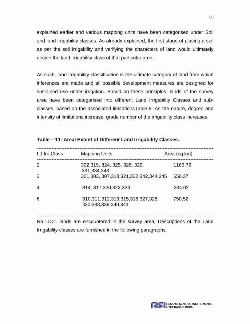
68
REMOTE SENSING INSTRUMENTSHYDERABAD, INDIA.REMOTE SENSING INSTRUMENTSHYDERABAD, INDIA.
explained earlier and various mapping units have been categorised under Soil
and land irrigability classes. As already explained, the first stage of placing a soil
as per the soil irrigability and verifying the characters of land would ultimately
decide the land irrigability class of that particular area.
As such, land irrigability classification is the ultimate category of land from which
inferences are made and all possible development measures are designed for
sustained use under irrigation. Based on these principles, lands of the survey
area have been categorised into different Land Irrigability Classes and sub-
classes, based on the associated limitationsTable-9. As the nature, degree and
intensity of limitations increase, grade number of the irrigability class increases.
Table – 11: Areal Extent of Different Land Irrigability Classes: ------------------------------------------------------------------------------------------------------------ Ld.Irri.Class Mapping Units Area (sq.km) ------------------------------------------------------------------------------------------------------------ 2 302,319, 324, 325, 326, 329, 1163.76 331,334,343 3 301,303, 307,318,321,332,342,344,345 650.37 4 314, 317,320,322,323 234.02
6 310,311,312,313,315,316,327,328, 750.52 330,338,339,340,341
------------------------------------------------------------------------------------------------------------ No LIC-1 lands are encountered in the survey area. Descriptions of the Land
Irrigability classes are furnished in the following paragraphs.

69
REMOTE SENSING INSTRUMENTSHYDERABAD, INDIA.REMOTE SENSING INSTRUMENTSHYDERABAD, INDIA.
7.2.4. LIC-2: Moderate Limitations: Eight mapping units are grouped under this class. Particulars of the mapping
units and soil series are furnished in the following table.
---------------------------------------------------------------------------------------------------------- LIC Subclass Mapping Units Soil Series 2d 302 Gangatoli 2t 319 Balia 2d 324 Nagri, Bthantoli 2d 325 Dolaicha 2d 326 Lohana 2d 329 Dumbartoli 2s 331 Hemromtoli 2s 334 Tanbang 2c 343 Binda ------------------------------------------------------------------------------------------------------------ One unit has topography problem and all other units’ have drainage problem. All
these soils are encountered in the lower elements of topography. Balia series
has sandy soils. In all other cases slight subsoil clay, which makes the internal
drainage imperfect and permeability poor, is the major problem; besides the
other problem of differential textures within the profile. Most of these soils are
under irrigation. Broadly speaking, all these soils need calcium application and
drainage to ward off aggravation of the problems with reduction in yields.
Calcium is such an inhibition that obliterates balanced fertilisation also.

70
REMOTE SENSING INSTRUMENTSHYDERABAD, INDIA.REMOTE SENSING INSTRUMENTSHYDERABAD, INDIA.
7.2.5. LIC-3-: Severe Limitations: Mostly soil related limitations are more in these soils. Mapping units and series
covered under this LIC category are listed below.
------------------------------------------------------------------------------------------------------------ LIC Subclass Mapping Units Soil Series 3d 301 Sangur 3 303 Nawatoli 3t 307 Sukrahatu 3t 318 Bathantoli, Kundo 3d 321 Salangapos 3d 332 Rargaon 3s 342 Ronhe 3t 344 Hariharpur 3s 345 ` Jonha ------------------------------------------------------------------------------------------------------------ These lands are the important agriculture lands under rain-fed conditions.
Soils of mapping unit-318 are loam, which is deep to very deep, but the slopes
are 3-5%.
7.2.7. LIC-4: Very Severe Limitations Limitations become more and more severe as the number of LIC increases. Very
severe limitations of soil in the form of depth, gravelliness or cobbliness or
stoniness or rockiness or other inhabitations such as sodicity are observed in
these areas. Mapping units and series covered under this LIC are furnished in
the following table.

71
REMOTE SENSING INSTRUMENTSHYDERABAD, INDIA.REMOTE SENSING INSTRUMENTSHYDERABAD, INDIA.
------------------------------------------------------------------------------------------------------------ LIC Subclass Mapping Units Soil Series 4t 314 Chama, Karantoli 4t 317 Tangartoli, Hundratoli 4d 320 Lodhma, Salagapos, Jamtoli 4d 322 Banrotoli, Patrotoli 4d 323 Patrotoli ------------------------------------------------------------------------------------------------------------ Two subclasses 4t and 4d are identified. Subclass 4t encompasses two mapping
units. Topography is the limitation in this case. Soil depth is moderately deep to
very deep, soils are on the slopes of over 5% to some extent but mostly extend
up to 10% and at times the areas are stony too. Number of irrigations may
increase the yields but inputs would be very high. As the gradients are more and
soils have lesser effective depth, no drastic levelling can be done. Heavy
machinery should not be used for levelling. Only bench terracing or contour
terracing has to be resorted to, lest the precious surface soil would be lost and
substrata murrum would be exposed. The second category, 4d, encompasses
three units 320, 322&323. These are clayey areas and at places have shallow
water table.
7.2.4. LIC-6: Not Suitable: Mapping units and series grouped under this category are listed in the following
table. Altogether, 9 mapping units are grouped under this category. Problems are
so severe that extending irrigation facilities to these areas would be
uneconomical and also not possible.

72
REMOTE SENSING INSTRUMENTSHYDERABAD, INDIA.REMOTE SENSING INSTRUMENTSHYDERABAD, INDIA.
------------------------------------------------------------------------------------------------------------ LIC Subclass Mapping Units Soil Series
6t 310 Teontoli
6t 311 Tirha
6t 312 Karantoli
6t 313 Tetra
6t 315 Teontoli, Karantoli 6t 316 Teontoli
6t 327 Kudda
6t 328 Bartuwa
6t 330 Joranga 6t 338 Jarerel
6t 339 Dolda
6t 340 Pahantoli 6t 341 Dolda
------------------------------------------------------------------------------------------------------------ These units represent hills, Inselbergs, Pediment inselberg complex, Uplands
and Ridges, Larger areas are rocky. These are unfit for irrigation.
7.3. Soil Suitability Grouping for Sustainable Agriculture: Under this section the soil and land characteristics, assets, deficiencies and
problems have been evaluated for deciding the sustainability for rainfed
agriculture and irrigated agriculture. The primary characteristics of soil and land
like texture, depth, slope conditions, limitations like stoniness, rockiness, salts
etc., have been considered for deciding the suitability. The evaluation is done for
rainfed agriculture and irrigated agriculture separately and presented below:
73
REMOTE SENSING INSTRUMENTSHYDERABAD, INDIA.REMOTE SENSING INSTRUMENTSHYDERABAD, INDIA.
A. Rainfed Agriculture: Due to inherent characteristics of soils, surface features and conditions related to
water holding and nutrient supply, differences in adoptability to various crops
exist under rain fed conditions. In the area of survey, most of the area is under
rain fed agriculture or wastelands that can be put under dry land crops after
some reclamation. The rainfall is very low and if the received precipitation is well
preserved, one successful crop and even two rains fed crops can be taken from
the majority of the area, duly adopting necessary water conservation measures.
Keeping in view of all these factors an attempt is made in this section to assess
the suitability of each soil series to some principal crops that are in vogue in the
survey area.
Soils suitable to rainfed aagriculture are grouped into 5 categories as given
under:
I. Soils with very few limitations for growing crops under rain fed conditions - Very Good - (VG).
II. Soils with few limitations for growing crops under rain fed conditions indicated as- Good - (G).
III. Soils with moderate limitations for growing crops under rain fed conditions indicated as Fair - (F).
IV. Soils with severe limitations for growing crops under rain fed agriculture indicated as Poor - (P).
V. Soils with severe limitations for growing crops under rain fed conditions indicated as Unsuitable - (U).
In estimating the suitability of each soil for particular crop the following properties
are considered.
a. Moisture supplying power of the soil
b. Physical condition with regard to root penetration, erosion etc. c. Presence or absence of salts, both neutral and sodic

74
REMOTE SENSING INSTRUMENTSHYDERABAD, INDIA.REMOTE SENSING INSTRUMENTSHYDERABAD, INDIA.
d. Growth period of a particular crop.
In case of some major crops is compiled and enclosed for general information.
In the present case as mapping is done at association of soil series under each
mapping unit and 36 such mapping units are identified, the suitability rating is
furnished for each mapping unit to aid general planning and development of the
area. Table.12. Provides information of mapping unit wise suitability for rain fed
agriculture.
To cover all the mapping units, areas that are under paddy cultivation are also
included. But, this table has to be referred for guidance in case of rain fed crops.
While classifying the mapping units, the characters of major soil series
associated with the units are considered. In the area of survey, large extents of
irrigated areas are not encountered. Some pockets are under bore well irrigation,
but they are in patches. Most of the area under ground water is reported to be
brackish. Under this situation, more stress is laid in considering rain fed crops.
Obviously, water conservation will remain the primary requisite.
Certain criteria for deciding the suitability under rain fed conditions are presented
in table.12.
Group A areas are not available in the district as they encompass only coarse
textured soils with low run off potential. The major constituents of all the mapping
units are clay loam or clay or have heavy textures below surface horizon. Though
gravelly at surface, textures are often clayey. Thus, run off potentials are
moderate to high in the survey area. As such, sedimentation losses are also
higher from major area. Except the irrigated lands, other areas need soil
conservation. Though the valley lands are also clayey and produce higher run off
potentials; as they are well bunded, in most cases, sediment losses are at
minimum. Thus, management comes as a severe factor in these cases.

75
REMOTE SENSING INSTRUMENTSHYDERABAD, INDIA.REMOTE SENSING INSTRUMENTSHYDERABAD, INDIA.
Table – 12: Suitability for Rainfed Agriculture: ------------------------------------------------------------------------------------------------------------ Mapping Unit Suitability Class Limitation 301 Good Shallow water table.nutral pH
302 Good Shallow water table, low pH
303 Moderate Low pH, Location
307 Moderate Low pH, Location
310 Unsuitable Soil depth, Rocky
311 Unsuitable Soil depth, Rocky
312 Unsuitable Soil depth, Rocky
313 Poor Low pH, Location
314 Poor Low pH, location
315 Unsuitable Soil depth, gravelliness
316 Unsuitable Soil depth, gravelliness
317 Fair Low pH, location
318 Moderate Low pH, location
319 Moderate Low pH, location
320 Good Low pH, base saturation
321 Good shallow water table
322 Good shallow water table, low pH
323 Moderate shallow water table, low pH
324 Good Low pH

76
REMOTE SENSING INSTRUMENTSHYDERABAD, INDIA.REMOTE SENSING INSTRUMENTSHYDERABAD, INDIA.
------------------------------------------------------------------------------------------------------------ Mapping Unit Suitability Class Limitation 325 Good shallow W.T, low pH
326 Good shallow W.T, low pH
327 Unsuitable Soil depth, Rocky
328 Poor Soil depth, Rocky
329 Moderate Low pH, location
330 Unsuitable Soli depth, higher slope
331 Moderate Low pH, location
332 Poor Soil depth, rocky
334 Good Low pH,location
338 Unsuitable Soil depth, Rocky
339 Unsuitable Soil depth, Rocky
340 Moderate Low pH, location
341 Unsuitable Soil depth, Rocky
342 Poor Low pH, location
343 Poor Soil depth, rocky
344 Moderate Soil depth, Rocky
345 Poor Soil depth, rocky
------------------------------------------------------------------------------------------------------------
Nine mapping units are grouped under Good class, which represents low land
areas. Under moderate class mapping units nine mapping units are grouped.
These units have limitations of location of low pH.
B. Irrigated Agriculture The irrigability suitability classification aims at assessing the inherent properties
of the soils that express their degree of limitations for development under
irrigated agriculture. If water is available, with varied inputs and costs any soil
can be brought under irrigation. But the core idea of classification is to indicate
the best soils suitable for irrigation with limited management and have sustained
use of the soils under irrigation. The following soil properties are generally
77
REMOTE SENSING INSTRUMENTSHYDERABAD, INDIA.REMOTE SENSING INSTRUMENTSHYDERABAD, INDIA.
considered for classifying the soils under varied degrees of suitability for
sustained use under irrigation.
A generalised picture of these various parameters are to be considered before
deciding any soil on its suitability for irrigation. Since the consideration is for
‘sustained use under irrigation’, considering the present status of the soils or the
present condition is alone not sufficient.
The long-term behaviour of the soils under irrigation should also be considered.
Some of the important parameters are as follows:
i. Depth of soil
ii. Texture at surface
iii. Water holding capacity
iv. If salts are present, the amount and nature
v. pH of the soil
vi. Cation exchange capacity
vii. Drainage conditions
viii. Depth of Ground water
Land irrigability classification has already been discussed under section 6.3 of
the report. As and additional information the following points are discussed
keeping in view of the properties indicated earlier.
a. Best suited: None
b.Better suitable: Mapping units 302,320,321,322,323,324,325,326,331,334and
343 can be developed as wetlands. Some of these areas are already under
sugarcane/paddy cultivation. Though, these areas are in lower elements of
topography and mostly under irrigation, they are slightly sodic and for better
results drainage need to be provided and amendments may be added as

78
REMOTE SENSING INSTRUMENTSHYDERABAD, INDIA.REMOTE SENSING INSTRUMENTSHYDERABAD, INDIA.
required. Soils are also good and can be better managed with limited
expenditure.
c. Moderately suitable: Mapping units 303,307,318,319,332, 342,344,345
considered to be moderately suitable for irrigation because of the limitations of
higher slope gradients topography and heavy soil texture. Continuous
management is required.
d. Poorly suitable: Mapping units 314,317,328,329 and 342 are poorly suitable
because of the terrain conditions and the shallowness of soil, severe erosion
etc.
e. Unsuitable: Mapping units 310, 311, 312,313,315,327,328,330, 338,340 are
unsuitable for irrigation because of their topography, hilly and rocky nature of the
landscapes. Crops mentioned in this table are popular in survey area. Standards
used for Jowar (Sorghum) are applicable to Bajra also.
7.4. Cropping Systems And Recommended Crops: Concept of cropping system is as old as agriculture. Farmers’ prefered mixed
cropping, especially under dryland conditions, to minimise the risk of total failure.
Even in Vedas there is mention of first and second crops, indicating existence of
sequential cropping. Cropping system comprises all components required for the
production of a particular crop and the interrelations between them and
environment (TAC, CGIAR 1978). In other words, a cropping system usually
refers to a combination of crops in time and space. The term cropping system is
often used interchangeable with multiple cropping, which in essence represents a
philosphy of maximum crop production per unit area of land within a year or
some other relevant time unit with minimum land degradation. Cropping systems
approach, in contrast to component approach, encompasses wide range of
issues related to economic aspects of crop production. Cropping systems
approach enables to address issues pertaining to:

79
REMOTE SENSING INSTRUMENTSHYDERABAD, INDIA.REMOTE SENSING INSTRUMENTSHYDERABAD, INDIA.
o Maximising system productivity on annual basis,
o Utilisation of resources with higher efficiency by considering various
interactions and direct, residual and cumulative effect in soil-plant-
environment system,
o Intensive input use vis-avis quality of environment, and
o Sustainability of farm resources and environment in long-term perspective.
The cropping system should deal with the following aspects;
o Development of economically viable and resource efficient cropping
sytems for different agroclimatic conditions,
o Development of agrotechniques for major cropping systems,
o Improvement in use efficiency of nutrients and other inputs, and
o Resource characterisation, problem diagnosis and priortisation of issues
under different farming situations.
The goal of any cropping system should be output specific, and an efficient
cropping system should maximise the resource use (soil, water, solar radiation,
vegetation and humas and animals). This should be achieved by identifying the
crop adoption zone for maximum production, based on soil climate and
management strategy.
There are two major cropping sytems, which are mostly followed:
Dryland Cropping Systems: The crop production in areas having less than 750
mm annual rainfall in case of arid and semi arid climate, have moderate to
severe soil moisture stress during substantial period of the crop-growing season.
In arid and semi arid tropics with-6 months crop growing season, predominant
cropping system is intercropping with short season crops. In case of longer
cropping season the intercropping should be done with short season crops.

80
REMOTE SENSING INSTRUMENTSHYDERABAD, INDIA.REMOTE SENSING INSTRUMENTSHYDERABAD, INDIA.
Intercropping: Cereals with pigeonpea intercropping systems are popular in
India. Amount of rainfall determines the cereal crop associated with pigeonpea:
rice with 1000 to 1500mm, maize with 750 to 1000mm, sorghum with 500to
750mm and millets with 400 to 600mm rainfall. Mostly cereals, depending on
their growth duration and height, reduce the growth of pegion pea and can be
ranked for competativeness: maize>sorghum>pearlmillet>setaria.
It is better if pearl millete is intercropped in pegionpea wih low rainfall areas on
shallow to medium deep soils during rainy season. The sorghum and pegionpea
can be grown as yield advantage. In intercropping choice of a tall or short, early
or late maturing, flowering or nonflowering companion crop can magnify or
decrease the effects of particular pest. The miaze and sweet potato intercropping
may pose good and profitable to farmers. On the same soil sorghum and
groundnut can also be practised that will be more profitable in the rainy season.
Corn in monoculture is unique, since on many soils it maintains reasonably
acceptable soil physical condition. The factors are (1) the return of several tons
of crop residues to the soil when corn is harvested for grain and (2) the corn crop
is well adopted to reduce tillage and decreased damage from traffic on the soil.
Irrigation water is scarce and costly resource of crop production. Rice-mustard-
sesame, rice-mustard-greengram and rice-potato-greengram are the suitable
cropping system and remunerative and have proved less water consuming.
Weed management for any cropping system can involve the use of many kinds
of biological, physical and chemical techniques to promote crop dominance over
weeds.
Most suitable agro-ecosystems to avoid diseases, damage in tropical areas are
multiple cropping systems that resemble to control the virus infection. Crop
rotation can lower the inoculum of many pathogens. Wilt of pigeonpea caused by
Fusarium odium can be minimised by its rotation with sorghum.

81
REMOTE SENSING INSTRUMENTSHYDERABAD, INDIA.REMOTE SENSING INSTRUMENTSHYDERABAD, INDIA.
The following crops can be grown are recommended for the Khunti soils:
1-In case of Alfisols-soybean, groundnut, mungbean, millet (or sorghum) linseed,
chikpea, sunflower, mustard and rice.
This cropping system is best suited for the soils of Khunti for one year.
Rice –cowpea-fingermillet
Rice-potato-cowpea
Rice-pulses
Paddy-wheat-lobia
Maize-rice
Paddy-potato-mung
Maize –poatao- wheat
Paddy-lentil
Paddy-gram
The above-mentioned cropping systems can be best suited and recommended
for the different regions of Ranchi soils.
A short duration rainfed green manure crop can be grown taking advantage of
early monsoon rains in June, which can be incorpoarted before planting the rice.
The development of short duration and photo-sensitive varieties of various crops
in areas with assured irrigation a series of cropping sequence with wheat as one
of the main crops have been developed. These cropping sequences have been
designated as crop cafetaria, which denotes that farmers can choose any
cropping sequence, etc.
7.5. Horticulture Development: Khunti district is suitable for growing different
types of vegetables and fruits. The soils and climate of the area is suitable for the
cultivation of vegetables like potato, tomato, cauliflower, cabbage .The fruits are
also grown to some extent, the main fruits grown are like mango, banana, guava,
litchi and upto some extent citrus.

82
REMOTE SENSING INSTRUMENTSHYDERABAD, INDIA.REMOTE SENSING INSTRUMENTSHYDERABAD, INDIA.
7.5.1. Suitability for Horticulture: Highly calcareous soils encountered in mapping unit under valley fills can be well
developed under citrus gardens. Mapping units 314,316,318,319 and 329 could
be developed under Mango orchards, provided water facilities could be
generated. This method involves digging of pits of 4’x4’x4’ size, filling the pit with
good soil mixed with manures and fertilisers and planting hybrid varieties of
Mangos which start fruiting from the third year.
7.5.2. Suitability for Fuel and Fodder: Areas under stony and rocky phases, highly sloping areas and very severe
gravelly lands are to be earmarked for grassland development. The requirements
of fodder and fuel are equally important and are to be met with. Species of Pipal
can grow well in these soils, which could be used for fuel and also as cheap
timber. The fruits and leaves of these species, particularly of Arabica are
palatable to goats and sheep. They are available even in agricultural lands.
Juliflora sp. can be grown on stream banks, catchements of tanks in the near
vicinity of eater spread, in sodic soils etc., this sp.will grow any where, but in fact
spread profusely. The branches of this species are excellent as firewood. Su-
babul is another plant that grows rapidly and is useful as fodder by lopping.
Branches are useful as firewood and the bigger wood parts could also be used
as cheap timber. This plant seeds very profusely and has a market value.
Grasses of leguminous types could be grown on eroding slopes, stream banks
where areas are severely to very severely eroded and undulating/hummocky
areas. These are self-spreading and once well-established can be used for
grazing. The matty root system also protects the soil from further erosion. Ber
(zizyphus Jujuba) grows well even in the rocky areas and also under arid to
semi-arid conditions. Grasses like Cinnadon, Saccharum sp. can grow well.
Local varieties like Sheda and Marvel may have to be sown in all the rocky and
gravelly areas and high slopes. The following mapping units are to be developed
under grasses and other useful plants.
Mapping Units: 310,311,312,313,315,317,320,322,327,328,330, 338 and 340.

83
REMOTE SENSING INSTRUMENTSHYDERABAD, INDIA.REMOTE SENSING INSTRUMENTSHYDERABAD, INDIA.
7.6. Hydrologic Soil Groups: Hydrologic soil groups utilise such soil parameters to determine hydrologic soil
complexes for using in estimating runoff in any given area. The main soil and
land characteristics such as texture, depth, profile makeup, slope, gravelliness,
stoniness, rockiness and other associated factors are considered in classifying
the areas under Hydrologic soil groups. Rainfall is one important parameter,
which has to be considered since the intensity, and total quantum decides runoff
character. Apart from the rainfall, the soil-associated characters such as
permeability and infiltration also decide the run off. Considering the uniform
rainfall pattern is almost uniform in the survey area for the purpose of Hydrologic
soil groups, categorisation of mapping units is attempted and the information is
provided in table No.13. The Hydrologic soil groups are also very important and useful for Hydrologic
status in watershed management programmes, which will decide the approach
for their development. As the mapping system is through remote sensing
technology and the scale of mapping is smaller (1:50000), major soil composition
in the mapping units is considered for classifying the soil under this interpretation
grouping.
As per the standards available in India, the definitions, of Hydrologic groups are
as follows. Mainly 4 categories of Hydrologic groups are identified.
Group A: Low Runoff Potential: Soils which are deep, excessively drained, sand
and gravels that have high infiltration grades.
Group B: Moderately Low Runoff Potential: Moderately deep to deep, moderately
well drained, fine to moderately coarse textured soils, moderate infiltration
grades.
Group C: Moderately High Runoff Potential: Moderately deep-to-deep,
moderately coarse textured soils with slow infiltration rate.

84
REMOTE SENSING INSTRUMENTSHYDERABAD, INDIA.REMOTE SENSING INSTRUMENTSHYDERABAD, INDIA.
Group D: High Runoff Potential: Clayey soils with high swell potential, high water
table, clay pan and shallow soils having impervious layers with slow infiltration
rates.
Classifying the areas of survey as per the standards mentioned above, 3
categories of Hydrologic soil groups are identified. The information is compiled in
the following table (Table-13). Hilly and rocky areas are excluded from the
purview of this classification as the system dwells with Hydrological Soil
Grouping.
Table – 13: Hydrological Soil Groupings: ------------------------------------------------------------------------------------------------------------ H.S.G. Mapping Unit Description
------------------------------------------------------------------------------------------------------------ A --- --- B 302, 303,307,310,311,314, Mod.low runoff,
317,316,318,319, potential, 331,334,339,340,341,342,344 C 301,305, 320,321,324,325,326,345, Mod.low runoff 330,332,343,345,338 potential,Mod.deep-to- deep soil, gravelly soils Clay textures, sub-soils D 322,323,312,313 High runoff potential, heavy soils ------------------------------------------------------------------------------------------------------------
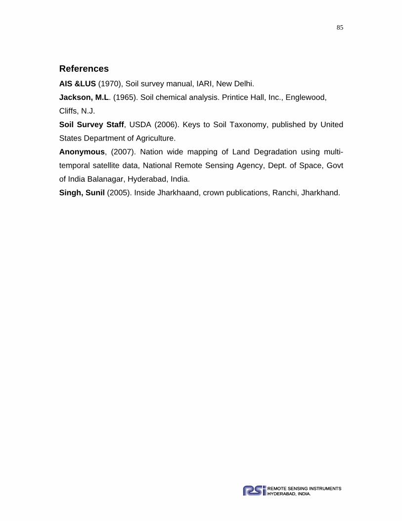
85
REMOTE SENSING INSTRUMENTSHYDERABAD, INDIA.REMOTE SENSING INSTRUMENTSHYDERABAD, INDIA.
References AIS &LUS (1970), Soil survey manual, IARI, New Delhi.
Jackson, M.L. (1965). Soil chemical analysis. Printice Hall, Inc., Englewood,
Cliffs, N.J.
Soil Survey Staff, USDA (2006). Keys to Soil Taxonomy, published by United
States Department of Agriculture.
Anonymous, (2007). Nation wide mapping of Land Degradation using multi-
temporal satellite data, National Remote Sensing Agency, Dept. of Space, Govt
of India Balanagar, Hyderabad, India.
Singh, Sunil (2005). Inside Jharkhaand, crown publications, Ranchi, Jharkhand.

86
REMOTE SENSING INSTRUMENTSHYDERABAD, INDIA.REMOTE SENSING INSTRUMENTSHYDERABAD, INDIA.
APPENDIX-I Description of Soil Series

87
REMOTE SENSING INSTRUMENTSHYDERABAD, INDIA.REMOTE SENSING INSTRUMENTSHYDERABAD, INDIA.
Sangur Series Profile No. : 76
Mapping Unit : 301
Location : 1.5Km North West of village Sangur
Toposheet No. : 73E/4
Lat. Long : N 23º9’52.4” E 85º4’49.9”
Elevation : 594m
Slope Percentage : 0-1%
Slope Direction : E-W
Physiography : Very gently sloping Alluvial plain
Land Use / Land Cover : Harvested Paddy
Parent Material : Alluvium
Erosion Class : e1
Land Capability Sub Class : IIIw
Land Irrigability Sub Class : 3d
Morphology:
Horizon Depth
(cm) Description
Ap 0-20 Dark gray (10YR4/1m) sandy clay loam; moderate, medium to
coarse, sub-angular blocky; friable, slightly sticky, slightly plastic;
many very fine to medium pores; many very fine to fine roots;
gradual clear smooth boundary.
B11 20-55 Very dark grayish brown (10YR3/2m) sandy clay loam; moderate,
medium, sub-angular blocky; friable, sticky, plastic; common very
fine to medium pores; common very fine roots; gradual clear
smooth boundary.
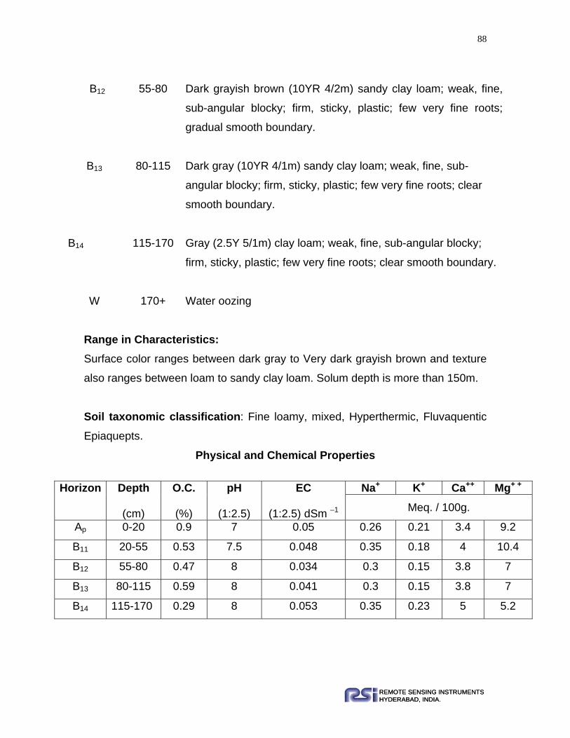
88
REMOTE SENSING INSTRUMENTSHYDERABAD, INDIA.REMOTE SENSING INSTRUMENTSHYDERABAD, INDIA.
Range in Characteristics: Surface color ranges between dark gray to Very dark grayish brown and texture
also ranges between loam to sandy clay loam. Solum depth is more than 150m.
Soil taxonomic classification: Fine loamy, mixed, Hyperthermic, Fluvaquentic
Epiaquepts.
Physical and Chemical Properties
Horizon Depth
(cm)
O.C.
(%)
pH
(1:2.5)
EC
(1:2.5) dSm –1
Na+ K+ Ca++ Mg+ +
Meq. / 100g.
Ap 0-20 0.9 7 0.05 0.26 0.21 3.4 9.2
B11 20-55 0.53 7.5 0.048 0.35 0.18 4 10.4
B12 55-80 0.47 8 0.034 0.3 0.15 3.8 7
B13 80-115 0.59 8 0.041 0.3 0.15 3.8 7
B14 115-170 0.29 8 0.053 0.35 0.23 5 5.2
B12 55-80 Dark grayish brown (10YR 4/2m) sandy clay loam; weak, fine,
sub-angular blocky; firm, sticky, plastic; few very fine roots;
gradual smooth boundary.
B13 80-115 Dark gray (10YR 4/1m) sandy clay loam; weak, fine, sub-
angular blocky; firm, sticky, plastic; few very fine roots; clear
smooth boundary.
B14 115-170 Gray (2.5Y 5/1m) clay loam; weak, fine, sub-angular blocky;
firm, sticky, plastic; few very fine roots; clear smooth boundary.
W 170+ Water oozing
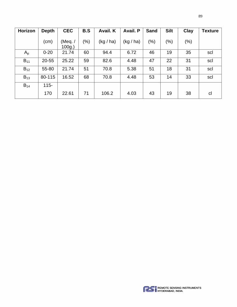
89
REMOTE SENSING INSTRUMENTSHYDERABAD, INDIA.REMOTE SENSING INSTRUMENTSHYDERABAD, INDIA.
Horizon Depth
(cm)
CEC
(Meq. / 100g.)
B.S
(%)
Avail. K
(kg / ha)
Avail. P
(kg / ha)
Sand
(%)
Silt
(%)
Clay
(%)
Texture
Ap 0-20 21.74 60 94.4 6.72 46 19 35 scl
B11 20-55 25.22 59 82.6 4.48 47 22 31 scl
B12 55-80 21.74 51 70.8 5.38 51 18 31 scl
B13 80-115 16.52 68 70.8 4.48 53 14 33 scl
B14 115-
170 22.61 71 106.2 4.03 43 19 38 cl
90
REMOTE SENSING INSTRUMENTSHYDERABAD, INDIA.REMOTE SENSING INSTRUMENTSHYDERABAD, INDIA.
Gangatoli Series Profile No. : 308
Mapping Unit : 302
Location : 100m East of village Gangatoli
Toposheet No. : 73A/7
Lat. Long : N 23º17’50.2” E 84º28’54.9”
Elevation : 669m
Slope Percentage : 0-1%
Slope Direction : W-E
Physiography : Nearly level Alluvial plain
Land Use / Land Cover : Harvested Paddy
Parent Material : Alluvium
Erosion Class : e1
Land Capability Sub Class : lls
Land Irrigability Sub Class : 2d
Morphology:
Horizon Depth
(cm) Description
Ap 0 – 19 Grayish brown (10YR 4.5/2m) loam; weak, fine,
medium to coarse, sub-angular blocky, friable, slightly
sticky, slightly plastic; few very fine to medium pores;
many fine to medium roots; gradual smooth boundary.
B11 t 19-70 Brown (10 YR5/3m) sandy clay loam; fine, medium,
coarse sub-angular blocky; friable, very sticky, very
plastic; few fine, medium pores; patchy thin cutans; few
fine to medium roots; gradual smooth boundary.

91
REMOTE SENSING INSTRUMENTSHYDERABAD, INDIA.REMOTE SENSING INSTRUMENTSHYDERABAD, INDIA.
Range in Characteristics: Surface texture ranges between loam and sandy clay
loam and Solum depth is more than 150cm.
Soil taxonomic classification: Fine, mixed, Hyperthermic and Oxyaquic
Haplustalfs.
Physical and Chemical Properties
Horizon Depth
(cm)
O.C.
(%)
pH
(1:2.5)
EC
(1:2.5) dSm –1
Na+ K+ Ca++ Mg+ +
Meq. / 100g.
Ap 0-19 1.05 5.7 0.028 0.26 0.44 8 4
B11 t 19-70 0.6 7.3 0.021 0.26 0.26 16 6
B12 t 70-140 0.6 7.1 0.020 0.23 0.22 17 8
Horizon Depth
(cm)
CEC
(Meq. / 100g.)
B.S
(%)
Avail. K
(kg / ha)
Avail. P
(kg / ha)
Sand
(%)
Silt
(%)
Clay
(%)
Texture
Ap 0-19 15.65 51 200.6 2.46 45 37 18 l
B11 t 19-70 27.83 61 118 1.79 52 13 35 scl
B12 t 70-140 27.66 72 110 1.77 54 13 33 scl
B12 t 70-140 Brown (10YR 5/3m) sandy clay loam; weak, fine, medium
to coarse, sub-angular blocky; friable, very sticky, very
plastic; few very fine to medium pores; patchy thin cutans;
gradual smooth boundary.
140+ Water oozing

92
REMOTE SENSING INSTRUMENTSHYDERABAD, INDIA.REMOTE SENSING INSTRUMENTSHYDERABAD, INDIA.
Nawatoli Series Profile No. : 294
Mapping Unit : 303
Location : 100m South of village Nawatoli
Toposheet No. : 73A/7
Lat. Long : N 23º18’16.7” E 84º17’50.5”
Elevation : 1063m
Slope Percentage : 0-1%
Slope Direction : SE-NW
Physiography : Very gently sloping plateau top
Land Use / Land Cover : Harvested paddy
Parent Material : Laterite
Erosion Class : e2
Land Capability Sub Class : lls Land Irrigability Sub Class : 3d
Morphology:
Horizon Depth
(cm) Description
Ap 0 –20 Brown (10YR 5/3m) silty clay loam; weak, fine,
medium coarse, sub-angular blocky, friable, slightly
sticky, slightly plastic; gravels 2-3%; many fine,
common medium pores; many fine to medium roots;
gradual smooth boundary.
B11t 20-45 Yellowish brown (10YR 4.5/4m) clay; weak, fine,
medium coarse, sub-angular blocky; friable, slightly
sticky, slightly plastic; gravels 2-5%; many few to
medium pores; patchy thin cutans; gradual smooth
boundary.
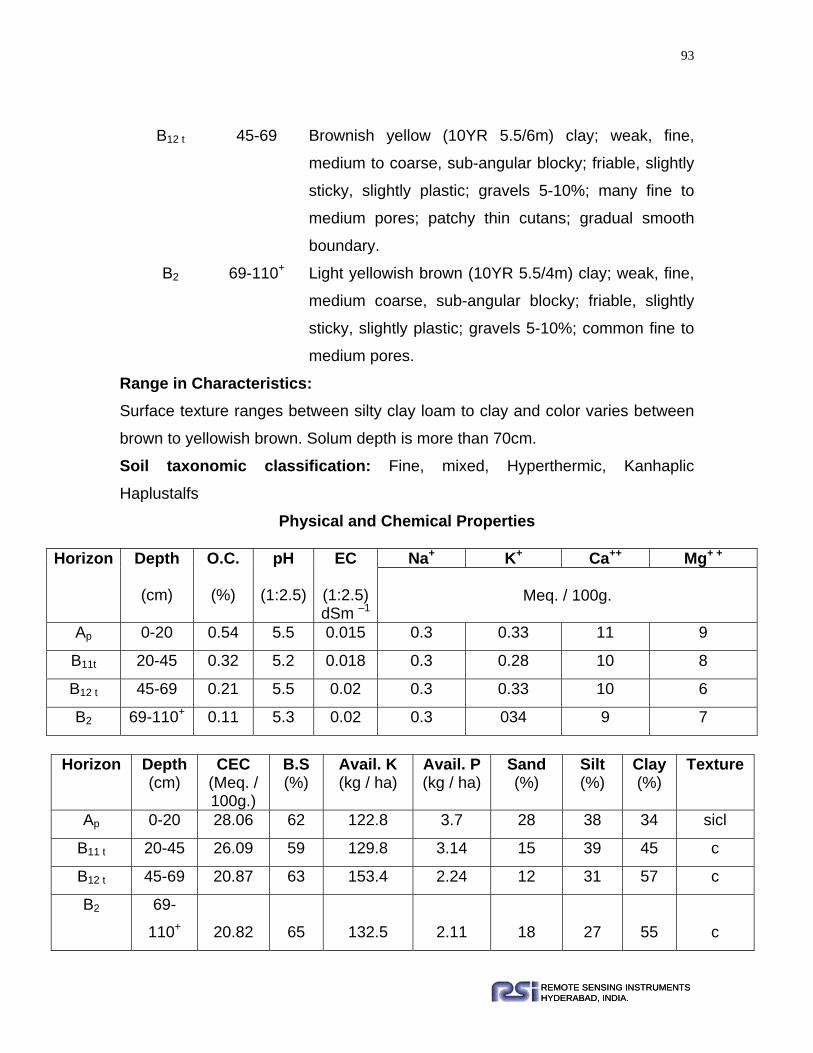
93
REMOTE SENSING INSTRUMENTSHYDERABAD, INDIA.REMOTE SENSING INSTRUMENTSHYDERABAD, INDIA.
Range in Characteristics: Surface texture ranges between silty clay loam to clay and color varies between
brown to yellowish brown. Solum depth is more than 70cm.
Soil taxonomic classification: Fine, mixed, Hyperthermic, Kanhaplic
Haplustalfs
Physical and Chemical Properties
Horizon Depth
(cm)
O.C.
(%)
pH
(1:2.5)
EC
(1:2.5) dSm –1
Na+ K+ Ca++ Mg+ +
Meq. / 100g.
Ap 0-20 0.54 5.5 0.015 0.3 0.33 11 9
B11t 20-45 0.32 5.2 0.018 0.3 0.28 10 8
B12 t 45-69 0.21 5.5 0.02 0.3 0.33 10 6
B2 69-110+ 0.11 5.3 0.02 0.3 034 9 7
Horizon Depth
(cm) CEC
(Meq. / 100g.)
B.S (%)
Avail. K (kg / ha)
Avail. P (kg / ha)
Sand (%)
Silt (%)
Clay (%)
Texture
Ap 0-20 28.06 62 122.8 3.7 28 38 34 sicl
B11 t 20-45 26.09 59 129.8 3.14 15 39 45 c
B12 t 45-69 20.87 63 153.4 2.24 12 31 57 c
B2 69-
110+ 20.82 65 132.5 2.11 18 27 55 c
B12 t 45-69 Brownish yellow (10YR 5.5/6m) clay; weak, fine,
medium to coarse, sub-angular blocky; friable, slightly
sticky, slightly plastic; gravels 5-10%; many fine to
medium pores; patchy thin cutans; gradual smooth
boundary.
B2 69-110+ Light yellowish brown (10YR 5.5/4m) clay; weak, fine,
medium coarse, sub-angular blocky; friable, slightly
sticky, slightly plastic; gravels 5-10%; common fine to
medium pores.
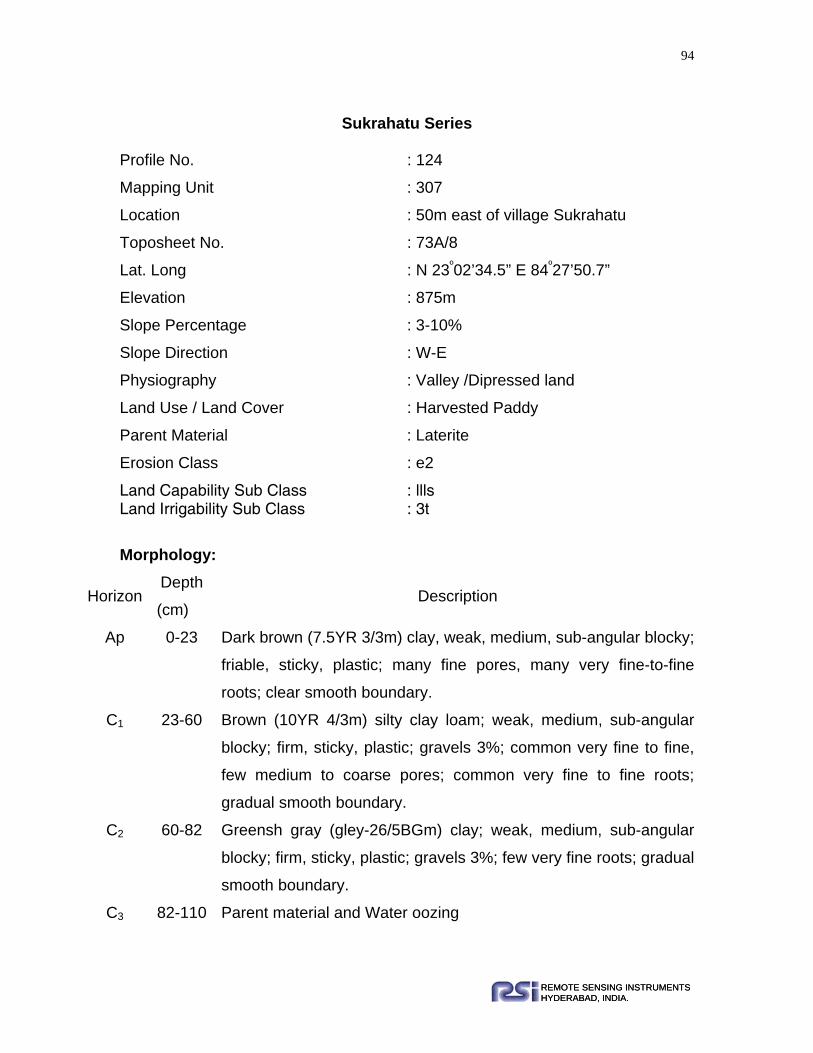
94
REMOTE SENSING INSTRUMENTSHYDERABAD, INDIA.REMOTE SENSING INSTRUMENTSHYDERABAD, INDIA.
Sukrahatu Series
Profile No. : 124
Mapping Unit : 307
Location : 50m east of village Sukrahatu
Toposheet No. : 73A/8
Lat. Long : N 23º02’34.5” E 84º27’50.7”
Elevation : 875m
Slope Percentage : 3-10%
Slope Direction : W-E
Physiography : Valley /Dipressed land
Land Use / Land Cover : Harvested Paddy
Parent Material : Laterite
Erosion Class : e2
Land Capability Sub Class : llls Land Irrigability Sub Class : 3t
Morphology:
Horizon Depth
(cm) Description
Ap 0-23 Dark brown (7.5YR 3/3m) clay, weak, medium, sub-angular blocky;
friable, sticky, plastic; many fine pores, many very fine-to-fine
roots; clear smooth boundary.
C1 23-60 Brown (10YR 4/3m) silty clay loam; weak, medium, sub-angular
blocky; firm, sticky, plastic; gravels 3%; common very fine to fine,
few medium to coarse pores; common very fine to fine roots;
gradual smooth boundary.
C2 60-82 Greensh gray (gley-26/5BGm) clay; weak, medium, sub-angular
blocky; firm, sticky, plastic; gravels 3%; few very fine roots; gradual
smooth boundary.
C3 82-110 Parent material and Water oozing

95
REMOTE SENSING INSTRUMENTSHYDERABAD, INDIA.REMOTE SENSING INSTRUMENTSHYDERABAD, INDIA.
Range in Characteristics: Surface texture ranges between dark brown to greenish brown and texture varies
between silty clay loam to clay. Solum depth ranges between 20-80.
Soil taxonomic classification: Fine, mixed, Hyperthermic, Oxyaquic
Ustifluvents
Physical and Chemical Properties
Horizon Depth
(cm)
O.C.
(%)
pH
(1:2.5)
EC
(1:2.5) dSm –1
Na+ K+ Ca++ Mg+ +
Meq. / 100g.
Ap 0-23 1.58 5.2 0.076 0.3 0.87 7 3.4
C1 23-60 0.83 6.4 0.04 0.26 0.74 5.2 6.2
C2 60-82 0.23 5.9 0 0.26 0.87 3.2 14.8
Horizon Depth
(cm)
CEC
(Meq. / 100g.)
BS
(%)
Avail. K
(kg / ha)
Avail. P
(kg / ha)
Sand
(%)
Silt
(%)
Clay
(%)
Texture
Ap 0-23 23.48 49 401.2 6.72 28.45 28.77 42.78 c
C1 23-60 23.48 53 342.2 5.38 15.55 54.94 29.51 sicl
C2 60-82 26.09 73 401.2 4.48 21.05 29.81 49.15 c
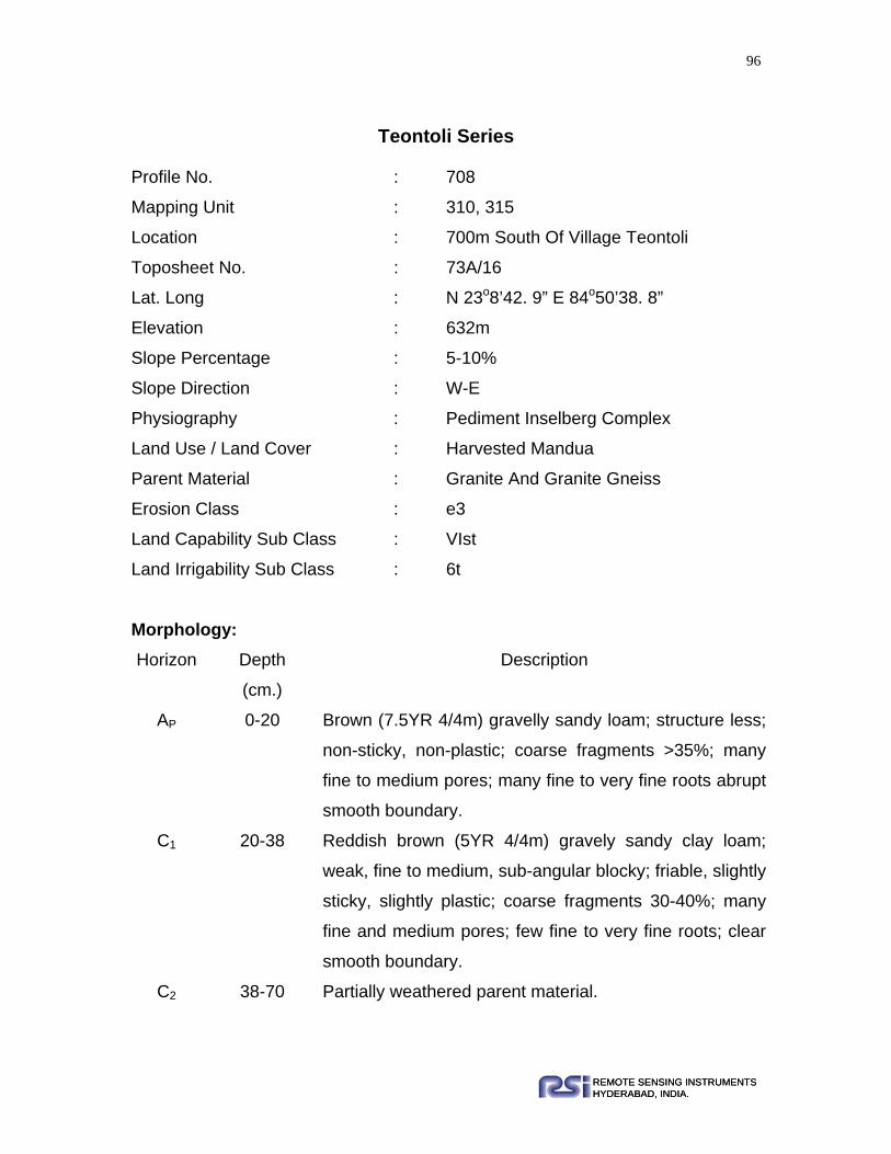
96
REMOTE SENSING INSTRUMENTSHYDERABAD, INDIA.REMOTE SENSING INSTRUMENTSHYDERABAD, INDIA.
Teontoli Series
Profile No. : 708
Mapping Unit : 310, 315
Location : 700m South Of Village Teontoli
Toposheet No. : 73A/16
Lat. Long : N 23o8’42. 9” E 84o50’38. 8”
Elevation : 632m
Slope Percentage : 5-10%
Slope Direction : W-E
Physiography : Pediment Inselberg Complex
Land Use / Land Cover : Harvested Mandua
Parent Material : Granite And Granite Gneiss
Erosion Class : e3
Land Capability Sub Class : VIst
Land Irrigability Sub Class : 6t
Morphology: Horizon Depth
(cm.)
Description
AP 0-20 Brown (7.5YR 4/4m) gravelly sandy loam; structure less;
non-sticky, non-plastic; coarse fragments >35%; many
fine to medium pores; many fine to very fine roots abrupt
smooth boundary.
C1 20-38 Reddish brown (5YR 4/4m) gravely sandy clay loam;
weak, fine to medium, sub-angular blocky; friable, slightly
sticky, slightly plastic; coarse fragments 30-40%; many
fine and medium pores; few fine to very fine roots; clear
smooth boundary.
C2 38-70 Partially weathered parent material.

97
REMOTE SENSING INSTRUMENTSHYDERABAD, INDIA.REMOTE SENSING INSTRUMENTSHYDERABAD, INDIA.
Range in Characteristics: The surface texture ranges between sandy loam to clay loam. The solum depth
is more than 30- 50cm.
Soil taxonomic classification: Loamy skeletal, mixed, Hyperthermic, Typic
Ustochrepts
Physical and Chemical Properties
Horizon Depth
(cm)
O.C.
(%)
pH
(1:2.5)
EC
(1:2.5) dSm –1
Na+ K+ Ca++ Mg+ +
Meq. / 100g.
Ap 0-20 0.42 5.5 0.055 0.35 0.31 9 9
C1 20-38 0.35 6.1 0.035 0.39 0.21 4.6 10.8
Horizon Depth
(cm)
CEC
(Meq. / 100g.)
B.S
(%)
Avail. K
(kg / ha)
Avail. P
(kg / ha)
Sand
(%)
Silt
(%)
Clay
(%)
Texture
Ap 0-20 20.87 64 141.6 7.62 25 50 25 sl
C1 20-38 21.74 68 94.4 8.06 35 16 49 scl

98
REMOTE SENSING INSTRUMENTSHYDERABAD, INDIA.REMOTE SENSING INSTRUMENTSHYDERABAD, INDIA.
Tirha Series
Profile No. : 276
Mapping Unit : 311
Location : 500m North of village Tirha
Toposheet No. : 73B/13
Lat. Long : N 22º52’22. 2” E 84º50’46.6”
Elevation : 537m
Slope Percentage : 25-35%
Slope Direction : N-S
Physiography : Residual hills
Land Use / Land Cover : Scrub lands/Forest land
Parent Material : Granite Gneiss
Erosion Class : e3
Land Capability Sub Class : VI t Land Irrigability Sub Class : 6t Morphology:
Range in Characteristics: The surface texture ranges between sandy loam to loamy sand. The solum depth
varies between 25-45cm.
Soil Taxonomic classification: Loamy skeletal, mixed, Hyperthermic, Lithic
Ustorthents.
Horizon Depth
(cm) Description
A1 0-20 Dark yellowish brown (10YR 3.5/4m) gravelly sandy loam; weak,
fine to medium, sub-angular blocky; friable, slightly sticky, slightly
plastic; coarse fragments %; many fine to medium pores; few fine
to medium roots; clear smooth boundary.
R 20+ Lithic contact

99
REMOTE SENSING INSTRUMENTSHYDERABAD, INDIA.REMOTE SENSING INSTRUMENTSHYDERABAD, INDIA.
Physical and Chemical Properties
Horizon Depth
(cm)
O.C.
(%)
pH
(1:2.5)
EC
(1:2.5) dSm –1
Na+ K+ Ca++ Mg+ +
Meq. / 100g.
A1 0-20 0.4 6.5 0.02 0.2 0.78 9 0.9
Horizon Depth
(cm)
CEC
(Meq. / 100g.)
B.S
(%)
Avail. K
(kg / ha)
Avail. P
(kg / ha)
Sand
(%)
Silt
(%)
Clay
(%)
Texture
A1 0-20 11 68 11.8 1.4 24 65 11 sl

100
REMOTE SENSING INSTRUMENTSHYDERABAD, INDIA.REMOTE SENSING INSTRUMENTSHYDERABAD, INDIA.
Karantoli Series Profile No. : 318
Mapping Unit : 312
Location : 2.5km East Of Village Karantoli
Toposheet No. : 73B/10
Lat. Long : N 22o32’54. 1” E 84o32’6. 4”
Elevation : 415m
Slope Percentage : 15-25%
Slope Direction : SE-NW
Physiography : Dissected Hills
Land Use / Land Cover : Open Mixed Forest
Parent Material : Granite and Granite Gneiss
Erosion Class : e3
Land Capability Sub Class : VIt
Land Irrigability Sub Class : 6t
Morphology: Horizon Depth
(cm) Description
Ap 0 – 31 Reddish brown (5YR 3.5/4m) gravelly sandy loam sand; weak,
fine, sub-angular blocky; very friable, non-sticky, non-plastic;
coarse fragments >35%; many fine to medium pores; many fine
to medium, few coarse roots; clear smooth boundary
C 31 – 115 Partially weathered parent material.
Range in Characteristics: The surface texture ranges between sandy loam to loamy sand. The solum
depth varies between 30-50cm.
Soil taxonomic classification: Loamy skeletal, mixed, Hyperthermic, Typic
Ustorthents.

101
REMOTE SENSING INSTRUMENTSHYDERABAD, INDIA.REMOTE SENSING INSTRUMENTSHYDERABAD, INDIA.
Physical and Chemical Properties
Horizon Depth
(cm)
O.C.
(%)
pH
(1:2.5)
EC
(1:2.5) dSm –1
Na+ K+ Ca++ Mg+ +
Meq. / 100g.
Ap
0-30
0.8 6.5 0.02 0.2 0.89 11 4.1
Horizon Depth
(cm)
CEC
(Meq. / 100g.)
B.S
(%)
Avail. K
(kg / ha)
Avail. P
(kg / ha)
Sand
(%)
Silt
(%)
Clay
(%)
Texture
Ap
0-30
18 65 409.57 1.8 56 20 24 sl

102
REMOTE SENSING INSTRUMENTSHYDERABAD, INDIA.REMOTE SENSING INSTRUMENTSHYDERABAD, INDIA.
Tetra Series Profile No. : 274
Mapping Unit : 313
Location : 600m North East Of Village Tetra
Toposheet No. : 73B/13
Lat. Long : N 22o52’3.4” E 84o46’46.8”
Elevation : 532m
Slope Percentage : 5-10%
Slope Direction : SE-NW
Physiography : Inselberg
Land Use / Land Cover : Scrublands
Parent Material : Granite and Granite Gneiss
Erosion Class : e3
Land Capability Sub Class : VIt
Land Irrigability Sub Class : 6t
Morphology: Horizon Depth
(cm) Description
Ap 0 – 25 Yellowish brown (10YR 4.5/4m) loamy sand; weak, fine medium
to coarse sub-angular blocky; friable, slightly sticky, slightly
plastic; coarse fragments >35%; many fine to medium pores;
few fine to medium roots; gradual smooth boundary
C1 25 – 70 Partially weathered parent material,
R 70+ Hard rock
Range in Characteristics: The surface texture ranges between sandy loam to loamy sand. The solum depth
varies between 15-25cm.

103
REMOTE SENSING INSTRUMENTSHYDERABAD, INDIA.REMOTE SENSING INSTRUMENTSHYDERABAD, INDIA.
Soil taxonomic classification: Loamy skeletal, mixed, Hyperthermic, Typic
Ustorthents.
Physical and Chemical Properties
Horizon Depth
(cm)
O.C.
(%)
pH
(1:2.5)
EC
(1:2.5) dSm –1
Na+ K+ Ca++ Mg+ +
Meq. / 100g.
Ap 0-25
0.38
6.7
0.031
0.17
0.1
4
6
Horizon Depth
(cm)
CEC
(Meq. / 100g.)
B.S
(%)
Avail. K
(kg / ha)
Avail. P
(kg / ha)
Sand
(%)
Silt
(%)
Clay
(%)
Texture
Ap
0-25
15.65
66
47.2
3.58
74.65
5.64
19.71
ls

104
REMOTE SENSING INSTRUMENTSHYDERABAD, INDIA.REMOTE SENSING INSTRUMENTSHYDERABAD, INDIA.
Chama Series Profile No. : 58
Mapping Unit : 314
Location : 1km South Of Village Chama
Toposheet No. : 73E/2
Lat. Long : N 23o34’33. 0” E 85o01’13. 4”
Elevation : 601m
Slope Percentage : 5-10%
Slope Direction : N-S
Physiography : Lowland
Land Use / Land Cover : Scrub Lands/ Forest Plants
Parent Material : Granite Gneiss
Erosion Class : e3
Land Capability Sub Class : IIIt
Land Irrigability Sub Class : 4t
Morphology:
Horizon Depth (cm)
Description
Ap 0 - 20 Reddish brown (5YR 4/4m) sandy loam; weak, fine to medium,
sub-angular blocky; friable slightly sticky, slightly plastic; coarse
fragments 2%; many very fine to medium pores; many very fine-
to-fine roots; clear smooth boundary.
B11 20 - 65 Dark reddish brown (5YR 3/3m) sandy clay loam; common, fine,
distinct, very dark grayish brown (10YR3/2m) Fe, Mn
concretions; weak, fine to medium, sub-angular blocky; friable,
sticky, plastic; coarse fragments 5%; many very fine to medium
pores; few coarse and common very fine to fine roots; gradual
smooth boundary.

105
REMOTE SENSING INSTRUMENTSHYDERABAD, INDIA.REMOTE SENSING INSTRUMENTSHYDERABAD, INDIA.
B12
65-110
Dark reddish brown (5YR 3/3m) clay; common, fine, distinct,
very dark grayish brown (10YR3/2m) Fe, Mn concretions; weak,
fine sub-angular- blocky; firm sticky, plastic; coarse fragments
8%; common very fine to medium pores; very few coarse roots;
gradual smooth boundary.
B13 110-190 Dark brown (10YR 3/3m) clay loam; many, fine to medium,
distinct, very dark brown (10YR2/2m) Fe, Mn concretions; weak,
fine, sub angular blocky; firm, sticky, plastic; coarse fragments
15%; few very fine to medium pores; very few coarse roots.
Range in Characteristics: The surface texture ranges between sandy loam to clay loam. The solum depth
is more than 150cm.
Soil taxonomic classification: Fine loamy, mixed, Hyperthermic, Typic
Dystrustepts
Physical and Chemical Properties
Horizon Depth
(cm)
O.C.
(%)
pH
(1:2.5)
EC
(1:2.5) dSm –1
Na+ K+ Ca++ Mg+ +
Meq. / 100g.
Ap 0-20 0.60 5 0.025 0.13 0.33 4.6 3.8
B11 20-65 0.44 5.4 0.026 0.17 0.38 2.6 6.2
B12 65-110 0.53 5.5 0.022 0.22 0.46 3.4 9.2
B13 110 -
190 0.38 6.1 0.045 0.17 0.31 3.5 6.4

106
REMOTE SENSING INSTRUMENTSHYDERABAD, INDIA.REMOTE SENSING INSTRUMENTSHYDERABAD, INDIA.
Horizon Depth
(cm)
CEC
(Meq. / 100g.)
B.S
(%)
Avail. K
(kg / ha)
Avail. P
(kg / ha)
Sand
(%)
Silt
(%)
Clay
(%)
Texture
Ap 0-20 26 34 115.34 8.5 16 53 31 sl
B11 20-65 28.7 33 120 9 18 49 33 scl
B12 65-
110 36.5 36 125.96 6.5 9 57 44 c
B13 110-
190 24.35 43 120 5 40 30 30 cl

107
REMOTE SENSING INSTRUMENTSHYDERABAD, INDIA.REMOTE SENSING INSTRUMENTSHYDERABAD, INDIA.
Hundratoli Series Profile No. : 106
Mapping Unit : 317
Location : 700m North East Of Village Hundratoli
Toposheet No. : 73A/12
Lat. Long : N 23o6’34.9” E 84o40’36.6”
Elevation : 572m
Slope Percentage : 3-5%
Slope Direction : N-S
Physiography : Dissected Pediment
Land Use / Land Cover : Inter Mixed Crop
Parent Material : Granite and Granite Gneiss
Erosion Class : e2
Land Capability Sub Class : IVs
Land Irrigability Sub Class : 4t
Morphology: Horizon Depth
(cm.)
Description
AP 0-11 Reddish brown (5YR 4/4m) sandy loam; weak,
moderate, sub-angular blocky; friable non-sticky, non-
plastic; coarse fragments 3 %; many fine to medium
pores; many very fine to medium roots; clear smooth
boundary.
B11 11-36 Red (2.5YR 4/6m) loam; common, medium, distinct, very
dark brown (10YR2/2m) Fe, Mn concretions; weak,
medium, sub-angular blocky; friable slightly sticky,
slightly plastic; coarse fragments 5%; many very fine to
medium pores; common very fine to fine roots; gradual

108
REMOTE SENSING INSTRUMENTSHYDERABAD, INDIA.REMOTE SENSING INSTRUMENTSHYDERABAD, INDIA.
smooth boundary.
B12 36-59 Dark reddish brown (2.5 YR 3/4m) sandy clay loam;
weak, fine, sub-angular blocky; friable slightly sticky,
slightly plastic; coarse fragments 5%; many very fine to
medium pores; few very fine roots; clear smooth
boundary.
C 59-140 Highly weathered parent material.
Range in Characteristics: The surface texture ranges between sandy loam to loam. The solum depth varies
between 45 - 60cm.Surface color varies between Yellowish red to reddish brown.
Soil taxonomic classification: Fine loamy, mixed, Hyperthermic, Typic
Dystrustepts
Physical and Chemical Properties
Horizon Depth
(cm)
O.C.
(%)
pH
(1:2.5)
EC
(1:2.5) dSm –1
Na+ K+ Ca++ Mg+ +
Meq. / 100g.
Ap 0-11 0.26 5 0.04 0.35 0.33 5.2 11.2
B11 11-36 0.19 5 0.04 0.26 0.28 4.1 9.1
B12 36-59 0.14 5 0.027 0.17 0.13 3.6 3.6
Horizon Depth
(cm)
CEC
(Meq. / 100g.)
B.S
(%)
Avail. K
(kg / ha)
Avail. P
(kg / ha)
Sand
(%)
Silt
(%)
Clay
(%)
Texture
Ap 0-11 18.7 56 153.4 6.72 76 2 22 sl
B11 11-36 18.11 58 111.9 6.12 41 36 23 l
B12 36-59 16.52 51 59 5.6 57 9 34 scl
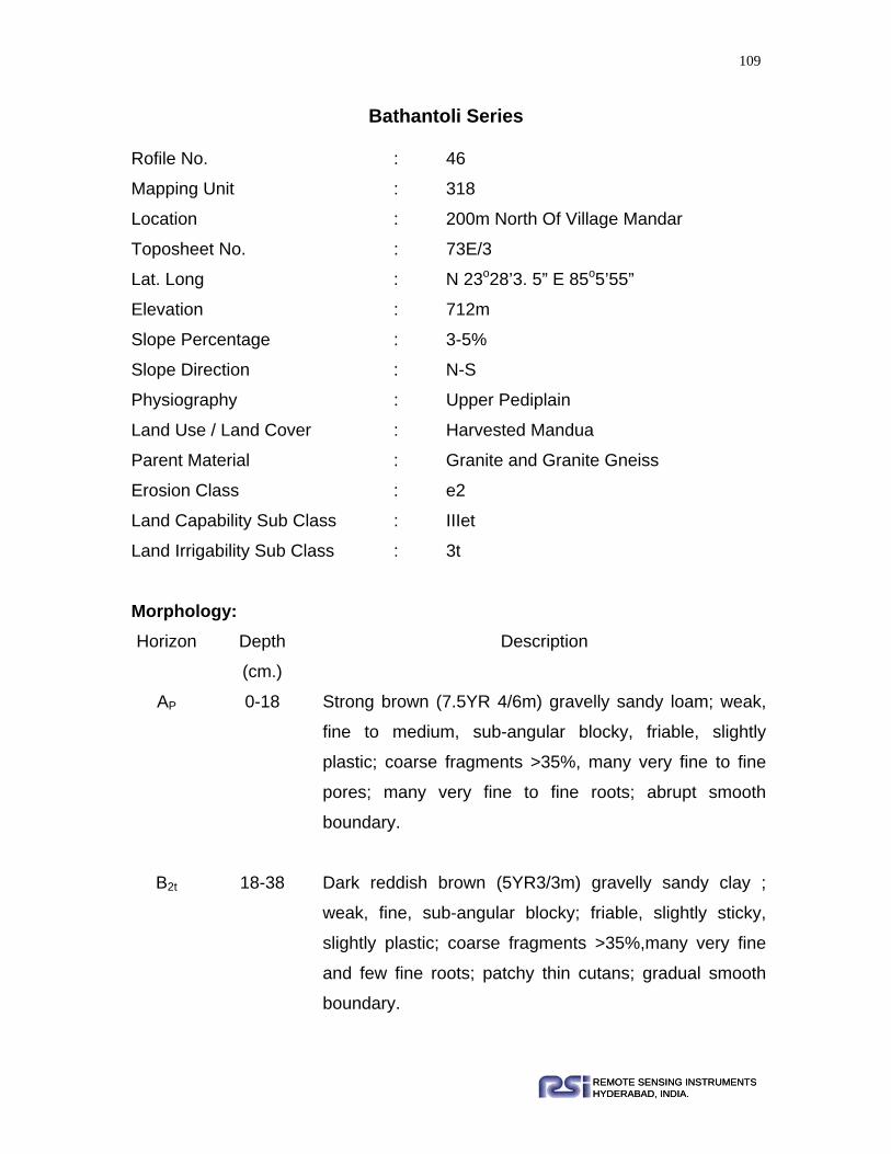
109
REMOTE SENSING INSTRUMENTSHYDERABAD, INDIA.REMOTE SENSING INSTRUMENTSHYDERABAD, INDIA.
Bathantoli Series
Rofile No. : 46
Mapping Unit : 318
Location : 200m North Of Village Mandar
Toposheet No. : 73E/3
Lat. Long : N 23o28’3. 5” E 85o5’55”
Elevation : 712m
Slope Percentage : 3-5%
Slope Direction : N-S
Physiography : Upper Pediplain
Land Use / Land Cover : Harvested Mandua
Parent Material : Granite and Granite Gneiss
Erosion Class : e2
Land Capability Sub Class : IIIet
Land Irrigability Sub Class : 3t
Morphology: Horizon Depth
(cm.)
Description
AP 0-18 Strong brown (7.5YR 4/6m) gravelly sandy loam; weak,
fine to medium, sub-angular blocky, friable, slightly
plastic; coarse fragments >35%, many very fine to fine
pores; many very fine to fine roots; abrupt smooth
boundary.
B2t 18-38 Dark reddish brown (5YR3/3m) gravelly sandy clay ;
weak, fine, sub-angular blocky; friable, slightly sticky,
slightly plastic; coarse fragments >35%,many very fine
and few fine roots; patchy thin cutans; gradual smooth
boundary.

110
REMOTE SENSING INSTRUMENTSHYDERABAD, INDIA.REMOTE SENSING INSTRUMENTSHYDERABAD, INDIA.
B3 38-96 Yellowish red (5YR4/6m) gravelly sandy clay loam;
weak, fine, sub-angular blocky; friable, sticky, plastic;
coarse fragments >35%; common very fine-to-fine pores;
patchy thin cutans; gradual smooth boundary.
C 96-125 Highly weathered parent material.
Range in Characteristics: Surface texture ranges between gravelly sandy loam to loam. Solum depth
ranges between 75-100cm. Surface colors varies between strong brown to dark
reddish brown.
Soil taxonomic classification: Fine loamy, mixed, Hyperthermic, Ultic
Haplustalfs
Physical and Chemical Properties
Horizon Depth
(cm)
O.C.
(%)
pH
(1:2.5)
EC
(1:2.5) dSm –1
Na+ K+ Ca++ Mg+ +
Meq. / 100g.
Ap 0-18 0.6 5.6 0.088 0.22 0.13 4.2 3.6
B2t 18-38 0.42 5.7 0.06 0.17 0.13 3.6 4.2
B3 38-96 0.21 5.4 0.037 0.17 0.18 3.6 4.4
Horizon Depth
(cm)
CEC
(Meq. / 100g.)
B.S
(%)
Avail. K
(kg / ha)
Avail. P
(kg / ha)
Sand
(%)
Silt
(%)
Clay
(%)
Texture
Ap 0-18 20.87 46 59 7.17 51 23 26 sl
B2t 18-38 14.78 54 59 5.38 51 8 41 sc
B3 38-96 21.56 59 82.6 5.15 55 13 32 scl

111
REMOTE SENSING INSTRUMENTSHYDERABAD, INDIA.REMOTE SENSING INSTRUMENTSHYDERABAD, INDIA.
Kundo Series Profile No. : 778
Mapping Unit : 318
Location : 1.5km North West of Village Kundo
Toposheet No. : 73A/16
Lat. Long : N 23o33’3. 7” E 84o48’40. 4”
Elevation : 655m
Slope Percentage : 5-6%
Slope Direction : S-N
Physiography : Pedimont
Land Use / Land Cover : Scrub Lands
Parent Material : Granite and Granite Gneiss
Erosion Class : e3
Land Capability Class : IVs
Land Irrigability Class : 4st
Morphology:
Horizon Depth
(cm)
Description
Ap 0 - 30 Yellowish red (5YR 5/6m) sandy loam; fine sub angular blocky;
non sticky, non plastic; coarse fragments 5–10%; many fine
and medium roots
C1 30 – 48 Partially weathered parent material
IIC2 48+ Lithic contact of parent material
Range in Characteristics: The surface texture ranges between loamy sand to sandy loam. The solum depth
varies between 24-32cm.

112
REMOTE SENSING INSTRUMENTSHYDERABAD, INDIA.REMOTE SENSING INSTRUMENTSHYDERABAD, INDIA.
Soil taxonomic classification: Loamy skeletal, mixed Hyperthermic, Lithic
Ustorthents.
Physical and Chemical Properties Horizon Depth
(cm)
O.C.
(%)
pH
(1:2.5)
EC
(1:2.5) dSm –1
Na+ K+ Ca++ Mg+ +
Meq. / 100g.
Ap
0-30
0.24
7.5
0.17
0.22
0.15
12
3.6
Horizon Depth
(cm)
CEC
(Meq. / 100g.)
B.S
(%)
Avail. K
(kg / ha)
Avail. P
(kg / ha)
Sand
(%)
Silt
(%)
Clay
(%)
Texture
Ap
0-30
16.52
7.1
70.8
3.14
57
22
21
sl

113
REMOTE SENSING INSTRUMENTSHYDERABAD, INDIA.REMOTE SENSING INSTRUMENTSHYDERABAD, INDIA.
Balia (Ambatoli) Series Profile No. : 114
Mapping Unit : 319
Location : 600m South Of Village Ambatoli
Toposheet No. : 73A/16
Lat. Long : N 23o9’2. 5” E 84o46’8. 8”
Elevation : 626m
Slope Percentage : 3-5%
Slope Direction : N-S
Physiography : Upper Pediment
Land Use / Land Cover : Harvested Groundnut
Parent Material : Granite and Granite Gneiss
Erosion Class : e2
Land Capability Sub Class : IIs
Land Irrigability Sub Class : 2d
Morphology: Horizon Depth
(cm)
Description
Ap 0 – 18 Reddish brown (5YR 4/4m) sandy loam; weak, fine, sub-angular
blocky; very friable, non sticky, non plastic; many very fine to
coarse pores; many fine roots; clear smooth boundary
B1 18 – 53 Reddish brown (2.5YR 4/4m) sandy clay loam; common, fine,
distinct, very dark brown (10YR2/2m) Fe, Mn concretions; weak,
medium, sub-angular blocky; friable slightly sticky, slightly plastic;
coarse fragments 2%; many very fine to coarse pores; common
fine roots; clear smooth boundary
B21t 53 – 100 Dark reddish brown (2.5YR 3/4m) sandy clay; many, fine to

114
REMOTE SENSING INSTRUMENTSHYDERABAD, INDIA.REMOTE SENSING INSTRUMENTSHYDERABAD, INDIA.
medium, distinct, very dark brown (10YR2/2m) Fe, Mn
concretions; weak, medium, sub-angular blocky; friable, slightly
sticky, slightly plastic; coarse fragments 5%; patchy thin cutans;
many very fine to medium and common coarse pores; medium
very roots; gradual smooth boundary
B22t 100 – 170 Dark reddish brown (2.5YR 3/3m) clay; many, fine to medium,
distinct, very dark brown (10YR2/2m) Fe, Mn concretions; weak,
medium, sub-angular blocky; friable, sticky, plastic; coarse
fragments 10%; patch thin cutans; many very fine to fine and
common medium to coarse pores.
Range in Characteristics: Surface texture ranges between sandy clay loam to clay. Solum depth ranges
between 100-170cm. Surface colors varies between reddish brown to dark
reddish brown.
Soil taxonomic classification: Fine, mixed, Hyperthermic, Typic Rhodustalfs
Physical and Chemical Properties
Horizon Depth
(cm)
O.C.
(%)
pH
(1:2.5)
EC
(1:2.5) dSm –1
Na+ K+ Ca++ Mg+ +
Meq. / 100g.
Ap 0 – 18 0.39 5.2 0.026 0.13 0.21 3.4 5.8
B1 18-53 0.35 .5.5 0.022 0.15 0.22 4.5 7.2
B21t 53-100 0.29 5.1 0.024 0.18 0.25 5.1 9.4
B22t 100-
170 0.27 5.8 0.022
0.22 0.21 3.6 3.4

115
REMOTE SENSING INSTRUMENTSHYDERABAD, INDIA.REMOTE SENSING INSTRUMENTSHYDERABAD, INDIA.
Horizon Depth
(cm)
CEC
(Meq. / 100g.)
B.S
(%)
Avail. K
(kg / ha)
Avail. P
(kg / ha)
Sand
(%)
Silt
(%)
Clay
(%)
Texture
Ap 0-18 14.78 65 94.4 4.48 72 7 7 sl
B1 18-53 18.11 67 95.6 4.34 53 15 32 scl
B21t 53-
100 22.34 67 96.2 4.39 45 11 44 sc
B22t 100-
170 24.65 60 94.4 4.93 34 20 45 c

116
REMOTE SENSING INSTRUMENTSHYDERABAD, INDIA.REMOTE SENSING INSTRUMENTSHYDERABAD, INDIA.
Lodhma Series
Profile No. : 4
Mapping Unit : 320
Location : 500m East Of Village Lodhma
Toposheet No. : 73E/7
Lat. Long : N 23o17’16. 7” E 85o22’57”
Elevation : 645m
Slope Percentage : 0-1%
Slope Direction : S-N
Physiography : Lower Pediplain
Land Use / Land Cover : Harvested Paddy
Parent Material : Granite and Granite Gneiss
Erosion Class : e1
Land Capability Sub Class : IVw
Land Irrigability Sub Class : 4d
Morphology: Horizon Depth
(cm)
Description
Ap 0 - 16 Grayish brown (2.5Y 5/2m) clay loam; weak, medium to coarse,
sub-angular blocky; friable slightly sticky, slightly plastic; coarse
fragments 3%; few medium and many very fine to fine pores;
many very fine to fine roots; clear smooth boundary
B11 16 - 49 Light brownish gray (2.5Y6/2m) clay loam; common, fine,
distinct, brown (7.5YR4/4m) Fe, Mn concretions; weak, medium
to coarse, sub-angular blocky; firm sticky, plastic; coarse
fragments 3%; common very fine to medium pores; common
very fine to fine roots; common very fine to fine roots; gradual
smooth boundary
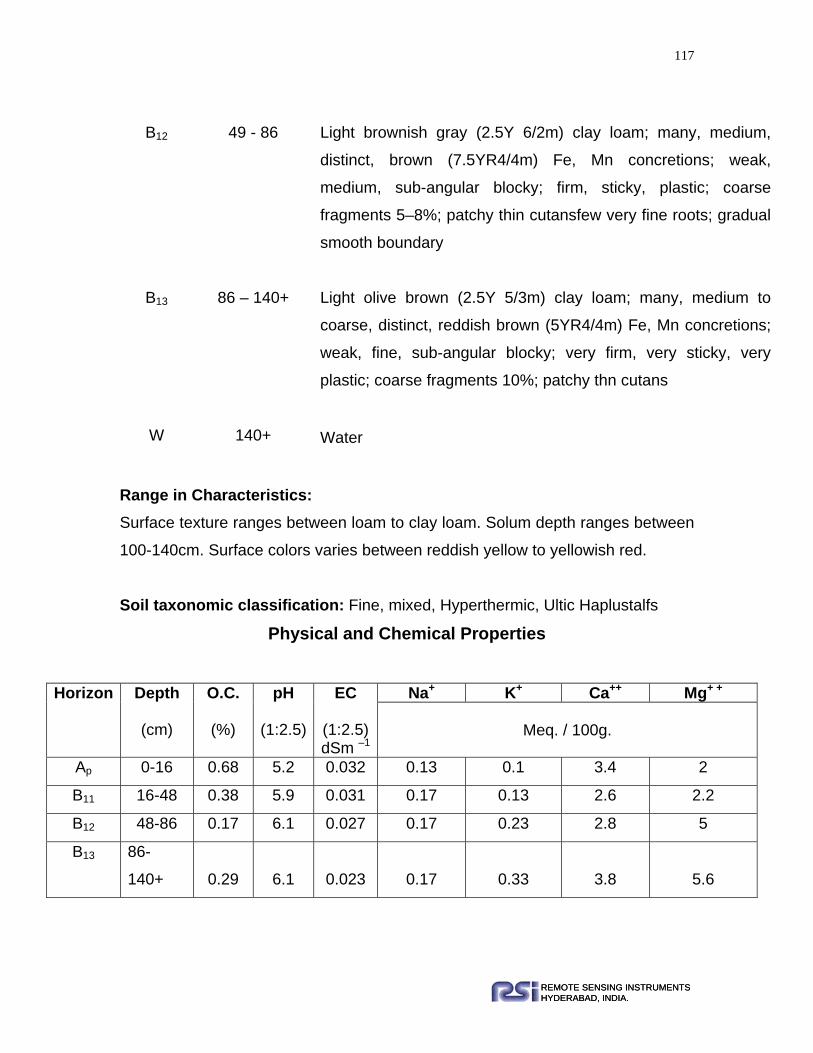
117
REMOTE SENSING INSTRUMENTSHYDERABAD, INDIA.REMOTE SENSING INSTRUMENTSHYDERABAD, INDIA.
B12 49 - 86 Light brownish gray (2.5Y 6/2m) clay loam; many, medium,
distinct, brown (7.5YR4/4m) Fe, Mn concretions; weak,
medium, sub-angular blocky; firm, sticky, plastic; coarse
fragments 5–8%; patchy thin cutansfew very fine roots; gradual
smooth boundary
B13 86 – 140+ Light olive brown (2.5Y 5/3m) clay loam; many, medium to
coarse, distinct, reddish brown (5YR4/4m) Fe, Mn concretions;
weak, fine, sub-angular blocky; very firm, very sticky, very
plastic; coarse fragments 10%; patchy thn cutans
W 140+ Water
Range in Characteristics: Surface texture ranges between loam to clay loam. Solum depth ranges between
100-140cm. Surface colors varies between reddish yellow to yellowish red.
Soil taxonomic classification: Fine, mixed, Hyperthermic, Ultic Haplustalfs
Physical and Chemical Properties
Horizon Depth
(cm)
O.C.
(%)
pH
(1:2.5)
EC
(1:2.5) dSm –1
Na+ K+ Ca++ Mg+ +
Meq. / 100g.
Ap 0-16 0.68 5.2 0.032 0.13 0.1 3.4 2
B11 16-48 0.38 5.9 0.031 0.17 0.13 2.6 2.2
B12 48-86 0.17 6.1 0.027 0.17 0.23 2.8 5
B13 86-
140+ 0.29 6.1 0.023 0.17 0.33 3.8 5.6

118
REMOTE SENSING INSTRUMENTSHYDERABAD, INDIA.REMOTE SENSING INSTRUMENTSHYDERABAD, INDIA.
Horizon Depth
(cm)
CEC
(Meq. / 100g.)
B.S
(%)
Avail. K
(kg / ha)
Avail. P
(kg / ha)
Sand
(%)
Silt
(%)
Clay
(%)
Texture
Ap 0-16 18.26 48 47.2 4.48 33 39 28 cl
B11 16-48 17.39 54 59 3.81 35 36 29 cl
B12 48-86 20.87 61 106.2 3.58 36 29 35 cl
B13 86-
140+ 26.09 65 153.4 3.36 39 23 38 cl

119
REMOTE SENSING INSTRUMENTSHYDERABAD, INDIA.REMOTE SENSING INSTRUMENTSHYDERABAD, INDIA.
Jamtoli Series Profile No. : 100
Mapping Unit : 320
Location : 100m South Of Village Danartoli
Toposheet No. : 73A/12
Lat. Long : N 23o7’11. 8” E 84o35’18. 4”
Elevation : 606m
Slope Percentage : 2-3%
Slope Direction : S-N
Physiography : Lower Pediplain
Land Use / Land Cover : Harvested Paddy
Parent Material : Granite and Granite Gneiss
Erosion Class : e2
Land Capability Sub Class : IVw
Land Irrigability Sub Class : 4d
Morphology: Horizon Depth
(cm.)
Description
AP 0-22 Light yellowish brown (2.5Y6/4m) clay loam; weak, very
coarse, sub-angular blocky; firm, sticky, plastic; many
very fine, common fine, few coarse pores; many very fine
to fine roots; clear smooth boundary.
B21t 22-60 Olive brown (2.5Y4/4m) clay; many, fine to medium,
distinct, dark brown (7.5YR3/3m) Fe, Mn concretions;
weak, coarse, sub-angular blocky; firm, sticky, plastic;
coarse fragments 5% few very fine to fine pores; very
few very fine to fine roots; patchy thin cutans; gradual
smooth boundary.

120
REMOTE SENSING INSTRUMENTSHYDERABAD, INDIA.REMOTE SENSING INSTRUMENTSHYDERABAD, INDIA.
B22t 60-140 Very dark grayish brown (2.5Y3/2m) clay; many, fine to
medium, distinct, dark brown (7.5YR3/3m) Fe, Mn
concretions; moderate, coarse, sub-angular blocky; very
firm, very sticky, very plastic; coarse fragments 10%;
common very fine to fine pores; patchy thin cutans;
gradual smooth boundary.
140+ Water oozing.
Range in Characteristics: Surface texture ranges between clay loam to clay. Solum depth ranges between
100-140cm. Surface color varies between light yellowish brown to yellowish
brown
Soil taxonomic classification: Fine, mixed, Hyperthermic, Ultic Haplustalfs
Physical and Chemical Properties
Horizon Depth
(cm)
O.C.
(%)
pH
(1:2.5)
EC
(1:2.5) dSm –1
Na+ K+ Ca++ Mg+ +
Meq. / 100g.
Ap 0-22 0.65 4.6 0.031 0.3 0.13 2.8 1.2
B21t 22-60 0.24 6.5 0.027 0.39 0.28 7.2 6
B22t 60-140 0.41 6.6 0.033 0.48 0.31 5.6 9.2
Horizon Depth
(cm)
CEC
(Meq. / 100g.)
B.S
(%)
Avail. K
(kg / ha)
Avail. P
(kg / ha)
Sand
(%)
Silt
(%)
Clay
(%)
Texture
Ap 0-22 12.17 36 59 4.93 34 32 34 cl
B21t 22-60 20 69 129.8 5.38 41 12 46 c
B22t 60-
140 19.13 71 141.6 6.72 41 15 42 c

121
REMOTE SENSING INSTRUMENTSHYDERABAD, INDIA.REMOTE SENSING INSTRUMENTSHYDERABAD, INDIA.
Banrotoli Series Profile No. : 690
Mapping Unit : 322
Location : Nearly 30m South Of Banrotoli
Toposheet No. : 73A/4
Lat. Long : N 23o3’13.2” E 84o10’33.4”
Elevation : 748m
Slope Percentage : 2-4%
Slope Direction : W-E
Physiography : Narrow Valley
Land Use / Land Cover : Harvested Paddy
Parent Material : Granite and Granite Gneiss
Erosion Class : e1
Land Capability Sub Class : IVw
Land Irrigability Sub Class : 4d
Morphology: Horizon Depth
(cm.)
Description
Ap 0-18 Brown (10YR4/3m) clay loam; weak, fine to medium,
sub-angular blocky; friable, sticky, slightly plastic; coarse
fragments1-2%; many fine to medium pores; many fine
to medium roots; abrupt smooth boundary.
B1 18-40 Grayish brown (10YR5/2m) loam; weak, fine, sub-
angular blocky; friable, slightly sticky, slightly plastic;
many fine to medium pores; few fine roots; gradual
smooth boundary.
B2g 40-75 Dark gray (10YR4/1m) loam; moderate, fine, sub-angular

122
REMOTE SENSING INSTRUMENTSHYDERABAD, INDIA.REMOTE SENSING INSTRUMENTSHYDERABAD, INDIA.
blocky; firm sticky, plastic; many fine pores; few very fine
roots; gradual smooth boundary.
B3g 75-110 Dark gray (10YR4/1m) silty loam; moderate, medium to
coarse sub-angular blocky; firm, very sticky, very plastic;
many very fine pores; very few, very fine roots.
W 110+ Water oozing.
Range in Characteristics: Surface texture ranges between clay loam to loam. Solum depth more than
100cm. Surface color varies between brown to olive brown
Soil taxonomic classification: Fine loamy, mixed, Hyperthermic, Typic
Endoaquepts
Physical and Chemical Properties Horizon Depth
(cm)
O.C.
(%)
pH
(1:2.5)
EC
(1:2.5) dSm –1
Na+ K+ Ca++ Mg+ +
Meq. / 100g.
Ap 0-18 0.35 5.8 0.025 0.26 0.08 3 0.8
C1 18-40 0.6 5.1 0.032 0.26 0.08 3.8 4.2
C2 40-75 0.02 6.4 0.026 0.22 0.1 3.4 3.4
C3 75-110 0.02 6.3 0.022 0.23 0.1 3.2 4.1
Horizon Depth
(cm)
CEC
(Meq. / 100g.)
B.S
(%)
Avail. K
(kg / ha)
Avail. P
(kg / ha)
Sand
(%)
Silt
(%)
Clay
(%)
Texture
Ap 0-18 17.39 49 35.4 3.58 31 42 27 cl
C1 18-40 16.52 46 35.4 3.36 38 41 20 l
C2 40-75 16.52 59 47.2 3.81 39 37 24 l
C3 75- 14.99 56 52.4 4.21 16 60 24 sil

123
REMOTE SENSING INSTRUMENTSHYDERABAD, INDIA.REMOTE SENSING INSTRUMENTSHYDERABAD, INDIA.
110
Bangru Series Profile No. : 490
Mapping Unit : 323
Location : 500m South of village Bangru
Toposheet No. : 73B/9
Lat. Long : N 22º49’58.3” E 84º40’9.3”
Elevation : 595m
Slope Percentage : 0-1%
Slope Direction : NE-SW
Physiography : Broad valley
Land Use / Land Cover : Harvested Paddy
Parent Material : Granite and Granite Gneiss
Erosion Class : e1
Land Capability Sub Class : IV w
Land Irrigability Sub Class : 4d
Morphology:
Horizon Depth
(cm) Description
Ap 0-15 Yellowish brown(10YR 4.5/4m) sandy clay loam; weak, fine,
medium to coarse, sub-angular blocky; firm, very sticky, very
plastic; gravels 5-6%; common fine pores; many fine to medium
roots; abrupt smooth boundary.
C1 15-40 Brown (7.5YR 4/4m) sandy loam; weak, fine to medium, sub-
angular blocky; friable, very sticky, plastic; gravels 2-3%;
common fine to medium pores; many fine to medium, common
coarse roots; gradual smooth boundary.

124
REMOTE SENSING INSTRUMENTSHYDERABAD, INDIA.REMOTE SENSING INSTRUMENTSHYDERABAD, INDIA.
Range in Characteristics: Surface texture ranges between loam to sandy clay loam. Solum depth ranges
between 80-120cm. Surface colors varies between brown to dark brown.
Soil taxonomic classification: Fine loamy, mixed, Hyperthermic, Oxyaquic
Ustifluvents.
Physical and Chemical Properties
Horizon Depth
(cm)
O.C.
(%)
pH
(1:2.5)
EC
(1:2.5) dSm –1
Na+ K+ Ca++ Mg+ +
Meq. / 100g.
Ap 0-15 0.68 6 0.034 0.26 0.18 6.4 3.8
C1 15-40 0.5 5.9 0.023 0.22 0.15 5.6 3.2
C2 40-80 0.45 6 0.021 0.26 0.15 5.4 2.8
Horizon Depth
(cm)
CEC
(Meq. / 100g.)
B.S
(%)
Avail. K
(kg / ha)
Avail. P
(kg / ha)
Sand
(%)
Silt
(%)
Clay
(%)
Texture
Ap 0-15 19.13 56 82.6 6.99 59.24 16 24 scl
C1 15-40 26.09 35 70.8 5.6 60.53 23 16 sl
C2 40-80 18.26 47 70.8 4.48 49.98 17 32 scl
C2
40-80
Strong brown (7.5YR 4/5m) gravelly sandy clay loam; weak to
moderate, fine, sub-angular blocky; friable, sticky, plastic; gravels
20-25%; few fine to medium pores; few fine roots; gradual smooth
boundary.
C3 80-
130
Fluvial material deposition mainly sand
W 130+ Water

125
REMOTE SENSING INSTRUMENTSHYDERABAD, INDIA.REMOTE SENSING INSTRUMENTSHYDERABAD, INDIA.
Nagri Series Profile No. : 652
Mapping Unit : 324
Location : 2km East Of Village Nagri
Toposheet No. : 73E/3
Lat. Long : N 23o19’40. 7” E 85o12’1. 6”
Elevation : 707m
Slope Percentage : 1-3%
Slope Direction : S-N
Physiography : Burried Pediment
Land Use / Land Cover : Harvested Paddy
Parent Material : Granite and Granite Gneiss
Erosion Class : e1
Land Capability Sub Class : IIs
Land Irrigability Sub Class : 2d
Morphology: Horizon Depth
(cm.)
Description
Ap 0-25 Yellowish brown (10YR5/4m) clay; weak, coarse, sub-angular
blocky; firm very sticky, very plastic; many very fine to medium
pores; many fine to medium roots; abrupt smooth boundary.
B1 25-85 Dark brown (10YR3/3m) silty clay loam; weak to moderate
medium, sub-angular blocky; firm, very sticky, plastic, common
fine to medium pores; few fine roots; gradual smooth boundary.
B2 85-125 Light brownish gray (10YR6/2m) loam; weak to moderate fine to
medium sub-angular blocky; friable, sticky, plastic; common fine
to medium pores; gradual smooth boundary.

126
REMOTE SENSING INSTRUMENTSHYDERABAD, INDIA.REMOTE SENSING INSTRUMENTSHYDERABAD, INDIA.
C 125-140+ Highly weathered parent material
Range in Characteristics: Surface texture ranges between silty clay loam to clay. Solum depth is more than
150 cm. Surface color varies between brown to dark brown
Soil Taxonomic classification: Fine loamy, mixed, hyperthermic, Typic
Haplustepts.
Physical and Chemical Properties
Horizon Depth
(cm)
O.C.
(%)
pH
(1:2.5)
EC
(1:2.5) dSm –1
Na+ K+ Ca++ Mg+ +
Meq. / 100g.
Ap 0-25 0.60 5.9 0.046 0.35 0.23 11.4 6
B1 25-85 0.23 7.7 0.045 0.43 0.31 12.0 8.4
B2 85-125 0.12 8.4 0.064 0.13 0.15 3.0 5
Horizon Depth
(cm)
CEC
(Meq. / 100g.)
B.S
(%)
Avail. K
(kg / ha)
Avail. P
(kg / ha)
Sand
(%)
Silt
(%)
Clay
(%)
Texture
Ap 0-25 25.22 71 106.2 6.72 10 35 55 c
B1 25-85 29.96 78 141. 6 4.03 5 60 35 sicl
B2 85-
125 10.43 79 70.8 3.81 41 46 13 l

127
REMOTE SENSING INSTRUMENTSHYDERABAD, INDIA.REMOTE SENSING INSTRUMENTSHYDERABAD, INDIA.
Majhauli (Senha) Series Profile No. : 138
Mapping Unit : 324
Location : 1km South West Of Village Senha
Toposheet No. : 73A/11
Lat. Long : N 23o22’31. 6” E 84o38’59. 6”
Elevation : 646m
Slope Percentage : 2-3%
Slope Direction : NE-SW
Physiography : Burried Pediment
Land Use / Land Cover : Harvested Paddy
Parent Material : Granite and Granite Gneiss
Erosion Class : e1
Land Capability Sub Class : IIs
Land Irrigability Sub Class : 2d
Morphology: Horizon Depth
(cm)
Description
Ap 0 – 21 Reddish brown (5YR 4/4m) sandy loam; weak, medium, sub-
angular blocky; friable, non sticky, non plastic; coarse
fragments 2%; many very fine to medium, common coarse
pores; many very fine to fine roots; abrupt smooth boundary
C1 21 – 53 Light reddish brown (2.5YR 6/4m) sandy clay; common, fine,
distinct, very dark grayish brown (10YR3/2m) Fe, Mn
concretions; weak, medium, sub-angular blocky; friable,
slightly sticky, slightly plastic; coarse fragments 5%; many
very fine and medium common coarse pores; common very
fine to fine roots; clear smooth boundary

128
REMOTE SENSING INSTRUMENTSHYDERABAD, INDIA.REMOTE SENSING INSTRUMENTSHYDERABAD, INDIA.
C2 53 - 110 Reddish brown (2.5YR 4/4m) silty clay loam; common,
medium, distinct, dark brown (10YR2/2m) Fe, Mn
concretions; weak, medium, sub-angular blocky; friable,
slightly sticky, slightly plastic; coarse fragments 8%; many
very fine to fine and common medium to coarse pores; few
very fine roots; gradual smooth boundary
C3 110 –
160+
Dark reddish brown (2.5YR 3/4m) silty clay loam; many,
medium to coarse, distinct, dark brown (10YR2/2m) Fe, Mn
concretions; weak, fine to medium, sub-angular blocky;
friable, slightly sticky, slightly plastic; coarse fragments 10%;
many very fine to fine and common medium to coarse pores
Range in Characteristics: Surface texture ranges between sandy loam to silty clay loam. Solum depth is
more than 150 cm. Surface color varies between reddish brown to brown.
Soil taxonomic classification: Fine loamy, mixed, Hyperthermic, Ustic
Ustifluvents.
Physical and Chemical Properties Horizon Depth
(cm)
O.C.
(%)
pH
(1:2.5)
EC
(1:2.5) dSm –1
Na+ K+ Ca++ Mg+ +
Meq. / 100g.
Ap 0-21 0.09 5 0.015 0.22 0.13 5.4 5.2
C1 21-53 0.21 5.9 0.02 0.22 0.21 5.8 8.2
C2 53-110 0.3 6 0.02 0.26 0.21 4.4 8
C3 110-
160 0.25 6.3 0.03 0.23 0.22 4.7 8.2

129
REMOTE SENSING INSTRUMENTSHYDERABAD, INDIA.REMOTE SENSING INSTRUMENTSHYDERABAD, INDIA.
Horizon Depth
(cm)
CEC
(Meq. / 100g.)
B.S
(%)
Avail. K
(kg / ha)
Avail. P
(kg / ha)
Sand
(%)
Silt
(%)
Clay
(%)
Texture
Ap 0-21 18.7 58 59 11.2 73 4 23 sl
C1 21-53 24.35 59 94.4 6.72 50 2 48 sc
C2 53-
110 27.83 61 94.4 4.48 12 50 38 sicl
C3 110-
160 30.45 64 90.2 4.54 10 52 38 sicl

130
REMOTE SENSING INSTRUMENTSHYDERABAD, INDIA.REMOTE SENSING INSTRUMENTSHYDERABAD, INDIA.
Dolaicha Series Profile No. : 716
Mapping Unit : 325
Location : 1.25km North East Of Village Dolaicha
Toposheet No. : 73A/16
Lat. Long : N 23o11’57. 6” E 84o57’45. 8”
Elevation : 676m
Slope Percentage : 1-3%
Slope Direction : Se-Nw
Physiography : Narrow Valley
Land Use / Land Cover : Harvested Mandua
Parent Material : Granite and Granite Gneiss
Erosion Class : e1
Land Capability Sub Class : IIs
Land Irrigability Sub Class : 2d
Morphology: Horizon Depth
(cm)
Description
Ap 0-20 Olive yellow (2.5YR 6/6m) silty clay loam; weak, fine, subangular
blocky structure; sticky, non plastic; many medium and coarse
pores; many fine and medium roots; abrupt smooth boundary
B21t 20-95 Light olive brown (2.5YR 5/6m) clay; weak, medium, sub-angular
blocky; friable, sticky, plastic; many fine pores; few fine roots;
gradual smooth boundary
B22t 95-125 Olive brown (2.5YR4/4m) clay; weak, fine, sub-angular blocky;
firm, sticky, plastic; many fine pores; very few fine roots; gradual
smooth boundary

131
REMOTE SENSING INSTRUMENTSHYDERABAD, INDIA.REMOTE SENSING INSTRUMENTSHYDERABAD, INDIA.
C 125-150 Partially weathered parent material paralithic contact
Range in Characteristics: Surface texture ranges between silty clay loam to clay. Solum depth ranges
between 100 - 140cm. Surface color varies between yellowish brown to olive
yellow.
Soil Taxonomic classification: Fine, Mixed, Hyperthermic, Ultic Haplustalfs
Physical and Chemical Properties
Horizon Depth
(cm)
O.C.
(%)
pH
(1:2.5)
EC
(1:2.5) dSm –1
Na+ K+ Ca++ Mg+ +
Meq. / 100g.
Ap 0 – 20 0.56 5.2 0.029 0.13 0.41 4.8 3.8
B21t 20-95 0.5 6.2 0.038 0.43 0.26 4.4 6.2
B22t 95-125 0.48 7 0.044 0.43 0.21 5 4
Horizon Depth
(cm)
CEC
(Meq. / 100g.)
B.S
(%)
Avail. K
(kg / ha)
Avail. P
(kg / ha)
Sand
(%)
Silt
(%)
Clay
(%)
Texture
Ap 0-20 14.78 59 188.8 5.38 39 47 14 sicl
B2t1 20-95 19.13 66 118 4.93 32 24 44 c
B22t 95-125 20.87 69 94.4 4.48 24 31 45 c

132
REMOTE SENSING INSTRUMENTSHYDERABAD, INDIA.REMOTE SENSING INSTRUMENTSHYDERABAD, INDIA.
Lohana Series Profile No. : 42
Mapping Unit : 326
Location : 1.5km South East Of Village Lohana
Toposheet No. : 73E/3
Lat. Long : N 23o25’16. 7” E 85o11’56”
Elevation : 710m
Slope Percentage : 0-1%
Slope Direction : S-N
Physiography : Broad Valley
Land Use / Land Cover : Harvested Paddy
Parent Material : Granite and Granite Gneiss
Erosion Class : e1
Land Capability Sub Class : IIs
Land Irrigability Sub Class : 2d
Morphology:
Horizon Depth
(cm)
Description
Ap 0-21 Brown (10YR 4/3m) clay loam; weak, medium to very coarse,
sub-angular blocky; firm, sticky, plastic; many very fine common
fine pores; many very fine to fine roots; clear smooth boundary
B11t 21-56 Olive brown (2.5Y 4/3m) clay loam; many, medium to coarse,
distinct, dark brown (10YR2/2m) Fe, Mn concretions; weak,
medium to coarse, sub-angular blocky; firm, sticky, plastic;
many very fine, common very fine few fine pores; few very fine
roots; patchy thin cutans; gradual smooth boundary
B12t 56-110 Grayish brown (2.5Y 5/2m) silty clay; common, fine to medium,
distinct, dark brown (10YR2/2m) Fe, Mn concretions; weak fine

133
REMOTE SENSING INSTRUMENTSHYDERABAD, INDIA.REMOTE SENSING INSTRUMENTSHYDERABAD, INDIA.
to medium, sub-angular blocky; very firm, very sticky, very
plastic; few very fine, pores; patchy thin cutans; gradual wavy
boundary
B2 110-150 Dark grayish brown (2.5Y 4/2m) clay; common, fine to medium,
distinct, dark brown (10YR2/2m) Fe, Mn concretions; weak,
fine, sub-angular blocky, very firm, very sticky, very plastic;
Range in Characteristics: Surface texture ranges between silty clay loam to clay. Solum depth is more than
150cm. Surface color varies between brown to olive brown
Soil taxonomic classification: Fine, mixed, Hyperthermic, Ultic Haplustalfs.
Physical and Chemical Properties Horizon Depth
(cm)
O.C.
(%)
pH
(1:2.5)
EC
(1:2.5) dSm –1
Na+ K+ Ca++ Mg+ +
Meq. / 100g.
Ap 0-21 1.5 6 0.087 0.26 0.21 3.4 4.8
B11t 21-56 0.89 6.8 0.099 0.35 0.28 5.6 9.0
B12t 56-110 0.81 7.3 0.117 0.39 0.28 8.8 9.2
B2 110-
150 0.72 7 0.058 0.48 0.28 6.6 12.2
Horizon Depth
(cm)
CEC
(Meq. / 100g.)
B.S
(%)
Avail. K
(kg / ha)
Avail. P
(kg / ha)
Sand
(%)
Silt
(%)
Clay
(%)
Texture
Ap 0-21 18.26 51 94.4 5.6 43 25 32 cl
B11t 21-56 20.87 73 129.8 5.38 30 32 38 cl
B12t 56-110 24.35 77 129.8 5.38 6 48 46 Sic
B2 110-150 23.48 83 129.8 4.93 25 29 45 c

134
REMOTE SENSING INSTRUMENTSHYDERABAD, INDIA.REMOTE SENSING INSTRUMENTSHYDERABAD, INDIA.
Kudda Series
Profile No. : 240
Mapping Unit : 327
Location : 200m West Of Village Kudda
Toposheet No. : 73F/13
Lat. Long : N 22o57’5. 3” E 85o5’9. 8”
Elevation : 276m
Slope Percentage : 20-35%
Slope Direction : SW-NE
Physiography : Structural Hill
Land Use / Land Cover : Forest
Parent Material : Schist
Erosion Class : e3
Land Capability Class : VIt
Land Irrigability Class : 6t
Morphology: Horizon Depth
(cm.)
Description
Ap 0-15 Dark grayish brown (10YR3.5/2m) gravelly clay loam; weak,
fine, medium and coarse, sub-angular blocky; friable, slightly
sticky; slightly plastic; coarse fragments 25-30%; many fine
and medium pores; many fine and medium roots; gradual
smooth boundary.
B2 15-72 Very dark grayish brown (10YR 3/2m) gravelly clay; weak,
medium to coarse, sub-angular blocky; friable, sticky, plastic;
coarse fragments 25-30%; many fine and medium pores; few
fine to medium roots; gradual smooth boundary.

135
REMOTE SENSING INSTRUMENTSHYDERABAD, INDIA.REMOTE SENSING INSTRUMENTSHYDERABAD, INDIA.
C2 72-105+ Partially weathered parent material.
Range in Characteristics: Surface texture ranges between clay loam to clay. Solum depth is a range
between 45-75cm. lithic contacts is observed.
Soil taxonomic classification: Fine, mixed, Hyperthermic, Typic Haplustepts.
Physical and Chemical Properties
Horizon Depth
(cm)
O.C.
(%)
pH
(1:2.5)
EC
(1:2.5) dSm –1
Na+ K+ Ca++ Mg+ +
Meq. / 100g.
Ap 0-15 0.84 5.5 0.035 0.26 0.13 16 8
B2 15-72 0.8 6 0.031 0.3 0.18 8 6
Horizon Depth
(cm)
CEC
(Meq. / 100g.)
B.S
(%)
Avail. K
(kg / ha)
Avail. P
(kg / ha)
Sand
(%)
Silt
(%)
Clay
(%)
Texture
Ap 0-15 20.84 53 59 2.24 32 29 38 cl
B2 15-72 23.48 69 82.6 2.02 18 34 48 c

136
REMOTE SENSING INSTRUMENTSHYDERABAD, INDIA.REMOTE SENSING INSTRUMENTSHYDERABAD, INDIA.
Bartuwa Series Profile No. : 250
Mapping Unit : 328
Location : 300m North Of Village Bartuwa
Toposheet No. : 73E/10
Lat. Long : N 23o31’53. 4” E 85o31’26. 9”
Elevation : 601m
Slope Percentage : 10-15%
Slope Direction : Ne-Sw
Physiography : Uplands
Land Use / Land Cover : Scrubland
Parent Material : Schist
Erosion Class : e3
Land Capability Sub Class : VIst
Land Irrigability Sub Class : 6t
Morphology:
Horizon Depth
(cm)
Description
Ap 0 – 20 Brown (10YR 3.5/3m) gravelly loam; weak, fine, medium and
coarse, sub-angular blocky; friable, slightly sticky, slightly
plastic; coarse fragments >35%; many fine to medium pores;
many fine to medium and few coarse roots; clear smooth
boundary
C 20 – 145+ Partially weathered parent material
Range in Characteristics: Ap horizon depth varies between 12-30 cm. Surface texture ranges between
gravelly loam to gravelly sandy loam.
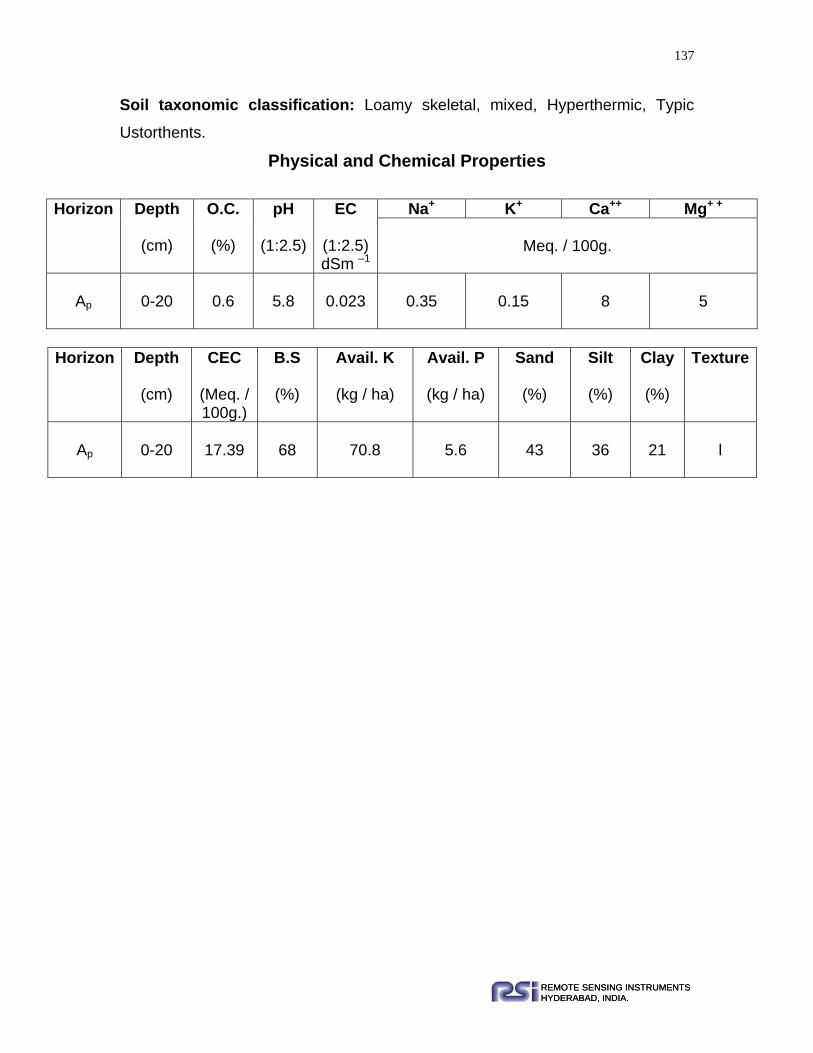
137
REMOTE SENSING INSTRUMENTSHYDERABAD, INDIA.REMOTE SENSING INSTRUMENTSHYDERABAD, INDIA.
Soil taxonomic classification: Loamy skeletal, mixed, Hyperthermic, Typic
Ustorthents.
Physical and Chemical Properties
Horizon Depth
(cm)
O.C.
(%)
pH
(1:2.5)
EC
(1:2.5) dSm –1
Na+ K+ Ca++ Mg+ +
Meq. / 100g.
Ap
0-20
0.6
5.8
0.023
0.35
0.15
8
5
Horizon Depth
(cm)
CEC
(Meq. / 100g.)
B.S
(%)
Avail. K
(kg / ha)
Avail. P
(kg / ha)
Sand
(%)
Silt
(%)
Clay
(%)
Texture
Ap
0-20
17.39
68
70.8
5.6
43
36
21
l
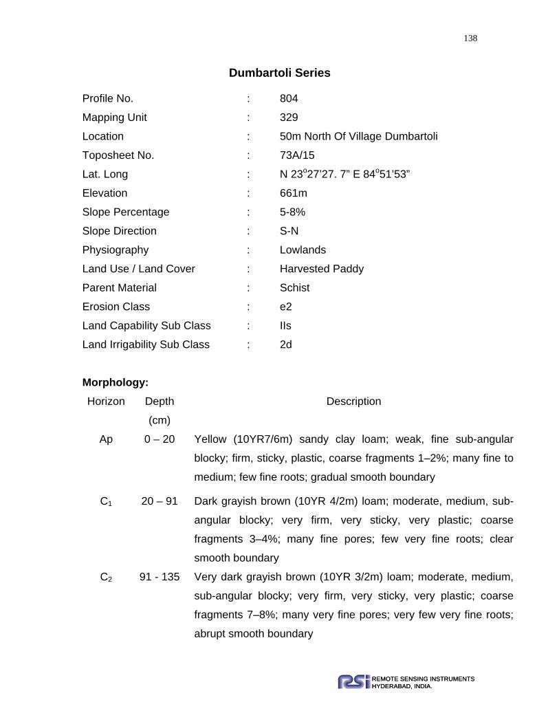
138
REMOTE SENSING INSTRUMENTSHYDERABAD, INDIA.REMOTE SENSING INSTRUMENTSHYDERABAD, INDIA.
Dumbartoli Series Profile No. : 804
Mapping Unit : 329
Location : 50m North Of Village Dumbartoli
Toposheet No. : 73A/15
Lat. Long : N 23o27’27. 7” E 84o51’53”
Elevation : 661m
Slope Percentage : 5-8%
Slope Direction : S-N
Physiography : Lowlands
Land Use / Land Cover : Harvested Paddy
Parent Material : Schist
Erosion Class : e2
Land Capability Sub Class : IIs
Land Irrigability Sub Class : 2d
Morphology: Horizon Depth
(cm)
Description
Ap 0 – 20 Yellow (10YR7/6m) sandy clay loam; weak, fine sub-angular
blocky; firm, sticky, plastic, coarse fragments 1–2%; many fine to
medium; few fine roots; gradual smooth boundary
C1 20 – 91 Dark grayish brown (10YR 4/2m) loam; moderate, medium, sub-
angular blocky; very firm, very sticky, very plastic; coarse
fragments 3–4%; many fine pores; few very fine roots; clear
smooth boundary
C2 91 - 135 Very dark grayish brown (10YR 3/2m) loam; moderate, medium,
sub-angular blocky; very firm, very sticky, very plastic; coarse
fragments 7–8%; many very fine pores; very few very fine roots;
abrupt smooth boundary

139
REMOTE SENSING INSTRUMENTSHYDERABAD, INDIA.REMOTE SENSING INSTRUMENTSHYDERABAD, INDIA.
C3 135 - 155 Partially weathered parent material.
Range in Characteristics: The surface texture range between sandy loam to loam. Gravel percentage is
increases with depth. Solum depth is range between 90-160cm.
Soil Taxonomic classification: Fine loamy, mixed, Hyperthermic, Udic
Ustorthents.
Physical and Chemical Properties
Horizon Depth
(cm)
O.C.
(%)
pH
(1:2.5)
EC
(1:2.5) dSm –1
Na+ K+ Ca++ Mg+ +
Meq. / 100g.
Ap 0-20 0.23 6.2 0.042 0.22 0.21 6.2 4.2
C1 20-91 0.15 6.3 0.041 0.26 0.18 5.8 3.6
C2 91-135 0.09 6.3 0.036 0.22 0.15 5.6 3.2
Horizon Depth
(cm)
CEC
(Meq. / 100g.)
B.S
(%)
Avail. K
(kg / ha)
Avail. P
(kg / ha)
Sand
(%)
Silt
(%)
Clay
(%)
Texture
Ap 0-20 16.52 66 5.6 1.25 56 20 24 scl
C1 20-91 15.65 69 4.03 0.9 42 41 17 l
C2 91-135 15.65 69 3.58 0.8 43 38 19 l

140
REMOTE SENSING INSTRUMENTSHYDERABAD, INDIA.REMOTE SENSING INSTRUMENTSHYDERABAD, INDIA.
Joranga Series
Profile No. : 431
Mapping Unit :330
Location :1.25Km South East of village Joranga
Toposheet No. : 73E/12
Lat. Long :N 23º1’16.1” E 85º32’16.1”
Elevation :302m
Slope Percentage :20-25%
Slope Direction :S-N
Physiography :Structural hill
Land Use / Land Cover :Forest
Parent Material :Shale, Slate and Phyllite
Erosion Class :e3
Land Capability Sub Class :VI t Land Irrigability Sub Class :6t Morphology:
Range in Characteristics:
Horizon Depth
(cm) Description
Ap 0-21 Brown (7.5YR 3.5/4m) silty clay loam; weak, fine to medium, sub-
angular blocky, friable, slightly sticky, plastic; gravel 45%; many
fine, medium and coarse pores; many fine, medium and coarse
roots; clear smooth boundary
B 21-58 Brown (7.5YR 3.5/3m) clay loam; weak, fine to medium, sub-
angular blocky, very friable, slightly sticky, plastic; gravels 40%;
many fine to medium pores; many fine medium and coarse roots;
gradual smooth boundary
C 58-145+ Partially weathered parent material.

141
REMOTE SENSING INSTRUMENTSHYDERABAD, INDIA.REMOTE SENSING INSTRUMENTSHYDERABAD, INDIA.
The surface texture range between silty clay loam to loam. Surface colour varies
between brown to strong brown. Solum depth ranges between 45-75cm.
Soil taxonomic classification: Loamy skeletal, mixed, Hyperthermic, Udic
Haplustepts.
Physical and Chemical Properties
Horizon Depth
(cm)
O.C.
(%)
pH
(1:2.5)
EC
(1:2.5) dSm –1
Na+ K+ Ca++ Mg+ +
Meq. / 100g.
Ap 0-21 1.23 5.7 0.023 0.34 0.79 4.9 9.6
B 21-58 0.89 5.7 0.022 0.33 0.67 5.1 10.2
Horizon Depth
(cm)
CEC
(Meq. / 100g.)
B.S
(%)
Avail. K
(kg / ha)
Avail. P
(kg / ha)
Sand
(%)
Silt
(%)
Clay
(%)
Texture
Ap 0-21 22.42 58 110.6 12.67 11 54 35 sicl
B 21-58 24.56 62 156.2 14.89 32 35 33 cl

142
REMOTE SENSING INSTRUMENTSHYDERABAD, INDIA.REMOTE SENSING INSTRUMENTSHYDERABAD, INDIA.
Hemromtoli series
Profile No. : 414
Mapping Unit :331
Location :200m East of village Hemromtoli
on the road khunti to Jamar
Toposheet No. : 73E/8
Lat. Long :N 23º00’26.7” E 85º29’59.5”
Elevation :343m
Slope Percentage :12-13%
Slope Direction :NE-SW
Physiography :Undulating buried pediment
Land Use / Land Cover :Harvested Paddy
Parent Material :Shale, Slate and Phyllite
Erosion Class :e2
Land Capability Sub Class :lls Land Irrigability Sub Class :2s Morphology:
Horizon Depth
(cm) Description
Ap 0-21 very dark grayish brown (10YR 3/2m) sandy loam; weak to
moderate, fine, medium and coarse, sub-angular blocky; friable,
slightly sticky, slightly plastic; gravels12-15%; many fine, medium
and coarse pores; many fine common medium roots; clear smooth
boundary
B 21-105 Brown (7.5YR 3.5/2m) gravelly sandy clay loam; weak to moderate
medium to coarse sub-angular blocky; firm slightly sticky, slightly
plastic; gravels15-20%; many fine to medium pores; common fine
few coarse roots; clear smooth boundary
R 105+ Hard rock

143
REMOTE SENSING INSTRUMENTSHYDERABAD, INDIA.REMOTE SENSING INSTRUMENTSHYDERABAD, INDIA.
Range in Characteristics: Ap horizon depth varies between 20-30 cm. The surface texture ranges between
loam to sandy loam. Solum depth varies between 80-120 cm.
Soil taxonomic classification: Fine loamy, mixed, Hyperthermic, Typic
Dystrustepts.
Physical and Chemical Properties
Horizon Depth
(cm)
O.C.
(%)
pH
(1:2.5)
EC
(1:2.5) dSm –1
Na+ K+ Ca++ Mg+ +
Meq. / 100g.
Ap 0-21 1.14 5.4 0.021 0.39 0.54 4.4 5.2
B 21-105 0.78 5.4 0.022 0.33 0.67 5.1 8.2
Horizon Depth
(cm)
CEC
(Meq. / 100g.)
BS
(%)
Avail. K
(kg / ha)
Avail. P
(kg / ha)
Sand
(%)
Silt
(%)
Clay
(%)
Texture
Ap 0-21 20.87 50 247.8 13.44 62 23 15 sl
B 21-105 22.67 52 256.23 23.12 54 22 24 scl

144
REMOTE SENSING INSTRUMENTSHYDERABAD, INDIA.REMOTE SENSING INSTRUMENTSHYDERABAD, INDIA.
Rargaon series
Profile No. :439
Mapping Unit :332
Location :100m West of village Rargaon
Toposheet No. :73F/13
Lat. Long :N 22º58’57.5” E 85º49’17.9”
Elevation :244m
Slope Percentage :1-3%
Slope Direction :E-W
Physiography :Deep buried pediment
Land Use / Land Cover :Parmanent fallow (Rainfed
cultivation)
Parent Material :Shale, Slate and Phyllite
Erosion Class :e1
Land Capability Sub Class :llls Land Irrigability Sub Class :3d
Morphology:
Horizon Depth
(cm) Description
Ap 0-18 Brown (7.5YR 4/4m) silty clay loam; weak to moderate, fine to
medium, sub-angular blocky; friable, very sticky, very plastic;
gravels 8-10%; many fine and few medium pores; many fine roots;
clear smooth boundary
B 18-52 Reddish brown (5YR 4/4m) gravelly silty clay loam; weak to
moderate, fine to medium, sub-angular blocky; firm, very sticky,
very plastic; gravels 25-30%; many fine and few medium pores;
few fine roots; gradual smooth boundary
C 52-90 Partially weathered parent material
R 90+ Hard rock or lithic contact

145
REMOTE SENSING INSTRUMENTSHYDERABAD, INDIA.REMOTE SENSING INSTRUMENTSHYDERABAD, INDIA.
Range in Characteristics: Ap horizon depth varies 10-30 cm. Surface texture range between silty loam to
silty clay loam. Solum depth ranges between 45-70cm.
Soil taxonomic classification: Loamy skeletal, mixed, Hyperthermic, Udic
Haplustepts.
Physical and Chemical Properties
Horizon Depth
(cm)
O.C.
(%)
pH
(1:2.5)
EC
(1:2.5) dSm –1
Na+ K+ Ca++ Mg+ +
Meq. / 100g.
Ap 0-18 1.21 5.7 0.032 0.28 0.42 11.5 5
B 18-52 0.85 5.8 0.053 0.34 0.40 11.6 6
Horizon Depth
(cm)
CEC
(Meq. / 100g.)
B.S
(%)
Avail. K
(kg / ha)
Avail. P
(kg / ha)
Sand
(%)
Silt
(%)
Clay
(%)
Texture
Ap 0-18 23 55 111.67 5.67 27 55 18 sicl
B 18-52 28 61 99.96 6.11 18 55 32 sicl

146
REMOTE SENSING INSTRUMENTSHYDERABAD, INDIA.REMOTE SENSING INSTRUMENTSHYDERABAD, INDIA.
Tanbang Series
Profile No. :434
Mapping Unit 3:34
Location :1Km South of village Tanbang
near Domra nadi
Toposheet No. :73E/16
Lat. Long :N 23º9’28.2” E 85º50’49.2”
Elevation :209m
Slope Percentage :3-4%
Slope Direction :NW-SE
Physiography :Broad valley
Land Use / Land Cover :Harvested paddy
Parent Material :Shale, Slate and Phyllite
Erosion Class :e1
Land Capability Sub Class :lls Land Irrigability Sub Class :2s Morphology:
Horizon Depth
(cm) Description
Ap 0-29 Yellowish brown (10YR 4.5/4m) sandy loam; weak, fine to medium,
sub-angular blocky; very friable, slightly sticky, slightly plastic;
gravels 4-5%; many fine medium and coarse pores; many fine to
medium roots; gradual smooth boundary
B11 29-81 Yellowish brown (10YR 5/4m) sandy loam; weak, fine, sub-angular
blocky; very friable, slightly sticky, slightly plastic; gravels 8-10%;
many medium and coarse pores; many fine and few medium roots;
gradual wavy boundary
B12 81-160+ Gray (10YR 6/1m) clay loam; weak to moderate, fine, medium and
coarse, sub-angular blocky; firm, very sticky, very plastic, gravels
4-5%; common fine and few medium pores; few fine roots

147
REMOTE SENSING INSTRUMENTSHYDERABAD, INDIA.REMOTE SENSING INSTRUMENTSHYDERABAD, INDIA.
Range in Characteristics: Ap horizon depth varies in between 14-30 cm. Surface texture range between
sandy loam to loam. Solum depth ranges between 89-160cm.
Soil taxonomic classification: Coarse loamy, Hyperthermic, Udic Haplustepts.
Physical and Chemical Properties
Horizon Depth
(cm)
O.C.
(%)
pH
(1:2.5)
EC
(1:2.5) dSm –1
Na+ K+ Ca++ Mg+ +
Meq. / 100g.
Ap 0-29 0.62 5.8 0.023 0.3 0.15 6 4.2
B11 29-81 0.61 6 0.034 0.35 0.13 5.6 3.8
B12 81-160 0.38 6.2 0.018 0.3 0.13 6.4 3.6
Horizon Depth
(cm)
CEC
(Meq. / 100g.)
B.S
(%)
Avail. K
(kg / ha)
Avail. P
(kg / ha)
Sand
(%)
Silt
(%)
Clay
(%)
Texture
Ap 0-29 11.3 54 70.8 6.72 58 27 15 sl
B11 29-81 12.1 60 59 4.48 47 47 6 sl
B12 81-160 25.2 65 59 4.03 39 26 35 cl

148
REMOTE SENSING INSTRUMENTSHYDERABAD, INDIA.REMOTE SENSING INSTRUMENTSHYDERABAD, INDIA.
Jarerel Series
Profile No. : 736
Mapping Unit : 338
Location : 200m North of village Jarerel
Toposheet No. : 73B/14
Lat. Long : N 22º38’21.6” E 84º54’1.3”
Elevation : 442m
Slope Percentage : 20-25%
Slope Direction : W-E
Physiography : Narrow elongated ridges
Land Use / Land Cover : Scrub lands
Parent Material : Dolerite dyke/Quartzite
Erosion Class : e3
Land Capability Sub Class : VI t
Land Irrigability Sub Class : 6t
Morphology:
Horizon Depth
(cm) Description
A1 0-30 Red (2.5YR 5/8m) clay loam; weak, fine, sub-angular blocky; very
friable, slightly sticky, slightly plastic; many medium to coarse
pores; many fine to medium roots; clear smooth boundary.
B2 30-80 Red (2.5YR 4/6m) loam; weak, moderate medium to coarse, sub-
angular blocky; friable, slightly sticky, slightly plastic; many fine to
medium pores; common fine and medium roots; abrupt smooth
boundary.
C 80-
135+
Partially weathered parent material. Paralithic contact
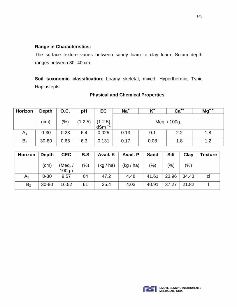
149
REMOTE SENSING INSTRUMENTSHYDERABAD, INDIA.REMOTE SENSING INSTRUMENTSHYDERABAD, INDIA.
Range in Characteristics: The surface texture varies between sandy loam to clay loam. Solum depth
ranges between 30- 40 cm.
Soil taxonomic classification: Loamy skeletal, mixed, Hyperthermic, Typic
Haplustepts.
Physical and Chemical Properties
Horizon Depth
(cm)
O.C.
(%)
pH
(1:2.5)
EC
(1:2.5) dSm –1
Na+ K+ Ca++ Mg+ +
Meq. / 100g.
A1 0-30 0.23 6.4 0.025 0.13 0.1 2.2 1.8
B2 30-80 0.65 6.3 0.131 0.17 0.08 1.8 1.2
Horizon Depth
(cm)
CEC
(Meq. / 100g.)
B.S
(%)
Avail. K
(kg / ha)
Avail. P
(kg / ha)
Sand
(%)
Silt
(%)
Clay
(%)
Texture
A1 0-30 9.57 64 47.2 4.48 41.61 23.96 34.43 cl
B2 30-80 16.52 61 35.4 4.03 40.91 37.27 21.82 l

150
REMOTE SENSING INSTRUMENTSHYDERABAD, INDIA.REMOTE SENSING INSTRUMENTSHYDERABAD, INDIA.
Dolda Series
Profile No. : 249
Mapping Unit : 339, 341
Location : 500m West Of Village Dolda
Toposheet No. : 73F/5
Lat. Long : N 22°56’22. 5” E 85°24’24. 5”
Elevation : 636m
Slope Percentage : 15-20%
Slope Direction : NW-SE
Physiography : Ridges / Low Hills
Land Use / Land Cover : Forest
Parent Material : Metabasic Rock
Erosion Class : e3
Land Capability Sub Class : VIt
Land Irrigability Sub Class : 6t
Morphology:
Horizon Depth
(cm)
Description
Ap 0 - 15 Light reddish brown (5YR 5.5/4m) silty loam; weak, fine
medium and coarse, sub-angular blocky; friable, slightly
sticky, slightly plastic; coarse fragments 25-30%; many
fine to medium pores; many fine to medium roots; gradual
smooth boundary
C 15 – 130+ Highly weathered parent material
Range in Characteristics: Ap horizon color range between brown to dark brown. Solum depth varies
between 18-30 cm. Surface texture ranges between sandy loam to silty loam.

151
REMOTE SENSING INSTRUMENTSHYDERABAD, INDIA.REMOTE SENSING INSTRUMENTSHYDERABAD, INDIA.
Soil taxonomic classification: Loamy skeletal, mixed, Hyperthermic Typic
Ustorthents.
Physical and Chemical Properties
Horizon Depth
(cm)
O.C.
(%)
pH
(1:2.5)
EC
(1:2.5) dSm –1
Na+ K+ Ca++ Mg+ +
Meq. / 100g.
Ap
0-15
0.78
5.5
0.039
0.16
0.19
3.5
0.9
Horizon Depth
(cm)
CEC
(Meq. / 100g.)
BS
(%)
Avail. K
(kg / ha)
Avail. P
(kg / ha)
Sand
(%)
Silt
(%)
Clay
(%)
Texture
Ap
0-15
12.63
48
2
1
26
59
15
sil

152
REMOTE SENSING INSTRUMENTSHYDERABAD, INDIA.REMOTE SENSING INSTRUMENTSHYDERABAD, INDIA.
Pahantoli Series Profile No. : 728
Mapping Unit : 340
Location : 600m South Of Village Pahantoli
Toposheet No. : 73F/2
Lat. Long : N 22°34’20. 3” E 84°47’57. 2”
Elevation : 455m
Slope Percentage : 5-10%
Slope Direction : S-N
Physiography : Pediment/Uplands
Land Use / Land Cover : Harvested Mandua
Parent Material : Epidiorite/Metavolcanic Rocks-Mainly
Intrusives
Erosion Class : e2
Land Capability Sub Class : IIIs
Land Irrigability Sub Class : 3d
Morphology: Horizon Depth
(cm.)
Description
AP 0-20 Red (2.5YR5/8m) sandy clay; structure less; non-sticky,
non-plastic; coarse fragments 1-2%; many medium pores;
many fine and medium roots.
B11 20-55 Red (2.5YR 5/6m) silty clay loam; weak, medium, sub-
angular blocky, firm, sticky, plastic; coarse fragments 2-
11%; many medium pores; few fine roots.
B12 55-145 Red (2.5YR 4/6m) clay; weak, fine to medium, sub-angular
blocky; firm very sticky, very plastic; coarse fragments 3-

153
REMOTE SENSING INSTRUMENTSHYDERABAD, INDIA.REMOTE SENSING INSTRUMENTSHYDERABAD, INDIA.
6%; many fine pores; few very fine and fine roots.
C 145-160 Partialy weathered parent material.
Range in Characteristics: Ap horizon texture varies between sandy clay loam to sandy clay. Surface
horizon ranges between 12-30 cm. Surface colour ranges between reddish
brown to red.
Soil taxonomic classification: Fine, mixed, Hyperthermic, Typic Haplustepts.
Physical and Chemical Properties
Horizon Depth
(cm)
O.C.
(%)
pH
(1:2.5)
EC
(1:2.5) dSm –1
Na+ K+ Ca++ Mg+ +
Meq. / 100g.
Ap 0-20 0.48 5.1 0.123 0.26 0.18 9 4.4
B11 20-55 0.27 6.2 0.047 0.3 0.33 4.4 6
B12 55-145 0.15 6.4 0.052 0.13 0.31 4 7
Horizon Depth
(cm)
CEC
(Meq. / 100g.)
BS
(%)
Avail. K
(kg / ha)
Avail. P
(kg / ha)
Sand
(%)
Silt
(%)
Clay
(%)
Texture
Ap 0-20 19.13 64 82.6 4.93 49 7 43 sc
B11 20-55 20 69 153.4 17.92 14 52 34 sicl
B12 55-145 18.26 71 141.6 4.03 27 28 45 c

154
REMOTE SENSING INSTRUMENTSHYDERABAD, INDIA.REMOTE SENSING INSTRUMENTSHYDERABAD, INDIA.
Ronhe Series Profile No. : 668
Mapping Unit : 342
Location : 200m South Of Village Ronhe
Toposheet No. : 73F/1
Lat. Long : N 22°53’19. 4” E 85°9’34. 9”
Elevation : 509m
Slope Percentage : 5-10%
Slope Direction : SW-NE
Physiography : Upland In between ridges
and low hills
Land Use / Land Cover : Scrub lands
Parent Material : Metabasic Rock
Erosion Class : e3
Land Capability Sub Class : IIIs
Land Irrigability Sub Class : 3s
Morphology: Horizon Depth
(cm)
Description
Ap 0 – 24 Yellowish red (5YR 5/6m) sandy loam; structure less; non sticky,
non plastic; coarse fragments 2-4%; many medium and coarse
pores; few fine to medium roots; abrupt smooth boundary
B11t 24 – 45 Reddish brown (5YR 4/4m) clay loam; weak, fine sub-angular
blocky; friable, slightly sticky; slightly plastic; coarse fragments 1-
2 %; many fine to medium pores; few fine roots; patchy thin
cutans gradual smooth boundary
II B12 45 – 100 Reddish brown (5YR 4/3m) loamy sand; weak, fine, sub-angular
blocky; firm, non sticky, non plastic; many fine pores; few very
fine roots

155
REMOTE SENSING INSTRUMENTSHYDERABAD, INDIA.REMOTE SENSING INSTRUMENTSHYDERABAD, INDIA.
C 100 - 120 Partially weathered parent material
Range in Characteristics: Ap horizon texture varies between sandy loam to loam. Surface depth range
between 20-30 cm. Surface colour ranges between yellowish red to red.
Soil taxonomic classification: Fine loamy, mixed, Hyperthermic, Typic
Haplustalfs.
Physica and Chemical Properties
Horizon Depth
(cm)
O.C.
(%)
pH
(1:2.5)
EC
(1:2.5) dSm –1
Na+ K+ Ca++ Mg+ +
Meq. / 100g.
Ap 0-24 0.23 5.6 0.021 0.17 0.13 3 1
B11t 24-45 0.08 5.6 0.022 0.17 0.1 4 2
IIB12 45-100 0.27 5.7 0.024 0.17 0.21 6 3
Horizon Depth
(cm)
CEC
(Meq. / 100g.)
B.S
(%)
Avail. K
(kg / ha)
Avail. P
(kg / ha)
Sand
(%)
Silt
(%)
Clay
(%)
Texture
Ap 0-24 7.83 55 59 4.26 75 8 17 sl
B11t 24-45 10.43 60 47.2 4.26 41 22 37 cl
IIB12 45-
100 14.78 63 94.4 3.81 68 13 19 ls
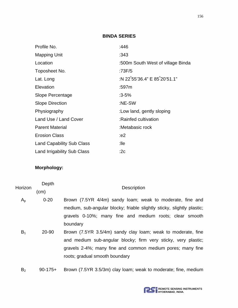
156
REMOTE SENSING INSTRUMENTSHYDERABAD, INDIA.REMOTE SENSING INSTRUMENTSHYDERABAD, INDIA.
BINDA SERIES
Profile No. :446
Mapping Unit :343
Location :500m South West of village Binda
Toposheet No. :73F/5
Lat. Long :N 22º55’36.4” E 85º20’51.1”
Elevation :597m
Slope Percentage :3-5%
Slope Direction :NE-SW
Physiography :Low land, gently sloping
Land Use / Land Cover :Rainfed cultivation
Parent Material :Metabasic rock
Erosion Class :e2
Land Capability Sub Class :lle
Land Irrigability Sub Class :2c
Morphology:
Horizon Depth
(cm) Description
Ap 0-20 Brown (7.5YR 4/4m) sandy loam; weak to moderate, fine and
medium, sub-angular blocky; friable slightly sticky, slightly plastic;
gravels 0-10%; many fine and medium roots; clear smooth
boundary
B1 20-90 Brown (7.5YR 3.5/4m) sandy clay loam; weak to moderate, fine
and medium sub-angular blocky; firm very sticky, very plastic;
gravels 2-4%; many fine and common medium pores; many fine
roots; gradual smooth boundary
B2 90-175+ Brown (7.5YR 3.5/3m) clay loam; weak to moderate; fine, medium

157
REMOTE SENSING INSTRUMENTSHYDERABAD, INDIA.REMOTE SENSING INSTRUMENTSHYDERABAD, INDIA.
Range in Characteristics: Ap horizon texture varies between sandy loam to loam. Surface depth ranges
between 20-30cm. Surface colour ranges between brown to strong brown.
Soil taxonomic classification: Fine loamy, mixed, Hyperthermic, Typic Udic
Haplustepts.
Physical and Chemical Properties
Horizon Depth
(cm)
O.C.
(%)
pH
(1:2.5)
EC
(1:2.5) dSm –1
Na+ K+ Ca++ Mg+ +
Meq. / 100g.
Ap 0-20 0.45 5.8 0.022 0.17 0.18 6.0 3.8
B1 20-90 0.3 6.1 0.032 0.22 0.15 5.8 3.0
B2 90-
175+ 0.27 6.5 0.024 0.21 0.13 5.1 3.2
Horizon Depth
(cm)
CEC
(Meq. / 100g.)
B.S
(%)
Avail. K
(kg / ha)
Avail. P
(kg / ha)
Sand
(%)
Silt
(%)
Clay
(%)
Texture
Ap 0-20 17.39 58 82.6 5.38 50 32 18 sI
B1 20-90 22.61 61 70.8 3.99 57 20 22 scl
B2 90-
175+ 24.82 65 61.9 3.12 47 20 33 cl
and coarse, sub-angular blocky; firm, very sticky, very plastic;
gravels 2-4%; common fine and medium pores; few fine roots

158
REMOTE SENSING INSTRUMENTSHYDERABAD, INDIA.REMOTE SENSING INSTRUMENTSHYDERABAD, INDIA.
Hariharpur Series
Profile No. :40
Mapping Unit :344
Location :2km South Of Village Hariharpur
Toposheet No. :73E/3
Lat. Long :N 23°16’41. 8” E 85°1’31. 2”
Elevation :708m
Slope Percentage :15-25%
Slope Direction :E-W
Physiography :Medium to Large Size Ridges
Land Use / Land Cover :Mustard, Beans Cultivated
Parent Material :Crystalline Limestone, Calcareous Rocks
Erosion Class :e3
Land Capability Sub Class :IIIst
Land Irrigability Sub Class :3t
Morphology: Horizon Depth
(cm)
Description
Ap 0 - 18 Reddish brown (5YR 4/4m) sandy loam; weak, very fine to
fine, sub-angular blocky; friable, slightly sticky, slightly
plastic; coarse fragments 5%; many very fine to medium
pores; many very fine to fine roots; abrupt smooth boundary
B2 18 - 56 Dark reddish brown (5YR 3/3m) gravelly sandy clay loam;
weak, very fine to fine, sub-angular blocky; friable, sticky,
plastic; coarse fragments >35%; many very fine to fine
pores; few very fine roots; gradual smooth boundary
C 56 – 80 Partially weathered parent material
R 80+ Hard rock

159
REMOTE SENSING INSTRUMENTSHYDERABAD, INDIA.REMOTE SENSING INSTRUMENTSHYDERABAD, INDIA.
Range in Characteristics: Ap horizon depth varies between 16-25 cm. Surface texture varies between
sandy loam to loam. Gravel percentage increases with depth.
Soil taxonomic classification: Loamy skeletal, mixed, Hyperthermic, Typic
Dystrustepts.
Physical and Chemical Properties
Horizon Depth
(cm)
O.C.
(%)
pH
(1:2.5)
EC
(1:2.5) dSm –1
Na+ K+ Ca++ Mg+ +
Meq. / 100g.
Ap 0-18 0.87 6.8 0.124 0.22 0.13 4 4.4
B1 18-56 0.83 6.7 0.089 0.17 0.08 4 4.4
Horizon Depth
(cm)
CEC
(Meq. / 100g.)
B.S
(%)
Avail. K
(kg / ha)
Avail. P
(kg / ha)
Sand
(%)
Silt
(%)
Clay
(%)
Texture
Ap 0-18 15.65 56 59 6.72 20.22 23.87 55.91 sl
B1 18-26 18.26 66 35.4 4.93 32.26 4.3 63.44 scl

160
REMOTE SENSING INSTRUMENTSHYDERABAD, INDIA.REMOTE SENSING INSTRUMENTSHYDERABAD, INDIA.
Jonha Series
Profile No. :624
Mapping Unit :345
Location :2.5Km North of village Jonha
Toposheet No. : 73E/11
Lat. Long :N 23º17’46. 7” E 85º48’52. 2”
Elevation :262m
Slope Percentage :6-10%
Slope Direction :N-S
Physiography :Gently to moderately sloping uplands
Land Use / Land Cover :Scrub lands
Parent Material :Crystalline Limestone, Calcareous rocks
Erosion Class :e3
Land Capability Class :llls
Land Irrigability Class :3s
Morphology:
Horizon Depth
(cm) Description
A1 0-20 Yellowish red (5YR 5/8m) sandy clay loam; weak, fine, sub-angular
blocky; friable, slightly sticky, slightly plastic; gravels 2-4%; many
fine and medium and few coarse pores; few fine and medium roots;
abrupt smooth boundary
B11 20-70 Yellowish red (2.5YR 3/6m) clay; moderate, fine, sub-angular
blocky; firm, very sticky, very plastic; gravels 4-6%; few fine and
medium pores; few fine roots; gradual smooth boundary
B12
70-100
Yellowish red (2.5YR 3/6m) sandy clay; moderate, fine, medium

161
REMOTE SENSING INSTRUMENTSHYDERABAD, INDIA.REMOTE SENSING INSTRUMENTSHYDERABAD, INDIA.
Range in Characteristics: The surface texture varies between sandy clay loam to clay loam. The solum
depth varies between 20-100cm. The surface colour varies between reddish
brown to brown.
Soil taxonomic classification: Fine, mixed, Hyperthermic, Udic Rhodustalfs.
Physical and Chemical Properties
Horizon Depth
(cm)
O.C.
(%)
pH
(1:2.5)
EC
(1:2.5) dSm –1
Na+ K+ Ca++ Mg+ +
Meq. / 100g.
A 0-20 0.21 5.2 0.026 0.13 0.18 3.2 4.2
B11 20-70 0.02 6 0.021 0.13 0.18 5.2 4.4
B12 70-100 0.06 6.3 0.031 0.17 0.08 3.6 2
Horizon Depth
(cm)
CEC
(Meq. / 100g.)
B.S
(%)
Avail. K
(kg / ha)
Avail. P
(kg / ha)
Sand
(%)
Silt
(%)
Clay
(%)
Texture
A 0-20 13.91 55 82.6 2.69 54 18 28 scl
B11 20-70 18.26 64 82.6 3.58 43 15 42 c
B12 70-100 14.78 68 35.4 2.69 46 14 40 sc
and coarse; sub-angular blocky; firm very sticky, very plastic;
gravels 10-15%; common fine to medium pores; very few, very fine
roots; gradual smooth boundary
C 100-120+ Highly weathered parent material
B11 20-70 Yellowish red (5YR 5/6m) clay; moderate, fine, sub-angular blocky;
firm, very sticky, very plastic; gravels 4-6%; few fine and medium
pores; few fine roots; gradual smooth boundary

162
REMOTE SENSING INSTRUMENTSHYDERABAD, INDIA.REMOTE SENSING INSTRUMENTSHYDERABAD, INDIA.
Range in Characteristics: The surface texture varies between sandy clay loam to clay loam. The solum
depth varies between 20-100cm. The surface colour varies between reddish
brown to brown.
Soil taxonomic classification: Fine, mixed, Hyperthermic, Udic Haplustepts.
Physical and Chemical Properties
Horizon Depth
(cm)
O.C.
(%)
pH
(1:2.5)
EC
(1:2.5) dSm –1
Na+ K+ Ca++ Mg+ +
Meq. / 100g.
A 0-20 0.21 5.2 0.026 0.13 0.18 3.2 4.2
B11 20-70 0.02 6 0.021 0.13 0.18 5.2 4.4
B12 70-100 0.06 6.3 0.031 0.17 0.08 3.6 2
Horizon Depth
(cm)
CEC
(Meq. / 100g.)
BS
(%)
Avail. K
(kg / ha)
Avail. P
(kg / ha)
Sand
(%)
Silt
(%)
Clay
(%)
Texture
A 0-20 13.91 55 82.6 2.69 46 9 45 sc
B11 20-70 18.26 64 82.6 3.58 43 15 42 c
B12 70-100 14.78 68 35.4 2.69 46 14 40 sc
B12 70-100 Yellowish red (5YR 4/6m) sandy clay; moderate, fine, medium and
coarse; sub-angular blocky; firm very sticky, very plastic; gravels
10-15%; common fine to medium pores; very few, very fine roots;
gradual smooth boundary
C 100-120+ Highly weathered parent material

163
REMOTE SENSING INSTRUMENTSHYDERABAD, INDIA.REMOTE SENSING INSTRUMENTSHYDERABAD, INDIA.
APPENDIX-II
Landscapes and Profiles of Different
Mapping Units

164
REMOTE SENSING INSTRUMENTSHYDERABAD, INDIA.REMOTE SENSING INSTRUMENTSHYDERABAD, INDIA.
PLATE-1 LANDSCAPE OF VERY GENTLY SLOPING ALLUVIAL PLAIN (MU-302)
PLATE-2. PROFILE OF GANGATOLI SERIES-- FINE OXYAQUIC HAPLUSTALFS

165
REMOTE SENSING INSTRUMENTSHYDERABAD, INDIA.REMOTE SENSING INSTRUMENTSHYDERABAD, INDIA.
PLATE-3. PROFILE OF NAWATOLI SERIES--FINE KANHAPLIC HAPLUSTALFS.( MU-303)

166
REMOTE SENSING INSTRUMENTSHYDERABAD, INDIA.REMOTE SENSING INSTRUMENTSHYDERABAD, INDIA.
PLATE-4LANDSCAPE OF LOW LANDS (MU-314)
PLATE-5.PROFILE OF CHAMA SERIES-- FINE TYPIC DYSTRUSTEPTS

167
REMOTE SENSING INSTRUMENTSHYDERABAD, INDIA.REMOTE SENSING INSTRUMENTSHYDERABAD, INDIA.
PLATE-6. LANDSCAPE OF UPER PEDIPLAIN (MU-318)
PLATE-7. PROFILE OF BATHANTOLI SERIES--FINE LOAMY ULTIC HAPLUSTALFS. (MU-318)

168
REMOTE SENSING INSTRUMENTSHYDERABAD, INDIA.REMOTE SENSING INSTRUMENTSHYDERABAD, INDIA.
PLATE-8. LANDSCAPE OF LOWER PEDIPLAIN (MU-320)
PLATE-9. PROFILE OF LODHMA SERIES-- FINE ULTIC HAPLUSTALFS

169
REMOTE SENSING INSTRUMENTSHYDERABAD, INDIA.REMOTE SENSING INSTRUMENTSHYDERABAD, INDIA.
PLATE-10 LANDSCAPE OF NARROW VALLEY (MU-322)
PLATE-11. PROFILE OF PATROTOLI SERIES-- FINE LOAMY TYPIC EDOAQUEPTS

170
REMOTE SENSING INSTRUMENTSHYDERABAD, INDIA.REMOTE SENSING INSTRUMENTSHYDERABAD, INDIA.
PLATE-12 LANDSCAPE OF PEDIPLAIN (MU-324)
PLATE-13. PROFILE OF NAGRI SERIES--FINE LOAMY TYPIC HAPLUSTEPTS

171
REMOTE SENSING INSTRUMENTSHYDERABAD, INDIA.REMOTE SENSING INSTRUMENTSHYDERABAD, INDIA.
PLATE-14 LANDSCAPE OF NARROW VALLEY (MU-325)
PLATE-15. PROFILE OF DOLAICHA SERIES--FINE ULTIC
HAPLUSTALFS.

172
REMOTE SENSING INSTRUMENTSHYDERABAD, INDIA.REMOTE SENSING INSTRUMENTSHYDERABAD, INDIA.
PLATE-16 LANDSCAPE OF UPLAND ONCRYSTALLINE LIMESTONE, CALCAREOUS ROCKS (MU-345)
PLATE-17. PROFILE OF JONHA SERIES--FINE UDIC RHODUSTALFS

173
REMOTE SENSING INSTRUMENTSHYDERABAD, INDIA.REMOTE SENSING INSTRUMENTSHYDERABAD, INDIA.
PLATE-18. LANDSCAPE OF UPPER PEDIPLAIN ON PHYLLITE, MICA SCHIST (MU-331)
PLATE-19 PROFILE OF HENROMTOLI SERIES--FINE LOAMY TYPIC DYSTRUSTEPTS

174
REMOTE SENSING INSTRUMENTSHYDERABAD, INDIA.REMOTE SENSING INSTRUMENTSHYDERABAD, INDIA.
PLATE-20 LANDSCAPE OF BROAD VALLEY (MU--334)
PLATE-21 PROFILE OF TANBANG SERIES--COARSE LOAMY UDIC HAPLUSTEPTS

175
REMOTE SENSING INSTRUMENTSHYDERABAD, INDIA.REMOTE SENSING INSTRUMENTSHYDERABAD, INDIA.
PLATE-22 LANDSCAPE OF LOWLANDS (MU-332)
PLATE-23 PROFILE OF RARGAON SERIES--FINE UDIC HAPLUSTEPTS


![State: Jharkhandjsac.jharkhand.gov.in/pdf/crop/JKD1-Garhwa-10.08.12[1].pdf · Cauliflower 0.520 0.520 Medicinal and Aromatic crops - Plantation crops - Fodder crops - Total fodder](https://img.dokumen.tips/doc/110x75/5e984abdba1859541f1aa068/state-1pdf-cauliflower-0520-0520-medicinal-and-aromatic-crops-plantation.jpg)