Embed Size (px)
Citation preview

ORIGINAL ARTICLE
On causes and impacts of land subsidence in Bandung Basin,Indonesia
Hasanuddin Z. Abidin • I. Gumilar •
H. Andreas • D. Murdohardono • Y. Fukuda
Received: 20 July 2011 / Accepted: 9 July 2012 / Published online: 25 July 2012
� Springer-Verlag 2012
Abstract The Bandung Basin is a large intra-montane
basin surrounded by volcanic highlands, in western Java,
Indonesia, inhabited by more than seven million people.
The basin, an area of about 2,300 km2, is a highland pla-
teau at approximately 650–700 m above sea level and is
surrounded by up to 2,400 m high Late Tertiary and
Quaternary volcanic terrain. Based on the results of nine
GPS surveys conducted since 2000 up to 2011, it was
shown that several locations in the Bandung Basin have
experienced land subsidence, with an average rate of about
-8 cm/year and can go up to about -23 cm/year in certain
locations. A hypothesis has been proposed by several
studies that land subsidence observed in several locations
in the Bandung Basin has been caused mainly by excessive
groundwater extraction. It is found that there is a strong
correlation between the rates of groundwater level lower-
ing with the GPS-derived rates of land subsidence in sev-
eral locations in Bandung Basin. The GPS results in this
study detected significant subsidence in the textile industry
area, where very large volumes of groundwater are usually
extracted. The impact of land subsidence in Bandung can
be seen in several forms, mainly in the cracking and
damage of houses, buildings and infrastructure. Land
subsidence also aggravates the flooding in Bandung Basin,
which has brought huge economic losses and deteriorated
the quality of life and environment in the affected areas.
Keywords Land subsidence � Indonesia � Bandung �GPS � Groundwater � Flooding
Introduction
Bandung Basin is a large intra-montane basin surrounded by
volcanic highlands, located in West Java province, Indonesia
(Fig. 1). The central part of the basin has an altitude of about
665 m and is surrounded by up to 2,400 m high Late Tertiary
and Quaternary volcanic terrain (Dam et al. 1996). The
catchment area of the basin and surrounding mountains
covers approximately 2,300 km2, and the Citarum River with
its tributaries forms the main drainage system of the basin
catchment. It is one of the largest watersheds on the island of
Java, which provides water for drinking, agriculture and
fisheries, as well as the main supply for three reservoirs
(hydroelectric dams), with a total volume of about
6,147 million cubic meters (Wangsaatmaja 2004). The mean
annual temperature in the basin is about 23.7 �C, with mean
annual precipitation amounts to about 1,700 mm (Iwaco-
Waseco 1991). Deposits in the basin comprise coarse vol-
caniclastics, fluvial sediments and notably a thick series of
lacustrine deposits.
On the basis of its hydraulic characteristics and its depth,
the multi-layer aquifer configuration of the Bandung Basin
may be simplified into two systems (Soetrisno 1996): shallow
aquifers (a few meters to around 40 m below the surface) and
deep aquifers (more than 40–250 m below the surface).
These aquifers are composed of volcanic products from the
volcanic complexes that bordered this basin, and lake
H. Z. Abidin (&) � I. Gumilar � H. Andreas
Geodesy Research Group, Faculty of Earth Science and
Technology, Institute of Technology Bandung, Jl. Ganesha 10,
Bandung, Indonesia
e-mail: [email protected]
D. Murdohardono
Geological Agency of Indonesia, Jl. Diponegoro 57,
Bandung, Indonesia
Y. Fukuda
Graduate School of Science, Kyoto University, Kyoto, Japan
123
Environ Earth Sci (2013) 68:1545–1553
DOI 10.1007/s12665-012-1848-z

sediments that were deposited when the central part of the
basin was a lake. The lake was fully formed about
50,000 years ago, and was drained away about 16,000 years
ago (Dam et al. 1996).
The basin has an area of about 2,300 km2 and encom-
passes five administrative units: the Bandung City
(municipality) which is an urban area 81 km2 in size per-
ched against the northern mountain range; the surrounding
Bandung regency; part of the Sumedang and West Bandung
regencies; and the city of Cimahi. The central part of the
basin, mostly comprising urban and industrial areas, is a
plain measuring about 40 km east–west and about 30 km
north–south. Bandung City itself is the capital of West Java
province, Indonesia. The population of the Bandung
municipality increased from less than 40,000 in 1906 to
nearly one million in 1961, and had grown to about 2.4
million in 2010 (BPS 2011). The population in Bandung
Basin itself was about 3.4 million in 1986, became about 4.4
million in 1994, and in 2003 was about 5.9 million people.
In addition, with expansion of manufacturing and textile
industries in the Bandung Basin, urbanisation increased and
in 2010 about 7.7 million people inhabited the basin.
There are several types of land subsidence that can be
expected to occur in the Bandung Basin, namely subsi-
dence due to groundwater extraction, subsidence induced
by the load of man-made constructions (i.e., settlement of
highly compressible soil), subsidence caused by natural
consolidation of alluvium soil, and geotectonic subsidence.
As information on land subsidence characteristics will be
useful for managing many developmental and environmen-
tal aspects, systematic and continuous monitoring of land
subsidence in Bandung is obviously needed and is critical to
the welfare of the city. Comprehensive information on land
subsidence characteristics would be important for several
tasks, such as spatial-based groundwater extraction regula-
tion, effective control of floods, conservation of
environment, design and construction of infrastructure, and
spatial urban development planning in general.
In principle, the land subsidence phenomenon can be
studied using several methods, such as hydrogeology
methods, e.g., groundwater level observation, extensometer
measurement and piezometer measurement, as well as by
geodetic methods such as leveling surveys, GPS surveys
and interferometric synthetic aperture radar (InSAR).
Subsidence phenomena in Bandung Basin has been studied
since 2000 using GPS surveys (Abidin et al. 2006) and also
InSAR since 2006 (Abidin et al. 2008; Sumantyo et al.
2012). This paper analyzes and discusses the causes and
impacts of land subsidence phenomena in Bandung Basin.
Estimating land subsidence in Bandung Basin
Subsidence phenomena in Bandung Basin have been
studied using GPS survey method and also InSAR. In
estimating land subsidence using repeated GPS surveys,
several monuments, which are placed on the ground cov-
ering the Bandung Basin and its surroundings, are accu-
rately positioned relative to a certain reference (stable)
point, using the GPS survey technique. The precise coor-
dinates of the monuments are periodically determined
using repeated GPS surveys at certain time intervals. By
studying the characteristics and rate of change in the height
components of the coordinates from survey to survey, the
land subsidence characteristics can be derived.
To study the land subsidence phenomena in the Ban-
dung Basin, nine GPS surveys have been conducted in
February 2000, November 2001, July 2002, June 2003,
June 2005, August 2008, July 2009, July 2010 and August
2011. The surveys at all stations were carried out using
dual-frequency geodetic-type GPS receivers. In this case,
the PSCA station located inside the Institute of Technology
Fig. 1 Bandung Basin and its location in West Java, Indonesia
1546 Environ Earth Sci (2013) 68:1545–1553
123

Bandung (ITB) campus was used as the reference point
with known coordinates. For all GPS surveys, except for
the first survey, the length of sessions was between 10 and
12 h. In the first GPS survey, the length of sessions was
about 5–6 h. The data were collected with a 30-s interval,
and the elevation mask was set to 15� for all stations. The
surveys were mainly carried out by the staff and students
from the Department of Geodesy and Geomatics Engi-
neering of ITB. Location of GPS stations used for studying
land subsidence in Bandung Basin is shown in Fig. 2.
The data were processed using the software Bernese 5.0
(Beutler et al. 2007). Since this study is mostly interested in
the relative heights with respect to a stable point, the radial
processing mode was used instead of a network adjustment
mode, with baselines that ranged from about 4–25 km in
length. In this case, the relative ellipsoidal heights of all
stations are determined relative to the PSCA station
(northernmost station in Fig. 2). For data processing, pre-
cise ephemeris was used instead of the broadcast ephem-
eris. The effects of tropospheric and ionospheric biases are
mainly reduced by the differencing process and the use of
dual-frequency observations. The residual tropospheric
bias parameters for individual stations are estimated to
further reduce the tropospheric effects. In processing
baselines, most of the cycle ambiguities of the phase
observations were successfully resolved. Based on the
estimated ellipsoidal heights obtained from GPS process-
ing, the height differences between two consecutive survey
epochs can be calculated. The estimated land subsidence at
several locations in Bandung Basin as derived from five
GPS surveys (i.e., from 2000 to 2005) are given in Abidin
et al. (2006, 2008).
The spatial and temporal variations of subsidence rates in
Bandung Basin are shown by the eight interpolated maps in
Fig. 3. These maps were interpolated using Kriging method
based on the GPS-derived subsidence rates, and then plotted
using the Surfer software. Considering the distribution of
GPS points shown in Fig. 2, these interpolated maps should
be considered just as the indicative rather than final land
subsidence maps of Bandung area. In this case, the inter-
polated and extrapolated values for the areas located several
kilometers away from the GPS stations may be misleading
and may alter the interpretation of the maps.
The GPS-derived subsidence results shown in Fig. 3
indicate that the mechanism of land subsidence in the
Bandung Basin is not simple and may be caused by
several factors, such as excessive groundwater extraction,
sediment compaction, building load and tectonic activi-
ties. In general, rates of subsidence have a mean of
about -8 cm/year, which can go up to about -23 cm/
year at certain locations and certain time periods. Several
stations, e.g., CMHI, DYHK, RCK2, GDBG, BM9L and
BM18L (see Fig. 2), have higher subsidence rates com-
pared to others, namely more than 12 cm/year. Stations
CMHI, DYHK, RCK2 and GDBG are located in the
textile industry areas, where excessive groundwater
extraction is expected to occur; while BM9L and
BM18L stations are located on the bank of the Citarum
River. The results in Fig. 3 also show that subsidence
rates are not always linear. Several stations show a
slowing down of subsidence, while others do not. The
results obtained from InSAR using ALOS/PALSAR data
also show that subsidence of over 12 cm occurred during
the period between June 2006 and March 2007, near
Fig. 2 Distribution of GPS
points for studying land
subsidence in the Bandung
Basin. The PSCA reference
station is the northern-most
point in the figure
Environ Earth Sci (2013) 68:1545–1553 1547
123
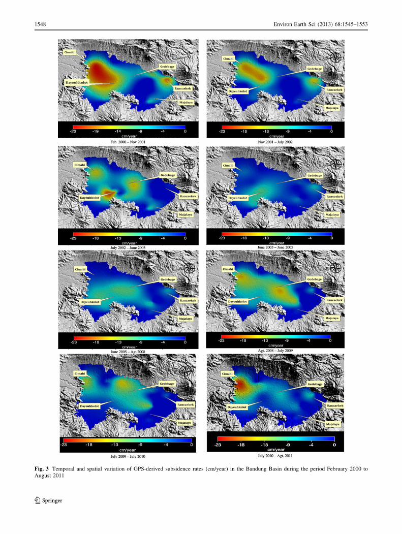
Fig. 3 Temporal and spatial variation of GPS-derived subsidence rates (cm/year) in the Bandung Basin during the period February 2000 to
August 2011
1548 Environ Earth Sci (2013) 68:1545–1553
123

GPS stations CMHI, BM18L and BM19L (Abidin et al.
2008, Sumantyo et al. 2012).
Impacts of land subsidence in Bandung Basin
In general, the impacts of land subsidence in Bandung
Basin could be seen in several forms, such as cracking of
permanent constructions and roads, changes in river canal
and drain flow systems, wider expansion of flooding areas
and malfunction of drainage system. Figure 4 shows some
representation in the field caused by land subsidence phe-
nomena from several years ago and recent times.
Ground thruthing surveys have been conducted to find
and locate the impact features of land subsidence in the
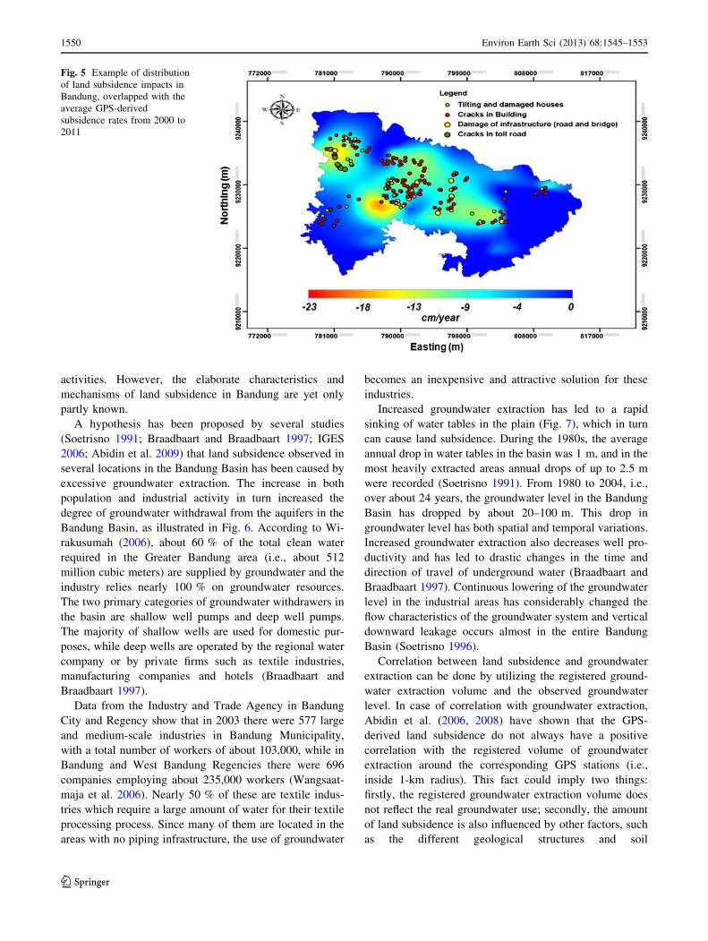
Bandung area. Figure 5 shows the distribution of land
subsidence impacts in 2011, overlapped with the average
GPS-derived subsidence from 2000 to 2011. From this
map, it can be seen that the numbers of buildings, houses
and other infrastructure affected by land subsidence phe-
nomena are also numerous, exhibiting cracking, tilting or
general damage. Figure 5 also shows that most damages
occurred in the areas showing high subsidence and also
those which spatially have differential subsidence.
The tangible and intangible impacts of land subsidence
cannot be underestimated. The primary environmental and
economic effects of land subsidence phenomena can vary
from negligible to severe depending on the present land-
use nature of the affected area and the subsidence magni-
tude and coverage. The indirect effects of subsidence
through aggravation of other hazards already present in the
area are frequently more severe than the direct effects
(Viets 2010). In the case of Bandung Basin, the increase in
flooding coverage caused by continuing subsidence intro-
duces more problems compared to other indirect effects of
land subsidence. Flooding mainly occurred in the areas
along the Citarum River and its tributaries and subsidence
in these areas worsen it. Flooding can also occur in the
other areas during the rainy season due to the poor drainage
system. Land subsidence in these areas, besides lowering
the ground elevation, can also change the water flow
direction in the drainage system and in turn also worsen the
flooding phenomena.
The economic losses caused by land subsidence in
Bandung are potentially enormous, as many buildings and
infrastructure were severely affected by land subsidence,
and its collateral flooding disaster also frequently affected
economic activities in the southern Bandung region
(Gumilar et al. 2012). Many houses, public utilities and a
large part of the populations are also exposed to this silent
disaster. The corresponding maintenance cost is increasing
every year, and the living conditions of the affected pop-
ulation are deteriorating. The quality of their social and
economic activity is consequently decreasing as well.
Causes of land subsidence in the Bandung Basin
Land subsidence in the Bandung Basin can be caused by
excessive groundwater extraction, load of man-made con-
structions (i.e., settlement of highly compressible soil),
natural consolidation of alluvium soil and tectonic
Fig. 4 Examples of recent subsidence features in the Bandung Basin.
Photos taken by Irwan Gumilar in 2010. a Subsided house in the
Dayeuh Kolot area (around DHYK GPS stations); b highway
cracking in the southern Cimahi area (around CMHI GPS station);
c uplifting of the road due to subsidence in the Gedebage area (around
GDBG GPS station); d subsided house in the Gedebage area (around
GDBG GPS station); e subsided house in the southern Cimahi area
(around CMHI GPS station); f flooding in Dayeuh Kolot area (around
DHYK GPS station)
Environ Earth Sci (2013) 68:1545–1553 1549
123
activities. However, the elaborate characteristics and
mechanisms of land subsidence in Bandung are yet only
partly known.
A hypothesis has been proposed by several studies
(Soetrisno 1991; Braadbaart and Braadbaart 1997; IGES
2006; Abidin et al. 2009) that land subsidence observed in
several locations in the Bandung Basin has been caused by
excessive groundwater extraction. The increase in both
population and industrial activity in turn increased the
degree of groundwater withdrawal from the aquifers in the
Bandung Basin, as illustrated in Fig. 6. According to Wi-
rakusumah (2006), about 60 % of the total clean water
required in the Greater Bandung area (i.e., about 512
million cubic meters) are supplied by groundwater and the
industry relies nearly 100 % on groundwater resources.
The two primary categories of groundwater withdrawers in
the basin are shallow well pumps and deep well pumps.
The majority of shallow wells are used for domestic pur-
poses, while deep wells are operated by the regional water
company or by private firms such as textile industries,
manufacturing companies and hotels (Braadbaart and
Braadbaart 1997).
Data from the Industry and Trade Agency in Bandung
City and Regency show that in 2003 there were 577 large
and medium-scale industries in Bandung Municipality,
with a total number of workers of about 103,000, while in
Bandung and West Bandung Regencies there were 696
companies employing about 235,000 workers (Wangsaat-
maja et al. 2006). Nearly 50 % of these are textile indus-
tries which require a large amount of water for their textile
processing process. Since many of them are located in the
areas with no piping infrastructure, the use of groundwater
becomes an inexpensive and attractive solution for these
industries.
Increased groundwater extraction has led to a rapid
sinking of water tables in the plain (Fig. 7), which in turn
can cause land subsidence. During the 1980s, the average
annual drop in water tables in the basin was 1 m, and in the
most heavily extracted areas annual drops of up to 2.5 m
were recorded (Soetrisno 1991). From 1980 to 2004, i.e.,
over about 24 years, the groundwater level in the Bandung
Basin has dropped by about 20–100 m. This drop in
groundwater level has both spatial and temporal variations.
Increased groundwater extraction also decreases well pro-
ductivity and has led to drastic changes in the time and
direction of travel of underground water (Braadbaart and
Braadbaart 1997). Continuous lowering of the groundwater
level in the industrial areas has considerably changed the
flow characteristics of the groundwater system and vertical
downward leakage occurs almost in the entire Bandung
Basin (Soetrisno 1996).
Correlation between land subsidence and groundwater
extraction can be done by utilizing the registered ground-
water extraction volume and the observed groundwater
level. In case of correlation with groundwater extraction,
Abidin et al. (2006, 2008) have shown that the GPS-
derived land subsidence do not always have a positive
correlation with the registered volume of groundwater
extraction around the corresponding GPS stations (i.e.,
inside 1-km radius). This fact could imply two things:
firstly, the registered groundwater extraction volume does
not reflect the real groundwater use; secondly, the amount
of land subsidence is also influenced by other factors, such
as the different geological structures and soil
Fig. 5 Example of distribution
of land subsidence impacts in
Bandung, overlapped with the
average GPS-derived
subsidence rates from 2000 to
2011
1550 Environ Earth Sci (2013) 68:1545–1553
123

compressibility at the observed locations. In the case of the
Bandung Basin, both reasons may be valid. According to
Hutasoit (2008), the registered groundwater extraction
volume is just about 30 % of the actual amount. In 1995,
the illegal extraction of groundwater was estimated to be
120 % of the registered volume (Soetrisno 1996). More-
over, besides evidence found in the field, the significant
GPS-observed subsidence shown in previous Fig. 3 is
located in the textile industry area. It is known that the
textile industry usually extracts very large volumes of
groundwater.
Excessive groundwater extraction will generally lower
the groundwater level in the corresponding area. In general,
groundwater level inside Bandung Basin has been signifi-
cantly lowered compared to its level before the 1980s.
Theoretically, it can be expected that the subsidence of
certain areas will have a positive correlation with the
lowering of groundwater level. Abidin et al. (2009) shows
that indeed there is a strong correlation between the rates of
groundwater level lowering with the GPS-derived rates of
land subsidence in certain locations in Bandung Basin, in
which considering the maximum groundwater lowering
rates, correlation up to 0.92 is obtained. Figure 8 shows an
example of this correlation between land subsidence and
lowering of the groundwater level in four locations in
Bandung Basin, namely Cimahi (CMHI), Dayeuh Kolot
(DYHK), Banjaran (BNJR) and Rancaekek (RCK2), which
are located in areas with many textile industries. The In-
SAR technique also detected that significant subsidence
occurred in the textile industry area, where very large
volumes of groundwater are usually extracted (Abidin et al.
2008, Sumantyo et al. 2012). This InSAR result supports
0.5 1.63.2
4.6 4.9 6.3 7.310.5
18.7
38.6
45.8 46.8 48.150
61
66.9
76.8
50.1
41.7
45.4 46.6 46.6 47.450.6
58.5
51.452.8
50.847.6
5 15 30 42 45 58 78 96
300
686
821
971
1327
1666
1978
2225
2628
2484
2396
2462
2371
2154
22372258
2252
2484
2397
24012387
1910 1920 1930 1940 1960 1970 1976 1985 1988 1992 1993 1994 1995 1996 1997 1998 1999 2001 2002 2003 2004 2005 2006 2007
Fig. 6 Registered groundwater extraction in Greater Bandung (1900–2008) from the deep aquifers (40–250 m below the surface): courtesy of
the Geological Agency of Indonesia
Fig. 7 Lowering of groundwater level in some locations in the Bandung Basin, based on data from the Geological Agency of Indonesia
Environ Earth Sci (2013) 68:1545–1553 1551
123

the hypothesis that excessive groundwater extraction has
led to subsidence in the corresponding area.
However, as these correlations are only performed at
several locations in Bandung Basin, further research is
needed to clarify the real correlation pattern between land
subsidence, groundwater extraction volume and ground-
water level in the Bandung Basin. More geodetic and
hydrogeological data are needed to gain greater insight into
land subsidence and groundwater characteristics in the
Bandung Basin.
Conclusions
Land subsidence is an ongoing phenomenon in the Ban-
dung Basin. Based on the results of nine GPS surveys
conducted in 2000 up to 2011, it was shown that several
locations in the Bandung Basin have experienced land
subsidence, with an average rate of about -8 cm/year and
can go up to about -23 cm/year in certain locations. The
observed subsidence rates have spatial and temporal vari-
ations, and in general the observation stations around the
textile industrial areas have relatively high subsidence
rates, indicating the effects of excessive groundwater
extraction on observed land subsidence.
Land subsidence in Bandung has a strong linkage with
the urban development process. The urban development in
Bandung Basin and its surrounding areas has grown very
rapidly in the sectors of industry, trade, transportation, real
estate and many others. This exponential increase in urban
development has introduced several environmental prob-
lems, such as (1) extensive conversion of prime agricultural
areas into residential and industrial areas, (2) significant
disturbance to the main ecological function of the sur-
rounding upland areas of Bandung Basin as a water
recharge area for Bandung City, and (3) increase in
groundwater extraction due to the development of indus-
trial activities and the high population increase. These
negative impacts will contribute to the lowering of
groundwater level inside the Bandung Basin and in turn
can introduce the occurence of land subsidence phenomena
in several places in Bandung Basin.
Besides excessive groundwater extraction, land subsi-
dence in the Bandung Basin may also be partly caused by
natural consolidation of alluvium soil, load of man-made
constructions (i.e., settlement of highly compressible soil)
and tectonic activities. Therefore, further research is still
needed to clarify the real mechanism and pattern of land
subsidence in the Bandung Basin. In this regard, besides
carefully considering all possible factors influencing sub-
sidence in the Bandung Basin, the GPS-derived results
should also be integrated with results obtained by other
monitoring techniques such as InSAR, absolute micro-
gravity, leveling and automatic water level recorders.
The impact of land subsidence in Bandung can be seen
in several forms, mainly the cracking and damage of
houses, buildings and infrastructure, and also it aggravates
flooding in the Bandung Basin. In general, the direct and
Subsidence
Groundwater level
Subsidence
Groundwater levelGro
undw
ater
leve
l dep
th (
m)
Gro
undw
ater
leve
l dep
th (
m)
Land
sub
side
nce
(cm
)
Land
sub
side
nce
(cm
)
Subsidence
Groundwater level
Gro
undw
ater
leve
l dep
th (
m)
Land
sub
side
nce
(cm
)
Subsidence
Groundwater levelGro
undw
ater
leve
l dep
th (
m)
Land
sub
side
nce
(cm
)
Fig. 8 Correlation between land subsidence and lowering of the groundwater level in some locations in Bandung. Groundwater level depth data
were from the Geological Agency of Indonesia
1552 Environ Earth Sci (2013) 68:1545–1553
123
indirect losses caused by land subsidence in Bandung Basin
are quite significant, in terms of financial, environmental
and social costs. Elaborate and systematic study is there-
fore needed to estimate these direct and indirect losses due
to land subsidence phenomena in the Bandung Basin.
References
Abidin HZ, Andreas H, Gamal M, Djaja R, Murdohardono D,
Rajiyowiryono H, Hendrasto M (2006) Studying land subsidence
of Bandung basin (Indonesia) using GPS survey method. Survey
Review 38(299):397–405
Abidin HZ, Andreas H, Gamal M, Wirakusumah AD, Darmawan D,
Deguchi T, Maruyama Y (2008) Land subsidence characteristics
of the Bandung Basin, Indonesia, as estimated from GPS and
InSAR. J Appl Geodesy 2(3):167–177. doi:10.1515/JAG.
2008.019
Abidin HZ, Andreas H, Gumilar I, Wangsaatmaja I, Fukuda Y,
Deguchi T (2009) Land subsidence and groundwater extraction
in Bandung Basin (Indonesia). In: Trends and sustainability of
groundwater in highly stressed aquifers, IAHS Publication no.
329, pp 145–156. ISSN 0144-7815
Braadbaart O, Braadbaart F (1997) Policing the urban pumping race:
industrial groundwater overexploitation in Indonesia. World Dev
25(2):199–210
Beutler G, Bock H, Dach R, Fridez P, Gade A, Hugentobler U, Jaggi
A, Meindl M, Mervant L, Prange L, Schaer S, Springer, T,
Urschl C and Walser P (2007) Bernese GPS software Version
5.0. In: Dach R, Hugentobler U, Fridez P, Meindl M (eds)
Astronomical Institute, University of Berne, p 612
BPS (2011) Website of the Indonesian Central Agency for Statistics
(Badan Pusat Statistik, BPS). http://www.bps.go.id/. Accessed 1
May 2011
Dam MAC, Suparan P, Nossin JJ, Voskuil RPGA, Group GTL (1996)
A chronology for geomorphological developments in the greater
Bandung area, West-Java, Indonesia. J Southeast Asian Earth Sci
14(1–2):101–115
Gumilar I, Abidin HZ, Andreas H, Sidiq TP and Gamal M (2012) On
mapping and evaluating the impacts of land subsidence in
Bandung Basin (Indonesia). In: Proceedings of the FIG 2012
working week, TS09E—planning and risk management, Rome,
Italy, 6–10 May, Proceedings available at: http://www.fig.net/pub/
fig2012/index.htm
Hutasoit LM (2008) Hydrogeologist, Faculty of Earth Science and
Technology, Institute of Technology Bandung. 17 Jan 2008
(personal communication)
IGES (2006) Sustanaible Groundwater Management in Asian Cities.
A Summary Report of Research on Sustainable Water Manage-
ment in Asia, Freshwater Resources Management Project,
Institute for Global Environmental Strategies (IGES), Kanagawa
Japan, pp 240–0115. http://www.iges.or.jp/en/fw/index.html
Iwaco-Waseco (1991) Bandung Hydrological Study. Main Report
Annex 1: Surface water resources
Soetrisno S (1991) Groundwater use, impact and Mitigation: case
study of Bandung basin, West Java (in Indonesian). Direktorat
Geologi Tata Lingkungan, Bandung
Soetrisno S (1996) Impacts of urban and industrial development on
groundwater, Bandung, West Java, Indonesia. In: Symposium on
Groundwater and Landuse Planning, Fremantle, Western Aus-
tralia, 16–18 Sept
Sumantyo JTS, Shimada M, Mathieu PP, Abidin HZ (2012) Long-
term consecutive DInSAR for volume change estimation of land
deformation. IEEE Transact Geosci Remote Sens 50(1):259–270
Viets VF (2010) Environmental and economic effects of subsidence.
LBNL Paper LBL-8615, Lawrence Berkeley National Labora-
tory. http://escholarship.org/uc/item/1sb4c8vh
Wangsaatmaja S (2004) Land use change impacts on surface water
regime and environmental sanitation: case analysis of the Upper
Citarum Watershed. PhD Dissertation. Institute of Technology
Bandung, Indonesia
Wangsaatmaja S, Sutadian AD and Prasetiati MAN (2006) A review
of groundwater issues in the Bandung Basin, Indonesia: man-
agement and recommendations. The International Review for
Environmental Strategies (IRES), 6(2). http://www.iges.or.jp/
en/pub/ires/volume6_2.html
Wirakusumah AD (2006) Groundwater of Greater Bandung (in
Indonesian). Makalah disajikan pada Lokakarya Pemenuhan
Kebutuhan Air Baku Di Cekungan Bandung Tahun 2025,
Bandung, 28 Feb
Environ Earth Sci (2013) 68:1545–1553 1553
123

null