Embed Size (px)
Citation preview
Society of Earth Scientists Series
Om Prakash Pandey
Geodynamic Evolution of the Indian Shield: Geophysical Aspects

Society of Earth Scientists Series
Series Editor
Satish C. Tripathi, Lucknow, India

The Society of Earth Scientists Series aims to publish selected conferenceproceedings, monographs, edited topical books/text books by leading scientistsand experts in the field of geophysics, geology, atmospheric and environmentalscience, meteorology and oceanography as Special Publications of The Society ofEarth Scientists. The objective is to highlight recent multidisciplinary scientificresearch and to strengthen the scientific literature related to Earth Sciences.Quality scientific contributions from all across the Globe are invited for publica-tion under this series. Series Editor: Dr. Satish C. Tripathi
More information about this series at http://www.springer.com/series/8785
Om Prakash Pandey
Geodynamic Evolutionof the Indian Shield:Geophysical Aspects
123
Om Prakash PandeyCSIR-National GeophysicalResearch InstituteHyderabad 500007, India
ISSN 2194-9204 ISSN 2194-9212 (electronic)Society of Earth Scientists SeriesISBN 978-3-030-40596-0 ISBN 978-3-030-40597-7 (eBook)https://doi.org/10.1007/978-3-030-40597-7
© Springer Nature Switzerland AG 2020This work is subject to copyright. All rights are reserved by the Publisher, whether the whole or partof the material is concerned, specifically the rights of translation, reprinting, reuse of illustrations,recitation, broadcasting, reproduction on microfilms or in any other physical way, and transmissionor information storage and retrieval, electronic adaptation, computer software, or by similar or dissimilarmethodology now known or hereafter developed.The use of general descriptive names, registered names, trademarks, service marks, etc. in thispublication does not imply, even in the absence of a specific statement, that such names are exempt fromthe relevant protective laws and regulations and therefore free for general use.The publisher, the authors and the editors are safe to assume that the advice and information in thisbook are believed to be true and accurate at the date of publication. Neither the publisher nor theauthors or the editors give a warranty, expressed or implied, with respect to the material containedherein or for any errors or omissions that may have been made. The publisher remains neutral with regardto jurisdictional claims in published maps and institutional affiliations.
This Springer imprint is published by the registered company Springer Nature Switzerland AGThe registered company address is: Gewerbestrasse 11, 6330 Cham, Switzerland
Series Editor Foreword
Indian subcontinent has been the most traveled landmass of the Earth and sufferedgeodynamically varied conditions affecting crust–mantle evolution. The geologicalevidences need to be corroborated by geophysical data interpretation to strengthenour understanding of geodynamic evolution of Indian shield. The Indian shieldconsists of the oldest Archean nucleus, and various cratons were amalgamatedtogether recording episodes of inter-cratonic and intra-cratonic tectonism, mag-matism, and sedimentation. The book presents the geophysical data available onIndian shield and their interpretation. Such compilations open the gaps in ourknowledge and new domains for future research. My sincere and personal thanks toProf. J. R. Kayal for critically reviewing the manuscript and suggesting necessarychanges to make the book more comprehensive.
The mega-event of 36th International Geological Congress 2020 in India openednew chapter on the geology of India. On such an occasion, Society of EarthScientists Series by Springer decided to bring out 36th IGC CommemorativeVolumes on various recent geological and geophysical studies of India. As such,veteran geoscientists were requested to prepare comprehensive account as mono-graphs or edited volumes. I am personally thankful to all the editors and authors fortimely submission of high-quality manuscripts for inviting interest of globalcommunity of geoscientists.
Lucknow, India Satish C. Tripathi
v
Preface
The nature of the evolution of the crust and the mantle lithosphere of the ancientterrains, and their subsequent deformation due to regional plate tectonics andcontinued intraplate geodynamic activity, has been a subject of immense interest tothe geoscientific community. This is especially true for a unique Archean shield likeIndia, which differs considerably from other stable regions of the Earth. The Indianshield remained quite active during its entire course of geologic history, havingsuffered several episodes of rifting, collision, and continental breakups. It alsosustained massive intraplate volcanism, a major K-T boundary impact and inter-action with four mantle plumes (Reunion, Marion, Crozet, and Kerguelen) in quicksuccession, during its super-mobile phase between 130 and 53 Ma. The scarscreated by these events are clearly visible in the geophysical and geological sig-natures over all the geotectonic segments of India.
The Indian shield contains five major Eoarchean to Paleoproterozoic cratons,which are welded together by rift valleys, Gondwana basins, sutures, andmega-lineaments. Establishing the origin of Indian shield and its time-bound evo-lutionary nature, especially in relation to other coeval global cratonic shields,remains a challenge. There has been an explosion of geophysical data in last threedecades, although these data sets remain insufficient in many geodynamicallyimportant areas, like Bastar and Bundelkhand cratons. Thorough interpretationof these data has helped immensely to decipher the preserved seismic, petrophys-ical, and thermo-geodynamic characters of the shield. At the same time, thesestudies have posed many new questions like whether (i) Vindhyan sediments occursouth of the NSL rift zone, (ii) the repeatedly degenerated Indian crust is denudatedso much that the mafic crust is exposed in majority of geological terrains,(iii) Indian cratonic keels are largely destroyed, unlike other global shields wherethey are still preserved, (iv) cratons like Singhbhum or Aravalli can be considered acraton in strict sense, or they should be termed mobile belts, or (v) mantle meta-somatism has created enough crustal seismic inhomogeneity to cause intraplateearthquakes. These aspects need serious scrutiny.
vii
This book is an attempt to highlight the compositional and evolutionary natureof the crust and mantle lithosphere beneath different geotectonic terrains of Indiaand adjacent western offshore region, based on in-depth and up-to-date interpre-tation of integrated geophysical, geological, and petrophysical studies, carried outin the last few decades. The book is arranged in ten chapters. Chapter 1 deals withthe fundamental aspects of the Earth’s constitution and its dynamic nature. It alsoincludes a brief summary of major constituents of Indian shield, their broad geo-physical characters, and its critical position in Paleo-Supercontinent Assembly. Thisis followed by an in-depth analysis of geophysical data over the Dharwar craton andCuddapah basin in Chap. 2, Singhbhum and Bastar cratons in Chap. 3, and Aravalliand Bundelkhand cratons in Chap. 4. The diamondiferous Vindhyan basin, which isconsidered one of the largest Proterozoic basins in the world, is dealt in Chap. 5.Western continental margins and associated offshore region (discussed in Chap. 6)played a key role in degenerating Indian lithosphere during Cretaceous. This region,bestowed with unusual geophysical characters, suffered several geodynamicupheavals, including Deccan volcanism and K-T mass extinction that killeddinosaurs.
Since it is not possible to interpret the geological and geophysical data withoutthe knowledge of seismic, elastic, and petrophysical properties, such aspects arecovered in Chap. 7, where special emphasis is given to multi-parametric boreholesample studies. In the last fifty years, a number of disastrous intraplate earthquakesalso took place in India, killing thousands of people. Chapter 8 focusses on causeand seismotectonics of some of these earthquakes. Earth’s heat flow is anotherimportant geophysical field that provides valuable information about the thermalstate of the Earth’s crust and upper mantle. Its fundamental nature, and how to usesuch data in the realm of the lithospheric structure, is discussed in Chap. 9.Chapter 10 describes in detail our current understanding of the seismic nature andprevailing P-T condition in the Indian crust. Many geoscientists do not have a fairidea about this.
This book is primarily intended to benefit a good cross section of geoscientificcommunity, as it covers almost all the aspects of geophysical data and its interre-lationship with crust–lithosphere structure and prevailing geodynamic scenario.I am sure the readers will be benefited and feel encouraged.
I would like to express my sincere gratitude to Prof. V. P. Dimri, Prof. R. S.Sharma, and Dr. Satish C. Tripathi, who encouraged me all the time to write a bookon ‘Geodynamics of India.’
This book contains a large number of studies carried out at CSIR-NationalGeophysical Research Institute, Hyderabad. I am thankful to all the former directorsof NGRI, who encouraged and supported me to pursue such studies. During my stayat this institute, I got tremendous support from the present director Dr. V. M. Tiwari,my co-authors, and colleagues, like Dr. Nimisha Vedanti, Dr. Ravi Srivastava,Dr. T. R. K. Chetty, Dr. S. Masood Ahmad, Dr. K. J. P. Lakshmi, Dr. M. V. M. S.Rao, Dr. D. Srinivasa Sarma, Dr. G. Parthasarathy, Dr. S. S. H. Jafri, Dr. U. Raval,Dr. A. Keshav Krishna, Dr. M. Satyanarayanan, Dr. K. Chandrakala, Sri. G. KotiReddy, Dr. A. Vasanthi, and Dr. Prantik Mandal. I also take this opportunity to
viii Preface
sincerely acknowledge the support provided by Dr. Mukund Sharma (BSIP),Dr. B. Sreedhar (CSIR-IICT), Dr. H. K. Sachan (WIGH), Shri. V. Rajagopalan(AMD), Prof. J. P. Srivastava (DU), Dr. Sesa Sai (GSI), Prof. S. P. Singh (BU), andProf. N. V. Chalapathi Rao (BHU) at various stages of the scientific studies. Thanksare also due to Dr. H. C. Tewari, Dr. K. Sain, Dr. Prakash Kumar and Dr. L. Beherafor their supportive help. Dr. Priyanka Tripathi, also helped me a lot during thewriting of this book. Many figures of the book were made by Sri. M. Vittal,Sri. Sujeet Dwivedi, Dr. K. M. Bhatt, Dr. B. Mandal, Dr. Sandeep Gupta,Dr. P. Karuppannan, Dr. K. K. Abdul Azeez, and Dr. S. S. Ganguli.
Further, I am greatly indebted to Prof. J. R. Kayal, who in spite of being verybusy took so much pain to review thoroughly all the chapters of this book andsuggested needful changes. Publication of this book was expertly handled bySudhany Karthick of Springer. I am also extremely thankful to Geological Societyof India (Bengaluru), Elsevier, Springer, JESS and JIGU, for permitting to repro-duce some of the figures used in this book. CSIR (New Delhi) is thanked forgranting me Emeritus Scientist Scheme. All the support extended by the IndianGeophysical Union is also thankfully acknowledged.
My deepest gratitude remain to Late Professor Dr. J. G. Negi, who was mymentor at NGRI. Professor Negi introduced me to the wide spectrum of geophysicalsciences and guided me to grow as an individual and to carry out curiosity-drivenbasic research. I was also fortunate to have Late Professor F. F. Evison at theVictoria University of Wellington, New Zealand, as my Ph.D. supervisor, whotaught me how to become an independent researcher.
At this occasion, it is my wish to recall sweet remembrance to my wife lateKamala, my brothers late N. N. Pandey and S. N. Pandey, and my parents lateIndrasan Pandey and Radhika Pandey, who shaped my career to what I am today.I also express my sincere appreciation toward my son Manas, daughter Manisha,her husband Anand, and daughter-in-law Sudha, without whose support, love, andblessings, this kind of work would not have been possible.
Hyderabad, India Om Prakash Pandey
Preface ix
Contents
1 Geodynamic and Geologic Evolution of Indian Continent:A Brief History . . . . . . . . . . . . . . . . . . . . . . . . . . . . . . . . . . . . . . . . 11.1 Introduction . . . . . . . . . . . . . . . . . . . . . . . . . . . . . . . . . . . . . . 11.2 Plate Tectonic Processes . . . . . . . . . . . . . . . . . . . . . . . . . . . . . 1
1.2.1 Convergent Plate Margin . . . . . . . . . . . . . . . . . . . . . . 31.3 Indian Subcontinent and Paleo-Supercontinent Assembly . . . . . 7
1.3.1 Lateral Geologic Correlation . . . . . . . . . . . . . . . . . . . . 81.3.2 Paleo-Super Dharwar Craton and Madagascar
Breakup . . . . . . . . . . . . . . . . . . . . . . . . . . . . . . . . . . . 101.4 Geodynamic Evolution of Indian Subcontinent
Since Early Cretaceous . . . . . . . . . . . . . . . . . . . . . . . . . . . . . . 111.4.1 Super Mobility . . . . . . . . . . . . . . . . . . . . . . . . . . . . . . 13
1.5 Major Geological Segments of the Indian PeninsularShield . . . . . . . . . . . . . . . . . . . . . . . . . . . . . . . . . . . . . . . . . . 141.5.1 Geological Time Scale . . . . . . . . . . . . . . . . . . . . . . . . 141.5.2 Indian Cratons . . . . . . . . . . . . . . . . . . . . . . . . . . . . . . 161.5.3 Proterozoic Basins . . . . . . . . . . . . . . . . . . . . . . . . . . . 161.5.4 Gondwana Basins . . . . . . . . . . . . . . . . . . . . . . . . . . . . 191.5.5 Tertiary Basins . . . . . . . . . . . . . . . . . . . . . . . . . . . . . . 221.5.6 Deccan Traps . . . . . . . . . . . . . . . . . . . . . . . . . . . . . . . 23
1.6 Regional Geophysical Studies . . . . . . . . . . . . . . . . . . . . . . . . . 241.6.1 Gravity Studies . . . . . . . . . . . . . . . . . . . . . . . . . . . . . 251.6.2 Deep Crustal Seismic, Tomographic
and Receiver Function Studies . . . . . . . . . . . . . . . . . . 271.6.3 Heat Flow and Lithospheric Studies . . . . . . . . . . . . . . 291.6.4 Magnetotelluric Studies . . . . . . . . . . . . . . . . . . . . . . . 301.6.5 Seismicity . . . . . . . . . . . . . . . . . . . . . . . . . . . . . . . . . 30
References . . . . . . . . . . . . . . . . . . . . . . . . . . . . . . . . . . . . . . . . . . . . 32
xi
2 Dharwar Craton . . . . . . . . . . . . . . . . . . . . . . . . . . . . . . . . . . . . . . . 412.1 Introduction . . . . . . . . . . . . . . . . . . . . . . . . . . . . . . . . . . . . . . 412.2 Geological Settings . . . . . . . . . . . . . . . . . . . . . . . . . . . . . . . . . 412.3 Geophysical Studies . . . . . . . . . . . . . . . . . . . . . . . . . . . . . . . . 442.4 Western Dharwar Craton . . . . . . . . . . . . . . . . . . . . . . . . . . . . . 44
2.4.1 Crustal Seismic Structure . . . . . . . . . . . . . . . . . . . . . . 442.4.2 Gravity Field . . . . . . . . . . . . . . . . . . . . . . . . . . . . . . . 472.4.3 MT Studies . . . . . . . . . . . . . . . . . . . . . . . . . . . . . . . . 482.4.4 Heat Flow and Lithosphere . . . . . . . . . . . . . . . . . . . . . 51
2.5 Eastern Dharwar Craton . . . . . . . . . . . . . . . . . . . . . . . . . . . . . 512.5.1 Crustal Seismic Structure . . . . . . . . . . . . . . . . . . . . . . 512.5.2 MT Studies . . . . . . . . . . . . . . . . . . . . . . . . . . . . . . . . 602.5.3 Regional Gravity Field . . . . . . . . . . . . . . . . . . . . . . . . 622.5.4 Magnetic Studies . . . . . . . . . . . . . . . . . . . . . . . . . . . . 632.5.5 Heat Flow and Lithosphere Structure . . . . . . . . . . . . . . 662.5.6 Evolution of Cuddpah Basin and Adjacent
Continental Terrain . . . . . . . . . . . . . . . . . . . . . . . . . . 672.6 Southern Granulite Terrain . . . . . . . . . . . . . . . . . . . . . . . . . . . 71
2.6.1 Crustal Seismic Structure . . . . . . . . . . . . . . . . . . . . . . 712.6.2 MT Studies . . . . . . . . . . . . . . . . . . . . . . . . . . . . . . . . 742.6.3 Gravity Field . . . . . . . . . . . . . . . . . . . . . . . . . . . . . . . 752.6.4 Heat Flow and Lithosphere Structure . . . . . . . . . . . . . . 76
References . . . . . . . . . . . . . . . . . . . . . . . . . . . . . . . . . . . . . . . . . . . . 81
3 Singhbhum and Bastar Cratons . . . . . . . . . . . . . . . . . . . . . . . . . . . 893.1 Singhbhum Craton . . . . . . . . . . . . . . . . . . . . . . . . . . . . . . . . . 89
3.1.1 Introduction . . . . . . . . . . . . . . . . . . . . . . . . . . . . . . . . 893.1.2 Geological Setting . . . . . . . . . . . . . . . . . . . . . . . . . . . 903.1.3 Geophysical Signatures . . . . . . . . . . . . . . . . . . . . . . . . 92
3.2 Bastar Craton . . . . . . . . . . . . . . . . . . . . . . . . . . . . . . . . . . . . . 1043.2.1 Geological Settings . . . . . . . . . . . . . . . . . . . . . . . . . . 1043.2.2 Geophysical Studies . . . . . . . . . . . . . . . . . . . . . . . . . . 106
References . . . . . . . . . . . . . . . . . . . . . . . . . . . . . . . . . . . . . . . . . . . . 110
4 Aravalli and Bundelkhand Cratons . . . . . . . . . . . . . . . . . . . . . . . . . 1154.1 Aravalli Craton . . . . . . . . . . . . . . . . . . . . . . . . . . . . . . . . . . . . 115
4.1.1 Introduction . . . . . . . . . . . . . . . . . . . . . . . . . . . . . . . . 1154.1.2 Regional Geology . . . . . . . . . . . . . . . . . . . . . . . . . . . 1154.1.3 Geophysical Studies . . . . . . . . . . . . . . . . . . . . . . . . . . 117
4.2 Bundelkhand Craton . . . . . . . . . . . . . . . . . . . . . . . . . . . . . . . . 1294.2.1 Geophysical Characteristics . . . . . . . . . . . . . . . . . . . . . 131
4.3 A Composite Geodynamic Model . . . . . . . . . . . . . . . . . . . . . . 135References . . . . . . . . . . . . . . . . . . . . . . . . . . . . . . . . . . . . . . . . . . . . 136
xii Contents

5 Vindhyan Basin: Anomalous Crust-Mantle Structure . . . . . . . . . . . 1435.1 Introduction . . . . . . . . . . . . . . . . . . . . . . . . . . . . . . . . . . . . . . 1435.2 Geotectonic and Geologic Features . . . . . . . . . . . . . . . . . . . . . 145
5.2.1 Geochronology and Stratigraphy . . . . . . . . . . . . . . . . . 1455.2.2 Jabera-Damoh Region . . . . . . . . . . . . . . . . . . . . . . . . 146
5.3 Geophysical Characteristics . . . . . . . . . . . . . . . . . . . . . . . . . . . 1465.3.1 Crustal Seismic Structure from DSS . . . . . . . . . . . . . . 1465.3.2 Broadband Seismic Studies . . . . . . . . . . . . . . . . . . . . . 1515.3.3 Gravity Investigations . . . . . . . . . . . . . . . . . . . . . . . . . 1545.3.4 Magnetotelluric (MT) Studies . . . . . . . . . . . . . . . . . . . 1585.3.5 Heat Flow Studies . . . . . . . . . . . . . . . . . . . . . . . . . . . 159
5.4 Geodynamic Evolution of Vindhyan Basin . . . . . . . . . . . . . . . . 1615.4.1 1.1 Ga Super Plume Interaction . . . . . . . . . . . . . . . . . 162
References . . . . . . . . . . . . . . . . . . . . . . . . . . . . . . . . . . . . . . . . . . . . 162
6 Western Continental Margin and Adjacent Oceanic Regions . . . . . 1676.1 Introduction . . . . . . . . . . . . . . . . . . . . . . . . . . . . . . . . . . . . . . 1676.2 Super Mobility and Geodynamic Events . . . . . . . . . . . . . . . . . . 167
6.2.1 Madagascar Breakup . . . . . . . . . . . . . . . . . . . . . . . . . 1696.2.2 K-T Impact and Deccan Volcanism . . . . . . . . . . . . . . . 169
6.3 Thermal Structure . . . . . . . . . . . . . . . . . . . . . . . . . . . . . . . . . . 1756.3.1 Cambay Basin . . . . . . . . . . . . . . . . . . . . . . . . . . . . . . 1766.3.2 Geothermal Springs . . . . . . . . . . . . . . . . . . . . . . . . . . 1796.3.3 West Coast Thermal Anomaly Zone . . . . . . . . . . . . . . 180
6.4 Gravity Field, MT Studies and Seismicity . . . . . . . . . . . . . . . . 1816.5 Deep Crustal Seismic Studies . . . . . . . . . . . . . . . . . . . . . . . . . 183
6.5.1 DSS Studies . . . . . . . . . . . . . . . . . . . . . . . . . . . . . . . . 1836.5.2 Receiver Function Studies . . . . . . . . . . . . . . . . . . . . . 184
6.6 Impact Induced Rifting and Deccan Volcanism . . . . . . . . . . . . . 1856.7 Seychelles Breakup and Initiation of Laxmi and Calsberg
Ridges . . . . . . . . . . . . . . . . . . . . . . . . . . . . . . . . . . . . . . . . . . 1866.7.1 Laxmi Ridge Evolution . . . . . . . . . . . . . . . . . . . . . . . 1876.7.2 Crust-Mantle Structure in Arabian Sea and Western
Continental Region . . . . . . . . . . . . . . . . . . . . . . . . . . . 191References . . . . . . . . . . . . . . . . . . . . . . . . . . . . . . . . . . . . . . . . . . . . 194
7 Seismic, Elastic and Petrophysical Propertiesof Crustal Rocks: Deccan Volcanic Province . . . . . . . . . . . . . . . . . . 2017.1 Introduction . . . . . . . . . . . . . . . . . . . . . . . . . . . . . . . . . . . . . . 2017.2 Deep Scientific Drilling . . . . . . . . . . . . . . . . . . . . . . . . . . . . . . 2037.3 Measurement of Seismic, Elastic and Petrophysical
Properties . . . . . . . . . . . . . . . . . . . . . . . . . . . . . . . . . . . . . . . . 2047.3.1 Experimental Techniques . . . . . . . . . . . . . . . . . . . . . . 2057.3.2 Integrated Geological Studies . . . . . . . . . . . . . . . . . . . 207
Contents xiii
7.4 Crystalline Basement . . . . . . . . . . . . . . . . . . . . . . . . . . . . . . . . 2077.4.1 Geological Nature of Crystalline Basement . . . . . . . . . 2077.4.2 Elastic and Petrophysical Properties . . . . . . . . . . . . . . . 2077.4.3 Mineralogical Effects on Density, Velocity and
Elastic Moduli . . . . . . . . . . . . . . . . . . . . . . . . . . . . . . 2147.4.4 Mantle Metasomatism and Anomalous Velocity Drop
in Iron and Biotite-Rich Rocks . . . . . . . . . . . . . . . . . . 2167.5 Deccan Volcanics . . . . . . . . . . . . . . . . . . . . . . . . . . . . . . . . . . 227
7.5.1 Geological Nature of Basaltic Column . . . . . . . . . . . . . 2277.5.2 Seismic and Petrophysical Properties . . . . . . . . . . . . . . 2297.5.3 Compressional and Shear Wave Attenuation . . . . . . . . 2377.5.4 Characteristic Density and P- and S-Wave Velocity
for Deccan Basalts . . . . . . . . . . . . . . . . . . . . . . . . . . . 239References . . . . . . . . . . . . . . . . . . . . . . . . . . . . . . . . . . . . . . . . . . . . 240
8 Seismic Instability and Major Intraplate Earthquakes . . . . . . . . . . 2478.1 Introduction . . . . . . . . . . . . . . . . . . . . . . . . . . . . . . . . . . . . . . 2478.2 1993 Killari Earthquake . . . . . . . . . . . . . . . . . . . . . . . . . . . . . 248
8.2.1 Introduction . . . . . . . . . . . . . . . . . . . . . . . . . . . . . . . . 2488.2.2 Geophysical Studies . . . . . . . . . . . . . . . . . . . . . . . . . . 250
8.3 2001 Bhuj Earthquake . . . . . . . . . . . . . . . . . . . . . . . . . . . . . . . 2568.3.1 Introduction . . . . . . . . . . . . . . . . . . . . . . . . . . . . . . . . 2568.3.2 Seismic Activity . . . . . . . . . . . . . . . . . . . . . . . . . . . . . 2588.3.3 Seismic Reflection Studies . . . . . . . . . . . . . . . . . . . . . 2668.3.4 Gravity Field . . . . . . . . . . . . . . . . . . . . . . . . . . . . . . . 2668.3.5 MT Studies . . . . . . . . . . . . . . . . . . . . . . . . . . . . . . . . 267
8.4 1967 Koyna Earthquake . . . . . . . . . . . . . . . . . . . . . . . . . . . . . 2688.4.1 Introduction . . . . . . . . . . . . . . . . . . . . . . . . . . . . . . . . 2688.4.2 Scientific Deep Drilling and Nature of Crystalline
Basement . . . . . . . . . . . . . . . . . . . . . . . . . . . . . . . . . . 2708.4.3 Crustal Seismic Studies . . . . . . . . . . . . . . . . . . . . . . . 2718.4.4 Gravity Field . . . . . . . . . . . . . . . . . . . . . . . . . . . . . . . 2728.4.5 Thermal Regime and Lithosphere Structure . . . . . . . . . 2758.4.6 MT Studies . . . . . . . . . . . . . . . . . . . . . . . . . . . . . . . . 2768.4.7 Aeromagnetic Study . . . . . . . . . . . . . . . . . . . . . . . . . . 276
8.5 Major Earthquakes Associated with NSL . . . . . . . . . . . . . . . . . 2798.6 Other Prominent Earthquakes . . . . . . . . . . . . . . . . . . . . . . . . . 2808.7 Mantle Metasomatism and Crustal Low Velocity Zones . . . . . . 280
8.7.1 Earthquake Nucleation . . . . . . . . . . . . . . . . . . . . . . . . 280References . . . . . . . . . . . . . . . . . . . . . . . . . . . . . . . . . . . . . . . . . . . . 281
xiv Contents
9 Heat Flow and Lithospheric Thermal Structure . . . . . . . . . . . . . . . 2919.1 Introduction . . . . . . . . . . . . . . . . . . . . . . . . . . . . . . . . . . . . . . 2919.2 Terrestrial Heat Flow . . . . . . . . . . . . . . . . . . . . . . . . . . . . . . . 292
9.2.1 Temperature Measurements . . . . . . . . . . . . . . . . . . . . . 2929.2.2 Thermal Conductivity . . . . . . . . . . . . . . . . . . . . . . . . . 293
9.3 Heat Flow Estimation . . . . . . . . . . . . . . . . . . . . . . . . . . . . . . . 2949.4 Crustal Radioactivity . . . . . . . . . . . . . . . . . . . . . . . . . . . . . . . . 295
9.4.1 Fractal Behaviour in Crustal Radioactivity . . . . . . . . . . 2969.5 Radioactive Heat Generation and Temperature-Depth
Estimation . . . . . . . . . . . . . . . . . . . . . . . . . . . . . . . . . . . . . . . 2979.5.1 Heat Flow-Heat Generation Relationship . . . . . . . . . . . 2989.5.2 Temperature-Depth Estimation . . . . . . . . . . . . . . . . . . 298
9.6 Heat Flow Studies in India . . . . . . . . . . . . . . . . . . . . . . . . . . . 2999.6.1 Regional Heat Flow Distribution . . . . . . . . . . . . . . . . . 299
9.7 Lithosphere Thickness Variation . . . . . . . . . . . . . . . . . . . . . . . 3139.7.1 Previous Studies . . . . . . . . . . . . . . . . . . . . . . . . . . . . . 3139.7.2 Present Estimates of Lithospheric Thickness . . . . . . . . 315
9.8 Lithospheric Mantle Deformation Beneath Indian Cratons . . . . . 3189.9 Distribution of Geothermal Springs . . . . . . . . . . . . . . . . . . . . . 322References . . . . . . . . . . . . . . . . . . . . . . . . . . . . . . . . . . . . . . . . . . . . 324
10 Indian Crust . . . . . . . . . . . . . . . . . . . . . . . . . . . . . . . . . . . . . . . . . . 33110.1 Introduction . . . . . . . . . . . . . . . . . . . . . . . . . . . . . . . . . . . . . . 33110.2 What Is Crust? . . . . . . . . . . . . . . . . . . . . . . . . . . . . . . . . . . . . 332
10.2.1 Oceanic Crust . . . . . . . . . . . . . . . . . . . . . . . . . . . . . . 33210.2.2 Continental Crust . . . . . . . . . . . . . . . . . . . . . . . . . . . . 333
10.3 Crustal Thickness . . . . . . . . . . . . . . . . . . . . . . . . . . . . . . . . . . 33510.4 Continental Crust: A General Perception . . . . . . . . . . . . . . . . . 33710.5 P-T Regime in the Continental Crust . . . . . . . . . . . . . . . . . . . . 33810.6 Indian Crust: A Paradigm Shift . . . . . . . . . . . . . . . . . . . . . . . . 339
10.6.1 Deep Borehole Studies . . . . . . . . . . . . . . . . . . . . . . . . 34110.6.2 Widespread Effect of Mantle Metasomatism . . . . . . . . 343
10.7 Sub-division of the Indian Crust . . . . . . . . . . . . . . . . . . . . . . . 343References . . . . . . . . . . . . . . . . . . . . . . . . . . . . . . . . . . . . . . . . . . . . 347
Contents xv
About the Author
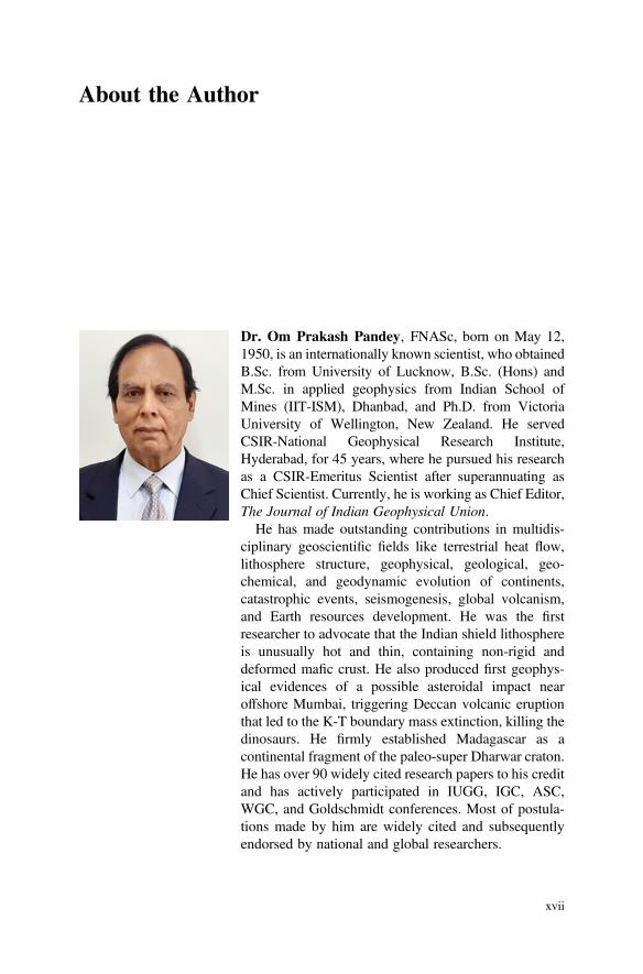
Dr. Om Prakash Pandey, FNASc, born on May 12,1950, is an internationally known scientist, who obtainedB.Sc. from University of Lucknow, B.Sc. (Hons) andM.Sc. in applied geophysics from Indian School ofMines (IIT-ISM), Dhanbad, and Ph.D. from VictoriaUniversity of Wellington, New Zealand. He servedCSIR-National Geophysical Research Institute,Hyderabad, for 45 years, where he pursued his researchas a CSIR-Emeritus Scientist after superannuating asChief Scientist. Currently, he is working as Chief Editor,The Journal of Indian Geophysical Union.
He has made outstanding contributions in multidis-ciplinary geoscientific fields like terrestrial heat flow,lithosphere structure, geophysical, geological, geo-chemical, and geodynamic evolution of continents,catastrophic events, seismogenesis, global volcanism,and Earth resources development. He was the firstresearcher to advocate that the Indian shield lithosphereis unusually hot and thin, containing non-rigid anddeformed mafic crust. He also produced first geophys-ical evidences of a possible asteroidal impact nearoffshore Mumbai, triggering Deccan volcanic eruptionthat led to the K-T boundary mass extinction, killing thedinosaurs. He firmly established Madagascar as acontinental fragment of the paleo-super Dharwar craton.He has over 90 widely cited research papers to his creditand has actively participated in IUGG, IGC, ASC,WGC, and Goldschmidt conferences. Most of postula-tions made by him are widely cited and subsequentlyendorsed by national and global researchers.
xvii

He won many prestigious fellowships likeSenior DAAD Fellowship (Germany), CommonwealthFellowship (New Zealand), and INSA-ASCR ExchangeFellowship of Czech Republic. He is an elected fellowof National Academy of Sciences, India (NASI), apartfrom several other geoscientific societies, likeA.P. Akademi of Sciences, Indian Geophysical Union,Geological Society of India, Indian Society ofEarthquake Sciences, and Association of ExplorationGeophysicist. He was bestowed with LifetimeAchievement Award from Society of Earth Scientists,India, in 2016.
xviii About the Author
Chapter 1Geodynamic and Geologic Evolutionof Indian Continent: A Brief History
1.1 Introduction
Some 4.6Ga old Earth is known to be an extremely active physical system, associatedwith complex evolutionary processes in comparison with other planets. Arguably, itblended out of planetesimals (asteroids), and subsequently underwent differentiationof its interior, which led to development of distinct mantle layers and a core. Itwas then followed by generation of magnetic field, global plate tectonics and thedevelopment of oceans, atmosphere and subsequently, the life.
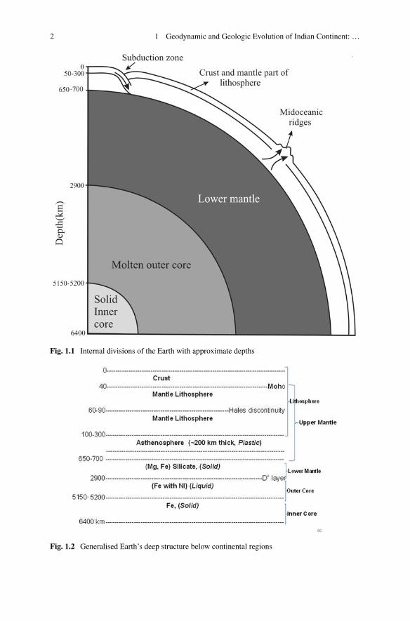
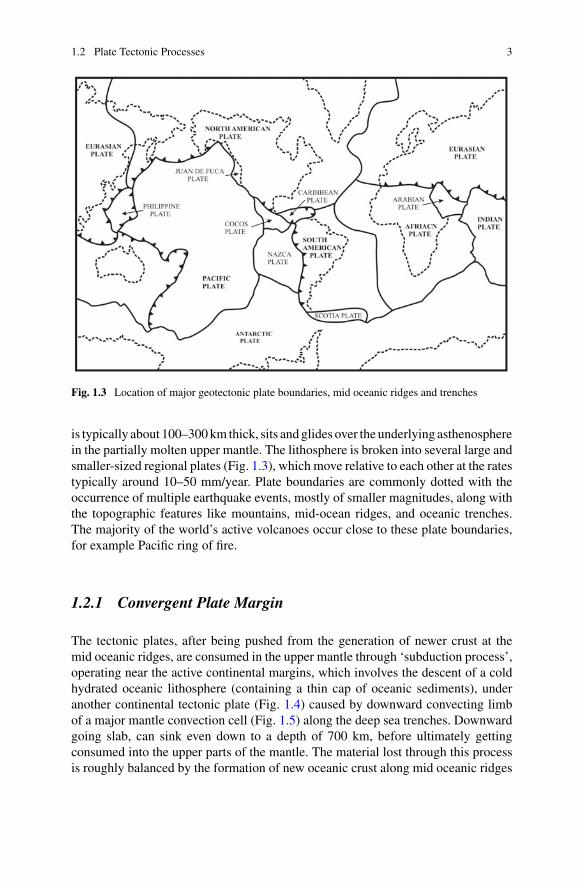
The Earth has a radius of about 6400 km and the equatorial circumference,40,075 km. The internal parts of the Earth can principally be divided into five majordistinguishable regions, viz., inner and outer core, lower and upper mantle and thecrust (Fig. 1.1), which are individually characterised by different physical, elasticand geochemical properties. A detailed subdivision of its constituent internal struc-ture is shown in Fig. 1.2. Interestingly, outer core is molten, while the inner coreis solid. Out of these layers, the upper mantle is considered buoyant and responsi-ble for the plate-movements. It can be further subdivided into mantle lithosphere,asthenosphere and an underlying transition zone. Above the upper mantle, lies therigid crust, which are of two different types, oceanic and continental. Oceanic crust isconsiderably thin, hardly exceeding eight kilometres beneath the ocean floor, whilethe continental crust is on an average about 35–45 km thick, but it could be as thickas 70 km in orogenic areas, like mountains. It is generated largely by plate tectonicprocesses.
1.2 Plate Tectonic Processes
The plate tectonics concept was formally established by geoscientists around 1960s,although such processes have been operative since Paleo-Mesoarchean era. Accord-ing to this theory, rigid part of the Earth’s outer layer, known as the lithosphere, which
© Springer Nature Switzerland AG 2020O. P. Pandey, Geodynamic Evolution of the Indian Shield: Geophysical Aspects,Society of Earth Scientists Series, https://doi.org/10.1007/978-3-030-40597-7_1
1
2 1 Geodynamic and Geologic Evolution of Indian Continent: …
Fig. 1.1 Internal divisions of the Earth with approximate depths
Fig. 1.2 Generalised Earth’s deep structure below continental regions
1.2 Plate Tectonic Processes 3
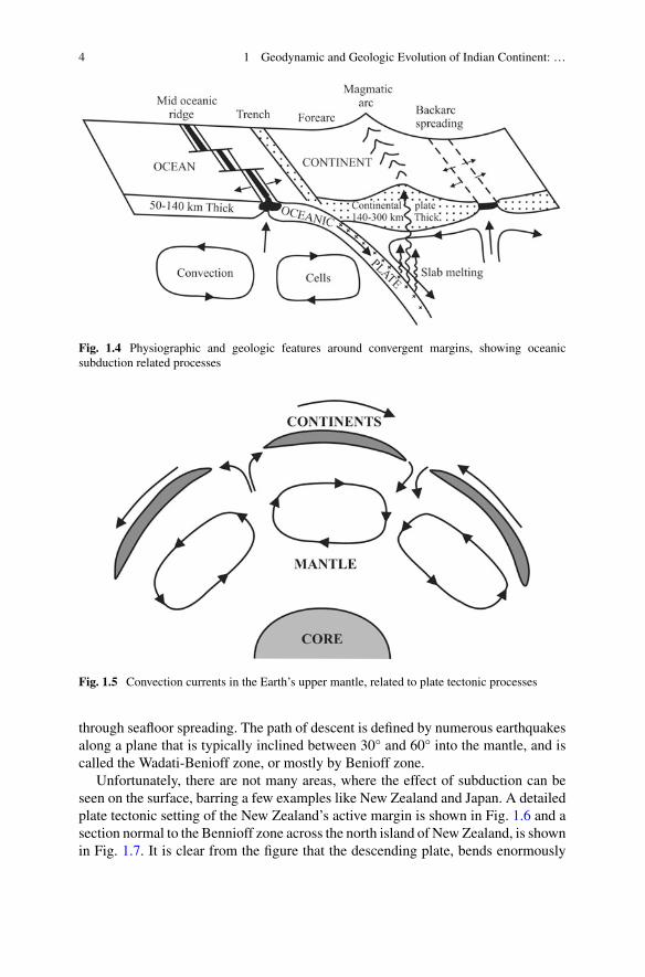
Fig. 1.3 Location of major geotectonic plate boundaries, mid oceanic ridges and trenches
is typically about 100–300km thick, sits andglides over the underlying asthenospherein the partially molten upper mantle. The lithosphere is broken into several large andsmaller-sized regional plates (Fig. 1.3), which move relative to each other at the ratestypically around 10–50 mm/year. Plate boundaries are commonly dotted with theoccurrence of multiple earthquake events, mostly of smaller magnitudes, along withthe topographic features like mountains, mid-ocean ridges, and oceanic trenches.The majority of the world’s active volcanoes occur close to these plate boundaries,for example Pacific ring of fire.
1.2.1 Convergent Plate Margin
The tectonic plates, after being pushed from the generation of newer crust at themid oceanic ridges, are consumed in the upper mantle through ‘subduction process’,operating near the active continental margins, which involves the descent of a coldhydrated oceanic lithosphere (containing a thin cap of oceanic sediments), underanother continental tectonic plate (Fig. 1.4) caused by downward convecting limbof a major mantle convection cell (Fig. 1.5) along the deep sea trenches. Downwardgoing slab, can sink even down to a depth of 700 km, before ultimately gettingconsumed into the upper parts of the mantle. The material lost through this processis roughly balanced by the formation of new oceanic crust along mid oceanic ridges
4 1 Geodynamic and Geologic Evolution of Indian Continent: …
Fig. 1.4 Physiographic and geologic features around convergent margins, showing oceanicsubduction related processes
Fig. 1.5 Convection currents in the Earth’s upper mantle, related to plate tectonic processes
through seafloor spreading. The path of descent is defined by numerous earthquakesalong a plane that is typically inclined between 30° and 60° into the mantle, and iscalled the Wadati-Benioff zone, or mostly by Benioff zone.
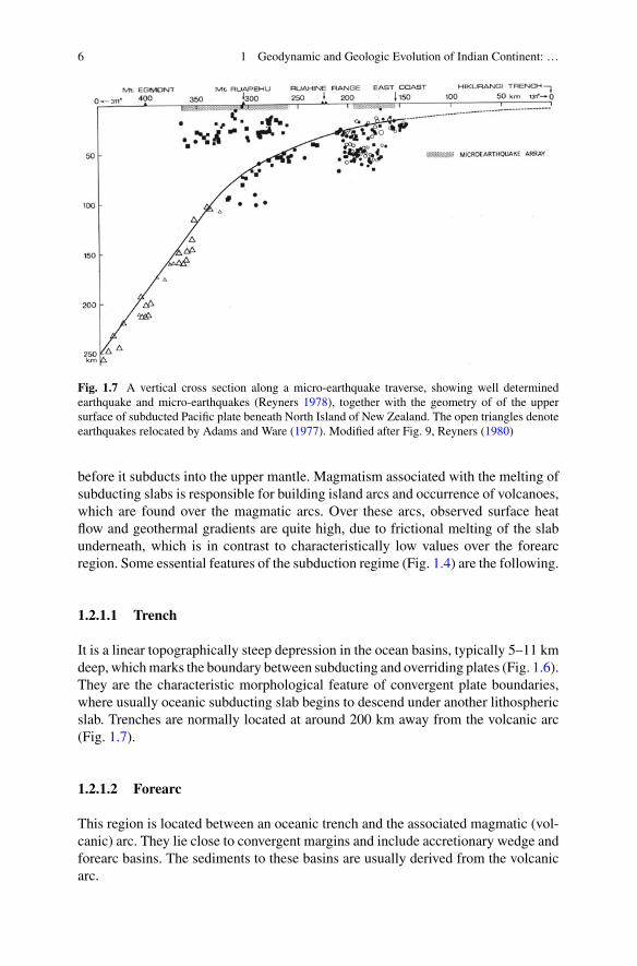
Unfortunately, there are not many areas, where the effect of subduction can beseen on the surface, barring a few examples like New Zealand and Japan. A detailedplate tectonic setting of the New Zealand’s active margin is shown in Fig. 1.6 and asection normal to the Bennioff zone across the north island of New Zealand, is shownin Fig. 1.7. It is clear from the figure that the descending plate, bends enormously
1.2 Plate Tectonic Processes 5
Fig. 1.6 Regional plate-tectonic settings around New Zealand. Bathymetry is in meters adoptedfrom Lawrence (1967). Boundary between Pacific and Indian plate is shown by dotted line (Walcott1978). Arrows indicate Pacific plate velocities (in mm/yr) relative to Indian plate based on Chase(1978). Modified after Fig. 1, Reyners (1980)
6 1 Geodynamic and Geologic Evolution of Indian Continent: …
Fig. 1.7 A vertical cross section along a micro-earthquake traverse, showing well determinedearthquake and micro-earthquakes (Reyners 1978), together with the geometry of of the uppersurface of subducted Pacific plate beneath North Island of New Zealand. The open triangles denoteearthquakes relocated by Adams and Ware (1977). Modified after Fig. 9, Reyners (1980)
before it subducts into the upper mantle. Magmatism associated with the melting ofsubducting slabs is responsible for building island arcs and occurrence of volcanoes,which are found over the magmatic arcs. Over these arcs, observed surface heatflow and geothermal gradients are quite high, due to frictional melting of the slabunderneath, which is in contrast to characteristically low values over the forearcregion. Some essential features of the subduction regime (Fig. 1.4) are the following.
1.2.1.1 Trench
It is a linear topographically steep depression in the ocean basins, typically 5–11 kmdeep, whichmarks the boundary between subducting and overriding plates (Fig. 1.6).They are the characteristic morphological feature of convergent plate boundaries,where usually oceanic subducting slab begins to descend under another lithosphericslab. Trenches are normally located at around 200 km away from the volcanic arc(Fig. 1.7).
1.2.1.2 Forearc
This region is located between an oceanic trench and the associated magmatic (vol-canic) arc. They lie close to convergent margins and include accretionary wedge andforearc basins. The sediments to these basins are usually derived from the volcanicarc.
1.2 Plate Tectonic Processes 7
1.2.1.3 Volcanic Arc
They are also known as magmatic arc that can contain volcanoes. When thedownward-moving slab reaches to a depth of about 100–150 km, it gets sufficientlyheated, thereby stimulating partialmelting ofmantle in the plate above the subductionzone (or the mantle wedge), which produces magma, that are predominantly basalticin composition with largely calc-alkaline affinity. This buoyant magma, after risingthrough the surface, gives birth to a chain of volcanoes in the overriding plate, knownas a volcanic arc.
1.2.1.4 Back Arc
Collapse of the dense slab into the asthenosphere, sometimes gets ‘roll back’ oceanward and cause extensional stretching into the overlying tectonic plate behind theisland arc. This ultimately results into back-arc spreading, where small ocean basins(also known as marginal basins) may be formed. In this region, the crust becomesprogressively thinner, and the decompression of the underlying mantle causes thecrust to melt, initiating seafloor-spreading processes, somewhat similar to those thatoccur at ocean ridges.
1.3 Indian Subcontinent and Paleo-SupercontinentAssembly
Inter-continental geologic correlation studies have indicated that during the Protero-zoic, Indian subcontinent has been an integral part of the two paleo-supercontinents,Columbia andRodinia. The former is understood to have existed somewhere between2.5 and 1.6 Ga, while the latter, from approximately 1.3 to 0.9 Ga. The Columbiasupercontinent has been associated with subduction related crustal growth during1.8 and 1.3 Ga via accretion at the continental margins that resulted into forma-tion of magmatic accretionary belts. This supercontinent started fragmenting after1.6 Ga. In fact, a further accretion and collision of the segments produced by thisfragmentation, led to the formation of Rodinia supercontinent, which was fully amal-gamated by 1.3 Ga and may have possibly existed till about 0.9 Ga. This was also theperiod during which collision between East Antarctica and east coast of India tookplace (around 0.95 Ga), after cessation of the prolonged supra-subduction regimethat lasted between 1.6 and 0.95 Ga (Dharma Rao and Reddy 2009; Dharma Raoet al. 2011; Vijaya Kumar et al. 2010; Saha 2011; Saha et al. 2015). It gave rise tocollisional features that can still be seen lying east of Cuddapah basin in southernIndia.
Interestingly, during both the supercontinental assembly periods, Indian continentwitnessed several accretional, collisional, rifting and continental breakup episodes,apart from massive intraplate magmatism that took place during Neoarchean-Paleoproterozoic period, specially in the Singhbhum and Dharwar cratons. Subse-quently at around 750–600 Ma, Rodinia supercontinent too started breaking up and
8 1 Geodynamic and Geologic Evolution of Indian Continent: …
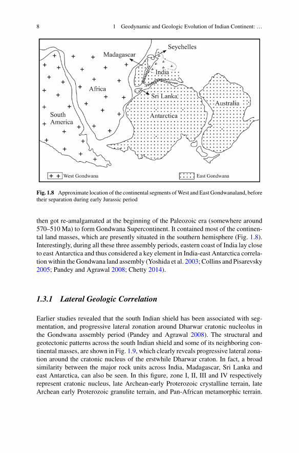
Fig. 1.8 Approximate location of the continental segments ofWest and East Gondwanaland, beforetheir separation during early Jurassic period
then got re-amalgamated at the beginning of the Paleozoic era (somewhere around570–510 Ma) to form Gondwana Supercontinent. It contained most of the continen-tal land masses, which are presently situated in the southern hemisphere (Fig. 1.8).Interestingly, during all these three assembly periods, eastern coast of India lay closeto east Antarctica and thus considered a key element in India-east Antarctica correla-tionwithin theGondwana land assembly (Yoshida et al. 2003; Collins and Pisarevsky2005; Pandey and Agrawal 2008; Chetty 2014).
1.3.1 Lateral Geologic Correlation
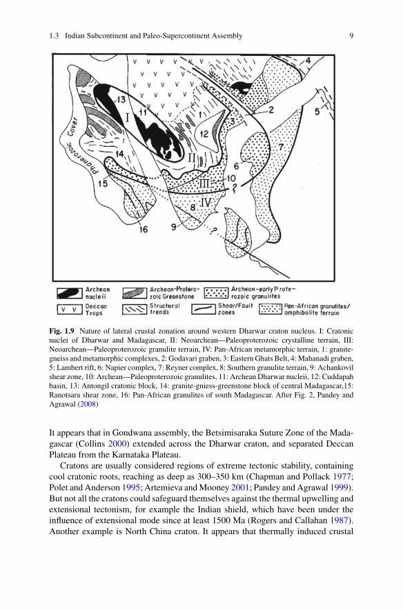
Earlier studies revealed that the south Indian shield has been associated with seg-mentation, and progressive lateral zonation around Dharwar cratonic nucleolus inthe Gondwana assembly period (Pandey and Agrawal 2008). The structural andgeotectonic patterns across the south Indian shield and some of its neighboring con-tinental masses, are shown in Fig. 1.9, which clearly reveals progressive lateral zona-tion around the cratonic nucleus of the erstwhile Dharwar craton. In fact, a broadsimilarity between the major rock units across India, Madagascar, Sri Lanka andeast Antarctica, can also be seen. In this figure, zone I, II, III and IV respectivelyrepresent cratonic nucleus, late Archean-early Proterozoic crystalline terrain, lateArchean early Proterozoic granulite terrain, and Pan-African metamorphic terrain.
1.3 Indian Subcontinent and Paleo-Supercontinent Assembly 9
Fig. 1.9 Nature of lateral crustal zonation around western Dharwar craton nucleus. I: Cratonicnuclei of Dharwar and Madagascar, II: Neoarchean—Paleoproterozoic crystalline terrain, III:Neoarchean—Paleoproterozoic granulite terrain, IV: Pan-African metamorphic terrain, 1: granite-gneiss andmetamorphic complexes, 2: Godavari graben, 3: EasternGhats Belt, 4:Mahanadi graben,5: Lambert rift, 6: Napier complex, 7: Reyner complex, 8: Southern granulite terrain, 9: Achankovilshear zone, 10: Archean—Paleoproterozoic granulites, 11: Archean Dharwar nucleii, 12: Cuddapahbasin, 13: Antongil cratonic block, 14: granite-gniess-greenstone block of central Madagascar,15:Ranotsara shear zone, 16: Pan-African granulites of south Madagascar. After Fig. 2, Pandey andAgrawal (2008)
It appears that in Gondwana assembly, the Betsimisaraka Suture Zone of the Mada-gascar (Collins 2000) extended across the Dharwar craton, and separated DeccanPlateau from the Karnataka Plateau.
Cratons are usually considered regions of extreme tectonic stability, containingcool cratonic roots, reaching as deep as 300–350 km (Chapman and Pollack 1977;Polet and Anderson 1995; Artemieva andMooney 2001; Pandey and Agrawal 1999).But not all the cratons could safeguard themselves against the thermal upwelling andextensional tectonism, for example the Indian shield, which have been under theinfluence of extensional mode since at least 1500 Ma (Rogers and Callahan 1987).Another example is North China craton. It appears that thermally induced crustal

10 1 Geodynamic and Geologic Evolution of Indian Continent: …
reactivations, rise in mantle solidus (Pandey 2016), resulted into large scale influx ofvolatiles and magmatic material into the lithosphere, thereby making it rheologicallyweak, warm and less viscous. In presence of already existing weak zones, it madeDharwar craton venerable for the break up in case, it confronted with a rising mantleplume.
1.3.2 Paleo-Super Dharwar Craton and MadagascarBreakup
Around 90 Ma, Marion plume hit the SE margin of the Madagascar (Curray andMunasinghe 1991; Storey et al. 1995; Raval and Veeraswamy 2003) (Fig. 1.10),which hosts number of mega shear zones andmobile belts. Below this region, suddenmagma upwelling triggered the ridge jump, which was then active between Africaand Madagascar, to the east of Madagascar, thus creating a new rifting phase alongIndia’s western margin. Convective processes, associated with this rifting phase,degenerated and sheared the once thick cratonic root beneath south Indian shield,which ultimately led to the breakup of the Paleo-super Dharwar craton (Agrawalet al. 1992; Pandey and Agrawal 2008; Gibbons et al. 2012; Chetty 2017), part ofwhich is now located as Antongil block in northeastern part of Madagascar. Someauthors (Tucker et al. 2011) called the erstwhileDharwar craton assembly, as “greaterDharwar craton”.
Fig. 1.10 Kinship ofMadagascar and India before90 Ma. Star shows thepostulated location ofMarion Plume (M) before itsoutburst (Curray andMunasinghe 1991). Circlewith dots indicate the areainfluenced by Marion plume.After Fig. 6, Pandey andAgrawal (2008)
1.3 Indian Subcontinent and Paleo-Supercontinent Assembly 11
1.3.2.1 Sri Lanka Connection
Although, the kinship of Madagascar and India in erstwhile Gondwanaland is nowwell established (Agrawal et al. 1992), the paleo affinity between India and SriLanka did not attract much attention. Geographically, Sri Lanka lay quite close toIndia relative to Madagascar most of the time during the geologic history. However,it has always been questioned whether, (i) Sri Lanka got detached from the Indiansubcontinent after the breakup of Gondwanaland, or (ii) underwent rotational andtranslational movements, or alternatively, (iii) it was always attached to India as asingle land mass and travelled together to its present position (Burke et al. 1978;Katz 1978a, b; Crawford 1974; Yoshida et al. 1992).
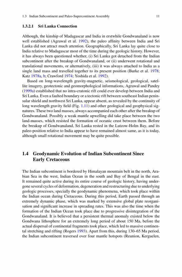
Based on long-wavelength gravity-magnetic, seismological, geological, satel-lite imagery, geotectonic and geomorphological informations, Agrawal and Pandey(1999a) established that no intra-cratonic rift could ever develop between India andSri Lanka. Even a faulted boundary or a tectonic rift between southeast Indian penin-sular shield and northwest Sri Lanka, appear absent, as revealed by the continuity oflong wavelength gravity field (Fig. 1.11) and other geological and geophysical sig-natures. These two land masses, always accompanied each other after the breakup ofGondwanaland. Possibly a weak mantle upwelling did take place between the twoland-masses, which resisted the formation of oceanic crust between them. Beforethe breakup of Gondwanaland, Sri Lanka rested in the Lutzow-Holm Bay, and itspaleo-position relative to India appear to have remained almost same, as it is today,although small rotational movement may be quite possible.
1.4 Geodynamic Evolution of Indian Subcontinent SinceEarly Cretaceous
The Indian subcontinent is bordered by Himalayan mountain belt in the north, Ara-bian Sea in the west, Indian Ocean in the south and Bay of Bengal in the east.It remained quite active during its entire course of geologic history, having under-gone several cycles of deformation, degeneration and restructuring due to underlyinggeologic processes, specially the geodynamic phenomena, which took place withinthe Indian ocean during Cretaceous. During this period, Earth passed through anextremely dynamic phase, which was marked by extensive global plate reorgani-sation and significant increase in spreading rates. This was also the time when theformation of the Indian Ocean took place due to progressive disintegration of theGondwanaland. It is believed that a persistent thermal anomaly existed below theGondwana lithosphere for an extremely long period of about 150 Ma, before theactual dispersal of continental fragments took place, which led to massive continen-tal stretching and rifting (Rogers 1993). Apart from this, during 130–65 Ma period,the Indian subcontinent traversed over four mantle hotspots (Reunion, Kerguelen,
12 1 Geodynamic and Geologic Evolution of Indian Continent: …
Fig. 1.11 Bouguer anomalies (in mGal) over southeastern part of Indian shield and Sri Lanka(Bouguer Anomaly Map 1976). Extension of gravity anomalies on two sides are shown bydashed lines. 1: Nartamali, 2: Tiruchirappalli, 3: Ginge, 4: Nagapattinam, 5: Jaffna peninsula,6: Pondicherry. A and B represent gravity anomalies over Palk strait and eastern Vijayan terrain.After Fig. 5, Agrawal and Pandey (1999a)
Crozet, andMarion) in quick succession, which extensively damaged the Indian con-tinental lithosphere, as they were in close proximity to Indian cratonic areas andwerealso involved with the separation of India from its Gondwanan neighbours (Storeyet al. 1995).
1.4 Geodynamic Evolution of Indian Subcontinent Since Early … 13
1.4.1 Super Mobility
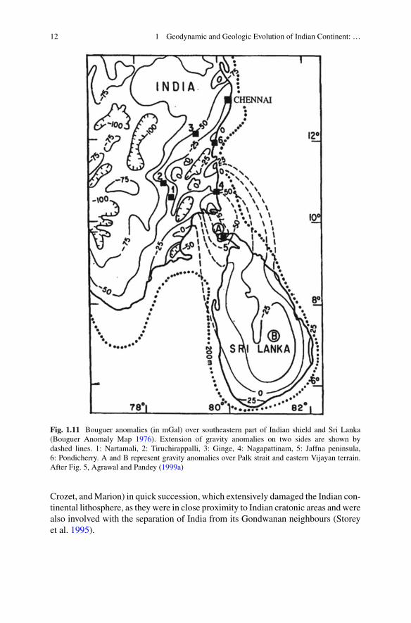
This subcontinent displayed extraordinary mobility after its breakup fromAntarcticaduring early Cretaceous. In fact, it remains the most mobile continent on the surfaceof the Earth. Between 90 and 53 Ma, its mobility rate reached 20 cm/year, which isthe highest among the geotectonic plates, containing continental lithosphere (Jurdyand Gordon 1984). It was also the time, when this continent interacted with twomantle plumes, Marion and Reunion and was also inflicted by large scale magmaticextrusions (Deccan and Rajmahal Traps), besides a possible K-T boundary asteroidalimpact offshore near Bombay (Negi et al. 1993), which induced large-scale rifting innearby regions (Fig. 1.12). Persistent thermal reactivations caused by the presenceof higher radioactivity and lithophilic elements since at least 1.5 Ga (Rogers andCallahan 1987), coupled with Late Cretaceous geodynamic events, as stated above,have resulted into higher mantle heat flows, large-scale lithospheric mantle rootdeformation and extensive degenerationof the Indian continental lithosphere.Various
Fig. 1.12 Location of K-T boundary impact site (solid circle) during super mobile phase of Indiancontinent, initiation of the Carlsberg ridge and Seychelles break up from India’s west coast. Dottedarea represent known extent of Deccan volcanics. Modified after Fig. 9, Pandey et al. (1995)
14 1 Geodynamic and Geologic Evolution of Indian Continent: …
studies carried out in the past have confirmed that the Indian lithosphere may be quitethin; only about 100 km (Negi et al. 1986, 1987; Kumar et al. 2007, 2013; Pandeyand Agrawal 1999; Pandey 2016; Mandal 2017). This finding was in total departurefrom the erstwhile thinking that the continental shields are cold, stable and could notbe deformed. Currently, the most of Indian cratons may not contain ancient old roots,as they were not strong enough to resist the extensional tectonism. A large number ofgeotectonic segments in peninsular shield are experiencing repeated uplifts, whichhas exposed the peneplanation surfaces of earlier cycles to new cycles of erosion(Radhakrishna 1993).
1.5 Major Geological Segments of the Indian PeninsularShield
Earth’s continental crust is known to contain several ancient cratonic blocks, varyingin age from Eoarchean to Paleoproterozoic. Besides, there are several Proterozoicand Phanerozoic structures,mobile belts and sedimentary basins, which dot the entireEarth. These ancient cratonic blocks, in due course of time, got merged together andformed Precambrian shield terrains across the globe. It is believed, that by and large,these terrains remained almost stable and undeformed since their inception, barringa few exceptions like the Indian shield and the north China craton, as mentionedbefore. In order to decipher the evolutionary nature of different geologic terrains andportray their time-bound integrated evolutionary history, one needs to understandchronostratigraphy, for which the knowledge of geologic time scale is essential.
1.5.1 Geological Time Scale
It is a global chronostratigraphic scale, which is largely based on Global StandardStratigraphic age, compiled on the basis of isotopic dates of global geologic eventsand numerous dating’s of suitable rocks from the geologically well studied sections.A simplified internationally accepted chronostratigraphic chart based on Cohen et al.(2013), is shown in Fig. 1.13. As can be seen, a large part of the Earth’s history (about88 %) is covered by Precambrian Eon, out of which Archean Era spans for about1500Ma; Eoarchean (4000–3600Ma), Paleoarchean (3600–3200Ma),Mesoarchean(3200–2800 Ma) and Neoarchean (2800–2500 Ma). Almost all the Indian cratonicnuclei were formed and stabilized during theArcheanEra. End of this erawasmarkedby large scale continental crustal production.
The Archean Era was followed by the Proterozoic Era, divided into three dis-tinct periods, Paleoproterozoic (2500–1600 Ma), Mesoproterozoic (1600–1000 Ma)and Neoproterozoic (1000–541 Ma). This era has been associated with large scale


![[ORDERS (INCOMPLETE MATTERS / IAs / CRLMPs)] · garg, suresh chandra tripathy, sunil kumar jain, sudhir naagar[r-1], shiv prakash pandey, shekhar kumar, senthil jagadeesan, a satyendra](https://img.dokumen.tips/doc/110x75/6104ce2219b89f69c677f85f/orders-incomplete-matters-ias-crlmps-garg-suresh-chandra-tripathy-sunil.jpg)