Embed Size (px)
Citation preview

www.wyedeantourism.co.uk
2nd Edition
T O U R I S M A S S O C I A T I O N
Get Moving!
Walks suitable for:
Older Walkers
The Less Able
Young Families
Pushchairs
Inexperienced Walkers
EASYWALKSEASYWALKS
J4 / M50 / Ross on Wyelabelsout letshopping.co.uk

12
11
10
9
8
6
5
2
3
74
1
P
N
Wye
Val
ley
& F
ores
t of D
ean
Tour
ism
Ass
ocia
tion
Visi
t ww
w.w
yede
anto
uris
m.c
o.uk
for
mor
e in
form
atio
n
2
Wye
Val
ley
& F
ores
t of D
ean
Tour
ism
Ass
ocia
tion
Visi
t ww
w.w
yede
anto
uris
m.c
o.uk
for
mor
e in
form
atio
n3
WA
LK L
OC
AT
ION
S
INT
RO
DU
CT
ION
KEY TO SYMBOLS
Walk Gate Parking
Stile Major Road Forest Area
Minor Road Pathway Building
River, Lake, Pond Castle Church
co-exist happily with mighty Douglas Firs from North America. This dense woodland, however, also reveal secrets to those who take the time to explore. Hidden remnants of an illustrious industrial past can be found if we look carefully and know how to identify them. Both areas are natural treasures in their own way.
Nowadays we seek active ways of experiencing an area. The industries and railways may be gone, but they have left us with a wealth of heritage and the means to enjoy it on foot. We can have the benefits of light exercise while taking in marvellous scenery and historic sites.
The walks in this booklet span two countries and 3 counties: Gloucestershire and Herefordshire in England, Monmouthshire in Wales. The area is blessed with two majestic rivers, babbling brooks, gentle and rugged hills, woods, valleys, marshlands and a wealth of history.
About the WalksAlthough many of us prefer to be active, we prefer not to be too active! Easy Walks gives you a gentle introduction to the region. These circular walks are intended as manageable strolls for anyone who wants to spend a short time walking without a great deal of effort. You will not need specialised clothing or state-of-the-art GPS’s. You will not be expected to do acrobatics, leaping over stile after stile. You will not have to scramble up rough, steep inclines to see glorious views.
The walks are mainly on clearly defined, well-worn paths, tracks and lanes which should be easy to locate. There are sketched route maps indicating the starting points, car parks, gates, as well as features of interest. The Ordnance Survey Map Grid Reference of the start is included with each map. The distance is made clear, allowing you to judge whether this walk is suitable for you. Some of the walks have optional shortcuts. We have indicated points of historic and natural interest, as well as stunning viewpoints.
For almost 40 years, the Wye Valley has deservedly been an Area of Outstanding Natural Beauty (AONB). As far back as the 18th century, visitors appreciated the attractions of the Wye Valley. These new tourists would have experienced the sometimes gentle, sometimes dramatic, winding river trip down the Wye, enjoying breathtaking natural scenery as well as an extensive industrial landscape. Poets and artists such as Wordsworth and Turner were enchanted and inspired by this trip. This river trip would eventually be overtaken by a no less impressive railway trip, opening up the area for the pleasure of more people.
The Wye Valley’s neighbour, the Royal Forest of Dean, has contrasting, but no less impressive features. It is one of the most extensive tracts of native woodland left in Britain, although it is also a welcome host to trees from other parts of the globe. Grand, sturdy English oak trees
Welcome
You can see from the map that the walks cover a representative spread of both the Wye Valley and the Forest of Dean. Nevertheless, with a little planning, you can easily combine two or three walks to give you a full day’s enjoyment.
Although the area is densely packed with things to do and see, the distances are not at all vast.
So let’s get moving!

1
23
4
5
67
8
9
1011
12
STARTHERE
N
P
A466
A466
TO CHEPSTOW
RIVER WYE
TO M
ON
MO
UTH
Wye
Val
ley
& F
ores
t of D
ean
Tour
ism
Ass
ocia
tion
Visi
t ww
w.w
yede
anto
uris
m.c
o.uk
for
mor
e in
form
atio
n
4
Wye
Val
ley
& F
ores
t of D
ean
Tour
ism
Ass
ocia
tion
Visi
t ww
w.w
yede
anto
uris
m.c
o.uk
for
mor
e in
form
atio
n5
WA
LK 1
BR
OC
KW
EIR
BrockweirSUMMARY A figure of eight walk centred on the delightful village of Brockweir. The walk is mainly level along the Wye Valley on old railway tracks, the riverbank and minor roads, part in Wales and part in Gloucestershire.
START The Old Station Tintern, one mile north of Tintern on A466. There is a visitors’ centre, café and toilets (open April – October) and a charge for parking.
DISTANCE
WALKINFO
No. OF STILES
No. OF GATES
2 MILES
1 (Easy Access)
5
• Starting from the Old Station platform [1], facing the river, turn left and follow the old track of the Wye Valley Railway. The railway ran from Chepstow to Monmouth and closed to passengers in 1959; taking the steam train along this scenic valley must have been delightful. The track gently curves and after a short distance reaches a road bridge across the river [2].
• Climb the steps, turn the right and cross the bridge into the village of Brockweir. As you cross the river, you leave Wales and enter Gloucestershire. Brockweir is the highest point on the Wye for deep water vessels and in the 18th and 19th centuries was the centre of riverside commerce; shipbuilding and transhipping of goods from coastal boats to small barges able to go further upstream.
• Pass the Brockweir Inn on your right and turn left into Underhill [3]. Follow this quiet lane fora short distance and then branch left just before a house on your right called Herries [4]. After about 200 yards go through a gate, join another lane from the left and continue in the same direction parallel with the river. The valley opens up with good views in all directions. After about ¼ mile, look for an old-fashioned metal stile in a wooden fence on your left [6]. If you reach the double gates of Brockweir House, you have gone too far.
• Cross the stile and make your way to the riverbank. Turn left and follow the bank back towards Brockweir. You will go through one gate, with a bridge and a stile to its right, [8] before reaching the Old Quay. You are now walking along Offa’s Dyke Path that runs for 177 miles from the Severn Estuary near Chepstow to Prestatyn in North Wales. Offa was King of Mercia from 757 to 796 AD and controlled much of southern England. The dyke was an earthworks roughly following the English/Welsh border but its exact purpose is unclear.
• On reaching the bridge, turn left and at the Brockweir Inn [9] turn right. Pass the Malthouse and the 14th century Monks Hall and then turn right into a narrow path, signed to the Brockweir
Moravian Church [10]. With its riverside trade, Brockweir had a poor reputation in the early 19th century; it had 16 inns but no church. In 1832 the Moravian Chapel was built on the site of a former cockpit. The chapel is a simple but peaceful place and is still used. The Moravians had their roots in Slovakia and believed in equality within their community. You will notice this equality in the churchyard where there are only simple markers and no ornate headstones.
• Close to the church at Gregory Farm is a horse and pony sanctuary (including a café) which is also worth a visit. Make your way back to the bridge, cross into Wales and go down the steps to the railway track. Rather than following
the track back to the station, go through a gate (signed Tintern via Riverbank) to the left onto the riverbank [11] following it until you are close to the old signal box [12]. Turn right through a gate into a wildlife area including a willow tunnel and the through two more gates and climb steps to return to your start point.
• Spend some time enjoying the Old Station. The signal box has changing exhibitions from local artists and the café is in the Victorian waiting room. There are six life sized sculptures from tree trunks depicting mystical or historical characters from Monmouthshire’s past.
OS GRID REFERENCE SO 537 007 ½ MILE

1
2
4
6
7
8
STARTHERE
N
PP
LLANDOGO
CLEDDONHALL
RIVER WYEA
466
A46
6
TO C
HEP
STO
W
3
5
Wye
Val
ley
& F
ores
t of D
ean
Tour
ism
Ass
ocia
tion
Visi
t ww
w.w
yede
anto
uris
m.c
o.uk
for
mor
e in
form
atio
n
6
Wye
Val
ley
& F
ores
t of D
ean
Tour
ism
Ass
ocia
tion
Visi
t ww
w.w
yede
anto
uris
m.c
o.uk
for
mor
e in
form
atio
n7
WA
LK 2
WH
ITE
STO
NE
WhitestoneSUMMARY There is a gentle uphill incline near the start of this mainly level woodland walk. There are stunning views down into the Wye Valley and a stop at the waterfall that may have been the sounding cataract, in Wordsworth’s ‘Lines written a few miles above Tintern Abbey’.
START From A466 in Tintern take the minor road beside the Wye Valley Hotel signed to Catbrook. At a T-junction (after 1½ miles) the car park is immediately opposite. Park close to the road near the pond.
DISTANCE
WALKINFO
No. OF STILES
No. OF GATES
2 MILES
0
2
• From the lower car park [1], with your back to the pond, go into the woodland opposite, following the level path as it meanders through majestic conifers. These are mainly Douglas Fir which were introduced into the UK from British Columbia. At the T-junction [2] turn left up the rough path. This is part of the Wye Valley Walk which follows the river from its confluence with the Severn at Chepstow to its source on Plinlimon in mid-Wales. The upper car park appears ahead. Keep to the wider left fork up into the area that has BBQs, picnic tables and children’s play equipment.
• Keeping to the right of the car park, a wonderful view to the River Wye comes up on your right – the bridge in the distance is at Brockweir (see Walk 1). Pause at the Forestry Commission/Wye Valley AONB information board [3] and then head straight on up to the stoned forest road. Turn right.
• The road goes steadily uphill and you will come to three magnificent views eastwards into the Wye Valley. At each viewpoint there is a bench engraved with quotations from Wordsworth’s poem ‘Lines written a few miles above Tintern Abbey’.
• At the T-junction [4] turn right. This track leads from the wood and seems to be an ancient route with old moss covered stone walls to either side. At a junction of paths [5], gostraight on towards the road, crossing the falls.
• This is Cleddon [6] and the falls, or shoots, are tumbling away to the right (walk 3 from Beacon Hill comes to this point). If you wish to take a closer look at the waterfall please take great care on the steps to your right. This may be the place that Wordsworth calls ‘The sounding cataract’ in the Tintern Abbey poem.
• Opposite the falls, take the lane and then first left by a gate marked ‘Home Cottage’. If you would like to see the house where Bertrand Russell was born in 1872, walk up the lane a couple of hundred yards. To your right Cleddon
Hall can be seen. Retrace your steps to Home Cottage gate.
• Along the lane you cross the bridge over the stream on its way to the falls.
• At Rose Cottage, look ahead and slightly right to an old stone stile with a gate to the left [7]. Go through, leaving the gate as you found it, onto an old track between stone walls. This section can be very muddy. Note the boulders of conglomerate rock - full of pebbles and known locally as pudding stone.
The path opens out at another gate with a stile beside it – this time a wooden one. Go through into forestry land; the young trees to the left are larch. The path ends at a minor road [8]. Turn left and take care walking down the road (approximately 10 minutes) back to Whitestone.
• If you stay for a picnic, you may wish to move up to the higher level car park.
OS GRID REFERENCE SO 523 028 ½ MILE

STARTHERE
P
N
CLEDDONHALL
TO LLANDOGO
TO TRELLECH
TO T
INTE
RN
5 4
3
2
6
71
Wye
Val
ley
& F
ores
t of D
ean
Tour
ism
Ass
ocia
tion
Visi
t ww
w.w
yede
anto
uris
m.c
o.uk
for
mor
e in
form
atio
n
8
Wye
Val
ley
& F
ores
t of D
ean
Tour
ism
Ass
ocia
tion
Visi
t ww
w.w
yede
anto
uris
m.c
o.uk
for
mor
e in
form
atio
n9
WA
LK 3
TR
ELL
EC
H B
EA
CO
N
Trellech BeaconSUMMARY A circular route on Trellech Beacon with stunning views to the Wye Valley below and the Forest of Dean, Malverns and Cotswolds in the distance.
START From the B4293 in Trellech take the road signed ‘Llandogo, Catbrook, Tintern’ and immediately take the left turn. After ½ mile take the first left turn. Beacon View Forestry Commission car park is ¼ mile on the right.
DISTANCE
WALKINFO
No. OF STILES
No. OF GATES
3 MILES
0
6
• Turning from the fabulous view over Trellech towards the Brecon Beacons [1], climb up the rough steps to the left of a yew tree. Take a look at the Forestry Commission/Wye Valley AONB information panel. At the track turn left and walk steadily up hill, following red and yellow waymark arrows. As the route levels out, there is a picnic table to the left, more lovely views and another information panel. The path veers right down to a bridle gate. Go through, into an area being reclaimed as heathland.
• As you cross straight over the forest road, stunning views open out taking in, from left to right, the Malvern Hills, May Hill, Forest of Dean and Cotswold ridge. Go through the bridle gate and turn right at the track below. This level track comes to a forest road, go straight over and enter woods [2]. Ignore the routes shown by the red and yellow arrows.
• If you would like a shorter walk, turn right up the forest road and right again at the top of the hill, walk through the gate, rejoining the route at [6]. The first part of this path can be muddy but by taking the higher ground you can avoid the worst of it.
• Go straight ahead at the junction [3] with the seat to the right of the path. You have now joined the Wye Valley Walk.
• To the left, the ground slopes down steeply to the River Wye. You are walking through mixed woodland with the path going gently down hill. Notice the former boundary walls amongst the trees. This old route is stone lined – perhaps it is the way William Wordsworth came when he walked in the Wye Valley in 1793 and was later inspired to write his famous poem ‘Lines written a few miles above Tintern Abbey’. Keep to the path between two cottages and come to an open area. Cleddon Falls can be seen, and heard, to the left. Take great care if you chose to take a closer look at the waterfall.
• From the Falls [4] turn around and follow the road opposite. In a couple of hundred yards a
large house can be seen over the wall to the right. This is Cleddon Hall, the birthplace of Bertrand Russell. Turn right at the kissing gate [5] in the wall and walk diagonally across the meadow to the next kissing gate. Turn right onto the track and follow it uphill back into the Forestry Commission woods. Ignore the right turn in the forest road and keep steadily uphill taking the left fork in the road. Go through the gate [6] and past a pond on your right. There
are some single dead trees left in the heathland – these provide good song posts for birds. Nightjars have been known to frequent this open area in summer. At the memorial seat to Joan Chivers [7], turn left uphill to another bridle gate. Go straight over the track and rejoin the red arrow route back to the car park.
OS GRID REFERENCE SO 510 052½ MILE

1
2
3
4
5
STARTHERE
N
P
TO M
ON
MO
UTH
TO MONMOUTH
WERNFARM
CAERLLAN
Wye
Val
ley
& F
ores
t of D
ean
Tour
ism
Ass
ocia
tion
Visi
t ww
w.w
yede
anto
uris
m.c
o.uk
for
mor
e in
form
atio
n
10
Wye
Val
ley
& F
ores
t of D
ean
Tour
ism
Ass
ocia
tion
Visi
t ww
w.w
yede
anto
uris
m.c
o.uk
for
mor
e in
form
atio
n11
WA
LK 4
CR
AIG
-Y-D
OR
TH
Craig-y-dorthSUMMARY This short walk provides some of the best views in Monmouthshire. Delightful at anytime of year, but in spring there is a succession of wild flowers – snowdrops, primroses, daffodils, wood anemones and bluebells. It follows a little used minor road around Craig-y–dorth hill and is suitable for pushchairs and motorised buggies.
START Approximately three miles from Monmouth, on the B4293 towards Trellech; turn right at the crossroads signed Craig-y-dorth 1½ miles. There is roadside parking for a few cars just beyond the driveway to Caerllan Field Study and Conference Centre.
DISTANCE
WALKINFO
No. OF STILES
No. OF GATES
1½ MILES
0
0
• Once parked, carry on along the lane keeping right at Caerllan Cottage [1]. The verge to the right is covered in snowdrops early each year. After young woodland to the right, views open out as you pass an old stone stile. There are stunning views of Monmouth, the Wye and Trothy valleys. There is also a convenient bench if you would like to pause and enjoy the panorama.
• Keep on the level, ignoring the right turn [2] and pass Wern Farm, once the home of MI6 intelligence officer Colonel John Wyke (1920-91). In the 1960s, at the height of the cold war with Russia, he was “the best technical operator”. His exploits took him to Germany, Cyprus and Pakistan but his cover was blown with the publishing of ‘Spycatcher’ in 1984.
• You may hear noise from the traffic on the A40 following the route of the former railway in the valley below. Just before the bend there is a bridle gate and Byway sign to the right [3] and if you would like to rest there is a seat just inside the gate. It was put in by Monmouthshire footpath volunteers and is aimed at walkers who have struggled up the steep field below, but it is there for everyone to enjoy.
• Rejoin the lane and just over the hedge to the right is a small dewpond. It often has tadpoles in spring. Marked on maps as a battleground, this area is reputed to be the site of the rout between Owen Glendower and King Henry IV in 1404. On this occasion, the Welsh rebels were the winners, chasing the King’s men back to the gates of Monmouth.
• The fantastic views to the north take in, from left to right, the Blorenge, Sugarloaf and Skirrid near Abergavenny, The Black Mountains and Brecon Beacons, and the edge of Hay Bluff. In the near distance, you can see Dingestow, with Dingestow Court to the left and Treowen Court to the right of the village.
• Continue around the hill to the community of Craig-y-dorth [4] a group of houses on the
warmer, west facing side of the hill. Craig-y-dorth translates from the Welsh into ‘hill of the loaf’.
• You now climb steadily uphill through bluebell-carpeted woodland. On the left at the crest there is a bank that is covered in snowdrops in January. The views to the right take in the remote Cwmcarvan valley with Croes Robert Wood on the far side – a Gwent Wildlife Trust reserve. As you start to descend [5]
look slightly to the right and spot a large stone house tucked into the hillside. This is Caerllan Field Study and Conference Centre. Part of the property is Berm House - set into the hillside and earth-covered so that it is perfectly insulated. Over the hedges to either side are wonderful panoramas.
• At the lane junction [1] walk straight back to your parked vehicle.
OS GRID REFERENCE SO 490 084 ¼ MILE

1
2
3 4 56
7
8
9
10
N
STARTHERE
P
CLUB
WORKS
TO LYDNEY
R I V E R S E VE
RN
Wye
Val
ley
& F
ores
t of D
ean
Tour
ism
Ass
ocia
tion
Visi
t ww
w.w
yede
anto
uris
m.c
o.uk
for
mor
e in
form
atio
n
12
Wye
Val
ley
& F
ores
t of D
ean
Tour
ism
Ass
ocia
tion
Visi
t ww
w.w
yede
anto
uris
m.c
o.uk
for
mor
e in
form
atio
n13
WA
LK 5
LYD
NE
Y D
OC
KS
Lydney DocksSUMMARY Mostly flat, easy walking.Beware, unfenced drops at the pier and harbour edges.
START From the A48 around Lydney, follow the signs to Lydney Industrial Estate. Continue straight ahead on the private road and park in the car park at the end of the road.
DISTANCE
WALKINFO
No. OF BRIDGES
No. OF GATES
¾ MILE
2
1
• Walk back up the road and turn right opposite the bridge. Walk as far as the first pole [1]. Ahead is Naas House, one of the oldest houses in the area built in the 17th century for a William Jones. U.S. servicemen were stationed in the grounds during the Second World War.
• To your immediate left is the former Pine End works. This was built in 1940 to manufacture technical aircraft and marine plywood for wartime requirements. After the war William Mallison and Sons took over. This explains the large ‘M’s above the gates. The plywood produced here was made from huge African logs shipped here in barges from Avonmouth Docks.
• Walk back to the bridge. This is a grade 2 listed swing bridge. It formerly rotated to allow vessels to pass.
• Cross the bridge and continue ahead. Turn right at the post with the red arrow [2] and walk to the boulder on the riverbank [3]. The boulder shows the direction to the site of the Lydney Roman Temple and Alvington church.
• Walk left along the riverside path to the six standing rocks [4]. As you walk around the rocks, you will see the compass directions appear as the letters on the rocks become aligned. When you can read a compass direction that is the direction in which you are looking.
• Continue to the next rock [5] between the interpretation boards. Look through the holes in the rock to see the Severn Bridges, salmon putchers and the Oldbury nuclear power station. Now look over the bank down to the foreshore. At low tide you may be able to see the remains of trows and barges in the mud. These were beached here and filled with rocks to protect the riverbank from erosion, but have now been eroded away themselves.
• Continue along the path. The remaining boulders [6-9] point out further features of interest and the interpretation boards will give
you an introduction to the past and present of the harbour area.
• The boulders and compass were created by local sculptor David Yeates. David also re-carved 72,000 individual letters on the Lydney war memorial sited near St. Mary’s church just up the road. Another of David’s works is the Forest of Dean Geomap at New Fancy Viewpoint back in the Forest. David’s grandparents Frank and Alice Yeates restored nearby Clearwell Castle from a near ruin (see Walk 7).
• Continue to the end of the path and cross the lock gates. Turn right and walk out on to the pier [10]. To the left, where the river narrows is the site of the former Severn Rail Bridge. This bridge was damaged beyond economical repair in an accident in 1960 and removed a few years later. In the days of sailing ships, much skill
and knowledge was needed to safely get into the harbour due to the fast moving tides. The last vessel to regularly use the harbour was the Black Dwarf. The Dwarf’s final voyage from here was made in 1942. Nowadays once or twice a year, a large pleasure cruiser ties up to this pier to load passengers for a cruise down the Bristol Channel as far as Ilfracombe.
• Walk back up the pier and return to the car park by keeping the harbour on your left.
For more information see “A Glance Back at Lydney Docks” by Neil Parkhouse (2001).
¼ MILEOS GRID REF. SO 649 014
1253
6
7
8 9
10
1211
4
STARTHERE N
P
B4231
B4231
TO COLEFORD
TO L
YD
NE
Y
Wye
Val
ley
& F
ores
t of D
ean
Tour
ism
Ass
ocia
tion
Visi
t ww
w.w
yede
anto
uris
m.c
o.uk
for
mor
e in
form
atio
n
14
Wye
Val
ley
& F
ores
t of D
ean
Tour
ism
Ass
ocia
tion
Visi
t ww
w.w
yede
anto
uris
m.c
o.uk
for
mor
e in
form
atio
n15
WA
LK 6
BR
EA
M V
ILL
AG
E W
ALK
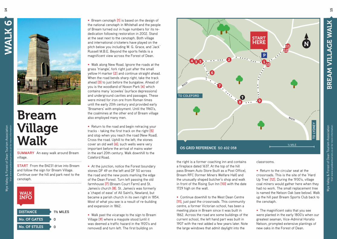
Bream Village WalkSUMMARY An easy walk around Bream village.
START From the B4231 drive into Bream and follow the sign for Bream Village. Continue over the hill and park next to the cenotaph.
DISTANCE
WALKINFO
No. OF STILES
No. OF GATES
1½ MILES
0
0
• Bream cenotaph [1] is based on the design of the national cenotaph in Whitehall and the people of Bream turned out in huge numbers for its re-dedication following restoration in 2002. Stand at the seat next to the cenotaph. Both village and international cricketers have played on the pitch below you including W. G. Grace, and ‘Jack’ Russell M.B.E. Beyond the sports fields is a magnificent view across the Forest of Dean.
• Walk along New Road. Ignore the roads at the grass ‘triangle’, fork right just after the small yellow H marker [2] and continue straight ahead. When the road bends sharp right, take the track ahead [3] to just before the bungalow. Ahead of you is the woodland of Noxon Park [4] which contains many ‘scowles’ (surface depressions) and underground cavities and passages. These were mined for iron ore from Roman times until the early 20th century and provided early ‘Breamers’ with employment. Until the 1960’s, the coalmines at the other end of Bream village also employed many men.
• Return to the road and begin retracing your tracks - taking the first track on the right [5] and stop when you reach the road (New Road). Cross the road. Uphill to the left, the stones cover an old well [6]; such wells were very important before the arrival of mains water in the earl 20th century. Walk downhill to the Coleford Road.
• At the junction, notice the Forest boundary stones DF 49 on the left and DF 50 across the road and the new posts marking the edge of the Dean Forest. Turn left passing the old farmhouse [7] (Bream Court Farm) and St. James’s church [8]. St. James’s was formerly a ‘chapel of ease’ of All Saint’s, Newland, but became a parish church in its own right in 1854. Most of what you see is a result of re-building and expansion in 1862.
• Walk past the vicarage to the sign to Bream Village [9] where a maypole stood (until it was deemed a traffic hazard in the 1920’s and removed) and turn left. The first building on
the right is a former coaching inn and contains a fireplace dated 1637. At the top of the hill pass Bream Auto Store (built as a Post Office), Bream RFC (former Miners Welfare Hall) and the unusually shaped butcher’s shop and walk in front of the Rising Sun Inn [10] with the date 1729 high on the wall.
• Continue downhill to the West Dean Centre [11], just past the crossroads. This community centre, a former Victorian school, has been a meeting place in Bream since it was built in 1862. Across the road are some buildings of the current school, the left hand part was built in 1907 with the rest added a few years later. Note the large windows that admit daylight into the
classrooms.
• Return to the circular seat at the crossroads. This is the site of the ‘Hard Up Tree’ [12]. During the 1930’s, village coal miners would gather here when they had no work. The small replacement tree is named the Nelson Oak (see below). Walk up the hill past Bream Sports Club back to the cenotaph.
• The magnificent oaks that you see were planted in the early 1800’s when our greatest seaman, Vice-Admiral Horatio Nelson, prompted extensive plantings of new oaks in the Forest of Dean.
OS GRID REFERENCE SO 602 058¼ MILE

1
2
34
56
7
STARTHERE
N
P
CLEARWELLCASTLE
CLEARWELLCAVES
CLEARWELLCROSS
TO COLEFORD
TO L
YD
NE
Y
Wye
Val
ley
& F
ores
t of D
ean
Tour
ism
Ass
ocia
tion
Visi
t ww
w.w
yede
anto
uris
m.c
o.uk
for
mor
e in
form
atio
n
16
Wye
Val
ley
& F
ores
t of D
ean
Tour
ism
Ass
ocia
tion
Visi
t ww
w.w
yede
anto
uris
m.c
o.uk
for
mor
e in
form
atio
n17
WA
LK 7
CLE
AR
WE
LL V
ILL
AG
E W
ALK
Clearwell Village WalkSUMMARY An easy walk around Clearwell village.
START There is limited parking next to the Clearwell Memorial Hall, otherwise there is usually street parking. Start the walk at Clearwell Cross in the centre of the village.
DISTANCE
WALKINFO
No. OF STILES
No. OF GATES
¾ MILES
0
0
• Clearwell Cross [1] is a 14th century preaching cross. It has had several restorations over the years; the last in 1991 was jointly funded by Clearwell villagers and English Heritage.
• Leave the cross and walk uphill towards St. Peter’s Church [2], you will easily see the spire. Pass St. Peter’s and stop at the entrance to Clearwell Castle [3] at the bend in the road. Opposite the castle is the ‘Dog Well’ [4]. Inside was a hand-cranked pump to feed water into a tank at the castle. Notice the troughs on the outer wall at horse and dog level.
• Clearwell Castle. The present building was built by Thomas Wyndham in 1728. His grand-daughter Caroline, Countess of Dunraven, was a great benefactor to Clearwell. Fire, neglect and finally asset stripping took their toll and by 1953 the castle was almost a ruin. However, hard work by Frank and Alice Yeates over many years ensured the castle’s survival and it is now a well-known wedding venue.
• Enter the churchyard through the small gate opposite the castle entrance through the avenue of yew trees. St. Peter’s was built by Caroline and architect John Middleton in 1866. Notice how Caroline’s entrance ahead is more ornate than the public entrance around to the right. There are no gravestones here as St. Peter’s replaced a chapel on the edge of the village where burials still take place.
• Walk back to the Cross passing the Victorian village school. Stop at the Wyndham Arms [5], an L-plan 17th Century coaching inn with an overhanging wood-framed gable. Originally the landlords would have kept horses in nearby fields in readiness for the arrival of the Lydney to Monmouth stage coach.
• Continue around the Wyndham, and walk left up the path to the village well [6], from which the village gets its name. It was restored by Caroline and Middleton in Victorian times and again by the Parish Council in 2005. The inscription was
taken from an old photo of the well. Continue ahead back to the road. The hand-pump you pass was formerly used to supply water to the vicarage near to the castle. The pump in the Dog Well would have been similar to this one.
• Turn right and return to the cross. Walk straight ahead at the cross to the Mortuary Chapel [7] situated at the bend in the road in the distance. This chapel was restored by Caroline and Middleton in 1866 but still has no electricity to this day. Buried in the churchyard lies F. G. ‘Chris’ Miles V.C, a coal miner who enlisted in the Gloucestershire Regiment in WWI. He won his V.C. for storming an enemy machine
gun post. Chris had the rank of ‘Private’. After the war he returned to coal mining and lived at Cemetery House next to the chapel.
• Further up this road within easy walking distance is Clearwell Caves. The caves have a large car park and are open to the public. Several scenes in Dr Who episodes have been filmed there. As you return to your car, don’t be surprised if you ‘bump into’ a celebrity as many have visited Clearwell including famous footballers, the Olympic Rowing Team and TV personalities.
¼ MILEOS GRID REF. SO 572 080

1
2
3
546
STARTHERE
P
N TO C
OLE
FOR
D
TO PARKEND
DARK HILLIRONWORKS
Wye
Val
ley
& F
ores
t of D
ean
Tour
ism
Ass
ocia
tion
Visi
t ww
w.w
yede
anto
uris
m.c
o.uk
for
mor
e in
form
atio
n
18
Wye
Val
ley
& F
ores
t of D
ean
Tour
ism
Ass
ocia
tion
Visi
t ww
w.w
yede
anto
uris
m.c
o.uk
for
mor
e in
form
atio
n19
WA
LK 8
DA
RK
HIL
L
Dark HillSUMMARY An easy walk around the remains of the Dark Hill ironworks. For a longer walk, follow the cycle track from Coleford (1½ miles) or from Parkend (2 miles). In either case you can then start and finish the walk at the vertically mounted railway lines [2].
For more information see “Robert Mushet and the Dark Hill Ironworks” by Keith Webb (Black Dwarf 2001).
START From Parkend, take the road to Coleford. After 1¼ miles turn uphill at the signpost to Ellwood. The car park is a further 400 yards on the right.
DISTANCE
WALKINFO
No. OF STILES
No. OF GATES
¾ MILE
0
0
• Walk away from the road and car park [1] and turn right when you reach the gravel track. This is a branch of the Family Cycle Trail from Coleford to Parkend. Formerly it was part of the Severn and Wye Railway that ran from Parkend up this valley to a terminus at Coleford. Regular passenger traffic on this line ceased in 1929 but freight continued into the 1970’s.
• Walk downhill on the cycle track until you see large railway lines set vertically in the ground to your left [2]. This is a monument to David Mushet and his son Robert, pioneers in metallurgy. The Mushets’ findings from experiments on steel here and in Coleford were a real breakthrough. Unfortunately, their marketing expertise was not so good and it is Henry Bessemer that most people remember. • Walk further downhill until you can see the restored remains of buildings in the valley to the left. These are the remains of Dark Hill Ironworks. Soon, you will see a Dark Hill Ironworks interpretation board on your left [3] that gives a good description of the site.
• Continue down the gravel track. The path will eventually go uphill and turn into a tarmac surface. Ahead, you will see a dirt path at a large rock on your left – turn left up that path. If you reach the road, you have gone too far [4]. Before the dirt track, you may be able to see a ‘bear’ from the ironworks, a large solidified mass of iron slag, off the track to the left.
• As you walk along the dirt path, look for stone blocks set into the ground, these are ‘sleepers’ that carried a ‘dramroad’ along this path. A dramroad is a lightweight narrow gauge railway on which ran small ‘journeys’ of trucks pulled by horses. In the Forest of Dean, they were used to carry coal and iron ore from the many mines found in this valley, and timber and stone from the quarries.
• Continue ahead past a fence on the left and a hedge on the right. Keep the hedge to your right. Stop along the fence to look at the Dark
Hill remains from this side of the valley [5]. The best view is just beyond the electrical pole on your left.
• Continue ahead through the large rocks placed to prevent vehicle access and uphill until you reach Marefold [6], a house on the right. You will see more iron slag on the large rocks at the gate.
• Take the track to the left at Marefold through the stones, downhill. At the bottom of the hill,
cross the shallow ford using the stepping-stones. Some of the scrub in the area has been cleared by volunteers to improve the habitat for butterflies. The Small Pearl-bordered Fritillary is a species that you may encounter here.
• When you reach the cycle track at the top of a slope, the path back to the car park is straight ahead.
¼ MILEOS GRID REF. SO 588 086

1 2
3
4610
9 8
N
STARTHERE
P
7
5
STONEWORKS
B42
34
TO L
YD
NE
Y
Wye
Val
ley
& F
ores
t of D
ean
Tour
ism
Ass
ocia
tion
Visi
t ww
w.w
yede
anto
uris
m.c
o.uk
for
mor
e in
form
atio
n
20
Wye
Val
ley
& F
ores
t of D
ean
Tour
ism
Ass
ocia
tion
Visi
t ww
w.w
yede
anto
uris
m.c
o.uk
for
mor
e in
form
atio
n2
1
WA
LK 9
CA
NN
OP
PO
ND
S
Cannop PondsSUMMARY A short walk through woodland visiting Cannop Ponds, a Forest Freemine and an unusual monument. Some easy uphill sections. Woodland paths may be muddy in wet weather.
START Cannop Ponds Forestry Commission car park between Speech House and Broadwell - leave the B4226 at the cycle trail.
DISTANCE
WALKINFO
No. OF STILES
No. OF GATES
2 or 1¼ MILES
0
2
• Drive carefully along the track to the car park. When you leave the tarmac, the track bears left. Continue around the track looking on the left for two large stones set in the ground near a wooden post with a red ring. This is the start of the walk [1].
• Walk into the woodland crossing the two small bridges [2]. Continue up the path through this oak woodland until you reach a gate at a forest track [3]. Turn right along the track and continue through a clearing in the trees. After the clearing you will notice fir trees on both sides of the track. When you reach a cross-track, turn right and continue downhill to a gate [4]. Notice the moss covering everything both sides of the track. Opposite the gate across the cycle trail is a sign “Cannop Wharf”.
• For a short cut back to the car park walk to the right along the cycle track. To continue themain walk, cross the cycle track, then take the path opposite [5] to the bridge at the outlet of the ponds [6], and cross it. On the pond you may see swans, geese and ducks including brightly coloured mandarin ducks.
• Walk ahead to the road. You will pass Cannop Stoneworks on the left and the pond on your right. The pond was built to power a huge waterwheel at Parkend.
• Cross the road and take the forest track uphill (signposted “Gloucestershire Way” [7]). The barrier can only be negotiated on foot. Continue uphill to a large boulder on the left. Leave the track here, walking to the left of the electricity pole. As you walk up this path you may notice stone blocks on the ground. These stone blocks are ‘sleepers’ for drams (horse-drawn trucks) that ran until 1946 on rails up and down the valley carrying stone and coal.
• Turn left onto the forest track just before the next electricity pole. Continue uphill around the bend until you see spoil heaps then the works on your left. This is Monument Mine [8], a working Freemine. Freemining traditions began as a
reward for wartime services of Forest of Dean miners to Plantagenet kings. Continue ahead to the monument on your left [9]. A plaque tells you the sad story of the miners you see set in stone. From the monument continue ahead until the track opens out. Ahead to the right is the entrance to Mine Train Quarry, a working stone quarry.
• To return, turn right between the large stones [10]. Walk downhill following the electricity lines. Notice more stone blocks on the ground. Ahead on the horizon is the New Fancy coal spoil
heap, a place well worth visiting for the view, wild life and to learn more about the Forest’s mining past.
• When you reach the forest track, cross it and walk straight ahead, retracing your steps from before. Cross the road and return to the bridge at the pond outlet, then continue ahead to the cycle track at Cannop Wharf. At the trail junction, turn left and walk along the cycle track back to the car park.
OS GRID REFERENCE SO 609 109¼ MILE

1
2
34
5
6
7
8
9
10
N
STARTHERE
P
P
SPEECH HOUSE
SCHOOL
B4226
B422
6
TO COLEFORD
TO CINDERFORD
Wye
Val
ley
& F
ores
t of D
ean
Tour
ism
Ass
ocia
tion
Visi
t ww
w.w
yede
anto
uris
m.c
o.uk
for
mor
e in
form
atio
n
22
Wye
Val
ley
& F
ores
t of D
ean
Tour
ism
Ass
ocia
tion
Visi
t ww
w.w
yede
anto
uris
m.c
o.uk
for
mor
e in
form
atio
n2
3
Speech HouseSUMMARY A short circular forest walk on good surfaces, mainly level with some gentle inclines.
START Forestry Commission car park at Cyril Hart Arboretum, 200 yards from Speech House towards Cinderford on B4226.
DISTANCE
WALKINFO
No. OF STILES
No. OF GATES
2½ MILES
0
4
• Leave the car park and enter the Cyril Hart Arboretum [1] which has fine specimen trees, is laid out for the visually impaired and is itself a pleasant short walk. Follow the main path directly ahead leaving via another gate [2] to enter the forest. The first part of the walk is marked with green arrows. Notice the boundary stone near the gate.
• Keep on this forest track, ignoring crossings until it bears sharply left [3]. Continue to a diagonal crossing [4] and turn sharp right (green arrow) onto another forest track. Walk downhill to a wide track, Spruce Ride [5]. For the main walk turn left onto Spruce Ride; for a shorter route continue to follow the green arrows, turning right and rejoining the main route at [9]. At this junction is Speech House Lake, which is worth a detour to explore.
• Follow Spruce Ride up a gentle incline and at the brow of the hill turn right onto another track [6] with marker post M1. This track descends, crosses a stream and climbs to join Trafalgar Avenue [7]. Turn right passing through new plantations; you are walking through a working forest where timber is continually cut and new trees planted. If you are lucky, you may spot wild deer nearby. Trafalgar Avenue continues past Nelson Grove, into mature conifers before bearing right [8] and then rejoining Spruce Ride [9]. The names here commemorate the visit of Nelson to the area in 1802 following which parliament passed an act that the Dean was to be replanted with oaks for the Royal Navy. The boundary stone you saw earlier also commemorates this act and in Trafalgar Avenue 200 oaks were planted by local people on the 200th anniversary of Trafalgar in 2005.
• At Spruce Ride, turn left (marker post M2 and green arrow). After a short distance pass through a wide gate to a parking area and immediately turn right through a smaller gate to re-enter the arboretum [10], following the paths back to the start of the walk.
• From the arboretum, you will see the back
WA
LK 1
0
SPE
EC
H H
OU
SE
of the Speech House built during the reign of Charles II. Speech House, today a hotel but still owned by the crown, is where the Verderers’ Court meets. The Verderers were originally responsible for the governance of the Forest, particularly protecting the vert and venison (trees and animals) for the King. The Verderers’ Court is the oldest establish court in England but today its role is largely as an intermediary between the local public and the Forestry
Commission ensuring long established traditions are maintained. Dr Cyril Hart, after whom the arboretum is named was a verderer for over 50 years.
• Having completed the walk, why not go to the Speech House to see the court and have some refreshments!
OS GRID REFERENCE SO 624 121½ MILE
1
5
9
4
3
6
7
2
8
P
P
N
RIV
ER W
YE
B4432
Wye
Val
ley
& F
ores
t of D
ean
Tour
ism
Ass
ocia
tion
Visi
t ww
w.w
yede
anto
uris
m.c
o.uk
for
mor
e in
form
atio
n
24
Wye
Val
ley
& F
ores
t of D
ean
Tour
ism
Ass
ocia
tion
Visi
t ww
w.w
yede
anto
uris
m.c
o.uk
for
mor
e in
form
atio
n2
5
WA
LK 1
1
SYM
ON
DS
YAT
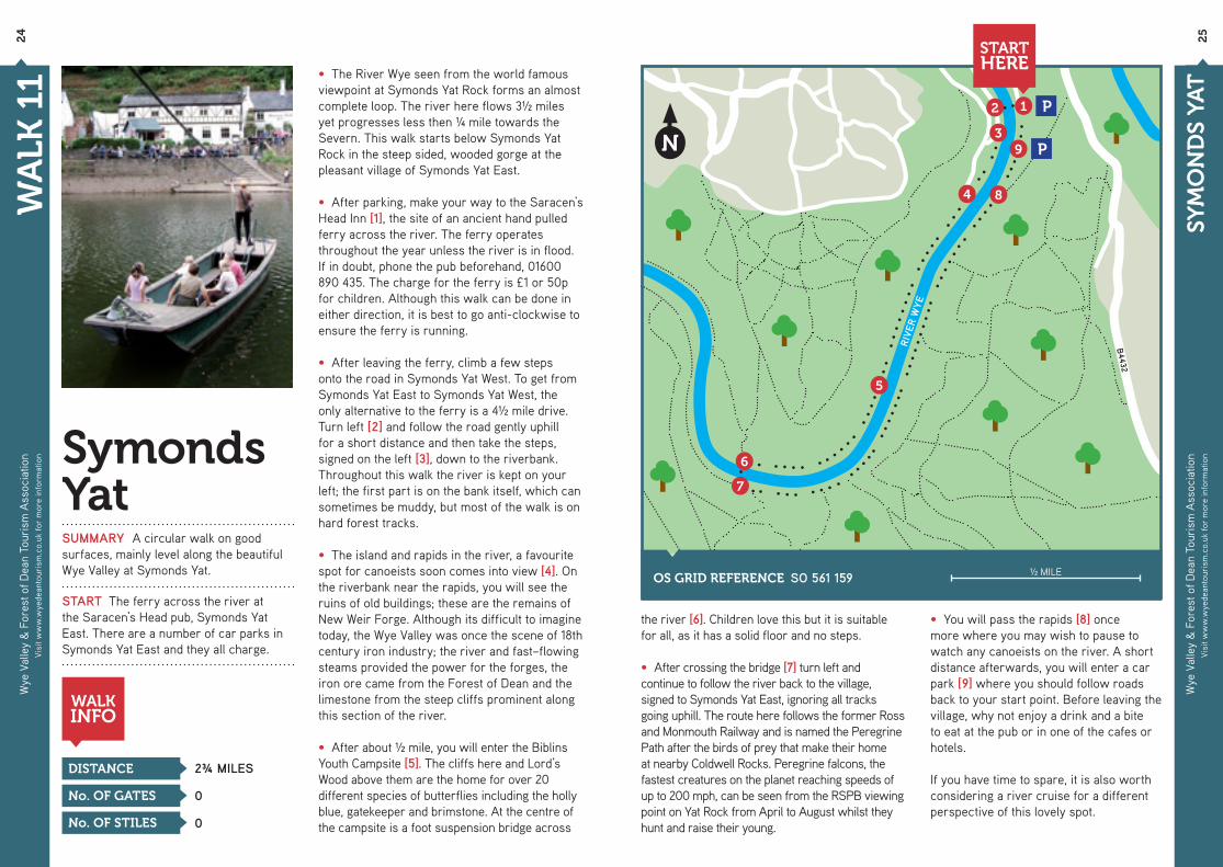
Symonds YatSUMMARY A circular walk on good surfaces, mainly level along the beautiful Wye Valley at Symonds Yat.
START The ferry across the river at the Saracen’s Head pub, Symonds Yat East. There are a number of car parks in Symonds Yat East and they all charge.
DISTANCE
WALKINFO
No. OF STILES
No. OF GATES
2¾ MILES
0
0
• The River Wye seen from the world famous viewpoint at Symonds Yat Rock forms an almost complete loop. The river here flows 3½ miles yet progresses less then ¼ mile towards the Severn. This walk starts below Symonds Yat Rock in the steep sided, wooded gorge at the pleasant village of Symonds Yat East.
• After parking, make your way to the Saracen’s Head Inn [1], the site of an ancient hand pulled ferry across the river. The ferry operates throughout the year unless the river is in flood. If in doubt, phone the pub beforehand, 01600 890 435. The charge for the ferry is £1 or 50p for children. Although this walk can be done in either direction, it is best to go anti-clockwise to ensure the ferry is running.
• After leaving the ferry, climb a few steps onto the road in Symonds Yat West. To get from Symonds Yat East to Symonds Yat West, the only alternative to the ferry is a 4½ mile drive. Turn left [2] and follow the road gently uphill for a short distance and then take the steps, signed on the left [3], down to the riverbank. Throughout this walk the river is kept on your left; the first part is on the bank itself, which can sometimes be muddy, but most of the walk is on hard forest tracks.
• The island and rapids in the river, a favourite spot for canoeists soon comes into view [4]. On the riverbank near the rapids, you will see the ruins of old buildings; these are the remains of New Weir Forge. Although its difficult to imagine today, the Wye Valley was once the scene of 18th century iron industry; the river and fast–flowing steams provided the power for the forges, the iron ore came from the Forest of Dean and the limestone from the steep cliffs prominent along this section of the river.
• After about ½ mile, you will enter the Biblins Youth Campsite [5]. The cliffs here and Lord’s Wood above them are the home for over 20 different species of butterflies including the holly blue, gatekeeper and brimstone. At the centre of the campsite is a foot suspension bridge across
the river [6]. Children love this but it is suitable for all, as it has a solid floor and no steps.
• After crossing the bridge [7] turn left and continue to follow the river back to the village, signed to Symonds Yat East, ignoring all tracks going uphill. The route here follows the former Ross and Monmouth Railway and is named the Peregrine Path after the birds of prey that make their home at nearby Coldwell Rocks. Peregrine falcons, the fastest creatures on the planet reaching speeds of up to 200 mph, can be seen from the RSPB viewing point on Yat Rock from April to August whilst they hunt and raise their young.
• You will pass the rapids [8] once more where you may wish to pause to watch any canoeists on the river. A short distance afterwards, you will enter a car park [9] where you should follow roads back to your start point. Before leaving the village, why not enjoy a drink and a bite to eat at the pub or in one of the cafes or hotels.
If you have time to spare, it is also worth considering a river cruise for a different perspective of this lovely spot.
OS GRID REFERENCE SO 561 159 ½ MILE
STARTHERE
1
10
9
2
3
4
5
6
7
8
N
RIVER WYE
B4260
B4260
HIGH ST.
B423
4
A40
B423
4
STARTHERE
P
P
P
SCHOOL
Wye
Val
ley
& F
ores
t of D
ean
Tour
ism
Ass
ocia
tion
Visi
t ww
w.w
yede
anto
uris
m.c
o.uk
for
mor
e in
form
atio
n
26
Wye
Val
ley
& F
ores
t of D
ean
Tour
ism
Ass
ocia
tion
Visi
t ww
w.w
yede
anto
uris
m.c
o.uk
for
mor
e in
form
atio
n2
7
WA
LK 1
2
RO
SS T
OW
N W
ALK
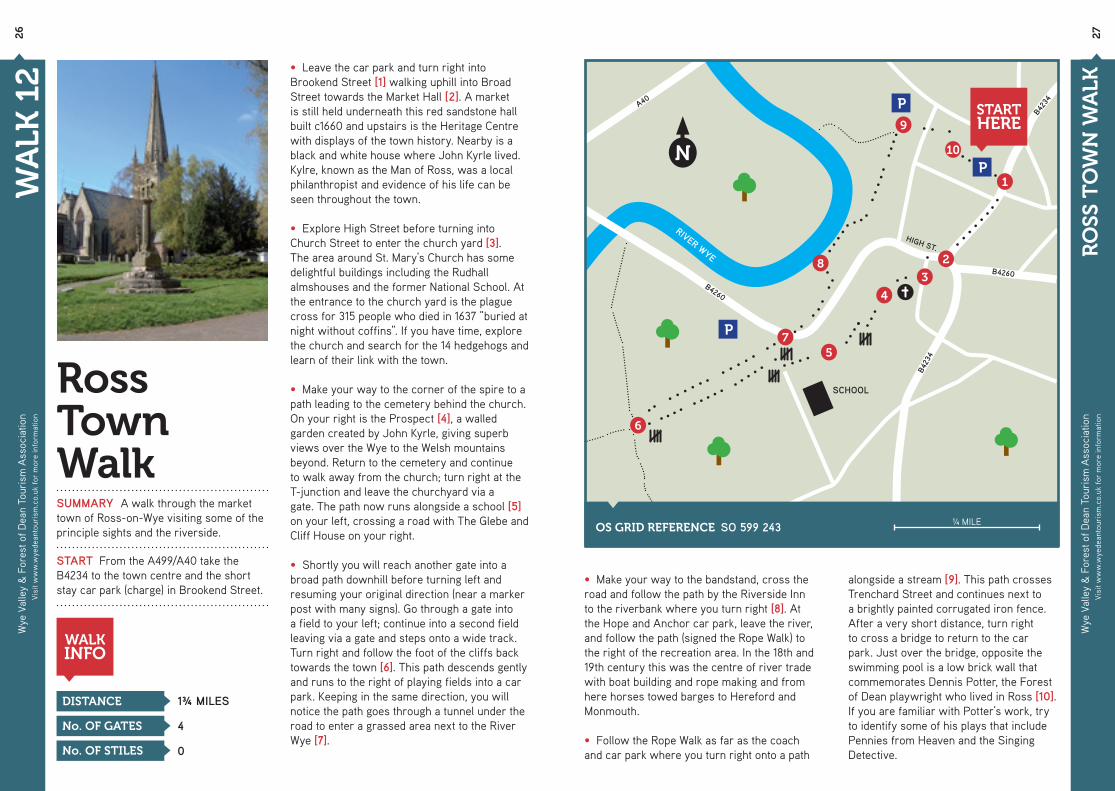
Ross Town WalkSUMMARY A walk through the market town of Ross-on-Wye visiting some of the principle sights and the riverside.
START From the A499/A40 take the B4234 to the town centre and the short stay car park (charge) in Brookend Street.
DISTANCE
WALKINFO
No. OF STILES
No. OF GATES
1¾ MILES
0
4
• Leave the car park and turn right into Brookend Street [1] walking uphill into Broad Street towards the Market Hall [2]. A market is still held underneath this red sandstone hall built c1660 and upstairs is the Heritage Centre with displays of the town history. Nearby is a black and white house where John Kyrle lived. Kylre, known as the Man of Ross, was a local philanthropist and evidence of his life can be seen throughout the town.
• Explore High Street before turning into Church Street to enter the church yard [3]. The area around St. Mary’s Church has some delightful buildings including the Rudhall almshouses and the former National School. At the entrance to the church yard is the plague cross for 315 people who died in 1637 “buried at night without coffins”. If you have time, explore the church and search for the 14 hedgehogs and learn of their link with the town.
• Make your way to the corner of the spire to a path leading to the cemetery behind the church. On your right is the Prospect [4], a walled garden created by John Kyrle, giving superb views over the Wye to the Welsh mountains beyond. Return to the cemetery and continue to walk away from the church; turn right at the T-junction and leave the churchyard via agate. The path now runs alongside a school [5] on your left, crossing a road with The Glebe and Cliff House on your right.
• Shortly you will reach another gate into a broad path downhill before turning left and resuming your original direction (near a marker post with many signs). Go through a gate into a field to your left; continue into a second field leaving via a gate and steps onto a wide track. Turn right and follow the foot of the cliffs back towards the town [6]. This path descends gently and runs to the right of playing fields into a car park. Keeping in the same direction, you will notice the path goes through a tunnel under the road to enter a grassed area next to the River Wye [7].
• Make your way to the bandstand, cross the road and follow the path by the Riverside Inn to the riverbank where you turn right [8]. At the Hope and Anchor car park, leave the river, and follow the path (signed the Rope Walk) to the right of the recreation area. In the 18th and 19th century this was the centre of river trade with boat building and rope making and from here horses towed barges to Hereford and Monmouth.
• Follow the Rope Walk as far as the coach and car park where you turn right onto a path
alongside a stream [9]. This path crosses Trenchard Street and continues next to a brightly painted corrugated iron fence. After a very short distance, turn right to cross a bridge to return to the car park. Just over the bridge, opposite the swimming pool is a low brick wall that commemorates Dennis Potter, the Forest of Dean playwright who lived in Ross [10]. If you are familiar with Potter’s work, try to identify some of his plays that include Pennies from Heaven and the Singing Detective.
OS GRID REFERENCE SO 599 243 ¼ MILE

Produced by the Wye Valley & Forest of Dean Tourism Association.PO Box 56, Coleford, GL16 9AN • T - 0845 053 1173
With thanks to:Walks developed by Forest of Dean & Wye Valley Tour Guides: www.wyedeantourguides.org.uk
Brochure designed by Pixcell Design: www.pixcelldesign.co.uk Printed by Westdale Press Ltd, Cardiff: www.westdale.co.uk
The photographs in this booklet were kindly provided by the following who retain the copyright:Forest of Dean District Council (Walk 7), Geoff Davis (Walks 5, 6, 8, 9), Ian MacNab (Walk 11), John Bosley (Walk 1, 8, 10, 12), Pam Singer (Walk 3), Val Long (Walks 2, 4)
“Our members are committed to delivering excellence.”
This booklet has been produced by the Wye Valley & Forest of Dean Tourism Association, nearly 300 businesses claiming their livelihood in whole or part from tourism. Although the Wye Valley and Forest of Dean spans two countries and three counties, we promote it as a single tourist destination. We are proud of the huge range of attractions, activities and natural beauty that the area has to offer the visitor. In addition, we are well known for specialist food and drink, which adds to the visitor’s experience.
In this booklet we promote walking for the older visitor, young families, the less able and anyone who is not a confident walker. However, the area is also suitable for the more experienced walker seeking greater challenges and has a wide range of outdoor pursuits for all ages.
Details of further walks in the Wye Valley and Forest of Dean and general information on the area can be obtained from the following tourist information centres:
ABERGAVENNY 24 Monmouth Road, Abergavenny, NP7 5HL - 01873 853 254BEECHENHURST LODGE Speech House Road, Coleford, GL16 7EG - 01594 822 612CHEPSTOW Castle Car Park, Bridge Street, Chepstow, NP16 5EY - 01291 623 772
MONMOUTH Shire Hall, Agincourt Square, Monmouth, NP25 3DY - 01600 713 899ROSS ON WYE Market House Visitor Centre, Market Place, Ross on Wye, HR9 5HD - 01989 562 768
If you want to know more about our area, including places to stay, places to eat and things to do, visit our website:
www.wyedeantourism.co.ukIn addition, we produce two further publications:
Taste Something Different - Our guide to eating out and local produce.
Do Something Different - Our guide of attractions, activities, speciality shopping and business services.