Embed Size (px)
Citation preview

PROPRIETARY RIGHTS STATEMENT
This document contains information, which is proprietary to the “Seanergy 2020” Consortium. Neither this document
nor the information contained herein shall be used, duplicated or communicated by any means to any third party, in
whole or in parts, except with prior written consent of the “Seanergy 2020” consortium.
Offshore Renewable Energy and
Maritime Spatial Planning
Recommendations for Adaptation and Development of Existing and Potentially
New International Marine Spatial Planning Instruments
October, 2011
Agreement n.: IEE/09/898/SI2.558294
Duration : 24 months – 05/2012
Co-ordinator: European Wind Energy Association
Supported by:

2 | P a g e
Document information
Document Name: Analysis of planned/suggested offshore electricity infrastructure relatively to
existing international MSP instruments
Document Number: D3.3
Author: Sophie Jacques, Paul Kreutzkamp, Pieter Joseph
Date: 20/09/2011
WP: 3
Task: 3.2, 3.3, 3.4

3 | P a g e
CONTENT
INTRODUCTION ................................................................................................................................... 4
1 ANALYSIS OF OFFSHORE RENEWABLE ENERGIES SITING PLANS RELATIVELY TO EXISTING
INTERNATIONAL MSP INSTRUMENTS ....................................................................................... 4
1.1 Existing International MSP Instruments .................................................................. 4
1.2 National Renewable Action Plans............................................................................ 8
2 OFFSHORE ELECTRICITY INFRASTRUCTURE AND INTERNATIONAL MSP INSTRUMENTS .... 10
2.1 Strategic Planning of OffshoreGrid Infrastructure ................................................ 11
2.2 Importance of International MSP for the Offshore Grid Infrastructure ............... 15
2.3 SEANERGY2020-OffshoreGrid-Windpseed Cooperation ...................................... 16
3 CONCLUSIONS AND RECOMMENDATIONS ............................................................................. 21
3.1 Comparison of international and EU level approaches ........................................ 21
3.2 International Approaches ....................................................................................... 22
3.3 MSP development on EU level ............................................................................... 29

4 | P a g e
INTRODUCTION
A high level of cooperation between Member States is crucial for a fast and optimal deployment of
offshore renewable energies and related grid infrastructure. Some international Maritime Spatial
Planning instruments have been developed in the last years but they do not necessarily take into
consideration the specific features of offshore renewable energies.
This report analyses the existing international maritime spatial planning instruments with the
objective to identify the critical elements within these instruments that impact on a coordinated
development of offshore renewable energy. Chapter 1 analyses the different existing national
zoning plans of the 17 Members States covered by the SEANERGY2020 project compared to
existing International MSP instruments, in order to highlight eventual inconsistencies and to
qualify the effect of International MSP instruments on the deployment of offshore renewable
energies (ORE). Chapter 2 focuses on the offshore grid infrastructure and cable routing for a pan-
European grid at sea, for which a strategic planning at international level is necessary.
This document closes with conclusions and recommendations for the further development on
MSP on international, regional and European level, in order to facilitate the co-ordinated
development of offshore renewable energy sources, through enhanced cooperation between
Member States.
1 ANALYSIS OF OFFSHORE RENEWABLE ENERGIES SITING PLANS RELATIVELY TO EXISTING INTERNATIONAL MSP INSTRUMENTS
The objective of this section is to analyse the different existing national siting/zoning plans, the
National Renewable Energy Action Plans1 and compare this “zoning information” to the existing
international MSP instruments. For the states where geographical areas have explicitly been
identified by national policy or other projects, these will be compared against the boundary
conditions as set by the current international MSP instruments.
Finding appropriate sites that avoid conflicts with other sea users will be important in order to
accelerate offshore deployment. It will be discussed in how far possible spatial conflicts endanger
national goals and expected ORE deployment. In particular, it will be analysed how possible
conflicts can be mitigated beforehand.
1.1 Existing International MSP Instruments
The legal framework related to maritime issues and offshore exploitation is extensive. Many
documents of different types and with different legal forces and jurisdictional value exist and
regulate maritime activities. Most of these instruments and conventions focus on a particular
activity, such as navigation or fishery, with strong historical claims and receiving often priority
based on economic considerations. Amongst all these international MSP instruments, several
agreements, conventions and international or regional organisations relate to the protection of
the marine environment.
Report 3.1 is available on the project website and provides an overview of existing MSP
instruments (laws, conventions, agreements) at the international, European and regional level.
The aim of each instrument has been interpreted and its possible impact on the deployment of
offshore renewables is analysed.
1 http://ec.europa.eu/energy/renewables/transparency_platform/action_plan_en.htm

5 | P a g e
Table 1: Existing International MSP instruments and related offshore maritime sectors
Sector International European Regional
Shipping &
Navigation
IMO:
COLREG
SOLAS
MARPOL
Fishery
Regional Fisheries
Management
Organization (RFMOs)
UN Fish Stock
Agreement (UNFSA)
International
Convention for the
Conservation of
Atlantic Tunas (ICCAT)
Common Fishery Policy (CFP)
Convention on the future
multilateral cooperation
in North East Atlantic
Fisheries (NEAFC)
Agreement for the
Establishment of a
general Fisheries
commission for the
Mediterranean (GFCM)
Marine
environment
protection
Espoo Convention
Protocol on Strategic
Environmental
assessment
Convention on
Biological Diversity
(CBD)
Marine Strategy Framework
Directive (MSFD)
Habitats and Birds Directive
(Natura 2000)
SEA- and EIA-Directive
OSPAR Convention
HELCOM
International conferences
on the protection of the
North Sea
Bonn agreement
(pollution)
ICZM Protocol
Barcelona Convention
MAP
All marine legislation comes under the 'umbrella' of the United Nations Convention on the Law of
the Sea (UNCLOS). UNCLOS defines the different maritime zones at sea and the legal status of
these zones. UNCLOS authorises coastal states to extend their jurisdiction up to 200 nm to create
Exclusive Economic Zones (EEZs), in which the coastal state is allowed to deploy offshore
renewable energy projects. It is worth specifying that UNCLOS provides general rules. Detailed
regulation is organised through specialised bodies and specific agreements.
None of the existing and analysed instruments contains explicit provisions or restrictive elements
for renewable offshore installations. This is due to the fact that offshore renewable energy
activities are recent. Nevertheless, these international instruments may impact the deployment of
ORE and influence the location of ORE activities, the permitting and licensing procedures as well
as the construction and operational phases.
In order to highlight the possible influence of the existing international MSP instruments on the
planning of offshore renewable activities in the sea, these have been classified according to the
different phases of an offshore renewable energy activity (table 2).
Table 2: Summary table of the impact of the instruments on the phases of offshore renewable energy
development
Phase of project
development
Instrument Relevant elements influencing offshore renewable energies
deployment
Location
UNCLOS With respect to UNCLOS, offshore renewable energy installations may
be built anywhere within EEZ and a safety zone of 500m around can
be established.
Related to cable lying: Coastal State cannot control the laying by
other States of cables passing through its EEZ. UNCLOS preserve the
freedom to do so (Art58). However delineation of cables is subject to
the consent of the Coastal State (Art 79). Within Territorial Sea, the
coastal State has more comprehensive control on cable and pipeline
lying, and can impose restrictions to these.
IMO Sea-lanes and traffic separation schemes regulated by IMO are
considered as excluded zones in the sea.
PSSA introduced the principle of deviating shipping routes.

6 | P a g e
RFMOs By establishing fishing limits and controlled zones, with respect to
sustainable fisheries, RMFOs may influence the location of renewable
offshore activities.
CBD Under CBD, Parties can establish marine protected areas (MPAs) in
and outside national jurisdiction (including EEZ). The designation of
marine protected areas under CBD (legally binding treaty) may
influence the location of offshore renewable energy infrastructure;
meanwhile possible synergies need to be clarified.
Birds and Habitat
Directive The Birds Directive calls for the establishment of Special Protected
Areas (SPAs) for birds. The Habitats Directive calls for the
establishment of Special Areas of Conservations (SACs) for habitats
or species. The protected areas defined by these directives are legally
binding and define key number of criteria to be met when developing
activities within these protected areas.
These directives don’t exclude offshore renewable energy
installations within protected areas, however if this would occur the
developer must show that the activity will not harm the conservation
goals set out for the particular area.
The synergies with other functions/ uses within protected areas
should be studied further and clarified (e.g. ORE, aquaculture etc)
CFP
GFCM
NEAFC
Presently, there are no regulatory restrictions on the development of
fishery and the establishment of ORE activities such as wind farm.
But fisheries are a well-known and wide spread sea use function in
European waters. CFP aims to ensure sustainable exploitation of fish
resources. This means reducing the number of fishing vessels and
the duration of fishing period, the establishment of open and closed
fishing seasons and areas. These influence the location and some
operational phases of offshore renewables. Meanwhile, the
compatibility between fisheries and offshore infrastructure should be
clarified such as fishing conditions in the vicinity of wind farms.
Barcelona Convention Barcelona Convention encourages the establishment of specially
protected areas called “Specially Protected Area of Mediterranean
Interest” (SPAMI) and provides protective measures for the Protection
of the Mediterranean Sea against Pollution. The protection measures
for SPAMI should be taken into account in MSP and may influence
the location of offshore renewable activities.
Espoo Convention The Espoo Convention promotes consultation and cross-border
cooperation in the planning process of activities and outlines specific
conditions to be incorporated into national environmental impact
assessment (EIA) procedures.
Birds and Habitat
Directive The Habitats Directive requires an assessment of plans or projects
that may significantly impact a NATURA 2000 sites.
Permitting &
Licensing
EIA-Directive Offshore renewable activities require an Environmental Impact
Assessment according to the EIA Directive. The results of the EIA are
presented in an Environmental Statement (ES) and are submitted
together with license and consent applications.
OSPAR OSPAR Commission adopts legally binding regulation requiring
Member States to adopt procedure and actions related to Marine
Environment Protection, which can influence the licensing and
permitting procedure for the development phase of offshore
renewable energies projects.
OSPAR serves as a platform for exchange of information and plays an
important role in starting discussions on new issues.
Monitoring
UNCLOS UNCLOS obliges its parties in principle to protect the marine
environment and stipulates obligations to environmental monitoring
and assessment.
OSPAR OSPAR Commission adopts legally binding regulation requiring
Member States to adopt procedure and actions related to Marine
Environment Protection. Under OSPAR, parties have the obligation to
realize regular marine environmental monitoring campaigns.
CFP
GFCM
NEAFC
Construction and maintenance activities could be influenced or
restricted during particular fishing (open and closed fishing seasons
and areas).

7 | P a g e
Construction &
Operation
Bonn Agreement Chapter 8 of the Bonn Agreement Counter-Pollution Manual sets out
the considerations that need to be taken into account if any problem
appears related with wind farms. It states on the payer-pollution
principle.
Removal/
Decommissioning
UNCLOS UNCLOS (Art60) state the principle of the obligation to remove
abandoned or disused offshore installations.
IMO IMO adopted in 1989 guidelines and standards for the Removal of
offshore installations and structures on the Continental Shelf and in
the EEZ.
CFP
GFCM
NEAFC
CFP, GFCM and NEAFC request to reduce or limit activities during
particular fishing period (open and closed fishing seasons and areas)
which might impact the phase of removal planning of an ORE project
OSPAR OSPAR Commission adopted in 1998 a legally binding regulation for
the disposal of disused offshore installation. Parties have the
obligation to foresee the disposal of disused offshore installations.
International, European and regional instruments set up provisions influencing the legislative and
procedural requirements for offshore renewable energy deployment and the necessary grid
infrastructure.
In this sense, location and procedural rules for offshore renewable energy may be influenced by
international and regional or European regulations, but planning decisions remain subject to
national specific administrative and procedural rules, defined through national legal frameworks.
International MSP instruments do not explicitly consider offshore renewable energy. Therefore it
may be assumed that the latter do not hamper deployment of renewable offshore energies. At the
same time international MSP do not explicitly refer to, and thus support, offshore renewables
deployment.
Nevertheless, national and international regulations need to be more linked to each other and
require more flexibility of internationally adopted regulations and advanced MSP at national level.
Compatibilities or incompatibilities as well as synergies between different users (including ORE)
should be studied further in detail, as well as the possibilities to adapt some historically strong
regulations.
Flexibility of internationally adopted regulations will be necessary in the future. Up to now a basic
assumption is to treat the existing international system as fixed. However, the system needs to be
able to evolve to adapt to changing socio-economic needs. Currently, the international
instruments can be revised but it remains a lengthy process.
This is especially the case for the instruments regulating navigation. Sea-lanes and traffic
separation schemes regulated by IMO are considered as exclusion zones. These zones are
reserved for navigation and shipping. Therefore, they cannot be considered compatible with
offshore energy generation, mainly for the sake of safety of both shipping and offshore power
plants. The priority principle for navigation has been firmly anchored in the UNCLOS and is
consequently reflected in the dominant positions of the shipping sector vis-à-vis other legitimate
maritime activities, such as offshore renewable energies.
However, the expansion of offshore activities and the development of new uses of the sea will
enhance the need to discuss maritime spatial conflicts.
Following this, adaptations are mainly made at national level and within national jurisdictions’
scope. Some decisions, however, need to be enforced by receiving international support. An
example would be decisions relating to safety zones of contiguous uses, such as the definition of
a safety zone around shipping routes and offshore infrastructure (max. 500m according UNCLOS):
currently these are drawn separately and thus cumulated, reducing available space considerably.
A harmonised interpretation of international legislation should be recommended in order to
harmonise practices and opportunities for ORE deployment. This is the case for instance for the
Birds and Habitat Directives, with regards to the establishment of the Natura 2000 network, and
its compatibility with ORE activities. While these directives do not exclude offshore renewable
energy installations within NATURA 2000, several countries erroneously consider these protected
areas as no-go for ORE.

8 | P a g e
The existing international conferences involve co-operation between different parties related to
the use of the sea, they can play an important role in starting discussions on new issues and
influencing management decisions at national level. Offshore renewable energy deployment
should be taken into consideration in the framework of these discussions.
1.2 National Renewable Energy Action Plans
All 27 Member States submitted (during 2010 and early 2011) a National Renewable Energy
Action Plan (NREAP) as provided by Article 4 of the Renewable Energy Directive (2009/28/EC), in
which the contribution of renewables are quantified in order for each Member State to reach its
binding 2020 target.
The 17 Coastal States2 of the 4 European sea basins (North Sea, Baltic Sea, Mediterranean Sea
and Atlantic Coast) covered by the project announced quantitative objectives for offshore
renewable energies and some of them identified the area dedicated to offshore renewable energy
activities. Table 3 characterises the different Coastal States with their potential sea area (EEZ
area), and where a geographical zone for ORE has been identified, the part this area represents in
the sea area.
Table 3: 2020 ORE targets in comparison with sea space potentialities
State 2020 Target Needed ORE
area to meet
2020 Target
EEZ Area ORE Area % of ORE
Area in
EEZ
Installed
OWF
% of
installed
capacity
vs. 2020
target
Denmark 1 339 MW 140 km² 105 989 km²
(1)
1012 km² 0.9 % 853,7 MW 64 %
Sweden 182 MW 18 km² 39 960 km² - - 163,65 MW 90 %
Finland3 900 MW 90 km² 52 472 km² 1000 km² 1.9% 26,3 MW 3 %
Estonia 250 MW 25 km² 36 992 km²
(1)
- - 0 MW 0 %
Latvia 180 MW 18 km² 28 000 km² - - 0 MW 0 %
Lithuania No 2020
Target in
NREAP
Other sources:
100 MW
10 km² 6 425 km² - - 0 MW 0 %
Poland 500 MW 50 km² 33 307 km² 2500 km² 7.5% 0 MW 0 %
Germany 10 000 MW 1000 km² NS: 28 539
km²
NS:880 km² NS: 3% 180,3 MW 2 %
2 Baltic Sea: Sweden, Finland, Estonia, Latvia, Lithuania, Poland and Denmark-East,
North Sea: Denmark-West, Germany, the Netherlands, Belgium and United Kingdom-East,
Atlantic coast: United Kingdom-West, Ireland, France, North Spain and Portugal
Mediterranean Sea: Southern Spain, Southern France, Italy and Greece.
3 Finland did not breakdown its wind targets into onshore and offshore deployment in its original NREAP submission
to the Commission. In a subsequent submission the 2,500 MW of wind power by 2020 were broken down into 900 MW offshore wind and 1,600 MW onshore.
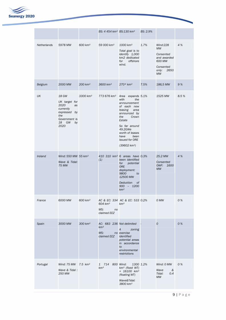
9 | P a g e
BS: 4 454 km² BS:130 km² BS: 2.9%
Netherlands 5978 MW 600 km² 59 000 km² 1000 km²
Total goal is to
identify 1,000
km2 dedicated
for offshore
wind.
1.7% Wind:228
MW
Consented
and awarded
600 MW
Consented
only: 2650
MW
4 %
Belgium 2000 MW 200 km² 3600 km² 270* km² 7.5% 186,5 MW 9 %
UK 18 GW
UK target for
2020 as
currently
expressed by
the
Government is
18 GW by
2020
3300 km² 773 676 km² Area expands
with the
announcement
of each new
leasing area
announced by
the Crown
Estate
So far around
49.2GWe
worth of leases
have been
issued for ORE
(39602 km²)
5.1% 1525 MW 8.5 %
Ireland Wind: 550 MW
Wave & Tidal:
75 MW
55 km² 410 310 km²
(1)
6 areas have
been identified
for potential
ORE
deployment:
9800 to
12500 MW
Deduction of
900 – 1200
km²
0.3% 25.2 MW
Consented
OWF: 1600
MW
4 %
France 6000 MW 600 km² AC & EC: 334
604 km²
MS: no
claimed EEZ
AC & EC: 533
km²
0.2% 0 MW 0 %
Spain 3000 MW 300 km² AC: 683 236
km²
MS: no
claimed EEZ
Not delimited
A zoning
exercise
identified
potential areas
in accordance
to
environmental
restrictions
- 0 0 %
Portugal Wind: 75 MW
Wave & Tidal :
250 MW
7.5 km² 1 714 800
km²
Wind: 1300
km² (fixed WT)
+ 16100 km²
(floating WT)
Wave&Tidal:
3800 km²
1.2% Wind: 0 MW
Wave &
Tidal: 0.4
MW
0 %

10 | P a g e
Italy Wind: 680 MW
Wave & Tidal:
3 MW
7 km²
No claimed
EEZ
- - 0 MW
Consented
OWF: 245
MW
0 %
Greece Wind: 1500
MW
Wave & Tidal :
28 MW
150 km² No EEZ zone
and TS is
limited to 6
nautical miles
from the shore
531.9 m2 - 0 MW 0 %
Figures in this table are based on information collected in the Nations Reports of WP2 (*)MB 3-2-2011 modified and reduced the offshore wind energy zone (following complaints of navigation that the block hindered safe navigation at two corners of the zone) ORE Area: 238 km², 6.6% of EEZ
EEZ areas: source http://en.wikipedia.org/wiki/Exclusive_Economic_Zone
As the table shows, marine area dedicated to ORE deployment currently represent a small part of
most of the EEZs. Only for UK, Belgium and Poland the surface dedicated to ORE reaches
approximately 5% and 7.5% of EEZ. Belgium is the Coastal State with the smallest sea area
(3,600 km²) in which a 270 km² area has been delimited and allocated to OWF. Poland identified
a 2,500 km² ORE area, which is the largest ORE area identified after the 39,602 km² in UK.
The percentages of installed capacity with regard to the 2020 targets highlight the early stage of
ORE deployment, except for Denmark and Sweden. These countries published very low targets
with regard to the available sea space .
The column “Needed ORE area to meet 2020 Target” verifies whether enough has been zoned to
satisfy the 2020 target. The reference density used for offshore wind farm is 10 MW/km². The
minimum ORE area given in this column should be considered as a rough estimation of the
needed ORE area in order to satisfy the 2020 target. This density will change depending on the
existing wind conditions of the sea basin. As shown in table 3, the countries that did delimit an
ORE area designed it to satisfy the 2020 target. France it is the only country for which the ORE
area currently delimited is not sufficient to satisfy the2020 target. It should be reminded that for
France the 6,000MW target is expected through 2 tender rounds. The first round was published in
July 2011 and designated a 533 km².
The deployment of offshore renewable energy in the different EU Coastal States is more
constrained by limited MSP policy and related legal framework or complex permitting and
incentives procedures at national level than by MSP Instruments at International or regional
level.However, expansion of offshore activities and the development of new uses of the sea will
enhance the need to discuss maritime spatial use / conflicts.
2 OFFSHORE ELECTRICITY INFRASTRUCTURE AND INTERNATIONAL MSP INSTRUMENTS
As discussed in chapter 1, international MSP is currently not constraining the construction of
offshore wind farms or their connection to shore. However, offshore space is a limited resource
and the increasing offshore capacity reduces the available space. Therefore a strategic planning
of offshore infrastructure is necessary. As future offshore wind infrastructure will interconnect
across country borders, planning should be coordinated on an international level.
This chapter focuses on the offshore grid infrastructure and carries out the following tasks or
assesses the following questions:
To what extent does international planning for offshore grids exist today,

11 | P a g e
Discussion whether the Ten Years Network Development Plan (TYNDP), the results of the
EU OffshoreGrid project and the EC blueprint among others take into account strategic
planning and international MSP,
Feeding the OffshoreGrid project4 results into the WindSpeed Decision Suport System
(DSS) tool5 that maps all relevant maritime sea uses and thus allows identifying possible
spatial conflicts.
The last task allows fostering a unique cooperation between three important EU projects in the
field of offshore wind energy. Along with the necessary data exchange, each party could further
deepen the understanding of projects they were not directly involved in.
2.1 Strategic Planning of OffshoreGrid Infrastructure
The liberalisation of the electricity markets was triggered by Directive 96/92/EC6. However, the
issues of grid development were left to the national TSOs, while the electricity markets were
further coupled to contribute for the development of an integrated European market. The dena
grid study (dena grid study I)7, which reserved international kudos, clearly illustrates this mindset:
Dena, published in 2005, was a leading study in addressing the issue of strategic grid planning by
setting up a German grid development plan for the coming 10 years. The exchange of electricity
with neighbouring countries however was regrettably neglected, partly because models for such
analysis did not exist, and partly because the general mindset did not at the time focus on these
issues.
However, this changed recently as it became clearer that cross border flows were rapidly
increasing due to market coupling as well as RES deployment. Moreover, the first integrated
European studies were conducted such as TradeWind8 or EWIS among others. Even though these
European studies still lack the detail that national studies achieved, it is clear that any future
studies on grid infrastructure that aim at public, political and scientific acceptance will have to be
based on an European power flow and market modelling.
With the Regulation 714/20099 international grid planning was brought to a next level as it was
institutionalised in Entso-E’s Ten Year Network Development Plan (TYNDP). Article 8.10 stipulates
that the planning should be based not only on national grid analyses but also on integrated
community-wide modelling. Still, as discussed below, the TYNDP does not cover the complete
scope of the European grid development: offshore grid connections and a possible offshore grid
interconnection are not envisaged, at least not in the first TYNDP published in June 2010.10
It is clear that for any future developments of international interconnecting offshore grids,
European studies should be considered as transnational power flows are of great importance.
Subsequently, the most relevant studies in this regard will be reviewed and whether they treat the
issue of maritime spatial planning will be discussed.
2.1.1 Ten Year Development Plan (TYNDP)
The ENTSO-E Ten Years Development Plan investigates the development of the European
transmission grid from 2010 to 2020. Even though the overall document focuses on the onshore
4 IEE project, project life time: 2008-2011, www.offshoregrid.eu
5 Within the IEE project WindSpeed (www.windspeed.eu) the DSS tool was developed. The DSS tool helps to
identify conflicts of use in the European Seas. 6 Directive 96/92/EC of the European Parliament and of the Council of 19 December 1996 concerning
common rules for the internal market in electricity 7 dena-Netzstudie I, 2005, dena 8 TradeWind was a European project funded under the EU’s Intelligent Energy-Europe Programme. The
project addressed one of the most challenging issues facing wind energy: its maximal and reliable integration
in the Trans-European power markets, http:// www.trade-wind.eu
EWIS: the European Wind Integration Study (EWIS) is an initiative established by the European transmission
system operators for Electricity (ENTSO-E) in collaboration with the European Commission, http://www.wind-
integration.eu/ 9 Regulation (EC) No 714/2009 of the European Parliament and of the Council of 13 July 2009 on
conditions for access to the network for cross-border exchanges in electricity and repealing Regulation (EC)
No 1228/2003 10
TYNDP, June 2010, Entso-E

12 | P a g e
grid development, it clearly recognises that “achieving the integration of large amount of offshore
resources will require a significant amount of investment and offshore grid infrastructure
measures”11. The study clearly states that an offshore grid can be seen as a key building block to
develop the European electricity market and to exchange renewable energy among European
countries. In line with this, ENTSO-E adopted the EWEA target for offshore wind energy of 40 GW
in 2020.
The overall importance of the offshore grid becomes clear in section 10 of the TYNDP that is, in
particular, dedicated to the long term development of an “offshore grid in North Sea, the
Mediterranean ring”, the “supergrid”. ENTSO-E highlights the importance of Kriegers Flak12 as a
pilot project and finally develops a roadmap towards a North Sea Offshore Grid.
It should further be mentioned that the TYNDP lists a large number of envisaged subsea
interconnections of different member states (MS)..
TYNDP and MSP
MSP is not in the scope of the TYNDP. However the roadmap lists the barriers for an offshore grid.
Some of these may be seen as related to the MSP:
According to ENTSO-E, a clear vision on who will be responsible to build the offshore grid
is needed. National approaches differ largely and international coordination is required.
National governments must therefore clearly support faster permitting and authorisation
processes and ensure international coordination13.
Permitting procedures and regulatory approval for an onshore and offshore grid
development are not sufficiently aligned among Member States. Policymakers and
regulators should coordinate, smoothen and speed-up permitting procedures14.
Moreover, the TYNDP never states explicitly that the development of an offshore grid can be
hampered by insufficient MSP procedures. However, indirectly, the aforementioned demand for
faster permitting procedures - and in particular international regulation - is an issue that can be
taken up by MSP.
The TYNDP does not propose a specific offshore grid design. This is also picked up by the
European Commission (EC) in its Blueprint: the TYNDP does not include an adequate assessment
of the infrastructure needed to connect upcoming new offshore wind capacities15.
2.1.2 OffshoreGrid Project
The OffshoreGrid (Intelligent Energy Europe programme16) looks into the development of an
offshore grid in Northern Europe based on a techno-economic analysis. It is the first study that
investigates suitable designs and technologies in detail. Furthermore, the study investigates the
costs and benefits of such an offshore grid.
In particular, the project looks into different possible offshore grid designs. Starting from a so-
called reference case of radial connections of the offshore wind farms, the case of hub
connection (bundled connection) and, finally, the case of a meshed grid are investigated.
OffshoreGrid Project and MSP
Marine use and marine spatial planning are not a prime goal of the OffshoreGrid project. The
issue was, however, brought up by national authorities (such as the BSH, approval authority in
Germany) during the OffshoreGrid workshops17,18 and was intensely discussed. This was also the
11 Entso-E TYNDP, p. 17 12
Kriegers Flak is a maritime area in the Baltic Sea. In particular it covers the tri-junction where the EEZ zones of Denmark, Germany and Sweden meet. There is Danish, a German and a Swedish wind farm planned at this tri-junction. Therefore in energy policy the name Kriegers Flak is used as a synonym for a three-leg interconnector that could be built by interconnecting via the three wind farms. 13
Entso-E TYNDP, p. 158 14
Entso-E TYNDP, p. 158 15
Priorities for 2020 and beyond ─ A Blueprint for an integrated European energy network, 2011, p. 17 and p. 29 16
http://www.offshoregrid.eu/ 17
1st Northern European Stakeholder Workshop, European Offshore Wind Conference 2009
13 | P a g e
reason behind the cooperation between WindSpeed and OffshoreGrid. WindSpeed looks into the
different marine use conflicts and provides data on certain marine use that were then considered
in OffshoreGrid: for example the cable crossings that have a significant cost impact fed into the
techno-economic analysis.
The cooperation between OffshoreGrid and WindSpeed is again fostered within the
SEANERGY2020 project. Within SEANERGY2020 a Non-Disclosure-Agreement (NDA) was signed
that allowed mapping the OffshoreGrid scenarios on the WindSpeed maps in order to highlight
certain marine use conflicts. The results of this cooperation are in chapter 2.3.
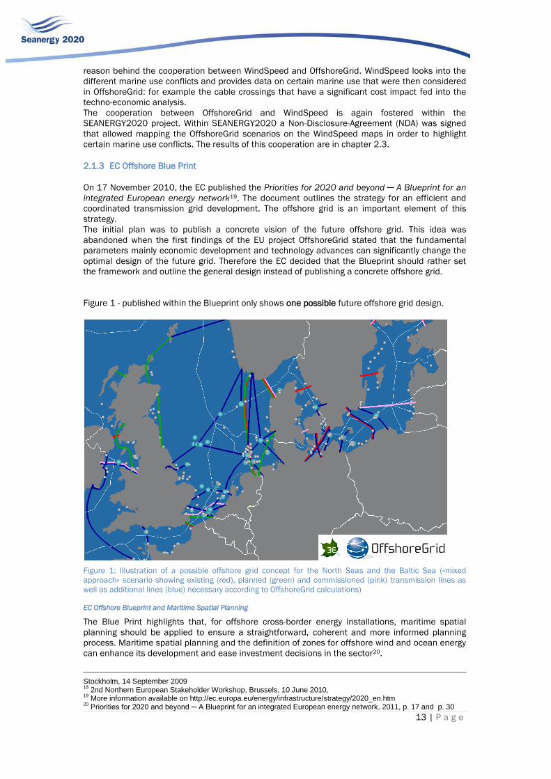
2.1.3 EC Offshore Blue Print
On 17 November 2010, the EC published the Priorities for 2020 and beyond ─ A Blueprint for an
integrated European energy network19. The document outlines the strategy for an efficient and
coordinated transmission grid development. The offshore grid is an important element of this
strategy.
The initial plan was to publish a concrete vision of the future offshore grid. This idea was
abandoned when the first findings of the EU project OffshoreGrid stated that the fundamental
parameters mainly economic development and technology advances can significantly change the
optimal design of the future grid. Therefore the EC decided that the Blueprint should rather set
the framework and outline the general design instead of publishing a concrete offshore grid.
Figure 1 - published within the Blueprint only shows one possible future offshore grid design.
Figure 1: Illustration of a possible offshore grid concept for the North Seas and the Baltic Sea («mixed
approach» scenario showing existing (red), planned (green) and commissioned (pink) transmission lines as
well as additional lines (blue) necessary according to OffshoreGrid calculations)
EC Offshore Blueprint and Maritime Spatial Planning
The Blue Print highlights that, for offshore cross-border energy installations, maritime spatial
planning should be applied to ensure a straightforward, coherent and more informed planning
process. Maritime spatial planning and the definition of zones for offshore wind and ocean energy
can enhance its development and ease investment decisions in the sector20.
Stockholm, 14 September 2009 18
2nd Northern European Stakeholder Workshop, Brussels, 10 June 2010, 19
More information available on http://ec.europa.eu/energy/infrastructure/strategy/2020_en.htm 20
Priorities for 2020 and beyond ─ A Blueprint for an integrated European energy network, 2011, p. 17 and p. 30

14 | P a g e
The blueprint discusses the different possible offshore grid designs and mentions that costs can
be reduced significantly by working from the radial point to point connection towards the hub and
meshed connection of offshore wind energy. The Blueprint however focuses on the economic
benefits and does not elaborate, for instance, on the fact that an integrated grid design brings the
benefit of minimised space use and thus minimised maritime spatial conflicts.
As the blueprint scenario is based on the OffshoreGrid results, possible conflicts with maritime
spatial planning will be further discussed in chapter 2.3 in which the OffshoreGrid results are
mapped against maritime constraints.
2.1.4 EWEA Master Plan
In 2009 EWEA published a long term vision on the development of the offshore wind and grid
development21 in Oceans of opportunity: harnessing Europe’s largest domestic energy resource
report and discussed possible barriers and solutions. The envisaged EWEA offshore grid design is
illustrated in Figure 2.
Figure 2: EWEA Master Plan 2009.
EWEA Offshore Grid Masterplan and MSP
The Oceans of Opportunity report underlines the importance of maritime spatial planning (MSP)
and emphasises that lacking national MSP is further aggravated by the absence of an integrated
and coordinated approach to maritime spatial planning (MSP) between the different Member
States and regions. Cross-border cooperation on MSP would support projects crossing several
Economic Exclusive Zones such as large-scale offshore wind projects, and the interconnectors of
the future pan-European grid22.
As the EWEA Master Plan was developed in close cooperation with the OffshoreGrid consortium, it
shows strong similarities with the OffshoreGrid design, therefore the in depth discussion in
chapter 2.3 can also be transferred to the EWEA Master Plan.
21
Oceans of opportunity: harnessing Europe’s largest domestic energy resource, EWEA, 2009. 22
Oceans of Opportunity - Harnessing Europe’s largest domestic energy resource, p. 21 and p. 23

15 | P a g e
2.1.5 Friends of the Super Grid (FOSG) – first phase
Friends of the Supergrid (FOSG) is an initiative of leading European companies in the field of
offshore wind energy that promotes the development of an European Supergrid. The Supergrid
shall interconnect generation and consumption centres to enhance market integration and
increase the reliability and security of the European power system. The focus is on the integration
of renewable energies by covering a sufficiently large area with a Supergrid in order to allow
smoothing effects to reduce the large variability of weather dependent energy sources as wind
and solar energy.
Figure 3: 2050 Supergrid development proposed by FOSG
FOSG Supergrid and MSP
The FOSG, however, focus in their assessments on an appropriate grid design rather than on high
level economic benefits, financing issues, grid code requirements, logistical supply chain issues
etc. Maritime spatial planning is, on the other hand, discussed in the internal working groups and
will be further detailed in the FOSG roadmap by the end of 2011.
However it is obvious that such a large infrastructure measure as a Supergrid would heavily
“consume” maritime space, which might conflict with other marine uses. The construction of such
a Supergrid can be largely accelerated if supported by international MSP.
2.2 Importance of International MSP for the Offshore Grid Infrastructure
From the examples above it may be seen that none of the current relevant projects in the field of
offshore grid infrastructure addresses maritime spatial planning in depth. This, however, should
not lead to the assumption that international MSP is not a relevant issue for the design of an
offshore grid.
The current discussions in Germany show that even for the German wind farms that will be solely
connected to the German transmission grid; the room for cabling is scarce. An offshore wind farm
might be in the way of the connection cable of another one. Conversely, it is more complex to
construct a wind farm in an area where cables are already installed. At national level, the projects
are often handled by one single national approval authority and thus the cable laying can be
coordinated and corridors for future cables can be foreseen.
On international level that approach becomes more complex. The mind game illustrated in Figure
4 gives a typical example: the EEZ of country A and B both host two wind farms that connect to an
offshore hub. This hub in turn is connected to the countries’ onshore transmission grid. As a
variety of studies show, it might be beneficial to connect the two offshore hubs in order to allow
cross border trading, increase the stability and the n-1 (or n-2) security of the power system. This
would then indeed be a step towards a meshed offshore grid.

16 | P a g e
As shown in Figure 4, the direct connection of the hubs is strongly hampered by the existing
offshore wind farms and their internal grid connections. The necessary room for such an
interconnection was not foreseen. Mid to long-term MSP might reduce future constraints of this
kind.
Figure 4: Hub connection via EEZ borders. (Source: 3E)
2.3 SEANERGY2020-OffshoreGrid-Windpseed Cooperation
Benefits of Project Cooperation
As discussed above the OffshoreGrid study is the only project that mapped a concrete offshore
grid based on techno-economic analysis so far. It is thus of particular interest within the
SEANERGY2020 project to analyse these first results in view of MSP restrictions.
For this purpose, the SEANERGY2020 project fostered an extensive data exchange between the
three EU projects SEANERGY2020, WindSpeed and OffshoreGrid. All three EU projects benefit
from this exchange:
SEANERGY2020: The data exchange allows SEANERGY2020 to discuss the
importance of MSP by reviewing a concrete vision of a future meshed grid design.
WindSpeed: The cooperation allows testing in how far the WindSpeed findings can be
applied to non-WindSpeed data. If successful, the general applicability of WindSpeed
is proven.
OffshoreGrid: The OffshoreGrid consortium will receive an evaluation of the results
based on maritime spatial restrictions. This feedback can be used to refine the
findings or can be taken into account in future similar analysis.
In order to make this cooperation possible, a Non-Disclosure Agreement was signed by all parties
involved (3E, Senergy Econnect, ECN) in order to protect associated intellectual property.
OffshoreGrid results and conflicts with international or European MSP
The environmental impact of an offshore turbine or a substation is completely different from the
electric cable connection. For instance, the offshore wind turbines and substations can never be
built within shipping lines and will also conflict largely with other marine use as fishery, nature
conservation, military use etc. Even though task 3.3 will focus on grid infrastructure, the project
consortium decided to map in addition the wind farm locations against the MSP constraints.
Detailed cable planning requires a case by case study of each cable that takes into account tides,
bathymetry and aspects beyond the scope of this study given the fact that all cables are only
EE
Z b
ord
er
To country A To country B

17 | P a g e
hypothetical at this stage. As the OffshoreGrid results were not available at the time of this
deliverable, the assessment below is relatively short. Moreover, it does not focus on international
MSP issues alone and focuses also at constraints on national level.
2.3.1 OffshoreGrid cable connection
IMO Shipping Lines
The UNCLOS recognises a coastal State’s sovereignty within its territorial sea (UNCLOS Art 2).
According to UNCLOS, the coastal states may adopt laws and can impose the use of specified sea
lanes and traffic separation schemes, taking into account recommendations of the competent
international organisation, the International Maritime Organisation (IMO), customary practices and
the nature and density of the traffic (UNCLOS Art 21).
Cables and pipelines are not affected much by shipping. Under normal operating conditions they
are safely positioned on the seabed while the ships float on the water surface and stay well clear
of the bed. Only in accidental situations when a ship runs aground where a cable or pipeline is
laid, damage is likely to occur23. Furthermore, ships might anchor for emergency stopping. Such
an emergency stop anchor trenches up to several meters into the seabed, thus cables in the way
will be cut.
Therefore it is of particular interest for the offshore wind farm operators to minimise the cable
length in the area of shipping routes. This is illustrated in Figure 5 for the example of the wind
farm connection Alpha Ventus. The cable connecting the wind farm to shore crosses the shipping
routes almost perpendicularly. The cable is installed this way even though the overall cable has to
go a longer way. The same can be observed for the data cables which are marked pink.
Figure 5: Vertical crossing of shipping routes, the two shipping routes are marked in blue going from west to
east, the energy cable that connects the wind farm alpha ventus is also market in blue. The circle marks the
almost vertical crossing of the electricity cable across the shipping routes (source: BSH, maps of the
maritime uses in the North Sea).
Figure 6 shows the cables planned according to the OffshoreGrid project. As one can clearly note
from this figure, the idea of crossing shipping lanes the shortest way was not taken into account.
This option has not been considered in the results of the techno-economic assessment of the
OffshoreGrid project, although the necessary cable deviations would be minimal. It suggests that
future similar projects take the findings of SEANERGY2020 and WindSpeed into account in order
to reach a higher level of detail in cable laying and its accuracy.
It is important to mention that there are also significant amounts of traffic outside the IMO
shipping routes that also need to be taken into account when planning cable routs.
23
WindSpeed project, “Identification and analysis of interaction between sea use functions”, WP3 Report D3.2
Shipping
routes
Electricity
cable

18 | P a g e
Figure 6: OffshoreGrid meshed grid design mapped against the IMO routes (source: ECN, WindSpeed
project).
Existing Offshore Infrastructure: pipelines and subsea cables
With respect to offshore installations, UNCLOS confers exclusive rights to states to construct,
authorise and regulate the construction, operation and use of artificial islands, installations and
structures. States may establish safety zones of 500 metres or less around artificial islands,
installations and structures. Within EEZs the freedom of navigation, the laying of cables and
pipelines and other lawful uses of the sea are protected.
Figure 7 clearly shows that WindSpeed allows mapping all cables and pipelines. Possible conflicts
as for instance the laying of cables and pipelines too close to each other or not crossing the
shortest way (rectangular) can be easily identified.

19 | P a g e
Figure 7: OffshoreGrid meshed grid design mapped against the existing pipelines and cable routes (source:
ECN, WindSpeed project).
Nature conservation areas
The Habitats Directive24 and the Birds Directive25 require Member States to identify and protect
areas for the conservation of species or habitats they host. The Birds Directive requires the
establishment of Special Protection Areas (SPAs) for birds. The Habitats Directive similarly
requires Special Areas of Conservation (SACs) to be designated for other species, and for
habitats. Together, SPAs and SACs constitute the Natura 2000 network.
These directives do not exclude offshore renewable energy installations within protected areas,
however if this occurs, the developer must show that the activity will not harm the conservation
goals set out for the particular area. Indeed, the Habitats Directive requires an appropriate
assessment of plans or projects that may significantly impact a NATURA 2000 site.
Figure 8 illustrates the OffshoreGrid design and the embedded wind farms as well as the nature
conservation areas in the North Sea. One can see here that the NATURA 2000 does not exclude
wind farms. The mapping illustrates where cables cross nature conservation areas and where
possible conflicts may occur.
To avoid Nature conservation areas is in many cases in the interest of the offshore infrastructure
developer, as this might significantly accelerate the approval process. When cables are built in a
nature conservation area, they can be bundled in corridors and laid at the same time in order to
reduce the environmental impact. This is for instance planned in the case of several cable
projects in Germany.
As shown in the figure above, within the OffshoreGrid design there are various cables that cross
nature conservation areas. The mapping allows one to identify possible deviations or bundling.
24 Council Directive 92/43/EEC of 21 May 1992 on the conservation of natural habitats and of wild fauna and flora,
25 Council Directive of 2 April 1979 on the conservation of wild birds (79/409/EEC)

20 | P a g e
Figure 8: OffshoreGrid meshed grid design mapped against nature conservation areas (source: ECN,
WindSpeed project).
Please note that in all discussed cases the bundling of connection and interconnections in cable
corridors with high rated cables significantly reduces the spatial impact. This minimises maritime
conflicts of use and additionally facilitates the approval process.

21 | P a g e
3 CONCLUSIONS AND RECOMMENDATIONS
Within chapter 3 conclusions and recommendations are developed – partly based on the findings
of previous chapters and partly developed within chapter 3. Some conclusions and
recommendations touch EU level issues while others go further and discuss international aspects.
Thus, they are categorised accordingly. Throughout this chapter we clearly distinguish between
the MSP on international and EU-level in order to categorise the recommendations. When
referring to international MSP, all instruments excluding EU level MSP instruments are
considered. This allows the reader to clearly distinguish between the two.
This part refers to the conclusions and recommendations relevant for different levels of MSP:
international MSP, MSP at EU level and MSP defined by bilateral or multi-lateral agreements at
regional level.
3.1 Comparison of international and EU level approaches
As discussed in chapter 1, International MSP instruments do not explicitly consider offshore
renewable energy. Therefore it may be assumed that the latter do not hamper deployment of
renewable offshore energies. But at the same time international MSP does not explicitly refer to,
and thus support, offshore renewables deployment neither.
It should be highlighted that one of the most important international MSP instruments, the
UNCLOS or the “Constitution of the Seas”, creates more opportunities than obstacles for the
deployment of renewable offshore energies. Nevertheless, there is room for further improvement
of conditions for offshore renewables within the international MSP framework.
One of the most important achievements of the UNCLOS is that it authorises coastal states to
extend their jurisdiction up to 200 NM to create EEZs. The UNCLOS confers sovereign rights on
coastal states in the EEZ. Under article 56, coastal states are given sovereign rights for the
purpose of exploring, exploiting, conserving and managing the living and non-living resources.
‘Energy from the water, currents and winds’ (Art 56.1) is considered a non-living economic
resource in the EEZ. Under article 60, coastal states have the exclusive jurisdiction to construct,
to authorise and regulate the construction and operation of artificial islands, installations and
structures.
According to Rothwell & Stephens26, article 56 (1) “…was drafted broadly, in the expectation that
it would need to be able to embrace future scientific and technological developments…. Parties to
the UNCLOS may rely upon this provision for the granting of licenses in their EEZs for renewable
energy facilities such as offshore tidal power generators, wave barrages and wind farms.“ This
sovereign right is however not unlimited: “… coastal states will not be able to derogate from the
freedom and safety of navigation, nor cause damage to the marine environment …”
The fundamental right to lay submarine cables is equally firmly anchored in the international law
of the sea and has been used as such since the end of the nineteenth century for
telecommunications, fuels and electricity transport needs.
As mentioned above, even if the current international MSP instruments do not appear to stand in
the way of the development of offshore renewable energies, new international MSP instruments
may be desirable for spurring the deployment of the ORE industry.
New international MSP instruments could be created in various ways, by:
The establishment of a set of sectoral international standards and guidelines for the
an optimal development of offshore renewable energies.
International sectoral organisations like International Maritime Organisation, Food
and Agriculture Organisation of the United Nations, Convention on Biological
Diversity, United Nations Convention on the Law of the Sea Legal secretariat,
International Cable Protection Committee, Global Wind Energy Council, etc. seem to
be the most appropriate organisms to develop these international MSP standards
and guidelines related to ORE development;
An international agreement on the increasing role and space needed by offshore
renewable in the maritime area.
26
The International Law of the Sea, op.cit., p 89.

22 | P a g e
Even though there is room for improvement of MSP at international level, the question is whether
the focus of MSP policies should be kept at international or at EU level. It has to be highlighted
that changes of international legislation or international agreements are very lengthy and
resource binding processes. At the same time, international MSP will have to build a broader
consensus and may therefore be vaguer in the definition of rules and instruments compared to
EU level MSP. Still, even though ORE development will take place mostly on European territory or
within European EEZs, the development of ORE will always touch international issues, for instance
the fundamental agreements as the right of way for international shipping. International MSP can
therefore give guidelines and frameworks for EU level legislation and this way support ORE
development.
Therefore, for the accelerated development of offshore renewables in Europe it is
recommended to treat EU level MSP as priority as it is already an ambitious task to achieve a
coherent MSP framework within the EU. UNCLOS provides general rules, assuming that
detailed regulation is organized through specialized bodies and specific agreements. UNCLOS
gives in this sense opportunities and support for EU level MSP developments for all necessary
MSP instruments at EU level.
International MSP development could be initiated based on best practice EU examples.
Completely new and holistic27 international MSP agreements however may not be necessary
for an accelerated development of the ORE sector.
Still, there are some recommendations given for international level that can facilitate ORE
deployment as further developed in chapter 3.2.
The development of international sectorial standards and guidelines related to ORE may be very
useful for a coherent and efficient development of ORE, from a technical (standardisation of the
industry) and financial (investment security) point of view.
3.2 International Approaches
3.2.1 International MSP Development and Implementation for Offshore Renewables
International MSP related to offshore renewable energy (ORE) should be pragmatic and result-
oriented in the first place. In order to prevent or to minimise international conflicts concerning
ORE deployment, international MSP should ideally result in the establishment of internationally
accepted standards and guidelines for best MSP practices in this field.
Given the emergence of offshore renewable energies, mainly offshore wind, in Europe but also in
other parts of the world like China28, South Korea29 and the United States of America30, the
issuing of international MSP standards related to ORE development may be useful for the
deployment of a global ORE industry.
27 COM(2008)395 Guidelines for an Integrated Approach to Maritime Policy: Towards best practice in
integrated maritime governance and stakeholder consultation 28 The first offshore wind power demonstration project, which is also the first offshore wind project outside of
Europe, the Shanghai Donghai Bridge Offshore wind farm, began generating power in June 2010. (source:
gwec.net) 29 The Korean government has set an ambitious strategy for offshore wind power development, and has
announced a strategy to attract investments worth USD 8.2 billion (EUR 5.8 billion) in developing offshore
wind farms with a total capacity of 2.5 GW over the next nine years. The government is aiming to set up a
private-public partnership (PPP) to install about 500 turbines off the country’s west coast. Under this PPP,
100 MW of wind projects should be operational by 2013, a further 900 MW by 2016 and the final 1.5 GW by
2016.In addition, local governments are promoting another 4.5 GW of offshore wind projects across the
country. (source: gwec.net) 30 « A National Offshore Wind Strategy: Creating an Offshore Wind Energy Industry in the United States” was
published in February 2011 by the U.S. Department of Energy’s (DOE) Office of Energy Efficiency and
Renewable Energy (EERE) Wind and Water Power Program. The strategy outlines the actions it will pursue to
support the development of a “world‐class offshore wind industry” in the United States. (source:
eere.energy.gov/windandhydro/pdfs/national_offshore_wind_strategy.pdf)

23 | P a g e
The establishment of ORE standards and guidelines should be initiated through soft law. 31
As stated by Rothwell and Stephens32, soft law can respond more rapidly to the newly emerging
maritime activity of offshore renewable energies than international treaties and conventions. The
attractiveness of soft law lies with its ability to be determined on a relatively rapid basis without all
of the formality associated with a treaty negotiation, and to respond to newly emerging issues
which require action33.
In certain fields, mostly related to signalisation and nautical safety, international norms and
standards for ORE activities have already been developed. For example, norms for aviation (ICAO)
and navigation (IALA) signalisation34 in and around offshore wind farms have been established
and are widely applied.
International MSP could set a series of sectoral guidelines and standards constituting best
practices for spatial planning related to ORE. Coastal states could subsequently integrate the
internationally accepted MSP standards related to ORE deployment into legally binding
national MSP regulation.
International MSP should aim at facilitating and accelerating the setting up of national MSP
policies and should generate a harmonising effect on the more legally binding national MSP
instruments.
International MSP should consist of international guidelines laying down a series of spatial
planning criteria that are taken into account when screening maritime zones for possible ORE
development sites. Such international guidelines should contribute to the establishment of
European, regional (sea basin) and national MSP. The integration and implementation of
internationally agreed guidelines into EU or national MSP is likely to minimise international
conflicts concerning offshore wind energy deployment.
In this context, the Convention on Environmental Impact Assessment in a Transboundary
Context, elaborated under the auspices of UNECE (United Nations Economic Commission for
Europe), adopted at Espoo (Finland) on 25 February 1991 that entered into force on 10
September 1997, is recommended to be used as a model for cross border consultation
related to ORE deployment35.
3.2.2 International Agreement on Offshore Renewable Deployment on Sea
It is important to give a clear signal to current and future investors that the development of
offshore renewable energies will contribute, in a substantial way, to the global ambition of
decarbonising electricity generation. This ambition could equally be expressed at the international
level by an international agreement stating that a part of the oceans and seas worldwide will be
needed for ORE deployment, as offshore renewable will occupy significant maritime space in the
future. Moreover, when developing such an agreement, one needs to take account of the fact that
ORE are the very few maritime activities that need to use maritime space for a relatively long
period (minimum 20 years).
With such an agreement, coastal states could have a solid basis for identifying appropriate sites
for ORE development.
This designation of ORE zones will most likely not be a sufficient condition for the security of ORE
investment, but it may as well be a necessary preliminary one. International MSP related to ORE
could equally provide a long term vision for governments and public authorities in the domain of
31
A “Soft law" is a quasi-legal instruments without legally binding force, or with a binding force that is "weaker" than the binding force of traditional law, often contrasted with soft law by being referred to as "hard law". A soft law can e.g. be contracts, statements of intent or guidelines. . 32 The International Law of the Sea, op.cit. p 24. 33 The International Law of the Sea, op.cit. p 25. 34 The International Association of Marine Aids to Navigation to Navigation and Lighthouse Authorities (IALA)
and International Civil Aviation Organisation (ICAO) have developed international norms and standards for
the signalisation for offshore wind farms in order to prevent collision incidents from navigation and aviation
activities in the neighbourhood of wind farms. 35 The Convention now has 45 Parties35. The Espoo Convention stipulates that its Parties shall assess the
environmental impact of certain activities at an early stage of planning. It also requires States to notify and
consult each other on all major projects under consideration that are likely to have a significant adverse
environmental impact across borders.

24 | P a g e
energy policy (security of supply, RES, electricity grid design...), R&D policies, support
mechanisms, etc.
As analysed in EU studies and reports36, a combination of other than MSP parameters such as
grid connection, stable support mechanisms etc, will equally determine the investment
opportunity for ORE development, in Europe and elsewhere.
However, having legal certainty about the increased role in the maritime space for ORE
development may constitute an important criterion for long-term investment strategies, for private
investors as well as for public authorities. In order to create long term security of investment it is
important that the relevant public bodies start to invest also by enhancing capacity building in the
relevant government departments, financing ORE R&D programmes, and by integrating ORE
development in public scientific research policies.
SEANERGY2020 highlights that:
It is a fact that offshore renewables will occupy maritime space in the future. Therefore it
should be assessed how an agreement at international level can be reached that clearly
recognises this fact. A formal recognition of this will facilitate further discussion and
emphasize the importance of martime spatial planning.
3.2.3 Suggestions/recommendations towards a future implementation of International MSP
related to ORE.
In order to initiate and follow up international legislation, processes like international MSP, need
clear responsibility assignments. Therefore it would be most convenient to identify existing
supranational entities.
The establishment of international MSP should be prepared by an overarching cross sector
institution such as the Office of Legal Affairs of UN’s Division for Ocean Affairs and the Law of
the Sea.
International MSP guidelines related to ORE development should be submitted and approved
by the international organisations having supranational regulatory power in their respective
sectors:
- International Maritime Organisation for navigational matters (nautical safety, prevention
marine pollution from ships etc.);
- Food and Agriculture Organisation of the United Nations (and Regional Fisheries
Management Organisation) for fisheries;
- Conference of the Parties (COP) for Convention on Biological Diversity related to marine
biodiversity conservation, United Nations Economic Commission for Europe for the SEA
protocol related to marine environment protection.
3.2.4 Facilitate the approval of wind farms close or across borders.
The approval of wind farms close to or across borders could be facilitated in some cases37 by the
delimitation of maritime zones of coastal states. The Law of the Sea lays down the general
principles which coastal states have to implement in bi- or multilateral maritime boundaries
agreements.
If the maritime boundaries are settled in bi- or multilateral agreements, the approval of wind
farms close or across borders can still raise problems for neighbouring countries for socio-
economic or environmental reasons.
Making bi- or multilateral consultation on maritime activities entailing a possible cross border
social, economic or environmental impact mandatory is likely to contribute to the approval of
wind farms close to or across borders. This consultation process should be one of the criteria
of international MSP related to ORE deployment.
36 Wind barriers, etc. 37 For EU countries, this is the case for most Mediterranean coastal states.

25 | P a g e
However, the facilitation of approval processes can most easily be organised at EU level. The
international arrangements should mainly be designed to support EU level, multi- and bilateral
agreements.
3.2.5 International Approaches to Facilitate Cross-Border Grid Infrastructure
All states are entitled to lay submarine cables and pipelines on the continental shelf and on the
seabed underlying the high seas38. Article 58.1 refers to the rights of all states to lay submarine
cables and pipelines in the EEZs of other coastal states. This right to lay submarine cables refers
to the traditional freedoms of the high seas (art 87). The fundamental principle of the freedom
related to the laying of submarine cables and pipelines is equally anchored in the chapter related
to the continental shelf regime. Art. 79.1 of the UNCLOS stipulates that “all states have the right
to lay submarine cables and pipelines on the continental shelf”. This fundamental right, to which
all states can appeal to, cannot be obstructed by a coastal state but can be restricted in limited
cases, which are enumerated in Art. 79.2: a coastal state can take measures having possibly a
restrictive impact on cable laying activities if it concerns the exploration of the continental shelf
and the exploitation of the natural resources from it, or measures to prevent the pollution of the
marine environment by pipelines. Art 79. 3 states that a coastal state has to approve the routing
of a pipeline but this does not apply to cables that are not submitted to the same constraints as
pipelines.
The infrastructure for transport of offshore renewable electricity should, a priori, enjoy the same
freedom and rights as other utilities infrastructure connections have enjoyed in the past and
continue to.
An example of the common practice of freedom of cable lying on the seabed is described by Sohn
et al39:
“The first transatlantic telegraph cable was laid in 1866. By the year 2000, more than 370.000
kilometres of submarine fibre-optic cable had been laid across the ocean floors, enough to circle
the globe almost ten times. By 2008 this figure has tripled...”
However, the freedom of laying submarine cables is not absolute and must therefore be
exercised “with due regard to the interests of other states… “ 40
In order to balance the fundamental freedom of submarine cable laying on the one hand and
the interests of coastal states on the other hand, it is recommended to facilitate cross border
submarine cable projects by developing international standards and guidelines for the laying
of offshore submarine cables. For instance, a set of MSP criteria such as recommended burial
depth, recommended buffer distances between cables and pipelines, etc. could be developed.
Possible appropriate organisations for developing international spatial planning standards for
submarine cable laying are the Division for Ocean Affairs and the Law of the Sea41, the
International Seabed Authority (ISA)42 or the International Cable Protection Committee43.
38
« Law of the Sea, in a nutshell”, Louis B.Sohn, West Publishing CO, 2010, p.24 39 Sohn e.a.:ibid., p.24 40 Ibid. p 29 41http://www.un.org/Depts/los/doalos_activities/about_doalos.htm
The Division for Ocean Affairs and the Law of the Sea serves as the secretariat of the United Nations
Convention on the Law of the Sea and provides information, advice and assistance to States with a view to
promoting a better understanding of the Convention and the related Agreements, their wider acceptance,
uniform and consistent application and effective implementation. 42http://www.isa.org.jm/en/home; The International Seabed Authority (ISA) is an autonomous international
organisation that administers mineral resources in the Area, defined as the seabed and subsoil beyond the
limits of national jurisdiction. The ISA is currently developing the "Mining Code”, which refers to a
comprehensive set of rules, regulations and procedures issued by the International Seabed Authority to
regulate prospecting, exploration and exploitation of marine minerals in the international seabed Area. The
ISA could e.g. elaborate, like the Mining Code, international MSP guidelines for the laying of submarine
cables, which could include recommendations and standards of a technical nature (AC or DC technology, kV
standards) , or of a nautical nature (cable burial depth recommendations), appropriate siting of offshore
HVDC hubs, etc.. 43 http://www.iscpc.org

26 | P a g e
The International Cable Protection Committee (ICPC) is an international organisation with the
objective to produce and maintain industry recommendations that define the minimum standards
for cable route planning, installation, operation, maintenance and protection.
The ICPC is recommended as the most appropriate international organisation for developing a
set of international standards and guidelines related to submarine cable laying given its
historic expertise in this domain and its experience in facilitating the exchange of technical,
environmental and legal information pertaining to submarine cable systems.
The European Union should further play an active role in the development of an international
submarine cable code, given the innovative projects related to interconnecting grids and
offshore energy transmission that are currently being developed and co-financed within the
EEPR44 programme. Projects such as the offshore HVDC hub in the UK, the Kriegers Flak
project or COBRA could generate interesting experience and recommendations for
international standards for submarine cabling related to ORE development.
3.2.6 Ensure long term planning security (cross border wake effects)
It would be interesting if the organisation that is entrusted with the development of international
MSP standards related to ORE development could integrate a universal standard of a minimum
distance to be respected between cross border wind farms in order to annihilate or reduce to a
the cross border wake effects. An internationally accepted standard of good practice related to
measures reducing or annihilating wake effects between neighbouring wind farms situated on
both sides of national maritime borders could be developed so that they can be implemented in
national MSP policies related to ORE activities.
For instance, in the offshore wind sector, the ‘8D/6D’45 rule is currently applied as an informal
standard distance for reducing wake effects in and between wind farms in the North Sea. An
international recognition of such a best practice example for reducing or annihilating wake effects
in offshore wind farms, a buffer zone between maritime boundaries, could be proposed. However
concrete numbers for such stand-offs need extensive research as they depend on the region,
wind climate, wind farm size, turbine type and relative dimensions, etc.
If a recommended distance between offshore wind farms (depending on different parameters)
would formally be approved as an international best practice, it should be recognised as an
international good MSP practice for offshore wind farms close to maritime boundaries of
adjacent coastal states.
This distance to be recognised however can vary for different sea basins depending for instance
on the prevailing wind directions.
The same standard could be elaborated for other offshore renewables such as tidal and current
energy installations although less empirical data are available on the vicinity effect of wave and
tidal devices.
It should be noted that a standard for the minimum distance does not have to be introduced at
international level, it might be even more advisable to focus at EU level concerning this issue.
3.2.7 Shipping and international MSP
The movement of shipping lanes can be beneficial for both ORE development and shipping it self
in particular in regard to the safety of shipping. Therefore the moving shipping routes to
accommodate new uses of the sea such as ORE should be investigated, even though the process
may be a difficult and complex. It is furthermore important to analyse possible negative ecological
impacts, such as higher fuel use and consequent CO2 emissions: The potential environmental
impact of moving a shipping route has to be measured against the positive environmental impact
of increased renewable penetration via ORE deployment.
One of the sacrosanct rules of the law at sea is the freedom and safety of navigation. This
fundamental principle is translated into the right of innocent passage for ships in the territorial
44 European Energy Programme for Recovery (EEPR): see website DG ENER for the exhaustive list of EEPR
interconnection projects. http://ec.europa.eu/energy/eepr/index_en.htm 45 8D/6D: 8 X dimensions rotor diameter and 6 X dimensions rotor diameter for distances between wind
turbines.

27 | P a g e
sea, as laid down in article 17 of the Law of the Sea Convention (UNCLOS). Art. 17 stipulates that
all ships, regardless of the fact that they are under the flag of coastal states or not, enjoy the right
of innocent passage in the territorial sea. A coastal state can pass laws and regulations with the
aim of restricting and/or organising the navigation in the territorial sea for a series of reasons
such as nautical safety, protection of cables or pipelines, conservation of living natural resources,
prevention of infringement of coastal state fishery laws, etc. (Art. 21). However, a coastal state
may, as a general rule, not impede the innocent passage of foreign ships through its territorial sea
(art 24).
The same importance of free and safe navigation is adopted in the Exclusive Economic Zone
(EEZ). Art. 58 prescribes that all states, whether they are coastal states or not, enjoy the freedom
of navigation in the EEZ.
The priority principle for navigation has been firmly anchored in the UNCLOS and is consequently
reflected in the dominant positions of the shipping sector vis-à-vis other legitimate maritime
activities, such as offshore renewable energies.
This is illustrated in art. 60, section 7 of the UNCLOS, in which the priority of official shipping
routes is established at the expense of the setting up of artificial islands, installations and
constructions in the exclusive economic zone.
This principle of the freedom of navigation is mentioned in “Roadmap for Maritime Spatial
Planning: Achieving Common Principles in the EU” (Communication from the Commission,
November 2008)46.
“Also of importance is the principle of freedom of navigation guaranteed under UNCLOS, which is
conditional upon rules and standards on maritime safety and protection of the marine
environment being met. The International Maritime Organisation (IMO) establishes internationally
recognised rules and standards for shipping and maritime transport such as traffic separation
schemes.”
From a legal point of view, but also given longstanding and common practices, relocation of
shipping lanes in order to enable the construction and operation of offshore renewable
energies can be challenging and requires an appropriate analysis in order to support it.
However, if demonstrated that the relocation of official navigational routes could have a net
benefit without compromising nautical safety, this may be desirable from the perspective of
identifying additional space for ORE47.
An illustration of the practice in which other than navigational interests can prevail, is the
possibility, created by MARPOL48, COLREG49, SOLAS50, CBD51 or by coastal state jurisdictions, to
designate different types of ‘no-go’ areas for shipping. These areas “to be avoided” or
“precautionary areas” are proposed, discussed and eventually approved within the NAV
workgroup of the IMO52.
3.2.8 Allocating International ORE Areas
The possibility created by IMO conventions COLREG (1972) & SOLAS (1974) to install and
recognise “areas to be avoided” and “precautionary areas”53 could be explored in the context of
international MSP related to ORE development. The designation and the international acceptance
of such zones by the approval of IMO could be seen as an interesting practice that could be
transposed for the designation of ORE zones.
The legal status of the high seas and the deep seabed as a ‘res communis’ area in which non-
living resources are open to be used by all states could be further explored in the context of
international MSP related to ORE.
46 http://ec.europa.eu/maritimeaffairs/pdf/com08_791_en.pdf 47 See Seanergy 2020, Analysis existing international MSP instruments, p.30 48 The International Convention for the Prevention of Pollution from Ships, 1973 49 Convention on the International Regulations for Preventing Collisions at Sea, 1972 50 International Convention for the Safety of Life at Sea, 1974 51 Convention on Biological Diversity, 1992 52 International Maritime Organization 53 As an illustration, the wind energy development area in the Belgian part of the North Sea has been
officially approved by NAV-workgroup as a “precautionary area”.

28 | P a g e
Rothwell and Stephens54 state that offshore renewable energy sources such as currents, wave
and wind continue to be subject to the freedom of the high seas:
“The deep seabed regime (of common heritage of mankind) under UNCLOS applies only to solid,
liquid or gaseous mineral resources in or beneath the seabed. Therefore it does not apply to other
non-living resources potentially exploitable on the high seas, such as energy that could be
harvested from currents, waves and wind. Such resources continue to be subject to the freedom
of the high seas, and may be utilised freely by states subject only to the requirements to have due
regard for the interests of other states in their exercise of the freedom of the high seas“.
The development of offshore renewable energies in the high seas is, according to the
international law of the sea, not restricted, as opposed to the activity of the exploitation of mineral
resources.
In this context, the opportunity to create an ORE zone within the high seas area, for instance,
in the Mediterranean Sea55 should be explored. An ORE zone in the high seas should
constitute an interesting precedent and case study on the UNCLOS freedom to harvest wind,
waves and currents in the high seas.
The Commission’s Communication ‘Towards an Integrated Maritime Policy for better governance
in the Mediterranean (2009) states that: “The semi-enclosed nature of the Mediterranean Sea
and the trans-boundary impacts of maritime activities call for increased co-operation with non-EU
Mediterranean partners”.
Such increased co-operation with non-EU Mediterranean partners should be tested in the field
of ORE. An international consortium composed of EU and non-EU Mediterranean countries
could submit to the NAV workgroup of IMO a joint proposal of possible locations, after having
conducted preliminary geotechnical survey campaigns and risk assessments, for ORE
development zones in the high seas of the Mediterranean.
Once one or several international ORE zones within the Mediterranean high seas are
approved by the NAV workgroup and IMO, several subsequent consultations could be started:
EUROMED for the cross border aspects and relations with non-EU Mediterranean states, FAO
for the fisheries impact, etc…
After formal approval of all statutory stakeholders (IMO, UNCLOS juridical advice, ….) and
favourable opinions of other stakeholders, these areas could then be proclaimed international
ORE zones. These zones would not be subject to national jurisdiction of an adjacent coastal
state nor would they be reserved for development of ORE for a particular coastal state. The
international ORE zones in the high seas would be subject to the provisions of the
international law of the sea.
These international ORE zones should subsequently be designated or tendered for ORE
development in the high seas of the Mediterranean demonstrating innovative ORE
technologies, such as floating substructures, efficient long distance transport of ORE
electricity, etc... It could also drive the development of a cooperation mechanism for
renewable energy56, thus spurring the creation of a cooperation mechanisms market in order
to achieve the EU 2020 renewable energy target.
There are no precedents for high seas ORE areas in Mediterranean. Thus, the idea needs to
be investigated in-depth, and the Mediterranean costal countries consulted before drawing
concrete conclusion on the value and effectiveness.
From a maritime spatial planning point of view, the international law of the sea allows ORE activity
in High Seas zones. From a financing point of view, the European Union could enable, through the
Renewables directive (2009), the development of joint support mechanisms for such projects.
Examples of joint development in other sea basins, where maritime boundaries have not been
delimited or where doubts remain as to the outer limits of a coastal state’s continental shelf, have
already proved to enable the development of common mineral resources. One of the most recent
54 “The International Law of the Sea”, op.cit. p. 290 55 “A large part of the Mediterranean marine space is made up of High Seas. It appears that approximately 16% of the
marine space is made up of Territorial Sea and 31% is made up of diverse maritime zones (fishing zone, ecological
protection zone)...” Source: Call for tenders No MARE/2010/05 "Costs and benefits arising from the establishment of
maritime zones in the Mediterranean Sea. 56
Cooperation mechanisms, as foreseen in the Renewable Energy Directive 2009/28/EC

29 | P a g e
joint development zones is being set up in the East China Sea57: “… where in 2008 China and
Japan reached agreement in principle to develop jointly an identified area of the seabed, around
2,700 km². This provisional agreement allows the cooperative development of an area of the East
China Sea that remains hotly contested between the two states. “
Given the equally ‘hot’ context of non-delimitation of EEZs and the subsequent presence of
high seas maritime zones in the Mediterranean Sea basin, a similar possibility of a joint ORE
development zone in the high seas should be explored.
Sohn58 et al also mentions the practice of joint development zones, in which two or more states
are granted rights of development. These zones have been established regarding living and non-
living resources, but also regarding marine scientific research and environmental regulation.
In the EU, no such joint development zones appear to have been created to date.
Joint development zones should be built on these existing international practices of joint
development zones in the context of ORE development (Mediterranean Sea, Atlantic Ocean
etc.).
3.3 MSP development on EU level – The Current Status
To date, most of the ORE developments have taken place in the European seas. MSP related to
ORE has been, consequently, developed more in the European seas than in other maritime areas.
The SEANERGY2020 report analyses how MSP can contribute to deliver the Energy Policy
objectives for 2020 and beyond.
Within the scope of SEANERGY2020 report, it is thus more relevant to investigate how MSP at the
European level could be beneficial for the further development of ORE and whether European
MSP related to ORE development could contribute substantially to the European 20 % RES
objective by 2020.
For EU MSP related to ORE, three of the common EU MSP principles seem to be relevant:
Using MSP according to area and type of activity
Defining objectives to guide MSP
Ensuring the legal effect of national MSP
These three common EU MSP principles could legitimise an ORE oriented, quantitative and legally
binding EU objective for MSP
3.3.1 EU MSP Instruments -
In order to introduce the possibilities of MSP development at EU level, the current status of MSP
is discussed below.
Communication from the Commission: Guidelines for an Integrated Approach to Maritime Policy: Towards best practice in
integrated maritime governance and stakeholder consultation (2008)
This Communication proposes a set of guidelines aimed at encouraging Member States and other
players to take steps towards adopting an integrated approach to sea-related affairs within their
governance frameworks. It further states that integrated maritime planning could be best
addressed at regional sea basin level.
The guidelines of this Communication are rather generic. So far, the Integrated Maritime Policy
(IMP) approach does not seem to have produced tangible results for European MSP related to
ORE.
Communication from the Commission: Roadmap for Maritime Spatial Planning (MSP): Achieving common principles in
the EU (2008)
MSP is considered to be an important instrument for the European Integrated Maritime Policy
(IMP). As a general objective, the Commission “seeks to encourage a debate to help guide the
development of MSP in the EU”.
57 Ibid., p.291 58
«Law of the Sea, in a nutshell”, Louis B.Sohn, Kirsten Gustafson Juras, John E. Noyes and Erik Franckx, West Publishing
CO, 2010

30 | P a g e
The Communication identifies a set of common principles of relevance to MSP in the EU:
Using MSP according to area and type of activity
Defining objectives to guide MSP
Developing MSP in a transparent manner
Stakeholder participation
Coordination within Member States – Simplifying decision processes
Ensuring the legal effect of national MSP
Cross-border cooperation and consultation
Incorporating monitoring and evaluation in the planning process
Achieving coherence between terrestrial and maritime spatial planning
A strong data and knowledge base
These common principles apply to a comprehensive MSP approach. MSP with a holistic approach
within the context of the Integrated Maritime Policy (IMP) may turn out to be a lengthy process
and therefore needs concerted action. The first Blue Paper on this subject was already elaborated
in 2007.
Test projects on EU Maritime Spatial Planning: Baltic Sea and North Sea and North East Atlantic and -Plan Bothnia,
MASPNOSE and MESMA
The EU co-finances two test projects on MSP in the Baltic Sea and in the North East Atlantic,
including the North Sea and the Channel area. Each project involves bodies from different
Member States and aims to gain practical experience of applying MSP in a cross-border area.
These projects started at the end of 2010 and will run for 18 months.
The MASPNOSE59 project addresses maritime spatial planning in the North East Atlantic/North
Sea/Channel Area and gathers partners from the Netherlands, Belgium, Germany and Denmark.
The Plan BOTHNIA60 project looks into maritime spatial planning in the Baltic Sea. Experts from
Finland and Sweden are participating in the project.
MESMA61 is an EU-FP7 project on monitoring and evaluation of spatially managed marine areas
(2009-2013). Within MESMA, the case studies cover the European Seas: the North Sea, Baltic,
Mediterranean, Atlantic, and Black Sea. Here, the focus is specifically on competing uses within
regions, but also across the different seas. There is a comparisons part on a European scale that
can contribute with general solutions for conflicts.
The deliverables of these test projects on EU MSP can be expected by 2012-2013 at the earliest.
The development of an EU MSP instrument related to ORE cannot await the outcome of these test
projects, given the 2020 time horizon and the rather long lead time of the development of ORE
projects.
Communication 'Maritime Spatial Planning in the EU - Achievements and future development'
On 17 December 2010, the European Commission adopted the Communication 'Maritime Spatial
Planning in the EU - Achievements and future development'62. This Communication takes stock of
the debate the Commission launched with the Roadmap Communication of 2008. The 2010
Communication reports the results of the stakeholder workshops organised as part of the
Roadmap consultation process, and reviews concrete and conceptual developments at both
national and EU level. The European Commission (EC) emphasises that the implementation of
MSP is the responsibility of Member States. However, the EC is ready to act as a facilitator for
cooperation and development of a common approach since it will help to achieve a coherent
framework for MSP within the EU.
The Communication further states that MSP is crucial for legal certainty, predictability and
transparency, and that MSP will reduce costs for investors and operators, in particular those
operating in more than one Member State.
59 https://www.surfgroepen.nl/sites/CMP/maspnose/news The EU Preparatory Action on Maritime Spatial Planning in the
North Sea (MASPNOSE), focusing on cross-border issues in Member States in the Southern North Sea, was officially
launched on 3 March 2011. 60
http://planbothnia.org/ The PLAN BOTHNIA project, co-ordinated by the HELCOM Secretariat, will test Maritime Spatial
Planning (MSP) in the Bosnian Sea area as a transboundary case between Sweden and Finland. 61
http://www.mesma.org/ 62
http://ec.europa.eu/maritimeaffairs/pdf/com_2010_771_en.pdf

31 | P a g e
The Communication concludes that action is now needed at EU level to ensure that MSP is
deployed in the most coherent and effective way possible across sea basins.
3.3.2 Official European Long Term Vision for Offshore Renewables
In the following the long term targets of the EU and its MS in regard to ORE deployment are
discussed in view of the pulling effect of long term goals.
Europe has expressed its vision on climate and energy policy including the ambition for offshore
wind energy within the 2020 objective and beyond. An EU target of 150 GW for offshore wind has
been mentioned in COM (2008)768. Europe has equally demonstrated ambition in the
development of a pan European electricity grid by financially supporting innovative
interconnection projects through EEPR aid and by facilitating the development of a European
offshore grid.
So far the NREAP plans of the national governments state 2020 targets for ORE. However these
targets are not translated into space to be reserved for ORE deployment. This is mainly because
the maritime space for the overall planned capacity for 2020 in Europe is still small in comparison
to the available maritime space.
National governments long-term goals should be established, e.g. in line with the recently
published European 2050 roadmap, to clearly show the need to discuss maritime spatial
conflicts.
The idea of regional long term offshore deployment goals has been previously proposed by the
WindSpeed project as a requirement for large scale offshore wind energy deployment in the North
Sea.63
3.3.3 Cross-Border Permitting and Licensing
As mentioned above an efficient interconnecting offshore grid is supposed to be an important
corner stone of Europe’s future power system. The OffshoreGrid project suggests building by
modularly developing it, based on offshore wind farms and offshore wind farm hubs.
Today the approval of a national wind farm and its cable connection to the same country is a
complex process in most Member States with sometimes different approval processes for the EEZ
and the 12nm zone.
This process is even more complex for cross-border projects like international hub-to-hub
connections, the tee-in64 of a wind farm or hub into a country-to-country interconnector or for
instance the concrete three-leg interconnector in the Kriegers Flak region in the Baltic Sea.
With this backdrop how far the approval process of cross border projects can be simplified
and how far it is necessary to enhance the compatibility of different national approval regimes
should be assessed. European Guidelines, preferably based on best-practice examples for
cross-border approvals, can significantly facilitate and accelerate approval processes.
63
http://www.windspeed.eu/publications.php 64
Tee-in is the T-joint connection of a wind farm into an interconnector. The T-connection can still be build when the direct interconnector is already existent. Vice versa also an existent wind farm can be connected to a newly built interconnector.For details please see Final Report of the EU project OffshoreGrid (www.offshoregrid.eu)