Embed Size (px)
Citation preview

1736 Final V1.1 1
Offset Strategy PROPOSED COLLECTOR WIND FARM
FEBRUARY 2012

Offset Strategy
Proposed Collector Wind Farm
1/216 carp st (po box 470) bega nsw 2550 australia t 61 2 6492 8333 f 61 2 6494 7773
www.nghenvironmental.com.au e [email protected]
unit 9/65 tennant st (po box 1037) fyshwick act 2609 australia
t 61 2 6280 5053 f 61 2 6280 9387
18/21 mary stsurry hills nsw 2010 australia
t 61 2 8202 8333 f 61 26494 7773
po box 8323perth bc wa 6849 australia
t 61 8 9759 1985 f 61 2 6494 7773
102/63‐65 johnston st (po box 5464)wagga wagga nsw 2650 australia t 61 2 6971 9696 f 61 2 6971 9693
suite 6/234 naturaliste tce (po box 1037)dunsborough wa 6281 australia
t 61 8 9759 1985 f 61 2 6494 7773
Document Verification
Project Title: Offset Strategy
Proposed Collector Wind Farm
Project Number: 1736 Project File Name: Offset Strategy Final V1.docxRevision Date Prepared by (name) Reviewed by (name) Approved by (name) Draft V0.1 16/03/11 Brooke Marshall
Dave Maynard Brooke Marshall
Draft v1 10/06/11 Brooke Marshall
Brooke Marshall
Draft v2 21/06/11 Brooke Marshall
Brooke Marshall
Draft v3 18/07/11 Brooke Marshall
Brooke Marshall
Final v1 14/12/11 Brooke Marshall
Dave Maynard Brooke Marshall
Final v1.1 08/02/12 Dave Maynard
Brooke Marshall
Brooke Marshall
nghenvironmental prints all documents on environmentally sustainable paper including paper made from 100% bagasse (a by‐product of sugar production) or recycled paper.

Offset Strategy
Proposed Collector Wind Farm
1736 Final V1.1 i
CONTENTS
1 INTRODUCTION .......................................................................................................................... 1
1.1 AIM OF THIS STRATEGY ........................................................................................................................1
1.2 LEGISLATIVE CONTEXT .........................................................................................................................3
1.3 BACKGROUND ......................................................................................................................................3
2 AREA TO BE IMPACTED BY THE DEVELOPMENT ........................................................................... 4
2.1 IMPACT TYPES AND ESTIMATING IMPACT AREAS ...............................................................................4
2.2 AREAS TO BE IMPACTED ......................................................................................................................4
3 THE PROPOSED OFFSET SITE ........................................................................................................ 9
3.1 METHOD TO ASSESS ‘IMPACTED AREA’ VS ‘OFFSET AREA’ ..................................................................9
3.2 SELECTING THE OFFSET SITE ................................................................................................................9
3.3 ASSUMPTIONS ....................................................................................................................................11
3.4 PREFERRED OFFSITE SITE ...................................................................................................................11
SECURITY AND MANAGEMENT .....................................................................................................................14
4 CONCLUSION ............................................................................................................................ 14
APPENDIX A PRINCIPLES FOR THE USE OF BIODIVERSITY OFFSETS IN NSW ‐ DISCUSSION .................. I
APPENDIX B MANAGEMENT MEASURES APPROPRIATE TO OFFSETTING WITHIN THE SITE BOUNDARIES................................................................................................................V
APPENDIX C INVESTIGATIONS WITH LANDOWNERS: PREFERRED OFFSET OPTION ......................... VIII
TABLES
Table 2‐1 Estimated impact area of the development by vegetation type ....................................................7
Table 2‐2 Estimated impact areas by vegetation condition 5 .........................................................................8
Table 2‐3 Estimated TSC Act EEC (permanent) impact areas by condition ...................................................8
FIGURES
Figure 1‐1 Site location, north‐west of Collector. ...........................................................................................2
Figure 3‐1 Preferred offset option ................................................................................................................13

Offset Strategy
Proposed Collector Wind Farm
1736 Final V1.1 1
1 INTRODUCTION The Collector Wind Farm proposal is being assessed as a Major Project by the NSW Department of Planning. It is located near Collector on the Southern Tablelands of NSW. Refer to Figure 1‐1.
Major Projects are required to ‘maintain or improve’ biodiversity outcomes, which often requires the residual impacts (those that cannot be avoided or minimised) to be addressed through the establishment of ‘biodiversity offsets’; land dedicated to conservation management outcomes.
Wind farm development provides novel opportunities in regard to offsetting impacts:
• Wind farms produce renewable energy, thereby offsetting during operation, fossil fuel generated adverse environmental impacts.
• Wind farms in agricultural settings, such as this proposal, can improve biodiversity outcomes by influencing land management. In drought years, degradation is likely under current management. Modifications to current practices, such as reduced grazing intensity, would lead to biodiversity improvements and are often achievable due to the income stream provided by the wind turbine lease agreements with land owners.
• Lease agreements with landholders during the operational phase of the wind farm provide an opportunity to fund management measures and ensure their implementation, sufficient to provide for biodiversity improvement.
1.1 AIM OF THIS STRATEGY
The aim of this strategy is to develop options to address the commitment of land and funds to fulfil the offsetting commitments of the proposed Collector Wind Farm, at an early stage in the planning process.
This strategy:
1. Sets out a method to calculate the value of habitat removed as a result of the project. 2. Sets out a method to identify ‘like for like’ offset of the vegetation communities to be removed or
otherwise disturbed. 3. Sets out the appropriate management measures that will be required at the offset site. 4. Proposes a ratio of impacted area to offset area. 5. Sets out a method to achieve secure management of the offset site for biodiversity outcomes.
The Office of Environment and Heritage (OEH, formerly Department of Environment Climate Change and Water DECCW) document Draft Principles for the use of Biodiversity Offsets in NSW has been used to guide the preparation of this plan. The principles are addressed specifically in Section 7 of this document.
Consultation has been undertaken with OEH during the development of this strategy, discussing:
• Methods suitable to assess and quantify areas impacted by the development and proposed offset sites and offset site management options (intensive management versus low levels of management)1
• Appropriateness of offset ratios and methods2.
1 Verbally, with Julian Thompson OEH, June 9, 2011. 2 Formal correspondence from Julian Thompson, OEH to Kate Masters, D. P&I, 5 August 2011, regarding the draft Offset Strategy.

Offset Strategy
Proposed Collector Wind Farm
1736 Final V1.1 2
Figure 1‐1 Site location, north‐west of Collector.
!(
!(
!(
!(
!(
!(
!(
!(
!(
!(
!(
!(
!(
!(
!(
!(
!(
!(
!(
!(
!(
!(
!(
!(
!(
!(
!(
!(
!(
!(
!(
!(
!(
!(
!(
!(
!(
!(
!(
!(
!(
TARAGO
BRONTE HALLLAKE BATHURST
PEJAR
YARRA
ARGYLE
LERIDA
MUMMELL KENMORE
NORWOODPOMEROY
BAW BAW
GUNDARY
KOMUNGLA
CULLERIN
TIRRANNA
EASTGROVE
WAYO PARK
COLLECTOR
KINGSDALE
CURRAWANG
GURRUNDAH
BANNISTER
THE FOREST
FISH RIVER
BREADALBANE
WOLLOGORANG
COVAN CREEK
SPRINGFIELD
INVERALOCHY
PARKESBOURNE
TIRRANNAVILLE
SPRING VALLEY
JOPPA JUNCTIONCULLERIN RANGE
NORTH GOULBURNGOULBURN NORTH
BREADALANE PLAINS
GREAT DIVIDING RANGE POLICE DRIVER TRAINING SCHOOL
Proposal area
Highway
Principal Road
Secondary Road
Minor Road
Track
Major waterway
Minor waterway
Native vegetation
Wetlands°
0 4 82 Kilometres
@ A4Reference: 1523‐11:300000
www.nghenviro nmental.com.au
Offset Strategy
Proposed Collector Wind Farm
1736 Final V1.1 3
1.2 LEGISLATIVE CONTEXT
The proposed Collector Wind Farm is currently being assessed by the NSW Department of Planning as a Major Development under Part 3A of the Environmental Planning and Assessment Act 1979. Pursuant to this part, Director General’s Requirements were issued to guide the assessment. These included a specific requirement to:
Include measures to avoid, mitigate or offset impacts associated with the construction and operation of all project components consistent with ‘improve or maintain’ principles. Sufficient details must be provided to demonstrate the availability of viable and achievable options to offset the impacts of the project (including in relation to water quality, salinity, soils and biodiversity).
1.3 BACKGROUND
The proposed Collector Wind Farm includes a commitment to:
Finalise an offset plan (in accordance with the Draft Principles for the use of Biodiversity Offsets in NSW) based on the final infrastructure design, prior to construction and in consultation with DECCW.
This was a recommendation of the draft Biodiversity Assessment (BA; nghenvironmental, February 2012) that was incorporated into the proposal. The BA recommendation goes on to state:
In order to meet the ‘maintain or improve’ test for biodiversity values, the proposal must ‘offset’ areas of native vegetation to be removed by the work, relative to their value (determined by habitat values and level of clearing). The offset plan would detail appropriate offset ratios and measures to manage the areas for their preservation and improvement.
Areas of EEC in moderate to good condition are of very high value and therefore will be a critical component of the offset plan. The proposal would permanently remove 8.24 hectares of Box‐Gum Woodland EEC and 1.62 hectare of Tablelands Snow‐Gum Grassy Woodland EEC, both in moderate to good condition as defined by the Biometric definitions. In terms of offsetting these impacts within the site boundaries, there are approximately:
o 3,884.23 hectares of Box‐Gum Woodland EEC.
o 67.63 hectares of Tablelands Snow‐Gum Grassy Woodland EEC.
The identification of offset areas should also consider ways to maximise connectivity of forest and woodland onsite. It is considered that on the basis of the large areas of CEEC and EEC onsite able to be improved, a net improvement can be met for this project.

Offset Strategy
Proposed Collector Wind Farm
1736 Final V1.1 4
2 AREA TO BE IMPACTED BY THE DEVELOPMENT
2.1 IMPACT TYPES AND ESTIMATING IMPACT AREAS
With respect to the types of impacts that the proposal would generate, the Biodiversity Assessment (nghenvironmental, February 2012) states the direct impacts to biodiversity will be predominately from loss and degradation of flora and fauna habitat during construction, such as:
• Vegetation clearing.
• Earth moving and landform reshaping.
• Associated sediment, erosion, weed and pollution risks.
Further, it identifies for each vegetation type to be affected, the extent of impact. This was done by overlaying the infrastructure layout on vegetation mapping prepared as part of the assessment. This achieves a precise calculation for the impact of the infrastructure foot print (set out in below in detail). However, it does not include landform reshaping and the installation of sediment controls, which would be designed at a later stage of the project’s development, if approved. It also separates out those areas that would be rehabilitated post‐construction.
It is considered a good estimate of the actual area that would be impacted as:
• It is based on the upper limit of turbines (and associated hard‐stand areas) that may be installed at the site.
• It utilizes generous impact areas which to some extent will allow for the landform reshaping and indirect impacts that may be associated with earth moving.
• It is acknowledged that in woodland and forest vegetation types, operational impacts such as noise and shadow‐flicker may also constitute a degradation of fauna habitat, affecting the use of the areas immediately around turbines by birds and bats. Based on relevant wind farm monitoring nearby, it is the experience of the author that species richness is unlikely to be affected into the operational phase of this wind farm. As a precaution however, where turbines occur in woodland or forest vegetation types3, a larger permanent impact area has been assumed (50 x 50m being the total area of turbine footings, hardstands and crane operation areas, instead of 25 x 25m; refer to Table 2‐1).
2.2 AREAS TO BE IMPACTED
The proposal would result in the removal of vegetation under the development footprint, including the turbine towers and surrounding hardstand and crane operation areas, substation and control building, and access tracks (electrical cabling would be installed in areas disturbed for access tracks). Vegetation removed for infrastructure such as footings for turbines, access tracks and buildings would be removed for the life of the wind farm (up to 30 years). After the infrastructure is installed, grass cover may be able to be restored over much of the permanent access routes to assist track stability and reduce runoff. Additionally, the construction compound and underground electrical cabling trenches would be revegetated.
3 Vegetation types and not fauna habitat mapping is used to calculate impact areas, refer to Table 2‐1 Estimated impact area of the development by vegetation type.

Offset Strategy
Proposed Collector Wind Farm
1736 Final V1.1 5
Estimates of permanent and temporary habitat loss for each of the affected vegetation types are presented in the tables below, based on the infrastructure layout included in the Biodiversity Assessment documentation for the proposal. Overall impact areas were determined based on estimated infrastructure footprints provided by the proponent. Impact areas by vegetation type were calculated using GIS software and as such small discrepancies (<0.01ha) in total area calculations may exist. It should be noted that for the purposes of habitat loss calculations, exotic dominated pasture is not considered to constitute flora or fauna habitat.
The tables show that, in terms of total impact areas:
• The area assessed in this study within which infrastructure may be located (the development envelope) totals 898.49 hectares.
• Within this area, the permanent habitat loss would be 24.6 hectares, mostly attributable to the establishment of tracks (16.8 hectares). Most permanent habitat loss is within Derived Grassland (14.2 hectares) with Box‐Gum Woodland accounting for an additional 7.7 hectares. There are small losses of habitat (≤2ha) within other vegetation types.
• Additional areas of disturbance to habitat total 15.5 hectares however, these areas are considered able to be rehabilitated post‐construction (these include the construction compound, track buffers and crane operation areas and hardstands where they occur in cleared native pasture or Derived Grassland). Most of this area is Box‐Gum Woodland Derived Grassland (13.5 hectares).
In terms of vegetation of conservation significance (Error! Reference source not found. and Error! Reference source not found.) the permanent habitat loss will include areas of moderate and good condition TSC Act EEC (high constraint):
• Box‐Gum Woodland and Derived Grassland (8.2 hectares).
• Tablelands Snow Gum Grassy Woodland (1.6 hectares).
This permanent habitat loss includes areas of EPBC Act CEEC:
• Box‐Gum Woodland and derived grasslands (3 hectares).
In addition, 13.7 hectares of habitat associated with poor condition Box‐Gum Woodland and Derived Grassland EEC (moderate constraint) will also be permanently impacted.
In terms of fauna habitat types, estimated permanent impact areas are as follows:
• Native pasture – 12.3 hectares.
• Pasture with trees – 7.6 hectares.
• Woodland – 0.6 hectares.
• Forest – 0.1 hectares.
The density of hollow‐bearing trees within wooded areas is as follows:
• Pasture with trees – 3 per hectare.
• Woodland – 35 per hectare.
Offset Strategy
Proposed Collector Wind Farm
1736 Final V1.1 6
• Forest – 60 per hectare.
Based on the estimation of hollow‐bearing tree density specific to habitat type, the maximum number of hollow‐bearing trees that would be removed is 23 within pasture with trees, 19 within woodland and 4 within forest; a total of 46 hollow‐bearing trees.
However, in order to minimise the impact on mature and hollow‐bearing trees, an additional infrastructure layout revision was undertaken to demonstrate that within woodland and forest, micrositing of infrastructure could allow for the retention of the majority of trees that occur within the 50 x 50m footing, hardstand and crane operation area. That is, the turbine footing and hard stand area can be placed to minimise the loss of mature and hollow‐bearing trees. Further, it is assumed that access tracks to these turbines can avoid most mature trees in woodland and forest and all mature trees in pasture. A count of the maximum number of trees likely to be removed was undertaken with reference to aerial photography using this new layout4. This reduced the number of mature (and assumed to be potentially hollow‐bearing) trees to be removed to 37.
4 This is the final infrastructure layout that appears in the Biodiversity Assessment, February 2012.

Offset Strategy
Proposed Collector Wind Farm
1736 Final V1.1 7
Table 2‐1 Estimated impact area of the development by vegetation type
Legend:
BGW Box‐Gum Woodland FHW Tablelands Snow Gum Grassy Woodland DGL Box‐Gum Woodland Derived Grassland NP Native pasture BBDGF Brittle Gum – Broad‐leaved Peppermint Dry Grass Forest EX Exotic WGF White Gum Forest
Infrastructure Quantity Width (m) Length (m) Area (ha)1 BGW (ha)2 DGL(ha)2 BBDGF(ha)2 WGF(ha)2 FHW(ha)2 NP(ha)2 EX(ha)2
Turbine footing a 68 25 25 4.25 0.81 2.25 0.00 0.13 0.25 0.06 0.75
Crane hardstand (in woodland and forest) a 19 15 32 0.91 0.62 0.00 0.00 0.10 0.19 0.00 0.00
Crane hardstand (in pasture areas) b 49 15 32 2.35 0.00 1.73 0.00 0.00 0.00 0.05 0.58
Additional crane operation area (woodland and
forest) a19 37.35 37.35 2.65 1.81 0.00 0.00 0.28 0.56 0.00 0.00
Additional crane operation area (pasture areas) b49 37.35 37.35 6.84 0.00 5.02 0.00 0.00 0.00 0.14 1.67
Tracks (buffer during construction) b 1 2 35037 7.01 1.48 3.74 0.00 0.05 0.21 0.12 1.40
Tracks (permanent formed width)a 1 6 35037 21.02 4.44 11.23 0.00 0.18 0.62 0.35 4.21
Substation and control bldg a 1 50 150 0.75 0.00 0.75 0.00 0.00 0.00 0.00 0.00
Construction compound, staging and storage b 1 300 100 3.00 0.00 3.00 0.00 0.00 0.00 0.00 0.00
Development envelope 898.49
Breakdown ‐ habitat loss by impact type (*excludes exotic vegetation):
a Permanent habitat loss (includes all footings, hardstands and operation areas in woodland and forest and permanent formed width of new tracks)
24.62 7.69 14.23 0.00 0.68 1.62 0.41 *
Percentage of habitat within the development envelope permanently impacted
2.74 0.86 1.58 0.00 0.08 0.18 0.05 *
b Temporary habitat loss (areas that can be rehabil itated post construction)
15.54 1.48 13.49 0.00 0.05 0.21 0.31 *
Percentage of habitat within the development envelope temporarily impacted
1.73 0.16 1.50 0.00 0.01 0.02 0.03 *
1Derived from estimated infrastructure footprints
2Derived from GIS vegetation mapping

Offset Strategy
Proposed Collector Wind Farm
1736 Final V1.1 8
Table 2‐2 Estimated impact areas by vegetation condition 5
Collector Windfarm
Vegetation types Total of each vegetation type within DE
Good Moderate Poor Total
Box‐Gum Woodland 1.23 2.76 3.70 7.69 220.85Box‐Gum Woodland Derived Grassland 1.76 2.48 9.99 14.23 427.63Brittle Gum/Broad‐leaved Peppermint Dry Grass Forest 0.00 0.00 0.00 0.00 8.07
White Gum Forest 0.27 0.41 0.00 0.68 28.10Tablelands Snow Gum Grassy Woodland 1.62 0.00 0.00 1.62 37.71
Native Pasture 0.00 0.41 0.00 0.41 7.64
Exotic/planted 0.00 0.00 4.96 4.96 168.72
Permanent loss within each condition class
Table 2‐3 Estimated TSC Act EEC (permanent) impact areas by condition 5
Collector Windfarm
EEC
Moderate constraint EECBox‐Gum Woodland and Derived Grassland 13.69Tablelands Snow Gum Grassy Woodland 0.00
Total area within the DE 395.62
Permanent habitat loss within each class
High constraint EEC
8.24
290.57
1.62
5 All of the condition classes in Tables 2‐2 and 2‐3 (good, moderate and poor) excluding the ‘exotic’ class would equate to the ‘moderate to good’ definition specified within the Biometric Guidelines due to the dominance of native vegetation in the groundlayer or having a native overstorey with a percent foliage cover greater than 25% of the lower value of the over‐storey percent foliage cover benchmark of that vegetation type. Exotic dominated vegetation would equate to ‘low’ condition.

Offset Strategy
Proposed Collector Wind Farm
1736 Final V1.1 9
3 THE PROPOSED OFFSET SITE
3.1 METHOD TO ASSESS ‘IMPACTED AREA’ VS ‘OFFSET AREA’
The Biometric methodology allows the biodiversity values of different sites to be compared precisely and systematically, in a standard manner. However, it is proposed that, due to the nature of the development, with relatively small impact areas spread over a large site, and with the existing information derived from previous biodiversity surveys, that an alternative method be utilised to derive an appropriate set of offset ratios for this site.
As a part of the Construction Environmental Management activities, post approval, it is proposed that the following actions be undertaken:
1. Vegetation type and condition mapping updated by experienced botanists.
Vegetation maps currently exist for the development envelope. The proposed additional round of surveys will ensure that vegetation type and condition is accurate at the time the offset site is to be defined and its management formalised.
2. Final infrastructure layout superimposed on vegetation mapping.
There is scope for the wind farm developer to make minor adjustments to the wind farm layout prior to construction, altering the offset requirements. This step will ensure that the offsetting is reflective of the actual impacts, not those assumed to occur in the assessment stage.6
3. Total number of hollow‐bearing trees to be removed within the final infrastructure footprint to be quantified by ecologists on the ground and marked to ensure no additional trees are removed.
This will ensure both that only those trees required to be removed are removed (allowing an additional round of micrositing) and that the exact number of trees to be removed are included within the offset package.
4. Apply the offset ratios developed in Section 3.3 to define the final extent of the offset site (refer to Section 3.3 for discussion of the preferred offset site).
5. Audit the actual clearing undertaken during construction and verify the adequacy of the actual areas offset. This is proposed to be undertaken by the Environmental Representative as part of the Annual Environmental Management Review as an independent verification of the adequacy of the offset area.
3.2 SELECTING THE OFFSET SITE
Areas were investigated in terms of their suitability as offset sites. The guiding principles that have been used at the Collector site to define a suitable offset site include:
• Offsetting within the project boundary.
6 By setting out offset ratios in this strategy, in advance of the final infrastructure layout, an additional opportunity is provided to the proponent to reduce impacts in areas of higher conservation values, as this will also reduce the offset requirement.
Offset Strategy
Proposed Collector Wind Farm
1736 Final V1.1 10
This ensures that no additional land is required to be purchased to fulfil the offset requirement. There are additional advantages regarding lease agreements and management options that are discussed in Appendix B.
• Offsetting ‘like for like’ or ‘like for better’ habitat resources.
The number of hollow‐bearing trees to be removed will be offset at the offset site.
• Offsetting ‘like for like’ or ‘like for better’ vegetation communities.
Areas of Commonwealth listed Critically Endangered Community (CEEC), represents the vegetation of most conservation value on the Collector site. This is an opportunity to achieve a ‘like for better’ offset. By minimising as much as possible construction impacts within CEEC, forest and woodland and by maximising their inclusion in the offset site, the lowest offset ratio will be achieved. The preferred offset site offers an opportunity to achieve ‘like for better’.
• Areas will be under as few landholdings as possible, to increase the ease of co‐ordinated management of the offset site.
• Areas will be as connected as possible. This will reduce the degradation of edge effects as well as increase the ease of co‐ordinated management of the offset site.
• Areas that will enhance landscape connectivity as much as possible. That is, patches that link larger areas and can create a corridor or larger viable remnant area.
In defining the offset site, consideration would be given to linking areas to achieve corridors, reducing the degree of fragmentation in remnant native vegetation onsite. Replanting with the connecting areas with appropriate species would enhance this action, if natural regeneration requires assistance.
It was noted during the evaluation of options that offset ratios will be influenced by:
• The quality of the area being impacted – high quality vegetation will require higher offset ratios than low quality vegetation.
• The conservation significance of the area being impacted – vegetation of conservation significance (such as endangered ecological communities) will require higher offset ratios than common vegetation types.
• The intensity and type of management actions proposed. These affect how much the offset site will improve under the offset management. Where large improvements can be expected, a lower offset ratio may be warranted.
o It is likely that the developer and landowner will prefer greater intensity of management, much of which can be undertaken by the developer during construction and operation of the wind farm. This will leave a smaller residual ongoing commitment to the landowner; that being a smaller offset site.
o Sample management strategies are set out in Appendix B.

Offset Strategy
Proposed Collector Wind Farm
1736 Final V1.1 11
3.3 ASSUMPTIONS
Assumptions in assessing the suitability of the offset site include:
• The infrastructure layout provided in the Biodiversity Assessment (nghenvironmental, February 2012) is used to calculate impact area at the development site. Vegetation mapping and not fauna habitat mapping is used to calculate the impact areas.
• The broad scale vegetation mapping of the site boundaries provided in the Biodiversity Assessment (nghenvironmental, February 2012) and the site visit undertaken on the 27 July to estimate is used to estimate vegetation type and condition at the offset site.
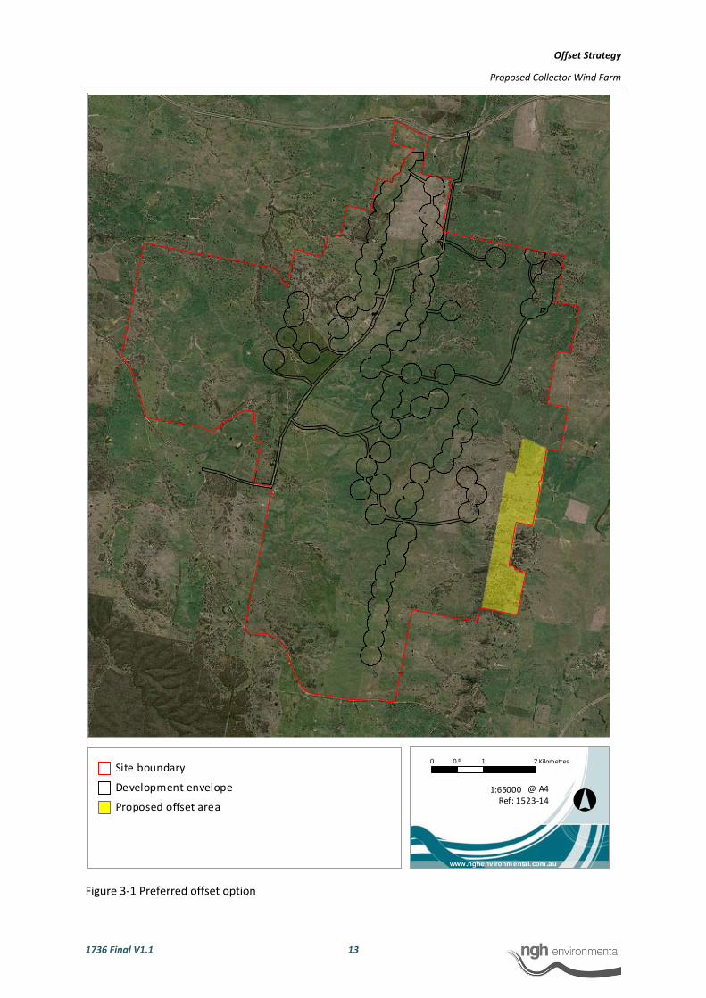
3.4 PREFERRED OFFSITE SITE
The preferred offset site is located within the project site boundaries on the south‐eastern boundary of the proposed wind farm site (Figure 3‐1). In total, the area available for use as an offset is approximately 200ha.
The broad vegetation mapping (provided in the Biodiversity Assessment, nghenvironmental, February 2012 Figure 3‐1) of the site shows that the offset site is comprised of Box‐Gum Woodland with tree cover with a small component of Box‐Gum Woodland Secondary Grassland. The majority is considered to be in moderate to good condition.
Extrapolating the hollow‐bearing tree quadrat data undertaken in the development envelope for woodland fauna habitat to the offset site, approximately 70007 hollow‐bearing trees (35 x 200ha) may be expected to occur within the offset site.
The site is considered highly suitable as an offset site for the following reasons:
• It maximises the component of the offset area that is of highest conservation value (EEC) achieving a ‘like for better’ offset.
• It is located in an area that contributes to landscape connectivity.
• It provides woodland fauna habitat and thereby can be used to offset removal of hollow‐bearing trees.
• It is owned by one land owner who is amenable to the establishment of an offset site (refer to Appendix C).
The management strategy proposed is for intensive management actions to be undertaken early in the life of the offset site, so that they are the responsibility of the wind farm operator, reducing longer‐term management obligations for the land owner. Management actions proposed include:
• Improving poor condition EEC through intensive management: o Fencing. o Managed grazing according to biomass indicators. o Intensive weed and feral animal management.
• Enhancing connectivity at a landscape scale: o Planting and protecting trees in specific areas.
7 As quadrats at the development envelope focussed on better quality habitat to achieve a precautionary estimate of hollows to be impacted, the hollow‐bearing tree densities, when applied to the offset site, may be an overestimate. However, it is considered a consistent comparison methodology and would be verified prior to construction impacts, in accordance with the recommendations of this strategy.

Offset Strategy
Proposed Collector Wind Farm
1736 Final V1.1 12
• Targeting gully erosion onsite: o Landform reshaping o Structures to diffuse surface flow
The proposed offset ratio is:
• 1:5 for areas of native vegetation to be permanently removed, where a ‘like for like’ or ‘like for better’ offset can be achieved. That is, impact areas would not be offset with areas of lesser value.
• 1:10 for hollow‐bearing trees required to be removed. The offset site must contain this many hollow‐bearing trees.
The low offset ratio would be justified on the basis of the ‘like for better’ able to be achieved and the intensity of management actions proposed both within the offset site and potentially in other areas during the construction of the wind farm. The ability to achieve these offset ratios is demonstrated in Table 3‐1.
Table 3‐1 Impacts compared to potential available offsets
Offseting areas of vegetation hectaresTotal area of permanent impact 24.62Offset area required at 1:5 123.1Total area available for use at the preferred offset site 200
Offseting removal of hollow‐bearing trees treesWorst case hollow‐bearing tree removal (calculated using quadrats) 46Offset tree number required at 1:10 460
More precise estimate of tree removal after micrositing (not all are hollow‐bearing) 37Offset tree number required at 1:10 370Estimated number of hollows available at the preferred offset site 7000
Offset Strategy
Proposed Collector Wind Farm
1736 Final V1.1 13
Figure 3‐1 Preferred offset option
Site boundary
Development envelope
Proposed offset area °
0 1 20.5 Kilometres
@ A4Ref: 1523‐14
1:65000
www.nghenvironmental.com.au
Offset Strategy
Proposed Collector Wind Farm
1736 Final V1.1 14
The site identified is within the site boundaries, across one landholding. It approximates 200 hectares. The corridor to the east of the site can be actively restored. This area includes Box‐Gum woodland qualifying as an EEC (Endangered Ecological Community).
SECURITY AND MANAGEMENT
It is proposed that the wind farm operator be responsible for the management of the offset site, during the operation of the wind farm. The operator is likely to finance the owner of the site to undertake management actions (such as fencing and weed control) and retain responsibility for the site. This provides surety that the actions will be undertaken, as the requirement to offset is a condition of the wind farm operator’s consent.
At the decommissioning stage, the ongoing management would be the responsibility of the landowner. It is expected that by this time the majority of the required management actions would have been undertaken and ongoing management tasks will largely coincide with routine agricultural activities.
A formal vehicle will be required to manage the offset site in perpetuity. A Property Vegetation Plan is the likely vehicle. The agreement will specify management recommendations and restrictions on land use, in accordance with the finalised offset plan for the site.
4 CONCLUSION This Offset Strategy sets out a methodology to define, secure and manage an offset site to offset the impacts of construction and operation of the proposed Collector Wind Farm. It has identified a site with suitable vegetation and habitat types, and means to ensure the final arrangement will accurately reflect the impacts of the wind farm. The proposed approach ensures surety regarding:
• Areas suitable to define the offset site.
• Ratios required to offset the impacts of the development.
• Management of the offset site.
• Security of the offset site, in perpetuity.

Offset Strategy
Proposed Collector Wind Farm
1736 Final V1.1 I
APPENDIX A PRINCIPLES FOR THE USE OF BIODIVERSITY OFFSETS IN NSW ‐ DISCUSSION
The following principles, developed by OEH, provide a useful framework for developing offset proposals. They have been considered in developing this offset strategy, as detailed below.
Impacts must be avoided first by using prevention and mitigation measures.
Offsets are then used to address remaining impacts. This may include modifying the proposal to avoid an area of biodiversity value or putting in place measures to prevent offsite impacts.
By way of iterative infrastructure planning, considering refined constraints mapping, the proposal has avoided and mitigated, proposing to offset only residual impacts. This is documented within the BA (nghenvironmental 2011).
All regulatory requirements must be met.
Offsets cannot be used to satisfy approvals or assessments under other legislation, e.g. assessment requirements for Aboriginal heritage sites, pollution or other environmental impacts (unless specifically provided for by legislation or additional approvals).
Not relevant to this proposal.
Offsets must never reward ongoing poor performance.
Offset schemes should not encourage landholders to deliberately degrade or mismanage offset areas in order to increase the value from the offset.
This can be addressed in two ways:
a) The offset site can be set up in perpetuity – this removes the incentive to degrade the offset site to facilitate development at a later date
b) The management measures can have clear targets and be set out to push most management to the beginning of the agreement, where successful accomplishment of targets would be rewarded by less intensive management in ongoing years. This suits measures such as weed control which are more easily achieved with intensive efforts than small ongoing efforts.
Offsets will complement other government programs.
A range of tools is required to achieve the NSW Government’s conservation objectives, including the establishment and management of new national parks, nature reserves, state conservation areas and regional parks and incentives for private landholders.
Not relevant to this proposal.

Offset Strategy
Proposed Collector Wind Farm
1736 Final V1.1 II
Offsets must be underpinned by sound ecological principles.
They must:
• include the consideration of structure, function and compositional elements of biodiversity, including threatened species
• enhance biodiversity at a range of scales • consider the conservation status of ecological communities • ensure the long‐term viability and functionality of biodiversity.
Biodiversity management actions, such as enhancement of existing habitat and securing and managing land of conservation value for biodiversity, can be suitable offsets. Reconstruction of ecological communities involves high risks and uncertainties for biodiversity outcomes and is generally less preferable than other management strategies, such as enhancing existing habitat.
The site boundaries contain vegetation of conservation value, able to be used as offsets. The BA provides a comprehensive evaluation of the value of the areas to be impacted to allow a suitable offset site to be defined.
Offsets should aim to result in a net improvement in biodiversity over time.
Enhancement of biodiversity in offset areas should be equal to or greater than the loss in biodiversity from the impact site.
Setting aside areas for biodiversity conservation without additional management or increased security is generally not sufficient to offset against the loss of biodiversity. Factors to consider include protection of existing biodiversity (removal of threats), time‐lag effects, and the uncertainties and risks associated with actions such as revegetation.
Offsets may include enhancing habitat, reconstructing habitat in strategic areas to link areas of conservation value, or increasing buffer zones around areas of conservation value and removal of threats by conservation agreements or reservation.
This strategy has:
• Identified threats to the proposed offset site
• Set out suitable management measures that can be undertaken for the long‐term
• Included enhancement options, where required
Offsets must be enduring ‐ they must offset the impact of the development for the period that the impact occurs.
As impacts on biodiversity are likely to be permanent, the offset should also be permanent and secured by a conservation agreement or reservation and management for biodiversity. Where land is donated to a public authority or a private conservation organisation and managed as a biodiversity offset, it should be accompanied by resources for its management. Offsetting should only proceed if an appropriate legal mechanism or instrument is used to secure the required actions.

Offset Strategy
Proposed Collector Wind Farm
1736 Final V1.1 III
The offset site is proposed to be secured until full decommissioning of the wind farm (and any rehabilitation or management associated with decommissioning).
Offsets should be agreed prior to the impact occurring.
Offsets should minimise ecological risks from time‐lags. The feasibility and in‐principle agreements to the necessary offset actions should be demonstrated prior to the approval of the impact. Legal commitments to the offset actions should be entered into prior to the commencement of works under approval.
It is proposed that all offset arrangements are in order prior to construction.
Offsets must be quantifiable ‐ the impacts and benefits must be reliably estimated.
Offsets should be based on quantitative assessment of the loss in biodiversity from the clearing or other development and the gain in biodiversity from the offset. The methodology must be based on the best available science, be reliable and used for calculating both the loss from the development and the gain from the offset. The methodology should include:
• the area of impact • the types of ecological communities and habitat/species affected • connectivity with other areas of habitat/corridors • the condition of habitat • the conservation status and/or scarcity/rarity of ecological communities • management actions • level of security afforded to the offset site.
These points are addressed in the calculation of impact areas and the management measures and security vehicles discussed in this document.
The best available information/data should be used when assessing impacts of biodiversity loss and gains from offsets. Offsets will be of greater value where:
• they protect land with high conservation significance • management actions have greater benefits for biodiversity • the offset areas are not isolated or fragmented • the management for biodiversity is in perpetuity (e.g. secured through a conservation
agreement).
In selecting a suitable offset site, the first three points have been considered.
Management actions must be deliverable and enforceable.
Addressed in this document.
Offsets must be targeted.
They must offset impacts on the basis of like‐for‐like or better conservation outcome. Offsets should be targeted according to biodiversity priorities in the area, based on the conservation status of the ecological community, the presence of threatened species or their habitat, connectivity and the potential to enhance condition by management actions and the removal of threats. Only ecological communities that are equal or greater in conservation status to the type of ecological community lost can be used for offsets. One

Offset Strategy
Proposed Collector Wind Farm
1736 Final V1.1 IV
type of environmental benefit cannot be traded for another: for example, biodiversity offsets may also result in improvements in water quality or salinity but these benefits do not reduce the biodiversity offset requirements.
Offsets have been proposed based on biodiversity values and achieve a ‘like for like’ or ‘like for better’ outcome.
Offsets must be located appropriately.
Wherever possible, offsets should be located in areas that have the same or similar ecological characteristics as the area affected by the development.
Locating the offset site adjacent to the impacts, within the site boundaries, achieves this aim.
Offsets must be supplementary.
They must be beyond existing requirements and not already funded under another scheme. Areas that have received incentive funds cannot be used for offsets. Existing protected areas on private land cannot be used for offsets unless additional security or management actions are implemented. Areas already managed by the government, such as national parks, flora reserves and public open space cannot be used as offsets.
The proposed offset site is currently privately owned and used for agricultural grazing activities. Management actions would reduce grazing pressure but retain private ownership. They would be supplementary.
Offsets and their actions must be enforceable through development consent conditions, licence conditions, conservation agreements or a contract.
Offsets must be audited to ensure that the actions have been carried out, and monitored to determine that the actions are leading to positive biodiversity outcomes.
The lease agreements with the wind farm developer and the landholders extend only for the life of the development and provide a vehicle to secure the management actions for the life of the project. Consideration of this timeframe allows for security in the sense that management actions on the offset site can be enforced using the lease agreements with landholders, providing both a revenue stream to undertake management actions and a means to force actions (by withholding lease payments) should actions not be carried out.
Post development, it is proposed all restrictions on the offset site be lifted. That is, the offset site would operate only for the life of the impact and would terminate with the completion of the decommissioning of the wind farm.

Offset Strategy
Proposed Collector Wind Farm
1736 Final V1.1 V
APPENDIX B MANAGEMENT MEASURES APPROPRIATE TO OFFSETTING WITHIN THE SITE BOUNDARIES
The aim of the offset site management strategies is to maintain or improve the values of the offset site – no loss of value. Management intensity has a bearing on improvement and thereby offset ratios:
• Intensive management could include addressing issues such as erosion, revegetation of link areas. This could be done largely during the wind farm construction, leaving a smaller ongoing management requirement for the landowner. As a larger improvement would be expected, lower ratios could be justified. This strategy may be most acceptable to the landowner in the longer term.
• Minimal proposed management would be in line as much as possible with agricultural land management so that it could be undertaken by land managers largely in conjunction with normal on‐farm practices. Examples include weed management, stock exclusion. This may appear more acceptable initially to the land owner but would require larger offset ratios, as not much improvement would be expected.
It is proposed that the wind farm operator be responsible for the management of the offset site, during the operation of the wind farm. The operator is likely to finance the owner of the site to undertake management actions (such as fencing and weed control) however, by retaining responsibility for the site, additional security it achieved.
At the decommissioning stage, the ongoing management would be the responsibility of the landowner. It is expected that by this time the majority of the required management actions would have been undertaken and ongoing management tasks will largely coincide with routine agricultural activities.
The following table sets out the range of suitable management actions, the aim of each measure, the rationale for undertaking it at the site and an auditable measure of its implementation.
Offset Strategy
Proposed Collector Wind Farm
1736 Final V1.1 VI
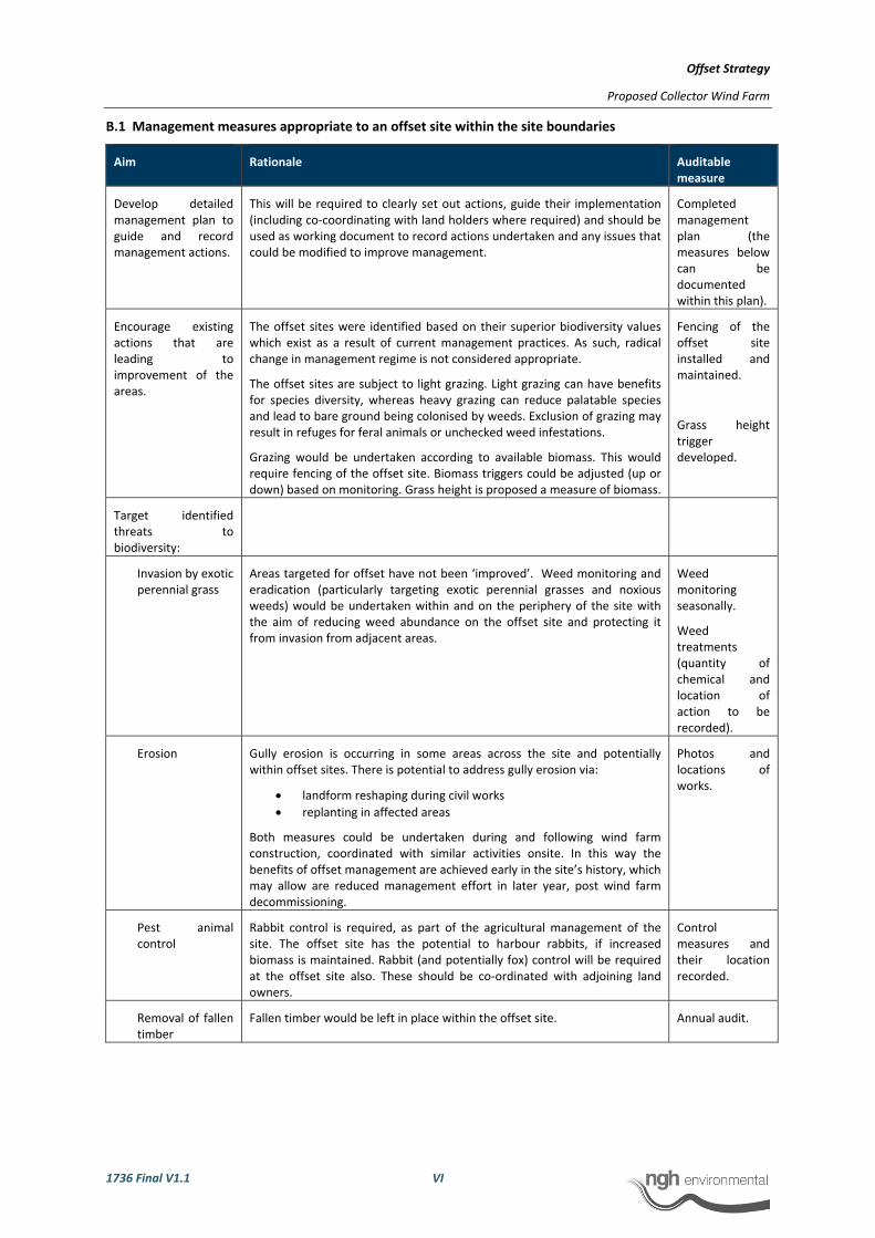
B.1 Management measures appropriate to an offset site within the site boundaries
Aim Rationale Auditable measure
Develop detailed management plan to guide and record management actions.
This will be required to clearly set out actions, guide their implementation (including co‐coordinating with land holders where required) and should be used as working document to record actions undertaken and any issues that could be modified to improve management.
Completed management plan (the measures below can be documented within this plan).
Encourage existing actions that are leading to improvement of the areas.
The offset sites were identified based on their superior biodiversity values which exist as a result of current management practices. As such, radical change in management regime is not considered appropriate.
The offset sites are subject to light grazing. Light grazing can have benefits for species diversity, whereas heavy grazing can reduce palatable species and lead to bare ground being colonised by weeds. Exclusion of grazing may result in refuges for feral animals or unchecked weed infestations.
Grazing would be undertaken according to available biomass. This would require fencing of the offset site. Biomass triggers could be adjusted (up or down) based on monitoring. Grass height is proposed a measure of biomass.
Fencing of the offset site installed and maintained.
Grass height trigger developed.
Target identified threats to biodiversity:
Invasion by exotic perennial grass
Areas targeted for offset have not been ‘improved’. Weed monitoring and eradication (particularly targeting exotic perennial grasses and noxious weeds) would be undertaken within and on the periphery of the site with the aim of reducing weed abundance on the offset site and protecting it from invasion from adjacent areas.
Weed monitoring seasonally.
Weed treatments (quantity of chemical and location of action to be recorded).
Erosion Gully erosion is occurring in some areas across the site and potentially within offset sites. There is potential to address gully erosion via:
• landform reshaping during civil works • replanting in affected areas
Both measures could be undertaken during and following wind farm construction, coordinated with similar activities onsite. In this way the benefits of offset management are achieved early in the site’s history, which may allow are reduced management effort in later year, post wind farm decommissioning.
Photos and locations of works.
Pest animal control
Rabbit control is required, as part of the agricultural management of the site. The offset site has the potential to harbour rabbits, if increased biomass is maintained. Rabbit (and potentially fox) control will be required at the offset site also. These should be co‐ordinated with adjoining land owners.
Control measures and their location recorded.
Removal of fallen timber
Fallen timber would be left in place within the offset site. Annual audit.

Offset Strategy
Proposed Collector Wind Farm
1736 Final V1.1 VII
Aim Rationale Auditable measure
Removal of hollow‐bearing trees
Nest boxes to emulate hollow‐bearing trees could be added to the offset site to preserve the overall abundance of hollows across the project boundaries.
Documentation of number of nest boxes installed to number of hollows removed.
One‐off audit, once installed.
Encourage overstorey regeneration
Tree saplings detected within previously cleared areas would be selectively fenced and protected from grazing until established. Trees would be selected at similar densities to more intact woodland remnants.
Documentation of location of trees to be protected
Installation and maintenance of protective fencing.
Fire management Fire can be used to improve species diversity in grasslands. Controlled burns, of prescribed season and intensity, could be used to enhance native diversity.
Documentation of location and timing of burns.
Be adaptive to the results obtained during monitoring.
All actions above would be assessed in an annual report aiming to document:
• Details of all actions undertaken throughout the year. • Any change in condition, observed seasonally.
The information could be collected by the land manager and one annual monitoring session undertaken by an independent ecologist who would assessable the yearly report and revise management prescriptions as required to achieve improvement at the site.
This report can be used to review the effectiveness of actions in consultation with the land manager. As well, it could be independent verification that lease requirements are being adequately fulfilled.
Annual report, provided to Dept. Planning and Wind Farm Developer.

Offset Strategy
Proposed Collector Wind Farm
1736 Final V1.1 VIII
APPENDIX C INVESTIGATIONS WITH LANDOWNERS: PREFERRED OFFSET OPTION
investigations with landowners: preferred offset option
Discussions have commenced with Mr. Gary Poile of the Lake George Apairies land holding, identified in Figure 3‐1 Preferred offset option. The Poile Trust has confirmed that they are happy to allow APP/Transfield to present and discuss the current offset strategy with OEH for the purpose of exploring its suitability. Mr. Poile has outlined his holistic approach to his property below.
Mr Poile notes that when purchased in 1987, "Melliodora Park" was degraded with large areas of soil erosion and some saline affected areas. Weeds such as serrated tussock and gorse bush posed some threat but were not a major issue and some areas were being impacted by rabbits. The property was open woodland with native pastures. Internal fences had fallen into disrepair and stock were grazing the whole property as one block.
Pasture and grazing management since this time has promoted a greater diversity of pasture species and recovery of riparian areas in particular that were previously very degraded.
In 1999, in a joint project with NSW Land & Water Conservation, 20 hectares were fenced off to preserve remnant vegetation for ten years. The project has been successful with remnant vegetation in these areas not only surviving the ten years of drought in good condition but abundant regeneration is also occurring (especially of the ground cover and understory) and could provide a case study for further expansion of this practise under the proposed offset program.
In addition to sheep grazing, beekeeping is also undertaken at the property.
Other areas, such as control of weeds and rabbits and maintenance of fencing require constant effort and account for a considerable amount of the time and money.
Mr. Poile is amenable to the establishment of an offset site on his property. If undertaken as suggested in this offset strategy, the wind farm operator would be responsible for the management of the offset site during the operational life of the wind farm, providing surety that funding is made available for the appropriate management of the site.