Embed Size (px)
Citation preview

Combining digital flat-panel display sophistication with the power
of high-speed computer processing, Garmin’s MX20 is a major
advance in information technology for the cockpit. Loaded with
features, the MX20’s versatile design offers multiple charting
options and overlays – in pilot-selectable combinations – to achieve
unprecedented levels of safety and situational awareness in flight.
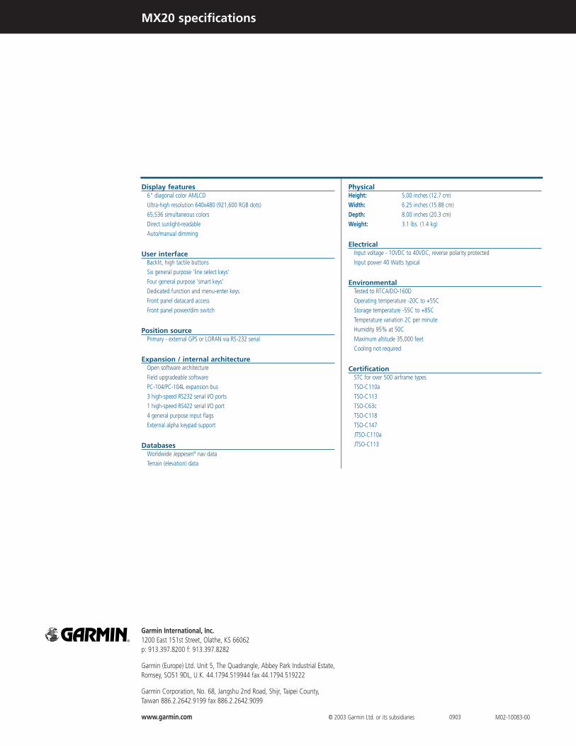
Display features6" diagonal color AMLCD
Ultra-high resolution 640x480 (921,600 RGB dots)
65,536 simultaneous colors
Direct sunlight-readable
Auto/manual dimming
User interfaceBacklit, high tactile buttons
Six general purpose 'line select keys'
Four general purpose 'smart keys'
Dedicated function and menu-enter keys
Front panel datacard access
Front panel power/dim switch
Position sourcePrimary - external GPS or LORAN via RS-232 serial
Expansion / internal architectureOpen software architecture
Field upgradeable software
PC-104/PC-104L expansion bus
3 high-speed RS232 serial I/O ports
1 high-speed RS422 serial I/O port
4 general purpose input flags
External alpha keypad support
DatabasesWorldwide Jeppesen® nav data
Terrain (elevation) data
PhysicalHeight: 5.00 inches (12.7 cm)
Width: 6.25 inches (15.88 cm)
Depth: 8.00 inches (20.3 cm)
Weight: 3.1 lbs. (1.4 kg)
ElectricalInput voltage - 10VDC to 40VDC, reverse polarity protected
Input power 40 Watts typical
EnvironmentalTested to RTCA/DO-160D
Operating temperature -20C to +55C
Storage temperature -55C to +85C
Temperature variation 2C per minute
Humidity 95% at 50C
Maximum altitude 35,000 feet
Cooling not required
CertificationSTC for over 500 airframe types
TSO-C110a
TSO-C113
TSO-C63c
TSO-C118
TSO-C147
JTSO-C110a
JTSO-C113
Garmin International, Inc. 1200 East 151st Street, Olathe, KS 66062 p: 913.397.8200 f: 913.397.8282
Garmin (Europe) Ltd. Unit 5, The Quadrangle, Abbey Park Industrial Estate, Romsey, SO51 9DL, U.K. 44.1794.519944 fax 44.1794.519222
Garmin Corporation, No. 68, Jangshu 2nd Road, Shijr, Taipei County, Taiwan 886.2.2642.9199 fax 886.2.2642.9099
www.garmin.com © 2003 Garmin Ltd. or its subsidiaries M02-10083-000903
MX20 specifications

MX20 multi-function display
Pilots who can visualize
their flight situation
at a glance
tend to make
better decisions
than those who can’t.
There are basically two kinds of
information most pilots want from
a multi-function display:
(1) The kind that helps them see
and avoid potential hazards, and
(2) the kind that helps them plan
and anticipate what’s needed for
a trouble-free flight.
For both kinds of "big picture"
situational awareness, the Apollo
MX20 is a welcome new benchmark
in pilot workload-reduction.
Providing a wealth of useful features
and information for every phase of flight –
from preflight checklist to final approach
and taxi to the ramp – the MX20 offers
easy, affordable access to MFD functions
previously found only on high-end air
transport and business jet systems.
The editors at Aviation Consumer
magazine were so impressed they
named the MX20 their 2001
"Product of the Year."
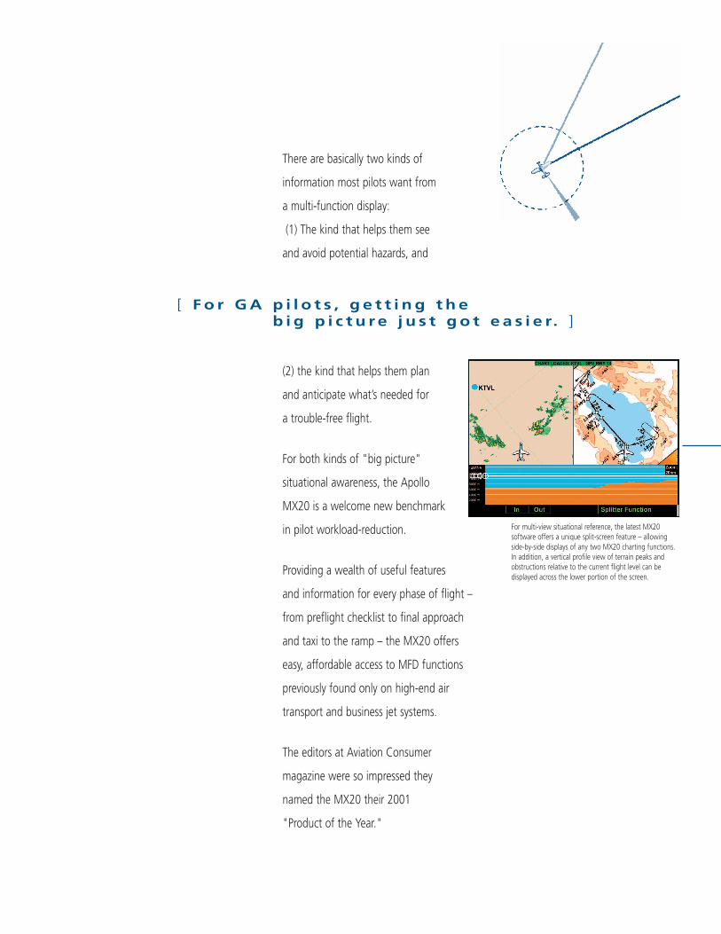
For multi-view situational reference, the latest MX20software offers a unique split-screen feature – allowingside-by-side displays of any two MX20 charting functions.In addition, a vertical profile view of terrain peaks andobstructions relative to the current flight level can bedisplayed across the lower portion of the screen.
[ F o r G A p i l o t s , g e t t i n g t h e b i g p i c t u r e j u s t g o t e a s i e r. ]
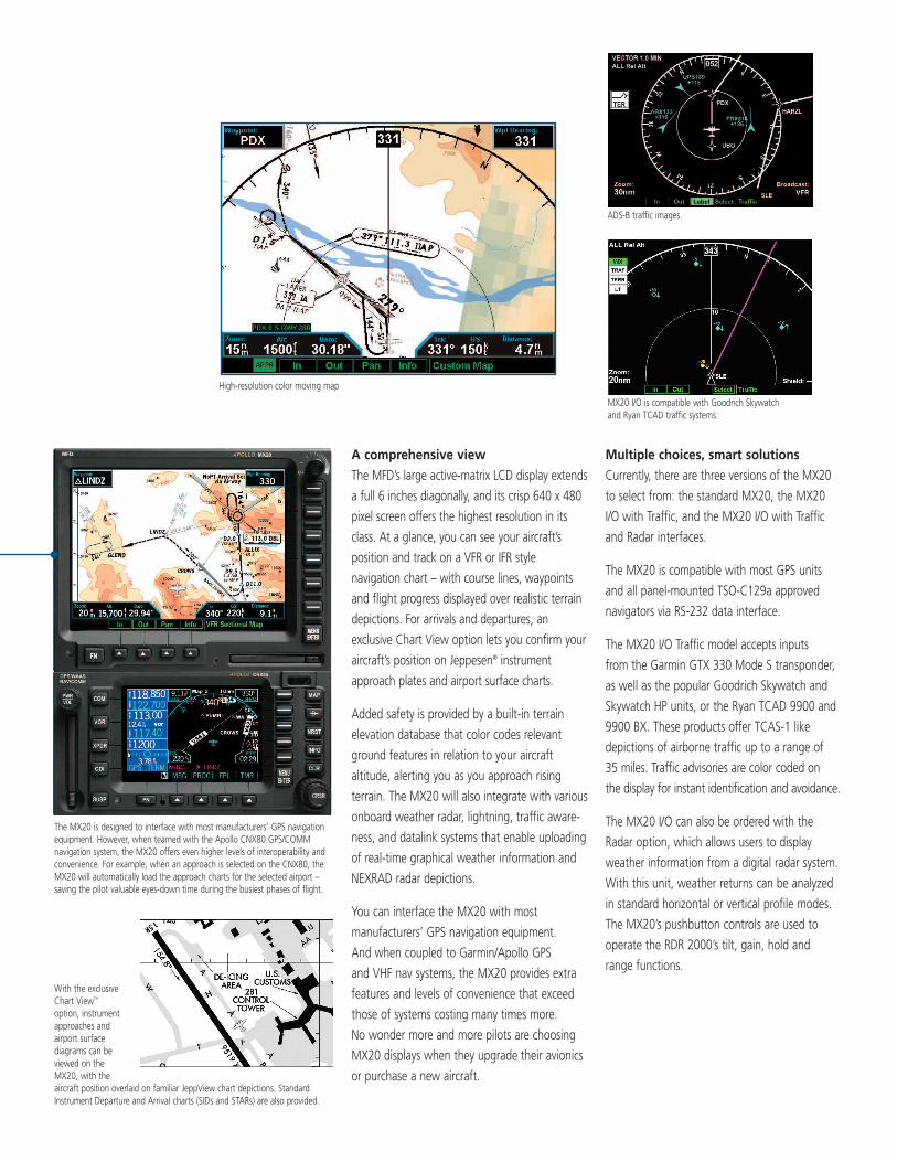
A comprehensive viewThe MFD’s large active-matrix LCD display extends
a full 6 inches diagonally, and its crisp 640 x 480
pixel screen offers the highest resolution in its
class. At a glance, you can see your aircraft’s
position and track on a VFR or IFR style
navigation chart – with course lines, waypoints
and flight progress displayed over realistic terrain
depictions. For arrivals and departures, an
exclusive Chart View option lets you confirm your
aircraft’s position on Jeppesen® instrument
approach plates and airport surface charts.
Added safety is provided by a built-in terrain
elevation database that color codes relevant
ground features in relation to your aircraft
altitude, alerting you as you approach rising
terrain. The MX20 will also integrate with various
onboard weather radar, lightning, traffic aware-
ness, and datalink systems that enable uploading
of real-time graphical weather information and
NEXRAD radar depictions.
You can interface the MX20 with most
manufacturers’ GPS navigation equipment.
And when coupled to Garmin/Apollo GPS
and VHF nav systems, the MX20 provides extra
features and levels of convenience that exceed
those of systems costing many times more.
No wonder more and more pilots are choosing
MX20 displays when they upgrade their avionics
or purchase a new aircraft.
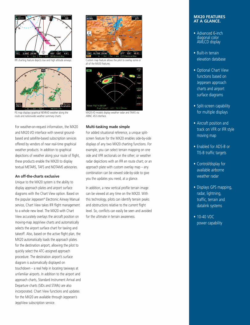
Multiple choices, smart solutions Currently, there are three versions of the MX20
to select from: the standard MX20, the MX20
I/O with Traffic, and the MX20 I/O with Traffic
and Radar interfaces.
The MX20 is compatible with most GPS units
and all panel-mounted TSO-C129a approved
navigators via RS-232 data interface.
The MX20 I/O Traffic model accepts inputs
from the Garmin GTX 330 Mode S transponder,
as well as the popular Goodrich Skywatch and
Skywatch HP units, or the Ryan TCAD 9900 and
9900 BX. These products offer TCAS-1 like
depictions of airborne traffic up to a range of
35 miles. Traffic advisories are color coded on
the display for instant identification and avoidance.
The MX20 I/O can also be ordered with the
Radar option, which allows users to display
weather information from a digital radar system.
With this unit, weather returns can be analyzed
in standard horizontal or vertical profile modes.
The MX20’s pushbutton controls are used to
operate the RDR 2000’s tilt, gain, hold and
range functions.
ADS-B traffic images.
MX20 I/O is compatible with Goodrich Skywatch and Ryan TCAD traffic systems.
High-resolution color moving map
The MX20 is designed to interface with most manufacturers’ GPS navigationequipment. However, when teamed with the Apollo CNX80 GPS/COMMnavigation system, the MX20 offers even higher levels of interoperability andconvenience. For example, when an approach is selected on the CNX80, theMX20 will automatically load the approach charts for the selected airport –saving the pilot valuable eyes-down time during the busiest phases of flight.
With the exclusiveChart View™
option, instrumentapproaches andairport surfacediagrams can beviewed on theMX20, with theaircraft position overlaid on familiar JeppView chart depictions. StandardInstrument Departure and Arrival charts (SIDs and STARs) are also provided.
For weather-on-request information, the MX20
and MX20 I/O interface with several ground-
based and satellite-based subscription services
offered by vendors of near real-time graphical
weather products. In addition to graphical
depictions of weather along your route of flight,
these products enable the MX20 to display
textual METARS, TAFS and NOTAMS advisories.
An off-the-charts exclusiveUnique to the MX20 system is the ability to
display approach plates and airport surface
diagrams with the Chart View option. Based on
the popular Jeppesen® Electronic Airway Manual
service, Chart View takes IFR flight management
to a whole new level. The MX20 with Chart
View accurately overlays the aircraft position on
moving-map JeppView charts and automatically
selects the airport surface chart for taxiing and
takeoff. Also, based on the active flight plan, the
MX20 automatically loads the approach plates
for the destination airport, allowing the pilot to
quickly select the ATC-assigned approach
procedure. The destination airport’s surface
diagram is automatically displayed on
touchdown – a real help in locating taxiways at
unfamiliar airports. In addition to the airport and
approach charts, Standard Instrument Arrival and
Departure charts (SIDs and STARs) are also
incorporated. Chart View functions and updates
for the MX20 are available through Jeppesen’s
JeppView subscription service.
Multi-tasking made simpleFor added situational reference, a unique split-
screen feature for the MX20 enables side-by-side
displays of any two MX20 charting functions. For
example, you can select terrain mapping on one
side and VFR sectionals on the other; or weather
radar depictions with an IFR en route chart; or an
approach plate with custom overlay map – any
combination can be viewed side-by-side to give
you the updates you need, at a glance.
In addition, a new vertical profile terrain image
can be viewed at any time on the MX20. With
this technology, pilots can identify terrain peaks
and obstructions relative to the current flight
level. So, conflicts can easily be seen and avoided
for the ultimate in terrain awareness.
MX20 FEATURES AT A GLANCE.
• Advanced 6-inchdiagonal color AMLCD display
• Built-in terrain elevation database
• Optional Chart Viewfunctions based onJeppesen approachcharts and airportsurface diagrams
• Split-screen capabilityfor multiple displays
• Aircraft position andtrack on VFR or IFR stylemoving map
• Enabled for ADS-B orTIS-B traffic targets
• Control/display foravailable airborneweather radar
• Displays GPS mapping,radar, lightning, traffic, terrain anddatalink systems
• 10-40 VDC power capability
IFR charting feature depicts low and high altitude airways. Custom map feature allows the pilot to overlay some orall of the MX20 features.
MX20 I/O models display weather radar and TAWS viaARINC 453 interface.
FIS map displays graphical NEXRAD weather along theroute and nationwide weather summary charts.