Embed Size (px)
Citation preview

OCEAN BOUNDARIES IN THE SOUTH PACIFIC*
by Sherry Broder" and Jon Van Dyke,*·· with the assistance of Faye Kimurat and Naomi Hirayasutt
CONTENTS
I. INTRODUCTION..................................... 3 A. National Jurisdiction Over Ocean Space . . . . . . . . . . . . . 3 B. What Is at Stake? . . . . . . . . . . . . . . . . . . . . . . . . . . . . . . . . . 7
II. TONGA.............................................. 9 A. The Friendly Isles . . . . . . . . . . . . . . . . . . . . . . . . . . . . . . . . . 9 B. Tonga's Historic Title Claim. . . . . . . . . . . . . . . . . . . . . . . . 12
1. Background .......................... _ . . . . . . . . 12 2. The Juridical Regime of Historic Waters . . . . . . . . . 15
a. Exercise of Authority Over the Area Claimed 17 b. Continuity of the Exercise of Authority . . . . . 18 c. Attitude of Foreign Nations. . . . . . . . . . . . . . . . 19 d. Other Considerations . . . . . . . . . . . . . . . . . . . . . . 19
• C Copyright 1982, Sherry Broder and Jon Van Dyke. This paper is a result of research (Projects PP/R-4 and PP/R-5) sponsored in part by the University of Hawaii Sea Grant College Program under Institutionalized Grants No. NA79AA-DOOO85 and NA81AA-DOOO70 from NOAA, Office of Sea Grant, Department of Commerce. Sea Grant journal contribution UNIHI-SEA GRANT-JC-82-09. Assistance for this work has also been received from the Marine Affairs Coordinator, Department of Planning and Economic Development, State of Hawaii; the Environment and Policy Institute, East-West Center; and the University of Hawaii School of Law. The maps were adapted for this article by Miratul Mahiuddin, Ph.D. candidate, Geography Department, University of Hawaii at Manoa .
.. Attorney, Honolulu, Hawaii. B.A. Wellesley College, 1970; J.D., University of California, Berkeley, 1975. Member of the Hawaii and California Bars .
••• Associate Dean and Professor of Law, University of Hawaii at Manoa; Adjunct Research Associate, Environment and Policy Institute, East-West Center, Honolulu. B.A., Yale University, 1964; J.D., Harvard Law School, 1967. Member of the Hawaii, California and District of Columbia Bars.
t Attorney, Honolulu, Hawaii. B.A., University of Hawaii at Manoa, 1973; J.D., University of Hawaii at Manoa, 1980. Member of the Hawaii Bar.
tt Attorney, Palau. B.A., Middlebury College, 1973; J.D., University of Hawaii at Manoa, 1981. Member of the Hawaii Bar.
1
2 UNIVERSITY OF HA WAIl LA W REVIEW [Vol. 4
3. Other Unique Ocean Boundary Situations: Historic Claims by the Philippines and the Republic of Maldives . . . . . . . . . . . . . . . . . . . . . . . . . . . . . . . . . . . . . . 20
4. Applying the Archipelagic Principles of UNCLOS III to Tonga. . . . . . . . . . . . . . . . . . . . . . . . . . . . . . . . . . . 23
C. Tonga's Claim to Teleki Tonga and Teleki Tokelau (the Minerva Reefs) . . . . . . . . . . . . . . . . . . . . . . . . . . . . . . . . . . . . 26 1. Background................................... 26 2. Are Teleki Tonga and Teleki Tokelau "Islands"
According to the Norms of International Law? . . . . 29 a. The 1930 League of Nations Codification
Conference at the Hague .................. 30 b. The International Law Commission-1952,
1954, 1956. . . . . . . . . . . . . . . . . . . . . . . . . . . . . . . . 30 c. The 1958 Geneva Convention and the Third
U.N. Conference on the Law of the Sea. . . . . 33 3. Are Teleki Tonga and Teleki Tokelau Entitled to
Safety Zones? . . . . . . . . . . . . . . . . . . . . . . . . . . . . . . . . . . 37 III. FIJI.................................................. 37
A. An Archipelagic State. . . . . . . . . . . . . . . . . . . . . . . . . . . . . . 37 B. Fiji's Claim to Ceva-i-Ra (Conway Reef) . . . . . . . . . . . . . 39 C. Approaches to Delimitation. . . . . . . . . . . . . . . . . . . . . . . . . 40
IV. DELIMITING THE BOUNDARIES. . . . . . . . . . . . . . . . . . . . . 42 A. The Competing Claims. . . . . . . . . . . . . . . . . . . . . . . . . . . . . 42
1. Tonga......................................... 42 2. Fiji........................................... 43 3. New Zealand (The Kermadec Islands). . . . . . . . . . . . 43
B. Equitable Principles . . . . . . . . . . . . . . . . . . . . . . . . . . . . . . . 44 1. The Anglo-French Continental Shelf Arbitration. . 45 2. Treaty Between Australia and Papua New Guinea 46 3. Dependency on Fish Resources . . . . . . . . . . . . . . . . . . 48
V. WESTERN SAMOA AND AMERICAN SAMOA. . . . . . . . . 50 A. Introduction......... . . . . . . . . . . . . . . . . . . . . . . . . . . . . . 50 B. Western Samoa ................................... 50 C. American Samoa .................................. 52 D. Specific Problem Areas. . . . . . . . . . . . . . . . . . . . . . . . . . . . . 52
1. Rose Island. . . . . . . . . . . . . . . . . . . . . . . . . . . . . . . . . . . . 52 2. Swains Island. . . . . . . . . . . . . . . . . . . . . . . . . . . . . . . . . . 53 3. Tafahi and Niuatoputapu Islands (Tonga) . . . . . . . . 56
VI. SUMMARY AND CONCLUSION. . . . . . . . . . . . . . . . . . . . . . . 57

1982] OCEAN BOUNDARIES 3
I. INTRODUCTION
A. National Jurisdiction Over Ocean Space
The island communities of the South Pacific have an unique relationship to the sea because the land area of their islands is small compared to that of the surrounding ocean. They have developed economies and cultures highly dependent on the sea. Their ocean boundaries are essential to their self-definition and preservation.
This article will analyze maritime claims of South Pacific political communities that could produce conflicts. The claims are those of Tonga, Fiji, New Zealand (the Kermadec Islands), American Samoa, Western Samoa, New Caledonia and Vanuatu. Several special circumstances make the South Pacific an interesting focus for such an analysis. Tonga, Fiji and American Samoa claim reefs or islands that are far from their main island groups. Recognition of these geological formations as islands would permit these countries to claim adjacent 200-nautical-mile exclusive economic zones,! which would greatly expand their maritime jurisdiction. Another potential problem is Tonga's 1887 claim, which defined its boundaries in terms of geographic coordinates,S and which has been reasserted by Tonga in recent years. S It is difficult to predict how these claims will mesh with the concepts being developed at the Third United Nations Conference on the Law of the Sea (UNCLOS 111).4 These claims and the
I The exclusive economic zone is a zone extending not more than 200 nautical miles from the baselines from which the breadth of the territorial sea is measured. Draft Convention on the Law of the Sea (Formal Text), U.N. Doc. AI CONF.62/L.78 (1981), arts. 55, 57 [hereinafter cited as "Draft Convention"). In the exclusive economic zone, a coastal state has sovereign rights over the natural resources, living or non-living, of the seabed, subsoil and superjacent waters. [d. art. 56.
A coastal state is also entitled to a territorial sea, which extends the sovereignty of the state beyond its land territory over an adjacent belt of sea of not more than twelve miles. This sovereignty extends to the air space as well as to the seabed and subsoil. [d. arts. 2-3. Although a nation does not possess as great a bundle of rights in its exclusive economic zone as in its territorial sea, the rights of a nation to control its natural resources in its exclusive economic zone are still extensive.
• See note 26 infra and accompanying text. • See note 28 infra and accompanying text. See also text accompanying note 54 infra. • The Third United Nations Conference on the Law of the Sea has been in progress since
1974. Virtually all nations of the world have been participating in the negotiations. The Conference completed its work in the spring of 1982, and has scheduled a signing in Caracas, Venezuela, for December, 1982. For descriptions of the progress of the negotiations, see Oxman, The Third United Nations Conference on the Law of the Sea: The Eighth Session (1979), 74 AM. J. INT'L L. 1 (1980); Oxman, The Third United Nations Conference on the Law of the Sea: The Seventh Session (1978), 73 AM. J. INT'L L. 1 (1979); Oxman, The Third United Nations Conference on the Law of the Sea: The 1977 New York Session, 72 AM. J. INT'L L. 57 (1978); Oxman, The Third United Nations Conference on the Law of the Sea; The 1976 New York Sessions, 71 AM. J. INT'L L. 247 (1977); Oxman, The Third United Nations Conference on the Law of the Sea: The 1975 Geneva Session, 69 AM. J. INT'L L. 763 (1975); Oxman, The Third United Nations Conference on the Law of the Sea:

4 UNIVERSITY OF HA WAIl LA W REVIEW [Vol. 4
close geographic configuration of the nations making the claims create potentially overlapping maritime boundaries which may create conflicting areas of jurisdiction.
In other parts of the world, ocean boundary disputes have been major topics of international controversy. The International Court of Justice has considered a maritime boundary problem in the North Sea,!1 arbitration tribunals have been established in several locations,8 treaties have been negotiated to resolve many disputes7 and the delegates to the United Nations Law of the Sea conferences have labored long and hard to articulate the standards that should govern these disputes.
The standard adopted in 1958 in the Convention on the Continental Shelf8 and the Convention on the Territorial Sea and Contiguous Zone' emphasized the equidistance principle, which requires the splitting of a disputed area between the countries involved. to This reference to the
The 1974 Caracas Session, 69 AM. J. INT'L L. 1 (1975); Stevenson & Oxman, The Preparations for the Law of the Sea Conference, 68 AM. J. INT'L L. 1 (1974).
• N. Sea Continental Shelf Cases, [1969] I.C.J. 4. • Arbitration between the United Kingdom of Great Britain and Northern Ireland and
the French Republic on the Delimitation of the Continental Shelf (1977-78), reprinted in 18 INT'L LEGAL MATERIALS 397 (1979) (American Society of International Law, D.C.) [hereinafter cited as "Anglo-French Arbitration, 18 I.L.M. 397"].
7 See, e.g., U.S. DEP'T OF STATE, BUREAU OF INTELLIGENCE AND RESEARCH, OFFICE OF THE GEOGRAPHER, LIMITS IN THE SEAS No. 87, TERRITORIAL SEA AND CONTINENTAL SHELF BOUNDARIES: AUSTRALIA AND PAPUA NEW GUINEA-INDONESIA (1979); U.S. DEP'T OF STATE, BUREAU OF INTELLIGENCE AND RESEARCH, OFFICE OF THE GEOGRAPHER, LIMITS IN THE SEAS No. 75, CONTINENTAL SHELF BOUNDARY AND JOINT DEVELOPMENT ZONE: JAPAN-REPUBLIC OF KOREA (1977) [hereinafter cited as "JAPAN-REPUBLIC OF KOREA JOINT DEVELOPMENT ZONE"].
8 Convention on the Continental Shelf, Apr. 29, 1958, 15 U.S.T. 471, T.I.A.S. No. 5578, 499 U.N.T.S. 311.
o Convention on the Territorial Sea and Contiguous Zone, Apr. 29, 1958, 15 U.S.T. 1606, T.I.A.S. No. 5639, 516 U.N.T.S. 205.
10 Article 6 (1)-(2) of the Convention on the Continental Shelf, supra note 8, reads as follows:
1. Where the same continental shelf is adjacent to the territories of two or more States whose coasts are opposite each other, the boundary of the continental shelf appertaining to such States shall be determined by agreement between them. In the absence of agreement, and unless another boundary line is justified by special circumstances, the boundary is the median line, every point of which is equidistant from the nearest points of the baselines from which the breadth of the territorial sea of each State is measured. . 2. Where the same continental shelf is adjacent to the territories of two adjacent States, the boundary of the continental shelf shall be determined by agreement between them. In the absence of agreement, and unless another boundary line is justified by special circumstances, the boundary shall be determined by application of the principle of equidistance from the nearest points of the baselines from which the breadth of the territorial sea of each State is measured.
Article 12(1) of the Convention on the Territorial Sea and Contiguous Zone, supra note 9, reads as follows:
Where the coasts of two States are opposite or adjacent to each other, neither of the two States is entitled, failing agreement between them to the contrary, to extend its
1982] OCEAN BOUNDARIES 5
equidistance approach continued in the early versions of the current Draft Convention,l1 but in 1981 the text was amended to eliminate any mention of equidistance. The version adopted in the summer of 1981 reads as follows: "The delimitation of the exclusive economic zone between States with opposite or adjacent coasts shall be effected by agreement on the basis of international law, as referred to in Article 38 of the Statute of the International Court of Justice, in order to achieve an equitable solution."12
territorial sea beyond the median line every point of which is equidistant from the nearest points on the baseline from which the breadth of the territorial seas of each of the two States is measured. The provisions of this paragraph shall not apply, however, where it is necessary by reason of historic title or other special circumstances to delimit the territorial seas of the two States in a way which is at variance with this provision.
Adjacent states are those states having a common land boundary. Opposite states do not share a land boundary, but lie across an area of water from each other.
Current analysis of delimitation rules can be traced to the reports prepared in 1951 and 1953 by the International Law Commission to the General Assembly. Report of the International Law Commission to the General Assembly, 6 U.N. GAOR Supp. (No.9), U.N. Doc. A/ 1858 (1951), reprinted in (1951) 2 Y.B. INT'L L. COMM'N 123 at 143, U.N. Doc. A.CNAISer. A/1951/Add.1; Report of the International Law Commission to the General Assembly, 8 U.N. GAOR Supp. (No.9), U.N. Doc. A/2456 (1953), reprinted in (1953) 2 Y.B. INT'L L. COMM'N 200 at 213, U.N. Doc. A/CN.4/Ser.A/1953/Add.1. These reports indicate that the Commission's proposals for continental shelf and territorial sea delimitation were negotiation and the principle of equidistance. The commentary noted that "departures necessitated by any exceptional configuration of the coast, as well as the presence of islands or of navigable channels" are justifiable deviations from the general rule. The Commission emphasized that the situations suggested as special circumstances were illustrative, not exhaustive, and acknowledged that the rule was "elastic." The Commission stated: "This case may arise fairly often." Report of the International Law Commission to the General Assembly, 11 U.N. GAOR Supp. (No.9), U.N. Doc. A/ 3159 (1956), reprinted in (1956) 2 Y.B. INT'L L. COMM'N 300, U.N. Doc. A/CNA/Ser. A/1956N.2.
Tonga and Fiji both ratified the Convention on the Territorial Sea and Contiguous Zone as well as the Convention on the Continental Shelf. New Zealand ratified the Convention on the Continental Shelf, but did not ratify the Convention on the Territorial Sea and Contiguous Zone. U.S. DEP'T OF STATE, TREATIES IN FORCE 317-18 (1980).
11 See Draft Convention on the Law of the Sea (Informal Text), U.N. Doc. A/CONF. 621 W.P. 10!Rev. 3 (Aug. 27, 1980), art. 74(1):
1. The delimitation of the exclusive economic zone between States with opposite or adjacent coasts shall be effected by agreement by conformity with international law. Such an agreement shall be in accordance with equitable principles, employing the median or equidistance line, where appropriate, and taking account of all circumstances prevailing in the area concerned.
Article 83 on the delimitation of the continental shelf boundaries had virtually identical language.
For an in-depth discussion of the debate in the lengthy negotiations to formulate a compromise treaty text on delimitation, see Adede, Toward the Formulation of the Rule of Delimitation of Sea Boundaries Between States With Adjacent or Opposite Coasts, 19 VA. J. INT'L L. 207 (1979); U.N. Press Release SEA/376 at 15-16 (Feb. 27, 1980); U.N. Press Release SEA/396 at 4, 30-32 (Apr. 4, 1980).
,. Draft Convention, supra note 1, art. 74(1) (as amended). Paragraphs 2, 3 and 4 of article 74 highlight the significance of agreement in providing for arrangements prior to a

6 UNIVERSITY OF HAWAII LA W REVIEW [Vol. 4
This new language was designed in part to refer to the decision in the North Sea Continental Shelf Cases,18 where the International Court of Justice stated that "delimitation is to be effected by agreement in accordance with equitable principles."14 In addition, the delegates to the 1981
final agreed delimitation, in making provision for resolution of differences in reaching agreement and in stating that an agreement in force between nations shall determine any future
. questions of delimitation: 2. If no agreement can be reached within a reasonable period of time, the States concerned shall resort to the procedures provided for in Part XV. 3. Pending agreement as provided for in paragraph I, the States concerned, in a spirit of understanding and cooperation, shall make every effort to enter into provisional arrangements of a practical nature and, during this transitional period, not to jeopardize or hamper the reaching of the final agreement. Such arrangements shall be without prejudice to the final determination. 4. Where there is an agreement in force between the States concerned, questions relating to the delimitation of the exclusive economic zone shall be determined in accordance with the provisions of that agreement.
Article 83 was also amended in 1981 to conform to the new language of article 74. 11 [1969] I.C.J. 4. ,. Id. at 54. Despite strong language in the 1958 Convention regarding the use of the
equidistance method (see note 10 supra), the International Court of Justice in the North Sea Cases determined that equidistance is a cartographical method, not an obligatory legal basis for delimitation. Id. at 36, 46-47, 53-54.
In the context of the Germany-Netherlands-Denmark geography, the court ruled that equidistance would have produced a clearly inequitable result. Id. at 49, 53-54. Denmark, the Federal Republic of Germany and the Netherlands are adjacent to each other on the eastern and southeastern shores of the North Sea. The Danish coastline and the adjacent portion of the German coastline are due north-south. Near the mouth of the Elbe River and close to the two land boundaries, the German coastline changes to an east-west direction, in the same direction as the Dutch Friisian shoreline. Because of this radical change in the shoreline, application of equidistance in these circumstances would result in Germany receiving a disproportionately smaller area of the North Sea. Denmark and the Netherlands argued that the equidistance principle governed delimitation in the absence of special circumstances. Id. at 20-21. Germany argued that equidistance was not mandatory, and that each nation should be entitled to a "just and equitable share." Id. at 21-22.
The court concluded that the concept of a just and equitable share was not the basis for delimitation. Delimitation, not apportionment, noted the court, was in issue. Apportionment would involve the allocation of a previously unallocated area. Delimitation assumes preexisting rights to the areas of ocean to be delimited. Although the concept of a just and equitable share might be applicable when apportionment is in issue, that concept is not a guiding principle when delimitation is involved. Id. at 21-23.
The court determined that the first applicable rule was the obligation to negotiate. It found that this rule arose out of the Truman Proclamation and was simply a special application of a general principle underlying all international relations. Id. at 32-33, 47-48.
In rejecting equidistance and apportionment, the majority in the North Sea Cases relied heavily on the physical facts and geographic features ("natural prolongation") of the continental shelf existing in the area. Id. at 51, 54-55. Continental shelves do not exist in the South Pacific in the same sense that they are found in Europe and the North Atlantic, but the underlying rationale for the majority was, simply, equity. Id. at 48-49. The court suggested various factors to be considered to produce an equitable result: appurtenance of the continental shelf to the countries in front of whose coastlines it lies, the configuration of the coast, the natural resources of the area and a reasonable degree of proportionality between

1982] OCEAN BOUNDARIES 7
session of UNCLOS III were aware of the many negotiated and arbitrated agreements that had reached unique solutions which departed from notions of equidistance.11I Many other agreements have, of course, been based completely on equidistance,18 because that is the most "equitable" approach in many situations. But no nation can now insist on equidistance as the only appropriate solution. Each boundary problem must be examined in light of its own factual situation to provide a balanced solution that considers the interests of all the competing parties.
This article will therefore examine potential boundary problems of the South Pacific to provide background analysis that should be relevant to the solution of these disputes. The actual solution can only be reached by the parties themselves through good-faith negotiation and agreement.
B. What Is at Stake?
It is important for the island communities of the South Pacific to establish their maritime claims and to be able to control the development of their marine environments for several reasons. First, recent advances in the technology for exploitation of natural resources has put technologically underdeveloped countries such as these at a disadvantage. Degradation or pollution from the new methods involved in exploiting mineral resources from the sea may endanger the environment or deplete marine resources and thus cut off the access the people traditionally have had to the ocean environment.
Second, some of the resources within the Pacific Ocean may become
the extent of the shelf and the lengths of the coastlines of the respective nations. ld. at 51-52. The court suggested that areas of overlap can be divided between the parties in agreed proportions and in some cases a regime of joint jurisdiction or use may be warranted. ld. at 53-54.
The 1958 Conventions did not specifically include natural resources of the area as a factor or a special circumstance significant to resolution of delimitation by agreement. This factor shows the fluidity of the content of the equitable principles/special circumstances rule. The court's recognition of the natural resources factor could be significant in any South Pacific delimitation. More data on the resources of the region may be necessary to determine the most equitable result. In spite of the court's suggestion that delimitation could consider the location of resource fields, however, the boundaries in both cases are drawn 80 that known Danish and Dutch hydrocarbon fields were excluded from the German Continental Shelf. Hodgson, The Delimitation of Maritime Boundaries between Opposite and Adjacent States Through the Economic Zone and the Continental Shelf 16 (paper delivered at the Law of the Sea Institute Annual Meeting, Mexico City, Oct. 1979, to be published in STATE PRACTICE IN ZoNES OF SPECIAL JURISDICTION (T. Clingan ed. 1982».
,. See sections IV-B-1 to B-3 infra. ,. See, e.g., u.S. DEP'T OF STATE, BUREAU OF INTELLIGENCE AND RESEARCH, OFnCE OF THE
GEOGRAPHER, LIMITS IN THE SEAS No. 72, CONTINENTAL SHELF BOUNDARY: CANADA-GREENLAND (1976) [hereinafter cited as "CANADA-GREENLAND CONTINENTAL SHELF BOUNDARY"), where almost all of the boundary was established by application of the equidistance method, the exact line being drawn with the aid of a computer.

8 UNIVERSITY OF HAWAII LA W REVIEW [Vol. 4
foundations of economic expansion for these island communities. At present, fish is the most significant of these resources and all the communities are in the process of expanding their fishing industries, both for local consumption and for export.17 In particular, skipjack and yellowtin tuna are in relative abundance in this region and can produce significant income if exploited properly. IS
Although oil has not yet been discovered in the South Pacific, its potential as an economic resource should also counsel the importance of maritime space. IS When Indonesia issued its declaration claiming archipelagic status in 1957,20 it had no knowledge that its archipelagic waters contained rich deposits of oil. However, provisions for minerals and oils were wisely included in the declaration.lI1
17 For a general discussion of these efforts and a detailed analysis of the legal issues raised by tuna fishing in the Pacific, see Van Dyke & Heftel, Tuna Management in the Pacific: The South Pacific Forum Fisheries Agency, 3 U. HAWAII L. REv. 1 (1981). See also G. KENT, THE POLITICS OF PACIFIC ISLANDS FISHERIES (1980).
18 Van Dyke & Heftel, supra note 17, at 6. " Thus far, geological surveys by the Tonga Oil Consortium have failed to locate any
mineral deposits in commercial quantities in the waters of the Kingdom. A consortium of companies, Shell, British Petroleum, Aquitane, Ampol and Republic, was formed in the middle of 1970. Under the Petroleum Agreement of June 4, 1970, a concession of 6,000 square miles was granted in southern Tongan territory. Comprehensive geological surveys were undertaken. Two wells were drilled to depths of approximately 5,500 feet, but no oil was discovered. Tonga is now trying to reappraise the petroleum potential within the Kingdom. An expert from the New Zealand Department of Scientific and Industrial Research, and an U.N. Development Program marine geologist have reported that good petroleum potential may exist in the south Tongan Ridge. Drilling tests are recommended at depths of 8,000 to 12,000 feet. The Tongan government is negotiating with applicants for a petroleum exploration agreement covering the southern portion of the previous concession area. KINGDOM OF TONGA, THIRD DEVELOPMENT PLAN 1975·1980 213 (1976) [hereinafter cited as "1975-1980 TONGA DEVELOPMENT PLAN"]. In the spring of 1982, a ship from United States Geologi· cal Survey returned to this area for further seismic testing. Interview with Gary Greene, Pacific-Arctic Marine Geology Branch, U.S. Geological Survey, in Honolulu (Mar. 21, 1982).
I. See generally Draper, The Indonesian Archipelagic State Doctrine and Law of the Sea: "Territorial Grab" or Justifiable Necessity?, 11 INT'L LAW. 143 (1977).
.. Indonesia was probably inspired to do so by the Truman Proclamation. Pres. Proc. No. 2667,3 C.F.R. 67 (1943-1948 Compilation). Even in the North Sea seabed, as late as 1957, most professionals viewed the possibility of exploitable gas and oil deposits as poor. Swan, Gulf of Maine Dispute: Canada and the United States Delimit the Atlantic Continental Shelf, 10 NAT. RESOURCES LAW. 405, 421 (1977). Once initial signs were detected, controversy over maritime delimitation of the North Sea continental shelf began between Denmark, Netherlands and the Federal Republic of Germany. Eventually, the differences were submitted to the International Court of Justice. N. Sea Continental Shelf Cases, supra note 14.
The United States and Canada faced a similar problem in the late 1960's concerning the delimitation of Georges Bank in the Gulf of Maine. In 1973, the issue was described as "one of the thorniest boundary questions at the moment because of the high oil and gas potential." Beauchamp, Crommelin & Thompson, Jurisdictional Problems in Canada's Offshore, 11 ALBERTA L. REV. 431, 443 (1973). This Atlantic delimitation controversy will be submitted to a panel of the International Court of Justice as well. Treaty Between the United States and Canada to Submit to Binding Dispute Settlement the Delimitation of the Mari-

1982] OCEAN BOUNDARIES 9
Another resource that may be of value in the South Pacific are the polymetallic nodules that form naturally on the ocean floor.1I Their prevalence and quality in this region have not yet been determined. Although general surveys have not discovered any rich, commercially viable nodules in the southwestern Pacific Ocean, detailed surveys of the area have yet to be undertaken.
It is impossible to put a monetary value on the wealth within the waters of the South Pacific. Only time will tell what types and quantities of resources will be found. Control over these resources has, however, a psychological dimension in addition to any economic payoff. The Fijian delegate to the 1974 Caracas session of the Law of the Sea negotiations described the relationship of his people to the sea in these terms:
The sea and the land of Fiji were interdependent. The sea was regarded as an essential link between the islands of the archipelago; it was not only a roadway but a source of sustenance for many Fijians. Archipelagic peoples were farmers of the seas and the sea-bed; the control of the sea was as important to them as control of the land was to continental StateS.11
These "farmers of the seas and the sea-bed" must soon see if they can reach agreement on how the boundaries of the seas should be drawn so that their resources can be divided in the most equitable fashion.
II. TONGA
A. The Friendly Isles
The independent Kingdom of Tonga, known to visitors as "the Friendly Isles," has a population of slightly more than 90,000 persons and encompasses 169 islands (of which about forty are inhabited) with a total land area of around 750 square kilometers.14 This is less than the land area of the island of Oahu. so
In 1887, Tonga issued a territorial claim to all the islands, rocks, reefs, foreshores and waters lying between 150 and 230 30' south latitude, and between 1770 and 1730 west longitude. IS This claim encompasses 259,000
time Boundary in the Gulf of Maine Area, Mar. 29, 1979, MARmME BOUNDARY SETTLEMENT TREATY WITH CANADA, S. EXEC. Docs. U & V, 97th Cong., 1st Seas. [hereinafter cited as "U.S.-Canada Gulf of Maine Treaty"). The treaty was ratified by the Senate on April 29, 1981. 127 CONGo REC. S4060 (daily ed. Apr. 29, 1981) .
•• See generally Van Dyke & Yuen, "Common Heritage" v. "Freedom of the High Seas"; Which Governs the Seabed?, 19 SAN DIEGO L. REV. 493 (1982) .
.. 1 UNCLOS III OR at 113, U.N. Sales No. E.75 V.3 (1974) .
.. PAC. ISLANDS Y.B. 407, 411 (J. Carter ed. 1981) . •• Oahu contains 607 square miles (1572 square kilometers) of land. ATLAS OF HAWAII 200
(W. Armstrong ed. 1973) . •• Royal Proclamation of August 24, 1887:

10 UNIVERSITY OF HA WAIl LAW REVIEW
< ~ I ON' ~ ,
[Vol. 4
~ Z ~ .. l " ~ _________ i_:_' ____ ~ ________________ ~~J, ____ +-____________ ~~/~/ ____________________ -t ~ ~ (
" <" ~!; :;! :go! .:~
'?: .. -'0
t 5 ~ ! .... j
~ i ' ~ < I
~ ~ i ..,
t. .. ...... "''''', ,
------------~-----:---------. I ~.- ~ t
., rl } ~~" ~LJ 1 ! 0« j .o.e1li.~ (j ~ t:::· -z ,''0 -
~ ~~ r :z:
----------------~-----------
.!! ~ : ] .5
E ;; ~ . d z '" .. y y .. ';0 .~ ... ~
~ .. C>.
% i ~ .c -c; < ~ C>. - ~ >- "'- c :z: 0: ....
FIGURE 1: THE SOUTH PACIFIC
\ \ \
" \ \ \ \ \ \ \ l ", I
"
Rectangle around Tongan Islands illu.strates 1887 historic title claim. Lines around Fijian Islands illustrate archipelagic claim around which a 200-mile exclusive economic zone has been claimed. New Zealand's Kermadec Islands are directly below the Minerva Reefs.

1982] OCEAN BOUNDARIES 11
square kilometers of oceanll? (see Figure 1). In 1968, when oil exploration commenced in the area, the Tongan legislature reaffirmed this territorial claim by enacting a definition of "land" that included the seabed within its historic claim: "Land includes all submerged lands lying within the extent and boundaries of the Kingdom as defined by the Royal Proclamation of 11 June 1887."18 This claim was communicated by letter to the Secretary-General of the United Nations.18 No government has yet challenged the Tongan claim.80
In 1972, Tonga proclaimed jurisdiction over the Minerva Reefs81 (see Figures 1 and 4), formations of volcanic origin that emerge at low tide but are below water at high tide. These reefs81 lie 170 miles southwest of the nearest Tongan island of Ata and are outside the boundaries of the 1887 claim.83 Tonga also claimed a twelve-mile territorial sea around the
Whereas it seems expedient to us that we should limit and define the extent and boundaries of Our Kingdom, we do hereby erect as Our Kingdom of Tonga all islands, rocks, reefs, foreshores and waters lying between the fifteenth and twenty-third and a half degree of south latitude and between the one hundred and seventy-third and the one hundred and seventy-seventh degree of west longitude from the Meridian of Greenwich.
2 TONGA GOVERNMENT GAZETTE No. 55 (1887) . •• PAC. ISLANDS Y.B., supra note 24, at 411. U Minerals Act of 1968, Act No. 11 of 1968 (Tonga). Tonga has reaffirmed its sovereignty
over this area in the Petroleum Mining Act of 1969 (text transmitted to the Secretary-General of the United Nations by the Acting Prime Minister for Foreign Affairs of Tonga, in a letter dated June 25, 1974, reprinted in 29 U.N. GAOR, U.N. Doc. ST/LEG/SER. B/18 at 32-33; the Continental Shelf Act of 1970 (text transmitted to the Secretary-General of the United Nations in a letter dated June 25, 1974, reprinted in 29 U.N. GAOR, U.N. Doc. STI LEG/SER. B/18/Add. 2 at 122-27; and the Fisheries Protection Act of 1973 (text transmitted to the Secretary-General of the United Nations in a letter dated June 25, 1974, reprinted in 29 U.N. GAOR, U.N. Doc. ST/LEG/SER. B/18/Add. 2 at 352-55). See also O'Connell, Mid-Ocean Archipelagos in International Law, BRIT. Y.B. INT'L L. I, 47 (1971) .
.. Letter from Acting Prime Minister of Foreign Affairs of Tonga to Secretary-General of the United Nations (June 25, 1974), reprinted in 29 U.N. GAOR, U.N. Doc. ST/LEG/SER. B/18.
ao O'Connell, supra note 28, at 47. States have objected to other unilateral proclamations that include all islands of an archipelago and the sea between them as an integral unit. For instance, the 1957 "Proclamation on the Territorial Waters of the Republic of Indonesia" was greeted with considerable international opposition. Draper, supra note 20, at 146.
" Proclamation of June 15, 1972: WHEREAS the Reefs known as North Minerva Reef and South Minerva Reef have long served as fishing grounds for the Tongan people and have long been regarded as belonging to the Kingdom of Tonga; AND WHEREAS the Kingdom of Tonga has now created on these Reefs islands known as Teleki Tokelau and Teleki Tonga; AND WHEREAS it is expedient that we should now confirm the rights of the Kingdom of Tonga to these islands; THEREFORE we do hereby AFFIRM and PROCLAIM that the islands of Teleki Tokelau and Teleki Tonga and all islands, rocks, reefs, foreshores and waters lying within a radius of twelve miles thereof are part of our Kingdom of Tonga.
TONGA GOVERNMENT GAZETTE EXTRAORDINARY No.7 (1972) . .. See text accompanying notes 116-17 infra. "' See note 26 supra and accompanying text.
12 UNIVERSITY OF HA WAIl LAW REVIEW [Vol. 4
Reefs.S4 The following discussion will focus on potential boundary delimitation
issues faced by Tonga in light of its historic title claim established by the Proclamation of 1887,slI and the controversy surrounding the Minerva Reefs, which Tonga refers to as the islands of Teleki Tonga and Teleki Tokelau.s8
B. Tonga's Historic Title Claim
1. Background
In the 19th century, Tonga began to experience pressures from powerful nations such as England and Germany who sought to control it through annexation or conquest.87 To counter these pressures, King George Tupou I sought to adopt many internationally recognized attributes of a sovereign nation. These included the 1887 Royal Proclamation defining the Territory of Tonga.sa The Proclamation explains its purpose as follows: "Whereas it seems expedient to us that we should limit and define the extent and boundaries of Our kingdom. "8e As noted earlier, this claim included "all islands, rocks, reefs, foreshores and waters" within the coordinates!O
It is understandable that Tonga would include such a vast area within its historic claim, for the Tongans have historically been described as "the widest ranging navigators in western Polynesia. "41 Although written records of the extent of past Tongan fishing operations are practically non-existent, substantial traditional archaeological and anthropological evidence exists of their ability as mariners and navigators to travel for commerce, conquest, birds and fish over sizable stretches of the Pacific!·
.. See section II-C infra .
... See section II-B infra .
... See section II-C infra. a. FRIENDLY ISLANDS, A HISTORY OF TONGA 162-63 (N. Rutherford ed. 1977). .. See note 26 supra. a. [d. During this period, King George Tupou I of Tonga took numerous other steps to
define his kingdom as a nation in order to prevent falling under direct European rule. In 1875, a constitution was adopted. In 1882, an act was passed to regulate land, whereby all land belonged to the King and was inalienable. Tonga gained a code of laws, Privy Council, Cabinet, Legislature, Judiciary, flag and emblem during his reign. Tonga was successful in remaining independent for some time. Germany and England both Signed treaties recognizing Tonga as a nation. But in 1900, Tonga was forced to become a protectorate of England, a status that lasted until 1970. N. Rutherford, Shirley Baker and the King of Tonga (1971) (unpublished Ph.D. thesis available in Australian National University Library); PAC. IsLANDS Y.B., supra note 24, at 419.
4. See note 26 supra and accompanying text . .. P. BELLWOOD, MAN's CONQUEST OF THE PACIFIC, THE PREHISTORY OF SOUTHEAST AsIA
AND OCEANIA 312 (1979) . .. [d.

1982] OCEAN BOUNDARIES 13
The seat of Tongan power was on Tongatapu, but Tongan rule extended over a vast area.48 Around 1200, the Tongans dominated some parts of Samoa in addition to the Tongan group of islands. H Traditions also suggest that in earlier times, the Tongans dominated Uvea (Wallis Island), Futuna (Hoorn Island) and Rotuma (now a part of Fiji).411 Reports during the mid-18th century indicate that Tongans were still visiting Samoa and Fiji.4e Based on this history, Tonga may be able to develop persuasive arguments for its 1887 jurisdictional claim.41
For an additional argument in support of its claim, Tonga could assert that the islands in the Kingdom have an intrinsic association with each other and, as such, have been and must continue to be regarded as a single political unit. In support of this position, Tonga can point out that it has been classified as an archipelago by at least one of its neighbors, although it has not formally made such a claim itself.48
.. [d . •• [d . •• [d .
•• [d. at 301. .. Tongans still fish extensively in the waters surrounding their islands. These waters are
rich in fish and other marine resources. Recently, Tonga has been working with the United Nations Development Program to determine more specifically the extent and abundance of fish and other marine resources available in its waters. 1975-1980 TONGA DEVELOPMENT PLAN, supra note 19, at 208. Fish have historically been the major protein and complements carbohydrates as the major food of the islanders.
Modernization has had an impact on Tonga's ocean resources. Growing migration to the main island of Tongatapu and overfishing by its residents have depleted the fish resources of the reefs and lagoons around this island. Fish are still abundant in the rest of the Tongan Kingdom, including the Minerva Reefs.
The Tongan government estimates that the market in Tongatapu could absorb an additional 100 to 1,000 tons of fish annually. [d. at 207. Development of Tonga's fishing industry could assist in satisfying the traditional Tongan demand for fish. A healthy fishing industry could also help diminish an increasing trade deficit.
The Tongan government, in recognition of these needs, has embarked on a program to increase the catch of fish. The private sector has been encouraged to modernize its equipment. In 1966, the government first ventured into long-line fishing. KINGDOM OF TONGA, DEVELOPMENT PLAN 1970-1975, at 9. More recently, the Ekiaki, a new long-line fishing vessel, has substantially increased the nation's catch. 1975-1980 TONGA DEVELOPMENT PLAN, supra note 19, at 207. These vessels provide recent evidence of Tonga's geographically.extended fishing operations. In the mid-1970's the Tongan government stated its intention to expand deep sea fishing operations by purchasing a second deep sea fishing vessel to increase the export of fish. [d. at 385.
The largest segment of the Tongan fishing industry remains the private sector. Tongan fishing methods are basic, geared to subsistence. A 1975 Tongan government survey revealed that of 715 privately owned vessels, 458 were canoes, 50 were sail powered, 193 were small skiffs powered by outboard motors and only 14 were larger private vessels powered by inboard motors. [d. at 206. These boats tend to confine their operations to the lagoons and reefs near their islands, but the Tongans also fish far from the lagoons and reefs of the major island groups in unsophisticated canoes and boats just as they did in prehistoric times .
•• For example, S. Nandan, Fiji's delegate to the U.N. Seabed Committee argued that:

14 UNIVERSITY OF HA WAIl LA W REVIEW [Vol. 4
Tonga can also assert several equitable arguments in defense of its historic claim. These are quite similar to those raised by states claiming archipelagic statuS.49 First, as an island state, Tongans have a greater degree of economic interdependency between their land and surrounding waters than exists with continental states. Second, the unhampered use of the interisland waters is essential to the nation's travel and communication needs. Finally, fishing within these waters is of enormous importance and the impact of pollution could be devastating. lIo
Recognizing the relevance these arguments have to his country's historic title claim, Tonga's delegate to UNCLOS III has publicly supported the concept of archipelagic states and archipelagic waters.1Il At the 1974 session, Ambassador Tupou stated that Tonga's 1887 Royal Proclamationll2 was based on the need to protect territorial integrity and the unity
Either an island group is such an entity or it is not, and no arbitrary distance test can affect that factual entity. For instance a test of ten or even twenty-four miles between islands such as has at times been mooted would exclude from the definition of an archipelago both the Fiji and Tonga archipelagos, both.of which have been generally accepted as archipelagos and have been cited as such by eminent authorities. . . . Each is contained on its own submarine platform with the islands and islets comprising mere surface manifestations of a single submerged land mass. Each is a tightly knit political and economic entity and historically has been accepted as such for many years ....
It is the contention of my delegation that just as coastal archipelagos were freed by the judgment in the Anglo·Norwegian Fisheries Case of 1951 from such arbitrary tests, oceanic archipelagos should be treated in the same way, so that the tests to be applied to them are those of a real unity and not an arbitrary one. It is in our view the physical relationship that is important . . . and that . . . mere distance between the islands comprising the archipelago is irrelevant ....
PARLIAMENT OF FIJI, REPORT ON FOREIGN AFFAIRS FOR THE PERIOD 10TH OCTOBER, 1970-31ST DECEMBER, 1973 at 33,34, PARLIAMENTARY PAPER No. 19 (1974) (emphasis added) [hereinafter cited as "FIJI PARLIAMENTARY REPORT ON FOREIGN AFFAIRS") .
•• The development of the concept of "archipelagic waters" and "archipelagic states," see Draft Convention, supra note 1, arts. 46-54, was based on a recognition of the close relationship between land and sea in these island states and the geographical and ecological unity of the land and water areas. M. Kasumaatmadja, The Legal Regime of Archipelagoes: Problems and Issues, in THE LAW OF THE SEA, NEEDS AND INTERESTS OF DEVELOPING COUNTRIES 166 (Proceedings of the 7th Annual Meeting of the Law of the Sea Institute, Rhode Island, 1972, published in 1973); Andrew, Archipelagos and the Law of the Sea, MARINE POLICY 46 (Jan. 1978); Anand, Mid-Ocean Archipelagos in International Law: Theory and Practice, 19 INDIAN J. INT'L L. 228 (1979); see generally O'Connell, supra note 28.
o. Article 46(b) of the Draft Convention, supra note 1, looks not only to the political association of a group of islands claiming archipelagic status but also to their economic association and geographic configuration. See also Comment, The Third United Nations Conference on the Law of the Sea and an Archipelagic Regime, 13 SAN DIEGO L. REv. 742 (1976). The Philippines has advanced similar equitable arguments to support its historic claims. Anand, supra note 49, at 235.
o. 2 UNCLOS III OR at 107, U.N. Sales No. E. 75 V. 4 (1974). o. See note 26 supra.

1982] OCEAN BOUNDARIES 15
of its islands,03 which is of course the same reason for the modern development of the archipelagic concept. He also reported that Tonga "was willing to review its claim [of 1887] so that the Conference might bring into being a convention accommodating not only the legitimate interests of Tonga but also the interests of the world community.,,04 Tonga's claim to the status of an "archipelagic state" is discussed below, 00 but before examining this subject, we will examine the validity of the historic claim itself.
2. The Juridical Regime of Historic Waters
The concept of historic waters has on numerous occasions been considered an indispensable principle in the delimitation of maritime areas. For example, the International Court of Justice ruled in 1951 that Norway had historic title to the waters in its sharply indented north coast because of the geographic configuration of that coast, the long use by Norwegians of these waters, their economic dependence on its resources and the acquiescence of foreign states in this exclusive use.08 In addition, the 1958 Convention on the Territorial Sea and Contiguous Zone explicitly allows for variance in delimiting the territorial sea between two opposite or adjacent states where necessary to accommodate historic title claims.07 The Draft Convention also adopts this historic title exception. os However, neither the Geneva Convention nor the Draft Convention defines the criteria for determining the validity of a claim to historic title.
This question has been addressed by the United Nation's Office of Legal Affairs. I,:l 1962, upon the request of the International Law Commission,09 the Office prepared a study entitled Juridical Regime of Historic
•• 2 UNCLOS III OR at 107, U.N. Sales No. E. 75 V. 4 (1974) . .. Id . •• See section II-B-4 infra . ... The Fisheries Case (United Kingdom v. Norway), [1951) I.C.J. 116. See also the discus
sion of Hawaii's historic claim to the waters around its northwest islands in Comment, State-Federal Jurisdictional Conflict Over the International Waters and Submerged Lands of the Northwestern Hawaiian Islands, 4 U. HAWAII L. REV. 139, 168 n.132 (1982).
'7 Convention on the Territorial Sea and Contiguous Zone, supra note 9, art. 12(1) (quoted in note 10 supra) .
... Draft Convention, supra note 1, art. 15 (emphasis added): Where the coasts of two States are opposite or adjacent to each other, neither of the two States is entitled, failing agreement to the contrary, to extend its territorial sea beyond the median line every point of which is equidistant from the nearest points on the baselines from which the breadth of the territorial seas of each of the two States is measured. The above provision. does not apply, however, where it is necessary by reason of historic title or other special circumstances to delimit the territorial seas of the two States in a way which is at variance therewith.
•• The International Law Commission is: an arm of the General Assembly charged, per Article 13 of the U.N. Charter, to 'initiate studies and make recommendations for the purpose of encouraging the progres-

16 UNIVERSITY OF HA WAIl LAW REVIEW [Vol. 4
Waters, Including Historic Bays.so According to the authors, this study was undertaken because codification of the international law governing delimitation of territorial waters and bays in the 1958 Convention on the Territorial Sea and Contiguous ZoneS1 could remove considerable maritime areas over which states had historically exercised jurisdiction. In order to deal with this problem and to induce as many states as possible to accept codification, a clause to exclude historic waters from its regulations was included in the Convention,82 and this 1962 study was prepared to convince nations with claims to historic waters to accede to the Convention.88
Applying the analysis of this study to Tonga's situation, the rectangular shape of Tonga's claim would not of itself bar its claim to historic waters.s. Although the term "historic waters" has often been thought to refer only to bays, the study states unequivocally that "all those authorities who have directed their attention to the problem seem to agree that historic title can apply also to waters other than bays, i.e., to straits, archipelagoes8 r. and generally to all those waters which can be included in the maritime domain of a State."88 Mter examining the customary law on historic waters, the study contends that the regime of historic waters is not an exception to the general rules of international law regarding delimitation of maritime space.87 In other words, the regime of historic title is to be considered on its own merits and general delimitation rules do not
sive development of international law and its codification.' The Commission holds one session per year, lasting from eight to eleven weeks, in Geneva, Switzerland. Its twenty-five members do not serve as representatives of their governments but, rather, in their individual capacities as 'recognized' experts on international law. Since it began its work in 1948, the Commission has explored a wide variety of topics deemed suitable for codification, including, inter alia, the law of consular intercourse and immunities, of nationality, of the sea, of State responsibility, and of treaties.
B. WESTON, R. FALK & A. D'AMATO, INTERNATIONAL LAW AND WORLD ORDER 103 (1980). For additional discussion of the work of the International Law Commission see text accompanying notes 144-55, 169-73 infra.
eo 14 U.N. GAOR, U.N. Doc. AlCN.4/143 (1962) at 19 [hereinafter cited as "Historic Waters Study"].
II See note 9 supra . • , See Convention on the Territorial Sea and Contiguous Zone, supra note 9, art. 12(1)
(quoted in note 10 supra) . •• The Historic Waters Study, supra note 60, at 19, quotes from Gidel on this point:
"The theory of 'historic water,' whatever name it is given, is a necessary theory; in the delimitation of maritime areas, it acts as a sort of safety valve; its rejection would mean the end of all possibility of devising general rules concerning this branch of public international law ... ." 3 G. GIDEL, DROIT INTERNATIONAL PUBLIC DE LA MER 651 (1934) .
.. The study does not comment specifically on Tonga's claims or on other rectangular claims .
•• Although Tonga has not yet claimed archipelagic status, at least one of its neighbors has. See note 48 supra and accompanying text. For a discussion of whether archipelagic principles may be applicable to Tonga, see section II-B-4 infra .
•• Historic Waters Study, supra note 60, at 17 (emphasis added). 87 [d. at 21-31.

1982] OCEAN BOUNDARIES 17
necessarily have a superior validity in relation to a historic title claim.88
This study concludes that the following three factors should be considered in determining whether a nation has acquired historic title to a maritime area: "(1) the exercise of authority over the area by the State claiming the historic right; (2) the continuity of this exercise of authority; (3) the attitude of foreign States."8e These three factors will therefore be analyzed and applied to Tonga'S historic title claim.
a. Exercise of Authority Over the Area Claimed
According to the study, because a claim over historic waters denotes a claim to a maritime area as part of the domain of the nation, a state must· exercise sovereignty over the waters.70 Not all the rights and duties of sovereignty are required to have been exercised.71 Rather, the state must have carried on activities which would normally be performed by the sovereign of the area.11 For instance, the state may have excluded foreign fishing vessels or regulated their activities, measured the seas, placed beacons or otherwise assisted navigation or maintained ownership through legislation.73
Although a state need not necessarily have taken concrete action, sovereignty must have been effectively expressed.14 Where action is required to enforce the nation's authority, however, such action must be taken.71i
The simple assertion of a "right for its citizens to fish in the area" would not be sufficient to establish a historic claim.78 The assertion must be for "an exclusive right" and the state asserting this right must have "kept
•• [d. For further discussion see id. at 37. The study points out that: [C]laims to maritime areas have been made by States on grounds which have varied greatly both within the same period of time and from one time to another. International doctrine and practice therefore present a rather confusing picture in this respect. It is to be expected that the Geneva Conventions will, when coming into force, bring more stability to this field, but as far as the customary law is concerned the situation is far from clear.
[d. at 29. Obviously, the study did not expect the Convention on the Territorial Sea and Contiguous Zone to preempt the field of customary law and, in particular, the regime of historic waters. Rather, article 12 was intended to maintain historic titles status quo ante the entry into force of the Convention. For further discussion see id. at 35 .
•• [d. at 37. 70 [d. at 39. 71 [d. at 40 . .. [d. 7. [d. at 38-44 . .. [d. at· 43. 7' [d. at 38-44. On this point, Bourquin expressed the general opinion that, "Sovereignty
must be effectively exercised; the intent of the State must be expressed by deeds and not merely by proclamations." [d. at 43, quoting Bourquin, Les Baies Historiques, in MELANGES GEORGES SAUSER-HALL 43 (1952).
7. Historic Waters Study, supra note 60, at 39.
18 UNIVERSITY OF HAW All LA W REVIEW [Vol. 4
foreign fishermen away from the area or taken action against them.'''17 Historical accounts of Tongan action to enforce sovereignty over this
.area do not appear to exist. No doubt, Tonga's location has served as a natural protection against hostile incursions into its ocean boundaries by other nations, thereby eliminating the need for confrontations. In more recent times, Tonga probably has not attempted to confront the naval and fishing nations of the world who have sent ships into its historic waters. The fact that Tonga is a relatively small and poor country should be given due consideration in this regard. Permitting the extinction of Tonga's claim just because it did not directly confront these incursions would promote an intolerable policy, for mighty nations could then arbitrarily change ocean boundaries of South Pacific island communities simply by sailing into their waters.78
b. Continuity of the Exercise of Authority
The 1962 U.N. study reports that the dominant view of jurists and decision makers is that "usage" is required to establish a valid claim to historic waters.79 "Usage" may mean a general pattern of behavior or a repetition by the same persons of the same or similar activity.80 Although the former may provide the basis for a general rule of customary law, only usage in the latter sense can give rise to historic title.81 A nation consequently must exhibit repeated or continued usage over a period of time determined to be sufficiently lengthy from an evaluation of all relevant circumstances.82
Tonga's navigation tradition provides relevant evidence to establish actual usage of the waters.88 It can be argued that prior to the period of European discovery, Tonga was unaware of customary international law and the need to formalize its claim. Thus, Tonga's 1887 Proclamation14
and its continued assertion of jurisdiction through various proclamations8
& of its legislature could be argued to be sufficient evidence of con-
71 Id. at 40 . • B The fact that a nation has not met opposition to its authority does not invalidate a
claim. If the nation's authority has been continuously exercised and respected, that may suffice. After the 1887 Proclamation, Tonga signed a treaty with the United States (1888) which recognized Tonga's independence and did not dispute its claim. N. Rutherford, supra note 39, at 411. Tonga has, at various times, asserted and affirmed its sovereignty over the area described in the Royal Proclamation of 1887. See note 28 supra. Apparently, no nation has yet disputed this claim. See note 30 supra .
•• Historic Waters Study, supra note 60, at 44. B. Id. at 45. 81 Id. B' Id . .. See notes 41·50 supra and accompanying text . •• See note 26 supra . • & See note 28 supra.
1982J OCEAN BOUNDARIES 19
tinued usage.
c. Attitude of Foreign Nations
The third factor necessary to establish a claim to historic waters is toleration by other nations to a state's exercise of sovereignty.8s Inaction, particularly by neighbors, is sufficient;S7 formal consent is not required.88
Tonga's neighbors are well aware of Tonga's historic title claim. In 1977, Joji Kotobalavu, then the Foreign Minister of Fiji, noted the existence of the "historical claim of Tonga, which we shall have to take into account in negotiations .. "88 Fiji's position appears to constitute evidence of validation and, in conjunction with the longstanding absence of challenge to Tonga's boundaries, may be a persuasive indication of tolerance. Fiji's tolerance is especially significant for Tonga, because Fiji and Tonga are neighbors who most certainly will be involved in delimitation negotiations, and Fiji is one of the potential users of the seas claimed by Tonga. In addition, the fact that no other nation has yet disputed Tonga's claim further strengthens Tonga's position."
d. Other Considerations
The U.N. study also states that "geographical configuration, requirements of self-defence or other vital interests of the coastal State" can serve to strengthen a claim to historic waters.81 Perhaps Tonga could emphasize its economic dependence on these waters to provide additional persuasive evidence for its claim. III
A final issue raised by this study is whether the historic waters "are internal waters of the coastal State or are to be considered a part of its territorial sea."88 The answer given is that it depends on how the state itself has treated the waters:
If the claimant State has exercised sovereignty as over internal waters, the area claimed would be internal waters, and if the sovereignty exercised was
.. Historic Waters Study, supra note 60, at 46-56. The study concludes that the attitude of neighboring states should be given most weight, particularly those that are directly affected because of geographical proximity or commercial or other interest in the subject matter. Id. at 51-55 .
.. Id .
.. Id. at 47 . •• Kotobalavu, The South Pacific and the Law of the Sea, in REGIONALIZATION OF THE
LAW OF THE SEA 317 (D. Johnston ed. 1977). 00 See note 30 supra . • , Historic Waters Study, supra note 60, at 56 . •• See note 47 supra . •• Historic Waters Study, supra note 60, at 65.
/

20 UNIVERSITY OF HAWAII LA W REVIEW [Vol. 4
sovereignty as over the territorial sea, the area would be territorial sea. For instance, if the claimant State allowed the innocent passage through the waters claimed, it could not acquire an historic title to these waters as internal waters, only as territorial seas."
Because Tonga has permitted innocent passage by foreign ships through waters within its historic claim, the claim could probably not be considered one for internal water status. However, as shown above, Tonga'S historic title claim arguably does meet the three criteria laid down by the 1962 U.N. study. Tonga can argue therefore that it has some level of sovereignty over the resources of those waters.
3. Other Unique Ocean Boundary Situations: Historic Claims by the Philippines and the Republic of Maldives
Tonga can cite the historic claims of other island nations for additional support. The archipelagic baseline delimitation established by the Philipines in the 1960'S8& is similar to Tonga's claim in that it also essentially followed a line identified by coordinates located along meridians and parallels. The enclosed archipelagic waters were defined as lying within straight baselines connected by the outermost islands of the archipelago. However, the limits of the overall territorial seas, which are claimed to have been established by three treaties," extends from the nearest land by as much as 285 nautical miles in some spots while hugging the coastline in others87 (see Figure 2).
In addition, the Republic of Maldives in the Indian Ocean has declared a rectangular exclusive economic zone. liB The claimed area varies in
... Id. at 66. 06 Republic Act No. 3046, June 17, 1961, as amended by Republic Act No. 5446, Sept. 18,
1968 . .. J. PRESCOTT, MARITIME JURISDICTION IN SOUTHEAST ASIA: A COMMENTARY AND MAP 14
(East-West Center Environmental and Policy Institute Research Report No.2, 1981) (referring to treaties in 1898 and 1900 between the United States and Spain and the 1930 treaty between the United States and the United Kingdom), citing G. Martens, Nouveau Recueil general de traites et autres actes relatifs aux rapports de droit international, continuation de grant recueil de F. Fr. de Martens par Felix Stoerk, 2 series, vol. 32, Librarie Deiterich, Leipzig, 1905, at 74 (Dec. 10, 1898),82 (Jan. 2, 1900); 137 L.N.T.S. 298 .
... J. PRESCOTT, supra note 96, at 15. Krueger & Nordquist, The Evolution of the 200-Mile Exclusive Economic Zone: State Practice in the Pacific Basin, 19 VA. J. INT'L L. 321, 349 (1979).
" Krueger & Nordquist, supra note 97, at 351-52. There appears to be no historical or legal precedent for the Maldivian limits which were first declared in the Maldives' 1964 Constitution. The Republic was defined as "the islands and the sea and air surrounding and in between latitudes 7-10 Ij.' (North) and 0-45 W (South) and longitudes (East 72-29 t.4' and 73-49')." Constitution of the Republic of Maldives, art. I, reprinted in U.N. Doc. STI LEG/SER. B/16, at 16 (1974). The limits were affirmed on February 24, 1969, when the Republic created an exclusive fishing zone that paralleled the rectangle at a distance of

1982] OCEAN BOUNDARIES 21
115·E
{}AOW," 125 E
Archipelagic Baseline 25 N
Treaty Claim
- Line of Equidistance
••••••• Disputed Spratly Islands Claim -----.
I I
0 120 I I Nautical Miles ,,"i
PHILIPPINES
Kalayaan
FIGURE 2: THE PHILIPPINES
Rectangular lines around main Philippines Islands illustrates its historic "treaty claim," which in certain areas is broader than the200-mile equidistance claim (solid line).

22 UNIVERSITY OF HA WAIl LA W REVIEW
-----------~--------1---------t-------------72'E , 74'E
\ 8·N--+--------1t------..,... .. ---I-------~8··N \ \ .•.
I--------~· .. J Ih~vandiffulu Aloll' .~:', ....
I ". I • I ~., '1. I • I .'.:'.:' Til~dumm~li Aloll • I~: II· .... -" : . ,", : ............ . , ..... , , .".' MiI~dumm~dulu Aloll
6·N--+------~-...... -....,..:..,......:..,,...... ....... _t-------4-6·N
North M~IOsmtIU 1Ion<.,~ .:: . ! I .......... M ........ f'"" . <, rlffOIU
Aloll
I . ,
j
! .-:- t~ lIe Aloll
4'N --+------f--+....:.....-...i..---:-~~------_ir__4·N ArI AI:'II .. Souih M~le Aloll
: 1 I 'I '. Felidu Aloll , . i I ~ .. ' " :
NiI~ndu Aloll.. . ,. Mul~ku Aloll
Ii"" ., ! Kolum~duhi Aloll , .. ' :
I· I
fN --+----__ ~--"'I------:"-.;..r_j't:_:_li---,.....,._:::---t_ 2'N ) H~ildumm~li 041011
o·
0
Suy~djy AlolI;··
----r----------r---+_i----------~+_------------+_-O· I I I I
MALDIVE ISLANDS
so 100
----------. ____ EuiulMfishinaZane CWmedin1'"
••.••• ~:,==~from I I I I I 2'S
I I I 72'E 7~E I I ______ ----~-------------------~--------------I
FIGURE 3: MALDIVE ISLANDS
[Vol. 4
India also has some islands north of these Islands that may affect the boundary delimitation between the two nations.

1982] OCEAN BOUNDARIES 23
breadth from thirty-five to over 300 nautical miles.BB This claim is interesting in that the freedoms permitted foreign nations in the newly declared zone suggest an attempt by that nation to enlarge the area of its territorial sea, rather than the establishment of a new economic zone. This result appears to have been intended because only innocent passage through the exclusive economic zone is permitted without the prior consent of the Maldivian government;100 all other uses of the waters are subject to prosecution and conviction under Maldivian lawslol (see Figure 3). By contrast, article 58 of the Draft Convention protects the freedoms of navigation, overflight and the right of all nations to lay submarine cables and pipelines in the exclusive economic zones of other nations. loa
4. Applying the Archipelagic Principles of UNCLOS III to Tonga
It is also possible to analyze Tonga's historic claim in terms of the concept of the archipelagic state, which is gaining acceptance throughout the world. Despite Tonga's support for the development of the archipelagic concept at UNCLOS III, the specific principles that have emerged do not appear at first glance to apply very well to the geographic configuration of Tonga's islands. Article 47 of the Draft Convention defines the archipelagic baselines that an archipelagic state is permitted to draw in precise terms:
1. An archipelagic State may draw straight archipelagic baselines joining the outermost points of the outermost islands and drying reefs of the archipelago provided that within such baselines are included the main islands and an area in which the ratio of the area of the water to the area of the land, including atolls, is between 1 to 1 and 9 to 1. 2. The length of such baselines shall not exceed 100 nautical miles, except that up to 3 per cent of the total number of baselines enclosing any archipelago may exceed that length, up to a maximum length of 125 nautical miles. loa
Because Tonga's islands are small and scattered, even straight archipelagic baselines enclosing only the major islands of Tonga would exceed the maximum proposed water-to-Iand ratio of 9:1. Baselines enclosing the islands south of Fonualei produce a water-to-Iand ratio of 45:1, and if all
approximately 100 miles. Law No. 5/69 Javiyani of 1969. On May 29, 1972, the Maldives transmitted a note to the U.N. Secretariat, restating the fishing zone limits and redefining the Republic's coordinates, but retaining the rectangular shape of its territory.
" Krueger & Nordquist, supra note 97, at 352. lOOId. lOlId. 101 Draft Convention, supra note 1, art. 58. loa Id. art. 47(1)-(2).

24 UNIVERSITY OF HA WAIl LA W REVIEW [Vol. 4
the islands are enclosed, the ratio increases to 65:1 104 (see Figures 1 and 4).
In order to come within the requisite 9:1 water-to-Iand ratio, Tonga could draw baselines connecting the islands in some of its island clusters-although not all its islands-and thereby qualify as an archipelagic state made up of several archipelagoes. 1011 It could then claim territorial seas around its remaining islands. Fiji, which declared itself to be an archipelagic regime as of 1978, employs this method for its islands that do not fit within the 9:1 ratio. lOG In the alternative, Tonga could of course choose to claim territorial seas around each of its islands.l07
Tonga would have about the same area of exclusive economic zone whether it chooses to claim archipelagic baselines around its several island clusters with exclusive economic zones drawn from these baselines or draw a territorial sea and an exclusive economic zone around each Tongan island. The results are similar because all the islands claimed by Tonga are within 400 miles of another Tongan island.
The only practical difference between these two types of claims involves the status of the waters within the archipelagic baselines. According to the Draft Convention, an archipelagic state can exercise "sovereignty" over its archipelagic waters. lOS These waters are therefore akin to waters in the territorial sea, and the archipelagic state has greater control over them than over waters in the exclusive economic zone.109 Although it is possible for Tonga to assert some sort of archipelagic status under the principles established by UNCLOS III, no as of this writing, Tonga has not made any specific claim in these terms and instead appears to be
104 J. Prescott, Existing and Potential Maritime Claims in the Southwest Pacific Ocean 19 (unpublished paper delivered to Environment and Policy Institute, East-West Center, 1980). Fiji has been generally supportive of considering Tonga to be an archipelagic state although it appears that Tonga does not meet the current definition in the Draft Convention. In the earlier stages of negotiation, Fiji argued against the requirement of a water-toland ratio for archipelagoes. See FIJI PARLIAMENTARY REPORT ON FOREIGN AFFAIRS, supra note 48, at 33.
10' Article 46 of the Draft Convention, supra note 1, defines "archipelagic state" and "ar-chipelago" as follows:
(a) "Archipelagic State" means a State constituted wholly by one or more archipelagos and may include other islands; (b) "Archipelago" means a group of islands, including parts of islands, interconnecting waters and other natural features which are so closely interrelated that 'such islands, waters and other natural features form an intrinsic geographical, economic and political entity, or which historically have been regarded as such.
108 See figure 5 and section III-A infra. In 1977, Fiji established an archipelagic regime effective April 21, 1978, for the purpose of drawing its territorial sea and exclusive economic zone. See note 186 infra and accompanying text.
107 Draft Convention, supra note 1, art. 121(2). 108 [d. art. 49. 108 [d. Compare arts. 2, 49-53 and 56-73. 110 See text accompanying notes 105-07 supra.

~ -o c::: g; ~
~ o Z o :> :> z t::l ~ ::r: tz:j
~ -Z
~ ~ ::c tz:j tz:j ~ 00
F I J ----------------, TONGA
Niualobulabu •
Fonualei "' .• T oku
Tafahi , .... Vilauua " .... Nggele
-' ':', Levu _.-' . ~ Y~~':.wa ,.-' co .• . ', •
G ,~VA~E'{.t Taveu~1 .. ; Exploring .' o· 0 ....1'. .. ' Island 1'9 . Koro •.• • P • Thilhiao " Lau '. • • ORO Nayau. •
Vavau PGroup
• VITI LEVU ~ K J Lakembao , N~u .Gro~
\ ,; Mb.nggd la SEA .• Valu " Moa o'
Lele .. 0' l Ongea . '·On.. Tolo a ., Levu Ha'apal \~-.-.-•• YFulanga, • Tofuacl'lGroup Kandavu Malukil , • I . ;
" \Valoa I I b , I 20°5 " ...
", {Ono-i-Lau
~Tuvana-i-Ra Tuva'na-i-Tholo ..
I • - I _ I Fiji's Archipeloigic Buelines
Tongtl's Historic CI.ims
qO 180 , ,
Milt",
Hung .. H .. '.tp.a., 1~I .. nd Olu Tulu Gp.
T ongalapu ~'Tongalapu Island ~ Group
Eua Island
.Ala
G:]...... ----------------:0:
<Ii'" MINERVA REEFS
180'
TELEKI TOKELAU (NORTH MINERVA)
1 1 :s «: 140'
SOUTH PACIFIC OCEAN
MINERVA REEFS
o 6
N.autiul Miles
I I Iso'
10'
TELEKI TONGA (SOUTH MINERVA)
179'W
~ CO 00 !::
a
~ b::J a ~ t;;
.~ t;j tJ'.l
l\:) C11

26 UNIVERSITY OF HA WAIl LA W REVIEW [Vol. 4
maintaining its historic title claim of 1887.111
It is difficult to translate this 19th century claim into the concepts that are emerging in the Draft Convention. As mentioned above, 111 the Tongan delegate to the 1974 Caracas session of UNCLOS III stated that Tonga was willing to "review" its claims to assist in the development of a global treaty. But what will the result of this review be?
If Tonga's historic claim is treated by other nations as an archipelagic claim, the resulting acquisition of control over ocean space might represent too great a loss of rights previously enjoyed by its neighbors and the international community. If the "foreshores and waters"l18 within the coordinates are viewed as a territorial sea or as archipelagic waters, Tonga could exert control to the exclusion of other states in the waters concerned, except for the right of innocent passage or archipelagic sea lanes passage.1l4 Moreover, Tonga could then claim an expansive exclusive economic zone that would overlap with those zones and even the territorial seas of Fiji, Western Samoa and American Samoa.
A reasonable interpretation of the 1887 Proclamation might be to view the waters beyond the twelve-mile territorial seas surrounding each island as having the same status as that of waters within an exclusive economic zone. Or perhaps Tonga should claim an exclusive economic zone around all its islands, which would give them more maritime space than contained in their historic claim (see Figure 1). The historic claim would still be of importance in resolving the boundary delimitation problems that would arise because of overlapping exclusive economic zones with Tonga's neighbors.l U
C. Tonga's Claim to Teleki Tonga and Teleki Tokelau (the Minerva Reefs)
1. Background
The Minerva Reefs are two formations of volcanic OrIgm, eighteen miles apart and approximately 170 miles southwest of the nearest Tongan Island-Ata (see Figure 4). South Minerva, or Teleki Tonga, consists of two atolls, each forming a semi-circle approximately seven and a half miles in circumference. North Minerva, or Teleki Tokelau, is a single atoll
'" See note 26 supra . ... See text accompanying note 54 supra. "3 See Proclamation, supra note 26. "4 Draft Convention, supra note 1, arts. 52-53. Article 51 also requires archipelagic states
to respect existing submarine cables and "traditional fishing rights and other legitimate activities of the immediately adjacent neighboring States in certain areas falling within archipelagic waters," as "regulated by bilateral agreements." See text accompanying notes 93-94 supra.
110 See section IV -A infra.
1982] OCEAN BOUNDARIES 27
with a circumference of eleven miles. l1e Prior to 1972, Soutlt Minerva was covered by more than three feet of water at high tide and North Minerva was even more submerged. At low tide, however, portions of both were exposed. 117
Previously, the Minerva Reefs had been primarily known as a navigational hazard. For centuries, vessels and sailors were shipwrecked there, never to be heard of again. In 1962, for example, Captain Tevita Fifita and his crew of seventeen sailors were marooned on the Reefs for 102 days. us In 1966, Captain Fifita returned to the Reefs, raised the Tongan flag, and proclaimed annexation of the Reefs to Tonga. lUI
In 1972, the Minerva Reefs were claimed by the Republic of Minerva, an organization operating through the corporate personality of the Ocean Life Research Foundation of Carson City, Nevada, whose members apparently adhere to a libertarian philosophy. no This group planned to create a new independent country, free of taxes and government control, and wanted to build a sea-city on the Reefs to house a population of up to 250,000.121 On January 16, 1972, two members of the Ocean Life Research Foundation set sail with three crew members for the Minerva Reefs. They erected mounds of coral rock ten feet high on each reef and planted poles outfitted with reflectors and beacon lights. Laying claim to the Reefs in the name of the Republic of Minerva, they raised 1'1 flag they had designedlU and then sent letters to more than 100 nations, including the United States, declaring and requesting recognition of Minervan sovereignty. 118
The Minervan "President," Morris C. "Bud" Davis (who had never even seen the Minerva Reefs) explained that the Minervas were chosen by the Ocean Life Research Foundation after a search for "any place in the world that was unclaimed."ll. He argued that the Reefs were 100 miles from Tonga's boundaries as declared in the Tongan Royal Procla-
111 O. RUHEN, MINERVA REEF 2-S (19S3). mId. passim; N.Y. Times, Feb. 27, 1972, at 5, col. 1; Honolulu Advertiser, May 1, 1972,
at D-2, col. 1; Sunday Star-Bulletin & Advertiser, Dec. 10, 1972, at G-5, col. 1. "0 O. RUHEN, supra note llS, at 13-17. See also Comment, To Be or Not to Be: The
Republic of Minerva-Nation Founding by Individuals, 12 COLUM. J. TRANSNAT'L L. 520, 545 (1973)[hereinafter cited as "Minerva Comment'1.
111 Minerva Comment, supra note llS, at 527, 545. '". The Ocean Life Research Foundation claimed a membership of 200,000 in the United
States, Great Britain, Europe, Australia and New Zealand. Auburn & Chandler, A New Island Country, 25 SEA FRONTIERS 274 (Oct. 1979); Minerva Ploy, NEWSWEEK, Oct. 23, 1972, at 52; Honolulu Advertiser, July 2S, 1972, at A-25, col. 2.
111 Auburn & Chandler, supra note 120, at 2S1; 43 PAC. ISLANDS MONTHLY 93 (Mar. 1972); Sunday Star-Bulletin & Advertiser, supra note 117.
'II Minerva Comment, supra note llS, at 521; Sunday Star-Bulletin & Advertiser, supra note 117.
'"' Sunday Star-Bulletin & Advertiser, supra note 117. '14 Honolulu Star-Bulletin, Nov. 23, 1972, at F-S, col. 1.

28 UNIVERSITY OF HA WAll LAW REVIEW [Vol. 4
mation of 1887 and succeeding declarations.l26
Although the Republic never did materialize,116 Tonga actively disputed the Foundation's claim to the Reefs and took several courses of action. In February 1972, Tongan officials built refuge stations on each of the reefs-boxes with beacons containing survival kits marked "Maintained by the Government of Tonga."127 In May of the same year, a Tongan vessel towed a barge carrying several steel I-beams to support a permanent structure that Tonga intended to build on the Reefs. U8 King Taufa'ahau sailed on this voyage to observe the area,ue and on June 15, 1972, issued a Royal Proclamation affirming Tonga's claim by declaring that the Reefs and the mounds created on them by the Foundation, which he called Teleki Tonga and Teleki Tokelau, plus all "islands, rocks, reefs, foreshores, and waters lying within a radius of twelve miles thereof are part of the Kingdom of Tonga."lso The King asserted that the Reefs should have been part of Tongan territory years ago because they were part of the estate of an early Tongan chief whose other lands had all become a part of Tonga. 131
That same month, the King arrived at the Reefs with a work force of ninety to 100 Tongans who added to the work of Ocean Life claimants, constructing two tiny islands on the Reefs with the steel I-beams transported earlier. These artificial islands are above water at high tide. The Tongans lowered the flag of the Ocean Life Research Foundation and proceeded to raise their own. Tonga's Prime Minister Mahe U. Topounia then read a Royal Proclamation declaring sovereignty over the Reefs.lsi
Also in 1972, the Tongan government commenced operations with a patrol boat to insure that the Minervan waters would be protected from incursions by foreign fishing vessels.188
No nation ever recognized the Ocean Life Research Foundation's claim to the Minerva Reefs. ls• At a meeting of the South Pacific Forum in Can-
••• [d.; Sunday Star-Bulletin & Advertiser, supra note 117; see note 26 supra . ••• Honolulu Star-Bulletin, supra note 124; cf. Auburn & Chandler, supra note 120, at
281. ••• Minerva Comment, supra note 118, at 545; Honolulu Advertiser, supra note 117. lO. Minerva Comment, supra note 118, at 528 n.31, 545-46 . ••• [d. 130 See Proclamation, supra note 31; Minerva Comment, supra note 118, at 546. 13. 44 PAC. ISLANDS MONTHLY 15 (Sept. 1973). S. Langi Kavaliku, Tongan Minister of Ed
ucation, Works and Civil Aviation, has stated that the Tongan claim is based on oral traditions. Letter from S. Langi Kavaliku to Faye Kimura (Jan. 22, 1982).
132 Auburn & Chandler, supra note 120, at 280; Minerva Comment, supra note 118, at 546; Sunday Star-Bulletin & Advertiser, supra note 117; Honolulu Star-Bulletin, supra note 124; Honolulu Advertiser, supra note 120.
u. 44 PAC. ISLANDS MONTHLY 15 (Sept. 1973) . .... The Sultanate of Ocussi Ambino on the island of Timor in the Malay archipelago
invited the Foundation to enter into diplomatic relations in January 1972. Ocuasi Ambino did not, however, have the status of a sovereign nation. Auburn & Chandler, supra note 120, at 281; Minerva Comment, supra note 118, at 526; Honolulu Advertiser, supra note 117.

1982] OCEAN BOUNDARIES 29
berra in February 1972, Australia, New Zealand, Nauru, the Cook Islands, Western Samoa and Fiji all agreed to join Tonga in opposing the Foundation's claim. At its next meeting in September of the same year, the Forum recognized Tonga's historical association with the Minerva Reefs and agreed to exclude all other claims. 1311
The significance of Tonga's claim to the Reefs lies in the potential implications which would arise if a 200-mile exclusive economic zone were to be declared around each reef. Although a claim of this nature has not yet been made, such a declaration would result in an appropriation of a vast area of the high seas. Moreover, this claim would overlap with the exclusive economic zones of Fiji and New Zealand's Kermadec Islands and produce potential disputes with these countries of over 18,500 and 5,000 square nautical miles respectively.13s It is true that Fiji and New Zealand have acquiesced to Tonga's claim to the Reefs and corresponding territorial seas during meetings of the South Pacific Forum and that, thus far, no other nation has opposed these claims. The question whether the Minerva Reefs and the islands built on them can or should generate territorial seas and exclusive economic zones is, however, one that needs to be examined in greater detail.
2. Are Teleki Tonga and Teleki Tokelau "Islands" According to the Norms of International Law?
According to the Draft Convention, artificial islands are not true islands and therefore cannot generate territorial seas or exclusive economic zones.137 Tonga's position seems to be that Teleki Tonga and Teleki Tokelau are real islands, not artificial structures. For example, at the Second Session of UNCLOS III, on July 3, 1974, Prince Tupoutua of Tonga asserted that: .
[His] country did not question the rule that an artificial structure did not of itself generate a territorial sea, but that rule had by no means settled the question of islands. In fact, his Government had recently proclaimed its sovereignty over the islands of Teleki Tonga and Teleki Tokelau. 188
This section will examine relevant authority to shed light on whether Teleki Tonga and Teleki Tokelau can be classified as true islands .
.. 3 Auburn & Chandler, supra note 120, at 279·80; N.Y. Times, supra note 117; Honolulu Star· Bulletin, Feb. 2, 1972, at B·12, col. 1. II. J. Prescott, supra note 104, at 33. Fiji claimed an exclusive economic zone in An Act to Make Provision for the Demarcation of the Marine Spaces, Act No. 18 of 1977, Dec. 15, 1977 (Fiji) [hereinafter cited as "Fiji Marine Spaces Act of 1977"). See also section III-A infra.
m See note 160 infra. II. 1 UNCLOS III OR at 109, U.N. Sales No. E 75 V. 3 (1974)(paraphrase).

30 UNIVERSITY OF HA WAIl LA W REVIEW [Vol. 4
a. The 1930 League of Nations Codification Conference at the Hague
The reports of the 1930 Codification Conference were considered at the time of their formulation to codify the customary international law concerning islands. l39 The Final Act of the Conference included a recommendation that an isolated island be allowed its own territorial waters only if it is above water at high tide.140 The report defined an island as "an area of land, which is permanently above [the] high-water mark."l4l Significantly, however, the commentary explicitly refused to exclude artificial islands from the definition,1411 although low tide elevations of the sea bed were deemed not to be islands.148
b. The International Law Commission-1952, 1954, 1956
The 1930 definition of "island" was adopted by Professor J.P.A. Francois, the Special Rapporteur to the International Law Commission, in his first report on the regime of the territorial sea in 1952.144 Two years later, at the 1954 meeting of the Commission, Francois explained his stance concerning artificial islands and their ability to generate territorial seas.l411
When a nation erects an artificial island beyond its territorial waters, he stated, other nations have the right to object and to refuse to recognize it and the territorial sea claimed to surround it.14e Francois went on to state, however, that if no nation objected to the erection of an artificial island, it would be entitled to a territorial sea.147
... Johnson, Artificial Islands, 4 INT'L L. Q. 203, 212-13 (1951); A. Soons, Artificial islands and Installations in International Law 17 (Law of the Sea Institute Occasional Paper No. 22, 1974).
... Islands visible only at low tide could be used in determining the baseline for territorial waters only if they are within the territorial waters of the nation seeking to use them as baselines. League of Nations Conference for the Codification of International Law at 52-53, League of Nations Doc. C.74M.39.1929.V (1929) .
... League of Nations Conference for the Codification of International Law at 219, League of Nations Doc. C.230.M.117.1930.V (1930).
u, The comment to article 9 (Islands) states: The definition of the term "island" does not exclude artificial islands, provided these are true portions of the territory and not merely floating works, anchored buoys, etc. The case of an artificial island erected near to the line of demarcation between the territorial waters of two countries is reserved.
An elevation of the sea bed, which is only exposed at low tide, is not deemed to be an island for the purpose of this Convention.
Id. u·Id . ... Francois, Report on the Regime of the Territorial Sea, 4 U.N. GAOR, U.N. Doc. AI
CN.4/53 (1952) . ... Summary of Records of the 260th Meeting, [1954] Y.B. INT'L L. COMM'N 91-94, U.N.
Doc. AlCN.4/SER.A/1954 [hereinafter cited as "Summary Records"]. "·Id. '47 Id. at 91.

1982] OCEAN BOUNDARIES 31
The British jurist Sir Hersh Lauterpacht, who later became a judge on the International Court of Justice, disagreed with Francois on this question. Lauterpacht proposed that the word "natural" be inserted before the words "area of land."148 In this manner, he hoped to prevent an artificial island, a technical installation or a lighthouse from being the focus for extensions of maritime jurisdiction. He The Commission rejected this amendment by a five to four vote. lGO It declined, however, to decide whether artificial islands were in fact entitled to territorial seas. 1111
The Commission did note that elevations above water only at low tide are not "islands." Francois analogized lighthouses built on such low tide elevations to installations built upon the water to exploit resources of a continental shelf. He concluded that neither would qualify as islandsUII
nor be entitled to territorial seas. IllS Francois also suggested, however, that an island formed artificially by the accumulation of sand or rubble would be entitled to a territorial sea. Significantly, the Commission did not explicitly rule out this possibility.
The Commission eventually adopted the following definition of an island. "Every island has its own territorial sea. An island is an area of land surrounded by water which is under normal circumstances permanently above highwater mark [sic]."11I4 This language was also recommended by the International Law Commission in its 1956 proceedings.11I1I
Under the standards with regard to islands laid down by the 1930 Conference and draft provisions prepared through 1956 by the International Law Commission, Tonga's claim to a territorial sea around Teleki Tonga and Teleki Tokelau would arguably be justifiable. If Francois' theory is applicable, the claim would especially be justified if the material elevating them above the high-tide line was "natural."
c. The 1958 Geneva Convention and the Third V.N. Conference on the Law of the Sea
Article 10 of the Convention on the Territorial Sea and Contiguous Zone,11I1I as finally adopted by the 1958 Geneva Convention, codified Lau-
... See text accompanying note 141 supra .
... Summary Records, supra note 145, at 92. Lauterpacht also proposed to add the words "and capable of effective occupation and control" after the words "above the high-water mark." He withdrew that amendment before a vote was taken. [d. at 92, 94.
, .. [d. at 94 . ... [d. at 93. The Chair noted that "the question of artificial islands should be left open." ... Francois, supra note 144, at 28-29 . ... Francois stated that lighthouses and technical installations built on low-tide elevations
would not have a territorial sea. The members of the Commission appeared to agree. Summary Records, supra note 145, at 91-94 .
... [d. at 94 .
... [1956] 2 Y.B. INT'L L. COMM'N 270, U.N. Doc. AlCNA/SER.A/1956N.2. , •• Convention on the Territorial Sea and Contiguous Zone, supra note 9.

32 UNIVERSITY OF HA WAIl LA W REVIEW [Vol. 4
terpacht's view that artificial islands are not entitled to a territorial sea. It provides that "[a]n island is a naturally-formed area of land, surrounded by water, which is above water at high tide."ui7 Tonga has ratified this Convention.l&8
This definition of islands has been adopted without change as article 121 of all the negotiating texts and drafts prepared by UNCLOS III.lIi9 Under this definition, the Minerva Reefs, being totally submerged at high tide under "natural" conditions, would not seem to qualify as islands. Instead, the Reefs would probably be classified as low tide elevations which, according to the Draft Convention, are not entitled to territorial seas. ISO
Such elevations can be used as basepoints for measuring a territorial sea if they are within twelve miles of other territory within a country's jurisdiction, but if not, they can have no impact on the delimitation of maritime space. lSI Because the Reefs are approximately 170 miles from the closest Tongan territory, the island of Ata, they therefore cannot be used as base points for measuring Tonga's territorial sea.
Fiji appears to be in support of this conclusion. In a session of the Law of the Sea Institute in November 1977, Fiji's then Foreign Minister, Joji Kotobalavu, responded to a question on the status of the Minerva Reefs as follows:
[The status of the Minerva Reefs], of course, is a matter that will have to be resolved by Fiji and Tonga. New Zealand also has an interest in this. If it is accepted that Minerva Reefs can generate its own economic zone, that will
107 Id. art. 10(1) (emphasis added). , •• U.S. DEP'T OF STATE, TREATIES IN FORCE 317-18 (1980). ". Although the late S. H. Amerasinghe, then President of the Conference, noted in his
memorandum to the 1979 Revised Informal Composite Negotiating Text that the regime of islands (article 121) "had not yet received adequate consideration and should form the subject of further negotiation during the resumed session" (U.N. Doc. A/Conf.62/WP.I0/Rev.l (1979) at 19), further consideration of the article now seems unlikely. See generally Van Dyke & Brooks, Uninhabited Islands and the Ocean's Resources: The Clipperton Island Case to be published in STATE PRACTICES IN ZoNES OF SPECIAL JURISDICTION (T. Clingan ed. 1982).
, •• The latest version of the Draft Convention, supra note I, art. 60(8) states, "Artificial islands, installations and structures do not possess the status of islands. They have no territorial sea of their own, and their presence does not affect the delimitation of the territorial sea, the exclusive economic zone or the continental shelf."
,., Id. art. 13: 1. A low-tide elevation is a naturally formed area of land which is surrounded by and above water at low-tide but submerged at high-tide. Where a low-tide elevation is situated wholly or partly at a distance not exceeding the breadth of the territorial sea from the mainland or an island, the low-water line on that elevation may be used as the baseline for measuring the breadth of the territorial sea. 2. Where a low-tide elevation is wholly situated at a distance exceeding the breadth of the territorial sea from the mainland or an island, it has no territorial sea of its· own.
Article 13 is identical to article 11 of the 1958 Convention on the Territorial Sea and Contiguous Zone, supra note 9.

1982] OCEAN BOUNDARIES
have some effect on the manner in which the economic zones of Fiji and New Zealand are drawn. This situation has not yet been resolved, but, again, we hope it will be settled in a Pacific way. Under the ICNT [Informal Composite Negotiating Text of the Law of the Sea Conference], as you know, a drying reef (that is a low-tide elevation) cannot generate a territorial sea or an EEZ [exclusive economic zone], if it is wholly situated more distant than the breadth of the territorial sea from the adjoining or adjacent territory. Ie.
33
This statement not only indicates that Fiji may recognize some type of Tongan jurisdiction over waters around the Reefs, but also that Fiji is willing to resolve the matter only through direct negotiations with Tonga and New Zealand.
It should be noted here that Teleki Tonga and Teleki Tokelau would fall within an exclusive economic zone generated by the island of Ata if Tonga were to claim such zones around its islands. Ata's zone would extend thirty miles beyond the Reefs. Article 121 of the Draft Convention states that all islands have exclusive economic zones except "[r]ocks which cannot sustain human habitation or economic life of their own."IS8 Under this definition, Ata would probably be deemed as having the capacity to generate an exclusive economic zonel84 since it is clearly above water at high tide and apparently has been inhabited in the past, even though it is presently uninhabited. lell Although jurisdiction ·in such a zone is not as great as in a territorial sea, it would sanction the establishment and use of artificial islands lee such as Teleki Tonga and Teleki Tokelau.
3. Are Teleki Tonga and Teleki Tokelau Entitled to Safety Zones?
If the structures built upon the Minerva Reefs do not qualify as islands, Tonga could assert a claim to a form of territorial jurisdiction to the waters surrounding the Reefs by claiming a safety zone. At the 1952 meetings of the International Law Commission, Francois examined prior statements of international scholars and draft provisions concerning continental shelves and concluded that the concept of safety zones could ap-
••• Kotobalavu, supra note 89, at 316-17. The Informal Composite Negotiating Text was an earlier version of the Draft Convention, supra note 1; no substantive changes have been made in the articles under discussion.
The reference to a solution "in a Pacific way" is central to Fiji's foreign relations. In 1974, the Foreign Minister stated, "In its foreign policy, Government has accorded the highest priority to the development of the closest possible relationships with its South Pacific neighbours and to the extension of practical co-operation to all matters of common interest .... " FIn PARLIAMENTARY REPORT ON FOREIGN AFFAIRS, supra note 48, at 1.
••• Draft Convention, supra note 1, art. 121. ... See generally Van Dyke & Brooks, supra note 159 . ••• PAC. ISLANDS Y.B., supra note 24, at 421. ... Draft Convention, supra note 1, art. 56(I)(b)(i).

34 UNIVERSITY OF HA WAIl LA W REVIEW [Vol. 4
ply to lighthouses placed on low tide elevations.I87 These safety zones would extend for "reasonable distances" so measures necessary for their protection could be taken. 188
Besides the question of whether artificial islands should be entitled to territorial seas,I89 the International Law Commission also debated the question of whether it is permissible for a nation to construct artificial islands in areas beyond its territorial sea. The consensus among members in 1954 appeared to be that such a construction would be contrary to international law. I70
Francois argued that lighthouses and other technical installations should be considered special cases. He noted that lighthouses on an area of land permanently above the high water mark would present no difficulties because the land would of itself be an island and have its own territorial sea. I7I He also explained the converse situation; lighthouses built on an area of land above water only at low tide would not be entitled to a territorial sea.172 But he also argued that technical installations should be entitled to at least a safety zone because of their great vulnerability.178 These proposals were debated but no resolution was reached.
Because Tonga has not yet declared exclusive economic zones around its islands, the waters around the Minerva Reefs could also be considered to be "high seas."17. It may therefore be necessary to consider whether the construction of Teleki Tonga and Teleki Tokelau on the Reefs constitutes a permitted use of the high seas. Although the 1958 Convention on
, •• Francois, supra note 144, at 3. Francois relied on draft articles on the continental shelf and related subjects. See Report of the International Law Commission to the General Assembly, 6 U.N. GAOR Supp. (No.9) at 19, U.N. Doc. A/1858 (1951), reprinted in [1951) 2 Y.B. INT'L L. COMM'N 123, U.N. Doc. A/CN.4/Ser.A/1951/Add.1. The draft articles referred to installations constructed for the exploration and exploitation of the continental shelf, and Francois argued the same regime should govern lighthouses.
Francois summarized the views of scholars of international law as follows:
Id.
Sir Charles Russell, in his arguments during the Behring Sea Arbitration, claimed that a lighthouse built upon a rock or upon piles driven into a bed of a sea "becomes as far as that lighthouse is concerned, part of the territory of the nation which has erected it, and has incident to all the rights which belong to the protection of the territory." Westlake would limit this statement to a claim to immunity from violation and injury, together with exclusive authority and jurisdiction of the territorial State.
It would be difficult to admit that a mere rock and building, incapable of being so armed as really to control the neighboring sea, could be made the source of a presumed occupation of it, converting a large tract into territorial waters.
'08 Id. , •• See section II-C-2-b supra . .. 0 Summary Records, supra note 145, at 91-93. 171 Id. at 91. ""Id . .. 3 Id. 174 See Convention on the High Seas, Apr. 29, 1958, 13 U.S.T. 2312, T.I.A.S. No. 5200,
450 U.N.T.S. 82, art. 2.

1982] OCEAN BOUNDARIES 35
the High Seas did not specifically decide the issue, article 2 provides that "[t]he high seas being open to all nations, no State may validly purport to subject any part of them to its sovereignty."J711
International law does permit some uses of the high seas even though they are permanent and exclusive in nature. For instance, fishing conducted by means of equipment embedded in the floor of the sea, lighthouses built on submerged rocks and lightships are generally permitted.178 Lighthouses and lightships are considered permissible because they serve important international community interests such as safety of shipping, navigational aid and meteorological observation. These and any other uses must be exercised, however, "with reasonable regard to the interests of the other States in their exercise of the freedom of the high seas."177
Tonga may argue persuasively that the refuge stations constructed on Teleki Tonga and Teleki Tokelau178 serve these important international community interests. Tonga's assertion of jurisdiction may also, however, be viewed as an exercise of sovereignty, which is quite different from a use.
Returning to the issue of whether a safety zone can be declared, under emerging law, the Draft Convention permits the construction of artificial islands, installations and other structures on the high seas178 and in the exclusive economic zone.180 Article 60, on the status of artificial islands in the exclusive economic zone, authorizes the establishment of a safety zone "to ensure the safety both of navigation and of artificial islands, installations and structures."18l This article also specifically states, however, that artificial islands "have no territorial sea of their own and their presence does not affect the delimitation of the territorial sea [or] the exclusive economic zones. . . . "181
Applying these principles to the Minerva Reef situation, Tonga may be able to claim a safety zone around these formations by arguing that the refuge stations aid navigational safety. If the claim is recognized, the Draft Convention grants the coastal state the right to determine the breadth of safety zones but sets a maximum distance of 500 meters.· ..
11. [d .
• 7. Johnson, supra note 139, at 212-14; A. Soons, supra note 139, at 8 . • 77 Convention on the High Seas, supra note 174, art. 2. 170 See text accompanying note 127 supra . • ,. Draft Convention, supra note 1, art. 87(l)(d) . ••• [d. arts. 56(l)(b)(i), 60 . •• , [d. art. 60(4). , •• [d. art. 60(8) . ••• [d. art. 60(5):
The breadth of the safety zones shall be determined by the coastal State, taking into account applicable international standards. Such zones shall be designed to ensure that they are reasonably related to the nature and function of the artificial islands, installations or structures, and shall not exceed a distance of 500 metres around them, measured from each point of their outer edge, except as authorized

36 UNIVERSITY OF HA WAIl LA W REVIEW
_ I _ • _ Archipelagic Baselines
.0 11111 1,0 '----'-, --,'----',
Ceva·i.Ra :"'IConway Reef!
co Rotuma Island
F I J I
FIGURE 5: FIJI
180'
180'
Fuluna~ Island
(Fr.anc(")
[Vol. 4
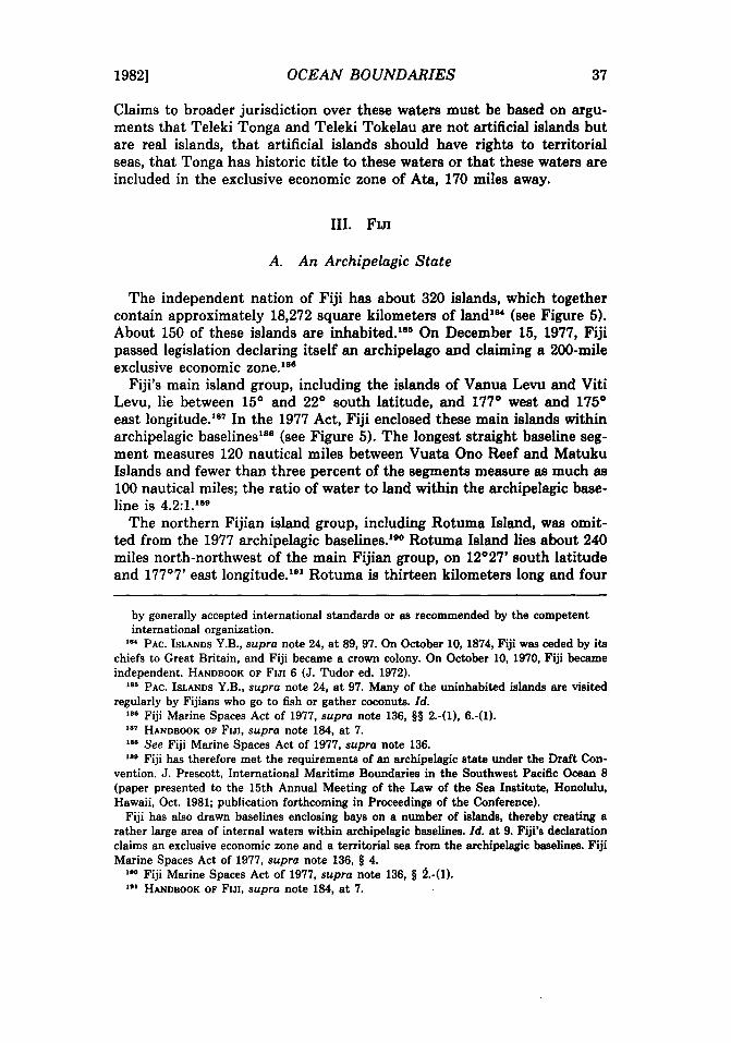
1982] OCEAN BOUNDARIES 37
Claims to broader jurisdiction over these waters must be based on arguments that Teleki Tonga and Teleki Tokelau are not artificial islands but are real islands, that artificial islands should have rights to territorial seas, that Tonga has historic title to these waters or that these waters are included in the exclusive economic zone of Ata, 170 miles away.
III. FIJI
A. An Archipelagic State
The independent nation of Fiji has about 320 islands, which together contain approximately 18,272 square kilometers of landl84 (see Figure 5). About 150 of these islands are inhabited. l811 On December 15, 1977, Fiji passed legislation declaring itself an archipelago and claiming a 200-mile exclusive economic zone.188
Fiji's main island group, including the islands of Vanua Levu and Viti Levu, lie between 15° and 22° south latitude, and 177° west and 175° east longitude.18
? In the 1977 Act, Fiji enclosed these main islands within archipelagic baselinesl88 (see Figure 5). The longest straight baseline segment measures 120 nautical miles between Vuata Ono Reef and Matuku Islands and fewer than three percent of the segments measure as much as 100 nautical miles; the ratio of water to land within the archipelagic baseline is 4.2:1.189
The northern Fijian island group, including Rotuma Island, was omitted from the 1977 archipelagic baselines.lllo Rotwna Island lies about 240 miles north-northwest of the main Fijian group, on 12°27' south latitude and 177°7' east longitude. llli Rotuma is thirteen kilometers long and four
by generally accepted international standards or as recommended by the competent international organization.
'84 PAC. ISLANDS Y.B., supra note 24, at 89, 97. On October 10, 1874, Fiji was ceded by its chiefs to Great Britain, and Fiji became a crown colony. On October 10, 1970, Fiji became independent. HANDBOOK OF FIJI 6 (J. Tudor ed. 1972).
"6 PAC. ISLANDS Y.B., supra note 24, at 97. Many of the uninhabited islands are visited regularly by Fijians who go to fish or gather coconuts. [d .
••• Fiji Marine Spaces Act of 1977, supra note 136, §§ 2.-(1), 6.-(1). '.7 HANDBOOK OF FIJI, supra note 184, at 7. '88 See Fiji Marine Spaces Act of 1977, supra note 136 . ••• Fiji has therefore met the requirements of an archipelagic state under the Draft Con
vention. J. Prescott, International Maritime Boundaries in the Southwest Pacific Ocean 8 (paper presented to the 15th Annual Meeting of the Law of the Sea Institute, Honolulu, Hawaii, Oct. 1981; publication forthcoming in Proceedings of the Conference).
Fiji has also drawn baselines enclosing bays on a number of islands, thereby creating a rather large area of internal waters within archipelagic baselines. [d. at 9. Fiji's declaration claims an exclusive economic zone and a territorial sea from the archipelagic baselines. Fiji Marine Spaces Act of 1977, supra note 136, § 4.
10. Fiji Marine Spaces Act of 1977, supra note 136, § 2.-(1). 10. HANDBOOK OF FIJI, supra note 184, at 7.
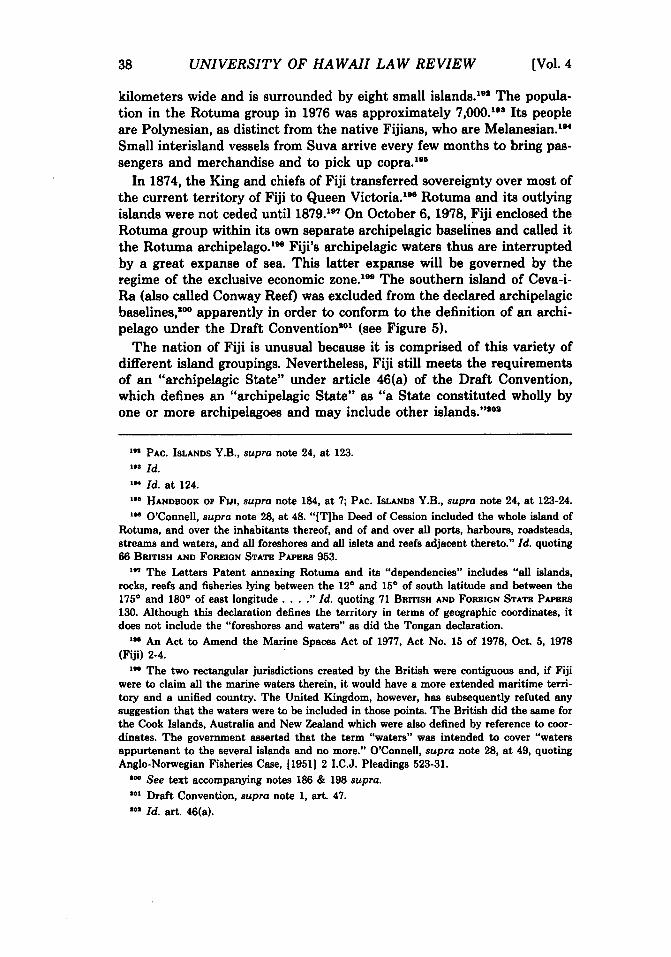
38 UNIVERSITY OF HAW All LAW REVIEW [Vol. 4
kilometers wide and is surrounded by eight small islands.1911 The population in the Rotuma group in 1976 was approximately 7,000.198 Its people are Polynesian, as distinct from the native Fijians, who are Melanesian.11N
Small interisland vessels from Suva arrive every few months to bring passengers and merchandise and to pick up copra. 1911
In 1874, the King and chiefs of Fiji transferred sovereignty over most of the current territory of Fiji to Queen Victoria. lee Rotuma and its outlying islands were not ceded until 1879.197 On October 6, 1978, Fiji enclosed the Rotuma group within its own separate archipelagic baselines and called it the Rotuma archipelago.188 Fiji's archipelagic waters thus are interrupted by a great expanse of sea. This latter expanse will be governed by the regime of the exclusive economic zone.188 The southern island of Ceva-iRa (also called Conway Reef) was excluded from the declared archipelagic baselines,lIOo apparently in order to conform to the definition of an archipelago under the Draft Conventionllol (see Figure 5).
The nation of Fiji is unusual because it is comprised of this variety of different island groupings. Nevertheless, Fiji still meets the requirements of an "archipelagic State" under article 46(a) of the Draft Convention, which defines an "archipelagic State" as "a State constituted wholly by one or more archipelagoes and may include other islands."IIOIi
"" PAC. ISLANDS Y.B., supra note 24, at 123. '··Id. 'M Id. at 124. , •• HANDBOOK OP Fm, supra note 184, at 7; PAC. ISLANDS Y.B., supra note 24, at 123-24. '" O'Connell, supra note 28, at 48. "[T]he Deed of Cession included the whole island of
Rotuma, and over the inhabitants thereof, and of and over all ports, harbours, roadsteads, stre8DlS and waters, and all foreshores and all islets and reefs adjacent thereto." Id. quoting 66 BRITISH AND FOREIGN STATE PAPERS 953.
,.., The Letters Patent annexing Rotuma and its "dependencies" includes "all islands, rocks, reefs and fisheries lying between the 120 and 150 of south latitude and between the 1750 and 1800 of east longitude .... " Id. quoting 71 BRITISH AND FOREIGN STATE PAPERS 130. Although this declaration defines the territory in terms of geographic coordinates, it does not include the "foreshores and waters" as did the Tongan declaration.
, .. An Act to Amend the Marine Spaces Act of 1977, Act No. 15 of 1978, Oct. 5, 1978 (Fiji) 2-4.
'" The two rectangular jurisdictions created by the British were contiguous and, if Fiji were to claim all the marine waters therein, it would have a more extended maritime territory and a unified country. The United Kingdom, however, has subsequently refuted any suggestion that the waters were to be included in those points. The British did the S8Dle for the Cook Islands, Australia and New Zealand which were also defined by reference to coordinates. The government asserted that the term "waters" was intended to cover "waters appurtenant to the several islands and no more." O'Connell, supra note 28, at 49, quoting Anglo-Norwegian Fisheries Case, [1951] 2 I.C.J. Pleadings 523-31.
100 See text accompanying notes 186 & 198 supra. I.' Draft Convention, supra note I, art. 47. 1.1 Id. art. 46(a).
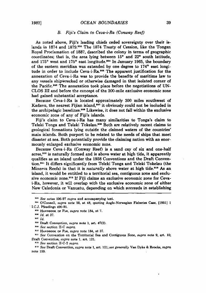
1982] OCEAN BOUNDARIES 39
B. Fiji's Claim to Ceva-i-Ra (Conway Reef)
As noted above, Fiji's leading chiefs ceded sovereignty over their islands in 1874 and 1879.103 The 1874 Treaty of Cession, like the Tongan Royal Proclamation of 1887, described the colony in terms of geographic coordinates; that is, the area lying between 15° and 22° south latitude, and 175° west and 175° east 10ngitude.104 In January 1965, the boundary of the eastern meridian was extended by one degree to 174° east longitude in order to include Ceva-i-Ra.IOII The apparent justification for the annexation of Ceva-i-Ra was to provide the benefits of maritime law to any vessels shipWrecked or otherwise damaged in that isolated corner of the Pacific.208 The annexation took place before the negotiations of UNCLOS III and before the concept of the 200-mile exclusive economic zone had gained substantial acceptance.
Because Ceva-i-Ra is located approximately 300 miles southwest of Kadavu, the nearest Fijian island,107 it obviously could not be included in the archipelagic baselines.108 Likewise, it does not fall within the exclusive economic zone of any of Fiji's islands.
Fiji's claim to Ceva-i-Ra has many similarities to Tonga's claim to Teleki Tonga and Teleki Tokelau.IOt Both are relatively recent claims to geological formations lying outside the claimed waters of the countries' main islands. Both purport to be related to the needs of ships that meet disaster at sea. Both potentially provide the claiming nation with an enormously enlarged exclusive economic zone.
Because Ceva-i-Ra (Conway Reef) is a sand cay of six and one-half acres,21O is naturally formed and is above water at high tide, it apparently qualifies as an island under the 1958 Conventions and the Draft Convention.lIll It differs significantly from Teleki Tonga and Teleki Tokelau (the Minerva Reefs) in that it is naturally above water at high tide.1lI As an island, it would be entitled to a territorial sea, contiguous zone and exclusive economic zone.213 If Fiji claims an exclusive economic zone for Cevai-Ra, however, it will overlap with the exclusive economic zone of either New Caledonia or Vanuatu, depending on which succeeds in establishing
1.3 See notes 196·97 supra and accompanying text. I .. O'Connell, supra note 28, at 48, quoting Anglo-Norwegian Fisheries Case, (1951) 1
. I.C.J. Pleadings 490-91. '.6 HANDBOOK OF FIJI, supra note 184, at 7 . .... [d. at 37. """ [d. 108 Draft Convention, supra note 1, art. 47(2). 1.0 See section II -C supra. II. HANDBOOK OF FIJI, supra note 184, at 37. 111 See Convention on the Territorial Sea and Contiguous Zone, supra note 9, art. 10;
Draft Convention, supra note 1, art. 121. ... See section II-C-2 supra . ... See Draft Convention, supra note 1, art. 121; see generally Van Dyke & Brooks, supra
note 159.
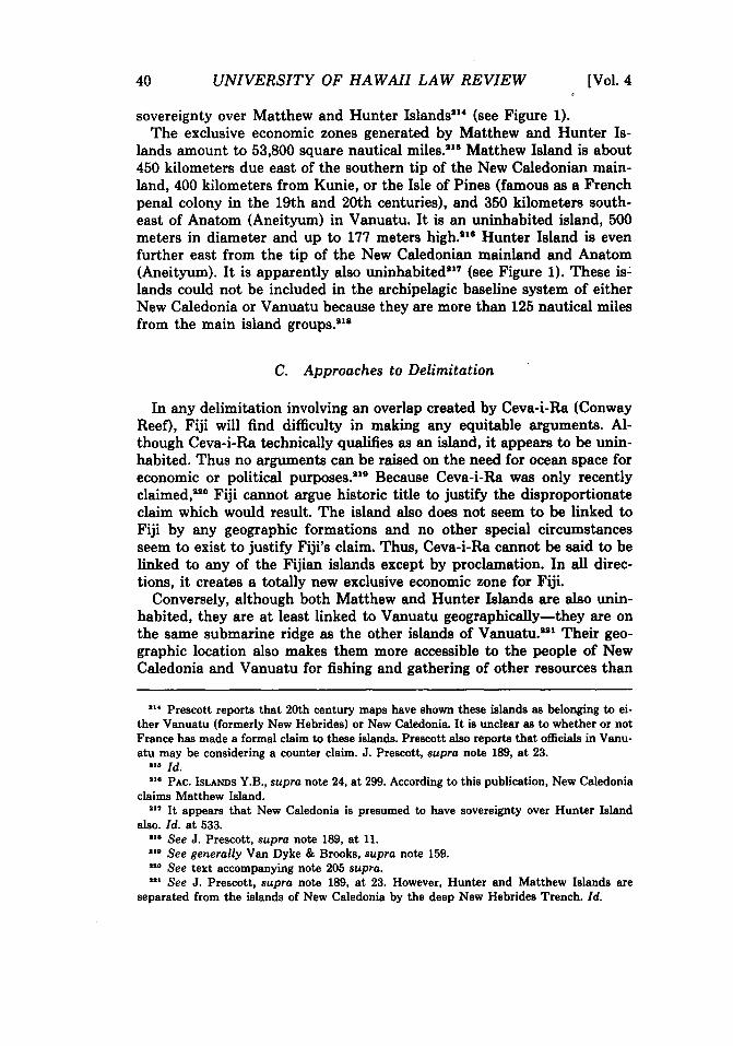
40 UNIVERSITY OF HA WAll LAW REVIEW [Vol. 4
sovereignty over Matthew and Hunter Islands1l14 (see Figure 1). The exclusive economic zones generated by Matthew and Hunter Is
lands amount to 53,800 square nautical miles.lIU1 Matthew Island is about 450 kilometers due east of the southern tip of the New Caledonian mainland, 400 kilometers from Kunie, or the Isle of Pines (famous as a French penal colony in the 19th and 20th centuries), and 350 kilometers southeast of Anatom (Aneityum) in Vanuatu. It is an uninhabited island, 500 meters in diameter and up to 177 meters high. lI18 Hunter Island is even further east from the tip of the New Caledonian mainland and Anatom (Aneityum). It is apparently also uninhabitedlll7 (see Figure 1). These is~ lands could not be included in the archipelagic baseline system of either New Caledonia or Vanuatu because they are more than 125 nautical miles from the main island groups. liS
C. Approaches to Delimitation
In any delimitation involving an overlap created by Ceva-i-Ra (Conway Reef), Fiji will find difficulty in making any equitable arguments. Although Ceva-i-Ra technically qualifies as an island, it appears to be uninhabited. Thus no arguments can be raised on the need for ocean space for economic or political purposes.1Il9 Because Ceva-i-Ra was only recently claimed,II2O Fiji cannot argue historic title to justify the disproportionate claim which would result. The island also does not seem to be linked to Fiji by any geographic formations and no other special circumstances seem to exist to justify Fiji's claim. Thus, Ceva-i-Ra cannot be said to be linked to any of the Fijian islands except by proclamation. In all directions, it creates a totally new exclusive economic zone for Fiji.
Conversely, although both Matthew and Hunter Islands are also uninhabited, they are at least linked to Vanuatu geographically-they are on the same submarine ridge as the other islands of Vanuatu.lIlIl Their geographic location also makes them more accessible to the people of New Caledonia and Vanuatu for fishing and gathering of other resources than
... Prescott reports that 20th century maps have shown these islands as belonging to either Vanuatu (formerly New Hebrides) or New Caledonia. It is unclear as to whether or not France has made a formal claim to these islands. Prescott also reports that officials in Vanuatu may be considering a counter claim. J. Prescott, supra note 189, at 23 .
... Id. II' PAC. ISLANDS Y.B., supra note 24, at 299. According to this publication, New Caledonia
claims Matthew Island . ... It appears that New Caledonia is presumed to have sovereignty over Hunter Island
also. Id. at 533. 118 See J. Prescott, supra note 189, at U. 11. See generally Van Dyke & Brooks, supra note 159. II. See text accompanying note 205 supra . ... See J. Prescott, supra note 189, at 23. However, Hunter and Matthew Islands are
separated from the islands of New Caledonia by the deep New Hebrides Trench. Id.

1982] OCEAN BOUNDARIES 41
Ceva-i-Ra is to the Fijians. In addition, Hunter and Matthew Islands would grant a more restrictive claim than Ceva-i-Ra. The northerly and westerly expanses of the exclusive economic zones for Hunter and Matthew Islands fall to a great extent in the exclusive economic zones of either Anatom (Aneityum), the main island of New Caledonia, or Kunie.
Fiji has indicated a willingness to negotiate to resolve potential disputes with its neighbors over the delimitation of its exclusive economic zone.222 According to Fijian law, the Minister of Foreign Affairs is empowered to establish the outer limits of the country's exclusive economic zone "for the purpose of implementing any international agreement or the award of any international body, or otherwise .... "128 If no such line is drawn, a median line is assumed for delimitation "which is equidistant from the nearest points of the baselines from which the breadth of the territorial seas of Fiji and of any opposite or adjacent State or territory are measured. "224
Because all these islands are remote and uninhabited, their claim to maritime space is weak. Assuming that they are all entitled to exclusive economic zones, application of the equidistant principle in a delimitation between Ceva-i-Ra and Matthew and Hunter Islands could arguably grant Ceva-i-Ra too much recognition. Ceva-i-Ra will already give Fiji extensive ocean space in other directions of its exclusive economic zone.
In order to curb inequities in delimitation negotiations, recent agreements and arbitral decisions have tended to reduce the impact of islands where their geographic location produces disproportionate results. For example, some islands have been given only half-effect,1I1111 while others have been excluded from baselines and have only been given effect in establishing territorial seas. lIB
In other instances, countries have proceeded with delimitation without considering an island's effect. Greenland and Canada discounted Hans Island in their boundary delimitation because the sovereignty of the island was in dispute; no boundary was therefore drawn in that vicinity.IIU Another example is Machias Seal Island in the Gulf of Maine. When the United States and Canada agreed to submit the delimitation of the maritime boundary in the Gulf of Maine area to the International Court of Justice, they requested the court to ignore that island because it is claimed by both countries.228
••• Fiji Marine Spaces Act of 1977, supra note 186, § 6 . ... Id. § 6(2) . ... Id. § 6(3)-(4) . ••• See text discussing the Scilly Isles accompanying notes 257-60 infra. ••• See text discussing the Channel Islands accompanying notes 253-56 infra . •• 7 CANADA-GREENLAND CONTINENTAL SHELF BOUNDARY, supra note 16, at 8 . ••• Special Agreement between the United States and Canada to Submit to the Interna
tional Court of Justice the Delimitation of the Maritime Boundary in the Gulf of Maine area, art. 11(1), attachment to U.S.-Canada Gulf of Maine Treaty, supra note 21; see 127 CONGo REC. S4052-54 (daily ed. Apr. 29, 1981) (remarks of Sen. William Cohen of Maine).
42 UNIVERSITY OF HA WAIl LA W REVIEW [Vol. 4
One important point for Vanuatu and New Caledonia to consider in their negotiations is that a dispute between them concerning sovereignty over Hunter or Matthew Islands could result in a loss of maritime space for either country, depending on who is ultimately determined to be the sovereign. These countries might consider following the solution reached for Hans and Machias Seal Islands where the disputing countries agreed to disregard the islands altogether in boundary delimitation.229 In the South Pacific arena, because the disputed islands create a potential conflict with a third country (Fiji), Vanuatu and New Caledonia could protect any future interests to an exclusive economic zone around these islands by creating a joint development zone.lISO Alternatively, New Caledonia and Vanuatu might consider protecting their mutual rights by agreeing to divide the exclusive economic zone gained by these islands according to some proportionate share.
Assuming Ceva-i-Ra is permitted the full sweep of its exclusive economic zone in the north, east and south, the resulting appropriation of ocean may be sufficiently great to convince Fiji to negotiate an agreement with New Caledonia and/or Vanuatu giving less than full effect to Ceva-iRa. In exchange, New Caledonia and/or Vanuatu could agree to recognize Fiji's claim to Ceva-i-Ra and a corresponding territorial sea and exclusive economic zone.
IV. DELIMITING THE BOUNDARIES
A. The Competing Claims
1. Tonga
The task of delimiting Tonga's boundaries is somewhat unique because that country's historic claim does not refer to specific base points on land from which baselines may be drawn. Instead, its claim is staked out according to longitudinal and latitudinal coordinates.lI81 The territorial limits drawn from these coordinates are approximately forty-eight to 152 miles in breadth from the nearest point of land within the area. Tonga's claim over Teleki Tonga and Teleki Tokelau (the Minerva Reefs)lI8lI presents additional delimitation problems.
Machias Seal Island is 500 feet wide and about a third of a mile long. It has been declared a bird sanctuary and has a lighthouse. Gull or North Rock is 12 feet high. Grandall, Remember Machias Seal Island?, 64 ATLANTIC ADVOCATE 47-53 (1974) .
••• 127 CONGo REC. S4052-54 (daily ed. Apr. 29, 1981) (remarks of Sen. William Cohen of Maine) .
••• Cf. JAPAN-REPUBLIC OF KOREA JOINT DEVELOPMENT ZoNE, supra note 7. See also note 270 infra and accompanying text .
•• , See note 26 supra and accompanying text . • a. See section H-C supra.

1982] OCEAN BOUNDARIES 43
2. Fiji
Fiji has declared itself an archipelagic regime and has claimed a 200-mile exclusive economic zone.1I88 Although Fiji has yet to issue formal declarations for its 200-mile zone, the government declared in 1980 that it intends to issue such a formal statement in the near future. IM When Fiji's formal declaration is issued, an interface of 4,860 square nautical miles with Tonga's declared territorial limits will resuWl811 (see Figure 1). An even greater overlap would occur if Tonga were to declare the limits of its historical claim as baselines from which further claims are measured.lae
3. New Zealand (The Kermadec Islands)
The Kermadec Islands, a New Zealand dependency, are a volcanic group whose principal islands are Raoul (or Sunday), Macauley, the Herald Isles, Curtis and L'Esperance.1I87 Their total land area is only thirteen square miles.1I8S The islands are an important nature preserve and the sole inhabitants are a handful of New Zealand personnel who live on Raoul Island.1I8B
On September 26, 1977, New Zealand declared a 200-mile exclusive economic zone around its islands, including the outlying ones.140 Presumably, New Zealand intends this claim to include the Kermadecs for they fit the definition of "island" under the act, and also are clearly not "low-tide elevation[s]."141
The Kermadecs are located approximately 360 miles south of the Mi-
... See note 136 supra .
... 51 PAC. ISLANDS MONTHLY 9 (July 1980) .
... See J. Prescott, supra note 189, at 20 . ••• This situation would be possible if all the waters within the historic claim were consid
ered to be territorial waters. But see text accompanying notes 93-94 supra; Draft Convention, supra note 1, arts. 3, 57 .
• a. PAC. ISLANDS Y.B., supra note 24, at 233. The Kermadec Islands are annexed islands and all New Zealand laws extend to them. They have no separate administrative structure but rather are administered by the New Zealand Survey Department. N.Z. OFFICIAL Y.B. 1134 (1958).
The Kermadec Islands are north of New Zealand's two main islands, North Island and South Island, and are located between 29° and 32° south latitude, and 177° and 180° west longitude. [d. at 1. By proclamation of July 21, 1887, the Kermadecs were declared to be part of the territory of New Zealand, which was then a British colony. British sovereignty over New Zealand was proclaimed on January 30, 1840. [d. at 3 .
... N.Z. DEP'T OF INTERNAL AFFAIRS, INTRODUCTION TO NEW ZEALAND 166 (1945) . • a. Meteorological and radio stations have been constructed on Rauol Island. PAC. ISLANDS
Y.B., supra note 24, at 233. Cf, N.Z. DEP'T OF INTERNAL AFFAIRS, supra note 238, at 166; G. LINGE & R. FRAZIER, ATLAS OF NEW ZEALAND GEOGRAPHY 6 (1977).
"0 Territorial Sea and Exclusive Economic Zone Act, 1977, Act No. 28, 1 Stat. N.Z. 192, 196, 198 [hereinafter cited as "New Zealand Territorial Sea and EEZ Act"); see also Reserves Act, 1977, Act No. 66 § 100(1), 1 Stat. N.Z. 836 .
.. , New Zealand Territorial Sea and EEZ Act, supra note 240, at 194 § 2(1).

44 UNIVERSITY OF HA WAIl LAW REVIEW [Vol. 4
nerva Reefs and 480 miles south of Ata, the closest inhabitable Tongan island (see comment to Figure 1). Even if Tonga were to declare a 200-mile exclusive economic zone with baselines at Ata, this zone would not overlap with New Zealand's zone around the Kermadecs. If, however, Tonga declares a 200-mile exclusive economic zone around Teleki Tonga and Teleki Tokelau, the islands built on the Minerva Reefs, this zone would overlap with New Zealand's claim by approximately 5,000 square nautical miles.242
New Zealand has suggested a solution to this problem within its Terri~ torial Sea and Exclusive Economic Zone Act.148 The Act defines a "median line" between New Zealand and any other country as "a line every point of which is equidistant from the nearest points of the baseline of the territorial sea of New Zealand and the corresponding baseline of that other country."244 If New Zealand agrees to accept Teleki Tonga and Teleki Tokelau as a baseline point, then the difference might be allocated between the two countries by drawing such a median line. New Zealand might, however, be reluctant to consider the islands built on the Minervas to be an appropriate Tongan baseline point146 since it would lose a significant part of its claimed exclusive economic zone if it did.
B. Equitable Principles
The triumph of the doctrine of "equitable principles" over the cartographic approach of drawing equidistant lines has been described in the opening section.148 Under the adopted approach, boundary conflicts should be resolved through negotiations between (or among) affected states, taking all factors into consideration.
As a preliminary matter, because of the North Sea Continental Shelf Cases,147 Tonga may be able to negotiate from a strong position for the establishment of ocean boundaries based on its historic claim. The International Court of Justice in the North Sea Cases, although dealing there with disputes concerning the continental shelf, pointed out that delimitation involves the expression of preexisting rights.148 According to the court, rights to the areas to be delimited are already in existence, vested in the states-parties to the delimitationl48 and the process of delimitation
... See Section II-C supra for a discussion of Tonga's claim to Teleki Tonga and Teleki Tokelau .
••• New Zealand Territorial Sea and EEZ Act, supra note 240, at 192 . ••• [d. at 195 . ... Prescott concludes that Tonga is not entitled to any maritime zones around the Mi
nerva Reefs except a 500 meter safety zone. J. Prescott, supra note 189, at 21-22. See discussion in section II-C supra .
••• See notes 5-16 supra and accompanying text . ... [1969) I.C.J. 4; see note 14 supra. ••• [1969) I.C.J. 4, 3l. ••• [d. at 33: "[T)he coastal state has an original, natural, and exclusive (in short a vested)

1982] OCEAN BOUNDARIES 45
is simply the expression of these prior rights.IIlIO Because the equidistance/ median line method of delimitation is merely a cartographical device, a generally convenient mode of expressing these preexisting rights,1I111 that method cannot be as persuasive a mode of expression as a longstanding historic title claim.lIIIlI
Keeping these pronouncements of the International Court in mind, some recent solutions to international boundary disputes will now be examined. These examples illustrate the types of approaches taken and solutions reached in cases that parallel the complexity of the situation in the South Pacific.
1. The Anglo-French Continental Shelf Arbitration
Mter several years of unsuccessful negotiations, the governments of France and the United Kingdom agreed to submit the issue of continental shelf delimitation between the two countries to a Court of Arbitration.1I118 France argued that the Channel Islands, under the jurisdiction of the United Kingdom but located close to the French coast, were a special circumstance which would have to be taken into account in order to achieve an equitable result.lItu The court agreed and decided that the islands were a "special circumstance" and "a circumstance creative of inequity" within the meaning of article 6 of the 1958 Convention on the Continental Shelf.lIIIII It then formulated a two-part solution. First, a median line was drawn in the English Channel without considering the Channel Islands as a point on the baseline. Second, the court created an "enclave" within the continental shelf for the Channel Islands to allow them a fisheries zone measured twelve miles seaward from the natural baseline. IN
The other major area of disagreement in the Great Britain-France delimitation arbitration was in the Atlantic region. France argued that the westward British Scilly Isles, and the greater projection of the Cornish mainland beyond the French coastline constituted a special circumstance justifying departure from equidistance.1II7 The United Kingdom perceived no "special circumstances" and argued for the true equidistant line.alls
right to the continental shelf off its shores .... " '00 [d. at 22: "Delimitation is a process which involves establishing the boundaries of an
area already, in principle, appertaining to the coastal state and not the determination de novo of such an area."
'" [d. at 23, 35. ••• [d. at 35-36 . ••• Anglo-French Arbitration, 18 I.L.M. 397, supra note 6 . ... [d. 1111 6-8, 18 I.L.M. at 402-403 . ••• Convention on the Continental Shelf, supra note 8; Anglo-French Arbitration, supra
note 6, 1111 196-97, 18 I.L.M. at 444 . ... Anglo-French Arbitration, supra note 6, 1111 201-02, 18 I.L.M. at 444-45 . •• 7 [d. 1111 216-28, 18 I.L.M. at 448-49 . ... [d. 1111 227-31, 18 I.L.M. at 450-51.

46 UNIVERSITY OF HA WAll LA W REVIEW [Vol. 4
The court rejected both arguments and concentrated instead on the geography of the Celtic Sea shoreline. It found that the projection westward of the Scilly Isles, when "superadded" to the Cornish mainland, distorted the equidistant line and, as such, constituted a special circumstance. lilt The court employed an unusual technique in delimitation, but one it thought produced an equitable result. The court modified the Scilly Isles to "half-effect" basepoints; no justification was given for their choice of that particular fraction. In any event, the court constructed one set of baselines and equidistance lines using the Ushant and the Scilly Isles and another set that ignored them. The triangle thereby created was divided in half to create the "half-effect" line.lSo
This decision opens the door to several possible technical solutions to any boundary disputes between Fiji and Tonga (and for the two Samoas as discussed belowl
•1). If an exclusive economic zone around Fiji's
archipelagic baselines protrudes into Tonga's historic waters, the latter could formulate archipelagic baselines around the opposite group of islands solely for the purpose of delimitation. Alternatively, baselines around the separate islands of both Fiji and Tonga might result in an equitable delimitation. If an island or low-tide elevation were to give one country a "superadded" geographic claim, this effect could be reduced by some fractional proportion equitable to both sides.
The decision in the Anglo-French case is also important in that it underscores the significance of the choice of baselines. The principle of equidistance was not applicable until all the baselines were drawn. Most importantly, the court's methodology would allow Tonga to argue the relevance of its historic claim because before drawing any baselines, the court analyzed whether or not any special circumstances existed.
2. Treaty Between Australia and Papua New Guinea
Should the drawing of a median line between Tonga and Fiji or between Tonga and New Zealand be unacceptable to any of the parties, the nations might consider the creation of a joint resource zone within the area beyond their respective territorial waters. Recent agreements be-
••• Id. 11 244, 18 I.L.M. at 454 . ••• [d. 1111 251-53, 18 I.L.M. at 455-56. In other geographic locations where application of
equidistance would lead to a disproportionate result, similar solutions have been negotiated. Italy and Yugoslavia had a number of very small islands lying between them in the Adriatic Sea which were given partial effect in delimitation. Ely, Seabed Boundaries Between Coastal States: The Effect to be Given Islets as "Special Circumstances," 6 INT'L LAw. 219, 227-28 (1972).
In the delimitation between Iran and Saudi Arabia, the island of Kharg was given halfeffect by constructing the equidistance line halfway between the area formed by a line equidistant from the Saudi Arabian mainland and Kharg and a line equidistant from both the mainland of Iran and Saudi Arabia giving no effect to Kharg. [d. at 229 .
... See text accompanying notes 325-27 infra.

1982] OCEAN BOUNDARIES 47
tween Japan and Korea,181 Abu Dhabi and Qatar,283 and Papua New Guinea and Australia284 provide illustrations for delimitation of such a zone. Of these, the treaty between Papua New Guinea and Australia will be examined in detail.
On December 18, 1978, the two countries signed a treaty which, among other things, set up maritime boundaries between them.lI811 This treaty highlights the importance of mutual agreement as the primary mode of resolving boundary issues between neighboring nations.
Part 4, article 10 of the Treaty establishes a protected or joint resource zone.288 In conjunction with Annexes 6, 7 and 9 to the treaty, article 10 establishes the boundaries of the area, including the land, sea, airspace, seabed and subsoil of the Torres Straits area. Article 10(3) sets out the principal purpose of the parties in establishing the protected zone, which is "to acknowledge and protect the traditional way of life and livelihood of the traditional inhabitants including their traditional fishing and free movement. "287
"Traditional activities" are defined in Part 1, article (k) as "traditional activities performed by the traditional inhabitants in accordance with local tradition," including "(ii) activities on water, including traditional fishing."288 "Traditional fishing" is defined in article 1(1) as "the taking, by traditional inhabitants for their own use or their dependents' consumption or for use in the course of other traditional activities, of the living resources of the sea, seabed, estuaries and coastal tidal areas. "lI89 In this manner, Australia and Papua New Guinea used the unique approach of a joint resource zone to protect the traditional lifestyles of the inhabitants of the Torres Straits.
This model may be a useful one for any of the potential South Pacific boundary disputes raised in this paper. A joint jurisdiction or use zone could be established with the Australia-Papua New Guinea protected zone as a model.270 Traditional fishing activities of the peoples of Tonga
••• See note 7 supra . ••• Ely, supra note 260, at 229; Karl, Islands in the Delimitation of the Continental
Shelf, 71 AM. J. INT'L L. 642, 665 (1977). The area is to be developed by Abu Dhabi concessionaries, but all royalties, profits and government fees are to be divided equally .
... See note 265 infra . ••• Treaty Concerning Sovereignty and Maritime Boundaries, Dec. 18, 1974, Australia
Papua New Guinea (publication of the Dep't of Foreign Affairs, Canberra) [hereinafter cited as "Treaty between Australia and Papua New Guinea") .
••• Id. at 15 . •• 7 Id. at 16. 'ea Id. at 3 . ••• Id. at 4. no A joint use zone has recently been established in the Gulf of Maine. Although a
fisheries treaty had been negotiated between the United States and Canada covering the conservation, management and utilization of fish stocks in the area, the detailed provisions setting entitlement shares for various fish was unacceptable to the New England fishing industry. Agreement Between the United States of America and Canada on East Coast Fish-

48 UNIVERSITY OF HA WAll LA W REVIEW [Vol. 4
and Fiji could thus be protected and maintained. The Australia-Papua New Guinea Treaty also addresses issues concern
ing exploitation of seabed resources. First, it deals with the problem of upholding the rights of a permittee who had been granted a petroleum prospecting license by Australia over an area that subsequently became a part of the protected zone. The agreement requires Papua New Guinea to grant the permittee a license under its own laws.271 Second, the signatories have provided for the equitable sharing of any mineral resources extending across any line defining the seabed jurisdiction of the parties.1I711
Tonga has already granted one petroleum exploration license in south Tonga territory.lI7S The Australia-Papua New Guinea Treaty may thus provide a model for negotiation in the event any of the territory to which the license extends is in issue in delimitation. The treaty also presents one approach to the problem of how to exploit seabed deposits which extend beyond Tonga's boundaries. The Australia-Papua New Guinea model, however, is not the only possible mode of resolving the latter problem. Tonga and her neighbors could also consider forming a joint exploration and exploitation agreement in the event any deposits sitUated across common boundaries are discovered.1I74
3. Dependency on Fish Resources
Any delimitation in the South Pacific region will need to consider the dependency of the negotiating countries on fish resources within the disputed areas. Fiji, for example, in partnership with the Japanese, is the largest exporter of fish products in the South Pacific.1I7I Although it ap-
ery Resources (Mar. 29, 1979). This agreement was subsequently withdrawn from the Sen· ate. Letter from Senator William Cohen of Maine to Sherry Broder (Sept. 22, 1981). However, the treaty to submit the boundary dispute over the Gulf of Mexico to the International Court of Justice has been ratified. See U.S.-Canada Gulf of Maine Treaty, supra note 21. In the interim, President Reagan agreed to permit Canadian fishermen to fish the entire disputed zone until the final court decision is issued, see CONGo REC. S4053 (daily ed. Apr. 29, 1981) (remarks of Sen. William Cohen of Maine), and to follow article IX of the 1977 agreement between the U.S. and Canada which states: (1) Neither the United States nor Canada will enforce the fishing laws against the nationals of the other country, (2) neither the U.S. nor Canada will permit a third country to take what either country might consider "excess" fish in the disputed area, and (3) both countries have the authority to enforce their Jaws against any third country in the disputed area. [d.; letter from Senator William Cohen of Maine to Sherry Broder (Sept. 22, 1981).
171 Treaty between Australia and Papua New Guinea, supra note 265, art. 5 . ... [d. art. 6. The problem with such a "unity of deposits" is that one country would be
able to exploit all of the available amount of that resource from its side of a boundary line. See discussion of this problem in N. Sea Continental Shelf Cases, (1969) I.C.J. 4, 51-52.
178 1975-1980 TONGA DEVELOPMENT PLAN, supra note 19. "" See, e.g., JAPAN-REPUBLIC OF KOREA JOINT DEVELOPMENT ZoNE, supra note 7 . .. & PAC. ISLANDS Y.B., supra note 24, at 101. "In 1977, Fiji exported 2,113 tons of fish
products worth $4.68 million .... " [d. For a survey of the fishing industry in the South
1982] OCEAN BOUNDARIES 49
pears that Tonga's fishing activity is more subsistence oriented, new fisheries are being developed278 and it is quite possible that Tonga may grow more economically dependent on fish resources in the future.
The importance to be attached to a nation's dependency on fish resources has been given explicit recognition in several negotiated solutions of past disputes. The Australia-Papua New Guinea Treaty, for example, makes provision for commercial fisheries in article- 21 which states that "the parties shall cooperate in the conservation, management and optimum utilization of Protected Zone commercial fisheries."177
The significance of fisheries to livelihood and economic development were considered by the International Court of Justice in the Fisheries Jurisdiction Case.178 In negotiations regarding fishing off Iceland's shores, the first factor that both parties were instructed to take into account was Iceland's entitlement to a preferential share of the fish resources in the area "to the extent of the special dependence of its people upon the fisheries in the seas and around its coasts for their livelihood and economic development. "178
In addition, it may be interesting for the South Pacific nations to note the decision of the International Court of Justice in the maritime boundary dispute pending between the United states and Canada regarding the Georges Bank.lso This area is a fertile fishing bank with potential for oil production, which falls into an overlap of the exclusive economic zones claimed by the two countries.lI8l Canada seeks an equidistance delimitation. The United States, pointing to the heavy reliance of the Maine fishing industry on the fish resources of the Georges Bank, is arguing for a more equitable approach to delimitation.182 Whatever solution is reached in that case, the nations of the South Pacific should be well aware that
Pacific, see G. KENT, supra note 17, at 12-53 . .,. Tonga exported 9.5 tons of albacore tuna in 1976. A new Fisheries Extension Centre is
being established at Vava'u and fisheries survey work under the FAO-UNDP marine resources development project has been conducted. PAC. ISLANDS Y.B., supra note 24, at 413. See also note 47 supra.
277 Treaty between Australia and Papua New Guinea, supra note 265, at 26. 218 United Kingdom v. Iceland, (1974) I.C.J. 3. 270 [d. at 79. The main issue before the court in the Fisheries Jurisdiction Case was Ice
land's assertion of a 50-mile fisheries zone. The court was understandably reluctant to render judgment or anticipate the law in light of ongoing Law of the Sea Conference discussion of those issues. [d. at 53. This reluctance was well justified in light of subsequent developments-the provisions of the Draft Convention on the Law of the Sea and the practices of nations in asserting their rights to 200-mile economic zones encompassing fisheries jurisdiction. The court's consideration of the special dependence of Iceland's people upon fisheries for their livelihood and economic development is, however, an aspect of the decision of con-tinuing validity. -
2 •• U.S.-Canada Gulf of Maine Treaty, supra note 21. See generally Note, Boundary Delimitation in the Economic Zone: The Gulf of Maine Dispute, 30 MAINE L. REV. 207 (1979).
2., Note, supra note 280, at 243. 2.2 [d_ See text accompanying notes 253-60 supra for a discussion of the application of
equitable principles in the Anglo-French Continental Shelf Arbitration.
50 UNIVERSITY OF HAW All LAW REVIEW [Vol. 4
reliance on fish resources within a disputed area is a factor that has been and will be given strong consideration in resolving problems surrounding maritime boundary disputes.
V. WESTERN SAMOA AND AMERICAN SAMOA
A. Introduction
American Samoa and Western Samoa are separated by a narrow strait thirty-two nautical miles wide. Western Samoa has a land area of 1,100 square miles'. Its population in 1976 numbered 155,000.188 American Samoa encompasses a land area of approximately seventy-seven square miles284 and had a population of about 30,500 in 1979.IH Thus Western Samoa is approximately fourteen and a half times as large as American Samoa in land area and has approximately five times as many residents.
Through a circumstance of geography, American Samoa can potentially claim an exclusive economic zone of 114,000 square nautical miles; if the principle of equidistance were applied, Western Samoa would only be entitled to a zone of 38,100 square nautical miles.18S With Wallis (France) 190 nautical miles to the west, Tafahi (Tonga) 142 nautical miles to the south,287 Swains Island (American Samoa) 190 nautical miles to the north and Tutuila Island (American Samoa) thirty-two nautical miles to the east,288 Western Samoa is blocked in all directions from claiming a full 200-mile exclusive economic zone (see Figure 6). Moreover, Tonga's historic claim creates a conflict at the south-eastern edge of Western Samoa's ocean boundary. The situation is ripe for application of those equitable principles that would give Western Samoa a more proportionate share of ocean territory.
B. Western Samoa
Western Samoa consists of two main islands, Savai'i and Upolu, and the seven small islands of Apolima, Manono, Fanuatopu, Namua,
••• WESTERN SAMOA, DEP'T OF ECONOMIC DEVELOPMENT, WESTERN SAMOA, NATIONAL
GOALS, DEVELOPMENT PRIORITIES AND PUBLIC EXPENDITURE POLICIES: 1975-1979, FiRST REPORT OF THE 1975-1979 ECONOMIC DEVELOPMENT PLAN, at 1.111 2 (1974) [hereinafter cited as
"1975-1979 WESTERN SAMOA ECONOMIC DEVELOPMENT PLAN"]; PAC. ISLANDS Y.B., supra note
24, at 501. ••• AMERICAN SAMOA DEVELOPMENT PLANNING OFFICE, EcONOMIC DEVELOPMENT PLAN FOR
AMERICAN SAMOA FY 1979-1984, at III-6 (1979) . ••• [d. at 11-2 . ••• J. Prescott, supra note 189, table 1. 187 [d. This distance is measured from Asuisui on Savai'i Island to the nearest point on
Tafahi Island . ••• [d.
1982]
.' .'
OCEAN BOUNDARIES
'_'.'.-.'_-.'.'.'._._.'.1.'.'._.1..'
51
.' .' ~,
" " ,,' ",
Swains Island
Equidisldnl .- •• - Lines
", .... .... .... ..... .......
;11 11111 ! ,
\1ilt· ..
'-,-. WESTERN SAMOA " ",
I AMERICAN SAMOA .........
S ·M Upolu i ' .... aval I .c---.. ! "
'. ~ , Manu'a " '. ,. <? •• ~ Islands ".
" • Rose .... .' Tutuila Island \
....... I \ ~lfs------~~--------~~--------~------------------------------~_~ ... , I ,
... , I -
TONGA
"', ... , i ' ... . , ~ ~
\ ~ \ ~ ~ ~ \. .... _1.--· .-._._.,.__ , ..
'''''4IIIIt , ...
1700W ~
.... " , .. .... ~ ..... , ..
FIGURE 6: AMERICAN SAMOA AND WESTER~ SAMOA Q
Lines illustrate ocean space which would be allotted to each if equidistance lines were used.
Nuutele, Nuulua and Nuusafee.189 The group is an independent state1l90
and a member of the United Nations, the South Pacific Forum and the (British) Commonwealth of Nations.191
In 1977, the Legislative Assembly of Western Samoa passed the Exclu-
'1' W. SKINNER, HANDBOOK OF WESTERN SAMOA 17 (1925). Savai'i and Upolu comprise most of the land area. Savi'i accounts for 660 square miles; Upolu, 430 square miles. Only Apolina and Manono of the smaller islands are inhabited. The rest are near the fringe reef surrounding Upolu. J. Adren, The Political Development of Western Samoa from Mandate to Independence 4-6 (1964) (unpublished Ph.D. thesis at the University of Oklahoma).
Ito Western Samoa became an independent state on January I, 1962. PAC. ISLANDS Y.B., supra note 24, at 501.
•• , [d. In 1889, Samoa was divided into Western Samoa and American Samoa along 1710
52 UNIVERSITY OF HA WAIl LAW REVIEW [Vol. 4
sive Economic Zone Act of 1977,292 which establishes an exclusive economic zone of 200 miles measured from the baselines described in the Territorial Seas Act of 1971.2118 Despite the potential jurisdictional overlaps resulting from this claim, no reservations have yet been raised by Tonga or American Samoa. Western Samoa has not signed any of the 1958 Geneva Conventions.
C. American Samoa
American Samoa is an unorganized and unincorporated territory of the United StateS.294 The main group contains six islands: Tutuila, Aunuu, Tau, Ofu, Olosega and Rose Island.
The United States has claimed a three-mile territorial sea around the territory29D and a 200-mile fisheries management zone under the 1976 Fisheries Conservation and Management Act.2M As a territory of the United States, American Samoa is subject to the treaties and conventions which the United States has ratified, including all the 1958 Geneva Conventions.
D. Specific Problem Areas
1. Rose Island
Rose Island is an atoll approximately eighty miles southeast of Tau Is-
west longitude, with Germany acquiring Western Samoa in return for renouncing its claims in Tonga and West Africa to Great Britain. J. HART, HISTORY OF SAMOA 87 (1971) .
... Reprinted in 29 U.N. GAOR, U.N. Doc. ST/LEG/SER. B/18 (1976) at 33 (as noted in Krueger & Nordquist, supra note 97, at 348) .
••• Act No.3 of July 15, 1971 (Western Samoa), reprinted in 29 U.N. GAOR, U.N. Doc. ST/LEG/SER. B/18/Add. 2 at 37 (text transmitted through the Charge' d'Affaires a.i. of New Zealand to the United Nations in a note verbale of July 9, 1974). Id .
... See generally Laughlin, The Application of the Constitution in United States Territories: American Samoa, A Case Study, 2 U. HAWAII L. REv. 337, 361-62 (1981). Tate, What's Going On in American Samoa? 79 CASE AND COMMENT 26 (1974). Residents of American Samoa are "nationals" of the United States with rights to' travel to and from other parts of the American political community. The right to trial by jury was recently declared to be a right of defendants in American Samoa. King v. Andrus, 452 F. Supp. 11 (D.D.C. 1977).
After the 1889 division of the two Samoas (see note 291 supra), the American islands were placed under the jurisdiction of the United States Department of the Navy and desigI}ated as Tutuila Naval Station. In 1911, "American Samoa" was adopted as the name of the territory. In 1951, the territory's administration was transferred to the United States Department of the Interior. PAC. ISLANDS Y.B., supra note 24, at 45 .
••• J. Prescott, supra note 189, at 12 . ... 16 U.S.C. §§ 1801-1882 (1976).
1982J OCEAN BOUNDARIES 53
land in the Manua Group of American Samoalll7 (see Figure 6). It is a naturally formed area of land above water at high tide. ltl8 Plant life apparently exists on the atoll because German promoters of a fishing station planted coconuts on the island around 1870.1t18 Although presently uninhabited, it is apparently capable of supporting life. Setchell reported in 1924 that one of the Samoans employed in conjunction with the fishing station remained on the island with his family after the project had been discontinued.30o Rose Island thus qualifies as an island under article 121(1) of the Draft Convention301 and article 10 of the 1958 Geneva Convention on the Territorial Sea and Contiguous Zone. aoa It would therefore be entitled to a territorial sea under article 10(2) of the 1958 Geneva Convention on the Territorial Sea and Contiguous Zone80a and a territorial sea, contiguous zone, exclusive economic zone and continental shelf under article 121(2) of the Draft Convention.8N
2. Swains Island
Swains Island is an atoll with a land area of a little over one square mile3011 (see Figure 6). The greatest elevation of land is about six meters.308 The island is historically and geographically a part of the Tokelau Islands.307 It has a small population of people of Samoan and Tokelauan extraction. S08
Shortly after 1841, Tokelau Islanders formed a colony on the atoll. Swains Island was originally included within the Tokelau islands as part
••• J. COULTER, LA~ID UTILIZATION IN AMERICAN SAMOA 43 (1941) . ••• W. SETCHELL, AMERICAN SAMOA 227 (1924) . ••• [d. at 247; J. COULTER, supra note 297, at 43. 300 W. SETCHELL, supra note 298, at 247 . .... Draft Convention, supra note 1. 80' Convention on the Territorial Sea and Contiguous Zone, supra note 9. Rose Island would merit consideration as an island under a test even more rigorous than
. the one adopted in the Draft Convention. Although not presently inhabited, Rose Island, "dont les conditions naturelles permettent la residence stable de groupes humains or· ganizes" and is "capable of effective occupation and control," thus satisfying the more rigorous tests proposed by Lauterpacht. See text accompanying notes 144-55 supra; see generally Van Dyke & Brooks, supra note 159 .
• 0. Convention on the Territorial Sea and Contiguous Zone, supra note 9. ... Draft Convention, supra note 1. .... PAC. ISLANDS Y.B., supra note 24, at 55 . ... [d .
.... Tokelau is a territory directly north of the Samoas under New Zealand administration. [d. at 401.
... HOUSE COMM. ON INTERIOR AND INSULAR AFFAIRS, SPECIAL SUBCOMM. ON TERRITORIAL AND INSULAR AFFAIRS, 84TH CONG., 1ST SESS., REPORT ON AMERICAN SAMOA (Comm. Print No. 4). According to the 1970 census, the population of Swains Island was 74. PAC. ISLANDS Y.B., supra note 24, at 55-56.

54 UNIVERSITY OF HA WAIl LA W REVIEW [Vol. 4
of the Union. Group and was then known as Olosenga.s09 The Union Group was subsequently incorporated into the British colonies of Gilbert and Ellice Islands in 1916.810 In 1925, Swains Island was annexed by the United States and made an administrative part of American Samoa.Sll
Today the island is owned by a single family, which exploits the atoll for copra, producing up to 200 tons per year.SlI
Although American Samoa, as an island community, can advance many of the equitable arguments in favor of establishing an archipelagic regime for itself, it cannot qualify as an archipelagic regime drawing archipelagic baselines around all its islands under the provisions of the Draft Convention. SIS One problem is that if Swains Island is used as one of the base points for drawing archipelagic baselines, the resulting group would not satisfy the water-to-Iand ratio test.814 In addition, the recent United States policy has been to refrain from recognizing archipelagic regimes and no attempt has thus been made to declare archipelagic status for American Samoa. Finally, because the Draft Convention permits only "States" to declare themselves archipelagoes, American Samoa may be foreclosed from making such a claim.81II
If independence were declared, however, or if the "States" requirement in the Draft Convention were interpreted to include dependent territories, American Samoa could follow the precedent of Fiji and declare an archipelago using its main islands as base points, excluding Rose and Swains Islands. S18 The ocean between Swains Island and the main islands would then be included in an exclusive economic zone but would not be subject to those sovereign rights adhering to archipelagic waters.
If the United States declares a 200-mile exclusive economic zone around American Samoa, Swains Island could permit American Samoa to declare ocean boundaries disproportionate in relation to its neighbors (see· Figure 6). Swains Island could account for approximately one-third of the total claim for American Samoa and at the same time severely restrict the claims of Western Samoa and Tokelau.817 Application of the principle of
.o. PAC. ISLANDS Y.B., supra note 24, at 56. "0 Swains Island is historically closer to the Tokelaus as evidenced by the large number
of Tokelau Islanders that originally lived on the island and the number of Tokelau-style homes still in existence there. J. GRAY, AMERIKA SAMOA 211 (1960); PAC. ISLANDS Y.B., supra note 24, at 56.
'" H.R.J. Res. 294, 64th Cong., 1st Sess., 43 Stat. 1357 (1925) . ... The island is owned by the Jennings family. PAC. ISLANDS Y.B., supra note 24, at 56 . ... Draft Convention, supra note I, arts. 46-54; Krueger & Nordquist, supra note 97, at
13. 314 See Draft Convention, supra note I, art. 47, quoted at text accompanying note 103
supra . ... Draft Convention, supra note I, arts. 46-47 . ... See section III-A supra. 317 See J. Prescott, supra note 189, at 15.
1982] OCEAN BOUNDARIES 55
equidistance would not appear to produce equitable results in this case. Instead, this situation presents another occasion in which it may be more equitable to apply the approaches used in the Anglo-French arbitration.818
Swains Island is only 175 kilometers from the Tokelaus but is 450 kilometers from American Samoa's main island of Tutuila.819 The geographic location of Swains Island is therefore comparable to that of the British Channel Islands, which are closer to France than to the United Kingdom, but are under the latter's jurisdiction.8l10 As discussed earlier,321 in the Anglo-French Arbitration, the court found that the Channel Islands were a special circumstance because of geographic factsSl2 and devised a creative solution to delimit the boundaries. The court ruled that the Channel Islands were on France's continental shelf and thus surrounded by French ocean space. au It then created an "enclave" to be measured twelve miles seaward from the natural baselines of the Channel Islands, which then became British ocean space.811
'
Tokelau would be able to present additional equitable arguments to justify creation of such an "enclave." Swains Island has traditional ties to Tokelau and has very limited economic importance to American Samoa.
Alternatively, the effect of Swains Island on the boundaries could be minimized in the manner proposed by the Anglo-French court for the Cornish Scilly Islands. alii! Once again, the court recognized a "special circumstance" based on the tendency of these islands to distort the equidistant line. The equidistant line was modified by giving only "half effect" to the Scilly Isles as base points.Sls The court developed one equidistant line using the Scilly Isles and another ignoring its existence; the resulting triangle was then divided in half.8t7
This approach could be followed in the Swains Island situation. One equidistant line using Swains Island and Tutuila as base points could be drawn. A second equidistant line, ignoring Swains Island could then be drawn, and some fraction, possibly one-half, of the reSUlting extension could be awarded to Tutuila.
The location of Swains Island presents another potential delimitation problem in that declaration of a 200-mile exclusive economic zone around
... Anglo-French Arbitration, supra note 6. See text accompanying notes 253-56 supra .
... PAC. ISLANDS Y.B., supra note 24, at 55-56 . • 1. See text accompanying notes 253-56 supra . •• , Id .
••• Anglo-French Arbitration, supra note 6, 11 196, 18 I.L.M. at 443-44 . ••• Id. 11 201, 18 I.L.M. at 444 . ••• Id. 11 202, 18 I.L.M. at 444-45 . ... Id. 1111 248-55, 18 I.L.M. at 455-56; see text accompanying notes 257-60 supra . ... Id. 11 253, 18 I.L.M. at 456 . ... Id. 1111 250-55, 18 I.L.M. at 455-56.

56 UNIVERSITY OF HA WAll LA W REVIEW [Vol. 4
Swains Island would create an overlap with the zone claimed by Western Samoa, further boxing in that country's maritime space8Z8 (see Figure 6). Application of the proportionality principle, recognized by the International Court of Justice in the North Sea Cases, may be appropriate to a delimitation between American Samoa and Western Samoa.m The court held that a reasonable degree of proportionality should exist between the extent of the continental shelf and the lengths of the coastlines of the respective nations. sso
Because no continental shelf exists in this area of the Pacific, a modified proportionality principle might be more appropriate to the Samoan delimitation. Since the countries are island states, a more significant consideration than the length of the coastlines would be the land area of the two Samoas. If the equidistance principle is utilized, Western Samoa, with a land area more than fourteen times that of American Samoa, would be entitled to only a third of the expanse of exclusive economic zone that American Samoa could claim. Proportionality, as applied in this context, would require giving Western Samoa a larger exclusive economic zone.
Once again, the solutions applied to ameliorate the disproportionate effect of the Channel Islands and Scilly Isles in the Anglo-French case could be useful in achieving a fair resolution.881
3. Tafahi and Niuatoputapu Islands (Tonga)
Tafahi and Niuatoputapu are located 127 nautical miles from the island of Vavau in the main Tongan group (see Figure 1). Tafahi is 142 nautical miles from Western Samoa. S811
The Channel Islands' solution88s may provide one possible model for resolving this potential overlap between Tonga's and Western Samoa's exclusive economic zones. Tafahi and Niuatoputapu could be treated as enclaves and accorded twelve-mile fisheries zones.8M Tafahi and Niuatoputapu might then be discounted as base points in drawing an equidistant line. SSG In the alternative, both Tongan islands might be given
3 •• See note 317 supra and accompanying text . ... (1969) I.C.J. 4, 52, 54. 33. [d.
331 See notes 253-61 supra and accompanying text . ... J. Prescott, supra note 104, at 21. The importance of Niuatoputapu to Tonga was
recently underscored. In June 1981, Tonga's Deputy Prime Minister, Baron Tuita, told the legislative assembly that the two most northerly islands, Niuatoputapu and Niua-foou, would gain the right to elect a people's representative to Parliament. 52 PAC. ISLANDS MONTHLY 44-45 (1981).
333 See text accompanying notes 253-56 supra. 33' See text accompanying note 256 supra. 33. [d.
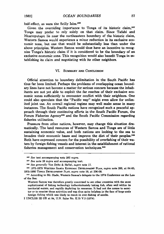
1982] OCEAN BOUNDARIES 57
half-effect, as were the Scilly Isles.338
Given the overriding importance to Tonga of its historic claim,387 Tonga may prefer to rely solely on that claim. Since Tafahi and Niuatoputapu lie near the northeastern boundary of the historic claim, Western Samoa would experience a minor reduction in its exclusive economic zone, but one that would be substantially less than under the above principles. Western Samoa would thus have an incentive to recognize Tonga's historic claim if it is considered to be the boundary of an exclusive economic zone. This recognition would also benefit Tonga in establishing its claim and negotiating with its other neighbors.
VI. SUMMARY AND CONCLUSION
Official attention to boundary delimitation in the South Pacific has thus far been limited. Perhaps the problems of overlapping ocean boundary lines have not become a matter for serious concern because the inhabitants are not yet able to exploit the far reaches of their exclusive economic zones sufficiently to encounter conflict with their neighbors. One could also speculate that the "Pacific way" might even allow for unlimited joint use. An overall regional regime may well make sense in many instances. The South Pacific nations have recognized such a peaceful approach through their continuing efforts in the South Pacific Forum, the Forum Fisheries Agency338 and the South Pacific Commission regarding fisheries utilization.
Pressure from other nations, however, may change this situation dramatically. The land resources of Western Samoa and Tonga are of little sustaining economic value, and both nations are looking to the sea to broaden their economic bases and improve the diet of their peoples.sslI
Both have expressed concern for the possibility of overfishing of their waters by foreign fishing vessels and interest in the establishment of rational fisheries management and conservation techniques.84o
••• See text accompanying note 260 supra . •• 7 See note 26 supra and accompanying text . ... See generally Van Dyke & Heftel, supra note 17 . ••• 1975·1979 WESTERN SAMOA ECONOMIC DEVELOPMENT PLAN, supra note 283, at 64-65;
1975·1980 TONGA DEVELOPMENT PLAN, supra note 19, at 206-08 . ... According to Mr. Slade, Western Samoa's delegate to the 1974 Conference on the Law
of the Sea: Western Samoa was therefore greatly concerned to see other countries with the most sophisticated of fishing technology indiscriminately taking fish, often well within its territorial waters, and rapidly depleting its resources. It had not the means to monitor or to counter those activities and was thus quite helpless in the face of large-scale foreign fishing which was likely to result in over-fishing of stocks.
I UNCLOS III OR at 84, U.N. Sales No. E.75 V.3 (1974).

58 UNIVERSITY OF HAWAII LAW REVIEW [Vol. 4
All these island communities face a problem in policing their waters. Their naval power is limited compared to the developed nations of the world, and, in some cases, it is nonexistent. Their lack of sophisticated vessels places them in a competitively disadvantageous position for pursuing fish, petrochemicals or polymetallic nodules.
Clarification of ocean boundaries may be necessary in order to exclude foreign fishing vessels, to negotiate joint fishing agreements and to impose fees, royalties or other forms of reimbursement for fish taken from national waters. If other resources are discovered, such as petroleum or polymetallic nodules, the financial impetus for drawing boundaries will be even greater. If proposals are made to use the seabed for dumping or emplacement of nuclear wastes, environmental concerns will certainly lead to the desire for clear boundaries. These are all matters over which every state has the right to exercise control.
Both Tonga and Fiji claim uninhabited reef areas far from their main island groups. No dispute yet exists regarding these claims, but whether these reefs can or should generate 200-mile resource zones remains in doubt. The Tongan situation is particularly complex, because the Tongans have built artificial land structures on top of a reef that is below water at high tide. At the very least, one can conclude that these reefs should not be able to generate zones that would infringe upon the established zones of other nations. They arguably should not generate any zones whatsoever because these zones would reduce the resources available to the common heritage of humankind.
Tonga's historic title claim of 1887 may also create difficulties. Was the Proclamation originally issued to claim the waters themselves or only to give clear guidance to the locations of the islands claimed? Should the historic claim be considered one for a territorial sea, a modified archipelago or a type of resource zone? A historic claim should certainly be given due consideration in any ultimate resolution, but the actual weight to be given must be determined through good-faith negotiations.
The problem involving the two Samoas appears to require maximum flexibility in order to ameliorate the harshness of geographic realities because a solution based on the drawing of median lines between the two island groups leads to a result clearly inequitable to Western Samoa. Swains Island, separate from the main islands of American Samoa and only sparsely inhabited, appears to be a "special circumstance" demanding careful analysis in negotiations.
The Pacific Island communities have a strong record of resolving their differences in a "Pacific way," through agreements reached by respect and understanding. The boundary problems of this region have their own unique characteristics, but are not totally unlike problems that have been addressed and resolved in other regions. The Pacific communities may be

1982J OCEAN BOUNDARIES 59
able to draw upon these recent solutions, and may in turn be able to negotiate agreements that can serve as models to be used elsewhere.