Embed Size (px)
Citation preview

Observers Guide to
U. S. Department of Commerce • National Oceanic and Atmospheric Administration
NOAA Ocean Service • Office of Response and Restoration
National Environmental Satellite, Data, and Information Service • National Ice Center

U. S. Department of Commerce
National Oceanic and Atmospheric Administration
NOAA Ocean Service • Office of Response and Restoration
National Environmental Satellite, Data, and Information Service • National Ice Center
For additional information contact:
NOAA Emergency Response Division
7600 Sand Point Way NE
Seattle, WA 98115
response.restoration.noaa.gov
This Observers’ Guide to Sea Ice was prepared by Dr. Orson P. Smith, University of Alaska Anchorage, School of Engineering for the National Oceanic and Atmospheric Administration with thanks to Kathleen Cole, Anchorage Forecast Office Ice Forecaster. It is a product of the Cook Inlet and Prince William Sound Navigation Safety and Ef-ficiency project. To order additional copies of this document, fax your request to (206) 526-6329 or e-mail [email protected].

1
O B S E R V E R S ’ G U I D E T O S E A I C E
Table of Contents
Introduction 2
Completing an Observation Report 4
Sea Ice Observation Report Form 5
Glacier Ice Observation Report Form 6
Concentration 7
Stages of Development 11
Sea Ice Forms 16
Glacier Ice Forms 23

2
Introduction
This booklet is intended for use by volunteers to report aerial, ship-board, or shoreline observations of ice conditions at sea to authorities such as the National Weather Service, National Ice Center, U.S. Coast Guard, pilots’ associations, port authorities, or other maritime interests. Emphasis here is on conditions of concern to mariners with regard to safe passage of ships. Scientific observers may wish to note additional details following guidance of the World Meteorological Organization. Sea ice consists of frozen sea water. River (freshwater) ice is often indistinguishable when mixed with sea ice, especially with snow cover. Glacier ice, broken away from a tidewater glacier, is usually more irregular than river ice or frozen sea water. Tidal estuaries may also have thick, irregular pieces of sediment-laden beach ice, which have been grounded on tidelands, repeatedly submerged, and floated free by spring tides. Sea ice is observed in terms of three basic parameters: concentra-tion, stage of development, and form. Concentration refers to the fraction of the sea surface covered by ice, reported in tenths by international conven-tion. Stage of development refers to age and structural characteristics of the ice that may be inferred from specific visible features and knowledge of regional conditions prior to the observation. Stage may be more directly observed from shipboard when ice breaking reveals the prevailing thickness of the ice. Stage classification does not apply to glacier ice. Form refers to the horizontal shape and dimensions of pieces of ice. The form of glacier ice is also reported in terms of freeboard, or maximum height above the sea surface. Observers should report sea ice conditions with reference to the date, time, and geographical position of the observation and the particular perspective, or field of view. The field of view from an airplane is much dif-ferent from the field of view from the bridge of a ship or from the shoreline. A reporting form for sea ice and a separate form for glacier ice are provided to aid observers in noting this essential information.

3
U.S. Sea Ice Reporting Agencies
National Weather ServiceAlaska Region, Forecast Office6930 Sand Lake RoadAnchorage, Alaska 99502Ice Desk: (907) 266-5138Marine Desk (24 hours): (907) 266-5106Fax: (907) 266-5188e-mail: [email protected]://pafc.arh.noaa.gov/ice.php
National Ice CenterFederal Office Building #4, Room 23014231 Suitland Road Washington, D.C. 20395 Telephone: (301) 394-3100Fax: (301) 394-3200e-mail: [email protected] http://www.natice.noaa.gov

4
Completing an Observation Report
1. Use a dry-erase marker to fill out either the sea ice or the glacier ice observation report form, or to make a permanent record on a copy of the form.
2. Note the date, time, and time zone of the observation, e.g., “Alaska Standard,” “Alaska Daylight Savings (summer) Time,” or “Greenwich Mean Time” (GMT).
3. Note the latitude and longitude of the observation by reference to a chart or Global Positioning System (GPS). GPS also give accurate time of day.
4. Describe your position in words, as you would over the radio or telephone, noting the water body and nearby charted geographical features, e.g., “central Cook Inlet, 3 nautical miles east of Middle Ground Shoal.”
5. Describe your perspective in terms of altitude above the water, the com-pass direction toward which you are looking, and the most recognizable geographical features directly in view, e.g., “10 m (30 ft) above the water (bridge-level), looking west toward the center of Trading Bay.”
6. Check the choices of concentration that apply to the conditions you observe, noting the average and the range of concentrations in view.
7. Sea ice: Circle the stages of development you judge to be in view. Direct knowledge of recent local weather and prior nearby ice observations, as well as the appearance of the ice, may be applied to judge stage of development.
8. Use the length, or beam, of the ship or recognizable objects in view (like ships, docks, or oil platforms) to estimate the size of ice pieces observed and note the prevailing form and the range of ice forms visible.
9. Glacier ice: Note the form in terms of estimated maximum freeboard and waterline length. Also note the above-water shape.
10. Note any other observed features that might help mariners following you across the water body or that would help ice reporters match your observation with others.
11. Transmit your report as soon as possible to the National Weather Service, National Ice Center, or other marine service organization.

5
Sea Ice Observation Report Form
Date: Time: Time zone:
Latitude: Longitude:
Description of position:
Altitude of observer:
Looking toward (compass bearing):
Charted landmarks in view:
Concentration:(see pages 7-10)
0 1 2 3 4 5 6 7 8 9 10
Stage of Development:(see pages 11-15)
New Ni YN-G
YN-GW
FL FM FT Old
Form:(see pages 16-22)
New Brash Belts Strips Pancakes
Cakes Small floes Medium floes
Big floes Vast floes Giant floes
Other description:

6
Glacier Ice Observation Report Form
Date: Time: Time zone:
Latitude: Longitude:
Description of position:
Altitude of observer:
Looking toward (compass bearing):
Charted landmarks in view:
Concentration:(see page 7)
0 1 2 3 4 5 6 7 8 9 10
Glacier ice forms:(see pages 23-27)
Growlers Bergy bits Small berg
Medium berg Large berg Very large berg
Above-water shape:(see page 23)
Blocky Tabular Domed
Pinnacled Drydocked Wedged non-tabular
Other description:

7
Concentration
Concentration
less than 1 tenth “open water” 2 - 3 tenths “very open drift” 4 tenths “open drift”
5 tenths “open drift” 6 tenths “open drift” 7 - 8 tenths “close pack”
9 tenths “very close pack” 10 tenths “compact”

8
Concentration
1 - 2 tenths “very open drift”Photo provided by ConocoPhillips
3 - 4 tenths “open to very open drift”Photo provided by USCG MSD Kenai, Alaska
Concentration

9
Concentration
5 - 6 tenths “open drift”
7 - 8 tenths “close pack”
Concentration
10
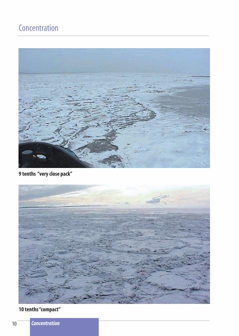
Concentration
9 tenths “very close pack”
Concentration
10 tenths “compact”

11
Stages of Development
New (N): Ice of the following initial stages of ice formation
Frazil: Separate fine needles or plates suspended in the waterGrease: A thin skin of frazil crystals coagulated on the sea surface hav-ing a dark, greasy appearance (Also called ice fat, lard ice)Slush: Snow mixed with water in a viscous surface layerShuga: An accumulation of spongy white lumps
Nilas (Ni): A thin, elastic crust of ice, less than 10 cm (4 in) thick, easily bending on waves, often with a striped or chevron appearance
Young (YN): Ice 10 - 30 cm (4 - 12 in) thick of the following sub-stages
Gray (G): Young ice 10 - 15 cm (4 - 6 in) thick, less elastic than nilas, that breaks on swell and rafts (one layer over another) under pressureGray-white (GW): Young ice 15 - 30 cm (6 - 12 in) thick, that buckles to form ridges on its edges from pressure or collisions
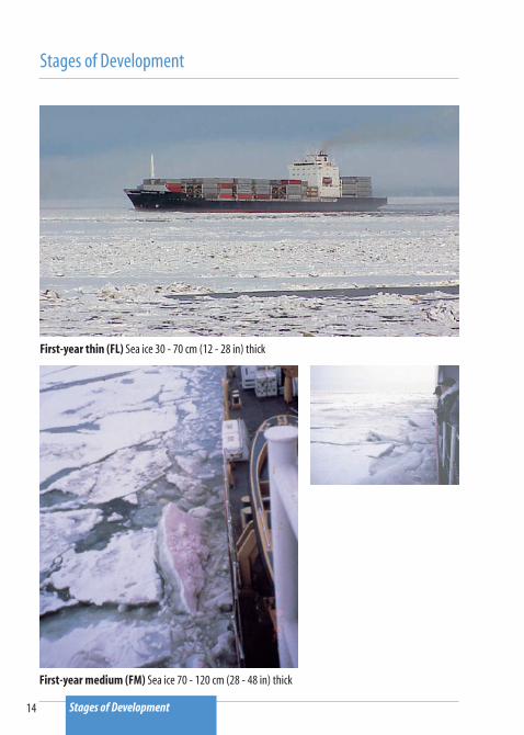
First-year thin (FL): Sea ice that, in uniform level areas without ridges or other deformations, is 30 - 70 cm (12 - 28 in) thick
First-year medium (FM): Sea ice 70 - 120 cm (28 - 48 in) thick
First-year thick (FT): Sea ice over 1.2 m (4 ft) thick
Old or multi-year (MY): Sea ice of any thickness that has survived at least one melting season, char-acterized by undulating, weathered ridges and a well-defined melt water drainage pattern
Stages of Development

12
Stages of Development
New Ice (N)Frazil: Fine needles or plates suspended in the water Grease: A thin skin of frazil crystals coagulated on the sea surface having a dark, greasy appearance (Also called ice fat, lard ice)
Stages of Development
New Ice (N)Slush: Snow mixed with waterShuga: An accumulation of spongy white lumps

13
Stages of Development
Nilas (Ni) A thin, elastic crust of ice, less than 10 cm (4 in) thick, easily bending on waves, often with a striped or chevron appearance
Young (YN) Level ice 10 - 30 cm (4 - 12 in) thick, of the following sub-stages: Gray (G): Young ice 10 - 15 cm (4 - 6 in) thick, less elastic than nilas, that breaks on swell and rafts under pressure Gray-white (GW): Young ice 15 - 30 cm (6 - 12 in) thick, which buckles to form ridges on its edges from pressure or collisions
Stages of Development
14
Stages of Development
First-year thin (FL) Sea ice 30 - 70 cm (12 - 28 in) thick
First-year medium (FM) Sea ice 70 - 120 cm (28 - 48 in) thick
Stages of Development

15
Stages of Development
First-year thick (FT) Sea ice over 1.2 m (4 ft) thick (Photo provided by Jerry Galt)
Old or Multi-year (MY) Sea ice of any thickness that has survived at least one melting season, characterized by undulating, weathered ridges and a well-defined melt water drainage pattern
Stages of Development

16
Sea Ice Forms
New: Small, thin, newly formed, dinner plate-sized pieces
Brash: Broken pieces less than 2 m (6 ft) across
Pancake: Rounded floes 30 cm - 3 m (1 - 10 ft) across with ridged rims
Ice Cake: Level piece 3 - 20 m (6 - 65 ft) across
Small Floe: Level piece 20 - 100 m (65 - 328 ft) across
Medium Floe: Level, continuous piece 100 -500 m (328 - 1640 ft) across
Big Floe: Level, continuous piece 500 m - 2 km (1/3 - 1 mi) across
Vast Floe: Level, continuous piece 2 - 10 km (1 - 6 mi) across
Giant Floe: Level, continuous piece greater than 10 km (6 mi) across
Belt: A linear accumulation of sea ice from 1 km to over 100 km (0.6 - 60 mi) wide
Strip: A linear accumulation of sea ice less than 1 km (0.6 mi) wide
Beach Ice: Irregular, sediment-laden blocks that are grounded on tide-lands, repeatedly submerged, and floated free, generally, by spring tides
Fast Ice: Ice formed and remaining attached to shore
Sea Ice Forms
17
Sea Ice Forms
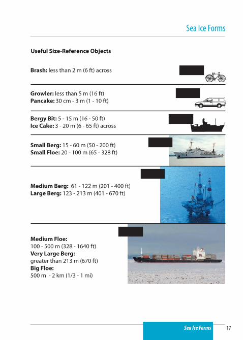
Useful Size-Reference Objects
Brash: less than 2 m (6 ft) across 6 ft
Growler: less than 5 m (16 ft)Pancake: 30 cm - 3 m (1 - 10 ft)
Bergy Bit: 5 - 15 m (16 - 50 ft) Ice Cake: 3 - 20 m (6 - 65 ft) across
Small Berg: 15 - 60 m (50 - 200 ft)Small Floe: 20 - 100 m (65 - 328 ft)
16 ft
32 ft
200 ft
Medium Berg: 61 - 122 m (201 - 400 ft)Large Berg: 123 - 213 m (401 - 670 ft)
300 ft
Medium Floe: 100 - 500 m (328 - 1640 ft)Very Large Berg: greater than 213 m (670 ft)Big Floe: 500 m - 2 km (1/3 - 1 mi)
710 ft
Sea Ice Forms

18
Sea Ice Forms
Brash Broken pieces less than 2 m (6 ft) across (Homer, Alaska)
Pancake Ice Circular floes 30 cm - 3 m (1 - 10 ft) across and up to 10 cm (4 in.) thick with raised rims
Sea Ice Forms

19
Sea Ice Forms
Ice Cake Relatively level piece less than 20 m (65 ft) across (altitude 500 feet, Cook Inlet, Alaska)
Small Floe Continuous level piece 20 - 100 m (65 - 328 ft) across (altitude 500 ft, Anchorage, Alaska)
Sea Ice Forms

20
Sea Ice Forms
Medium Floe Continuous flat piece 100 - 500 m (328 - 1640 ft) across (altitude 800 ft, Cook Inlet, Alaska)
Big Floe Continuous flat piece 500 m - 2 km (1/3 - 1 mi) across (altitude 500 - 600 ft, Arctic Ocean)
Sea Ice Forms

21
Sea Ice Forms
Belt A linear accumulation of sea ice from 1 km to over 100 km (0.6 - 60 mi) wide
Strip A linear accumulation of sea ice less than 1 km (0.6 mi) wide (altitude 800 ft, Cook Inlet, Alaska)
Sea Ice Forms

22
Sea Ice Forms
Beach Ice Thick, irregular, sediment-laden pieces, which have been grounded on tidelands, repeatedly submerged, and floated free, generally, by spring tides (grounded beach ice, Cook Inlet, Alaska)
Fast Ice Ice formed and remaining attached to shore (upper Cook Inlet, Alaska)
Sea Ice Forms

23
Glacier Ice Forms
Form Freeboard (height above water) Length
Growler less than 1 m (3 ft) less than 5 m (16 ft)
Bergy Bit 1 - 5 m (3 - 16 ft) 5 - 15 m (16 - 50 ft)
Small Berg 5 - 15 m (16 - 50 ft) 15 - 60 m (50 - 200 ft)
Medium Berg 16 - 45 m (51 - 150 ft) 61 - 122 m (201 - 400 ft)
Large Berg 46 - 75 m (151 - 240 ft) 123 - 213 m (401 - 670 ft)
Very Large Berg greater than 75 m (240 ft) greater than 213 m (670 ft)
Blocky: Generally straight-sided polygonal shape
Tabular: Flat top with near-vertical sides
Domed: Rounded appearance above the waterline
Non-tabular or irregular: No regular geometric shape apparent
Wedged: Triangular wedge shape
Pinnacled: One or more prominent central spires
Drydocked: Melted out in center to form a U-shaped slot
Black Ice: Dark, sediment-laden ice from glacier medial moraines or associated frozen glacier surface ponds of turbid runoff water
Glacier Ice Forms

24
Glacier Ice Forms
Growler Glacier fragment less than 1 m (3 ft) freeboard and less than 5 m (16 ft) across (Prince William Sound, Alaska)
Glacier Ice Forms

25
Glacier Ice Forms
Bergy bit (irregular)
Bergy Bit Glacier fragment 1 - 5 m (3 - 16 ft) freeboard or 5 - 15 m (16 - 50 ft) across (Prince William Sound, Alaska, photo provided by Stan Stephens)
Black ice bergy bit (blocky)
Glacier Ice Forms
26
Glacier Ice Forms
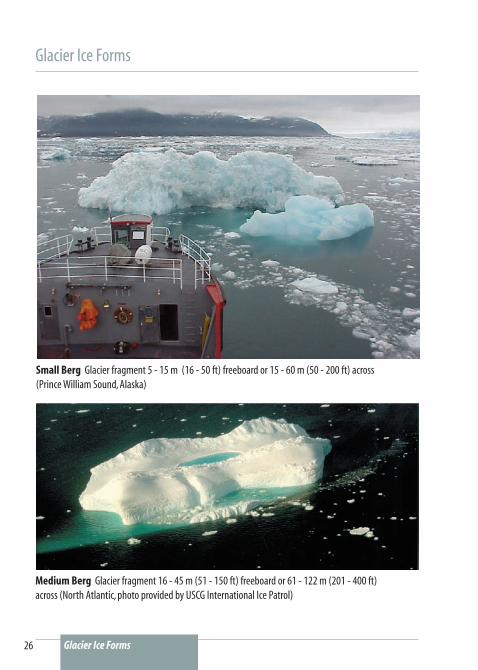
Small Berg Glacier fragment 5 - 15 m (16 - 50 ft) freeboard or 15 - 60 m (50 - 200 ft) across (Prince William Sound, Alaska)
Glacier Ice Forms
Medium Berg Glacier fragment 16 - 45 m (51 - 150 ft) freeboard or 61 - 122 m (201 - 400 ft) across (North Atlantic, photo provided by USCG International Ice Patrol)

27
Glacier Ice Forms
Large Berg Glacier fragment 46 -75 m (151 - 240 ft) freeboard or 123 - 213 m (401 - 670 ft) across (Photo provided by Jerry Galt)
Very Large Berg Glacier fragment over 75 m (240 ft) freeboard or over 213 m (670 ft) across (Antarctica, photo provided by USCG International Ice Patrol)
Glacier Ice Forms

U.S. Department of CommerceNational Oceanic and Atmospheric Administration • NOAA Ocean Service
Carlos M. Gutierrez
Secretary, U.S. Department of Commerce
Vice Admiral Conrad C. Lautenbacher, Jr., USN (Ret.)
Under Secretary for Oceans and Atmosphere and NOAA Administrator
John H. Dunnigan
Assistant Administrator, Ocean Services and Coastal Zone Management
NOAA Ocean Service
August 2007