Embed Size (px)
Citation preview
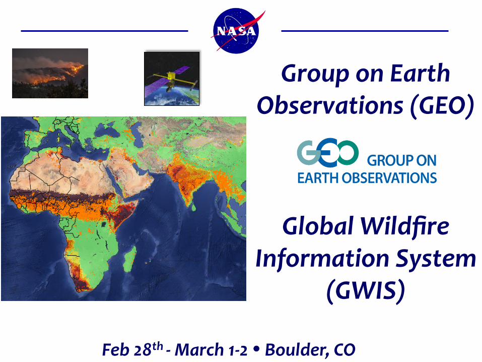
Group on Earth Observations (GEO)
Global Wildfire Information System
(GWIS)
Feb 28th -‐ March 1-‐2 • Boulder, CO
GWIS History
• The Global Wildfire Information System was developed as a proposal in October 2011 under the GOFC (Global Observation of Forest Cover) element at the GOFC Fire Implementation Team meeting in Stresa, Italy;
• In April 2013, the GWIS was conceived as a beta system under the European Forest Fire Information System (EFFIS) operated by the European Commission (EC);
• November 2013: GWIS proposed under GEO for the Work Programme 2012-‐2015 (by C. Justice, San Miguel Ayanz, and Gaetani);
• Adopted by the GEO WP in March 2014 and added under the DISASTERS component, Informing Risk Management & Disaster Reduction, Component C4 (DI-‐01-‐C4);GEO GWIS was
• The GWIS was continued as a GEO Initiative in the Transitional Work Programme in 2016 (GI-‐04), and then adopted as a continuing component of the GEO Work Programme for 2017-‐2019;
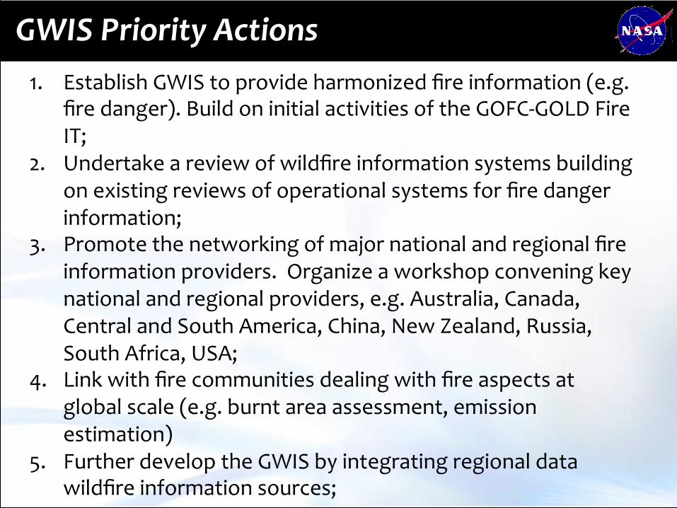
GWIS Priority Actions 1. Establish GWIS to provide harmonized fire information (e.g.
fire danger). Build on initial activities of the GOFC-‐GOLD Fire IT;
2. Undertake a review of wildfire information systems building on existing reviews of operational systems for fire danger information;
3. Promote the networking of major national and regional fire information providers. Organize a workshop convening key national and regional providers, e.g. Australia, Canada, Central and South America, China, New Zealand, Russia, South Africa, USA;
4. Link with fire communities dealing with fire aspects at global scale (e.g. burnt area assessment, emission estimation)
5. Further develop the GWIS by integrating regional data wildfire information sources;
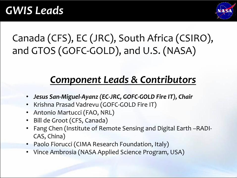
GWIS Leads
Canada (CFS), EC (JRC), South Africa (CSIRO), and GTOS (GOFC-‐GOLD), and U.S. (NASA)
Component Leads & Contributors • Jesus San-‐Miguel-‐Ayanz (EC-‐JRC, GOFC-‐GOLD Fire IT), Chair • Krishna Prasad Vadrevu (GOFC-‐GOLD Fire IT) • Antonio Martucci (FAO, NRL) • Bill de Groot (CFS, Canada) • Fang Chen (Institute of Remote Sensing and Digital Earth –RADI-‐
CAS, China) • Paolo Fiorucci (CIMA Research Foundation, Italy) • Vince Ambrosia (NASA Applied Science Program, USA)

GWIS: Extension of EFFIS to GWIS
Canadian, USA, Australian fire danger (ECMWF)

GWIS Prototype
GWIS prototype provides a beta web map service (WMS) viewer that includes real-‐time fire information sets such as Fire Danger, Active Fires, Fire Emissions, Burned Areas,
Fuels, and other layers, on a global scale.

GWIS Goals in GEO WP 2017-‐2019
• Provide harmonized fire information (e.g. fire danger) – building on initial activities of the EC in the EFFIS and the GOFC-‐GOLD Fire Implementation Team (GOFC-‐GOLD Fire IT);
• Promote networking of fire information providers through annual workshop through key international organizations and initiatives and national and regional providers;
• Establish operational links with other wildfire communities dealing with global wildfire aspects (e.g. burnt area assessment, emission estimation);
• Integrate / harmonize regional wildfire information data sources; • Develop, implement and promote interoperability and
communication among national, regional and global wildfire information systems following OGC standards and the GEOSS Data Sharing Principles;
• Coordinate / promote capacity building and training activities in close cooperation with the GOFC-‐GOLF Fire IT regional networks and the EFFIS network.

NASA ROSES-‐16 GEO Solicitation
A.50 Group on Earth Observations Work Programme
• Solicitation offered by NASA Earth Science and Applied Science Program
• To demonstrate a strong ability to support and advance GEO, to further U.S. and NASA interests, and to demonstrate U.S. and NASA commitments to GEO ;
• To foster broader domestic involvement in a U.S. national approach to GEO and the Work Programme;
• Advance the use of Earth observations to inform decisions and actions and broaden the organizations routinely using them;
• Increase international collaboration and partnering across GEO and broaden the GEO community;

NASA ROSES-‐16 GEO Solicitation
A.50 GEO Work Programme
• Nine Elements of the ROSES-‐16 A.50 GEO solicitation
• 3.1 AmeriGEOSS • 3.2 Earth Observations for Ecosystem Accounting (EO4EA) • 3.3 Earth Observations for Health • 3.4 GEO Biodiversity Observation Network (GEO BON) • 3.5 GEO Global Water Sustainability (GEOGLOWS) • 3.6 GEO Vision for Energy (GEOENER) • 3.7 Global Flood Risk Monitoring • 3.8 Global Wildfire Information System (GWIS) • 3.9 Human Planet
NASA ROSES-‐16 GEO Solicitation
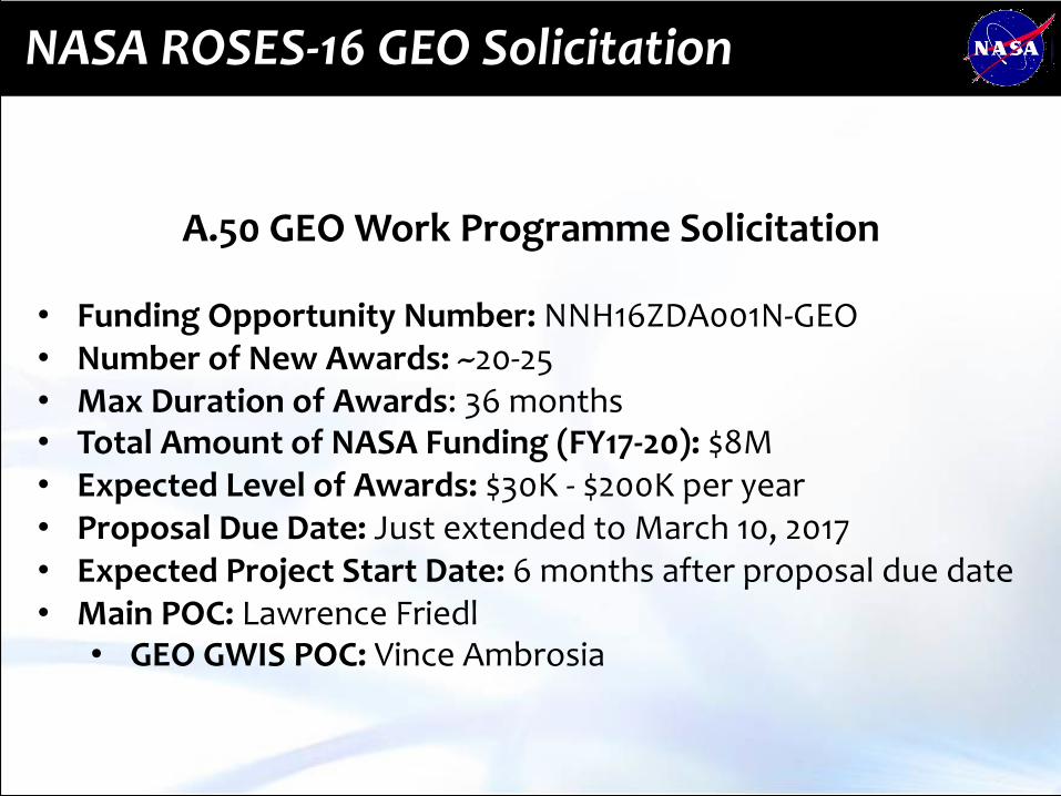
A.50 GEO Work Programme Solicitation • Funding Opportunity Number: NNH16ZDA001N-‐GEO • Number of New Awards: ~20-‐25 • Max Duration of Awards: 36 months • Total Amount of NASA Funding (FY17-‐20): $8M • Expected Level of Awards: $30K -‐ $200K per year • Proposal Due Date: Just extended to March 10, 2017 • Expected Project Start Date: 6 months after proposal due date • Main POC: Lawrence Friedl
• GEO GWIS POC: Vince Ambrosia
GEO GWIS Element Solicitation
A.50 GEO Work Programme
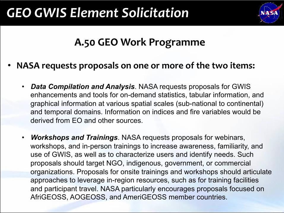
• NASA requests proposals on one or more of the two items:
• Data Compilation and Analysis. NASA requests proposals for GWIS enhancements and tools for on-demand statistics, tabular information, and graphical information at various spatial scales (sub-national to continental) and temporal domains. Information on indices and fire variables would be derived from EO and other sources.
• Workshops and Trainings. NASA requests proposals for webinars,
workshops, and in-person trainings to increase awareness, familiarity, and use of GWIS, as well as to characterize users and identify needs. Such proposals should target NGO, indigenous, government, or commercial organizations. Proposals for onsite trainings and workshops should articulate approaches to leverage in-region resources, such as for training facilities and participant travel. NASA particularly encourages proposals focused on AfriGEOSS, AOGEOSS, and AmeriGEOSS member countries.

GEO GWIS: http://forest.jrc.ec.europa.eu/effis/applications/global-‐viewer/