Embed Size (px)
Citation preview
December 2007

Oak Hill Neighborhood Plan
Oak Hill Vision Statement
The Oak Hill area is characterized by its many unique, historical homes, large lots and old trees. Specimens include post oaks, black jack oaks and “O.S. Gray Nursery” pecans. Residents describe the neighborhood as a quiet, safe place to live. Oak Hill celebrates diversity and its unique heritage. Many of the original homeowners played important roles in Arlington and/or Texas history. Residents practice responsible stewardship of the area’s architectural, cultural and natural environment. Oak Hill’s close proximity to UTA, downtown, shopping centers and medical facilities gives the area a small-town feeling. Residents wish to add more green spaces and preserve the intimate scale of the neighborhood for the future.
Prepared by Oak Hill Neighborhood Plan Steering Committee
Assisted by
City of Arlington Community Development and Planning Department

Oak Hill Neighborhood Plan
Acknowledgments The Oak Hill Neighborhood Plan is the result of many hours of work, research and discussions by citizens, business owners, other organizations and City staff. This plan could not have been completed without the dedication and effort of the citizens of the Oak Hill neighborhood and the volunteer steering committee. Oak Hill Neighborhood Plan Steering Committee Sandra Argentini Donna Austin Patty Bush Elena Cogdell Tom Cogdell Sarah Garrett Barbara Hackney Charles Hackney Michelle Kafer P.J. Lockwood Richard Merrill Sharron Merrill Elouise Perry Ana Pettit Merry Sarles Robert Strickland Tricia Taylor Becky Upchurch Mike Yeager Mayor & City Council
Dr. Robert Cluck, Mayor Lana Wolff, Council Member, District 5 Planning and Zoning Commission
Victor Vandergriff, Chair Community Development & Planning Department
Jim Parajon, AICP, Director Michelle Hardin, AICP, Assistant Director Bridgett White, AICP, Chief Planner/Comprehensive Clayton Husband, AICP, Senior Planner/Comprehensive Lexin Murphy, Planner/Comprehensive Support City Staff
City Manager’s Office Jim Holgersson, City Manager Trey Yelverton, Deputy City Manager
Arlington Strong Neighborhood Initiative Regina “R.J.” Blair, Neighborhood Services Coordinator Community Services Sheryl Kenny, Grants Program Manager Robert Lawless, Community Services Supervisor Library Cary Siegfried, Director Lee Shqeir, Administrative Services Coordinator Police Department Lt. Jerry Hataway Officer Douglas Glotfelty Public Works & Transportation Keith Melton, P.E., Assistant Director/Operations Paul Iwuchukwu, P.E., City Traffic Engineer Caryl DeVries, P.E., Traffic Engineer Other Organizations
Tin Cup Coffee Shop & Deli Damon & Bradi Carney Arlington Historical Society Geraldine Mills, Director University of Texas at Arlington John D. Hall, Vice President of Finance and Campus Operations Hill Gilstrap Attorneys & Counselors Frank Hill


Oak Hill Neighborhood Plan
Table of Contents
Chapter 1
Introduction 2 Vision Statement 4 Goals – Objectives – Strategy Statements 5
Chapter 2
Planning Process and Public Participation 10
Citizen Participation 11
Neighborhood Assessment Survey 12
Chapter 3
Assessment of Existing Conditions 14 Demographic Profile 15 Land Characteristics 21 External Influences on Neighborhood 29 Internal Influences on Neighborhood 34
Chapter 4
General Implementation Strategies 42 Implementation Program 43 Conservation District Overlay 46 Neighborhood Design & Character 49 Funding Resources 52 Amendments 53
Appendices
Oak Hill neighborhood history 55 Neighborhood Assessment Survey Questions 60 Responses to Selected Survey Questions 64 Responses to Open Comment Survey Question 73 SWOT Issues and Rankings 77

Chapter 1
Introduction Goals and Strategies

Introduction, Goals and Strategies Page 2
Introduction Study Area Profile The study area is located in central Arlington, west of the downtown area and immediately west of the University of Texas at Arlington (UTA) campus. The area is generally bounded by Fielder Road (west), West Abram Street (north), Davis Drive (east) and Maverick Stadium and the University Hills subdivision (south). Second Street is the only continuous east-west street through the neighborhood, and connects Davis Drive with Fielder Road. The area covers approximately 132 acres of land, most of which is developed with single family residences. Development has occurred over the course of 80 years. The first residence in the neighborhood was constructed in 1920, and some houses as late as the early 1990s. There are 14 different platted subdivisions in the area, though some property is still unplatted. The platted subdivisions include Adamdale Addition, Elliott Subdivision, Robert Fielder Addition, Iondale Place, Jerry Jordan Addition, Lattimore Subdivision, O. Medlin Addition, North Oak Hill Acres, Oak Hill Acres, Summit Grove, Vellenga Acres, Wildflower Estates, Wildflower Estates West and Wilemon Subdivision. Properties along the south side of West Abram Street are redeveloping from residential uses to office uses. These properties are zoned either Planned Development or Office. The area is located outside of any tax increment financing districts or other special districts. There are no public parks located within the study area. The closest parks are Fielder Park and College Hills Park, both of which are neighborhood parks. This area is in City Council District 5 and the Central Planning Sector. History of Neighborhood Area One of the adopted strategies in the Central Sector Plan is to “promote the history of the Central Sector in the development of the Sector’s image.” This strategy provides an opportunity to educate citizenry on Arlington’s history.

Introduction, Goals and Strategies Page 3
The general area in which the neighborhood is located has a storied history related to Arlington, UTA and Texas. A history of the neighborhood area was written by Tom Cogdell, a member of the volunteer steering committee. A copy of the history is included in the appendix. A survey of property owners and residents was conducted to determine interest in a nickname for the neighborhood. The name “Oak Hill” was chosen by more than 70% of the respondents. The name “Oak Hill” honors the historic Fielder House, which was once known as “Home on the Hill”, and Oak Hill Acres, one of the first subdivisions created in the neighborhood.
References to Adopted Plans The neighborhood area is included in the Central Sector Plan, known as “The Heart of Arlington”. The Plan for this sector was approved by the City Council on November 30, 1999, by Ordinance 99-148. The Central Sector Plan is a community-driven plan and a direct product of citizen and neighborhood involvement. The plan covers a framework of six different topical areas: human environment, built environment, land use environment, economic environment, natural environment and service environment. The 10-year vision statement for the Central Sector Plan is the foundation from which this plan was prepared. The statement reads as follows:
To create a community at the heart of Arlington that takes pride in its diversity of people and land uses, where all stakeholders exhibit pride in the community that results in a safe, desirable area and produces an inviting place for redevelopment, entrepreneurism and preserving and enhancing its residential neighborhoods while building on its many assets, including its people, the University of Texas at Arlington, other institutions and Downtown.
The Oak Hill neighborhood plan is considered a further refinement of the Central Sector Plan and the overall Comprehensive Plan for the city. Specific references to the Central Sector Plan are noted throughout this document in appropriate places. Oak Hill Neighborhood Goals Cities commonly establish goals and policy statements as a part of most planning efforts. Goals specify a direction of intended movement, with associated political and financial commitments. Setting goals also helps clarify problems and generally leads to positive action. Many of the problems confronting Arlington, like most communities, are complex and can be difficult to understand. Almost everyone has a vague idea of what these problems are, but when goals are written down for everyone to see, the problems become clearer. Furthermore, establishing community goals and policy statements elicits community support. The citizens of the neighborhood enjoy a high quality of life. Approximately 98% of the Oak Hill residents surveyed rated the livability of their neighborhood as good or very good. The goals established for this neighborhood plan are intended to maintain the existing living standards and to provide potential solutions for correcting problems where identified. The plan is designed to provide guidance that will improve the quality of life in the neighborhood for years to come. Additionally, the goals and policy statements that have been outlined in this report will help to guide and shape the future development of the community and the area.

Introduction, Goals and Strategies Page 4
The goals, objectives and strategies listed in this chapter represent the collective efforts of citizens who were involved in neighborhood meetings or workshops arranged to facilitate the development of the plan. The views regarding the neighborhood were also collected from a voluntary written survey done by the steering committee. SWOT Analysis The first exercise conducted by the steering committee was to analyze the strengths, weaknesses, opportunities and threats in the neighborhood. This type of analysis helps identify the positive and negative issues that face a neighborhood, both internally and externally. The committee generated ideas, recorded the ideas in a round-robin feedback session and considered each of them in turn, discussing and evaluating the relevant issues. The brainstorming session resulted in a list of issues for each category – strengths, weaknesses, opportunities and threats. These issues were then ranked through voting. For each category, a committee member was given five self-adhesive dots and asked to place dots next to issues they thought were most important. A person could place one to five dots on any issue statement, but only five dots could be used per person. The results from this brainstorming session were used to determine the following goals and policy statements. A full list of the issues for each category, and the associated ranking, is included in the Appendix. Vision Statement A vision statement is a statement of where the community wants to be in the future, and should be comprehensive, realistic and easy to understand. It is important because it establishes the overriding goal for the neighborhood over the long term. The remainder of the plan is the approach for making the vision become reality. To recognize its importance to the planning process, the Oak Hill neighborhood vision statement has been placed on the first page of this document. However, for the purpose of reinforcing the focus on the goals and policy statements contained in this chapter, the vision statement is repeated here.
The Oak Hill area is characterized by its many unique, historical homes, large lots and old trees. Specimens include post oaks, black jack oaks and “O.S. Gray Nursery” pecans. Residents describe the neighborhood as a quiet, safe place to live. Oak Hill celebrates diversity and its unique heritage. Many of the original homeowners played important roles in Arlington and/or Texas history. Residents practice responsible stewardship of the area’s architectural, cultural and natural environment. Oak Hill’s close proximity to UTA, downtown, shopping centers and medical facilities gives the area a small-town feeling. Residents wish to add more green spaces and preserve the intimate scale of the neighborhood for the future.

Introduction, Goals and Strategies Page 5
Goals - Objectives - Strategy Statements Goals should be established that relate to solving problems or addressing specific issues affecting the neighborhood. The goals included in this document are arranged according to specific issue topics identified during the neighborhood planning process. In a broad sense, a goal is a general statement concerning an aspect of the neighborhood’s desired ultimate physical, social and economic environment. A goal sets the tone for public decisions in terms of the residents’ desired quality of life. The associated objectives and strategy statements express the specific actions necessary to achieve the stated goal, without assigning responsibility to any specific action. Detailed methods of implementing the strategy statements are contained in Chapter 4 of this document. The following goals, objectives and strategy statements were determined to be of primary importance to the future of the neighborhood by its residents.
1. Create a safe environment for families 1.A Implement a crime watch program
Coordinate with the Arlington Police Department to create a crime watch program in the neighborhood
1.B Improve streets and lighting
Correct ponding water at Sunset Court and Barnes Drive Address drainage issues at the Parkwood Avenue and West Second Street intersection
1.C Incorporate aesthetic methods of traffic control to reduce speeding
Redirect traffic at West Second Street and Elliott Street using one-way turns Add decorative street lighting with directional signs at the West Second Street and Elliott Street intersection
1.D Provide incentives to reduce property code violations
Introduce a “yard of the month” recognition program Make use of local free labor, such as YMCA teens, church organizations and UTA social and service fraternities and
sororities to assist those in need with property maintenance

Introduction, Goals and Strategies Page 6
Partner with City of Arlington Community Services department for neighborhood improvement projects Allow teen court to assign community service projects in the neighborhood
Encourage residents to join the City of Arlington Code Ranger program
2. Protect property values and enhance quality of life 2.A Ensure the primary land use is single family detached dwellings
Strengthen relationships with absentee landlords through communication and sharing neighborhood plans Inform code enforcement of violations regarding the number of unrelated people living in a dwelling and junk or
inoperable cars parked in the street Encourage property owners to park in driveways only or on surfaces allowed by City codes
2.B Acquire new signage for streets
Design a new logo to represent the neighborhood, possibly through a design contest Create new street signs for all streets using the new logo
2.C Bury existing utility lines
Investigate the costs and timeframe Discuss with the neighborhood and gauge interest
Contact TXU and City of Arlington
2.D Create new green spaces and a neighborhood park
Form partnership with UTA to purchase the house and property west of Maverick Stadium and fronting West Second Street
Apply for grant funds (city, state and national) to purchase and develop the property as a neighborhood park
Design layout for a walking and jogging path surrounding the UTA fields
Partner with UTA, using grant funds, to build the neighborhood park

Introduction, Goals and Strategies Page 7
Arrange maintenance schedule with UTA
Use the existing house on the property as a meeting place and neighborhood center
2.E Establish a set of guidelines for future in-fill of existing sites and add-ons to existing houses
Using building permit and tax roll information, determine setbacks, lot size, building heights, lot coverage and average home size for each street in the area
Limit the size of new construction in terms of percentages of lot size or lot coverage
3. Preserve the historic and unique character of the neighborhood 3.A Celebrate the area’s diversity and heritage with annual gatherings
Choose dates for biannual gatherings Develop a schedule and format for gatherings, such as “come dressed as your home’s original owner” or “have each street
choose a theme and serve as hosts”
3.B Document the history of the area and its former residents
Publish the neighborhood history Create a neighborhood tree, like a family tree, with streets for branches to show residents the history of ownership of
each house
3.C Protect the native trees, post oaks and black jack oaks
Hire an arborist or partner with UTA School of Architecture to do a tree study in the neighborhood, establishing specimens and ages of trees
Create a directory of arborists for future trimming of trees
3.D Ensure that the subdivision of large lots, infill development and new construction are consistent with the scale of the area
Lots should conform in width, depth and area to the predominant pattern established by the existing lots located on the same block, having due regard to the character of the area
Work with the City’s permit department to implement guidelines for new construction

Introduction, Goals and Strategies Page 8
4. Strengthen the relationship with the University of Texas at Arlington and the City of Arlington 4.A Encourage residents to attend and participate in UTA events
Work with UTA to provide discounts for local residents to festivals, the Activities Building and fitness center, the Planetarium and fine arts events
Purchase a block of tickets for residents for UTA weekend events, such as the Texas Scottish Festival and Highland
Games, winter celebration, sporting events and other activities Volunteer with UTA during Special Olympics
Utilize the journalism department to write articles or produce a neighborhood newsletter
Establish a neighborhood newsletter for the dissemination of neighborhood news and events, and publication of the area’s
history
4.B Establish a neighborhood plan recognized by the City of Arlington
Form a steering committee Create a neighborhood plan with City officials
Present plan to the Planning & Zoning Commission and City Council for adoption
4.C Prevent the encroachment of businesses into residential areas
Establish relationships with and meet with local business owners to share concerns and expectations about the neighborhood area
Establish boundaries for businesses’ encroachment into the neighborhood
Report any code violations to the City
4.D Work with the City of Arlington and businesses to improve aesthetics and parking
Carefully locate business driveways and parking areas Establish tow-away zones where necessary

Chapter 2
Planning Process and
Public Participation

Oak Hill Neighborhood Plan
Planning Process and Public Participation Page 10
Planning Process and Public Participation
Basis for Creating the Plan The City of Arlington’s Neighborhood Planning program is an effort to both address opportunities for change and promote stability in neighborhoods. A Neighborhood Plan is the official City policy regarding the future of a neighborhood and contains recommendations that are created by the neighborhood residents. The plan, once approved and adopted by the Planning and Zoning Commission and City Council, becomes an amendment to Arlington’s Comprehensive Plan. In November 2006, the residents in the Oak Hill area petitioned the City Council to request assistance in creating a neighborhood plan. The petition, which was signed by 137 families, asked that the Community Development and Planning Department work with the residents to prepare the plan. Staff met with representatives of the neighborhood on April 19, 2007 to discuss the planning process. A formal kick-off meeting with the residents of the neighborhood area was held on May 14, 2007, at the Tin Cup, a coffee shop and deli located at 1025 West Abram Street. Steering Committee A volunteer steering committee was established by the residents in the area. One of the goals of the process is to engage the residents in creating the plan, with the City providing professional and technical support throughout the process. The steering committee worked with and advised staff during the preparation of the plan, and served as the liaison between the community and the City. The steering committee members represented certain streets within the neighborhood and were responsible for seeking input on many matters related to the plan. The committee members also became educated on community-wide issues, identified neighborhood concerns and recommended suggestions for addressing those concerns. Developing the Plan The first phase of the planning process involves gathering and analyzing background information from the area. Public meetings are used to hear neighborhood concerns and identify issues and problems, while extensive analysis is done of demographics, physical features and other aspects of the neighborhood. The planners, with the advice of the committee, write draft recommendations which address the issues that were identified in the first phase of the planning process. The recommendations reflect the neighborhood's own desires for its future.
Oak Hill Neighborhood Steering Committee Sandra Argentini Donna Austin Patty Bush Elena Cogdell Tom Cogdell Sarah Garrett Barbara Hackney Charles Hackney Michelle Kafer P.J. Lockwood Richard Merrill Sharron Merrill Elouise Perry Ana Pettit Merry Sarles Robert Strickland Tricia Taylor Becky Upchurch Mike Yeager

Oak Hill Neighborhood Plan
Planning Process and Public Participation Page 11
After the recommendations have been drafted, the planners and committee discuss how to best implement the recommendations. There is a set group of neighborhood aspects which the City can protect and regulate. Zoning, subdivision and capital improvements are typical implementation methods. The neighborhood plan may also recommend a change of zoning. One zoning change option is the Conservation District Overlay, which was a tool created especially for the neighborhood planning process. Once the draft neighborhood plan is complete, the planners arrange for the plan to have a public hearing before the Planning and Zoning Commission and the City Council. Before the hearing, a draft plan will be distributed to all property owners in the area. Once the plan is adopted, it becomes an element of the Comprehensive Plan. Steering Committee meetings The steering committee formally met eight (8) times between May 24 and December 3, 2007. Most meetings lasted two to three hours, and were held during the afternoon at city hall. Two of the meetings were held in the evening at a member’s home in the neighborhood. These meetings do not include time spent canvassing the neighborhood to discuss ideas and issues with residents or coordination of efforts to distribute and collect information. The committee spent time at the meetings identifying issues; drafting a vision statement, goals, objectives and strategies; discussing issues related to the neighborhood; and studying topics such as traffic calming, grant opportunities, neighborhood signage and crime watch. At these meetings, staff reported on the demographic, economic and social characteristics of the neighborhood; transportation and gas drilling; grants; and the planning process in general. Citizen participation
The process for creating the Oak Hill Neighborhood Plan was designed to place an emphasis on direct neighborhood involvement and citizen participation.
Kick-off meeting – May 14, 2007. This meeting provided an opportunity to introduce residents and property owners to the planning process. Postcard invitations were mailed to all property owners within the study area. Over 75 people attended the meeting, which was held at the Tin Cup, located at 1025 West Abram Street. Neighborhood meeting – August 9, 2007. The committee hosted a meeting to get feedback on the proposed goals and strategy statements. The meeting was held in the Community Room at the George W. Hawkes Central Library. Postcard notices were mailed to all property owners in the study area. Over 50 people attended the meeting. Neighborhood Summit – November 10, 2007. Several members of the committee attended the 2007 Neighborhood Summit, held at the Bob Duncan Center in Vandergriff Park. The members participated in the module on neighborhood preservation and planning, and their experience with the planning process with people from other neighborhoods around Arlington.

Oak Hill Neighborhood Plan
Planning Process and Public Participation Page 12
Community Watch organizing meeting – November 17, 2007. An informational meeting on establishing a community watch (crime watch) group was held in the garden courtyard area at Hill Gilstrap offices on West Abram Street. About 20 people attended the meeting to hear representatives from the police department speak about crime prevention and personal safety. Committee representation in neighborhood. The committee members chose to represent specific streets in the neighborhood throughout the process. The members had direct contact with the residents of those streets to provide information, receive feedback and discuss issues relevant to the neighborhood and the planning process. Distribution of plan to residents – December 7, 2007. The committee hand-delivered copies of the draft plan to all residents and property owners in the neighborhood. A cover letter was attached to the plan, which explained the committee was seeking feedback and comments on the proposed document.
Neighborhood Assessment Survey In conjunction with the preparation of the neighborhood plan, a voluntary neighborhood assessment survey was provided to all residents of the area. The purpose of the survey was to gather general information about the resident’s opinions of the area. The survey also offered an opportunity to allow residents who could not participate in meetings to be able to provide input on the future of the neighborhood. The survey contained questions related to neighborhood conditions and land use issues; streets, sidewalks and lighting; traffic and parking; parks and beautification; and community services and public safety. Approximately 250 surveys were distributed in the neighborhood area by the steering committee members. Eighty-four (84) surveys were returned for a response rate of 34%. Returned survey responses were compiled by City staff. Responses to the survey are noted throughout this document in relevant locations. Responses to open-ended questions are listed in their entirety, along with a copy of the survey form, in the Appendix.

Chapter 3
Assessment of Existing Conditions

Oak Hill Neighborhood Plan
Assessment of Existing Conditions Page 14
ASSESSMENT OF EXISTING CONDITIONS
In order to create an effective neighborhood plan, it is important to understand the existing conditions of the area. This chapter of the plan contains an assessment of existing conditions in the Oak Hill neighborhood area.

Oak Hill Neighborhood Plan
Assessment of Existing Conditions Page 15
DEMOGRAPHIC PROFILE
The demographic data referenced in this chapter are from Census 2000. The data provides a snapshot of the neighborhood area at the time of the 2000 census, and allows for a comparison of the same characteristics with the city as a whole. When Census 2010 is taken, changes over the 10-year period can be analyzed.
The study area location is shown in reference to the Census tract boundary below on the left. The neighborhood is located in Census Tract 1224.00, Block Group 1, Blocks 1004-1010. The Census Blocks are shown in the exhibit on the lower right. Block 1006 is completely comprised of the Fielder House museum and has no population. A portion of Block 1004 includes some residential property on University Drive and Freeman Court, which is located outside the study area. Block 1004 also contains a significant amount of UTA property, including Maverick Stadium, University Police offices, Studio Arts Center and G.R. Gilstrap Athletic Center.

Oak Hill Neighborhood Plan
Assessment of Existing Conditions Page 16
Population, Race & Ethnicity Characteristics The data in the tables below are for the Oak Hill area (Census Tract 1224.00, Blocks 1004-1010). For comparison purposes, some categories for the Central Sector and entire city of Arlington are shown. According to the Central Sector Plan adopted in 1999, the Central Planning Sector, where the Oak Hill neighborhood is located, is the most culturally and racially diverse sector in Arlington. By contrast, the Oak Hill neighborhood is more homogeneous when compared to the Central Sector and entire city.
Population Characteristics Category Oak Hill Central Sector Arlington
Number Percent Number Percent Number Percent Total population 686 - 24,694 - 332,695 - Population in families 184 26.8 % 17,278 69.9 % 124,852 37.5 %
Average family size 2.76 - 3.20 - 3.20 -
Average household size 2.41 - 2.54 - 2.64 -
Source: U.S. Census Bureau, Census 2000; North Central Texas Council of Governments
Race & Ethnicity Category Oak Hill Central Sector Arlington
Number Percent Number Percent Number Percent White alone 617 89.9 % 14,458 58.5 % 225,712 67.8 % Black or African American alone 18 2.6 % 2,853 11.6 % 44,621 13.4 % American Indian and Alaska Native alone 3 0.4 % 184 0.7 % 1,731 0.5 % Asian alone 21 3.1 % 2,274 9.2 % 19,271 5.8 % Native Hawaiian and other Pacific Islander alone 2 0.3 % 72 0.3 % 371 0.1 % Some other race alone 15 2.2 % 3,945 16.0 % 30,276 9.1 % Two or more races 10 1.4 % 908 3.7 % 10,713 3.2 % Hispanic or Latino 30 4.4 % 8,052 32.6 % 60,977 18.3 % Not Hispanic or Latino 656 95.6 % 16,642 67.4 % 332,695 81.7 & Source: U.S. Census Bureau, Census 2000; North Central Texas Council of Governments

Oak Hill Neighborhood Plan
Assessment of Existing Conditions Page 17
Educational Attainment According to the Central Sector Plan, the educational attainment of persons residing in the sector is generally lower than all the other regions of the city. This is true even though the University of Texas at Arlington is located within this sector. Educational attainment levels are only available at the census tract level and higher, with data collected for the population 25 years of age and older. The table below shows a comparison between Census Tract 1224, the Central Sector, and the city as a whole. The percentage of the population with a bachelor’s degree or graduate or professional degree is higher for Census Tract 1224 than either the Central Sector or the city. The Central Sector also has a lower percentage of high school graduates than either the census tract or city. The percentages in other categories are roughly the same as the percentages for the city.
Educational Attainment Category Census Tract 1224 Central Sector Arlington
Number Percent Number Percent Number Percent Total population 25 years and over 3,265 100.0 % 13,725 100.0 % 203,373 100.0 %
Less than 9th grade 275 8.4 % 2,105 15.3 % 12,493 6.1 % 9th – 12th grade, no diploma 272 8.3 % 2,196 16.0 % 18,163 8.9 % High School graduate 557 17.1 % 2,553 18.6 % 42,657 21.0 % Some college, no degree 737 22.6 % 3,136 22.8 % 54,418 26.8 % Associate degree 224 6.9 % 590 4.3 % 13,805 6.8 % Bachelor’s degree 746 22.9 % 2,101 15.3 % 44,030 21.6 % Graduate, Professional degree 452 13.8 % 1,044 7.6 % 17,807 8.8 %
Percent high school graduate or higher - 83.2 % - 68.7 % - 84.9 % Percent bachelor’s degree or higher - 36.8 % - 22.9 % - 30.4 %
Source: U.S. Census Bureau, Census 2000

Oak Hill Neighborhood Plan
Assessment of Existing Conditions Page 18
5 4 3 2 1 0 1 2 3 4 5
0-4 yrs.
5-9 yrs.
10-14 yrs.
15-19 yrs.
20-24 yrs
25-29 yrs
30-34 yrs.
35-39 yrs.
40-44 yrs.
45-49 yrs.
50-54 yrs.
55-59 yrs.
60-64 yrs.
65-69 yrs.
70-74 yrs.
75+ yrs.
AGE
PERCENT of TOTAL Males(%)Females(%)
Age-Sex Distribution
Source: U.S. Census Bureau
Age-Sex Distribution This chart shows a breakdown of the age structure of the neighborhood in 2000, generally in five-year blocks of population, for males and females separately. The data represents only Census Blocks 1004-1010, which comprise the study area. The age-sex distribution can be reexamined after Census 2010 is complete to show how the neighborhood has changed over the 10-year period. Two things are immediately noticeable in the chart. One, as a large number of residents is in the 75 years and older category, the distribution is top-heavy in that population group. Two, a noticeable gap occurs in the male population in the 20-24 year age group. The median age for both sexes is 41.3 years. The median age for males is 39.7 years and females is 42.3 years. The overall median age is significantly higher than the city as a whole, which has a median age of 30.7 years.
Age-Sex Distribution Males Females 0-4 yrs. 27 22 5-9 yrs. 22 21 10-14 yrs. 19 17 15-19 yrs. 23 17 20-24 yrs 8 18 25-29 yrs 22 23 30-34 yrs. 26 23 35-39 yrs. 29 30 40-44 yrs. 25 27 45-49 yrs. 30 32 50-54 yrs. 23 30 55-59 yrs. 15 15 60-64 yrs. 14 18 65-69 yrs. 12 15 70-74 yrs. 6 10 75+ yrs. 30 37 Totals 331 355
Source: U.S. Census Bureau, Census 2000

Oak Hill Neighborhood Plan
Assessment of Existing Conditions Page 19
Housing characteristics The U.S. Census Bureau defines ‘household’ as all the people who occupy a house as their usual place of residence. A household includes families, where all people are related by birth, marriage or adoption. A household also includes a group of unrelated people or one person living alone. The Oak Hill neighborhood has a high percentage of owner-occupied houses (85.1%), which is considerably higher than the city overall. The average household size for owner-occupied houses is 2.37, which is less than the overall city average of 2.91. Of the 234 owner-occupied houses, 153 are one- or two-person households, with 52 being one-person households and 101 being two-person households. These factors could account for the smaller average household size. The percentage of renter-occupied units is much lower than the city and census tract percentages. However, the average household size for renter-occupied units in Oak Hill is 2.66, slightly higher than the 2.32 city and 2.17 census tract averages. The neighborhood’s proximity to the University of Texas at Arlington makes it a prime location for students seeking rental housing near the school. The neighborhood assessment survey indicates that 56% of the respondents have lived in the neighborhood for more than 10 years.
Housing Characteristics Category Oak Hill Census Tract 1224 Arlington
Number Percent Number Percent Number Percent Total housing units 284 100.0 % 2,853 100.0 % 130,822 100.0 %
Vacant housing units 9 3.2 % 118 4.1 % 5,938 4.5 %
Total households 275 100.0 % 2,735 100.0 % 124,852 100.0 % Owner occupied housing units 234 85.1 % 745 27.2 % 68,309 54.7 % Renter occupied housing units 41 14.9 % 1,990 72.8 % 56,575 45.3 %
Average household size 2.41 - 2.24 - 2.64 - Owner occupied units 2.37 - 2.44 - 2.91 - Renter occupied units 2.66 - 2.17 - 2.32 -
Source: U.S. Census Bureau, Census 2000

Oak Hill Neighborhood Plan
Assessment of Existing Conditions Page 20
Employment and Income Characteristics Income and employment characteristics look at where people work, how they get there and how much they earn. The data is not available at the block level specific to the Oak Hill neighborhood, but is available for Census Tract 1224 and the city. Most common industries of employment for those residing in Census Tract 1224 include retail trade; professional, scientific, management, administrative and waste management services; and educational, health and social services. The census tract has a higher unemployment rate and larger percentage of residents not in the labor force than the city averages. Over 10% of the residents in the census tract walked to work, compared to only 1.6% of the city overall. The proximity of the University of Texas at Arlington could be a factor in this difference. The median household income is significantly lower (47%) in Census Tract 1224 than the city.
Employment Status Category Census Tract 1224 Arlington
Number Percent Number Percent Population 16 years and over 5,376 100.0 % 248,147 100.0 % Employed 3,146 58.5 % 175,452 70.7 % Unemployed 247 4.6 % 7,746 3.1 %
Not in labor force 1,975 36.7 % 64,572 26.0 % Armed forces 8 0.1 % 377 0.2 %
Commuting to Work
Category Census Tract 1224 Arlington Number Percent Number Percent Workers 16 years and over 3,068 100.0 % 172,355 100.0 % Car, truck or van – drove alone 2,285 74.5 % 141,151 81.9 % Car, truck or van – carpooled 369 12.0 % 21,582 12.5 % Walked 318 10.4 % 2,761 1.6 % Other means 46 1.5 % 1,945 1.1 % Worked at home 50 1.6 % 4,654 2.7 % Mean travel time to work (minutes) 23.1 - 26.5 -
Income in 1999
Category Census Tract 1224 Arlington Number Percent Number Percent
Total households 2,735 100.0 % 124,852 100.0 % Households with Social Security Income 438 16.0 % 16,098 12.9 %
Households with Retirement income 229 8.4 % 12,887 10.3 %
Median Household Income 1999 $ 25,175 - $ 47,622 - Source for all tables: U.S. Census Bureau, Census 2000

Oak Hill Neighborhood Plan
Assessment of Existing Conditions Page 21
LAND CHARACTERISTICS The neighborhood area covers approximately 132 acres, and consists of 14 different platted subdivisions as well as unplatted property. Oak Hill primarily consists of single family residences, and included 239 single family residential lots as of May 2007. The area also has 4 duplex lots, 13 commercial lots and 12 vacant parcels. Platting The first plat in the neighborhood was recorded in 1910, and the most recent in 1991. The timing of development has led to the construction of distinctly different housing styles over that 80-year period.
Subdivision Date Platted 2 Elliott Subdivision 1910 9 Oak Hill Acres 1925 8 North Oak Hill Acres 1938 11 Vellenga Acres 1939 4 Iondale 1941 14 Wilemon 1947 3 Robert Fielder 1951 10 Summit Grove I 1947 10 Summit Grove II 1952 5 Jerry Jordan 1953 6 Lattimore 1967 1 Adamdale 1977 12 Wildflower Estates 1990 13 Wildflower Estates West 1991
The number in the table corresponds to the subdivision number identified on the photograph. Source: Community Development & Planning Department
Oak Hill Neighborhood Plan
Assessment of Existing Conditions Page 22
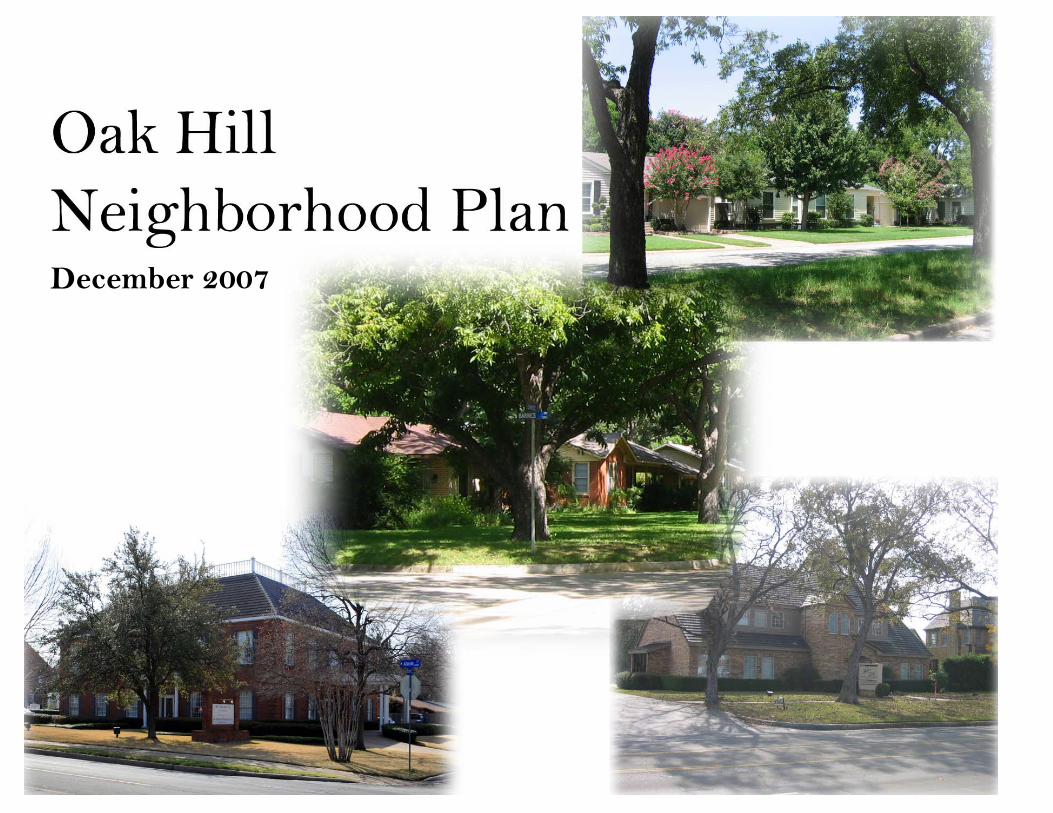
Existing Zoning The existing zoning in the Oak Hill neighborhood is predominantly Residential (“R”), as shown on the map to the right. Two areas are zoned Duplex (“D”), with one being the Fielder House museum. The other area is located on Elliott Street, where there are four duplex units just north of the Killian Drive intersection. The properties with non-residential zoning in the neighborhood are primarily located on West Abram Street, with one parcel located on South Davis Drive. These areas are zoned either Office (“O”) or Planned Development (“PD”). The table below shows the zoning cases considered in the neighborhood in the past ten years.
Recent Zoning Cases Address Case No From To Status
600 S Davis Dr Z97-04 B97-04
R PD Approved
1612 W Abram St
Z97-35 P97-35 S97-07
R PD Denied
604 S Davis Dr Z99-51 B99-51
R & PD PD Denied
1600 W Abram St
Z07-11 B07-11
R PD Approved
Source: Community Development & Planning Department

Oak Hill Neighborhood Plan
Assessment of Existing Conditions Page 23
Residential Property Values Property value data was obtained from Tarrant Appraisal District for all parcels within the neighborhood area. The values for all 239 single family residential parcels were analyzed. The table below shows the average values for all residential parcels and the average values for each individual subdivision. The appraised values for 2006 are generally less than the market value, as estimated by the Tarrant Appraisal District. On average, the market value of all single family property rose 2.78% from 2005 to 2006. However, several of the subdivisions showed declines in market values. The appraisal information also shows that of the 239 single family parcels, 126 have general homestead exemptions, 42 additionally have “Over 65” exemptions, and 4 properties additionally have “Disabled Veteran” exemptions. There are 60 properties without any exemptions.
Residential Property Values 2006 Market Value
Subdivision Parcel Structure Total 2006 Total Appraised
2005 Market Value
Market Value % change
2005-2006
2006 Appraised Value per SF
Residential average $31,878 $92,928 $125,046 $111,829 $121,666 2.78 $10 Adamdale $24,811 $87,019 $111,749 $111,749 $112,615 -0.77 $11 Elliott $20,000 $61,313 $81,313 $79,355 $69,729 16.61 $7 Robert Fielder $30,000 $115,570 $145,570 $124,741 $153,150 -4.95 $11 Iondale $24,000 $49,600 $73,600 $72,933 $81,780 -10.00 $4 Jerry Jordan $25,000 $71,430 $96,430 $79,706 $84,480 14.15 $8 Lattimore $27,083 $76,450 $103,533 $100,852 $136,800 -24.32 $11 Medlin Abstract $29,991 $72,746 $102,711 $94,450 $101,271 1.42 $8 No Oak Hill Acres $51,235 $149,958 $201,193 $186,232 $204,086 -1.42 $7 Oak Hill Acres $43,127 $73,802 $116,929 $99,208 $97,429 20.01 $6 Summit Grove $31,333 $80,893 $112,227 $88,276 $105,423 6.45 $9 Vellenga Acres $46,242 $79,386 $125,628 $105,722 $136,728 -8.12 $6 Wildflower Est $28,000 $168,740 $199,740 $199,207 $190,193 5.02 $24 Wildflower Est West $28,700 $162,930 $191,630 $190,143 $181,720 5.45 $24 Wilemon $25,000 $77,619 $102,619 $83,511 $89,638 14.48 $7
Source: Tarrant Appraisal District

Oak Hill Neighborhood Plan
Assessment of Existing Conditions Page 24
Redevelopment Probability Analysis The teardown of existing homes for the purpose of rebuilding a new larger structure was identified as a threat to the neighborhood during the SWOT analysis conducted with the steering committee. A teardown is a house that is demolished in order to place a newer, usually larger, house in its place. The ratio of parcel value to structure value was calculated on the average values for each subdivision. A ratio of 100% would indicate the value of the land and the value of the house are the same. A ratio of over 100% would indicate the value of the land exceeds the value of the house. The lower the ratio, the greater the value of the house compared to the value of the lot. This ratio is used to explore the possibility that property in the neighborhood could be subject to the current “teardown” trend in the single family construction industry. Properties that are candidates for teardowns are those where the primary value of the property is in the lot, though there are not formal guidelines used by the real estate industry. Other factors include the amount of current new construction activity in the neighborhood, a rise in real estate prices, the trend toward bigger homes and dissatisfaction with newer subdivisions. (National Trust for Historic Preservation) Articles and reports about the phenomenon from various media sources (National Public Radio, CNNMoney.com, The Wall Street Journal, and The New York Times) suggest that a new home must sell for three times the value of the purchased property to be considered a candidate for a teardown. Given that most of the property in the Oak Hill neighborhood is developed, the value of three-times the average total value was calculated for each subdivision. This could indicate the target sales price for a new house that is needed to make the teardown economical. Based on this analysis, it appears the neighborhood is not a prime area for teardowns. However, there are too many variables that factor into the decision to teardown and rebuild to definitively address the issue.
Redevelopment Probability Analysis
Ratio of Parcel to Structure Value
Average Total Property Value
Three-times total value
Residential 34% $ 125,116 $ 375,348
Iondale 48% $ 73,600 $ 220,800
Elliott 33% $ 81,313 $ 243,938
Jerry Jordan 35% $ 96,430 $ 289,290
Wilemon 32% $ 102,619 $ 307,858
Lattimore 35% $ 103,533 $ 310,600
Adamdale 29% $ 111,749 $ 335,246
Summit Grove 39% $ 112,227 $ 336,680
Oak Hill Acres 58% $ 116,929 $ 350,786
Medlin Abstract 51% $ 124,165 $ 372,495
Vellenga Acres 57% $ 126,988 $ 380,965
Fielder Robert 26% $ 145,570 $ 436,710
Wildflower Est West 18% $ 191,630 $ 574,890
Wildflower Est 17% $ 199,740 $ 599,220
No Oak Hill Acres 34% $ 201,193 $ 603,578
Source: Community Development & Planning Department

Oak Hill Neighborhood Plan
Assessment of Existing Conditions Page 25
Residential Lots The table below contains information on the single family residential lots in the neighborhood, which make up 90% of all the lots. The information is shown by subdivision, and includes unplatted property in the Medlin Abstract. Lot coverage was calculated using house size and lot size data from Tarrant Appraisal District. The lot coverage in the entire neighborhood ranges from 7% to 30%. Two subdivisions are below 10% lot coverage: Iondale Place and Vellenga Acres. The unplatted portion of the Medlin Abstract is also below 10% lot coverage. Most of the subdivisions are close to the average lot coverage of 14%. However, Wildflower Estates and Wildflower Estates West, the newest development in the area, have lot coverage of 30% and 28%, respectively. The lot coverage percentages in the Wildflower Estates and Wildflower Estates West subdivisions are slightly skewed due to the prevalence of two-story houses.
Residential Lot Analysis
Number of Lots
Average Lot Size (sq ft)
Typical Lot Width (ft)
Typical Lot Depth (ft) Lot Coverage Typical Front
Setback (ft) All Residential Lots 239 17,176 - - 14% - Adamdale 36 9,883 70 115 18% 20 Elliott 19 10,115 70 130 11% 30 Fielder Robert 11 18,994 100 140 14% 35 Iondale 5 21,538 100 200 7% 30 Jerry Jordan 10 12,118 75 175 12% 25-30 Lattimore 3 9,828 70 104 17% 20 Medlin Abstract 18 16,343 106 200 8% 30 No Oak Hill Acres 7 34,242 160 260 12% 50-75
Oak Hill Acres1 4 10 32,388 205
65 300 212 9% 50
30
Summit Grove2 16 14
9,252 22,464
70 100
125 200
18% 8%
30 30
Vellenga Acres3 12 18
39,772 18,214
150 105
290 240
5% 11%
40-50 30
Wildflower Est 20 8,588 60 120 30% 20 Wildflower Est West 10 8,318 70 104 28% 20 Wilemon 26 13,976 75 175 12% 30
1 Lot size/width/depth in Oak Hill Acres differs between the West Second Street and Fielder Road portions. The top number refers to the West Second Street portion. 2 Lot size/width/depth in Summit Grove differs between the Killian Court and Barnes Drive portions. The top number refers to the Killian Court portion
3Lot size/width/depth in Vellenga Acres differs between the West Second Street and Sunset Court portions of the plat. The top number refers to the West Second Street portion.
Source: Tarrant Appraisal District

Oak Hill Neighborhood Plan
Assessment of Existing Conditions Page 26
Housing Size, Age and Value The table below contains information on the single family residential houses in the neighborhood. Data was collected from Tarrant Appraisal District records. The average house in the neighborhood was built in 1959 and has 1,815 square feet of living area. Of all the houses in the neighborhood, 77% have central heating and air conditioning, 44% have a two-car garage and 9% have swimming pools. Mass-produced, low-cost window unit air conditioners became widely available in 1947, according to the National Academy of Engineering (www.nae.edu). In 1947, 43,000 units were sold in the United States. Of the 56 houses without central heating and air conditioning, 82% of them were built before to 1947. The oldest house in the neighborhood, located at 300 Sunset Court, was built in 1920.
House Size, Age and Value 2006 Valuation
Subdivision Average House
Size (sq ft)
Average Year Built
Age of Structure
(years) Appraised
Value Value per
Square Foot All Residential Lots 1,815 1959 48 $ 111,766 $ 63 Adamdale 1,791 1979 28 $ 111,749 $ 64 Elliott 1,169 1950 57 $ 79,355 $ 69 Fielder Robert 2,287 1954 53 $ 124,741 $ 63 Iondale 1,346 1947 60 $ 72,933 $ 58 Jerry Jordan 1,390 1951 56 $ 79,706 $ 59 Lattimore 1,590 1969 38 $ 100,852 $ 65 Medlin Abstract 1,873 1948 59 $ 96,588 $ 55 No Oak Hill Acres 2,989 1954 53 $ 186,232 $ 60 Oak Hill Acres 1,449 1946 62 $ 99,208 $ 67 Summit Grove 1,726 1951 56 $ 88,276 $ 53 Vellenga Acres 1,781 1947 60 $ 105,001 $ 60 Wildflower Est 2,430 1992 15 $ 199,207 $ 82 Wildflower Est West 2,287 1993 14 $ 190,143 $ 83 Wilemon 1,667 1948 59 $ 83,511 $ 53
Source: Tarrant Appraisal District
300 Sunset Court

Oak Hill Neighborhood Plan
Assessment of Existing Conditions Page 27
Commercial Property Values and Improvements Most of the property along West Abram Street has been converted from residential use to office and commercial use over time. The Central Sector Plan designates this area for service, office and retail development. There was less than a 1% increase in appraisal valuation of these properties between 2005 and 2006. There are 9.26 acres of property devoted to commercial use in the neighborhood area, almost all of which is located along the West Abram Street corridor. There is one property located at 600 South Davis Drive that is used for religious purposes.
Commercial Property Values
Address Market Value 2006 Appraised Value Market Value Lot Size Area Property
Value 2006 Number Street Parcel Structure Total 2006 Total 2005 Sq Ft Acres per SF
1202 Abram St W $ 37,027 $ 0 $ 37,027 $ 37,027 $ 37,027 7,550 0.17 $ 4.90
1204 Abram St W $ 38,236 $ 29,444 $ 67,680 $ 67,680 $ 62,639 9,784 0.22 $ 6.92
1206 Abram St W $ 87,556 $ 95,444 $ 183,000 $ 183,000 $ 183,000 40,939 0.94 $ 4.47
1210 Abram St W $ 64,319 $ 49,888 $ 114,207 $ 114,207 $ 114,207 15,932 0.37 $ 7.17
1300 Abram St W $ 65,037 $ 37,107 $ 102,144 $ 102,144 $ 102,144 14,397 0.33 $ 7.09
1304 Abram St W $ 66,234 $ 191,086 $ 257,320 $ 257,320 $ 257,320 15,635 0.36 $ 16.46
1306 Abram St W $ 45,015 $ 160,305 $ 205,320 $ 205,320 $ 205,320 10,565 0.24 $ 19.43
1320 Abram St W $ 54,258 $ 263,363 $ 317,621 $ 317,621 $ 317,621 13,877 0.32 $ 22.89
1400 Abram St W $ 110,232 $ 339,078 $ 449,310 $ 449,310 $ 449,310 55,725 1.28 $ 8.06
1404 Abram St W $ 73,108 $ 356,892 $ 430,000 $ 430,000 $ 430,000 35,796 0.82 $ 12.01
1408 Abram St W $ 100,101 $ 468,129 $ 568,230 $ 568,230 $ 568,230 26,221 0.60 $ 21.67
1500 Abram St W $98,921 $ 37,055 $ 135,976 $ 135,976 $ 135,976 19,051 0.44 $ 7.14
1600 Abram St W $ 41,164 $ 57,836 $ 99,000 $ 99,000 $ 84,600 22,609 0.52 $ 4.38
1616 Abram St W $ 202,444 $ 110,170 $ 312,614 $ 312,614 $ 312,614 70,252 1.61 $ 4.45
600 Davis Dr S $ 40,941 $ 126,867 $ 167,808 $ 167,808 $ 167,808 30,687 0.70 $ 5.47
304 Elliott St $ 22,680 $ 118,776 $ 141,456 $ 141,456 $ 123,006 14,525 0.33 $ 9.74
$ 1,147,273 $ 2,441,440 $ 3,588,713 $ 3,588,713 $ 3,550,822 403,552 9.26 $ 8.89
Source: Tarrant Appraisal District
Oak Hill Neighborhood Plan
Assessment of Existing Conditions Page 28
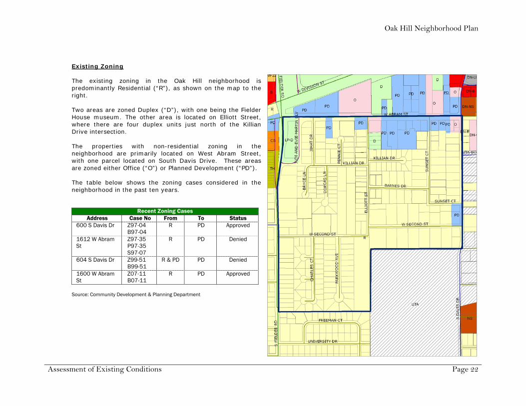
Vacant Property There are 9.33 acres of vacant property located within the neighborhood boundary. The properties are shown on the map to the right. Most of the property is zoned Residential, with two parcels on West Abram Street zoned Planned Development. Tarrant Appraisal District information shows that 8 of the 12 vacant parcels increased in value from 2005 to 2006. The increase ranged from 34.4% to 93.6%. Of the 9.33 acres, 3.79 acres (41%) are located at 1505-1511 West Second Street, between Parkwood Avenue and Elliott Street. The properties are contiguous and are presently under one ownership. These properties make up the largest undeveloped tract of land within the neighborhood boundary. The residence at 1505 West Second Street was demolished in 2005.
Vacant Property Analysis
Address Value Lot Size Zoning 2006 Acres
506 Elliott St $ 20,000 0.22 R (Residential)
408 Elliott St $ 2,000 0.12 R (Residential)
201 Jimat Dr $ 30,000 0.31 R (Residential)
205 Jimat Dr $ 30,000 0.30 R (Residential)
1324 Abram St W $ 7,287 0.04 PD (Planned Development)
1312 Abram St W $ 106,177 1.62 PD (Planned Development)
1505 Second St W $ 98,990 2.04 R (Residential)
1511 Second St W $ 83,635 1.75 R (Residential)
1603 Second St W $ 50,000 1.31 R (Residential)
701 Fielder Rd S $ 20,000 0.27 R (Residential)
1401 Second St W $ 97,500 1.15 R (Residential)
411 Bryce Ln $ 28,000 0.19 R (Residential)
$ 573,589 9.33
Source: Tarrant Appraisal District; Community Development and Planning Department

Oak Hill Neighborhood Plan
Assessment of Existing Conditions Page 29
EXTERNAL INFLUENCES ON NEIGHBORHOOD
Factors that affect a neighborhood can come from within the neighborhood (internal factors) as well as from outside the area (external factors). This section examines some of the external factors as they relate to the Oak Hill neighborhood area. Relationship of Neighborhood to Surrounding Area
The Oak Hill neighborhood is located in central Arlington, immediately west of the University of Texas at Arlington campus and just west of downtown. When viewed in a larger context, Oak Hill’s location southeast of the intersection of Fielder Road and Division Street (US 180) places it in an area with a wide variety of land uses. Within a half-mile of the neighborhood, residential properties range from detached single family houses to townhouses to apartment complexes. The commercial spectrum includes offices, restaurants and retail shops, and a mixture of other business and industrial uses. Several social agencies, fraternal organizations and religious institutions are also in close proximity to Oak Hill.
University of Texas at Arlington
Parts of the University of Texas at Arlington (UTA) campus are adjacent to the neighborhood on the east and south sides. UTA has an enrollment of almost 25,000 students, and encompasses 420 acres and more than 100 buildings. Maverick Stadium. Built in 1980, the stadium is located immediately south of property in the Vellenga Acres subdivision. The stadium has a seating capacity of 15,000, and is used for many athletic and community events during the year. Greek Row. A portion of West Second Street, between Davis Drive and Cooper Street, was renamed Greek Row. The street is the location of most of the sorority and fraternity houses that serve the UTA campus. Campus housing. Greek Row is the closest student-based housing to the Oak Hill neighborhood. There are other housing units located on the west side of campus between West Nedderman Drive and South Davis Drive. This housing includes Arbor Oaks, University Village and Trinity House, located on Greek Road Drive. Meadow Run and Timber Brook are located on UTA Boulevard (formerly West Border Street).

Oak Hill Neighborhood Plan
Assessment of Existing Conditions Page 30
Thoroughfare Development Plan Thoroughfare Plan Roadways
Roadway TDP Classification Typical Design Abram Street Minor Arterial 4 lane divided 90’ r.o.w. Fielder Road Minor Arterial 4 lane divided 90’ r.o.w. Davis Drive Major Collector 4 lane undivided 70’ r.o.w.
The Arlington Thoroughfare Development Plan (TDP) contains a hierarchy of roadways, each of which is intended to serve defined needs with a specific balance between movement and access. The elements of the plan include freeways, strategic regional arterials, major arterials, minor arterials, collector streets and veloweb (bicycle). The plan was created with a computer model of daily traffic volumes for the year 2025 using projected growth trends, patterns and land uses. Using the existing thoroughfare street segments as a base, a network of roadway elements was developed to serve projected demands while maintaining acceptable levels of circulation and congestion. The Oak Hill neighborhood is bordered on three sides by roadways shown on the plan: West Abram Street, South Fielder Road and South Davis Drive. The City’s Comprehensive Bikeway Plan is a component of the Thoroughfare Development Plan. It represents efforts to identify and address bikeway facility needs in the community. One of the goals is to provide a system that links residences, employment centers, schools, parks and transit facilities to promote the use of bicycles as an alternative mode of transportation. West Second Street is identified as a bicycle route on the bikeway plan. It provides a route that connects to Norwood Drive, which serves as a route from points in west Arlington. The route ends at Davis Drive, on the western edge of the UTA campus.
FIE
LDE
R
DA
VIS
Source: Public Works & Transportation Department
Oak Hill Neighborhood Plan
Assessment of Existing Conditions Page 31
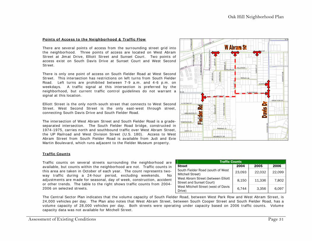
Points of Access to the Neighborhood & Traffic Flow
There are several points of access from the surrounding street grid into the neighborhood. Three points of access are located on West Abram Street at Jimat Drive, Elliott Street and Sunset Court. Two points of access exist on South Davis Drive at Sunset Court and West Second Street. There is only one point of access on South Fielder Road at West Second Street. This intersection has restrictions on left turns from South Fielder Road. Left turns are prohibited between 7-9 a.m. and 4-6 p.m. on weekdays. A traffic signal at this intersection is preferred by the neighborhood, but current traffic control guidelines do not warrant a signal at this location. Elliott Street is the only north-south street that connects to West Second Street. West Second Street is the only east-west through street, connecting South Davis Drive and South Fielder Road. The intersection of West Abram Street and South Fielder Road is a grade-separated intersection. The South Fielder Road bridge, constructed in 1974-1975, carries north and southbound traffic over West Abram Street, the UP Railroad and West Division Street (U.S. 180). Access to West Abram Street from South Fielder Road is available from Judi and Evie Martin Boulevard, which runs adjacent to the Fielder Museum property.
Traffic Counts
Traffic counts on several streets surrounding the neighborhood are available, but counts within the neighborhood are not. Traffic counts in this area are taken in October of each year. The count represents two-way traffic during a 24-hour period, excluding weekends. No adjustments are made for seasonal, day of week, construction, accident or other trends. The table to the right shows traffic counts from 2004-2006 on selected streets. The Central Sector Plan indicates that the volume capacity of South Fielder Road, between West Park Row and West Abram Street, is 24,000 vehicles per day. The Plan also notes that West Abram Street, between South Cooper Street and South Fielder Road, has a volume capacity of 28,000 vehicles per day. Both streets were operating under capacity based on 2006 traffic counts. Volume capacity data was not available for Mitchell Street.
Traffic Counts Street 2004 2005 2006 South Fielder Road (south of West Mitchell Street) 23,093 22,032 22,099
West Abram Street (between Elliott Street and Sunset Court) 8,150 11,336 7,802
West Mitchell Street (west of Davis Drive) 6,744 3,356 6,097

Oak Hill Neighborhood Plan
Assessment of Existing Conditions Page 32
Office Development on West Abram Street The following is a list of the businesses located on West Abram Street and South Davis Drive as of October 2007.
West Abram Street office development
Address Tenants Type of Business 1202 Abram St W vacant vacant
Donna M. Goodrich, Ph.D. Psychologist office
R. Jon Leffingwell Psychologist office 1204 Abram St W
Beth A. Maxwell, Ph.D. Psychologist office
1206 Abram St W All American Awards Trophies, plaques and awards store
1210 Abram St W Lone Star House of Quilts Quilt shop
1300 Abram St W Roger D. Allen, Attorney at Law Attorney office
Madearis Studio Photography studio 1304 Abram St W
Michael Phillips, Attorney at Law Attorney office
1306 Abram St W SBM Ltd. General business office
1320 Abram St W Alliance for Children Children’s advocacy center
1400 Abram St W
1404 Abram St W Hill Gilstrap Attorney office
Hill Gilstrap Attorney office 1408 Abram St W
Rattikin Title Company Title company
1500 Abram St W Respiratory Associates of Texas Medical staffing and continuing education agency
1600 Abram St W vacant vacant
1616 Abram St W Fielder Museum Cultural organization
304 Elliott St Pars Academy Cultural organization
600 Davis Dr Institute of Religion – Church of Jesus Christ of Latter-Day Saints Religious education
Source: Community Development & Planning Department

Oak Hill Neighborhood Plan
Assessment of Existing Conditions Page 33
Gas well drilling Gas drilling and production has taken place in Arlington since 2006. By September 2007, the City of Arlington had approved 31 gas well permits and issued 16 permits. Also, a comprehensive revision to the gas drilling and production ordinance was completed in October 2007. The City provides public information related to gas well drilling on its website at www.arlingtontx.gov/planning/gas_drilling.html. The University of Texas at Arlington partnered with Carrizo Oil and Gas, Inc., for the exploration and development of natural gas on campus property. The University held a forum on August 8, 2007, to present information on gas drilling plans for the campus and to answer questions from the public. As of December 2007, seismic research was completed and drilling on a site at the southeast corner of the campus was commenced. The University maintains public information related to these activities on its website at www.uta.edu/naturalgas. Some residents in the Oak Hill neighborhood expressed concerns about gas drilling in the city and on the UTA campus. Several signs and banners opposing gas drilling were placed in yards and on fences in Oak Hill and in surrounding neighborhoods.

Oak Hill Neighborhood Plan
Assessment of Existing Conditions Page 34
INTERNAL INFLUENCES ON NEIGHBORHOOD
This section examines some of the internal factors as they relate to the Oak Hill neighborhood area. Building construction No new housing construction has occurred in the neighborhood over the last two years. A building permit for a new single family house was submitted in 2007 for property at 1401 West Second Street. Most building permits were issued for remodels or alterations to existing houses, and for portable buildings and fences. Demolition permits for two properties were issued in the last two years. Houses were demolished at 1209 and 1505 West Second Street, and the properties are presently vacant. If a building is determined to be 50 years of age or older, the demolition or relocation of a building is automatically stayed for a period of up to 30 days to allow the Landmark Preservation Commission an opportunity to determine whether the building or structure is historically significant. This requirement of the City Code potentially affects a large number of houses in the Oak Hill neighborhood. The following subdivisions, on average, have homes 50 years of age or older: Elliott, Robert Fielder, Iondale, Jerry Jordan, North Oak Hill Acres, Oak Hill Acres, Summit Grove, Vellenga Acres and Wilemon. Land use Land uses contribute to the character of the neighborhood. The mixing or separation of different uses in an area can affect the quality of life for residents. The introduction of incompatible land uses can have a detrimental effect on the neighborhood’s character. The properties along West Abram Street are transitioning from residential uses to office and service oriented businesses. Many of the businesses have kept the existing residential structures to use for business purposes, while new buildings have been constructed to mimic the residential appearance. Lot Splits In March 2007, the Planning and Zoning Commission denied a replat of Lot 8R, Oak Hill Acres Addition. This property is located at the northeast corner of West Second Street and Elliott Street. The property owner proposed to divide the property into two lots to construct two residences. The Commission found that the subdivision of the lot was not consistent with the existing lots in the neighborhood.

Oak Hill Neighborhood Plan
Assessment of Existing Conditions Page 35
Property maintenance The City of Arlington has ordinances related to maintenance, sanitation, rehabilitation, conservation and safety of existing residential and commercial properties. The ordinances cover issues such as graffiti, high weeds and grass, junked vehicles, cars parked in yards, fence maintenance and illegal dumping. The codes are intended to make neighborhoods a better place to live, work and play. Compliance with these standards can reduce vandalism, deter crime, maintain property values and prevent deterioration of a neighborhood. One of the strategies identified by the Plan is to provide incentives to reduce property code violations. This strategy ties into one included in the Central Sector Plan that “encourages neighborhoods to participate in improving the looks of their neighborhood.” The strategies help improve the aesthetics of the area, and provide an opportunity for neighbors to come together in a concerted effort. Road conditions & Infrastructure Several streets within the neighborhood are proposed for mill and overlay in 2008. These streets include Barnes Drive, Charles Court, Elliott Street, Killian Drive, Killian Court, Parkwood Avenue, Pennie Court and West Second Street. The Public Works & Transportation Department will contact property owners several weeks before construction starts to explain the project. Micro-surfacing, micro-sealing and asphalt overlays improve mobility, extend the life of pavement and seal the surface of the street to prevent moisture buildup and deterioration. Low water pressure was identified by several residents as a problem in the neighborhood as part of the survey. Sidewalks There are no sidewalks on the interior streets within the neighborhood and limited sidewalks along the perimeter streets. The neighborhood assessment survey indicated that 83% of the respondents do not see a need for sidewalks within the neighborhood. Residents that attended the August 9, 2007, neighborhood meeting expressed support for construction of sidewalks along the perimeter streets of Fielder Road, West Abram Street and Davis Drive. Social Network & Community Services The Oak Hill neighborhood is not an incorporated neighborhood association. On November 12, 2007, the Board of the Arlington Historical Society, which is based at the Fielder House museum, formed a partnership with the Oak Hill neighborhood. Geraldine Mills, director of the Arlington Historical Society, worked with the neighborhood group on this project, and the Board agreed to be a 501(c)(3) sponsor for the Oak Hill neighborhood for the purpose of neighborhood matching grant applications made to the City of

Oak Hill Neighborhood Plan
Assessment of Existing Conditions Page 36
Arlington. The partnership will also allow the neighborhood to assist the Society in making applications for future grants related to the Fielder House. The residents have identified a goal to create a community watch organization, and are currently working toward achieving that goal. An informational meeting was held on November 17, 2007, at the outdoor courtyard area at Hill Gilstrap offices on West Abram Street. Officer Douglas Glotfelty and Lieutenant Jerry Hataway of the Arlington Police Department presented information about the police department and explained how to organize a community watch group. They also provided crime prevention tips and answered questions from the residents about crime in and around the area. Crime Rates and Police Protection The Arlington Police Department divides the city into several geographic subsets. First, the city is divided into four districts: North, East, South and West, with deputy chiefs assigned to each district. Each district is then divided into police sectors. There are 9 sectors within the city, with a lieutenant assigned to each. Police sectors are further divided into police beats. A sergeant and uniformed officers are assigned to each of the beats. Finally, the city is divided into police reporting areas to handle service calls. The Oak Hill neighborhood area is located in the North District, Sector K, Beat 250 and Police Reporting Area 211. Beat 250 is shown in the map on this page. The table below shows the number and types of selected police calls for the Oak Hill neighborhood area between June 2, 2006, and July 5, 2007.
Police Calls Call Type Number Abandoned Vehicle 1 Accident –Hit and Run 4 Accident – Major 3 Accident – Minor 1 Alarm – Residential 5 Assault – Aggravated 1 Assault – Domestic 1 Burglary of a vehicle 3 Burglary – Residential 6 Criminal Mischief Report 5 Driving While Intoxicated 1 Fraud 1 Runaway 1 Sexual Assault Report 1 Theft /Theft of a motor vehicle 0 Threat/Harassment 2
Source: Arlington Police Department

Oak Hill Neighborhood Plan
Assessment of Existing Conditions Page 37
Fire Protection The Oak Hill neighborhood is primarily served by Fire Station No. 1, located at 401 West Main Street. A portion of the neighborhood is in the service area of Fire Station No. 3, located at 1820 South Fielder Road. Fire Station No. 3 was built in 1956. In December 2007, the construction of a new facility started with the demolition of the existing station. The new station will be larger with more room to house additional fire service equipment. The fire station will have a community assistance room, which will allow them to further expand community outreach programs such as blood pressure screenings and fire safety information. Station No. 3 and its crew members have relocated to Fire Station No. 14 at 2000 West Green Oaks Boulevard. Other nearby stations are also assisting with coverage of Fire District No. 3, along with additional support from the Pantego Fire Department Effective December 1, 2007, the Insurance Service Organization (ISO) rating for the City of Arlington changed from a 3 rating to a 2 rating. The Texas Department of Insurance rates communities from 1 to 10 on their ability to protect the public from the hazard of fire. Arlington has had a 3 rating for about 17 years. The new rating places Arlington in the top two percent of cities in the United States with a 2 rating or better. (Arlington Fire Department) Educational Resources The Arlington Independent School District (AISD) serves the entire neighborhood. The neighborhood is in the attendance zones of Swift Elementary, Bailey Junior High and Arlington High School. Both Swift Elementary and Bailey Junior High were rated “Recognized” by the Texas Education Agency for the 2005-2006 school year. Arlington High School was rated “Academically Acceptable” for the same year.
Arlington Public Schools in Oak Hill neighborhood School Location Year Built Enrollment May 2007 Percent Minority
Swift Elementary 1101 South Fielder Road 1973 584 55.6% Bailey Junior High 2411 Winewood Street 1968 789 45.8% Arlington High 818 West Park Row Drive 1956 2,580 44.8% Arlington ISD totals 63,050 68.6%
Source: Arlington Independent School District

Oak Hill Neighborhood Plan
Assessment of Existing Conditions Page 38
Parks and Recreation There are no public or private parks located in the neighborhood. The closest parks are Fielder Park and College Hills Park, both of which are neighborhood parks. Many of the survey respondents indicated they visited these two parks. The other park most often mentioned as visited was River Legacy. Walking and jogging trails, biking trails, playgrounds and passive open areas were noted by survey respondents as useful and desired parks facilities. O.S. Gray Park, a 20-acre park located west of the neighborhood on West Abram Street, is presently undeveloped. Bond funds in the amount of $200,000 were approved in 2005 to begin development of the park. The development of the first phase of the O.S. Gray Natural Area is expected to begin in fiscal year 2008, and will include a parking lot, walking trail and pavilion.
Park Facilities near Oak Hill neighborhood Park Location Size Amenities
Fielder Park 1100 South Fielder Road 6 acres Playground, picnic area, restrooms, facility lighting, tennis, basketball, grills
College Hills Park 151 University Drive 1 acre Picnic area, playground, basketball, practice field
O.S. Gray Park 2021 West Abram Street 20 acres Nature area
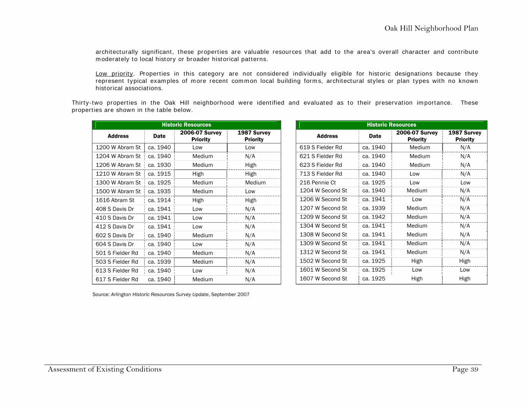
Source: Parks & Recreation Department Guide to Arlington Parks Historic Resources The Central Sector Plan identifies a need to preserve historic buildings. Specifically, the Plan calls for encouraging the City to provide incentives for preserving historic structures and educating the public on Arlington’s historic structures. In 1987, the City hired Hardy-Heck-Moore to survey and document historical sites in Arlington. The survey was updated in September 2007 by Komatsu Architecture, in conjunction with the Community Services Department. The survey, title Arlington Historic Resources Survey Update, includes “the identification, documentation, and assessment of pre-1960 buildings, structures, neighborhoods and object in Arlington that possess architectural, historical and cultural value.” Sites were evaluated for their preservation importance based on the following criteria. The descriptions are taken directly from the study text. Overall, the study assigned high priority ranking to 190 properties, medium ranking to 244 properties, and low ranking to 257 properties.
High priority. Property has either been subject to previous historic designation on a local, state or national level or has the best potential for such designation because of their relative architectural, historical or cultural significance. Properties contribute significantly to local history or broader historical patterns and are considered to be the most significant resources within the city. Medium priority. Include properties that are not eligible for individual historic designation because they possess only a moderate level of significance for their physical attributes and/or historical associations. Though not identified as
Oak Hill Neighborhood Plan
Assessment of Existing Conditions Page 39
architecturally significant, these properties are valuable resources that add to the area’s overall character and contribute moderately to local history or broader historical patterns. Low priority. Properties in this category are not considered individually eligible for historic designations because they represent typical examples of more recent common local building forms, architectural styles or plan types with no known historical associations.
Thirty-two properties in the Oak Hill neighborhood were identified and evaluated as to their preservation importance. These properties are shown in the table below.
Historic Resources Historic Resources
Address Date 2006-07 Survey Priority
1987 Survey Priority Address Date 2006-07 Survey
Priority 1987 Survey
Priority 1200 W Abram St ca. 1940 Low Low 619 S Fielder Rd ca. 1940 Medium N/A
1204 W Abram St ca. 1940 Medium N/A 621 S Fielder Rd ca. 1940 Medium N/A
1206 W Abram St ca. 1930 Medium High 623 S Fielder Rd ca. 1940 Medium N/A
1210 W Abram St ca. 1915 High High 713 S Fielder Rd ca. 1940 Low N/A
1300 W Abram St ca. 1925 Medium Medium 216 Pennie Ct ca. 1925 Low Low
1500 W Abram St ca. 1935 Medium Low 1204 W Second St ca. 1940 Medium N/A
1616 Abram St ca. 1914 High High 1206 W Second St ca. 1941 Low N/A
408 S Davis Dr ca. 1941 Low N/A 1207 W Second St ca. 1939 Medium N/A
410 S Davis Dr ca. 1941 Low N/A 1209 W Second St ca. 1942 Medium N/A
412 S Davis Dr ca. 1941 Low N/A 1304 W Second St ca. 1941 Medium N/A
602 S Davis Dr ca. 1940 Medium N/A 1308 W Second St ca. 1941 Medium N/A
604 S Davis Dr ca. 1940 Low N/A 1309 W Second St ca. 1941 Medium N/A
501 S Fielder Rd ca. 1940 Medium N/A 1312 W Second St ca. 1941 Medium N/A
503 S Fielder Rd ca. 1939 Medium N/A 1502 W Second St ca. 1925 High High
613 S Fielder Rd ca. 1940 Low N/A 1601 W Second St ca. 1925 Low Low
617 S Fielder Rd ca. 1940 Medium N/A 1607 W Second St ca. 1925 High High
Source: Arlington Historic Resources Survey Update, September 2007

Oak Hill Neighborhood Plan
Assessment of Existing Conditions Page 40
The survey also focused on subdivision development that took place in the years immediately following World War II. Subdivisions established between 1945 and 1960 were identified and rated on the same three-tier system used for structures using criteria that included characteristics of design or layout, distinctive aspects of landscape design, and the presence of community facilities such as schools and stores. Five subdivisions in the Oak Hill area were included in the inventory of post-war subdivisions. Wilemon Subdivision (Parkwood Avenue) was ranked as a high-priority subdivision. Of the remaining four, Robert Fielder and Summit Grove were ranked as medium priority, and Jerry Jordan and O. Medlin were ranked as low priority.
Fielder House (1616 West Abram) The Fielder House was built in 1914 by prominent bankerJames Park Fielder and wife, Mattie. Fielder was an Arlingtoncommissioner and served on the original board of the present UTA. This two-story brick Prairie-style home was built on a 215-acre site surrounded by live oaks, orchards and gardens.Once known as "Home on the Hill," today it is the home of theFielder Museum, the Arlington Historical Society and the Arlington Preservation Foundation. The Fielder House has a Texas Historical Marker on the site, and it is a RegisteredTexas Historic Landmark. (Arlington Landmark Preservation Commission)
John M. Elliott home (1210 West Abram) John M. Elliott and his wife, Sally Russell Elliott, purchasedthis home on West Abram Street. Elliott was a director of the Citizens National Bank at the corner of Main andCenter. Built around 1913, this home is an outstandingexample of a hipped roof bungalow with classical influences. The porch and entry detailing areespecially noteworthy, as is the cross-hatched wood that adorns the windows. (Arlington Landmark PreservationCommission) The building is currently the home of Lone Star House of Quilts.

Chapter 4
Implementation Program Conservation District Overlay
Neighborhood Design & Character Recommendations Funding Resources
Amendments

Oak Hill Neighborhood Plan
Implementation Page 42
General Implementation Strategies The residents of the Oak Hill neighborhood have taken an important step in shaping the future of their local community. The Oak Hill neighborhood plan will provide a critical tool for the City Council, appointed boards and commissions and staff to use in making sound planning decisions regarding the long-term growth and development of the area. The elements of the plan are based upon realistic objectives and goals that were directly developed by the residents. The following are general recommendations for the implementation of the Oak Hill neighborhood plan. Development Policy. The City Council should adopt the neighborhood plan as the official City policy for evaluating development proposals within the boundaries of the neighborhood. The plan should also be used as a guide in reviewing development proposals in areas adjacent to the neighborhood.
Implementation Program. The Implementation Program included in this chapter contains summaries of the goals and strategy statements from this neighborhood plan, time frames in which the task should be initiated and possible outside partners and resources to assist in implementation. Through this effort, the City of Arlington is able to budget for any necessary expenditure as well as track the progress of the established initiatives. This Implementation Program should be reviewed annually by the residents and City, and any additional planning projects that have been determined necessary to implement the plan should be included in the program at that time. Conservation District Overlay. In order to implement the goals and objectives of the Oak Hill Neighborhood Plan and specific neighborhood design and character standards, the Plan recommends that a conservation district overlay be established in four areas within the Oak Hill neighborhood. These areas are located within the boundary of the planning area. Neighborhood Design and Character. Neighborhood design and character recommendations are also included in this chapter. Their purpose is to identify desired standards and guidelines that assist in preserving the critical design features of the various areas in the neighborhood. These design features could be enacted in a more formal framework through the use of a conservation district overlay, as described in the City of Arlington zoning ordinance. Funding Resources. The implementation program contains several items that ultimately require the expenditure of money. A summary of the types of available funding resources is included in this chapter.
Amendments. An integral part of implementation is a procedure for revision. The goal and policy-oriented nature of the plan will reduce the revisions needed but changing circumstances will, nonetheless, mandate revision from time to time. To accommodate such changes an orderly procedure is necessary. A suggested procedure for amending the Plan is included in this chapter.

Oak Hill Neighborhood Plan
Implementation Page 43
Implementation Program Listed below are selected goals and strategies that can be refined into more specific targeted actions for implementation. Some goals and strategies are policy oriented and included in the next section. The time frame identified below is the recommended time in which the actions should be initiated. Also listed below are possible agencies or outside resources with which the neighborhood could partner with or seek other assistance through to implement the actions.
Goals / Strategies Targeted Actions Time Frame Partners / Resources
1. Create a safe environment for families 1.A Implement a crime watch
program
Coordinate with Arlington Police Department to create crime watch program in the neighborhood
Fall2007 City – Police
1.B Improve streets and lighting
Correct ponding water at Sunset Court and Barnes Drive by using City of Arlington Ponding Program
Fall 2007 City - Public Works & Transportation
Address drainage issues at Parkwood Avenue intersection with West Second Street by using City of Arlington Ponding Program
Fall 2007 City - Public Works & Transportation
1.C Incorporate aesthetic methods of traffic control to reduce speeding
Redirect traffic at West Second Street and Elliott Street using one-way turns
Spring 2008 City - Public Works & Transportation Arlington Tomorrow Foundation grants
Add decorative street lighting with directional signs at West Second Street and Elliott Street intersection, possibly using UTA streetlamp design
Summer 2008 Oncor UTA Administration Arlington Tomorrow Foundation grants
1.D. Provide incentives to reduce property code violations
Introduce a “yard of the month” recognition program
Summer 2008 Neighborhood newsletter
Make use of local free labor, such as YMCA teens, church organizations and UTA social and service fraternities and sororities to assist those in need with property maintenance
Ongoing YMCA of Arlington UTA Greek Life Local churches
Partner with City of Arlington Community Services department for neighborhood improvement projects
Fall 2007 City – Community Services City – Neighborhood Matching Grant program
Allow teen court to assign community service projects in the neighborhood
Ongoing City – Municipal Court City – Teen Court
Encourage residents to join the City of Arlington Code Ranger program Fall 2007 City – Community Services 2. Protect property values and enhance quality of life 2.A Ensure the primary land use is
single family detached dwellings
Strengthen relationships with absentee landlords through communication and sharing neighborhood plans
Summer 2008 Neighborhood newsletter Steering Committee
Inform code enforcement of violations regarding the number of unrelated people living in a dwelling and junk or inoperable cars parked in the street
Ongoing City – Community Services
Encourage property owners to park in driveways only or on surfaces allowed by City codes
Summer 2008 Neighborhood newsletter

Oak Hill Neighborhood Plan
Implementation Page 44
Goals / Strategies Targeted Actions Time Frame Partners / Resources 2.B Acquire new signage for streets
Design a new logo to represent the neighborhood, possibly through a design contest
Spring 2008 UTA Art+Art History Department Arlington Historical Society
Create new street signs for all streets using the new logo
Spring 2008 City – Neighborhood Matching Grant program City - Public Works & Transportation Arlington Historical Society
2.C Bury existing utility lines Investigate the costs and timing, discuss with neighborhood residents and coordinate any plans with TXU and City of Arlington
Fall 2008 Oncor City - Public Works & Transportation
2.D Create new green spaces and a neighborhood park
Form partnership with UTA to purchase the house and property west of Maverick Stadium and fronting on West Second Street and develop property as a neighborhood park and gathering place
Fall 2008 / Winter 2009
UTA Administration Grant funding
Use grant funding opportunities (local, state and national) to develop the property as a neighborhood park with landscaping, walking trail, lighting and benches
Fall 2008 / Winter 2009
UTA Administration Grant funding
3. Preserve the historic and unique character of the neighborhood
3.A Celebrate the area’s diversity and heritage with annual gatherings
Choose dates for biannual gatherings
Fall 2008 Neighborhood newsletter Steering Committee
Develop a schedule and format for gatherings, such as “come dressed as your home’s original owner” or “have each street choose a theme and serve as hosts”
Fall 2008 Neighborhood newsletter Steering Committee
3.B Document the history of the area and its former residents
Publish the neighborhood history
Fall 2007 Fall 2008
Neighborhood Plan Neighborhood newsletter Arlington Historical Society
Create a neighborhood tree, like a family tree, with streets for branches to show residents the history of ownership of each house
Fall 2008 Neighborhood newsletter Arlington Historical Society
3.C Protect the native trees, post oaks and black jack oaks
Hire an arborist or partner with UTA School of Architecture to do a tree study in the neighborhood, establishing specimens and ages of trees
Summer 2008 UTA School of Architecture International Society of Arboriculture
Create a directory of arborists for future trimming of trees
Fall 2008 Neighborhood newsletter Steering Committee International Society of Arboriculture
3.D Ensure that the subdivision of large lots, infill development and new construction are consistent with the scale of the area
Using building permit and tax roll information, determine setbacks, lot size, building heights, lot coverage and average home size for each street in the area
Fall 2007 Neighborhood Plan City – Community Development and Planning
Work with the City’s permit department to implement guidelines for new construction through the use of a Conservation District Overlay
In progress City – Community Development and Planning Conservation District Overlay

Oak Hill Neighborhood Plan
Implementation Page 45
Goals / Strategies Targeted Actions Time Frame Partners / Resources
4. Strengthen the relationship with the University of Texas at Arlington and the City of Arlington
4.A Encourage residents to attend and participate in UTA events
Work with UTA to provide discounts for local residents to festivals, the Maverick Activities Center, the Planetarium and fine arts events
Summer 2008 UTA Student Affairs
Purchase a block of tickets for residents for UTA weekend events, such as the Texas Scottish Festival and Highland Games, winter celebration, sporting events and other happenings
Summer 2008 UTA Student Affairs
Volunteer with UTA during Special Olympics
Spring-Summer 2008 UTA Volunteers Special Olympics Texas
Establish a neighborhood newsletter for the dissemination of neighborhood news and events and publication of the area’s history
Spring-Summer 2008 UTA Department of Communication Neighborhood newsletter Steering Committee
4.B Establish a neighborhood plan recognized by the City of Arlington
Volunteer steering committee work with City officials to write plan for neighborhood
COMPLETED Steering Committee City – Community Development and Planning
Present plan to the Planning & Zoning Commission and City Council for adoption
COMPLETED Steering Committee City – Community Development and Planning
4.C Prevent the encroachment of businesses into residential areas
Establish a relationship and meet with local business owners to share concerns and expectations about the neighborhood area
Ongoing Steering Committee
Establish boundaries for business encroachment into the neighborhood
Fall 2007 Neighborhood Plan
Report any code violations to the City
Ongoing City – Community Services
4.D Work with the City of Arlington and businesses to improve aesthetics and parking
Carefully located business driveways and parking areas with respect to adjacent residential development
City – Community Development and Planning
Establish tow-away zones where necessary City - Public Works & Transportation

Oak Hill Neighborhood Plan
Implementation Page 46
Conservation District Overlay
In order to implement the goals and objectives of the Oak Hill Neighborhood Plan and specific neighborhood design and character policies, it is recommended that a Conservation District Overlay be established for certain areas within the Oak Hill neighborhood. These areas are located within the boundary of the planning area. The four identified areas are described below, and suggested standards are included with the description. It is important to note that the adoption of the Oak Hill Neighborhood Plan does not actively implement the recommendations for the conservation district overlay areas. Each area must meet the conditions and application requirements contained in the Arlington Zoning Ordinance, including but not limited to property owner participation, public notice and public hearings. The intent of a conservation district overlay for the Oak Hill neighborhood is not to make any existing property or lots non-conforming. The regulation would apply only to the construction of new houses, additions to existing houses and newly created lots.
West Second Street 1. The minimum lot size should be 39,000 square feet (just less than one acre).
2. Front yard setbacks should be within ten (10) percent either
direction of the median setback of all existing homes on the same side of the block face.
3. The maximum square footage of newly constructed single family residences should be no larger than 3,700 square feet.
4. The maximum building height should be thirty (30) feet or two stories.
5. The orientation of the front door entrance of a residence should be consistent with the majority of the existing homes on the block face. The front door entrance to the residence should face the street that is the official address of the lot.

Oak Hill Neighborhood Plan
Implementation Page 47
Parkwood Avenue
1. The minimum lot size should be 13,500 square feet.
2. Front yard setbacks should be within ten (10) percent either direction of the
median setback of all existing homes on the same side of the block face.
3. The maximum square footage of newly constructed single family residences should be no larger than 3,300 square feet.
4. The maximum building height should be thirty (30) feet or two stories.
5. The orientation of the front door entrance of a residence should be consistent with the majority of the existing homes on the block face. The front door entrance to the residence should face the street that is the official address of the lot.
Charles Court 1. The minimum lot size should be 9,500 square feet.
2. Front yard setbacks should be within ten (10) percent either direction of the
median setback of all existing homes on the same side of the block face.
3. The maximum square footage of newly constructed single family residences should be no larger than 3,600 square feet.
4. The maximum building height should be thirty (30) feet or two stories.
5. The orientation of the front door entrance of a residence should be consistent with the majority of the existing homes on the block face. The front door entrance to the residence should face the street that is the official address of the lot.
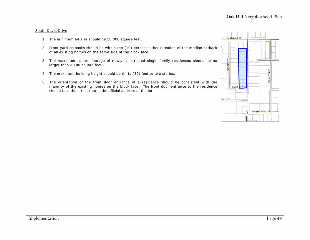
Oak Hill Neighborhood Plan
Implementation Page 48
South Davis Drive 1. The minimum lot size should be 18,000 square feet.
2. Front yard setbacks should be within ten (10) percent either direction of the median setback
of all existing homes on the same side of the block face.
3. The maximum square footage of newly constructed single family residences should be no larger than 3,100 square feet.
4. The maximum building height should be thirty (30) feet or two stories.
5. The orientation of the front door entrance of a residence should be consistent with the majority of the existing homes on the block face. The front door entrance to the residence should face the street that is the official address of the lot.

Oak Hill Neighborhood Plan
Implementation Page 49
Neighborhood Design & Character Recommendations
Neighborhood design and character recommendations are included in this chapter. The purpose for including these recommendations is to identify desired standards and guidelines that could assist in preserving the critical design features of the various areas in the neighborhood. The recommendations are intended to encourage capital investment within the neighborhood and assist in the revitalization of the area by protecting property values and enhancing the quality of life enjoyed by the residents. The inclusion of these recommendations does not establish any legal requirement for property development within the Oak Hill neighborhood area. Rather, they convey the vision expressed by the residents for the future of the neighborhood. These design features could be enacted through the use of a conservation district overlay, as described in the Arlington Zoning Ordinance and referenced in this document.
Residential Construction The front door entrance to the residence should face the street that is the official
address of the lot.
The material used on the exterior walls of the houses is encouraged to generally match the types of materials used on the other homes on the block face. Materials typically found on houses in the neighborhood include brick, stone and wood siding.
Houses should not exceed thirty (30) feet or two stories in height.
To maintain a balanced pattern of housing sizes along a street, the maximum square footage of newly constructed single family residences is encouraged to be no larger than two-times the average size of the existing average square footage established in 2007. This baseline is displayed in the table to the right, and is based on data obtained through the Tarrant Appraisal District in 2007.
Infill Development The development of vacant property within the interior of the neighborhood should be single family residential. The development of vacant property along West Abram Street should be encouraged to develop as service, retail and office uses,
as described in the Central Sector Plan. All new buildings should be constructed with a residential architectural character. The teardown of existing residences solely for the purpose of constructing a new larger residence is discouraged, especially if the
new residence is out of scale with the existing houses on the block face. Renovations to and expansions of existing homes are encouraged, especially when the renovation or expansion is consistent with
the style, form and structure of the existing or original structure. Land use
Maximum New House Size Recommendations
Street Average House Size (sq ft)
New House Size (sq ft)
Abram St 2,658 5,316 Barnes Dr 1,556 3,112 Bryce Ln 2,287 4,574 Charles Ct 1,780 3,560 Davis Dr 1,553 3,106 Dorcas Ln 2,431 4,862 Elliott St 1,204 2,408 Jimat Dr 1,783 3,566 Killian Dr 1,483 2,966 Parkwood Ave 1,660 3,320 Pennie Ct 1,403 2,806 W Second St 1,828 3,656 Sunset Ct 1,965 3,930

Oak Hill Neighborhood Plan
Implementation Page 50
The predominant land use within the neighborhood should be detached single family residential.
Service, retail and office uses on West Abram Street should be limited on the amount of penetration in the single family area of the neighborhood. The recommended boundary is shown by the red line on the map below. A Central Sector Plan strategy supports the development of these uses in this area given its location near UTA and Downtown. This development trend is also making use of older homes in the area.
Lot requirements Lots should conform in width, depth and area to the predominant pattern established by the existing lots located on the same
block, having due regard to the character of the area.
Front yard setbacks should be within ten (10) percent either direction of the median setback of all existing homes on the same side of the block face.
Signs

Oak Hill Neighborhood Plan
Implementation Page 51
Neighborhood identification signs should be designed and added to all street signs in the neighborhood. Funds for this project should be sought through the City of Arlington Neighborhood Matching Grant program.
Streetscape Preferred front yard fence materials include picket-style fences, non-solid wood construction or ornamental iron. Chain link fences
are discouraged in front yard locations, but are appropriate for rear yards.
The preservation of trees in the neighborhood is highly encouraged. The primary species include post oaks, black jack oaks, pecans or otherwise healthy native trees. Other appropriate species are noted in the landscape section of the City of Arlington Zoning Ordinance.
Tree-lines streets are very desirable in the neighborhood. Property owners are encouraged to plant trees in front yards to enrich
the appearance of the streets within the area. Transportation Sidewalks should be constructed on the perimeter streets of the neighborhood. These streets are South Fielder Road, West
Abram Street and South Davis Drive. The construction should conform to the standards contained in the City of Arlington Design Criteria Manual.
Driveways for business and non-residential properties should only be constructed on perimeter streets, if practicable. If a driveway must be located on an interior street, care should be taken to minimize the affect on any adjacent residential property.
Tow-away zones should be established where necessary or warranted within the neighborhood.

Oak Hill Neighborhood Plan
Implementation Page 52
Funding Resources
Capital Improvements Plan. Major infrastructure improvements are typically planned for through a capital improvements plan. Each year the City of Arlington prepares a five-year plan for the construction of new infrastructure such as streets, water lines, sewer lines, storm drainage facilities and parks. Since these types of improvements usually require multi-year financing, they are typically paid for through the issuance of bonds. This financing mechanism allows the City to pursue large-scale projects and spread the cost over several years.
Several of the strategies and issues identified in this plan may be candidates for future capital improvement projects, such as street and park improvements.
Street Maintenance Sales Tax. In January 2003, a 0.25-percent sales and use tax went into effect in Arlington. The sales tax is dedicated to the repair and maintenance of existing and aging streets. Funds go toward maintenance, rehabilitation and repair of public streets that existed at the time of the election. Micro-surfacing and asphalt overlays may be used, which could extend the life of pavement by five to seven years. These processes improve ride-ability, increase skid resistance and seal the surface of the streets to prevent moisture damage and deterioration.
Public Works & Transportation Department information indicates that in 2008, nine of the twelve streets in Oak Hill are proposed for milling and overlay.
Neighborhood Matching Grants. The Arlington's Strong Neighborhood Initiative (ASNI) strives to reinvigorate Arlington’s neighborhoods and ensure sustainability by leveraging resources, increasing citizen participation and encouraging community stakeholder collaborations. ASNI’s Neighborhood Matching Grants program gives neighborhood organizations the opportunity to implement public projects with City funds to be matched equally by a private source of funds, donated funds, labor and/or in-kind contributions.
In September 2007, the Oak Hill neighborhood steering committee, in partnership with the Arlington Historical Society, submitted two grant proposals to the Neighborhood Matching Grants program. The grant proposals were for street sign toppers and assistance with a neighborhood newsletter and website. The grant proposals were successful, and were awarded in November 2007 at the Neighborhood Summit.
Arlington Tomorrow Foundation. The Arlington Tomorrow Foundation was formed by the Arlington City Council to oversee an endowment fund created from natural gas revenues realized on City-owned property. Ninety-percent of gas well lease bonus earnings and 50 percent of all royalties earned on the wells go into a permanent endowment fund. The interest earnings from this fund will be distributed through grants to help improve the quality of life in Arlington. When the Mayor and City Council created the Tomorrow Foundation, they wanted only interest earnings to be distributed so that the fund could benefit the community in perpetuity. The Arlington Tomorrow Foundation awards grants for a broad array of public purposes that improve the well-being of the residents or make lasting enhancements to the City of Arlington, Texas. These grants fall under two classifications: Quality, Culture, Leisure & Learning Project Areas; and Safe & Healthy Neighborhoods Project Areas. Maximum award amounts range from $15,000 to $100,000.
In April 2008 the City of Arlington, as a partner with the Oak Hill neighborhood, received a grant for $50,000 for beautification projects in the neighborhood. The grant would assist with the construction of sidewalks on South Davis Drive and the construction of a landscaped neighborhood entry sign on one of the bounding streets.

Oak Hill Neighborhood Plan
Implementation Page 53
Amendments The Oak Hill Neighborhood Plan is intended to be a dynamic document, and one that is responsive to the changing conditions within the neighborhood and Central Sector. As conditions change, and new issues arise, the Plan may need to be revised or updated. Proposed amendments should only be made after thoughtful analysis and public input. The Plan should be monitored to ensure it reflects the needs and goals of the Oak Hill neighborhood. An amendment should not occur in order to justify approval of a specific development proposal. Caution should be exercised if the primary purpose or benefit of the Plan is to reach a short term gain, as this may come at the price of achieving a long term goal. Amendments will most often occur as the result of monitoring of the Plan for effectiveness or in order to achieve a more clearly defined goal or objective which is the result of a work plan item.
The Plan should be amended by using the same process in which it was created. Residents of the neighborhood may request that City Council begin amending the Plan by submitting a petition to the Council. Also, the City Council may vote to initiate an amendment to the Plan.
After Council authorizes the amendment process, the Community Development and Planning Department begins the preparation of the changes with the steering committee appointed by the neighborhood. The committee will work with and advise the planners while they prepare the changes to the neighborhood plan. The planners, with the advice of the committee, will write draft recommendations which address the relevant issues and solve the problems that necessitated the changes.
Once the amendments are complete, the planners will arrange for the updated plan to have a public hearing before the Planning and Zoning Commission and the City Council. Before the hearing, a draft copy of the revisions will be mailed to all property owners in the area. The revised plan will remain an element of the City’s comprehensive plan.
During the preparation of the plan, the following subject matters arose as topics of discussion. These subjects could be considered as future amendments to the plan.
1. In November 2007 at the Neighborhood Summit, residents from the University Hills subdivision expressed interest in being a part of the Oak Hill neighborhood planning area. The addition of this subdivision could be a future amendment to the plan.
2. The area of the neighborhood adjacent to Fielder Road struggles with a unique set of circumstances related to traffic,
noise, access and future development. Since many of these issues came to light towards the completion of the plan, it may be more appropriate to concentrate on these issues in more detail through a future amendment to the plan. This will allow the residents living on Fielder Road can participate in a more detailed study.
Appendices
1. History of the Oak Hill neighborhood
2. Neighborhood Assessment Survey Questions
3. Selected Responses to Survey Questions
4. Responses to Open-Ended Survey Question
5. SWOT Issues and Rankings

Oak Hill Neighborhood Plan
Appendices Page 55
1. History of the Oak Hill neighborhood Researched and written by Tom Cogdell The land on which we live is roughly the northwest quarter of the Owen Medlin league. Here is its description in the title granted April 14, 1856 by the State of Texas to Mathew J. Brinson, assignee of Owen Medlin.
In Denton District Tarrant County about nine miles (southeast) of Birdville, by virtue of Peters Colony Certificate Number 5 issued by the Clerk of the County Court of Tarrant County to said Medlin and by him transferred to the said Brinson, beginning at James Hyden's northwest corner at a stake, proceeding north one mile to a stake, west one mile to a stake, south one mile to a stake, and east one mile to the place of beginning.
Those stakes in the prairie were located in the document with respect to their distance and direction from landmark oaks, but the surveyor's path would now be described as “beginning at the intersection of Park Row and Cooper Street in Arlington, north on Cooper, west on Abram, south on Fielder and east on Park Row.” No value is given for the transfer of the patent. It might have been to settle a debt or for a few hundred dollars cash, but one can only wonder at the present value of the property. To set the scene further, the Republic of Texas was short on money in the 1840s and made an empresario grant in 1841 to a group of American and English investors led by William S. Peters of Louisville, Kentucky. The grant was continued with additions during Texas' statehood. The Peters group was supposed to survey the Peters Colony land located in North Texas, advertise it, and settle it, 640 acres (one square mile) to a family. The families surrendered certificates awarded them for services to Texas, time of arrival in Texas or purchased from those who owned them. Owen Medlin was a member of a group of pioneer settlers who came from Missouri and settled along the Tarrant-Dallas county line east of what is now Grapevine. They were founders in 1846 of
the historic Lonesome Dove Baptist Church. Owen Medlin possessed Robertson Third Class Certificate Number 1584 for 640 acres by virtue of the date of his arrival in Texas, and sold it 'unlocated' to Matthew J. Brinson. This gave Brinson the right to pick 640 acres of unoccupied land. Captain Matthew Brinson was from Shelby County in East Texas, as was Colonel Middleton Tate Johnson. They served together in the Mexican War and on missions of the Texas Rangers. Brinson, who married Middleton Tate Johnson's daughter, Louisa, chose to locate Medlin's league where it is. Although Johnson's Station was thriving, it was not until the railroad came through that Hayterville was founded in 1875, and renamed Arlington in 1877. The townsite centered where Center Street now crosses the railroad and extended one half mile in each direction. The Owen Medlin league was still in the country. Brinson himself made his homestead near the southeast corner of the present campus of the University of Texas at Arlington (UTA), where Trading House Creek meets Johnson Creek. He owned 140 acres there and 1120 acres further south reaching nearly to Johnson Station. Like many pioneers, he preferred to live in the woods of the Cross Timbers, near a source of water, and farm cotton on the blackland prairie. For a time he was in business in Fort Worth, but came back to Arlington in 1859. He was Mayor of Arlington 1881-1884 and 1889-1891. The development of the northwest part of the Owen Medlin league can be learned from a title abstract by Elliott and Waldron Abstract Company, simplified as follows.
In a warranty deed from M. J. Brinson to Fred A. Brinson, Owen Medlin Lot 2, which was being transferred, was bounded by a line starting at the northwest corner of the Owen Medlin league (near the Fielder House), going south 645 varas (l/3 mile), east along a line which is the south boundary of those lots on West Second Street between Davis Drive and Elliott Street (adjoining the UTA stadium land), continuing along West Second Street east of Davis Drive to the west branch of Trading House Creek (at the UTA Indoor Swim Building), then northwest following the creek to its origin at Abram Street (just a low place on

Oak Hill Neighborhood Plan
Appendices Page 56
Abram Street at The Tin Cup), and west on Abram to the Fielder corner, approximately 160 acres.
Subsequently, the 160 acres was repeatedly divided, part passing in 1872 back to M. J. Brinson, in 1873 to Jessee W. Hill, in 1876 to Mollie I. Gee and in February 1910 to James Park Fielder. Fielder, a banker who was Mayor of Arlington during 1909, built his house in the northwest corner in 1914 and operated a farm and orchard. He raised and sold chickens. Later, he and his wife, Mattie B. Fielder, took an active role in developing the neighborhood, filing a plat in 1925 along part of West Second Street near Elliott Street and naming it Oak Hill Acres. Eventually, they sold not only the lots in Oak Hill Acres, but also much of the rest of the acreage, some to other developers and some to individuals whose land has been passed on down to the present day as part of the Owen Medlin Survey. On March 8, 1910, J. P. Fielder conveyed a 10-acre tract to Joe A. Elliott, who filed a plat for the Elliott Addition to Arlington, Texas. On September 30, 1922 he filed an affidavit correcting errors in the 1910 plat, thus making it the Revised Elliott Addition and mentioned Elliott Avenue, then in existence, as part of the tract. Mollie Gee had previously conveyed a 21-foot strip on the north to the public for what was described as the Arlington and Fort Worth Public Road. Joe A. Elliott and his wife Eliza, married in 1879, lived with his mother, Sarah, in the Johnson Station area in 1880. He was active in several other developments in Arlington and later had his homestead on a hill north of Division Street northwest of the Fielder House. Wagon roads existed along the four boundaries of the Owen Medlin league as early as 1893. The Texas and Pacific Railroad right of way cut off a slice of the north boundary at the west edge when it was graded in 1876. The Northern Texas Traction Company (interurban) came through downtown Arlington in the middle of Abram Street beginning in June 1902. However, its track moved onto the north shoulder of Abram just west of Davis Street from there to its convergence with the railroad, where it curved to follow the south side of the railroad continuing west. Abram Street veered dangerously across both rail tracks at an acute angle, forming the notorious Death Crossing, named for the many train-automobile collisions that occurred there. A replaced crossing
further east that crossed the railroad perpendicular to its path was safer. Then the hazard was eliminated, as well as direct connection to Division Street, by the Fielder Overpass. The first development within the neighborhood was in the Elliott Addition, though there is evidence for houses along Abram Street earlier. From deed records, Joe A. Elliott sold parcels to Martha R. Burke, Robert Carswell, Mrs. Mollie Poole, Ed M. Forlines and H. F. Moore between 1910 and 1930. Some of these were probably speculative ventures on the part of the purchasers, for some were for six lots, and tax records indicate that they were not taxed until later, when a structure was built. The first tax assessments were to Vernon Roberts, J. O. Hardie, Mrs. Olive Dawson, Mary Blanche Fowler, L. Thompson, W. B. Hiett and Mary Griffith, James Knapp, Joe Delk and A.T. E. Haynes on the west side, lots 1-29 of Block 3 and part of Block 2. On the east side, on lots 2-30 in Block 4, were owners Mr. and Mrs. O. L. (Irma B.) Killian, J. O. Hardie, Everette L. Crabtree, Robert Carswell and J. G. Smith, V. A. Norman, W. M. W. Splawn, Maude M. Crouch, Bergman Produce Co. and W. T. Angell. The times at which development of other parts of the neighborhood occurred can be roughly conceived by the filing dates for plats of the later developments. Residents of the neighborhood who had an impact include the following:
Mollie I. Gee lived on the west end of Abram Street before 1893, where her house appears on the Sam Street map roughly opposite the Masonic Home. On the 1910 census she is a widow. She appears in the 1915 Arlington telephone directory.
James Park Fielder, Mattie B. and sons James, Jr. and Robert built the fine home in the northwest corner of the area beginning in 1914, but according to Geraldine Mills of the Arlington Historical Society divided time between living in Alvarado and Arlington until about 1920. They appear in the 1920 and 1930 census (occupation farmer) and in the 1942 Arlington telephone directory with RFD 2 given for the address.

Oak Hill Neighborhood Plan
Appendices Page 57
The Arlington city limit on the west remained unclear on maps until a 1952 map shows it on Fielder Road.
Irma M. Barnes lived with her mother Ellie Barnes on Abram Street in 1930, while Oscar L. Killian lived with his father Burwell W. Killian nearby. They married that year and afterward were involved in real estate in the area. They platted the Summit Grove Addition on Barnes Drive and Sunset Court in 1947. Barnes Drive could not be completed to Elliott Street until they acquired lots 8-18 of the Elliott Addition, dedicated lot 10 to the city for the street, and turned houses on the corner lots from facing west to face Barnes Drive. On July 3, 1951, the young Mayor Tom Vandergriff signed notice of assessment of the cost of paving Sunset Court and Barnes Drive, gravel roads until then. In deed restrictions for Summit Grove, one specification is that all houses must connect to city sewage, if available, and if not to a sanitary means of disposal. This suggests that services by the city were just becoming available. In 1942 the Killian's lived on Abram Street just east of Davis Drive. Vernon Roberts is said to have personally built four houses on Elliott Street in the 1940s, all in the south part of the Elliott Addition.
The telephone listings give an undercount of people living in the neighborhood because a telephone was an expense that was a hardship for some during the 1930s and 1940s. However, compare the number of houses listed by street in 1942 with 1949.
1942: Abram Street (8): E. J. Bradley, H. Bailey Carroll, Mrs. Buena Davis, Les Dublin, Jr., George E. Jenkins, B. B. McBride, Mrs. Albert R. Parsons and J. P. Fielder.
West Second Street (2): G. L. Perkins, R. W. Tanner. 1949: Abram Street (8), West Second Street (2), Elliott
Street (5), Parkwood Avenue (11), Sunset Court (3), Barnes Drive (2) and Davis Drive (2).
The explosive growth was just beginning, for the 1950s were years of strong growth, and in 1960 there were 11 telephone listings each on Elliott Street and Barnes Drive, for example. That is, they were fully developed. Tarrant Appraisal District posts Official Public Records for properties in the county on their web site which includes a date of construction of each house. While the dates are correct for most homes, there are errors for many older homes built before 1947. Before these records were computerized, the tax records were kept as tax assessor's cards, which are now in the Tarrant County Administration Building. These reveal the date on which older properties entered the tax records, owner's name at that time and deed record book and page for the transaction in which the property was acquired. The earliest date given may indicate that there was a house there, since that is likely when tax collection was enforced. It often coincided with division of a 6-lot space into four homesteads, especially on Elliott Street where lots were 50 feet wide and most houses are now on 75-foot frontages. For some properties there may be a drawing of the home's footprint, dimensions, distance to the street, description of building materials, number of rooms, presence of plumbing and year built. For Elliott Street homes, the oldest in the neighborhood, considering only those for which the year of construction given ranges from 1923 to 1947 on the cards, the corresponding electronically stored date ranges from 1946 to 1952. After 1947, there is good agreement of dates given for each house. After the tax system was computerized, the tax assessor cards were no longer updated, so comparable details are not available for new houses. It is clear that homes in the neighborhood span 80 years time and are built in a variety of styles, from bungalows on pier and beam foundations to attractive modern homes of conservative design on concrete slab foundations. There is no great disparity in size, but much individual character. This is no neighborhood of tract houses. With attractive trees and gardens and a sense of open space that the breezes can penetrate, it is quiet enough outdoors to hear the bells chime at Santa Maria Greta Church, the bands play at

Oak Hill Neighborhood Plan
Appendices Page 58
Maverick Stadium, and the trains announce their approach to the Davis Drive crossing. It is a gracious place to live. Information from Maps Following are some observations about what is found on early maps and what was added later. Many of these maps were located in Special Collections at The University of Texas at Arlington (UTA), where generous help was provided by Kit Goodwin, Brenda McClurkin and Ben Huseman. Map of Texas comprising the grant of the Texian Emigration and Land Company. J. M. Johnson, Richardson, Cornhill, London, 1843. (UTA)
This is a Township and Range map based on the point at the junction of the Elm and West Forks of the Trinity River, from which surveyors would in the future lay out their grid. Features shown are Dallas and Cedar Springs, a network of trails, Bird's Fort and a few land patents, mostly on the west bank of the Trinity south of Dallas. Some creeks have their modern names, such as Fossil Creek and Five Mile Creek. However, the creeks through Arlington are called Caddo Creek (now Village Creek) and Trading House Branch (now Johnson Creek). The East Line of Cross Timbers is shown bisecting the future location of Arlington. The sections are numbered and it is possible to recognize that the Owen Medlin patent is Number 33 in Township 1S, Range 3W, based on identifying the west branch of Trading House Branch shown on the map as the creek now having its head in the Owen Medlin and passing through UTA on its way to Johnson Creek. That west branch is now called Trading House Creek.
Sam Street's Tarrant County. Texas Map Publishing Company, Fort Worth, Texas, 1893. (Tarrant County Archives)
This is a General Land Office (GLO) map of land patents to which a lot of information has been drawn in, towns and small communities, railroads, wagon roads in rural areas, homesteads with owner's names and rent houses as
unidentified small squares. In the margin are county officer's names, precinct numbers (Arlington 6, Johnson Station 7) and explanation of symbols used. The Matthew J. Brinson homestead is shown, near where the UTA southeast corner now is. The college is shown as a single building. The O. Medlin league is bordered by four wagon roads, contains one homestead (Gee) and seven rent houses, two along Abram and five dispersed, likely tenant houses near cotton fields. From the center of Arlington and following the edge of the Cross Timbers is a wagon road reaching Johnson Station, now the route of Center Street, but Johnson Creek has the abbreviated name Station Branch.
Arlington and Vicinity, Topographical Map compiled by second year ROTC, North Texas Agricultural College, May 26, 1924. (UTA)
Cooper Street is named Mansfield Pike. From Mansfield Pike, Abram goes west to Death Crossing over both the Northern Texas Traction Company (Interurban) and Texas and Pacific Railroad tracks, intersecting with the Bankhead Highway. West Second Street going west passes the old NTAC athletic fields (now site of the UTA Activities Building), crosses Trading House Creek and dead ends at Davis Drive, which at that intersection is shown with the small zigzag in its north-south course that we still have. A short segment of Fielder Road turns into a country lane. The Fielder house, built in 1914, old Arlington High School, Ransom Hall and the larger Masonic Home are represented.
Official Map, Arlington Texas, Myers, Noyes and Forrest, Engineers, 1926, W. G. Hiett, Mayor. (UTA)
Division Street is labeled Bankhead Highway. Abram Street, not named, is illustrated with the interurban track down the middle through town, but veering off to the north side shoulder after passing Davis Drive until it curves to parallel the T and P rails.

Oak Hill Neighborhood Plan
Appendices Page 59
The city limit is shown clearly across the south part of town following Johnson Creek and Trading House Branch, turning straight west to dead end at Davis Drive. Outside the city limit, no street names are given, but Davis Drive, West Second, Sunset Court and Elliott are illustrated. Elliott Addition and Oak Hill Acres are the only named subdivisions in that part of the map.
1943 Official Map, Arlington Texas, Robert W. Gibbins, County Engineer. (UTA)
This is identical to the drawing made in 1926 but for: The Bankhead Highway is also named State Highway No. 1. Interurban track is removed. Present Fielder Road is named Henry Road. Elliott, Second and Altman Avenue (Sunset Court) are the only streets in the neighborhood. No buildings are shown, but tracts are labeled Arlington High School and N. T. A. C. Athletic Field. The city limits are still vague, discontinuous. W. F. Altman is Mayor.
Universal Map of Arlington, Texas, Universal Map and Drafting Company, Fort Worth, 1952. (UTA)
The neighborhood is finally shown inside city limits, except for the land where Charles Court will be. Sunset Court is named. Completed streets are Barnes, Killian west of Elliott, Jimat and Parkwood. Norwood Street west of Fielder is drawn, but named M. Brinson Road along its western end. Some structures are shown, the Masonic Home, A. S. C. (Arlington State College) campus and football oval, Arlington Downs and Buick-Oldsmobile-Pontiac Assembly Division of General Motors Corporation.
Arlington Quadrangle, Texas, 7.5 minute series, USGS, 1959. (UTA)
Killian east of Elliott and Pennie Court are added. Development west of Fielder is under way. Buildings shown include Saint Maria Goretti School, West Side School at Border and Summit, new Arlington High School at Cooper and Park Row, and a substantial campus for the college. Division Street is U.S. 80 and the city limit is along Forest Edge Drive.
Street Names and Persons for whom they are named The source for most of these is J. W. Dunlop's memoir now in UTA Special Collections. Others come from interviews with family members of the honored person.
Abram Street Abram Harris, an early land owner
Davis Drive Dean D.D. Davis of North Texas Agricultural College
Fielder Road J. P. Fielder family, formed Oak Hill Acres
Jimat Drive Jim + Mat, from James and Mattie Fielder
Elliott Street Joe A. Elliott, formed Elliott Addition
Barnes Drive Ellie Barnes, mother of Irma Barnes Killian
Killian Drive Oscar L. and Irma B. Killian, formed Summit Grove Addition
Dorcas Lane Dorcas Benson, formed Wildflower Estates and Wildflower Estates West
Bryce Lane son of Dennis and Dorcas Benson
Pennie Court unknown
Charles Court unknown
Altman Avenue Mayor W. F. Altman, later renamed Sunset Court

Oak Hill Neighborhood Plan
Appendices Page 60
2. Neighborhood Assessment Survey I. NEIGHBORHOOD CHARACTERISTICS
1. What street do you live on?
2. Do you own or rent your dwelling? own rent
3. Please check the year the structure was built (if known) 2000 or later 1990 – 1999 1980 – 1989 1970 – 1979 1960 – 1969 1950 – 1959 1940 – 1949 1939 or earlier
4. How long have you lived in this neighborhood? less than one year 1-2 years 3-5 years 6-10 years more than 10 years
5. What attracted you to the neighborhood? (check all that apply) people schools type of housing convenience to work location other
6. Are you planning to move this year? Yes No
If yes, why?
going from renter to owner need a larger house job relocation other
II. GENERAL NEIGHBORHOOD CONDITIONS, LAND USE AND ZONING
7. What do you like most about our neighborhood? (Rank in order of
importance.) 8. What do you like least about our neighborhood? (Rank in order of
importance.) 9. Do you agree with the way land is currently used in our neighborhood in
regard to: commercial development single family housing undeveloped land other
10. Is there a problem with noise on your street?
from traffic from commercial establishments from recreational facilities from dogs from other residents other

Oak Hill Neighborhood Plan
Appendices Page 61
11. Overall, how do you rate the livability of your neighborhood? very good good bad very bad don’t know
III. STREETS, SIDEWALKS AND LIGHTING
12. Are there drainage problems on your street?
Yes no 13. Is additional street lighting needed on your block or elsewhere in the
neighborhood? Yes no
14. Are there corners where bushes, trees or fences obstruct your vision of
oncoming traffic? Yes no
15. Do you think a pedestrian safety problem exists at particular intersections
or specific streets (including routes taken by children to school)? Yes no
If yes, please list the type of problem and where.
16. Do you feel there is a need for sidewalks in your neighborhood?
Yes no IV. TRAFFIC
17. Is through traffic a problem on your street?
Yes no
18. Is through traffic a problem elsewhere in the neighborhood?
Yes no
19. Do you think motor vehicles speed through the neighborhood? Yes no
20. Are the street or traffic signs (e.g., stop signs, street name signs, etc.) in
your area: Yes No adequate unobstructed well-maintained
If not, please explain:
V. PARKING
21. Is parking in front of your house a regular problem for you or your
guests? Yes no
22. Do you anticipate parking problems in the future?
Yes no 23. If you have parking problems, what do you think are the causes?
commuters college students commercial parking not enough off-street parking for residents other

Oak Hill Neighborhood Plan
Appendices Page 62
VI. PARKS, RECREATION AND BEAUTIFICATION
24. What type of parks and facilities do you like and use? (Please check all that
apply). walking or jogging trails biking trails playgrounds picnic areas athletic ballfields and/or courts passive open areas
25. Do you visit any of the following park facilities?
Fielder Park College Hills Park other
26. Do you think that we should promote the preservation of trees and other
green or open space areas in the neighborhood? on public property on private property
27. Are there median areas, parks or other public spaces that would be improved by landscaping?
Yes no 28. Would you favor installing a neighborhood identification sign at an
entrance point to the neighborhood? Yes no
29. Would you favor installing neighborhood identification signs on street
sign poles in the neighborhood? Yes no
30. Do you think the neighborhood has a problem with:
trash
litter graffiti
VII. COMMUNITY SERVICES
31. Please rate the following services as G (Good), F (Fair), P (Poor), or N
(No Opinion).
police protection
fire/ambulance service
water/sewage
solid waste collection
street maintenance
library facilities
social services
schools
other
Please specify other
32. Do the commercial establishments in or near the neighborhood:
Yes No meet your daily shopping needs keep premises clean and well maintained
provide adequate customer parking have a negative impact on nearby residences
other

Oak Hill Neighborhood Plan
Appendices Page 63
VIII. PUBLIC SAFETY
33. Do you consider crime a problem in this neighborhood?
Yes no 34. Have you or your neighbors been a victim of crime in your
neighborhood? Yes no
If yes, what type of crime was it?
35. Is there a Neighborhood Crime Watch program on your block?
Yes no If yes, is it active?
Yes no IX. OPEN COMMENTS
36. We would appreciate your additional comments on any topic about your
neighborhood.

Oak Hill Neighborhood Plan
Appendices Page 64
3. Responses to Selected Survey Questions The tables below show the responses to most of the questions on the survey. Not all percentages total 100% as the responses to some questions were left blank. For some of the “check all that apply” questions, the responses are referenced as to how many times that particular answer was given. Where applicable, a list of responses to the answer of “other” is provided. I. NEIGHBORHOOD CHARACTERISTICS
Do you own or rent your dwelling?
own: 98%
rent: 2%
Are you planning to move this year?
yes: 7%
no: 93%
How long have you lived in this neighborhood?
less than one year: 6%
1-2 years: 9%
3-5 years: 9%
6-10 years: 9%
more than 10 years: 66%
What attracted you to the neighborhood? (response refers to number of times mentioned by respondents)
people: 13
schools: 13
type of housing: 47
convenience to work: 0
location: 61
other: (see comments to right)
charm of neighborhood, quiet, large lots, character of houses, little traffic
wide lots, smaller houses, small neighborhood
big lots, quiet street
neighborhood look, large yards, small houses, etc
convenience to shopping, beautiful mature trees
married into neighborhood
convenience to church and relatives
compromise between our 2 job locations
mature trees, price, looked safe
trees in neighborhood, cul-de-sac, swimming pool
privacy, kids, college
we inherited it, raised our family here
my parents purchased it and remodeled our home in 1959. my brother and I inherited it. my husband and I raised our family here and continue to enjoy living here
seclusion
quiet neighborhood with fully grown shade trees big yards, somewhat remote
prices were less expensive in Arlington compared to Dallas
trees, off busy street
trees and bigger lots
trees, quiet neighborhood, close to university
be near wife’s parents
I grew up on this street from age 4-19, moved back in1991. Love it.
it’s a nice quiet neighborhood, centrally located to Dallas and Fort Worth
the older homes with large yards and heavily treed area
this was my grandmother’s house. I have been familiar with area since 1962
family home, we have been here since it was built
large lots, older homes with character
parents gave us the lot
large lots, trees, wide street

Oak Hill Neighborhood Plan
Appendices Page 65
II. GENERAL NEIGHBORHOOD CONDITIONS, LAND USE AND ZONING
Is there a problem with noise on your street? (response refers to number of times mentioned by respondents)
from traffic: 16
from commercial establishments: 1
from recreational facilities: 6
from dogs: 12
from other residents: 5
other: 17 (see comments below)
Overall, how do you rate the livability of your neighborhood?
very good: 72%
good: 26%
bad: 0%
very bad: 0%
don’t know: 2%
trains loud music sometimes UTA stadium now and then noise from concerts at UTA stadium we occasionally have thru traffic speed through work trucks parked on yards frat house late night music sirens and planes
III. STREETS, SIDEWALKS AND LIGHTING
Are there drainage problems on your street?
yes: 33% no: 65%
Is additional street lighting needed on your block or elsewhere in the neighborhood?
yes: 33%
no: 65%
Are there corners where bushes, trees or fences obstruct your vision of oncoming traffic?
yes: 29%
no: 68%
Do you think a pedestrian safety problem exists at particular intersections or specific streets (including routes taken by children to school)?
yes: 29%
no: 65%
Do you feel there is a need for sidewalks in your neighborhood?
yes: 24%
no: 76%

Oak Hill Neighborhood Plan
Appendices Page 66
IV. TRAFFIC
Is through traffic a problem on your street?
yes: 24% no: 76%
Is through traffic a problem elsewhere in the neighborhood?
yes: 17%
no: 56%
Do you think motor vehicles speed through the neighborhood?
yes: 55%
no: 45%
Are the street or traffic signs (e.g., stop signs, street name signs, etc.) in your area:
yes no
adequate 81% 11%
unobstructed 64% 7%
well-maintained 69% 2%
V. PARKING
Is parking in front of your house a regular problem for you or your guests?
yes: 9% no: 91%
Do you anticipate parking problems in the future?
yes: 14%
no: 82%
If you have parking problems, what do you think are the causes? (response refers to number of times mentioned by respondents)
commuters: 2
college students: 7
commercial parking: 0
not enough off-street parking for residents: 6
other: 13(see comments to right)
many have 1-car garages and driveways; also, rent houses that have college students too many cars not using garage or driveway residents have to many vehicles and don’t use garage several drivers in house complaining neighbor it’s a court, so if someone has a party it is very congested only parking problems are where housing density exists. Parkwood and E Killian have too many houses crammed in so people park in the street more often, unlike 2nd, Barnes, Elliott and Sunset garage sales cul-de-sac, fire plug people who leave cars parked in street all the time people parking the wrong way on curbs only if multi-family housing or UTA stadium access from 2nd St were allowed
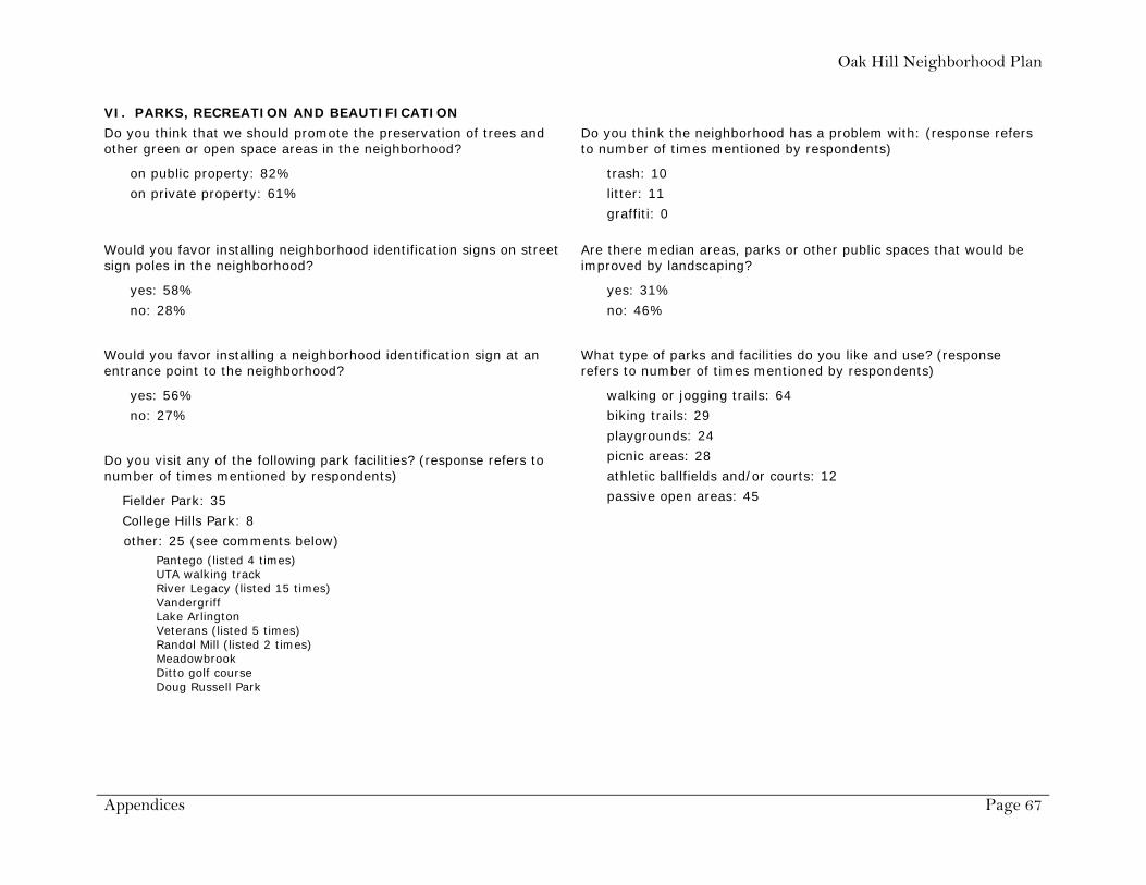
Oak Hill Neighborhood Plan
Appendices Page 67
VI. PARKS, RECREATION AND BEAUTIFICATION
Do you think that we should promote the preservation of trees and other green or open space areas in the neighborhood?
on public property: 82%
on private property: 61%
Do you think the neighborhood has a problem with: (response refers to number of times mentioned by respondents)
trash: 10
litter: 11
graffiti: 0
Would you favor installing neighborhood identification signs on street sign poles in the neighborhood?
yes: 58%
no: 28%
Are there median areas, parks or other public spaces that would be improved by landscaping?
yes: 31%
no: 46%
Would you favor installing a neighborhood identification sign at an entrance point to the neighborhood?
yes: 56%
no: 27%
Do you visit any of the following park facilities? (response refers to number of times mentioned by respondents)
Fielder Park: 35
College Hills Park: 8
other: 25 (see comments below)
What type of parks and facilities do you like and use? (response refers to number of times mentioned by respondents)
walking or jogging trails: 64
biking trails: 29
playgrounds: 24
picnic areas: 28
athletic ballfields and/or courts: 12
passive open areas: 45
Pantego (listed 4 times) UTA walking track River Legacy (listed 15 times) Vandergriff Lake Arlington Veterans (listed 5 times) Randol Mill (listed 2 times) Meadowbrook Ditto golf course Doug Russell Park

Oak Hill Neighborhood Plan
Appendices Page 68
VII. COMMUNITY SERVICES
Please rate the following services as G (Good), F (Fair), P (Poor), or N (No Opinion).
G F P N Blank
police protection 74% 16% 2% 5% 2%
fire/ambulance service 83% 2% 1% 11% 2%
water/sewage 64% 22% 10% 2% 2%
solid waste collection 94% 5% 0% 2% 2%
street maintenance 40% 43% 13% 1% 2%
library facilities 74% 4% 0% 15% 7%
social services 43% 4% 0% 37% 7%
schools 56% 12% 4% 21% 7%
Do the commercial establishments in or near the neighborhood:
Yes No Blank
meet your daily shopping needs 79% 12% 9%
keep premises clean and well maintained 88% 1% 11%
provide adequate customer parking 87% 2% 11%
have a negative impact on nearby residences 9% 67% 24%
VIII. PUBLIC SAFETY
Do you consider crime a problem in this neighborhood?
yes: 12% no: 84%
Is there a Neighborhood Crime Watch program on your block
yes: 5%
no: 75%
Have you or your neighbors been a victim of crime in your neighborhood?
yes: 55%
no: 39%

Oak Hill Neighborhood Plan
Appendices Page 69
What do you like most about our neighborhood? (Rank in order of importance.)
Below are the responses to the open-ended question number 7 in the assessment survey.
Best Neighborhood Feature Next Best Feature Third Best Feature
1 quiet, tree lined streets and lots charm of houses, character large lots 2 small town feeling peaceful, quiet lot size 3 big lots older homes big trees 4 location size of lots cost at time of purchase 5 overall look quiet community caring neighbors 6 quiet central Arlington location trees, park-like appearance 7 well kept homes location 8 quiet good neighbors 9 seclusion manageable sized lot location
10 people take care of houses and yards location 11 location 12 close to UTA close to work close to I-30 13 location to work care of homes and maintenance neighbors, community, trees 14 non-cookie cutter homes trees people 15 nice people little traffic old growth trees 16 quiet neighborhood mature shade trees accessible to thoroughfare (Fielder) 17 peacefulness security curb appeal 18 old atmosphere dead end street less traffic 19 stable neighbors safe trees 20 everyone leaves you alone fairly quiet fairly low crime 21 quiet neighborhood limited access 22 quiet wooded no more homes being built 23 small not much traffic lots of trees 24 cul-de-sac layout discourages through
traffic friendly neighborhood safe enough to walk, parts of neighborhood built during
different eras giving it charming eclectic character 25 no thru traffic central location affordable 26 people central Arlington location homey atmosphere, trees 27 mostly single family housing large yards (great gardens) cul-de-sacs (single family) 28 location within the city stable residential quiet 29 quiet neighborhood 30 central location near hospital and doctors near grocery stores and banks 31 central location near doctors near stores and banks 32 quiet, no thru traffic neighbors watch our for each other beautiful street 33 location quiet 34 era of homes and their spacious lots diversity of trees and plants (age and species) traditional families and lifestyles 35 single housing structures location trees 36 age location atmosphere 37 low crime lots of shade, greenery quiet 38 it feels like a neighborhood nostalgic look and feel style of houses range from the 40s to the 70s, each
one is unique 39 quiet friendly 40 location size of lot

Oak Hill Neighborhood Plan
Appendices Page 70
Best Neighborhood Feature Next Best Feature Third Best Feature 41 quiet large lots responsible people 42 location trees lack of crime 43 long time neighbors solitude, peaceful safe to walk the neighborhood 44 quiet everyone looks out for everyone 45 quality houses historic look people 46 quiet trees location 47 trees modest houses location near UTA 48 peaceful neighbors location in metroplex 49 quiet, except for stadium know our neighbors 50 quiet mostly well kept 51 stable quiet well kept homes 52 lot size trees 53 people/unique area age of homes mature trees 54 large lots trees architecture 55 style of the homes big yards location 56 safe quiet 57 mature trees central location few tall wooden fences around lots 58 location compatible neighbors 59 quiet great neighbors within walking distance of services 60 single family housing character of neighborhood large lots 61 location lot sizes historical houses 62 privacy individualism of houses natural yards 63 good neighbors generally quiet close to shopping, doctors, hospital and church 64 neighborhood setting, trees neighborhood lots, atmosphere quiet street, tree lined, neighbors 65 lot size trees age of homes 66 large lots single dwelling households trees 67 large lots trees no mcmansions 68 large lots with old growth trees small cottage type homes my neighbors, stable or increasing property values 69 historical character small town feel large lots, trees 70 trees house spacing character 71 location trees and land neighbors 72 character of homes large lots old trees 73 types of charming houses land space convenient location 74 country feel location near my church location to hospitals 75 large wooded lots unique homes single family housing 76 character of homes large lots with many trees single family housing 77 quiet wonderful neighbors centrally located 78 large yards space between homes central Arlington location 79 location close to stores nice neighborhood

Oak Hill Neighborhood Plan
Appendices Page 71
What do you like least about our neighborhood? (Rank in order of importance.)
Below are the responses to the open-ended question number 8 in the assessment survey.
Worst Neighborhood Feature Next Worst Feature Third Worst Feature
1 threatened development tearing down existing houses not keeping property up 2 fast cars down Elliott going to Abram, Davis or
Fielder as a short cut
3 rental property unkempt property (homes and landscaping) low water pressure 4 houses being torn down prospect of multi-family homes being built 5 traffic-traveling on street and turning around occasional train noise 6 noise on Judi Martin 7 cars parked on street 8 loud neighbors street noise 9 close to homes that are unkempt
10 need green space closer to home 11 too many renters low water pressure no parks in walking distance 12 rent homes lack of yard care parked cars on street 13 distance from work (Dallas) 14 parked cars on street people using front yards like a backyard 15 conditions land use 16 rental property with slumlords 17 houses not real big neighbors quick to call city for length of grass electricity goes out in storm 18 no dislikes 19 renters certain neighbors that don’t keep their houses or
yards up
20 lots of barking dogs streets need repair low water pressure 21 untidy neighbors 22 rental property that is not taken care of intersection of 2nd and Fielder concert noise from UTA stadium 23 tear downs of historic houses people looking to buy rent houses too much UTA traffic, thru streets 24 location near train 25 water pressure 26 name of street small lot, backyard red dirt 27 driveways 28 lack of restriction on multi-family housing housing density increase road to and from Fielder on 2nd, road to Abram
from Fielder, esp. when signal is red at Norwood 29 traffic noise from college noise from trains 30 fast cars loud trains out of place housing 31 no negatives so far 32 not all homes maintained with same level of
ownership pride
33 traffic unkempt yards cars parked in yards 34 trains 35 duplexes at Elliott/Abrams 36 concerned about the future of the empty lots on
2nd Street
37 need an additional street light, it is so dark

Oak Hill Neighborhood Plan
Appendices Page 72
Worst Neighborhood Feature Next Worst Feature Third Worst Feature 38 few rundown houses yard not kept up duplexes off Elliott 39 bad road (street) 40 speeding down 2nd and Elliott new construction out of character and size of
historic homes
41 slobby neighbors too many cats question mark on lot at end of street 42 people who won’t keep up their yards and can get
away with trashy mess
43 speeding on W 2nd 44 speeding 45 unkempt houses too much yard art houses not code compliant 46 some residential not well cared for, although this is
changing traffic speeding through lack of neighborhood protection/designation
47 lighting junk in backyards 48 junk in people’s yards junk in backyards 49 nothing 50 slumlord who owns 2 crack houses on my block lack of sidewalks owner neglect, property rates too high 51 traffic 52 lack of sidewalks UTA encroachment lack of streetlights 53 rental property upkeep or lack of: homes and yards unsafe conditions on streets due to speeding 54 people who think they know best for others 55 vacant houses poorly kept yards and fences occasional noise 56 homes/yards uncared for slum lords 57 street lights not always on at night utility wires water pressure too low 58 speeders no sidewalks no central park 59 possibility of development not in keeping with our
existing neighborhood character high traffic on 2nd St and speeders unnecessary noise levels from Maverick Stadium
60 all old ones gone 61 thru traffic (speed) students parking on street rental properties 62 TXU butchering trees and the threat of a repeat wires should be buried W 2nd is a speedway at some times of the day 63 lack of sidewalks 64 speeding traffic unknown future use of lots parked cars on streets 65 threat of change to historical appeal 66 loud traffic 67 traffic on Fielder Rd high speeds on Fielder Rd loud vehicles, exhaust and stereos 68 traffic on Fielder Rd, excessive noise and speeding
creates too much danger to pedestrians new buys are tearing down the older homes
69 unused cars parked on front drives unkempt yards 70 duplex near Abram

Oak Hill Neighborhood Plan
Appendices Page 73
4. Responses to Open Comment Question from Neighborhood Assessment Survey “We would appreciate your additional comments on any topic about your neighborhood.”
We enjoy the neighbors - UTA, churches, people
Very interested in keeping the character of neighborhood. Keep it single family homes. Build community spirit.
Wonderful neighborhood. Great neighbors. It would be nice to create a walking area to connect with office complexes and UTA for recreational walks. We now use streets and contend with traffic.
Biggest threats to neighborhood are multi-tenant housing and excessive renters. Would like to see a better relationship with UTA.
Streets need repaving. Need more drainage for heavy water. Need mirror to see oncoming traffic corner of Fielder and 2nd St.
I really think things are fine, and I really don't think we need a neighborhood committee trying to change things.
I live next to a rent house, which is owned by a man who I consider to be a slumlord. Do owners have rights against renters?
We have a good neighborhood. I see more rental property and potential for negative change if the city approves certain construction.
Because several older homes in the neighborhood have been demolished we hope that new construction will be single family similar in size and character to the surrounding homes.
We have a few neighbors on Charles that do not or can not take care of landscaping and lawns - also general clean up! This bothers me the most - it could cause me to move at some point.
We have a lovely neighborhood and some of us are very close friends. It would be nice to plan events to meet other neighbors and welcome new ones.
Please consider the idea of slowing traffic on Fielder. It would much improve the living conditions of homeowners whose homes are on Fielder and every one who drives on it, as well as the children who attend schools.
Some neighbors have expressed concern about new properties for lease. Also, development of large open spaces is a concern for those of us backing up to the undeveloped land.
We have many retired couples on our court (cul-de-sac) who watch over things pretty well, sometimes too well!
The neighborhood as a whole is beautiful. I would say, however, that the duplexes on Elliott are not to the standard this neighborhood should expect. It'd also be nice if Pars Academy on Elliott was zoned residential, not commercial.
I know there is a lot of open land near. I do not want high occupancy housing to go there. Large lot single housing only!
I think one of the most important factors in having a nice, historical neighborhood is outside appearance. It would be great if everyone would keep their grass, trees, shrubs and edging looking nice year round.
Would like to see flag pole fixed on our street. Also, trees and shrubs replaced like there used to be in the median.
New development that does not fit the rest of the neighborhood.
It is a wonderfully unique neighborhood in Arlington where neighbors interact and share history about Arlington's roots.

Oak Hill Neighborhood Plan
Appendices Page 74
We like the fact that it is an old neighborhood and all the housing fits the era when established (1940s and up). Friendly neighbors who want to preserve the grace and beauty of the surrounding neighborhoods.
I am opposed to additional city intervention or restrictions in our neighborhood. Further, I do not believe the self-appointed "steering committee" is very interested in opinions other than their own.
We would like to thank Mr. Frank Hill for all he has done for our neighborhood!
Vacant homes on Davis
The water hydrant at Barnes and Sunset has chronic leaking problems, sometimes for days or weeks before being attended to.
We love living in this neighborhood and want to see it grow with new families.
The city must help us maintain what quality of life remains; another "East" Arlington is creeping upon us - just look at south of Park Row between Cooper and Fielder. Would be nice to turn remaining open space in neighborhood into private or pocket parks. One place does not keep mowing done as often as it should.
Please protect the post oaks. Help with traffic study. Prevent out-of-scale fill-in on vacant lots. No townhomes/apts.
Speed bumps are needed on W 2nd.
Please do not let anyone put in townhomes on his large lot. It’s not in keeping with the neighborhood and could cause too much traffic.
We have a unique neighborhood, and I would very much like to see it preserved. I am concerned with development that tears down existing small homes and puts up large homes completely out of character with the rest of the neighborhood. This is already happening, and we want to try to at least direct some of this development. These historical homes are worth saving, as well as the charm and old feel of our neighborhood. We do not have much history left to preserve in Arlington. Most people that move here did so to get away from cookie cutter development and zero lot lines, etc. I would like to see the city help us and protect us from such building in our neighborhood. Thank you
We feel strongly that the character of our neighborhood needs to be preserved. We would also like to see more speed control and a central park space developed. Perhaps oil and gas royalties could be used? Cheers to PJ and the rest of the volunteers for all of their hard work.
It should be against the law to rent houses with no electrical or water utilities and landlords should be forced to make improvements or have their homes demolished. Also, ordinances need to be in place so as to not allow shrubbery and landscaping to completely engulf a property to the point where entering the front would be impossible without a good pair of tree trimmers and a chainsaw. In addition, police ought to be able to figure out when drugs are being trafficked in our neighborhoods and do something about it.
I hope that establishing a neighborhood plan will keep out multi-family development and aid in maintaining the existing "feel" that our neighborhood currently enjoys. I feel the speed limit on Fielder Rd should be dropped to 35 mph. This is a residential neighborhood with currently 40 mph limit. The traffic averages at least 50 mph (with many cars going far, far faster.)

Oak Hill Neighborhood Plan
Appendices Page 75
For the speeds on Fielder in general, the increased speed of northbound traffic to beat the traffic light and the poor visibility to south while facing west on 2nd and facing east on 2nd from west side of Fielder make the intersection of 2nd and Elliott a prime candidate for a fatality wreck.
Are “Stop” signs always necessary? “Yield” signs at low traffic, especially “T” intersections are enormously more sensible. Increased fuel consumption (deceleration and acceleration) and increased air pollution at a dead stop and acceleration are considerable. Since even traffic lights have different pattern during the early a.m. hours then surely the feasibility of something more sensible is not out of the question. Besides, yield sounds much friendlier than stop!
Handitran buses carrying one person often seen here. That operation is a financial sink hole. I would much rather the city would send their street crews to edge the grass at the curb in front of my house. After all it is your right of way. Or, how about the city being responsible for sewer repair from the curb to the sewer main?
Any nonessential city employees for Parks and Recreation, Handitran, etc., don’t need to be working after 9:00 p.m. or Sundays, especially if being paid a premium over regular pay rate.
Code enforcement should be allowed to address the issue of improperly constructed picket fences. I am not in favor of loose cannons with authority, but long term incremental blight conditions are fostered when certain situations are ignored. An immediate warning should be given when, at any time during normal duties, an officer observes a situation that does not comply. There should be one rule, among those for fences, that is completely unambiguous… All rails, all sides, all of the time are to be facing inward toward your property. Other code situations of high grass, motor vehicles, dilapidated house, etc. can be handled by complaint.
I would like to see a designated pick up day on a monthly basis that allows disposal of items that are too large for regular trash pickup or recycle. This would help during times of storm debris and/or remodeling projects that residents are unable to transport to the dump or the new designated places on a quarterly basis.
Abrams, Davis and Fielder Roads are too narrow to accommodate more traffic. We do not need commercial development in this older, single family neighborhood. I do not want tree, landscaping ordinances. I do not want size and height restrictions on new houses. Single family homes should be required for future development.
Though crime is minor, a crime watch would help keep it that way! Also, more attention from the city on code enforcement. Many of us have given up trying to keep the neighborhood cleaner because of no follow through by the city to enforce regulations. It seems they don’t care! Also, the city pound needs to drop by more often and notice all the dogs and cats without leashes on our street.
I really want to keep this a neighborhood of single family houses. I do not want to see commercial business in this area. We have easy access to any necessary commerce, so let’s not bring it in. There are some old trash trees that are due to be cut down and replaced before they fall.
Our family will not fill out the “Survey” because we do not wish to support the neighborhood plan agenda. The questionnaire that has been handed out is just plain silly. By completing this questionnaire I could give the impression that our family would like a government entity to bestow some “power” to a group of individuals to wield as they please. That is not the case. Please entertain me as I comment on a few of your survey questions:
Neighborhood Characteristics: Who cares how long someone has lived at their house, when their home was built or for that matter if they plan to move.

Oak Hill Neighborhood Plan
Appendices Page 76
General Neighborhood Conditions: I for one did not move into my home because I was attracted to the neighborhood; I was attracted to my home. Who cares what individuals do with their land/homes? For the love of Pete! They pay the mortgage not some silly committee. Noise…? Oh hey, how about the UTA stadium? Let’s get them to move so it is not so noisy.
Streets sidewalks and lighting: If you have a problem with lighting, drainage etc, call the city or an individual contractor. If you want a sidewalk you pay for it. Don’t make the entire neighborhood pay for changes that the committee deems necessary.
I thought that bushes and trees (landscape stuff) was not going to be a factor on this. I thought off of this was to protect the neighborhood from multifamily and business zoning. So why are we even talking about someone’s bushes?
Traffic: Once again if there is someone speeding or acting like a fool, call them out. Why do we need a committee for commonsense?
Parking: I am just baffled by this one. How about this: Ask the person to move the car.
Parks, etc.: Either looking for a problem where one does not exist or just filling space on the questionnaire.
Community Services: We pay taxes for the majority of these services. If you are not pleased with the way the government works then change the government (Vote).
Public Safety: Wow, one non-taxable action we could do by ourselves, without the need for a government agency. A Neighborhood Watch! But then that would require real communication.

Oak Hill Neighborhood Plan
Appendices Page 77
5. Issues and Rankings from SWOT Analysis
Strengths Weaknesses Issue Score Ranking Issue Score Ranking Old & established 9 19% Lack of standards for new & infill construction 10 20% Older, established, unique homes 9 19% Lack of architectural guidelines 9 18% Large lots and trees 8 17% Property maintenance by renters and owners 8 16% Safe feeling 7 15% Lack of green/open space 5 10% Quiet 4 8% Street conditions and maintenance 4 8% Convenient to downtown 3 6% Cut through traffic on Second and Elliott 3 6% Proximity to UTA 3 6% Disregard for smaller historical homes 3 6% Location 2 4% Water/sewer line conditions 2 4% Easy access to I-20 and I-30 1 2% Lack of street lighting 1 2% Low turnover 1 2% Lack of traffic and parking control 1 2% People care about neighborhood 1 2% No sidewalk on Davis 1 2% Cycling back to younger families 0 0% No sidewalks 1 2% Homes in good shape 0 0% Vacant lots 1 2% No school located in neighborhood 0 0% Infrequent street sweeping 0 0% Social organization 0 0% No storm sewer/drainage 0 0% Uniformity of house size 0 0% Reduction of police patrol 0 0%
Opportunities Threats Issue Score Ranking Issue Score Ranking Set future standards 10 22% Multi-family residences affect property values 12 25% Support from city for neighborhood plan 9 20% New out-of-scale construction 10 21% Develop relationship with UTA 5 11% Subdividing properties 10 21% Future public park/playground 5 11% Boarding/renting to UTA students 6 13%
Tear downs of existing homes 4 8% Inconsistent, unwanted development 2 4%
Neighborhood involvement (newsletters, block parties, bi-annual meetings, neighborhood watch)
4 9% Lack of crime watch 2 4%
Partnership with UTA on Boring property 4 9% Home repairs to older homes 1 2% Traffic calming measures 4 9% Property values lead to high turnover 1 2% Creating pride in neighborhood 3 7% Car burglaries 0 0% PR opportunities for City 2 4% Decline of Division Street 0 0% Downtown development opportunities 0 0% Lack of street lighting 0 0% Improve median landscaping on Parkwood 0 0% Reduction of police patrol 0 0% Understanding history of neighborhood 0 0% TXU tree trimming 0 0%

Oak Hill Neighborhood Plan
Artwork by Barbara Hackney, 2008


![Descendants of Joseph Hackney · Descendants of Joseph Hackney 1 Joseph Hackney 1651 ... [58] Davie Adeline Edwards 1874 ... John Franklin Estes 1920](https://img.dokumen.tips/doc/110x75/5b09b9617f8b9a992a8e276e/descendants-of-joseph-of-joseph-hackney-1-joseph-hackney-1651-58-davie-adeline.jpg)