Embed Size (px)
Citation preview

Ny Nationell marktäckekartereing-CadasterENV
För miljöövervakning och landskapsanalys
Kartografiska sällskapet 2015-11-07
Bakgrund• Finansierat av ESA
• Två CadasterENV-projekt (Sverige och Österrike)
• Nov 2012- Okt/Nov 2015
• Svenska användare:

Projektmål
Framtagande av ett system för att:
• Kartera marktäcke/markanvändning i två olika skalnivåer
• Övervaka förändringar
• Uppfylla flera svenska användares databehov
Skalnivåer:
• 10 meters upplösning för att kartera marktäcke och identifiera förändringar på nationell och regional nivå (HR)
• 2 meters upplösning med fokus på marktäcke och förändringar i städer med behov av underlag för lokal planering (VHR)

Användarkrav
•Heltäckande martäckekartering
•Återupprepbart (fånga förändringar, kontinuerlig uppdatering)
•Lättanvänd
•Kostnadseffektiv

Identifier Description User Prio
URBAN
RB-1 The actual land cover shall be mapped (regardless of
whether it is inside of urban areas or not).
SCB 1
RB-2 The same land cover classes shall be used for vegetated
areas within urban areas as well as outside.
SCB,SBA, CAB, Lantm, SEPA 1
RB-3 Impervious surfaces shall be mapped similarly regardless of
whether they are within or outside urban boundaries.
SCB 1
RB-4 Impervious areas shall be separated in built-up and non-
built up areas
SCB, CAB 1
RB-5 The definition of sparse and dense urban structure from
SMD shall be used
SCB 1
RB-6 Mapping should not be based on existing urban boundaries. SCB 1
RB-7 Extractions and dump areas. SEPA, SCB 2
RB-8 Golf courses 2
RB-9 Morphology (structure) of buildings SCB, CAB 1
RB-10 Height of buildings SCB, CAB 1
RB-11 Update frequency 5 years SCB, SEPA
FOREST
RB-100 Forest classes from KNAS CAB, SEPA 1
RB-101 Forest definitions shall be adapted to FAO SCB, SBA, CAB, Lantm,
SEPA
1
RB-102 Non-productive forests shall be classified according to
forest type
CAB, SEPA 2
RB-103 Refine age groups CAB 1
RB-104 An improved delineation of forest on wetlands CAB, SEPA 1
RB-105 Field layers, especially lichen-rich shall be mapped CAB, SEPA 2
RB-106 Field layers with heath vegetation, herb and grass are also
of interest to map.
CAB 2
RB-107 Burnt forest areas shall be distinguished from clearings CAB 2
RB-108 Storm-felled forest areas to be distinguished from
clearings.
CAB 2
RB-109 Other disturbed forest due to scree and flooding to be
distinguished from clearings
CAB 2
RB-110 Differentiate exotic species within spruce and pine forests CAB 2 RB-111 Specify type of deciduous forest (e.g. aspen and willow)
within the class Mixed forest. Find and classify deciduous
forest within the coniferous forest also when the deciduous
forest doesn’t reach 30% of the crown cover.
CAB 2
RB-112 Find older forests on sand / gravel / ridge (N2000 9060) CAB 2
RB-113 Find nutritious spruce and non-nutritious pine on sand CAB 2
RB-114 Land elevation forests are of interest to map CAB
RB-115 Update frequency 5-10 years SEPA 1
RB-116 The Swedish definition of non-productive forest shall be
followed
SEPA, CAB 1
AGRICULTURAL AREAS
RB-200 Open agricultural areas shall be distinguished from wooded
agricultural lands
SBA, CAB, SEPA 1
RB-201 Definition of wooded pastures shall be based on FAO (>
10%)
SBA, CAB, SEPA 1
RB-202 Coverage of 5-10% shall be mapped as "Other wooded
land" according to FAO
SEPA, 1
RB-203 Identify wooded agricultural land of high conservational
value
CAB, SEPA 1
RB-204 Grasslands outside LPIS shall be separated from other
subgroups of “other open land”.
SBA, CAB, SEPA 2
RB-205 Distinguish permanent leys from temporary leys SBA 2
RB-206 Constructed wetlands SBA 2
RB-207 Map larger landscape elements as attributes SBA, SEPA 2
RB-208 Update frequency of agricultural land should be 3 years SBA 1
RB-209 Store information on nature values as an attribute 2
RB-210 Encroachment of shrubs/trees. The signal from the "Change
Alert" shall be stored as an attribute.
SCB, SBA, CAB, Lantm, SEPA 1
RB-211 Identify non-acceptable geometric accuracy of the LPIS
(Land Parcel Identification System)
SBA 1
RB-212 Use LPIS for better delineation SEPA 2
RB-213 Arable land outside LPIS shall be mapped SBA 1
RB-214 Define wooded pastures and shrublands in accordance to
the Swedish Board of Agriculture’s directive SJVFS 2011-7
SBA 2
WETLANDS
RB-300 Improved delineation for wetlands, both between open
wetland and open non-wetland and between forested
wetland and forested non-wetland.
SCB, CAB, Lantm, SEPA 1
RB-301 Trees/bushes on wetlands shall be mapped SCB, CAB, Lantm, SEPA 1
RB-302 Traditionally managed wetlands SEPA 1
RB-303 Incorporate VMI (when digitized) CAB, SEPA 1
RB-304 Classify according to hydro-topographic units bog, fen,
mixed mire.
CAB 1
RB-305 Classify according to field layer (grass, moss etc) CAB 2
WATER
RB-400 Fresh water shall be distinguished from oceans SCB, CAB, Lantm, SEPA 1
RB-401 Distinguish different types of lakes CAB 2
RB-402 Reed (10 m width) CAB, SEPA 2
RB-403 Lower water vegetation ( water lilies, pondweed etc) CAB 2
OTHER
RB-500 Substrate areas and heathland CAB, SEPA, SBA 2
RB-501 Sand environments CAB 2
RB-502 Power line corridors CAB 2
RB-503 Power line corridors with grass CAB 2
RB-504 Accuracy of each class for different parts of the country CAB 1
RB-505 Compatibility between Cadaster classification system, CLC
and KNAS
SEPA 1
RB-506 Classify according to field layer (grass, herb, heath etc)) CAB 2
LCC
RB-600 Other yearly updated data (e.g. LPIS) can be used for a
yearly update of the LC
CAB, SEPA 1
RB-601 Where and when to update the LC must be decided from
class to class and region to region
1
RB-602 Changes between main class groups SCB, SBA, CAB, Lantm, SEPA 1
LCC
RB-600 Other yearly updated data (e.g. LPIS) can be used for a
yearly update of the LC
CAB, SEPA 1
RB-601 Where and when to update the LC must be decided from
class to class and region to region
1
RB-602 Changes between main class groups SCB, SBA, CAB, Lantm, SEPA 1
RB-603 Changes of bush/tree cover (priority in LPIS areas) SBA 1
RB-604 Plugging of ditches on wetland 2
RB-605 New buildings SCB 1
RB-606 Field layer (e.g. lichen - not lichen) SEPA, CAB 2
RB-607 Mixed Forest/Deciduous forest to increased coniferous part SEPA, CAB 1
RB-608 Mixed Forest to increased deciduous part CAB 1
RB-609 Changes between different coniferous classes (e.g. pine to
mixed coniferous forest)
CAB 2
Användarkrav

SPOT5 10m Pleiades (alt ortofoton) 0,5-2m LIDAR
Underlag
Sentinel 2A/2B10m
Sentinel 2A/2B ger en ny bild av samma område var 5:e dag= ökade möjligheter att få molnfria scener, bättre klassåtskillnad
… framöver

Nomenklatur


Produkter
Marktäcke:
• Karta med 24 tematiska klasser• Nivå 1-3
• HR/VHR
• Raster 10/2 meter
• Separata lager• Markanvändning
• Objekthöjder
• Täckningsgrad
• Produktivitet

HR
VHR


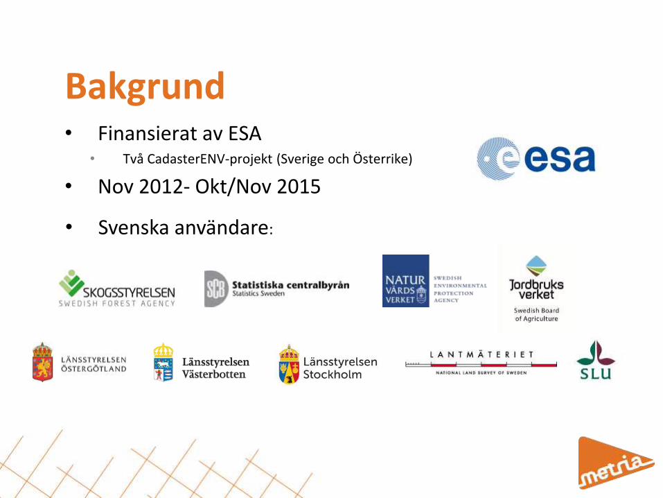
Västerbotten
Legend
CadasterENV
Kartdata


Karterade områden
HR (10m upplösning):
• Stockholms län
• Östergötlands län
• Västerbottens län
VHR (2m upplösning):
• Stockholm
• Linköping
• Norrköping
• Umeå

Olika typer av förändring
Snabba:• Nya hyggen• Exploatering• Nytt vatten (inkl. temporära)
Långsamma:• Igenväxning• Förändrad trädslagsblandning

Verktygslåda
Nya hyggen Ny bebyggelse
Snabb skogstillväxt Ingen skogstillväxt
Nya vattenytor Tidigare vattenytor

Verktygslåda
20062014


a) En nationell marktäckekartering som underlag för grön infrastruktur och statistik på nationell och regional nivå
b) Förändringsinformation som tas fram utifrån användarnas krav, årligen eller med annat intervall beroende på användningsområde
c) Kvalitetssäkrade förändringar som ligger till grund för uppdateringen av marktäckekarteringen var 5:e år, på sikt kan långsamma förändringar t.ex. trädslagsblandning och igenväxning identifieras och ingå i produkten
Integrering

Identifier Description User Prio
URBAN
RB-1 The actual land cover shall be mapped (regardless of
whether it is inside of urban areas or not).
SCB 1
RB-2 The same land cover classes shall be used for vegetated
areas within urban areas as well as outside.
SCB,SBA, CAB, Lantm, SEPA 1
RB-3 Impervious surfaces shall be mapped similarly regardless of
whether they are within or outside urban boundaries.
SCB 1
RB-4 Impervious areas shall be separated in built-up and non-
built up areas
SCB, CAB 1
RB-5 The definition of sparse and dense urban structure from
SMD shall be used
SCB 1
RB-6 Mapping should not be based on existing urban boundaries. SCB 1
RB-7 Extractions and dump areas. SEPA, SCB 2
RB-8 Golf courses 2
RB-9 Morphology (structure) of buildings SCB, CAB 1
RB-10 Height of buildings SCB, CAB 1
RB-11 Update frequency 5 years SCB, SEPA
FOREST
RB-100 Forest classes from KNAS CAB, SEPA 1
RB-101 Forest definitions shall be adapted to FAO SCB, SBA, CAB, Lantm,
SEPA
1
RB-102 Non-productive forests shall be classified according to
forest type
CAB, SEPA 2
RB-103 Refine age groups CAB 1
RB-104 An improved delineation of forest on wetlands CAB, SEPA 1
RB-105 Field layers, especially lichen-rich shall be mapped CAB, SEPA 2
RB-106 Field layers with heath vegetation, herb and grass are also
of interest to map.
CAB 2
RB-107 Burnt forest areas shall be distinguished from clearings CAB 2
RB-108 Storm-felled forest areas to be distinguished from
clearings.
CAB 2
RB-109 Other disturbed forest due to scree and flooding to be
distinguished from clearings
CAB 2
RB-110 Differentiate exotic species within spruce and pine forests CAB 2 RB-111 Specify type of deciduous forest (e.g. aspen and willow)
within the class Mixed forest. Find and classify deciduous
forest within the coniferous forest also when the deciduous
forest doesn’t reach 30% of the crown cover.
CAB 2
RB-112 Find older forests on sand / gravel / ridge (N2000 9060) CAB 2
RB-113 Find nutritious spruce and non-nutritious pine on sand CAB 2
RB-114 Land elevation forests are of interest to map CAB
RB-115 Update frequency 5-10 years SEPA 1
RB-116 The Swedish definition of non-productive forest shall be
followed
SEPA, CAB 1
AGRICULTURAL AREAS
RB-200 Open agricultural areas shall be distinguished from wooded
agricultural lands
SBA, CAB, SEPA 1
RB-201 Definition of wooded pastures shall be based on FAO (>
10%)
SBA, CAB, SEPA 1
RB-202 Coverage of 5-10% shall be mapped as "Other wooded
land" according to FAO
SEPA, 1
RB-203 Identify wooded agricultural land of high conservational
value
CAB, SEPA 1
RB-204 Grasslands outside LPIS shall be separated from other
subgroups of “other open land”.
SBA, CAB, SEPA 2
RB-205 Distinguish permanent leys from temporary leys SBA 2
RB-206 Constructed wetlands SBA 2
RB-207 Map larger landscape elements as attributes SBA, SEPA 2
RB-208 Update frequency of agricultural land should be 3 years SBA 1
RB-209 Store information on nature values as an attribute 2
RB-210 Encroachment of shrubs/trees. The signal from the "Change
Alert" shall be stored as an attribute.
SCB, SBA, CAB, Lantm, SEPA 1
RB-211 Identify non-acceptable geometric accuracy of the LPIS
(Land Parcel Identification System)
SBA 1
RB-212 Use LPIS for better delineation SEPA 2
RB-213 Arable land outside LPIS shall be mapped SBA 1
RB-214 Define wooded pastures and shrublands in accordance to
the Swedish Board of Agriculture’s directive SJVFS 2011-7
SBA 2
WETLANDS
RB-300 Improved delineation for wetlands, both between open
wetland and open non-wetland and between forested
wetland and forested non-wetland.
SCB, CAB, Lantm, SEPA 1
RB-301 Trees/bushes on wetlands shall be mapped SCB, CAB, Lantm, SEPA 1
RB-302 Traditionally managed wetlands SEPA 1
RB-303 Incorporate VMI (when digitized) CAB, SEPA 1
RB-304 Classify according to hydro-topographic units bog, fen,
mixed mire.
CAB 1
RB-305 Classify according to field layer (grass, moss etc) CAB 2
WATER
RB-400 Fresh water shall be distinguished from oceans SCB, CAB, Lantm, SEPA 1
RB-401 Distinguish different types of lakes CAB 2
RB-402 Reed (10 m width) CAB, SEPA 2
RB-403 Lower water vegetation ( water lilies, pondweed etc) CAB 2
OTHER
RB-500 Substrate areas and heathland CAB, SEPA, SBA 2
RB-501 Sand environments CAB 2
RB-502 Power line corridors CAB 2
RB-503 Power line corridors with grass CAB 2
RB-504 Accuracy of each class for different parts of the country CAB 1
RB-505 Compatibility between Cadaster classification system, CLC
and KNAS
SEPA 1
RB-506 Classify according to field layer (grass, herb, heath etc)) CAB 2
LCC
RB-600 Other yearly updated data (e.g. LPIS) can be used for a
yearly update of the LC
CAB, SEPA 1
RB-601 Where and when to update the LC must be decided from
class to class and region to region
1
RB-602 Changes between main class groups SCB, SBA, CAB, Lantm, SEPA 1
LCC
RB-600 Other yearly updated data (e.g. LPIS) can be used for a
yearly update of the LC
CAB, SEPA 1
RB-601 Where and when to update the LC must be decided from
class to class and region to region
1
RB-602 Changes between main class groups SCB, SBA, CAB, Lantm, SEPA 1
RB-603 Changes of bush/tree cover (priority in LPIS areas) SBA 1
RB-604 Plugging of ditches on wetland 2
RB-605 New buildings SCB 1
RB-606 Field layer (e.g. lichen - not lichen) SEPA, CAB 2
RB-607 Mixed Forest/Deciduous forest to increased coniferous part SEPA, CAB 1
RB-608 Mixed Forest to increased deciduous part CAB 1
RB-609 Changes between different coniferous classes (e.g. pine to
mixed coniferous forest)
CAB 2
Användarkrav
0
2
4
6
8
10
12
14
16
18
Forest Openwetlands
Arable land Other openland
Urban Water LCC
Sentinel 2
CENV & auxiliary data
CENV

Nya indata - Sentinel-2Förväntade förbättringar när bilder från Sentinel-2 finns tillgängligt:
• Högre klassningsnoggrannhet;• Lövinslag och lövskogar
• Vatten och vattenvegetation (medelvattenstånd)
• Öppen våtmark
• En mer detaljerad klassning• Naturtyper i öppen mark baserat på fältskikt (t.ex. gräsmark och hed)
• Skogstyper med lövträd (t.ex. ek- och askskog)
• Naturtyper i fjällen
• Identifiera långsamma förändringar • Övergång från jordbruksmark till annan öppen mark
• Övergång mellan olika trädslagsblandningar
• Igenväxning
• En mer kostnadseffektiv kartering • Större scener
• Fler scener (fler molnfria data får önskad registreringstidpunkt)
• …

Tillämpningar• Beslutsunderlag
• Planeringsunderlag
• Landskapsanalyser
• Förfinade karteringar

Swedish Environmental Protection Agency Ola Inghe, Bo Lundin, Sandra Wennberg, Birgitta Olsson
Swedish Board of Agriculture Anders Forsberg
Statistics Sweden Jerker Moström, Stefan Svanberg
Swedish Forest Agency Patrik Olsson
Lantmäteriet Thomas Karlsén
County Administrative Board of Stockholm Ulf Birgersson, Klara Tullback Rosenström
County Administrative Board of Östergötland Jens Johannesson
County Administrative Board of Västerbotten Sören Uppsäll
Swedish University of Agricultural Science Mats Nilsson, Anna Allard

Fortsättning• En nationellt heltäckande
marktäckekartering i HR (10 m raster)• En kartering i högre upplösning som
täcker Sveriges större tätorter (2 m raster)
• En uppdatering av marktäckekarteringen var 5: e år, av markslag och attribut
• En verktygslåda som möjliggör för förändringsanalys mellan och inom olika markslag och attribut
information :
www.cadasterenv.se