Embed Size (px)
Citation preview
NWT Mineral Tenure Map
Viewer
• Presented by: Daniel Gibson • Enterprise GIS Admin, NWT Centre for Geomatics,
Informatics Shared Services, ENR/ITI/Lands, Government of the Northwest Territories

Organization Overview
NWT Centre for Geomatics
Informatics Shared Service Centre
for ENR, ITI, and Lands
The NWT Centre for Geomatics provides quality innovative geomatics services in support of GNWT programmes and policies.
Located in Yellowknife
Consists of 12 employees, supporting 4700 government employees with geospatial services
Esri users since 1996
Project Description
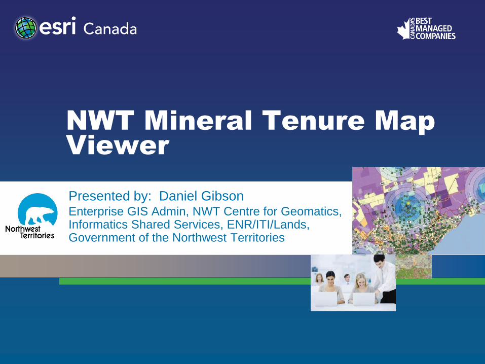
The NWT Mineral Tenure Map Viewer is a replacement of the NT GeoViewer web mapping application that was maintained by Aboriginal Affairs and Northern Development Canada. The transfer of responsibility was a part of the devolution agreement between the Government of the Northwest Territories and Government of Canada on April 1st, 2014.
NT GeoViewer NWT Mineral Tenure Map Viewer
Project Description
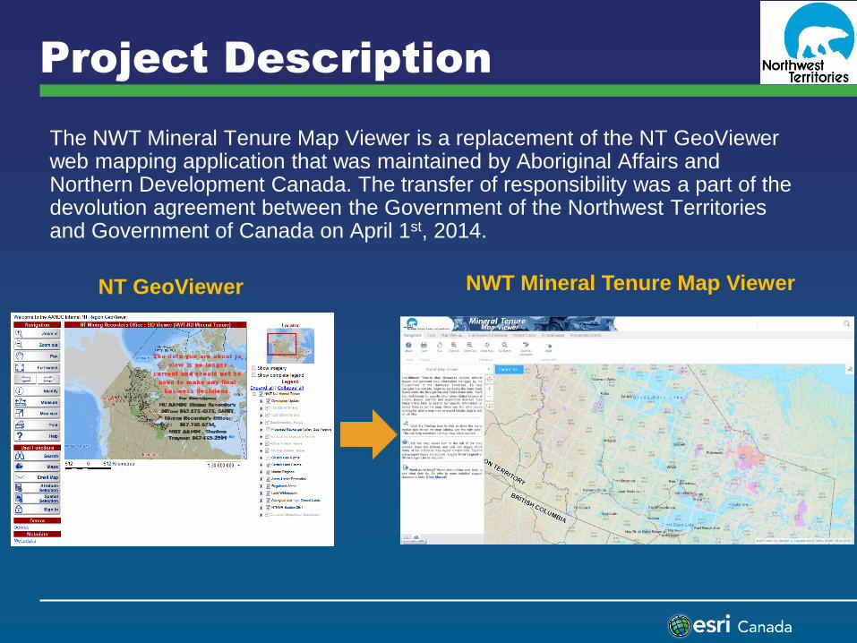
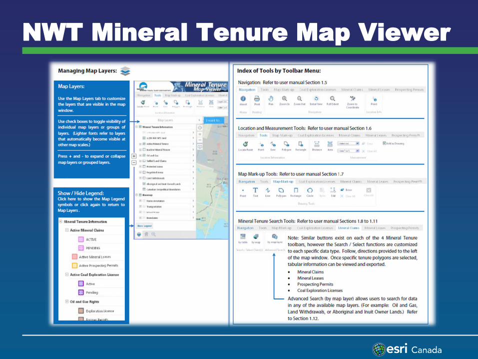
The NWT Mineral Tenure Map Viewer allows user to browse online map information and real-time data maintained by the GNWT Mineral Inventory Tenure System (MITS). The Map Viewer was designed to be used with minimal technical support through intuitive and standard web mapping functions.
NWT Mineral Tenure Map Viewer

Project Description
Planning stage began a year in advance 1. Co-operation was formed between the two governments and staff starting
to plan meetings on various migrating systems
2. Joint technical meetings helped distinguish what components needed migrating
3. Technical staff identified what systems needed to be update and database management issues before we integrated the systems
4. Work plans were formed and organized into GANTT charts
5. Consultants were brought in to help ‘shore up’ time constraints on specific system components (example: Geocortex workflows)
6. Weekly update status reports occurred, measured to the GANTT charts
7. Four weeks in advance of launch; trained internal users and consulted for input on all aspects of the system
8. Development to production migration occurred two weeks in advance on launch to test all systems
Project Description
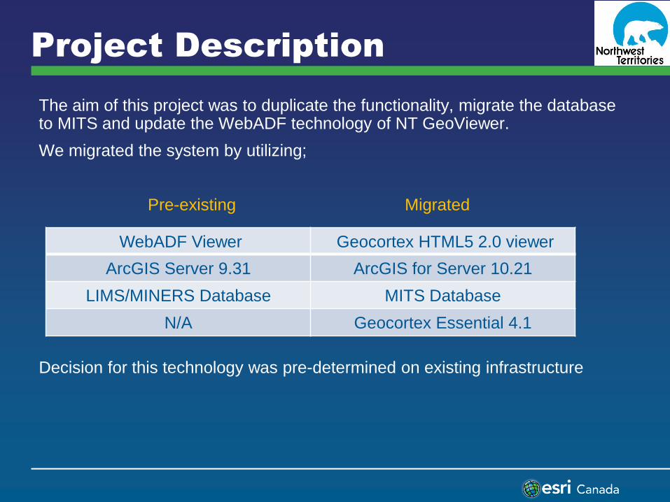
The aim of this project was to duplicate the functionality, migrate the database to MITS and update the WebADF technology of NT GeoViewer.
We migrated the system by utilizing;
Pre-existing Migrated
Decision for this technology was pre-determined on existing infrastructure
WebADF Viewer Geocortex HTML5 2.0 viewer
ArcGIS Server 9.31 ArcGIS for Server 10.21
LIMS/MINERS Database MITS Database
N/A Geocortex Essential 4.1

Project Description
The project consisted of these resources;
Mineral Tenure
Information System
(MITS)
1 project manager
1 business analysis
3 GIS staff
Pacific GeoTech
$800,000
Database management Table structure, schema, naming
conventions
3 GIS staff
N/A
GIS System
Infrastructure ArcServer, Geocortex, SQL Database
1 GIS staff
N/A
Geocortex HTML5
Viewer Workflows, Basemaps, Cartography
3 GIS staff
Caslys Consulting Ltd
$35,000
Components Labour Costs

System Environment

System Environment

NWT Mineral Tenure Map Viewer
NWT Mineral Tenure Map Viewer

Benefits
Objectives Achieved • Provides NWT residents with more transparency on how public land and
resources are used
• Provides easy assess to spatial queries and print map functionality
Recommendations • Esri software makes it possible to run a successful spatial data infrastructure
utilizing different RDBMS (Microsoft SQL Server & Oracle)
• Migrating ArcServer 10.0 to 10.2.1 takes planning and good deal of time
• HTML5 will allow for a long product cycle with increasing future development opportunities
Future Plans
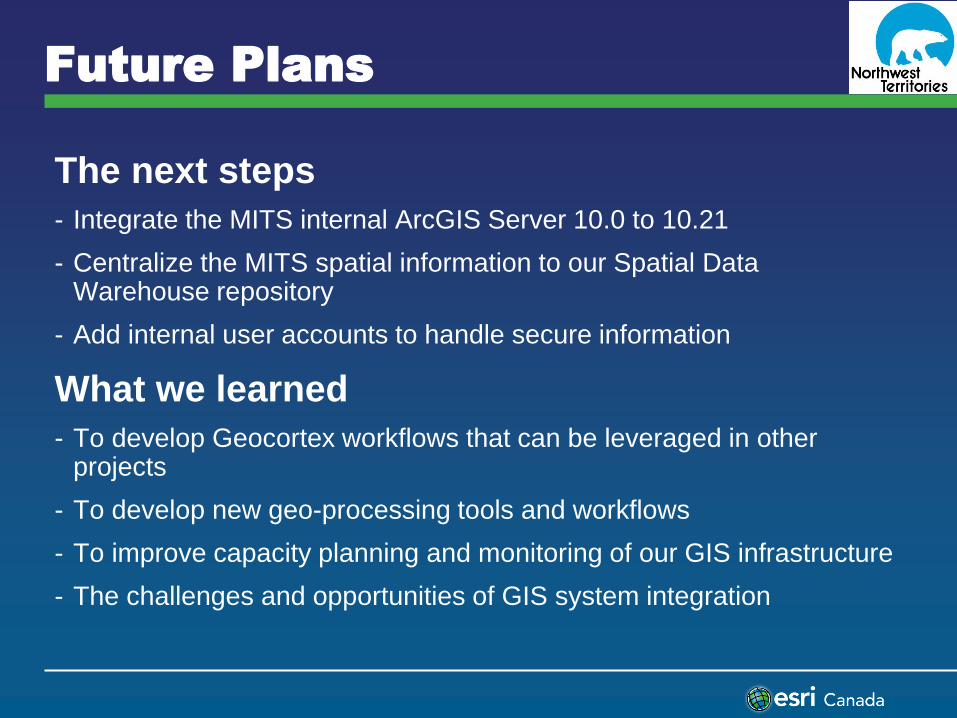
The next steps
- Integrate the MITS internal ArcGIS Server 10.0 to 10.21
- Centralize the MITS spatial information to our Spatial Data Warehouse repository
- Add internal user accounts to handle secure information
What we learned
- To develop Geocortex workflows that can be leveraged in other projects
- To develop new geo-processing tools and workflows
- To improve capacity planning and monitoring of our GIS infrastructure
- The challenges and opportunities of GIS system integration
Q & A
Daniel J. Gibson
Enterprise GIS administrator
NWT Centre for Geomatics
Tel: 867-765-6798
Fax: 867-765-0144
E-mail: [email protected]
Website: http://www.geomatics.gov.nt.ca
Government of the Northwest
Territories
P.0 Box 1320
4923 - 52nd street
Yellowknife, NT
Canada, X1A 2L9