Embed Size (px)
Citation preview

NWS River Forecast Operations Current Status and Future Plans
Kate E. Abshire National Water Center
National Weather Service
NASA Flood Response Workshop
June 13, 2016

NWS Mission and Goals
• NOAA NWS Mission
– “NOAA’s NWS provides weather, water, and climate data, forecasts and warnings for
the protection of life and property and the enhancement of the national economy.”
• Strategic Outcome: Weather Ready Nation
– Ready, Responsive, and Resilient
• NWS Strategic Goals
– Improve Weather Decision Services
– Improve Water Forecasting Services
– Enhanced climate services and adapt to climate-related risks
– Improve sector-relevant information in support of economic productivity
– Enable environmental forecast services supporting healthy communities and
ecosystems
– Sustain a highly skilled workplace equipped with training, tools, and infrastructure to
meet mission 2

Socioeconomic Impacts
On average, over the past 30
years in the U.S., flooding has
claimed near 90 lives and caused
damages in excess of $8 billion
annually
• Floods occur in all 50 of the
United States
• Threat all months of the year
• More fatalities than any other
severe weather related
phenomenon
• More than half of all flood-related
deaths result from motorists
being swept away in their vehicles
3

4
NWS Operational Infrastructure
4 National Water Center
National
Water Center
Weather
Prediction Center
National
Hurricane
Center

5
NCEP Centers • Weather Prediction Center - QPF, PQPF, Excessive
Rainfall Product, Heavy Rain Mesoscale Discussion
• Climate Prediction Center - 6-10 day, 8-14 day, and monthly/seasonal temperature and precipitation anomaly products
National Water Center • National Snow Analysis • National Water Model (Coming Soon)
NWS Operational Infrastructure

6
River Forecast Centers (RFCs)
• Flash flood guidance
• QPF
• Multi-sensor precipitation analyses
• River forecast guidance (deterministic and probabilistic) with extended service/hours during flood events
• Significant River Flood Outlook
• Routine multi-agency collaboration
• Water supply forecasts
• Outreach, training, and general WFO support (SCH & DOH)
• Model calibration, verification, and other development activities
NWS Operational Infrastructure

7
Weather Forecast Offices (WFOs) • 24x7 hydromet watch function
• QPF
• Flash flood watches and warnings
• River forecasts and warnings
• Local outreach and education (SH, hydro focal point, or WCM)
• Flash flood verification (LSRs and Storm Data Reports)
• Real-time precipitation and river gage data analysis and quality control
• Local data network management (equipment and data base management (e.g., (IHFS))
• Event-based decision support services
• Web service delivery QA/QC
WGUS42 KTAE 021419 FLWTAE FLOOD WARNING NATIONAL WEATHER SERVICE TALLAHASSEE FL 919 AM EST TUE DEC 02 2008 OCHLOCKONEE RIVER NEAR CONCORD AFFECTING GADSDEN AND LEON COUNTIES ...MODERATE FLOODING IS OCCURRING...FORECAST TO FALL BELOW FLOOD STAGE... SAFETY MESSAGE...ALL PERSONS WITH INTEREST ALONG THE RIVER SHOULD MONITOR THE LATEST FORECASTS...AND BE PREPARED TO TAKE NECESSARY PRECAUTIONS TO PROTECT LIFE AND PROPERTY. DO NOT DRIVE CARS THROUGH FLOODED AREAS. IF YOU SEE FLOOD WATERS...REMEMBER TO TURN AROUND AND DO NOT DROWN. FLC039-073-031419- /O.CON.KTAE.FL.W.0049.000000T0000Z-000000T0000Z/ /CONF1.2.ER.081201T0846Z.081202T1401Z.000000T0000Z.UU/ 919 AM EST TUE DEC 02 2008 ... OBSERVED FLOODING INCREASED FROM MINOR TO MODERATE SEVERITY... THE FLOOD WARNING CONTINUES FOR THE OCHLOCKONEE RIVER NEAR CONCORD. * UNTIL FURTHER NOTICE...OR UNTIL THE WARNING IS CANCELLED. * AT 9:01 AM TUESDAY THE STAGE WAS 32.2 FEET. * FLOOD STAGE IS 30.0 FEET. $$
NWS Operational Infrastructure

http://weather.gov/
“click on” RIVERS, LAKES & RAINFALL
for current river conditions
http://water.weather.gov/ahps
Accessing AHPS Information
8

“click on” the forecast location to access the local hydrograph
Accessing AHPS Information
9
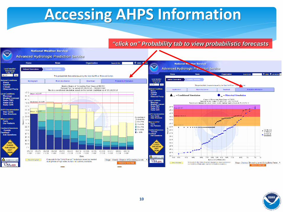
“click on” Probability tab to view probabilistic forecasts
Accessing AHPS Information
10

• Provide spatial extent and depth of flood waters
• Display inundation maps for levels from minor flooding through flood of record
• Better mitigate impacts of flooding and build more resilient communities
• Libraries include NWS flood severity categories and regulatory FEMA flood frequency maps
Implementation Status:
137 Flood Inundation Map Libraries
Continued Partnership with FEMA, USACE, USGS, States, & Others
“click on” Inundation Mapping tab to view flood inundation maps
Accessing AHPS Information
11

Enhancing Current Forecasting System Hydrologic Ensemble Forecast System (HEFS)
Probabilistic information to support risk-based decisions
• Incorporates both atmospheric and hydrologic uncertainties
• 123 locations have experimental product for short-range river forecasts
• Testing and evaluation ongoing; collecting feedback via web
• New river service locations will expand throughout 2016
12

13
• Weather-Ready Nation (WRN)
• Ambassadors Program
• Turn Around Don’t Drown
• Partner and community engagement
• Seasonal Safety Campaigns
• Partner engagement - coordinated flood messaging
• High Water Mark Initiative
• Federal Working Group
New Services: Outreach

14
Impetus for Change Growing Water Challenges
Multiple Threats
•Population growth and economic development are stressing water supplies and increasing vulnerability
•A changing climate is impacting water availability and quality, increasing uncertainty
•An aging water infrastructure is forcing critical, expensive decisions
•Socio-economic risks of floods and droughts are escalating

15
Stakeholder Priorities Case for Change
Flooding Water
Quality Water
Availability Drought
Climate Change
Need integrated understanding of near- and long-term outlook and risks
Transform information into intelligence by linking hydrologic, infrastructural, economic, demographic, environmental, and political data
Actionable Water Intelligence High Resolution, Integrated Water Analyses, Predictions and Data

National Water Center Initial Operating Capacity: May 26, 2015
16
A Catalyst to Transform NOAA’s Water Prediction Program
Mission: Nationally Integrated Water
Prediction
• Earth system modeling and geo-intelligence for water prediction
• Operations Center for water resources common operating picture
• Decision support services for spectrum of water stakeholders
• Proving ground to accelerate research to operations
• Interagency and Academia Collaboration

Transforming NOAA Water Prediction
17
TODAY THE FUTURE
Approximately 4000 forecast locations at points
Approximately 2,700,000 forecast stream reaches
Forecast river flow/stage, from summit to coastal zone
Forecast all hydrologic parameters which define the water budget, from summit-to-sea
Driven by large catchment “lumped” modeling
Driven by high/hyper resolution Earth System modeling
Forecaster “in the loop” – serial, basin to basin, modeling of flow through the river network
Forecaster “over the loop” – parallel, simultaneous modeling the nation’s entire river network
Average basin size greater than 420 square miles
Average basin size ~1 square mile
13 RFCs developing separate versions of the same regional model
13 RFCs, NWC, academia, and federal partners developing/evolving same state-of-the-science national model
RFC-generated river forecasts coordinated with WFOs to deliver Impact-based forecasts at selected points
NWM-based predictions coordinated among NWC, RFCs, and WFOs and linked with detailed local infrastructure data to communicate street level impacts

Movie (slide show to view)
18
https://www.youtube.com/watch?v=lbA2KoYSEsg

• WCOSS Implementation and experimental product availability in FY16 Q4
• NWC/NCAR/NCEP partnership
• Implementation accelerated by 2 years
• Foundation for sustained growth in operational hydrologic forecasting capability
• Goals for NWM V1.0
• Provide forecast streamflow guidance for underserved locations
• Produce spatially continuous national estimates of hydrologic states (soil moisture, snow pack, etc.)
• Implement a modeling architecture that permits rapid infusion of new data and science, and allows for geointelligence linkages
• Complimentary Water Resources Data Services and Evaluation Services are required
National Water Model Version 1.0
19

20
• Hydrologic Output
• River channel discharge and velocity at 2.7 million river reaches
• Reservoir inflow, outflow, elevation
• Surface water depth and subsurface flow (250 m CONUS+ grid)
• Land Surface Output
• 1km CONUS+ grid
• Soil and snow pack states
• Energy and water fluxes
• Direct-output and derived products (e.g. stream flow anomalies)
• Three pronged dissemination strategy
• NOMADS
• Web
• Direct to field
NWM V1.0 Experimental Output
Current NWS AHPS points (red) NWM output points (blue)
20
Current NWS River Forecast Points (circles) Overlaid with NWM Stream Reaches
20

21
Summary • NOAA’s Water Services are Evolving
• We are building a foundation for change – but have a long way to go
• Deliver comprehensive, integrated actionable water intelligence
• Compliment current services with new information spanning Summit-to-Sea, Floods to Droughts, Treetops to Bedrock
• Implementing State-of-the-Art Technical Approach
• Water prediction through state-of-the-science earth system modeling
• Impact-based decision support services underpinned by geo-intelligence
• Scale Change: Orders of Magnitude More Data
• Reach-based “Street Level” prediction
• High Performance Computing
• New Organization, Cornerstone Facility and Philosophy
• National Water Center
• Collaborative, cross-NOAA, interagency, academic partnerships

Questions?
22