Embed Size (px)
Citation preview

For permission to copy, contact [email protected] 2003 Geological Society of America624
GSA Bulletin; May 2003; v. 115; no. 5; p. 624–638; 10 figures; 1 table; Data Repository item 2003067.
Number and size of last-glacial Missoula floods in the Columbia Rivervalley between the Pasco Basin, Washington, and Portland, Oregon
Gerardo Benito†
Consejo Superior de Investigaciones Cientıficas, Centro de Ciencias Medioambientales, Serrano 115 bis, 28006 Madrid, Spain
Jim E. O’Connor‡
U.S. Geological Survey, 10615 SE Cherry Blossom Drive, Portland, Oregon 97216, USA
ABSTRACT
Field evidence and radiocarbon age dat-ing, combined with hydraulic flow model-ing, provide new information on the mag-nitude, frequency, and chronology of latePleistocene Missoula floods in the ColumbiaRiver valley between the Pasco Basin,Washington, and Portland, Oregon. Morethan 25 floods had discharges of .1.0 3 106
m3/s. At least 15 floods had discharges of.3.0 3 106 m3/s. At least six or seven hadpeak discharges of .6.5 3 106 m3/s, and atleast one flood had a peak discharge of ;103 106 m3/s, a value consistent with earlierresults from near Wallula Gap, but betterdefined because of the strong hydrauliccontrols imposed by critical flow at con-strictions near Crown and Mitchell Pointsin the Columbia River Gorge.
Stratigraphy and geomorphic position,combined with 25 radiocarbon ages and thewidespread occurrence of the ca. 13 ka (ra-diocarbon years) Mount St. Helens set-Stephra, show that most if not all the Mis-soula flood deposits exposed in the studyarea were emplaced after 19 ka (radiocar-bon years), and many were emplaced after15 ka. More than 13 floods perhaps post-date ca. 13 ka, including at least two withdischarges of .6 3 106 m3/s.
From discharge and stratigraphic rela-tionships upstream, we hypothesize that thelargest flood in the study reach resultedfrom a Missoula flood that predated block-age of the Columbia River valley by theCordilleran ice sheet. Multiple later floods,probably including the majority of floodsrecorded by fine- and coarse-grained de-posits in the study area, resulted from mul-
†E-mail: [email protected].‡E-mail: [email protected].
tiple releases of glacial Lake Missoula thatspilled into a blocked and inundated Co-lumbia River valley upstream of the Oka-nogan lobe and were shunted south acrossthe Channeled Scabland.
Keywords: Quaternary, Columbia Basin,Missoula floods, fluvial features, radiocar-bon dating.
INTRODUCTION
Floods from cataclysmic releases of gla-cially dammed Lake Missoula produced spec-tacular flood features along many flow pathsin the Channeled Scabland of eastern Wash-ington. All these paths converged in the PascoBasin, below which water funneled throughWallula Gap and followed the Columbia Val-ley to the Pacific Ocean (Fig. 1A). Here wereport on flow modeling, flood features, stra-tigraphy, and radiocarbon dating betweenWallula Gap and Portland, with major empha-sis on the reach between Arlington and HoodRiver, Oregon (Fig. 1B). We speculate on therelationship between results from our studyarea and observations by others and by usfrom upstream sites.
Our studies address issues raised regardingthe number, magnitude, geomorphic effective-ness, and chronology of late Pleistocene flood-ing (Waitt, 1985, 1994; Baker et al., 1991;Baker and Bunker, 1985; O’Connor and Bak-er, 1992; Smith, 1993; Shaw et al., 1999,2000; Atwater et al., 2000). Specifically, weaddress the correlation of evidence for .40late-glacial Missoula floods inferred fromrhythmic beds of silty and sandy flood depos-its found chiefly at low altitudes in back-flooded valleys along the entire flood route(Waitt, 1980, 1985; Atwater, 1986, 1987;Smith, 1993) to the evidence of very large
Missoula floods indicated by the high andcoarse gravel bars that J Harlan Bretz dem-onstrated were the work of great cataclysms(e.g., Bretz, 1928, 1969; Bretz et al., 1956).
We document stratigraphic evidence of atleast 25 last-glacial floods, not only in slack-water facies but also in coarse, high-energydeposits. Results of step-backwater flow mod-eling in conjunction with altitudes of floodfeatures show that many of these floods wererelatively small, with discharges between 1 3106 m3/s and 6 3 106 m3/s. Few floods haddischarges approaching the maximum flow of10 3 106 m3/s. By using radiocarbon andtephra dating, we show that it is probable thatall of these floods passed through the studyarea after 19,000 14C yr B.P.
The Columbia Valley between the PascoBasin and Portland
Between the Pasco Basin and Portland, theColumbia River flows west through a series ofbasins and constrictions as it exits the Colum-bia Plateau province and crosses through theCascade Range. In constrictions, the valley isbounded by tall, sheer, and stepped cliffsformed primarily of upwarped basalt flows ofthe Miocene Columbia River Basalt Group(Beeson et al., 1989; Reidel et al., 1989). Therolling uplands flanking constrictions and thebottoms of the intervening synclinal basins aregenerally formed on post-Miocene fluvial andvolcanic deposits and capped by Quaternaryloess and soils. Between The Dalles and Port-land, the Columbia River flows within the nar-row and incised Columbia River Gorge as ittransects the core of the Cascade Range beforeentering the Portland basin.
The physiography of the Columbia Valleybetween the Pasco Basin and Portland resultedin a single flow route mostly confined by an

Geological Society of America Bulletin, May 2003 625
LAST-GLACIAL MISSOULA FLOODS IN THE COLUMBIA RIVER VALLEY
Figure 1. (A) Regional setting of Missoula floods. (B) Major flood features in the study area, including locations of evidence for maximum-flood stages and stratigraphic sites (detailed locations and site data provided in Table DR2 [see footnote 1 in the text]).
existing and unblocked large river valley. Bycontrast, in the Channeled Scabland of easternWashington, late-glacial flood routes and dis-charges were governed by the extent of theOkanogan ice lobe of the Cordilleran ice sheet,by the stage of glacial Lake Columbia (Atwater,1986, 1987), and perhaps by the erosion of ma-jor channel complexes like Grand Coulee andthe Cheney-Palouse scabland tract, thus com-plicating hydraulic calculations. Nevertheless,the gradient and geometry of the ColumbiaRiver valley within the study reach, with itsconstrictions and basins, produced diverse flowconditions, resulting in a variety of well-preserved erosional and depositional features(O’Connor and Waitt, 1995; Benito, 1997).
METHODS
Assessment of the number and chronologyof floods was based on stratigraphic studies offlood deposits and erosional features betweenArlington and Hood River, Oregon (Fig. 1B).
Most exposures of coarse deposits (sand andgravel) are at abandoned sand-and-gravel quar-ries, whereas finer facies were generally bestexposed at road and stream cuts. At many ex-posures, we described and sketched the stratig-raphy, paying particular attention to boundariesof beds of contrasting grain size (Fig. 2). Atmost exposures, we also searched for datablematerial such as organic detritus and tephras.
Missoula flood discharges were estimatedby relating altitudes of flood features to water-surface profiles calculated for the reach be-tween Arlington and Portland. Evidence ofmaximum-flood stages was compiled from re-ports of previous workers, notably Piper(1932), Allison (1933, 1935, 1978), Newcomb(1969), and Allen et al. (1986). To this wehave added our own estimates of maximum-flood stages from field evidence and interpre-tation of aerial photographs. The discharge ofthe largest flood(s) was further defined by ev-idence of altitudes that were not flooded—sites where divides were apparently not
crossed or loess-covered uplands without ev-idence of fluvial sculpting, following the ap-proach of Baker (1973, p. 13–14), O’Connorand Baker (1992), and O’Connor (1993). Inaddition, we recorded altitudes of deposits in-ferred to record multiple floods. Altitudeswere determined by plotting flood features oncurrent 1:24,000 topographic maps, with un-certainties of about one contour interval (gen-erally 12 m), or by hand leveling from knownaltitudes such as benchmarks or spot altitudesshown on topographic quadrangles. Tabulatedlocations, elevations, and descriptions of max-imum stage evidence and stratigraphic sitesare listed in Tables DR1 and DR2.1
1GSA Data Repository item 2003067, Table DR1:Evidence of maximum Missoula flood stages be-tween Arlington and Portland, Oregon; Table DR2:Sites of stratigraphic observations for Missoula flooddeposits in the Columbia Valley between Arlingtonand Hood River, Oregon, is available on the Web athttp://www.geosociety.org/pubs/ft2003.htm. Requestsmay also be sent to [email protected].

626 Geological Society of America Bulletin, May 2003
BENITO and O’CONNOR
Figure 2. Measured sections of stratigraphic sites. Site labels refer to locations in Figure 1B. Alti-tudes of tops of described sections were determined from 1:24,000-scale topographic maps and arein meters above sea level (m a.s.l.). Altitudes are rounded to the nearest 5 m and have uncertaintiesof ;10 m. Sections were measured perpendicular to bedding, which had dips as great as 308.

Geological Society of America Bulletin, May 2003 627
LAST-GLACIAL MISSOULA FLOODS IN THE COLUMBIA RIVER VALLEY
Like the studies of O’Connor and Baker(1992) and O’Connor (1993), we have usedthe U.S. Army Corps of Engineers’ HEC-2Water Surface Profiles computer program(Feldman, 1981; Hydrologic EngineeringCenter, 1985) to calculate water-surface pro-files to use as a basis for flood discharge es-timates (O’Connor and Webb, 1988). Water-surface profiles were calculated for a series of121 cross-valley cross sections for the 196 kmreach between Arlington and Portland. Crosssections were measured from topography andbathymetry shown on 1:24,000 scale USGSquadrangles and were spaced and oriented tocharacterize the effective flow geometry (e.g.,O’Connor, 1993, p. 12–15). For each modelrun, discharge and flow stage were specifiedat the downstream cross section, and flow wascomputed stepwise upstream, resulting in anenergy-balanced water-surface profile(O’Connor and Webb, 1988). Downstreamflow stage for each trial was either assumedto be 120 m on the basis of highest Missoulaflood features in the Portland area or calculat-ed on the basis of the Manning equation byusing a slope value of 1 3 10–5 (reflectingponding in the Portland basin). Assignment ofenergy-loss coefficients, such as Manning n(flow resistance imparted by boundary rough-ness), was based on best estimates developedfrom experience with modeling other largeflood discharges (e.g., O’Connor and Baker,1992; O’Connor, 1993). For flow over themodern channel and flood plain of the Colum-bia River, n was assigned a value of 0.03; forflow over valley sides and flanking upland, nwas 0.05. Sensitivity of the resulting dischargeestimates to Manning n was assessed by trialswith a range of n values. Expansion and con-traction energy-loss parameters were assignedvalues of 0.3 and 0.1, respectively. Althoughno specific trials of sensitivity to these valueswere conducted for this study, results fromprevious studies (e.g., O’Connor and Webb,1988) indicate that reasonable ranges of thesevalues have little effect, especially in reachessuch as this one where there are sections ofcritical flow.
RESULTS AND DISCUSSION
Flood Features and Stratigraphy
Missoula flood features between WallulaGap and Portland include tracts of eroded ba-salt (scabland), diversion and overflow chan-nels cut through overlying loess and alluvium,large gravel bars, and in almost every back-flooded tributary valley, as much as 10 m ofbedded sand and silt.
Types of DepositsGravel bars left by the Missoula floods are
found in locations that would logically bezones of diminished velocity (Bretz, 1928).Tractive bar deposits are composed of sedi-ment we infer was transported as bedload andare generally the coarsest and most poorlysorted. Clasts in tractive bars were mostly de-posited in downstream-directed foresets, areangular to rounded, and almost everywhere at-tributable to local sources. Abundant soil andloess clasts, some with diameters .1 m, alsoattest to short transport distances.
Tractive deposits common along the Co-lumbia River valley between Wallula Gap andPortland include large delta-like bars formedby flow spilling from high upland channelsinto back-flooded tributary valleys (Figs. 3,4; Bretz, 1925, p. 244; 1928, p. 693; Alli-son, 1933, p. 196). These bars, commonlyfan shaped in plan view, are composed ofdownstream-dipping foresets overlain bysubhorizontal beds. Where the original mor-phology is preserved, the downstream ends ofthe bars terminate with smooth 308 slopesconcordant with foreset bedding (Fig. 3C).Many of these bar surfaces have current duneson their surfaces (Fig. 3A).
At many of the tributary junctions with theColumbia River between Wallula Gap andPortland, large, round-topped, gravel deposits(Bretz, 1925, 1928) partially block tributarymouths. These ‘‘eddy bars’’ are composed ofclasts ranging from sand to small cobblescommonly deposited in foresets dipping uptributary valleys. Eddy-bar sediments are gen-erally finer and better sorted than tractive-barsediments and are interpreted to have been de-posited from the flood’s suspended load inzones of flow recirculation that developed inthe canyon reentrants at tributary junctions(O’Connor, 1993, p. 58–62).
Sand and silt mantle parts of almost everyback-flooded valley along the flood route be-tween glacial Lake Missoula and Portland(e.g., Bretz, 1929; Allison, 1933, 1941; Glenn,1965; Waitt, 1980, 1985, 1994; Atwater, 1986,1987; Smith, 1993). Between Wallula Gap andPortland, back-flooded valley deposits nearthe Columbia River are generally composedof coarse sand, locally containing gravel, andat some locations are traceable to eddy bars attributary mouths. Fine sand and silt predom-inate at higher and more distal sites. In theJohn Day and Deschutes River valleys, suchdeposits are found as far as 100 km upstreamfrom the Columbia River confluence. Thesand and silt deposits are thickest and mostextensive on the valley bottoms, generally atlow altitudes, but are also found as a thin blan-
ket (,1 m thick) on upland surfaces up toabout maximum-flood stage, although at high-er altitudes it is difficult to distinguish Mis-soula flood silt from late Pleistocene loess.
A distinctive feature of the sand and silt de-posits, especially in the valley bottoms, istheir rhythmic bedding manifested by se-quences of graded beds or couplets of con-trasting grain sizes. Thicknesses of individualrhythmite beds range from .20 cm to .2 m,and beds generally thin and fine up-section(Fig. 2). Where studied elsewhere, evidence ofsubaerial exposure or hiatuses between indi-vidual beds within these generally low-lyingrhythmites—such as varves, burrows, mud-cracks, and fallout tephra (Glenn, 1965; Waitt,1980, 1984, 1985, 1987, 1994; Atwater, 1986;Smith, 1993)—led to the hypothesis that therewere as many as 89 releases from glacial LakeMissoula. This evidence, however, has beencontested by Shaw et al. (1999), followed byrebuttal by Atwater et al. (2000).
Evidence for Multiple Floods in CoarseDeposits
Many of the tractive and eddy bars betweenWallula Gap and Portland contain prominentstratigraphic discontinuities that we interpretto mark boundaries between deposits of sep-arate floods. But evidence of multiple floodsin deposits of coarse sand and gravel is gen-erally less compelling and probably less com-plete than in finer-grained rhythmite sections,where successive rhythmites are conformableand where upper parts of many rhythmitescontain burrows, channels, loess, and tephralayers. By contrast, stratigraphic discontinu-ities within coarser facies are generally sweep-ing unconformities juxtaposing gravel againstgravel, locally with intervening sand and siltlayers or coarse boulder layers (Fig. 4). Suchdiscontinuities may be ascribed to pulses with-in a single flood. Their close inspection, how-ever, reveals features similar to those at con-tacts between rhythmites, including featureswe interpret as illuviated silt, colluvium, bur-rows, and fallout tephra.
Estimating the number of separate floodsrecorded in gravel-bar exposures is difficultbecause not all contacts show compelling ev-idence of subaerial exposure, and one mustjudge whether gravel beds bounded by prom-inent contacts or beds of finer sediment indeedrecord separate floods. Additionally, for sev-eral tall exposures we could not closely in-spect each contact and could only estimate thenumber of separate floods represented bycounting beds separated by prominent uncon-formities. Our experience with bringing manygeologists to some of these study sites is that

628 Geological Society of America Bulletin, May 2003
BENITO and O’CONNOR
Figure 3. The Fairbanks delta bar, formed by Missoula floodwaters spilling southward out of the Columbia River valley and into thevalley of Fifteenmile Creek. (A) Vertical overview from USGS digital orthophotograph (1994). (B) View southwestward across theColumbia River to Fairbanks divide. The divide is 200 m above the present impounded water level of the Columbia River and 220 mabove typical pre-dam river level. For overtopping, discharge had to exceed 5 3 106 m3/s. (C) Northwestward view of the delta bar andsite F.
flood counts might vary by a factor of two,depending on one’s definition of ‘‘prominentunconformity.’’ For this analysis, the numberof floods ascribed to each deposit is based oncounting deposits between disconformitiesmarked by widespread boulder concentrations(commonly associated with erosion of the un-derlying bed), deposits from local sources, orother evidence of subaerial exposure. Many ofthe bars probably record more floods than weinfer from them, a problem compounded bylimited exposure at most bars.
Evidence for multiple flows is found in alltypes of bars along the Columbia River valleybetween Arlington and Hood River, but thedelta bars deposited into tributary valleys areparticularly suitable: not only are they typi-cally well exposed, but they only record floodslarge enough to cross the upland divides be-
tween the deposit and the Columbia River val-ley. Thus, the altitude of the divide crossingcan be related to hydraulic-modeling results todetermine the discharge that floods must haveexceeded to form the deposits. For example,the bar at Petersburg (site E in Fig. 1) wasdeposited by flows spilling south out of theColumbia River valley and into FifteenmileCreek valley via a 2-km-long, 1.5-km-wide di-vide crossing eroded down through loess andPliocene deposits. The altitude of the bottomof the divide is 180 m above sea level (;155m above the preimpoundment altitude of theColumbia River). The core of the bar is com-posed of boulder-to-pebble gravel and sanddeposited in foreset beds, apparently as thedelta bar prograded into Fifteenmile Creekvalley (Fig. 4A). Many of the contacts be-tween thick gravel beds are unconformable
and are locally associated with sand lenses,coarse boulder lags, or both (Fig. 4B). Expo-sures 0.5 km to the northeast at the east edgeof the bar also show several sand and gravelcouplets that are finer, thinner, and more gent-ly dipping than the deposits in the core of thebar (Fig. 4C). The exposure of the core of thebar shows nine prominent beds, which we in-fer resulted from that many separate floodslarge enough to vigorously overtop the 180 mdivide crossing.
Not all such bars show similar evidence ofmultiple flood deposits. Five kilometers to theeast, flow from the Columbia River valleyspilled into Fifteenmile Creek valley via an-other divide crossing at Fairbanks Gap (site F,Fig. 3), which, at an altitude of 250 m, is 70m higher than the divide at Petersburg. A 30-m-high road cut that is perpendicular to the

Geological Society of America Bulletin, May 2003 629
LAST-GLACIAL MISSOULA FLOODS IN THE COLUMBIA RIVER VALLEY
Figure 4. Stratigraphy at the Petersburg delta bar (site Eof Figs. 1B and 2). (A) Overview of exposure in the core ofthe bar showing six sand and gravel deposits separated byprominent contacts (partly indicated by dashed lines). Weinfer that each of these deposits formed from separatefloods. (B) Close view of beds 5 and 6. Person pointing tolocation of radiocarbon sample MF-1 (Fig. 2, Table 1). (C)Exposure 0.5 km east of (B), at the bar margin (PetersburgII of Fig. 2 and Table 1), showing seven dipping flood bedsof sand and cobbly gravel. The soil clast providing the14,480 14C yr age on extracted humates was deposited with-in bed 3 (MF-37, Table 1; Fig. 2). Shovel (in box) is 50 cmlong.
Figure 5. Northward view of an exposure of the tractive bar near Maryhill (site H) showingdownstream-dipping foresets of cobbly and sandy gravel. The top of the bar has beenremoved from this part of the exposure. The disconformity locally truncates underlyingdeposits and is locally marked by accumulation of interstitial silt in the underlying gravel.
delta front partly exposes bouldery gravelwithout the sweeping unconformities seen inthe bar near Petersburg (Figs. 2, 4C). Possibleexplanations for the lack of unconformities in-clude (1) the contacts are not visible becauseseparate boulder deposits are juxtaposed with-out detectable contrast in grain size or evi-dence of subaerial exposure, (2) the depositsof the last overtopping flood conceal depositsof earlier floods, or (3) only one flood waslarge enough to vigorously overtop this higherdivide.
Similar delta bars resulted from overflowinto Alkali Canyon near Arlington (site L), theJohn Day River valley near Philippi Canyonand near McDonald Ford (sites J and K), andinto the Mosier Creek valley near Mosier (siteB). Best exposed is site B, where from oneoutcrop we infer at least seven floods (Fig. 2).
Exposures within two high tractive bars onuplands flanking the Columbia River valleyalso show strong evidence for being formedby multiple floods. Near Maryhill is a bar (siteH), 1 km long, with a crest at an altitude of255 m. A gravel pit shows three-dimensionalexposure of west-dipping foreset beds of al-
ternating sand and gravel containing clasts aslarge as 30–40 cm (Fig. 5). Most of theseforeset beds are conformable and probably re-cord the passage and deposition of dunes onslip faces as the bar grew westward duringindividual floods. By contrast, however, at
least five contacts between foreset layers dis-conformably overlie a coarser cobble frame-work filled with a brown silty matrix. We inferthe coarser tops of each of these foreset bedsto have resulted from armoring during later,sediment-depleted periods of individual

630 Geological Society of America Bulletin, May 2003
BENITO and O’CONNOR
Figure 6. Stratigraphy of the eddy bar near the confluence of the Deschutes and Columbia Rivers (site G). (A) Eastward view of fourdepositional beds (couplets of sand and gravel) and parts of two others. Each bed is separated by planar disconformities and is composedof cobbly and sandy gravel and a thin silty cap. Foresets within the gravel parts of the couplets dip southward, away from the ColumbiaRiver and up the Deschutes River valley. Many of the couplets contain a basal layer of medium sand, up to 30 cm thick, deposited withnorthward-dipping foresets. We infer that each sand and gravel couplet was deposited during a single flood. (B) Close view of contactbetween couplets showing 1 cm of sand at the base of one couplet overlying coarser sand and gravel of the underlying couplet. In theuppermost 3 cm of the sandy gravel, clasts are more randomly oriented than below, and their interstices are filled with silt and finesand. From these features we infer surface disturbance and eolian infilling during subaerial exposure. Pencil is 15 cm long.
floods. The brown silt contained in the upperfew centimeters of each bed is inferred to beof eolian origin that illuviated into intersticeswhile the gravel bar was exposed subaerially.Where this silt is present, tracing the contactlaterally leads to disconformities where cob-bly lags cut across bedding of the underlyingdeposits, apparently recording erosion beforeor during deposition of the overlying gravelforeset beds (Fig. 5). The incompletely ex-posed Maryhill bar shows six sets of foresetbeds separated by silty, unconformable con-tacts, implying that at least that many floodstransported gravel across the surface of thebar.
A similar bar near Arlington (site M) wastrenched in the early 1980s, revealing thewhole stratigraphy from underlying Tertiarysediment to capping soil (Baker and Bunker,1985; R.C. Bunker, 1994, personal commun.).The bar ranges from 245 to 255 m above sealevel and comprises five or six sets of foresetbeds that dip north and away from the adja-cent overflow channel. The foreset beds over-lie subhorizontal, cross-bedded gravel, whichunconformably overlies Tertiary sediment.
Groups of foresets are separated by contactslike those at Maryhill bar, including one con-tact where the Mount St. Helens set-S tephrais locally preserved, indicating subaerial ex-posure between two separate floods (Bakerand Bunker, 1985). If the other similar con-tacts in this deposit also represent periods ofsubaerial exposure, this bar also records six orseven flows, including two or three that post-date the set-S tephra.
Large eddy bars lie in almost every tribu-tary mouth and canyon reentrant along theColumbia River valley (Bretz, 1925, 1928).Exposures of these also reveal evidence formultiple flows. One of the highest (185 mabove sea level) is ;2 km northwest of Lyle(site D), where east-dipping foreset beds ofwell-sorted gravel and coarse sand were ap-parently deposited in a large eddy on the northside of the Columbia Valley. Seven prominentstratigraphic breaks are exposed (Fig. 2), eachdefined by 0–20 cm layers of sand and gravelwith silt-filled interstices disconformablyoverlain by as much as 25 cm of steeply dip-ping (#358) sandy gravel. We infer that thesilt illuviated into the upper few centimeters
of the sand and gravel during times betweenfloods, and we view the steeply dipping sandygravel lenses as talus from raveling, betweenfloods, of flood-deposited gravel on a slopingflank of the bar. If each of the stratigraphicbreaks records a hiatus between floods, theoutcrop records eight separate floods. This de-posit is apparently inset against an even higher(surface is 220 m above sea level) and coarserdeposit tucked into a small tributary valley tothe north (site C), but only ;1 m of its stra-tigraphy is exposed.
Another large and high eddy bar formed atthe mouth of the Deschutes River (Bretz,1928, p. 458; site G) and has a maximum al-titude of 150 m above sea level. A gravel pitnear its top reveals at least seven subhorizon-tal couplets, each consisting of cross-beddedmedium sand, as much as 30 cm thick, un-conformably overlain by up to 120 cm offoreset-bedded sandy gravel (Fig. 6A). Cou-plet thickness decreases up-section from 120cm to ;30 cm. The top ;3 cm of the sandygravel of each couplet has silt-filled intersticesbetween granules that lack sedimentary struc-ture (Fig. 6B). We infer the silt to be wind-

Geological Society of America Bulletin, May 2003 631
LAST-GLACIAL MISSOULA FLOODS IN THE COLUMBIA RIVER VALLEY
blown dust illuviated into the top of each de-posit during subaerial exposure. The sevensand and gravel couplets thus indicate that atleast seven separate floods formed this eddybar. The couplets of sand overlain by sandygravel probably result from changes in localeddy circulation during separate floods—thelower sand deposited during waxing flowwhile the site was inundated, but was awayfrom currents within the back-flooded tribu-tary mouth, whereas the gravel was depositedlater during the same flood, but near the timeof peak stage when flow recirculation over thesite was more vigorous.
Quarries in an eddy bar tucked against thevalley margin of Helm Canyon (Fig. 2, site I)expose four deposits of bedded sand and grav-el up to an altitude of 215 m above sea level.Each of the sand and gravel beds is separatedby discontinuous diamicts of angular basaltclasts within a silty matrix. We infer the lensesof angular basalt to be colluvium that accu-mulated on top of flood deposits during timesbetween floods, thus implying at least fourseparate floods recorded by the beds of sandand gravel.
RhythmitesWe have not mapped and analyzed all
rhythmite deposits in the study area becausethey are generally at altitudes so low that theydo not necessarily indicate discharges as greatas those required by higher, coarse-grained de-posits. Nevertheless, some fine-grained depos-its are exposed at high altitude (Fig. 2, sitesN, O, P, and Q), and their geomorphic rela-tionships with adjacent high-energy facies andthe local presence of the Mount St. Helens set-S tephra aid in correlation between slack-water and coarse facies.
About 10 km southeast of Arlington, a roadcut exposes at least six cycles of fining-up se-quences of fine sand and silt deposited be-tween ;215 and 220 m above sea level (Fig.7A; site N). The cycles themselves thin andfine upward from 20–30 cm thick near thebottom of the exposure (Fig. 7B) to a few cen-timeters thick at the top. The base of therhythmites is not exposed. Three thin (,1mm) and discontinuous tephra layers lie with-in the rhythmites, two near the top of the fifthvisible cycle from the top and one at the nextoverlying cycle (Fig. 7C). Although thesetephra layers have not been geochemically orpetrographically identified, their similar strati-graphic position, the almost identical grainsize and field appearance, and the number oflayers indicate that they are almost certainlycomponents of the Mount St. Helens set-Stephra found in similar rhythmite exposures in
Oregon and Washington (Mullineaux et al.,1978; Waitt, 1980, 1985; Bunker, 1982), in-cluding the discontinuous tephra chemicallyidentified as set-S at the nearby site M (Bakerand Bunker, 1985). If the presence of fallouttephra indicates subaerial exposure and if sim-ilar contacts between rhythmite cycles alsorepresent periods of subaerial exposure (Waitt,1980, 1985), site N records at least six floods.
A thicker but lower (205 m above sea level)sequence of rhythmites is exposed in AlkaliCanyon, 8 km south of Arlington (site O). Thebottom of the rhythmites is not exposed hereeither, but 15 fining-up cycles of bedded finesand and silt were counted in the 4-m-tall sec-tion. The three uppermost cycles overlie a fall-out tephra, also inferred to be set-S. If the cy-cles all record separate floods, at least 15floods reached an altitude of 205 m, and threeof them postdate the set-S tephra.
A much lower exposure of rhythmites inAlkali Canyon, 2 km south of Arlington (siteP) shows at least 10 rhythmites. This sequencepartly fills the valley bottom and forms aprominent surface at 130–145 m that is insetagainst the gravel delta that prograded into thevalley from the overflow channels to the east.Despite searching, we did not find tephra inthis set of rhythmites.
Several other rhythmite sections are alsoexposed in the study area. Of at least 10 sandyrhythmites in the John Day Valley (site Q;Figs. 7C, 7D), five overlie a tephra inferred tobe set-S. An exposure 3 km southeast of TheDalles (in part described by Cordero, 1997)also reveals ;10 fine sand and silt rhythmites,including at least three that overlie the set-Stephra.
In addition to the low and well-beddedrhythmites, isolated exposures of fine-grainedsediment approach the maximum flood limit.South of The Dalles, Allison (1933, p. 353)described a ‘‘thin silt sheet’’ up to 290 m. Wehave seen similar deposits at several locations,generally composed of less than 1 m of tan togray, very fine sand and silt, locally laminatedbut generally lacking sedimentary structures.These deposits conformably overlie massiveto blocky tan silt and fine sand that appear tohave been the underlying land surface of ac-tively accumulating loess. The contact is sharpand, at one location (site R in Fig. 1), wasmarked by a granite cobble, apparently icerafted by a large Missoula flood.
Ages of Flood Deposits
In exposures between Wallula Gap andHood River, detrital organic material is sparsebut present within and below Missoula flood
deposits. Radiocarbon ages of such material,together with the local presence of the MountSt. Helens set-S tephras and the geomorphicand stratigraphic relationships of enclosingdeposits, help clarify the chronology of thelate Pleistocene Missoula floods.
Most samples collected for radiocarbon dat-ing were from gravel deposits and consistedof charcoal, soil organic material, dung,bones, and fibrous clasts of organic-rich silt(probably mats of cyanobacteria). We obtainedradiocarbon analyses on 25 samples from var-ious sites, yielding ages from older than40,000 to 13,700 14C yr B.P. (Table 1). Be-cause all these ages are from transported ma-terial within or below the Missoula flood de-posits, they are maximum-limiting ages forthe floods. The wide range of resulting agesis not unexpected with such diverse samples.Some ‘‘charcoal’’ samples that gave ages old-er than 40 ka are probably pre-Quaternarycoal. Other very old charcoal samples, includ-ing one friable sample that cleaved alonggrowth rings, were probably derived fromsites where they had been protected from de-cay for many thousands of years.
The large number of samples that gave agesbetween 20,000 and 30,000 14C yr B.P. wereprobably entrained from sites of sediment ac-cumulation and soil formation prior to thefloods, and their ages reflect carbon photosyn-thesized during thousands of years before thefloods. Humate extracts and plant fragments,isolated from larger bulk soil and sedimentclasts collected either within or below Mis-soula flood deposits (and below the range ofmodern soil formation processes), gave agessubstantially younger than those derived fromcorresponding bulk samples (Table 1) andprobably limit the age of the floods moreclosely. Many of the older ages are discordant(out of stratigraphic order) with ages youngerthan 20,000 14C yr B.P. commonly found strat-igraphically below much older ages (Fig. 2).
Mount St. Helens set-S tephra was blownwidely across south-central Washington dur-ing several late Pleistocene eruptions, formingup to four distinct layers within rhythmite se-quences in the Yakima and Walla Walla Rivervalleys (Mullineaux et al., 1978; Waitt, 1980,1985). In the most complete section in theYakima River valley, the top of one rhythmitecontains a prominent tephra couplet .6.5 cmthick (Waitt, 1980), and each of the rhythmitesabove and below is capped by ,1-mm-thicklayers of fine ash (Waitt, 1985). The set-Stephra has been geochemically and petro-graphically correlated with proximal depositsat Mount St. Helens for several sites in south-central Washington (Mullineaux et al., 1978;

632 Geological Society of America Bulletin, May 2003
BENITO and O’CONNOR
Figure 7. Rhythmite exposures in the study area. (A) Westward view of sand and silt rhythmites at site N. The six or seven flood bedsare not clearly visible, but can be counted based on grain-size variation. (B) Close view of site N, showing bed 4 and parts of beds 3and 5. A single, partly destroyed, tephra layer was deposited near the top of bed 4, and two tephra layers fell while bed 5 was the landsurface. Of this couplet capping bed 5, the lower tephra layer is mostly bioturbated, similar to the exposure at site Q. Carpenter rulersegments are 22 cm long. (C) Southward view in the John Day River valley (site Q) showing nine fining-up cycles of sand and silt. (D)Close view of contact between beds 6 and 7 of C, showing two ash layers that are probably part of the Mount St. Helens set-S tephras.Few primary sedimentary structures are visible in the upper 15 cm of the bed containing the tephra layers (in contrast to the well-preserved ripple structures at the base of the overlying flood bed), and the lower, thicker tephra has been mostly destroyed by burrowing(tephra visible in small burrow fills under the original layer). Because the upper tephra layer is more continuous, much of this biotur-bation probably dates from the time between deposition of the ash layers. The next flood layer was apparently deposited soon after thesecond tephra fall, judging from the continuity of the layer. Pencil is 15 cm long.

Geological Society of America Bulletin, May 2003 633
LAST-GLACIAL MISSOULA FLOODS IN THE COLUMBIA RIVER VALLEY
TABLE 1. RADIOCARBON AGES FROM MISSOULA FLOOD DEPOSITS IN THE COLUMBIA VALLEYBETWEEN ARLINGTON AND HOOD RIVER, OREGON
Labnumber
Fieldnumber
Material dated† Pretreatment§ Age(C14 yr B.P. 6 1s)
Comments
Mosier eddy bar (site A)AA-9283 MF-40 Charcoal ABA 14,795 6 150 Clast in Missoula flood depositAA-9284 MF-42 Charcoal ABA .46,300 Clast in Missoula flood deposit.
Sample possibly coalMosier delta bar (site B)A-6534 MF-19 Cyanobacteria ABA 41,460 13270/–2320 Clast in Missoula flood depositA-6538 MF-66 Cyanobacteria ABA 30,410 1680/–620 Clast in Missoula flood depositAA-9275 MF-11 Cyanobacteria A 21,185 6 220 Clast in Missoula flood depositAA-8291 MF-12 Cyanobacteria ABA 28,845 6 370 Clast in Missoula flood depositAA-8292 MF-14 Dung ABA 13,695 6 95 Clast in Missoula flood depositAA-8293 MF-16 Cyanobacteria and
plant fragmentsABA 36,645 6 905 Clast in Missoula flood deposit
Secondary pit adjacent to describedsection
A-6535 MF-27 Charcoal and wood ABA 35,150 11400/–1200 Clast in Missoula flood depositAA-9285 MF-50 Charcoal ABA 40,300 6 1500 Clast in Missoula flood depositLyle high eddy bar (site C)A-6526 MF-3 Cyanobacteria 23,000 1520/–490 Clast in Missoula flood depositLyle inset eddy bar (site D)AA-9287 MF-62 Charcoal ABA .42,600 Clast in Missoula flood deposit.
Sample possibly coalPetersburg delta bar: I (site E)GX-16867 MF-1A Cyanobacteria ABA 24,200 1520/–490 Clast in Missoula flood depositAA-7588 MF-1B Cyanobacteria ABA 16,720 6 210 Clast in Missoula flood depositAA-8259 MF-5 Cyanobacteria ABA 45,500 6 2700 Clast in Missoula flood depositAA-9276 MF-35 Cyanobacteria A 31,870 6 650 Clast in Missoula flood depositAA-9277 MF-36 Cyanobacteria A 23,400 6 250 Clast in Missoula flood depositPetersburg delta bar: II (site E)AA-9278 MF-37A Organic-rich soil
clastA 32,920 6 650 Clast in Missoula flood deposit
AA-9278 MF-37B Humic acid extractfrom soil clast
ABA 14,480 6 145 Age from humic acid extractedfrom soil clast MF-37
Fairbanks delta bar (site F)AA-8294 MF-29 Charcoal ABA .43,600 Clast in Missoula flood deposit.
Sample possibly coalAA-8290 MF-30 Charcoal ABA 46,000 6 3000 Clast in Missoula flood deposit.
Sample possibly coalMaryhill tractive bar (site H)AA-9286 MF-59 Charcoal A 32,630 6 610 Clast in Missoula flood depositPhilippi eddy bar (site J)A-6529 MF-31 Soil clast ABA 35,980 12460/–1880 Soil clast from bedded slope
deposits beneath Missoulaflood deposit
AA-9281 MF-39A Soil clast 29,845 6 470 Soil clast from bedded slopedeposits beneath Missoula
flood depositAA-9282 MF-39B Humic acid extract
from soil clastABA 19,015 6 165 Age from humic acid extracted
from soil clast MF-39
Note: Sites for localities refer to Figures 1B and 2.†Material identification primarily from hand lens inspection except for cyanobacteria (blue-green algae) for which
the preliminary field identification (collected as thin friable clasts commonly containing macroscopic plantfragments) is supported by electron-microscope analysis by C. Ascaso at the Centro de CienciasMedioabientales, Spain.
§Pretreatment: ABA, acid-base-acid standard pretreatment; A, acid only.
Waitt, 1980; Bunker, 1982; McDonald andBusacca, 1988; Busacca et al., 1992).
The set-S tephras are usually considered tobe ca. 13,000 radiocarbon years old on the ba-sis of radiocarbon dating of charcoal andwood within the tephra layers and associatedvolcanic deposits near the volcano (Crandellet al., 1981; Mullineaux, 1986, 1996). Consis-tent with this interpretation are dates as youngas 13,326 6 185 and 14,060 6 450 14C yrB.P. from shells in the third rhythmite belowa Mount St. Helens S-set couplet in the Yak-
ima River valley (Baker and Bunker, 1985, p.20; Waitt, 1985, p. 1284). The age of set-S ismade somewhat uncertain, however, by theevidence that Beget et al. (1997, p. 143) pre-sented of ‘‘distal tephra deposits [primarilynorth of the volcano] [that] are apparentlygeochemically correlative with set-S [that]predate 14,500–14,000 [14C] yr B.P. and maybe as old as 16,000 [14C] yr B.P.’’ Addition-ally, thermoluminescence dating of loess strat-igraphically bracketing a set-S tephra in east-ern Washington indicates that the tephra is
18,500 6 1500 cal. (calendar) yr B.P., equiv-alent to ca. 15,500 6 1500 14C yr B.P. (Bergerand Busacca, 1995). For now, we rely on theradiocarbon dates in southern Washington andconsider the tephras enclosed within Missoulaflood deposits in north-central Oregon to dateto ca. 13,000 14C yr B.P., but if the tephras inour field sites are not the set-S tephras, or ifthe set-S tephras are indeed significantly olderthan 13,000 yr B.P., our conclusions regardingflood timing will require modification.
The radiocarbon results, the local presenceof the set-S tephra, and the weak soils cappingthe high gravel bars indicate that most, if notall, of the coarse Missoula flood deposits inthe Columbia River valley are from a last-glacial episode of flooding. For example, weobtained (1) samples dated at 16,720 6 210and 14,480 6 145 14C yr B.P. from the delta-like bar near Petersburg (site E), (2) a date13,700 6 95 14C yr B.P. from dung incorpo-rated into the delta bar near Mosier (site B),(3) a date 14,795 6 150 14C yr B.P. from char-coal within the high eddy deposit near Mosier(site A), and (4), a date 19,010 6 165 14C yrB.P. from humates extracted from a soil clastin colluvium beneath flood deposits near thedivide crossing at Philippi Canyon (site J).These ages and the set-S tephra imply thatmany floods occurred after 15,000–13,000 14Cyr B.P., although some very large floods, suchas the one that formed the bar near the dividecrossing at Philippi Canyon, are only knownto postdate 19,010 6 165 14C yr B.P. The ev-idence of several floods that postdate the set-S tephras may indicate (1) Missoula floodscontinued somewhat past 12,700 14C yr B.P.,the time that Waitt and Atwater (1989) pos-tulated for the demise of glacial Lake Missou-la, or (2) the set-S tephra is older than 13,000yr B.P., as proposed by Berger and Busacca(1995) and Beget et al. (1997). We have notyet found any coarse deposits in the study areathat have soils or radiocarbon results that in-dicate pre-Wisconsin episodes of Missoulaflooding, such as identified in eastern Wash-ington by Bjornstad et al. (2001), althoughCordero (1997) inferred older flooding record-ed in fine-grained deposits preserved belowlast-glacial Missoula-flood rhythmites nearThe Dalles.
Flood Discharges
Flow-Modeling ResultsWater-surface profiles were calculated for
discharges between 1 3 106 m3/s and 10 3106 m3/s at increments of 1 3 106 m3/s (Fig.8). Steps in the calculated water-surface pro-files are due to flow funneling through valley

634 Geological Society of America Bulletin, May 2003
BENITO and O’CONNOR
Figure 8. Step-backwater water-surface profiles for discharges between 1 3 106 m3/s and 10 3 106 m3/s and their relationship tostratigraphic evidence of multiple floods in the study area. The altitude ranges shown for the described parts of the deposits are onlyapproximate because the sections were measured perpendicular to bedding, which had dips as great as 308. Lettered sections correspondto sites described in Figure 2. Columbia River water-surface and bottom profiles generalized from bathymetry and topography shownon topographic maps. Flow was calculated by assuming a slope of 10–5 at cross section 1 (at Portland), but the uncertainty in this valuehas negligible influence upstream of Crown Point, where flow was critical or nearly so at all modeled discharges.
constrictions near Crown Point, MitchellPoint, and to a lesser extent at Rowena Gap.At Crown and Mitchell Points, flow was crit-ical or nearly so for all discharges and reason-able boundary conditions. Because of the hy-draulic control created by these constrictions,water-surface profiles upstream of CrownPoint are insensitive to the boundary condi-tions specified at the downstream end of thereach. Additionally, profiles upstream of theCrown and Mitchell Points are less sensitiveto choices of energy-loss coefficients (param-eters that can only be guessed for flows of thisscale) than would be the case for flow througha more uniform channel (O’Connor, 1993, p.12–15, 34–35). Flow-modeling results forseveral cross sections downstream of the twoconstrictions with critical flow are unreliablebecause of the unquantified energy loss re-sulting from transitions between supercriticaland subcritical flow downstream of such con-
strictions. But for this study, most of the an-alyzed flood evidence is upstream of these twoconstrictions and unaffected.
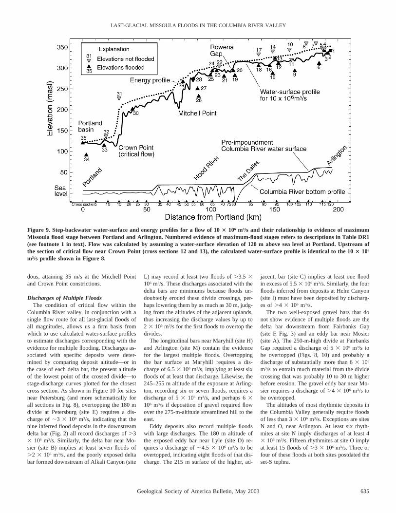
The Largest Flood(s)The highest altitude of ice-rafted erratics,
flood deposits, and erosional features define aprofile of the maximum stage achieved by thelargest flood(s) between Wallula Gap andPortland (Fig. 9). Maximum-flood stagesdropped substantially between Wallula Gapand Portland, from at least 366 m in the PascoBasin near the entrance to Wallula Gap(O’Connor and Baker, 1992) to ;120 m nearPortland 325 km downstream. More than 80percent of this fall was in the 130 km Colum-bia River Gorge between The Dalles and Port-land, through which maximum-flood stage de-scended from 320 m to 120 m above sea level.
A discharge of 10 3 106 m3/s results in aprofile that most closely matches the maximum-
flood evidence, especially upstream of theconstriction at Mitchell Point, where there isabundant geologic evidence of maximum-flood stages (Fig. 9). This discharge estimateis similar to that obtained at Wallula Gap byO’Connor and Baker (1992), but less sensitiveto choice of energy-loss coefficients (Fig. 10)because of the hydraulic control imposed bythe constrictions in the Columbia RiverGorge. Hydraulic ponding behind the constric-tions at Mitchell Point and Crown Point re-sulted in decreased water-surface gradients up-stream of Hood River and probably impededflow through Wallula Gap (also increasing theuncertainty of the O’Connor and Baker [1992]discharge estimate). Within the hydraulicallyponded reaches, flow velocities were relative-ly slow; for example, maximum calculated ve-locities ranged between 5 and 20 m/s for thereach between Arlington and The Dalles. Butwithin constrictions, velocities were tremen-
Geological Society of America Bulletin, May 2003 635
LAST-GLACIAL MISSOULA FLOODS IN THE COLUMBIA RIVER VALLEY
Figure 9. Step-backwater water-surface and energy profiles for a flow of 10 3 106 m3/s and their relationship to evidence of maximumMissoula flood stage between Portland and Arlington. Numbered evidence of maximum-flood stages refers to descriptions in Table DR1(see footnote 1 in text). Flow was calculated by assuming a water-surface elevation of 120 m above sea level at Portland. Upstream ofthe section of critical flow near Crown Point (cross sections 12 and 13), the calculated water-surface profile is identical to the 10 3 106
m3/s profile shown in Figure 8.
dous, attaining 35 m/s at the Mitchell Pointand Crown Point constrictions.
Discharges of Multiple FloodsThe condition of critical flow within the
Columbia River valley, in conjunction with asingle flow route for all last-glacial floods ofall magnitudes, allows us a firm basis fromwhich to use calculated water-surface profilesto estimate discharges corresponding with theevidence for multiple flooding. Discharges as-sociated with specific deposits were deter-mined by comparing deposit altitude—or inthe case of each delta bar, the present altitudeof the lowest point of the crossed divide—tostage-discharge curves plotted for the closestcross section. As shown in Figure 10 for sitesnear Petersburg (and more schematically forall sections in Fig. 8), overtopping the 180 mdivide at Petersburg (site E) requires a dis-charge of ;3 3 106 m3/s, indicating that thenine inferred flood deposits in the downstreamdelta bar (Fig. 2) all record discharges of .33 106 m3/s. Similarly, the delta bar near Mo-sier (site B) implies at least seven floods of.2 3 106 m3/s, and the poorly exposed deltabar formed downstream of Alkali Canyon (site
L) may record at least two floods of .3.5 3106 m3/s. These discharges associated with thedelta bars are minimums because floods un-doubtedly eroded these divide crossings, per-haps lowering them by as much as 30 m, judg-ing from the altitudes of the adjacent uplands,thus increasing the discharge values by up to2 3 106 m3/s for the first floods to overtop thedivides.
The longitudinal bars near Maryhill (site H)and Arlington (site M) contain the evidencefor the largest multiple floods. Overtoppingthe bar surface at Maryhill requires a dis-charge of 6.5 3 106 m3/s, implying at least sixfloods of at least that discharge. Likewise, the245–255 m altitude of the exposure at Arling-ton, recording six or seven floods, requires adischarge of 5 3 106 m3/s, and perhaps 6 3106 m3/s if deposition of gravel required flowover the 275-m-altitude streamlined hill to theeast.
Eddy deposits also record multiple floodswith large discharges. The 180 m altitude ofthe exposed eddy bar near Lyle (site D) re-quires a discharge of ;4.5 3 106 m3/s to beovertopped, indicating eight floods of that dis-charge. The 215 m surface of the higher, ad-
jacent, bar (site C) implies at least one floodin excess of 5.5 3 106 m3/s. Similarly, the fourfloods inferred from deposits at Helm Canyon(site I) must have been deposited by discharg-es of .4 3 106 m3/s.
The two well-exposed gravel bars that donot show evidence of multiple floods are thedelta bar downstream from Fairbanks Gap(site F, Fig. 3) and an eddy bar near Mosier(site A). The 250-m-high divide at FairbanksGap required a discharge of 5 3 106 m3/s tobe overtopped (Figs. 8, 10) and probably adischarge of substantially more than 6 3 106
m3/s to entrain much material from the dividecrossing that was probably 10 to 30 m higherbefore erosion. The gravel eddy bar near Mo-sier requires a discharge of .4 3 106 m3/s tobe overtopped.
The altitudes of most rhythmite deposits inthe Columbia Valley generally require floodsof less than 3 3 106 m3/s. Exceptions are sitesN and O, near Arlington. At least six rhyth-mites at site N imply discharges of at least 43 106 m3/s. Fifteen rhythmites at site O implyat least 15 floods of .3 3 106 m3/s. Three orfour of these floods at both sites postdated theset-S tephra.

636 Geological Society of America Bulletin, May 2003
BENITO and O’CONNOR
Figure 10. Stage rating curves constructed from step-backwater results near the FairbanksGap and Petersburg divide crossings (cross section 88). Each gray bar shows the rangeof discharges computed to correspond with a single flood-inundation level. The sensitivityof the step-backwater calculations to uncertainty in Manning n values (flow resistanceimparted by boundary roughness) is shown by the three separate curves. The primarymodel (heavier middle curve) results from a Manning n value of 0.03 for flow over thepresent channel and flood plain of the Columbia River and 0.05 for flow over valley sidesand flanking uplands, whereas for the two other curves, n is shifted each direction by25%. Because of the hydraulic control imposed by downstream constrictions, the dischargeestimates are relatively insensitive to uncertainties in Manning n values compared toreaches of more uniform flow. The highest flood evidence near Fairbanks Gap requires adischarge of 9 to 10 3 106 m3/s.
The lower sequence of 10 rhythmites in Al-kali Canyon, near Arlington (site P), couldhave been formed by discharges as small as 13 106 m3/s. These rhythmites at site P are in-set into a delta bar formed from flow thatcrossed uplands to the east and therefore mustpostdate all flows of .3 3 106 m3/s, becauseany subsequent flows over these 210–280 muplands would have destroyed the inset rhyth-mites. This inference is consistent with the ab-sence of the set-S tephra in the low-lyingrhythmites at site P, because deposits at nearbysites M, N, and O show that three or fourpost–set-S floods had discharges of .3–4 3106 m3/s. A similar conclusion was reached byWaitt (1994) for an exposure near WallulaJunction, Washington, where 21–25 rhythmi-tes well exposed near river level contain nosigns of the set-S tephra.
Summary of Discharges, Number ofFloods, and Chronology in the ColumbiaValley
The high-water evidence, stratigraphic in-ferences, age constraints, and modeling resultscan be summarized to support several infer-ences about the timing, number, and magni-tude of Missoula floods in the Columbia Rivervalley between Wallula Gap and Portland:
1. The altitudes of the maximum-stage ev-idence and the flow-modeling results showthat at least one flood had a discharge of 103 106 m3/s. The weak soil development onfine-grained flood deposits near maximum-flood stage indicates this flood (or floods) wasduring the last glaciation. This age is corrob-orated by a radiocarbon date of humates froma soil clast underneath high flood depositsnear Philippi Canyon (site J; Table 1), indi-cating that the highest coarse-grained flooddeposits were emplaced after 19,015 6 16514C yr B.P.
2. The longitudinal bar at Maryhill (site H) in-dicates at least six floods of .6.5 3 106 m3/s.Likewise, the high longitudinal bar east of Ar-lington (site M) shows that at least six or sevenfloods had discharges of .5–6 3 106 m3/s andthat at least two or three of these floods post-dated the set-S tephra. Additionally, radiocar-bon ages from within the Petersburg delta bar(site E) and eddy bar at Mosier (site A) showthat multiple bar-building floods had dischargesof .3–4 3 106 m3/s after ca. 15,000 14C yrB.P. (Table 1; Fig. 2).
4. The sequence of rhythmites in AlkaliCanyon (site O) shows that at least 15 floodshad discharges of .3.0 3 106 m3/s, of whichat least three were after the set-S tephras.
5. A lower sequence of rhythmites in Alkali
Canyon (site P) provides evidence for at leastten floods that had discharges between 1.0 3106 m3/s and 3.0 3 106 m3/s and probablypostdated set-S.
Because no exposures are complete (exceptfor the trenched bar at site M), the number offloods specified in each of these conclusionsprobably underestimates that actual number offloods that were within stated discharge val-ues. Evidence found so far, however, requiresonly one flood of .7 3 106 m3/s.
Discharge Estimates from Elsewhere alongthe Flood Routes
The 10 3 106 m3/s discharge estimate forthe maximum flood(s) in the Columbia Valleyis consistent with O’Connor and Baker’s(1992) estimates of .17 3 106 m3/s near theice dam and 10 6 2.5 3 106 m3/s for flowexiting the Pasco Basin through Wallula Gap(although the discharge could have been ashigh as 15 3 106 m3/s if flow was criticalthrough the Wallula Gap constriction). Step-
backwater flow modeling for the ColumbiaRiver valley and Channeled Scabland routesupstream from Wallula Gap implies that a to-tal discharge of at least 22 3 106 m3/s con-verged onto the Pasco Basin during the largestflood(s) (Harpel et al., 2000; Waitt et al.,2000). Such inflow into the Pasco Basin, re-leased at a rate of 10 3 106 m3/s through Wal-lula Gap and the lower Columbia Valley, isconsistent with more than half of the total vol-ume of maximum glacial Lake Missoula hy-draulically ponding upstream of Wallula Gap(Baker, 1973, p. 21; Waitt, 1980; O’Connorand Baker, 1992).
The results of Waitt (1994), Harpel et al.(2000), and Waitt et al. (2000) also show thatglacial Lake Missoula released at least onelarge flow of .15.5 3 106 m3/s before block-age of the Columbia River by the Okanoganlobe of the Cordilleran ice sheet. This flowincluded 10 3 106 m3/s down the northwestsegment of the Columbia Valley, 5.5 3 106
m3/s down Grand Coulee, and perhaps 5.5–113 106 m3/s down Moses Coulee. Without

Geological Society of America Bulletin, May 2003 637
LAST-GLACIAL MISSOULA FLOODS IN THE COLUMBIA RIVER VALLEY
blockage of the Columbia River, less than 33 106 m3/s crossed the scabland tracts east ofGrand Coulee. In contrast, when the Okanog-an lobe blocked the Columbia River valley,Moses Coulee, and at times Grand Coulee, 7.7to 11 3 106 m3/s coursed across the easternpart of the Channeled Scabland (Waitt et al.,2000). High-water evidence from flowthrough these eastern routes and down thelower Snake River valley defines a profilegrading to ponding altitude of #325 m up-stream of Wallula Gap, which is .40 m lowerthan the 366 m upper limit of the maximumflood(s) (Waitt, 1994). The 366 m flood stageupstream of Wallula Gap must therefore haveresulted from the earlier flood(s) flowingthrough an unblocked northern Columbia Val-ley (O’Connor and Baker, 1992; Waitt, 1994,Waitt et al., 2000). For conditions of criticalflow through Wallula Gap, ponding to an al-titude of 366 m results in a discharge of 15 3106 m3/s, whereas a 325 m ponding level im-plies a critical-flow discharge of 10 3 106 m3/s (from Fig. 5 of O’Connor and Baker [1992]).But because all flows were similarly impededby the downstream constrictions in the Co-lumbia River Gorge, the downstream maxi-mum discharge corresponding with a maxi-mum stage of 366 m in the Pasco Basin likelycorresponds with the 10 3 106 m3/s dischargematching the highest flood evidence in thedownstream Columbia River valley, whereasthe floods crossing the eastern part of theChanneled Scabland and causing the PascoBasin stages of only 325 m likely had peakdischarges of 6–7 3 106 m3/s, reflecting thetwo-thirds ratio between critical-flow dis-charge relationships at Wallula Gap. Not fac-tored into any of these volumes are possiblereleases from glacial Lake Columbia that mayhave been coincident or caused by Missoulafloods.
Relative flood magnitude and timing havealso been estimated by the thickness and max-imum grain size of flood-laid beds and the al-titudinal variation of the number of post–set-S rhythmites in the Channeled Scabland andback-flooded valleys (Waitt, 1980, 1985,1994; Baker and Bunker, 1985; Smith, 1993).These results have been supplemented byvarve counts and radiocarbon dating where la-custrine deposits are interbedded with flooddeposits (Atwater, 1986, 1987). These rela-tionships imply that during the last-glacial ep-isode of flooding, flood magnitude generallydecreased with time, owing to a thinning Pur-cell Trench lobe and shorter intervals betweenice-dam failure (Atwater, 1986). This result isconsistent with the less complete evidence inthe lower Columbia River valley, which
shows at least 10 floods of 1 to 3 3 106 m3/sthat postdated at least 15 floods with discharg-es of .3 3 106 m3/s, as well as the 24 post–set-S rhythmites (Waitt, 1994; O’Connor andWaitt, 1995) that lie at low altitude near Wal-lula Gap.
The timing of the largest flood or floods ismore ambiguous. Varve counts, flood-bedthickness, and grain-size patterns in a 115 mglaciolacustrine section recording ;89 sepa-rate floods led Atwater (1986, 1987) to inferthat eight or nine floods between 15,200 6400 and 14,750 6 375 14C yr B.P were thelargest late-glacial floods. These floods, how-ever, are recorded in glacial Lake Columbia,a lake impounded in Columbia Valley innorthern Washington by the Okanogan lobe ofthe Cordilleran ice sheet. Large floods enter-ing this lake spilled onward primarily acrossthe eastern scabland tracts and may in partcorrelate to the six or seven floods in ourstudy area that had discharges of at least 6 3106 m3/s. Earlier last-glacial flood(s) predatedthe Okanogan lobe (Waitt, 1977, 1994) andthus the 15,550 6 450 14C yr B.P. base of theglacial Lake Columbia section described byAtwater (1986). The flood(s) during an ice-free Columbia River, with peak discharges ofat least 15.5 3 106 m3/s into the Pasco Basin,likely correspond to the post–19,015 6 16514C yr B.P. flood(s) of ;10 3 106 m3/s in ourstudy area recorded by the highest flood de-posits and ice-rafted erratics. This flood orfloods may correspond to one or more of sev-eral megaturbidites in the eastern PacificOcean ascribed to late-glacial Missoula floodsand apparently predating 15,480 6 100 14C yrB.P. (Zuffa et al., 2000).
CONCLUSIONS
Within the Columbia River valley betweenWallula Gap and Portland, the evidence formaximum-flood stages and the hydraulic flowmodeling indicate that at least one Missoulaflood reached 10 3 106 m3/s. The maximum-stage evidence and the step-backwater flowmodeling both indicate that flow was hydrau-lically impeded by constrictions in the Colum-bia River Gorge. The result was high stagesand temporary hydraulic ponding that affectedflow stages as far upstream as the Pasco Basin.
Among the flood deposits left in the Colum-bia Valley, several contain evidence of multi-ple late Pleistocene Missoula floods. As atother locations along the Missoula flood route(e.g., Glenn, 1965; Waitt, 1980, 1985; Bakerand Bunker, 1985; Atwater, 1986, 1987;Smith, 1993), sand and silt beds show thattens of floods occurred during the last glaci-
ation. Moreover, at least 25 floods had dis-charges of .1.0 3 106 m3/s. Many of thesefloods are also recorded in high gravel barsthat imply such large discharges more directlythan do rhythmites of sand and silt. High grav-el bars at two locations provide evidence of atleast six or seven Missoula floods with peakdischarges exceeding ;6 3 106 m3/s, and sev-eral lower bars also contain evidence of beingformed by multiple flows. But most of the oth-er .40 to 89 Missoula floods recorded at oth-er sections along the flood route (e.g., Glenn,1965; Waitt, 1980, 1985; Atwater, 1986, 1987)were too small to leave deposits in the highgravel bars and rhythmite sections along theColumbia Valley.
Radiocarbon dating, tephras, and soil de-velopment all indicate that most if not all ofthe flood deposits in the study area resultedfrom the latest episode of Pleistocene Missou-la floods. The flooding apparently begansometime after 19,015 6 165 14C yr B.P. andcontinued through 13,695 6 95 14C yr B.P.and perhaps substantially past 13,000 14C yrB.P., depending on the age of the Mount St.Helens set-S tephra.
Taken together, the stratigraphy of the de-posits, the results of the hydrologic modeling,and the chronologic information show thatmany of the high-altitude and high-energyMissoula flood features are indeed the prod-ucts of multiple late Pleistocene Missoulafloods, thus partly establishing the link be-tween high-energy facies and multiple floodsthat Baker and Bunker (1985) stated was nec-essary to prove ‘‘multiple cataclysms.’’ How-ever, most floods recorded in lake deposits andlow-elevation rhythmite sections along theflood routes were probably too small to carvethe scabland tracts and leave the high graveldeposits in the Columbia Valley downstreamof Wallula Gap. Additionally, the highestflood evidence in the study area may havebeen from at least one distinctly larger floodthat came primarily down the Columbia Rivervalley before blockage at Grand Coulee by theOkanogan ice lobe; this distinctly larger floodpredated the 89 or so floods recorded in gla-cial Lake Columbia (Atwater, 1986, 1987),which were shunted eastward though GrandCoulee and the Channeled Scabland.
ACKNOWLEDGMENTS
Discussions and site visits with Richard Waitt,Brian Atwater, Victor Baker, and Gary Smith havebeen valuable for clarifying field relationships andregional stratigraphy. Helpful manuscript reviewswere provided by Atwater and Waitt, as well asGSA Bulletin reviewers Victor Baker and GeneKiver. This work was partly supported by the Com-mission for Cultural, Educational and Scientific Ex-

638 Geological Society of America Bulletin, May 2003
BENITO and O’CONNOR
change between the United States of America andSpain.
REFERENCES CITED
Allen, J.E., Burns, M., and Sargent, S.C., 1986, Cataclysms onthe Columbia: Portland, Oregon, Timber Press, 211 p.
Allison, I.S., 1933, New version of the Spokane flood Val-ley: Geological Society of America Bulletin, v. 44,p. 675–722.
Allison, I.S., 1935, Glacial erratics in Willamette Valley:Geological Society of America Bulletin, v. 46,p. 615–632.
Allison, I.S., 1941, Flint’s fill hypothesis of origin of Scab-land: Journal of Geology, v. 49, p. 54–73.
Allison, I.S., 1978, Late Pleistocene sediments and floodsin the Willamette Valley: Oregon Department of Ge-ology and Mineral Industries, Ore Bin, v. 40,p. 177–202.
Atwater, B.F., 1986, Pleistocene glacial-lake deposits of theSanpoil River Valley, northeastern Washington: U.S.Geological Survey Bulletin 1661, 39 p.
Atwater, B.F., 1987, Status of glacial Lake Columbia duringthe last floods from glacial Lake Missoula: QuaternaryResearch, v. 27, p. 182–201.
Atwater, B.F., Smith, G.A., and Waitt, R.B., 2000, TheChanneled Scabland—Back to Bretz?: Comment: Ge-ology, v. 28, p. 574–575.
Baker, V.R., 1973, Paleohydrology and sedimentology ofLake Missoula flooding in eastern Washington: Geo-logical Society of America Special Paper 144, 79 p.
Baker, V.R., and Bunker, R.C., 1985, Cataclysmic latePleistocene flooding from glacial Lake Missoula: Areview: Quaternary Science Reviews, v. 4, p. 1–41.
Baker, V.R., Bjornstad, B.N., Busacca, A.J., Fecht, K.R.,Kiver, E.P., Moody, U.L., Rigby, J.G., Stradling, D.F.,and Tallman, A.M., 1991, Quaternary geology of theColumbia Plateau, in Morrison, R.B., ed., Quaternarynonglacial geology: Conterminous U.S.: Boulder, Col-orado, Geological Society of America, Geology ofNorth America, v. K-2, p. 215–250.
Beeson, M.H., Tolan, T.L., and Anderson, J.L., 1989, TheColumbia River Basalt Group in western Oregon:Geologic structures and other factors that controlledflow emplacement patterns, in Reidel, S.P., and Hoop-er, P.R., eds., Volcanism and tectonism in the Colum-bia River flood-basalt province: Geological Society ofAmerica Special Paper 239, p. 223–246.
Beget, J.E., Keskinen, M.J., and Severin, K.P., 1997, Te-phrochronologic constraints of the late Pleistocenehistory of the southern margin of the Cordilleran icesheet, western Washington: Quaternary Research,v. 47, p. 140–146.
Benito, G., 1997, Energy expenditure and geomorphic workof the cataclysmic Missoula flooding in the ColumbiaRiver Gorge, USA: Earth Surface Processes and Land-forms, v. 22, p. 457–472.
Berger, G.W., and Busacca, A.J., 1995, Thermolumines-cence dating of late Pleistocene loess and tephra fromeastern Washington and southern Oregon and impli-cations for the eruptive history of Mount St. Helens:Journal of Geophysical Research, v. 100, no. B11,p. 22,361–22,374.
Bjornstad, B.N., Fecht, K.R., and Pluhar, C.J., 2001, Longhistory of pre-Wisconsin ice age cataclysmic floods:Evidence from southeastern Washington State: Journalof Geology, v. 109, p. 695–713.
Bretz, JH., 1925, The Spokane flood beyond the ChanneledScabland: Journal of Geology, v. 33, p. 97–115, 236–259.
Bretz, JH., 1928, Bars of the Channeled Scabland: Geolog-ical Society of America Bulletin, v. 39, p. 643–702.
Bretz, JH., 1929, Valley deposits immediately east of the
Channeled Scabland of Washington: Journal of Ge-ology, v. 37, p. 393–427, 505–541.
Bretz, JH., 1969, The Lake Missoula floods and the Chan-neled Scabland: Journal of Geology, v. 77,p. 505–543.
Bretz, JH., Smith, H.T.U., and Neff, G.E., 1956, ChanneledScabland of Washington: New data and interpreta-tions: Geological Society of America Bulletin, v. 67,p. 957–1049.
Bunker, R.C., 1982, Evidence of late Wisconsin floods fromglacial Lake Missoula in Badger Coulee, Washington:Quaternary Research, v. 18, p. 17–31.
Busacca, A.J., Nelstead, K.T., McDonald, E.V., and Purser,M.D., 1992, Correlation of distal tephra layers in loessin the Channeled Scabland and Palouse of WashingtonState: Quaternary Research, v. 37, p. 281–303.
Cordero, D.I., 1997, Early to middle Pleistocene catastrophicflood deposits, The Dalles, Oregon (Master’s thesis):Portland, Oregon, Portland State University, 162 p.
Crandell, D.R., Mullineaux, D.R., Rubin, M., Spiker, E.,and Kelley, M.L., 1981, Radiocarbon dates from vol-canic deposits at Mount St. Helens, Washington: U.S.Geological Survey Open-File Report, v. 81–844,p. 1–15.
Feldman, A.D., 1981, HEC models for water resources sys-tem simulation, theory, and experience: Advances inHydroscience, v. 12, p. 297–423.
Glenn, J.L., 1965, Late Quaternary sedimentation and geo-logic history of the north Willamette Valley, Oregon(Ph.D. thesis): Corvallis, Oregon, Oregon State Uni-versity, 231 p.
Harpel, C.J., Waitt, R.B., and O’Connor, J.E., 2000, Paleo-discharges of the late Pleistocene Missoula floods,eastern Washington, U.S.A., in Finnsdottir, H.P., andGudnadottir, E., eds., Extremes of the Extremes, Sym-posium Abstracts, Reykjavık, Iceland, July 17–19,2000: Reykjavık, Iceland, Orkustofnun HydrologicalService, p. 21.
Hydrologic Engineering Center, 1985, HEC-2 water surfaceprofiles user’s manual: Davis, California, The Hydro-logic Engineering Center (U.S. Army Corps of Engi-neers), 37 p.
McDonald, E.V., and Busacca, A.J., 1988, Record of pre–late Wisconsin giant floods in the Channeled Scablandinterpreted from loess deposits: Geology, v. 16,p. 728–731.
Mullineaux, D.R., 1986, Summary of pre-1980 tephra-falldeposits erupted from Mount St. Helens, WashingtonState, USA: Bulletin of Volcanology, v. 48, p. 17–26.
Mullineaux, D.R., 1996, Pre-1980 tephra-fall depositserupted from Mount St. Helens, Washington: U.S.Geological Survey Professional Paper 1563, 99 p.
Mullineaux, D.R., Wilcox, R.E., Ebaugh, S.F., Fryxell, R.,and Rubin, M., 1978, Age of the last major scablandflood of the Columbia Plateau in eastern Washington:Quaternary Research, v. 10, p. 171–180.
Newcomb, R.C., 1969, Effect of tectonic structure on theoccurrence of ground water in the basalt of the Co-lumbia River Group of The Dalles area, Oregon andWashington: U.S. Geological Survey Professional Pa-per 383-C, 33 p.
O’Connor, J.E., 1993, Hydrology, hydraulics, and geomor-phology of the Bonneville flood: Geological Societyof America Special Paper 274, p. 1–83.
O’Connor, J.E., and Baker, V.R., 1992, Magnitudes and im-plications of peak discharges from glacial Lake Mis-soula: Geological Society of America Bulletin, v. 104,p. 267–279.
O’Connor, J.E., and Waitt, R.B., 1995, Beyond the Chan-neled Scabland—A field trip guide to Missoula floodfeatures in the Columbia, Yakima, and Walla WallaValleys of Washington and Oregon: Oregon Geology,v. 57, Part I, p. 51–60; Part II, p. 75–86; Part III,p. 99–115.
O’Connor, J.E., and Webb, R.H., 1988, Hydraulic modelingfor paleoflood analysis, in Baker, V.R., Kochel, R.C.,and Patton, P.C., eds., Flood geomorphology: NewYork, John Wiley and Sons, p. 403–418.
Piper, A.M., 1932, Geology and ground-water resources ofThe Dalles region, Oregon: U.S. Geological SurveyWater-Supply Paper 659-B, p. 107–189.
Reidel, S.P., Fecht, K.R., Hagood, M.C., and Tolan, T.L.,1989, The geologic evolution of the central ColumbiaPlateau, in Reidel, S.P., and Hooper, P.R., eds., Vol-canism and tectonism in the Columbia River flood-basalt province: Geological Society of America Spe-cial Paper 239, p. 247–264.
Shaw, J., Munro-Stasiuk, M., Sawyer, B., Beaney, C., Le-semann, J.-E., Musacchio, A., Rains, B., and Young,R.R., 1999, The Channeled Scabland—Back toBretz?: Geology, v. 27, p. 605–608.
Shaw, J., Munro-Stasiuk, M., Sawyer, B., Beaney, C., Le-semann, J.-E., Musacchio, A., Rains, B., and Young,R.R., 2000, The Channeled Scabland—Back toBretz?: Reply: Geology, v. 28, p. 576.
Smith, G.A., 1993, Missoula flood dynamics and magni-tudes inferred from sedimentology of slack-water de-posits on the Columbia Plateau, Washington: Geolog-ical Society of America Bulletin, v. 105, p. 77–100.
Waitt, R.B., 1977, Missoula flood sans Okanogan lobe:Geological Society of America Abstracts with Pro-grams, v. 9, p. 770.
Waitt, R.B., 1980, About forty last-glacial Lake Missoulajokulhlaups through southern Washington: Journal ofGeology, v. 88, p. 653–679.
Waitt, R.B., 1984, Periodic jokulhlaups from Pleistoceneglacial Lake Missoula: New evidence from varvedsediment in northern Idaho and Washington: Quater-nary Research, v. 22, p. 46–58.
Waitt, R.B., 1985, Case for periodic, colossal jokulhlaupsfrom Pleistocene glacial Lake Missoula: GeologicalSociety of America Bulletin, v. 96, p. 1271–1286.
Waitt, R.B., 1987, Evidence for dozens of stupendousfloods from glacial Lake Missoula in eastern Wash-ington, Idaho and Montana, in Hill, M.L., ed., Geo-logical Society of America Centennial Field Guide V.1 (Cordilleran Section): Boulder, Colorado, Geologi-cal Society of America Decade of North AmericanGeology Series, p. 345–350.
Waitt, R.B., with contributions from J.E. O’Connor andG.Benito, 1994, Scores of gigantic, successively smallerLake Missoula floods through Channeled Scablandand Columbia Valley, in Swanson, D.A., and Hauge-rud, R.A., ed., Geologic field trips in the PacificNorthwest: Seattle, Washington, Department of Geo-logical Sciences, University of Washington, Geologi-cal Society of America Annual Meeting 1994, guidefor field trip 2, chapter 1K, v. 1, 88 p.
Waitt, R.B., and Atwater, B.F., 1989, Stratigraphic and geo-morphic evidence for dozens of last-glacial floods, inBreckenridge, R.M., ed., Glacial Lake Missoula andthe Channeled Scabland: International GeologicalCongress 28th, Field Trip Guidebook T310, p. 37–50.
Waitt, R.B., O’Connor, J.E., and Harpel, C.J., 2000, Vary-ing routings of repeated colossal jokulhlaups throughthe Channeled Scabland of Washington, U.S.A., inFinnsdottir, H.P., and Gudnadottir, E., eds., Extremesof the Extremes, Symposium Abstracts, Reykjavık,Iceland, July 17–19, 2000: Reykjavık, Iceland, Or-kustofnun Hydrological Service, p. 27.
Zuffa, G.G., Normark, W.R., Serra, F., and Brunner, C.A.,2000, Turbidite megabeds in an oceanic rift valley re-cording jokulhlaups of late Pleistocene glacial lakesof the western United States: Journal of Geology,v. 108, p. 253–274.
MANUSCRIPT RECEIVED BY THE SOCIETY 11 APRIL 2002REVISED MANUSCRIPT RECEIVED 12 NOVEMBER 2002MANUSCRIPT ACCEPTED 22 NOVEMBER 2002
Printed in the USA


![Seasonal Dynamics of a Temperate Tibetan Glacier Revealed ... · Remote Sens. 2020, 12, 2389 2 of 16 predicting glacier-related disasters, such as glacial lake outburst floods [3,4],](https://img.dokumen.tips/doc/110x75/5f91e6fd7c03842f18777603/seasonal-dynamics-of-a-temperate-tibetan-glacier-revealed-remote-sens-2020.jpg)