Embed Size (px)
Citation preview

Page 1 of 74
Berita Sedimentologi TIMOR & ARAFURA SEA
Number 24 – July 2012
Published by
The Indonesian Sedimentologists Forum (FOSI) The Sedimentology Commission - The Indonesian Association of Geologists (IAGI)
Number 24 07/2012
Permian-Jurassic Palaeogeography
of the SE Banda Arc Region
page 5
MMMuuuddd VVVooolllcccaaannnooo iiinnn
SSSooouuuttthhheeeaaasssttt MMMaaallluuukkkuuu:::
EEEvvviiidddeeennnccceee fffooorrr
NNNeeeooottteeeccctttooonnniiicccsss iiinnn EEEaaasssttt
IIInnndddooonnneeesssiiiaaa
pppaaagggeee 111888
HHHiiiggghhhllliiiggghhhtttsss aaannnddd IIImmmpppllliiicccaaatttiiiooonnn
ooofff aaa DDDeeeeeeppp---CCCrrruuussstttaaalll SSSeeeiiisssmmmiiiccc
RRReeefffllleeeccctttiiiooonnn SSSuuurrrvvveeeyyy iiinnn ttthhheee
AAArrraaafffuuurrraaa SSSeeeaaa RRReeegggiiiooonnn
pppaaagggeee 444888

Page 2 of 74
Berita Sedimentologi TIMOR & ARAFURA SEA
Number 24 – July 2012
Editorial Board
Herman Darman Chief Editor Shell International Exploration and Production B.V. P.O. Box 162, 2501 AN, The Hague – The Netherlands Fax: +31-70 377 4978 E-mail: [email protected]
Minarwan Deputy Chief Editor Mubadala Petroleum (Thailand) Ltd. 31st Floor, Shinawatra Tower 3, 1010 Viphavadi Rangsit Rd. Chatuchak, Bangkok 10900, Thailand E-mail: [email protected]
Fuad Ahmadin Nasution Total E&P Indonesie Jl. Yos Sudarso, Balikpapan 76123 E-mail: [email protected]
Fatrial Bahesti PT. Pertamina E&P NAD-North Sumatra Assets Standard Chartered Building 23rd Floor Jl Prof Dr Satrio No 164, Jakarta 12950 - Indonesia E-mail: [email protected]
Wayan Heru Young University Link coordinator Legian Kaja, Kuta, Bali 80361, Indonesia E-mail: [email protected]
Julianta Panjaitan Membership coordinator PT. Schlumberger Geophysics Nusantara Data & Consulting Services Jl. Mulawarman Km. 20, P.O.Box 117 Balikpapan 76117, Kalimantan Timur, Indonesia E-mail: [email protected]
Agus Suhirmanto Seruway Offshore Exploration Limited Wisma GKBI Building 37th Floor Jl. Jend. Sudirman No. 28, Jakarta 10210 E-mail: [email protected]
Visitasi Femant Treasurer Pertamina Hulu Energi Kwarnas Building 6th Floor Jl. Medan Merdeka Timur No.6, Jakarta 10110 E-mail: [email protected]
Advisory Board
Prof. Yahdi Zaim Quarternary Geology Institute of Technology, Bandung
Prof. R. P. Koesoemadinata Emeritus Professor Institute of Technology, Bandung
Wartono Rahardjo University of Gajah Mada, Yogyakarta, Indonesia
Ukat Sukanta ENI Indonesia
Mohammad Syaiful Exploration Think Tank Indonesia
F. Hasan Sidi Woodside, Perth, Australia International Reviewers
Prof. Dr. Harry Doust Faculty of Earth and Life Sciences Vrije Universiteit De Boelelaan 1085 1081 HV Amsterdam The Netherlands E-mails: [email protected]; [email protected]
J.T. (Han) van Gorsel 6516 Minola St. Houston, TX 77007, USA www.vangorselslist.com E-mail: [email protected]
Dr. T.J.A. Reijers Geo-Training & Travel Gevelakkers 11 9465TV Anderen, The Netherlands E-mail: [email protected]
• Published 3 times a year in February, June and October by the Indonesian Sedimentologists Forum (Forum Sedimentologiwan Indonesia,
FOSI), a commission of the Indonesian Association of Geologists (Ikatan Ahli Geologi Indonesia, IAGI).
• Cover topics related to sedimentary geology including their depositional processes, deformation, minerals, basin fill, etc.
Cover Photograph:
Mud volcano on the Wahru Island,
Kei Kecil Islands
(Photo courtesy of Y. Zaim)
Taken from the Paper of Y. Zaim et al.
(BS#24, page 18)
Page 3 of 74
Berita Sedimentologi TIMOR & ARAFURA SEA
Number 24 – July 2012
Welcome to Berita Sedimentologi number 24!
The volume focuses on the southeastern part of Indonesia, which covers the southern part of Banda Arc, Timor Sea and Arafura Sea. We have received a number of interesting articles on the region.
Tim Charlton submitted an article that summarizes the regional tectonic evolution of the SE Banda Arc. As an expert of the area, Tim shows the Permian to Jurassic paleographic reconstruction of the area. Jim Granath et al., provided a number of excellent quality deep seismic lines. These hard data help geoscientists to understand the regional geology in the area. I've
compiled published seismic lines in the Timor-Tanimbar trough. By putting consistent stratigraphic nomenclatures, it may help readers to understand different geological settings of the trough. Access to old publications is not always easy, but Han van Gorsel has brought back Molengraaff and Brouwer (1915) article for us to read. An article on mud volcanoes in the region has been submitted by Yahdi Zaim, based on his previous field work in early 1990's. Zaim's study shows active tectonism in the area.
Putri Radiani has initially submitted an article for previous Berita Sedimentologi volume. Due to technical reason, the editors can only include it in current volume. An announcement on a recent book published by Michael McLane, AAPG Singapore meeting and EAGE membership are included in this volume as well.
On organization's news, FOSI - the Indonesian Sedimentologists Forum, plan to raise some fund to support geological education in Indonesia by giving sponsorship to students and providing essential books for
universities. There are interests from the industry to put advertisements in the bulletin. We offer some space for advertisement with financial contribution and the form is included in this bulletin. Visitasi Femant has agreed to volunteer herself as the treasurer for FOSI.
In July 2012, our Linked-in membership database recorded 512 members. Is it time for members to pay contribution for to the organization? We will discuss this issue in forum.
Finally, I wish you a happy reading time, I'm sure you will enjoy this volume.
Best Regards,
Herman Darman Chief Editor
INSIDE THIS ISSUE
Permian-Jurassic Palaeogeography of the SE Banda Arc Region – T. Charlton 5
Seismic Expression of the Timor-Tanimbar, Eastern Indonesia – H. Darman
39
Book Review : The SE Asian Getway: History and Tectonic of the Australian-Asia Collision, editor: Robert Hall et al – T.J.A. Reijers
56
Mud Volcano in Southeast Maluku: Evidence for Neotectonics in East Indonesia – Y. Zaim et. al. 18
Highlights and Implication of a Deep-Crustal Seismic Reflection Survey in the Arafura Sea Region – J.W. Granath et. al.
48
Book Review - Biodiversity, Biogeography and Nature Conservation in Wallacea and New Guinea (Volume 1), Edited by D. Telnov, Ph.D. – H. Darman
58
Ophiolite obduction on Leti Island, as described by Molengraaff and Brouwer (1915): implication for age and genesis of metamorphic complexes in the Outer Banda Arc, Eastern Indonesia – J.T. van Gorsel
24
The Sorong Fault Zone Kinematics: Implication for Structural Evolution on Salawati Basin, Seram and Misool, West Papua, Indonesia – P. Riadini et. al.
61
Berita Sedimentologi
A sedimentological Journal of the Indonesia Sedimentologists Forum (FOSI), a commission of the Indonesian Association of Geologist (IAGI)
From the Editor

Page 4 of 74
Berita Sedimentologi TIMOR & ARAFURA SEA
Number 24 – July 2012
About FOSI
he forum was founded in 1995 as the Indonesian Sedimentologists
Forum (FOSI). This organization is a commu-nication and discussion forum for geologists, especially for those dealing with sedimentology and sedimentary geology in Indonesia. The forum was accepted as the sedimentological commission of the Indonesian Association of Geologists (IAGI) in 1996. About 300 members were registered in 1999, including industrial and academic fellows, as well as students.
FOSI has close international relations with the Society of Sedimentary Geology (SEPM) and the International Association of Sedimentologists (IAS). Fellowship is open to those holding a recognized degree in geology or a cognate subject and non-graduates who have at least two years relevant experience. FOSI has organized 2 international conferences in 1999 and 2001, attended by more than 150 inter-national participants.
Most of FOSI administrative work will be handled by the editorial team. IAGI office in Jakarta will help if necessary.
The official website of FOSI is:
http://www.iagi.or.id/fosi/
Any person who has a background in geoscience and/or is engaged in the practising or teaching of geoscience or its related
business may apply for general membership. As the organization has just been restarted, we use LinkedIn (www.linkedin.com) as the main data base platform. We realize that it is not the ideal solution, and we may look for other alternative in the near future. Having said that, for current situation, the LinkedIn is fit for purpose. International members and students are welcome to join the organization.
T
FOSI Membership
FOSI Group Member
as of JUNE 2012

Page 5 of 74
Berita Sedimentologi TIMOR & ARAFURA SEA
Number 24 – July 2012
Permian-Jurassic Palaeogeography of the SE
Banda Arc Region Tim Charlton 1 Saint Omer Ridge, Guildford, Surrey, GU1 2DD, U.K. Corresponding Author: [email protected]
Abstract Palaeogeographic maps covering the southern and eastern sectors of the Banda forearc (Savu to the Kei islands, also including Timor and the Tanimbar islands) and adjacent parts of the northwest Australian continental margin are presented for the Early Permian, Middle-Late Permian, Early-Middle Triassic, Late Triassic, and Early, Middle and Late Jurassic. A series of palaeotectonic reconstructions from the Devonian to the mid-Tertiary show an interpretation of the sequential phases of rifting that dismembered northeastern Gondwanaland through this period. Three major phases of rifting are documented for the core region of the future Banda forearc, commencing in the Early Permian, Late Triassic and Middle/Late Jurassic. Each rift event is characterised palaeogeographically by high facies diversity, which is a consequence of strong differential vertical crustal movements at that time. The three rift phases are separated by two quieter tectonic intervals characterised palaeogeographically by low facies diversity (widespread development of marine shales) during phases of post-rift thermal subsidence.
Introduction The islands of the southern and eastern Banda non-volcanic arc (Savu, Roti, Timor, Babar, Tanimbar and Kei, with numerous smaller intervening islands: Figure 1) are situated in the Neogene zone of collision between the Banda island arc and the formerly passive northwestern continental margin of Australia. Although elements of both the overriding Banda/Eurasian plate and the underthrusting Australian plate are found in these islands and are exposed in the fold and thrust belt that comprises the collision complex, it is Australian tectonostratigraphic elements that overwhelmingly predominate. These thrusted Australian-affinity stratigraphic successions appear to represent the shortened outer edge of the underthrusting Australian continental margin – or at least there is no strong evidence for sudden discontinuities in lithological types and facies belts that would require the presence of allochthonous or ‘suspect’ Australian-affinity tectonostratigraphic elements and necessitate a tectonic model more complex than simple thrustbelt shortening (this refers only to the Australian-affinity successions: there is clearly also a true allochthon of Banda forearc material).
Figure 1. Tectonic setting of the southern and eastern Banda Arc

Page 6 of 74
Berita Sedimentologi TIMOR & ARAFURA SEA
Number 24 – July 2012
Palaeogeographic reconstructions of the Australian-affinity stratigraphic successions in the Banda forearc provide a valuable constraint for understanding the evolution of the northern margin of the Australian continent, complementing data gathered from the generally more proximal and much less deformed Australian ‘passive’ margin successions to the south and east of the Timor-Tanimbar Trough system (the deformation front of the Banda collision complex: Figure 1). For the Permian to Jurassic interval considered in the present study the reconstructions may be particularly significant for petroleum exploration as petroleum systems in both the Banda forearc and the northwestern Australian margin (Northwest Shelf to West Papua) are found primarily within rocks of this age range. An overview of the regional evolution through the Permian to Jurassic interval is presented here in the form of a series of regional tectonic
cartoons (Figure 2) and more detailed palaeogeographic maps for seven time intervals (Figures 3-9).
Pre-Permian framework Figure 2 illustrates the interpreted evolution of Gondwanan eastern Indonesia from the Palaeozoic through to the Jurassic. In Figure 2a the numerous continental fragments of present-day northern east Indonesia (eastern Sulawesi, Buton, Banggai-Sula, the Bird's Head, Buru, Seram, Misool, etc.) have been re-assembled into a coherent continental fragment, the Greater Sula Spur, and these are repositioned to the north of the present-day southern Banda Arc from Tanimbar to Timor (Charlton, 2000, 2001). The Greater Sula Spur represents just one of the marginal Gondwanan
Figure 2. Devonian–Jurassic
evolution of northeastern
Gondwanaland

Page 7 of 74
Berita Sedimentologi TIMOR & ARAFURA SEA
Number 24 – July 2012
terranes that were detached from present-day Australia in a series of Palaeozoic-Mesozoic continental rifting events. Other terranes reconstructed against the northern Gondwanan margin during the Early Palaeozoic include North and South China, Indochina and Sibumasu (Figure 2a). The geological record for most of the Banda Arc region only extends back to the Permian, although there are unconfirmed reports of older Palaeozoic sedimentary rocks in Timor (Sousa Torres & Pires Soares, 1952). The pre-Permian history of the Banda Arc region can, therefore, only be inferred indirectly, particularly from the known Palaeozoic history of adjacent regions, and particularly from the Northwest Shelf and New Guinea Island. Prior to the Permian, the present-day Northwest Shelf formed an internal part of the Gondwanan supercontinent. In the Devonian a series of rift systems developed through this region, including the Bonaparte Graben which formed with a NW-SE orientation (present-day geographic coordinates) from the head of the Joseph Bonaparte Gulf on the NW coast of Australia towards present-day Timor (Lee & Gunn, 1988). This rift system appears to have been an entirely intracontinental aulacogen that never developed to a stage of oceanic rifting (O'Brien et al., 1993), although at the continental edge it probably connected with a continental margin rift system responsible for the separation of the North China block from the margin of Gondwanaland (Klootwijk, 1996). The Bonaparte Graben trend is interpreted in this study to have had a fundamental control on the evolution of particularly the Timor region, both in the pre-collisional phase and during Neogene arc-continent collision. This early differentiation into a relative structural high in what is now East Timor and a more basinal area in present-day West Timor (Figure 2a) is reflected in overall more basinal successions in West Timor compared to East Timor (see the individual palaeogeographic maps). This fundamental crustal differentiation between East and West Timor is also reflected by rather different structural styles in the present-day collision complexes in the two halves of the island (Charlton, 2004).
Permian A further phase of rifting within Gondwanaland was initiated in latest Carboniferous or earliest Permian times (Figure 2b). The primary E-W strike of structures (present-day geographic coordinates) resulting from N-S extension during this structural phase was rather oblique to the previous trend in the Bonaparte Graben. This second extensional phase was probably associated with the detachment of the Sibumasu Terrane (present-day western Thailand, eastern Myanmar, western peninsular Malaysia and northern Sumatra) from Gondwanaland (e.g. Metcalfe, 1990, 1996; Charlton, 2001). An oceanic rift probably developed between Sibumasu and the Argo Land continental terrane located immediately west of Australia (Veevers et al., 1991). Further east, this oceanic rift is interpreted to have passed laterally into an intracontinental rift system along the line of the present-day southern Banda Arc (the South Banda Graben: Figures 2b, 3 & 4) and into the Goulburn Graben on the southern Arafura
Shelf. Radiometric dating suggests that the Goulburn Graben was undergoing extension during the latest Carboniferous-earliest Permian (Bradshaw et al., 1990), while the lateral continuation of this rift system into Timor and other Banda forearc islands is indicated by abundant rift valley-type basaltic volcanism during the Early Permian, both in basinal clastic-dominated successions (Atahoc and Cribas formations in Timor), and particularly in the contemporaneous Maubisse Formation, which consists of basic volcanics, volcaniclastic sediments and shelf carbonates, and probably represents rift flank and intra-rift horst block successions. Directly comparable shallow marine carbonate and volcanic successions are also seen in Tanimbar (Selu Formation: unpublished field results), and similar successions are probably also present but less-well documented in the southwestern Maluku forearc islands (e.g. reddish Permo-Triassic limestones from Leti: Agustiyanto et al., 1994; crinoidal limestone from Babar: van Bemmelen, 1949). On the present Northwest Shelf to the south of this rift domain the shallow marine limestones of the Maubisse Formation can be correlated with Permian limestones encountered, for instance, in the Kelp Deep-1 well on the crest of the Sahul Platform (the Pearce and Dombey Formations/Members: Gorter, 1998; Charlton et al., 2002). Unlike the Tanimbar and Timor limestones, however, the Upper Permian limestones of the Australian Northwest Shelf are not known to be associated with volcanics. Stratigraphic information from the Tanimbar islands is rather limited, but it is inferred, based on an integration of data from various geological intervals, that the successions accumulated in a graben setting. This Tanimbar Graben (as it will be described hereafter) probably began to develop during the Permian as an aulacogenic rift on the northern margin of the South Banda Graben, and formed a northern counterpart to the Calder-Malita Graben system which developed contemporaneously on the southern margin of the South Banda Graben. Further north in Gondwanan eastern Indonesia (Banggai-Sula and northern New Guinea), granitoid plutonism commenced in the Carboniferous, and apparently continued throughout the Permian (summarised in Charlton, 2001).
Early-Middle Triassic During the Permian and Triassic the Sibumasu Terrane drifted northward relative to Gondwanaland (Metcalfe, 1996). However, continuing stratigraphic links between Sibumasu and Gondwanan eastern Indonesia through this period suggest continuing connection between the two regions (Audley-Charles et al., 1988; Lunt & Djaafar, 1991). In Figure 2b-d it is suggested that this apparent paradox can be resolved by Gondwanan eastern Indonesia being displaced northward relative to Australia with Sibumasu through this period, with movement relative to Gondwanaland accommodated on a left lateral fault system along the western margin of the present-day Arafura Shelf. To the west of this, intracontinental extension involving delamination between upper and lower crust took place in the region between the present-day southern and the

Page 8 of 74
Berita Sedimentologi TIMOR & ARAFURA SEA
Number 24 – July 2012
northern Banda forearc islands. The two opposing rift margins probably consisted of opposed upper-plate and lower-plate rifted margin pairs (cf. Lister et al., 1991), with what is now eastern Timor (upper-plate rifted margin) facing eastern Seram (lower-plate rifted margin), while western Timor (lower-plate rifted margin) faced western Seram and Buru (upper plate rifted margin). The switchover from upper- to lower-plate margin in Timor was probably associated with the graben-bounding faults along the pre-existing Bonaparte Rift trend (see Charlton, 2004 for further discussion). From the Early Permian (Figure 3) through the Middle/Late Permian (Figure 4) and into the Early/Middle Triassic (Figure 5) extension was focused within the South Banda Graben. Through the Permian and Early/Middle Triassic the locus of rifting migrated sequentially northward away from the southern margin of the rift (Figure 2b-d), and this is marked in the regional geology of the present-day southern Banda forearc by a waning of rift volcanism; by a marked reduction in facies diversity as active rifting declined; and by a major transgression with an associated dominance of shaly clastic facies as post-rift tectonic subsidence set in. By the Early and Middle Triassic (Figure 5) shale successions dominate the Northwest Shelf (Mount Goodwin Formation) and Timor (Niof Formation). Contemporaneously in Timor condensed and highly fossiliferous rosso ammonitico-type limestone successions were accumulating on isolated structural highs formed during the extension (the Cephalopod Limestone facies: Charlton et al., 2009) In Tanimbar non-marine claystones were deposited in the far north of the island group (Maru island: unpublished field results).
In the Australian-affinity terranes of the present-day northern Banda Arc region (Seram, Buru, Misool; also Buton), a downward transition from non-metamorphic Middle Triassic turbidites into low-grade metamorphic rocks appears to be a characteristic feature (see Charlton, 2001 for a fuller discussion). The structure of the northern Banda Arc region at this time has been interpreted as a series of active half-grabens downthrowing away from a continental hinterland to the north and east (e.g. Price et al., 1987; Kemp & Mogg, 1992; Figure 2d). In the northern part of Gondwanan eastern Indonesia granitoid intrusion continued through the Early and Middle Triassic in the Bird’s Head, Banggai-Sula and possible eastern Sulawesi (Figure 2d; summarised in Charlton, 2001). Terrestrial and fluviatile successions equivalent to the Tipuma Formation of the Bird’s Head also characterise the Triassic of Banggai-Sula and parts of southeastern Sulawesi, although these successions are generally not well dated.
Late Triassic It has been suggested (Charlton, 2001) that although Sibumasu rifted away from the main body of Gondwanaland during the Early Permian (in accord with the interpretations of Metcalfe, 1996), Sibumasu did not finally separate from Gondwanan eastern Indonesia until the Carnian (early Late Triassic). At that time a new seafloor spreading régime was probably initiated to the north of Argo Land (Figure 2e), which had the effect of driving Sibumasu rapidly northward relative to Australia, and may also account for an important
Figure 3. Early Permian palaeogeography

Page 9 of 74
Berita Sedimentologi TIMOR & ARAFURA SEA
Number 24 – July 2012
phase of Late Triassic fault reactivation in Timor (Audley-Charles, 1988) and the Northwest Shelf (Symonds et al., 1994). Regional extension associated with this renewed seafloor spreading adjacent to the future southeast Banda region led once more to the type of facies diversity in the Late Triassic (Figure 6) that had been seen previously during the early stages of rifting in the Early Permian (Figure 3) – but in the Late Triassic without the presence of significant volcanism. The Late Triassic is the key interval for petroleum exploration in the Banda Arc region, with the development of restricted marine source rocks in the graben basins, and contemporaneous development of proven and potential reservoir sequences in shallow marine carbonates deposited primarily on isolated structural highs, and in siliciclastic successions shed into the basins from erosion of the rejuvenated Late Triassic landscape (Charlton, 2002a, b; 2004). In Timor, Late Triassic reefal and other shallow marine carbonate buildups developed on active horst blocks (Fatu Limestone; ‘Cablac’ Limestone: see Haig et al. 2007, 2008 and later papers by these authors for discussion of the Mesozoic Cablac Limestone), while deeper, restricted marine sequences accumulated in adjacent grabens (the dominantly carbonate Aitutu Formation and the contemporaneous siliciclastic Babulu Formation). Towards the Australian continent more proximal sedimentary environments were established during the Late Triassic, represented by non-marine to shallow marine sandstones and subordinate shales of the Malita Formation. Somewhat more marine lateral equivalents of the Malita Formation have been encountered
in the subsurface of southern West Timor in the Banli-1 exploration well (the Malita-equivalent: Sani et al., 1995). Similar sedimentary environments and facies to those in Timor developed contemporaneously in Tanimbar, with reefal buildups (Wotar Formation) developed on local structural highs, and clastic sediments (Maru Formation) accumulating in adjacent basins (unpublished field results). Previously the present writer (Charlton et al., 1991) interpreted the Maru Formation as sourced from the Calder Graben to the south in a simple northward continuation of sedimentation within the Malita-Calder Graben system. However, further examination of palaeogeographic data for the Late Triassic of the Tanimbar islands suggests that the environmental polarity is wrong for a southern sedimentary source. The most proximal sandstone successions are found in the most northerly islands of Maru and Molu, where samples show a very strong terrestrial influence. Late Triassic sandstone-shale successions sampled from further south in the Tanimbar islands show only strong (as opposed to very strong) terrestrial influence, while the bivalve Halobia, which is found widely in the Late Triassic of Timor in low-energy, moderately deep shelf facies (see Charlton et al., 2009), has been recorded in the more southerly islands of the Tanimbar group (e.g. Weber, 1925). These palaeogeographic indications are more consistent with a northern sedimentary provenance within the Tanimbar Graben, as indicated in Figure 6. The palaeogeographic setting of Savu during the Late Triassic was initially a relatively deep marine basin accumulating limestone-shale successions, into which more proximal, probably fluviodeltaic, sandstone-shale successions
Figure 4. Middle–Late Permian palaeogeography

Page 10 of 74
Berita Sedimentologi TIMOR & ARAFURA SEA
Number 24 – July 2012
were introduced. These relatively proximal sediments may have been sourced from an emergent landmass to the southwest of Savu, in the now-removed Argo Land marginal terrane. In the northern Banda Arc and regionally, an important structural event is recognised in the mid-Carnian (Lunt & Djaafar, 1991), interpreted (Charlton, 2001) as marking the end of the main extensional phase in the northern Banda Arc province. In Misool, for instance, Lower Carnian and older turbiditic sediments of the Keskain Formation are folded and unconformably overlain by Lower Norian marls passing up into Middle and Upper Norian reef limestones (Wanner, 1931; Visser & Hermes, 1962).
Early-Middle Jurassic The phase of active extension during the Late Triassic waned into the Early and Middle Jurassic as the spreading centre moved away from the immediate vicinity of the study area. Post-rift thermal relaxation is marked stratigraphically by the regional development of transgressive shale sequences (Figures 7 & 8). In Timor the main stratigraphic unit in the Early-Middle Jurassic is the Wai Luli Formation, which is a shale-dominated succession up to several hundred metres thick. In the Banli-1 well in the south of West Timor the Wai Luli shales of Middle Jurassic age succeed Early Jurassic sandstone-dominated successions described as the Plover-equivalent (Sani et al., 1995), after the Plover Formation which occurs extensively across the Northwest Shelf during the Early and Middle Jurassic.
In the Tanimbar islands Jurassic sections have not been recognised in normal outcrop, but Jurassic shales are identified from the ejecta of mud volcanoes. Palaeoenvironmental indicators from material erupted from mud volcanoes are consistent with regional transgression during the Early Jurassic. For instance, in samples from a short-lived mud volcano in Selat Yamdena to the west of Yamdena island (now eroded to below sea level) a Sinemurian-earliest Toarcian dolomitised ferroan nodule was deposited in a supralittoral environment, while a Pliensbachian-earliest Toarcian dolomite was deposited in a very shallow inner sublittoral environment; and marine shales are dated to the early Toarcian. This suggests marine transgression in about the Pliensbachian (mid Early Jurassic) at this locality, assuming that the mud volcanic material corresponds approximately to a disrupted original vertical stratigraphic succession. In other mud volcanoes in Tanimbar Early Jurassic ammonites have been collected (Wanner & Jaworski, 1931; Charlton et al., 1991), presumably originating from open marine, low energy sedimentary successions. As with Late Triassic samples, the environmental information from Tanimbar is more consistent with a northern sedimentary source, rather than sourcing from the Plover Formation sedimentary system of the Malita-Calder Graben system as previously interpreted (Charlton et al., 1991). One additional interesting lithology from a Tanimbar mud volcano is a block of dolomite-replaced coral packstone dated to the Aalenien-earliest Bajocian. The present writer is unaware of other shallow marine limestones convincingly dated to the Middle Jurassic from anywhere else in the Banda Arc region (the Manusela Limestone in Seram,
Figure 5. Early–Middle Triassic palaeogeography

Page 11 of 74
Berita Sedimentologi TIMOR & ARAFURA SEA
Number 24 – July 2012
interpreted by Kemp & Mogg (1992), as Middle Jurassic, appears to be dated only on long-ranging species, and seems more likely to be Early rather than Middle Jurassic in age). In the Kei islands there is no known Jurassic outcrop, but the Kai Besar-1 well intersected a Lower Jurassic proximal open marine succession succeeded by Middle Jurassic (Aalenian-Bajocian) fluviodeltaic sediments. This broadly regressive succession contrasts with transgression in Timor, Tanimbar and the Northwest Shelf at this time. In Savu equivalents of the Wai Luli Formation from Timor have been recognised on the basis of lithology, although these are not accurately dated (Harris et al., 2009). These clastic successions are associated with basic volcanics which these authors interpreted as probably Late Jurassic (and hence they are indicated on the Late Jurassic palaeogeographic map: Figure 9), but it is possible that they are Middle Jurassic in age and should be shown on Figure 8 together with Middle Jurassic volcanics known from the Barcoo Basin on the western margin of Australia to the south of Savu. These volcanics were a precursor to the Late Jurassic breakup event described in more detail in the following sub-section. In the Leti-Babar sector of the Banda forearc the Early-Middle Jurassic appears to be developed primarily in Wai Luli-like shale facies. In Babar this facies is identified particularly through the occurrence of Jurassic ammonites in mud volcanic ejecta, including genera ranging in age from the Norian-Rhaetian (Late Triassic), through the entire Early and Middle Jurassic, and continuing possibly until the Oxfordian (early Late Jurassic) (Verbeek, 1908; Oyens,
1913). These ammonites were collected from ferruginous clay-marl geodes and marly limestone.
Late Jurassic The Late Jurassic saw renewed vertical crustal movements across the Northwest Shelf and the future southeastern Banda forearc region. The boundary between the Middle and Late Jurassic on the Northwest Shelf is widely marked by the so-called Callovian unconformity, which is identified regionally as corresponding to the onset of rifting associated with the initiation of the Indian Ocean and the development of the present western continental margin of Australia (Figure 9). In the Argo Abyssal Plain, located in the NE corner of the Indian Ocean to the southwest of Savu, an initial phase of spreading is identified between magnetic anomalies M26-M15 (approximately Oxfordian to mid-Valanginian), with spreading oriented in a NNW-SSE direction relative to Australia (Veevers & Li, 1991; Figure 2f). In Timor a distinct stratigraphic package corresponding fairly precisely in age to this phase of Oxfordian to mid-Valanginian spreading can be characterised as a syn-rift or breakup succession. Below the Callovian unconformity, sea-level regression associated with the early stages of rifting is probably expressed stratigraphically in Timor by the upward passage within the Wai Luli Formation from predominant shales into more sandy facies (the Wai Luli Sandstone Member). There appears to be a distinct palaeontological hiatus within the Jurassic successions in West Timor that cuts out the Lower-Middle Oxfordian (earliest Late Jurassic), and the succeeding Oe Baat Formation, which consists primarily of turbiditic glauconitic sandstones, is the main
Figure 6. Late Triassic palaeogeography

Page 12 of 74
Berita Sedimentologi TIMOR & ARAFURA SEA
Number 24 – July 2012
element of the breakup megasequence (Charlton, 1987). Broadly contemporaneous sandstone successions encountered in the Banli-1 well are overlain by basic volcanics and volcaniclastics also inferred to be Late Jurassic in age (Sani et al., 1995). In addition to the regional Callovian unconformity, interpreted as associated with the commencement of seafloor spreading during the Callovian/Oxfordian, there was also a marked change in spreading rate in the Kimmeridgian (Veevers & Li, 1991), and this also corresponds to a regionally important unconformity/disconformity. The Callovian unconformity appears to be more prominent in the extreme west of the Banda Arc-Northwest Shelf palaeogeographic region, for instance, in the Vulcan Graben of the Northwest Shelf (Pattillo & Nicholls, 1990); in western Timor (deposition of the high-energy Oe Baat Formation); and also in Buru in the northern Banda Arc (Oxfordian volcanics: Hummel, 1923). The intra-Kimmeridgian unconformity/disconformity, in contrast, appears be more prominent further east on the Northwest Shelf, e.g. in the Malita Graben which was probably reactivated in extension at this time (Anderson et al., 1993); and in the western part of the Joint Petroleum Development Area (JPDA) between Timor-Leste and Australia which is characterised by active block faulting at this time (Whittam et al., 1996). The Kimmeridgian phase of extension is also clearly marked in Seram, Misool and the Misool/Berau Shelf to the north of Seram. The intra-Kimmeridgian unconformity does not, however, appear to be of great stratigraphic significance in West Timor, for instance. It is possible that the trend of the Bonaparte rift acted as a barrier to the effective transmission of stresses
associated with the earliest Callovian-Oxfordian rift phase, so that areas further to the east were less affected by this initial rifting event; but conversely the slightly later Kimmeridgian rifting had more effect to the east of the Bonaparte rift. In Tanimbar the Late Jurassic is recognised through belemnites in the ejecta of mud volcanoes in the more southerly parts of the island group, and by perhaps more proximal red mudstone further north. There is also a major sandstone unit, the Ungar Formation (Charlton et al., 1991), which interdigitates in its upper part with radiolarian shales (Arumit Member: unpublished field results) of earliest Cretaceous, Berriasian-Valanginian age (Basir Jasin & Haile, 1996). The Ungar sandstones below the earliest Cretaceous radiolarian shales are not directly dated, but are likely to be Late Jurassic in age based on their significant thickness (several hundred metres) immediately below the dated earliest Cretaceous sediments. In the Kei Besar-1 well the Late Jurassic is absent beneath an Early Cretaceous unconformity, and there is no known surface exposure of the Jurassic in the Kei islands. The Late Jurassic may also be absent in the Leti-Babar sector of the Banda forearc between Timor and Tanimbar, as no fossils from this interval have yet been reported, apart from relatively long-ranging ammonites from Babar that could be as young as Oxfordian. The Late Jurassic is also not definitively proven from Savu, where the youngest indication of the Jurassic is the dinocyst Rigaudella aemula (Harris et al., 2009), which is the zone fossil on the Northwest Shelf for the latest Callovian and earliest Oxfordian. As already mentioned, basic volcanics in Savu have been interpreted as
Figure 7. Early Jurassic paleogeography

Page 13 of 74
Berita Sedimentologi TIMOR & ARAFURA SEA
Number 24 – July 2012
Late Jurassic in age (Harris et al., 2009), but this is not established palaeontologically or radiometrically.
Cretaceous-Tertiary regional evolution The extensional phase that commenced in the later Middle Jurassic continued into the Early Cretaceous. Based on seafloor spreading patterns from the Indian Ocean off the western margin of Australia, a significant reorganisation of spreading commenced in the mid-Valanginian, with a change from NNW-SSE spreading to spreading oriented WNW-ESE (Veevers & Li, 1991; Figure 10g). In this reconstruction it is speculated that the known spreading system off the western margin of Australia linked to a further spreading centre that initiated within what is now the Banda Embayment – i.e. within the continental crust of Gondwanan eastern Indonesia, detaching a microcontinental terrane (the Banda Embayment Terrane). It was speculated (Charlton, 2001) that the Banda Embayment Terrane was subsequently accreted to Southeast Asia as the West Burma Terrane which, according to Metcalfe (1990), consists of schist overlain by Triassic turbidites and Albian (mid-Cretaceous) shales and turbidites [the latter representing a post-breakup succession following the Early Cretaceous rifting?]. Metcalfe also considered the West Burma Terrane as a likely sedimentary provenance for the northerly-sourced Permian turbidites of Timor. An alternative is that part of the Banda Embayment Terrane was accreted to southeastern Sundaland as the East Java continental fragment (Smyth et al., 2007), although those authors preferred an origin for this allochthonous Gondwanan terrane further south on the western Australian margin.
In Timor the Early Cretaceous change in spreading direction coincided with dramatic deepening in the sedimentary environment, marking the boundary between a syn-rift megasequence deposited under neritic shelf water depths, and a post-rift megasequence deposited under bathyal and even abyssal water depths. Radiolarites and radiolarian shales in the Early Cretaceous Nakfunu Formation of West Timor and the equivalent Wai Bua Formation in East Timor are often lacking in carbonate fossil material, and it appears that these sediments were deposited at least in part below the carbonate compensation depth, at water depths of perhaps 4000m or more. The earliest Cretaceous (Berriasian-Valanginian) of the eastern Northwest Shelf is also characterised by transgressive conditions, in contrast to global eustatic regression at that time, with widespread deposition of shale-dominated successions of the Flamingo and Echuca Shoals formations. Only limited Early Cretaceous age determinations have been made from Tanimbar, but these also seem to indicate generally transgressive conditions. The Arumit Member of the Ungar Formation, a succession of radiolarian claystones interdigitating with the Ungar sandstones, is dated as probably Berriasian-Valanginian (after Basir Jasin & Haile, 1996), while a shale sample from a mud volcano has been dated as Hauterivian (unpublished field results). The shale sample contains a palynoflora indicating a strong terrestrial influence, suggesting land nearby. Furthermore, although undated, shallow marine or possibly terrestrial sandstones immediately overlie the Arumit Member on Ungar island, suggesting regression perhaps from as early as the Hauterivian (while sea levels were rising globally).
Figure 8. Middle Jurassic palaeogeography

Page 14 of 74
Berita Sedimentologi TIMOR & ARAFURA SEA
Number 24 – July 2012
In Kai Besar-1 the Early Cretaceous is represented by a relatively thin (10-15m?) interval, details of which are not available to the present study. The Early Cretaceous has hardly been documented from the Leti-Babar sector of the Banda forearc, while in Savu the Cretaceous succession has not been studied in any detail, but appears broadly similar to that in Timor (Harris et al., 2009). Following the Early Cretaceous rifting, it has been widely assumed that the outermost edge of the Australian continental margin in what is now the Banda forearc was tectonically quiescent, slowly subsiding and accumulating a prograding and shallowing-upward succession on the outermost edge of the Australian Northwest Shelf (e.g. Charlton, 1989). However, there are some indications that the region was not as ‘passive’ during the mid-Cretaceous and Paleogene as has been previously inferred. For instance, subsidence curves for petroleum exploration wells located near to the outer edge of the Australian continental margin external to the Banda Arc (Northwest Shelf, Arafura Shelf and Bird’s Head block) show a characteristic pattern of relatively stable crust until a point in the mid-Cretaceous or Palaeogene when the rate of crustal subsidence increased sharply. The time of accelerated subsidence is generally concordant over a small sector of the margin, but shows considerable variability around the arc. The pattern is more complex than a simple progression in the onset of subsidence as might be expected if an oceanic spreading centre was sequentially migrating away from the Banda Embayment. For instance, the area of the Sahul Platform to the south of Timor began relatively rapid subsidence during the Albian, while the continental margin to the east and north (Calder Graben, Arafura Shelf, Berau Basin) began to
subside slightly later in the Cretaceous, between about the Cenomanian and Santonian. To the west of the Sahul Platform in the Browse Basin-Ashmore Platform area rapid subsidence did not commence until the Maastrichtian (latest Cretaceous) or the Paleocene. The very delayed subsidence of particularly this western part of the Australian margin probably indicates a further phase of rifting (and subsequent post-rift subsidence) that is not apparent from the Indian Ocean seafloor spreading record. A further possible indication of passive-margin tectonics continuing into the Late Cretaceous and Palaeogene is sedimentological-palaeontological evidence from the Kolbano Megasequence in Timor. The Kolbano Megasequence represents the very distal Australian continental margin succession that accumulated during the Cretaceous and Tertiary prior to arc-continent collision (Audley-Charles & Carter, 1972; Haig & McCartain, 2007), and is broadly a shallowing-up sequence that developed as the carbonate shelf of NW Australia prograded towards the distal continental margin (e.g. Charlton, 1989). A characteristic feature of the Kolbano succession identified particularly by micropalaeontologist David Carter, is the strong reworking of Cretaceous planktonic foraminiferal faunas into Lower Eocene and younger hemipelagic limestone turbidites (e.g. Audley-Charles & Carter, 1972; Carter, unpublished report to Timor Oil 1971). According to Carter (1971) ‘It is possible that little if any sediment was accumulating on the slope of Timor in the late Senonian [Late Cretaceous] and that the material now found there accumulated up-slope, to slump down to its present position in the Lower Eocene. There is no direct evidence as to fall of the slope in the Cretaceous and Lower Eocene, but indirect
Figure 9. Late Jurassic palaeogeography

Page 15 of 74
Berita Sedimentologi TIMOR & ARAFURA SEA
Number 24 – July 2012
evidence suggests that it was from north to south and that Timor lay directly behind the crest of the buckled, leading edge of the Australian plate.’ This may suggest continuing vertical crustal movements (block faulting?) in Timor at least until the Eocene, and could indicate continuing seafloor spreading to the north of Australia more complex than is apparent from existing oceanic seafloor spreading patterns in the Indian Ocean (Figure 10h, i).
References Agustiyanto, D.A., Suparman, M., Partoyo, E. & Sukarna, D.
1994. Geological map of the Moa, Damar and Bandanaira sheets, Maluku. Geological Research & Development Centre, Bandung. 1:250,000. And accompanying brochure.
Anderson, A.D., Durham, M.S. & Sutherland, A.J. 1993. The integration of geology and geophysics to post-well evaluations - example from Beluga-1, offshore northern
Australia. APEA Journal v.33, p.15-27. Audley-Charles, M.G. 1988. Evolution of the southern
margin of Tethys (north Australian region) from early Permian to late Cretaceous. In: ‘Gondwana and Tethys’, eds. M.G. Audley-Charles & A. Hallam. Geological Society of London Special Publication 37, p.79-100.
Audley-Charles, M.G. & Carter, D.J. 1972. Palaeogeographical significance of some aspects of Palaeogene and early Neogene stratigraphy and tectonics of the Timor Sea region. Palaeogeography, Palaeoclimatology Palaeoecology v. 11, p.247-264.
Barber, P., Carter, P., Fraser, T., Baillie, P. & Myers, K. 2003. Paleozoic and Mesozoic petroleum systems in the Timor and Arafura Seas, eastern Indonesia. IPA Proceeding sv.29, 16p.
Basir Jasin & Haile, N. 1996. Uppermost Jurassic-Lower Cretaceous radiolarian chert from the Tanimbar islands (Banda Arc), Indonesia. Journal of SE Asian Earth Sciences, v.14, p.91-100.
Bemmelen, R.W. van. 1949. The Geology of Indonesia.
Figure 10. Jurassic to Tertiary evolution of northeastern Gondwanaland

Page 16 of 74
Berita Sedimentologi TIMOR & ARAFURA SEA
Number 24 – July 2012
Government Printing Office, The Hague. Bradshaw, J., Nicoll, R.S. & Bradshaw, M. 1990. The
Cambrian to Permo-Triassic Arafura Basin, northern Australia. APEA Journal, v.30, p.107-127.
Bradshaw, J., Sayers, J., Bradshaw, M., Kneale, R., Ford, C., Spencer, L. & Lisk, M. 1998. Palaeogeography and its impact on the petroleum systems of the North West Shelf, Australia. In: Western Australian Basins Symposium Proceedings, p.95-121. APPEA.
Carter, D.J. 1971. A synthesis of the post-Palaeozoic biostratigraphy of central and southern Timor. Unpublished report to Timor Oil Ltd. (held in the London University SE Asia collection).
Charlton, T.R. 1987. The Tectonic Evolution of the Kolbano-Timor Trough Accretionary Complex, Timor, Indonesia. Unpublished Ph.D. thesis, London University.
Charlton, T.R. 1989. Stratigraphic correlation across an arc-continent collision zone: Timor and the Australian Northwest Shelf. Australian Journal of Earth Sciences v. 36, p.263-274.
Charlton, T.R. 2000. Tertiary evolution of the eastern Indonesia collision complex. Journal of Asian Earth Sciences, v.18, p.603-631.
Charlton, T.R. 2001. The Permo-Triassic evolution of
Gondwanan eastern Indonesia, and the final Mesozoic separation of SE Asia from Australia. Journal of Asian Earth Sciences, v.19, p.595-617.
Charlton, T.R. 2002a. The petroleum potential of West Timor. IPA Proceedings v.30(1), p,301-317.
Charlton, T.R. 2002b. The petroleum potential of East Timor. APPEA Journal, v.42(1), p.351-369.
Charlton, T.R. 2004. The petroleum potential of the Banda Arc. AAPG Bulletin, v.88, p.565-585.
Charlton, T.R., Barber, A.J., Harris, R.A., Barkham, S.T., Bird, P.R., Archbold, N.A., Morris, N.J., Nicoll, R.S., Owen, H.G., Owens, R.M., Sorauf, J.E., Taylor, P.D., Webster, G.D. & Whittaker, J.E. 2002. The Permian of Timor: its stratigraphy, palaeontology and palaeogeography. Journal of Asian Earth Sciences, v.20, p.719-774.
Charlton, T.R., Barber, A.J., McGowan, A.J., Nicoll, R.S., Roniewicz, E., Cook, S.E., Barkham, S.T. & Bird, P.R. 2009. The Triassic of Timor: Lithostratigraphy, chronostratigraphy and palaeogeography. Journal of Asian Earth Sciences, v.36, p.341-363.
Charlton, T.R., de Smet, M.E.M., Samodra, H. & Kaye, S.J. 1991. The stratigraphic and structural evolution of the Tanimbar islands, eastern Indonesia. Journal of SE Asian Earth Sciences v.6, p.343-358.
Gorter, J.D. 1998. Revised Upper Permian stratigraphy of the Bonaparte Basin. In: Western Australian Basins Symposium Proceedings, p.129-139. APPEA.
Haig, D.W. & McCartain, E. 2007. Carbonate pelagites in the post-Gondwana succession (Cretaceous-Neogene) of East Timor. Australian Journal of Earth Sciences v.54, p.875-897.
Haig, D.W., McCartain, E., Barber, L. & Backhouse, J. 2007. Triassic-Lower Jurassic foraminiferal indices for Bahama-type carbonate-bank limestones, Cablac mountain, East Timor. Journal of Foraminiferal Research v.37(3), p.248-
264. Haig, D.W., McCartain, E.W., Keep M., & Barber, L. 2008.
Re-evaluation of the Cablac Limestone at its type area, East Timor: Revision of the Miocene stratigraphy of Timor. Journal of Asian Earth Sciences v.33(5-6), p.366-378.
Harris, R.A., Vorkink, M.W., Prasetyadi, C., Zobell, E., Roosmawati, N. & Apthorpe, M. 2009. Transition from subduction to arc-continent collision: geologic and neotectonic evolution of Savu island, Indonesia. Geosphere v.5(3), p.152-171.
Hummel, K. 1923. Die Oxford tuffite der insel Boeroe und ihre fauna. Palaeontographica, Supplement 4(4), p.113-184.
Kemp, G. & Mogg, W. 1992. A re-appraisal of the geology, tectonics and prospectivity of Seram island, eastern Indonesia. IPA Proceedings, v.21, p.521-551.
Klootwijk, C. 1996. North West Shelf Project, palaeomagnetic framework. Phanerozoic configurations of Greater Australia: evolution of the North West Shelf. Part two: Palaeomagnetic and geologic constraints on reconstructions. AGSO Records 1996/52. 85pp.
Lee, R.J. & Gunn, P.J. 1988. The Bonaparte Basin. In: Petroleum in Australia – the First Century, p. 252-269. APEA.
Lister, G.S., Etheridge, M.A. & Symonds, P.A. 1991. Detachment models for the formation of passive continental margins. Tectonics v.10, p.1038-1064.
Lunt, P. & Djaafar, R. 1991. Aspects of the stratigraphy of western Irian Jaya and implications for the development of sandy facies. IPA Proceedings, v.20(1), p.107-124.
Metcalfe, I. 1990. Allochthonous terrane processes in Southeast Asia. Philosophical Transactions of the Royal Society, v.A331, p.625-640.
Metcalfe, I. 1996. Pre-Cretaceous evolution of SE Asian terranes. In: Tectonic Evolution of Southeast Asia, eds. R. Hall & D. Blundell. Geological Society of London Special Publication v.106, p.97-122.
Mory, A.J. 1988. Regional geology of offshore Bonaparte Basin. In: The Northwest Shelf, Australia: Proceedings of Petroleum Exploration Society of Australia Symposium eds. P.G. & R.R. Purcell, p.287-309.
O'Brien, G.W., Etheridge, M.A., Willcox, J.B., Morse, M., Symonds, P., Norman, C. & Needham, J.D. 1993. The structural architecture of the Timor Sea, north-western Australia: Implications for basin development and hydrocarbon exploration. APEA Journal, v.23, p.258-277.
Oyens, F.A.H. de Marez, 1913. De geologie van het eiland Babar. Nat. Geneeskd. Congr. 1913, p.463-468.
Pattillo, J. & Nicholls, P.J. 1990. A tectonostratigraphic framework for the Vulcan Graben, Timor Sea region. APEA J. v.30, p.27-51.
Price, P.L., O'Sullivan, T. & Alexander, R. 1987. Nature and occurrences of oil in Seram, Indonesia. IPA Proceedings v.16, p.141-173.
Sani, K., Jacobson, M. & Sigit, R. 1995. The thin-skinned thrust structures of Timor. IPA Proceedings v.25, p.277-293.
Smyth, H.R., Hamilton, P.J., Hall, R. & Kinny, P.D. 2007. The deep crust beneath island arcs: inherited zircons reveal a Gondwana continental fragment beneath East Java, Indonesia. Earth and Planetary Science Letters

Page 17 of 74
Berita Sedimentologi TIMOR & ARAFURA SEA
Number 24 – July 2012
v.256, p.269-282. Sousa Torres, A. & Pires Soares, J. 1952. Quelques
contributions géologiques sur le Timor portugais. International Geological Congress v.18(13), p.238-244.
Symonds, P.A., Collins, C.D.N. & Bradshaw, J. 1994. Deep structure of the Browse Basin: implications for basin development and petroleum exploration. Sedimentary Basins of Western Australia eds. P.G. Purcell & R.R. Purcell, p.315-331.
Veevers, J.J. & Li, Z.X. 1991. Review of seafloor spreading around Australia. II. Marine magnetic anomaly modelling. Australian Journal of Earth Sciences v.38, p.391-408.
Veevers, J.J., Powell, C.McA. & Roots, S.R. 1991. Review of seafloor spreading around Australia. I. Synthesis of the patterns of spreading. Australian Journal of Earth Sciences v.38, p.373-389.
Verbeek, R.D.M. 1908. Geology of the Moluccas. Geological reconnaissance in the eastern part of the Netherlands East Indian archipelago. Translation of Molukken verslag. Original in Jaarboek Mijnwezen 1908, p.1-67. Translation
held at GRDC library, Bandung, H-08-1. Visser, W.A. & Hermes, J.J. 1962. Geological results of the
exploration for oil in Netherlands New Guinea. Koninklijk Nederlands Geologisch Mijnbouwkundig Genootschap, Geologische Serie v.20, 265p.
Wanner, J. 1931. De stratigraphie van Nederlandsch Oost-Indie. Mesozoikum. Leidsche Geologische Mededeelingen v.5, p.567-609.
Wanner, J. & Jaworski, E. 1931. Beitrage zur Palaontologie des Ostindischen Archipels. I. Liasammoniten von Jamdena und Celebes. Neuen Jahrbuch fur Mineralogie, Geologie und Palaontogie v.66, p.199-214.
Weber, F. 1925. Verslag omtrent het geologische onderzoek de ZW Tenimbar eilanden. Unpublished report held at GRDC library, Bandung.
Whittam, D.B., Norvick, M.S. & McIntyre, C.L. 1996. Mesozoic and Cainozoic tectonostratigraphy of western ZOCA and adjacent areas. APPEA Journal v.36, p.209-231.

Page 18 of 74
Berita Sedimentologi TIMOR & ARAFURA SEA
Number 24 – July 2012
Mud Volcano in Southeast Maluku:
Evidence for Neotectonics in East Indonesia Yahdi Zaim*, Budi Ernawan** and Fachrizal** *Department of Geology, Bandung Institute of Technology **Oil & Gas Professional, Alumni of Geology Department ITB Corresponding Author: [email protected]
Abstract Mud volcanoes are observed in S.E. Maluku, east Indonesia, in Babar, Tanimbar and in the Kai islands. They are active, show bubbles of flammable gases, mud flows and rock fragments, and except in the Kai Islands, are associated with melange complexes. They have also been reported to be present on Timor Island. The formation of active mud volcanoes in S.E. Maluku is closely related to the geology and tectonics of this region, and is due to subsurface overpressures forming liquefied shale that is extruded along thrust faults and fractured zones. The association of melange complexes and Quaternary fractured limestone terraces with mud volcanoes is closely related to the Quaternary and neotectonic activities in this region. Mud volcanism in this region is probably one of the main processes leading to the formation of chaotic deposits in the Quaternary in SE Maluku.
Introduction The purpose of this paper is to report and document the existence of mud volcanoes in Babar, Tanimbar and the Kei Islands, SE Maluku and their tectonic significance in Eastern Indonesia during the Quaternary Period. Mud volcanoes are also reported to be present on Timor Island. With the exception of the Kei Island, these islands are situated in the outer arc of an accretion and collision zone, where mélange complexes are found. The tectonic environments and formation mechanisms of mud volcanoes and shale diapirs have been described by several authors. They occur in accretionary complexes (Barber et al., 1986; Westbrook and Smith, 1983; Williams et al., 1984; and Tongkul, 1989) and in passive continental margins (Hedberg, 1980) and are often related to thrust faults (Barber et al., 1986; Ridd, 1970; Tongkul, 1989 and Williams et al. 1984).
Description of Mud Volcanoes Babar Island Mud volcanoes are observed in Babar Island, a small island located between Timor and Tanimbar. The geology of the western part of the Babar Island have been described by Fahrizal (1993), who recognized three lithological units. The oldest unit, which forms Melange Complex with several mud volcanoes, is overlain unconformably by Quaternary limestones and alluvial and beach deposits (Figure 1).
The Melange Complex consists of:
matrix: black shale, unsheared except in fault or fracture zones, containing nannofossils of Late Oligocene to Early Miocene age as indicated by Coccolithus miopelagicus and Dictyococcites abisectus.
fragments: consisting of blocks of various sizes from 50 cm3 up to hill size. The blocks consist of basalt (with pillow structure), diabase, quartz sandstones and turbiditic sandstones. Ammonite and belemnite of Mesozoic age, limestones with Pelmatozoan fossils and red clay interbedded with chert are also common.
The mud volcanoes on Babar are found in the central part of the island and are very active, with bubbles of flammable gases and mud flows with rock fragments (Photos 1-4). The mud contains nannofossils of Coccolithus miopelagicus and
Figure 1. Geological map of Tepa area, western part of the
Babar Island (Fachrizal, 1993)

Page 19 of 74
TIMOR & ARAFURA SEA Berita Sedimentologi
Number 24 – July 2012
Cyclocargolithus floridanus of Late Oligocene to Middle Miocene age. The mud composition is dominated by kaolinite, with very rare illite and chlorite. The rock fragments are similar to those found in the mélange complex, but smaller in size (0.5 – 10 cm in diameter). Ammonite and belemnite occurring in the mud are mostly broken and are mixed with other rock fragments. The mud volcanoes are associated with the mélange complex, thrust faults and fractures which trend N50E to N80E. Other fractures are directed toward N130E (Figure 2).
Tanimbar Islands Mud volcanoes on the island occur in Kabawa complex and they have been studied by Charlton (1992), Ernawan (1993) and Harun (1984). The mud volcanoes are still active and they release mud flows, gases and rock fragments. The mud contains microfossils, which according to Charlton (1992) indicating assemblages of Early to Middle Jurassic based on palynological examination. Ernawan (1993), however, interpreted that the mud is Early Miocene in age based on nannofossils of Sphenolithus abies, Sphenolithus meriformis, Cyclococolithus leptoporus and Cyclococolithus floridanus. The difference in interpreted age is probably due to the existence of different clay layers in the stratigraphic succession in the subsurface. The mud composition is dominantly kaolinite, with very rare illite and chlorite. The rock fragments are of various sizes (1.0–4.0 m in diameter) and they consist of black shales, claystones, serpentinite, red clay, limestones and sandstones. The black shale and claystone fragments are Early–Middle Jurassic in age (Charlton, 1991). The mud volcanoes are associated with the mélange complex, thrust faults and fractures. The fractures trend N52E and N23E.
Kei Islands In the Kei Islands, mud volcanoes are found in Taroa, Liek, Ut and Wahru Islands. These islands are also known as the Kei Kecil Islands. The mud volcanoes were mapped by Achdan and Turkandi (1981) and have been studied by Ernawan (1993). They are still active, releasing bubbles of flammable gases, mud flow and rock fragments (Photos 5-8). The mud contains nannofossils of Ceratolithus acutus that indicates Early Pliocene age (NN12). The mud is dominantly illite, with very rare kaolinite and chlorite. The rock fragments consist of claystone, marl, limestone and turbiditic sandstones of the Late Eocene to Middle Miocene age based on foraminifera analyses. All mud volcanoes in the islands occur in the Quaternary limestones and they are associated with fractures that trend N65E and N40E in the Wahru Island; and N170E in the Ut Island. Other Island: Timor Island The presence of mud volcanoes on Timor Island has been reported by several authors including Rosidi et. al. (1981), Tjokrosaputro (1978) and Barber et al. (1986). Barber et al. (1986) documented mud volcanoes and shale diapirs in the Semau and Kambing Islands region of West Timor and they observed that the mud volcanoes are still active; releasing gases, matrix and rock fragments. The matrix consists of scaly clay with scaly fabrics, scaly surfaces and shining on any freshly broken fragment. The rock fragments are composed
of Late Permian sandstones and Late Triassic turbiditic sandstones. The mud volcanoes associated with the mélange complex and thrust faults and are called “diapiric mélange” by Barber et al. (1986).
Tectonic Significance of Mud Volcanoes in
East Indonesia Mud volcanism is basically formed by the extrusion of overpressured shale or clay. Overpressured shales arise from different levels in the stratigraphic succession of SE Maluku. The age of the mud in the volcanoes of Timor, Babar, Tanimbar and Kei Islands varies from late Jurassic to early Pliocene, indicating that the overpressured shale or clay originated from different horizons at different depths. Overpressured shales with low density, deep in the structural succession and overlain by denser material, constitute a metastable condition. The association of mud volcanoes with fractures and thrust fault in this region suggests that the seal that confines the buoyant, plastic, overpressured shale units may have been breached (Barber et al.,1986; Tongkul, 1989). During tectonic activity, shale becomes liquefied and extrudes through the fault zones to the surface (Charlton, 1991). The presence of blocks of shale and compacted rocks of different ages in the in mud volcanoes demonstrates that the rock fragments were picked up and ejected along with the mud on the fault zones. This phenomenon suggests that liquefied shale has been extruded through different layers in the stratigraphic succession.
Figure 2. Sketch map of Mud Volcano Complex, central Babar
Island.
Page 20 of 74
TIMOR & ARAFURA SEA Berita Sedimentologi
Number 24 – July 2012
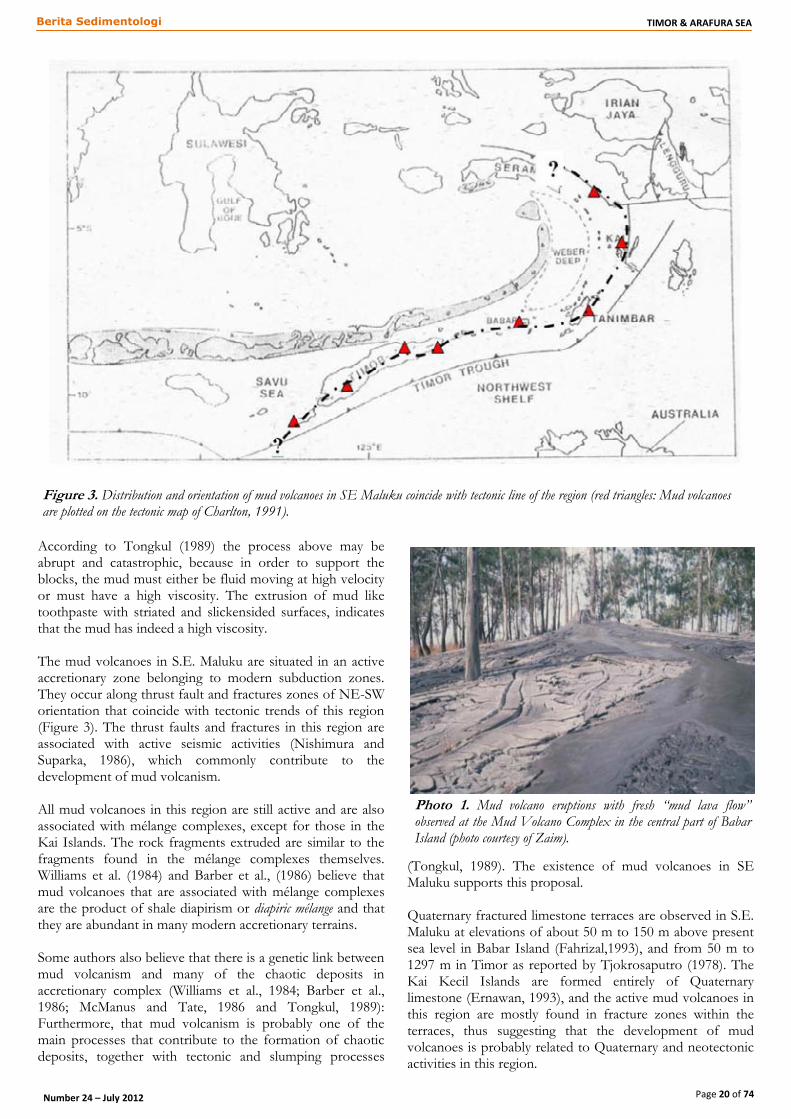
According to Tongkul (1989) the process above may be abrupt and catastrophic, because in order to support the blocks, the mud must either be fluid moving at high velocity or must have a high viscosity. The extrusion of mud like toothpaste with striated and slickensided surfaces, indicates that the mud has indeed a high viscosity. The mud volcanoes in S.E. Maluku are situated in an active accretionary zone belonging to modern subduction zones. They occur along thrust fault and fractures zones of NE-SW orientation that coincide with tectonic trends of this region (Figure 3). The thrust faults and fractures in this region are associated with active seismic activities (Nishimura and Suparka, 1986), which commonly contribute to the development of mud volcanism. All mud volcanoes in this region are still active and are also associated with mélange complexes, except for those in the Kai Islands. The rock fragments extruded are similar to the fragments found in the mélange complexes themselves. Williams et al. (1984) and Barber et al., (1986) believe that mud volcanoes that are associated with mélange complexes are the product of shale diapirism or diapiric mélange and that they are abundant in many modern accretionary terrains. Some authors also believe that there is a genetic link between mud volcanism and many of the chaotic deposits in accretionary complex (Williams et al., 1984; Barber et al., 1986; McManus and Tate, 1986 and Tongkul, 1989): Furthermore, that mud volcanism is probably one of the main processes that contribute to the formation of chaotic deposits, together with tectonic and slumping processes
(Tongkul, 1989). The existence of mud volcanoes in SE Maluku supports this proposal. Quaternary fractured limestone terraces are observed in S.E. Maluku at elevations of about 50 m to 150 m above present sea level in Babar Island (Fahrizal,1993), and from 50 m to 1297 m in Timor as reported by Tjokrosaputro (1978). The Kai Kecil Islands are formed entirely of Quaternary limestone (Ernawan, 1993), and the active mud volcanoes in this region are mostly found in fracture zones within the terraces, thus suggesting that the development of mud volcanoes is probably related to Quaternary and neotectonic activities in this region.
Figure 3. Distribution and orientation of mud volcanoes in SE Maluku coincide with tectonic line of the region (red triangles: Mud volcanoes are plotted on the tectonic map of Charlton, 1991).
Photo 1. Mud volcano eruptions with fresh “mud lava flow” observed at the Mud Volcano Complex in the central part of Babar Island (photo courtesy of Zaim).

Page 21 of 74
TIMOR & ARAFURA SEA Berita Sedimentologi
Number 24 – July 2012
Photo 2. Left: fresh “mud lava”. Right: semi-dry mud that formed “ropy-mud lava”. Location: Mud Volcano Complex, central part of the
Babar Island (photo courtesy of Zaim).
Photo 3. Top: other mud
volcano eruptions with fresh
“mud lava flow”. Bottom
left: cone structure that
contains gravel-size rock
fragments and Ammonite
and Belemnite fossils.
Bottom right: active bubble
gases. Location: Mud
Volcano Complex, central
part of the Babar Island
(photo courtesy of Zaim).

Page 22 of 74
TIMOR & ARAFURA SEA Berita Sedimentologi
Number 24 – July 2012
Photo 4. Top - Fractures pattern seen in the Mud Volcano Complex. Bottom - Large block (+ 1.5m in diameter) of turbiditic calcareous sandstones found in the Mud Volcano complex (photo courtesy of Zaim).
Photo 5. Mud volcano found in the Liek Island showing active bubble gases. Location: Kei Kecil Islands (photo courtesy of Zaim).
Photo 7. Mud volcano complex found in the Wahru Island, Kei Kecil Islands. Local witness stated that the large blocks seen in the photo were erupted in 1981 (photo courtesy of Zaim).
Photo 8. A large block (+ 4m in diameter) of calcareous sandstones was erupted in 1981. Location: Wahru Island, Kei Kecil Islands (photo courtesy of Zaim).
Photo 6. Circular fractures as a trace of (dried-up) mud volcano activities found in the Ut Island. Location: Kei Kecil Islands (photo courtesy of Zaim).

Page 23 of 74
TIMOR & ARAFURA SEA Berita Sedimentologi
Number 24 – July 2012
Conclusion The origin of active mud volcanoes in Babar, Tanimbar and Kei Islands as well as Timor Island, S.E. Maluku can be related to the geology and tectonics of this region. The association of mud volcanoes with thrust faults and fractured zones indicates that their development in this region is due to liquefied shale which extruded along such zones. The different type and age of rock fragments ejected by mud indicate that the volcanism passed through a number of stratigraphic sequences. The association of mud volcanoes with mélange complexes and the fractures in Quaternary limestone terraces indicates that the formation and development of mud volcanoes is related to active tectonic activities of this region and suggests that the mud volcanism is probably one of the main processes to the formation of chaotic deposits in the Quaternary in SE Maluku.
Acknowledgement This paper is based on data collected during October–December 1991, when the first author was the fieldwork supervisor of Fachrizal and Budi Ernawan (second and third authors, respectively) – then students in the Department of Geology ITB – for their B.Sc (Hons.) theses in Babar, Tanimbar and the Kei Islands. The data have never been published in any journal, except in an abstract that has been presented as an oral presentation by the first author in the International Symposium on Geology and Environment, Chiang Mai, Thailand on the 31st of January to the 2nd of February 1996. The authors’ fieldwork was sponsored by Union Texas SEA, therefore we would like to thank them for their financial assistance during the field geological study as well as fund for laboratory analyses.
References Achdan, A. and T. Turkandi, 1981. Peta Geologi Lembar Kai
(Tayandu dan Tual), Maluku (Skala 1:250.000). Arsip Terbuka, Pusat Penelitian dan Pengembangan Geologi, Bandung.
Barber, A.J., S. Tjokrosaputro and T. R. Charlton, 1986. Mud volcanoes, Shale Diapirs, Wrench Faults, and Melanges in Accretionary Complexes, Eastern Indonesia. AAPG Bulletin, vol 70, No. 11, p. 1729 – 1741.
Charlton, T. R., 1991. Post collision extension in arc-continent collision zones. Eastern Indonesia. Geology, vol.19,p. 28 – 31.
Charlton, T.R., 1992. Structure and Petroleum Potential of the Banda Forearc, Eastern Indonesia. Symposium of Eastern Indonesia Region, Pertamina.
Ernawan, B., 1993. Geologi Daerah Arma dan Sekitarnya, Pulau Yamdena, Kecamatan Tanimbar Utara, serta Studi Gunungapi Lumpur di Kepulauan Tanimbar dan Kei, Kabupaten Maluku Tenggara, Propinsi Maluku. Skripsi Sarjana Geologi FTM – ITB (unpublished)
Fahrizal, 1993. Geologi dan Stratigrafi Daerah Tepa dan Sekitarnya, P. Babar, Kabupaten Maluku Tenggara, Propinsi Maluku. Skripsi Sarjana Jurusn Teknik Geologi FTM – ITB (unpublished)
Harun, S., 1984. Geologi Kepulauan Kei Besar Bagian Selatan, Kecamatan Kei Besar, Maluku Tenggara. Skripsi Sarjana Jurusn Teknik Geologi FTM – ITB (unpublished)
Hedberg, H. D., 1980. Methane generation and petroleum migration. In: Problem in Petroleum Migration, W. H. Roberts III and R. J. Cordell (Eds.). AAPG Studies in Geology 10, p. 179 – 206.
McManus, J. and R. B. Tate, 1986. Mud volcanoes and the Origin of Certain Chaotic Deposits in Sabah, East Malaysia. GEOSEA V Proceedings V.1, Geol.Soc. Malaysia Bull. 19,P. 193 – 205.
Nishimura, S. and S. Suparka, 1986. Tectonic Development of East Indonesia. Journal of SE Asian Earth Sciences, vol. 1. No.1.,p. 45 – 57.
Ridd, M.F., 1970. Mud Volcanoes in New Zealand. AAPG Bulletin, vol.54, No.4, p. 601 – 616.
Rosidi, H.M.D., K. Suwitodirdjo and S.Tjokrosaputro, 1981. Geological Map of the Kupang – Atambua Quadrangles, Timor: Bandung GRDC, Scale 1: 250.000.
Tjokrosaputro, S., 1978. Holocene Tectonics on Timor Island, Indonesia. Bulletin of Geological Research and Development Centre, vol.4, p. 48 – 63.
Tongkul, F., 1989. Geological Control on the birth of the Pulau Batu Hairan Mud Volcano, Kudat, Sabah. Warta Geologi, vol.14, No.4, p. 153 – 165.
Westbrook, G. K. and M. J. Smith, 1983. Long decollements and mud volcanoes: evidence from the Barbados Ridge Complex for the role of high pore fluid pressure in the development of accretionary complex. Geology, 11, p. 279 – 283.
Williams, P. R., C. J. Pigram, D. B. Dow and Amiruddin, 1984. Melange production and the importance of shale diapirism in accretionary terrains. Nature, vol. 309, p. 145 – 146.
Zaim, Y., 1996. Mud Volcanoes in SE-Maluku: Their significance to Neotectonic in East Indonesia (Abstract). Oral presentation delivered in International Symposium on Geology and Environment, Chiang Mai – Thailand, 31 January-2 February 1996.

Page 24 of 74
TIMOR & ARAFURA SEA Berita Sedimentologi
Number 24 – July 2012
Ophiolite obduction on Leti Island, as described
by Molengraaff and Brouwer (1915):
implications for age and genesis of
metamorphic complexes in the Outer Banda
Arc, Eastern Indonesia
J.T. van Gorsel Houston, Texas, USA Corresponding Author: [email protected]
Abstract Geology, rocks and fossils of Leti Island, NE of Timor, were described in great detail by Molengraaff et al. (1915). Folded Early-Middle Permian sediments and basic volcanics in the south of the island gradually become low-grade metamorphics to the North, with further increases in metamorphic grade towards a serpentinite massif in the north of the island. In today's plate tectonic terms this may be characterized as 'ophiolite obduction', i.e. metamorphism of continental crustal material in a subduction zone. The serpentinite massif is overlain by Latest Oligocene shallow marine limestone with reworked clasts and detritus of serpentinite and metamorphic rocks. These observations suggest that the age of the metamorphic-ophiolite complex on Leti island is post-Early Permian (and is therefore not Australian continental crust basement) and younger than latest Oligocene (i.e. too old to represent metamorphism connected with the Late Neogene Banda arc- NW Australian continent collision). Metamorphic complexes on nearby Timor and on small islands to the East may all have a similar origin, despite the
wide range of published radiometric ages and proposed tectonic models (from Precambrian Australian continental basement to 'the world's youngest blueschist belt'). Many complexes are associated with ophiolitic rocks, overlie imbricated Permian-Triassic sediments and are overlain by an Upper Cretaceous- Lower Miocene 'Banda Terrane' succession (not always complete) that includes tropical carbonates, arc volcanics and unconformities, very similar to that of the Sundaland margin. These broad similarities suggest all or most of the metamorphic complexes may be parts of a single 'Timor-Tanimbar' metamorphic belt of Cretaceous age. If this interpretation of a single, extensive Cretaceous-age collisional/ subduction zone complex is correct, it follows that (1) this could not have taken place along the NW Australia passive margin, where it is today, and (2) if Permian-Triassic sediments and volcanics are indeed the protoliths of all metamorphic complexes, a microplate carrying these 'Gondwana sequence' sediments must already have separated from the Gondwana margin, probably in Jurassic time. This leads us back to the tectonic scenario that was prevalent around 1980 (Barber (1978, 1981, etc.), which
Figure 1. View of north coast of Leti Island, showing village of Serwaru. Hills in foreground are composed of serpentinite. Larger hills in
distance are metamorphic rocks.

Page 25 of 74
TIMOR & ARAFURA SEA Berita Sedimentologi
Number 24 – July 2012
shows most of Timor as a microcontinental sliver that rifted off the Sundaland margin in the Tertiary (should be ~Late Miocene-Pliocene time) during slab rollback/ arc splitting that opened the South Banda Sea. It returned microcontinental material that had rifted off the Gondwana margin in the Jurassic ('Gondwana sequence'), then collided with the Sundaland margin in the Cretaceous, after which it developed its overprint of Late Cretaceous- Early Miocene arc volcanics, tropical carbonates, etc..
Introduction As part of the 'Netherlands Timor Expedition 1910-1912' project professor G.A.F. Molengraaff from Delft University and his former Ph.D. student H.A. Brouwer (at that time with the Bandung Netherlands Indies Geological Survey; 'Dienst Mijnwezen'), spent one month in early 1911 surveying and mapping the island of Leti, NE of Timor. Their map and the accompanying 220-page documentation report published in the 'Jaarboek van het Mijnwezen' series are still the most detailed documentation of the surface geology and fossils of Leti Island.
For many years the monograph of Molengraaff and Brouwer (1915) was the only documentation of the geology of Leti. The 1:250,000 scale GRDC (1994) map sheet that includes Leti Island did not preserve much of the detail of the 1915 work. Recently a series of papers on the 'Timor-Tanimbar ophiolite' by a Japanese-Indonesian group provided additional detail on the Leti metamorphics and ophiolites and their genesis and exhumation history (Kaneko et al. 2007, etc.). Remarkably, the Molengraaff et al. (1915) book is rarely mentioned in reviews of the geology of the region. Since their field observations, the accompanying rock and fossil studies and conclusions still have important implications for the geological history of the region it was decided to republish some of their work almost 100 years later and place them in a modern context. Digital copies of the 1915 book (without the atlas) can be viewed/ downloaded online at: http://openlibrary.org/books/OL24343736M/Nederlandsche_Timor-expeditie_1910-1912, or at: http://archive.org/details/nederlandschetim00mole. The geologic maps and cross-sections from the accompanying Atlas can be viewed/ downloaded at: www.vangorselslist.com/gallery.
Figure 2. Location of Leti Island, E of Timor, and the Outer Banda Arc zone with metamorphic-ophiolite complexes (from
Kadarusman et al. 2003).

Page 26 of 74
TIMOR & ARAFURA SEA Berita Sedimentologi
Number 24 – July 2012
Geology of Leti Island Leti is a relatively small island (16 x 7.5 km), located about 40 km ENE of Timor Leste (Figure 2). Its geology is clearly an eastern continuation of that of NE Timor. As already noted by Wichmann (1892), it is part of a belt with a rock association of highly deformed Permian- Cretaceous sediments, crystalline schists and ophiolites, which stretches from Roti, Timor and Kisar in the west towards Moa, Sermata, Dai, Babar, Laibobar and Kur in the East, and possibly continuing to Seram and Buru. It is the inner zone of the 'non-volcanic Outer Banda Arc' (Figure 2). The following rock units were mapped on Leti island by Molengraaff and Brouwer (1915) (Figures 3, 4): 1. Southern zone of unaltered Permian sediments (olive green on map) This zone is composed of intensely folded, but non-metamorphic Permian clastic sediments (greywacke sandstone, shale) with thin limestones with brachiopods, crinoids, ammonites and fusulinid foraminifera and basic volcanics. Beds invariably dip steeply to the North. It is believed to be a thick section (estimated at possibly 2000m, but hard to measure because of probable repeated sections and instances of isoclinal folding). Molengraaff and Brouwer (1915, p. 24-25) noted that these rocks are very similar to Permian clastics with basic basalts and tuffs between Sufa and Maubisse, in what was then Portuguese Timor.
On nearby Timor Island the sediments described here would be assigned to the Atahoc/Cribas or Kekneno Groups (where clastics-dominated) and the Maubisse or Sonnebait Formations (where dominated by limestones, tuffs and pillow basalts). It is part of what is commonly referred to as 'Para-autochtonous' or 'Gondwana sequence'. 2. Central zone of metasediments (light orange) The central E-W trending zone of Leti island is composed of low-grade meta-sediments: phyllites, quartzites and schistose limestone. The limestones still have recognizable crinoid stems, demonstrating that these are metamorphosed Permian sediments. 3. Northern zone of high-grade metamorphics (pink) High-grade metamorphics: amphibolites, schists, gneiss, etc.. Contacts between 1-2 and 2-3 are described as gradual, suggesting a simple, overall gradual increase in metamorphism in Northern direction of original Permian sediments and volcanics. Kadarusman et al. (2010) noted common 'blueschist' metamorphic facies and estimated a maximum burial depth of 30-35 km. This formation is probably equivalent of the 'Aileu Formation' of northern Timor Leste. 4. Serpentinite complex in North (light green) Two large bodies of serpentinite outcrop in the North of Leti Island in an area of about 2 x 2km, forming the Javanoea and Emderi hills.
Figure 3. Geologic map of Leti Island, showing unaltered Permian sediments in South (olive color), grading to high-grade metamorphics
in North (pink), overlain by serpentinite (light green). Original map scale is 1:25,000. Length of island ~16 km, width ~7.5 km
(Molengraaff and Brouwer, 1915).

Page 27 of 74
TIMOR & ARAFURA SEA Berita Sedimentologi
Number 24 – July 2012
These rocks were interpreted by Molengraaff and Brouwer (1915) as serpentinized peridotite/ lherzolite. They struggled with the interpretation of structural relationships and the contact between the ultramafic complex and the metamorphics, whether it is an intrusive body in the Permian section, or, more what it looks like in the field, a relatively flat-lying body that that overlies the metamorphosed Permian (see below). 5. Latest Oligocene 'Cablac' reefal limestone and polymict carbonate breccia Scattered all over the serpentinites of the Javanoea- Manoepoera hills in Northern Leti are blocks of different rock types, dominated by latest Oligocene shallow marine limestone and breccias (Figure 4). They mostly occur as loose blocks, but in places they look like poorly bedded, slightly North-dipping, in-situ outcrop (Molengraaff 1915, p. 73). The limestone matrix contains the larger foraminifera Lepidocyclina, Spiroclypeus margaritatus and Miogypsinoides complanata. This assemblage was originally assigned an Early Miocene age by Schubert (1915), but is clearly in larger foram subzone Te4, which in modern calibrations is placed in the Latest Oligocene. The Leti limestone/ limestone breccia contains reworked clasts of older rocks, including
serpentinite, schist, radiolarian chert and Upper Cretaceous pelagic limestone. These limestones on Leti were already compared to a polymict conglomeratic limestone overlying metamorphic rocks of the Lalan Asu metamorphic complex in West Timor by Tappenbeck (1939). It also contains reworked clasts of metamorphics and contains the Te4 index fossil Miogypsinoides complanata (Marks 1954). Similar Te reefal-conglomeratic limestones with metamorphic detritus was also found at other metamorphic complexes on West Timor, like Boi (Tappenbeck 1939), Miomaffo (Van West, 1941), Mosu- Nefoneu (Van Voorthuysen, 1940), Usu, etc. (see also Haig et al., 2008). Very similar limestone with basal polymict conglomerates was found across East Timor. It was named 'Cablac Limestone' by Audley Charles (1968) and was also reported by other authors, including Harris (2006; Mata Bia massif). It contains the same latest Oligocene zone Te4 larger foram assemblages, but may range into earliest Miocene. There is some controversy about the use of the name Cablac for this limestone, as Haig et al. (2008) questioned its presence at Mount Cablac, and proposed the informal name Booi Limestone.
Figure 4. Detail map of Javanoea and Manoepoera hills, North Leti, showing localities of polymict 'block-cover' (+++) over serpentinite
(light green). Other lithologies: amphibolite (pink), Pliocene reef limestone (orange) and Pleistocene fringing terraces (yellow) (Molengraaff
and Brouwer 1915).

Page 28 of 74
TIMOR & ARAFURA SEA Berita Sedimentologi
Number 24 – July 2012
'Cablac Limestone' is generally regarded as part of the 'allochthonous', 'Banda Terrane' complex. Its main significance is that there is common latest Oligocene conglomeratic limestone on Timor that rests unconformably on multiple older formations and contains reworked Triassic, Cretaceous and Eocene sediments and Oligocene volcanics. On Leti an apparently equivalent conglomeratic limestone suggests that serpentinite, metamorphics and other Late Paleozoic- Mesozoic sedimentary formation were also exposed and eroded here at the end of the Oligocene. If this formation is indeed equivalent of the Timor 'Cablac-Booi', the Leti metamorphic-ophiolite complex may share a common mid-Tertiary history with 'Banda Terrane' of the Mutis complexes and may be more closely related to this group than is generally accepted. 6. Miscellaneous blocks in 'Block fields' The Javanoea and Manoepoera hills in the North of Leti Island are composed of serpentinite and are overlain by numerous large and small blocks of a different rock types
(Figure 4). These may be reworked from formerly nearby outcrops during a time of major erosion, or they may be equivalent of the widespread 'Bobanaro' olistostrome/ mélange' of Timor. Rock types include (1) metamorphic rocks (amphibolite, schist, etc.), (2) igneous rocks, including andesitic volcanics (not observed elsewhere else on Leti island), (3) rare Permian crinoidal limestone and limestone with fusulinid larger foraminifera, (4) radiolarian limestone (believed to be of Triassic and Jurassic age by Molengraaff et al. (1915), but ages were not confirmed biostratigraphically (radiolarites also occur in Upper Cretaceous of the Banda Terrane of Timor), (5) Triassic Halobia (pelagic bivalve) limestone and (6) Upper Cretaceous pelagic limestone with Globotruncana cf. linneana, as clasts in Late Oligocene limestone and as isolated blocks. 7. Fringe of Plio-Pleistocene uplifted reefal limestones (orange and yellow)
Figure 5. Diagrammatic NNE-SSW cross section C-D across Leti Island by Molengraaff and Brouwer (1915). Showing mostly
North-dipping (but probably imbricated and isoclinally folded) Permian sediments in South (right), grading into metasediments in center of
section to high-grade metamorphics in the North (left). Length of section is about 7 km.
Figure 6. Diagrammatic NNE-SSW cross section A-B across Leti Island by Molengraaff and Brouwer (1915). Similar to section C-
D. Here showing serpentinitites (green; in NNE) as intrusive bodies, a model-driven interpretation not supported by outcrop observations.
Length of section is about 10 km.
Figure 7. Alternative, preferred diagrammatic NE-SW cross-section across North part of Leti island by Molengraaff and Brouwer (1915), showing serpentinites as a flat-lying unit over steeply-dipping metamorphic rocks.

Page 29 of 74
TIMOR & ARAFURA SEA Berita Sedimentologi
Number 24 – July 2012
The entire island of Leti is surrounded by two or more terraces of Pleistocene reefal limestone, at about 10 and 20m above sea level (yellow on map of Figure 3). Remnants of older terraces (orange on Figure 3), believed to be of Pliocene age by Molengraaff et al. (1915), were observed up to 134m above sea level. Leti has fewer reef terraces than Timor island, which were also not uplifted as high (Timor Pleistocene terraces present until ~1200m above sea level).
Outcrop Relations between Metamorphic Rocks and Serpentinite Molengraaff and Brouwer (1915) struggled with the nature of the contact between the serpentinite and metamorphics. Clear contacts between the two units were not seen in outcrop. There was little doubt in their minds that the metamorphism was the result of contact with younger hot ultrabasic igneous rocks, so in their 'official' interpretive cross-section they show the serpentinites as intrusive bodies (Figure 6). However, in their discussion Molengraaff and Brouwer (1915, p. 24-26) emphasize that on Leti the serpentinites are restricted to the hills, with amphibolite/ schist in intervening saddles, making it look like a relatively flat-lying unit over the metamorphics (as depicted in their alternative, preferred model; Figure 7).
Geology of Leti Island: Example of 'Ophiolite
Obduction'? The mapping and outcrop observations of Molengraaff and Brouwer (1915) clearly support a genetic relationship between the Leti metamorphic complex and the overlying serpentinite/ophiolite complex. In plate tectonic terms this pairing is often interpreted as 'ophiolite obduction'. This does not really mean overthrusting of mantle-type rock over other units. It is the result of sinking of continental crustal material into a subduction zone, dragged down by an attached downgoing oceanic plate to depths of ~35 km and more, until the relative buoyancy of the volume of continental slab material prevents further sinking. The downgoing oceanic slab will continue to sink, breaks off, and the buoyant continental material is released/ exhumed back towards to surface. The now metamorphosed exhumed continental material often comes back with parts of the overlying ultramafic mantle wedge, with which it has been in contact (see e.g. Figure 8). Such ultramafic material is often serpentinized, carries evidence of hyperextension, but is not always preserved after exhumation of the metamorphic rocks. Because the downgoing slab is relatively cold, metamorphism in this subduction scenario is mainly 'High
Figure 8. N-S diagrammatic cross-section across Outer Banda Arc zone, showing uplift and exhumation of metamorphic-ophiolite
complex after slab break-off (from Ernst et al. 1997). This Figureure illustrates the process, not necessarily the location at which
subduction-exhumation of Leti- Timor complexes took place (more likely at Sundaland margin; see text).

Page 30 of 74
TIMOR & ARAFURA SEA Berita Sedimentologi
Number 24 – July 2012
Pressure - Low Temperature' metamorphism ('blueschist facies'). During exhumation this is commonly overprinted by lower pressure-temperature ('greenschist facies') metamorphism. This presence of 'blueschist' metamorphic facies was confirmed recently for the Leti metamorphics by Kaneko et al. (2007) and Kadarusman et al. (2010). The close relationship between ophiolite complexes and metamorphic rocks has been noted at many other localities on Timor and other islands along the Outer Banda Arc, with ophiolites generally observed to be overlying the metamorphics (e.g. Kadarusman et al., 2003, Ernst et al. 2007). Kadarusman et al. (2003) characterized the Timor-Tanimbar metamorphic/ophiolite belt as up to 2 km thick, 50 km wide and extending laterally for more than 1000 km. The first author to interpret the formation of metamorphic complexes on Timor as a result of hot ophiolite emplacement was Sopaheluwakan (1989, 1990, 1991; Mutis and Miomaffo complexes, W Timor), observing a systematic decrease in metamorphic grades away from the peridotite from amphibolite to greenschist facies. Ophiolite obduction was also invoked for Aileu complex metamorphism below the Atapupu peridotite of northern Timor and for the Kaibobo complex of Seram (Helmers et al., 1989). Earle (1981) observed an inverted metamorphic gradient in the Boi and Mollo massifs of West Timor and noted that the Boi massif was overlain by altered mantle peridotite. However,
Harris and Long (2000) argued against obduction of ophiolite as a cause of metamorphism on Timor. Kaneko et al. (2007) and Kadarusman et al. (2010) also interpreted the geology of Leti as metamorphism related to subduction, followed by exhumation and uplift. However, instead of the gradual, transitional contacts between metamorphic grades described by Molengraaff and Brouwer (1915), they observed normal fault contacts between the metamorphics and overlying ultramafic rocks and a reverse fault zone between the metamorphics and underlying unmetamorphosed Permian sediments. These are probably complexities related to the exhumation process, but do not change the overall 'obduction' concept.
Age of Leti Island Metamorphics The field observations of Molengraaff and Brouwer (1915) provide stratigraphic constraints on the age of metamorphic rocks of northern Leti Island, which suggest that this complex is too young to be a fragment of (Precambrian) NW Australian continental margin crust, and too old to be part of the ongoing Banda Arc- NW Australian continental margin collision: (1) Metamorphism is of post- Early Permian age, because
Early Permian rocks are altered by metamorphism; (2) The metamorphic-ophiolite complex of Leti was
exhumed before the end of the Oligocene (~24 Ma), as
Figure 9. Outline geological map of Timor, showing Lolotoi (includes Mutis) and Aileu metamorphic complexes (Barber, Audley Charles and Carter, 1977). Blue color is undisputed NW Australian margin cover, now in accretionary complex; yellow is overriding fore-arc plate, most recently from Sundaland.

Page 31 of 74
TIMOR & ARAFURA SEA Berita Sedimentologi
Number 24 – July 2012
demonstrated by reworked serpentinite and schist fragments in overlying conglomeratic reefal limestone with latest Oligocene larger foraminifera (see above).
An 11.0 Ma K-Ar radiometric age was reported for pelitic schist from Leti Island (Kaneko et al. 2007, Kadarusman et al. 2010). This is much younger than the minimum age of ~24 Ma suggested by the eroded serpentinite and metamorphic detritus. It is one of many radiometric ages in the Timor region that appear to be too young when compared to observed stratigraphic constraints and may reflect younger exhumation ages or thermal resets during later volcanic episodes (see below). Their conclusion that the Leti metamorphics are part of the 'world's youngest blueschist belt' may therefore need to be confirmed. Below we argue that the age of metamorphism on Leti and in similar complexes on Timor is probably Cretaceous.
Relation to Metamorphic Complexes of Timor As noted above, a series of similar metamorphic complexes associated with mafic/ultramafic bodies are exposed from Timor and Kisar to Leti and smaller islands to the East, and form parts of the 'Timor-Tanimbar ophiolite' belt of Ishikawa et al. (2007). About 15 metamorphic rock complexes have been identified on Timor (Figure 9). There continues to be considerable debate on whether these are all of similar age and origin, or whether there are multiple types. The main hypothesis in this paper is that they are all related. Charlton (2002) distinguished three categories of metamorphic complexes on Timor: (1) Aileu Complex of NE Timor: believed to be a young
metamorphic series with an inverted metamorphic gradient developed beneath overthrust allochthonous peridotite;
(2) Mutis Complex of West Timor: allochthonous metamorphic basement from the Banda forearc;
(3) Lolotoi- Laclubar and other complexes of Timor Leste: Australian continental basement crust.
1. Aileu Complex, NE Timor The 'Aileu Complex' of northern Timor Leste around Dili appears to be very similar to the metamorphic-ophiolite complex of Leti Island. It also features a gradual SW to NE increase in metamorphism of Permian shales, sandstones, limestones and basalts towards a metamorphic- ophiolite complex. The metamorphic complex is mainly slate in the south and higher grade mica schists, marbles and hornblende schists/ amphibolite near the north coast. Metamorphics are overlain by the Hili Manu ophiolite complex (Barber and Audley Charles 1976, Barber et al. 1977, Berry and Grady 1981, Berry and McDougall 1986, Harris and Long 1990, Charlton 2002, Bachri 2004, etc.). Brunnschweiler (1978) and Bachri (2004) observed that Triassic-Late Jurassic sediments were probably also involved in metamorphism of the Aileu complex, suggesting a post-Jurassic age of metamorphism. Most radiometric ages from the 'Aileu Complex' are relatively young, mainly between about 10 and 6 Ma, Late Miocene (Berry and McDougall 1986, Utoyo and Permanadewi 1994, Ely 2009, etc.). This is why it is
commonly viewed as metamorphism tied to the Banda Arc- NW Australia collision. However, if the Aileu and Leti metamorphic complexes are genetically related, as the basal parts of both complexes would suggest, these radiometric ages are 'too young' relative to ~24 Ma age of the limestones that overlie the Leti serpentinite. Berry and McDougall (1986) actually noticed a wide range in radiometric ages for the Aileu Complex, and concluded from hornblende Ar isotopes that the age of prograde metamorphism was at least 70 Ma (Cretaceous), with a reheating event at ~8- 5 Ma. We therefore speculate that the generally quoted young ages may all be caused by a younger volcanic heating event (in this case the Ocussi Volcanics, dated at ~5 Ma). If (1) the proposed Cretaceous radiometric minimum age of principal metamorphism of the Aileu Complex is correct, and (2) the Aileu complex is indeed closely related to the Leti complex, and (3) the Leti complex can be tied to the 'Banda Terrane' via its Late Oligocene "Cablac' limestone/ unconformity, then the Aileu complex may be more closely related to the Mutis, Mollo and other Timor massifs than is generally accepted (see below). 2. Mutis Complex and Banda Terrane Scattered across Timor are a group of metamorphic complexes that are commonly viewed as part of the 'allochthonous/ SE Asia' 'Banda Terrane' (Barber et al. 1977, Earle 1979, Brown and Earle 1983, Audley-Charles and Harris 1990, Harris,1992) also called 'Schist-Palelo Complex' by Brouwer (1942) and his students. They are commonly viewed as remnants of a recently obducted terrane of Asian (Sundaland) origin. In addition to the large Mutis complex, smaller complexes in West Timor include Mollo, Miomaffo, Usu, Lalan Asu, Boi, Mosu, etc. The Lolotoi, Bebe Susu, Lachluta and Mata Bia complexes of Timor Leste may or may not be part of this same group (see below). Typical Banda Terrane consists of Early-Middle Cretaceous metamorphics (some associated with ophiolites), overlain by Late Cretaceous radiolarian chert, turbiditic sediments and arc volcanics, Middle Late Eocene reefal limestones (Dartollu Fm) and Late Eocene arc volcanics (Metan/Mosu/ Barique volcanics; ~35 Ma) and latest Oligocene- earliest Miocene reefal limestones (Cablac Fm). As noticed by numerous workers before, these rocks do not belong on the NW Australian passive margin, but are remarkably similar to the Cretaceous- Tertiary succession of West Sulawesi and Sumba, and should be viewed as part of Sundaland during Cretaceous- Miocene time and became part of the overriding Banda forearc plate during its collision with the Australian continental margin. A good indicator of a Cretaceous minimum age of metamorphism is shown by overlying sediments. The oldest rocks are Middle-Late Cretaceous clastics, locally with fragments of metamorphic rocks (Mollo Massif, Tappenbeck (1939), Miomaffo, Van West (1941) and Lalan Asu, De Waard (1954)). These are overlain by open marine Upper Cretaceous calcareous shales with volcanoclastic turbidites, much like West Sulawesi and Sumba. Other metamorphic massifs in both West and East Timor have less complete overlying 'Banda Terrane' sections, with Middle-Late Eocene

Page 32 of 74
TIMOR & ARAFURA SEA Berita Sedimentologi
Number 24 – July 2012
shallow marine with Nummulites-Alveolina-Pellatispira limestones or latest Oligocene- Early Miocene Cablac Limestone as oldest rocks. Radiometric ages of metamorphic rocks are highly variable. Some confirm the likely Mid- Cretaceous for peak metamorphism (Brown and Earle 1983, Booi massif, Sopaheluwakan 1990). Many others obtained Late Eocene radiometric ages. Sopaheluwakan (1990) suggested the 37 Ma radiometric age for the Mutis massif reflects a Late Eocene reheating event. There is indeed widespread Middle-Late Eocene arc volcanism associated with these terranes (Mosu, Barique, etc. volcanics). It is tempting to consider all other Eocene and younger radiometric ages as thermal resets as well (31-38 Ma for Mosu, Boi, Mollo, Mutis, Usu massifs (Harris, 2006); 45 Ma for Lolotoi massif (Standley and Harris, 2009), etc.) 3. Lolotoi - Lachlubar Complexes, Timor Leste Charlton (2002, 2012) interpreted the Lolotoi- Lachlubar and other complexes of Timor Leste as old, Australian continental basement crust, mainly based on interpretation of 'thick-skinned' steep faults bordering these massifs. Most other workers viewed the 'Lolotoi' metamorphic complexes as equivalents of the West Timor 'Mutis' complexes (among the latest Standley and Harris 2009, Audley Charles 2011). There are indeed many similarities between the Lolotoi massifs and 'true' Banda Terrane metamorphic massifs, including the presence of Eocene Alveolina-Nummulites-Pellatispira limestones on the Laclubar, Lolotoi and Bebe Susu massifs, Eocene and Miocene arc volcanics, etc.. As noted above, these rocks do not belong in a distal Australian NW shelf passive margin setting.
Metamorphic Complexes did fot form at NW
Australian Margin? As explained above, 'ophiolite obduction' takes place in a collisional (subduction zone) setting. If ages of metamorphism and exhumation of Leti-Timor metamorphic complexes are indeed Cretaceous, this cannot have formed at the NW Australian margin, because this was a pre-collisional passive margin, far away from a subduction zone, from the Paleozoic until the onset of Banda Arc collision in Late Miocene or Pliocene time. The more likely setting would be the margin of Sundaland, probably a southern extension of SW and SE Sulawesi. The Sundaland margin was dismembered in Late Miocene time during a process of arc splitting during slab rollback, which eventually led to the creation of the South Banda Sea oceanic basin. The dismembered pieces are now found from Sumba through Timor, Leti, W Tanimbar, possibly all the way to Seram and Buru (zone depicted in Figure 2). Elements of this history have already been incorporated in many of the proposed tectonic scenarios, including Barber (1978, 1981), Milsom (2000, 2001), Harris (2006), Villeneuve et al. (2010) and more recently also Spakman and Hall (2011).
Conclusions and Speculations 1. Old geological field surveys contain valuable information on Leti island geology The well-documented geological survey work on Leti Island by Molengraaff and Brouwer in 1911 provides: (1) significant observations on the relationships between metamorphic rocks and their underlying sediments and overlying ophiolite complexes, and (2) ages of sediments underlying and overlying the metamorphic-ophiolite complex, which demonstrate that the age of metamorphism was between Permian and latest Oligocene. This means that the metamorphic complex on Leti neither represents (Precambrian) Australian continental margin continental crust, nor is it related to the ongoing collision between the Banda Arc and the Australian NW Shelf margin, which probably did not start before ~3-4 Ma. 2. Documentation of relationship between metamorphism and ophiolites on Leti Island On Timor Island the close association between ophiolites and crystalline schists had been noticed by many authors (e.g. Brouwer 1942). The rock assemblages described on Leti, where ophiolites overlie high-grade metamorphics which grade downward into unaltered sediments, can be interpreted as an example of 'ophiolite obduction', or, better, partial subduction of originally Gondwanan or Australian continental crust, followed by buoyancy-driven slab breakoff and exhumation. This model also appears to be suitable for most or all of the metamorphic complexes in the 'Timor-Tanimbar' metamorphics and ophiolite belt (e.g. Kaneko et al. 2007). 3. Similarities between metamorphic complexes of Timor and Leti Despite widely varying radiometric ages and differences in interpretations of metamorphic complexes between 'schools', there are remarkable similarities in underlying ('Gondwana Sequence' Permian-Triassic at Aileu, Leti, Mutis, Miomaffo, Mollo, etc.) and overlying formations (complete or partial Upper Cretaceous- Miocene 'Banda Terrane' succession). A possibly simplistic, but tempting conclusion from this is that perhaps all metamorphic complexes of the Timor-Leti-Tanimbar belt are parts of the same collisional event, with mid-Cretaceous as the most likely age of peak metamorphism. 4. Age of Banda Arc- NW Australian margin collision Latest Miocene- Early Pliocene 'Batu Putih-Viqueque Formations' pelagic marls and chalks are widespread across Timor. The rich foraminiferal assemblages show that probably all of Timor was under 500-2500m of water at that time (De Smet et al. 1990, Van Marle 1991, Roosmawati and Harris 2009, Haig 2012). It also means that the Timor area had subsided significantly since Early-Middle Miocene and was tectonically very quiet between ~6 Ma and 3.5 Ma. One obvious explanation is that this regional subsidence is associated with the rifting at the Sundaland margin and opening/spreading of the oceanic South Banda Sea, which that led to the transfer of the Sumba-Timor, etc. sliver from the Sundaland margin to the NW Australia collision zone.

Page 33 of 74
TIMOR & ARAFURA SEA Berita Sedimentologi
Number 24 – July 2012
Significant uplift, with evidence of emergence of parts of Timor above sea level is shown by the appearance of turbiditic, volcanoclastic sands and conglomerates above the Batu Putih marls, starting only about 3-4 million years ago (3.3 Ma; Haig 2012). The uplift process still continues today. One could therefore argue that all compressional tectonic events older than ~3-4 Ma must predate the Banda Arc- NW Australia collision and therefore probably took someplace away from the NW Australian continental margin. 5. 'Gondwana sequence': how Australian is it really? Folded Permian-Triassic 'flysch-type' clastic sediments, often associated with Permian crinoidal and fusulinid limestones and pillow basalts, are widespread in the topographically and structurally lower parts of Timor and also on southern Leti Island (see above). This sequence has been referred to as 'Gondwana (Mega-) sequence' or 'Kekneno series' or '(para-) autochthonous unit'. Many authors today take it for granted that these deposits formed more or less in their present-day position off NW Australia, in an intra-continental rift setting, prior to the Jurassic separation of 'Argoland' (e.g. Charlton op. div., Keep and Haig 2010). However, there are significant differences between the Permian-Triassic sediments of Timor and equivalent sediments of the NW Shelf. Whilst paleogeographic scenarios can be drawn to explain these differences (e.g. Charlton 2002, 2012), it is equally conceivable that the Timor 'Gondwana Sequence' is part of a microplate that rifted off some other part of the Gondwana margin, possibly closer to Papua New Guinea, which collided with the Sundaland margin in the Cretaceous and is now part of the Banda forearc complex (see tectonic history below). Provenance studies of Permian- Triassic sandstones do not support a link between the Timor immature, proximal sandstones (derived from metamorphic- volcanic sources to N or NE) and the Australian NW margin (more mature, quartz-rich sediments) (Bird and Cook, 1991). Detrital zircon age peaks are also dissimilar. Age peaks from the Timor Aileu Complex are similar to those from the 'Gondwana sequence' of Savu, but neither of them matches populations from NW Australia; they show closer ties to populations from the East Australia New England foldbelt or even East Malaya (Ely, 2009). Finally, as observed by paleontologists for over 100 years, Permian-Triassic macro- and microfaunal assemblages of Timor 'Gondwana sequence' tend to be of higher diversity and reflect lower paleolatitude positions than their nearby NW Australia counterparts. These have therefore been viewed as 'exotic' or 'Asian' for a long time and authors have prefered to place them farther away from Australia. 6. The Late Oligocene unconformity/uplift event on Timor and Leti Limestones with zone Te4 latest Oligocene larger foram assemblages overlie the serpentinites on Leti and contain
polymict conglomeratic interbeds with reworked metamorphics, serpentinite and Paleozoic- Mesozoic sediments (Molengraaff et al. 1915; see above). This occurrence on Leti is not well known, but is significant as it appears to be identical to 'Cablac/ Booi' Limestones, generally viewed as part of the allochthonous 'Banda Terrane'. The 'Cablac/Booi limestone' represents a latest Oligocene transgressive surface above an angular unconformity, usually above an Early-Middle Oligocene hiatus (Carter et al. 1976). This Oligocene-age uplift event apparently exposed and eroded all older formations, and overlying rocks are less deformed. For this reason the 'Base Cablac unconformity' was viewed as the principal deformation event on Timor by several authors (Tappenbeck 1939, Brouwer 1942, Gageonnet and Lemoine 1958, Reed et al. 1996, etc.). This Late Oligocene 'Cablac' event obviously pre-dates the Late Pliocene-Recent collision of the Banda Arc- Australian continental margin. It cannot be tied to events on the NW Australian passive margin, but a similar Oligocene angular unconformity/ hiatus was observed on Sumba, West Sulawesi, etc., which suggests it would fit well in a Sundaland margin setting. 7. Reliability of radiometric ages As discussed above, many of the radiometric ages of Timor-Leti metamorphics and ophiolites are in conflict with other age data, like ages of overlying or underlying biostratigraphically dated rocks. Radiometric ages are frequently 'too young' and may reflect thermal reactivation during younger volcanic events (mainly Late Eocene, Late Miocene- Early Pliocene), not age of main metamorphism. Interestingly, even if one has confidence in the 'young' radiometric ages, most of them probably are still too old to represent metamorphism or cooling associated with the ongoing Banda Arc- Australian NW margin collision, which started less than 3-4 million years ago. 8. Tectonic history of the Timor region: are the 'Gondwana Sequence', metamorphic-ophiolite complex and 'Banda Terrane' generations of one family? The complex geology around Timor Island has been subject of numerous interpretations and debates for over 100 years. Debates continue on how much of Timor is 'NW Australian' versus 'SE Asian', whether the dominant structural style is thrusting or block faulting, the timing of various tectonic events, etc. For listings of the numerous papers written on the subject see the Timor and East Indonesia chapters in the 'Bibliography of Indonesia Geology' (www.vangorselslist.com). A selection of recent papers will give a sense of continuing diverging opinions among different 'schools': Harris (2006, 2011), Charlton (2002, 2002b, 2009 and 2012, this journal), Audley Charles (2004, 2011), Keep and Haig (2009) and Villeneuve et al. (2004, 2005, 2010).

Page 34 of 74
TIMOR & ARAFURA SEA Berita Sedimentologi
Number 24 – July 2012
Most authors (1) recognize the 'Asian' nature of the 'Banda Terrane', (2) believe Banda Terrane to be thrust onto the NW Australian continental margin during the Late Miocene- present Banda Arc- NW Australian continent collision, and (3) assume that the low-lying, 'para-autochtonous'/ 'Gondwana mega-sequence' represents part of the Australian margin (Audley Charles, Charlton, Harris, Keep and Haig 2009, 2010, etc.). Inspired a.o. by the Molengraaff et al. (1915) observations from Leti, we like to argue that the tie between Timor- Leti metamorphics and the underlying 'Australia/Gondwana sequence' was cemented long before the Banda Arc collision, probably in early or middle Cretaceous, and probably along the Sundaland margin. Most metamorphic complexes are overlain by 'Sundaland' 'Banda Terrane' stratigraphy. If they are not separated by major thrusts (which are often inferred by authors, but can rarely
be observed due to inadequate outcrops), the Permian-Jurassic Gondwana sequence, Early Cretaceous metamorphic-ophiolite complex and Late Cretaceous-Miocene Banda Terrane all look like parts of one continuous genetic succession. This succession represents a tectonic history that is very similar to the scenario that was popular around 1980 (Figure 10) (Barber 1978, re-published in 1981, Earle 1979, 1981, Johnston 1981, Bowin et al. 1981), which shows separation of a sliver from the Gondwana margin in Late Jurassic time, collision of this block with Sundaland in Early Cretaceous, separation of this block (now called 'Lolotoi microcontinent') from the Sundaland margin in the Tertiary (should be Late Miocene-Pliocene; creating the South Banda Sea), and finally collision of this microplate with the Australian NW continental margin in the Latest Tertiary. Remnants of this Sundaland sliver are not only present on Timor and Leti, but also Sumba, Savu and numerous small islands in the inner part of the Outer Banda Arc (Figure 1). This 'Barber model' appears to have lost some popularity, but appears to be a good fit for many of the stratigraphic and paleobiogeographic relationships observed on Timor and Leti. Some of the 'French School' reconstructions are also close to this model (Villeneuve et al., 2010). This model resurrected here implies that most of the rocks exposed on Timor and Leti are part of the overriding Banda forearc plate, not recently thrusted slivers of Australian continental margin. The only true Australian continental margin sediments would be in the Kolbano- Ofu Complex of Jurassic-Tertiary sediments along the south coast of Timor and the adjacent offshore down to the Timor Trench (blue on Figure 9). These imbricated deep water sediments, scraped off the now-closed Indian Ocean floor and the most distal parts of the NW Australian continental margin, represent the Late Neogene accretionary complex. This structural model makes the drawing of a cross-section of the Banda Arc- NW Australia collision zone a lot simpler, as it does not require huge stacks of imbricated material to fill the space between the downgoing Australian plate and the mountains of Timor. Finally, the geology of Timor with its multiple compressional and extensional phases is very complex, and is hard to unravel as it is partly obscured by mud volcanoes, olistostromes, inadequate outcrops, etc. The model advocated here is strongly biased towards honoring stratigraphic relationships and unconformities that signify tectonic events. It is in conflict with some radiometric ages, and probably also with certain observed or inferred local structural relationships. However, for those viable alternative explanations can probably be found more easily. Interpretations will undoubtedly continue to evolve for many more years.
References Audley-Charles, M.G.,1968. The geology of Portuguese
Timor. Mem. Geol. Soc. London 4, p. 1-76.
Figure 10. Diagrammatic tectonic history of Timor, showing
break-up of continental fragment from Australian margin in Late
Jurassic, collision with Sundaland margin in Cretaceous,
separation in Tertiary and collision with Australia in Pliocene
(Barber 1978). This is an elegant way to 'marry' Permian-
Jurassic 'Gondwana Sequence', mid-Cretaceous Metamorphic-
Ophiolite Complexes' and Upper Cretaceous-Miocene 'Banda
Terrane' stratigraphy.

Page 35 of 74
TIMOR & ARAFURA SEA Berita Sedimentologi
Number 24 – July 2012
Audley-Charles, M.G., 2004. Ocean trench blocked and obliterated by Banda forearc collision with Australian proximal continental slope. Tectonophysics 389, 1-2, p. 65-79.
Audley-Charles, M.G., 2011. Tectonic post-collision processes in Timor. In: R. Hall et al. (eds.) The SE Asian gateway: history and tectonics of Australia-Asia collision, Geol. Soc. London, Spec. Publ. 355, p. 241-266.
Audley-Charles, M.G. & R. Harris, 1990. Allochtonous terranes of the Southwest Pacific and Indonesia. Philos. Trans. Royal Soc. London A331, p. 571-587.
Barber, A.J., 1978. Structural interpretations of the island of Timor, Eastern Indonesia. SEAPEX Proc. 4, Singapore 1977/78, p. 9-21.
Barber, A.J., 1981. Structural interpretations of the island of Timor, eastern Indonesia. In: A.J. Barber and S. Wiryosujono (eds.) The geology and tectonics of Eastern Indonesia, Geol. Res. Dev. Centre, Bandung, Spec. Publ. 2, Bandung, p. 183-197.
Barber, A.J. and M.G. Audley-Charles, 1976. The significance of the metamorphic rocks of Timor in the development of the Banda Arc, eastern Indonesia. Tectonophysics 30, p. 119-128.
Barber, A.J., M.G. Audley-Charles and D.J. Carter, 1977. Thrust tectonics in Timor. J. Geol. Soc. Australia 24, p. 51-62.
Berry, R.F. and A.E. Grady, 1981. Deformation and metamorphism of the Aileu Formation, North coast, East Timor and its tectonic significance. J. Struct. Geol. 3, p. 143-167.
Berry, R.F. and I. McDougall, 1986. Interpretation of 40Ar/39Ar and K/Ar dating evidence from the Aileu Formation, East Timor, Indonesia. Chemical Geol. 59, p. 43-58.
Bird, P.R. & S.E. Cook,1991. Permo-Triassic successions of the Kekneno area, West Timor: implications for palaeogeography and basin evolution. J. Southeast Asian Earth Sci. 6, 3-4, p. 359-371.
Bowin, C., G.M. Purdy, C. Johnston, G. Shor, L. Lawver, H.M.S. Hartono and P. Jezek, 1980. Arc-continent collision in Banda Sea region. Am. Assoc. Petrol. Geol. Bull. 64, p. 868-915.
Broili, F., 1915. Permische Brachiopoden der Insel Letti. Jaarboek Mijnwezen Nederl. Oost-Indie 43 (1914) Verhand. 1, p. 187-207.
Brouwer, H.A., 1915. Gesteenten van het eiland Letti. Nederlandsche Timor Expeditie, I, Jaarboek Mijnwezen Nederl. Oost Indie 43 (1914), Verhand., p. 89-160.
Brouwer, H.A., 1942. Summary of the geological results of the expedition. In: H.A. Brouwer (ed.) Geological Expedition of the University of Amsterdam to the Lesser Sunda Islands, etc., 1937, 4, p. 345-402.
Brown, M. and M.M. Earle, 1983. Cordierite-bearing schists and gneisses from Timor, eastern Indonesia. P-T conditions of metamorphism and tectonic implications. J. Metamorphic Geol. 1, p. 183- 203.
Brunnschweiler, R.O., 1978. Notes on the geology of Eastern Timor. BMR Bull. Australian Geol. Geophys. 192 (Crespin volume), p. 9-18.
Carter, D.J., M.G. Audley-Charles and A.J. Barber, 1976. Stratigraphical analysis of island-arc-continental margin
collision in eastern Indonesia. J. Geol. Soc. London, 132, p. 179-198.
Chamalaun, F.H. and A.E. Grady, 1978. The tectonic development of Timor: a new model and its implications for petroleum exploration. APEA Journal, p. 102-108.
Charlton, T.R., 2002. The structural setting and tectonic significance of the Lolotoi, Laclubar and Aileu metamorphic massifs, East Timor. J. Asian Earth Sci. 20, 7, p. 851-865.
Charlton, T.R., 2004. The petroleum potential of inversion anticlines in the Banda Arc. Am. Assoc. Petrol. Geol. Bull. 88, 5, p. 565-585.
Charlton, T.R., 2012. Permian-Jurassic palaeogeography of the SE Banda Arc region. Berita Sedimentologi 24 (this issue)
Charlton, T.R., A.J. Barber and S.T. Barkham, 1991. The structural evolution of the Timor collision complex, Eastern Indonesia. J. Struct. Geol. 13, 5, p. 489-500.
Charlton, T.R., A.J. Barber, R.A. Harris, S.T. Barkham, P.R. Bird, N.W. Archbold, N.J. Morris, R.S. Nicoll, H.G. Owen, R.M. Owens, J.E. Sorauf, P.D. Taylor, G.D. Webster and J.E. Whittaker, 2002. The Permian of Timor: stratigraphy, palaeontology and palaeogeography. J. Asian Earth Sci. 20, p. 719-774.
Charlton, T.R., A.J. Barber, A.J. McGowan, R.S. Nicoll, E. Roniewicz, S.E. Cook, S.T. Barkham and P.R. Bird, 2009. The Triassic of Timor: lithostratigraphy, chronostratigraphy and palaeogeography. J. Asian Earth Sci. 36, p. 341-363.
Crostella, A.A. and D.E. Powell, 1975. Geology and hydrocarbon prospects of the Timor area. Proc. 4th Ann. Conv. Indon. Petrol. Assoc., 2, p. 149-171.
De Roever, W.P., 1940. Geological investigations in the Southwestern Moetis Region (Netherlands Timor). Ph.D. Thesis University of Amsterdam, 244 p.
De Smet, M.E.M, A.R. Fortuin, S.R. Troelstra, L.J. Van Marle, , M.Karmini, S. Tjokrosapoetro and S. Hadiwisastra, 1990. Detection of collision-related vertical movements in the Outer Banda Arc (Timor, Indonesia), using micropaleontological data. J. Southeast Asian Earth Sci. 4, p. 337-356.
De Waard, D., 1954. Contributions to the geology of Timor, II. The orogenic main phase in Timor. Indonesian J. Natural Sci. 110, p. 9-20.
Earle, M.M., 1979. Mesozoic ophiolite and blue amphibole on Timor and the dispersal of eastern Gondwanaland. Nature 282, p. 375-378.
Earle, M.M., 1981. The metamorphic rocks of Boi, Timor, Eastern Indonesia. In: A.J. Barber and S. Wiryosujono (eds.) The geology and tectonics of Eastern Indonesia, Geol. Res. Dev. Centre, Bandung, Spec. Publ. 2, Bandung, p. 239-251.
Ely, K.S., 2009. Geochronology of Timor-Leste and seismo-tectonics of the southern Banda Arc. Ph.D. Thesis, University of Melbourne, 262 p.
Ernst, W.G, S. Maruyama and S. Wallis, 1997. Buoyancy-driven, rapid exhumation of ultrahigh-pressure metamorphosed continental crust. Proc. Nat. Acad. Sci. USA 94, p. 9532-9537.
Gageonnet, R. and M. Lemoine, 1957. Composition et subdivisions du complexe charrie au Timor portugais.

Page 36 of 74
TIMOR & ARAFURA SEA Berita Sedimentologi
Number 24 – July 2012
Comptes Rendus hebd. Acad. Sci. Paris 244, p. 2246-2249.
Gageonnet, R. and M. Lemoine, 1957. Sur l'age et les modalites des phenomenes de charriage au Timor portugais. Comptes Rendus hebd. Acad. Sci. Paris 244, 19, p. 2407-2410.
Gageonnet, R. and M. Lemoine, 1958. Contribution a la connaissance de la geologie de la province Portuguese de Timor. Junta Investig. Ultramar, Lisboa, 134p.
Grady, A.E., 1975. A reinvestigation of thrusting in Portuguese Timor. J. Geol. Soc. Australia 22, p. 223-228.
Grady, A.E. and R.F. Berry, 1977. Some Palaeozoic-Mesozoic stratigraphic-structural relationships in East Timor and their significance in the tectonics of Timor. J. Geol. Soc. Australia 24, p. 203-214.
Haig, D.W., 2012. Palaeobathymetric gradients across Timor during 5.7–3.3 Ma (latest Miocene–Pliocene) and implications for collision uplift. Palaeogeogr., Palaeoclim., Palaeoecol. 331-332, p. 50-59.
Haig, D.W., E.W. McCartain, M. Keep and L. Barber, 2008. Re-evaluation of the Cablac Limestone at its type area, East Timor: revision of the Miocene stratigraphy of Timor. J. Asian Earth Sci. 33, p. 366-378.
Haniel, C.A., 1915. Ammoniten aus dem Perm der Insel Letti. Jaarboek Mijnwezen Nederl. Oost-Indie 43 (1914) Verhand. 1, p. 161-165.
Harris, R., 2006. Rise and fall of the Eastern Great Indonesian arc recorded by the assembly, dispersion and accretion of the Banda Terrane, Timor. Gondwana Res. 10, 3-4, p. 207-231.
Harris, R., 2011. The nature of the Banda Arc-continent collision in the Timor region. In: D. Brown and P.D. Ryan (eds.) Arc-continent collision, Frontiers in Earth Sciences 2, Springer Verlag, Heidelberg, p. 163-211.
Harris, R.A. and T. Long, 2000. The Timor ophiolite, Indonesia: model or myth? Geol. Soc. America, Spec. Paper 349, p. 321-330.
Harsolumakso, A.H., M. Villeneuve, J.J. Cornee, P. De Wever et al., 1995. Stratigraphie des series para-autochtones du Sud de Timor occidental (Indonesie). Comptes Rendus Acad. Sci. Paris 320, IIa, p. 881-888.
Helmers, H., J. Sopaheluwakan, S. Tjokrosapoetro and E. Surya Nila, 1989. High-grade metamorphism related to peridotite emplacement near Atapupu, Timor with reference to the Kaibobo peridotite on Seram, Indonesia. Netherlands J. Sea Res. 24, 2/3, p. 357-371.
Ishikawa, A., Y. Kaneko, A. Kadarusman and T. Ohta, 2007. Multiple generations of fore-arc mafic-ultramafic rocks in the Timor- Tanimbar ophiolite, Eastern Indonesia. In: M. Santosh and S. Maruyama (eds.) Island arcs past and present, Gondwana Res. 11, p. 200-217.
Johnston, C.R., 1981. A review of Timor tectonics with implications for the development of the Banda Arc. In: A.J. Barber and S. Wiryosujono (eds.) The geology and tectonics of Eastern Indonesia, Geol. Res. Dev. Centre, Bandung, Spec. Publ. 2, p. 199-216.
Kadarusman, A., Y. Kaneko, T. Ohta and S. Maruyama, 2003. The geology and tectonic of the Banda Arc, Eastern Indonesia. Proc. 32nd Ann. Conv. Indon. Assoc. Geol. (IAGI) and 28th HAGI Ann. Conv., Jakarta, 17p.
Kadarusman, A., S. Maruyama, Y. Kaneko, T. Ota, A. Ishikawa, J. Sopaheluwakan and S. Omori, 2010. World's
youngest blueschist belt from Leti Island in the non-volcanic Banda outer arc of Eastern Indonesia. Gondwana Res. 18, 1, p. 189-204.
Kaneko, Y., S. Maruyama, A. Kadarusman, T. Ota, M. Ishikawa et al., 2007. On-going orogeny in the outer-arc of the Timor-Tanimbar region, Eastern Indonesia. Gondwana Res. 11, p. 218-223.
Keep, M., L. Barber and D. Haig, 2009. Deformation of the Cablac Mountain Range, East Timor: an overthrust stack derived from an Australian continental terrace. J. Asian Earth Sci. 35, 2, p. 150-166.
Keep, M. and D.W. Haig, 2010. Deformation and exhumation in Timor: distinct stages of a young orogeny. Tectonophysics 483, p. 93-111.
Marks, P., 1954. Contributions to the geology of Timor. III. An occurrence of Miogypsina (Miogypsinella) complanata Schlumberger in the Lalan Asu area, Timor. Indonesian J. Natural Science 110, p. 78-80.
Marks, P., 1961. The succession of nappes in the western Miomaffo area of the island of Timor; a possible key to the structure of Timor. Proc. 9th Pacific Sci. Congr., Bangkok 1957, Geol. Geophys. 12, p. 306- 310.
Milsom, J., 2000. Stratigraphic constraints on suture models for Eastern Indonesia. J. Asian Earth Sci. 18, p. 761-779.
Milsom, J., 2001. Subduction in eastern Indonesia: how many slabs? Tectonophysics 338, 2, p. 167-178.
Molengraaff, G.A.F., 1913. Overschuivingen en overschuivingsbladen op de eilanden Timor en Letti. Tijdschr. Kon. Nederl. Aardrijksk. Gen. 30, p. 273-274.
Molengraaff, G.A.F.,1915. Folded mountain chains, overthrust sheets and block-faulted mountains in the East Indian archipelago. 12th Int. Geol. Congress, Toronto 1913, p. 689-702.
Molengraaff, G.A.F. (with H.A. Brouwer), 1915. De geologie van het eiland Letti, Geographische en geologische beschrijving. Jaarboek Mijnwezen Nederl. Oost Indie 43 (1914), Verhand. 1, p. 1-87.
Reed, T.A., M.E.M. de Smet, B.H. Harahap and A. Sjapawi, 1996. Structural and depositional history of East Timor. Proc. 25th Ann. Conv. Indonesian Petrol. Assoc., 1, p. 297-312.
Sawyer, R.K., K. Sani and S. Brown, 1993. The stratigraphy and sedimentology of West Timor, Indonesia. Proc. 22nd Ann. Conv. Indon. Petrol. Assoc. 1, p. 533-574.
Schubert, R., 1915. Uber Foraminiferengesteine der Insel Letti. Jaarboek Mijnwezen Nederl. Oost-Indie 43 (1914), Verhand. 1, p. 169-187.
Sopaheluwakan, J., 1990. Ophiolite obduction in the Mutis complex, Timor, eastern Indonesia. An example of inverted, isobaric, medium-high pressure metamorphism. Ph.D. Thesis Free University, Amsterdam, VU University Press, 226 p.
Sopaheluwakan, J., 1991. The Mutis metamorphic complex of Timor: a new view on the origin and its regional consequences. Proc. 20th Ann. Conv. Indon. Assoc. Geol. (IAGI), p. 301-315.
Sopaheluwakan, J., H. Helmers, S. Tjokrosapoetro and E. Surya Nila, 1989. Medium pressure metamorphism with inverted thermal gradient associated with ophiolite nappe emplacement in Timor. Netherlands J. Sea Res. 24, p. 333-343.

Page 37 of 74
TIMOR & ARAFURA SEA Berita Sedimentologi
Number 24 – July 2012
Spakman, W. and R. Hall, 2010. Surface deformation and slab-mantle interaction during Banda arc subduction rollback. Nature Geoscience 3, p. 562-566.
Standley, C.E. and R.A. Harris, 2009. Tectonic evolution of forearc nappes of the active Banda arc-continent collision: origin, age, metamorphic history and structure of the Lolotoi Complex, East Timor. Tectonophysics 479, 1-2, p. 66-94.
Tappenbeck, D., 1939. Geologie des Mollogebirges und einiger benachbarter Gebiete (Niederlandisch Timor). Ph.D. Thesis University of Amsterdam, 105 p.
Utoyo, H. and S. Permanadewi, 1994. Perbandingan pentarikhan K-Ar pada hornblende dan biotit dalam batuan malihan Formasi Aileu, Timor Timur. J. Geol. Sumberdaya Min. 4, 32, p. 13-18.
Van Marle, L.J., 1991. Late Cenozoic palaeobathymetry and geohistory analysis of Central West Timor, Eastern Indonesia. Marine Petrol. Geol. 8, 1, p. 22-34.
Villeneuve, M., J.J. Cornee, A. Harsolumakso, R. Martini and L. Zaninetti, 2005. Revision stratigraphique de l'Ile de Timor (Indonesie orientale). Eclogae Geol. Helvetiae 98, 2, p. 297-310.
Villeneuve, M., J.J. Cornee, R. Martini and L. Zaninetti, 2004. Nouvelle hypothese sur l'origine des formations geologiques de l'ile de Timor (Sud-Est Asiatique). Comptes Rendus Geoscience 336, 16, p. 1511-1520.
Villeneuve, M., A.H. Harsolumakso, J.J. Cornee and H. Bellon, 1999. Structure of West Timor (East Indonesia) along a north-south cross section. Geol. Mediterraneenne 26, p. 127-142.
Villeneuve, M., R. Martini, H. Bellon, J.P. Rehault, J.J. Cornee, O. Bellier, S. Burhannuddin, F. Hinschberger, C. Honthaas and C. Monnier, 2010. Deciphering of six blocks of Gondwanan origin within Eastern Indonesia (South East Asia). Gondwana Res. 18, p. 420-437.
Wichmann, A., 1892. Bericht uber eine im Jahre 1888-89 im Auftrag der Niederlandischen Geographischen Gesellschaft ausgefuhrte Reise nach dem Indischen Archipel, part 4, Timor. Tijdschr. Kon. Nederl. Aardrijksk. Gen. ser. 2, 9, p. 161-221.
Zobell, E.A., 2007. Origin and tectonic evolution of Gondwana sequence units accreted to the Banda Arc: a structural transect through Central East Timor. M.Sc. Thesis Brigham Young University, p. 1-83.
APPENDIX: Leti Island Fossils The fossils from Leti collected Molengraaff and Brouwer in 1912 were studied by paleontological specialists in Germany (two of whom tragically died in the war in 1914-1915, before publication of their work).
Broili (1915) described a small, but relatively diverse Permian brachiopod assemblage with species of Spirifer, Productus and others from shales and sandy shales at the 'small Warlawan' and Boernoewan hills (Figure 11). Many are from concretions and are deformed by 'mountain formation pressure'. Many of the species described are also known from other parts of the world and are apparently not particularly diagnostic for age (other than probable Permian) or biogeography.
Figure 12. Ammonoid Paralegoceras sundaicum from Permian greywacke-shale, Leti (Haniel 1915)
Figure 11. Permian brachiopods from Letti (Broili 1915)

Page 38 of 74
TIMOR & ARAFURA SEA Berita Sedimentologi
Number 24 – July 2012
Permian ammonoids are relatively rare on Leti and not well preserved. A small collection of molds from greywacke shale at the south slope of Woerlawan II hill contains species identified as Paralegoceras sundaicum, Agathiceras sundaicum and Propinacoceras sp. (Haniel 1915; Figure 12). These species are also common in the Lower Permian of Timor (Bitauni, etc.) Foraminifera studied by Schubert (1915) include Permian fusulinids, described as Doliolina lepida var. lettensis (Figure 13). This species from the 'block field' appears to be more complex and probably younger than the fusulinids found in outcrop in the clastics-dominated section in the South of Letti island, which may be more comparable to the relatively simple Monodiexodina wanneri, which is locally abundant on Timor.
This species from the 'block field' appears to be more complex and probably younger than the fusulinids found in outcrop in the clastics-dominated section in the South of Letti island, which may be more comparable to the relatively
simple Monodiexodina wanneri, which is locally abundant on Timor. Reworked fragments of Upper Cretaceous limestone with Globotruncana linneana are present in the Late Oligocene limestone. They are pictured on Plates XIX and XX of Schubert (1915).
As described above, 'block fields' and probable in-situ outcrop on the serpentine hills of North Leti contain common shallow marine limestone with Lepidocyclina spp. (both Eulepidina and Nephrolepidina types), Heterostegina margaritata (=Spiroclypeus), Miogypsina cf. complanata (= Miogypsinoides) and Rotalia schroeteriana (more likely Neorotalia mecatepecensis). This association clearly represents zone Te4, of latest Oligocene age (Figure 14).
Figure 14. Latest Oligocene larger foraminifera from Letti,
including Lepidocyclina spp and Spiroclypeus (Schubert 1915) Figure 13. Permian fusulinid foraminifera Doliolina lepida var. lettensis from Letti (Schubert 1915)
Figure 11. Permian brachiopods from Letti (Broili 1915)
Figure 13. Permian fusulinid foraminifera Doliolina lepida var. lettensis from Letti (Schubert 1915)

Page 39 of 74
TIMOR & ARAFURA SEA Berita Sedimentologi
Number 24 – July 2012
Seismic Expression of the Timor-Tanimbar,
Eastern Indonesia Herman Darman Shell International E&P Corresponding Author: [email protected]
Introduction The Timor-Tanimbar Trough is an oceanic trough, which is an eastern continuation of the Sunda Trench. It marks the boundary between Indo-Australian Plate's continental shelf and the Timor Plate in the north. The trough is located in the south of Timor Island and is called the Timor Trough with WSW to ENE orientation. Further east, the trough orientation changes to SW-NE and is called Tanimbar Trough. A number of seismic lines across Timor-Tanimbar Trough have recently been published by different authors in several publications. Five of those seismic lines which provided regional geological understanding of the southern part of Banda arc, are discussed in this paper (Figure 1). These seismic lines provide a better geological understanding of the area after Hamilton published regional seismic lines in 1979. In this paper, consistent stratigraphic nomenclature has been applied to these key seismic lines. This will help to understand the regional geological process in chronological order. From west to east, the coverage of the sections published in this article are as follow:
Section 1: West part of Timor trough, published by Jones et al (2011; Figure 2);
Section 2: East part of Timor trough to Australian Platform, published by Lee and Bawden (2011; Figure 3);
Section 3: A regional older section, which provides a regional understanding of the tectonic in the area, is published by Hamilton (1979; Figure 4);
Section 4: South of the Tanimbar trough, published by Carter at al. (2003; Figure 5);
Section 5: A regional section across the northern part of Tanimbar trough published by Dinkelman et al, (2010; Figure 6), with details which is published by Roberts et al (2011).
This article discusses the observations of these seismic lines, but the alternative interpretations are quite limited, for the lack of access to the original data. Seismic-to-well tie is not explained in the source of these seismic sections, and it will not be discussed in this paper
Stratigraphy The stratigraphic nomenclature used in this article, refers to the chart published by Jones et al (2011) after Charlton, 2006 and Edwards et al, 2004 (Figure 7). The key stratigraphic
information in this area is taken from Timor Island outcrops and a number of wells in the Australian side of Timor Sea. The stratigraphy chart only goes as old as Permian and doesn’t cover the Carboniferous to Precambrian interval indicated in the south of Tanimbar trough. Five seismic markers, which are commonly used in the sections, are added into the stratigraphic chart. These markers are Top Permian, Top Triassic, Darwin, Turonian and Base Cenozoic. All horizons, apart from Darwin horizon, are related to major unconformities caused by tectonic events. The outcrops in West Timor are not easily tied to the offshore seismic in the trough, because seismic correlation across the accretionary complex is very difficult. Complex fault system has disturbed the seismic reflectors as shown in Figure 2 (for an example). In the stratigraphic chart (Figure 7), Triassic and lower Jurassic with sand dominating formations, are existing in Bonaparte Basin and part of West Timor. The Lower Cretaceous interval is dominated by a shaly formation of Wai Bua Nakfunu Formation in West Timor and Echusa Shoals Formation in Bonaparte Basin. Carbonate sequence developed well in most of the area during the Lower Tertiary. Neogene formation does not exist in West Timor due to tectonic uplift in the area.
Timor Trough The Timor Trough is located in the south of Banda Arc with water depth up to 2000 meters. In this area, the Australian plate is subducting northward below the Asian Plate and generating an accretionary complex. Part of this complex is exposed in Timor Island. Several model of the tectonic system in this area has been discussed by Richardson and Blundell (1996). Two sections represent the Timor Trough in this article. Section 1 is located the south of West Timor (Figure 2), published by Jones et al, 2011. This section mainly shows the structure and stratigraphy in the middle of the trough with a little part of Ashmore Platform in the south and part of the accretionary complex in the north. The water depth in this area reaches 3 seconds two-way-time. Permian unit is the deepest interpreted interval in this section (Figure 2). In the south, the Permian interval comes as shallow as 4 seconds. The intra Permian seismic reflector

Page 40 of 74
TIMOR & ARAFURA SEA Berita Sedimentologi
Number 24 – July 2012
is generally clear in the south but they are poorly imaged in the middle of the section. The Triassic unit is very thick compare to other sections discussed in this paper. Towards the centre of the trough, the Triassic section is up to 2.6 seconds. This unit is sub-divided into three units by the base Chalis and Pollard Formation horizons. These nomenclatures come from Bonaparte Basin stratigraphy chart shown in Figure 7. A series of normal faults cut through the Permian and Triassic section in the south of the section. These faults generated a series of horst and graben in the Permian section. The south and north heading faults cut each other in the Triassic section in the Triassic interval with minor offset. In other sections these faults formed hourglass structure pattern as discussed in detail by Çiftçi, N. B. & Langhi, L. (2012). In the south of Section 1, the seismic reflectors of the Triassic unit has been truncated, indicating an erosional process which formed an angular unconformity. This phenomenon is probably caused by a tectonic uplift related to the Ashmore Platform, which is started in Late Triassic (Carlton et al, 2012, this volume). The majority of Jurassic and Cretaceous unit is not existed in the south of Section 1. To the north the Jurassic unit in Section 1 is gradually thickening towards the centre of the trough. The Cretaceous unit also only appears in the trough area, but there is no significant thickening is seen on the
seismic section. Possibly the sediment transport direction is perpendicular to Section 1. The Cenozoic section in Section 1 is also thickening towards the trough. A number of faults has gone through this unit and go up to top of section, creating some sea bottom expressions. The thrust fault in the north of this section has created a significant sea bottom relief (Figure 2). In the east of the Timor Trough, longer Section 2 shows more of the accretionary wedge and the tectonically stable Sahul Platform (Figure 3). Similar to Section 1, Lee and Bawden (2011) started their interpretation with Permian interval. Below the base Permian interval, however, a number of continuous reflectors are still well observed. These reflectors are probably belong to Carboniferous or older stratigraphy. The overlain Triassic unit in Section 2 is relatively constant in its thickness (Figure 3). Carlton (2012, this volume) indicates an early development of Sahul Platform in late Triassic. Unfortunately this section is not detail enough to support this model, but the thickness changes of the overlain Jurassic unit to the south and north may support it. A major northward dipping fault in edge of the Australian Shelf generates an offset of nearly 1.5 sec. TWT at the lowest part of the section. Poorly imaged seismic downthrown of the fault makes the correlation across the fault difficult. This major offset is also seen in Section 1 (Figure 2) at the similar position of the trough.
Figure 1. Map of the Timor-Tanimbar Trough showing the location of seismic sections discussed. AP = Ashmore Platform; SP = Sahul Platform; VG = Vulcan Graben; MG = Malita Graben; CG = Calder Graben; GG = Gouburn Graben; MH = Mereuke High; MSP = Money Shoal Platform; BA=Barakan Basin; BB = Bonaparte Basin. Modified after Charlton, 2004 and Carter et al., 2003.

Page 41 of 74
TIMOR & ARAFURA SEA Berita Sedimentologi
Number 24 – July 2012
Figure 2. Seismic Section 1 of the western part of Timor Trough after Jones et al, 2011. “H” marks the western most horst observed on this section.

Page 42 of 74
TIMOR & ARAFURA SEA Berita Sedimentologi
Number 24 – July 2012
The Cretaceous unit in Section 2 (Figure 3) shows a gradual thinning towards the trough. In the proximal part, Lee and Bawden (2011) sub-divided the Cretaceous interval into 3 subunits by the Darwin and Turonian horizons. The Darwin Formation is ranging from Valanginian to Aptian in age. The horizons in Section 2 indicate the top of the formation. This formation is dominated by shale. Edwards et al (2004) called this interval Echusa Shoals Formation in the Bonaparte Basin. In West Timor this formation is equivalent to Wai Bua Nakfunu Formation. The top Darwin horizon is also a marker of the hiatus above Echusa Shoals Formation and close to the top of Wai Bua Nakfunu Formation.
Tanimbar Trough The eastern extension of the Timor Trough goes to the south of Tanimbar Islands and so it is called the Tanimbar Trough. The orientation of the trough has changed to SW-NE orientation and it is narrower than the Timor Trough. The maximum water depth in this area is also up to > 2000 meters. The water depth in Section 4 and 5 (Figure 5 & 6), are about 2.5 sec. TWT. Section 3 (Figure 4) shows a regional setting from Australian Continental Shelf to the Weber Basin, published by Hamilton (1979). The water depth is gradually deepening from south to north. In the north part of the section, the water depth is getting shallower in shorter distance towards the Tanimbar Islands. This steeper slope is generated by the
subduction process. Further to the north, the section goes through the outer arc basin, and it is called the Weber Basin. The deepest part of the basin reaches 7 km of water depth. The seismic reflections in the Australian Continental Shelf are clearer than the rest of the section because the shelf is tectonically less disturbed. The Tanimbar Island complex is caused by complex faulting mechanism. And in the south of Weber Basin, a recent accommodation space has developed in a water depth of 4-5 km, as shown by the flat seabed. Carter et al. (2003) has interpreted Precambrian to Carboniferous interval at the base of Section 4 (Figure 5). This unit is the deepest observed stratigraphy in this article. The shallowest Carboniferous unit is observed in the northern part of Abadi High, about 4 sec. TWT deep. The seismic section shows a missing section and it probably happened due to tectonic uplift and erosion in the SE of this fault block. The seismic reflector of the base of Ordovician unit is not well defined in this section. However, Carter et al (2003) has interpreted SE ward thickening in the Calder Graben and the east most part of this section. In Calder Graben, the Ordovician section varies from 0.6 to 1.7 sec. TWT. In the NW of Calder Graben this section has small variety of thickness change and in Tanimbar trough this unit is only 0.5 sec. TWT thick or less. Minor Permian and Triassic interval have been interpreted by Carter et al (2003) in the northwest of Section 4. The missing Permian to Triassic interval in the southeast of Section 4 is not well explained. Charlton (2012, this volume)
Figure 3. Seismic Section 2 of the eastern part of Timor Trough after Lee and Bawden (2011). This section also shows the accretionary wedge in the north and the Sahul Platform in the south.

Page 43 of 74
TIMOR & ARAFURA SEA Berita Sedimentologi
Number 24 – July 2012
indicates a major NNE-SSW sinistral lateral fault in this area during Permian. This may explain the missing Permian to Triassic interval in the majority of Section 4 (Figure 5). The Jurassic interval covers Section 4 entirely (Figure 5). Carter et al (2003) interpretes thicker Jurassic interval in the Calder Graben, in southeast and thinner unit in the northwest. The fault pattern in Section 4 has indicated that the faults have created a local depression in Calder Graben and generating an accommodation space for the Jurassic unit. The faults work in a similar way for the overlain Cretaceous unit. In the south of the Northern Abadi High, the Cretaceous unit is about 1.5 msec TWT and in the north of the high it changes to < 0.5 sec. TWT. Above the Cretaceous unit, the Cenozoic interval covers the entire Section 4. The Cretaceous interval is gradually getting thicker towards the trough. In the SE of the section, the thickness of this unit is about 1.2 sec. TWT and is changing to 2 sec. TWT in the centre of the trough. A regional seismic section goes across the north of the Tanimbar Trough (Figure 6A), showing the relationship of the Arafura Basin, the Tanimbar Trough and the accretionary wedge complex in the west. In Section 5A, Dinkelman et al. (2010) shows the pre-Cambrian Wessel Group and Mc Arthur Basin in the north of Tanimbar Trough. These two units can reach up to 25 km in the south of the Arafura Basin. Base on Arafura-1 well and outcrops in Wessel Islands, Struckmeyer (2006) describes these units as consist of mainly shallow marine sandstone, siltstone and mudstone with minor conglomerate and carbonates. A detail section of the regional section in Figure 6A is published by Roberts et al (2011), shown in Figure 6B. The interpretation of this section is based on the horizons used in Figure 3, where both have similar section of the Australian shelf. The interpretation of this section is started with Permian unit which underlain the SE part of the section. The overlain Triassic unit has poor seismic reflectors in the ESE part of the section.
An insignificant thickness change is observed from Jurassic to Cretaceous interval as seen on Section 5. It is very clear in the section (Fig 6B) that the Australian Shelf goes below the Tanimbar accretionary complex. The Jurassic interval is about 0.3 to 0.5 sec. TWT and the Cretaceous interval is divided by Darwin and Turonian as displayed in Section 2.
Conclusion The Timor-Tanimbar trough is bounded by the Banda Accretionary Wedge in the north with complex structures and poor reflectors. Seismic interpretation is hardly possible in this tectonic unit. The faults generate an irregular sea bottom surface. In the south of the Timor Trough, thick sedimentary sequence above the stable Australian Plate is dipping to the north. Close to the trough, the sequence is cut by intensive fault system. Several faults go up to the surface and generate some sea bottom expressions. There are sea bottom terraces caused by major faults. Towards the east, the orientation of the trough gradually swings to the north and commonly called as the Tanimbar Trough. Strike slip fault system developed at the northern end, close to Kai Islands.The trough becomes narrower and shallower compared to the Timor Trough. The northward direction of Australian plate movement may cause the geometry of the trough system. In the south of this study area, the Australian plate moves almost perpendicular to the Asian plate margin. The collision formed the accretionary complex, Timor Island and Timor trough subsequently. To the north, the Australian plate movement direction is subparallel to the eastern edge of the Asian plate and this lateral movement formed the narrower Tanimbar trough with strike slip faults.
Figure 4. Seismic Section 3, a long regional seismic section covering Australian Continental Shelf in the south to Weber Basin in the outer Banda Arc, published by Hamilton (1979). The quality of the seismic is poor for detail stratigraphic interpretation but it clearly shows the major tectonic unit in the region such as the Tanimbar outer-arc ridge and Weber outer-arc basin which is almost 8 km deep.

Page 44 of 74
TIMOR & ARAFURA SEA Berita Sedimentologi
Number 24 – July 2012
Figure 5. Seismic Section 4, composite seismic sections showing the tectonic units in the south of Tanimbar Trough such as the Banda Arc accretionary wedge, Tanimbar trough, northeastern Abadi High and the Calder Graben (after Carter et al, 2003).

Page 45 of 74
TIMOR & ARAFURA SEA Berita Sedimentologi
Number 24 – July 2012
Figure 6. A) Section 5 regional seismic line from the Arafura Basin in the east to outer Banda Arc in the west after Dinkelman et al, 2010; B) Detail section of Section 5 published by Lee & Bawden, 2011, showing part of the Australian Platform subducted below the accretionary complex; C) Stratigraphic interpretation of B).

Page 46 of 74
TIMOR & ARAFURA SEA Berita Sedimentologi
Number 24 – July 2012
Acknowledgement The author would like to thank Wayan Heru Young and Junida Rejeki Purba for reviewing this article.
References Carter, P., Barber, B., Fraser, T., Baillie, P., Myers, K., 2003
Under-explored Petroleum Systems in the Paleozoic and Mesozoic of the Timor and Arafura Seas, Eastern Indonesia, SEAPEX Conference proceedings.
Charlton, T. R., 2004, The Petroleum Potential of the Banda Arc, AAPG Bulletin, v. 88.
Charlton, T. R., 2012, Permian-Jurassic Paleogeography of the SE Banda Arc Region, Indonesian Sedimentological Journal, v. 24 (this volume).
Çiftçi, N. B. & Langhi, L., 2012, Evolution of the hourglass structures in the Laminaria High, Timor Sea: Implications for hydrocarbon traps, Journal of Structural Geology, Volume 36.
Dinkelman, M., Granath, J., Christ, J. and Emmet, P., 2010, Arafura Sea: A Deep Look at an Underexplored Region SEAPEX Press No. 62, Volume 13, Issue 4, Q4,.
Edwards, D.S., Preston, J.C., Kennard, J.M., Boreham, C.J., van Aarssen, B.G.K., Summons, R.E. and Zumberge, J.E., 2004, Geochemical Characteristics of Hydrocarbons from the Vulcan Sub-basin, Western Bonaparte Basin, Australia. In: Ellis, G.K., Baillie, P.W. and Munson, T.J., (editors), Timor Sea Petroleum Geoscience, Proceedings of the Timor Sea Symposium, Darwin, 19-20 June 2003. Northern Territory Geological Survey, Special Publication 1, 169-201.
Hamilton, W., 1979, Tectonics of the Indonesian Region, Geological Survey Professional Paper 1078, United States Government Printing Office,
Figure 7. Stratigraphy of West Timor (Charlton, 2006) and Bonaparte Basin (Edwards et al, 2004)as reference for the stratigraphy of the Timor-TanimbarTrough.

Page 47 of 74
TIMOR & ARAFURA SEA Berita Sedimentologi
Number 24 – July 2012
Jones, W., Tripathi, A., Rajagopal, R. and Williams, A., 2011, Petroleum Prospectivity Of The West Timor Trough, PESA News Resourcdes online.
Lee, S. G & Bawden, M., 2011, Exploration Opportunities in the Prolific Bonaparte Basin of the Timor Sea, Spectrum Geo Expro Issue 2, Volume 8, 2011
Richardson, A.N., Blundell, D.J. 1996 Continental collision in the Banda Arc. In: R. Hall and D.J. Blundell, (Eds.) Tectonic Evolution of Southeast Asia Geological Society of America Special Publication 106, 47-60.
Roberts, G., Christoffersen, T., Ramsden, C., 2011, New Light has been Shed on the Petroleum Potential of the Northern Arafura Shelf area in Eastern Indonesia, by, Spec Partners Ltd; C. Ramsden, Far Cape Pte, in Geo Expro Issue 2, Volume 8, 2011
Stukmeyer, H. I. M. (compiler), 2006, Petroleum Geology of the Arafura & Money Shoal Basins, Geoscience Australia Record 2006/22.
Schulter, H. U. & Fritsch,J., 1985, Geology and Tectonics of the Banda Arc Between Tanimbar Island and Aru Island, Geol Jb. 30, 3-41

Page 48 of 74
TIMOR & ARAFURA SEA Berita Sedimentologi
Number 24 – July 2012
Highlights and Implication of a Deep-Crustal
Seismic Reflection Survey in the Arafura Sea
Region James W. Granath*, Menno G. Dinkelman**,
Janice C. Christ-Stringer* and Peter A. Emmet* *Consultant **ION-GeoVentures BasinSPAN Programs Corresponding Author: [email protected]
Abstract A regional 2-D reconnaissance seismic survey, ArafuraSPAN™, provideS pre-stack depth images down to 40 km, allowing new interpretations of the basement structure and its influence on the overlying sedimentary cover of at least seven geological provinces. In the Arafura Sea, the new data have revealed an enormous two-part Proterozoic supracrustal section comprised of a some 15+ km thick Arafura Basin and an underlying additional 15+ km McArthur Basin equivalents. The stratigraphic thicknesses of these rocks make up virtually the entire crust under the Arafura platform. Stratiform reflections are interpretable to a depth of over 30 km, an imaging first and a game changer in terms of understanding the regional geological framework. The best available interpretation of this section is that it represents a peri-cratonic large igneous province of Proterozoic age, preserved as virtually the entire crust. In the Banda Sea, structural relationships between the Tanimbar accretionary prism, the Weber Deep, and the platform suggest that the Weber Deep initiated as a forearc extensional event the severed the accretionary prism from its hard volcanic core, and then evolved into a major basin within the Banda Basin. The Seram thrust belt is shown to lie above a strike-slip system that separates the Banda microplate from the Bird's Head, and forms the plate boundary in that area.
Introduction The deep crustal imaging programs conducted by ION/GXT, many of which penetrate to 40 km, commonly provide new insights into the geology of and address some of the fundamental geological problems in their subject areas. They consist of PSTM and PSDM (pre-stack time and depth migration) lines located specifically to highlight geologically significant transects. The crustal reflection survey under consideration here is no exception. The ArafuraSPAN survey (Figure 1) spans a remarkable variety of tectonic environments: a long-lived, stable Precambrian craton under the Arafura Sea itself, an active margin involving subduction of young oceanic crust along the eastern rim of the Banda Sea, an active collisional margin between micro-continents and Australia at the Seram Trough, the passive margin along the northern coast of Australia in collision with the Banda Arc, and intra-plate effects of the greater north Australia-Asia collision.
The SPAN™ surveys were conceived in the early 2000s in response to an industry need for new regional datasets that overcome limitations of legacy seismic and to provide a crucible for new exploration concepts. They do this by providing a regional crustal-scale framework of data that stimulate new insights into the architecture of hydrocarbon-bearing basins and their petroleum systems and can facilitate basin modeling. Until the SPAN surveys, deep reflection imaging programs were primarily academic, such as COCORP and ANSIR, and based on 20 year old technology (Brewer and Oliver, 1980; COCORP, 2009; ANSIR, 2009). SPAN surveys have been acquired to date in offshore SE Asia, southern Australia, and many other continental margin areas worldwide (ION, 2010). Similar to many of the other surveys, the ArafuraSPAN survey is comprised of nearly 7,000 line kilometers of 2-D data acquired with a 50 m shot interval, 25 m group interval and maximum offset of 9,130 m. The record length is 18 seconds TWT and the data have been processed to prestack time images of 16 seconds and prestack depth images of 40 km (or more) record length. The lines capture key features of the geologic framework of the Bird’s Head, Arafura Sea, Seram Trough, and Banda Sea, while tying to sparse petroleum exploration wells for stratigraphic control.
Figure 1. Location map of seismic lines shown in this article. ArafuraSPAN grid is shown in finer red lines.

Page 49 of 74
TIMOR & ARAFURA SEA Berita Sedimentologi
Number 24 – July 2012
Any available seismic refraction surveys and available gravity and magnetic data, both public domain and gravity data gathered during the seismic acquisition, are typically used to constrain the seismic processing stream for the deep crustal structure imaging and interpretation. In this particular case, Hayes (1978) was used to supplement the data collected in connection with ArafuraSPAN. Such an approach places limits on the velocities of the deeply buried sedimentary and non-sedimentary rocks that are critical to the PSDM processing workflow. The resulting 40 km depth sections are used for interpretation, and the time sections are used to connect the surveys to legacy industry data. The regional extent and depth of these images requires a different mindset from that of interpretation of conventional data, not the least of which is an appreciation of the scale of the observations.
Regional Geology The ArafuraSPAN survey is located at the junction of three major tectonic plates, the Pacific, Australian and Southeast Asian (Figure 2). The Australian Plate is a long-lived continental block, in contrast to the SE Asian and Pacific plates, which are amalgams of continental and mixed-affinity terranes along with oceanic crust. The Arafura platform is located on the northern, leading edge of the Australian plate where its surface lies just below sea level and forms the geological connection between New Guinea and Australia. Its northern rim is involved in the Neogene New Guinea collisional orogen, and was previously
overprinted by the northern extent of the Paleozoic Tasman orogen (Figure 3).
The earliest evolution of the area involves the cratonization of parts of northern and western Australia, interpreted as the deepest crystalline basement in the ArafuraSPAN data set. This basement is comprised of late Archean to Paleoproterozoic cratonic blocks and intervening orogenic
Figure 2. Tectonic elements in the ArafuraSPAN area. Red arrows are GPS vectors derived for motion of the locations near the but of the arrow. Plate boundaries in broad green (Pacific), brown (Australia), and blue (Asia) stripes. Dashed where problematical. Constructed in ArcGIS.
Figure 3. Locations of the major foreland basin troughs in the ArafuraSPAN region. the Paleozoic Tasman in pink and the Cenozoic New Guinea in blue

Page 50 of 74
TIMOR & ARAFURA SEA Berita Sedimentologi
Number 24 – July 2012
belts (Cawood & Korsch, 2008). The main basins are built upon this amalgamated Precambrian framework. In general terms, three major basin-forming tectonic cycles of assembly and breakup reworked the crust subsequent to the initial establishment of cratonic crust:
Columbia (Paleo-Mesoproterozoic, ca. 1900-1300 Ma) associated with formation of the McArthur Basin;
Rodinia (Meso-Neoproterozoic, ca. 1300-600 Ma) associated with the formation of the Arafura Basin; and
Gondwana, associated with the upper Arafura and Australian NW Shelf basins such as Bonaparte.
Gondwana began to assemble at about 650 Ma, was formed by the end of the Cambrian, sutured with Laurasia to form the southern half of Pangea in the early Devonian, and was fully amalgamated by ca. 320 Ma (Carboniferous). Subduction along the southeastern convergent margin of Gondwana produced the Tasman fold belt, with some of these Lower Paleozoic metasediments forming the basement rock of the Kemum Terrane of the Bird’s Head in western New Guinea.
A collection of terranes fragmented from the northern divergent margin of Gondwana in the Devonian, Permian and Jurassic. They were later sutured to Asia to form various parts of Indochina and Sunda. The Devonian episode of extension is associated with formation of the Petrel Sub-basin of Bonaparte and other basins to the southwest, and the Permian episode formed the Westralian Superbasin along the entire northwestern margin of the Australian Plate. The last breakup event began about 185-160 Ma (Early-Middle Jurassic), when rifting overprinted and enhanced the precursor Westralian Superbasin to form the basin structure of much of the Australian NW Shelf. This last event culminated in the current seafloor and formation of a drift margin along the northwestern Australian plate margin. In the Neogene, this margin impinged on SE Asia while portions of the Pacific Plate (e.g. the Caroline microplate) collided from the northeast. In broad terms, the resulting compression folded, thrusted and uplifted Timor, the Banda accretionary arc, and the Seram, Lengguru and Central New Guinea fold/thrust belts. Erosional products from the rising fold belts accumulated in foreland basins such as Bintuni, and the
Figure 4. Generalized stratigraphy of the region.

Page 51 of 74
TIMOR & ARAFURA SEA Berita Sedimentologi
Number 24 – July 2012
present day convergent plate setting was established (Figures 2 and 3). The basins in the region developed through many episodes of subsidence and uplift/deformation, overlapping older basins in a variety of configurations. They are shown in Figure 2 with color keyed to their primary time of formation. Phanerozoic stratigraphy is shown in Figure 4. Adjacent basins have similar Upper Paleozoic-Recent strata although often the nomenclature varies.
Precambrian underpinnings of Arafura Sea Arafura Basin. ArafuraSPAN images two basins containing impressive Precambrian sedimentary sections, the Arafura and McArthur Basins, primarily known from onshore in northern Australia. The younger of the two basins, the Arafura Basin formed on the Rodinia
supercontinent in temperate latitudes (Figure 5). It was initiated in the Neoproterozoic as an intracratonic basin during upper crustal extension (Struckmeyer, 2006) but persisted into lower Paleozoic time as a broadly subsiding basin with little internal structure to drive the subsidence. Wessel Group sediments comprise the bulk of the basin fill, spanning the Neoproterozoic to the Eocambrian. The Wessel is known in Australia (Struckmeyer, 2006) from the Arafura-1 well and outcrops in the Wessel Islands, where it consists mainly of shallow marine sandstones, siltstones and mudstones with minor conglomerates and carbonates.
The lowest stratigraphic units onshore in New Guinea are termed the Kariem Formation which is composed of sandstone and shale both in outcrop and in Indonesian wells; it lies above the Awitagoh mafic volcanics in outcrop in southeastern Papua Province (Visser & Hermes, 1962) and together they appear to constitute a lowermost or pre-Paleozoic section. Nearshore wells have intersected the upper part of the Kariem Formation. Darman & Sidi (2000) dated the Kariem in New Guinea as correlative to the top of this Wessel Group, and thus it forms the uppermost part of the Wessel equivalents on the north side of the Arafura
Figure 5. Position of the Arafura Basin in relation to the Rodinia reconstruction, for 760 Ma.
Figure 6. Line 1000 of the ArafuraSPAN data set, north to the right. Line is shown in a black to white color bar and in an average energy display. The display is an IHS Kingdom Suite option generated by squaring the average amplitude within pixelated areas down each trace of the data, the length vertically is the size of the seismic wavelet. It is useful in that the display tends to sharpen features within the crust.
Figure 7. Line 600 of the ArafuraSPAN data set, east to the right. Line is shown in a black to white color bar and in an average energy display. The display is an IHS Kingdom Suite option generated by squaring the average amplitude within pixelated areas down each trace of the data, the length vertically is the size of the seismic wavelet. It is useful in that the display tends to sharpen features within the crust.

Page 52 of 74
TIMOR & ARAFURA SEA Berita Sedimentologi
Number 24 – July 2012
Sea, where it caps a section that is as much as 10 km thick in places on the survey lines. ArafuraSPAN stretches from the Goulburn Graben in the southeastern extreme of the survey (Figure 2) across the Arafura Sea toward New Guinea. As such it images the entire Arafura Basin, and hence the Wessel Group can be traced on the ArafuraSPAN data without interruption from Australia to New Guinea. Several long lines (e.g. Figures 1and 6) are tied to the Indonesian wells, and show the Wessel section to approach 20 km in thickness. Figure 6 runs N-S, while Figure 7 shows a generally E-W section, 40 km in depth from the Weber Deep in the Banda Basin, across the Aru Ridge into the Arafura Basin. Both sections contain Wessel sediments that extend from about 2 km to 18 km depth. Note the vertical exaggeration of the section is about 5:1, the lack of large structures affecting the Wessel Group in these figures, particularly the broad blanket character of the Wessel Group in Figure 7 with little internal structure. Correlations across this thinly covered platform are fairly easy, and indicate that the Phanerozoic is underlain along the entire length by the Wessel Group. Four key horizons that can be correlated across large distances were picked in the Wessel Group (Horizons A through D are annotated Figures 6 and 7), and have been used in this project to characterize the high-level subdivisions within the Wessel Group. There appears to be very little fault-controlled expansion of the stratigraphy above the basal unit: faulting is important in the basal unit D, which is affected by half-graben extension. Struckmeyer (2006) related the half-graben formation to NW-SE upper crustal extension associated with back arc processes between the Tarim Block and northwestern Australia during the breakup of the supercontinent Rodinia. We would agree that extension is confined to the lower part of the group. The basal unit is succeeded by horizon C, and this interval may be a sag phase in the conventional sense of the word. The upper Wessel sediments (the top of the Wessel Group to the top of the horizon C) form a regional blanket as much as 6 km thick, apparently unrelated to any known tectonic phase. The Wessel Group as a whole forms the bulk of the section in the Arafura Basin, with the Paleozoic of lesser thickness (see below). The Wessel Group spans an enormous amount of time (300 m.y.), from Neoproterozoic to the Eocambrian, a remarkably long-lived history of sedimentation involving a number of different phases of platform evolution with only mild intracratonic tectonics. Figure 6 shows the section across 500 km of the shelf with a variation in the Wessel Group thickness from about 12 km to a maximum of 18 km. For typical continental crust of 40 km thickness, this means that over broad areas of the craton the Wessel represents 45% of the crustal thickness. McArthur Basin. Even more remarkable is the appearance of the McArthur Basin under the Wessel group in the ArafuraSPAN survey. Unable to separate units within this section we equate the seismic interval to the totality of the
complicated McArthur Basin fill onshore in northern Australia (Rogers, 1996; Pegum, 1997; Worden, 2007; de Vries et al., 2008; Cawood and Korsch, 2008). Formed during the Mesoproterozoic on the outboard edge of the Columbia supercontinent (Figure 8), the basin fill as seen onshore in northern Australia consists of a basal arkose succeeded by three unconformity-separated stratigraphic groups, two of which contain thick, organic-rich shales that have sourced numerous live oil and gas shows in the onshore (Dutkiewicz et al., 2007; Summons et al., 1988). The older McArthur and Nathan groups are comprised mainly of platform carbonates and evaporites, with lacustrine shales containing up to 10.4% TOC (total organic carbon) in the Barney Creek Formation of the McArthur Group (Jackson et al., 1988). Satyana et al. (2010) provide a possible modern stromatolite analog for these beds. The younger Roper Group is a siliciclastic sequence which contains numerous sandstone units and the Velkerri Formation shales, deposited in a deepwater shelf environment and containing 1-8% TOC with Type I/II kerogen. Sandstones in the Roper Group contain oil and gas shows typed mainly to the Velkerri with some
Figure 8. Position of the Arafura Basin in relation to the Columbia reconstruction, for 1500 Ma.

Page 53 of 74
TIMOR & ARAFURA SEA Berita Sedimentologi
Number 24 – July 2012
contribution from the Barney Creek (Dutkiewicz et al., 2007). Evidently, the crust in the Arafura has experienced a very mild thermal overprint to have a preserved petroleum potential over such a long period of geological time. Similar petroleum system elements may have been present under the continental shelf. In the offshore, of course, this mild
thermal overprint could not survive under the massive thickness of Wessel Group rocks described above, but it does serve to illustrate the remarkably uneventful tectonic history or the region. The ArafuraSPAN data show that the McArthur Basin
Figure 9. Gravity model for line 1000, showing the density distribution that best matches the observed gravity (solid line). Cross lines are shown in the black vertical lines on the display. Courtesy Bird Geophysical.
Figure 10. Internal stratigraphy of the Seram thrust belt.

Page 54 of 74
TIMOR & ARAFURA SEA Berita Sedimentologi
Number 24 – July 2012
strata extend offshore into the Arafura Sea and thicken dramatically below the Arafura Basin. Beneath the Wessel Group, and in many places having a much more prominent seismic character, lies a variably-deformed section of what must be burial metamorphic simply by reason of their present depth (Figures 6 & 7). This section appears to be faulted where Wessel Group is thickened over it. It also appears to dip to the east from the Aru Ridge (Figure 7) and thicken as it does so. Unless this is an entirely new package of rocks we would correlate it broadly to one or more of the many units in the McArthur Basin. Figure 6 shows that this section extends to an astounding depth of 35 km, and that Moho lies below 40 km in this area. The bright reflections in the section and some cross-cutting character suggest that this section is dominated by metavolcanics, as does the gravity modeling inference that the densities are slightly higher than normal continental crust (Figure 9). We would intepret these relationships to suggest that the continental margin of the McArthur basin is occupied by peri-continental large igneous province similar to something like the Deccan traps in India. The onshore equivalents of this section are much less impressive, and in the literature are usually described in passing as mafic volcanics interbedded with much more interesting sedimentary sections (Rogers, 1996; Pegum, 1997; Worden, 2007; de Vries et al., 2008; Cawood and Korsch, 2008). Which of the volcanic intervals onshore is equivalent to those offshore is at present unknown. A remarkable thing about this section is that it rests on very thin older continental crust or perhaps even overlaps a Precambrian continent-ocean transition, one that has survived since mid Proterozoic time with little deformation. If so the rocks above the thin crystalline basement themselves form a major part of the crust, and represent a period of continental crustal growth relatively unaffected since the Proterozoic. The craton-margin Proterozoic is deformed only toward the north and east, some of which is shown on Figure 7 as the thrust faults denoted in blue. Part of the explanation of this long survival may be the location of the section on the outboard edge of the craton
throughout most of the Proterozoic (Figures 5 and 8) and well into the Paleozoic before the deformation of the continental margin in the Tasman orogenic cycle (Figure 3). To our knowledge a structural situation like this one is unprecedented in seismic reflection studies anywhere in the world. Archean and/or Paleoproterozoic. The basement of the Aru Ridge, which trends generally NNE-SSW from Aru Island toward Darwin, is internally featureless in seismic character (Figure 7) and may represent the continental core over which the massive supracrustal section of the Arafura and McArthur basins was deposited. This basement may be older Proterozoic metamorphic complexes similar to the Pine Creek Inlier, or more likely they are similar in nature to late Archean inliers onshore in Australia, i.e. the Rum Jungle and Nanambu Complexes (Plumb, 1979; Worden, 2007) with ages of ~2,545-2,520 Ma and ~2,675Ma for the Woolner Granite. Sediments overlying this Archaen basement contain detrital zircons with ages ~2,506 Ma onshore in northern Australia.
Phanerozoic Post-Wessel Paleozoic sediments are comparatively thin (a few thousand meters) across most of the Arafura Basin and represent relatively short time intervals separated by large hiatuses (Figure 4). The sediments were deposited in intracratonic to continental marginal settings along the northern edge of Gondwana as it drifted southward from subtropical to tropical latitudes during the Early Paleozoic, reaching temperate to cool southern latitudes by the Permian. The Middle Cambrian-Lower Ordovician Goulburn Group contains a basal Jigaimara Formation consisting of shelfal limestone, shale, and dolomite succeeded by carbonates and siliciclastics. The Jigaimara is correlative with the Middle Cambrian Thorntonia(!) petroleum system of the Georgina Basin onshore northern Australia and geochemical characteristics of oil stains from Lower Paleozoic rocks of Goulburn Graben wells resemble Thorntonia oils. Struckmeyer (2006) therefore considers the Jigaimara
Figure 11. A portion of line 7000 showing the frontal Seram thrust belt and the Seram trough. The edge Misool shelf is located on the right (North) side of the section.

Page 55 of 74
TIMOR & ARAFURA SEA Berita Sedimentologi
Number 24 – July 2012
Formation the most likely hydrocarbon source for the Arafura Basin. The Goulburn Group is in turn unconformably overlain by the Upper Devonian Australian Arafura Group and correlative ?Siluro-Devonian Indonesian Modio Formation, which contain carbonates and interbedded siliciclastics. Live oil shows were encountered in this section at Kola-1 (Moss, 2001). The Arafura Group-Modio Formation is unconformably overlain by the Upper Carboniferous-Lower Permian Australian Kulshill Group and correlative Indonesian Aiduna Formation. The section is composed of fluvial-deltaic to marginal marine interbedded sandstone, siltstones and claystone, with some coal and minor dolomite. This section had minor oil shows in Indonesian wells and the coals and carbonaceous shales may be source rocks where more deeply buried there (Moss, 2001; Darman & Sidi, 2000). The upper portion of the Permian section was removed by erosion following Triassic uplift of the Arafura area and local inversion (Struckmeyer, 2006), ending the Arafura Basin sequence. The southeastern-most lines in ArafuraSPAN image the inverted Goulburn graben. Note in Figure 4 that the Carboniferous and Permo-Triassic section is more complete on the northern side of the basin, in Indonesia, where it accumulated in the foreland basin for the Tasman orogenic system (Figure 3). The post-Tasman section is succeeded over most of the Arafura Basin by onlap of mostly thin Cretaceous and younger cover, and in the north by a more complete Jurassic section capping the Tasman trough and pre-saging the Tertiary rejuvenation of foreland subsidence. Following a thin Paleogene section, also in the north, a thick Neogene section was deposited in the rejuvenated foreland basin peripheral to the rising Central New Guinea range. This section overlaps the Arafura Basin.
Neogene convergent plate boundary region The gentle tectonics reflected in the Mesozoic and Paleogene history of the Arafura Sea is starkly contrasted with the Neogene orogenesis on the northern margin of the Australian plate. The provinces to the west and north of the
Arafura plaform are involved in the complexities of the present day convergence and have diverse formal stratigraphies. As a consequence, our interpretation of the ArafuraSPAN data uses generic time-rock units rather than formational level units (e.g. top Cretaceous, Miocene limestones, etc.) to bring out any correlation commonalities that do exist. The messy triple junction. In the Neogene, the northwestern passive margin of the Australian plate impinged on SE Asia, while portions of the Pacific Plate (e.g. Caroline microplate) collided from the northeast. In broad terms, the resulting compression folded, thrusted and uplifted Timor, the Banda accretionary arc, and the Seram, Lengguru and Central New Guinea fold and thrust belts. Erosional products from the rising foldbelts accumulated in the surrounding peri-orogenic basins such as the foreland trough in the main part of New Guinea and the Bintuni basin. Beyond that simplistic statement, the geology is controversial. The discussion that follows reflects the authors' point of view on the region, which is influenced by the concept that the area is a youthful triple junction whose component terranes are undergoing rapid rearrangement. Consequently tectonic elements may be playing very different roles in the current kinematic framework than they have in the past, so that some structural relationships may be misleading. This is particularly true of the northern rim of the Banda Sea. We feel that the ArafuraSPAN data help clarify some of the relationships there. Figure 2 shows the major structural features, which in some cases serve as current plate boundaries. As recent GPS data have shown, the Bird's Head, some islands along the Sorong Fault zone, and Halmahera are all currently moving with the Pacific plate and thus have rapid WSW motion with respect to Australia (Stevens et al., 2002; Bock et al., 2003). Ambon and Banda Besar in the Banda Sea are moving in a distinctly more SW direction at a slower rate with respect to Australia, almost at 90° to the convergence of Asia with Australia, and thus are independent of all three major surrounding plates. We regard Ambon and Banda Besar to lie on an independent microplate, the Banda microplate. It is difficult to place a western boundary for the Banda microplate as GPS data are few from that area.
Figure 12. A portion of line 700 showing the decollement of the Seram thrust belt in relation to young strike-slip faults in the Seram trough, the edge of the Arafura shelf, and the Aru Trough on the east side of the line.

Page 56 of 74
TIMOR & ARAFURA SEA Berita Sedimentologi
Number 24 – July 2012
So even though it moves differently from the rest of the Asian collage, we have simply lumped Banda microplate with the other Asian fragments in Figure 2. The Pacific-Banda boundary north of the island of Seram is called the Asian/Pacific plate boundary and located along the thrust front as a dashed line in Figure 2, which is its best surface location. Seram. Sitting in the middle of this area, Seram is a key element in the system. ArafuraSPAN images the frontal part of the Seram thrust wedge where only the deformed Neogene is included in the survey at the surface. Farther back in the thrust wedge some of the conventional time-rock units are involved (Kemp and Mogg, 1992; Figure 10 this paper). ArafuraSPAN adds to the understanding of the Seram Trough by improved imaging within the trough and clearly connecting the wells on the north side of the trough in the Bird's Head into the subthrust environment on the south. The data show that the detachment surface, as might be expected, ramps above the Miocene limestones of the area and is onlapped by young Pliocene and younger sediments (Figure 11). Dip lines across the trough show that the frontal part of the thrust wedge itself is composed of finely imbricated sheets of Neogene sediments which do not, at this most frontal position, contain the slabs of older rocks that characterize the onshore thrust belt. Interpretation of these new data place the Jurassic, Cretaceous, and Paleogene, with some Neogene, in a subthrust setting. The SPAN data confirm that Seram is indeed a fragment of the Bird's Head that has been thrust north over itself (e.g. Pairault et al., 2003), but whether it is currently moving with the Bird's Head or with the Banda microplate (Ambon and Banda Besar) is not clear: its thrust relationship to the Bird's Head is compatible with either interpretation. Furthermore, the thrust belt is intersected in the east by a very young left-lateral shear system that is seen in multi-beam data on the floor of the eastern Seram trough (Teas et al., 2009). This shear is compatible with the Banda-Pacific relative motion if the displacement is partitioned between strike-slip and thrust components. In the center of Figure 12, line 700 of the SPAN data shows that this shear zone
affects the lower sheets of the Seram thrust system. This is a new structural relationship to be imaged offshore of the eastern end of Seram. The thrust system appears to interact with the young left-lateral shears. Steeply dipping fault surfaces cut and offset the subthrust and the lower detachment surface (Figure 12). They die out upward, i.e. do not offset shallower thrust planes, and thus appear to represent deformation partitioning between left lateral strike slip on easterly trends and more northerly directed thrusting. This may be where the plate boundary is attempting to stabilize; the nascent Banda-Pacific boundary in this region may be expressed only at depth where it is working its way up from the lower crust through the overlying Seram thrust sheet. The upper part of the Seram thrust belt is 'floating' above and straddling the plate boundary. North, East, and West of Seram. Elsewhere in the neighborhood, the specific tectonic elements that reflect contemporary motions are similarly not clear, resulting in much of the confusion concerning the tectonics of the region. The Australian Plate is separated from the Bird’s Head continental block along the Tarera-Aiduna Fault east of Seram (Figure 13), and along a diffuse boundary through the Cenderwasih region that connects to the clearer, active part of the Yapen Fault Zone of north central New Guinea (Figure 2). The pre-Neogene geology of the Bird's Head of western New Guinea is universally considered of Australian heritage: its Precambrian, Paleozoic, and Mesozoic history as well as that of the rest of New Guinea have much in common with continental Australia regardless of the fact that the GPS data indicate its current location is on the Pacific plate. Hence its past positions and motion is a piece of the regional puzzle, one that is decidedly unsettled. Robert Hall's most recent reconstructions hold the Bird's Head in place along with the islands of the Sula Spur during Jurassic rifting of northern Australia (Hall, et al., 2009), attributing therefore minor and recent motion to the splays of the Sorong system. An animation in the supporting documents to Spakman and Hall (2010) shows this particularly well. Other authors move the Bird's Head north away from the NW shelf of Australia (e.g. Decker, et al., 2009), but that juxtaposes very different basement types:
Figure 13. Line 700, rendered in a conventional amplitude display.

Page 57 of 74
TIMOR & ARAFURA SEA Berita Sedimentologi
Number 24 – July 2012
the basement that is exposed in the Bird's Head is comprised of early Paleozoic metasediments (Visser & Hermes, 1962; Pieters et al., 1983), and thus has an early history more similar to the eastern Australia Tasman province than to the Northwest Shelf. Similarly the islands of the Sula Spur have stratigraphic and tectonic histories involving Paleozoic dynamic metamorphism and peri-orogenic sedimentation in the late Paleozoic, and thus appear to have drifted westward from the Bird's Head region by motion on strands of the Sorong fault system (Pigram and Panggabean, 1984; Milsom et al., 2000). Reassembly of those motions and some eastward restoration of the Bird's Head appear to us to be reasonable in light of the structural elements involved. Regardless of its exact paleo-location, then, the ArafuraSPAN data indicate that prior to involvement in the triple junction Seram and the Bird's Head were unified in a single continental fragment. To the west of Seram, the Pacific/Asian boundary is located along the western side of Halmahera, but to connect to its current position along the Seram Trough, the boundary must work its way across the splay faults of the Sorong system (separating the fragments of the 'Sula Spur'), nearly perpendicular to the left-lateral displacement field (Figure 2). South of Seram. The boundary between the Asian (Banda microplate) and Australian plates is usually traced southward from Seram along the Tanimbar trough toward Timor. The Tanimbar accretionary prism lies in the middle, along the east rim of the Banda Sea where it is well imaged in several of the ArafuraSPAN lines (Figure 7) . Even though it is often regarded in the literature as a continuation of the Seram wedge, none of the Paleozoic and Mesozoic stratigraphy recognized in Seram can be recognized in the Tanimbar prism south of and more or less opposite Kai Besar. Presumably, the Tanimbar prism has a plate-scale tectonic significance in that it relates to the convergence between the Asian plate (specifically the Banda microplate) and Australian continental crust, in
contrast to the intra-plate thrust relationship between the Seram wedge and the Bird’s Head. The frontal part of the prism is reasonably well imaged and shows thin imbricate fault slices lying within the tip of the thrust wedge, which itself lies over Neogene stratigraphy in the foredeep. Imaging is less clear within the prism itself, but there are hints of mud diapirism and possibly some intact crustal slabs but no hard volcanic core or basement of any kind. Piggyback basins are common on top of the wedge, and a bottom simulating reflector covers much of the prism, indicating the presence of gas hydrates. Figure 7 also shows the extreme contrast in water depths from over 7 km above oceanic crust in the Weber Deep of the Banda Sea to less than 200 meters in the shallow Arafura Sea on continental crust of the Australian craton. The west side of the accretionary prism, as far as we know, has never been deeply imaged before. The top of the prism is dropped down below its regional depositional level on the east edge of the Weber Deep in a stepwise fashion, with rotation of features inside each of the fault slices toward the east. This indicates that normal faults have been superimposed on the prism separating the outer forearc portion of the prism from any volcanic core that it may have had. Volcanism is now located west of the Weber Deep between it and the south basin of Banda oceanic crust. To the south that volcanic string swings in closer to the frontal parts of the prism behind Timor. We presume these normal faults relate to the opening of the Weber Deep, which gravity modeling indicates is developed over thin, oceanic-like crust. The Weber Deep, then, looks like young oceanic crust in the ArafuraSPAN data: the deep basin suggests that extension in the Weber Deep nucleated in the forearc of the Tanimbar sector of the accretionary prism and severed the volcanic arc from its forearc, probably more or less contemporaneously with the defection of the Bird's Head from the Australian plate to the Pacific plate. We would suggest that remains of the old arc may lie in the central
Figure 14. Line 2000, which runs down the center of the Aru Trough from north to south.

Page 58 of 74
TIMOR & ARAFURA SEA Berita Sedimentologi
Number 24 – July 2012
Banda Sea overlapped by the contemporary volcanism there. Hence the SPAN data suggest that the Banda microplate is separated from Australia through the center of the Weber Deep rather than at the leading edge of the Tanimbar prism. The forearc of the accretionary prism is literally stranded on the rim of the Arafura shelf by extension to its west. Intraplate effects. The Aru Trough (Figures 13 & 14) is a young extensional basin filled with a very complicated Plio-Pleistocene stratigraphy. ArafuraSPAN lines show that it is not connected to the Tanimbar Trough as is commonly shown in the literature and hence lies in an intraplate setting on the Arafura shelf. Other than seismic imaging, the stratigraphy in the Aru Trough is poorly controlled. Dredge samples near the eastern side of Kai Besar Island have established that a fairly complete Carboniferous-Permian and younger Australian Northwest Shelf section is involved in the western wall of the Trough (Cornee et al., 1997). Geological mapping on Kai Besar itself and the neighboring islands shows that the Paleogene and Neogene are involved in the deformation and are overlain unconformably by Pliocene and Quaternary deposits (Burollet and Salle, 1985); this dates the development of the western fault system to the last few million years, not as precisely as one might want. The ArafuraSPAN data set is, as far as we know, the deepest seismic imaging of the Aru Trough to date. Figure 12 shows the position of the Aru Trough along line 700. It is a profile across the Trough north of Kai Besar and the Aru Islands with the Arafura Platform section in detail on the right. In form, the Trough is a graben in 3000+ m of water. It is composed of a number of narrower troughs containing thick sections between multiple steeply-dipping faults with normal separation (they are not necessarily purely dip-slip faults so this separation is not the net offset). Some of the sections between the faults are remarkably planar-bedded, with sections up to 5 km thick in 15 km-wide subbasins. Thick sections such as these are characteristic of narrow, pull-apart basins in which sediment accumulates on ramps between fault strands. The ramps drop the surrounding shoulders of the rift down into the floor of the basin early in its development, and are later cut and isolated as separate subbasins as faults lengthen and intersect (Figure 7). The accumulating sediment is shingled above the rotated surface of the underlying ramp so that in reality the stratigraphic section in any single place may not as thick as indicated in seismic lines. Some of the subbasins in the Aru Trough contain sediments that are severely deformed--older, pre-rift rocks and/or syn-rift sediments. They are deformed because they are caught between converging strands of the fault system within the larger graben, or between diverging strands if extension is involved. The western boundary of the Aru Trough strikes SSW from line 700 toward the eastern side of Kai Besar (Figure 14), and the eastern boundary is located at the edge of the
Arafura Shelf. Both sides are marked by sharp, apparently active faults that drop the section down into the larger structure and control bathymetry. Those two sides are arranged in a right-stepping en echelon pattern, thus implying the Aru as a whole has a right-lateral pull-apart geometry. Furthermore, the fracture and fold patterns as mapped on Kai Besar by Burollet and Salle (1985) are compatible with the ENE-WSW shortening direction implied by such a system, which corresponds in a general way to the Pacific-Australia convergence vector for the recent past (DeMets et al., 1990, 1994). Timing of extension in the Aru Trough is indicated by the thin to nonexistent sedimentary drape over the structures. It is restricted to the later Pliocene and Quaternary by outcrop on Kai Besar (Burollet and Salle, 1985), implying that the sediment supply to this part of the shelf in recent time has been minimal (a starved basin). The Trough is restricted to the shelf, and at its southern extreme it shoals and is overlain by but is not connected to the accretionary prism. This relationship indicates that the Aru Trough is older than the emplacement of the accretionary prism, i.e. older than the collision of the Banda-Tanimbar prism with the Australian continental margin. The Aru Trough has received scant attention in the literature over the years except in the context of other tectonic elements, but there is a sense in the literature that strike-slip motion is involved. Hamilton (1979) simply places the trough along the northeastern end of the Banda accretionary prism, as do Katili & Asikin (1985), although they assign a right-lateral component to its sense of offset. Hobson et al. (1997) drew a comparison to the Waipona Basin on the east coast of Cenderwasih Bay, and interpreted the two basins as pull-apart basins along strands of a right-lateral system. If a physical connection between the two basins is real, however, it has been broken since by younger, cryptic tectonic activity in the “Bird’s Neck” of New Guinea.
Conclusions Deep crustal reflection profiling offers a valuable tool in tectonic studies as well as petroleum exploration to transcend the scale of conventional exploration data sets, to enhance understanding of the regional picture, and to allow meaningful comparisons between more focused studies, such as individual conventional seismic surveys. In the Arafura Sea, the ArafuraSPAN data and interpretation have specifically: • Imaged the stratigraphic connections across the Arafura
Sea between Australia and New Guinea within a single survey, so that jump ties between different surveys need not be made,
• Clarified the Precambrian underpinnings of the New Guinea foreland region by making a sound connection to the Precambrian of northern Australia, and in particular has for the first time illustrated some remarkable features of and the relationships between the

Page 59 of 74
TIMOR & ARAFURA SEA Berita Sedimentologi
Number 24 – July 2012
Arafura Basin Wessel Group, the underlying McArthur Basin, and true crystalline basement,
• provided a better link between geotectonic studies of the SE Asian/Australian collisional zone in the Banda Sea area and the crustal scale aspects of the structural geology, e.g. better imaging of the frontal part of the Seram fold and thrust belt, and in particular its subthrust relationships, the internal geometry of the Aru Trough and thus its kinematics, and the role of the Weber Deep in the Tanimbar sector of the accretionary prism.
Acknowledgements The authors would like to thank ION/GXT for the opportunity to present this paper, and especially the seismic processing team for providing such a great set of data. We would especially like to note the support of Dale Bird of Bird Geophysical, who provides the gravity and magnetic images we use in connection with SPAN projects.
References ANSIR, 2009. National Research Facility for Earth
Sounding: http.//rses.anu.edu.au/seismology/ANSIR/ansir.htm.
Bock, Y., Prawiridirdjo, L., Genrich, J.F., Stevens, C.W., McCaffrey, R., Subarya, C., Puntodewo, S.S.O., & Calais, E., 2003. Crustal motion in Indonesia from Global Positioning System measurements: Jour. Geophys. Research v. 108, No. B8, 2367, doi: 10.1029/2001JB000324. BIRPS, 2009. The British Institutions Profiling Syndicate: http.//bullard.esc.cam.ac.uk/~birps/.
Brewer, J.A., and Oliver, J.E., 1980. Seismic Reflection Studies of Deep Crustal Structure: Annual Review of Earth and Planetary Sciences, v. 8, p. 205-230.
Burollet, P.F. & Salle, C.L., 1985. Tectonic significance of the Banda Sea: Proc. Indon. Petrol. Assoc. 14, p. 477-490.
Cawood, P.A. & Korsch, R.J., 2008. Assembling Australia: Proterozoic building of a continent: Precambrian Research 166, p. 1-38.
COCORP, 2009. Consortium for Continental Reflection Profiling: http.//www.geo.cornell.edu/geology/cocorp/COCORP.html
Cornee, J-J., Villeneuve, M., Rehault, P-P., Malod, J., Butterlin, J., Saint-Marc, P., Tronchetti, G., Lambert, B., Michoux, D., Burhanuddin, S., Gil-Capar, L., Honthaas, C., Saint Martin, J-P., & Sarmili, L., 1997. Stratigraphic succession of the Australian margin between Kai and Aru islands (Arafura Sea, eastern Indonesia) interpreted from Banda Sea II cruise dredge samples: Jour. Asian Earth Sci. v. 15, p. 423-434.
Courteney, S., Cockcroft, P., Phoa, R.S.K. & Wight, A., 1988. Indonesia, Oil and Gas Fields Atlas: Vol. 6: Eastern Indonesia, Indon. Petrol. Assoc., Jakarta.
Darman, H. & Sidi, F.H. (eds.), 2000. An outline of the Geology of Indonesia, Indonesian Assoc. of Geologists, 192 pp.
Decker, J., Bergman, S.C., Teas, P.A., Baillie, P. & Orange, D.L., 2009. Constraints on the tectonic evolution of the Bird’s Head, West Papua, Indonesia. Proc. IPA 33rd Annual Conv. & Exh., IPA09-G-139.
DeMets, C., Gordon, R.G., Argus, D.F., & Stein, S., 1990. Current plate motions: Geophys. Jour Int. v. 101, p. 425-478.
DeMets, C., Gordon, R.G., Argus, D.F., & Stein, S., 1994. Effects of recent revisions to the geomagnetic reversal time scale on estimates of current plate motions: Geophys. Res. Lett. v 21, p. 2192-2194.
de Vries, S.T., Pryer, L.L., & Fry, N., 2008. Evolution of Neoarchean and Proterozoic basins of Australia: Precambrian Research v. 166, p. 39-53.
Dinkelman, M., Granath, J., Christ, J. & Emmet, P., 2010. Arafura Sea: A Deep Look at an Underexplored Region. SEAPEX Press, No. 62, Vol. 13, Issue 4, Q4 2010, p. 76-95.
Dutkiewicz, A., Volk H., Ridley, J. & George, S.C., 2007. Precambrian inclusion oils in the Roper Group: A review. In: Munson, T.J. & Ambrose, G.J. (eds.), Proceedings of the Central Australian Basins Symposium (CABS), Alice Springs, Northern Territory, 16-18 August, 2005. Northern Territory Geological Survey, Special Publication 2, p. 326-348. http://conferences.minerals.nt.gov.au/cabsproceedings/mcarthur.htm.
Hall, R., Clements, B. & Smyth, H.R., 2009. SUNDALAND: Basement Character, Structure and Plate Tectonic Development: Proc. Indon. Petrol. Assoc. 33, IPA09-G-134, 26 pp.
ION, 2010. http://www.iongeo.com/Data_Libraries/SPANS/
Hamilton, W. 1979. Tectonics of the Indonesian Region. U.S. Geological Survey Professional Paper 1078, 345 p.
Hayes, D.E. (editor), 1978. A Geophysical Atlas of the East and Southeast Asian Seas (6 sheets): MC-25. The Geological Society of America.
Hobson, D.M., Adnan, A., & Samuel, L., 1997. Relationship between Late Tertiary Basins, thrust belts and major transcurrent faults in Irian Jaya: implications for petroleum systems throughout New Guinea: Indon. Petrol. Assoc. Proc. Petroleum Systems of SE Asia And Australasia Conference, p. 261-284.
Jackson, M.J., Sweet, I.P. & Powell, T.G., 1988. Studies on petroleum geology and geochemistry of the Middle Proterozoic McArthur basin, Northern Australia I: petroleum potential: APEA Journal, v. 28, p. 283-302.
Katili, J.A., & Asikin, S., 1985. Hydrocarbon prospects in complex paleo subduction zones: Proc. Indon. Petrol. Assoc. 14, p. 83-103.
Kemp, G. & Mogg, W., 1992. A Reappraisal of the Geology, Tectonics, and Prospectivity of Seram Island, Eastern Indonesia: Proc. Indon. Petrol. Assoc. 21, p. 521-552.
Li, Z.X., Bogdanova, S.V., Collins, A.S., Davidson, A., De Waele, B., Ernst, R.E., Fitzsimons, I.C.W., Fuck, R.A.,

Page 60 of 74
TIMOR & ARAFURA SEA Berita Sedimentologi
Number 24 – July 2012
Gladkochub, D.P., Jacobs, J., Karlstrom, K.E., Lu, S., Natapov, L.M., Pease, V., Pisarevsky, S.A., Thrane, K. & Vernikovsky, V., 2008. Assembly, configuration, and break-up history of Rodinia: A synthesis: Precambrian Research, v. 160, p. 179-210.
Milsom, J., Thurow, J. & Roques, D. 2000. Sulawesi Dispersal and the Evolution of the Northern Banda Arc: Proc. Indon. Petrol. Assoc. 27, IPA99-G-023, 1-11.
Moss, S. 2001. Extending Australian Geology Into Eastern Indonesia And Potential Source Rocks Of The Indonesian Arafura Sea: PESA News, Technical Focus, February/March 2001, p. 54-56.
Pairault, A.A., Hall, R., & Elders, C.F., 2003. Structural styles and tectonic evolution of the Seram Trough, Indonesia: Marine and Petroleum Geology, vol. 20, p. 1141–1160.
Pegum, D.M., 1997. An introduction to the petroleum geology of the Northern Territory of Australia: Dept. of Mines & Energy, Northern territory Geological Survey, 46 p.
Pieters, P.E., Pigram, C.J., Trail, D.S., Dow, D.B., Ratman, N., & Sukamto, R., 1983. The Stratigraphy of Western Irian Jaya: Bull. Geol. Res. and Dev. Centre, No. 8, Bandung, p. 14-48.
Pigram C.J. & Panggabean, H., 1984. Rifting of the northern margin of the Australian continent and the origin of some microcontinents in eastern Indonesia: Tectonophysics, v. 107, p.331-353.
Plumb, K.A., 1979. Structure and tectonic style of the Precambrian shields and platforms of northern Australia: Tectonophysics, v. 58, p. 291-325.
Rogers, J., 1996. Geology and tectonic setting of the Tawallah Group, southern McArthur Basin, Northern Territory, PhD Thesis, Univ. Tasmania, 224 pp.
Rogers, J.J.W. & Santosh, M., 2002. Configuration of Columbia, a Mesoproterozoic Supercontinent: Gondwana Research, v. 5, p. 5-22.
Satyana, A.H., Pudyo, N., Rachmat, H., Hendratno, A. & Husein, S., 2010. Exploring Precambrian to Lower Paleozoic Carbonates in Indonesia: Lessons from their Modern Analogs of Stromatolitic Reefs in the Satonda
Island Crater Lake, North Sumbawa: Proc. 34th IPA Assoc., CD-ROM article IPA10-G-152.
Spakman, W. & Hall, R. 2010. Surface deformation and slab-mantle interaction during Banda Arc subduction rollback: Nature Geoscience, vol. 3, p. 562-566. Supplementary movie at http://searg.rhul.ac.uk/current_research/plate_tectonics/index.html.
Stevens, C.W., McCaffrey, R., Bock, Y., Genrich, J.F., Pubellier, M., & Subaraya, C., 2002. Evidence for Block Rotations and Basal Shear in the World’s Fastest Slipping Continental Shear Zone in NW New Guinea: In Stein, S. & Freymeuller, J.T. (eds), Plate Boundary Zones, American Geophysical Union, Geodynamics Series, v. 20, p. 87-99.
Struckmeyer, H.I.M. (compiler), 2006. Petroleum Geology of the Arafura and Money Shoal Basins: Geoscience Australia Record 2006/22, 65pp.
Summons, R.E., Powell, T.G. & Boreham, C.J., 1988. Petroleum geology and geochemistry of the Middle Proterozoic McArthur Basin, Northern Australia: III. Composition of extractable hydrocarbons: Geochimica et Cosmochimica Acta, v. 52, p. 1747-1763.
Teas, P.A., Decker, J., Orange, D. & Baillie, P., 2009. New Insight into Structure and Tectonics of the Seram Trough from SeaSeep™ High Resolution Bathymetry: Proc. Indon. Petrol. Assoc. 33, CD-ROM Paper IPA09-G-091, 18 pp.
Visser, W.A. & Hermes, J.J., 1962. Geological results of the exploration for oil in Netherlands New Guinea, Koninklijk Nederslands Geologisch Mijnbouwkundig Genootschap Verhandelingen Geologische Serie 20.
Worden, K.E., 2007. Time-Space evolution of the Pine Creek Orogen, northern McArthur Basin, and Arnhem Inlier: In Neumann, N.L. & Fraser, G.L. (eds), Geochronological synthesis and Time-Space plots for Proterozoic Australia, Geoscience Australia Record 2007/06, p. 103-126.

Page 61 of 74
TIMOR & ARAFURA SEA Berita Sedimentologi
Number 24 – July 2012
The Sorong Fault Zone Kinematics: Implication
for Structural Evolution on Salawati Basin,
Seram and Misool, West Papua, Indonesia Putri Riadini*, Benyamin Sapiie**, A.M. Surya Nugraha*** * APEC Bunga Mas International Company, Jakarta, Indonesia ** Department of Geology, Bandung Institute of Technology, Bandung, Indonesia *** SE Asia Research Group RHUL, Egham, Surrey, UK
Abstract The Sorong Fault Zone (SFZ) is an active left lateral fault system that active since the Late Miocene. The SFZ is located in the northern margin of Papua, Indonesia, extended thousand kilometers from the Eastern part of the island to the Bird's Head region. Our new model indicates that SFZ moved the Bird's Head area, including Salawati Basin to the west, related to the movement of the Pacific Plate. The movement of SFZ involves rotation and translation that separates Salawati Basin from the Bird's Head region with basement high as the boundary of the basin, and also give an implication to the evolution of Seram Fold Thrust Belt (SFTB) and Misool Onin Kumawa
Anticline (MOKA). More than 200 seismic lines have been interpreted along Seram, Misool, and Salawati offshores. These interpretations show the development of listric and planar normal faulting at Western part of Misool island and flower structure at NW Bird's Head region. This faulting activity was interpreted as a result of SFZ activities, which cut Paleozoic through the Tertiary formations. The listric and planar normal fault in the Salawati Basin explains the block rotation mechanism that related to the Bird's Head movement to the west. In addition, flower structures that observed at NW Bird's Head indicate the shortening effect of the SFZ activities. Seemingly, rotation and translation of SFZ to the west are
Figure 1. Tectonic elements on Bird’s Head and Western Papua, showed the N 300°E and E-W lineament at Tarera Aiduna fault, Misool-Kumawa, and lineament on Sorong fault. The N-S lineaments as the result of the Northern Australia continental margin, showed at Lengguru fold-thrust belt (Riadini, 2009).

Page 62 of 74
TIMOR & ARAFURA SEA Berita Sedimentologi
Number 24 – July 2012
associated with the evolution of SFTB that indicate by NE-SW shortening perpendicular to the island. The deformation in the SFTB showed the development of fold-thrust belt structure at Seram Trough area, which repeated the Mesozoic-Miocene sequences, with the detachment surface located between Seram and Seram Trough. Reverse fault at Mesozoic through Miocene sequences in the north of the trough and at Misool area are reactivated normal faults formed during the NW shelf of Australia rifting since the Mesozoic. Therefore, SW directed shortening as a response of the Bird's Head region movement combined with additional westward movement of Tarera-Aiduna strike-slip system forms the SFTB. New seismic interpretations combined with palinspastic reconstruction suggest that there are rotation and translation phase in relation to SFZ mechanism that develops the Salawati Basin, MOKA, and SFTB. These deformations mechanism are active since the Late Miocene related to the collision between Pacific island arc complexes and passive margin of the NW Australian plate.
Introduction Strike-slip fault movement is common to form wide deformation zone consisting of various scale of subsidiary fault system. In some case, large scale strike-slip fault such as transform fault system which acted as plate boundary can be associated with the formation and deformation of sedimentary basins including their depositional environment. The main purpose of this study is to evaluate effect of large continental boundary strike-slip fault movement in the basin formation and deformation of the Bird Head region, Papua, Indonesia.
The Yapen-Sorong Fault Zone is a major left-lateral strike-slip fault system located in northern Papua and extended for more than 1000 km from east to west. This strike-slip fault system is interpreted as transform fault bounded Pacific Plate in the north and Australia plate in south. In Bird Head region, this fault known as the SFZ and it changes its strike direction from NW-SE become NE-SW in the west corner. As a result, it formed very complex deformation pattern in the Bird Head region for example in the Salawati Basin, Misool, and Seram area. The Salawati Basin, Seram and Misool area has different sedimentary pattern and deformation style (Riadini et al., 2009) (Figure 1). There are thrust-fold belt structures in the Seram area, known as SFTB, while there is an anticline structure in Misool area (MOKA) as a result of reactivated structure from the activities of Bird's Head collision (Riadini et al., 2010). However, the relationship between different area was never been evaluated before due to lack of data. This study will present the result of integrated analysis of those areas using new acquired 2D seismic survey. Figure 2 show 2D seismic surveys along Seram, Misool, and Salawati offshore conducting by TGS-NOPEC Geophysical Company on 1998, 1999, and 2007. The new data combined with the existing data will be used to generate new interpretation in the Bird Head Region particularly concentrated in evaluation the mechanism of SFZ.
Figure 2. Location of seismic and well. The main concern area is bordered by Seram Iskland to the South, Misool Island to the NW and Onin High to the NE.

Page 63 of 74
TIMOR & ARAFURA SEA Berita Sedimentologi
Number 24 – July 2012
Regional Tectonic and Stratigraphy The tectonic of Papua is considered to be one of the ideal examples where two major tectonic elements are contemporaneously active in one area. At the present time, the Pacific plate is moving west-southwest at 7.5 cm/y, while the Australian plate is moving northward at 10.5 cm/y. The collision of the two plates has been active ever since Eocene (Cloos et al. 2005; Hall, 1997). These tectonic episodes have imparted a complex structural setting to the Papua. Most of Papua is underlain by the continental crust belonging to the Australian continent. Neogene tectonics of Papua and New Guinea areas are marked by the collision of the northern Australian continental plate margin with the Pacific oceanic plate in the north (Hamilton, 1979), as well as collision with the Banda Sea oceanic plate in the northwest. The southwestward motion of the Pacific plate and N 25˚ E movement of Australian plate created a convergent strike-slip movement for the whole of Papua, resulting in wrench and thrust faulting across Papua and New Guinea. The N 300˚ E and E – W paleo faults, reactivated as sinistral wrench fault, and thrust faults, depending on their position to the Neogene stress field. The N – S paleo-fracture such as the Lengguru Fold Belt behaves as an accommodation zone for the westward moving of the northern block of Papua creating intensive network thrust faults and folds of the Lengguru zone (Sapiie and Cloos, 2004). Generally, the
major trend at Bird Head Region, Papua, is shown by the E-W to NW-SE lineation at Misool-Onin, N-S lineation in the Lengguru thrust-fold belt trend. The E-W to NE-S trend is associated with the presently active SFZ, and NNE-SSW to N-S trend related with Late Permian graben structures, which is shown at Vorwata and Wiriagar Deep area and likely to be more extensive around the region (Syafron et al., 2008). Four major tectonics events have imparted a complex structural setting at Western Papua (Henage, 1993), which are: 1) Early Jurassic rifting along the Australian plate northern margin; 2) Early Jurassic rifting along the Australian NW Shelf; 3) Neogene collision of the Pacific and Australian plates with subduction on the New Guinea Trench drives the Papuan and Lengguru Fold Belt and 4) Neogene collision of the Banda Arc with the Australian plate has formed the Misool-Onin-Kumawa Arc. These tectonic events are related to the structural configuration and evolution on Bird's Head area. The main structural elements on Bird's Head area are the SFZ and the Kemum High, the Ayamaru Plateau in the north, the Ransiki Fault and the Lengguru Fold Thrust Belt in the east, the Misool-Onin-Kumawa in the south, Berau Basin in the southwest, and the Salawati Basin in the northwest. The SFZ and the Ransiki Fault bounded the exposed part of the Bird's Head basement known as Kemum High. It contains the Paleozoic (Siluro-
Figure 3. Seismic Picks based on stratigraphy column of Seram, Misool, Salawati, and Western Papua areas and also as a compilation with the wells data (modified from Fraser et al., 1993; Pairault et al., 2003 and Satyana, 2003).

Page 64 of 74
TIMOR & ARAFURA SEA Berita Sedimentologi
Number 24 – July 2012
Devonian) metamorphic sediments, to the south overlain by Carboniferous-Permian sediments of the Aifam Group. The Ayamaru Platform is overlain by a strong unconformity of Miocene Kais Fm and appears to be the source of sediments from the Late Paleozoic to recent. The structural configurations of Kemum High, Lengguru Fold Thrust Belt and Misool-Onin-Kumawa High bounded the low relief feature known as Bintuni Basin. It is separated from the Salawati Basin by the Ayamaru Platform. The Sorong fault also bounded the Salawati Basin on the north and on the southwest by the Misool-Onin-Kumawa High. The Salawati Basin is interpreted to be related to the trans-current movement of the SFZ. However, Bird's Head and Misool block controlled by the configuration of the Sorong Fault and the Ransiki Fault. The Bird's Head block was affected by an important phase of deformation during the Oligocene, most notably giving rise to the NW-SE trending Central Bird's Head (Vogelkop) Monocline (Visser and Hermes, 1962). A contemporaneous Oligocene structural event is also recognized in the Misool Island, where Late Oligocene-Early Miocene section unconformably overlies the gently deformed Eocene-Oligocene and the older strata (Pigram et al., 1982). The age of initial movement of the SFZ has been variously estimated between Oligocene and Middle Pliocene, with most possible placing the main phase of movement in the Middle Miocene-Pliocene (Charlton, 1996). Another structure related to the Tertiary deformation at the Bird's Head area is the Seram trough. The Seram trough is a foredeep area, which was developed by the fold-thrust belt system during the Early Pliocene (Pairault et al., 2003). All of these structural elements explain some hypotheses of Bird's Head relative movement; either a Late Tertiary clockwise rotation (Hamilton, 1979; Robinson and Ratman, 1978) or composite micro-continents with a separate drift history (Pigram and Pangabean, 1984). Table 1 shows the regional structure compilation between some sub-areas around Bird's Head tectonics. The stratigraphy of Western Papua and Bird's Head divide on seven sequences which associated with three main tectonics period on Eastern Indonesia (Fraser et al, 1993). Stratigraphic column showing Western Papua and Bird's Head lithologic strata is as shown in Figure 3.
Method and Study In this study, we integrated 2D seismic interpretation from Salawati, Misool and Seram areas connected through regional lines. The interpretation is conducted using guidance from Eastern Indonesia regional tectonic concept. Relationship between deformation and sedimentation is evaluated using several palinspastic regional cross-sections. This palinspastic cross-section is generated with balancing cross-section techniques using Midland Valley 2D/3D software package. Structural interpretation also confirmed with bathymetry and multibeams data provided by TGS-NOPEC. The 2D seismic data set was provided by TGS-NOPEC Geophysical Company and tied to 22 wells around Seram, Misool, and Salawati areas. Seven horizons were interpreted and contoured. These horizons identified based on well data
and Bird's Head stratigraphy (Fraser et al., 1993), those are: top Tipuma (Late Triassic), top Roabiba (Middle Jurassic), top Gamta (Early Cretaceous), top Ekmai (Late Cretaceous), top Faumai (Early Oligocene), and top Kais (Middle Miocene). A major unconformity on Early Pliocene identified as top sequence VII which separates the lower six horizons and the youngest sequence (Figure 4). There are four structural patterns around Seram, Misool, and Salawati (Figure 5A): The N-S trending normal faults that develops as horst and graben at Permian-Late Jurassic sequence; The NE-SW trending normal faults along West of Misool and Salawati area that associated with a large strike-slip zone; The E-W trending fold-thrust belt along Northern Seram area that deformed until the Early Pliocene sequence; The NE-SW trending reverse fault along NW Bird’s Head area which associated with a large strike-slip zone. These structures pattern is show on the isochore map for each horizon (Figure 5B).
Palinspastic Reconstruction Palinspastic reconstruction was applied to reconstruct the structure deforming the research area. This method was used to estimate the timing and to define better generation of the structural events associated with the SFZ, SFTB and reactivation fault at the Misool-Onin high. The two dimensional configuration between surface and fault was seen by using 2D/3D Move Software (Figure 6A, 6B, 6C, and 6D). Figure 6A shows the palinspastic reconstruction of the Misool and Seram area. The reconstruction shows that there are at least two major tectonic events, which occurred in this area since the Permian-Triassic deposition. Normal faulting related to the Late Triassic-Early Jurassic rifting was
Table 1. Structural event compilation between Bird’s Head and some sub-areas around Bird’s Head areas (Riadini, 2009).

Page 65 of 74
TIMOR & ARAFURA SEA Berita Sedimentologi
Number 24 – July 2012
developed after the deposition of the Permian-Triassic sequence. Some of the faults controlled the development of the Jurassic basin, especially those at the north of Misool and Onin area. The normal faulting during Jurassic controlled the thickness at some of the Jurassic sequence. The deformation continued and the deposition of carbonate sediments started in the Middle Miocene time. During this time, the area experienced a strike-slip event, and it reactivated the Late Triassic-Early Jurassic normal faults to reversed faults. The Middle-Miocene tectonic continued and the fault was active until the deposition of the Early Pliocene sequence. Some of the Middle Miocene faulting are still active and affected the Early Pliocene unconformity. In the Seram area, deformation continues and developed the fold-thrust belt system due the compression system. The fold-thrust belt systems were also found in the sequence above the unconformity. This suggests that the deformation was still active until the younger sequence in Seram to south of Misool-Onin area. Figure 6B shows the other palinspastic reconstruction around the Onin high area. The section is crossing the South Onin-1 well and correlated to the surface cross section across the Onin East-1 well. The section shows the development of normal faulting due the Permian-Jurassic sequence deposition. The normal faulting is also related to the Late Triassic-Early Jurassic rifting. The development of the normal fault continued to the Cretaceous sequence deposition. The reactivation started after the Miocene sequence deposited and reactived most of the normal faulting in the Onin area to reverse faults. The reactivated
fault is dominant in the Onin area and created significant uplifting of the Miocene sequence at the Onin high. The Early Pliocene sequence is deposited above the Miocene faulting and created the unconformity surface; the deformation continued to the Early Pliocene sequence as normal faults. This structure is still active up to the sequence above the unconformity. This suggests that the structure is related to the Tertiary deformation at Bird's Head area, which controlled by the strike-slip zone. Figure 6C shows the palinspastic reconstruction around the West Salawati area. The reconstruction showed at least two events affected this area. The Early Oligocene sequence is overlain above the Paleozoic basement high. The evidence of Eocene to Oligocene graben started in this time showed by a normal fault as the bordered fault for the basin that created at this area. There is also evidence of rifting that interpreted as the Mesozoic rifting. The deformation continues and the deposition of carbonate sediments also started in the Middle Miocene time. In this Middle Miocene time the strike slip event that created the pop-up structure started, which showed as the first time of the growth structure. This strike slip system continued and the fault had been active until the deposition of Early Pliocene sequence. The growth up strike slip structure continued and deformed the youngest sequence. It is also interpreted that this deformation has been active until the present time. Starting from the Middle Miocene time, this fault has been developed as strike slip system and has created some antithetic fault. The pop-up structure that is developed in this area is interpreted as the
Figure 4. Well seismic tie on Seram-Misool and Salawati area that show the evidence of seven sequences from the Mesozoic until the Tertiary time.

Page 66 of 74
TIMOR & ARAFURA SEA Berita Sedimentologi
Number 24 – July 2012
antithetic fault from the big strike slip system known as the Sorong Fault. This palinspastic reconstruction confirms that the Sorong fault system has been active since the deposition of the Middle Miocene sequence until the present time. The palispastic reconstruction showed the trend of the compression that created the Sorong fault system was the NE-SW trend. Figure 6D shows the palinspastic reconstruction around the West Misool area. The section shows the development of Permian-Triassic normal faults that related with NW Australia rifting at passive margin event. The normal faults continous developed until the Early Jurassic sequence. The development of normal faulting followed by the subsidence event at Early Jurassic. The subsidence event created the significant thickness during the deposition of the Early Jurassic sequence. The development of normal faulting still continuos until the Cretaceous sequence developed. The collision event since the Early Eocene influenced to the structural development at West Misool area. In this phase the palinspastic reconstruction shows the changing of extensional phase to the shortening phase. Normal faults that developed since the Mesozoic at the Eastern part, reactivated as the reverse fault and also influenced to the reactivation at MOKA since the Late Oligocene. This
normal faulting development is related with the SFZ activities, since the Late Miocene, with the NE-SW trend.
Structural Model and Discussion The collision between the Pacific and NW Australia at Bird's Head area start since the Late Eocene (Cloos et al, 2005). The collision event started after the end of the extensional phase related to the passive margin tectonic and Late Triassic-Early Jurassic rifting. The start of the reactivation structure around north of Misool-Onin and Berau-Bintuni area in the Late Oligocene are the first structure and deformation event that marked around the Bird's Head area. The development of thrust fault around this area continued with the deposition of the Late Oligocene sequence, which unconformably overlaid the previous Permian-Cretaceous sequence. The reactivation is significant at the some Jurassic basin area, and created a high area that will be known as Onin High. The reactivated reverse faults are also eroded some Creataceous-Late Oligocene sequence, especially around the old Jurassic basin. The deformation is continued after the deposition of Miocene sequence, and it still occurred by the collision activities. In the Miocene, some Mesozoic structure especially at Seram and south of Misool-
Figure 5A. Seismic interpretation along Seram, Misool, and Salawati show the development of three structure domain in the Tertiary time.

Page 67 of 74
TIMOR & ARAFURA SEA Berita Sedimentologi
Number 24 – July 2012
Onin area are reactivated while the other area, such as Salawati, affected by the strike-slip system known as SFZ. In the north of Misool-Onin and Bintuni area, the Miocene structure is developed above the Late Oligocene unconformity, and created folding at Oligocene-Miocene sequence as a result from structural reactivation at the Mesozoic faulting. The reactivation at the Miocene uplifted the Onin high. Some of the Miocene sequence is also eroded
around the Onin High, especially at the old Jurassic basin. The structure is continues until the deposition of the Early Pliocene sequence that unconformable with the Permian-Miocene sequence.
Figure 5B. Time Structure Map along Seram, Misool and Salawati area.

Page 68 of 74
TIMOR & ARAFURA SEA Berita Sedimentologi
Number 24 – July 2012
6A. 6B.
6C.
6D
.
Figure 6. 2D palinspastic reconstruction on Seram, Misool, and Salawati area. This reconstruction show the development of strike-slip system and fold-thrust belt that developed since the Late Miocene and active until the present time.

Page 69 of 74
TIMOR & ARAFURA SEA Berita Sedimentologi
Number 24 – July 2012
Structure interpretation from the seismic and multibeams bathymetri show the SFZ mechanism is develop into two mechanisms, there are divergen strike-slip system on West Misool and Salawati area, and horsetail mechanism (releasing bend/fault) termination that related with reverse fault development on NW Salawati. The MOKA that active since
the Late Oligocene related with the tilting process on South Misool until Seram. The compressional and shortening events on the Early Pliocene created the fold-thrust belt development that known as SFTB.
Figure 7a. Seismic cross sections of Seram, Misool and Salawati area, which is tectonically active until the present time.

Page 70 of 74
TIMOR & ARAFURA SEA Berita Sedimentologi
Number 24 – July 2012
Structure and deformation still continued after the deposition of Early Pliocene sequence due to the collision event around the Bird's Head area. The fold-thrust belt at Seram area was developed after the Early Pliocene deposition and also affected the sequence above the Early Pliocene unconformity. The structural activities were related to the NE-SW shortening around the Bird's Head area and suggested as the accommodation from the SFZ activities to the northwest. The structure above the unconformity also explains that the structure is still active until present time.
The normal faults during the Early Pliocene-youngest sequence explained the structural activities related to the E-W trending strike-slip deformation (Figures 7 and 8).
Conclusions Deformation around Seram and Misool-Onin high start since the Late Triassic, known as the Late Triassic-Early Jurassic NNE-SSW normal fault. The development of the normal faults created some basin filled with the Jurassic sediments. During the Bird's Head collision, which has started in the Eocene, new structural event is developed at the north of Onin area (Berau-Bintuni area). The tectonic event reactivated the Mesozoic structures and created the unconformity surface known as the Late Oligocene-Miocene unconformity. This structural event was the first reactivation that caused the uplift around the Onin high area. Reactivation of the Mesozoic faults continued to the Miocene and amplified the uplift of the Misool-Onin high. The deformation in the Miocene developed normal faults related to the E-W trending strike-slip system, which also controlled structures that develop at the Miocene. There are regional unconformity surfaces at the Early Pliocene time, which were truncated with sediments as old as Jurassic-Miocene sequence. This unconformity surface is also folded and deformed by the fold-thrust belt structure at the Seram area. This unconformity was also folded at the MOKA and it is assumed that the deformation occurred in the Late Oligocene and still active until the present time. Some normal faults also developed during the Early Pliocene. This suggests that the activities of the E-W strike-slip system since the Miocene are still active at the Seram and MOKA area. Basinal areas are identified in the NW Bird's Head, which is bordered by a faulted basement high that created from the rifting event, associated with the Mesozoic rifting. Mesozoic sequence in the area was not deposited, due to the relatively stable basement high until the deposition of Early Oligocene sequence. The strike slip system was started during the deposition of Middle Miocene sequence as a growth fault and remained active during the deposition of Early Pliocene time. The strike slip system created some antithetic fault which also known as the pop-up structure. This pop-up structure was created in extreme depth at the basin area and the deformation continued to the youngest sequence. The pop-up structure are the antithetic fault trending NE-SW from the left lateral couple Sorong fault system trending E-W and NNE-SSW.
Acknowledgements This work was part of our thesis at the Master Program Institute of Technology Bandung. We especially thank to:
Mr. Philip Teas, Mr. John Decker and Mr. Widodo from Black Gold Energy for time and financial support;
Figure 7b. Structural evolution of Seram, Misool and Salawati
area, which is developed since the Late Oligocene as the collision
effected the Bird’s Head area.

Page 71 of 74
TIMOR & ARAFURA SEA Berita Sedimentologi
Number 24 – July 2012
DIRJEN MIGAS, BP MIGAS and TGS-NOPEC for the permission of using the seismic data;
Midland Valley for 2D/3D moves software for supporting balancing cross-section;
Bunga Mas International Company;
A.C. Adyagharini, A.M. Surya Nugraha, Fiati Hadiana; Riky Regandara, Ridwan P. Sidik, Indra Gunawan, Alfend Rudyawan, Astyka Pamumpuni, Isto Jannata Saputra, Suci Nurmala Mulyati and Dian Sari Prabawanti from Geodynamic Research Group.
References Charlton, T.R., 1996. Correlations of the Salawati and
Tomori basins, eastern Indonesia: a constraint on left-lateral displacements on the Sorong Fault Zone. In: Hall, R., Blundell, D.J. (Eds.), Tectonic Evolution of Southeast Asia. Geological Society of London Special Publication 106, 465±481.
Cloos, M., Sapiie, B., Van Ufford, A.Q., Weiland, R.J., Warren, P.Q., Mcmahon, T.P, 2005. Collisional Delamination in New Guinea: The Geotectonics of Subducting Slab Breakoff. Geology Society of America.
Fraser, T. H., Bon, J. & Samuel, L. 1993. A New Dynamic Mesozoic Stratigraphy for The West Irian Micro-Continent Indonesia and Its Implications. Indonesian
Petroleum Association, Proceedings 22nd Annual Convention, Jakarta, p. 707-761.
Hall, R., 1997. Cenozoic Tectonics of SE Asia and Australia. Indonesian Petroleum Association, Proceedings 26nd Annual Convention, Jakarta.
Hamilton, W., 1979, Tectonic of the Indonesia region. U. S. Geol. Prof. Paper, 1078. 345p.
Henage, L. F., 1993, Mesozoic and Tertiary Tectonics of Papua Province: Evidence for Non Rotation of Kepala Burung, proc. IPA 22nd An. Conv. p. 763-792.
Pairault, Angelique A., Hall, Robert, Elders, Christoper F. 2003. Tectonic evolution of the Seram Trough, Indonesia. Indonesian Petroleum Association, Proceedings 29th Annual Convention, Jakarta.
Pigram, C. J., Challinor, A. B., Hasibuan, F., Rusmana, E. & Hartono, U. 1982. Lithostratigraphy of the Misool archipelago, Irian Jaya, Indonesia. Geologie en Mijnbouw 61, p. 265-279.
Pigram, C.J., Panggabean, H., 1984. Rifting of the northern margin of the Australian continent and the origin of some micro continents in eastern Indonesia. Tectonophysics 107, 331±353.
Riadini, P., Adyagharini, A.C., Nugraha, A.M. Surya., Sapiie, B., Teas, Philip A., 2009. Palinspastic Reconstruction of The Bird Head Pop-Up Structure As A New Mechanism of The Sorong Fault. Indonesian Petroleum Association, Proceedings 33rd Annual Convention, Jakarta.
Figure 8. Structural system configuration in the Bird’s Head area.

Page 72 of 74
TIMOR & ARAFURA SEA Berita Sedimentologi
Number 24 – July 2012
Riadini, P., 2009. Kinematika Sesar Sorong Sebagai Implikasi Terhadap Evolusi Struktur Daerah Seram, Misool, dan Cekungan Salawati. Thesis, Institut of Technology Bandung.
Riadini, P., Sapiie, B., Nugraha, A.M. Surya., Nurmaya, F., Regandara, R., Sidik, Ridwan P., 2010. Tectonic Evolution of The Seram Fold-Thrust Belt and Misool-Onin-Kumawa Anticline as an Implication For The Bird’s Head Evolution. Indonesian Petroleum Association, Proceedings 34th Annual Convention, Jakarta.
Robinson, G.P. and N. Ratman, 1978. The Stratigraphic and Tectonic Development of the Manokwari Area, Irian Jaya: Australian Bureau of Mineral Res. Jour., v. 3, p. 19-24.
Sapiie, B. and Cloos, M., 2004. Strike-slip Faulting in The Core of The Central Range of West New Guinea Ertsberg Mining District, Indonesia. GSA Bulletin., v. 116, no. 3-4, p. 277-293.
Syafron, E., Mardani, R., Susilo, S.W., Anshori, R., 2008. Hydrocarbon Prospectivity of The Pre-Tertiary Interval In The Offshore Berau Area, Bird's Head, Papua. Indonesian Petroleum Association, Proceedings 32nd Annual Convention, Jakarta.
Teas, Philip A., Decker, J., Orange, D., Baillie, P., 2009. New Insight Into Structure and Tectonic of The Seram Trough from SeaseepTM High Resolution Bathymetry. Indonesian Petroleum Association, Proceedings 33rd Annual Convention, Jakarta.

Page 73 of 74
TIMOR & ARAFURA SEA Berita Sedimentologi
Number 24 – July 2012
Page 74 of 74
TIMOR & ARAFURA SEA Berita Sedimentologi
Number 24 – July 2012