Embed Size (px)
Citation preview
Source of Acquisition ' NASA Goddard Space fight center I Cloud motion vectors from MISR using sub-pixel enhancements 1
Roger Davies Akos Horvath [email protected], Catherine Moroney [email protected] Banglin Zhang < banglin@,gmao.gsfc.nasa.gov Yanqiu Zhu zhu@gmao. gsfc.iiasa.gov
r .davies@,auckland. ac .m
Abstract
The operational retrieval of height-resolved cloud motion vectors by the Multiangle Imaging Spectro Radiometer on the Terra satellite has been significantly improved by using sub-pixel approaches to co- registration and disparity assessment, and by imposing stronger quality control based on the agreement between independent forward and aft triplet retrievals. Analysis of the fore-aft differences indicates that CMVs pass the basic operational quality control 67% of the time, with rms differences -- in speed of 2.4 d s , in direction of 17", and in height assignment of 290 m. The use of enhanced quality control thresholds reduces these rms values to 1.5 d s , 17" and 165 m, respectively, at the cost of reduced coverage to 45%. Use of the enhanced thresholds also eliminates a tendency for the rms differences to increase with height. Comparison of CMVs from an earlier operational version that had slightly weaker quality control, with 6-hour forecast winds fiom the Global Modeling and Assimilation Office yielded very low bias values and an rms vector difference that ranged from 5 d s for low clouds to 1 0 d s for high clouds.
Popular Summary
Unlike most satellite instruments, Multiangle Imaging SpectroRadiometer (MISR) on the Terra satellite is a new instrument that will image Earth's climate system simultaneously at 9 different angles. One camera points toward nadir, and the others provide forward and aftward view angles, at the Earth's surface, of 26.1", 45.6", 60.0", and 70.5". As the instrument flies overhead, each region of the Earth's surface is successively imaged by all nine cameras in each of four wavelengths (blue, green, red, and near-infrared).
In addition to measure the amount of sunlight that is scattered in different directions, MISR can also distinguish different types of clouds, aerosol particles, and surfaces. With the information obtained from MISR in the amount, types, and heights of clouds and the distribution of land surface cover, the height- resolved cloud motion vectors (CMVs) can be retrieved.
In this paper, we focused on improving operational retrieval algorithm of height-resolved CMVs. Sub- pixel approaches were used for co-registration and disparity assessment, and stronger quality control was imposed based on the agreement between independent forward and aft triplet retrievals. Analysis of the fore-aft differences indicated that CMVs passed the basic operational quality control 67% of the time, with rms differences -- in speed of 2.4 d s , in direction of 17", and in height assignment of 290 m. The use of enhanced quality control thresholds reduced these rms values to 1.5 d s , 14" and 165 m, respectively, at the cost of reduced coverage to 45%. Use of the enhanced thresholds also eliminated a tendency for the rms differences to increase with height. Comparison of CMVs from an earlier operational version that had slightly weaker quality control, with 6-hour forecast winds from the Global Modeling and Assimilation Office yielded very low bias values and an rms vector difference that ranged from 5 d s for low clouds to 1 0 d s for high clouds.
https://ntrs.nasa.gov/search.jsp?R=20070017446 2018-08-29T09:00:14+00:00Z
Cloud Motion Vectors from MISR Using Sub-pixel Enhancements
Roger Davies Department of Physics, The University of Auckland, New Zealand
&os Horviith, University of Miami, FL, USA
Catherine Moroney Jet Propulsion Laboratory, California Institute of Technology, Pasadena, CA, USA
Banglin Zhang, Global Modeling and Assimilation Office, NASA Goddard Space Flight Center, Greenbelt, MD USA
Yanqiu Zhu, Global Modeling and Assimilation Office, NASA Goddard Space Flight Center, Greenbelt, MD USA
Previously [l-3,, we have reporteG on the retrieval of cloud motion vectors (CMV)
obtained by the Multiangle Imaging SpectroRadiometer (MISR) on the Terra satellite.
These are derived by matching cloud reflectivity patterns from three different view
angles (An, B, and D cameras, corresponding to view angles of 0", 45" and 70"), one
pair at a time (i.e., An-B and B-D). The across-track and along-track disparities enter
two time-dependent equations that are then solved simultaneously to separate the
height and motion effects. This yields the cloud motion components parallel to and
orthogonal to the satellite's direction, as well as the height of the cloud top. The
retrieval is relatively noisy, and must be repeated many times over a mesoscale
domain (of dimension 70.4 km) to obtain a consensus motion vector from the
distribution of individual retrievals performed at the 275 m pixel level. Experience
1 of 19, printed 11/30/06, draft version prior to submission
with the original operational algorithm showed that it was capable of achieving a
theoretical accuracy of -4 d s , with a height resolution of -400 m, for many
mesoscale regions, but that higher errors were also common due to limited quality
control. In particular, the retrievals were found to be highly sensitive to the precision
to which the multiangle views were co-registered to a common reference level.
Accordingly, several improvements have since been made to the original algorithm.
As described below, these improvements have led to more accurate, and far more
reliable, CMVs. The off-nadir views are now rigorously co-registered to the nadir
view with a sub-pixel accuracy of -0.2 pixels, separately for each orbit, using an
automated matching procedure that recognizes land-surface features or sea-ice
patterns [4]. Previously, the Da camera (aft view of 70") had a higher uncertainty in
its co-registration, preventing the reliable use of the aft triplet (An-Ba-Da). With the
improved co-registration of all cameras, we can now use the Da camera with
confidence, and thus obtain two equivalent estimates of the mesoscale CMV, one
from the forward triplet (An-Bf-Df), and one from the aft triplet, with their agreement
providing a strong measure of quality control. In addition, the distribution of 275-m
retrievals is now being interpolated at the sub-pixel level to further improve the
precision of the consensus mesoscale vector.
These improvements are described in the following, ,followed by an assessment of the
new CMV accuracy and results from a comparative study conducted by the Global
Modeling and Assimilation Office (GMAO).
Retrieval sensitivities to eo-registration errors
In El], we introduced a simplified model of the wind' retrieval problem, in
For ease of readability, the technically correct 'CMV' is often referred to simply as
2 of 19, printed 11/30/06, draft version prior to submission
which we ignored the cross-track component of look-vectors and cloud motion, and
assumed a non-rotating spherical Earth and circular obit. This elementary model takes
advantage of the fact that the stereo effect is much stronger in the along-track
direction than in the cross-track direction and proves helpful in investigating the
sensitivity of the retrieval algorithm, at least to along-track camera misregistration.
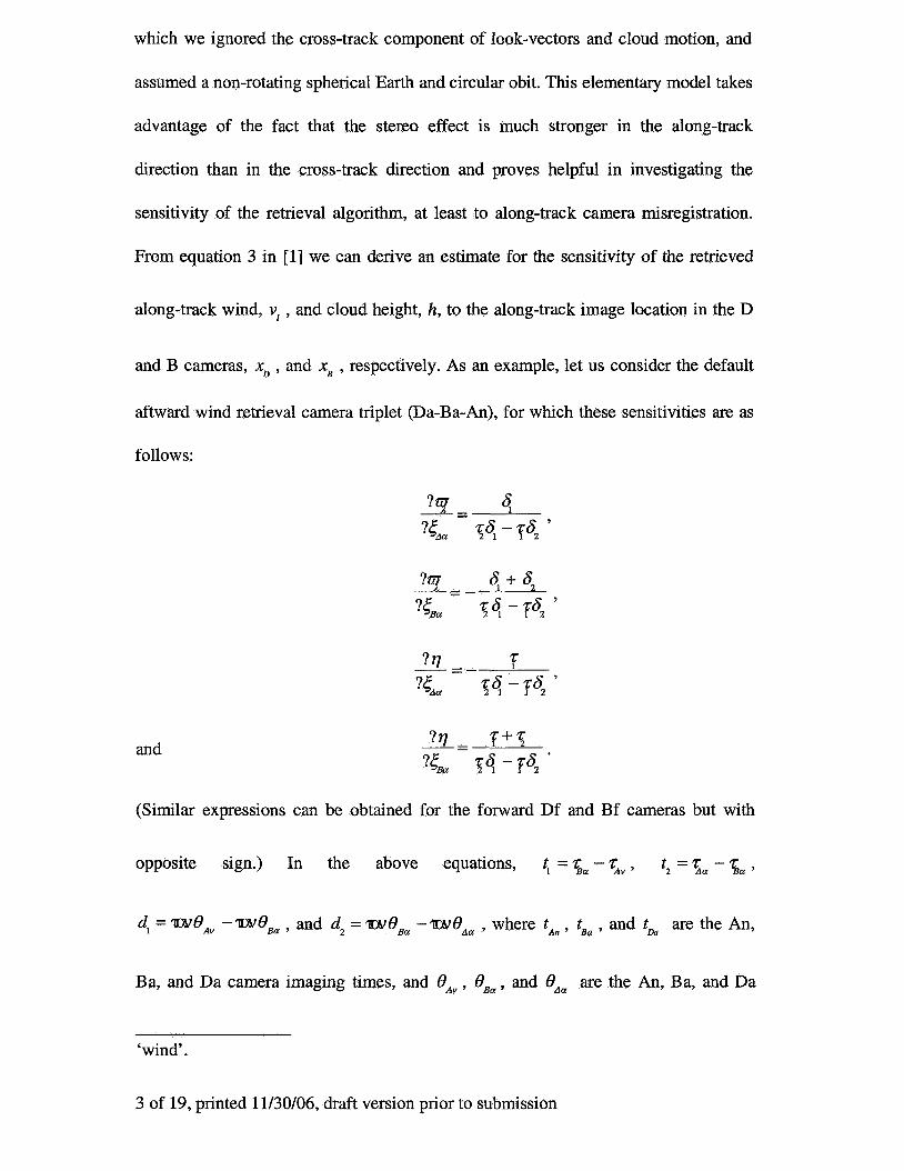
From equation 3 in [l] we can derive an estimate for the sensitivity of the retrieved
along-track wind, vl , and cloud height, h, to the along-track image location in the D
and B cameras, xD , and xB , respectively. As an example, let us consider the default
aftward wind retrieval camera triplet @a-Ba-An), for which these sensitivities are as
follows:
and
(Similar expressions can be obtained for the forward Df and Bf cameras but with
opposite sign.) In the above equations, t, = 5, - %,, t2 = 5, - 5, ,
d, = WeAv -WeBa , and dz = weBa -wO,, , where t,, , tB, , and t& are the An,
Ba, and Da camera imaging times, and OAv , OB, , and OAa are the An, Ba, and Da
‘wind’.
3 of 19, printed 11/30/06, draft version prior to submission
camera view angles. In order for the along-track wind to have a positive merihonal
component, its sign convention treats it as negative if it is in the same direction as the
satellite motion down-track. Retrieval uncertainties resulting from an along-track co-
registration uncertainty of 1 pixel (275 m) calculated from Eqs. 1-4 using nominal
values for camera view angles and imaging times are summarized in Table 1. This
shows that the retrieval uncertainty is 2-3 times more sensitive to B camera co-
registration error than it is to D camera co-registration error. This is because the B
image location affects both the B-D and the B-An disparities, whereas the D image
location affects only the B-D hsparity.
The simplified model above considers the along-track direction only. In
reality, the look-vectors also have cross-track (y-axis) components that introduce a
weak coupling between the along-track and cross-track wind retrievals for the general
case. Consequently, a co-registration error in the along-track direction creates an error
in the cross-track wind as well. Similarly, a eo-registration error in the cross-track
direction also has an effect on the along-track wind, although this effect is relatively
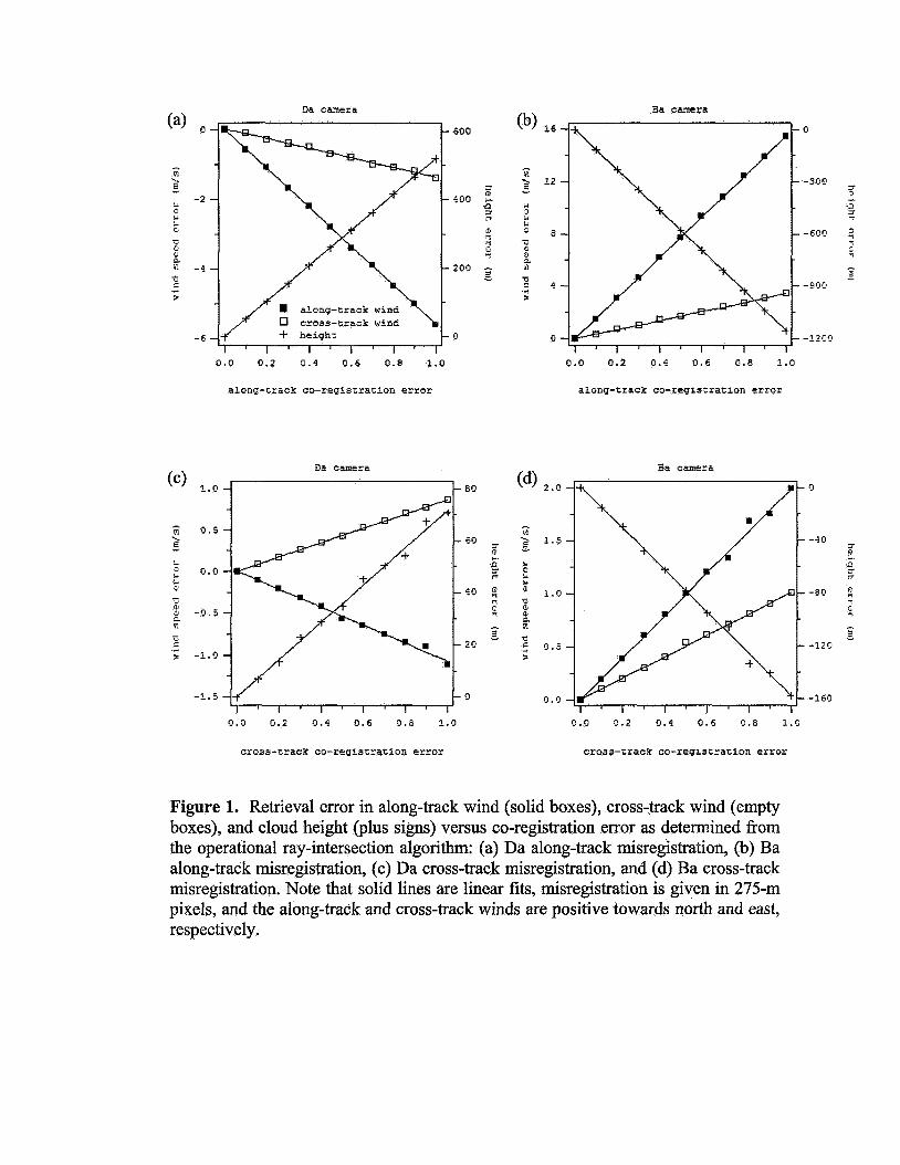
small. In order to get a full picture of the various retrieval uncertainties, we performed
a sensitivity analysis .with the operational CMV algorithm that treats the 3D nature of
the problem properly using ray-intersection. We applied co-registration errors of up to
1 pixel in the along-track and the cross-track directions and show the resulting
retrieval errors separately for the Da and Ba cameras in Fig. 1. Retrieval uncertainties
corresponding to an along-track or cross-track co-registration uncertainty of 1 pixel
are also summarized in Table 2 and Table 3, respectively. Comparison of Tables 1-3
shows the following. First, the simplified model is perfectly adequate for estimating
retrieval errors due to along-track misregistration. Second, retrievals are more
4 of 19, printed 11/30/06, draft version prior to submission
sensitive to along-track misregistration than to cross-track misregistration. In fact, the
effects of the latter might be neglected. Finally, the along-track wind is generally
more sensitive to misregistration than is the cross-track wind.
The significance of the above findings is that in [l] we only considered
retrieval errors due to finite pixel size. Such random quantization errors, however,
tend to cancel out when the mean wind of a mesoscale domain is computed from a
few dozen individual retrievals. Systematic errors in camera co-registration, (which
tend to persist over large sections of a given orbit), on the other hand, do not cancel
out and tend to bias the retrievals. Our current analysis indicates that MISR CMV
retrievals are indeed sensitive to mis-registration of either the D or B cameras, with
the largest retrieval errors occurring for along-track co-registration errors in the B
cameras. Although co-registration errors in the B cameras are usually much smaller
than in the D cameras, they can still result in significant CMV and height errors due to
their enhanced effect on the retrievals. Therefore, we have implemented an algorithm
that, in the presence of visible land-surface or sea-ice features, improves not only the
D but also the B camera co-registration. This is performed at the sub-pixel level,
separately for each orbit 141.
In addtion to these co-registration enhancements, the analysis of the measured
disparities has also been improved. Previously, along-track and cross-track disparities
retrieved over a given domain were sorted into a 2D histogram, and then the final
mesoscale wind was computed from the most populated histogram bin. Because the
MISR stereo matchers have no sub-pixel capability, this meant that the modal along-
track and cross-track disparities were always quantized as integer values. In the
updated algorithm, the final mesoscale wind is calculated as the weighted average of
5 of 19, printed 11/30/06, draft version prior to submission
the most populated bin and the surrounding bins. This yields more precise (floating
point) values for the modal disparities, even though the input disparities are still
integers. Experience with the new algorithm indicates that the enhanced co-
registration and modal disparity computation contribute about equally to reducing the
rms errors in the updated CMVs, with the eo-registration error being mainly
responsible for the bias error.
Comparison of forward and aft CMV retrievals Quality Control
In addition to the above enhancements, a more rigorous quality control has now been
implemented. The main quality check is obtained by comparing the forward triplet
retrieval with that from the aft triplet. If any one of the fore-aft retrievals of height,
CMY direction, or either wind component, differs by a basic threshold, then the
quality is labeled ‘bad’. Since directionality loses its significance as the wind speed
drops to zero, the directionality threshold is applied only to wind speeds > 2 m / s . For
operational purposes, the basic thresholds are chosen empirically with fairly broad
tolerance, with the intention of removing gross blunders due to either co-registration
error or stereo mismatches. No attempt is made to further salvage ‘bad’ CMVs,
although this may be possible for special cases that can be studied at greater depth.
This yields the basic data set of operationally retrieved ‘good’ C M v s that are used in
the subsequent comparison with the GMAO.
Intended for research, rather than for basic operational purposes, a subset of improved
quality, or ‘better’, CMVs is also obtained from the ‘good’ CMY data set by setting
enhanced thresholds for the height and wind components. For a ‘good’ CMV to be
labeled ‘better’ it must satisfy at least two of the enhanced thresholds. The basic and
6 of 19, printed 11/30/06, draft version prior to submission
enhanced thresholds are summarized in Table 4.
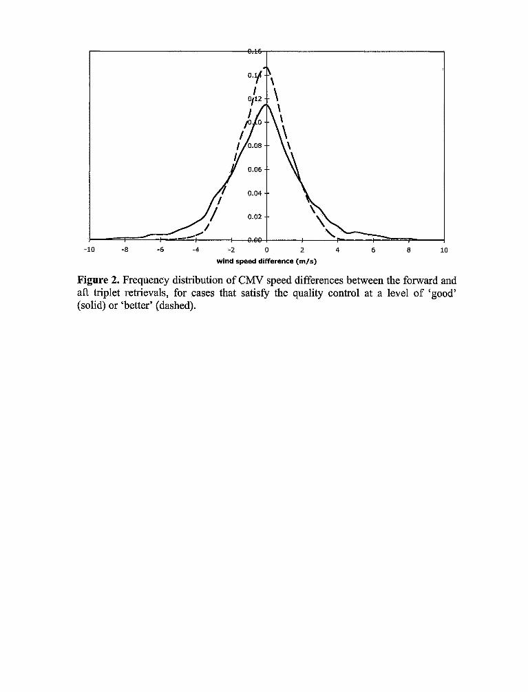
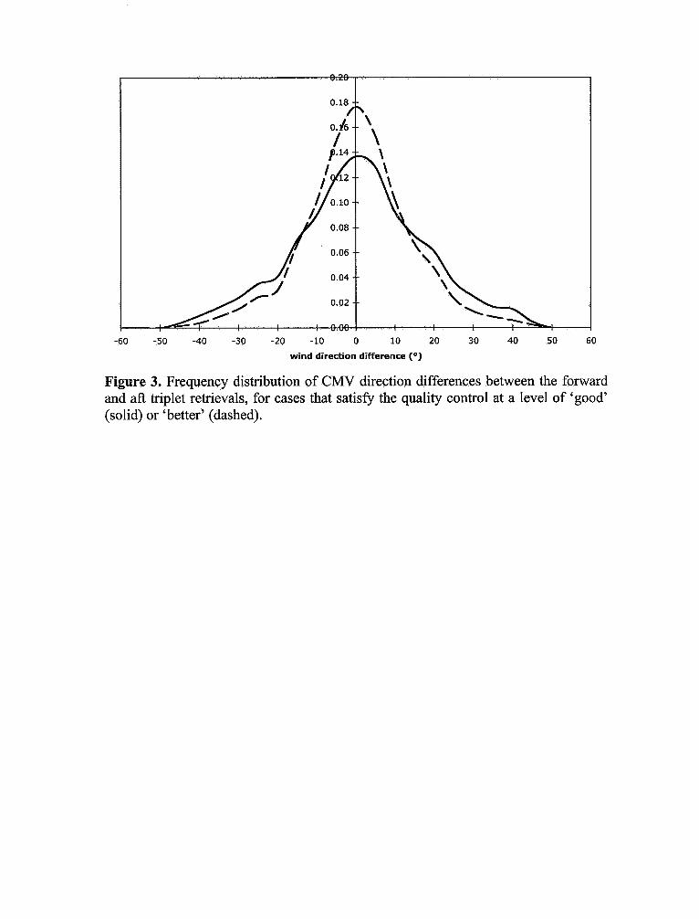
Analysis of Differences
To assess the internal consistency of the CMV retrievals, the forward and aft
differences were analyzed over a randomly chosen set of 10 orbits. This produced
sufficient data for representative statistics. The frequency distributions of the
differences between the forward and aft retrievals are shown in Figs. 2-4 for,
respectively, the scalar wind speed, the wind direction, and the wind height. The
‘better’ distributions are narrower than the ‘good’ distributions, as expected from their
definition, and both distributions are relatively unbiased and symmetric. The shape of
the distributions helps to indicate the role of the thresholds, as these cut off the tails of
the overall distributions. For most of these, the effect is simply to remove outliers
from the tail of the distribution. For the ‘better’ wind-height differences, the enhanced
height difference threshold probably limits the distribution a little too strongly for the
rejected data to be called outliers.
The mean and rms of the fore-aft wind-speed, wind-direction, and wind-height
differences, together with the vector rms difference, and the overall coverage, are
summarized in Table 5. In the absence of a fore-aft quality control, the rms
differences are quite high due to the presence of blunders. The low wind-speed bias in
the absence of quality control shows simply that the blunders are not preferentially
positive or negative. Some of these blunders could be removed by other techniques, as
by examining the original disparity histograms, which would eliminate about 10% of
the data and reduce the rms speed error to about 13 m/s. However, the fore-aft quality
control is far more effective. This quality control comes at the expense of eliminating
7 of 19, printed 11/30/06, draft version prior to submission

about one third of the total coverage, but some of this includes clear regions, multi-
leveled clouds, and featureless clouds for which the triplet stereo approach is not
effective anyway.
The difference between ‘good‘ and ‘better’, in terms of overall statistics, is not
profound. By using the enhanced thresholds, the rms speed difference reduces to 1.5
m / s with a coverage that is still almost half of the data. It would of course be possible
to reduce this difference further, eliminating more data, but for the following we
simply address the ‘good’, or operational product.
Comparison with the Global Modeling and Assimilation Office
The MISR CMVs were also compared against the 6-hour model forecast winds from
version 4.03 of the GEOS data assimilation and forecast systems of the GMAO. A 6-
week data set starting 1 September 2003 was used for this comparison. The
operational MISR product for ‘good’ winds, version 4.0, included the sub-pixel
enhancements mentioned above, but used a slightly earlier version of the quality
control, with tighter basic thresholds for the along-track wind difference, and no
across-track, height, or direction thresholds. These thresholds are somewhat
correlated, so the overall differences in quality are not very great. The summary
statistics for the fore-aft differences for the same version of processing used in the
comparison set are also given in Table 5. These values are slightly higher than for the
current ‘good’ winds.
The GMAO analyses are a combination of information from the forecast model and
several types of observations. The latter include wind and mass profiles from
radiosondes, conventional surface observations, aircraft measurements, surface wind
8 of 19, printed 11/30/06, draft version prior to submission
data from satellite scatterometers, geostationary satellite AMVs (atmospheric motion
vectors that may include both cloud and water vapor features), mass and humidity
data from infrared and microwave satellite sounders, and total precipitable water from
passive microwave imagers.
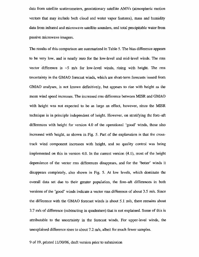
The results of this comparison are summarized in Table 5. The bias difference appears
to be very low, and is nearly zero for the low-level and mid-level winds. The rms
vector difference is -5 m/s for low-level winds, rising with height. The rms
uncertainty in the GMAO forecast winds, which are short-term forecasts issued from
GMAO analyses, is not known definitively, but appears to rise with height as the
mean wind speed increases. The increased rms difference between MISR and GMAO
with height was not expected to be as large an effect, however, since the MISR
technique is in principle independent of height. However, on stratifying the fore-aft
differences with height for version 4.0 of the operational ‘good’ winds, these also
increased with height, as shown in Fig. 5. Part of the explanation is that the cross-
track wind component increases with height, and no quality control was being
implemented on this in version 4.0. In the current version (4.1), most of the height
dependence of the vector rms differences disappears, and for the ‘better’ winds it
disappears completely, also shown in Fig. 5. At low levels, which dominate the
overall data set due to their greater population, the fore-aft differences in both
versions of the ‘good’ winds indicate a vector rms difference of about 3.5 m/s. Since
the difference with the GMAO forecast winds is about 5.1 m/s, there remains about
3.7 m / s of difference (subtracting in quadrature) that is not explained. Some of this is
attributable to the uncertainty in the forecast winds. For upper-level winds, the
unexplained difference rises to about 7.2 m / s , albeit for much fewer samples.
9 of 19, printed 11/30/06, draft version prior to submission
Discussion
With the implementation of the changes described here, notably the use of sub-pixel
co-registration and a fore-aft quality control, the operational MISR wind product has
likely reached full maturity. With 67% coverage, the rms speed error is -2.4 d s , the
rms direction error for winds over 2 m/s is -17”, and the rms height error of the
CMYs is -300 m. These errors appear to lack measurable bias. Comparison with the
GMAO forecast winds over an extensive data set also shows very low bias. The rms
vector speed differences with the GMAO rise from -5 to -10 rn/s from low to high
troposphere. Part of the difference in the upper troposphere is attributable to a weaker
quality control in the MISR operational version compared, that has since been
improved. Part of the difference remains unexplained, and may be due in part to the
higher wind speeds and greater wind shear that exists in the upper troposphere. For
these, the height assignment of the C W s plays a crucial role. By providing a
geometrically based height assignment (with known uncertainty), the MZSR CMYs
are insensitive to assumptions about the atmospheric temperature profile, but the
comparison with other techniques, done in pressure coordinates, will introduce some
uncertainty.
From the perspective of producing a superior quality product, the ‘better’ winds
quality control yields a wind speed rms of -1.5 m/s with a height uncertainty of -165
m that may be useful for in-depth dynamical case studies.
Future glans include investigating the impact of these winds, especially from data
sparse areas, on forecast skill.
10 of 19, printed 11/30/06, draft version prior to submission

Acknowledgements
Part of this research was conducted when R. Davies and A. Horviith were at the Jet
Propulsion Laboratory, under a contract from the National Aeronautics and Space
Administration. The MISR data were supplied by the NASA Langley Research Center
Atmospheric Science Data Center. D.J. Diner, V. Jovanovic, and L-P. Riishojgaard
are thanked for useful discussions.
Ref e rences
[l] A. Horviith and R. Davies, Feasibility and error analysis of cloud motion wind
extraction from near-simultaneous multiangle MISR measurements, Journal of
Atmospheric and Oceanic Technology, 18,591-608,2001.
[2] A. Horviith and R. Davies, Simultaneous retrieval of cloud motion and height from
polar-orbiter multiangle measurements, Geophysical Research Letters, 28, 29 15-
2918,2001.
[3] C. Moroney, A. HorvSlth and R. Davies, Use of stereo-matching to coregister
multiangle data from MISR, IEEE Trans. Geosci. Remote Sensing, 40, 1541-1546,
2004.
[4] V. Jovanovic, C. Moroney and R. Davies, this issue, 2006.
11 of 19, printed 11/30/06, draft version prior to submission

Table 1. Retrieval uncertainty in along-track wind, vl , and cloud height, h, due to a 1-
Da
pixel uncertainty (A(= 275 m) in Da or Ba along-track co-registration as determined
Ba
from the simplified model.
-1.1 m/s/pixel 19.1
Da Ba
2.0 m/s/pixel
?9 -5.7 m/s/pixel 15.6 rn/s/pixel 2A(
0.9 m/s/pixel 1 2 A . I
3.n
1.0 m/s/pixel
I'h{ 507 m/pixel -1 132 m/pixel 3s
72 m/pixel
Table 2. Retrieval uncertainty in along-track wind, vl , cross-track wind, v,, and cloud height, h, due to a 1-pixel uncertainty (A{= 275 m) in Da or Ba along-track co- registration as determined from the operational ray-intersection algorithm.
-159 &pixel
Da Ba
?A( -5.6 m/s/pixel 15.5 m/s/pixel
A( - 1.4 m/s/pixel 3.4 m/s/pixel
?'la{ 519 &pixel -1159 dpixel 7Y
Table 3. Retrieval uncertainty in along-track wind, vl , cross-track wind, v, , and cloud height, h, due to a 1-pixel uncertainty ( A p 275 m) in Da or Ba cross-track co- registration as determined from the operational ray-intersection algorithm.
12 of 19, printed 11/30/06, draft version prior to submission

Table 4. Quality control thresholds applied to the component differences between
mesoscale CMV retrievals obtained separately using forward triplet views (An-Bf-Df)
Number Coverage SPeed bias ( m / s )
and aft triplets (An-Ba-Da).
satisfied for 'better'
All 'good' 'better' 'good' (GMAO) 10,237 6,866 4,602 6,295 100% 67% 45% 61% -0.10 -0.20 -0.14 -0.17
Table 5. Summary statistics for the differences between fore and aft CMV retrievals
Speed rms ( d s ) Direction bias
using the current basic and enhanced thresholds, as well as for the earlier basic
19.1 2.4 1.5 2.7 3.1" 0.9" 0.5" 2.2"
thresholds used in the GMAO comparison.
Direction rms Vector rms (m/s) Height bias (m)
55" 17" 14" 24" 23.2 3.7 2.2 3.9 133 38 18 30
I Height rms (m) I 2,102 I 29 1 165 649 1
Table 6. Comparison of MISR wind retrievals with forecast winds from the Global
Modeling and Assimilation Office.
13 of 19, printed 11/30/06, draft version prior to submission
( d s ) mean speed ( d s ) 8.6 normalized rms
vector difference
number of
observations
12.1 24.3
low-level mid-level high-level
(>700 hPa) (400-700 hPa) (<400hPa) -0.02
70,09 1 12,442 2,63 1
0.59 0.62 0.43
14 of 19, printed 11/30/06, draft version prior to submission
-6
Da camera
along-track co-registration error
600
400
200
0
Da camera
1.0 4 !- 80
@) 3.6
z 4 -4 2
0
%a camera
0
-300
-600
-900
-1200
0.0 0.2 0.4 0.6 0.3 1.0
along-track co-reglszration error
Ba camera
0
-40
-a0
-120
-160
0.0 0.2 0.4 0.6 0.3 1.0
cross-track co-registration error
0.0 0.2 0.4 0.6 0.8 1.0
cross-track eo-registration error
Figure 1. Retrieval error in along-track wind (solid boxes), cross-track wind (empty boxes), and cloud height (plus signs) versus co-registration error as determined from the operational ray-intersection algorithm: (a) Da along-track misregistration, (b) Ba along-track misregistration, (c) Da cross-track misregistration, and (d) Ba cross-track misregistration. Note that solid lines are linear fits, misregistration is given in 275-m pixels, and the along-track and cross-track winds are positive towards north and east, respectively.
n V.
“4‘ I
0.06
0.04
\ \
-10 -8 -6 -4 -2 0 2 4 6 8 10
wind speed difference (rn/s)
Figure 2. Frequency distribution of CMY speed differences between the forward and aft triplet retrievals, for cases that satisfj the quality control at a level of ‘good’ (solid) or ‘better’ (dashed).
-60 -50 -40 -30 -20 -10 0 10 20 30 40 50 60
wind direction difference (”)
Figure 3. Frequency distribution of CMV direction differences between the forward and aft triplet retrievals, for cases that satisfy the quality control at a level of ‘good’ (solid) or ‘better’ (dashed).

-1000 -800 -600 -400 -200 0 200 400 600 800 1000
wind height differences (rn)
Figure 4. Frequency distribution of CMV height differences between the forward and aft triplet retrievals, for cases that satisfy the quality control at a level of ‘good’ (solid) or ‘better’ (dashed).
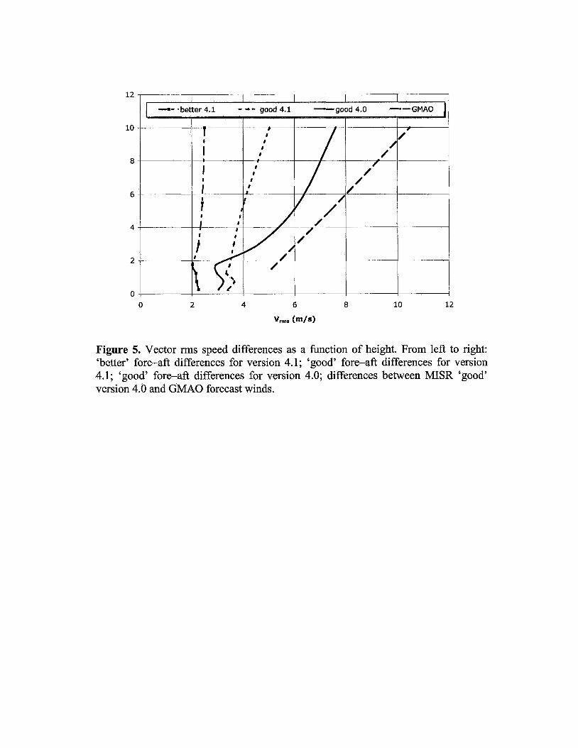
Figure 5. Vector rms speed differences as a function of height. From left to right: ‘better’ fore-aft differences for version 4.1; ‘good’ fore-aft differences for version 4.1; ‘good’ fore-aft differences for version 4.0; differences between MISR ‘good’ version 4.0 and GMAO forecast winds.


![Implantacion GMAO SAP[1]](https://img.dokumen.tips/doc/110x75/5571fafd497959916993aa34/implantacion-gmao-sap1.jpg)