Embed Size (px)
Citation preview

Permitting Lower Bois d’Arc Creek Reservoir
NCTCOGWater Resource Council
November 13, 2014
Presented by:Robert McCarthy

History of NTMWD
• 1951 - Created by Texas Legislature as a Special District to provide water service
• 1956 - Began providing treated water
• 1970s - Expanded to wastewater service
• 1980s - Expanded to solid waste service

Major North Texas Water Providers

NTMWD Service Area
13 Member Cities
47 Customer Cities, Towns, MUDs, Special Utility Districts and Water Supply Corporations
1.6 Million People

NTMWD Raw Water Supply System

Lower Bois d’Arc Creek Reservoir Fannin County, TX
Area: 16,526 acres
Storage: 367,609 ac-ft
Supply: 113 MGD
Average Depth: 22 ft
Maximum Depth: 70 ft
Lake Elevation: 534 ft msl
Owner & operator: NTMWD
(Not a USACE reservoir)

Lower Bois d’Arc Creek Reservoir Project
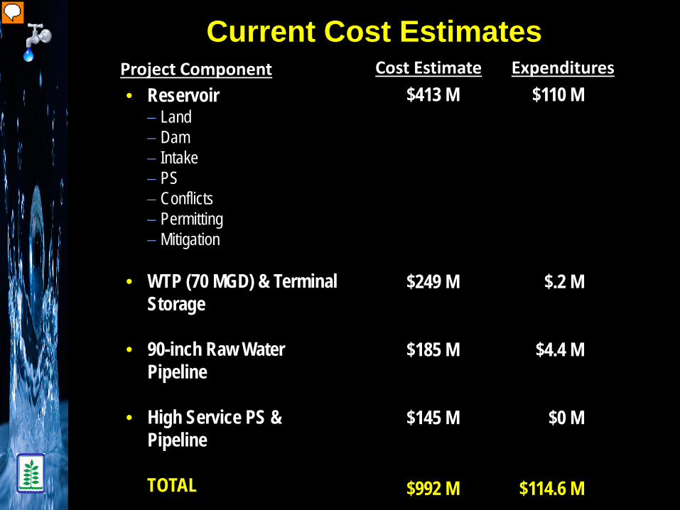
Current Cost Estimates
$413 M $110 M
$249 M $.2 M
$185 M $4.4 M
$145 M $0 M
$992 M $114.6 M
• Reservoir− Land− Dam− Intake− PS− Conflicts− Permitting− Mitigation
• WTP (70 MGD) & Terminal Storage
• 90-inch Raw Water Pipeline
• High Service PS & Pipeline
TOTAL
Project Component Cost Estimate Expenditures

Lower Bois d’Arc Creek ReservoirHouses inside 100 year flood boundary
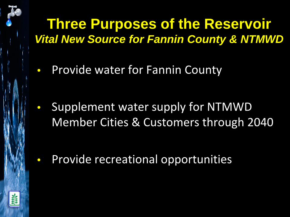
Three Purposes of the ReservoirVital New Source for Fannin County & NTMWD
• Provide water for Fannin County
• Supplement water supply for NTMWD Member Cities & Customers through 2040
• Provide recreational opportunities

Benefits To Economic Growth
During Construction:• Dam and infrastructure will increase local economic
activity in Fannin County between $509 M & $563 M during construction
Following Construction:• Ongoing operation & maintenance of new infrastructure
will support approximately 24 full-time equivalent jobs &spur approximately $2 M in new economic activity per year
(2011 dollars)

Opportunities for Business Development & Commerce
• $145 M in economic activity through new industrial &commercial activities
• $70 – 77 M in annual spending by new, permanent &weekend residents– Supporting more than 500 new permanent jobs
• $16 - 22 M in annual spending by non-local recreational visitors
• New housing, residents & recreational visitors will contribute:– $1.9 M in county property tax revenues– $3.9 M in school property tax revenues– $290,000 in municipal sales tax revenues– $175,000 in hotel occupancy tax revenues
• 3,200 new homes over a 30-year period
(2011 dollars)

Lower Bois d’Arc Creek Reservoir
Two Major Permits Required• CWA Section 404
‒ USACE
• Water Rights‒ TCEQ

CWA Section 404 Permit
• Application submitted – June 2008
• EIS Determination – March 2009
− EIS contractor selected – August 2009− Public & Agency Scoping Meetings – December 2009
• Draft EIS expected to be published in early 2015

EIS Scoping MeetingDecember 8, 2009

CWA Section 404 Permit Application
• Required by USACE− Jurisdictional Determination Report
− Habitat Evaluation Procedures Study (HEP)
− Geomorphic Assessment of Stream
− Environmental Report
− Archeological Report
− Environmental Impact Statement early 2015(Draft)

Jurisdictional Determination

Habitat Evaluation Procedures Study

Habitat Evaluation Procedures Study

Habitat Evaluation Procedures Study

Geomorphic Assessment Of Streams
Mapping Geomorphic Units/Channel Processes
Monitoring Erosion
Measuring Discharge and Velocity
Soil ProfilesDepositional Environment
Measure cross sections

Environmental Report
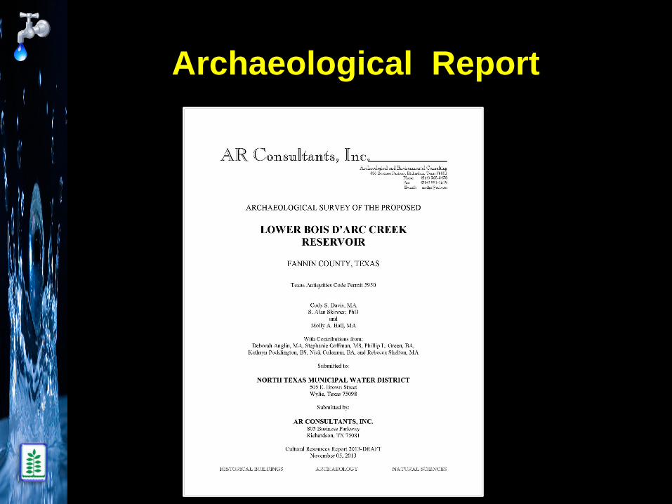
Archaeological Report

CWA Section 404 Permit Recent Activities
• Completed Final Pipeline Alignment, Intake Pump Station Location, and Terminal Storage Analysis Study
• Met with THC and USACE and Completed Archaeological Study of reservoir site, pipeline route and Leonard WTP site. Began Archaeological Study of Mitigation Site
• Completed Final Draft Proposed Mitigation Plan
• Reviewed Preliminary Draft EIS and provided comments to USACE
• Began Preliminary Dam Design

Final Pipeline Alignment, Intake Pump Station, and Terminal
Storage Location

Leonard Water Treatment Plant
Site:• Located west of Leonard• Capacity: Phase I – 70 MGD;
Ultimate – 280 MGD• Storage Reservoir – 420 MG
Scope accomplished to date:• Property purchased• Facilities master plan
underway
Schedule:• Detail Engineering (2.5 years)• Construction (2.5 years)
26

CWA Section 404 Permit Recent Activities
• Completed Final Pipeline Alignment, Intake Pump Station Location, and Terminal Storage Analysis Study
• Met with THC and USACE and Completed Archaeological Study of reservoir site, pipeline route and Leonard WTP site. Began Archaeological Study of Mitigation Site
• Completed Final Draft Proposed Mitigation Plan
• Reviewed Preliminary Draft EIS and provided comments to USACE
• Began Preliminary Dam Design

Archaeological Study• Investigation
– 22% of 22,590 acre reservoir site• Surveyed 4,500 acres• Walked 40 miles of creek channels - 500 acres
– 5,423 shovel tests– 35 trenches– 4 stream bank profiles
• Findings– 38 historic structures - none recommended for NRHP– 61 sites - none recommended for NRHP
• 31 prehistoric sites• 26 historic sites (includes Wilks Cemetery)• 4 prehistoric/historic sites• 9 sites recommended for further testing

Archaeological Study

Archaeological Study

Archaeological StudyShovel Tests

Archaeological Study Trenching

Archaeological StudyStream Bank Profile

Archaeological StudyPrehistoric Artifacts

Archaeological StudyHistoric Artifacts

Archaeological StudyHistoric Site

Archaeological StudyHistoric Site
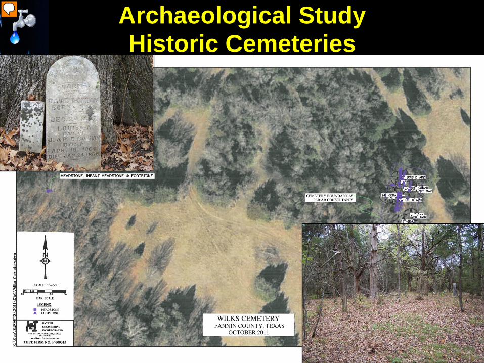
Archaeological StudyHistoric Cemeteries

CWA Section 404 Permit Recent Activities
• Completed Final Pipeline Alignment, Intake Pump Station Location, and Terminal Storage Analysis Study
• Met with THC and USACE and Completed Archaeological Study of reservoir site, pipeline route and Leonard WTP site. Began Archaeological Study of Mitigation Site
• Completed Final Draft Proposed Mitigation Plan
• Reviewed Preliminary Draft EIS and provided comments to USACE
• Began Preliminary Dam Design

Riverby Ranch

Riverby RanchExisting Cover Types

Baseline Habitat Units at Riverby Ranch
Cover Type Average HSI Values Area (acres) Habitat Units
(HUs)Upland Deciduous Forest 0.58 78 45Riparian Woodland / Bottomland Hardwood 0.38 840 317
Forested Wetland 0.38 452 171Emergent / Herbaceous Wetland 0.24 1,377 337Grassland / Old Field 0.41 5,413 2,234Cropland 0.44 3,858 1,690Shrubland N/A 41 N/AShrub Wetland N/A 98 N/ABare Ground N/A 36 N/ALacustrine (Open Waters) N/A 34 N/ATOTAL: 12,228 4,794*Does not include any of the Wetland Reserve Program habitat (approximately 2,700 acres) within the ranch that will remain enrolled in perpetuity.

Mitigation Measures Utilized to Achieve Ecological Uplift
• Establishing conservation easements in perpetuity• Removing cattle and stopping existing farming practices• Earthwork/Stream Restoration
– Restoring stream meanders and riparian corridors– Restoring stream and wetland hydrology
• Revegetation - Planting of native trees, shrubs, and herbaceous species
• Controlling invasive/non-native species• Once implemented, these measures all provide for
improvements (i.e., ecological uplift) to fish and wildlife habitat, which was estimated using the USFWS’s Habitat Evaluation Procedures (HEP)

Proposed Future Cover Types at Riverby Ranch

Proposed Mitigation for Impacts to Waters of the U.S.
*Total impacts from Reservoir, Raw Water Line, Terminal Storage Reservoir and Leonard Water Treatment Plant
Type of Water of the U.S.
Amount Impacted* Amount of Mitigation Net Gain (+) / Net Loss (-)
Acres HUs Acres HUs Acres HUs
Emergent Wetland (-)1,223 (-)514 (+)3,879 (+)1,276.2 (+)2,656 (+)762.2
Forested Wetland (-)4,602 (-)1,150.5 (+)3,952 (+)2,266.1 (-)650 (+)1,115.6
Shrub Wetland (-)49 (-)23 (+)423 (+)224.3 (+)374 (+)201.3
Open Waters (-)87 N/A (+)15,2731 N/A (+)15,186 N/A
Streams (linear ft.) (-)651,024 (+)486,375 (-)164,649

Proposed Mitigation for Impacts to Terrestrial Habitat
Terrestrial Resource Type Amount Impacted* Amount of Mitigation Net Gain (+) / Net Loss (-)
Upland Deciduous Forest (HU)
(-) 1,046 (+) 665 (-) 381
Riparian Woodland / Bottomland Hardwood (HU)
(-) 433 (+) 855 (+) 422
Shrubland (acre) (-) 64 (+) 41 (-) 23
Grassland / Old Field (HU)
(-) 2,886 (+) 2,393 (-) 493
*Total impacts from Reservoir, Raw Water Line, Terminal Storage Reservoir and Leonard Water Treatment Plant

CWA Section 404 Permit Recent Activities
• Completed Final Pipeline Alignment, Intake Pump Station Location, and Terminal Storage Analysis Study
• Met with THC and USACE and Completed Archaeological Study of reservoir site, pipeline route and Leonard WTP site. Began Archaeological Study of Mitigation Site
• Completed Final Draft Proposed Mitigation Plan
• Reviewed Preliminary Draft EIS and provided comments to USACE
• Began Preliminary Dam Design

Boring Locations at Dam Site

Boring at Dam Site

Core Sample from Boring

Core Sample from Boring B-66 Rock Core from 55’ - 60’
52

Planned ActivitiesCWA Section 404 Permit
• Continued discussions:– USFS– Parks and Wildlife– TxDot– Fannin County– USACE– EPA Tour of Project Site scheduled for
November 25, 2014– Draft EIS expected early 2015
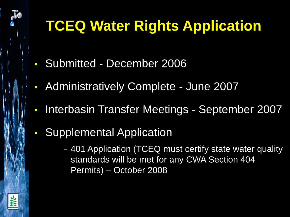
TCEQ Water Rights Application
• Submitted - December 2006
• Administratively Complete - June 2007
• Interbasin Transfer Meetings - September 2007
• Supplemental Application− 401 Application (TCEQ must certify state water quality
standards will be met for any CWA Section 404 Permits) – October 2008

2014 Activities – TCEQ Water Rights Permit
• Hired Conservation Experts and Enhanced Conservation Plan
• Met with protestants– National Wildlife Federation– Sierra Club– Texas Parks and Wildlife – Bois d’Arc MUD– Landowners
• SOAH Jurisdictional Hearing November 10, 2014• Contested Case Hearing April 20-29, 2015

Property Acquisition
• NTMWD Board initially approved - Nov. 2007
• Reservoir site property needed - 22,590 acres
• Acquisitions to date - 18,560 acres (82%)
• Riverby Ranch mitigation area - 14,959 acres
• North (Leonard) WTP site - 841 acres

Lower Bois d’Arc Creek ReservoirPurchased Parcels

Impact on Local Taxing Authorities
• Taxes paid to Fannin County by NTMWD− Tax Years 2008 - 2010 - $272,043.77− Tax Year 2011 - $171,436.66− Tax Year 2012 - $166,884.20− Tax Year 2013 - $174,046.25
• Taxes paid to Lamar County by NTMWD− Tax Year 2010 - $145.20− Tax Year 2011 - $2,047.52− Tax Year 2012 - $2,037.04− Tax Year 2013 - $2,222.77

Senate Bill 525 - 82nd Legislature
• Grants Fannin County zoning authority over “the area within 5,000 feet of where the shoreline of the Lower Bois d’Arc Creek Reservoir would be if the reservoir were filled to its storage capacity”
• Effective upon passage of SB 525 (April 29, 2011)

Local Government Code Section 231.133
(a) The commissioners court of a county in which an area subject to this subchapter is located may regulate in that area:
(1) the height, number of stories, & size of buildings & other structures;
(2) the percentage of a lot that may be occupied;(3) the size of yards, courts, & other open spaces;(4) population density;(5) the location & use of buildings, other structures, & land for
business, industrial, residential, or other purposes; (6) the placement of water & sewage facilities, parks, & other
public requirements
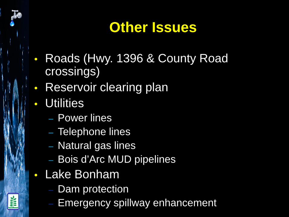
Other Issues
• Roads (Hwy. 1396 & County Road crossings)
• Reservoir clearing plan• Utilities
‒ Power lines‒ Telephone lines‒ Natural gas lines‒ Bois d’Arc MUD pipelines
• Lake Bonham– Dam protection– Emergency spillway enhancement

Highway 1396 Relocation
Estimated cost for FM 897 extension and adding new bridge as proposed is $40.2 M (January 2014 dollars) with 10 ft. bridge height (elevation 551 ft. msl) above 100 yr. flood elevation. 27 County Roads would be impacted – 5 Closed, 13 left in place, 9 crossings reconstructed.
62

Major Scope Items:• Clear 3200 acres of
timber‒ Enhance creation
of fish habitat‒ Improve human
access to shore locations
‒ Reduce hazards to boating safety and fishing from large floating debris
• To be undertaken during 2 years preceding impoundment
Scope accomplished to date:• Initial layout for
permittingSchedule:• Engineering (1 year)• Construction (2 years)
New FM 879 bridge
Clearing areas
Reservoir Clearing 63

LBCR Overall Timeline
Delivering Water

Questions


![Joana d'arc #02 [centurions]](https://img.dokumen.tips/doc/110x75/568bbca41a28ab777e8bfdb4/joana-darc-02-centurions.jpg)