Embed Size (px)
Citation preview

Novi Sad‐ short history of urban development
k l ć hDarko PolićMsc MarchPublic enterprize “Urbanizam”City Institute for Urban PlanningNovi Sad, Serbia

Novi Sad‐ where we are
EUROPE‐ Pannonian plainEUROPE‐ Serbia

Novi Sad‐modern beginning
"We, Maria Theresia, by the God's mercy Holy Roman Empress,the Queen of Hungary, Bohemia, Moravia, Dalmatia, Croatia, Slavonia, Rama Serbia Galicia Lodomeria Carinthia etc etcRama, Serbia, Galicia, Lodomeria, Carinthia, etc, etc.Cast this proclamation to anyone, whom it might concern...so that the renowned Petrovaradinski Šanac, which lies on the other side of the Danube in the Bačka province on the Sajlovo land, by the might of our divine royal power and prestige...make this town a Free Royal City and to fortify, accept and acknowledge it as one of the free royal cities of our Kingdom of Hungaryaccept and acknowledge it as one of the free royal cities of our Kingdom of Hungaryand other territories, by abolishing its previous name of Petrovaradinski Šanac, renaming it Neoplantae (Latin), Új‐Vidégh (Hungarian), Neusatz (German), and Novi Sad (Serbian)."—Maria Theresa giving city rights to Novi Sad in 1748
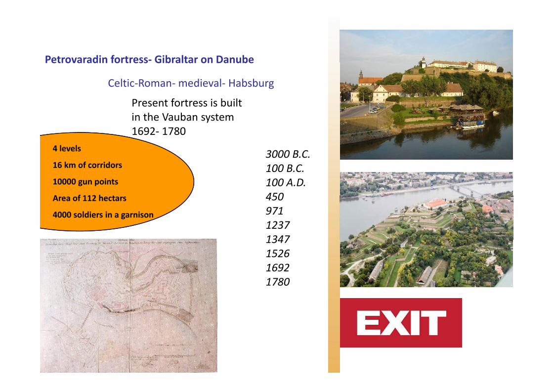
Petrovaradin fortress‐ Gibraltar on Danube
Celtic‐Roman‐medieval‐ Habsburg
Present fortress is built
Petrovaradin fortress Gibraltar on Danube
in the Vauban system 1692‐ 1780
4 levels 3000 B C4 levels
16 km of corridors
10000 gun points
A f 112 h
3000 B.C.100 B.C.100 A.D.450Area of 112 hectars
4000 soldiers in a garnison
450 9711237134713471526169217801780

Novi Sad‐ XVIII century
Good geographical place on roadGood geographical place on roadFrom Belgrade to Budapest, Vienna, From Belgrade to Budapest, Vienna, TemisoaraTemisoara,,The key factor of its quick andThe key factor of its quick andsuccesfulsuccesful development.development.Merchants, Craftsman, regional market place,... Merchants, Craftsman, regional market place,... Border with Ottoman empire, e.g. Border with Ottoman empire, e.g. Serbia,NoviSerbia,Novi Sad aside with, Sad aside with, SremskiSremski KarlovciKarlovci (town 16km South from NS),(town 16km South from NS),S e sS e s a o ca o c (to 6 Sout o S),(to 6 Sout o S),made it the 1made it the 1stst town with Serbian majority town with Serbian majority In Habsburg empireIn Habsburg empire

The end of XIXc‐ la belle epoque1
Development of industryRaiway from 1883The first temorary bridgeThe first temorary bridgeBanksRailway bridge 1883.Serbian Natioanl Theater 1861.(1895.)City hall (1884‐)1895.Roman catholic church 1895.Orthodox cathedral 1905.Synagogue 1909City spa 1909.Serbian gymnasium 1910Serbian gymnasium 1910Electric plant 1910City hospital 1912Hungarian gymansium 1912New building of Matica Srpska 1912
( ti l lt d lit t i t )(national culture and literature society)

La belle epoque 2
Good economic situation was themain reason for its high standard at the end of 19th cNOVI SAD has around O S as a ou d40 000 inhabitans

Novi Sad has 65000 inhabitansBetween the wars
Novi Sad comes to the DanubeReconstruction of Mali Liman 1922‐ 1941
The first boulevard Of Queen Maria,The Bridge of Prince Tomislav,Ban’s palace,Sindicate headquartersheadquarters,The main city medical service centre,Palace of merchant T džićTanurdžić…

The Communists’ era
Master planspof Novi Sad1950, 1962,1974, 1985,
Residential area of the Danube liman 1950s
2000,...
Establishing University campus 1960s
Development of industry

Post crisis era

In searching for a new methodology of (urban) design in post crisisURBAN DESIGN COMPENDIUMURBAN DESIGN COMPENDIUM
By English partnerships
With support of:The Serbian chamber of EngineersThe Serbian chamber of Engineers,City Institute for Urban Planning BelgradeCity Institute for Urban Planning Novi SadAssociation of Novi Sad ArchitectsAssociation of Novi Sad Architects

U R B A N D E S I G N C O M P E N D I U M I N P R A C T I C E
C a s e s t u d y ‐ N o v o n a s e l j e
Novo naselje (New Setlement)Novo naselje (New Setlement) ‐ planned in the end of 1970s ,‐ 1st phase 1978‐ 1983‐ 2nd phase 1989‐ 19932nd phase 1989 1993‐ 3rd phase until 2030.

U R B A N D E S I G N C O M P E N D I U M I N P R A C T I C E
C a s e s t u d y ‐ N o v o n a s e l j e

U R B A N D E S I G N C O M P E N D I U M I N P R A C T I C E
C a s e s t u d y ‐ N o v o n a s e l j e

URBAN DESIGN COMPENDIUM IN PRACTICE
Planning aproach: repair, reconstruction, rebuilt
U R B A N D E S I G N C O M P E N D I U M I N P R A C T I C E
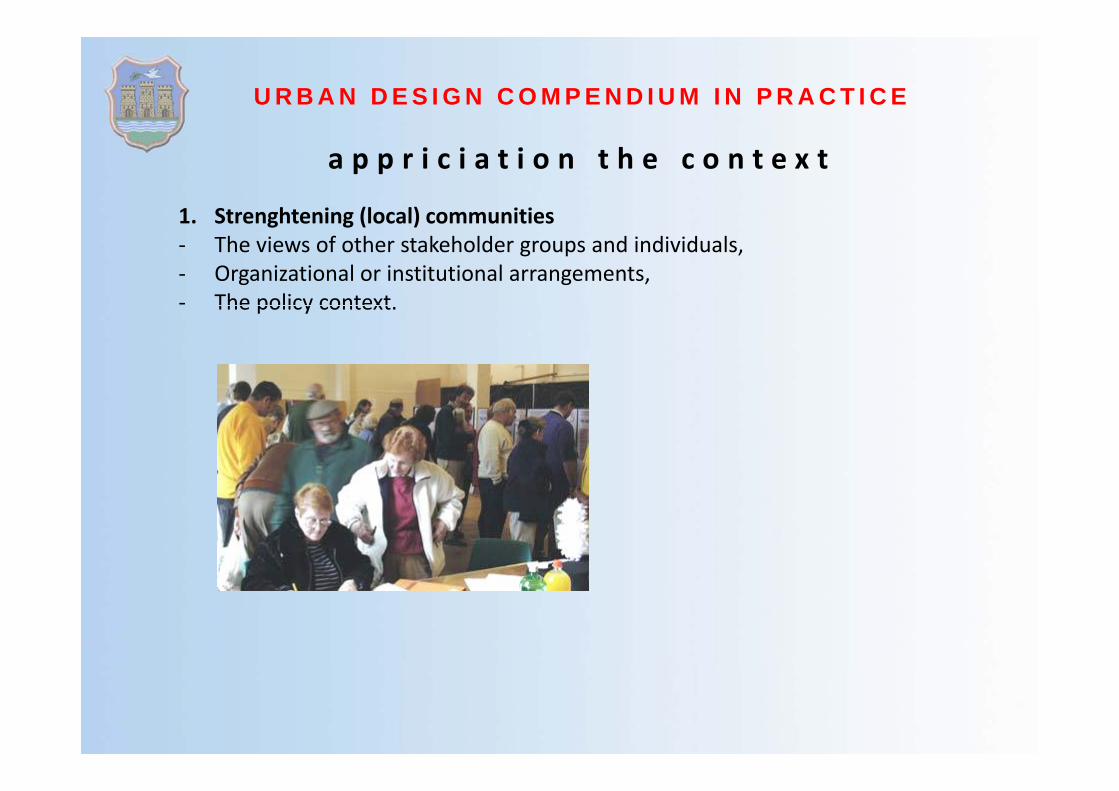
a p p r i c i a t i o n t h e c o n t e x t
1 Strenghtening (local) communities1. Strenghtening (local) communities‐ The views of other stakeholder groups and individuals,‐ Organizational or institutional arrangements,‐ The policy contextThe policy context.

U R B A N D E S I G N C O M P E N D I U M I N P R A C T I C E
a p p r i c i a t i o n t h e c o n t e x t
2 Creating places of distinction2. Creating places of distinction‐ Regional identity (climate, physical geography, socio‐ economic profile),‐ Linkages to surroundings (how do connections define
the settlements characteristics‐ linear/ grid)the settlements characteristics linear/ grid),‐ Local character (elements of local distinctiveness: form of place and use of it),‐ Morphology (historic routes, block patterns, building heights and massing)
cues for appropriate design form,cues for appropriate design form,‐ Natural features (particular ecological or geological forms),‐ Socio‐ economic profile (local traditions and events to draw influence from).

U R B A N D E S I G N C O M P E N D I U M I N P R A C T I C E
a p p r i c i a t i o n t h e c o n t e x t
3 Harnessing intrinsic site assets and resources3. Harnessing intrinsic site assets and resources‐ Identify landscape assets to preserve,‐ Strenghten the identity and structure of the landscape,‐ Reduce energy demands (utilize solar potential rain water and drainage systemsReduce energy demands (utilize solar potential, rain water and drainage systems,
the potential of the ground for heating or cooling…).
4. Connections4. Connections‐ Understand existing access and linkages,‐ Observe the quality of movement (Movement analysis inventory).

U R B A N D E S I G N C O M P E N D I U M I N P R A C T I C E
a p p r i c i a t i o n t h e c o n t e x t
5 Feasibility5. Feasibility‐ Community need,‐ Market supply and demand,‐ Finding sourcesFinding sources,‐ Site capacity,‐ Land ownership, ‐ Integration with surrounding context,Integration with surrounding context,‐ Construction costs,‐ Engineering constraints,‐ Local planning policy context.p g p y
6. Vision‐ Value can be created,‐ Constraints can be overcome,‐ Context is dynamic.


![· Medicinski fakultet, Zavod za anatomi]u, Novi Sad' Medicinski fakultet, Katedra za radiologiju, Beograd2 Kliniëki centar "Novi Sad", Novi Sad, Institut za hirurgiju,](https://img.dokumen.tips/doc/110x75/5e0bc23245ed837a417fdc6b/medicinski-fakultet-zavod-za-anatomiu-novi-sad-medicinski-fakultet-katedra.jpg)