Embed Size (px)
Citation preview

NOVEMBER 2009 VOL 13 ISSUE 11Th
e G
loba
l Geo
spat
ial M
agaz
ine
Price: INR 150 / US$ 15 Subscriber’s copy. Not for Sale
AFRICA I AMERICAS I ASIA I AUSTRALIA I EUROPE www.GISdevelopment.net
RN
I 685
61/1
8/6/
98
ISS
N 0
971-
9377
U
P/B
R-3
43/2
009-
2011
Map Middle East 201022 - 24 MARCH, 2010, ABU DHABI NATIONAL EXHIBITION CENTRE, ABU DHABI, UAE
6TH ANNUAL MIDDLE EAST CONFERENCE AND EXHIBITION ON GEOSPATIAL INFORMATION TECHNOLOGY AND APPLICATIONS


Trimble® ®
®

Web Mapping APIsUse Fast, Intuitive Web Maps to Share Your Geographic Knowledge
You can easily access and leverage your GIS with clients built on
Flex™ | Silverlight™ | JavaScript™
With ArcGIS® Web Mapping APIs, you can create and deploy GIS applications that are best
suited for your environment. To save time and resources while learning how to use these
APIs, ESRI offers live samples, training seminars, sample applications, and free maps and GIS
tasks such as geocoding and routing. Discover how ArcGIS Web Mapping APIs can deliver
mapping and GIS functionality in your Web applications; visit www.esri.com/mappingapis.
Copyright © 2009 ESRI. All rights reserved. ESRI, the ESRI globe logo, ArcGIS, and www.esri.com are trademarks, registered trademarks, or service marks of ESRI in the United States, the European Community, or certain other jurisdictions. Other companies and products mentioned herein may be trademarks or registered trademarks of their respective trademark owners.
G38642_GIS-Development_Nov09.indd 1 10/15/09 1:37:10 PM

November 2009 GIS DEVELOPMENT 5
W h a t ’ s i n s i d e
2424
20
26
29
Regular Features
07 Editorial I 08 News I 55 ISPRS: In Retrospect & Prospect I 58 Events
34
Theme – Positioning
ABOUT COVER
Geospatial industry is firmly rooted in Middle East. Political will, abundantresources, high degree of awareness and aspiration to excel have made governments in the region to invest inlatest applications, making it a fertileground for geospatial technologies.
On a positive pitch
GNSS Receivers - Generation next
It is estimated that by 2013-15, there will be up to three times the number of satellites andfour to six times the number of individual signals.
Prof. Chris Rizos
Interview: We believe in building local content
Stanley NG, CEO, MapKing
GNSS + INS – Coupled for accuracy
Spatial data has become so readily available that it is now assumed precise and accurate, buthow is that accuracy achieved?
Jason Hamilton
SatRef - What makes positioning infra work?
A satellite positioning infrastructure establishes the reference frame to integrate the spatialinformation of a region.
Simon Kwok
52Eng. Mohammed Al Zaffin
Director - GIS centreDubai Municipality
First Perso
n

November 2009GIS DEVELOPMENT6
ADVISORY BOARD
Dato’ Dr. Abdul Kadir bin TaibDirector General of Survey and Mapping, Malaysia
Bhupinder SinghSr. Vice PresidentBentley Systems Inc.
Prof. Ian Dowman Former PresidentISPRS
Prof. Josef Strobl Director, Centre for GeoinformaticsUniversity of Salzburg, Austria
Kamal K Singh Chairman and CEORolta Group of Companies
Mark Reichardt President and CEO,Open Geospatial Consortium
Matthew O’Connell CEO, GeoEyeUSA
Dr. Prithvish Nag DirectorNATMO, India
Prof. V. S RamamurthyDirectorNIAS, Bangalore, India
KCM KumarChairman & Managing DirectorSpeck Systems Limited
Brian NichollsGeneral ManagerAAMHatch
Shailesh Nayak SecretaryMinistry of Earth Sciences, India
Prof William CartwrightPresidentInternational Cartographic Association
Dr Derek. G. ClarkeChief Director: Surveys and MappingSouth Africa
Bradley C SkeltonChief Technology OfficerERDAS
PRESIDENT M P Narayanan Editor-in-Chief Ravi Gupta Director Maneesh Prasad Publisher Sanjay Kumar
PUBLICTIONS TEAM Managing Editor (Honorary) Prof. Arup Dasgupta Sr. Associate Editor (Honorary)
Dr. Hrishikesh Samant Associate Editor Bhanu Rekha Sub Editors Simmi Sinha,
Pratiksha Singh Product Manager Shivani Lal
DESIGN TEAM Sr. Creative Designer Deepak Kumar Graphic Designer Manoj Kumar Singh
CIRCULATION TEAM Vijay Kumar Singh
GIS Development Pvt. Ltd. A - 145, Sector - 63, Noida, India Tel + 91 - 120 - 4612500 Fax + 91 - 120 - 4612555 / 666
Environment Agency
Geospatial for environmental sustainability
Urban Planning Council (UPC)
Enterprise GIS for urban growth
Abu Dhabi Systems & Information Centre
“AD-SDI is integral to eSociety vision”
Ajman Municipality & Planning Department
Building Future with GIS
Military Survey Department (MSD)
Partnering in spatial development
OMAN
To maximise the value of GIS in Oman, the implementation strategy needs to be reviewedand modified to meet old and new objectives of GIS--and to go with a new trend of thetechnology.
Supreme Committee for Town Planning (SCTP)
“Sustainable spatial strategy is our goal”
QATAR
As same GIS standards are used throughout Qatar, data and resulting applications of all government agencies are compatible, providing a nationwide GIS.
The Centre for GIS (CGIS)
Leading by example
Qatar Telecom (Qtel)
Planning telecom network using GIS
BAHRAIN
GIS in Bahrain is nearly a decade old. Many GIS applications have been developed toimprove the performance of various municipalities.
Central Informatics Organisation (CIO) - GIS Directorate
"Working towards Vision 2030"
DISCLAIMERGIS Development does not necessarily subscribe to the views expressed in the publication. All views expressed in this issue are those of the contributors. It is not responsible for any loss toanyone due to the information provided.
GIS Development Pvt. Ltd. Printed and Published by Sanjay Kumar. Press M. P. Printers B-220,Phase-II, Noida, Gautambudh Nagar (UP) INDIA Publication Address P-82, Sector-11, Gautambudh Nagar, Noida, India Editor Ravi Gupta
UAE
In UAE, GIS is considered an integral part of information technology (IT) and many governmentdepartments have already implemented or on their way to introduce GIS.
Special Focus – Middle East
38
40
42
43
44
45
49
50
51
Use of GIS is pervasive in Middle East
Zul Jiwani
GIS Consultant
Keep space and outer space for peaceful use
Dr MA Tarabzouni
Director - Coordinating Office for Peaceful Use of Outer Space
K A C S T, Saudi Arabia
Pioneers
45
48

GIS DEVELOPMENT 7
One of the enduring impressions of any visit to the
Middle East (ME) is the 'forest' of tower cranes.
Building activity seems to be never ending in
this part of the world. There is another activity, equally
vigorous though not as visible and that is the building up
of spatial data infrastructures in the states that make up
the GCC. Beginning with Qatar, the efforts have spread
to all the states and significant progress has been made.
As Zul Jiwani points out, the necessary ingredients for
this success are a patron, a field clear of the baggage of
legacy, a receptive clientele and adequate financial
resources. Understanding the user needs and catering to
a variety of users from security agencies to the public
drives many of these efforts. Each agency has its own way
of meeting its user needs. As systems mature, so do users
and the needs grow.
Given this fertile ground, it is no surprise that the
geospatial industry has taken firm root here. The experience of industry is interesting. While
financial resources are not a problem there is a matching requirement to see that these
resources fetch the best in technology and services. This keeps the industry on its toes. The
growth of geospatial awareness has progressed on familiar lines. From an initial naive view of
GIS as a 'magic box', the awareness has progressed to a more mature understanding of
the benefits of geospatial applications for the management of resources, utilities, urban
environment and security. Industry has kept pace with this learning process providing the
necessary products and services and then, as the maturity of the users grew, tools to generate
these products and services.
In this issue, we carry a special section on the geospatial activities in the GCC with the
intention of showcasing success stories and we hope our readers from developing nations will
find these useful in applying the lessons learnt to their own contexts.
Our other focus in this issue is position location. The importance of 'where' is being realised
as never before as resources become scarce and demands multiply. Better and improved
techniques are required and this leads to the convergence of technologies to provide better
location information. India's GAGAN, a version of WAAS is one such example of the use of
GPS for precision guidance. GPS is also being integrated with INS to provide better point to
point navigation which is a requirement for aerial surveys.
As 2009 draws to a close, all eyes are on the economic indicators. The recession has affected
the geospatial world as our Middle East story shows. With the US economy showing a small
positive growth, is there a glimmer of light ahead?
Prof. Arup Dasgupta
Managing Editor (Honorary) [email protected]
E d i t o r S p e a k
ME - fertile ground for geospatial
ME - fertile ground for geospatial
ME - fertile ground for geospatial
November 2009

News
Africa
Mapping forests for survival
Villagers in the Republic of Congo's Plateaux
nord region have started mapping their
forest resources, in a move to protect their
interests.
The initiative started in the first half of this
year in Assengue, Ibangui, Epounou and Inga
villages in Ollombo district, with the
aim of protecting their livelihoods in the face
of rampant deforestation and logging activities.
The maps show areas where local people grow
food crops, fish, gather berries and other food
resources and where they hunt. They will be
used as a tool in negotiations with logging
companies and the authorities.
First company to use GIS
The Uganda Electricity Transmission Company Ltd. (UETCL) will be the
first African power utility company to introduce the GIS “ArcFM UT”.
The company’s network infrastructure documentation was either not
at all available, or was only on paper maps.
The company opted to obtain first-hand information on the use of GIS
technology and on the processes of data conversion before implementing
the system. The decision to invest in a multi-purpose GIS system will help
the company to adequately meet its proposed programmes.
Map digitisation accomplished
Office of the Surveyor-General of the Federation (SGoF) declared that the
agency has successfully converted the country’s maps from analogue form to
digital format.
The SGoF gave the Federal School of Surveying Oyo the credit for the
achievements in modernisation of the survey sector.
Asia
8 GIS DEVELOPMENT November 2009
ASIS to develop
digital soil map
A digital map of soils in sub-Saharan
Africa is to be developed in an
initiative that is meant to assess the
impact of climate change and
deforestation. The African Soil Infor-
mation Service (ASIS), based in
Kenya, will produce the digital map of
42 of Africa's 53 countries revealing
soil type and its component nutrients.
The project will gather existing local
soil maps and combine them with
new measurements to produce the
digital map.
Online atlas to
map biodiversity
The Karnataka Biodiversity Board
(KBB) is preparing an online atlas of
the State’s biodiversity. The atlas
will provide information about the
diversity of Karnataka’s wildlife
species and their habitats and help
researchers, resource managers,
decision-makers and the public.
This would help in conservation
planning and decision making.

9GIS DEVELOPMENT
Google shows
Arunachal in China
Google's satellite map of the border
area between India and China shows
several Indian towns in Arunachal
Pradesh as part of the People's Repub-
lic of China listed under their Chi-
nese names.
The maps also show the state's
southern border with Assam and its
northern boundary with China in
broken lines, indicating disputed
territory.
The publication of the map has pro-
voked an angry response in India,
where tensions are high following a
series of public statements in which
Chinese officials have denounced
New Delhi for refusing to discuss a
border dispute.
HCL bags first
RAPDRP contract
HCL Infosystems has bagged a con-
tract of over Rs 500 crore to imple-
ment a state wide solution
for Rajasthan involving integration
of IT, GIS, AMR & associated
technologies.
The state is also the first in India to
facilitate implementation of power
reforms by the ministry of power
under Re-structured Accelerated Pow-
er Development and Reform Program
(RAPDRP).
US scientists to
map the Ganges
Scientists from the United States
would work with the researchers
of Tilka Manjhi Bhagalpur University
(TNBU) to analyse the quality
of water of river Ganga and prepare
a map of the riverbed through Global
Positioning System (GPS).
The Inland Waterways Authority of
India will lend support to the effort
with a well equipped vessel to aid the
research.
The scientists hope that some newer
forms of life could be uncovered in
the process of the research. Geo-map-
ping of the riverbed around these hills
may also help discover as yet
unknown causes of floods and also
hideouts of aquatic life like dolphins.
Onze Technologies
LBS service
Onze Technologies Pvt. Ltd has come
up with a new location-based service,
‘Latlong’ which offers location search
as well as driving direction services
over the SMS channel.
It claims that the service is easier to
use, less time consuming and cheaper
than other competing services avail-
able in the market.
The services support a wide range of
handsets and are not limited to smart-
phones.
ISRO to map
Himalayan health
The Indian Space Research Organisa-
tion’s (ISRO) Space Application Cen-
tre in Ahmedabad will undertake
mapping and tracing of the
Himalayan region to keep track of the
movement of glaciers and their
health. This is to put in place gover-
nance and management of the
Himalayan ecosystem.
The mission aims to scientifically
study the impact of climate change
on Indian Himalayas and put in place
adaptation measures to meet the
challenges.
November 2009
K RadhaKrishnan is ISRO chief
K Radhakrishnan has been appointed as the new
chairman of Indian Space Research Organisation
(ISRO).
ISRO Chairman said it was a great challenge to
head the country's space agency, considering the
high expectations from various quarters.
Space applications, satellites and launch vehicles
are programmes of thrust. Another important mis-
sion is the human space flight programme.

News
GIS DEVELOPMENTGIS DEVELOPMENT
RazakSAT relays
geo data
RazakSAT, transmitted data on geo-
graphical topography, mapping, illegal
logging as well as data needed for agri-
culture activities of Malaysia.
The images transmitted by RazakSAT
are important and assisted the author-
ities in managing as well as monitor-
ing land, mining and cultivation activ-
ities apart from surveillance on the
country's coast and waters and also
other aspects that are beneficial to the
country.
First to track ships
Bahrain has become the first Arab
state to use a global ship-tracking sys-
tem. The system will allow Bahrain to
bolster its coastal security and mar-
itime rescue operations. It will also be
able to better track its own growing
fleet of vessels round the globe, within
an estimated 1,000 miles of its coastal
frontiers. Allowing for rapid access of
information, the L.R.I.T. system will
also provide Bahrain an edge in
quickly pinpointing and reaching
ships in distress in its waters.
Osamu Murao joins
Sokkia Middle East
Osamu Murao has been
appointed General Man-
ager of Topcon and Sokkia
Middle East & Africa
office in Dubai as a suc-
cessor of Katsuhiro Umino. Murao has
a rich history in the positioning indus-
try and a wide managerial scope cov-
ering sales, planning and finance. He
held various management positions in
Japan, Singapore, USA and Europe.
RTA Dubai streets
on Google map
Dubai's Roads and Transport Authori-
ty (RTA) has teamed up with Google
to provide an interactive street map,
which could make getting around the
city easier for residents and visitors.
The introduction of route mapping
makes Dubai the first city in the Mid-
dle East and North Africa region to be
featured on Google's online mapping
website, which aims to provide
motorists and pedestrians with accu-
rate directions. The site map also
shows available bus routes and esti-
mates the time it takes to reach a des-
tination.
10 November 2009
3D map of moon complete
China has completed a high-resolution, three-
dimensional map of the entire surface of the
moon. The map was made using image data
obtained by a camera on China's first lunar probe
-- the Chang'e 1 -- launched in October 2007.
China is one of only a few countries including the
United States, Russia, Japan and India to have undertaken
mapping of the moon.
CIST wins surveying & mapping award
China Information Security Technology (CIST) has been honoured with
three high level awards by the surveying and mapping industry of China.
The company's "Multi-source Spatial Information Network Sharing Soft-
ware Platform and Engineering Applications" project was awarded first
place for the Surveying and Mapping Science and Technology Progress
Award by the Chinese Society for Geodesy Photogrammetry and Cartogra-
phy (the "Society") while the Company's "Zhejiang Provincial Geographic
Information System" project won second place.
In addition, the Company's "Nanchang Digital Garden" project was
awarded third place in the outstanding Surveying and Mapping Engineer-
ing Award.


News
12 November 2009
London to benefit
from UKMap
The GeoInformation Group anno-
unced that the Brent Council, Lon-
don, has become the UK’s first public
authority to implement UKMap.
Brent Council has signed up a corpo-
rate licence for a three-year term and
chose UKMap to provide key location
and base map data for a number of its
applications, including planning and
transportation. Brent Council plans
to incorporate the location informa-
tion from UKMap with their Local
Land and Property Gazetteer to fur-
ther enhance their public services
through Web based applications.
3D maps using
laser
Ordnance Survey has been undertak-
ing trials on the use of lasers to create
an incredibly-detailed three-dimen-
sional map of Bournemouth that
could change forever the way the
country is surveyed. Cartographers
created the project over the course
of three years, mapping every square
metre of Bournemouth using a com-
bination of land-based survey tech-
niques and aerial lasers.
News and advts by
location
North Wales-based newspaper pub-
lisher NWN Media has launched a
series of websites using mapping tech-
nology to highlight news and advertis-
ers by location. All editorial content
produced by journalists will be auto-
matically plotted on a Google map
alongside advertising from that area.
EU’s satellite
to fine-tune GPS
The European Union launched a free
satellite navigation network by fine-
tuning the accuracy of the U.S. GPS
to around 2 meters. The EGNOS sys-
tem will use three satellites and 34
ground stations to narrow the hori-
zontal accuracy of GPS from around 7
metres previously and improve its ver-
tical accuracy to help pilots during
landings.
It paves the way for the better
known Galileo project, a European
satellite system which will rival GPS
and could be up and running in 2014.
Good Things on
Ovi Maps
Nokia unveiled a new feature on its
online mapping portal Ovi Maps
called “Good Things”. It allows users
to share their favourite places around
the world. Good Things is made up of
three key elements.
The first is the ability to spot Good
Things icons on the map, where you
can click on each one to find out more
information, add it to a route or to
your favourites. The key part is the
ability for users to add their own
Good Things.
GIS DEVELOPMENT
Europe
160 mn mobile navigators in 2015
Mobile navigational services
are gradually witnessing
uptake across the world with
the first half of 2009
accounting for 28 million
subscribers using the service.
By 2015, the number of sub-
scribers is estimated to reach
160 million at a CAGR of
33.7 %, according to Uk-
based research firm, Breg
Insight. Fuelling the demand for such services is the increased availability of
GPS-enabled handsets and bundling of navigational applications with mobile
terminals as well as mobile service offerings.


News
Multi-Site option
for RS imagery
AAMHatch’s Multi-Site product is
now available for 50cm GeoEye-1
satellite imagery. Multi-Site allows
clients interested in multiple captures
over small areas to acquire the higher
resolution and more accurate Geo-
Eye-1 satellite imagery. The benefit of
this new offer is that the minimum
new capture area of 100sq km is
slashed to only 50sq km if the same
site is imaged three times annually.
Online map to give
access information
The issue of recreational access to
public and privately owned land is
about to become much clearer with
the creation of an extensive online
mapping system. The new scheme
was outlined in a draft strategy and
aims to stop meandering hunters,
fishers and walkers from going where
they are not welcome.
Mapping and prop-
erty info goes live
Locating and mapping properties in
the Queenstown Lakes district is now
possible with a new search tool on the
Queenstown Lakes District Council
website.
The online public mapping and
property information tool went live
on the site and the council hoped it
would prove useful for a variety of
people. Combining legal property
boundaries, ownership information
and aerial photos would provide a per-
spective of the district.
Navigate in 3D in Melbourne
Melbourne has been recreated in 3D for the city's sat-nav loving
motorists. Developed using aerial photography and state of the art digital
mapping techniques, the software will bring Melbourne's streets to life for
drivers relying on sat-nav technology. Sensis digital mapping subsidiary
Whereis will launch the feature.
Ban on phones for navigation
Victoria would soon clamp down the use of iPhone - or other GPS-
enabled smartphones - for navigation purposes while driving. With the
new rules scheduled
to come into effect in
November, it will
become illegal for
drivers to navigate
using devices that
serve the dual pur-
pose of being a phone
as well as a satellite
navigation system.
Australia and Oceania
November 200914 GIS DEVELOPMENT


News
16
Place Pages from Google
Google has introduced
a new map-based
search feature which
helps people to easily
locate facilities within a
town.
The new service,
which is known as Place
Pages for Google Maps, puts all the information for busi-
nesses, public amenities and notable landmarks in a single
sidebar on the mapping software.
3-D mapping on smart phones
Earthmine is releasing a suite that lets people capture 3-D
views of cities and then lets artists draw fake graffiti all
over them on smart phones and websites. Earthmine’s
data is spatially accurate. It can capture photos of places
and then figure out the exact distance between spots. That
makes it useful to architects, construction workers and
other professionals.
The company claims its platform is a complete solution
for hosting, processing and delivering street-level 3-D data.
CSR’s GPS location processor
CSR plc introduced the SiRFstarIV GSD4e GPS location
processor. The GSD4e adds a built-in CPU and innova-
tions such as SiRFGeoRecov technology that are opti-
mised to ensure continuous location awareness in a new
breed of digital cameras, portable game consoles, wearable
platforms and other consumer devices, without loading
the host processor.
The GSD4e's adaptive accuracy and SiRFGeoRecov
technologies make it possible to instantly geo-tag images
or videos with a camera or camcorder and improve the
accuracy as better GPS information becomes available.
GIS DEVELOPMENT
America
WorldView-2 launched
DigitalGlobe announced
the successful launch and
deployment of World-
View-2, the company’s
high-resolution, remote-
sensing satellite. The
satellite was launched on
a Boeing Delta II 7920
rocket from Vandenberg
Air Force Base in Califor-
nia. The DigitalGlobe
ground station received a
downlink signal confirm-
ing that the satellite suc-
cessfully separated from its launch vehicle and automat-
ically initialised its onboard processors. The first images
from WorldView-2, captured Love Field Airport near
Dallas and the AT&T Center in San Antonio, Texas.
>> Releases
>> Business
November 2009
GPS navigation moving from
cars to mobiles
The market for GPS navi-
gation systems is shifting
from cars to mobile
phones. Mobile phone
navigation
systems provide traffic
and geographical infor-
mation using GPS sig-
nals and installed digi-
tal maps.
Until last year, navi-
gation service market
growth focussed pri-
marily on areas with
highly developed
automotive cultures
like the U.S., Europe
and Japan, but the mobile phone
navigation market is growing rapidly in both Korea and
Europe.

17GIS DEVELOPMENTNovember 2009
DG on Deloitte list
DigitalGlobe has been named to the Deloitte 2009 Tech-
nology Fast 500, an annual listing of the fastestgrowing
technology companies in North America.The Technology
Fast 500 provides a ranking of the fastest growing technol-
ogy, media, telecommunications, life sciences and clean
technology companies. The ranking is compiled from
nominations submitted directly to the Technology Fast
500 website and public company database research con-
ducted by Deloitte.
Google drops Tele Atlas
Google Maps has switched from Tele Atlas map data to
Google's own database for the US. It's only a year ago that
Google gave NAVTEQ the boot and signed a five-year
global agreement with Tele Atlas. Tele Atlas confirmed
that Google will continue to use its data for the rest of the
world, but declined to comment on how the switch affects
the existing agreement that also gave Tele Atlas access to
Google Maps user input, including in the US.
Live traffic on mobile
O2 and iTraffic have teamed up to launch additional traf-
fic and travel services on mobile phones later this year. The
first will be a live traffic mapping service, with maps show-
ing colour-coded roads to indicate the most and least con-
gested routes. This will be followed by a full GPS naviga-
tion service with turn-byturn directions.

News
Google teams up to monitor
deforestation
Google is joining forces
with space agencies
around the world and the
conservation organisation
Group on Earth Observa-
tions (GEO) to monitor
deforestation rates using
satellite imagery. Among the space agencies working on
the programme are NASA, ESA, and national space agen-
cies of Japan, Germany, Italy, India, and Brazil. Annual
monitoring via satellite images will help identify changes
in areas of forest more accurately than ever before. The
data will be important in helping support programmes in
which governments, environmental groups, and investors
pay to protect certain forests.
GIS to locate investors
A new GIS that allows businessmen to better locate poten-
tial investors and supplies them with marking statistics
and data is soon to be put into operation in the south of
Lebanon.
The Chamber of Commerce, Industry and Agriculture in
Sidon and south Lebanon organised a conference concern-
ing the use of the GIS it was planning to adopt. GIS helps
businessmen and investors access the location and type of
a company, the number of companies in a given region,
the demographics of a region, commercial statistics, and
analytical information.
Re-mapping of flood prone
areas
In order to better
inform property
owners and better
serve emergency
responders, Seattle is
reassessing most
flood prone areas in
the city. The re-map-
ping effort, which
uses new technology
in conjunction with data from record-setting 2007 floods,
is the first update to Seattle's flood prone areas since 1987.
The new maps removed 312 properties from the Thornton
Creek floodplain and added 88 new ones.
Lynchburg upgrades GIS
The city of Lynchburg undertook a massive upgrade of its
GIS system opting to switch to new software from ESRI.
The changeover, which cost about $228,500, allowed offi-
cials to pack more information into the online mapping
system and introduce new tools that make it easier for
users to sort through data and create unique maps to suit
their individual needs.
Bentley celebrates quarter
century
Bentley Systems observed 25th year as a company dedi-
cated to provide comprehensive software solutions for
the infrastructure that sustains the world. To hear the
designers' and doers stories' firsthand, Bentley hosted 'Be
Inspired’ seminar. CEO Greg Bentley and CTO and
founder Keith Bentley opened the seminar with keynote
sessions. They presented an engaging dialogue that
included a retrospective on Bentley Systems’ first 25
years, followed by their perspectives on current innova-
tions. They concluded with their priorities for innova-
tions that will become the future drivers of success.
Acquisitions and CollaborationBentley has acquired 9SQ Corporation, KSJ Beijing
Software Technology Co. Ltd. and gINT Software. It also
announced a technology transfer agreement with
Pointools Ltd., a U.K based company.
>> Application
GIS DEVELOPMENT18 November 2009

Serious tools for serious mapping.
UltraCamXp Wide Angle
>
>
>
>
Now you can have UltraCam performance
at any altitude!

GNSS receivers
Prof. Chris Rizos
School of Surveying and Spatial Information Systems,University of New SouthWales, Sydney, Australia
he U.S. Global Positioning
System (GPS) and the
USSR (now Russian) sys-
tem Glonass have operated for two
decades. Europe is developing
Galileo and China launched Beidou -
a Regional Navigation Satellite Sys-
tem (RNSS) - and then announced
Compass, a Global Navigation Satel-
lite System (GNSS). Japan will soon
launch the first satellite of its own
regional augmentation to GPS and
Galileo known as the Quasi-Zenith
Satellite System (QZSS). India has
proposed the Indian RNSS (IRNSS).
In addition there are a number of
Space-Based Augmentation Systems
(SBAS) that are already deployed, or
will be soon, that broadcast extra
navigation signals primarily intended
for aviation users. Most of the big
space players all now have, or will
soon launch, a Navigation Satellite
System (NSS) (which in this paper is
the generic acronym for GNSS,
RNSS and SBAS).
The main advantage that new NSSs
bring is that they provide more satel-
lites. It is estimated that by 2013-15,
there will be up to three times the
number of satellites and four to six
times the number of individual sig-
T
November 2009GIS DEVELOPMENT20

nals on which measurements can be made, compared to
today (approx 50 satellites, on which two frequency meas-
urements can be made with appropriate hardware). It is
generally conceded that more satellites and signals there
are, the better the positioning performance is (in terms of
accuracy, availability and integrity). Indeed, the advan-
tage that the 'extra' Glonass satellites provide for GNSS-
RTK has seen all high-end manufacturers offer
GPS+Glonass receivers, and increasingly claim their
products are also Galileo-ready. Hence this rapid increase
in satellite signals and constellations over the next five
years means that a receiver that can exploit all of the new
signals may be the ultimate in satellite positioning and
navigation - a so-called 'system of systems' (SoS) receiver.
Figure 1 shows the high average (24hr) visibility in the
Asia-Oceania region of the future NSSs.
However, it must be emphasised that there will be many
user communities, perhaps a vast majority that will only
use a subset of the available signals and constellations. In
particular, there may be regional markets/products that
will take advantage of signals broadcast only over their
area - and they may even be mandated to do so by the
governments of the NSS 'signal providers'. This raises
many interesting questions, as the world has only, to date
- with the exception of the few Beidou terminals in China
- been using 'global' GNSS products. How the various
RNSS and SBAS signals will be incorporated into user
products and services is still unknown.
While there are hardware design issues to be addressed,
the more challenging are the market-specific issues such
as applications software, the trend to regionalisation of
navigation systems, and business models, marketing and
service support. The goal of the International Committee
on GNSS (ICG - http://www.unoosa.org/oosa/en/
SAP/gnss/icg.html) is, however, to ensure sufficient inter-
operability of NSSs that SoS receiver products - or prod-
ucts using any subset combination of NSS signals - can be
relatively easily developed, and do not simply consist of a
number of separate NSS receivers inside a single box.
Market forces can be expected to ultimately define the
receiver configuration for most consumer devices such as
car navigation systems (transport telematics applica-
tions), PNDs, and mobile phones (LBS applications).
However, for the high-end applications (synonymous in
this paper with "high accuracy" - intended to address sur-
veying, machine guidance and geodesy applications) that
use differential GNSS techniques, the situation is a little
more complex. Such applications require appropriately
configured permanent reference station networks. Hence
consideration of the impact of multi-constellation NSS is
not just a matter of satellites and user terminals, but must
also include the terrestrial positioning infrastructure.
Implications of Extra NSS Satellites and
Signals
By 2013-15, appropriately equipped users would benefit
from:
• enhanced accuracy (more observations, greater measure-ment redundancy, faster solution filter convergence, lowerPDOP, etc.),
• improved availability (about three times more visible satel-lites, dual- and triple-frequency
November 2009 GIS DEVELOPMENT 21

signal availability, and for high-end users more rapid ambigu-ity resolution and lower constraints regarding user-referencereceiver separations), and
• higher integrity (high measurement redundancy, lower inter-ference vulnerability, enhanced QC algorithms, etc.).
All high accuracy GNSS techniques currently rely on the
differential mode of operation, in which carrier phase
measurements from multiple frequencies are processed
(for both carrier ambiguity resolution and positioning
computations), hence there are two aspects to multi-con-
stellation NSS. One is the receiver itself, either operating
as a user receiver or as a reference station, and the other is
the design of the continuously operating reference station
(CORS) positioning infrastructure. For example, at first
glance, the CORS infrastructure should be designed to
support differential positioning by operating reference
receivers with at least the same level of
signal tracking capability as those of its
users. However, the dilemma is:
• SoS receivers will be the most expensivehardware on the market. Network savingscould be made by having a less denseCORS network, however, only users oper-ating similar SoS receivers could takeadvantage of such a sparse CORS infra-structure. Users with simpler (lower cost)hardware, such as dual-frequencyreceivers, would be disadvantaged as thenearest reference station could be too faraway to ensure reliable and rapid ambiguityresolution.
• The lower cost dual-frequency receiverscould be deployed as reference receiverswith spacings of tens of kilometres, similarto today's CORS supporting Network-RTKand GNSS-RTK to support users seekingcm-level relative accuracy. However, such aCORS network could not service the usersoperating high-end SoS receivers.
Future "System-of-Systems" Receiver
Design
The following comments can be made with regard to
future SoS receivers:
• A multi-frequency, multi-constellation SoS receiver wouldbe expensive, especially if it were to only address the nichemarkets for high-end users.
• The power consumption of such SoS receivers may be sohigh that they would be unlikely to be used for portable appli-cations relying on battery power alone, possibly restricting itsuse to heavy equipment to support machine guidance in agri-culture, mining and construction, and for scientific uses.
• Such a receiver would be expected to be the "receiver-of-choice" as a reference station receiver, so as to service theneeds of all users, including those operating full SoS receivers.
• Increasingly such full SoS receivers may perform all theirbaseband processing using software-based correlators,which will to some extent future-proof the receivers as GNSSsatellites with new signals are launched in rapid succession.
• There will be many tradeoffs made in user receiver equip-ment design, between the ultimate performance of a full SoSreceiver and a receiver that may track, for example, just twointeroperable frequencies such as L1 and L5, resulting inuser equipment that tracks some of the signals of most/allthe satellites.
Future CORS Infrastructure Design
It is important to recognise the significant contribution of
the "super-network" of reference stations of the Interna-
tional GNSS Service (IGS) to geodesy, and to the GNSS
community in general. Several hundred globally distrib-
uted CORS (increasingly with Glonass tracking capabili-
ty) operate on a continuous basis, many for over ten years,
contributing data to the IGS analysis centres
(http://igs.org) and other users. The IGS
was established in January 1994 as a serv-
ice of the International Association of
Geodesy. Since June 1992 the IGS origi-
nally known as the International GPS Ser-
vice for Geodynamics, from 1999 simply
as the International GPS Service, and
finally since March 2005 as the Interna-
tional GNSS Service - has been making
freely available to all users: (a) raw GNSS
tracking data from its global CORS net-
work, and (b) high accuracy satellite
ephemerides and other derived products.
The IGS activities are fundamental to sci-
entific disciplines concerned with cli-
mate, surface weather, sea level change,
gravity, space weather research, and more.
The IGS CORS network therefore pro-
Fig. 1: Global satellite visibility (elevation cutoff angle of 15°) - average number ofvisible satellites of the GPS, Glonass, Galileo, Compass, WAAS, EGNOS, QZSS,MSAS, IRNSS and GAGAN constellations over a 24 hour period.
22 GIS DEVELOPMENT November 2009

Visit labs.erdas.com for a glimpse of ERDAS IMAGINE 2010. For more information on ERDAS,
please visit www.erdas.com or call +91 124 4633000.
On-Demand Geoprocessing: From Your Desktop to the Internet
Author your spatial
model in ERDAS
IMAGINE 2010
Catalog and Serve
your models as
OGC Web Processing
Services (WPS) in
ERDAS APOLLO 2010
Consume and Use your
OGC WPS in the ERDAS
TITAN Client and in other
Web applications.
24 GIS DEVELOPMENT November 2009
vides the fundamental NSS positioning infrastructure for
science and society. This is densified at the regional,
national and local level with many more CORS receivers
at spacings ranging from a few tens of kms (to support
standard GNSS-RTK) to hundreds of kms (for scientific
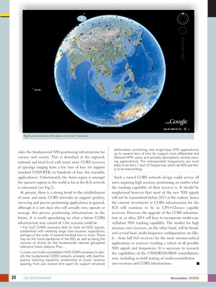
applications). Unfortunately the Asian region is amongst
the sparsest regions in the world as far as the IGS network
is concerned (see Fig 2).
At present, there is a strong trend to the establishment
of more and more CORS networks to support geodesy,
surveying and precise positioning applications in general,
although it is not clear who will actually own, operate or
manage this precise positioning infrastructure in the
future. It is worth speculating on what a future CORS
infrastructure may consist of. One scenario could be:
• Full SoS CORS receivers able to track all NSS signals,established with relatively large inter-receiver separations,perhaps of the order of several hundred kms or more. Thesemay be the future backbone of the IGS, as well as being thereceiver of choice for the fundamental national geospatialreference frame stations. Plus…
• Lower cost multi-constellation NSS CORS receivers to den-sify the fundamental CORS network, probably with dual-fre-quency tracking capability established at closer receiverspacing, from just several kms apart (to support structural
deformation monitoring, and single-base RTK applications),up to several tens of kms (to support most differential andNetwork-RTK users, and possibly atmospheric remote sens-ing applications). The interoperable frequencies are mostlikely to be the L1 and L5 frequencies which all NSS are like-ly to be transmitting.
Such a mixed CORS network design could service all
users requiring high accuracy positioning, no matter what
the tracking capability of their receiver is. It should be
emphasised however that most of the new NSS signals
will not be transmitted before 2013 at the earliest, hence
the current investment in CORS infrastructure for the
IGS will continue to be in GPS+Glonass capable
receivers. However, the upgrade of the CORS infrastruc-
ture at, or after, 2014 will have to incorporate multi-con-
stellation NSS tracking capability. The market for high
accuracy user receivers, on the other hand, will be broad,
and several basic multi-frequency configurations are like-
ly - from full SoS receivers for the most mission-critical
applications to receivers tracking a subset of all possible
NSS signals and frequencies. It is necessary to research
the capabilities of the GNSS/RNSS/SBAS constellations
now, including in-field testing of multi-constellation
user receivers and CORS infrastructure.
Fig. 2: Lower distribution of IGS stations in the Asian "hemisphere".


GIS DEVELOPMENT26
Jason Hamilton
Product [email protected]
Rod MacLeod
South Asia and AustraliaRegional Sales Manager,NovAtel [email protected]
ore and more of our physicalworld is being geo-referencedand the data used for a widevariety of applications by com-
panies, governments and militaries; oroffered to the public through sites likeGoogle Maps and Microsoft Virtual Earth.Spatial data has become so readily avail-able that it is now assumed precise andaccurate, but how is that accuracyachieved?
Until recently, only 2D representations ofthe Earth were widely available. Airbornesurvey systems utilised GNSS technologyfor geo-referencing airborne imagery tocreate geo-referenced digital mosaics.Airborne flight conditions are ideal forGNSS systems as the satellite signals arenearly always available and have high reli-ability. Precision is improved if the data ispost-processed with a local base stationor with precise point positioning usingprecise clock and orbit data.
In the last few years, traditional overheadimagery has begun to be augmented withdata collected at street-level. Imageryfrom the ground gives a more intuitive
view of the surroundings and opens manynew uses for visualisation of surround-ings. Extraction of features from ground-based imagery also offers an efficientmethod of collecting GIS data or monitor-ing environmental changes. However,ground-based data collection for bothimagery and LiDAR places increaseddemands on positioning systems. Unlikeairborne data collection, ground basedsystems operate through frequent partialor total blockages of the GNSS satellitesignals. Obstructions like buildings andheavy tree cover limit the availability ofGNSS signals and create multipath thatcan degrade the accuracy of the positionsolution. Even with post-processing tech-niques, GNSS alone does not offerenough availability or reliability for groundmapping applications.
One solution to this problem is to aid theGNSS system with a complementarytechnology to improve reliability andaccuracy. A good GNSS augmentationchoice is an Inertial Navigation System(INS), which uses measurements from aninertial measurement unit (IMU) to com-pute a position, velocity and attitude solu-
GNSS + INS
M
November 2009
Coupled
for accuracy
Coupled
for accuracy
Inertial NavigationSystem (INS) isan ideal complementingtechnology toimprove the reliability andaccuracy of GNSSsignals

27GIS DEVELOPMENT
tion. Unlike GNSS, INS requires noexternal inputs, so the accuracy of thesystem does not vary with the environ-ment.
GNSS positioning and inertial navigationare complementary technologies. GNSSreceivers track satellite signals to com-pute a position that can be as accurateas 1cm, but do not provide any attitude(roll, pitch or heading) information forthe vehicle. GNSS accuracy is also sub-ject to the satellites in view and can bedegraded or unavailable if satellites areblocked. An INS integrates measure-ments from gyroscopes and accelerom-eters to compute attitude, velocity andvery stable relative position.
However, INS solutions drift over timedue to accumulation of sensor measure-ment errors. In general, the higher thegrade of the IMU, the lower is the driftrate. When combined together, GNSS isused to calibrate the errors in the INSand INS is used to compensate for peri-ods when GNSS is unreliable. TheGNSS/INS combination is also able toprovide high rate accurate roll, pitch andheading.
An example of a commercial, off-the-shelf GNSS/INS combination is NovA-tel’s SPAN™ (Synchronised Position,Velocity and Attitude) product line, whichis unique because of the way GNSS andIMU data is combined. SPAN tightlyintegrates the data inside the GNSSreceiver, providing several advantages.Unlike loosely-coupled GNSS/INS sys-tems that integrate INS and GNSS inthe solution domain, SPAN integratesthe data together in the measurementdomain to create a very tightly coupledsystem. The stability of the blendedGNSS/INS solution is also used to aidthe GNSS functionality of the receiver.GNSS algorithms like the RTK and L-band correction filters are aided with the
GNSS/INS solution to achieve fastersolution convergence. Furthermore, theGNSS/INS solution is used to aid thesignal tracking loops, improving signalreacquisition during difficult GNSS con-ditions. The result is nearly instanta-neous GNSS signal reacquisition andmore accurate satellite observations.
The benefits of a tightly coupled systemcan be measured in two significantways; the satellite signal reacquisitiontime and the drift of the inertial solutionduring partial GNSS outages. Signaltracking aiding allows for faster signalreacquisition after GNSS outages. Fig-ure 2 shows the cumulative histogram ofGNSS signal reacquisition with and
TABLE 160s Outage Error 2D Position 2D Velocity Roll & Pitch Heading
Real-time SPAN 3.42m 0.13m/s 0.013° 0.030°
Inertial Explorer Post Processing
0.15 0.03m/s 0.011° 0.016°
Figure 1: The number of satellite observations is limited in built-up areas so GNSS availability is reduced
Figure 3: Number of satellites available during an urban mapping survey with tightly coupled GNSS/INS
Figure 4: Number of satellites available during an urban mapping survey with loosely coupled GNSS/INS
November 2009
Figure 2: Signal reacquisition benefit using SPAN

without aiding from the SPAN solution.Faster signal reacquisition results inmore GNSS observations to use to con-strain any inertial errors. Figure 3 showsthe number of satellites tracked duringan urban mapping data collection from aloosely coupled Vs a tightly coupled sys-tem. Because GNSS and IMU data iscombined at the measurement level inSPAN, the GNSS data is used evenwhen fewer than 4 satellites are avail-
able.
In a loosely coupled system, no updateinformation would be used when thetracked satellite count dropped below 4,as no GNSS solution would be possible.Figure 5 shows the benefit of using thecarrier phase data as a constraint to theinertial solution drift, when fewer than 4satellites are available. The red 0 Phaseline shows the drift of the solution dur-ing a complete GNSS outage. This driftis dominated by the accumulating errorsfrom IMU measurements. If two satel-lites are available, SPAN will use thedata to constrain the drift as shown inthe 1 Phase green line. If another satel-lite is available, the blue 2 Phase lineshows even more significant improve-ment.
SPAN is a real-time system that oper-ates in multiple modes, depending onthe required accuracy of the application.In stand-alone mode with no GNSS cor-rection data applied, position accuracy of<1.5m can be achieved. If local basestation corrections or satellite-basedaugmentation systems like Omnistar HPare input into the system, cm-level posi-tioning can be achieved. An optionalwheel sensor input is also available asan additional constraint during GNSSoutages.
Many mapping applications do notrequire a real-time solution for the gen-eration of their final product. Theseapplications can benefit from post-pro-cessing, where the GNSS and IMUmeasurement data is combined post-mission. Post-processing has manypractical and performance advantages.Data can be processed forwards andbackwards in time, thus minimising the
drift during GNSS outages. A solutionsmoother further
reduces
solution error. Absolute centimetre-levelaccuracy can be achieved using datafrom a local or virtual reference station(VRS). Figure 6 shows the improvementon position error growth during GNSSoutages by processing forwards andbackwards in time.
NovAtel’s Inertial Explorer® (IE) soft-ware package offers easy import andprocessing of SPAN measurement data.The performance improvement frompost-processing is most evident in theposition drift during a full 60s outage.For a SPAN system operating with aniMAR FSAS IMU, the solution drift over60s in real-time and post-processing isshown in Table 1.
All of these features result in animprovement to the solution accuracyand integrity. The difference between aGNSS-only system and a SPAN solutionis clearly noticeable in an urban canyontest. Figure 7 shows a trajectory view ofa GPS-only solution and of a SPANGPS/INS solution. While the GNSSsolution is often in error because of poorsatellite geometry and multipath signals,the SPAN GPS/INS solution offers con-tinuously precise positioning.
Conclusion
GNSS-only systems do not provide suitable positioning accuracies andavailability for the new applications inground mapping where multi-sensorobservations are made at high datarates in highly obstructed areas. AGNSS/INS combination provides asolution to the problem and SPAN, with its tightly coupled architecture incombination with Inertial Explorer post-processing software, offers an “off the shelf” system with maximum
performance to the user.
Figure 5: Position drift constraint using phase updates
Figure 6: Position Drift Improvement from Post Processing
Figure 7: GPS and GPS/INS trajectory in urban canyon
November 200928 GIS DEVELOPMENT

SatRef
Asatellite positioning infra-
structure establishes the
reference frame to integrate
the spatial information of a region. It
provides a link between the regional
reference system to the global refer-
ence system. The infrastructure also
helps users to improve accuracy of
positioning, enhance efficiency,
increase productivity and reduce the
cost of operation. To make a satellite
positioning infrastructure work and
deliver the aforesaid outcomes, the
organisation running the infrastruc-
ture should address the issues of
quality assurance, risk mitigation,
business continuity, legal require-
ments, training and growing an envi-
ronment for innovation. The article
discusses aspects based on the expe-
riences gained from developing the
Hong Kong Satellite Positioning Ref-
erence Station Network (SatRef)
during the past decade.
System Overview
The SatRef has twelve stations, one
date centre and one control centre.
Fig. 1 shows the network. The aver-
age station spacing is about 15 km. It
is designed to provide positioning
service for metropolitan areas. It
ensures continuous achievement of
cm level accuracy for real time posi-
tioning and static positioning with
short observation time (15 mins).
Such station distribution also pro-
vides redundancy to ensure business
continuity, as from time to time
some of the sites may be out of serv-
ice due to maintenance or equip-
ment failure. Fig. 2 shows the photo
of a typical station and its design
model.
GIS DEVELOPMENT 29November 2009
Simon Kwok
Chief Land Surveyor, Lands DepartmentHong Kong Special Administrative Region, [email protected]
A satellite
positioning
infrastructure helps
to improve accuracy
of positioning,
enhance efficiency,
the increase
productivity and
reduce the cost of
operation. Here is
the experience of
Hong Kong...
What makes
positioning infra work
What makes
positioning infra work


The services provided by the system are:
• RINEX data service for post processing by the user
• Network RTK real time positioning service
• DGPS real time positioning service
• Automatic position computation service using RINEX data
Data Centre and Control Centre
relationship
The Data Centre and Control Centre are situated at dif-
ferent locations. The purpose is to ensure high level of
security and provide flexibility for the operator to control
the system from their normal place of work. The hosting
service of the Data Centre is provided by a telecommuni-
cation company. The Data Centre has strict IT and phys-
ical security control. It also provides fire protection, back-
up power supply and optimum environment for the oper-
ation of the computer system. The Control Centre is
located at the Lands Department.
Quality Checking Mechanism
Hourly checking on RINEX data quality, equipmenterror and communication problem
• RINEX files collected from the reference stations areprocessed every hour
• Hourly solution is compared with the known position(dN,dE,dH)
• Poor results or no solution indicate problem in data quality, equipment error and communication problem.
Network-RTK Data Quality Checking Three independent monitoring stations are set up in
Hong Kong to monitor the quality of network RTK
data. Every epoch (1 second) of RTK measurement is
checked against the known position of the monitoring
station.
Station Stability CheckDaily REINX files of each station are processed using
Bernese software
• Preliminary solution: use quick orbit
• Final solution: use precise orbit
Detect trend in station movement with time series of
years of observation
DGPS data quality checking One reference station receives DGPS correction continu-
ously from the SatRef system. Its measured position is
compared with the known position. Alarm will be sent to
operators by email if error outside tolerance is detected.
Risk MitigationIT security measures are essential to mitigate risks to
business continuity. IT security audits are conducted reg-
ularly to review management control and operation con-
trol. The aspects to be audited include: risk management,
review of security controls, system security plan, personal
security, physical and environmental security, production,
input/output control, contingency planning, hardware
and system software maintenance, data integrity, change
control management, document, security awareness and
incident response capability.
Figure 1. Hong Kong Satellite Positioning Reference NetworkFigure 2. Typical station design: concrete pillar, equipment box, concrete platform, lightning protection system, security fence
32 GIS DEVELOPMENT November 2009

Legal Requirements - Accuracy Standards and Codeof Practice The Code of Practice issued under the Land Survey Ordi-
nance was revised to include the "Specifications and prac-
tice guides for establishing GPS control stations for land
boundary surveys". It regulates the quality of land bound-
ary survey conducted using GPS.
Human resource developmentBuilding up the ability of the people to do the task well is
essential for making the positioning infrastructure work.
All stakeholders have to participate in building the capac-
ity. It involves the government, professional institutions,
academics, industry, equipment manufacturer and the
users. The Satellite Positioning Reference Station Data
Services is designed for multi-discipline applications.
Other than land surveying and mapping, the system has
been used for:
• Structure and slope monitoring
• Land use control
• Weather forecast
• GIS data collection
• Asia and the Pacific Regional Geodetic Network
• Location base services
The consumer market has not yet full explored the
potential of DGPS, RTK, wireless internet, consumer
information, light weight and low cost devices. It is neces-
sary to stimulate an environment for innovation and facil-
itate development of value added product and
services.The Lands Department is now providing Satellite
Positioning Reference Station data service to government
departments and contractors of government projects. In
2010, the Lands Department will open the Satellite Posi-
tioning Reference Station data service to the public.
There will be no charge for the services provided (Net-
work RTK, DGPS and REINX data).
It will facilitate market participation in the provision of
value added products and services for the economic bene-
fit of Hong Kong.
The Hong Kong's Satellite Positioning Infrastructure
brings innovation to business, speeding up work efficien-
cy, reducing operation cost, enabling creation of
value added services and improving quality of life of the
people.

Bhanu Rekha
Associate EditorGIS Development Pvt. [email protected]
Geospatial Industry
nited Arab Emirates,
Bahrain, Saudi Arabia,
Oman, Qatar and Kuwait -
commonly referred to as GCC coun-
tries, form the chunk of Middle East
market for geospatial industry. Several
companies which started in the 1990s
as distributors of major companies
evolved to provide consultancy and
customised solutions in a decade.
SpaceImaging Middle East, Vision
Geoinformation solutions and
GeoImage figure prominently on the
list.
While GeoImage started as the dis-
tributor of PCI Geomatics, Definiens,
SpaceEyes and SPOT imagery, Global
Scan Technologies started with a
ground receiving station for satellite
imagery, Space Imaging Middle East
distributed LandSat and IRS imagery
and Pictometry Middle East has
recently been rechristened as Vision
Geoinformation Solutions.
Providing consultancy and a gamut
of geospatial services and solutions,
the industry in Middle East shared its
views and experiences with GIS
Development. Here's what the indus-
try has to say on various aspects.
Technology Uptake
The region has the second mover
advantage in adopting and adapting
to the right kind of technologies.
With tried and tested technologies
and applications on a platter, with
mounting awareness and local compe-
tition, government departments and
private enterprises are hand picking
applications that suit their need best.
"The level of acceptability of geospa-
tial technologies is very high," says
Muhammed Al Aswad, Managing
Director, Intergraph Middle East
LLC. According to him, "this is
because of the stability of govern-
ments and the availability of money.
Organisations in the region take
Europe for inspiration and emulate
their examples. "
Analysing the psyche behind this,
Hussain Harahshah, General Manag-
er, Global Scan Technologies says,
"People, especially in Arabian gulf
area want us to prove that a particular
U
GIS DEVELOPMENT34
Stability of governments coupled with availability ofresources and high degree of awareness is keepinggeospatial industry buoyant over the potential inMiddle East region inspite of economic recession
Middle EastMiddle East
November 2009

device is really the latest one. They
don't accept the second one even
though it can do the requisite work.
This is the reason we choose either
the latest or unique technology. We
also need to be competitive in terms
of price in this region."
Differing from Harahshah's view,
Jehad Hijazi, Chairman and CEO,
GeoImage says, "I feel the region
here is not very mature. They prefer
to invest in ready products like 3D
maps whatever the technology used.
They want end products not the
means. High technology is still not
much accepted by users here. Lack
of market, lack of awareness may be
the reasons."
Discussing the acceptability levels
of the latest technologies in the
region, Mohamad El Kadi, Managing
Director, Space Imaging Middle East
says, "There are two levels of accept-
ability apparent. On the one hand,
many organisations are actively
incorporating new GIS technology
into their everyday business applica-
tions. On the other, there are compa-
nies who are still questioning the
place of GIS in their structure and
only use geospatial solutions when a
direct need arises. Although we lost
some business to Google initially, the
advent of applications like Google
Earth has done a lot to build aware-
ness of GIS amongst our client base.
For example, real estate developers
used to come and buy data from us
to plan a new project. Now they go
on Google or Microsoft to mark out
their areas and take measurements.
As they start working on the project,
they are coming back to us because
they need new imagery. This way, our
client base is growing more sophisti-
cated now. We are catering to these
sophisticated people who are grow-
ing within their organisations to
change it into a GIS-based one."
Taking the discussion on the
acceptability levels of geospatial
technologies further, El Kadi says,
"There are two parameters here.
While one wants us to cater to their
need, the other wants stability and
support, which is why the market is
sceptical to use open source solu-
tions exclusively. So, we developed
in-house solutions and capabilities
to allow us to address their needs.
This enabled us to diversify our
offerings and introduce our clients to
new GIS technologies, while offering
them the comfort of local support."
With unique products in his kitty,
Pieter Franken, Sales Director, Vision
Geoinformation solutions, feels his
company's uniqueness of providing
oblique imagery and LiDAR has
proved to be an advantage. "At the
same time," Pieter says, "having
unique products means we need to
educate the clients. It is a long term
process. These products do not
appear in regular tenders in the mar-
kets. So we have to create the need,
educate the clients, show them how
to use it, support them."
35GIS DEVELOPMENT
Middle EastMiddle East
November 2009

Emerging Trends
Though one might feel global eco-
nomic recession has been a dampen-
er, the geospatial industry is upbeat
over the potential of the market. The
industry is divided on its view about
the most potent vertical though.
Phillippe Akl, Sales and Marketing
Manager, Positioning Division of
Topcon says, "Traditionally, survey
market is the biggest in the region.
Now the trend is changing. At pres-
ent, 70% of our revenues are coming
from construction sector.
This does not mean that surveyors
or surveying field does not play a
role. In Middle East, we are still
using surveying for construction
activity unlike Europe."
He feels that there is small confu-
sion about the general
trend - the type of
equipment people are
buying after the eco-
nomic crisis. "I heard
someone saying that
people are shifting to
cheaper brands and
lower accuracy levels
because of economic
crisis. But my experi-
ence suggests other-
wise. I am noticing
that companies are trying to opti-
mise their resources, invest in tech-
nologies that will increase their pro-
ductivity while downsizing the
resources. To achieve this, they are
investing in high end technologies
that will help them increase the pro-
ductivity with less number of peo-
ple." This, Philippe feels, is leading
to machine automation. "We are see-
ing a lot of reference station net-
works coming up for GPS. This will
change the rules of the game in the
GPS segment."
Taking a different stance, Hussain
Harahsh says, "We do face the
effects of recession. People are not
buying extensive technology easily.
Many government entities in the
region need applications. But this
need is not immediate as much as
the need for food."
According to Muhammed Al
Aswad, spatial data infrastructures
are the buzz word. "At the global
context, though Middle East is not
spearheading this activity, there is
considerable activity in this regard.
The major bottlenecks for SDIs to
take off in the region are use of dif-
ferent data formats and the predom-
inant use of proprietary solutions. 10
years into the race, we may have to
opt for open formats and have inter-
operability. It is time for the powers
to be to do something in this direc-
tion. It is important that proper stan-
dards are adhered to." Concurring
with the idea, Pieter says, "With the
creation of datasets, slowly market is
evolving towards 3D. This has been
forecast 6-7 years ago. But it is really
taking off now."
But according to El Kadi of Space
Imaging ME, which provides high
resolution imagery to a vast array of
applications, infrastructure, utilities
and public sector are on the growth
curve. Demand for high resolution
imagery is also on the up. Jehad
Hijazi feels one of the major applica-
tions for high resolutions imagery is
change detection. "There are huge
GIS DEVELOPMENT
Companies are optimisingresources, investing in highend technologies thatincrease productivity whiledownsizing the huimanresources. This is leading tomachine automation
Middle EastMiddle East
36 November 2009

investments happening for develop-
ment in this region. Municipalities
need to update their maps every few
months. To achieve this efficiently in
a cost effective way, availability of
data quickly when it is needed is crit-
ical."
Hijazi also lists environment and
homeland security as emerging verti-
cals for geospatial technologies. "I
think more and more GIS applica-
tions for environment and homeland
security will be developed. Security
is now very critical as there is delicate
situation politically."
Data Availability
The most critical criterion for the
development of geospatial industry
is the availability of base data.
Though different countries in the
region have different norms vis-à-vis
data, the overall picture is not very
positive.
Hijazi of GeoImage opines that
availability of data is not as much as
it is needed by the geospatial users.
In Saudi Arabia, imagery has to
come through KACST. In UAE, there
are no such restrictions. In Jordon,
one has to go through the national
mapping agency to buy imagery.
Concurring with this idea, Hussain
Harahshah says, "I think there is not
much data available. We discover
there is missing data or there is no
updation. Also, it is not easy to get
data from government. Some times,
data sharing between government
agencies is also difficult."
Voicing similar sentiments, Rohit
Anand, Sales and Marketing Manag-
er, Sokkia Middle East says, “Only a
few countries in the MENA region
have fairly developed geospatial data
infrastructure for collection, plan-
ning and effective utilisation of
data.”
Potential geographies
Economic recession not withstand-
ing, countries in the region are
investing in building infrastructure
and other development sectors. Says
Philippe, "UAE and in particular
Dubai is on a halt but if you look at
the larger picture, infrastructure is
still a major segment, especially in
Saudi Arabia. Saudi plans to invest
157 billion Saudi Riyals in the next
3-5 years in infrastructure. This is
creating lot of opportunities,"
Identifying the potential markets
for high-end technologies like pic-
tometry and LiDAR, Pieter Franken
says, "We are creating a very high res-
olution 3D model for the entire Abu
Dhabi city. Once completed, it
would be the biggest 3D model ever
made in the Middle East.
So, in terms of market focus, we
believe Abu Dhabi is very important
for Vision Geoinfo. We believe
Saudi Arabia is the most important
market in the region. Qatar
and Bahrain are important too.
Unfortunately, in Dubai, there is lack
of projects."
Conclusion
The geospatial industry in the region
is quite staggered at the moment.
Industry players feel the void and the
need to bring all private players
under an umbrella organisation. Says
Rohit Anand, "This will also help to
establish some standards, evolve a
code of conduct for the industry in
the region.
The membership should be open
to all government institutions, pri-
vate companies, academic institu-
tions, businesses and individuals
related to the industry."
With highly motivated decision
makers who are providing able
executive and political leadership,
with significant number of trained
professionals and consultants, with
colleges and universities providing
quality GIS education and training
and above all with growing awareness
about geospatial technologies in
the region, the industry is finding a
perceptible need and a proactive
pitch for the growth of geospatial
technologies in the Middle East
region.
November 2009 GIS DEVELOPMENT 37
Middle EastMiddle East

Q
UAE - Environment Agency
Q
Q
Q
Q
Promotion of sustainable developmentis one of the mottos of your organisa-tion. How are geospatiall technologiesbeing used to achieve this?
GIS is one of the important cornerstones ofour sustainable environment agenda. Wehave developed an extensive environmentaldatabase that includes over 100 layers ofgeospatial information that we make acces-sible to our staff, partners and the public.This information is used to support ourState of the Environment (SoE) analysisand reporting, our environmental perform-ance measurement and our environmentalinventory and monitoring activities. Thesefindings help in our strategic and businessplanning, establishment of environmentalprotection areas, environmental impactassessment review and coordination withother stakeholders towards balancing envi-ronmental management and protection withother economic and social issues.
How does Environment Agency ensuredevelopment without compromising onthe environment?
Development, even withthe current globaleconomic down-turn, is still pro-ceed-
ing in Abu Dhabi at an unprecedented rate,and it is always a challenge to ensure thatthe important environmental resources andheritage are preserved in this process. Wework closely with Abu Dhabi Urban Plan-ning Council, Abu Dhabi Authority for Cul-ture and Heritage (ADACH) and other con-cerned entities to ensure that environmen-tal issues and constraints are consideredfrom the earliest stages of planning anddevelopment. We have also implementedstrong environmental regulations thatrequire comprehensive environmentalimpact assessments as part of approvingany significant development project, as wellas operating permits for regulated industrialfacilities. The environmental impact assess-ment review enables us to ensure the envi-ronmental health of the Emirate.
What are the initiatives taken up for theeffective natural resources manage-ment in Abu Dhabi? Whaat are the latestgeospatial technologies being used forthis purpose?
We are responsible for the planning, policyand regulatory aspects of all the
key environmental sectors,including air, water, soil,marine, biodiversity and pol-
lution control. In each ofthese areas, we havebeen establishing infor-
mation systems for col-
38
'Geospatial
is our common
language'
lecting and analysing information regardingthe state of the environment, that over timewill yield trend analyses by which we candetermine if conditions are improving or not.Each sector has its own responsibilities tomonitor and report on conditions within thatsector. We have established monitoring net-works for groundwater, air quality andmarine water quality. We are also complet-ing a baseline and monitoring study that willdetermine areas of the environment that weneed to strengthen our information gather-ing and analysis.
Our Environmental Information Manage-ment (EIM) department is tasked with over-seeing the consolidation of key aspects ofthis information to a common repositorythat can be used to assess environmentalconditions across all the sectors. Most envi-ronmental problems are complex and havemany dimensions that cross all sectors insociety. We feel strongly that this cross-sec-tor integration of information is important topromoting and supporting the interdiscipli-nary analysis and problem solving that isrequired to solve most environmental chal-lenges.
Emergency management is an impor-tant aspect for sustainable develop-ment. What are the geospatiall initiativesfor effective disaster management?
This is a very important issue to long termsustainable development and geospatialtechnologies play a pivotal role in this area.The Agency is concerned both with protect-ing the natural environment, as well asensuring environmental health and safetywith respect to both natural and manmadehazards. Our marine resourcesteam is preparing acoastal resourcesatlas that willallow us to mod-
November 2009GIS DEVELOPMENT

Q
Q
Q
Q
el coastal resources at risk from various emergency situations,such as oil spills. Likewise, we are monitoring transport, storageand management of hazardous materials to better understandwhere they are located and the implications in case of accidents,fire or other emergency. We are also involved with the newly creat-ed National Crisis and Emergency Management Authority (NCE-MA) to develop and implement effective emergency managementplanning and response capabilities and with the Critical NationalInfrastructure Authority (CNIA) where marine environmental mon-itoring and other infrastructure are involved.
Are you contemplating to build an SDI of all the naturalresources data available with you? If so, aany plans to makesuch an SDI available to the public who can build differentapplications?
We already make our data available to the public, and we are anactive participant in the Abu Dhabi Spatial Data Infrastructure(AD-SDI). In fact, we helped to conceive and push the AD-SDIinto being beginning with promoting the idea in 2001, and throughour participation in the Spatial Data Management Committee(SDMC), a temporary committee that was created in 2005 specif-ically to advance this issue in the Emirate.
We are chairing the AD-SDI Environment Special Interest Group(EnviSIG) within this. We are also collaborating with the Min-istry of Environment and Water towards the development ofa National Environmental Data Base (NEDB). Since 2002,we have hosted the Abu Dhabi Global EnvironmentalData Initiative (AGEDI), a national initiative of the UAE topromote and support the more effective gathering, man-agement and utilisation of environmental data at thelocal, national, regional and international levels. As partof this programme, we are working with the UnitedNations Environment Program (UNEP) and otherstowards the realisation of a Global EnvironmentalInformation Network (GEIN). We see this as a criti-cal activity in bringing together the best ideas, meth-ods, tools and information to solve common problemsacross the world, and to improve our environmentalmanagement and protection here at home in AbuDhabi.
What are your future plans to enable the uptakeof geospatial technologies for biodiversity man-ageement and protection of the earth in view of thethreat of climate change?
The Agency is taking steps to institutionalise geospatial tech-nologies as a fundamental infrastructure that underlies mostof what we do. This includes how we monitor the world aroundus, analyse issues and trends, identify and implement solu-tions, raise awareness and improve societal values andbehaviours about the environment. We are also dedicat-ed to work with others across government and oth-er sectors to help implement coordinatedintervention strategies that solve envi-ronmental issues in a manner thatinvolves all segments of AbuDhabi society, as well asour stakeholders andpartners at the national,
regional and global levels. There are environmental challenges atall levels, from the impacts of local development to the globalthreats posed by climate change.
We are using geospatial technology as a sort of common languageto bring together our common interests and issues, and to addressthese in a manner that considers the cross-sector, interdisciplinarynature of these issues. We see the establishment of environmen-tal protection areas in both marine and terrestrial environments askey to biodiversity management and are seeking to establishabout 12% of our territory under such protection status. However, we also understand that biodiversity can only be maintained by protecting whole ecosystems. Understanding thesesystems and the complex interactions among natural systems and with the manmade environment is complicated. Geospatialtechnologies help us to see through this complexity to betterunderstand what is most important and to guide our decision making processes.
HE Majid Al Mansouri
Secretary General, Environment Agency - Abu Dhabi (EAD)
GIS DEVELOPMENT 39November 2009
Middle EastMiddle East

he Abu Dhabi Urban PlanningCouncil (UPC) was created by EmiriDecree in 2007 to manage AbuDhabi’s urban growth. Part of the
UPC’s mandate is to ensure public and privateland and infrastructure development propos-als.
The vision of UPC is tomake Abu Dhabi prosperas an attractive, livableplace that preserves theemirate's unique cultureand environment. UPCproduces plans and devel-opment regulations thatgovern Abu Dhabi's physi-cal environment. TheCouncil manages the emi-rate's urban growththrough efficient develop-ment review and proactivefacilitation of implementa-tion in coordination withpublic and private sectorpartners.
The government of AbuDhabi has committed itselfto strengthen and developfour key priority areas:economic development,social and humanresources development,infrastructure develop-ment and environmentalsustainability, optimisationof government operations.
The UPC has developedthe Abu Dhabi 2030Urban Structure Frame-work Plan to optimise the
city’s development through a 25-year pro-gramme of urban evolution The vision is builton a comprehensive analysis of the urban fab-ric, land availability and its best use, environ-mental issues, mobility, infrastructure andurban services that need to be integrated inAbu Dhabi’s development strategy.
With the recent recognition as one of the top10 sustainable cities of the future by the Ethi-sphere Institute, Abu Dhabi is on the right pathin transforming itself into the sustainable cap-ital of the Arab world.
To meet this challenge, UPC has developed apolitical vision that focuses on cutting-edge urban design, protecting cultural assets, fostering Arab/Muslim-based communities and engendering interaction between citizens and their builtenvironment.
UAE - Urban Planning Council
T
Enterprise GIS for urban growth
GIS DEVELOPMENT40
GIS initiatives in UPCAt UPC, we are defining the shape of the emirate, ensur-ing factors such as sustainability, infrastructure capacity,new transport infrastructures, community planning andquality of life, by overseeing development across the cityand the emirate as a whole. We start with plan frame-work, regional concept plans, and go into furthermoredetailed level of planning. UPC is coordinating thesestrategic plans with government agencies responsiblefor the implementation phases such as municipalitiesand Department of Transportation and EnvironmentAgency. In that process, GIS department is liaising on aregular basis with the municipalities and other con-cerned agencies to make sure that these plans areshared timely and organisations study their feasibilityprior to the initiation of any implementation. It’s one ofour key responsibilities to make sure that these data areas accurate as possible to ensure planning decisions.
Enterprise GISWe have created enterprise GIS system that is beenused by different departments within UPC such as
Planning and Policy Department,Development Review, Estidama(sustainable initiative) and Cor-porate Communications to inte-grate all data inputs from differ-ent resources for efficient plan-ning and decision making. Wehave provided them with onlinetool called GeoPlanner (a webbased GIS solution). UPC staffis now able to view, query, identi-fy and edit their data. It providesour planners with the requestedeasy access to spatial and nonspatial data on time and in a costeffective way. We also provide
planners and decision makers with spatial analy-sis support such as demographic analysis, trafficimpact and accessibility tools to support deci-sion making.
Implementation of master planAll our master plans should be implemented bythe municipalities and other concerned govern-ment agencies. UPC is now creating workforcewith all other agencies to make sure that themaster plans and vision 2030 are implemented and GISplays a big role in the coordination efforts in terms ofdata sharing and standardisation. GIS is the data chan-nel to make sure that other agencies are also going toimplement those plans and are aware of what’s happen-ing and what’s coming. Different data layers have beenincorporated in 2030 plan such as land use data layer,proposed transportation, proposed projects and facilities,development code layer which includes attributes that isrelated to each geographic area in the master plan.
Uptake of technologyWe are working on MDSS project with levels of accept-ance that varies from one stakeholder to the other basedon their level of GIS capabilities. Some are totally new tothe GIS system. Our strategy to tackle this challenge isto first make them involved from the start of the processand to demonstrate – step by step – all the benefits thatall parties involved will get out of it by making their dailylife more efficient. To get the expected results, a perfectcoordination is requested from the beginning betweenall stakeholders. First step is to analyse the situation andconduct pre-assessment of what exists and how to coor-dinate these efforts in a more effective way.
Private partnershipsAt UPC, we deal and partner directly with private sectoras we are reviewing all of their development projects andmaking sure that they are complying with Plan AbuDhabi 2030 vision and related framework. In this con-text, GIS is providing insights to the spatial distribution ofthese developments and assert their planning affectsfrom different prospective. GIS section has developedstandards and data specifications that have been distrib-uted to private developers. It also helps them to betterunderstand our overall strategic goals and adhere to ourstandards and best practices.
In
terv
iew
Naeema Al Zarouni
GIS Manager
Mid
dle
East
Mid
dle
East
November 2009

UAE - ADSIC
'AD
-SD
I is
in
tegral to
eSo
cie
ty vis
ion'
GIS DEVELOPMENT42
Q
Q
Q
Q
Geospatial technologies are becoming an importantelement in all e-initiatives. What are ADSIC's iniitia-tives in this aspect?
The AD-SDI is an important cornerstone of ADSIC'seGovernment programme. This initiative is not only bring-ing together, coordinating and leveraging the substantialinvestments in geospatial information and technology, butis also providing the foundation for spatially enabling manyeGovernment services. There are many types and levels ofinitiatives that the AD-SDI programme is facilitating withinthe broader context of eGovernment. These include thedevelopment of generic spatial application service mod-ules that can be consumed by the online services beingdeveloped by various entities. Likewise, we are preparing a"gMaturity" evaluation approach that will allow us toassess the readiness of each of our stakeholders to beeffective contributors and users of the AD-SDI. The aim isto have every entity in Abu Dhabi become an internationalshowcase of best practices within their own domain.
Can you elaborate on the efforts to build a spatialdata infrastructure in Abu Dhabi?
The building of AD-SDI is seen as a process rather than aproject or event. It was recognised early on that there wasa need to build an initial foundation capability that could beused to better understand the challenges ahead, as wellas raise the awareness of leaders, decision-makers, andmanagers across Abu Dhabi government about howGIS can be used most effectively within their ownbusiness areas.This was accomplished in phase 1 ofthe programme in 2007. We are now through overhalf of the second phase of development buildingupon that initial infrastructure to strengthen thecommunity and its governance, to convene workinggroups to develop and agree on standards, to enhancethe functional capabilities of the geospatial portal anddata clearinghouse, to align more than 70 ongoing majordata development projects, to institutionalise data sharingagreements and procedures, to strengthen the legal andpolicy aspects of the initiative, and to grow the communityfrom the original eight participating entities to nearly 40today. In the next phase, we envision that the initiative willmove from simply sharing information to increased appli-cations across all sectors of Abu Dhabi. We hope that AD-SDI will ultimately become an important and integral partof an eventual eSociety vision that ADSIC and manystakeholders are aspiring to achieve.
Do you foresee the role of private partnership ineffective governance?
We feel that private partnership will play an important rolein the development and societal utilisation of AD-SDIoutcomes. Among the nine pillars of the Abu Dhabipolicy strategy is specifically highlighted thatwe need to build a large and empoweredprivate sector, and that we need to buildand diversify the economy. We havejust started the process with a ten-der to establish a partnership inthe development and mainte-nance of a comprehensive nav-igable road database. As theprocess of consolidating andintegrating all the govern-
ment information is coming to a critical mass in the currentphase of AD-SDI development, we expect in the comingyears that we will step up the agenda for facilitating andpromoting public-private partnerships.
Geospatial technologies are moving from desktopto server based to enterprise systems. What is thestatus in various government departments of AbuDhabi? Any plans to make different governmentdepartmeents 'connected'?
The ADSIC eGovernment programme has established adata centre and service oriented architecture approachthat is being used to provide efficient access to onlinegovernment services, including those that are geospatiallybased or supported. According to the IT architecture stan-dards developed by the eGovernment programme twoyears ago, all government entities are required to movetowards enterprise systems, and the provision of moregovernment services online, coordinated through a centralhub. Geospatial services and applications are being struc-tured under this same SOA architecture, which will make iteasier for all government entities and the public to tap intoand utilise geospatial information and applications.
Abdul KarimExecutive Manager - GIS Abu Dhabi Systems & Information Centre (ADSIC)
November 2009
Mid
dle
East
Mid
dle
East

he vision of Ajman Municipality andPlanning Department is to build thefuture of the emirate of Ajman bypromoting its environment, infra-
structure and services in accordance withthe highest global standards using thenational resources while observing the val-ues and traditions.
GIS in Ajman Municipality was started in year2006. However, the GIS Division was offi-cially established in 2007 under the Planningand Survey Department.The mission of thedepartment is to providestate-of-the-art geospa-tial services to variousdepartments in themunicipality and in pri-vate companies. Today,GIS in Ajman is used inmany applications mainlyin urban planning andcadastral applications. Acomplete data base of60, 000 land parcels inAjman has been com-pleted and is updated onregular basis.
Projects like Ajman BaseMap, Ajman Explorerwebsite, Lands Informa-tion System, Locate yourland service, Ajman E-Map Application, landownership applicationand many more werecompleted successfullyby the municipality andthe planning departmentwhich have enhanced theintegrated development
of the emirate. The objective of the munici-pality is to design and develop various servic-es in compliance with standards of excel-lence and electronic transformation to meetthe needs and expectations of their clients.
The municipality also aims to develop andconstruct an infrastructure to meet theneeds of sustainable development and caterfor future growth of population and increas-ing construction projects in the emirate.Preservation of architectural characteristics
and building heritage in the emirate is alsoone of the objectives of the municipality.
The Ajman municipality was recognised forits work with the "Excellence of GIS Imple-mentation Award" in 2008 and the "Geospa-tial Excellence Award" in 2009.
The GIS division at the municipality plans toestablish a centralised GIS data base systemwhich will be accessible by all governmentand private departments in Ajman. Themunicipality is also working towards makingGIS a valuable tool to a wide range of publicand private establishments in Ajman emirate.
UAE - Ajman Municipality
T
Utilisation of technologyGIS is used in many applications in Ajman mainly inurban planning and cadastral applications. A completedata base of all the land parcels has been createddepicting all information and maps related to them. Thebase map project for Ajman was initiated in 2007 andnow we have plenty of data of layers, plenty of mapsthat we are using in several applications in differentdepartments in Ajman Municipatiliy. The information isshared with many government & private departments.
Source of dataUsually, we create our own data through aerial survey.We also do agreements with private companies whoare specialised in such type of projects.
Use of cadastral maps Let me give an example. In Ajmanand UAE, government grants freeland to the citizens of emirate to buildhouses. Every couple of months, anew list is announced and it is a chal-lenge for a place like Ajman to findempty land. With the help of our landinformation maps, we were able tofind 7000 land parcels that were notowned by any one. Before GIS, noone could do this.
On SDI initiativesWhen we started GIS in 2007, we
provided other departments with maps but ourmain focus was on the municipality as we werepart of it. In September 2009, we started theenterprise GIS project. We are creating cen-tralised GIS data base which will be shared byall government departments. For this, we willalso build our intranet portal that will includemap and all information we have. We will usethis infrastructure so that every governmentdepartment can access GIS data with otherdepartments. This will increase the coordinationbetween all the departments.
Enterprise GISWe expect to minimise the time needed by a customerto complete application such as NOC applicationwhich needs information shared by governmentdepartments and municipality. But after the implemen-tation of the enterprise GIS when all layers related to adepartment will be overlaid on one map, this would nottake so long. It will also increase the coordinationbetween all the departments. For example, informationabout traffic accidents is collected by police depart-ment but the municipality usually needs to do theanalysis of the traffic accidents.
Municipality needs to know the places where acci-dents are occurring frequently. The municipality willstudy and try to find out the reasons for the accidentsthat have occurred at a certain place. If there is some-thing wrong with the design of the road, then themunicipality will take measures to reduce accidents.
Future plans
Our aim is to build more applications and somethingspecific for the public. We plan to provide a site whichgives all the information about real estate, land parcelsetc. We plan to update our data and conduct more aerial surveys on regular basis for which we will bebuying satellite images every six months. We also planto conduct a complete base map project to update allthe layers every three years.
In
terv
iew
November 2009 GIS DEVELOPMENT 43
Building future with GIS
Rashed Al-Kaabi
Head - GISAjman Municipality & PlanningDepartment.
Mid
dle
East
Mid
dle
East

ilitary Survey Department(MSD) is the national organisa-tion of UAE that aims to provideall kinds of spatial data and
geographic information both as digitalgeo-databases and as traditional topo-graphic, air and marine maps.
Military Survey Department was estab-lished in January 1974 to serve the sur-veying and mapping needs of military unitsof UAE. The technical strength acquiredthrough this experience made it compe-tent to assume the role of national map-ping agency.
Considering the current trends for com-mon geospatial data framework for UAE,MSD shifted the focus from conventional
mapping to being geospatial data providerto a wide spectrum of users in the country.Creation of National Geodetic Networkand production of ortho photos were theinitiatives in this direction. These data setswere designed and created based uponcommon national data standards andspecifications.
Military Survey supports various govern-ment agencies, private and academic sectors with maps, aeronautical charts,nautical charts, aerial photographs, geodetic control data, etc. It also providestechnical advices on geospatial data
requirements and applications. The entireinitiative is strategically designed to put asolid foundation for the emerging SpatialData Infrastructure in UAE. MSD's visionis to provide an integrated spatial databias to support the decision makers.
Its main objective is to establish and main-tain high quality standards of spatial datainfrastructure in support of sustainabledevelopment of the country.
The UAE Military Survey has the capabilityto cover the activities such as production,management and dissemination of
UAE - Military Survey Department
M
44
Data accessibilityWe are planning to privatise the MSD sothat it is easily accessible by the civildepartments. We are encouraging theuse of data by adding a cost and makingit available online. To make spatial dataeasily available, we are working on acomplete data directory. We have desig-nated a team working on the project.
On SDI initiativesWe are thinking on the note to have a
sort of NSDI for armedforces. We are initiating atnational level and workingwith the cooperation of vari-ous sections of civil societyto have a different resolutionof SDI at UAE level.
Internal security aspect We have a set of agreementswith the police department tosupply them with data andeducate them. We also keepupdating their data as perrequirements. The data isvery secure within thedefence forces as there aremany security zones throughwhich the data flows.
In
terv
iew
Khalid K. Dasmal
Aerial Photograph System Manager
GIS DEVELOPMENT
Mid
dle
East
Mid
dle
East
Mid
dle
East
Mid
dle
East
Partnering in spatial
development
November 2009

Q
Q
Q
Q
Oman - Supreme Committee for Town Planning
Mid
dle
East
Mid
dle
East
November 2009 GIS DEVELOPMENT 45
Q
What are the prime necessities and
key challenges involved in town
planning and how geospatial tech-
nologies can help in this?
Town and country planning is a complexprocess of making decisions aboutspace, the earth surface and organisinghuman activities over it. This is based onrelevant spatial information. One part ofinformation required relates to making aplan for the city and region; and the oth-er part of information relates to manag-ing and monitoring those planned deci-sions.
The prime necessities of town planningare to capture, store and organise thedata in sustained and systematic manner.Since a vast amount of informationrequired for making appropriate analysis
to prepare town and country plan, GIS isused extensively. Although GIS is in usefor quite a while, gaps in data availability,lack of hormonisation between datasetsat different geographical scales andduplication of information collection arethe challenges that need to beaddressed.
Cities are dynamic. How can latestgeospatial technologies help inchange detection and better man-agement of a city?
Better management of a city is based notjust on latest geospatial technologies,but also on how one intends to clearlydefine the purpose, organise and use thetechnology that is available. It is impossi-ble for one single organisation, institutionto hold, integrate, maintain and update allavailable geo-information of a city.
In our view, it is essential to build a GIS-system that integrates all relevant exist-ing data and creates GIS-module as apart of urban spatial data infrastructurethat ensures content that can be con-stantly complemented and improved;maintained on a long-term basis; used inorder to constantly analyse and monitordevelopments; used for running scenar-ios and run simulations; are interoperablewith other GIS-implementations (nation-al, regional and urban level); where theuser can access the data in the best way.So the goal is to develop an infrastruc-ture that allows us to deliver integratedspatial information services to the users.
What GIS methods and technolo-gies is your organisation using tobring better administration to itscitizens?
We have acquired satellite images from2000 onward and have aerial photo-graphs for some parts of the country.Presently, we are using the technologyapart from the plan preparation exercise,to make decision about compensation tothe project affected population. We arealso using GIS for decision making about
request applications received from citi-zens for the conversion of existing landuse.
Sustainability and environmentalprotection are major criteria whileplanning a city. How is SupremeCommittee for Town Planningincorporating these into its plan-ning?
One of our major goals is to achieve andmaintain the principles of sustainablespatial strategy. Some of the objectivesfor preparation of the regional level planor the country level spatial plan includeinnovation of sustainable agriculturalland use, to integrate and retain agricul-ture and tourism, an important culturalheritage of the Sultanate. We have iden-tified and made preservation of ecologi-cally sensitive areas including our coast-lines, desert sand and natural streamsand have created protected nationalparks, dedicating archeological sites andcultural landscape.
At urban and city level, we are seriouslyworking on renewable sources of energylike wind and sun. We have already incor-porated that in the master plan of ournewly developing port-cum-industrialtown, Dqum. At city’s infrastructure level,we have planned the reuse of wastewater for irrigating landscaped areas ofthe town in the future.
What are the future plans of SCTPin terms of overall development ofOman?
The Sultanate of Oman has initiated aprocess of preparing national andregional level spatial strategy, OmanNational Spatial Strategy (ONSS). Thedevelopment of GIS as a Planning Infor-mation System is the precondition forOman National Spatial Strategy (ONSS).Our goal is to develop digital technologyin relevant spatial fields, coordination ofGIS among all the relevant authorities,developing the system for flow of infor-mation between authorities (of courseconsidering restricted and confidentialdata) as well as securing permanentupdate of information to make spatialplanning a dynamic process.
Sustainable spatial strategy is our goal
Eng. Qasim Mohd
Al. Nabhani
Director General
In
terv
iew
Prasanta De
Senior Urban & Regional Planner

PIONEER
‘Use o
f G
IS is
p
ervasiv
e in
M
idd
le East’
GIS DEVELOPMENT46 November 2009
QWhat inspired you to take up GIS as aprofession?
I stumbled into GIS as a profession in late 1970s whenI was appointed by the government of Province ofOntario, Canada, to a team that would advice the gov-ernment on global status of GIS and on strategies thatwould transform Ontario's mapping industry from ana-logue to digital and GIS. My education in surveying andphotogrammetry complemented with computer sciencewas an advantage. My fellow team members (thatincluded Jack Dangermond, Dr James Linders, JohnKerr and others) inspired me to take up GIS as a pro-fession.
By 1988, I was Director of GIS at the Federal Govern-ment in Ottawa, Canada when Qatar formally requestedCanada for assistance in GIS. I was asked to travel toQatar where I met Sheikh Ahmed Al-Thani who exhibit-ed tremendous enthusiasm for GIS and convinced meto join him in implementing a National GIS infrastruc-ture. We started Qatar's GIS implementation from theground in October 1989. Qatar had all the right ingredi-ents for building a successful national GIS infrastruc-ture: (a) it had a "champion" in Sheikh Ahmed Al-Thani;(b) there was no existing GIS infrastructure so noissues of legacy; (c) government was willing to investtime and resources in developing policies, standards,procedures and guidelines before technology was pur-chased; and (d) budgets were allocated for high-quali-ty base data collection. In 1992, Qatar became the firstcountry outside the developed world to win the URISAAward for Exemplary Systems in Government.
Difficulties faced in making decision makersunderstand the importance and advantages ofusing GIS? How different is the situation now?
When I started GIS in Qatar in 1989, I was asked a funnyquestion: "is GIS IBM compatible?" Many people thoughtGIS was a pre-built computer box that made maps. At thattime, GIS was viewed as the domain of the technicallysophisticated computer professionals. Organisations failedto realise that GIS implementation would introduce funda-mental changes to the way they conducted business. Wewere aware that such significant impacts in Qatar's min-istries needed to be understood and supported at politicalas well as highest executive levels. With Sheikh Ahmed'sability to access highest levels of government, we wereable to convince cabinet ministers, as well as senior execu-tives in each ministry that GIS was an evolving process oftechnological innovation and required continued politicaland executive attention. We hand-picked senior individualsfrom sixteen government organisations to form a steeringcommittee that oversaw Qatar's National GIS implementa-tion. The committee provided a platform to spread GISawareness throughout the country.
What is your assessment of the present use ofgeospatial technologies in Middle East in generaland Qatar in particular?Use of GIS in the Middle East is pervasive now. Many gov-ernment as well as private organisations have implementedGIS on a project basis or at departmental or enterprise lev-el. GIS is being used to provide end-user services as wellas for decision support. However, coordinated national lev-
el implementation is not readily found. Qatar became aunique case study because, in Qatar, every data item is col-lected and maintained only by the mandated organisation.This was possible because standards and procedures weredeveloped and approved prior to data collection and thesteering committee ensured that standards were enforced.
From serving in the government sector to leadingthe industry, how has been the transition?
Transition from government sector to establishing a privatesector company was not easy for me. First it required achange of mindset. Having worked for various governmentorganisations, I was aware of the multitude of spatial data-bases that were being built and how they were accessed.After leaving the government, I went back to college forone year to study internet technologies. This enabled me tostart a Web-GIS company that focussed on providing easyaccess to spatial databases using a Web browser. Having athorough understanding of how government operates, wewere able to build tools that enabled government depart-ments to use Web-GIS in decision making process.
What do you foresee for the growth of geospatialtechnologies in the Middle East region?I am optimistic about the growth of geospatial technologiesin the Middle East. The region now has a significant num-ber of trained professionals and colleges and universitiesproviding GIS education and training. Secondly, GIS aware-ness is increasing as the highest levels of leadership arebecoming aware of the benefits of GIS and thirdly we willsoon see successful implementations of SDIs.
Zul Jiwani
GIS Consultant
Mid
dle
East
Mid
dle
East


PIONEER
48
Q. You are referred to as the father of remote sensing in SaudiArabia. How has been the situation 110 years back and now interms of awareness about geospatial technologies?
Thank you for referring me as the father of remote sensing (RS) inSaudi Arabia (SA). I want to make sure that you reference is cor-rect because I was the first person in SA to have PhD in Aero-space Engineering and RS. I made a recommendation in my PhDdissertation (1981) to build a RS receiving station for earth obser-vation satellites with two antennas in SA. I was happy to see in1983 the decree authorising King Abdul Aziz City for Science andTechnology to go ahead. A receiving station was built and it start-ed operations in 1986 to receive data from LANDSAT and NOAAsatellites. It was the first in the Middle East and was equipped toreceive date from many satellites at the same time due to its mul-
tiple antennas.
The situation ten years agowas completely different
than what it is todaybecause then theowners of the satel-lites were the gov-ernment, data waslimited and offeredonly to expertsdoing research inremote sensingdata. Space tech-nology has grownby leaps andbounds over theyears. Its applica-tions are so wide
that it hasbecome a
part of our daily life. The modern day not onlyneeds latest technology but also good man-agement of its recourses and environment. Soawareness has grown tremendously due tocommercialisation of RS data, availability ofvery high (41 cm) resolutions, availability ofimagery on the Web and the availability of datafrom GNSS systems.
Q.. What are the advances made by Saudi Ara-bia to develop remote sensing capabilities?
We started the first mosaic map of SA in 1984using Landsat TM data. The decision to buildSaudi Centre for Remote Sensing (SCRS) was
taken in 1983. Because of this, SA had easy access to datathrough its receiving station due to the signing of agreements ofacquisition of data from various systems ( NOAA, GeoEye, SPOT ,RADARSAT etc ). With this, data became available to governmentagencies and the privet sector in a short time. Also, authoritiesinvolved in the development of cities like Makkah, AlMadina,Riyadh and Dammam started using RS data, GIS and GPS forstrategic planning and development
Q. What is your assessment of the present use/uptake ofgeospatial technologies in Middle East in general annd Saudi Ara-bia in particular? What in your view would be the future?
The use of geospatial technologies in the region is highly satisfac-tory because many national, regional and international confer-ences have increased the awareness about the application of RS,GIS and GPS. Besides, some Middle East countries like Algeriaand Egypt launched their own earth observation satellites. Most ofthe Middle East countries have established remote sensing cen-tres and started paying attention to the use of GIS and GPS withRS data to update their maps, prepare development plans and forsustainable development of their cities. Middle East universitiesintroduced graduate, post graduate and research facilities inremote sensing, GIS and environment studies. Beside, all the MEcountries are concentrating on capacity building.
But in SA, the use became highly successful due to the availabili-ty of latest satellite imagery like that of GeoEye within the countryitself. The establishment of the Saudi Centre for Remote Sensing(SCRS) equipped with state-of-the-art image acquisition,enhancement, analysis and printing systems has given furtherboost. SCRS has taken up several special projects in joint ven-tures with Saudi universities, government agencies and privatesector. It also has agreements with many international organisa-tions to carry out research, hold seminars, conferences and train-ing.
Q. How can geospatial technologies be used for peaceful purposes?Geospatial technologies can be used for dual purposes - both mil-itary and civilian. In my opinion, it could be used for peaceful pur-
poses if the world starts implementing the international agree-ments which have been approved in international conferences
and United Nation resolutions on climate change, sustainabledevelopment and environment protection.It is important to keep space and outerspace only for peaceful use. All the ME orthe Islamic countries and the Arab Leagueshould establish a space agency similar toESA and launch its own constellation of
'Keep space
and outer space
for peaceful use'
GIS DEVELOPMENT November 2009
Dr MA TarabzouniDirector - Coordinating Office forPeaceful Use of Outer SpaceKing Abdulaziz City for Science andTechnology , Saudi Arabia
Middle EastMiddle East

he role of the Centre is to
implement GIS in Qatar in an
organised and systematic fash-
ion and impartially serve the GIS
requirements of all government agen-
cies. One of the primary tasks of the
Centre is to implement a high resolu-
tion digital topographic database
which is now in place
providing a consistent
framework for a wide
range of GIS users and
their applications.
Today, 16 govern-
ment agencies in
Qatar are using GIS in
their day-to-day activ-
ities. Their databases
are compatible and
they are all integrated
through a high speed
fiber optic network.
Dozens of GIS appli-
cations have been
developed and are in
use, benefitting gov-
ernment workers, pri-
vate businesses and
citizens alike. With
the motto: "We pro-
vide the data, you
make the difference", the mission of
the Centre for GIS is to coordinate a
systematic implementation of GIS in
Qatar, which simplifies data transfer
between all agencies, minimises data
redundancy and ensures suitably
trained personnel are available to oper-
ate and manage the various compo-
nents of the system. CGIS does this by
developing national standards, specifi-
cations and procedures for the orderly
collection, storage and retrieval of GIS
data; by encouraging inter-agency
cooperation; by providing a high speed
fibre optic network (GISnet), accurate
spatial reference bases, technical sup-
port and advice; by developing special
products; by hosting training pro-
grammes, seminars and conferences;
and by publishing periodicals.
Qatar - CGIS
T
49November 2009GIS DEVELOPMENT
Map products provided by GIS CentreOne of the primary tasks of the Centre is to implementa high resolution digital topographic database whichprovides a consistent framework for a wide range ofGIS users and their applications in all agencies con-nected through the nation-wide GIS network namedGISnet. The Centre for GIS is responsible for maintain-ing and updating the following: topographic vectormaps, high resolution orthoimagery, high precisionDEM for the whole country, high resolution oblique aer-ial and satellite imagery of urban areas, 3D models ofurban areas, digital landmarks database, Qatar's net-work of Continuously Operating Reference Stations(CORS) and the national geographic names database.CGIS also developed several Web and stand-aloneapplications for the general public.
Security issues Vs devel-opment needs Access to the previously men-tioned types of data is restrictedto government agencies throughthe National GISnet. We current-ly have some regulations andstandards for data sharing overthis network and are working onenhancing those standards thesame way we have developedthe National GIS database spec-ifications and data dictionariesadopted by all agencies. CGIS iscommitted to make this wealthof continuously updated data
available to all 50+ agencies round the clockwhile guaranteeing data integrity by makingsure that only the people who have the rightaccess privileges would be able to modify thedata layers they are responsible for. The gener-al public is able to access read only datathrough Web applications and in cases wheredata is purchased, a data usage non-disclosureacknowledgement shall be signed. CGIS hasalso secured copy rights over all types of dataunder its mandate in addition to trade marks ofits commercial products.
Uptake of technologyGIS has become an indispensable tool for planning,decision making and operations for most of the agen-cies implementing it in Qatar. Private companies andgeneral public are also becoming aware of its benefitsand on ways GIS can help improve what they are doing.Contrary to the early nineties when we had a hard taskof convincing decision makers about the benefits byimplementing a GIS system, in the past few years,CGIS was being approached by organisations and oth-er institutions interested in taking advantage ofgeospatial technologies we provide.
Dissemination of dataCGIS provides all the data under its mandate in addi-tion to licenses of GIS software to all governmentagencies connected to GISnet free of charge. We takevery reasonable fees for data that is purchased forcommercial purposes.
Future growthIn addition to connecting the very few remaining agen-cies that have not joined GISnet yet, we are determinedto adopt useful and advanced technologies. As indicat-ed earlier, Qatar's digital topographic database nowincludes high resolution 3D model of urban areas and4-directional oblique aerial images that are utilisedthrough appropriate software. We are always workingon enhancing the quality of data and concentratingmore on the mobile and Web fronts.
In
terv
iew
Manaf Ahmad
Al Sada
Director
Leading by example
Mid
dle
East
Mid
dle
East

atar Telecom (Qtel) is the
telecommunications service
provider licensed by the
Supreme Council of Information
and Communication Technology
(ictQATAR) to provide both fixed and
mobile telecommuni-
cations services in the
state of Qatar.
Qtel serves 17 coun-
tries and is committed
to expand both in the
Middle East and
North Africa region
and South East Asia.
Qtel provides cover-
age to a population of
more than 560 million
people, with 57.5 million consolidated
subscribers. Qtel has a strong vision
and strategy to offer consumer mobile,
consumer broadband, and corporate
managed services to the customers
across Middle East and North Africa,
the Indian subcontinent and South
East Asia.
Qatar has been always a frontrunner
in geospatial technology. Qatar imple-
mented GIS way back in 1988.
GIS has been effectively and smartly
used by Qtel. This technology is used
from network planning to customer
service on the backend offices.
Qatar - Qtel
Q
50
Utilisation of geospatial technologies GIS technology has become very vast in the past one
decade. It’s necessary forsome of the businesses touse GIS very effectively.Even for home delivering ofpizza this technology is used.Most of the mobiles havethis technology, especiallyfor POI (Point of interest).Many companies like Googleare providing the mobileapplication as well as webapplication free of cost. Thisfree distribution has led thecommon man to use thistechnology.
Initiatives and statusof location basedservices in telecomsectorLBS has been here in Qatarsince many years. LBS is theVAS service provided by thetelecom operators. The serv-ice is widely used in variousparts of the world especiallyby the tourists. These days,mobile phone manufacturersalso provide their customerswith location based services.Location based services canbe subscribed, downloaded
and used on mobile handsets. The techniquekeeps one updated about traffic jams, locationof your hotel and many other things. In MiddleEast, there are value added services like yellowpages. A telecom service provider can sendyou the location details of the address yourequested for either through MMS or SMS.These days, there are smart phones availablein the market which have built-in featureswhich can provide the user with location basedservices at no added costs.
Usage of the maps in QTelIn our organisation, maps are being used since 1990and GIS is extensively used in network planning. Theorganisation has also built the business workflow inGIS application. There are applications which are usedto provide effective customer services using GIS. Qatarhas been the major hub of implementing GIS technol-ogy before the term NSDI and SDI were defined. Cur-rently there are 55 organisations in Qatar that haveimplemented GIS. These organisations are sharing theinformation and have developed a joint applicationbetween them for effective management of the infra-structure.
Availability and accessibility of mapsIn Qatar, cartographic or topographic maps are easilyavailable and can be purchased from Urban PlanningDevelopment Authority. The spatial database is avail-able online through the high speed network to theagencies. There is a GIS network established in Qatarwhere all the data is shared among agencies online 24x 7. Some of the online data is updated on hourly basis.
Growth of telecom market in the regionManagement in the organisation has identified thepotential of using GIS technology smartly and effec-tively. The organisation has lot of plans to expand thistechnology to almost all the departments. A lot ofpotential is there in the telecom market in Qatar withlot of services offered like Wimax and Tetra network.LBS will be the buzz word in near future amongst thevalue added services.
In
terv
iew
Krishna Kumar
GIS Specialist
Planning telecom network using GIS
GIS DEVELOPMENT November 2009
Mid
dle
East
Mid
dle
East

BAHRAIN - CIO
November 2009 51
WORKING TOWARDS
VISION 2030
GIS DEVELOPMENT
Q
Q
Q
What is the vision of Central Informatics Organisation(CIO)-GIS Directorate?CIO-GIS Directorate aims at concentrating efforts andworking towards manifesting its future vision of enterpris-ing geospatial data and hence achieve the mandate ofgenerating basic and reusable, applications to solve real-world needs; provide geospatial support to organisations(government, public and private); perform as a hub toimprove GIS technology by establishing technical stan-dards and facilitate GIS education through 'technologytransfer'; serve as a leader in advancing GIS technologybest practices; foster values of geospatial technology anddata sharing and enterprise thereby, to encourage thedevelopment and usage of integrated service offerings,rather than functional silos. It is envisaged that by buildingcentralised or 'core' GIS information and managing theKingdom's core geospatial data would lead to more effi-cient management and aid in achieving the government's2030 vision.
Can you let us knoow the status of efforts to build a spatialdata infrastructure in Bahrain?The GIS Directorate of CIO, in concordance of a govern-ment decree, implemented the nation-wide SDI calledBahrain Spatial Data Infrastructure. BSDI portal servesgovernment organisations, private sector, academic insti-tutions/organisations and the public sector in the King-dom. One of the objects of this project was to emphasizethe concept of a single, consistent, accessible, govern-ment funded spatial data infrastructure as a basis fordeveloping competitive, private sector, value adding servic-es towards sustainable development.
The BSDI portal is as an innovative endeavour in confor-mance with the policies of the Government of Bahrain, ineffectively recognising the significance of spatial informa-tion in planning, governance and provision of public servic-es. BSDI portal has a GIS database of data layers contain-ing important information including street centerlines,addresses, electricity and water transmission and distribu-tion, telecommunications, gas and oil pipelines, sewerageand drainage. At present, more than twenty governmentand private authorities are benefitting from this portal.
The objectives to be achieved include: to make GIS avail-able to improve the efficiency of ministries, public and pri-vate organisations; create Spatial Data Clearing Housewith a centralised data repository; direct and support thedevelopment of integrated GIS systems; define the priori-ties in the development of GIS databases and study andevaluate GIS development proposals; propose strategiesand standards for GIS data exchange; reduce the cost ofdevelopment of digital geospatial data; quick delivery of
services; makegeospatial data easilyaccessible for gov-ernment and generalpublic and eliminat-ing duplication ofeffort in the develop-ment ofgeospatial layers.
How is CIO incorrpo-rating GIS into vari-ous aspects of gov-ernance? Are youlooking at movingtowards providing gg-governance?
Under the auspicesof implementing asuccessful infra-structure of enter-prise GIS and e-gov-ernance of geospa-tial data thereof, theCIO-GIS Directorate,as a primary stake-holder and custodianof geospatial data-base, is now incorpo-rating spatial modelsinto its base technol-ogy, enabling stake-holders from govern-ment, public and pri-vate sectors to usethe geographic toolsin its application. Tofacilitate exchangeinformation, provideservices and transact with citizens, businesses and otherarms of government, a number of Web applications andservices have been developed.
GIS Directorate provides the needed geo-information andgeodata for e-government and easy accessibility and easeof use of geodata is the major target of BSDI to beachieved by 2030. Further, a stepwise approach is adopt-ed by developing customer oriented GIS projects; dataproduction - by generating digital thematic maps etc. anddata distribution - by providing access to other stakehold-ers and finally building a close cooperation among thestakeholders involved in terms of data sharing.
Dr Khalid Abdul Rahman Al-HaidanDirector, GIS Directorate
Mid
dle
East

First Person
Eng. Mohammed Al ZaffinDirector - GIS centre
Dubai Municipality
November 2009GIS DEVELOPMENT52

There were quite a fewmathematicians in sur-veying at that time. Iused to go to the fieldto see their work. Itwas a hot summer. Forthe first few months, Itried to just observeand understand theenvironment. Theywanted to see what Iwas made of - see if Iwould run away or stay.
I remember I went toone of the surveyorsas they picked up anarea to be surveyed.But before I went tothe field with them, Idid my homework. Imeasured all thedimensions from themap and memorisedthem. Surveyors usedtheodolites and total
stations at that time and as the surveyor started measuring thefield with a tape, I was ready with the accurate measurements.He looked at me in awe and said, "You are right".
I knew this was an exercise to gauge me. I learnt the game. Backin office, he told everyone that this guy 'just looks at things andtells the measurement'. Years later, I told him what I had done.It was a nice environment to work in. I learnt a lot from my sen-iors. During this learning process I realised that all the workwas being done manually. They used to go for field survey anduse a pencil for making their measurements. I said, "No morepencils. Only ink from now on." There was little reluctance initial-ly but eventually they agreed.
Let's go digital
That was the time when the GIS revolution had just started. Igot interested in this new technology and in 1991, decided togo for further studies. I met Professor Gottfried Konecny whowas a consultant in our survey section. He suggested New-brunswick in Canada, one of the best schools in this field.He established the department of survey engineeringthere. I completed my masters from there. I came backand said, "let's go digital now." We had three optionsat that time. To hire professionals in the depart-ment and do it on our own, hire a company towork for us and train our people or get the entireproject done outside. Knowing the people, knowing the environ-ment, I decided to move forward gradually.
We started with one person for digitisation and hired consultantsto do the whole planning. Gradually, we took the cadastral mapto build the data. We automated the whole work process. I madepeople stop recording data on paper and introduced data logger.No one was happy with it. I gave them six months. I said, "Use it
or thank you for your services. When we are building digital data,we have to automate all the processes." Nineteen people left asthey didn't wanted to adapt to new trends. Then, we progressedto automate the output such as site plan, NOC for sewage anddrainage gradually. We emphasised a lot on training our employ-ees. Organistions cannot survive without people. You can get thesoftware, you can get the data digitised, but projects cannot runwithout people. All that training insured that we have a goodcrew right now in the GIS Department.
We were lucky to have the support of our superiors. Our DirectorGeneral was the force behind the emergence of e-governancein Dubai municipality. We reported to him many times evenbefore he became the DG. He understands our work and wehave his full support. We also have the support of the govern-ment as it is not just Dubai municipality which is benefitting fromour work, but the entire nation.
Creating the need
I have been in this field for a long time now - almost 20 years.Initially, I had a hard time with
companies
We were lucky to havethe support of oursuperiors. Our DirectorGeneral was the forcebehind the emergence of e-governance in Dubaimunicipality. Heunderstands our work andwe have his full support.We also have the supportof the government as it isnot just Dubai municipalitywhich is benefitting fromour work, but the entirenation.
GIS DEVELOPMENT 53November 2009

producing GIS applications.. Representatives of various compa-nies came to us to try and sell their applications. They went onexplaining their product without understanding where exactlythe department was heading. So, we had to write our RFPs andmake them understand our vision. We finally decided to createan in-house research and development team .
Companies should not only sell their applications but build themin the first place according to the user's requirement. Many GISprojects fail not because of the contractor but because the userdoes not understand GIS domain and does not know what toexpect from it. So, it is important to build a flexible generic sys-tem and make it work to your requirement. We cover manydepartments within the municipality. Even the Dubai World Cen-tral airport is running from the main server at GIS Department.We manage the application and data management for them.They only view and use the data. This has helped them to save alot of money.
In the end, our aim is to create a GIS department for the govern-ment. For example, when we initiate a mapping project, we sendour requirement to all the departments and we incorporate theirrequirements within the RFP. This way, instead of five depart-ments doing the same task separately, we ensure that it is doneonce and the data is given to everybody. One has to be neededor one cannot exist. So, whatever data we have, we disseminateit., and by doing so,, we have created a need for the GIS Depart-ment on the data side. We develop applications in-house andprovide training, and now we are working on developing mobileapplications.
The most important thing before one starts a project is to get theuser involved in it and ensure that he gets a feel of it. I remem-ber once when I was pursuing my civil engineering, my concretedesign professor said, "If you don't have a feeling for it you arenot going to do it right." I wondered what feeling I should have
for concrete. It is just concrete! After a few months, I reallyunderstood what he meant. You ought to have a feeling for thetask/work you do. Otherwise, you are not going to perfect it, youare not going to reach where you want. It is also important toshare your ideas, let people listen and dream about it.
Another aspect I look into is bringing awareness about geospa-tial technologies, not just in Dubai Municipality and the govern-ment, but also among the people. I try to do this through confer-ences and newsletters. And the awareness has certainly grown.Earlier, we used to go to the users and ask them to use GIS.Now, they come and ask for various applications. We started witha vision. We wanted spatial data to be made available easily forutilities and we achieved this.
On international ties
The geospatial community in this region is numbered and weknow each other well. We have been in the business for 20years and so people come to us to understand how we devel-oped a particular solution/application. We also learn from themand share our experiences. I believe in sharing knowledge. Ionce told Prof Konecny, my guru, "The more I learn about thesetechnologies, the more I feel I know nothing." He looked at meand said, "What I know from the field is just a drop of what isthere. Nobody knows everything. Even a newcomer has some-thing for you to learn from. Don't be afraid to make a mistakeand don't be shy to say, I don't know. And if you have knowledge,give it away. Let people benefit from it."
On Family
My brothers and I were educated abroad. All of us are engineers.We have learnt to discuss issues and share knowledge amongourselves. Our father made sure that we are friends with him. Ofcourse, we had respect for him as sons would have for theirfather. We don't hide things and this helped us a lot. This is thereason why I believe in transparency. Especially, when you workwith people, it is important to understand each of them, it isimportant to relate to them. I try and create the right environmentand make sure to treat everyone equally.
I keep my work separate from home. I have ideas in my mind butI leave work at work and I leave home at home. Our time is shortand when it's gone we cannot bring it back. A day gone cannotbe brought back. You have to always think on how you have performed last day, last minute and constantly improve on it.
Many GIS projects fail notbecause of the contractor butbecause the user does not under-stand GIS domain and does notknow what to expect from it.
Receiving award from Dr Vanessa Lawrence at Map Middle East 2009 Interacting with diginitaries at an international conference
54 GIS DEVELOPMENT November 2009

ISPRS: In Prospect & Retrospect
he invention of the photographicprocess in the mid 19th centurystimulated the formation of small,but dedicated, scientific and
industrial groups. In the late 1850's, AiméLaussedat carried out the first topographi-cal survey of an area by means of a pair ofphotographs suitably distanced from eachother. Concurrently, Ignazio Porro developedthe "photogoniometer" and many otheringenious apparatuses. Laussedat namedthe method 'Metrical Photography', whichafter further development was later named'Photogrammetry by Intersection'. By theend of 19th century, the development ofbinocular measuring methods using stere-opairs of photographs, led by Carl Pulfrich,resulted in a new field of 'stereoscopic pho-togrammetry'.
With the invention of the airplane in 1903,and subsequently the development of aerialcameras, opportunities for applications ofaerial photogrammetry expanded rapidly.The potential for photogrammetry to over-come the deficiencies in 'topographicknowledge', in the form of maps, had clear-ly been recognised by Doležal and others.The task was to develop instrumentationthat would improve the efficiency and accu-racy of photogrammetric methods for map-ping worldwide. Early examples of theseinstruments were demonstrated in the 2ndISP Congress in Berlin in 1926.
During the 3rd Congress in Zurich in 1930,interest continued in restitution of aerialphotographs as well as aerial triangulation,which was an ongoing activity amongstpractitioners. Seven areas of study wereselected for the scientific commissions toaddress, based on the resolutions at theCongress. In 1934, except for the introduc-tion of a commission on aerial triangulation,the commissions were unchanged fromthose determined in 1930. At the 5th Con-gress in Rome in 1938, the only significantchange in the commissions was that med-ical applications replaced the topic of X-rayphotogrammetry.
During the 6th Congress in The Hague in1948, the commissions were reorganisedby President Schermerhorn into the funda-
mental structure that lasted until the 20thCongress in Istanbul in 2004. That is, sevencommissions based on the sequence ofprocesses in photogrammetry.
The first aerial survey camera was devel-oped in 1915. Initially aerial cameras wereimportant for intelligence and mapping pur-poses in World War I. The early frame cam-eras had a narrow field angle, but the fieldangle was increased and both image andgeometric quality were improved through-out the period 1930 to 1980. Precedingand during WW II, many unique cameras,some with multiple lens designs (up to 9lens or more) enabling oblique imaging,were developed. A single wide-angle lenswas developed by Carl Zeiss in Jena, Ger-many in the 1930s with nearly 100° fieldangle and a format of 18 cm square.Bausch and Lomb Optical Company in USAdeveloped a wide-angle lens with approxi-mately 90° field angle in 1938 for the USCorps of Engineers and a similar camerawas built by Fairchild Camera and Instru-ment Company in 1940. Wild Heerbruggintroduced the RC5 wide-angle aerial cam-era in 1944.
Instrumentation continued to be based onan analogue solution of the restitution ofimages and aerial triangulation from 1930s
into the 1960s. In 1957, the development ofthe concept of the analytical stereoplotterby Uki Helava brought about a major shift inthe approach to the design of stereoplot-ters. In 1957, dedicated computers werenecessary to perform the high speed com-putations that were required for the real-time operations of analytical stereoplotters.By the 13th Congress of ISP in Helsinki in1976, almost all of the major instrumentcompanies had abandoned development ofanalogue instrumentation and were market-ing analytical stereoplotters. Attempts toautomate height measurement in a pho-togrammetric stereoplotter by the processof stereo-correlation (now referred as'image matching') was initially demonstrat-ed by Gilbert Hobrough in 1957, and sever-al prototype systems were demonstrated atthe 10th ISP Congress in Lisbon, Portugalin 1964. Because of the limitations of digi-tal image processing at that time, thestereo-correlation was based on analoguesignal processing.
The potential of aerial triangulation toimprove the economy of the mappingprocess by eliminating the need for largenumbers of ground control points wasrecognised in the 1930s and hencebecame an ongoing topic of study withinISP for about 50 years. As computersbecame available in the 1950s and theirpower increased in the 1960s, aerial trian-gulation adjustments could be undertakenby analytical formulations (so-called bundleblock adjustment) for almost unlimited pho-to block sizes, together with appropriatestatistical analyses and self-calibration tocorrect for lens, film and atmospheric sys-tematic errors. The origin of this approachwas developed in the 1950s by Dr HelmutSchmid and Duane Brown in USA, andimplemented by the US Coast & GeodeticSurvey in the early 1960s.
t
GROWING
with technology
November 2009 GIS DEVELOPMENT 55
Metrical photography using photogoniometer

While orthophotography had been discussed as early as the 1930s,development of equipment for their production gained momentuminto the 1960s when it was apparent that manual methods of mapproduction were unable to satisfy the demands for up-to-date mapsthroughout the world. Orthophotos, could be produced rapidly usingspecially designed analogue instrumentation in the 1960s and1970s. Although the analogue approach was accepted for about 20years, there were deficiencies in the orthophotos. Eventually thedevelopment of digital systems replaced the analogue approach.
Since its inception, ISPRS commissions have addressed a variety ofclose-range applications of photogrammetry. Each close-rangeapplication has its own characteristics and hence special processesusually have to be developed for each.
Photo-Interpretation (PI) had formally become a part of ISP activitiesin 1948 and was normally confined to black & white (B/W) aerialphotographs. In the 1950s, colour and colour-IR films were devel-oped and were adapted for PI applications such as for vegetationanalysis. Radar images were also available at this time but they werevery low resolution. It is agreed that remote sensing was born in July1972 (during the 12th ISP Congress in Ottawa) when the first of theLandsat satellites was launched. At the 13th Congress in Helsinki,Finland in 1976, there were strong arguments by remote sensingspecialists in ISP for the Society to embrace this technology morestrongly in its activities. This stance was supported by the councilwhich recommended to the GA at the Society's 14th Congress inHamburg Germany in 1980 that the Society's name be changed toinclude remote sensing.
Expanding the horizons
The period 1980 to the present has seen the influence of the rap-id developments in electronic digital technologies, including fastercomputing and virtually unlimited data storage capacities at contin-ually reducing costs; faster computer graphics technologies;advanced digital imaging techniques and digital image processing;very high resolution commercial satellite imaging; satellite position-ing based on Global Navigation Satellite Systems (GNSS); terrainlaser scanning also referred to as LiDAR (Light Detection AndRanging); Synthetic Aperture Radar (SAR) and InterferometricSAR (IfSAR or InSAR) imaging; small satellite technologies; andgrowth of the Internet.
Data acquisition
The technologies of aerial frame cameraswere advanced in the 1980s with theinclusion of forward motion compensa-tion (FMC) to correct for the blurringeffects caused by the forward movementof the aircraft during film exposure. Withthe introduction of GPS by USA in1980s, it became possible to determinethe position of the aircraft for each expo-sure during flight. This further advancedthe ability of aerial triangulation to reducethe number of ground control points aswas demonstrated at the 16th ISPRSCongress in Kyoto, Japan in 1988.
Although the principles of automatic pho-togrammetric systems were demonstrat-ed as early as 1950s, it was not until1988 that a prototype commercial sys-tem based on digital image processingwas demonstrated at the 16th ISPRS
Congress in Kyoto, Japan. Digital Photogrammetric Workstations(DPW or Softcopy Workstations) for undertaking photogrammetricoperations on digital images, became commercially available in theearly 1990s, based on digital images produced by digital cameras.
With the first commercially available high resolution images fromspace by Space Imaging Co. in 2000, and the first digital aerial cam-era demonstrated at the 19th ISPRS Congress in Amsterdam, andavailable commercially in 2001, came the new era of purely digitalphotogrammetry. While DPWs were commercially available in theearly 1990s, it took another 10 years for the technologies to devel-op.
The commercial licensing in 1993 of space imaging technologies,which had been developed in the USA for military applications, led toa race by numerous international companies to produce high resolu-tion cameras and systems for the acquisition and processing of highresolution satellite images for commercial applications.
Airborne laser scanning (ALS) or LiDAR has been growing in impor-tance in ISPRS over the past 10-15 years. LiDAR scans the terrain
56 GIS DEVELOPMENT
Leica’s Lidar System
DEM from Lidar data
November 2009

GIS DEVELOPMENT 57
surface with a laser beam at right angles to the flight direction of anaircraft. The equipment includes a GPS receiver to determine thelocation of the aircraft and an IMU to continuously determine the tiltsof the aircraft. A dense point cloud is determined at a separation typ-ically of about 1m that represents a digital surface model (DSM) ofthe visible terrain surface. There are many applications of LiDAR datasuch as DEMs of the bare earth surface, beach erosion studies,infrastructure analysis, flood risk analysis and many more.
Remote sensing is based on the acquisition of satellite images, andto a lesser extent aerial images, in the visible wavelengths. Earthobservation satellites launched since 1972 for remote sensing appli-cations have resolutions (GSD) ranging from 0.4m to >1km anddetect radiation in the various parts of the electro-magnetic spec-trum.
Data Extraction for digital mapping and GISThe typical applications of aerial photogrammetry prior to 1980 werefor orthophotography and line mapping originally based on manualplotting and later on digitisation of features. Line mapping was partlyautomated using online computers in the semi-analytical and theanalytical stereoplotters, but the process was still time consuming.However by the 1980s, spatial information systems, referred to alsoas GIS were being developed in many countries. There was a needfor production of geocoded digital spatial data that could be inputinto a local GIS with an appropriate structure.
Close-range photogrammetryIn the late 1970s and 1980s, a new approach to close-range pho-togrammetry was possible due to the availability of digital imaging.This led to a much broader range of applications, including high pre-cision industrial and engineering applications, referred to as 'VisionMetrology'. This approach is based on specially designed camerasmade from off-the-shelf components, calibrated to achieve high pre-cision measurements.
Remote sensing applications
Although remote sensing is a relatively new field, developments andapplications of the technologies have grown rapidly in a very broadrange of areas, from vegetation studies, geological applications, sur-face subsidence, transportation, meteorology, anthropogenic effects,environmental monitoring, sea surface and ocean colour, disastermonitoring and many more. Electro-optical multispectral and hyper-spectral aerial and satellite images with resolutions from less than1m to >1km continue to be used for the extraction of terrain infor-mation and interpretation of features.
Conclusions
Over 100 years of history of ISPRS, its basic goals and structureshave been retained, yet expanded. Similarly, there have been majordevelopments in the sciences and technologies that have driven themethods and applications of the P&RS&SI sciences. In the early daysof ISP, the processing of images was based on analogue methods toreduce the computations.
The development of efficient algorithms, electronic computers anddigital technologies has transformed the methods used in ISPRS. Itis virtually impossible to project successful developments in the next10 years, but one can be confident that the activities of the Societywill continue to expand.
November 2009

M a r k Yo u r C a l e n d a r
November 2009
10 - 11 November
Telematics Munich 2009
Munich, Germany
http://www.telematicsmunich.com
14 - 19 November
MAPPS/ASPRS Joint
Conference
San Antonio TX
http://www.mapps.org/events/index.cfm
16 - 18 November
GIS in Transit Conference
St. Petersburg, FL
http://urisa.org/transit_reg
December 2009
1 - 3 December
ScanEx 4th International
Conference “Earth from
space – the most effective
solutions”
Russia
http://www.scanex.com/en/news/News_Preview.asp
?id=n11613365
7 - 11 December
URISA Leadership Academy
Seattle, WA
http://urisa.org/ula
January 2010
06 - 08 January
GeoDesign Summit
CA, USA
http://www.geodesignsummit.com
19 - 21 January
Map india 2010
Epicentre, Gurgaon, India
http://www.mapindia.org
25 - 28 January
DGI Europe 2010
London, UK
http://www.dgieurope.com
March 2010
03- 05 March
International Lidar Mapping
Forum Conference and Exhibition
Hyatt Regency, Denver Colarado,
USA
http://www.lidarmap.org/
22 - 24 March
Map Middle East 2010
Abu Dhabi National Exhibition
Centre, Abu Dhabi, UAE
http://mapmiddleeast.org/2010
July 2010
20 - 22 July
Map Asia 2010
Kuala Lumpur, Malaysia
http://mapasia.org
www.GISdevelopment.net/events/index.asp
Corrigendum
In the September edition of GIS Development, a photo-
graph with caption “Princeton University Graduation Day
1983-84 (Dr Kasturirangan fourth row fourth person) was
used by mistake on page 42 in the article titled, ‘Champi-
on of space’. We regret the error.

BENTLEY. ADVANCING GISFOR INFRASTRUCTURE.With Bentley’s integrated geospatial and infrastructure engineeringsolutions, owner-operators, engineering consultants and contractors allplan, build and operate better infrastructure – faster.
Bentley supports the full plan, design, build and operate lifecycle for theworld’s infrastructure offering comprehensive GIS-based solutions formapping, enterprise collaboration, Web publishing, engineering design,field workforce productivity, modeling and analysis, and enterprise ITintegration. Experience seamless continuity between geospatial andengineering design workflows.
Create infrastructure faster with Bentley’s real world geospatial solutions.
To find out how Bentley can help you develop better infrastructureTT ,call +91 11 4161 4122 to 27 or visit: www.bentley.com.
Water and Wastewater
© 2009 Bentley Systems, Incorporated. Bentley, the B logo, and Advancing GIS for Infrastructure are either registered or unregistered trademarks or service marks of Bentley Systems,Incorporated or one of its direct or indirect wholly-owned subsidiaries. Other brands and product names are trademarks of their respective owners.
BENTLEY SOLUTIONS
BENTLEYRECOGNIZED
AS NUMBER 2
DARA
TECH GEOSPATIAL 2008 STUDY
www.bentley.com
SM
4390_AGFI_Civil-Geo_Ad_7.75x10.25_IN_0609.indd 14390 AGFI Civil-Geo Ad 7.75x10.25 IN 0609.indddd 1