Embed Size (px)
Citation preview
HERITAGE CROSSING PAGE 1 OF 33 ZON2015-00002 et. al. FINAL ORDER
NOTICE OF FINAL ORDER
PLANNING COMMISSION
FOR THE CITY OF TIGARD, OREGON
120 DAYS = 07/23/2015
A FINAL ORDER DENYING A LAND USE APPLICATION FOR CONCURRENT REVIEW OF A ZONE CHANGE, SUBDIVISION, AND SPECIAL ADJUSTMENT TO STREET STANDARDS FOR THE HERITAGE CROSSING SUBDIVISION. THE COMMISSION DENIED THE APPLICATION ON MAY 18, 2015 BASED ON THE FACTS, FINDINGS, AND CONCLUSIONS DESCRIBED IN THE APPLICATION MATERIALS CONTAINED IN THE PROJECT FILE; THE STAFF REPORT TO THE PLANNING COMMISSION; A STAFF MEMORANDUM TO THE PLANNING COMMISSION DATED MAY 14, 2015; ORAL AND WRITTEN TESTIMONY RECEIVED AT THE HEARING; AND THIS FINAL ORDER.
SECTION I. APPLICATION SUMMARY FILE NO.: ZON2015-00002/SUB2015-00001/VAR2015-00001 FILE NAME: Heritage Crossing Zone Change and Subdivision PROPOSAL: The applicant is requesting a concurrent Zone Change, Subdivision, and Special
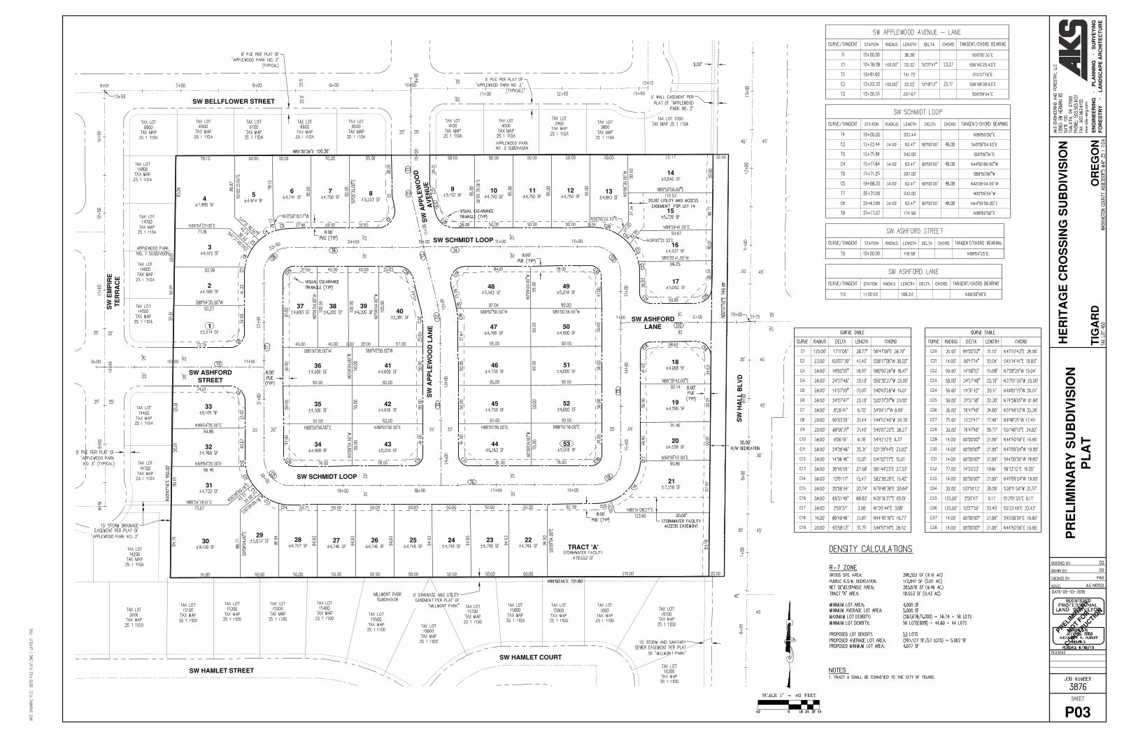
Adjustment to Street Standards to develop approximately 9.10 acres located at 15435 SW Hall Boulevard. The zone change would be a quasi-judicial map amendment from R-12 (existing) to R-7 (proposed), with no associated change to the Comprehensive Plan Map designation of Medium Density Residential. The subdivision would result in the creation of 53 lots intended for single-family residential style development, and an associated water quality tract. The special adjustment requests an alternate street section to match existing streets that adjoin the property.
APPLICANT: Venture Properties
Attn: Kelly Ritz 4230 Galewood Street Lake Oswego, OR 97035
OWNER: Schmidt Acres, LLC 12525 NW Jackson Quarry Road Hillsboro, OR 97124
LOCATION: 15435 SW Hall Blvd Washington County Tax Map 2S111DA, Tax Lot 00400 COMP. PLAN DESIGNATION: Medium-Density Residential — These areas will provide medium-density residences
(6 to 12 units to the net acre) and necessary urban services to maintain a stable mixture of single-family and multi-family neighborhoods. This designation includes the R-7 and R-12 zones.
CURRENT ZONE: R-12: medium-density residential district. The R-12 zoning district is designed to
accommodate a full range of housing types at a minimum lot size of 3,050 square feet. A wide range of civic and institutional uses are also permitted conditionally.
PROPOSED ZONE: R-7: medium-density residential district. The R-7 zoning district is designed to
accommodate attached single-family homes, detached single-family homes with or without accessory residential units, at a minimum lot size of 5,000 square feet, and

HERITAGE CROSSING PAGE 2 OF 33 ZON2015-00002 et. al. FINAL ORDER
duplexes, at a minimum lot size of 10,000 square feet. Mobile home parks and subdivisions are also permitted outright. Some civic and institutional uses are also permitted conditionally.
APPLICABLE REVIEW CRITERIA: Community Development Code Chapters 18.370.020.C.9, 18.380.030.C, and
18.430.040.A; and Metro Urban Growth Management Functional Plan Title 1 SECTION II. PLANNING COMMISSION DECISION
The Planning Commission finds the proposed application does not meet the applicable approval criteria of the Tigard Community Development Code. Therefore, the Planning Commission DENIES the requested Land Use Application.
SECTION III. BACKGROUND INFORMATION Site Description & Vicinity The project site is approximately 9.10 acres and rectangular in shape. A single-family home sits on the eastern edge of the site, with the remainder an undeveloped grass field. The site is relatively flat, with an 11-foot difference in elevation resulting from a gentle slope to the southeast. Vegetation on the site reflects the historical use of the property for hay production, with little tree cover and minimal landscaping around the existing home. Natural resources on the site are limited to two palustrine emergent wetlands approximately 0.80 and 0.94 acres in size. According to the natural resource assessment submitted with the application, one wetland is hydrologically connected to Fanno Creek through a stormwater catch basin in the Hall Boulevard right of way. The other appears isolated due to upland conditions separating the two. Both are dominated by non-native plants. These wetlands are not classified as locally significant on Tigard’s Wetland Inventory, and development within them does not require a sensitive lands permit from the City. Adjacent development is predominantly single-family residential, built between 1985 and 1998, when this part of Tigard converted from forest and farmland to urban residential land uses. Zoning in the surrounding area is predominantly R-7 and R-12 with some R-4.5 to the southwest (see Attachment “A”). City records show a relatively consistent zoning for this site since annexation. Major dates are below:
1981 – Project site annexed into the City as part of the Durham Island Annexation and assigned an “R-5” zoning designation. See Council Resolution No. 81-93.
1983 – Zone change from R-5 to R-12 as part of the 1983 update of the City’s Comprehensive Plan, Development Code, and Zoning Map. See Ordinance No. 83-52.
Primary road access is from Hall Boulevard, with approximately 550 feet of frontage along the eastern boundary. Hall Boulevard is a north-south arterial within the City under the jurisdiction of ODOT, and is also a Metro designated corridor on the Metro 2040 Growth Concept Map (see Attachment “B”). Neighborhood access is available from two local streets stubbed at the northern and western boundaries of the site. Tri-Met bus line 76 serves the property, with a bus stop immediately adjacent to the project site at the intersection of Hall Boulevard and Ashford Street. The 76 line connects this property to major destinations in Washington County including the Beaverton Transit Center, Downtown Beaverton, the Washington Square Transit Center, the Hall/Nimbus station, the Tigard Transit Center, Bridgeport Village, and Legacy Meridian Park Hospital (see Attachment “C”). Non-residential land uses are also within close proximity of the project site. A neighborhood commercial center is located approximately 800 feet to the south, at the corner of Hall and Durham Street. Three school facilities (Tigard High School, Durham Elementary, and Templeton/Twality) are within 0.3 miles of
HERITAGE CROSSING PAGE 3 OF 33 ZON2015-00002 et. al. FINAL ORDER
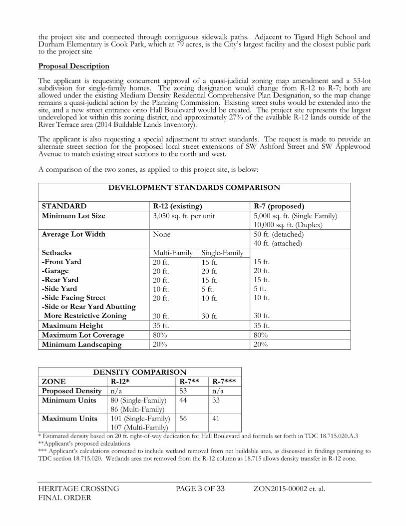
the project site and connected through contiguous sidewalk paths. Adjacent to Tigard High School and Durham Elementary is Cook Park, which at 79 acres, is the City’s largest facility and the closest public park to the project site Proposal Description The applicant is requesting concurrent approval of a quasi-judicial zoning map amendment and a 53-lot subdivision for single-family homes. The zoning designation would change from R-12 to R-7; both are allowed under the existing Medium Density Residential Comprehensive Plan Designation, so the map change remains a quasi-judicial action by the Planning Commission. Existing street stubs would be extended into the site, and a new street entrance onto Hall Boulevard would be created. The project site represents the largest undeveloped lot within this zoning district, and approximately 27% of the available R-12 lands outside of the River Terrace area (2014 Buildable Lands Inventory). The applicant is also requesting a special adjustment to street standards. The request is made to provide an alternate street section for the proposed local street extensions of SW Ashford Street and SW Applewood Avenue to match existing street sections to the north and west. A comparison of the two zones, as applied to this project site, is below:
DEVELOPMENT STANDARDS COMPARISON
STANDARD R-12 (existing) R-7 (proposed)
Minimum Lot Size
3,050 sq. ft. per unit 5,000 sq. ft. (Single Family) 10,000 sq. ft. (Duplex)
Average Lot Width None 50 ft. (detached) 40 ft. (attached)
Setbacks -Front Yard -Garage -Rear Yard -Side Yard -Side Facing Street -Side or Rear Yard Abutting More Restrictive Zoning
Multi-Family Single-Family 15 ft. 20 ft. 15 ft. 5 ft. 10 ft. 30 ft.
20 ft. 20 ft. 20 ft. 10 ft. 20 ft. 30 ft.
15 ft. 20 ft. 15 ft. 5 ft. 10 ft. 30 ft.
Maximum Height 35 ft. 35 ft.
Maximum Lot Coverage 80% 80%
Minimum Landscaping 20% 20%
DENSITY COMPARISON
ZONE R-12* R-7** R-7***
Proposed Density n/a 53 n/a
Minimum Units 80 (Single-Family) 86 (Multi-Family)
44 33
Maximum Units 101 (Single-Family) 107 (Multi-Family)
56 41
* Estimated density based on 20 ft. right-of-way dedication for Hall Boulevard and formula set forth in TDC 18.715.020.A.3 **Applicant’s proposed calculations *** Applicant’s calculations corrected to include wetland removal from net buildable area, as discussed in findings pertaining to TDC section 18.715.020. Wetlands area not removed from the R-12 column as 18.715 allows density transfer in R-12 zone.

HERITAGE CROSSING PAGE 4 OF 33 ZON2015-00002 et. al. FINAL ORDER
ALLOWED HOUSING TYPES
R-12 R-7
Single Unit – Detached P P
Single Unit – Attached P R9/C
Accessory Units R R
Duplexes P P
Multifamily P N
Manufactured P P P=Permitted R=Restricted C=Conditional Use N=Not Permitted 9Permitted by right if no more than five units in a grouping; permitted conditionally if six or more units per grouping.
Staff Recommendation of Denial A staff recommendation for denial was presented because the application does not meet the approval criteria for a quasi-judicial zone change or maximum density standards in the R-7 zone.
The applicant has not demonstrated compliance with all applicable Comprehensive Plan policies, particularly those pertaining to Chapter 2 (Land Use) and Chapter 10 (Housing);
The applicant has not demonstrated compliance with all applicable implementing ordinances, in particular Title 1 of the Metro Urban Growth Management Functional Plan and maximum density standards set forth in TDC 18.715 (Density Calculations); and
The applicant has not provided evidence of a change in the neighborhood or a mistake or inconsistency in the comprehensive plan or zoning map as applied to the project site.
Prior to and during application review, staff communicated concerns regarding the application on multiple occasions, including the following face-to-face meetings. At each of these meetings it was communicated that a recommendation of denial was likely.
September 9, 2014: Pre-Application Conference with staff from Community Development and Public Works. Staff expressed concern regarding potential noncompliance with the Tigard Community Development Code, Tigard Comprehensive Plan, and the Metro Urban Growth Management Functional Plan. This concern was highlighted on Page 7 of the pre-application notes delivered at the meeting, included as Exhibit “D” of the applicant’s materials.
November 5, 2014: Meeting between the applicant and staff from Community Development and the City Manager’s Office.
March 31, 2015: Meeting between the applicant and staff from Community Development and Public Works.

HERITAGE CROSSING PAGE 5 OF 33 ZON2015-00002 et. al. FINAL ORDER
SECTION IV. SUMMARY OF APPLICABLE CRITERIA The following summarizes the criteria applicable to this decision in the order in which they are addressed:
A. Applicable Development Standards 18.370 Variances and Adjustments 18.380 Zoning Map and Text Amendments 18.430 Subdivisions 18.510 Residential Zoning Districts 18.705 Access, Egress and Circulation 18.715 Density Computations 18.725 Environmental Performance Standards 18.745 Landscaping and Screening 18.765 Off-Street Parking and Loading Requirements 18.775 Sensitive Lands 18.790 Urban Forestry Plan 18.795 Vision Clearance Areas 18.810 Street and Utility Improvement Standards
B. Impact Study
SECTION V. APPLICABLE REVIEW CRITERIA AND FINDINGS TIGARD COMMUNITY DEVELOPMENT CODE 18.370: Variances and Adjustments 18.370.020 Adjustments C. Special adjustments.
9. Adjustments for street improvement requirements (Chapter 18.810). By means of a Type II procedure, as governed by Section 18.390.040, the director shall approve, approve with conditions, or deny a request for an adjustment to the street improvement requirements, based on findings that the following criterion is satisfied: Strict application of the standards will result in an unacceptably adverse impact on existing development, on the proposed development, or on natural features such as wetlands, bodies of water, significant habitat areas, steep slopes or existing mature trees. In approving an adjustment to the standards, the director shall determine that the potential adverse impacts exceed the public benefits of strict application of the standards.
Venture Properties is requesting a special adjustment to street standards. The request is made to provide an alternate street section for the proposed local street extensions of SW Ashford Street and SW Applewood Avenue to match existing street sections to the north and west. These streets were built as 32-foot curb-to-curb, with five foot curb-tight sidewalks, street trees on the outside of the sidewalks, and parking on one side of the street. Venture proposes to continue these street sections until they intersect with Schmidt Loop. Staff finds that a strict application of existing street standards would result in an awkward transition, could have potentially adverse consequences on users within the new and existing developments, and that strict application of the standards would not result in greater public benefits. This criterion is met. Finding: Based on the analysis above, the Variances and Adjustments standards have been met. 18.380: Zoning Map and Text Amendments

HERITAGE CROSSING PAGE 6 OF 33 ZON2015-00002 et. al. FINAL ORDER
18.380.030 Quasi-Judicial Amendments and Procedures to this Title and Map A. Quasi-judicial amendments. Quasi-judicial zoning map amendments shall be undertaken by means of a Type III-PC procedure, as governed by Section 18.390.050, using standards of approval contained in subsection D of this section. The approval authority shall be as follows:
1. The commission shall decide zone change applications which do not involve comprehensive plan map amendments;
The proposed zone change application to replace the R-12 zone with the R-7 zone does not involve a comprehensive plan map amendment, because the existing comprehensive plan designation of "Medium Density Residential" includes both the R-12 and R-7 zoning districts and would remain unchanged. Therefore, the Planning Commission shall make a decision on the proposed zone change application. C. Standards for making quasi-judicial decisions. A recommendation or a decision to approve,
approve with conditions or to deny an application for a quasi-judicial amendment shall be based on all of the following standards:
1. Demonstration of compliance with all applicable comprehensive plan policies and map designations.
The proposed change in zoning from R-12 to R-7 is consistent with the Comprehensive Plan Map designation of “Medium Density Residential”, but does not satisfy all applicable comprehensive plan policies. In particular, the proposal is inconsistent with Policies 2.1.2, 2.1.5, 2.1.14, 2.1.15, 6.1.3, 10.1.1, 10.1.2, 10.1.5, 10.2.5, 10.2.7, and 12.1.1 which are discussed in greater detail later in this report. This criterion is not met, and the proposal cannot be conditioned to satisfy this criterion.
2. Demonstration of compliance with all applicable standards of any provision of this code or other applicable implementing ordinance; and
The proposed change in zoning does not satisfy all applicable standards of the Metro Urban Growth Management Functional Plan. Findings regarding this noncompliance are discussed later in this report. This criterion is not met, and cannot be conditioned to satisfy this criterion.
3. Evidence of change in the neighborhood or community or a mistake or inconsistency in the comprehensive plan or zoning map as it relates to the property which is the subject of the development application.
The application narrative states on page 16 that “the region has changed substantially since the R-12 zoning was first applied in 1983.” The basis for this statement is that since 1983, adjacent lots have developed at R-7 levels, and that development consistent with the R-12 zone standards would be an “anomaly” and the present designation to be “spot zoning”. Staff finds that the applicant has not provided sufficient evidence of change in the neighborhood or community, nor has a mistake been identified that pertains directly to the project site. The evidence in the record demonstrates more consistency than change, as demonstrated in the following facts, which are discussed in greater detail below.
The R-12 zoning designation was adopted and re-affirmed in multiple ordinances adopted by Council, including Ord. Nos. 83-24 and 83-52 as part of the adoption of the City’s first state acknowledged comprehensive plan. There is no evidence of a mistake or inconsistency between the current zoning and that applied in 1983.
The location criteria used to assign the R-12 density to this property in 1983 remain unchanged, and
the current arrangement of land uses is neither an “anomaly” nor “spot zoning”.
The base zone lot sizes and development standards for medium density zones are substantially the same as adopted in 1983.
HERITAGE CROSSING PAGE 7 OF 33 ZON2015-00002 et. al. FINAL ORDER
The adopting maps of 1983 included a greater differential in density along the western boundary than exists today (R-7 existing versus R-4.5 in 1983), and despite a change in zoning along the northern and western boundaries, the average adjoining density has cumulatively increased on two sides. A copy of the zoning map adopted in Ordinance No. 83-52 is included as Attachment “D”.
The R-12 zoning was properly adopted and reaffirmed by Council in 1983, and the existing designation is not the result of a procedural or mapping error. The application for a zone change cannot be approved on the basis of a procedural or mapping error regarding the subject property. The application does not support a finding of “spot zoning”. The Tigard Community Development Code does not define spot zoning, nor is it present in the relevant approval criteria. The term is generally used to describe the rezoning of a small lot or parcel of land to benefit a single owner, for a use incompatible with surrounding uses, and/or for a use not associated with the furthering of a public interest. The project site does not meet this description in that it is a large property approximately 80 times the size of adjacent lots, was zoned R-12 to further a public purpose, and whose R-12 designation continues to further the policies of the Tigard Comprehensive Plan, as demonstrated elsewhere in this report. The current R-12 zoning was applied as part of the 1983 Comprehensive Plan Update that resulted in the adoption of the City’s first state acknowledged plan. This adoption process was finalized in City Ordinance No. 83-52 which formerly adopted the Comprehensive Plan Resource document (Volume 1); the Comprehensive Plan Findings, Policies, and Implementation Strategies document (Volume 2); and the Community Development Code and Zoning Map. When Ordinance No. 83-52 was adopted, the project site and vicinity was largely undeveloped farm and forestland. Through citizen input and findings regarding the appropriate placement of density, zones capable of accommodating higher densities were placed along Hall Boulevard between Sattler Street and Durham Road. Key determinants in the R-12 designation were the presence of transit, adjacency to a minor arterial, the proximity of neighborhood commercial, and the relative lack of site constraints.
The Resource Document adopted with the Comprehensive Plan documents Hall Boulevard’s status as a minor-arterial (page I-226), that Tri-Met Line 43 was an established route along this corridor (pages I-249 and I-250), and notes that “the Comprehensive Plan locates residential densities along, or in close proximity to, existing and potential transit corridors” (see Attachment “E”).
Policy 8.2.2 in Volume 2 stated “The City shall encourage the expansion and use of public transit by: (a) locating land intensive uses in close proximity to transitways” (Attachment “E”)
Policy 12.1.1 stated “The City shall provide for housing densities in accordance with: (a) the
applicable plan policies [and] (b) the applicable locational criteria.” Included as Attachment “F”, the locational criteria for Medium Density Residential, and more specifically the assignment of a density range allowed within Medium Density Residential, were based on factors which have not changed since 1983. These include the following:
o “The topography and natural features of the area and the degree of possible buffering from established low density residential areas.” [established as of 1983]
o “The capacity of the services.” o “The distance from public transit.” o “The distance to neighborhood…commercial centers…” o “The distance from public open space”
These locational factors have not changed since 1983 as Hall Boulevard remains a state highway and local arterial. Tri-Met continues to operate a transit stop immediately adjacent to the project site, and a neighborhood commercial center and three school sites remain in walkable distance from the project site.
Existing Comprehensive Plan Policies 2.1.5, 6.1.3, and 10.1.5 mirror the original locational criteria
discussed above. There is no evidence of change in City policies regarding the placement of densities along transit corridors.
Applicable conditions in 1983 remain consistent and relevant today, as reflected in current Comprehensive Plan policies. Therefore, there is no evidence of change in locational criteria since the 1983 assignment of the R-12 density.

HERITAGE CROSSING PAGE 8 OF 33 ZON2015-00002 et. al. FINAL ORDER
In 1983, the project site was designated R-12 as part of a continuous corridor along Hall Boulevard between Sattler and Durham Road. Lands to the west were designated R-4.5 due to the lower capacity of Sattler Road at that time. Two land use actions resulted in a change of zoning along the northern, western, and southern boundaries. These changes were made in response to changes to Sattler Road and problems with the R-12 zoning that have since been addressed.
1983 Existing
North R-12 R-7
West R-4.5 R-7
South R-12 R-7
East R-7 /
R-12
R-7 /
R-12
In 1984, the property to the south was developed as part of the Hallberg (later renamed to Milmont Park) subdivision, approved under File S 5-84. At that time, Metro’s minimum density standards were not yet enacted and property owners could develop at significantly lower densities than allowed in the zone. It also appears that developers were having a hard time meeting setbacks for single-family homes in the R-12 zone, as the R-12 chapter had not yet been amended to differentiate between single-family and multi-family structures. At that time it appears to have been a practice of the City to change zoning designations to match actual development levels, as the final order states “Because it appears that the current proposal is close to meeting the R-7 zone standards, the Planning staff is requesting consideration of a zone change from R-12 to R-7”. Given subsequent changes in the code to establish minimum density and facilitate single-family development through appropriate setback differentiation, the Tigard Community Development Code has been amended in a manner that would prohibit the downzoning of an R-12 zone based on the standards applicable in 1984. In 1996, the properties to the North and West of the project site were rezoned from R-12 and R-4.5 into a uniform R-7 zoning designation (CPA960004/ZON 96-0003). Known as the Sattler Site, the final order was submitted as Exhibit “O” of the application. The change was predicated on two criterion and one additional important finding: evidence of a mistake in the record regarding the zoning designation, increased vehicular capacity on Sattler Road as a result of capital improvements, and an increase in density by one additional unit across the whole of the affected area. As a result, the cumulative density of housing adjacent to the project site was actually increased, and the scale of the density transition decreased as R-12 and R-7 are more similar than R-12 adjacent to R-4.5 Despite these changes in zoning, staff does not find a reason that R-12 adjacent to R-7 presents an inherent conflict or compatibility issue. Both zones are within the Comprehensive Plan Designation of Medium Density Residential. The application narrative states the R-12 zone is “no longer compatible with the surrounding community,” but provides no explanation or evidence regarding the nature of the compatibility issues. The Tigard Comprehensive Plan provides guidance on this issue by defining the term:
“Compatibility — The ability of adjacent and/or dissimilar land uses to coexist without aesthetic, environmental, and/or operational conflicts that would prevent persons to enjoy, occupy, or use their properties without interference. A variety of remedies to compatibility conflicts are normally provided in a jurisdiction’s land use program; including limited land use designation, buffering, screening, site and building design standards, transportation facility design, etc.”
The Tigard Community Development Code has required density transition standards since at least 1983 to facilitate orderly transition between densities and housing types. This includes the 30 foot setback from a less restrictive zone, then and now included in the R-12 and R-7 setback requirements, and TDC Chapter 18.720 (Design Compatibility Standards) where attached and multi-family housing is proposed. As demonstrated in the evidence and analysis above, this criterion is not met and the application cannot be conditioned to meet this standard.

HERITAGE CROSSING PAGE 9 OF 33 ZON2015-00002 et. al. FINAL ORDER
FINDING: Based on the analysis above, the approval criteria for a quasi-judicial zone change have not been met. 18.430: Subdivisions 18.430.040 Approval Criteria: Preliminary Plat A. Approval criteria. The approval authority may approve, approve with conditions, or deny a
preliminary plat based on the following approval criteria: 1. The proposed preliminary plat complies with the applicable zoning ordinance and other
applicable ordinances and regulations;
The proposed plat is designed to meet R-7 standards. As discussed above in approval criteria for a zone change, the application has not satisfied the criterion for a quasi-judicial map amendment from R-12 to R-7. As discussed below in this report, the proposed subdivision exceeds maximum density allowed in this zone. Therefore, this criterion is not met.
2. The proposed plat name is not duplicative or otherwise satisfies the provisions of ORS
Chapter 92; The name of “Heritage Crossing” has been reviewed and approved by the Washington County Surveyors office, as documented in Exhibit K. This criterion is met.
3. The streets and roads are laid out so as to conform to the plats of subdivisions and maps of major partitions already approved for adjoining property as to width, general direction and in all other respects unless the city determines it is in the public interest to modify the street or road pattern;
As shown on the “Conceptual Future Street Connectivity Plan” in Exhibit A of the application materials, all existing roadway alignments and dedications are honored through Heritage Crossing. SW Ashford Street stubs into the west property line and has been extended along the existing line and grade. Similarly, SW Applewood Avenue stubs into the north property line and has been designed to extend into the site to match the existing line and grade. No changes to existing streets are proposed. This criterion is met.
4. An explanation has been provided for all common improvements. No common improvements are proposed except for public infrastructure. This criterion does not apply. Chapter 18.510: Residential Zoning Districts 18.510.050 Development Standards A. Compliance required. All development must comply with:
1. All of the applicable development standards contained in the underlying zoning district, except where the applicant has obtained variances or adjustments in accordance with Chapters 18.370;
2. All other applicable standards and requirements contained in this title. B. Development standards. Development standards in residential zoning districts are contained
in Table 18.510.2. The application proposes a single-family home subdivision intended to comply with standards applicable to the proposed R-7 zone, rather than the existing R-12 zone. The application provides a variety of lot sizes as permitted by the lot averaging provision of TDC 18.420.D, varying from 4,037 square feet to 9,129 square feet. The average lot size is 5,002 square feet which exceeds the minimum average lot size of 5,000 square feet. Only single-family detached homes are proposed, which is an allowed use in the R-7 zone per Table 18.510.1. The proposed setbacks match the R-7 standards as shown on the Building Setback Plan on

HERITAGE CROSSING PAGE 10 OF 33 ZON2015-00002 et. al. FINAL ORDER
Sheet 4 the proposed plans. Average lot width does not apply when lot size averaging is used per DIR2013-00002. This criterion is met. 18.705: Access, Egress, and Circulation 18.705.030 General Provisions H. Access management.
1. An access report shall be submitted with all new development proposals which verifies design of driveways and streets are safe by meeting adequate stacking needs, sight distance and deceleration standards as set by ODOT, Washington County, the City and AASHTO (depending on jurisdiction of facility.
The applicant has submitted a Sight Distance Certification, dated January 7, 2015. Removal of vegetation is required to provide adequate site distance at the intersection of Ashford Street and Hall Boulevard. The applicant shall provide intersection sight distance certification meeting ODOT standards. The applicant has submitted a Traffic Impact Study prepared by Lancaster Engineering, dated January 7, 2015. The analysis was done for the proposed Heritage Crossing development located along the west side of Hall Boulevard and is proposed to provide 53 single family homes. Based on the analysis done by Lancaster the following is recommended: • A northbound left-turn lane should be provided at the intersection of Ashford Street and Hall
Boulevard. • The existing access spacing between Ashford Street and Langtree on Hall Boulevard does not meet
ODOT standards, however the spacing is adequate to accommodate left-turn movements. Lancaster’s analysis concludes that the proposed neighborhood development can occur while maintaining acceptable traffic operations and safety at the study intersections. The proposed zone change will result in a net reduction in site trips. The applicant shall incorporate all of Lancaster’s recommendations into their ODOT Permit application and City of Tigard PFI permit application for review and approval.
2. Driveways shall not be permitted to be placed in the influence area of collector or arterial
street intersections. Influence area of intersections is that area where queues of traffic commonly form on approach to an intersection. The minimum driveway setback from a collector or arterial street intersection shall be 150 feet, measured from the right-of-way line of the intersecting street to the throat of the proposed driveway. The setback may be greater depending upon the influence area, as determined from City Engineer review of a traffic impact report submitted by the applicant’s traffic engineer. In a case where a project has less than 150 feet of street frontage, the applicant must explore any option for shared access with the adjacent parcel. If shared access is not possible or practical, the driveway shall be placed as far from the intersection as possible.
No driveways are proposed within 150 feet of SW Hall Boulevard. This criterion is met.
3. The minimum spacing of driveways and streets along a collector shall be 200 feet. The minimum spacing of driveways and streets along an arterial shall be 600 feet.
Hall Boulevard is classified as an arterial street by Tigard. The proposed local street access of SW Ashford Lane is approximately 720 feet from the centerline of SW Sattler Street and 720 feet from SW Hamlet Street. The access is only 320 feet from SW Langtree Street on the east side of SW Hall Boulevard, but this is an existing access spacing established when SW Ashford Street and SW Langtree Street were constructed on the east side of SW Hall Boulevard. This criterion is met.

HERITAGE CROSSING PAGE 11 OF 33 ZON2015-00002 et. al. FINAL ORDER
4. The minimum spacing of local streets along a local street shall be 125 feet. All proposed local street intersections have a minimum separation of 125 feet curb to curb. This criterion is met. I. Minimum Access requirements for residential use.
1. Vehicular access and egress for single-family…dwelling units on individual lots…shall not be less than as provided in Tables 18.705.1…
Lots 14 and 15 have frontage on SW Hall Boulevard but take access from a 15 foot paved drive in a 20 foot wide access easement. This exceeds the standards of this section. Lots 4 and 30 are both flag lots; both flag poles have just over 15 feet of frontage on the public street, which meets this standard. However, the access widths stated in the response refer to partitions for two or less units. The application is for a subdivision and is addressed further below in 18.810.060.
2. Vehicular access to multifamily structures shall be brought to within 50 feet of the ground floor entrance or the ground floor landing of a stairway, ramp, or elevator leading to the dwelling units;
The application does not propose a multi-family structure. This standard does not apply.
3. Private residential access drives shall be provided and maintained in accordance with the provisions of the Uniform Fire Code.
Tualatin Valley Fire and Rescue has reviewed the project and in a letter dated April 23, 2015 endorsed the proposal predicated on conditions of approval set forth in the letter. Access drives shall be reviewed for conformance as part of normal building permit review.
4. Access drives in excess of 150 feet in length shall be provided with approved provisions for the turning around of fire apparatus by one of the following:
a. A circular, paved surface having a minimum turn radius measured from center point to outside edge of 35 feet;
b. A hammerhead-configured, paved surface with each leg of the hammerhead having a minimum depth of 40 feet and a minimum width of 20 feet;
c. The maximum cross slope of a required turnaround is five percent. The only proposed access drive is 78 feet long. No access drives in excess of 150 feet are proposed. This criterion does not apply.
5. Vehicle turnouts, (providing a minimum total driveway width of 24 feet for a distance of at least 30 feet), may be required so as to reduce the need for excessive vehicular backing motions in situations where two vehicles traveling in opposite directions meet on driveways in excess of 200 feet in length.
Lots 14 and 15 contain the only access drive which is only 78 feet in length. No turnouts are needed.
6. Where permitted, minimum width for driveway approaches to arterials or collector streets shall be no less than 20 feet so as to avoid traffic turning from the street having to wait for traffic exiting the site.
No driveway access is proposed onto a collector or arterial street. Lots 14 through 21 will only have vehicle access from the local street to the west; this criterion does not apply.

HERITAGE CROSSING PAGE 12 OF 33 ZON2015-00002 et. al. FINAL ORDER
18.715: Density Computations 18.715.020 Density Calculation A. Definition of net development area. Net development area, in acres, shall be determined by
subtracting the following land area(s) from the total site acres: 1. All sensitive land areas:
a. Land within the 100-year floodplain, b. Land or slopes exceeding 25%, c. Drainage ways, and d. Wetlands, e. Optional: Significant tree groves or habitat areas, as designated on the City of Tigard
“Significant Tree Grove Map” or “Significant Habitat Areas Map”; 2. All land dedicated to the public for park purposes; 3. All land dedicated for public rights-of-way. When actual information is not available, the
following formulas may be used: a. Single-family development: allocate 20% of gross acreage, b. Multifamily development: allocate 15% of gross acreage or deduct the actual private
drive area; 4. All land proposed for private streets; and 5. A lot of at least the size required by the applicable base zoning district, if an existing
dwelling is to remain on the site. B. Calculating maximum number of residential units. To calculate the maximum number of
residential units per net acre, divide the number of square feet in the net acres by the minimum number of square feet required for each lot in the applicable zoning district.
C. Calculating minimum number of residential units. As required by Section 18.510.040, the minimum number of residential units per net acre shall be calculated by multiplying the maximum number of units determined in subsection B of this section by 80% (0.8).
The applicant’s narrative and associated plans (Sheet P03) do not address all of the sensitive land areas identified above. Specifically, 18.715.020.A.1 requires the applicant to subtract all sensitive land areas from the net development area, including all wetlands. As demonstrated on sheet P02 and CWS Service Provider letter 14-003153, there are two wetlands on the project site that total 75,894 square feet. Calculations provided in the application narrative address steep slopes (0 square feet) but do not include square footages for drainageways and wetlands. Application Narrative Revised Per Code Gross Site Area 396,523 396,523
Right of Way Dedication -112,676 -112,676 Wetlands -75,894
Net Development Area 283, 676 207,953 Maximum Density 56 41 Minimum Density 44 33
When wetland areas are subtracted from the net development area, the project exceeds maximum density by 12 units. This standard is not met. 18.715.030 Residential Density Transfer A. Rules governing residential density transfer.
2. Wetlands. Units per acre calculated by subtracting land areas listed in 18.715.020.A.1.d from the gross acres may be transferred to the remaining buildable land areas on land zoned R-12, R-25, and R-40 subject to the following limitations: a. The number of units which can be transferred is limited to the number of units which
would have been allowed on the wetland area, if not for these regulations;

HERITAGE CROSSING PAGE 13 OF 33 ZON2015-00002 et. al. FINAL ORDER
b. The total number of units per site does not exceed the maximum number of units per gross acre permitted for the applicable comprehensive plan designation.
The applicant does not request density transfer as they do not find the wetland areas to be applicable. Staff notes that within the R-12 zone, up to 100% of the allowable density within the wetland area may be transferred to the remainder of the site. Because the application requests a change in zoning from R-12 to R-7, this density transfer provision is not available. This standard does not apply to the proposal. 18.745: Landscaping and Screening 18.745.040 Street Tree Standards A. Street trees shall be required as part of the approval process for conditional use (Type III), downtown design review (Type II and III), minor land partition (Type II), planned development (Type III), site development review (Type II) and subdivision (Type II and III) permits. B. The minimum number of required street trees shall be determined by dividing the linear amount of street frontage within or adjacent to the site (in feet) by 40 feet. When the result is a fraction, the minimum number of required street trees shall be determined by rounding to the nearest whole number. C. Street trees required by this section shall be planted according to the street tree planting standards in the Urban Forestry Manual. D. Street trees required by this section shall be provided adequate soil volumes according to the street tree soil volume standards in the Urban Forestry Manual. E. Street trees required by this section shall be planted within the right-of-way whenever practicable according to the street tree planting standards in the Urban Forestry Manual. Street trees may be planted no more than six feet from the right-of-way according to the street tree planting standards in the Urban Forestry Manual when planting within the right-of-way is not practicable. F. An existing tree may be used to meet the street tree standards provided that: 1. The largest percentage of the tree trunk immediately above the trunk flare or root buttresses is either within the subject site or within the right-of-way immediately adjacent to the subject site; 2. The tree would be permitted as a street tree according to the street tree planting and soil volume standards in the Urban Forestry Manual if it were newly planted; and 3. The tree is shown as preserved in the tree preservation and removal site plan (per 18.790.030.A.2), tree canopy cover site plan (per 18.790.030.A.3) and supplemental report (per 18.790.030.A.4) of a concurrent urban forestry plan and is eligible for credit towards the effective tree canopy cover of the site. G. In cases where it is not practicable to provide the minimum number of required street trees, the director may allow the applicant to remit payment into the urban forestry fund for tree planting and early establishment in an amount equivalent to the city’s cost to plant and maintain a street tree for three years (per the street tree planting standards in the Urban Forestry Manual) for each tree below the minimum required. Street trees have been proposed as shown on Sheet 13. The project contains approximately 4,459 linear feet of street frontage. This would require a minimum of 111 street trees, and 93 street trees have been provided. The new Urban Forestry Plan requires street trees of a greater stature, and there is not room to provide the full 111 street trees per this code section. With the conflict in the standard, the more restrictive Urban Tree Code controls. Per Section 18.745.040.G, a fee-in-lieu will be required for the 18 trees that cannot fit on the property. Street planting specifications have been outlined in the Supplemental Arborist Report. Soil volumes have been shown on the table of Sheet 14. Over 500 cubic yards of soil have been provided for all proposed trees and over 1,000 cubic yards have been provided for the one existing tree. Through conditions of approval to ensure compliance with implementation standards, City street tree standards can be met.

HERITAGE CROSSING PAGE 14 OF 33 ZON2015-00002 et. al. FINAL ORDER
18.745.050 Buffering and Screening A. General provisions.
1. It is the intent that these requirements shall provide for privacy and protection and reduce or eliminate the adverse impacts of visual or noise pollution at a development site, without unduly interfering with the view from neighboring properties or jeopardizing the safety of pedestrians and vehicles.
2. Buffering and screening is required to reduce the impacts on adjacent uses which are of a different type in accordance with the matrices in this chapter (Tables 18.745.1 and 18.745.2). The owner of each proposed development is responsible for the installation and effective maintenance of buffering and screening. When different uses would be abutting one another except for separation by a right-of-way, buffering, but not screening, shall be required as specified in the matrix.
3. In lieu of these standards, a detailed buffer area landscaping and screening plan may be submitted for the director’s approval as an alternative to the buffer area landscaping and screening standards, provided it affords the same degree of buffering and screening as required by this code.
Per the Buffer Matrix, single-family detached development must provide a Type A buffer when adjacent to an arterial street. Lots 14 through 21 will be required to provide a ten foot buffer of lawn or living groundcover. The applicant proposes to provide this buffer within the 15 foot rear yard setback, which exceeds the minimum 10 foot rear yard buffer. This standard is met. B. Buffering and screening requirements.
1. A buffer consists of an area within a required setback adjacent to a property line and having a depth equal to the amount specified in the buffering and screening matrix and containing a length equal to the length of the property line of the abutting use or uses.
2. A buffer area may only be occupied by utilities, screening, sidewalks and bikeways, and landscaping. No buildings, accessways or parking areas shall be allowed in a buffer area except where an accessway has been approved by the city.
3. A fence, hedge or wall, or any combination of such elements, which are located in any yard is subject to the conditions and requirements of paragraph B.8 and subsection D of this section.
4. The minimum improvements within a buffer area shall consist of combinations for landscaping and screening as specified in Table 18.745.1. In addition, improvements shall meet the following specifications: a. At least one row of trees shall be planted. Trees shall be chosen from any of the tree lists
in the Urban Forestry Manual (except the nuisance tree list) unless otherwise approved by the director and have a minimum caliper of 1-1/2 inches for deciduous trees and a minimum height of six feet for evergreen trees at the time of planting. Spacing for trees shall be as follows: i. Small stature or columnar trees shall be spaced no less than 15 feet on center and no
greater than 20 feet on center. ii. Medium stature trees shall be spaced no less than 20 feet on center and no greater
than 30 feet on center. iii. Large stature trees shall be spaced no less than 30 feet on center and no greater than
40 feet on center. b. In addition, at least 10 five-gallon shrubs or 20 one-gallon shrubs shall be planted for
each 1,000 square feet of required buffer area. c. The remaining area shall be planted in lawn or other living ground cover.
F. Buffer matrix. 1. The buffer matrices contained in Tables 18.745.1 and 18.745.2 shall be used in calculating widths of buffering/screening and required improvements to be installed between proposed uses and abutting uses or zoning districts.

HERITAGE CROSSING PAGE 15 OF 33 ZON2015-00002 et. al. FINAL ORDER
Per the Buffer Matrix, single-family detached development must provide a Type A buffer when adjacent to an arterial street. Lots 14 through 21 will be required to provide a ten foot buffer of lawn or living groundcover. The applicant proposes to provide this buffer within the 15 foot rear yard setback, which exceeds the minimum 10 foot rear yard buffer. This standard is met. 18.765: Off-Street Parking and Loading Requirements 18.765.020 Applicability of Provisions A. New construction. At the time of the erection of a new structure within any zoning district, off-street vehicle parking will be provided in accordance with Section 18.765.070. The application does not include building and parking designs for any of the newly created lots. Conformance with off-street parking and loading requirements will be determined at the time of building permit issuance when the new structures are erected. FINDING: The standards of this chapter will be met through normal building permit review. 18.775: Sensitive Lands 18.775.020 Applicability of Uses—Permitted, Prohibited, and Nonconforming A. CWS stormwater connection permit. All proposed development must obtain a stormwater connection permit from CWS pursuant to its design and construction standards. D. Jurisdictional wetlands. Landform alterations or developments which are only within wetland areas that meet the jurisdictional requirements and permit criteria of the U.S. Army Corps of Engineers, Division of State Lands, CWS, and/or other federal, state, or regional agencies, and are not designated as significant wetlands on the City of Tigard “Wetland and Streams Corridors Map,” do not require a sensitive lands permit. The city shall require that all necessary permits from other agencies are obtained. All other applicable city requirements must be satisfied, including sensitive land permits for areas within the 100-year floodplain, slopes of 25% or greater or unstable ground, drainageways, and wetlands which are not under state or federal jurisdiction. Heritage Crossing contains two wetlands not on the Tigard Local Wetland Inventory, but subject to the jurisdictional requirements of federal, state, and regional agencies. The Applicant has applied for necessary state and federal permits to fill the wetlands and pay for off-site mitigation credits at a registered wetland bank. In order to comply with this section, a condition of approval is recommended to require the submission of a copy of all applicable permits prior to any ground disturbance on the site. As conditioned, this standard is met. 18.790: Urban Forestry Plan 18.790.030 Urban Forestry Plan Requirements A. Urban forestry plan requirements. An urban forestry plan shall: 1. Be coordinated and approved by a landscape architect (the project landscape architect) or a person that is both a certified arborist and tree risk assessor (the project arborist), except for minor land partitions that can demonstrate compliance with effective tree canopy cover and soil volume requirements by planting street trees in open soil volumes only; 2. Meet the tree preservation and removal site plan standards in the Urban Forestry Manual; 3. Meet the tree canopy site plan standards in the Urban Forestry Manual; and 4. Meet the supplemental report standards in the Urban Forestry Manual. A certified arborist has prepared the Urban Forestry Plan for Heritage Crossing. Full findings of the tree

HERITAGE CROSSING PAGE 16 OF 33 ZON2015-00002 et. al. FINAL ORDER
canopy standards, the tree preservation and removal standards, and the supplemental report standards have been provided on Sheets 13 and 14 of Exhibit A and in the Supplemental Arborist Report in Exhibit J of the application materials. Additional conditions of approval are recommended to ensure the requirements of the Urban Forestry Plan are complied with during construction. As conditioned, the requirements of Chapter 18.790 can be met. 18:795: Visual Clearance Areas 18.795.030 Visual Clearance Requirements A. At corners. Except within the CBD zoning district a visual clearance area shall be maintained on the corners of all property adjacent to the intersection of two streets, a street and a railroad, or a driveway providing access to a public or private street. B. Obstructions prohibited. A clear vision area shall contain no vehicle, hedge, planting, fence, wall structure or temporary or permanent obstruction (except for an occasional utility pole or tree), exceeding three feet in height, measured from the top of the curb, or where no curb exists, from the street center line grade, except that trees exceeding this height may be located in this area, provided all branches below eight feet are removed. 18.795.040 Computations A. Arterial streets. On all designated arterial streets the visual clearance area shall not be less than 35 feet on each side of the intersection. B. Non-arterial streets.
1. Non-arterial streets 24 feet or more in width. At all intersections of two non-arterial streets, a non-arterial street and a driveway, and a non-arterial street or driveway and railroad where at least one of the streets or driveways is 24 feet or more in width, a visual clearance area shall be a triangle formed by the right-of-way or property lines along such lots and a straight line joining the right-of-way or property line at points which are 30 feet distance from the intersection of the right-of-way line and measured along such lines. See Figure 18.795.1.
2. Non-arterial streets less than 24 feet in width. At all intersections of two non-arterial streets, a non-arterial street and a driveway, and a non-arterial street or driveway and railroad where both streets and/or driveways are less than 24 feet in width, a visual clearance area shall be a triangle whose base extends 30 feet along the street right-of-way line in both directions from the centerline of the accessway at the front setback line of a single-family and two-family residence, and 30 feet back from the property line on all other types of uses.
Vision clearance triangles have been shown on the Preliminary Plat in Exhibit A, and will be verified at final plat and building permit submittal. SW Hall Boulevard is an arterial street and 35-foot vision clearance triangles will be required. All other proposed roads are local streets with a width of 28 feet except for SW Applewood Avenue between Schmidt Loop, which is 24 feet wide; 30 foot vision clearance triangles will be required for the local street intersections. This criterion will be met. 18.810: Street and Utility Improvement Standards Improvements (Section 18.810.030 Section 18.810.030.A.1 states no development shall occur unless the development has frontage or approved access to a public street.
The Applicant states that Heritage Crossing has access to SW Applewood Avenue, SW Ashford Street, and SW Hall Boulevard.
Section 18.810.030.A.2 states no development shall occur unless streets within the development meet the standards of this chapter.

HERITAGE CROSSING PAGE 17 OF 33 ZON2015-00002 et. al. FINAL ORDER
The Applicant states they meet this standard; however they have asked for an adjustment which is a Type 2 procedure to the cross section width and placement of sidewalks for the of Ashford Street and Applewood Avenue.
Section 18.810.030.A.3 states no development shall occur unless the streets adjacent to the development meet the standards of this chapter, provided, however, that a development may be approved if the adjacent street does not meet the standards but half-street improvements meeting the standards of this title are constructed adjacent to the development.
The Applicant states they will dedicate right of way and install an 8 foot sidewalk along Hall Boulevard frontage. It is yet to be determined that there is an adequate pavement section on SW Hall Boulevard that meets ODOT standards.
Minimum Rights-of-Way and Street Widths: Section 18.810.030.E Section 18.810.030.E states that unless otherwise indicated on an approved street plan, or as needed to continue an existing improved street or within the downtown district, street right-of-way and roadway widths shall not be less than the minimum width described below. Where a range is indicated, the width shall be determined by the decision-making authority based upon anticipated average daily traffic (ADT) on the new street segment. (The city council may adopt by resolution, design standards for street construction and other public improvements. The design standards will provide guidance for determining improvement requirements within the specified ranges.) These are presented in Table 18.810.1.
The site is adjacent to Hall Boulevard, which is classified as an arterial. The Applicant has stated that the Hall Boulevard road section meets the ODOT standard, however half street improvements will be required to have a 36-foot paved width from centerline. Right of way dedication is 50 feet from centerline.
A 50-foot right-of-way and a 28-foot paved width are proposed for Schmidt Loop and Ashford Lane. Schmidt Loop’s centerline radius is 59 feet; however the standard is a minimum of 166 feet. Eyebrows will be required at these four (4) curve locations on Schmidt Loop.
Parking is permitted if traffic volumes are less than 1,000 vpd.
A 46 foot right of way with a paved width of 24 feet and no parking is proposed for Applewood Lane. The maximum vehicles per day allowed for this configuration is 200 vpd. Lancaster’s report does not address the number of vehicles projected for this section of the street; however it is the opinion of staff that given the short street length and the likelihood the vehicles using this length would be those who live on it then this narrowed section would be adequate.
Applewood Lane and Applewood Avenue show centerline radii as 59 feet however the standard is a minimum of 166 feet. The applicant has requested an adjustment to the local street standards for Ashford Street and Applewood Avenue. The adjustment would allow existing sidewalk adjacent to the curb to continue a short distance to Schmidt Loop.
The adjustment should be allowed.
Future Street Plan and Extension of Streets: Section 18.810.030.F states that a future street plan shall be filed which shows the pattern of existing and proposed future streets from the boundaries of the proposed land division. This section also states that where it is necessary to give access or permit a satisfactory future division of adjoining land, streets shall be extended to the boundary lines of the tract to be developed and a barricade shall be constructed at the end of the street. These street stubs to adjoining properties are not considered to be cul-de-sacs since they are intended to continue as through streets at such time as the adjoining property is developed. A barricade shall be constructed at the end of the street by the property owners which shall not be removed until authorized by the City Engineer, the cost of which shall be included in the street construction cost. Temporary hammerhead turnouts or temporary cul-de-sac bulbs shall be constructed for stub streets in excess of 150 feet in length.
The applicant has provided a Future Street Plan showing the pattern of existing and planned future streets adjacent to and around the development. In addition to the connection to Hall Boulevard, Ashford Street will provide a connection to the west and Applewood Lane will provide a connection to the north.

HERITAGE CROSSING PAGE 18 OF 33 ZON2015-00002 et. al. FINAL ORDER
Street Alignment and Connections (Section 18.810.030.H.1) Section 18.810.030.H.1 states that full street connections with spacing of no more than 530 feet between connections is required except where prevented by barriers such as topography, railroads, freeways, pre-existing developments, lease provisions, easements, covenants or other restrictions existing prior to May 1, 1995 which preclude street connections. A full street connection may also be exempted due to a regulated water feature if regulations would not permit construction. Section 18.810.030.H.2 states that all local, neighborhood routes and collector streets which abut a development site shall be extended within the site to provide through circulation when not precluded by environmental or topographical constraints, existing development patterns or strict adherence to other standards in this code. A street connection or extension is precluded when it is not possible to redesign, or reconfigure the street pattern to provide required extensions. Land is considered topographically constrained if the slope is greater than 15% for a distance of 250 feet or more. In the case of environmental or topographical constraints, the mere presence of a constraint is not sufficient to show that a street connection is not possible. The applicant must show why the constraint precludes some reasonable street connection.
The proposed street plans in the development meet the spacing standard of no more than 530 feet between connections.
Ashford Street and Applewood Lane abut the site and will be extended through the site.
This criterion for connection and through circulation is met.
Grades and Curves (Section 18.810.030.N) Section 18.810.030.N states that grades shall not exceed ten percent on arterials, 12% on collector streets, or 12% on any other street (except that local or residential access streets may have segments with grades up to 15% for distances of no greater than 250 feet). Centerline radii of curves shall be as determined by the City Engineer.
The applicant states that the grades of the local streets proposed within the site do not exceed 3%, thereby meeting this criterion.
Centerline radii of SW Schmidt Loop do not meet this requirement. Washington County standard eyebrows may be used to meet standards.
Access to Arterials and Major Collectors (Section 18.810.030.Q) Section 18.810.030.Q states that where a development abuts or is traversed by an existing or proposed arterial or major collector street, the development design shall provide adequate protection for residential properties and shall separate residential access and through traffic, or if separation is not feasible, the design shall minimize the traffic conflicts. The design shall include any of the following: A parallel access street along the arterial or major collector; Lots of suitable depth abutting the arterial or major collector to provide adequate buffering
with frontage along another street; Screen planting at the rear or side property line to be contained in a non-access reservation
along the arterial or major collector; or Other treatment suitable to meet the objectives of this subsection; If a lot has access to two streets with different classifications, primary access should be from
the lower classification street.
The site is adjacent to Hall Boulevard, an arterial. The applicant has provided a circulation plan that shows all lot access will be from the residential local streets.
This criterion is met.
Alleys, public or private (Section 18.810.030.R) Section 18.810.030.R states that alleys shall be no less than 20 feet in width. In commercial and industrial districts, alleys shall be provided unless other permanent provisions for access to off-street parking and loading facilities are made. While alley intersections and sharp changes in

HERITAGE CROSSING PAGE 19 OF 33 ZON2015-00002 et. al. FINAL ORDER
alignment shall be avoided, the corners of necessary alley intersections shall have a radius of not less than 12 feet.
Access for lot 14 is through lot 15 via an easement.
Private Streets (Section 18.810.030.T) Section 18.810.030.T states that design standards for private streets shall be established by the City Engineer. The City shall require legal assurances for the continued maintenance of private streets, such as a recorded maintenance agreement. Private streets serving more than six dwelling units are permitted only within planned developments, mobile home parks, and multi-family residential developments.
No private streets are proposed. This section does not apply.
Street Cross-Sections (Section 18.810.030.AA). Section 18.810.030.AA states that the final lift of asphalt concrete pavement shall be placed on all new constructed public roadways prior to final city acceptance of the roadway and within one year of the conditional acceptance of the roadway unless otherwise approved by the city engineer. The final lift shall also be placed no later than when 90% of the structures in the new development are completed or three years from the commencement of initial construction of the development, whichever is less. 1. Sub-base and leveling course shall be of select crushed rock; 2. Surface material shall be of Class C or B asphaltic concrete; 3. The final lift shall be placed on all new construction roadways prior to city final acceptance of the roadway; however, not before 90% of the structures in the new development are completed unless three years have elapsed since initiation of construction in the development; 4. The final lift shall be Class C asphaltic concrete as defined by A.P.W.A. standard specifications; and 5. No lift shall be less than 1-1/2 inches in thickness.
Applicant has proposed a street section of 3 inches of asphaltic concrete on 10 inches of aggregate base. The standard requires 3 ½ inches of asphaltic concrete.
Applicant shall revise plans to show 3 ½ inches of asphaltic concrete in two lifts.
Block Designs (Section 18.810.040.A) Section 18.810.040.A states that the length, width and shape of blocks shall be designed with due regard to providing adequate building sites for the use contemplated, consideration of needs for convenient access, circulation, control and safety of street traffic and recognition of limitations and opportunities of topography.
Block Sizes (Section 18.810.040.B) Section 18.810.040.B.1 states that the perimeter of blocks formed by streets shall not exceed 2,000 feet measured along the right-of-way line except:
Where street location is precluded by natural topography, wetlands or other bodies of water or, pre-existing development or;
For blocks adjacent to arterial streets, limited access highways, major collectors or railroads. For non-residential blocks in which internal public circulation provides equivalent access.
The Applicant states that Heritage Crossing is surrounded by existing development to the north, east, west, and south, which limits the ability to provide compact block lengths. Interior block perimeters are a maximum of 1,140 feet. The block created by SW Bellflower, SW Empire Terrace, SW Ashford Street, SW Schmidt Loop and SW Applewood Street has a perimeter length of approximately 2,590 feet. The block to the east of that block is approximately 1,480 measured from the existing pedestrian connection to SW Hall Boulevard. SW Hall Boulevard is subject to minimum access spacing standards of 600 feet for arterials. The block created along the south is very large, but no solution is available due to the existing development pattern.
Block size meets standards except to the south where existing development precludes any connections.
This criterion is met.

HERITAGE CROSSING PAGE 20 OF 33 ZON2015-00002 et. al. FINAL ORDER
Section 18.810.040.B.2 also states that bicycle and pedestrian connections on public easements or right-of-ways shall be provided when full street connection is exempted by paragraph 1 of this subsection B. Spacing between connections shall be no more than 330 feet, except where precluded by environmental or topographical constraints, existing development patterns, or strict adherence to other standards in the code. (Ord. 06-20; Ord. 02-33)
Lots - Size and Shape (Section 18.810.060.A) Section 18.810.060.A states that lot size, width, shape and orientation shall be appropriate for the location of the development and for the type of use contemplated, and:
1. No lot shall contain part of an existing or proposed public right-of-way within its dimensions. 2. The depth of all lots shall not exceed 2-1/2 times the average width, unless the parcel is less than 1-1/2 times the minimum lot size of the applicable zoning district. 3. Depth and width of properties zoned for commercial and industrial purposes shall be adequate to provide for the off-street parking and service facilities required by the type of use proposed.
This criterion is met.
Lot Frontage (Section 18.810.060.B) Each lot shall abut upon a public or private street, other than an alley, for a width of at least 25 feet unless the lot is created through a minor land partition in which case 18.162.050.C applies, or unless the lot is for an attached single-family dwelling unit, in which case the lot frontage shall be at least 15 feet
This application is for a subdivision not a land partition. All lots shall abut at least 25 feet of frontage on public or private streets. Lots 4 and 30 do not meet this requirement.
Revise plan showing lots 4 and 30 to show a minimum of 25 feet of frontage on SW Schmidt Loop.
Sidewalks (Section 18.810.070.A) Section 18.810.070.A requires that all industrial streets and private streets shall have sidewalks meeting city standards along at least one side of the street. All other streets shall have sidewalks meeting city standards along both sides of the street. A development may be approved if an adjoining street has sidewalks on the side adjoining the development, even if no sidewalk exists on the other side of the street. The applicant’s plans indicate they will be installing full sidewalk improvements with this development along both sides of the internal streets.
The Applicant shows sidewalk on all streets. There are existing sidewalks adjacent to the curb on Ashford Street and Applewood Avenue. The plans show a cross section with a 5 foot concrete sidewalk adjacent to the curb. The standard when sidewalk is placed adjacent to the curb is 6 foot width not including the curb. The Applicant is requesting a variance to extend this geometry to Schmidt Loop.
The plans shall be revised to show a 6 foot concrete sidewalk adjacent to the curb for Ashford Street and Applewood Avenue from existing to Schmidt Loop.
Planter Strip Requirements (Section 18.810.070.C) Section 18.810.070.C requires a planter strip separation of at least five feet between the curb and the sidewalk shall be required in the design of streets, except where the following conditions exist: there is inadequate right-of-way; the curbside sidewalks already exist on predominant portions of the street; it would conflict with the utilities; there are significant natural features (large trees, water features, significant habitat areas, etc.) that would be destroyed if the sidewalk were located as required; or where there are existing structures in close proximity to the street (15 feet or less) or where the standards in Table 18.810.1 specify otherwise. Additional consideration for exempting the planter strip requirement may be given on a case-by-case basis if a property abuts more than one street frontage.
The Applicant shows planter strips on all streets except Ashford Street and Applewood Avenue. The existing geometry of these streets have sidewalk adjacent to the curb. The plans show a cross section with a 5 foot concrete sidewalk adjacent to the curb. The Applicant is requesting a variance to extend this geometry to Schmidt Loop.
The plans shall be revised to show a 6 foot concrete sidewalk adjacent to the curb.

HERITAGE CROSSING PAGE 21 OF 33 ZON2015-00002 et. al. FINAL ORDER
SANITARY SEWERS
Sewers Required (Section 18.810.090.A) Section 18.810.090.A requires that sanitary sewer be installed to serve each new development and to connect developments to existing mains in accordance with the provisions set forth in Design and Construction Standards for Sanitary and Surface Water Management (as adopted by Clean Water Services in 1996 and including any future revisions or amendments) and the adopted policies of the comprehensive plan.
The applicant’s plans indicate sanitary sewer mains will be constructed to accommodate the development. The mains will connect to an existing manhole at Hall Boulevard, a state highway.
Applicant shall obtain an ODOT permit for work within ODOT right of way.
STORM DRAINAGE
General Provisions (Section 18.810.100.A) Section 18.810.100.A states that a culvert or other drainage facility shall be large enough to accommodate potential runoff from its entire upstream drainage area, whether inside or outside the development. The City Engineer shall approve the necessary size of the facility, based on the provisions of Design and Construction Standards for Sanitary and Surface Water Management (as adopted by Clean Water Services in 2000 and including any future revisions or amendments)
Accommodation of Upstream Drainage (Section 18.810.100.C) Section 18.810.100.C states that where it is anticipated by the City Engineer that the additional runoff resulting from the development will overload an existing drainage facility, the Director and Engineer shall withhold approval of the development until provisions have been made for improvement of the potential condition or until provisions have been made for storage of additional runoff caused by the development in accordance with the Design and Construction Standards for Sanitary and Surface Water Management (as adopted by Clean Water Services in 2000 and including any future revisions or amendments).
Effect on Downstream Drainage (Section 18.810.100.D) Section 18.810.100.D states that where it is anticipated by the City Engineer that the additional runoff resulting from the development will overload an existing drainage facility, the Director and Engineer shall withhold approval of the development until provisions have been made for improvement of the potential condition or until provisions have been made for storage of additional runoff caused by the development in accordance with the Design and Construction Standards for Sanitary and Surface Water Management (as adopted by Clean Water Services in 2000 and including any future revisions or amendments).
Applicant has submitted plans showing a storm drain design based on a Storm Drainage Analysis. Following collection and treatment, the runoff will be directed to the existing manhole in Hall Boulevard, a state highway. City of Tigard public works maintenance personnel request that a maintenance access point off of Hall Boulevard be provided. The maintenance accessway proposed may be reduced to 10 feet and connect through to Hall Boulevard and become a pedestrian/bicycle pathway.
Applicant shall revise plans to show a maintenance access driveway off of Hall Boulevard for maintenance of the outfall structure. Applicant shall revise plans for the water quality facility to show the pond ramp adjacent to Hall Boulevard. Maintenance accessway shown off of Schmidt Loop can be reduced to a 10 foot width.
Applicant shall obtain an ODOT permit for work within ODOT right of way.
Bikeways and Pedestrian Pathways (18.810.110) 18.810.110.C.4 states that the Design standards for bike and pedestrian-ways shall be determined by the city engineer. (Ord. 12-13 §1; Ord. 11-04 §2; Ord. 09-09 §3; Ord. 02-33; Ord. 99-22).
Hall Boulevard is an ODOT facility and shall incorporate bike lanes and will be reviewed by ODOT.

HERITAGE CROSSING PAGE 22 OF 33 ZON2015-00002 et. al. FINAL ORDER
The proposed maintenance accessway for the water quality facility can be reduced in width to 10 feet and will make a pedestrian/bike connection reducing walkable block length from 2,590 to approximately 2,180 feet.
Applicant shall revise plans to show a maintenance access driveway off of Hall Boulevard for maintenance of the outfall structure.
Applicant shall revise plans for the water quality facility to show the pond ramp adjacent to Hall Boulevard. Maintenance accessway shown off of Schmidt Loop shall be reduced to a 10 foot width.
UTILITIES
Underground Utilities Section 18.810.120 Section 18.810.120 states that all utility lines, but not limited to those required for electric, communication, lighting and cable television services and related facilities shall be placed underground, except for surface mounted transformers, surface mounted connection boxes and meter cabinets which may be placed above ground, temporary utility service facilities during construction, high capacity electric lines operating at 50,000 volts or above, and:
The developer shall make all necessary arrangements with the serving utility to provide the underground services;
The City reserves the right to approve location of all surface mounted facilities; All underground utilities, including sanitary sewers and storm drains installed in streets by the
developer, shall be constructed prior to the surfacing of the streets; and Stubs for service connections shall be long enough to avoid disturbing the street improvements
when service connections are made.
Exception to Under-Grounding Requirement (Section 18.810.120.C) Section 18.810.120.C states that a developer shall pay a fee in-lieu of under-grounding costs when the development is proposed to take place on a street where existing utilities which are not underground will serve the development and the approval authority determines that the cost and technical difficulty of under-grounding the utilities outweighs the benefit of under-grounding in conjunction with the development. The determination shall be on a case-by-case basis. The most common, but not the only, such situation is a short frontage development for which under-grounding would result in the placement of additional poles, rather than the removal of above-ground utilities facilities. An applicant for a development which is served by utilities which are not underground and which are located across a public right-of-way from the applicant’s property shall pay a fee in-lieu of under-grounding.
There are overhead utilities that run parallel to the project along the east side of Hall Boulevard. Applicant shall pay a fee in-lieu of undergrounding of (838.55 feet) ($35.00 /foot) = $29,349.
The applicant states that all utility lines within the development shall be placed underground.
ADDITIONAL CITY AND/OR AGENCY CONCERNS WITH STREET AND UTILITY IMPROVEMENT STANDARDS:
Traffic Study Findings: The applicant has submitted a Traffic Impact Study prepared by Lancaster Engineering, dated March 13, 2015. The analysis was done for the proposed Heritage Crossing development located along the west side of Hall Boulevard and is proposed to provide 53 single family homes.
The existing access spacing between Ashford Street and Langtree on Hall Boulevard does not meet ODOT standards; however the spacing is adequate to accommodate left-turn movements.
Based on the analysis done by Lancaster, the recommended installation of a continuous left-turn lane should be provided on Hall Boulevard between the intersections of Ashford Street/Ashford Lane and Langtree Street.
Lancaster’s analysis concludes that the proposed neighborhood development can occur while maintaining acceptable traffic operations and safety at the study intersections

HERITAGE CROSSING PAGE 23 OF 33 ZON2015-00002 et. al. FINAL ORDER
The applicant shall incorporate all of Lancaster’s recommendations into their ODOT Permit application and City of Tigard PFI permit application for review and approval.
ODOT staff has been requested to provide comments and conditions. The applicant shall comply with the recommended conditions.
Public Water System: The applicant indicates that they will provide service to this development by extending lines from street stubs at the existing terminations of Ashford Street and Applewood Avenue. In addition, a connection to the 12-inch line in Hall Boulevard is proposed.
This connection will require an ODOT permit.
Storm Water Quality: Surface Water Management (SWM) regulations established by Clean Water Services (CWS) Design and Construction Standards (adopted by Resolution and Order No. 07-20) require the construction of on-site water quality facilities. The facilities shall be designed to remove 65 percent of the phosphorus contained in 100 percent of the storm water runoff generated from newly created impervious surfaces. In addition, a maintenance plan shall be submitted indicating the frequency and method to be used in keeping the facility maintained through the year.
A combined water quality and quantity treatment facility in a tract at the southeast corner of the site is proposed.
The applicant shall obtain a (CWS) Stormwater Connection Permit Authorization prior to issuance of the City of Tigard PFI permit.
Grading and Erosion Control: CWS Design and Construction Standards also regulate erosion control to reduce the amount of sediment and other pollutants reaching the public storm and surface water system resulting from development, construction, grading, excavating, clearing, and any other activity which accelerates erosion. Per CWS regulations, the applicant is required to submit an erosion control plan for City review and approval prior to issuance of City permits.
The Federal Clean Water Act requires that a National Pollutant Discharge Elimination System (NPDES) erosion control permit be issued for any development that will disturb one or more acre of land. Since this site is over five acres, the developer will be required to obtain an NPDES permit from the City prior to construction. This permit will be issued along with the site and/or building permit.
A final grading plan shall be submitted showing the existing and proposed contours. The plan shall detail the provisions for surface drainage of all lots, and show that they will be graded to ensure that surface drainage is directed to the street or a public storm drainage system approved by the Engineering Department. For situations where the back portions of lots drain away from a street and toward adjacent lots, appropriate private storm drainage lines shall be provided to sufficiently contain and convey runoff from each lot.
The applicant will also be required to provide a geotechnical report, per Appendix J of the Oregon Specialty Structural Code (OSSC), for the proposed grading slope construction.
The design engineer shall also indicate, on the grading plan, which lots will have natural slopes between 10% and 20%, as well as lots that will have natural slopes in excess of 20%. This information will be necessary in determining if special grading inspections and/or permits will be necessary when the lots develop.
The site is over 5 acres in size, therefore an NPDES 1200-C permit is required.
Address Assignments: The City of Tigard is responsible for assigning addresses for parcels within the City of Tigard. An addressing fee in the amount of $50.00 per address shall be assessed. This fee shall be paid to the City prior to approval of the final plat.
For this project as currently proposed, the addressing fee will be $2,700.00 (53 lots and 1 tract X $50/address = $2,700.00).

HERITAGE CROSSING PAGE 24 OF 33 ZON2015-00002 et. al. FINAL ORDER
The developer will also be required to provide signage at the entrance of each shared flag lot driveway or unnamed private street that lists the addresses that are served by the given driveway or street. This will assist emergency services personnel to more easily find a particular home.
Survey Requirements The applicant’s final plat shall contain State Plane Coordinates [NAD 83 (91)] on two monuments with a tie to the City’s global positioning system (GPS) geodetic control network (GC 22). These monuments shall be on the same line and shall be of the same precision as required for the subdivision plat boundary. Along with the coordinates, the plat shall contain the scale factor to convert ground measurements to grid measurements and the angle from north to grid north. These coordinates can be established by:
GPS tie networked to the City’s GPS survey. By random traverse using conventional surveying methods.
In addition, the applicant’s as-built drawings shall be tied to the GPS network. The applicant’s engineer shall provide the City with an electronic file with points for each structure (manholes, catch basins, water valves, hydrants and other water system features) in the development, and their respective X and Y State Plane Coordinates, referenced to NAD 83 (91).
FINDING: Based on the analysis above, the approval criteria and standards for a quasi-judicial zone change and concurrent subdivision approval have not meet met, and the project cannot be conditioned to meet these applicable criterion and development standards. IMPACT STUDY SECTION 18.390.040.B.e requires that the applicant include an impact study. The study shall address, at a minimum, the transportation system, including bikeways, the drainage system, the parks system, the water system, the sewer system, and the noise impacts of the development. For each public facility system and type of impact of the development on the public at large, public facilities systems, and affected private property users. In situations where the Community Development Code requires the dedication of real property interests, the applicant shall either specifically concur with the dedication of real property interest, or provide evidence which supports the conclusion that the real property dedication requirement is not roughly proportional to the projected impacts of the development. The applicant has provided an impact analysis addressing the project’s impacts on public systems (see Exhibit “L” of the applicant’s materials). The applicant’s plans propose improvements or upgrades as needed to not have any adverse impact on the city infrastructure. Existing public sanitary sewer and water laterals will serve the site. There is no known deficiency in capacity. A proportional share contribution will be made for the resulting transportation and park system impacts. ROUGH PROPORTIONALITY ANALYSIS The applicant’s plans concur with the City’s request for the dedication of right-of-way and the construction of frontage improvements including 24 feet of pavement, a curb, and a six-foot wide sidewalk. The Transportation Development Tax (TDT) is a mitigation measure required for new development and will be paid at the time of building permits. Based on Washington County implementation figures effective October 1, 2014, TDTs are expected to recapture approximately 32.1 percent of the traffic impact of new development on the Collector and Arterial Street system. Based on the use and the size of the use proposed and upon completion of this development, the future builders of the residences will be required to pay TDTs of approximately $417,872 ($8,036 x 53 single-family dwelling units including credit for one existing dwelling). Based on the estimate that total TDT fees cover 32.0 percent of the impact on major street improvements citywide, a fee that would cover 100 percent of this project’s traffic impact is $1,305,850 ($417,872 0.32). The difference between the TDT paid and the full impact, is considered as unmitigated impact.
HERITAGE CROSSING PAGE 25 OF 33 ZON2015-00002 et. al. FINAL ORDER
Estimate of Unmitigated Impacts Full Impact ......................................................................TDT 0.32= .................... $1,305,850 Less TDT Assessment ....................................................13 lots x $8,036/lot= ........... 417,872 Less ROW value SW Hall Blvd.....................................10,999.6 s.f. x $10/s.f.= ....... 109,996 Estimated Value of Remaining Unmitigated Impacts $777,982 FINDING: Using the above cost factors, it can be determined that the value of the remaining
unmitigated impacts exceeds the costs of the right-of-way dedication and provides for additional frontage improvements. Therefore, the City could condition the project should the Planning Commission find in favor of the zone change and subdivision proposal, and find the required land dedication and improvements to be roughly proportional and justified.
TIGARD COMPREHENSIVE PLAN POLICIES Policy 1.2: The City shall define and publicize an appropriate role for citizens in each phase of the land use planning process. Public involvement and notice requirements for quasi-judicial zone changes are described in application requirements determined by the Director and section 18.390.050.C of the Tigard Community Development Code. Pursuant to application form requirements, the applicant noticed and held a neighborhood meeting on Wednesday, December 17, 2014 at the Tigard Community Friends Church. Pursuant to noticing requirements set forth in 18.390.050 of the development code, the public was made aware of the project and instructed on how they may participate through direct mailing of public hearing notices to all property owners within 500 feet on April 20, the posting of on-site notice on April 24, and the publishing of a notice in the Tigard Times on Thursday, May 6, 2015. The rule for public participation at a public hearing is set forth in 18.390.050.D which the Planning Commission must follow when making a decision. This policy is satisfied. Policy 2.1.2: The City’s land use regulations, related plans, and implementing actions shall be consistent with and implement its Comprehensive Plan. As demonstrated in findings pertaining to the Tigard Community Development Code and Comprehensive Plan policies below, the application is not consistent with the City’s land use regulations and Comprehensive Plan policies. This policy is not met, and cannot be conditioned to be met. Policy 2.1.3: The City shall coordinate the adoption, amendment, and implementation of its land use program with other potentially affected jurisdictions and agencies. As required by 18.390.050.C.1.a(3) of the Tigard Community Development Code, and discussed in Section VI below, notice of the proposed zone change was sent to affected government agencies. Agency comments are discussed later in this report. This policy is satisfied. Policy 2.1.5: The City shall promote intense urban level development in Metro-designated Centers and Corridors, and employment and industrial areas. The applicant’s narrative states that this policy does not apply as Hall Boulevard is not listed on the Metro Title 6 map of designated centers, as contained in Metro’s Urban Growth Management Functional Plan. Staff finds the Title 6 map does apply to this application as Title 6 is intended to govern regional investment policy and does not supersede the Metro 2040 Growth Concept Map (Attachment “B”). This relationship was confirmed through an April 7, 2015 phone conversation and April 23, 2015 email from Brian Harper, Metro Regional Planner, who verified Hall Boulevard’s status as a Metro-designated corridor. An action to reduce development density would be contrary to this policy requiring the city to promote “intense urban level development” in Metro designated corridors. Therefore, this policy is not met, and the application cannot be conditioned to meet this policy.

HERITAGE CROSSING PAGE 26 OF 33 ZON2015-00002 et. al. FINAL ORDER
Policy 2.1.14: Applicants shall bear the burden of proof to demonstrate that land use applications are consistent with applicable criteria and requirements of the Development Code, the Comprehensive Plan, and when necessary, those of the state and other agencies. As demonstrated in the analysis above and below in this report, the applicant has not met the burden of proof necessary for the City to approve this application. This policy is not met. Policy 2.1.15: In addition to other Comprehensive Plan goals and policies deemed applicable, amendments to Tigard’s Comprehensive Plan/Zone Map shall be subject to the following specific criteria:
A. Transportation and other public facilities and services shall be available, or committed to be made available, and of sufficient capacity to serve the land uses allowed by the proposed map designation;
B. Development of land uses allowed by the new designation shall not negatively affect existing or planned transportation or other public facilities and services;
Heritage Crossing abuts SW Hall Boulevard and has two local streets stubbing into it to provide transportation connectivity. A Transportation Impact Analysis has been provided that outlines how the proposed subdivision will impact the surrounding roadway network. The proposed zone change will reduce the density of the project and thus reduce the transportation impacts of any development. Sanitary sewer is available in the southeast corner as well as at the two street stubs. Water is available in the two street stubs as well. Sections A and B of this policy are satisfied.
C. The new land use designation shall fulfill a proven community need such as provision of needed commercial goods and services, employment, housing, public and community services, etc. in the particular location, versus other appropriately designated and developable properties;
D. Demonstration that there is an inadequate amount of developable, appropriately designated, land for the land uses that would be allowed by the new designation;
Section C of this policy requires the City to find that the new land use designation shall fulfill a “proven community need” in this particular location. As demonstrated in the table below, the proposed change in zoning would reduce or further restrict the allowed uses on the project site, and does not provide for a new use that is not presently allowed or needed in this particular location. More specifically, the applicant has failed to demonstrate a need to lower the density of housing in this particular location, or a need to prohibit multi-family housing, or restrict attached single-family housing in this particular location.
ALLOWED HOUSING TYPES
R-12 R-7
Single Unit – Detached P P
Single Unit – Attached P R9/C
Accessory Units R R
Duplexes P P
Multifamily P N
Manufactured P P P=Permitted R=Restricted C=Conditional Use N=Not Permitted 9Permitted by right if no more than five units in a grouping; permitted conditionally if six or more units per grouping.
Section D of this policy requires the City to find there is an inadequate amount of developable, appropriately designated land for the land uses that would be allowed by the new designation. As stated above, the applicant has failed to demonstrate a need for larger lot, single-family homes in this area. The

HERITAGE CROSSING PAGE 27 OF 33 ZON2015-00002 et. al. FINAL ORDER
application narrative makes a case that there is a “need” for R-7 land within the City, citing a number of deficiency of 59 housing units in the R-7 zone, but failing to analyze the similar diminishment of R-12 land which is capable of accommodating a broader variety of housing types at higher densities per acre. This lack of a balanced analysis is noted in the memorandum from the City of Tigard Housing Planner (Attachment G) which recommends denial of the project. Based on the analysis above, sections C and D of this policy are not met, and the application cannot be conditioned to meet them.
E. Demonstration that land uses allowed in the proposed designation could be developed in compliance with all applicable regulations and the purposes of any overlay district would be fulfilled;
While the proposed subdivision requires changes to comply density, urban forestry, and infrastructure requirements, there is no reason to believe the property could not be developed in conformance with R-7 standards. Section E of this policy is satisfied.
F. Land uses allowed in the proposed designation would be compatible, or capable of being made compatible, with environmental conditions and surrounding land uses; and
In the applicant states in their proposed findings for this policy, “the key consideration for this proposed zone change is neighborhood compatibility”, that proposed densities would be “twice” that of existing densities, and stating that only attached or multi-family housing could meet minimum densities. As discussed in previous analysis and findings, the Comprehensive Plan defines the term compatibility as follows:
“Compatibility — The ability of adjacent and/or dissimilar land uses to coexist without aesthetic, environmental, and/or operational conflicts that would prevent persons to enjoy, occupy, or use their properties without interference. A variety of remedies to compatibility conflicts are normally provided in a jurisdiction’s land use program; including limited land use designation, buffering, screening, site and building design standards, transportation facility design, etc.”
The applicant has provided no evidence other than stated differences in density and housing type regarding what sort of aesthetic, environmental, or operational conflicts would result from development built in conformance with R-12 standards adjacent to existing homes constructed to R-7 standards. Both zones are intended to provide for medium density residential land uses, and both base zone standards and Chapter 18.720 exist to ensure transitions between densities are as harmonious and compatible as possible. In addition, the code allows for lot size averaging which would allow the applicant to develop larger lots around the edge of the project site, further easing the transition. The applicant also asserts that it is impossible to develop single-family detached homes on the site. Staff disagrees as the site is flat, unconstrained, and other developers have conformed to the R-12 standard elsewhere in the City without the need for Planned Development Review or variances. The most recent example being the Solera I (SUB2005-00023) and Solera II (SUB2011-00001) subdivisions on Greenburg Road, where detached single-family homes were built on lots 25 feet wide, and averaging 3,063 and 3,193 square feet in size respectively. These dimensions were inclusive of a 30-foot rear yard setback which provides both buffering and outdoor amenities to the residents. As demonstrated above, the applicant has not demonstrated a compatibility issue exists in the current situation which would make the new land uses significantly more compatible. This policy is not met and cannot be met through conditions.
G. Demonstration that the amendment does not detract from the viability of the City’s natural systems.

HERITAGE CROSSING PAGE 28 OF 33 ZON2015-00002 et. al. FINAL ORDER
The zone change does not change potential wetland impacts. Section G of this policy is satisfied. Policy 2.1.17: The City may allow concurrent applications to amend the Comprehensive Plan/Zoning Map(s) and for development plan approval of a specific land use. Per this policy, the application is for a concurrent zoning map amendment and subdivision approval. This policy is satisfied. Policy 2.1.23: The City shall require new development, including public infrastructure, to minimize conflicts by addressing the need for compatibility between it and adjacent existing and future land uses. The proposal is for a zone consistent with that applied to adjoining properties where development was constructed according to R-7 zoning. No compatibility issues are anticipated as a result of the zone change. This policy is satisfied. Policy 6.1.3: The City shall promote land use patterns which reduce dependency on the automobile, are compatible with existing neighborhoods, and increase opportunities for walking, biking, and/or public transit. As detailed above, the proposal is to reduce the number of households on a site immediately adjacent to a bus stop and in walkable distance of school sites and a neighborhood commercial center. Hall Boulevard is also a designated bike route in the Tigard Transportation System Plan (Figure 5-7) and contains a bike route. An action to reduce the number of households within walkable distance of these services and facilities is not consistent with this policy. This policy is not met. Policy 10.1.1: The City shall adopt and maintain land use policies, codes, and standards that provide opportunities to develop a variety of housing types that meet the needs, preferences, and financial capabilities of Tigard’s present and future residents. The proposed zone change reduces the variety of housing types available to Tigard residents. The applicant makes a case that there is a general deficiency of R-7 land in the City, but has not provided evidence that the larger lot sizes and reduction in attached or multi-family units that would result from the zone change meets the needs, preferences, and financial capabilities of Tigard’s present and future residents to a greater degree than that allowed in the existing R-12 zone. This policy is not met. Policy 10.1.5: The city shall provide for high and medium density housing in the areas such as town centers (Downtown), regional centers (Washington Square), and along transit corridors where employment opportunities, commercial services, transit, and other public services necessary to support higher population densities are either resent or planned for in the future. The project site is immediately adjacent Tri-Met bus line 76. The 76-line connects this property to major destinations in Washington County including the Beaverton Transit Center, Downtown Beaverton, the Washington Square Transit Center, the Hall/Nimbus station, the Tigard Transit Center, Bridgeport Village, and Legacy Meridian Park Hospital (Attachment “C”). These stops form a corridor of employment opportunities, commercial services, transit connections, and other public services necessary to support higher population densities along this and other transit lines. While both the existing and proposed zoning are intended to provide for medium-density housing, the lowering of densities on this site would diminish conformance with this policy rather than enhance it. This policy is not met. Policy 10.2.5: The City shall encourage housing that supports sustainable development patterns by promoting the efficient use of land, conservation of natural resources, easy access to public transit

HERITAGE CROSSING PAGE 29 OF 33 ZON2015-00002 et. al. FINAL ORDER
and other efficient modes of transportation, easy access to services and parks, resource efficient design and construction, and the use of renewable energy resources. The proposal to reduce population density would result in a less efficient use of residentially designated land, would reduce the net benefit provided by the fill of mapped wetlands on the property, and would reduce the number of potential households along a transit corridor. As noted her memorandum of April 23, the City of Tigard Housing Planner found the location of the project to be of particular importance due to its location near the amenities and services identified above (Attachment “G”). This policy is not met. Policy 10.2.7: The City shall ensure that residential densities are appropriately related to locational characteristics and site conditions such as the presence of natural hazards and natural resources, availability of public facilities and services, and existing land use patterns. The R-12 designation was assigned to this property due to its proximity to an arterial, a Tri-Met bus line, and to schools and neighborhood commercial. Additionally, the R-12 designation was a decision made in 1983 to see this area develop to medium-density residential standards. Reducing density would not make full use of the locational opportunities listed above. This policy is not met. Policy 10.2.8: The City shall require measures to mitigate the adverse impacts from differing, or more intense, land uses on residential living environments, such as: A. orderly transitions from one residential density to another; B. protection of existing vegetation, natural resources and provision of open space areas; and C. installation of landscaping and effective buffering and screening. Policy 10.2.9: The City shall require infill development to be designed to address compatibility with existing neighborhoods. As previously discussed, the Tigard Community Development Code has standards to account for changes in density and housing types when they abut one another. The applicant has provided no evidence that development consistent with R-12 standards will be incompatible with adjacent, existing development and that existing compatibility standards required in Title 18 are inadequate. The proposed change in zoning is not supported by this policy. This policy is not met. Policy 12.1.1: 1. The City shall plan for a transportation system that meets current community needs and anticipated growth and development 2. The City shall prioritize transportation projects according to community benefit, such as safety, performance, and accessibility, as well as the associated costs and impacts. 3. The City shall maintain and enhance transportation functionality by emphasizing multi-modal travel options for all types of land uses. 4. The City shall promote land uses and transportation investments that promote balanced transportation options. 5. The City shall develop plans for major transportation corridors and provide appropriate land uses in and adjacent to those corridors. 6. The City shall support land use patterns that reduce greenhouse gas emissions and preserve the function of the transportation system. Policy 12.3.1: The City shall continue to support the existing commuter rail and

HERITAGE CROSSING PAGE 30 OF 33 ZON2015-00002 et. al. FINAL ORDER
bus service in Tigard and will seek opportunities for increased service frequency and passenger convenience. As discussed previously in this report, the lowering of density and reduction of potential transportation system users adjacent to a state highway, city arterial, bike route, and Tri-Met bus line does not promote balanced transportation options for the greatest number of people, or support existing bus service through the diminishment of potential riders. These policies are not met. FINDING: Based on the analysis above, the applicable Comprehensive Plan policies are not satisfied. METRO URBAN GROWTH MANAGEMENT FUNCTIONAL PLAN TITLE 1: HOUSING CAPACITY 3.07.110 Purpose and Intent The Regional Framework Plan calls for a compact urban form and a “fair-share” approach to meeting regional housing needs. It is the purpose of Title 1 to accomplish these policies by requiring each city and county to maintain or increase its housing capacity except as provided in section 3.07.120. Title 1 of the Metro Urban Growth Management Functional Plan requires cities and counties to maintain or increase their zoned capacity as a means of protecting regional housing capacity and requiring a “fair share” approach for each jurisdiction. This policy was approved by the Metro Council in 2011 after a long regional discussion with local partners that focused on how all jurisdictions would cooperate to address the 2011 Urban Growth Management Decision. 3.07.120 Housing Capacity A. A city or county may reduce the minimum zoned capacity of the Central City or a Regional
Center, Town Center, Corridor, Station Community or Main Street under subsection D or E. A city or county may reduce its minimum zoned capacity in other locations under subsections C, D or E.
The property fronts Hall Boulevard, a designated corridor on the Metro 2040 Growth Concept Map (Attachment “B”). Therefore, the City may only consider a reduction in minimum zoned capacity under subsection D or E as detailed below. As a result, the applicant may not rely on subsection C that allows reductions in if there is an equivalent increase in another location. Metro Regional Planner Brian Harper has confirmed the status of the corridor, and the strict applicability of subsections D and E below. C. A city or county may reduce its minimum zoned capacity by one of the following actions if it
increases minimum zoned capacity by an equal or greater amount in other places where the increase is reasonably likely to be realized within the 20-year planning period of Metro’s last capacity analysis under ORS 197.299: 1. Reduce the minimum dwelling unit density, described in subsection B, for one or more
zones; 2. Revise the development criteria or standards for one or more zones; or 3. Change its zoning map such that the city’s or county’s minimum zoned capacity would be
reduced. Action to reduce minimum zoned capacity may be taken any time within two years after action
to increase capacity. The application states that a separate development, approved in 2013 (Bonaventure Senior Housing / PDR2013-00001), provided 101 more dwelling units than allowed under existing zoning. This information is not relevant as this application may only be considered under subsections D and E due to the adjacency of a designated corridor on the Metro 2040 Growth Concept map. Metro Regional Planner Brian Harper has confirmed the adjacency of a Metro designated corridor, and the strict applicability of subsections D and E below. As a result, the applicant may not rely on subsection C

HERITAGE CROSSING PAGE 31 OF 33 ZON2015-00002 et. al. FINAL ORDER
that allows reductions in if there is an equivalent increase in another location. Even if the corridor were not present, the application would not satisfy this criterion. The Bonaventure approval did not include an “upzone” as part of its land use decision, was not considered concurrent with this application, and an assisted living facility is not an equivalent type of dwelling to the detached single-family homes being proposed. This criterion is not relevant. If it were relevant, the criterion would not be met. D. A city or county may reduce the minimum zoned capacity of a zone without increasing
minimum zoned capacity in another zone for one or more of the following purposes: 1. To re-zone the area to allow industrial use under Title 4 of this chapter or an educational or
medical facility similar in scale to those listed in section 3.07.1340D(5)(b)(i) of Title 13 of this chapter; or
2. To protect natural resources pursuant to Titles 3 or 13 of this chapter. The project does not propose an industrial, education, or medical use. The only inventoried natural resources on site are not proposed for protection, and the site will be fully developed. This criterion does not apply. E. A city or county may reduce the minimum zoned capacity of a single lot or parcel so long as the
reduction has a negligible effect on the city’s or county’s overall minimum zoned residential capacity.
The application proposes to meet this criterion through the use of Goal 10 methodology, citing excess capacity, but Title 1 creates separate requirements that prohibit any reduction in capacity beyond a negligible effect. The proposed zone change will reduce the overall capacity of the City’s housing capacity by 66 housing units when housing type is not taken into consideration. When accounting for the change in allowed housing types, the city could lose the capacity for 66 attached units or 107 multi-family units, which is not a negligible effect on the City’s overall zoned residential capacity. FINDING: As demonstrated in the evidence and analysis above, the proposed zone change does not
comply with Title 1 of the Metro Urban Growth Management Functional Plan. SECTION VI. ADDITIONAL CITY STAFF AND OUTSIDE AGENCY COMMENTS The City of Tigard Building Division, Department of Land Conservation and Development, Oregon Department of Fish and Wildlife, Oregon Division of State Lanes, Oregon Public Utilities Commission, Century Link, Comcast, NW Natural Gas, Portland General Electric, Tigard/Tualatin School District, and Verizon were invited to comment but did not submit a response. The City of Tigard Police Department and Washington County Land Use and Transportation reviewed the proposal and have no objection to it. The City of Tigard Development Engineering Division has reviewed the proposal and provided comments which are included in the Access, Egress and Circulation section and Street and Utility Improvements Standards section of this report. Recommended conditions are included in the conditions of approval. A full copy of the Division’s comments are included as Attachment “H” of this report. The City of Tigard Public Works Division reviewed the proposal and requested additional street-light, signage, and standard construction details. Such details are normally requested and approved by the City of Tigard Engineering Division through normal Public Facility Improvement (PFI) Permit review. The City of Tigard Housing Planner reviewed the proposal and provided comments in a memorandum
HERITAGE CROSSING PAGE 32 OF 33 ZON2015-00002 et. al. FINAL ORDER
which are included in the Comprehensive Plan Policies section of this report. In these comments, the Housing Planner recommends denial of the zone change, citing Comprehensive Plan policies and noting the applicant has failed to consider both sides of the equation regarding housing needed and land available. The letter also finds the analysis to misrepresent the River Terrace plan, noting there is three times as much R-7 as there is R-12 in the River Terrace Plan (190.2 Acres vs. 64.04 Acres). A copy of the memorandum is included as Attachment “G” of this report. The City of Tigard Transportation Planner submitted a memo dated May 14, 2015. This memorandum detailed Tri-Met’s plans for service enhancements to the 76 Bus Line, which would increase headways to 15 minute intervals during peak hours. Metro has reviewed the proposal and submitted preliminary comments on April 23, 2015 by email, which have been incorporated into the findings and analysis above. The email was followed by a formal comment letter dated May 14, 2015 which recommended denial of the application, stating noncompliance with section 3.07.120 of the Urban Growth Management Functional Plan. The Oregon Department of Transportation reviewed the proposal and has requested additional coordination between the City of Tigard and Tri-Met regarding proposed frontage improvements to Hall Boulevard to ensure all users (automotive, bike, transit, and pedestrian) are able to move safely and efficiently along the roadway. This coordination has not concluded as of the publication of this report, but should the Planning Commission find in favor, conditions of approval will be recommended to ensure compliance with the standards of all three jurisdictions. Tri-Met submitted a letter dated April 22, 2015 regarding recommendations for the maintenance and improvement of the bus stop adjacent to the project site. A copy of this letter was forwarded to the ODOT as any improvements within Hall Boulevard will require approval by ODOT. Should the planning commission find in favor of the application, conditions of approval will be added to incorporate these design criteria into required frontage improvements along Hall Boulevard. A copy of this letter is included as Attachment “I” of this report. Tualatin Valley Fire & Rescue has reviewed the proposal and submitted a comment letter dated April 23, 2015. In their letter TVF&R endorsed the proposal for a 53 unit subdivision, predicated on 18 criterion and conditions of approval. Should the Planning Commission find in favor of the proposal, conditions of approval will be added to ensure compliance with this agency’s requirements. A copy of this letter is included as Attachment “J” of this report. Clean Water Services (CWS) has reviewed the proposal and submitted a comment letter dated April 21, 2015, requesting a condition of approval that requires the applicant to obtain Storm Water Connection Permit Authorization prior to any site work and partition plat recording. Should the Planning Commission find in favor of the proposal, conditions of approval will be added to ensure compliance with this agency’s requirements. A copy of this letter is included as Attachment “K” of this report. SECTION IX. PUBLIC COMMENTS Written comments were submitted by nearby residents, including the following:
Brian Wegener, Tualatin Riverkeepers; April 30, 2015 Michael Mitchell; April 30, 2015 Dale and Melissa Blue; May 14, 2015 Applewood Park Neighborhood Homeowners Association; May 14, 2015


HALL
BLV
D
BOND ST
SATTLER ST
89TH PL
NORFOLK LN
MILLERCT
91ST
AVE
MCIN
TOSH
TER
DURHAMLN
EMPI
RE T
ER
HARC
OURT
TER
87TH
AVE
BELLFLOWER ST
DURHAM RD
REIL
ING
ST
HAMLET ST
NORFOLKCT
AVONPL
LANGTREE ST
83RD
AVE
81ST
CT
ASHFORD ST
B O NAVENTURE LN
81ST
AVE
HAMLET CT
AVON CT
88TH
AVE
STRATFORD CT
CORTLAND LN
GREENING LN
PIPPEN LN
AVON ST
CAROLANN
CT
APPL
EWOO
D AV
E
8 8TH AVE
82ND
AVE
KENTON DR
84TH
AVE
82ND
PL
S TRAT F O RD LOOP
R-7
R-7 (PD)
R-7
R-7
R-12
I-P
R-4.5
R-4.5
R-7 (PD)
R-12(HD)
R-4.5(PD)
C-N
R-12
R-4.5
R-4.5(PD)
R-4.5Zoning Map
ÄI 0 490245Feet
INFORMATION ON THIS MAP IS FOR GENERAL LOCATIONONLY AND SHOULD BE VERIFIED WITH THE DEVELOPMENT
SERVICES DIVISION.
DATA IS DERIVED FROM MULTIPLE SOURCES. THE CITY OF TIGARDMAKES NOT WARRANTY, REPRESENTATION, OR GUARANTEE AS TO THECONTENT, ACCURACY, TIMELINESS OR COMPLETENESS OF ANY OF THE
DATA PROVIDED HEREIN. THE CITY OF TIGARD SHALL ASSUME NOLIBABILITY FOR ANY ERRORS, OMISSIONS, OR INACCURACIES IN THE
INFORMATION PROVIDED REGARDLESS OF HOW CAUSED.
City of Tigard13125 SW Hall BlvdTigard, OR 97223
503 639-4171www.tigard-or.gov
COMMUNITY DEVELOPMENT DEPARTMENT
Subject Site
Map Printed: 08-Apr-15
Overlay ZonesHistoric District OverlayPlanned Development Overlay
Legend
" A Place to Call Home"
Zone DescriptionResidentialMixed Use ResidentialMixed Use Central Business DistrictCommercialMixed Use EmploymentIndustrialParks and RecreationWashington County Zoning
Generalized Zoning Categories