Embed Size (px)
Citation preview

NOTICE OF AVAILABILITY
Draft Mitigated Negative Declaration and
Joint Environmental Assessment / Initial Study Project: Modoc Federal Lands Transportation Program – Fish and Wildlife Service (FTFW)
Multiple Use Trail, Modoc County, California. Lead Agencies: Modoc County, Lead Agency pursuant to the California Environmental Quality Act (CEQA), U.S. Fish and Wildlife Service, Modoc National Wildlife Refuge, Lead Agency pursuant to the National Environmental Policy Act (NEPA), and U.S. Department of Transportation, Federal Highway Administration Central Federal Lands Highway Division, Cooperating Agency pursuant to NEPA. Notice: Modoc County, Modoc National Wildlife Refuge (NWR), and Federal Highway Administration Central Federal Lands Highway Division (CFLHD) have prepared a Draft Mitigated Negative Declaration (MND) and joint Environmental Assessment/Initial Study (EA/IS) for a proposed multiple use trail to improve non-motorized access between the City of Alturas and the Modoc NWR. The 1.77-mile-long, 10‐foot‐wide multiple use trail, which will be funded by CFLHD, would extend along the south side of Modoc County Road 56/McDowell Avenue (CR 56) from U.S. Route 395 (US 395) to 1,254 feet east of Modoc County Road 115 (CR 115), as well as from CR 56 south along the east side of CR 115 to the entrance road for the Modoc NWR. The Agencies are seeking public agency, interest group, and citizen input on the environmental analysis provided in the Draft MND and EA/IS. The 30-day comment period starts on February 4, 2016 and ends at 5:00 PM PST on Friday, March 4, 2016. Documents may be reviewed online at http://www.fws.gov/refuge/modoc/ (once at the Refuge website, go to the multiple use trail story and click on “More about the public comment process”) Copies of the documents are also available for review at:
Alturas Main Library 212 W. 3rd Street, Alturas, CA 96101 Call (530) 233-6326 for library hours
Written comments on the adequacy of the documents must be received by 5:00 PM PST on Friday, March 4, 2016 and can be provided as follows:
via U.S. Mail to: Kim Hunter, Planning Director, Modoc County Planning Department, 203 W. 4th Street, Alturas, CA 96101, or
via Email to: [email protected] (please include “Modoc Trail Comments” in
the subject line) For more information, contact Kim Hunter, Planning Director, Modoc County at (530) 233-6406, or via email at [email protected].
Modoc FTFW Multiple Use Trail - Draft MND Page 1
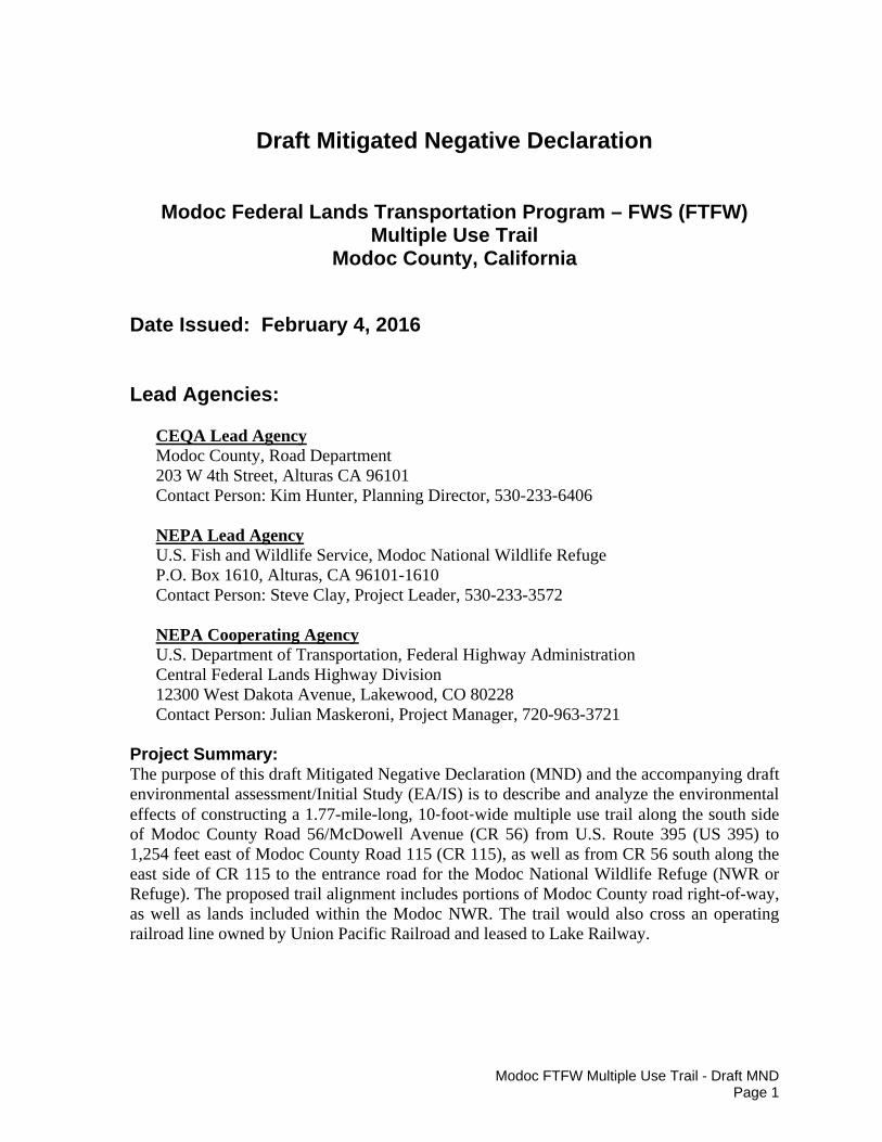
Draft Mitigated Negative Declaration
Modoc Federal Lands Transportation Program – FWS (FTFW) Multiple Use Trail
Modoc County, California
Date Issued: February 4, 2016 Lead Agencies:
CEQA Lead Agency Modoc County, Road Department 203 W 4th Street, Alturas CA 96101 Contact Person: Kim Hunter, Planning Director, 530-233-6406 NEPA Lead Agency U.S. Fish and Wildlife Service, Modoc National Wildlife Refuge P.O. Box 1610, Alturas, CA 96101-1610 Contact Person: Steve Clay, Project Leader, 530-233-3572 NEPA Cooperating Agency U.S. Department of Transportation, Federal Highway Administration Central Federal Lands Highway Division 12300 West Dakota Avenue, Lakewood, CO 80228 Contact Person: Julian Maskeroni, Project Manager, 720-963-3721
Project Summary: The purpose of this draft Mitigated Negative Declaration (MND) and the accompanying draft environmental assessment/Initial Study (EA/IS) is to describe and analyze the environmental effects of constructing a 1.77-mile-long, 10‐foot‐wide multiple use trail along the south side of Modoc County Road 56/McDowell Avenue (CR 56) from U.S. Route 395 (US 395) to 1,254 feet east of Modoc County Road 115 (CR 115), as well as from CR 56 south along the east side of CR 115 to the entrance road for the Modoc National Wildlife Refuge (NWR or Refuge). The proposed trail alignment includes portions of Modoc County road right-of-way, as well as lands included within the Modoc NWR. The trail would also cross an operating railroad line owned by Union Pacific Railroad and leased to Lake Railway.
Modoc FTFW Multiple Use Trail - Draft MND Page 2
The project is subject to both the California Environmental Quality Act (CEQA) and the National Environmental Policy Act (NEPA). CEQA is required because the County of Modoc, a California public agency, will consider the issuance of an encroachment permit for the segment of trail that extends along CR 56 from US 395 to the point where the trail enters the Modoc NWR, as well as for the segment of trail that crosses CR 115 at the CR 56/CR 115 intersection. NEPA is required because the trail will be constructed using Federal funds from the Federal Lands Transportation Program and a portion of the trail would be constructed on Federal land, the Modoc NWR. In addition, a minor amendment to the Modoc NWR Comprehensive Conservation Plan (CCP) is required to incorporate the project into the list of Refuge projects described in the CCP.
This draft MND and accompanying EA/IS have been prepared in accordance with CEQA (PRC 21000 et seq.) and the CEQA Guidelines (California Code of Regulations Title 14, section 15000 et seq.) and NEPA (42 USC 4341 et seq.) and the Council on Environmental Quality NEPA Regulations contained in C.F.R. Parts 1500-1508. The County of Modoc is the lead agency under CEQA and the U.S. Fish and Wildlife Service (Service) is the lead agency under NEPA. The Federal Highway Administration Central Federal Lands Highway Division (CFLH) is a Cooperating Agency under NEPA. The analysis provided in the accompanying draft EA/IS will aid Modoc County, the Service, and CFLH in their decision-making processes. Proposed CEQA Finding for the MND:
Findings of Significant Effect on the Environment: Based on the analysis and conclusions presented in the EA/IS, Modoc County finds that the environmental effects of this project are less than significant with mitigation. Specific mitigation measures will be implemented to mitigate the effects to below a level of significance. Therefore, a Mitigated Negative Declaration has been prepared. Mitigation Measures: The following measures have been developed and will be implemented to mitigate potential impacts associated with the project.
Water Quality Mitigation Measure
The County of Modoc through conditions incorporated into the required encroachment permit will ensure that the contractor adheres to and implements appropriate best management practices (BMPs) to minimize erosion and protect water quality during all phases of project construction within the County’s right-of-way. BMPs would include, but are not limited to, installation of appropriate erosion control along the construction route, at construction staging areas, and along all required construction access routes and preparation of a spill prevention plan. In addition, the permit will require that all disturbed areas adjacent to the trail and within staging areas and construction access routes be seeded and mulched, as necessary, immediately following completion of construction activity within the County right-of-way.

Modoc FTFW Multiple Use Trail - Draft MND Page 3
Noise Mitigation Measure
The County of Modoc through conditions incorporated into the required encroachment permit will ensure that the contractor adheres to a construction work schedule that limits construction activity along CR 56 from US 395 to CR 115 to daylight hours (one-half hour after sunrise to one-half hour before sunset).
Biological Resources Mitigation Measure
The County of Modoc through conditions incorporated into the required encroachment permit will ensure that project associated construction activities within the County right-of-way are restricted to the non-breeding season (July 15 through February 15).
Cultural Resources Mitigation Measure
The County of Modoc through conditions incorporated into the required encroachment permit will ensure that if cultural resources are encountered during ground-disturbing activities within the County right-of-way, work in the immediate vicinity would be suspended, the Central Federal Lands Highway Division of the Federal Highway Administration would be notified immediately, and no work in the area would recommence until the discovery is assessed by a qualified archaeologist and treatment is determined. Additionally, in the event that human remains are encountered during ground-disturbing activities, all work in the immediate vicinity will cease and the Medical Examiner will be contacted, per the California Public Resources Code. Should the remains be identified as Native American, the Medical Examiner will contact the Native American Heritage Commission within 24 hours of identification to provide a most likely descendent to determine appropriate actions All human remains would be treated in accordance with the Native American Graves Protection and Repatriation Act (NAGPRA).
Public Review and Comment:
This joint draft MND and the accompanying EA/IS are available for public comment for a period of 30 calendar days. All comments on the adequacy and accuracy of these documents must be provided in writing to Kim Hunter, Planning Director, Modoc County (via mail to 203 W. 4th Street, Alturas, CA 96101, or via email to [email protected] (please include “Modoc Trail Comment” in the subject line) no later than 5:00 PM PST on Friday, March 4, 2016. Questions regarding this document or the proposed project should be directed to Kim Hunter, Planning Director, Modoc County at (530) 233-6406, or via email at [email protected].
Modoc FTFW Multiple Use Trail - Draft MND Page 4
Distribution List: The draft documents have been provided to following agencies, organizations, and other interested parties for review and comment.
U.S. Congress Honorable Barbara Boxer, U.S. Senate Honorable Dianne Feinstein, U.S. Senate Congressman Doug Lamalfa, 1st District of California California State Legislature State Senator Ted Gaines, District 1 State Assemblyman Brian Dahle, District 1 Tribal Governments Alturas Rancheria of Pit River Indians Pit River Tribe of California Pit River Tribe Historical Preservation Office County Government Modoc County Board of Supervisors Modoc County, Roads Modoc County, Planning City Government City of Alturas, Public Works Department Federal Agencies U.S. Army, Corps of Engineers California State Agencies California State Clearinghouse Department of Fish and Wildlife, Northern Regional Manager Department of Fish and Wildlife, Richard Shinn, Amy Henderson Central Valley Regional Water Quality Control Board, Executive Officer Other Local Agencies Modoc County Transportation Commission Businesses, Organizations, and Other Interested Parties Union Pacific Railroad LRY, LLC d.b.a. “Lake Railway” Pacific Power Frontier Communications Modoc Chamber of Commerce
Modoc County Record Property Owners within 500 Feet of the Project Boundary


DRAFT ENVIRONMENTAL ASSESSMENT/INITIAL STUDY
Modoc Federal Lands Transportation Program – FWS (FTFW)
Multiple Use Trail
Modoc County, California
CEQA Lead Agency
Modoc County, Road Department 203 W 4th Street, Alturas, CA 96101
Kim Hunter, Planning Director, 530-233-6406
NEPA Lead Agency
U.S. Fish and Wildlife Service, Modoc National Wildlife Refuge P.O. Box 1610, Alturas, CA 96101-1610
Steve Clay, Project Leader, 530-233-3572
NEPA Cooperating Agency
U.S. Department of Transportation, Federal Highway Administration Central Federal Lands Highway Division
12300 West Dakota Avenue, Lakewood, CO 80228 Julian Maskeroni, Project Manager, 720-963-3721
February 4, 2016

Modoc FTFW Multiple Use Trail - Draft EA/IS Page i
Table of Contents
1. Introduction ................................................................................................................................ 1 2. Project Location ......................................................................................................................... 2
3. Purpose and Need ....................................................................................................................... 2 4. Decisions to be Made and Applicable Authorities ..................................................................... 5
5. Description of Alternatives, Including the Proposed Action ...................................................... 6 6. Alternatives Considered But Rejected from Further Analysis ................................................... 9
7. Affected Environment ................................................................................................................. 9
A. Topography/Visual Quality .................................................................................................. 9 B. Geology, Soils, and Important Farmland ............................................................................. 9 C. Hydrology and Water Quality ............................................................................................ 13 D. Noise .................................................................................................................................. 14 E. Biological Resources .......................................................................................................... 14 Vegetation/Habitat ............................................................................................................ 14 Wildlife ............................................................................................................................. 14 Endangered and Threatened Species and Other Species of Concern ............................... 15 Jurisdictional Wetlands ..................................................................................................... 19 F. Cultural Resources .............................................................................................................. 22
G. Traffic ................................................................................................................................. 23 H. Public Utilities.................................................................................................................... 23 I. Environmental Justice .......................................................................................................... 23
8. Environmental Consequences ................................................................................................... 24 A. Effects to Topography/Visual Quality ............................................................................... 25
B. Effects to Geology, Soils, and Important Farmland ........................................................... 26 C. Effects to Hydrology and Water Quality ............................................................................ 28

Modoc FTFW Multiple Use Trail - Draft EA/IS Page ii
D. Effects to Ambient Noise Levels ....................................................................................... 30 E. Effects to Biological Resources ......................................................................................... 33 F. Effects to Cultural Resources ............................................................................................. 36
G. Effects to Traffic Circulation ............................................................................................. 37 H. Effects to Public Utilities ................................................................................................... 38 I. Effects to Environmental Justice ......................................................................................... 38
9. Cumulative Effects of the Proposed Action .............................................................................. 39
10. Agencies and Persons Consulted ............................................................................................ 40 11. Document Preparation ............................................................................................................ 40 12. References Cited ..................................................................................................................... 40
List of Figures
Figure 1. Project Vicinity Map ....................................................................................................... 3
Figure 2. Project Location Map ...................................................................................................... 4
Figure 3. Typical Cross Sections of the Proposed Multiple Use Trail ........................................... 7
Figure 4. Soils Present in the Vicinity of the Proposed Trail Corridor ......................................... 11
List of Tables
Table 1. Birds of Conservation Concern with the Potential to Occur in Proximity to the Proposed Trail Alignment ....................................................................................................... 19
Table 2. Potential Jurisdictional Features within the Study Area ................................................. 20
Table 3. Ethnic Composition of Modoc County in 2013 per the U.S. Census Bureau................. 24 Table 4. Construction Equipment Noise Levels ........................................................................... 32 Table 5. Impacts to Potentially Jurisdicational Areas under Alternative 2 ................................... 35
Appendices
Appendix A – Draft Amendment to the Modoc NWR Comprehensive Conservation Plan

Modoc FTFW Multiple Use Trail - Draft EA/IS Page 1
Draft Environmental Assessment/Initial Study
Modoc Federal Lands Transportation Program – FWS (FTFW) Multiple Use Trail
Modoc County, California
1. Introduction
With funding provided by the Federal Lands Transportation Program, the U.S. Fish and Wildlife Service (Service), Modoc National Wildlife Refuge (NWR or Refuge), the U.S. Department of Transportation Federal Highway Administration Central Federal Lands Highway Division, and the Country of Modoc propose to facilitate the construction of an approximately 1.77-mile long, 10-foot-wide asphalt paved multiple use trail south of and parallel to Modoc County Road 56 (CR 56) from U.S. Route 395 (US 395) to 1,254 feet east of Modoc County Road 115 (CR 115) and east of and parallel to CR 115 from the intersection of CR 56 and CR 115 to the main entrance to the Modoc NWR. Construction of the trail will require the issuance of an encroachment permit from Modoc County for the segment of trail that extends south along CR 56 from US 395 to the point where the trail enters the Modoc NWR, as well as for the segment of trail that crosses CR 115 at the CR 56/CR 115 intersection. The remaining segments of the trail would be located within the boundary of the Modoc NWR, including the section that extends east along the south side of CR 56 from 400 feet west of the railroad crossing to CR 115, from CR 115 to just west of the Alturas Rancheria property, and approximately 4,775 linear feet of trail along the east side of CR 115 from CR 56 to the entrance to the Modoc NWR. This multiple use trail is proposed to meet the current and future need for safe, non-motorized access along CR 56 and from the surrounding community to the Modoc NWR.
The project is subject to both the National Environmental Policy Act (NEPA) and the California Environmental Quality Act (CEQA). Funding for trail construction would be provided by the Federal Lands Transportation Program and a major portion of the trail would be constructed on Federal land, the Modoc NWR; therefore, compliance with NEPA is required. NEPA compliance is also required to address amending the Modoc NWR Comprehensive Conservation Plan (CCP) to include the trail on the list of Refuge projects proposed to meet Refuge goals and objectives (Appendix A). The Federal Highways Administration Central Federal Lands Highway Division (CFLHD), a Cooperating Agency under NEPA, would be responsible for managing all aspects of the project from design to construction. Compliance with CEQA is required before Modoc County can issue an encroachment permit to allow trail construction within county road rights-of-way.
This document, which serves as a draft environmental assessment (EA) under NEPA and an Initial Study (IS) for the draft Mitigated Negative Declaration (MND) under CEQA, has been prepared in accordance with NEPA (42 USC 4341 et seq.) and the Council on Environmental Quality NEPA Regulations contained in C.F.R. Parts 1500-1508 and CEQA (PRC 21000 et seq.) and the CEQA Guidelines (California Code of Regulations Title 14, section 15000 et seq.). The Service is the lead agency under NEPA and the County of Modoc is the lead agency under CEQA. The draft EA/IS describes the purpose and need for the proposed
Modoc FTFW Multiple Use Trail - Draft EA/IS Page 2
action; presents a description of the proposed action and an alternative to the proposed action; describes the environmental setting; analyzes the potential environmental impacts of each alternative; and addresses the public involvement process.
The analysis provided in the draft EA/IS along with any comments received during the public comment period will be reviewed and considered by the Service and CFLHD as the basis for determining whether the proposed action would constitute a major Federal action significantly affecting the quality of the human environment or would result in a Finding of No Significant Impact. County of Modoc will consider the information and analysis provided herein to determine if a finding can be made that there is no substantial evidence in light of the whole record before the agency, that the project may have a significant effect on the environment (14 CCR 15070(a)).
Two project alternatives are considered in the draft EA/IS: Alternative 1 – No Action (i.e., do not build the proposed trail) and Alternative 2 (Proposed Action) – Construct a Multiple Use Trail along CR 56 and CR 115.
2. Project Location
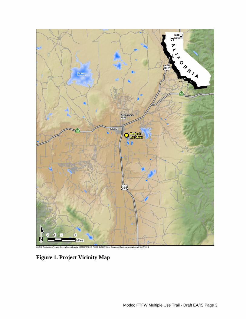
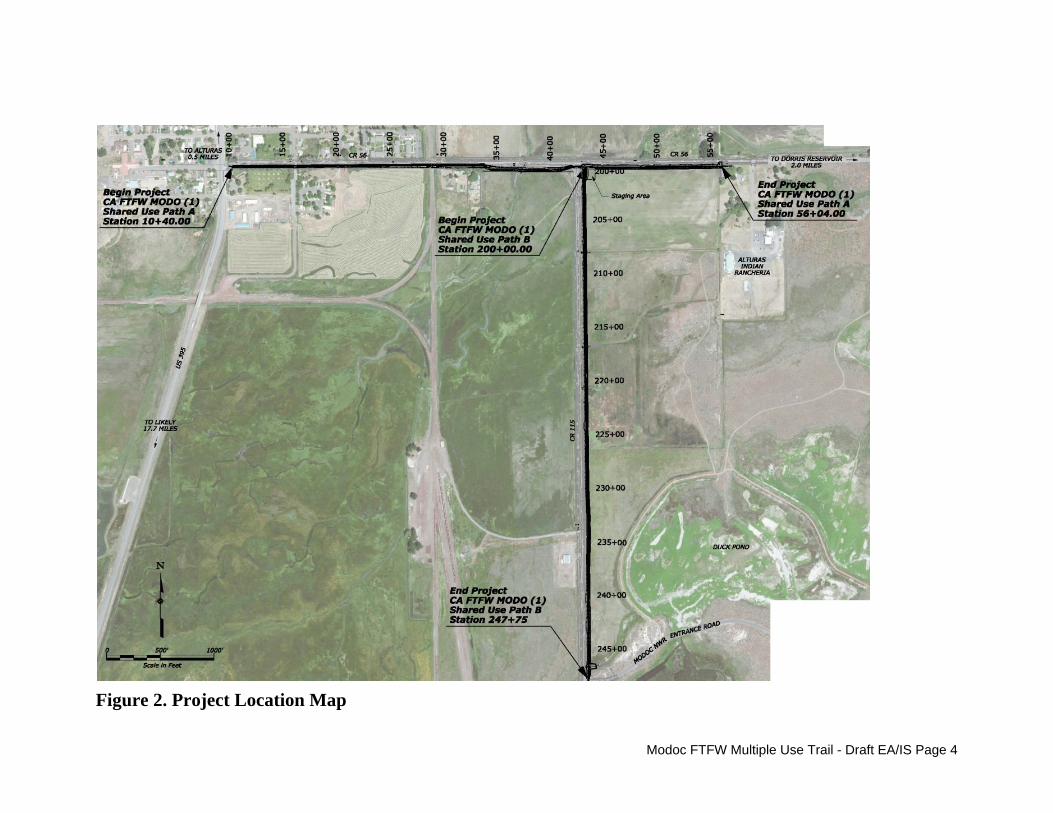
The proposed trail alignment it located within Modoc County in northeastern California (Figure 1). This non-motorized trail would extend along the south side of CR 56 from US 395 in the City of Alturas to 1,254 feet east of CR 115 near the western edge of the Alturas Rancheria property, and south from the intersection of CR 56 and CR 115 along the east side of CR 115 to the Modoc NWR entrance gate (Figure 2). 3. Purpose and Need
The purpose of this project is to provide safe access to the Modoc NWR for bicyclists and pedestrians from the City of Alturas to the west, as well as from the unincorporated areas to the north and east. Refuge visitors who travel on foot or by bicycle currently must use the edge of the travel lanes along CR 56 and CR 115 as these roadways do not have a shoulder of adequate width to accommodate these uses. According to the U.S. Census data, about ten percent of Modoc County households do not have a personal motor vehicle, which emphasizes the need to accommodate alternative modes of transportation in this area.
The proposed multiple use trail would support the mission of the Service by improving access to the Refuge for the public and expanding the Refuge’s ability to connect people with the wildlife and habitats the Refuge was established to protect. Improving accessibility to the Refuge also supports President Obama’s America's Great Outdoors Initiative and the Let's Move Outside (LMO) sub-initiative of the First Lady's Let's Move initiative. Both initiatives are intended to connect American’s to the outdoors, and increasing accessibility to our public lands is an essential component of making that connection. The project is also consistent with purpose of the Federal Lands Transportation Program which is to improve transportation facilities and multi-modal access on Federal lands for Federal Land Management Agency partners including the Service.
Modoc FTFW Multiple Use Trail - Draft EA/IS Page 3
Figure 1. Project Vicinity Map
Modoc FTFW Multiple Use Trail - Draft EA/IS Page 4
Figure 2. Project Location Map
Modoc FTFW Multiple Use Trail - Draft EA/IS Page 5
The implementation of this project would also support the following transportation goal from the draft Modoc County Regional Transportation Plan (RTP) (Modoc County Transportation Commission 2014): “support a transportation environment that encourages bicycling and walking where feasible and economical.” The draft RTP also states that the primary goal of the Draft Modoc County Bicycle Transportation Plan is “to serve the needs of bicyclists, pedestrians, and motorists, by supporting a safe, effective, efficient, balanced, and coordinated transportation system at reasonable cost.” 4. Decisions to be Made and Applicable Authorities Approvals, permits, or reviews to be obtained or initiated prior to implementing the proposed action include:
Modoc County - Certification of the MND and issuance of an Encroachment Permit; U.S. Fish and Wildlife Service - A determination that the proposed action qualifies
for a Finding of No Significant Impact; approval of a minor amendment to the Modoc NWR CCP (Appendix A); compliance with Section 7 of the Federal Endangered Species Act; and the issuance of funds from the Federal Lands Transportation Program to implement the project;
FHWA Central Federal Lands Highway Division – Concurrence that the proposed action will not have significant impacts;
U.S. Army Corps of Engineers - a Nationwide Permit pursuant to Section 404 of the Clean Water Act (CWA) would be required only if there is a determination that the project would impact Waters of the U.S.; and
Regional Water Quality Control Board - A National Pollutant Discharge Elimination Permit for soil disturbance of greater than one acre may be required by this project, but it is anticipated that it will qualify for the Low Erosivity Waiver for small construction projects. The permit requirements will depend on final design. An Erosion Control Plan or a Stormwater Pollution Prevention Plan (SWPPP) will be implemented based on final design requirements. Should a Nationwide 404 Permit be required pursuant to the CWA, a Section 401 Certification would also be required. Alternatively, Waters of the State not under the jurisdiction of the U.S. Army Corps of Engineers would require approval of Water Discharge Requirements.
The following Federal authorities, which apply to the proposed action, have been considered in preparing this EA:
National Wildlife Refuge Administration Act, as amended (16 U.S.C. 668 dd et seq.) National Wildlife Refuge System Improvement Act of 1997 (P.L. 105-57) National Environmental Policy Act of 1969 (NEPA) (P.L. 99-160) Endangered Species Act of 1973, as amended (16 USC 1531 et seq.) Fish and Wildlife Coordination Act of 1932, as amended Migratory Bird Treaty Act, as amended (16 USC 703 et seq.) National Historic Preservation Act of 1966, as amended (16 USC 470 et seq.) Archaeological and Historic Preservation Act of 1974

Modoc FTFW Multiple Use Trail - Draft EA/IS Page 6
Clean Air Act, as amended (42 USC 7401 et seq.) Federal Water Pollution Act of 1948, as amended (33 USC 1251 – 1376; Chapter
758; P.L. 845, 62 Stat. 1155) (Clean Water Act) Executive Order 12898, 11 February 1994, Environmental Justice
5. Description of Alternatives, Including the Proposed Action
The CEQ regulations (Section 1508.9 (b)) state that an EA must briefly describe alternatives to the proposed action. Specifically, NEPA Section 102(2)(E) requires Federal agencies to study, develop, and describe appropriate alternatives to recommended courses of action in any proposal that involves unresolved conflicts concerning alternative uses of available resources. In general, the Federal agency preparing an EA should develop a range of alternatives that could reasonably achieve the need that the proposed action is intended to address. A reasonable range of alternatives generally includes several “action” alternatives, as well as the “no action” alternative (NEPA Section 1502.14(d)). Under the no action alternative, the proposed action would not be implemented. The no action alternative serves as the baseline to which all other action alternatives are compared.
Due to constraints present along a portion of the proposed trail alignment, only one “action” alternative and the no action alternative are assessed in this document. A second action alternative was considered but rejected, as described below, due to potential impacts to mature trees along the proposed trail route. Project alternatives are described below.
Alternative 1 - No Action. Under the No Action Alternative, the proposed 1.77-mile multiple use trail would not be constructed and no changes would occur to the existing drainages and vegetation along the south side of CR 56 between US 395 and Modoc NWR boundary, and no changes would occur on the Modoc NWR to the south of CR 56 or to the east of CR 115 between CR 56 and the Refuge entrance. Instead, these areas would remain in their current state and bicyclists and pedestrians would continue to use the edge of the existing travel lanes on CR 56 and CR115 to access the Refuge.
Alternative 2 (Proposed Action) - Construct a Multiple Use Trail along CR 56 and CR 115. Under Alternative 2 (the Proposed Action), the Modoc NWR CCP would be amended to include the construction of the multiple use trail (Appendix A) on the Refuge, and a 1.77-mile multiple use trail would be constructed to provide safe access for bicyclists and pedestrians to travel along portions of CR 56 and CR 115. The proposed multiple use trail would include two segments:
1) An east/west segment (approximately 4,564 feet in length) would extend from the
southeast intersection of US 395 (South Main Street) and CR 56 (East McDowell Avenue/Parker Creek Road) along the south side of the roadway to the western boundary of the Alturas Rancheria property (the section of trail that will extend from the CR 56/CR 115 intersection to the eastern end of the trail is approximately 1,254 feet); and

Modoc FTFW Multiple Use Trail - Draft EA/IS Page 7
2) A north/south segment (approximately 4,775 feet in length) would extend from the intersection of CR 56 and CR 115 along the east side of CR 115, south to the Modoc NWR entrance gate.
Under this alternative, the first 2,310 feet of the multiple use trail (generally the segment of the trail proposed from US 395 to about 450 feet east of an existing railroad crossing near the boundary of the Modoc NWR) would be constructed within County right-of-way as an extension of the existing eastbound travel lane of CR 56. In this portion of the trail alignment, the multiple use trail would be separated from the travel lane by a one-foot buffer. A rumble strip and striping would be provided to separate the travel lane from the trail. Typical cross-sections of the trail are provided in Figure 3, with the first cross section illustrating how the trail would be constructed where it would be aligned adjacent to CR 56 and the second illustrating how the trail would be constructed where the trail would be located on Refuge property.
Figure 3. Typical Cross Sections of the Proposed Multiple Use Trail
Once the trail alignment reaches the boundary of the Modoc NWR, the trail would veer slightly to the south away from the roadway and onto Refuge land. At this point, the trail would be separated from the roadway but would remain parallel to CR 56. The proposed trail alignment would cross the intersection of CR 56 and CR 115 within the County
Typical cross section where the trail would abut CR 56.
Typical cross section where the trail would be located on the Modoc NWR.

Modoc FTFW Multiple Use Trail - Draft EA/IS Page 8
right-of-way, and once back on Refuge property would split to provide access to the east along the northern boundary of the Refuge to just west of the Alturas Rancheria property and access to the south along the eastern side of CR 115 to the Refuge entrance. Both routes within the Refuge would be separated from the travel lanes. Trail improvements would include providing a six-inch aggregate base covered by three inches of asphalt for the trail. In addition, some improvements to the existing drainage and irrigation ditches located along the trail route would be necessary and could involve filling and/or grading of existing drainage swales and installing or replacing culverts under the trail to accommodate storm water and existing irrigation facilities. Other improvements include preparing a trail at-grade railroad crossing, installation and/or relocation of fencing and signage, and revegtation of disturbed areas upon completion of construction. Specific improvements include:
Construct a 10-foot-wide trail immediately adjacent to CR 56 by extending the existing pavement of the eastbound travel lane to the south; this section of trail would extend from US 395 in Alturas to just east of the existing railroad crossing.
At the boundary of the Modoc NWR, align and construct the 10-foot-wide trail within the northern portion of the Modoc NWR, generally parallel to CR 56.
Within the Refuge along both CR 56 and CR 115, remove and replace the fence along the Refuge boundary with a three-strand smooth wire fence with metal posts to be installed between the trail and the Refuge property, at least 15 feet from the trail edge.
Replace existing or install new culverts, as necessary, in locations where the trail would be located adjacent to or would cross an existing drainage or irrigation ditch to ensure flow efficiency in the ditches.
To accommodate an at-grade trail crossing of the railroad, install a concrete panel within the track alignment, along with railroad crossing and stop advanced signage and striping of the trail in both directions as the trail approaches the railroad crossing.
Install yield and stop signs as appropriate at driveways and intersections crossed by the trail.
A temporary construction staging area for the project would be established on Refuge property at the intersection of CR 56 and CR 115. The limits of the staging area, which would be located either to the southeast or southwest of the intersection, would be approved by the Refuge prior to any site preparation. Following completion of the project, the staging area would be reclaimed and seeded with a combination of intermediate wheatgrass and western wheatgrass. To minimize the potential for erosion and downstream sedimentation from the project site during and after construction and to limit the potential for the introduction of contaminants into the soil, groundwater, or adjacent surface waters from construction vehicles, the implementation of best management practices (BMPs), including erosion control measures (e.g., the installation of fiber rolls, reseeding disturbed areas) and other measures (e.g., spill prevention plan, proper equipment maintenance) have been
Modoc FTFW Multiple Use Trail - Draft EA/IS Page 9
incorporated into the scope of the project. In addition, per the construction plans, the contractor would be required to locate machinery servicing and refueling areas away from streambeds and washes to reduce the possibility and minimize the impacts of accidental spills or discharges. Construction of the trail, which is expected to begin in summer 2017 (possibly summer of 2016 if funding allows) and will take approximately 12 to 14 weeks to complete. To avoid the bird nesting season, the construction window for this project would extend from July 15 through February 15.
6. Alternatives Considered But Rejected from Further Analysis The alignment of the segment of trail located along CR 56 between US 395 and the Modoc NWR boundary was originally designed to be separated from the existing pavement of CR 56 by approximately five to six feet in most locations, while still remaining within the limits of the County road right-of-way. Upon further analysis, it was determined that separating the trail from the roadway pavement would move the trail too close to the existing mature trees located along the south side of CR 56 near its intersection with US 395. To avoid any adverse effects to these trees, this alignment was rejected in favor of an alignment located adjacent to the existing roadway pavement.
7. Affected Environment
A. Topography/Visual Quality
The area to be affected by the construction of the proposed trail is generally disturbed land that has historically been used for public access or farming. All of the area to be affected has likely been graded in the past. Overall, the area supports a relatively constant elevation that ranges from 4,368 feet above mean sea level (MSL) to 4,372 feet MSL. The visual setting within the areas to be affected by the project from west to east along CR 56 include buildings and associated open turf areas, large ornamental trees lining the south side of CR 56 from US 395 to about half way between S. East Street and S. Estes Street, additional ornamental trees scattered along the south side of the road between S. Estes Street and the railroad crossing, and open fields used for haying or other agricultural purposes. Throughout the proposed alignment, there are minimally vegetated drainage and irrigation ditches that abut the existing right-of-way. Along CR 115, the visual setting consists almost exclusively of open fields of perennial native/non‐native grassland. Near the entrance to the Refuge, large wetland areas are visible to the east of the proposed trail route.
B. Geology, Soils, and Important Farmland
The proposed trail alignment, along with virtually the entire Upper Pit River Watershed from the headwaters to the historical confluence with Fall River is within the Modoc Plateau Geomorphic Province (USFWS 2009). The Modoc Plateau is a flat-topped upland area built up of irregular masses of a variety of volcanic materials, although it
Modoc FTFW Multiple Use Trail - Draft EA/IS Page 10
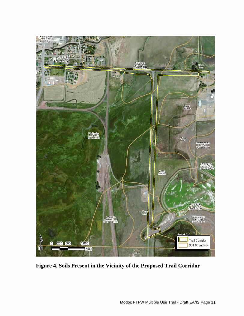
consists predominately of basalt (Oakeshott 1971). This area is characterized by attenuation, or stretching and thinning of the earth’s crust, which results in the high angle normal faults found throughout the region. Three main soil types that underlie the area in and around the proposed trail alignment were formed from alluvial parent material derived from basic igneous rocks. These include: Pit-Buntingville-Goose Lake (nearly level to moderately sloping, very deep, somewhat poorly drained and poorly drained silt loams, clay loams, silty clay loams, and clays in basins and on floodplains); Tulana-Pasquetti (nearly level, very deep, poorly drained mucky loams and silty clay loams in basins; and Bieber-Barnard-Modoc (nearly level to strongly sloping, shallow and moderately deep, well-drained gravelly loams, cobbly loams, clay loams, and sandy loams on alluvial fans and terraces). These soil types have been further refined into soil series by the U.S. Department of Agriculture Natural Resources Conservation Service (USDA NRCS). USDA (1980) soil mapping data for Modoc County indicates that the proposed trail alignment is overlain by five soil series (Figure 4).
The five soil series include:
Buntingville clay loam (0 to 2 percent slopes) The Buntingville soil series consists of very deep, somewhat poorly drained soils on fan remnants and terraces from 4,000 to 5,000 feet in elevation. The soils formed in ashy loamy alluvium derived primarily from tuffs, andesite, basalt, and tuff breccias. This soil series is subject to moderate wind erosion when disturbed (W. M. Beaty & Associates, Inc. 2011) and its water erosion hazard is slight (USDA 1980). This soil is listed as a hydric soil in the 2014 National Hydric Soils list (USDA NRCS 2014).
This soil series is present along CR 56 within the proposed trail alignment from US 395 to S. Estes Street and again from just east of the railroad crossing to just east of the CR 56/CR 115 intersection. This soil series is also present within the northern portion of the trail alignment that parallels CR 115.
Pit silty clay loam (0 to 2 percent slopes) Pit series soils are somewhat poorly drained soils located on floodplains and lake basin floors. The soil forms in alluvium derived mostly from basic igneous rocks. This soil is listed as a hydric soil in the 2014 National Hydric Soils list (USDA NRCS 2014). This soil series is subject to only minor wind erosion when disturbed (W. M. Beaty & Associates, Inc. 2011); its water erosion hazard is minimal (USDA 1980). This soil is present along CR 56 within the proposed trail alignment generally from S. Estes Street to the railroad crossing and within the midsection of the alignment between the CR 56/CR 115 intersection and the eastern end of the proposed trail alignment. This soil series is also present within a portion of the trail alignment that parallels CR 115 (see Figure 4).
Modoc FTFW Multiple Use Trail - Draft EA/IS Page 11
Figure 4. Soils Present in the Vicinity of the Proposed Trail Corridor
Trail Corridor
Modoc FTFW Multiple Use Trail - Draft EA/IS Page 12
Alturas loam The Alturas series consists of moderately well and somewhat poorly drained soils with slow runoff and slow permeability. These soils are in nearly level basin edges and low terraces at an elevation of 4,100 to 4,800 feet. They formed in stratified sediments from basic igneous and pyroclastic rocks. This soil series is subject to moderate wind erosion when disturbed (W. M. Beaty & Associates, Inc. 2011) and its water erosion hazard is slight (USDA SCS 1980). Alturas loam is present at the eastern end of the trail alignment parallel to CR 56, as well as in portions of the trail alignment that parallel CR 115 (see Figure 4).
Pineal silt loam The Pineal series consists of moderately well drained soils, with slow or very slow runoff and permeability. These soils are on nearly level old lake bottoms or on basin rims, at elevations of 4,350 to 4,450 feet. They formed in alluvium derived mostly from extrusive igneous rock, tuff, and volcanic ash. Wind and water erosion within this soil series is minimal (W. M. Beaty & Associates, Inc. 2011, USDA 1980). This soil series is present in the middle portion of the trail alignment that extends along CR 115. Bieber gravelly loam (0 to 9 percent slopes) The Bieber series consists of well drained soils on old stream terraces and fan remnants. Formed in alluvium derived from basic igneous rocks, Bieber soils have a silica-cemented hardpan and are found between 3,510 and 6,118 feet in elevation. This soil series is subject to minimal wind erosion when disturbed (W. M. Beaty & Associates, Inc. 2011) and its water erosion hazard is moderate (USDA 1980). Within the proposed trail alignment, this soil series is only present at the southern end of the trail alignment that parallels CR 115.
Three soil types located within the project boundary are identified by the California Department of Conservation (2015, 2010) as important Farmland soils. Prime Farmland is defined by the Department of Conservation as land with the best combination of physical and chemical features able to sustain long-term agricultural production. This land has the soil quality, growing season, and moisture supply needed to produce sustained high yields. Farmland of Statewide Importance is similar to Prime Farmland but with minor shortcomings, such as greater slopes or less ability to store soil moisture.
Buntingville clay loam, 0 to 2 percent slopes, is classified as Prime Farmland if it is either protected from flooding or is not frequently flooded during the growing season. This soil is present within the trail alignment from about 1,000 feet west of the CR 56/CR 115 intersection to about 250 feet east of the intersection. Alturas loam and Pit silty clay loam, 0 to 2 percent slopes (when protected from flooding), are classified as Farmland of Statewide Importance. Alturas loam is present within the trail alignment for about 250 feet at the eastern terminus of the trail along CR 56, for about 800 feet near the center of the trail section that extends north/south along CR 115, and for about 1,000 feet near the southern end of the CR 115 segment of the trail. Pit silty clay loam, 0 to 2 percent slopes, occurs within the CR 115 segment of the trail between the area overlain by Buntingville clay loam and the area overlain by Alturas loam.

Modoc FTFW Multiple Use Trail - Draft EA/IS Page 13
C. Hydrology and Water Quality
Hydrology. The proposed trail alignment is located within the Central Valley Regional Water Quality Control Board’s Pit River Hydrologic Unit, Upper Pit River Hydrologic Area, Upper Pit River Watershed (USGS cataloging unit: 18020002). The Upper Pit River Watershed begins in the Warner Mountains of northeast California and flows in a southwesterly direction toward Shasta Lake. The watershed is 3,400 square miles and includes portions of Modoc, Lassen, Siskiyou, and Shasta Counties (SRWP 2014).
Much of the trail alignment occurs within the boundaries of the Modoc NWR, which was established in 1960. Within the Refuge, the hydrology of the area is actively managed to support wildlife, including migratory birds. Wetland features (e.g., ponds, streams, wet meadows) within the Refuge are irrigated with water from the Dorris Reservoir, located just to the northeast of the proposed trail alignment. The Refuge has sole water rights to Dorris Reservoir, which is entirely dependent on snow melt and diversion canals from the North Fork Pit River and other drainages/natural sources (S. Clay, S. Cross, pers. comm., December 3, 2014). All irrigation infrastructure on the Refuge was constructed by the previous private landowner in the 1920s and 1930s to support farming and ranching. This oral history is consistent with 1892 USGS mapping of the area in which no streams or wetlands are depicted on the project site or at the location of Dorris Reservoir. The portion of the trail alignment to the west of the Refuge boundary also includes or is adjacent to drainage and irrigation ditches that extend parallel to or cross under CR 56.
The North Fork and South Fork Pit Rivers, which are fed by runoff from the west side of the Warner Mountains, converge at the City of Alturas and flow southwesterly for approximately 60 miles to the confluence with the Fall River. With the proposed trail to be located in proximity to both the North and South Forks of the Pit River, there is a potential that portions of the trail may be subject to flooding during the life of the project. The Federal Emergency Management Agency (FEMA), as part of the National Flood Insurance Program, is currently in the process of revising the Special Flood Hazard Areas (SFHA) map for a portion of Modoc County located upstream of the confluence of the North and South Forks of the Pit River. Those lands that are at high risk for flooding are included within SFHA. According to the latest public outreach map that reflects the proposed changes to the SFHA along the Pit River, the majority of the trail alignment along CR 56 between US 395 and the CR 115 is located within the SFHA. The portion of the trail alignment along CR 56 to the east of CR 115, as well as the entire alignment south on CR 115 from CR 56 to the Refuge entrance are included within an area that is proposed to be removed from the current SFHA based on Pit River physical map revision process (BakerAECOM 2013).
Water Quality. The beneficial uses identified for both the North Fork and South Fork of the Pit River include cold freshwater habitat and municipal and domestic water supply. Each of these water segments are currently listed as impaired under Section 303(d) of the Federal Clean Water Act for pH levels that exceed the acceptable Basin Plan levels of no lower than pH 6.5 and no higher than pH 8.5. The beneficial use affected by this exceedance is identified as cold freshwater habitat. The source of the cause for excessive pH levels is unknown. The South Fork Pit River is also included on the 303(d) list for

Modoc FTFW Multiple Use Trail - Draft EA/IS Page 14
salinity, with the pollutant identified as specific conductivity. The beneficial use affected by this exceedance is identified as municipal and domestic water supply.
D. Noise
The primary source of noise in the vicinity of the proposed trail alignment is traffic along CR 56 and CR 115. Noise is also generated from trains that periodically travel along the track that crosses CR 56 to the east of S. Estes Street. Sensitive receptors in the vicinity of the trail alignment include a few single-family houses along CR 56, a recreational vehicle park located to the south of CR 56 along S. East Street, and a multiple family residential development located along the north side of CR 56 between S. Estes Street and the railroad.
E. Biological Resources
The portion of the trail alignment that is located outside the boundaries of the Modoc NWR has been disturbed in the past in association with roadway and driveway construction, the creation of drainage and irrigation ditches, and development of the adjacent parcels. As a result, the vegetation within and adjacent to the proposed alignment consists primarily of non-native weedy and ornamental species. A number of large ornamental trees line portions of the proposed route.
Vegetation/Habitat. Although a detailed vegetation mapping effort was not conducted for the proposed alignment, visual surveys of the area indicate that the alignment and adjacent areas support several distinct vegetation communities including ornamental vegetation, disturbed habitat, and urban/developed land cover generally between US 395 and the railroad, and primarily perennial native/non‐native grassland (also referred to as cropland habitats) within the Refuge (USFWS 2009).
Wildlife. The mammal species most likely to be observed in and around the proposed trail alignment include deer mouse (Peromyscus maniculatus), Belding’s ground squirrel (Urocitellus beldingi), Nuttall’s cottontail (Sylvilagus nuttallii), and striped skunk (Mephitis mephitis). In addition, mule deer (Odocoileus hemionus), black-tailed jackrabbit (Lepus californicus), and coyote (Canis latrans) are likely to be observed in and around the portions of the trail alignment on Refuge property. Some of the native bird species expected to be present in the area of the proposed trail alignment include western kingbird (Tyrannus verticalis), western meadowlark (Sturnella neglecta), black-billed magpie (Pica hudsonia), and song sparrow (Melospiza melodia). Non-native bird species in the area include European starling (Sturnus vulgaris) and house sparrow (Passer domesticus). The Modoc NWR, which is situated along the Pacific Flyway, is an important resting, nesting, and feeding area for migratory birds, including waterfowl, greater sandhill cranes, and several raptor species. It has been recognized by the National Audubon Society as an Important Bird Area in the State of California for its support of 12 species of birds including the greater sandhill crane (Grus canadensis tabida), ferruginous hawk (Buteo regalis), northern harrier (Circus cyaneus), short-eared owl

Modoc FTFW Multiple Use Trail - Draft EA/IS Page 15
(Asio flammeus), long-eared owl (Asio otus), redhead (Aythya americana), least bittern (Ixobrychus exilis), long-billed curlew (Numenius americanus), tricolored blackbird (Agelaius tricolor), yellow-headed blackbird (Xanthocephalus xanthocephalus), bank swallow (Riparia riparia), and yellow warbler (Setophaga petechial). Only the greater sandhill crane and northern harrier have any potential to be present in proximity to the proposed trail alignment.
Endangered and Threatened Species and Other Species of Concern. No federally listed endangered and threatened species are known to utilize the areas within and immediately adjacent to the proposed trail alignment, nor is any portion of the site or adjoining areas designated as Critical Habitat per the Federal Endangered Species Act, as amended (16 U.S.C. 1531 et seq.). Two federally listed species are however occasional visitors to the wetter portions of the Modoc NWR. Both species are federally listed as threatened and include the western snowy plover (Charadrius nivosus nivosus) and western yellow-billed cuckoo (Coccyzus americanus). Neither species is likely to occur in proximity to the proposed trail project.
Western Snowy Plover The western snowy plover, a small shorebird typically observed in coastal areas, is a rare summer visitor at the Modoc NWR, with limited numbers observed in wetland areas in the early summer. The closest documented nesting for this species occurs on Goose Lake and in Surprise Valley. Western snowy plovers breed from Washington State to Baja, California, and winter in coastal areas from southern Washington to Central America. Their preferred coastal nesting habitats are sand spits, dune-backed beaches, unvegetated beach strands, open areas around estuaries, and beaches at river mouths.
Western Yellow-billed Cuckoo The western yellow-billed cuckoo was listed as federally threatened in 2014 and has been listed as endangered by the State since 1971. A Neotropical migrant bird, the western yellow-billed cuckoo winters in South America and breeds in North America. It is a secretive and hard-to-detect bird that requires dense, large tracts of riparian woodlands with well-developed understories for breeding. Based on historical accounts, the western yellow-billed cuckoo was widespread and locally common in California and Arizona. Today, the northern limit of breeding along the west coast is believed to be the Sacramento Valley, California, though recent surveys suggest that a small, potentially breeding population exists in coastal northern California on the Eel River. A statewide survey for the species was conducted in 1999 and 2000 that estimated the presence of 39 to 43 breeding pairs in California (Halterman et al. 2001). Yellow-billed cuckoo habitat in California is described by Grinnell and Miller (1944) as ‘‘riparian jungles of willows [Salix sp.] of fairly old growth, often mixed with Fremont cottonwoods (Populus fremontii), and with a tangled ‘lower story’ of blackberry (Rubus sp.), nettles (Urtica sp.), or wild grape (Vitis californica).’’ Smaller patches of habitat are rarely used by yellow-billed
Modoc FTFW Multiple Use Trail - Draft EA/IS Page 16
cuckoos, particularly when they were distantly isolated from other patches of riparian habitat (Laymon and Halterman 1989).
Western yellow-billed cuckoos are rare summer visitors to the riparian habitat on the Modoc NWR. Nesting has not been verified but is suspected to have occurred. There have been no reports of cuckoos in or around the proposed project site.
Several species have been observed on the Modoc NWR at various times of the year that are listed as endangered or threatened under California’s Endangered Species Act, as described below.
Greater Sandhill Crane The greater sandhill crane, one of six subspecies of sandhill cranes found in North America, is listed by the State of California as threatened. Greater sandhill cranes are divided into five distinct migratory populations, which return to the same breeding and wintering sites every year (Littlefield and Ivey 2000). These five populations are the Eastern, Prairie, Rocky Mountain, Lower Colorado River Valley, and California Central Valley (Littlefield and Ivey 2000, 2002). The cranes present on the Modoc NWR are part of the California Central Valley population.
On the Refuge, these cranes use large and small tracts of open habitat where visibility is good from all vantage points. Wet meadows, marshes, shallow ponds, hayfields, and grain fields are all favored for nesting, feeding, and roosting. Emergent wetland vegetation is a key component of nesting territories, and nests are typically placed on piles of emergent vegetation, grass, and mud. Pairs return to the same territory and even the same approximate nest location every year.
The greater sandhill crane is a common spring, summer, and fall resident at the Refuge, which supports approximately 40 to 50 nesting pairs each year with an average recruitment (number of young surviving to adulthood) of 12 cranes per year (USFWS 2009). Nesting generally occurs in the Refuge’s wet meadows and other wetlands, while foraging activities occur in both wetland and adjacent open upland areas. Thousands of cranes stopover at the Refuge in the spring and fall on their way to and from California’s Central Valley. The area in and around portions of the proposed trail alignment could support crane brood rearing and foraging. Willow Flycatcher The willow flycatcher, a State listed endangered species, is a rare to locally uncommon, summer resident in wet meadow and montane riparian habitats at 2,000-8,000 feet in the Sierra Nevada and Cascade Range. They have specific habitat requirements, typically consisting of riparian habitat often dominated by willows and/or alder, and permanent water, often in the form of low gradient watercourses, ponds, lakes, wet meadows, marshes, and seeps within and adjacent to forested landscapes. Peak fall migration occurs between mid-August and mid-
Modoc FTFW Multiple Use Trail - Draft EA/IS Page 17
September, and breeding individuals arrive in their breeding territory around late May and early June (Sedgwick 2000). On the Modoc NWR, willow flycatchers are a spring and fall migrant and uncommon summer resident of riparian habitats. One successful nesting attempt has been documented on the Refuge. Willow flycatchers have the potential to occur in the trees along CR 56, particularly during migration.
Swainson’s Hawk The Swainson’s hawk was listed by the State of California as threatened in 1983 as a result of habitat loss and decreased numbers across the state. The California Department of Fish and Wildlife (CDFW) estimates the Swainson’s hawk population in California historically included as many as17,136 pairs. In 1980, the total number of breeding pairs was estimated at 375 (+50). A state-wide survey conducted in 2005 of the bird’s known range resulted in an estimate of 2,081 breeding pairs (https://www.dfg.ca.gov/wildlife/nongame/ raptors/swha/, accessed on 8/12/2015). Although an increase over the 1980 estimate, this number remains considerably lower than historical estimates.
This hawk breeds in North America and winters in Mexico, Central America, and South America. Swainson’s hawks were once found throughout the lowlands of California; today they are generally restricted to portions of the Central Valley and Great Basin regions where suitable nesting and foraging habitat is still available. In northeast California, Swainson's hawks arrive at nesting areas in early to mid-April and begin to depart in early September, with a few individuals remaining on territories in early October. A pair of Swainson’s hawks has been observed on the Refuge since 2000 and several pairs currently nest on or near the Refuge. One pair has been observed in multiple years nesting within 50 meters of the proposed trail alignment in the vicinity of CR 115. Bank Swallows Bank swallows, listed by the State as threatened, are Neotropical migrants that breed in California from April to August and spend the winter months in South America. In California, they are found primarily in riparian and other lowland habitats. The current population is restricted to portions of the upper Sacramento River, primarily between Redding and Colusa; about four or five central and north coast colonies; and scattered colonies in northern and northeastern California (Schlorff 2000).
Bank swallows are a common migrant and uncommon summer resident on the Refuge. During the spring, the species has been observed feeding on flying insects over much of the Refuge. In the summer, they seem to be restricted to areas along the Pit River where they nest in limited numbers. This species is not expected to occur in proximity to the proposed trail alignment.
Modoc FTFW Multiple Use Trail - Draft EA/IS Page 18
American Bald Eagle The bald eagle, which is listed as endangered by the State of California, occupies various woodland, forest, grassland, and wetland habitats. The species winters throughout most of California at lakes, reservoirs, rivers, some rangelands, and coastal wetlands. Nesting territories are found mostly in the northern half of the State, with some in the southern Sierra Nevada, Central Coast Range, inland southern California south to Riverside County, and on Santa Catalina Island (Jackman and Jenkins 2004). Between 1959 and 1977, only two bald eagle territories were documented in the Upper Pit River Watershed. As of 2004, 16 territories had been recorded (VESTRA 2004) within the watershed. Wintering bald eagles utilize the Refuge from October through March. Large cottonwoods and junipers near Dorris Reservoir and the Pit River provide eagle roosting and perching sites. This species is unlikely to occur in proximity to the proposed trail alignment.
The 1988 amendment to the Fish and Wildlife Conservation Act mandates the Service to “identify species, subspecies, and populations of all migratory nongame birds that, without additional conservation actions, are likely to become candidates for listing under the Endangered Species Act of 1973.” The most recent effort to carry out this proactive conservation mandate is the approval of the Service’s report, Birds of Conservation Concern 2008 (USFWS 2008). The overall goal of the report is to accurately identify bird species at each geographic scale that represent Service conservation priorities and draw attention to species in need of conservation action. The bird species identified are primarily derived from prioritization scores from three major bird conservation plans: The Partners in Flight, U.S. Shorebird Conservation Plan, and North American Waterbird Conservation Plan (Kushlan et al. 2002). Birds included in the Birds of Conservation Concern 2008 report are deemed priorities for conservation action. These lists are to be consulted in accordance with Executive Order 13186 “Responsibilities of Federal Agencies to Protect Migratory Birds.”
The 2008 report encompasses three distinct geographic scales: the Bird Conservation Regions (BCR) of the United States and Canada, and the cross-border BCRs agreed on with Mexico as part of the North American Bird Conservation Initiative; the USFWS Regions, which each consist of several states in the same geographic area, and the National List, which encompasses the United States, including U.S. island “territories” in the Caribbean and Pacific. Birds of Conservation Concern for the Alturas/Modoc NWR area are those bird species included in the BCR 9 (Great Basin) List, USFWS Region 8 List, and the National List.
Table 1 lists the Birds of Conservation Concern that have been observed or are expected to occur in the Alturas/Modoc NWR area. The abundance of these species is described as common (easily found in the proper habitats during the appropriate seasons), uncommon (found in low densities throughout the proper habitats during the appropriate seasons, occasional (may or may not be found with difficulty in the proper habitats during the appropriate seasons), and rare (not to be expected annually, occurrence is unpredictable).

Modoc FTFW Multiple Use Trail - Draft EA/IS Page 19
Table 1
Birds of Conservation Concern with the Potential to Occur in Proximity to the Proposed Trail Alignment
Common Name Scientific Name Habitat(s) Utilized by
the Species Abundance
Included on BCC List BCR
9 Region
8 U.S.1
Ferruginous hawk
Buteo regalis Wetlands, Uplands
Rare (W) Yes No No
Golden eagle Aquila chrysaetos Wetland, Uplands
Uncommon permanent resident
Yes No No
Swainson’s hawk
Buteo swainsoni Wetland, Uplands
Uncommon (S) No No Yes
Peregrine falcon
Falco peregrinus Wetland, Uplands
Rare (F/W) Yes Yes Yes
Short-eared owl
Asio flammeus Open fields Uncommon* (S), Occasional (W)
No No Yes
Willow flycatcher
Empidonax traillii Riparian Migrant (Sp,F) Uncommon# (S)
Yes Yes Yes
Loggerhead shrike
Lanius ludovicianus Uplands Occasional (Sp,S,F,W)
Yes Yes Yes
1National List, Sp (spring), S (summer), F (fall), W (winter) *Nests in the area, #One recorded nesting Source: (USFWS 2008)
Jurisdictional Wetlands. A Jurisdictional Delineation (JD) report (HDR Engineering, Inc. 2015) was prepared for the area in and around the proposed multiple use trail alignment to summarize preliminary findings related to the potential for U.S. Army Corps of Engineers (USACE) jurisdiction over the project. The JD has been submitted to the USACE for review and is summarized here.
The proposed alignment and adjacent lands (the survey area) were surveyed to determine the limits of: USACE jurisdiction pursuant to Section 404 of the Clean Water Act (CWA) and/or State Water Resources Control Board (SWRCB)/Regional Water Quality Control Board (RWQCB) jurisdiction pursuant to the California Porter-Cologne Water Quality Control Act (and potentially Section 401 of the CWA). Within the study area, several features supporting an ordinary high water mark (OHWM) and/or other jurisdictional criteria, such as a dominance of hydrophytic vegetation, were identified. Although the receiving waters (e.g., the North and South Fork Pit Rivers) are potential Waters of the U.S., features within the study area exhibiting an OHWM are constructed in uplands and only exhibit an OHWM as a result of the Refuge releasing water from Dorris Reservoir. The USACE generally will not assert jurisdiction over ditches (including roadside ditches) excavated wholly in and draining only uplands that generally do not carry a relatively permanent flow of water (USACE 2007).

Modoc FTFW Multiple Use Trail - Draft EA/IS Page 20
Additionally, as stated in the preamble to the Corps’ Final Rule of November 13, 1986: “. . . we generally do not consider the following waters to be ‘Waters of the United States’ . . . (b) Artificially irrigated areas which would revert to upland if the irrigation ceased” (51 Federal Register 41217, November 13, 1986). Thus, waters, including wetlands, created as a result of irrigation would not be considered Waters of the U.S., even when augmented on occasion by precipitation. Similarly, the RWQCB will not generally assert jurisdiction over artificially irrigated features. However, for the purposes of the JD report, drainage features exhibiting an OHWM have been considered potentially jurisdictional. Eight soil test pits were conducted within the survey site that resulted in the determination that several features exhibit an OHWM or meet the criteria for hydrology and/or hydrophytic vegetation. However, none of the features met all three criteria for wetlands. Two of the five soils located within the study area are listed in the NRCS Hydric Soils list (USDA NRCS 2014), but no hydric soils were observed at any of the soil pit locations. Onsite soils ranged from dark reddish brown and reddish black to dark brown and black. Where observed, redox features were faint. In general, the study area supports predominantly clay loam and silty loam soils with sparse to moderately dense vegetation. The features on the site that are potentially jurisdictional are subject to active management by the Refuge, as described previously, and exhibit an OHWM (as a result of the Refuge releasing water from Dorris Reservoir) and/or other jurisdictional criteria, such as a dominance of hydrophytic vegetation. The acreage and linear feet of the four potential jurisdictional features within the study area are presented in Table 2.
Table 2 Potential Jurisdictional Features
within the Study Area
Potential Jurisdictional Feature
Acres within the Study Area
Linear Feet within the Study Area
Roadside Ditch 0.14 690
Irrigation Ditch A 0.03 150
Irrigation Ditch B 0.01 120
Irrigation Ditch C 0.01 116
Irrigation Ditch D 0.05 305
Total 0.24 1,381 Source: (HDR Engineering, Inc. 2015)
The first feature, the roadside ditch, runs parallel to CR 56 along the south side of the road east of the railroad crossing. Surface flows will pass through this ditch when a screw gate is opened at Irrigation Ditch A. After passing through a culvert at the rail line, the surface flows travel south to irrigate agricultural fields south of CR 56 and west of the Refuge. The ditch supports an average 8‐foot‐wide OHWM delineated by the destruction of vegetation, with grasses dominant within the channel and on the

Modoc FTFW Multiple Use Trail - Draft EA/IS Page 21
banks. Inundation is visible on aerial photography dated July 10, 2011. The ditch is considered a non-wetland potentially jurisdictional feature located on County land. Of the four irrigation ditches, Ditch A extends into the survey area from the north and traverses the trail alignment at CR 56 east of CR 115. The ditch carries flows from Dorris Reservoir via Dorris Canal (S. Clay and S. Cross, pers. comm., December 3, 2014). Flows are managed by the Refuge and are controlled by a series of screw gates, one of which occurs within the study area south of CR 56 and immediately east of Irrigation Ditch A. The ditch is used to irrigate neighboring private agricultural fields located west of the Refuge. Within the study area, the ditch supports a stand of white willows (Salix alba) north of CR 56. The ditch is considered a non‐wetland potentially jurisdictional feature. A portion of the ditch occurs on County land.
Irrigation Ditch B enters the survey area about 800 feet south of the intersection of CR 56 and CR 115. The ditch flows beneath CR 115 through a 24‐inch corrugated metal culvert and supports an OHWM width of 5 feet. The banks and a portion of the channel support upland grasses. The site did not exhibit hydric soils and therefore did not meet the criteria for wetland Waters of the U.S. The Irrigation Ditch B is considered a non-wetland potentially jurisdictional feature.
Irrigation Ditch C enters the study area approximately 880 feet south of Irrigation Ditch B. The ditch traverses beneath CR 115 through a 24‐inch culvert and supports upland grasses within the channel and on the banks. A 5‐foot‐wide OHWM was observed at the culvert inlet (east side of CR 115). Hydrophytic plants were not dominant within the feature; therefore, the Irrigation Ditch C is considered a non‐wetland potentially jurisdictional feature.
Irrigation Ditch D extends into the survey area 120 feet north of the entrance road to the Refuge. The ditch traverses beneath CR 115 through a 30‐inch culvert. Upstream (east of) CR 115, the OHWM is approximately 7 feet wide and widens into a 13‐foot‐wide swale dominated by cattail (Typha latifolia; OBL1) and orchard grass (FACU). Downstream from the culvert inlet, the ditch supports a 5‐foot‐wide OHWM and is dominated by cattails until flows disperse into an adjacent field dominated by grasses. Based on the results of the soil pits, the feature did not meet the criteria for wetland Waters of the U.S. Therefore, Irrigation Ditch D is considered a non‐wetland potentially jurisdictional feature; however because the site is dominated by orchard grass (FACU) with <1% redox and the presence of biotic crust (algal mats) and does not support a dominance of hydrophytic vegetation or exhibit hydric soil indicators, the ditch does not meet the three criteria for jurisdictional wetlands. A soil pit dug in an area dominated by cattails (OBL) to determine the presence of hydric soils and/or hydrology indicated that hydric soils were not present, but the site supports biotic crust, a hydrologic indicator.
1 OBL = obligate (almost always occurs in wetlands).

Modoc FTFW Multiple Use Trail - Draft EA/IS Page 22
No wetlands were identified on the project site. It will be up to the USACE to determine if the features described above meet the definition of jurisdictional Waters of the U.S. Should a determination be made that Waters of the U.S. are present onsite and that project construction would result in a discharge of fill to those waters, the following permitting documents would be required:
USACE Nationwide Permit pursuant to Section 404 of the CWA; and
Clean Water Certification in compliance with the California Porter-Cologne
Water Quality Control Act as defined by the SWRCB/ RWQCB or federal CWA Section 401 Certification requirements.
Should a determination be made that USACE does not maintain jurisdiction over the identified features and that project construction would result in a discharge of fill to Waters of the State, the following permitting document would be required:
Waste Discharge Requirements (WDR) in compliance with the California Porter-Cologne Water Quality Control Act as defined by the SWRCB/ RWQCB. A request for WDR is similar to an application for a 401 certification except that it requires public notice.
Section 1602 of the Fish and Game Code requires that a Streambed Alteration Application be submitted to the CDFW for certain activities. However, Federal agencies are not considered “entities” as defined in State Fish and Game Code Section 1601 and are not required to acquire a CDFW Streambed Alteration Permit. Consequently, this project is exempt from the CDFW Streambed Alteration Permit process.
F. Cultural Resources
A record search for the area in and around the proposed trail alignment, as well as a pedestrian survey of the entire proposed trail route, was conducted by the Service’s Region 1 and 8 Cultural Resources Team. No cultural resources were identified within the APE during the site survey, and no cultural resources have been recorded within the project’s area of potential effect (APE). Two previous archaeological surveys have been conducted either within or immediately adjacent to the current APE (Weigel 1981, Stutte 2003). Neither survey identified cultural resources in proximity to the current APE.
One historic feature was identified in the vicinity of the project, although not within the project APE. Site CAMOD3747H (the historic Cedarville Alturas Road, otherwise known as Bonner Road County) follows the same route, and in some places may be in the same alignment as the present CR 56. Three segments of the road (located well to the east of the current APE) were recorded in 1999. No inventory and evaluation of the resource has taken place in the vicinity of the proposed project. One previously recorded low density lithic scatter (P25-00495) is located approximately a half mile to the east of the APE within the Refuge boundaries.

Modoc FTFW Multiple Use Trail - Draft EA/IS Page 23
G. Traffic
The 1.77-mile-long proposed multiple use trail alignment extends to the south of and parallel to CR 56 between US 395 in Alturas and the western edge of the Alturas Rancheria property, as well as along the east side of CR 115 from the CR 56/CR 115 intersection to the entry gate of the Modoc NWR. CR 56 runs east-west from US 395 in Alturas toward Dorris Reservoir, ultimately connecting with CR 58, which provides access to California State Route 299. CR 115 runs north-south and extends from CR 56 south to US 395. Both CR 56 and CR 115 are rural 2-lane county highways. No sidewalk or pedestrian facilities currently provide access from Alturas to the Refuge and limited roadway shoulders require bicyclists to ride in travel lanes. Based on traffic counts conducted by Modoc County in August 2015, the average daily trips (ADT) on CR 56 and CR 115 are estimated at 1,042 and 174 ADT, respectively.
There are no traffic signals along the proposed alignment, but a signalized railroad crossing with crossing gates is present on CR 56 about 2,000 feet to the east of the US 395/CR 115 intersection. There are no traffic signals along CR 115 from the Refuge entrance north, but a stop sign controls traffic entering CR 56 from CR 115; through traffic on CR 56 does not stop at this intersection.
There are only two street crossings that occur within the proposed trail alignment; one at S. East Street and one at CR 115. The alignment also crosses several paved and unpaved driveways present along the south side of CR 56, including one unpaved driveway located opposite the southern terminus of S. Estes Street that appears to be used occasionally to access an open field. Two driveways provide access to a developed property located just east of the railroad crossing. There are no public driveways or roads intersecting the trail alignment along CR 115, however, several gates are present to allow Refuge staff access onto the Modoc NWR for maintenance and management activities.
H. Public Utilities
Above-ground phone and power transmission lines are present along the proposed trail corridor. Phone lines are the responsibility of Frontier Communications and the electric transmission lines are the responsibility Pacific Power.
I. Environmental Justice
The goal of environmental justice in the United States is to afford the same degree of protection from environmental and health hazards to all individuals and communities throughout the nation. To understand the current proposal’s potential effect as is relates to environmental justice, the following information is presented regarding the economic and ethnic composite of the communities that surround the project site.
The ethnic composite of Modoc County in 2013 is presented in Table 3.
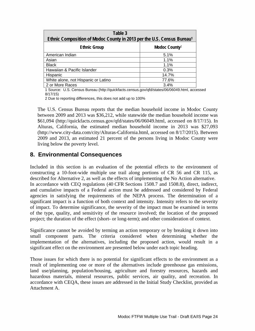
Modoc FTFW Multiple Use Trail - Draft EA/IS Page 24
Table 3 Ethnic Composition of Modoc County in 2013 per the U.S. Census Bureau1
Ethnic Group Modoc County2
American Indian 5.1% Asian 1.1% Black 1.1% Hawaiian & Pacific Islander 0.3% Hispanic 14.7% White alone, not Hispanic or Latino 77.6% 2 or More Races 3.4% 1 Source: U.S. Census Bureau (http://quickfacts.census.gov/qfd/states/06/06049.html, accessed 8/17/15) 2 Due to reporting differences, this does not add up to 100%
The U.S. Census Bureau reports that the median household income in Modoc County between 2009 and 2013 was $36,212, while statewide the median household income was $61,094 (http://quickfacts.census.gov/qfd/states/06/06049.html, accessed on 8/17/15). In Alturas, California, the estimated median household income in 2013 was $27,093 (http://www.city-data.com/city/Alturas-California.html, accessed on 8/17/2015). Between 2009 and 2013, an estimated 21 percent of the persons living in Modoc County were living below the poverty level.
8. Environmental Consequences Included in this section is an evaluation of the potential effects to the environment of constructing a 10-foot-wide multiple use trail along portions of CR 56 and CR 115, as described for Alternative 2, as well as the effects of implementing the No Action alternative. In accordance with CEQ regulations (40 CFR Sections 1508.7 and 1508.8), direct, indirect, and cumulative impacts of a Federal action must be addressed and considered by Federal agencies in satisfying the requirements of the NEPA process. The determination of a significant impact is a function of both context and intensity. Intensity refers to the severity of impact. To determine significance, the severity of the impact must be examined in terms of the type, quality, and sensitivity of the resource involved; the location of the proposed project; the duration of the effect (short- or long-term); and other consideration of context. Significance cannot be avoided by terming an action temporary or by breaking it down into small component parts. The criteria considered when determining whether the implementation of the alternatives, including the proposed action, would result in a significant effect on the environment are presented below under each topic heading. Those issues for which there is no potential for significant effects to the environment as a result of implementing one or more of the alternatives include greenhouse gas emissions, land use/planning, population/housing, agriculture and forestry resources, hazards and hazardous materials, mineral resources, public services, air quality, and recreation. In accordance with CEQA, these issues are addressed in the Initial Study Checklist, provided as Attachment A.

Modoc FTFW Multiple Use Trail - Draft EA/IS Page 25
A. Effects to Topography/Visual Quality
An effect to topography or visual quality would be considered significant if:
Grading would result in the substantial alteration of locally or regionally important topographic landforms; construction would result in the substantial loss of visually important resources; and/or the project would block public views to a scenic resource from existing public vantage points.
Alternative 1 – No Action. Under the No Action alternative, the proposed multiple use trail would not be constructed and the land within and adjacent to the propose trail alignment would not be modified; therefore, no changes to the existing topography would occur and there would be no potential for impacts to visual resources. Alternative 2 (Proposed Action) - Construct a Multiple Use Trail along CR 56 and CR 115. Construction of the proposed multiple use trail would permanently alter approximately 15 feet of the area immediately adjacent to the south side of CR 56 from US 395 to the railroad and temporarily effect up to an additional 5 feet beyond the proposed trail alignment. Similarly, from the railroad east along CR 56 to the Alturas Rancheria property, as well as from CR 56 south along CR 115 to the Refuge entrance gate, approximately 15 feet of existing land within the Refuge would be permanently altered and up to 5 additional feet would be temporarily affected during construction. In addition, because the trail would be separated from the road in these areas, temporary construction access from the road to the proposed trail site would be required from one or more points along this portion of the trail alignment. A portion of Refuge property at the southeast corner of the CR 56/115 intersection would be available as a potential construction staging area, which could result in the temporary removal of existing vegetation (primarily grasses and other forbs), but no grading would be required. Once construction is completed, the site would be reseeded. The trail would consist of a 10-foot-wide asphalt path. Where the trail abuts CR 56, the trail would be separated from the travel lane by striping and a rumble strip. Grading would be required within the trail alignment to prepare the trail bed and associated shoulders. Current construction plans indicate that a total of 1,054 cubic yards of excavation and 2,853 cubic yards of fill would be required for the project. Drainage improvements would also be required along portions of the trail and would likely involve grading and filling of existing drainage swales and installing or replacing culverts under the trail to accommodate storm water and existing irrigation facilities. In addition, some trimming of existing trees and shrubs, where they extend into the existing road right-of-way, would be necessary. New signage and fencing would also be installed in various locations along the trail route. A temporary construction staging area would be established on Refuge property to the south of the CR 56/CR 115 intersection. Where appropriate, those areas disturbed during construction would be seeded with a combination of intermediate wheatgrass and western wheatgrass once all construction has been completed.
Modoc FTFW Multiple Use Trail - Draft EA/IS Page 26
The grading required to construct the trail would result in little alteration of the existing topography and travelers along the roadway are unlikely to note any overall changes in the topographic landscape due to required drainage improvements. As a result, the project is not expected to result in any significant, adverse effects related to topography. The project would result in the conversion of a 10-foot-wide area of previously disturbed, but undeveloped land, to an asphalt pathway. All other areas disturbed during project construction would be seeded and mulched to minimize any visual evidence of the previous construction activity in the area. Based on trail’s proximity to public roads and the relatively disturbed nature of the areas in which it will be constructed, the project would result in only a minor change to the existing visual character of the area and would not distract from the overall visual character of the larger viewshed. In addition, the proposed tree and shrub trimming along the roadway that would be required to complete the trail would result in only minimal changes to the overall visual quality of the area. Therefore, no significant adverse effects to the visual quality of the project area are anticipated.
B. Effects to Geology, Soils, and Important Farmland
Any effect to geology or soils would be considered significant if:
Project-related actions would trigger or accelerate substantial slope instability, subsidence, ground failure, or erosion affecting on-site facilities or adjacent facilities, such as roadway and railway embankments and bridge abutments and pilings, or the proposed project could represent a safety hazard during a geologic or seismic event.
Alternative 1 – No Action. Under the No Action alternative, the proposed multiple use trail would not be constructed and there would be no grading or other modification of the land within the proposed trail alignment; therefore, no significant adverse effects related to geology or soils would occur.
Alternative 2 (Proposed Action) - Construct a Multiple Use Trail along CR 56 and CR 115. The construction of the proposed trail under Alternative 2 is not expected to trigger or accelerate slope instability, subsidence, ground failure or erosion that could affect adjacent facilities such as the adjacent highways, railroad, or drainage ditches. The grading required to construct the proposed trail would be minimal, with slopes of limited height and gentle slope gradients. The conditions in the area are not known to be subject to subsidence or ground failure. During construction, soils would be exposed to wind and water erosion; however, as described in Section 6B, the soils present within the proposed trail alignment are only moderately susceptible to wind erosion and slightly susceptible to water erosion. To minimize the potential for erosion during and after construction, both temporary and long-term erosion control measures have been incorporated into the scope of the

Modoc FTFW Multiple Use Trail - Draft EA/IS Page 27
project. These measures include the use of a water truck to minimize dust production during construction and implementation of best management practices (e.g., fiber rolls, sediment fences) to minimize erosion during rain events (refer to Section 7C for additional measures). The project would also extend existing culverts under the proposed trail where necessary and regrade ditches where the new trail alignment is placed along existing roadside ditches. Further, the existing geologic and soil conditions present in and around the proposed trail alignment are not expected to result in any significant adverse effects to the trail facility or future users. According to the Modoc County General Plan, there is very little evidence of geologic and seismic hazards in the County (Modoc County 1988). No significant adverse effects related to geology and soils are therefore anticipated under Alternative 2.
An effect to Important Farmland would be considered significant if: Project-related actions would result in the conversion of a substantial area of land in the region supporting Important Farmlands to non-agricultural use. Alternative 1 – No Action. Under the No Action alternative, the proposed multiple use trail would not be constructed; therefore, there would be no potential for the conversion of Important Farmlands to non-agricultural use. Alternative 2 (Proposed Action) - Construct a Multiple Use Trail along CR 56 and CR 115. Although the first 2,000 linear feet of the trail (when starting at US 395) would be constructed in an area overlain by Buntingville clay loam, 0 to 2 percent slopes, a soil type classified as Prime Farmland, this portion of the trail would be located within existing County road right-of-way and is therefore not available for agricultural use. As a result, there would be no adverse effects to Prime Farmland along this portion of the trail. Buntingville clay loam, 0 to 2 percent slopes, is also present where the trail would enter Refuge land, about 400 feet east of the railroad, to about 100 feet east of the intersection of CR 56 and CR 115 and for about 600 feet south along the east side of CR 115. Construction of the trail in these areas would result in the conversion of approximately 26,000 square feet of undeveloped Prime Farmland soil non-agricultural use. The swath of land to be converted to trail would be approximately 20 feet in width and would be located along existing roadways; therefore, this strip of land provides minimal value as Prime Farmland. As a result, the conversion of this land to a non-agricultural use is not considered a significant adverse effect. Alturas loam and Pit silty clay loam, 0 to 2 percent slopes (when protected from flooding), both classified as Farmland of Statewide Importance, are present within the trail alignment for about 2,250 feet. Construction of the trail in these areas would result in the conversion of approximately 45,000 square feet of undeveloped
Modoc FTFW Multiple Use Trail - Draft EA/IS Page 28
Farmland of Statewide Importance. Once again, this loss would occur within a 20 foot wide area located adjacent to the roadway, resulting in minimal change to the remaining Farmland of Statewide Important present in the area. The conversion of approximately 1.63 acres of Important Farmlands along CR 56 and CR 115 to a multiple use trail does not represent a substantial loss of Important Farmland. In addition, the project would not impact the ability of adjacent property owners with open fields to continue to manage their lands for haying or other agricultural purposes. Therefore, no significant adverse effects related to Important Farmlands are anticipated under Alternative 2.
C. Effects to Hydrology and Water Quality
Any effect related to hydrology would be considered significant if: Grading or other actions within the floodplain would substantially increase the projected 100-year flood elevations up or downstream of the project site or would substantially alter flood flow velocities and associated erosional forces. Alternative 1 – No Action. Under the No Action alternative, the proposed multiple use trail would not be constructed and no disturbance to the existing drainage and irrigation ditches would result; therefore, no significant adverse effects related to hydrology or water quality would occur.
Alternative 2 (Proposed Action) - Construct a Multiple Use Trail along CR 56 and CR 115. Portions of the proposed trail, as described in section 6 above, would be located within an area that FEMA has identified as subject to flooding from the Pit River under extreme flood conditions. Although the trail would be slightly elevated above the existing ground surface, the effect of this minor increase in elevation on downstream water flow or sheet flow across the general area would be inconsequential. Required alterations to the existing drainage and irrigation facilities to accommodate the proposed trail would be designed and constructed to meet or exceed current flow requirements. The project would extend existing culverts under the proposed trail where necessary and provide regraded ditches where the new trail alignment is placed along existing roadside ditches. If flow velocities through a culvert are expected to increase, riprap would be placed at culvert outlets to dissipate flow velocities.
Construction of the proposed trail would not result in any changes to the existing drainage patterns in the area, therefore, no substantial increases in the projected 100-year flood elevations up or downstream of the project site are anticipated, nor would the presence of the trail and associated drainage improvements substantially alter flood flow velocities and associated erosional forces. Therefore, no significant adverse effects related to hydrology are anticipated under Alternative 2.

Modoc FTFW Multiple Use Trail - Draft EA/IS Page 29
Any effect related to water quality would be considered significant if: The action could result in violations of water quality standards or waste discharge requirements, substantial increase of downstream sedimentation, or the introduction of contaminants (non-point source pollution) into the watershed. Alternative 1 – No Action. Under the No Action alternative, the proposed multiple use trail would not be constructed and no actions that could impact water quality would be implemented, therefore, implementing Alternative 1 would result in no significant adverse effects related to water quality. Alternative 2 (Proposed Action) - Construct a Multiple Use Trail along CR 56 and CR 115. Any potential for adverse effects to water quality from the implementation of Alternative 2 would occur during construction when construction equipment is present on the site and during and immediately after construction, when soils are exposed due to grading activity. Due to the relatively small scale of the project in terms of area disturbed and the limited change in the existing topography of the project site, any erosion from the site would not likely influence turbidity levels in nearby water courses or wetland areas. However, to minimize the potential for erosion from the site during and after construction and to limit the potential for the introduction of contaminants into the soil from construction vehicles, best management practices (BMPs), including erosion control measures (e.g., the installation of fiber rolls, reseeding disturbed areas) and other measures (e.g., spill prevention plan, proper equipment maintenance) to protect existing ground and surface water quality, would be implemented. Control of possible contaminants related to construction activities within the project site, in the construction staging areas, and along construction access routes would be accomplished through the use of spill control BMPs including, but not limited to: fueling vehicles and machinery in a designated location at an appropriate distance from any wetlands; immediately stopping, containing, cleaning, and properly disposing of spills; having spill kits available onsite from mobilization to demobilization, and training field personnel on spill prevention and cleanup. To ensure that all applicable BMPs are implemented during project implementation, the following mitigation measures will be implemented:
Water Quality Mitigation Measures
CEQA - The County of Modoc through conditions incorporated into the required encroachment permit will ensure that the contractor adheres to and implements appropriate best management practices (BMPs) to minimize erosion and protect water quality during all phases of project construction within the County’s right-of-way. BMPs would include, but are not limited to, installation of appropriate erosion control along the construction route, at construction staging areas, and along all required construction access routes and preparation of a spill prevention plan. In addition, the permit will require that all disturbed areas
Modoc FTFW Multiple Use Trail - Draft EA/IS Page 30
adjacent to the trail and within staging areas and construction access routes be seeded and mulched, as necessary, immediately following completion of construction activity within the County right-of-way. NEPA - CFLHD will be responsible for ensuring that the contractor adheres to and implements appropriate best management practices (BMPs) to minimize erosion and protect water quality during all phases of project construction throughout the overall trail alignment. BMPs would include, but are not limited to, installation of appropriate erosion control along the construction route, at construction staging areas, and along all required construction access routes and preparation of a spill prevention plan. In addition, CFLHD will also ensure that all disturbed areas adjacent to the trail and within staging areas and construction access routes are seeded and mulched, as necessary, immediately following completion of construction activity within the project site.
The implementation of these measures would ensure that no significant adverse effects to water quality would occur during the implementation of Alternative 2. It should also be noted that a National Pollutant Discharge Elimination Permit for soil disturbance of greater than one acre may be required by this project, but it is anticipated that this project will qualify for the Low Erosivity Waiver for small construction projects. The permit requirements will depend on final construction design. An Erosion Control Plan or a Stormwater Pollution Prevention Plan (SWPPP) would be implemented based on final design requirements.
D. Effects to Ambient Noise Levels
Any effect related to noise would be considered significant if:
The action generates noise levels that violate Federal, State, regional, or local noise standards or requirements. Alternative 1 – No Action. Under the No Action alternative, the proposed trail would not be installed, no construction activity would occur, and no construction noise would be generated within the proposed trail alignment. Therefore, there would be no potential for adverse effects related to noise. Alternative 2 (Proposed Action) - Construct a Multiple Use Trail along CR 56 and CR 115. At excessive levels, people typically perceive noise as being intrusive, annoying, and undesirable. A goal of the Modoc County General Plan (Modoc County 1988) is to “protect the citizens of Modoc County from the harmful effects of exposure to excessive noise.”
When addressing the effects of noise on people, noise levels are generally expressed in noise A-weighted decibels (dBA). Measurement of sound levels in dBA de-emphasizes the very low and very high frequency components of the sound, resulting in a greater emphasis on those frequencies within the sensitivity range of the human

Modoc FTFW Multiple Use Trail - Draft EA/IS Page 31
ear. Noise in the range of 30 dBA is considered very quiet, while noise in the range of 100 dBA is viewed as very loud. Noise levels measured at 140 dBA are considered painful. Common indoor and outdoor noise levels include 80 dBA for a garbage disposal at 3 feet, 70 dBA for a vacuum cleaner at 10 feet, and 60 dBA for an air conditioner at 100 feet. Activities generating noise as a result of implementing Alternative 2 would include:
Mobilization and demobilization of construction equipment; Delivery of construction materials to staging areas and/or the project site; Clearing and grubbing of existing vegetation within the trail alignment,
primarily on the Refuge; Grading within the project footprint to create the trail bed and to improve
and/or replace existing drainage and irrigation ditches; Placement of aggregate and asphalt within the 10-foot-wide trail bed; Pouring of concrete at the railroad crossing; Installation of sign posts and fencing; Reseeding of disturbed areas following construction; and Use of the trail by walkers, runners, and bicyclists following project
completion. Mobilization and demobilization activities, including equipment transport, would occur primarily to the west of any developed area, however, some equipment and construction related materials would be transported to various locations along the proposed trail alignment. Noise associated with the proposed action would be generated primarily during site grading and aggregate and asphalt application. Construction noise levels are a function of the number and type of equipment used and the timing and duration of their noise-generating activities. Vehicles and construction equipment likely to be used for the implementation of Alternative B include mower, excavator, backhoe, dump trucks, asphalt roller and grader, concrete pump truck, water truck, and pickup trucks. Other sound generating equipment might include posthole diggers, tree trimmers, and hydroseeding equipment. Presented in Table 4 are noise levels for typical road construction equipment. These levels are consistent with the levels of noise that would be anticipated on the project site during construction. Construction is expected to occur during an 8 to 10 week period sometime between mid-July and late December, 2016. Because this is a linear project, construction activity would not occur at any one location for the entire construction period, with the exception of the staging area site.

Modoc FTFW Multiple Use Trail - Draft EA/IS Page 32
Table 4 Construction Equipment Noise Levels
Equipment
Maximum Noise Level (dBA) 50 Feet from Source
Backhoe 78 Dump truck 84 Excavator 85 Compactor 83 Concrete saw 90 Paver 77 Roller 80 Pickup truck 75 Concrete pump truck 81 Chain saw 84 dBA = ampere-weighted decibels Source: U.S. Department of Transportation 2006
Land uses along the construction route include:
a museum and community facilities along the south and north side of CR 56 from US 395 to S. East Street (closest building approximately 125 feet from the trail alignment);
a single-family residence at the northeast corner of S. East Street and CR 56 and another single-family residence mid-block between S. East Street and S. Estes Street facing onto CR 56 (both located approximately 90 feet from the trail alignment);
an RV Park, located to the south of CR 56 between S. East Street (Riverside Street) and S. Estes Street (closest building approximately 120 feet from the trail alignment);
multi-family residential development just to the west of the railroad and north of CR 56 (closest residences approximately 70 feet from the trail alignment); and
one or more residential units and a small business use are located on a lot to the east of the railroad on the south side of CR 56 (the nearest residential unit is approximately 50 feet from the trail alignment).
Ambient noise levels around the project site are influenced by daily vehicle traffic traveling along CR 56 and CR 115, as well as occasional train activity on the Union Pacific line that crosses CR 56. The proposed construction activity would result in temporary increases in the ambient noise levels that some residents might consider to be a nuisance. Construction noise would be temporary and would vary from day to day as well as throughout a single day. To minimize the effect of construction noise on surrounding residents, the following mitigation measures would be implemented:

Modoc FTFW Multiple Use Trail - Draft EA/IS Page 33
Noise Mitigation Measures CEQA - The County of Modoc through conditions incorporated into the required encroachment permit will ensure that the contractor adheres to a construction work schedule that limits construction activity along CR 56 from US 395 to CR 115 to daylight hours (one-half hour after sunrise to one-half hour before sunset). NEPA - CFLHD will be responsible for ensuring that the contractor adheres to a construction work schedule that limits construction activity along CR 56 from US 395 to CR 115 and along CR 115 from CR 56 to the Modoc NWR entrance to daylight hours (one-half hour after sunrise to one-half hour before sunset).
The implementation of these mitigation measures would reduce the potential for adverse noise effects of constructing the proposed trail in accordance with Alternative 2 to below a level of significance.
E. Effects to Biological Resources
Any effect related to biological resources would be considered significant if:
The action would substantially change the amount or quality of available habitat to support one or more fish or wildlife species; substantially interfere with the movement of native resident or migratory wildlife species; and/or result in a substantial change in the local population of one or more fish or wildlife species, or The action would substantially alter the presence, reproductive success, movement, or the availability of appropriate habitat to support any listed Federal or State endangered, threatened, or candidate species, any species identified as sensitive, of special-status in local or regional plans, policies, or regulations; or any avian species identified as a Bird of Conservation Concern, or The action would result in a net loss of wetlands regulated by the USACE, RWQCB, and/or CDFW.
Alternative 1 – No Action. Under the No Action Alternative, the proposed multiple use trail would not be constructed and no alteration of the existing vegetation would occur, no changes to the existing drainage and irrigation ditches would be implemented, and there would be no potential for disturbance to wildlife as a result of construction or use of the trail. Therefore, no significant adverse effects related to biological resource would occur.
Alternative 2 (Proposed Action) - Construct a Multiple Use Trail along CR 56 and CR 115. The construction of the proposed trail under Alternative 2 would permanently replace approximately 3.24 acres of unvegetated land, disturbed vegetation, and cropland habitat with a 10-foot-wide asphalt pathway and a minimum two-foot-wide unvegetated shoulder on either side. Project implementation would also result in temporarily impacts to about one acre of disturbed habitat and unvegetated land along the trail corridor and within the proposed staging area. Areas subject to temporary disturbance during construction

Modoc FTFW Multiple Use Trail - Draft EA/IS Page 34
would be seeded, as appropriate, with a mix of intermediate wheatgrass and western wheatgrass following completion of all construction. The area to be permanently disturbed immediately adjacent to CR 56 from US 395 to the railroad crossing provides limited habitat value due to the lack of significant vegetation and the proximity to the travel lane. From the railroad crossing east and along the east side of CR 115, the trail would extend along the Refuge boundary, in proximity to the roadway. This relatively narrow, linear corridor of habitat loss would have little, if any, impact on wildlife. Therefore, the implementation of Alternative 2 would not substantially change the amount or quality of available habitat to support one or more fish or wildlife species, nor would it substantially interfere with the movement of native resident or migratory wildlife species. The habitat within the proposed trail alignment is also not essential for the support of any local population of fish or wildlife species. No significant adverse effects related to fish and wildlife habitat are therefore anticipated. Noise and human activity associated with the construction of the proposed multiple use trail have the potential to disturb nesting birds in the vicinity of the project site; therefore, to avoid such impacts, the following mitigation measures have been developed and would be implemented:
Biological Resources Mitigation Measures
CEQA - The County of Modoc through conditions incorporated into the required encroachment permit will ensure that project associated construction activities within the County right-of-way are restricted to the non-breeding season (July 15 through February 15). NEPA - USFWS and CFLHD will be responsible for ensuring that all project associated construction activities are restricted to the non-breeding season (July 15 through February 15).
The project design under Alternative 2 also includes a proposal to install a fence approximately 15 feet from the trail edge between the trail and the remaining Refuge property. The fence would minimize the potential for disturbance to habitats managed and maintained by the Refuge to support mammals, birds, and other wildlife. The combination of these actions would ensure that no significant adverse effects to wildlife would occur as a result of implementing Alternative 2. The habitats known to support the federally listed species that are occasionally observed on the Modoc NWR do not occur in proximity to the proposed trail; therefore, no adverse effects to these species are anticipated. State listed species including the greater sandhill crane and the less common Swainson’s hawk have the potential to be found in the cropland habitats of the Refuge. Restrictions on the timing of construction (as described in Mitigation Measure #1), as well as the installation of fencing to restrict public access within the Refuge would ensure that no significant adverse effects to these species would occur. The same measures would ensure the

Modoc FTFW Multiple Use Trail - Draft EA/IS Page 35
protection of those bird species that have been identified as Birds of Conservation Concern by the Service (USFWS 2008). With respect to wetland issues, as described previously, the proposed trail alignment includes features potentially subject to USACE and/or RWQCB jurisdiction. The implementation of Alternative 2 would result in discharge of fill to these features. Permanent impacts would result from grading for the proposed multiple use trail and extension of several existing drainage culverts. Temporary impacts to roadside swale include an area of soft bottom ditch realignment where the newly constructed slope extends below OHWM elevation. Anticipated temporary and permanent impacts to features that may be subject to regulation by USACE and/or RWQCB are presented in Table 5.
Table 5 Impacts to Potentially Jurisdictional Areas under Alternative 2
Potentially Jurisdictional Feature
Potential USACE Non-Wetland Waters
Perm (Ac)
Temp (Ac) Total (Ac) Linear feet
Roadside Ditch/Irrigation Ditch A
0.050 0.030 0.080 535
Irrigation Ditch B 0.006 0.005 0.011 59
Irrigation Ditch C 0.008 0.004 0.012 63
Irrigation Ditch D 0.009 0.014 0.023 123
Total 0.073 0.053 0.126 780
Additional details are provided in the Jurisdictional Delineation Report (JD Report), prepared by (HDR Engineering, Inc. (2015), provided as Appendix B. Based on the analysis in the JD Report, permanent impacts to non-wetland potentially jurisdictional waters would total 0.073 acre and temporary impacts would total 0.053 acre. The features proposed to be impacted are constructed in uplands, primarily for irrigation purposes. In addition, they do not support wetland or riparian habitat. All of the aforementioned features impacted during the project will be restored in kind to reestablish irrigation functionality. If these features are considered jurisdictional by USACE, a Nationwide Permit 14 (NWP-14) would be requested. Mitigation for impacts to non-wetland waters under 1/10 acre do not require mitigation under the terms of NWP-14. If these features are not considered jurisdictional by USACE, the only permit requirement would be satisfaction of Water Discharge Requirements per the RWQCB.

Modoc FTFW Multiple Use Trail - Draft EA/IS Page 36
F. Effects to Cultural Resources
Any effect related to cultural resources would be considered significant if:
The action could result in the physically damage or alteration of a resource listed in or eligible for listing in the NRHP, isolate a listed or eligible resource from the context associated with its listing, or affect the character or setting of a listed or eligible resource.
Section 106 (16 USC 470f) of the National Historic Preservation Act (NHPA) requires Federal agencies, prior to taking action, to take into account the effects of their undertaking on historic properties. Specific regulations regarding compliance with Section 106 state that although the tasks necessary to comply with Section 106 may be delegated to others, the Federal agency is ultimately responsible for ensuring that the process is completed according to statute.
Alternative 1 – No Action. Under the No Action alternative, the proposed multiple use trail would not be constructed; therefore, no ground disturbance would occur and there would be no potential for adverse effects to cultural resource.
Alternative 2 (Proposed Action) - Construct a Multiple Use Trail along CR 56 and CR 115. The Service's Regional Cultural Resources staff has determined based on the results of a record search and field reconnaissance that Alternative 2 is a routine undertaking (i.e., an action with little or no potential to affect historic properties), therefore, the action falls under the terms of the Service’s Programmatic Agreements (PA) with SHPO and the Advisory Council for Historic Preservation (Council) regarding the administration of routine undertakings under the NHPA in the states of California, Idaho, Nevada, Oregon, and Washington. All clearances include the stipulation that if cultural resources are discovered during the project, work will halt and the Service’s Regional Archaeologist shall be contacted.
Cultural Resources Mitigation Measure
The County of Modoc through conditions incorporated into the required encroachment permit and CFLHD through requirements in the construction drawings will ensure that if cultural resources are encountered during ground-disturbing activities within the County right-of-way or on the Modoc NWR, work in the immediate vicinity would be suspended, CFLHD would be notified immediately, and no work in the area would recommence until the discovery is assessed by a qualified archaeologist and treatment is determined. Additionally, in the event that human remains are encountered during ground-disturbing activities, all work in the immediate vicinity will cease and the Medical Examiner will be contacted, per the California Public Resources Code. Should the remains be identified as Native American, the Medical Examiner will contact the Native American Heritage Commission within 24 hours of identification to provide a most likely descendent to determine appropriate actions All human remains would
Modoc FTFW Multiple Use Trail - Draft EA/IS Page 37
be treated in accordance with the Native American Graves Protection and Repatriation Act (NAGPRA).
No significant adverse effects related to cultural resources are therefore anticipated under Alternative 2.
G. Effects to Traffic Circulation
Any effect related to traffic circulation would be considered significant if:
The action would generate traffic that would exceed existing road capacities; sight distances provided at ingress/egress points are inadequate; or the proposed action would substantially alter the demand for on- and/or off-street parking spaces.
Alternative 1 – No Action. Under the No Action alternative, the proposed trail would not be constructed. This would avoid the need for traffic control associated with temporary road construction. No significant adverse effects related to traffic would occur under the No Action alternative. However, under the No Action alternative the benefits of the proposed trail in terms of replacing some vehicle trips along CR 56 and CR 115 with pedestrian or bicycle trips would not be realized. In addition, the safety and traffic movement benefits associated with separating pedestrian and bicycle activity from the travel lanes of the existing roadways would also not be realized.
Alternative 2 (Proposed Action) - Construct a Multiple Use Trail along CR 56 and CR 115. The construction of the proposed trail under Alternative 2 would result in temporary impacts to traffic flow due to the need for traffic control in the vicinity of the proposed trail construction project. Temporary signs would be installed to warn drivers of upcoming road shoulder closures and in some cases flaggers may be present to control traffic when construction vehicles are entering or leaving the construction site, or in cases where it is necessary to temporarily close the east bound lane of CR 56. The majority of the traffic control would occur along CR 56 between US 395 and the railroad crossing. Once the trail moves onto the Refuge property, temporary impacts to traffic flow would be minimized. The need for traffic control would result in some traffic congestion in the area, particularly when there is a full lane closure, but the effects would be temporary and are not considered significant. In addition, construction would be scheduled to avoid important holidays such as the July 4th weekend. Once the trail is constructed, signage will be installed to control travel along the path and minimize the potential for conflicts between bicycles, pedestrians, and cross traffic. Yield or stop signs for trail users will be installed at intersections and driveways.

Modoc FTFW Multiple Use Trail - Draft EA/IS Page 38
Alternative 2 would also result in traffic benefits as some vehicle trips to and from the Refuge and Alturas Rancheria property would be replaced by bicycle or pedestrian trips. In addition, moving bicycles and pedestrians activity off the existing travel lanes of CR 56 and CR 115 will improve travel safety for all parties. No parking is permitted along the south side of CR 56 in the vicinity of the park and further to the east along CR 56, there are no adequate accommodations for on-street parking, therefore, the construction of the trail within the right-of-way of CR 56 would not result in any significant adverse effects related to parking.
H. Effects to Public Utilities Any effect related to public utilities would be considered significant if:
Project implementation has the potential to damage existing utilities, or prevent access to existing utilities. Alternative 1 – No Action. Under the No Action Alternative, the proposed multiple use trail would not be constructed and there would be no potential for adverse effects to the public utilities located adjacent to the proposed trail alignment.
Alternative 2 (Proposed Action) - Construct a Multiple Use Trail along CR 56 and CR 115. The construction of the proposed trail under Alternative 2 would occur adjacent to existing utility lines, including both power lines and phone lines. The trail alignment has configured to avoid the extent possible all utility poles and guy wires. It may be necessary relocate one telephone pedestal at the southeast corner of the intersection of CR 56 and CR 115. If relocation is required, it would be done in consultation with Frontier Communications. No adverse effects to any utilities are anticipated as a result of implementing Alternative 2.
I. Effects to Environmental Justice
Any effect related to environmental justice would be considered significant if:
A project would result in disproportionate adverse human health impacts or environmental effects to low-income or minority populations.
Alternative 1 – No Action. Under the No Action Alternative, the proposed multiple use trail would not be constructed and the benefits of providing a safe route for pedestrians and bicyclists to travel to the Refuge and the Alturas Rancheria property would not be realized.
Alternative 2 (Proposed Action) - Construct a Multiple Use Trail along CR 56 and CR 115. The construction of the proposed trail under Alternative 2 would not result in any adverse human health impacts or any environmental effects that would disproportionately affect low-income or minority populations. The project would
Modoc FTFW Multiple Use Trail - Draft EA/IS Page 39
however provide benefits that would be realized by all populations in the area through the provision of improved access for bicyclists and pedestrians along CR 56 from the City of Alturas to the Alturas Rancheria property and along CR 115 to the Refuge. The public will no longer be required to walk or ride at the edge of the travel lanes, improving safety for both walkers, bicyclists, and those driving on these segments of road.
9. Cumulative Effects of the Proposed Action Cumulative effects are those effects on the environment resulting from incremental consequences of a proposed action when added to other past, present, and reasonably foreseeable future actions, regardless of who undertakes those actions. Cumulative effects can be the result of individually minor impacts that can become significant when added over a period of time. It is difficult to accurately analyze cumulative effects because one action may increase or improve a resource in one area, while other unrelated actions may decrease or degrade that resource in another area. This section assesses how these other actions in addition to the proposed action would affect the physical, biological, cultural, and social and economic environment. In preparing for the cumulative impact analysis, a search of past, current, and potential future projects was conducted. According to the County of Modoc, no projects are currently pending or anticipated in the general vicinity of the project. The only potential future project would be the reconstruction of the Modoc NWR office and visitor center, which was destroyed by fire in 2015.
Cumulative Effects on the Physical Environment The implementation of the proposed action would result in a minimal impact on the physical environment. There would be limited change to the visual and topographic quality of the general area, impacts to water quality would be adequately mitigated, limited conversion of Important Farmland would occur, and noise levels would increase during the construction phase of the project, but would be minimal following the completion of construction. Overall, the provision of a facility to accommodate non-motorized access would provide a benefit, albeit minor, to the overall air quality in the area. Reconstruction of the Refuge office and visitor center would occur on previously disturbed land requiring minimal grading and little, if any, disturbance to previously undeveloped lands. Noise levels would increase during construction, but the project is sufficiently separated from the trail construction corridor that there would be no cumulative effect should the two projects be constructed during the same time period. Construction traffic would be greater if the two projects were implemented during the same time period, however, traffic volumes, particularly along CR 115 are relatively low and would not be adverse affected. Neither project would result in significant adverse effects either individually or cumulatively to the physical environment.
Cumulative Effects on Biological Resources Impacts to biological resources from the proposed action combined with the anticipated future action of reconstructing the Refuge visitor center and office would have a minimal
Modoc FTFW Multiple Use Trail - Draft EA/IS Page 40
effect on biological resources. No loss of sensitive plants or animals is anticipated, and measures to avoid disturbance during the breeding season would minimize impacts to wildlife populations. Therefore, no significant adverse effects either individually or cumulatively to biological resources are anticipated. Cumulative Effects on Cultural Resources The Service, CFLHD, and County of Modoc adhere to the policies and regulations pertaining to the protection of cultural resources to avoid or mitigate for any significant adverse effects resulting from construction activities and other actions that may be undertaken. No cumulative adverse effects to cultural resources are therefore anticipated from the implementation of the proposed action, the reconstruction of the Refuge office and visitor center, or any other future actions in the general area. Cumulative Effects on the Social and Economic Environment The construction of a non-motorized multiple use trail that provides access along CR 56 and to the Modoc NWR would provide benefits to local residents, as would the programs provided by the Modoc NWR, including environmental education and interpretation, that would in the future once again be conducted at a Refuge visitor center. A negligible amount of tourism dollars could be generated from these recreational and educational opportunities. No cumulative adverse effects to the social and economic environment are anticipated.
10. Agencies and Persons Consulted
The following agencies and/or individuals were contacted regarding this proposal:
City of Alturas, Public Works Department Modoc County Transportation Commission Lake Railway Alturas Rancheria
11. Document Preparation
Victoria Touchstone, Refuge Planner, USFWS Kim Hunter, Planning Director, Modoc County Steve Clay, Project Leader, USFWS, Modoc NWR Patricia Roberson, Refuge Program Specialist, USFWS Julian Maskeroni, Project Manager, FHWA/CFLHD
12. References Cited BakerAECOM. 2013. National Flood Insurance Program, Modoc County, California, Pit River PMR. Prepared for FEMA. Preliminary Firm Panel (SFHA changes since last FIRM, dated 2/14/13). http://www.r9map.org/Docs/Modoc_CSLF.pdf.
Modoc FTFW Multiple Use Trail - Draft EA/IS Page 41
California Department of Conservation. 2015. Modoc County Important Farmland 2012 California Department of Conservation, Farmland Mapping and Monitoring Program, Division of Land Resource Protection. Map published February 2015. ftp://ftp.consrv.ca.gov/pub/Dlrp/fmmp/pdf/2012/Mod12.pdf California Department of Conservation. 2010. Soil Candidate Listing for Prime Farmland and Farmland Of Statewide Importance, Modoc County. California Department of Conservation, Farmland Mapping and Monitoring Program, 7/18/95, Updated 2/02/2010. http://www.conservation.ca.gov/dlrp/fmmp/Documents/fmmp/Pubs/Soils/Modoc_ssurgo.pdf. Halterman, M. D., D. S. Gilmer, S. A. Laymon, and G. A. Falxa. 2001. Status of the yellow-billed cuckoo in California: 1999-2000. Report to the USGS-BRD. HDR Engineering, Inc. 2015. Jurisdictional Delineation Report Modoc Trail Project - CA FTFW MODO (1) Modoc County, CA. Prepared for the Federal Highway Administration Central Federal Lands Highway Division. November 2015.
Jackman, R. E. and J. M. Jenkins. 2004. Protocol for Evaluating Bald Eagle Habitat and Populations in California. Prepared for the U.S. Fish and Wildlife Service, Endangered Species Division, Sacramento, CA. June 2004. Kushlan, J.A., J. Steinkamp, K.C. Parsons, J. Capp, M. Acosta Cruz, M. Coulter, I. Davidson, L. Dickson, N. Edelson, R. Elliot, R. M. Erwin, S. Hatch, S. Kress, R. Milko, S. Miller, K. Wheeler, and K. Wohl. 2002. Waterbird Conservation for the Americas: The North American Waterbird Conservation Plan, Version 1. Waterbird Conservation for the Americas, Washington, DC, U.S.A. Laymon, S.A. and M.D. Halterman. 1989. A proposed habitat management plan for Yellow-billed Cuckoos in California. USDA Forest Service Gen. Tech. Rep. PSW-110 p 272-277. Littlefield, C. D., and G. L. Ivey. 2000. Conservation assessment for greater sandhill cranes wintering on the Consumnes River floodplain and delta regions of California. The Nature Conservancy. Littlefield, C. D., and G. L. Ivey. 2002. Washington State recovery plan for the sandhill crane. Washington Department of Fish and Wildlife. Modoc County. 1988. Modoc County General Plan Goals, & Action Program. Modoc County Transportation Commission. 2014. Draft Modoc County 2014 Regional Transportation Plan. Accessible at: http://modoctransportation.com/?page_id=12.
Modoc FTFW Multiple Use Trail - Draft EA/IS Page 42
Oakeshott, G. B. 1971. California's changing landscapes: A guide to the geology of the state. New York: McGraw-Hill. Pit River Watershed Alliance. No date. Upper Pit River Watershed Management Strategy. Schlorff, A. R. 2000. Report to the Fish and Game Commission on bank swallow populations. California Department of Fish and Game. California Department of Fish and Game. 2005c. The status of rare, threatened, and endangered plants and animals of California 2000-2004. Sedgwick, J. A. 2000. Willow flycatcher (Empidonax traillii). In The birds of North America, edited by A. Poole and F. Gill. Philadelphia: The Birds of North America, Inc. [SRWP] Sacramento River Watershed Program – Upper Pit River Watershed. Site updated 2014. Site viewed December 2, 2014. http://www.sacriver.org/aboutwatershed/roadmap/watersheds/northeast/pit/upper-pit-river-watershed. Stutte, Nicole. 2003. Alturas Rancheria Firebreak – Modoc NWR: Archaeological and Historical Resources Identification Report. Prepared by U.S. Fish and Wildlife Service.
[USACE] U.S. Army Corps of Engineers. 2007. Regulatory Guidance Letter No. 07-01: Practices for Documenting Jurisdiction under Sections 9 & 10 of the Rivers and Harbors Act of 1899 and Section 404 of the Clean Water Act. June 5. http://www.usace.army.mil/Portals/2/docs/civilworks/RGLS/rgl07-01.pdf. Viewed November 24, 2014. U.S. Census Bureau (http://quickfacts.census.gov/qfd/states/06/06049.html, accessed 8/17/15). [USDA NRCS] U.S. Department of Agriculture, Natural Resources Conservation Service. National List of Hydric Soils. March 2014. http://www.nrcs.usda.gov/wps/portal/nrcs/ main/soils/use/hydric; accessed November 24, 2014. [USDA] U.S. Department of Agriculture, Soil Conservation Service. 1980. Soil survey of Modoc County, California, Alturas area: National Cooperative Soil Survey. [USDOT] U.S. Department of Transportation. 2006. Construction Noise Handbook. Research and Innovative Technology Administration, John. A. Volpe National Transportation Systems Center, Environmental Measurement and Modeling Division, Acoustics Facility. Cambridge, MA. August 2006.

Modoc FTFW Multiple Use Trail - Draft EA/IS Page 43
[USFWS] U.S. Fish and Wildlife Service. 2008. Birds of Conservation Concern 2008. Division of Migratory Bird Management, Arlington, Virginia. [USFWS] U.S. Fish and Wildlife Service. 2009. Modoc National Wildlife Refuge Comprehensive Conservation Plan. VESTRA. 2004. Upper Pit River Watershed assessment. Prepared for Pit River Alliance. Weigel, Lawrence. 1981. Archaeological Reconnaissance and Monitoring on the Modoc National Wildlife Refuge, Alturas, California. Prepared by the U.S. Fish and Wildlife Service. W. M. Beaty & Associates, Inc. 2011. Shasta Forests Sustained Yield Plan Soil Description Reference (Appendix C) from the Shasta Forests Sustained Yield Plan. Prepared for Shasta Forests Timberlands, LLC et al. August 26, 2011.
Appendix A
Draft Amendment to the
Modoc National Wildlife Refuge
Comprehensive Conservation Plan

Draft Amendment to the Modoc NWR CCP - Page1
United States Department of the Interior
FISH AND WILDLIFE SERVICE Modoc National Wildlife Refuge
P.O. Box 1610 Alturas, CA 96101-1610
Draft Memorandum To: Assistant Regional Director, Refuges, Region 8 From: Project Leader, Modoc National Wildlife Refuge
Alturas, California Subject: Request for Amendment to 2009 Modoc NWR CCP to include the Modoc Trail
Project The U.S. Fish and Wildlife Service (Service) with funding from the Federal Lands Transportation Program proposes to partner with the Federal Highway Administration Central Federal Lands Highway Division to construct a multiple use trail within Modoc National Wildlife Refuge (NWR or Refuge) along County Roads 56 and 115 (Figure 1). The trail would improve opportunities for non-motorized public access to Refuge facilities by residents of Modoc County. The Modoc NWR Comprehensive Conservation Plan (CCP), which was adopted in 2009, did not include the development or use of this trail. Since the CCP is not scheduled to be revised for eight years, we are amending the CCP through this memorandum to incorporate the development and use of the Modoc Trail Project as required by the National Wildlife Refuge System Improvement Act of 1997 and Service policy. Background/Need for Amendment: The National Wildlife Refuge System Improvement Act of 1997 and Service policy (Fish and Wildlife Service Manual chapters 602 FW 1 and 3) identify the need to periodically review and revise Comprehensive Conservation Plans. Specifically, Service Manual chapter 602 FW 3, (Comprehensive Conservation Planning Process) Section 3.2 states “We will revise the CCP every 15 years … or earlier if monitoring and evaluation determine that we need changes to achieve planning unit purpose(s), vision, goals, or objectives.” The addition of the Modoc Trail Project is considered a minor amendment to the 2009 CCP. The addition of the trail does not alter the original intent of any part of the CCP. This is considered a minor CCP revision because it would include the addition, deletion, and/or modification of CCP strategies without changes to any objectives or goals and the modification of the numerical target values associated with one or more objectives, without changing the overall intent of the objective(s). Compliance with the National Environmental Policy Act of 1969 (NEPA) has been completed through the preparation of an environmental assessment and a determination that the proposed action qualifies for a Finding of No Significant Impact.
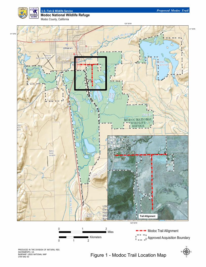
PRODUCED IN THE DIVISION OF NATURAL RES.SACRAMENTO, CABASEMAP: USGS NATIONAL MAPUTM NAD 83
Modoc National W ildlife RefugeModoc County, California
U.S. Fish & Wildlife Service Proposed Modoc Trail
USGS The National Map: National Boundaries Dataset, NationalElevation Dataset, Geographic Names Information System, NationalHydrography Dataset, National Land Cover Database, NationalStructures Dataset, and National Transportation Dataset; U.S. CensusBureau - TIGER/Line; HERE Road Data
120°30'W
120°30'W
41°30'N
41°30'N
0 1 2Miles
0 1 2Kilometers
µ
Trail Allignment
Modoc Trail AllignmentApproved Acquisition Boundary
Figure 1 - Modoc Trail Location Map

Draft Amendment to the Modoc NWR CCP - Page3
This memorandum complies with the National Wildlife Refuge System Improvement Act of 1997, which states that the “Secretary shall … revise the plan at any time if the Secretary determines that conditions that affect the refuge or planning unit have changed significantly.” Examples of new information or changed conditions include but are not limited to the following: 1) changes in the acreage of a specific habitat type; 2) changes in water management or availability; 3) changes in the status of a listed species; 4) the need for changes to wildlife management or public use programs; 5) changes to Service policy; 6) the need to construct new facilities, and/or 7) changes in sea level or other climate related changes. Need for the Modoc Trail Project: The Modoc NWR has strong Environmental Education Program, involving school children of all grade levels. This has led to a vibrant relationship with the Refuge's gateway town of Alturas, CA. Downtown Alturas is less than 2 miles from the main refuge entrance on Modoc County Road 115 (CR 115). Modoc County residents and visitors, people of all ages, use the refuge roads, trails, lakes and ponds for recreation. Many visitors access the Refuge on foot or bicycle, even though the main access roads to the Refuge, CR 56 (E. McDowell Road) and CR 115, do not have an adequate shoulder for safe bicycle or pedestrian traffic. US Census data shows that Modoc County has the second lowest median household income ($33,479) of any county in California and about ten percent of Modoc County's households do not have a personal motor vehicle. Modoc County's population is also significantly less than the other counties with a similar percentage which makes the impact of households without vehicles even stronger. These statistics demonstrate the need for the county and refuge to provide more ways to provide for non-motorized access to more visitors. In order to broaden and increase the number of visitors to Modoc NWR using non-motorized modes of transportation, the Service, City of Alturas and Modoc County all recognize that a safe, off-the-road facility needs to be constructed. This facility would also meet the Service’s goals for increasing accessibility to Federal public lands as presented in the America's Great Outdoors (AGO) initiative, and the Let's Move Outside (LMO) sub-initiative of the First Lady's Let's Move initiative. LMO is designed to increase the amount of active recreation on public lands. The project would further local transportation goals as well since increased bike and pedestrian facilities to the Refuge are in the Modoc County Regional Transportation Plan (RTP), and the RTP has a bicycle safety goal to reduce bike/vehicle crashes to 2000 levels by 2010. Based on the demonstrated need for non-motorized trails within the community, the Refuge has secured funding through the Federal Land Transportation Program for the construction of a 1.77-mile-long, 10-foot-wide multiple use trail along the south side of CR 56 from U.S. Route 395 to 1,254 feet east of CR 115, as well as from CR 56 south along the east side of CR 115 to the entrance road for the Refuge. Management Strategies: Goal 3 of the Modoc CCP states that quality wildlife-dependent recreation and interpretation should be provided to enhance public appreciation, understanding, and enjoyment of fish, wildlife, habitats, and cultural resources. Improving accessibility to the Refuge will enable more residents to experience the recreational and interpretative opportunities provided on the Refuge. Safe non-motorized access to the Refuge would also support CCP strategies to facilitate after school programs.
Draft Amendment to the Modoc NWR CCP - Page4
The following changes to the Modoc NWR CCP (as indicated by underlining) are proposed to incorporate the Modoc Trail project into the CCP. Page 71 of the Modoc NWR CCP - 8.8 Non-wildlife Dependent Recreation
Dorris Reservoir provides a number of recreational opportunities including swimming, boating, bicycling, horseback riding, and waterskiing. However, the Reservoir is closed to all public access during the waterfowl hunting season, from October 1 through January 31, to provide a sanctuary for wildlife. In addition, shoreline areas, islands, and peninsulas with nesting waterfowl are signed and closed to public access during waterfowl nesting season, March 1 through May 31. Walk-in access is allowed on the Reservoir beginning February 1. Licensed motorized vehicles and bicycles are permitted at the Reservoir from April 1 through September 30 on roads designated for motor vehicles. Horseback riding is permitted from April 1 through September 30 on roads designated for motor vehicles and on the equestrian trail across the dam (Figure 1). Horseback riding is also allowed year-round on roads designated for motor vehicles in the remaining portions of the Refuge. Bicycling is permitted from April 1 through September 30 on roads designated for motor vehicles. Bicycling is also allowed year-round on roads designated for motor vehicles, including the entrance road and auto tour route, in the remaining portions of the Refuge. A multiple use trail proposed for construction on the Refuge along County Roads 56 and 115 would also provide year-round opportunities for traveling to and from the Refuge via bicycle and walking. Boating is open April 1 through September 30. Swimming is open June 1 through September 30. No-wake zones in coves are designated with buoys to protect wildlife. Boat launch ramps, restrooms, and walking access are provided at the north and south sides of the Reservoir (Figure 1). Waterskiing is from June 1 through September 30 in the designated area (Figure 1). Personal watercrafts are prohibited. Page 75 of the Modoc NWR CCP - 13. Facilities
There are a number of structures located on the Refuge, including shops, vehicle storage, offices, residences, pump houses, and hazardous materials storage areas. A complex infrastructure of roads, trails, buildings, fences, canals, and water control structures is needed to provide suitable habitat for wildlife and provide safe functional areas for Refuge visitors and staff. Refuge facilities require frequent maintenance and repair. Currently, the Refuge has two permanent and one term wage grade positions for maintenance and operations. An intricate system of power lines also exists on the Refuge. Aboveground transmission lines are found primarily along county roads. One subsurface line follows the Refuge entrance road and provides service to the Refuge Headquarters. The Refuge has many miles of roads that were primarily constructed to facilitate farming or access to adjacent farms. Most of the main roads are paved or have an aggregate surface. Secondary roads are native surface and are inaccessible when wet. General road maintenance, including grading and mowing, is required to provide safe access through the Refuge. A paved multiple use trail is also proposed along a portion of County Roads 56 and 115 to serve Refuge visitors.
Draft Amendment to the Modoc NWR CCP - Page5
In order to maintain the integrity of the Refuge, it is critical to reduce trespass, dumping, and poaching on Refuge lands. It is the intent of the Service to maintain a positive working relationship with neighbors to reduce trespass, vandalism, and theft on adjacent landowner properties. To achieve these goals, the Refuge has fenced, signed, and gated the Refuge boundaries. This infrastructure helps to alleviate trespass problems. Annually, most Refuge units will require installation of some new posts due to vandalism. Information signs are maintained on the Refuge. Page 77 of the Modoc NWR - 16. Social and Economic Environment, 16.1 Transportation
Major transportation routes near the Refuge include State Routes 299, U.S. Highway 395, and County Roads 56 and 115. There are no public transportation systems that provide access to the Refuge, however, a multiple use trail is proposed along a portion of County Road 56 and 115 to provide safe, non-motorized access to the Refuge. Page 100 of the Modoc NWR - Non-wildlife Dependent Recreation Strategies
3.6.2 Continue to provide bicycling opportunities from April 1 through September 30 on roads designated for motor vehicles at Doris Reservoir (8 acres) and year-round on roads designated for motor vehicles, as well as non-motorized multiple use trails, in the remaining portions of the Refuge.
3.6.3 Continue to allow pedestrian use of roads designated for motor vehicles and the equestrian trail at Dorris Reservoir (9 acres) from February 1 through September 30 and year- round on roads designated for motor vehicles, as well as non-motorized multiple use trails, in the remaining portions of the Refuge.
Refuge Manager/ Project Leader: ______________________________________ ______________
(Signature) (Date) Concurrence: Chief, Natural Resources Division: _____________________________________ ______________
(Signature) (Date) Refuge Supervisor: _____________________________________ ______________
(Signature) (Date) Approval: Assistant Regional Director, Refuges: ______________________________________ _______________
(Signature) (Date)

Initial Study Checklist

California Environmental Quality Act Initial Study Checklist
1. Project title: Modoc Federal Lands Transportation Program – FWS (FTFW) Multiple Use Trail 2. Lead agency name and address:
Modoc County, Road Department 203 W 4th Street, Alturas, CA 96101
3. Contact person and phone number: Kim Hunter, Planning Director, 530-233-6406 4. Project location: South of and parallel to County Road 56 (CR 56) from US 395 to the Alturas
Rancho property and east of and parallel to County Road 115 from CR 56 to the entrance to the Modoc National Wildlife Refuge.
5. Project sponsor's name and address: Modoc National Wildlife Refuge (NWR), Steve Clay, Project
Leader, Modoc NWR, P.O. Box 1610, Alturas, CA 96101-1610. 6. General plan designation: Road right-of-way 7. Zoning: n/a 8. Description of project:
Modoc County proposes to issue an encroachment permit for the segment of a proposed trail that extends along County Road 56 (CR 56) from US 395 to the point where the trail enters the Modoc NWR, as well as for the segment of trail that crosses County Road 115 (CR 115) at the CR 56/CR 115 intersection. This proposal is part of a larger project proposed by the U.S. Fish and Wildlife Service, Modoc National Wildlife Refuge (NWR) to construct an approximately 1.77-mile long, 10-foot-wide asphalt paved multiple use trail south of and parallel to Modoc County Road 56 (CR 56) from US 395 in the City of Alturas, California to 1,254 feet east of Modoc County Road 115 (CR 115) and east of and parallel to CR 115 from the intersection of CR 56 and CR 115 to the main entrance to the Modoc National Wildlife Refuge. Specific project details are provided in Section 5, Alternative 2 (Proposed Action) of the accompanying draft Environmental Assessment/Initial Study.
9. Surrounding land uses and setting:
The proposed trail alignment extends along existing roadways, passing public parklands, residential development, and farmed and/or undeveloped lands within and adjacent to the Modoc NWR. Additional information regarding the project setting is provided in the Section 7 of the accompanying draft Environmental Assessment/Initial Study.
10. Other public agencies whose approval is required (e.g., permits, financing approval, or
participation agreement): U.S. Fish and Wildlife Service – Issuance of funds from the Federal Lands Transportation Program; approval of a minor amendment to the Modoc NWR CCP; compliance with Section 7 of the Federal Endangered Species Act; and determination that the proposed action qualifies for a FONSI
FHWA Central Federal Lands Highway Division – Concurrence that the proposed action will not have significant impacts;
U.S. Army Corps of Engineers - a Nationwide Permit pursuant to Section 404 of the Clean Water Act would be required only if there is a determination that the project would impact Waters of the U.S.
Regional Water Quality Control Board - A National Pollutant Discharge Elimination Permit for soil disturbance of greater than one acre may be required, but more likely it will qualify for the Low Erosivity Waiver for small construction projects. An Erosion Control Plan or a SWPPP will be implemented based on final design requirements. If 404 Permit is required, a Section 401 Certification would also be required. Alternatively, Waters of the State not under the jurisdiction of the Corps would require approval of Water Discharge Requirements.


Issues:
Potentially Significant
Impact
Less Than Significant with
Mitigation Incorporated
Less Than Significant
Impact
No Impact
I. AESTHETICS -- Would the project:
a) Have a substantial adverse effect on a scenic vista?
For details refer to Sections 7A and 8A of the draft EA/IS.
b) Substantially damage scenic resources, including, but not limited to, trees, rock outcroppings, and historic buildings within a state scenic highway?
For details refer to Sections 7A and 8A of the draft EA/IS.
c) Substantially degrade the existing visual character or quality of the site and its surroundings?
The extension of the existing roadway pavement to create the 10-foot-wide multiple use trail would not noticeably alter the existing visual character or quality of the area adjacent to the project.
d) Create a new source of substantial light or glare which would adversely affect day or nighttime views in the area?
No new lighting sources or structures that could create glare are proposed.
II. AGRICULTURE AND FOREST RESOURCES: In determining whether impacts to agricultural resources are significant environmental effects, lead agencies may refer to the California Agricultural Land Evaluation and Site Assessment Model (1997) prepared by the California Dept. of Conservation as an optional model to use in assessing impacts on agriculture and farmland. In determining whether impacts to forest resources, including timberland, are significant environmental effects, lead agencies may refer to information compiled by the California Department of Forestry and Fire Protection regarding the state’s inventory of forest land, including the Forest and Range Assessment Project and the Forest Legacy Assessment project; and forest carbon measurement methodology provided in Forest Protocols adopted by the California Air Resources Board. -- Would the project:
a) Convert Prime Farmland, Unique Farmland, or Farmland of Statewide Importance (Farmland), as shown on the maps prepared pursuant to the Farmland Mapping and Monitoring Program of the California Resources Agency, to non- agricultural use?
For details refer to Sections 6B and 7B of the draft EA/IS.
X
X
X
X
X

b) Conflict with existing zoning for agricultural use, or a Williamson Act contract?
The properties within the proposed trail alignment are not currently zoned for agricultural use or under a Williamson Act contract.
c) Conflict with existing zoning for, or cause rezoning of, forest land (as defined in Public Resources Code section 12220(g)), timberland (as defined by Public Resources Code section 4526), or timberland zoned Timberland Production (as defined by Government Code section 51104(g))?
The properties within the proposed trail alignment are not currently zoned for forest land or timberland.
d) Result in the loss of forest land or conversion of forest land to non-forest use?
The properties within the proposed trail alignment do not support forest land.
e) Involve other changes in the existing environment which, due to their location or nature, could result in conversion of Farmland, to non-agricultural use or conversion of forest land to non-forest use?
A limited portion of the proposed multiple use trail route would occur adjacent to existing Farmland and some existing irrigation channels would be regraded to allow for construction of the trail along with the continued conveyance of irrigation water to adjacent Farmland. Neither action would impact existing agricultural uses, nor result in the conversion of Farmland to non-agricultural use. No forest land occurs in proximity to the proposed trail; therefore, there is no potential for the project to result in the conversion of forest land to non-forest use.
X
X
X
X

Potentially Significant
Impact
Less Than Significant with
Mitigation Incorporated
Less Than Significant
Impact
No Impact
III. AIR QUALITY -- Where available, the significance criteria established by the applicable air quality management or air pollution control district may be relied upon to make the following determinations. Would the project:
a) Conflict with or obstruct implementation of the applicable air quality plan?
The proposal to construct a non-motorized multiple use trail would support the goals and objectives of the applicable air quality plan as the project has the potential to reduce automobile emissions in the area by providing options for safe nonmotorized access to the Refuge.
b) Violate any air quality standard or contribute substantially to an existing or projected air quality violation?
Emissions generated as a result of this project would be limited to short-term emission associated with project construction and would not violate air quality standards. Although the Modoc County Air Pollution Control District air basin is currently classified nonattainment for State PM 10 standards, the implementation of required best management practices, including dust control through the use of water trucks, would minimize the potential for increases in the emission of dust into the air. No significant adverse effects related to air quality are therefore anticipated as a result of this project.
c) Result in a cumulatively considerable net increase of any criteria pollutant for which the project region is non-attainment under an applicable federal or state ambient air quality standard (including releasing emissions which exceed quantitative thresholds for ozone precursors)?
The proposed project is expected to reduce current emissions by providing an opportunity for safe nonmotorized access to the Modoc NWR.
d) Expose sensitive receptors to substantial pollutant concentrations?
The average daily trips on CR 56 and CR 115 are very low, 1042 and 174, respectively; therefore trail users will not be exposed to substantial pollutant concentrations. Further, proposed construction activities will no generate pollutant levels that could impact adjacent residents.
X
X
X
X

Potentially Significant
Impact
Less Than Significant with
Mitigation Incorporated
Less Than Significant
Impact
No Impact
e) Create objectionable odors affecting a substantial number of people?
No objectionable odors will be generated by this project.
IV. BIOLOGICAL RESOURCES -- Would the project:
a) Have a substantial adverse effect, either directly or through habitat modifications, on any species identified as a candidate, sensitive, or special status species in local or regional plans, policies, or regulations, or by the CDFW or USFWS?
b) Have a substantial adverse effect on any riparian habitat or other sensitive natural community identified in local or regional plans, policies, regulations or by the CDFW or USFWS?
c) Have a substantial adverse effect on federally protected wetlands as defined by Section 404 of the CWA (including, but not limited to, marsh, vernal pool, coastal, etc.) through direct removal, filling, hydrological interruption, or other means?
d) Interfere substantially with the movement of any native resident or migratory fish or wildlife species or with established native resident or migratory wildlife corridors, or impede the use of native wildlife nursery sites?
e) Conflict with any local policies or ordinances protecting biological resources, such as a tree preservation policy or ordinance?
f) Conflict with the provisions of an adopted Habitat Conservation Plan, Natural Community Conservation Plan, or other approved local, regional, or state habitat conservation plan?
For details regarding the existing biological resources present within and in proximity to the site, as well as analysis of the potential effects to biological resources as a result of project implementation refer to Sections 7E and 8E of the accompanying draft EA/IS.
X
X
X
X
X
X
X

Potentially Significant
Impact
Less Than Significant with
Mitigation Incorporated
Less Than Significant
Impact
No Impact
V. CULTURAL RESOURCES -- Would the project:
a) Cause a substantial adverse change in the significance of a historical resource as defined in
§ 15064.5?
Refer to Section 8F of the accompanying draft EA/IS for additional discussion of this topic.
b) Cause a substantial adverse change in the significance of an archaeological resource pursuant to § 15064.5?
No cultural resources are known to occur within or adjacent to the project site. Refer to the cultural resources discussion in Section 6F of the accompanying draft EA/IS; actions to be taken in the event of the inadvertent discovery of cultural resources during construction are addressed in the Sections 7F and 8F.
c) Directly or indirectly destroy a unique paleontological resource or site or unique geologic feature?
There are no unique geologic features within or adjacent to the project site. In addition, much of the project site has been previously disturbed as a result of road construction, drainage and irrigation ditch construction, and agricultural activities. Finally, the proposed depth of grading required to implement the project is limited. Based on existing conditions and limited grading activity, there is no potential for impacts to paleontological resources or unique geologic features.
d) Disturb any human remains, including those interred outside of formal cemeteries?
There are no cemeteries within or adjacent to the project site and the potential for encountering human remains is unlikely, however, to ensure that should there be an inadvertent discovery of human remains during project implementation, a mitigation measure has been incorporated into the scope of the project to ensure that any impact is mitigated to below a level of significance. Refer to Section 8F of the accompanying draft EA/IS for details.
VI. GEOLOGY AND SOILS -- Would the project:
a) Expose people or structures to potential substantial adverse effects, including the risk of loss, injury, or death involving:
X
X
X
X
X

Potentially Significant
Impact
Less Than Significant with
Mitigation Incorporated
Less Than Significant
Impact
No Impact
i) Rupture of a known earthquake fault, as delineated on the most recent Alquist-Priolo Earthquake Fault Zoning Map issued by the State Geologist for the area or based on other substantial evidence of a known fault? Refer to Division of Mines and Geology Special Publication 42.
ii) Strong seismic ground shaking? iii) Seismic-related ground failure, including liquefaction?
For more information regarding questions a) i – iii above, refer to Section 7B and 8B of the accompanying draft EA/IS.
iv) Landslides?
The topography within the project site and adjacent properties is essentially flat, therefore, there is no potential for a landslide in the vicinity of the project.
b) Result in substantial soil erosion or the loss of topsoil?
Refer to Section 7B of the accompanying draft EA/IS for details.
c) Be located on a geologic unit or soil that is unstable, or that would become unstable as a result of the project, and potentially result in on- or off-site landslide, lateral spreading, subsidence, liquefaction or collapse?
Refer to Section 6B and 7B of the accompanying draft EA/IS for details.
d) Be located on expansive soil, as defined in Table 18-1-B of the Uniform Building Code (1994), creating substantial risks to life or property?
The soils present within the project site are not highly expansive; in addition, a gravel base will be installed below the asphalt trail to ensure long term stability.
e) Have soils incapable of adequately supporting the use of septic tanks or alternative waste water disposal systems where sewers are not available for the disposal of waste water?
Not applicable to this trail proposal.
X
X
X
X
X
X
X
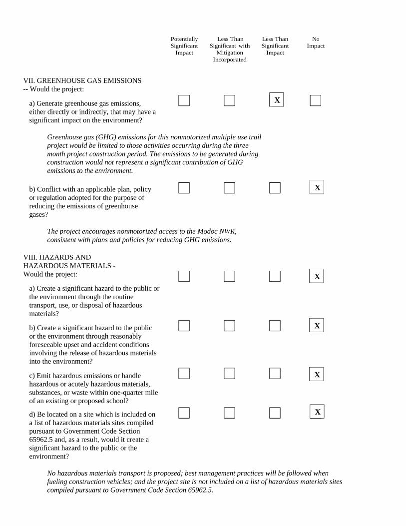
Potentially Significant
Impact
Less Than Significant with
Mitigation Incorporated
Less Than Significant
Impact
No Impact
VII. GREENHOUSE GAS EMISSIONS -- Would the project:
a) Generate greenhouse gas emissions, either directly or indirectly, that may have a significant impact on the environment?
Greenhouse gas (GHG) emissions for this nonmotorized multiple use trail project would be limited to those activities occurring during the three month project construction period. The emissions to be generated during construction would not represent a significant contribution of GHG emissions to the environment.
b) Conflict with an applicable plan, policy or regulation adopted for the purpose of reducing the emissions of greenhouse gases?
The project encourages nonmotorized access to the Modoc NWR, consistent with plans and policies for reducing GHG emissions.
VIII. HAZARDS AND HAZARDOUS MATERIALS - Would the project:
a) Create a significant hazard to the public or the environment through the routine transport, use, or disposal of hazardous materials?
b) Create a significant hazard to the public or the environment through reasonably foreseeable upset and accident conditions involving the release of hazardous materials into the environment?
c) Emit hazardous emissions or handle hazardous or acutely hazardous materials, substances, or waste within one-quarter mile of an existing or proposed school?
d) Be located on a site which is included on a list of hazardous materials sites compiled pursuant to Government Code Section 65962.5 and, as a result, would it create a significant hazard to the public or the environment?
No hazardous materials transport is proposed; best management practices will be followed when fueling construction vehicles; and the project site is not included on a list of hazardous materials sites compiled pursuant to Government Code Section 65962.5.
X
X
X
X
X
X
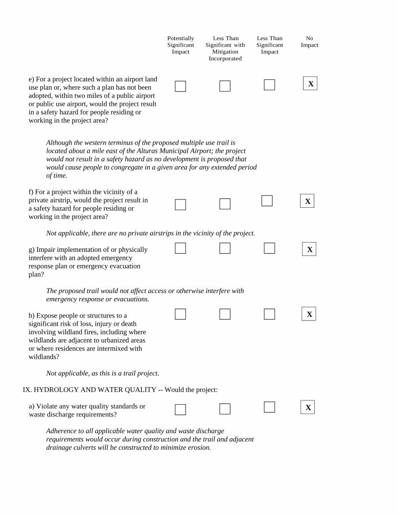
Potentially Significant
Impact
Less Than Significant with
Mitigation Incorporated
Less Than Significant
Impact
No Impact
e) For a project located within an airport land use plan or, where such a plan has not been adopted, within two miles of a public airport or public use airport, would the project result in a safety hazard for people residing or working in the project area?
Although the western terminus of the proposed multiple use trail is located about a mile east of the Alturas Municipal Airport; the project would not result in a safety hazard as no development is proposed that would cause people to congregate in a given area for any extended period of time.
f) For a project within the vicinity of a private airstrip, would the project result in a safety hazard for people residing or working in the project area?
Not applicable, there are no private airstrips in the vicinity of the project. g) Impair implementation of or physically interfere with an adopted emergency response plan or emergency evacuation plan?
The proposed trail would not affect access or otherwise interfere with emergency response or evacuations.
h) Expose people or structures to a significant risk of loss, injury or death involving wildland fires, including where wildlands are adjacent to urbanized areas or where residences are intermixed with wildlands?
Not applicable, as this is a trail project.
IX. HYDROLOGY AND WATER QUALITY -- Would the project:
a) Violate any water quality standards or waste discharge requirements?
Adherence to all applicable water quality and waste discharge requirements would occur during construction and the trail and adjacent drainage culverts will be constructed to minimize erosion.
X
X
X
X
X
Potentially Significant
Impact
Less Than Significant with
Mitigation Incorporated
Less Than Significant
Impact
No Impact
b) Substantially deplete groundwater supplies or interfere substantially with groundwater recharge such that there would be a net deficit in aquifer volume or a lowering of the local groundwater table level (e.g., the production rate of pre- existing nearby wells would drop to a level which would not support existing land uses or planned uses for which permits have been granted)?
No groundwater would be extracted by this project and the total paved area associated with the project would be minimal, therefore, the project would have no effect on groundwater recharge.
c) Substantially alter the existing drainage pattern of the site or area, including through the alteration of the course of a stream or river, in a manner which would result in substantial erosion or siltation on- or off-site?
Refer to Section 7C and 8C of the accompanying draft EA/IS for details.
d) Substantially alter the existing drainage pattern of the site or area, including through the alteration of the course of a stream or river, or substantially increase the rate or amount of surface runoff in a manner which would result in flooding on- or off-site?
Refer to Section 7C and 8C of the accompanying draft EA/IS for details.
e) Create or contribute runoff water which would exceed the capacity of existing or planned stormwater drainage systems or provide substantial additional sources of polluted runoff?
Runoff from the proposed project, a 10-foot-wide paved multiple use trail, would be minimal and as a non-motorized trail, the project would not contribute substantial additional sources of polluted runoff into the existing drainage and irrigation channels.
f) Otherwise substantially degrade water quality?
Adherence to all applicable water quality and waste discharge requirements would occur during construction and the trail and adjacent drainage culverts will be constructed to minimize erosion; therefore, no substantial degradation of water quality is anticipated.
X
X
X
X
X
Potentially Significant
Impact
Less Than Significant with
Mitigation Incorporated
Less Than Significant
Impact
No Impact
g) Place housing within a 100-year flood hazard area as mapped on a federal Flood Hazard Boundary or Flood Insurance Rate Map or other flood hazard delineation map?
Not applicable, no housing is proposed.
h) Place within a 100-year flood hazard area structures which would impede or redirect flood flows?
Refer to Section 7C and 8C of the accompanying draft EA/IS for details.
i) Expose people or structures to a significant risk of loss, injury or death involving flooding, including flooding as a result of the failure of a levee or dam?
Although the project site is included within an area proposed for designation by FEMA as a Special Flood Hazard Area (see Section 7C of the accompanying draft EA/IS for details), as a multiple use trail, the public would have sufficient warnings about the potential for flooding to avoid using the facility until the potential for inundation of the trail by floodwaters has passed. Refer to Section 7C of the accompanying draft EA/IS for details.
j) Inundation by seiche, tsunami, or mudflow?
There is no potential for inundation to the project site by seiche, tsunami, or mudflow.
X. LAND USE AND PLANNING - Would the project:
a) Physically divide an established community?
The proposed trail would be located adjacent to and parallel with existing roadways and has no potential to divide an established community.
b) Conflict with any applicable land use plan, policy, or regulation of an agency with jurisdiction over the project (including, but not limited to the general plan, specific plan, local coastal program, or zoning ordinance) adopted for the purpose of avoiding or mitigating an environmental effect?
This multiple use trail would implement objectives related to reducing air quality and GHG emissions by improving access from the adjacent community to the Refuge via safe nonmotorized uses.
X
X
X
X
X
X
Potentially Significant
Impact
Less Than Significant with
Mitigation Incorporated
Less Than Significant
Impact
No Impact
c) Conflict with any applicable habitat conservation plan or natural community conservation plan?
Construction of the proposed trail would not conflict with any applicable habitat conservation plans or natural community conservation plans adopted for the area.
XI. MINERAL RESOURCES -- Would the project:
a) Result in the loss of availability of a known mineral resource that would be of value to the region and the residents of the state?
The trail would be constructed within existing road right-of-way or within a National Wildlife Refuge, therefore, there is no loss of availability of mineral resources and no such resources have been identified in the immediate project vicinity.
b) Result in the loss of availability of a locally- important mineral resource recovery site delineated on a local general plan, specific plan or other land use plan?
The Modoc County General Plan does not identify any important mineral resources in the vicinity of project.
XII. NOISE -- Would the project result in:
a) Exposure of persons to or generation of noise levels in excess of standards established in the local general plan or noise ordinance, or applicable standards of other agencies?
As a multiple use trail project supporting nonmotorized uses, noise levels generated on the trail would be minimal. Users would be exposed to noise generated by vehicles traveling on the adjacent roadway, however, traffic volumes are relatively light and would not adversely affect users.
b) Exposure of persons to or generation of excessive groundborne vibration or groundborne noise levels?
As a multiple use trail project supporting nonmotorized uses, there would be no potential for groundbourne vibration or groundborne noise.
X
X
X
X
X

Potentially Significant
Impact
Less Than Significant with
Mitigation Incorporated
Less Than Significant
Impact
No Impact
c) A substantial permanent increase in ambient noise levels in the project vicinity above levels existing without the project?
As a multiple use trail project supporting nonmotorized uses, noise levels on the trail would be minimal and would not have the potential to substantially increase ambient noise levels in the vicinity of the project.
d) A substantial temporary or periodic increase in ambient noise levels in the project vicinity above levels existing without the project?
As a multiple use trail project supporting nonmotorized uses, substantial temporary or periodic increases in ambient noise levels in the project vicinity following project completion are not anticipated. Construction hours will be limited, as described in Section 8D of the accompanying draft EA/IS, to minimize noise impacts to nearby residents.
e) For a project located within an airport land use plan or, where such a plan has not been adopted, within two miles of a public airport or public use airport, would the project expose people residing or working in the project area to excessive noise levels?
See Response XIII c above.
f) For a project within the vicinity of a private airstrip, would the project expose people residing or working in the project area to excessive noise levels?
Not applicable.
XIII. POPULATION AND HOUSING -- Would the project:
a) Induce substantial population growth in an area, either directly (for example, by proposing new homes and businesses) or indirectly (for example, through extension of roads or other infrastructure)?
As a multiple use trail, this project has no potential to induce population growth.
X
X
X
X
X

Potentially Significant
Impact
Less Than Significant with
Mitigation Incorporated
Less Than Significant
Impact
No Impact
b) Displace substantial numbers of existing housing, necessitating the construction of replacement housing elsewhere?
No housing would be displaced as result of this project.
c) Displace substantial numbers of people, necessitating the construction of replacement housing elsewhere?
No people would be displaced as result of this project.
XIV. PUBLIC SERVICES
a) Would the project result in substantial adverse physical impacts associated with the provision of new or physically altered governmental facilities, need for new or physically altered governmental facilities, the construction of which could cause significant environmental impacts, in order to maintain acceptable service ratios, response times or other performance objectives for any of the public services:
Fire protection?
Police protection?
Schools?
Parks?
Other public facilities?
The proposed multiple use trail would not result in the need for any new or altered government facilities and would not impact existing public services.
XV. RECREATION --
a) Would the project increase the use of existing neighborhood and regional parks or other recreational facilities such that substantial physical deterioration of the facility would occur or be accelerated?
The construction and use of the proposed multiple use trail is not likely to increase the use of existing parks, rather it would provide opportunities for accessing existing parks via nonmotorized uses.
X
X
X
X
X
X
X
X
Potentially Significant
Impact
Less Than Significant with
Mitigation Incorporated
Less Than Significant
Impact
No Impact
b) Does the project include recreational facilities or require the construction or expansion of recreational facilities which might have an adverse physical effect on the environment?
No, this is a multiple use trail project.
XVI. TRANSPORTATION/TRAFFIC -- Would the project:
a) Conflict with an applicable plan, ordinance or policy establishing measures of effectiveness for the performance of the circulation system, taking into account all modes of transportation including mass transit and non-motorized travel and relevant components of the circulation system, including but not limited to intersections, streets, highways and freeways, pedestrian and bicycle paths, and mass transit?
This proposed multiple use trail would support transportation planning in the area by providing a safe option for nonmotorized uses along the affect roadways. For additional details, refer to Sections 7G and 8G of the accompanying draft EA/IS.
b) Conflict with an applicable congestion management program, including, but not limited to level of service standards and travel demand measures, or other standards established by the county congestion management agency for designated roads or highways?
There is no congestion management program for this area and traffic volumes considered low. The proposed multiple use trail would not be expected to have any impacts to current levels of service on the affected roadways.
c) Result in a change in air traffic patterns, including either an increase in traffic levels or a change in location that results in substantial safety risks?
The project will have no effect on air traffic patterns.
X
X
X
X

Potentially Significant
Impact
Less Than Significant with
Mitigation Incorporated
Less Than Significant
Impact
No Impact
d) Substantially increase hazards due to a design feature (e.g., sharp curves or dangerous intersections) or incompatible uses (e.g., farm equipment)?
The multiple use trail has been designed to meet Modoc County and Federal Highway design standards.
e) Result in inadequate emergency access?
The proposed trail will have no effect on emergency access.
f) Conflict with adopted policies, plans, or programs regarding public transit, bicycle, or pedestrian facilities, or otherwise decrease the performance or safety of such facilities?
The provision of the proposed multiple use trail will improve safety for nonmotorized travel along the affected segments of CR 56 and CR 115.
XVII. UTILITIES AND SERVICE SYSTEMS --
Would the project:
a) Exceed wastewater treatment requirements of the applicable Regional Water Quality Control Board?
The project will not generate any wastewater.
b) Require or result in the construction of new water or wastewater treatment facilities or expansion of existing facilities, the construction of which could cause significant environmental effects?
As a multiple use trail, the project will not generate any wastewater, nor will it require any water hookups.
c) Require or result in the construction of new storm water drainage facilities or expansion of existing facilities, the construction of which could cause significant environmental effects?
Minor modifications to existing drainage channels will be necessary to accommodate portions of the trail and these modifications will be implemented as part of the project. If jurisdictional wetlands are impacted, adequate mitigation will be implemented as a condition of the project. Refer to Section 8E of the accompanying draft EA/IS.
X
X
X
X
X
X

Potentially Significant
Impact
Less Than Significant with
Mitigation Incorporated
Less Than Significant
Impact
No Impact
d) Have sufficient water supplies available to serve the project from existing entitlements and resources, or are new or expanded entitlements needed?
As a multiple use trail, the project will not require any water hookups.
e) Result in a determination by the wastewater treatment provider which serves or may serve the project that it has adequate capacity to serve the project’s projected demand in addition to the provider’s existing commitments?
As a multiple use trail, the project will not generate any wastewater.
f) Be served by a landfill with sufficient permitted capacity to accommodate the project’s solid waste disposal needs?
As a multiple use trail, the project would generate only minimal amounts of solid waste.
g) Comply with federal, state, and local statutes and regulations related to solid waste?
As a multiple use trail, the project would generate only minimal amounts of solid waste.
XVIII. MANDATORY FINDINGS OF SIGNIFICANCE --
a) Does the project have the potential to degrade the quality of the environment, substantially reduce the habitat of a fish or wildlife species, cause a fish or wildlife population to drop below self-sustaining levels, threaten to eliminate a plant or animal community, reduce the number or restrict the range of a rare or endangered plant or animal or eliminate important examples of the major periods of California history or prehistory?
Refer to Sections 8 E and F of the accompanying draft EA/IS.
X
X
X
X
X

Potentially Significant
Impact
Less Than Significant with
Mitigation Incorporated
Less Than Significant
Impact
No Impact
b) Does the project have impacts that are individually limited, but cumulatively considerable? ("Cumulatively considerable" means that the incremental effects of a project are considerable when viewed in connection with the effects of past projects, the effects of other current projects, and the effects of probable future projects)?
Refer to Section 9 of the accompanying draft EA/IS.
c) Does the project have environmental effects which will cause substantial adverse effects on human beings, either directly or indirectly?
Refer to Sections 8 A, B, C, D, G, H, and I of the accompanying draft EA/IS.
Authority: Public Resources Code 21083, 21094.5.5 Reference: Public Resources Code Sections 21094.5 and 21094.5.5
X
X