Embed Size (px)
Citation preview
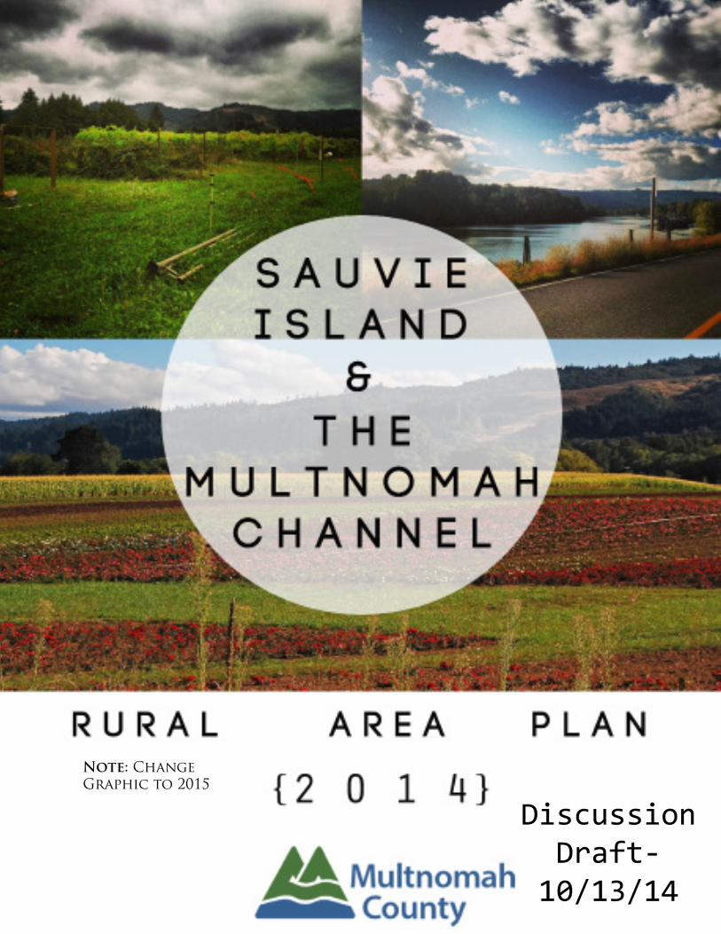
Note: Change
Graphic to 2015

p a g e
i n t e n t i o n a l l y
l e f t
b l a n k

This Sauvie Island – Multnomah County Rural Area Plan (SIMC Plan) is a statement
of policies meant to guide the future of land use within the plan area. The Rural Area
Plan is a tool for guiding public decisions on land use policy including the develop-
ment of land use codes and the promotion of inter-government coordination, collabo-
ration and partnerships.
This Plan does not prioritize one goal or policy over another. Implementation of this
plan requires ! exibility because the weight given to the goals and policies will vary
based on the issue being addressed. Policies should be read together even when
they promote competing policies---one does not control over another.
Contents:
Sauvie Island / Multnomah Channel Plan Introduction...........................4
Chapter 1: Land Use – Agriculture & Agri-Tourism..................................15
Chapter 2: Multnomah Channel – Marinas & Floating Homes............22
Chapter 3: Natural and Cultural Resources.................................................29
Chapter 4: Public & Semi-Public Facilities...................................................51
Chapter 5: Transportation................................................................................58
Chapter 6: Next Steps........................................................................................61
Appendices

Sauvie Island & Multnomah Channel Plan Introduction
Since adoption of the " rst Sauvie Island – Multnomah Channel Rural Area Plan (SIMC Plan) in 1997,
Sauvie Island’s and the Multnomah Channel’s role as a regional recreational and tourist destination has
increased substantially – as have the cumulative environmental and social impacts of increased visita-
tion and more intensive use of the Island’s and the Channel’s many amenities.
The 2014 update of the SIMC Plan focuses on six primary themes identi" ed in a 2013 Scoping Report
and reinforced through an extensive community involvement process:
1. Protect Sauvie Island’s agricultural land and recognize the importance of agri-tourism in supporting
commercial farming operations – while limiting agri-tourism impacts consistent with state law.
2. Clarify the process for development within existing marinas and houseboat moorages while mini-
mizing impacts to water quality and endangered salmon species.
3. Recognize and support e# orts to protect, restore and enhance the planning area’s extraordinary
natural and cultural resources.
4. Provide for a variety of transportation modes that ensure safe, equitable and e$ cient access to
and within Sauvie Island and the Multnomah Channel.
5. Recognize Sauvie Island’s role as a regional recreational and tourist destination.
6. Provide e# ective and equitable measures to mitigate the cumulative impacts of recreational and
agri-tourism activities.
Sauvie island & multnomah channel plan area
The Sauvie Island/Multnomah Channel Rural Area includes those portions of Sauvie Island and the
Multnomah Channel within Multnomah County. The Plan Area is bounded by U.S. Highway 30 on the
west, Columbia County on the north, the Columbia River on the east, and the Willamette River and the
city of Portland on the south. The area is dominated by agricultural uses and a wildlife refuge, with vari-
ous water-related uses on and along Multnomah Channel, ranging from protected wetlands to marinas
and houseboat moorages.
Historical Context
The following statement is taken from The Willamette River Guide (Oregon State Marine Board) and pro-
vides historical context for the SIMC Plan:
“The island was once a center of trade for Native Americans stretching from the Willamette Valley to Idaho and Wyo-
ming. Meriwether Lewis and William Clark, explorers for the young republic of the United States, noted the island
during their 1804-06 expedition, calling it Wapato Island after the large beds of arrowhead, or wild potato, growing
there. The Native American name for the plant is wapato. A French-Canadian employee of the Hudson’s Bay Com-
pany, Laurent Sauve, for whom Sauvie Island is now named, established the " rst non-native settlement in 1838—a
dairy.
Since then, little other than agricultural development has occurred on the island. The channel is mostly a peace-
ful water way featuring quiet moorages, lush vegetation, plentiful song birds and waterfowl. Multnomah Channel
begins three miles upstream from the Willamette’s main con! uence with the Columbia. It traverses the west ! ank of
Sauvie Island for 21 miles until it, too, connects with the Columbia River (at St. Helens).”
4
Introduction

Chinookan Tribal History & Information(Provided by the Sauvie Island Academy 3rd grade class)
“Imagine yourself paddling a canoe with the rest of you commoners you know in your village.
Imagine yourself gathering Wapato from the wetlands- in the canoe it goes!
The " rst people to use Sauvie Island were the Chinook. The wildlife around them was very important.
Having Western Red Cedar wood was very good to have.
Chinook used it for their plank houses (replica created by 3rd grade class below),
clothing, baskets, and canoes for transportation.
Chinook used Cedar for a lot of stu# .
The Chinook had quite a bit of food.
They stored a lot for winter.
Fish, berries, acorns, Wapato and sometimes women would gather roots and other plants.
The Chinook would collect Wapato by going in shallow water and would loosen up the Wapato with their
feet. Or they would go in a canoe and do the same.
If the acorns they harvested were bitter, they would dig a hole and put the acorns in the hole.
The hole would have water in it to help wash away the bitter taste.
Clothing for the Chinook was made out of Western Red Cedar wood.
They soften the wood to make it bendy and comfortable.
The Chinook transported by canoes. They used paddles to help.
The canoes were made out of Western Red Cedar wood.
Now that you have read this, I hope you know more about the Chinook!”
EQUITY:Throughout the process the concept of equity and impacts were raised, especially during transportation policy
conversations. This included concerns of impacts of any policies around exploring the development of user fees
and impacts to low-income and minority groups and their access to the area. In addition to impacts to users,
there was interest in ensuring that accountability measures to ensure that transportation investments account
for impacts on health and safety, in addition to equity are in place. There were also discussions around priori-
tization of investments to the degree to which they provide basic access (emergency services, public services,
and health care) to disadvantaged communities.
5
Introduction

Equity policies were initially proposed only under the Transportation Chapter but have since been
pulled out to serve more as a general policy for the whole Rural Area Plan. This recognizes the impor-
tance of ensuring equitable decision making and the need to consider the needs of low-income and
minority populations for all policies and in moving forward with implementation of the plan.
Equity PolicyPolicy 1.0
Acknowledge the needs of low-income and minority populations in future investments and programs, includ-
ing an equity analysis consistent with required federal, state and local requirements.
Community Vision:The policies in this document should be read in harmony with the following vision state-
ment. This statement was developed with the Community Advisory Committee & broader
public to be a compass that directs the policy framework.
The vision for the Sauvie Island & The Multnomah Channel planning area is to retain its cherished
rural character and agricultural
productivity, to enhance resource protections, and to reduce and manage cumulative impacts of
recreation, visitation, and commercial activities in order to preserve the distinctive character of the
island and channel for future generations.
Those who live on, work on, and visit Sauvie Island, value the Island’s productive farm land, which
provides fresh food for both locals and the region. Many who live here have a deep sense of place
and are passionate about protecting and preserving a beloved way of life characterized by the
predominance of nature, wildlife and water.
The Multnomah Channel is historically signi" cant concerning the early settlement of the area.
The marina community is dedicated to preserving and enhancing the channel environment and
wildlife habitat on which they live. They desire to see continuation of ! oating home moorages as
a part of the mix of uses on the channel.
The community strives to coordinate with state and local agencies to implement projects that
protect and enhance the natural and cultural features of the area. Community health and safety
continue to be a high priority for many residents, particularly the public road system and along
the rail line adjacent to the Channel. By providing safe, accessible roads and facilities, the variety
of multi-modal users may be accommodated.
Sauvie Island and the Multnomah Channel, as one rural area, both deeply value their
commitment to the land and water that surrounds them. The community recognizes and respects
the rich cultural history of both the native inhabitants and settlers who followed.
It is this history, along with current commitments and values, which has helped create such a
strong sense of place and devotion to
preserving its uniqueness.
6
Introduction

Introduction
Rural Character of Sauvie Island and the Multnomah Channel
What is the cherished rural and distinctive character of the island and channel that is to be preserved for future gen-
erations?
The SIMC Scoping Report states “Many of the issues identi" ed during the scoping process were directed at keeping
the island and channel as a rural area, with a focus on farming, connections to wildlife and nature, and an overarch-
ing concern about the future development of the area. Almost every response submitted indicated that the rural
character of the area is threatened.
Sauvie Island consists primarily of a state wildlife refuge that occupies most of the northern 2/3rds of the island and
agricultural lands in large blocks that occupy most of the southern third of the island. Acreage homesites, many in
farm use or habitat restoration, are concentrated in several areas along or near Gillihan Road, Sauvie Island Road
and Lucy Reeder Road, and there are several moorages and marinas located up and down the channel. The impres-
sion one gets upon visiting the island is of a sparsely occupied area dedicated to agricultural production, wildlife
habitat and open space, where people use the land to produce food and share the land with wildlife.
The rural and distinctive character of the SIMC area to be preserved, its “sense of place”, includes the following:
• Natural beauty: The openness and greenery of the area, together with expansive views of four Cascade peaks and
two rivers, give the island a rare and special beauty in the Portland metropolitan area.
• Sparse population and low-intensity uses: The land is intended for growing food, raising livestock and preserving
wildlife and habitat.
• Low environmental impacts: Low-density vehicular tra$ c, thriving diverse wildlife and plant life, quietude, good
air quality, good water quality and availability, and residents committed to protecting and enhancing the environ-
ment contribute signi" cantly to low impacts.
• Diverse landscapes, life forms & uses in a single bounded area: Rich productive farm land, rivers and lakes, " elds
and forests, wildlife, marine life, plant life, all coexist with a small human population in the SIMC area.
• High-value farmland: All of the agricultural land on Sauvie Island is foundation farmland, which is considered by
the State of Oregon to be the most highly valued agricultural land in the State. For this reason, Multnomah County
and the State of Oregon have designated Sauvie Island as a Rural Reserve.
• Island/Channel community services: There are no sewers or public water facilities. Ground water via wells supply
all water needs. Sheri# ’s patrol and the small volunteer RFPD provide police, " re and emergency services .
• Family-owned farms: Some farms have been in the same families for generations.
• Wildlife and habitat reserves: 11,564 of 26,000 acres of the island area is owned by the Oregon Department of Fish
and Wildlife (ODFW) and reserved for wildlife and habitat.
• Finite geographical features: Unlike other rural areas, access and egress and the area itself, are de" ned by the wa-
ter on all sides, a single bridge, and minimal road connectivity.
• Undeveloped natural features: There are few paved surfaces other than main roads, minimal signage, an absence
of commercial enterprises & buildings other than farms and a few cottage industries, and a notable absence of
suburban-like developments and subdivisions.
• Access to community services: Unlike many rural areas, services are easily accessible within 10-15 miles to the
north, south and west, in urban areas, including grocery stores, hospitals, and an entire full-service Portland metro-
politan area.
• Sense of place: The community and visitors to the island and channel value and are inspired by open farmland,
open waterways and vistas, nature, wildlife, habitat and the serene and quiet quality of rural life. Community mem-
bers are committed to retaining and improving the environmental quality of land, water and sky for future genera-
tions and all life forms.
• True rural community: An outstanding example of a supportive rural community, where we are all each others
neighbors, regardless of distance. While interests are diverse, they enjoy each others company and are there to help
one another in times of need.
7
AcknowledgmentsMultnomah County appreciates the conscientious service of the Community Advisory Committee (CAC) and Technical
Advisory Committee (TAC) throughout this process.
Community Advisory Committee:• Cindy Reid- Sauvie Island resident (Agriculture & Agri-Tourism; Public & Semi-Public Facilities Subcommittees)
• Angela Schillere# - Sauvie Island Kennels (Public & Semi-Public Facilities Subcommittee)
• Timothy Larson- Floating home resident (Public & Semi-Public Facilities Subcommittee)
• Mark Green" eld- Sauvie Island resident (Agriculture & Agri-tourism Subcommittee)
• Mike Hashem- Bella Organics (Agriculture & Agri-tourism Subcommittee)
• Diane Kunkel- Columbia Farms (Agriculture & Agri-tourism Subcommittee)
• Julie Samples- Oregon Law Center (Public & Semi-Public Facilities; Transportation Subcommittees)
• Linda Wisner- President, Sauvie Island Community Association (Natural & Cultural Resources Subcommittee)
• Jan Hamer- Moorage owner (Natural & Cultural Resources; Marinas & Floating Homes Subcommittees)
• Stan Tonneson- Moorage owner (Marinas & Floating Homes Subcommittee)
• Cherie Sprando- Moorage owner (Marinas & Floating Homes Subcommittee)
• John Nelson- Moorage owner (Marinas & Floating Homes Subcommittee)
• Roselie Fulkman- Floating home resident (Public & Semi-Public Facilities Subcommittee)
• Ericka Dickey-Nelson- Sauvie Island resident (Transportation Subcommittee)
• Stephan Morris- Bicyclist (Transportation Subcommittee)
• Martha Berndt- Sauvie Island resident (Transportation Subcommittee)
• Ron Spada- Duck hunter
• Jeremy Sievert- Multnomah County Planning Commission
Technical Advisory Committee:• Dick Springer- West Multnomah Soil & Water Conservation District.
• Mark Doyle- Burlington Water District
• Sue Beilke- Oregon Department of Fish & Wildlife
• Tami Hubert- Oregon Department of State Lands
• Erin Mick- City of Portland Bureau of Development Services
• Jim Johnson- Oregon Department of Agriculture
• Carl Larson- Bicycle Transportation Alliance
• Anne Squier- Houseboat resident (previously Governor Robert’s Natural Resource Advisor)
• Doug Drake- Oregon Department of Environmental Quality
• Tim Couch- Sauvie Island Drainage Company
• Jane Hartline- Sauvie Island Habitat Partnership
• Esther Lev- Wetlands Conservancy
• David Smith- Oregon Department of Transportation, Rail Division
• Je# Fisher- National Oceanic and Atmospheric Administration, Fisheries Division
• John Niiyama- Multnomah County Road Maintenance
• Norvin Collins- Sauvie Island Fire District #30
• Chris Worth- Multnomah County Vector Control
• Chris Foster- Multnomah County Planning Commission
• Michael Karnosh- Grand Ronde Tribe
• Brian Vincent- Multnomah County Road Services Manager
• John Mullen- Oregon State Parks
• Tina Birch- Multnomah County Department of Emergency Management
• Ben Baldwin- Trimet
• Monte Reiser- Multnomah County Sheri# ’s O$ ce
• Glen Higgins- Columbia County Planning Department
• Darla Meeuwsen- Director, Sauvie Island Academy
8
Introduction

Project Team:This plan was truly a collaborative e# ort between Multnomah County Land Use and Transportation plan-
ing sta# and the Winterbrook Planning consultant team.
MULTNOMAH COUNTY LAND USE & TRANSPORTATION DIVISION:• Karen Schilling- Planning Director
• Kevin Cook- Land Use Project Manager
• Joanna Valencia, AICP- Transportation Project Manager
• Adam Barber- Senior Planner
• Maia Hardy- Assistant Planner & Public Involvement Manager
Winterbrook Planning consultant team:• Greg Winterowd, Principal- Project Manager
• Doug Zenn (Zenn Associates)- Public Engagement
• Duncan Brown- Senior Planner/ Natural &Cultural Resources Policy
• Ron Eber- (Eber Land Use Planning) Agricultural Land Policy
• Ben Schonberger, AICP- Senior Planner Project Support
SIMC RAP Planning and Zoning History:The Multnomah County Comprehensive Framework Plan (Comprehensive Plan) is the guiding document for
land uses in unincorporated Multnomah County. The Comprehensive Plan was originally adopted in 1977 and
was substantially amended in 1983. In rural areas, the Comprehensive Plan is implemented in two primary
ways: " rst, through the adoption of rural area and transportation system plans; and second, through the adop-
tion of zoning regulations. The Sauvie Island – Multnomah Channel Rural Area Plan is a sub-plan of the Com-
prehensive Plan.
The 2013 Scoping Study (Appendix 1)In response to a growing number of issues raised by community members, Multnomah County (in collabo-
ration with CH2M Hill) initiated a scoping study to identify land use and transportation planning issues and
themes that have emerged or intensi" ed since adoption of the 1997 SIMC Plan. The Scoping Study was based
on the results of two stakeholder meetings, two open houses, completed questionnaires, two focus groups and
a community fair. The Scoping Study identi" ed the following aspirations (or “visions”) for the future of the plan-
ning area:
Land Use
• Preserve the rural character of the island
• Preserve the agricultural nature of the island
• Preserve and enhance the natural environment
• Balance island activities (hiking, tourism, farming, bicycling, etc.)
• Land use regulations should be clear, easy to implement, and coordinated between
government agencies
• Increase level of disaster preparedness
Transportation
• Reduce tra$ c con! icts between modes
• Provide for safe roads/facilities
9
Introduction

The 2013-14 SIMC Plan UpdateIn the fall of 2013, County Land Use and Transportation planning sta# in coordination with Winterbrook Plan-
ning, began to prepare an update to the 1997 SIMC Plan. In the early stages of the update process, the
following CAC subcommittees were established to address the topical issues raised in the Scoping Study:
• Agriculture and Farms Stands
• Marinas and Floating Homes
• Natural and Cultural Resources
• Public and Semi-Public Facilities
• Transportation
Subcommittees were comprised of representatives from the CAC as well as select TAC members. Each
subcommittee met at least twice (the Marinas and Floating Homes Subcommittee met four times), reviewed
draft background reports (included as appendices to the 2014 SIMC Plan), and made speci" c recom-
mendations to the full CAC. The CAC then made recommendations for changes to the policies of the 1997
SIMC Plan.
Statewide Regulatory FrameworkOregon’s Statewide Planning Goals and implementing “administrative rules” apply when local comprehen-
sive plans are adopted or amended. The SIMC Plan is part of the Multnomah County Comprehensive Plan;
therefore, any amendments to the SIMC Plan must comply with applicable Statewide Planning Goals, rules
and statutes. Appendix 8: Compliance with Applicable Statewide Planning Goals provides " ndings explain-
ing how proposed amendments to the SIMC Plan so comply.
Summary of Key Issues (from Appendix 1 - Scoping Report):
Multnomah County sta# summarized the results of the scoping report in a May 6, 2013 Memorandum
to the Planning Commission by identifying speci" c issues that need to be addressed in the SIMC Plan
update:
Land Use:• Concern regarding the types and degree of promotional activities at farm stands and related o#
site impacts.
• Desire to examine the pros and cons of agri-tourism and to form a consensus around the issue
of what should or shouldn’t be allowed on Sauvie Island farms with respect to farm stands and
events.
• Concern for maintaining the rural character and agricultural nature of Sauvie Island.
• Need for clear policies and codes for ! oating moorages and marinas.
• Desire for preservation, restoration and enhancement of natural habitat.
Transportation:• Need for strategies that reduce tra$ c con! icts between modes on Sauvie Island roads, particu-
larly between bicycles and motorists, but also including farm equipment and pedestrians.
• There is a strong desire for better accommodations for bicycles and pedestrians. The lack of road
shoulders and/or multi-use paths is a common theme.
• Need for safety improvements for roads, intersections, and rail crossings.
• Concern regarding the increasing numbers of visitors to Sauvie Island and related issues, such as
increased tra$ c and increased demand on emergency service providers.
T h e s c o p i n g r e p o r t c o n c l u d e s w i t h a s t a f f r e c o m m e n d a t i o n t o p r o c e e d
w i t h a n u p d a t e t o t h e R A P a n d t h e T S P :
Based on the number and variety of issues, several of which are new or more pronounced than in 1997, as well
as the high level of community interest, sta# recommends updating the RAP and the TSP.
10
Introduction

Plan OrganizationThis plan includes a vision statement, background information, composite inventory and zoning maps and
land use and transportation policies. The SIMC Plan is organized based on the subject areas addressed in
background reports considered by relevant subcommittees and the CAC.
The following chapters address the substantive themes covered in the background reports: Agriculture and Agri-
Tourism; Marinas and Floating Homes; Natural and Cultural Resources; Public and Semi-Public Facilities; and Trans-
portation. Each substantive chapter includes an introduction, a summary of background information, a description
of the issues to be addressed, and proposed policies related to these issues. This plan provides general discussion
and overview of the issues and plan policies. Detailed technical overview of the issues are found in the background
reports, Appendices 1 through 7.
Appendices (Background Reports)The following appendices provide the detailed substantive and procedural information leading up to and
supporting the adoption of the SIMC Plan:
• Appendix 1: Sauvie Island – Multnomah Channel Scoping Report
• Appendix 2: Agriculture and Agri-Tourism Background Report
• Appendix 3: Marinas and Floating Homes Background Report
• Appendix 4: Natural and Cultural Resources Background Report
• Appendix 5: Public and Semi-Public Facilities Background Report
• Appendix 6: Transportation Background Report
• Appendix 7: Consistency with Applicable Statewide Planning Goals
Community and Agency Involvement Process & ResultsThe Community Involvement Plan is based on an extensive Scoping Report prepared by CH2M Hill and County Sta#
in 2013. The Scoping Study included interviews with residents and business, as well as those who live outside the
planning area but who visit Sauvie Island and the Multnomah Channel for recreational or educational activities. The
broad categories of issues identi" ed are addressed in this plan.
The outreach plan was designed to address the " ve topic areas and targeted activities to support decisions on each
of these topics. At the same time it recognized the general interest in the plan and provided opportunities for in-
terested community members to follow the progress of the plan and provide input on the areas in which they are
interested.
An over-arching theme of the plan is to maintain the rural character of the Island while recognizing the more inten-
sive uses along the Multnomah Channel, and to do so within the framework of applicable statewide planning goals
and laws.
The County’s ability to address the all of the issues raised by the CAC or its various subcommittees was in some cases
limited by applicable state statutes, goals and administrative rules. Nevertheless, the process resulted in the devel-
opment of a plan that is tailored to the needs of the community, ensures an internally consistent, integrated set of
inventories and policies that systematically address issues raised in the Scoping Report.
The outreach program included structured activities related to general and speci" c topic areas. The program includ-
ed hosting core community activities including:
• Community Advisory Committee
• Technical Advisory Committee
• CAC Subcommittees
• Planning Commission Brie" ngs and Open Houses
• Mailers and email updates
• Other Community Outreach
11
Introduction

Though the Community Advisory Committee was generally representative of the community, additional
creative outreach strategies were included in the program to gain input on policies from the broader
community. A very useful outreach method was conducting focus groups with community members
from around the SIMC area. Focus groups were targeted to young families that live in the SIMC area,
as well as people who reside but do not work in the plan area.
Sauvie Island Academy:A strong partnership with the Sauvie Island Academy (SIA) further enhanced outreach e# orts, which included
faculty and students. Through place-based education, SIA o# ers a curriculum that integrates the natural envi-
ronment into the students’ education giving them the ability to become stewards of the environment. In the
update to the SIMC plan, County sta# worked with a " eld study class of 6th-8th graders to educate them on the
history of Oregon Land Use (relating to Sauvie Island and Multnomah Channel). The students went on various
tours of the island, which included stops at Colombia Farms, Bella Organic Farms, the Sauvie Island Fire Station,
and the County Park & Ride lot. The students focused on the following question; “how can we make Sauvie
Island and The Multnomah Channel an equitable, accessible place for everyone to live, work, and play?” The
students developed surveys that were distributed to people who live, work and play within the plan area. The
analysis was sumarized in a short video that was shown to the public and the Planning Commission.
Creative online surveys:Two online surveys were created to capture community perceptions and feedback. A “de" ning rural character”
visual preference survey was created during the beginning of the process to capture what places, words, and
photos depicted rural character for the SIMC area. The data was analyzed to determine the di# erences between
people who live in the plan area and visitors. In addition, online policy polls were created near the end of the
process for the community to give feedback to sta# on policy intent. The policy polls are in conjunction with a
community conversation board that was placed in the park and ride lot at the base of the Sauvie Island Bridge.
12
Introduction
Photo to the right:
Results of a heat mapping
exercise that was a part of
the De" ning Rural Character
Survey. The respondents were
instructed to click a spot on
the map that they believed
depicted rural character. The
map represents places that
were chosen. The red indi-
cates that 10+ respondents
clicked on that spot.
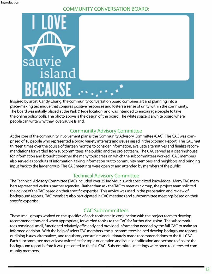
COMMUNITY CONVERSATION BOARD:
13
Introduction
Inspired by artist, Candy Chang, the community conversation board combines art and planning into a
place-making technique that conjures positive responses and fosters a sense of unity within the community.
The board was initially placed at the Park & Ride location, and was intended to encourage people to take
the online policy polls. The photo above is the design of the board. The white space is a white board where
people can write why they love Sauvie Island.
Community Advisory CommitteeAt the core of the community involvement plan is the Community Advisory Committee (CAC). The CAC was com-
prised of 18 people who represented a broad variety interests and issues raised in the Scoping Report. The CAC met
thirteen times over the course of thirteen months to consider information, evaluate alternatives and " nalize recom-
mendations forwarded from subcommittees, the public, and the project team. The CAC served as a clearinghouse
for information and brought together the many topic areas on which the subcommittees worked. CAC members
also served as conduits of information, taking information out to community members and neighbors and bringing
input back to the larger group. The CAC meetings were open to and attended by members of the public.
Technical Advisory CommitteeThe Technical Advisory Committee (TAC) included over 25 individuals with specialized knowledge. Many TAC mem-
bers represented various partner agencies. Rather than ask the TAC to meet as a group, the project team solicited
the advice of the TAC based on their speci" c expertise. This advice was used in the preparation and review of
background reports. TAC members also participated in CAC meetings and subcommittee meetings based on their
speci" c expertise.
CAC SubcommitteesThese small groups worked on the speci" cs of each topic area in conjunction with the project team to develop
recommendations and when appropriate, forwarded topics to the CAC for further discussion. The subcommit-
tees remained small, functioned relatively e$ ciently and provided information needed by the full CAC to make an
informed decision. With the help of select TAC members, the subcommittees helped develop background reports
outlining issues, alternatives, and regulatory constraints and ultimately made recommendations to the full CAC.
Each subcommittee met at least twice: " rst for topic orientation and issue identi" cation and second to " nalize the
background report before it was presented to the full CAC. Subcommittee meetings were open to interested com-
munity members.

Planning Commission Brie" ngs and Community Open Houses:The project team provided periodic project updates to the Planning Commission on the planning e# ort.
This approach informed the Planning Commission of the latest discussion topics and overall progress
of the committees well in advance of the public hearing process. Two Planning Commission members
also participated in the CAC and subcommittee meetings. The project team hosted open houses prior
to the scheduled Planning Commission brie" ngs. The Open Houses coincided with Planning Commis-
sion meetings in January, March and June of 2014.
Mailing and email updates:The project team developed a mailing list utilizing the extensive scoping work done prior to the CAC
kicko# as well as interest expressed at community events. This mailing list continued to grow during the
project and was used to apprise interested community members and stakeholders about project prog-
ress and upcoming project events. The mailings and email updates provided community members an
opportunity to provide written feedback about issues at any time during the project.
Other Community Outreach:The project team hosted a number of other opportunities for community members to get updates about and
provide input into the project including, regular mailings, email updates, and press releases. County sta# also
attended the Sauvie Island Community Association Community fair in April, 2014 to provide information and
answer questions from Community members.
Land Use and Demographic Information The study area encompasses approximately 15,400 acres of land and several thousand additional
acres of water. About three-fourths of the land acreage (approximately 11,800 acres or 76.6%) is within
the Exclusive Farm Use (EFU) zone and about a quarter (3,600 acres or 23.4%) is within the Multiple
Use Agriculture-20 (MUA-20) zone. About half (1,700 acres) of the MUA-20 zoned land is within the
Sauvie Island Wildlife Refuge.
Census Tract 71 encompasses all of the SIMC planning area and the Portland West Hills shown to the left of the
map below.
14
Introduction
Figure 1: Census
Tract 71, Multnomah
County, Oregon
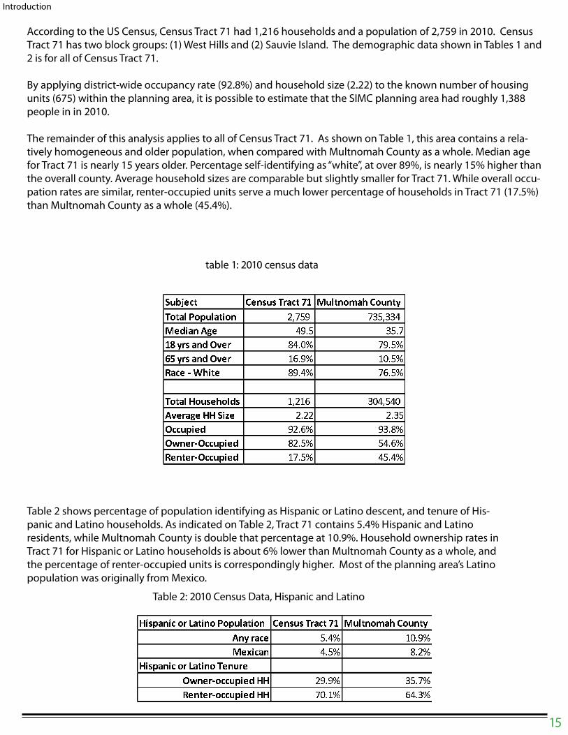
According to the US Census, Census Tract 71 had 1,216 households and a population of 2,759 in 2010. Census
Tract 71 has two block groups: (1) West Hills and (2) Sauvie Island. The demographic data shown in Tables 1 and
2 is for all of Census Tract 71.
By applying district-wide occupancy rate (92.8%) and household size (2.22) to the known number of housing
units (675) within the planning area, it is possible to estimate that the SIMC planning area had roughly 1,388
people in in 2010.
The remainder of this analysis applies to all of Census Tract 71. As shown on Table 1, this area contains a rela-
tively homogeneous and older population, when compared with Multnomah County as a whole. Median age
for Tract 71 is nearly 15 years older. Percentage self-identifying as “white”, at over 89%, is nearly 15% higher than
the overall county. Average household sizes are comparable but slightly smaller for Tract 71. While overall occu-
pation rates are similar, renter-occupied units serve a much lower percentage of households in Tract 71 (17.5%)
than Multnomah County as a whole (45.4%).
15
Introduction
� � � � � � � � � � � � � � � � � � � � � � � � � � � � � � � � � � � � � � � � � � � � � � � � � � � � � � � � �� � � � � � ! � � � " � � � " �� # � � � � � $ % � � & � " ' ( � � " � () * � � � � � $ % � � + , " � ( + ' " � (- � � � . / � � � � & � " � ( � , " � ( � � � � 0 � � � � � � � + � � + , � ' � � � � ' % � � � ! � 0 0 � � 1 � � " � � � " � �$ � � � � � � � � � " , ( � � " & ($ 2 � � � . $ � � � � � � � & � " � ( � � " , (- � � � � � . $ � � � � � � � + � " � ( � � " � (
3 4 5 6 7 8 4 9 : ; < 7 = 4 8 : > : 6 ? @ 7 = 4 : 8 A B 8 5 ? 5 C ; 7 9 = D E F ? @ = 8 : G 7 H A : ? 8 = IJ 8 I ; 7 9 B K L M N O P L Q NF B R 4 9 7 8 M L K N S L T N3 4 5 6 7 8 4 9 : ; < 7 = 4 8 : C B 8 ? ; BU V 8 B ; W : 9 9 ? 6 4 B X 3 3 T Q L Q N Y K L Z N[ B 8 = B ; W : 9 9 ? 6 4 B X 3 3 Z P L O N \ M L Y N
table 1: 2010 census data
Table 2: 2010 Census Data, Hispanic and Latino
Table 2 shows percentage of population identifying as Hispanic or Latino descent, and tenure of His-
panic and Latino households. As indicated on Table 2, Tract 71 contains 5.4% Hispanic and Latino
residents, while Multnomah County is double that percentage at 10.9%. Household ownership rates in
Tract 71 for Hispanic or Latino households is about 6% lower than Multnomah County as a whole, and
the percentage of renter-occupied units is correspondingly higher. Most of the planning area’s Latino
population was originally from Mexico.

C H A P T E R 1 :
AGRICULTURE
&
AGRI-TOURISM
Chapter 1 addresses agricultural and agri-tourism issues. Consistent with the Comprehensive
Framework Plan, the County is committed to protecting its agricultural land base through the
Exclusive Farm Use (EFU) zoning. The County is equally committed to carrying out state law as
set forth in ORS 197.215, Goal 3 (Agricultural Lands) and the Agricultural Lands and Urban Rural
Reserve administrative rules (OAR Chapter 660, Divisions 033 and 026, respectively).
A principal theme of the SIMC Plan is mitigating adverse impacts from tourism and recreation
on the environmental and community values that characterize the Island and Channel planning
area. This chapter focuses on agri-tourism issues: including appropriate limitations on (a) farm
stands and related promotional activities (which must be allowed when consistent with state
law), and (b) optional promotional activities such as agri-tourism events and gatherings on EFU
land.
Key Agriculture and Agri Tourism Issues:
(from Appendix 1)The following issues are quoted directly from the May 6, 2013 sta# report to the Multnomah County Planning
Commission related to PC-2013-2659 (Scoping Report in support of updating to the 1997 Sauvie Island – Mult-
nomah Channel Rural Area Plan). These issues were also considered in Appendix 2: Agriculture and Agri-Tourism
Background Report.
Land Use• Concern regarding the types and degree of promotional activities at farm stands and related o# site impacts.
• Desire to examine the pros and cons of agri-tourism and to form a consensus around the issue of what
should or shouldn’t be allowed on Sauvie Island farms with respect to farm stands and events.
• Concern for maintaining the rural character and agricultural nature of Sauvie Island.
Agricultural & Rural lands• Explore creation of design review standards for permitting of farm stands and farm stand related activities.
Include consideration of cumulative tra$ c impacts, parking, sanitation, and noise, hours of operation, etc.
• Consider policy addressing non-pro" t events and mass gatherings. Currently these are not treated as land
uses under state law. However their impacts are land use and transportation related so there should be some
requirements (Design Review) regarding parking, tra$ c impacts, sanitation, noise, and other o# site impacts
for those who hold larger events and/or events with some regularity.
• Consider a policy creating standards for annual reporting of farm stand retail sales and incidentals in order to
insure adherence to the 75/25 rule, which limits sales of incidental items to no more than 25 percent of the
total farm-stand retail sales.
• Build consensus around and develop a policy regarding the question of whether limited agri-tourism activi-
ties should be allowed (via SB 960) or no additional agri-tourism outside what is currently allowed under
farm-stand rules.
• Explore possible zoning code amendments that would allow two tiers of review for farm stands to separate
out the basic farm stand from the farm stand with promotional activities and events.
16
CHAPTER 1 : AGRICULTURE & AGRITOURISM
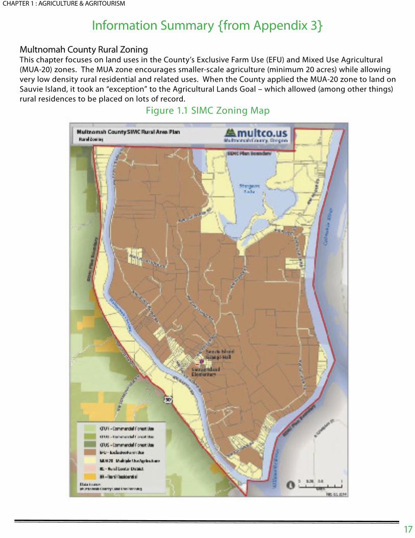
Information Summary from Appendix 3
Multnomah County Rural ZoningThis chapter focuses on land uses in the County’s Exclusive Farm Use (EFU) and Mixed Use Agricultural
(MUA-20) zones. The MUA zone encourages smaller-scale agriculture (minimum 20 acres) while allowing
very low density rural residential and related uses. When the County applied the MUA-20 zone to land on
Sauvie Island, it took an “exception” to the Agricultural Lands Goal – which allowed (among other things)
rural residences to be placed on lots of record.
Figure 1.1 SIMC Zoning Map
17
CHAPTER 1 : AGRICULTURE & AGRITOURISM
The EFU zone encourages and protects large tracts of land (minimum 80 acres) for commercial agricultural
– but allows a variety of other uses specified in state statutes and administrative rules – either as a review
use (which the County must approve if specific standards are met) or a conditional use (which the County
may approve based on discretionary criteria). The EFU Zone carries out Statewide Planning Goal 3 – Agri-
cultural Lands and its implementing rule – OAR Chapter 660, Division 033 Agricultural Lands.
Note that the following state and county provisions limit the intensity of
development in both the EFU and MUA-20 zones:
• Statewide Planning Goal 14 and its implementing rule (OAR 660 Division 004) prohibit urban densities
outside UGBs.
• Statewide Planning Goal 11 (Public Facilities and Services) and its implementing rule (OAR Division 011)
prohibit the extension of sanitary sewer service outside of urban growth boundaries; the SIMC planning
area is outside the Metro, St Helens and Scappoose UGBs.
• Oregon law and the Land Conservation and Development Commission’s (LCDC) Urban and Rural Re-
serves administrative rule (OAR 660, Division 027), authorize each of the three urban counties, in coor-
dination with Metro, to assign urban and rural reserve designations to land outside the regional urban
growth boundary (UGB). In 2010, Multnomah County coordinated with Metro to place a “Rural Reserve”
designation over the entire SIMC planning area. This designation, as implemented through Multnomah
County Framework Plan Policy 6A, means that the area cannot be considered for inclusion within the
UGB for at least 50 years, and prohibits comprehensive plan and zoning ordinance amendments that
allow new uses or increased density.
County Zoning Review Types:The Multnomah County Code (MCC) Chapter 34 specifies uses that are allowed or are potentially allowed in
the EFU and MUA-20 zones.
• Allowed Uses: The general organization of the zoning sections begins by listing Allowed Uses, which
are those uses that are allowed outright and do not require a land use review process (although technical
reviews such as building permits, flood permits, grading permits and so on may apply to allowed uses).
• Review Uses: The second tier of uses is Review Uses, which require approval via a land use applica-
tion. Review uses are allowed in the underlying zone provided that certain criteria are met. How a specific
proposal on a specific site can meet the criteria requires findings addressing the approval criteria. The
findings taken together inform the decision, which is made at the staff level unless appealed. Neighbor-
ing property owners and recognized community associations are required to receive notice and have the
opportunity to comment on the application. Farm stands with promotional activities and wineries are
“review uses” in the EFU zone.
• Conditional Uses: The third tier of uses listed are those that are potentially allowed as conditional
and community service uses, which are special uses by reason of their public convenience, necessity, un-
usual character or effect on the neighborhood, may be appropriate as specified in each zone district. Con-
ditional and community service uses are reviewed under discretionary criteria and may be conditioned or
denied by the County if applicable criteria are not met.
Commercial Uses in Agricultural Zones:In Oregon, the uses allowed in county EFU zones and the procedures for reviewing them are determined
by state statute. Four types of commercial activities on EFU land that may not be directly related to farm-
ing on Sauvie Island:
18
CHAPTER 1 : AGRICULTURE & AGRITOURISM

• Farm stands and related promotional activities: Farm stands are authorized ORS 215.283(1) as “review
uses” meaning that the County has no choice as to whether to implement this statute; however, the
County has limited discretion as to how (under what conditions) to approve farm stands and related
promotional activities. The Agriculture and Farm Stands Subcommittee and the full CAC were primar-
ily concerned with limiting the transportation, visual, auditory and agricultural land impacts resulting
from existing and potential promotional activities.
• Agri-tourism: Unlike farm stands, the County has a choice as to whether and how to implement ORS
215.283(4) provisions for agri-tourism activities. The Agriculture and Farm Stands Subcommittee and
the full CAC were generally opposed to implementation of the agri-tourism statute due to the addi-
tional adverse impacts on the rural character of the Island.
• Wineries: There are no commercial wineries on the Island. However, ORS 215.452 and 215.453 allow
wineries and related commercial activities to locate on EFU land.
• Gatherings: ORS 433.735-770 allows counties to permit outdoor “mass gatherings” and “other gather-
ings” up to maximums set by state law. Notably, review of such gatherings is not considered a “land
use decision” and therefore is not subject to zoning regulations. However, the County can adopt local
review processes and restrict the number, frequency and size of gatherings below the maximums al-
lowed by statute.
Farm Stands and Promotional Activities ] ORS 215.283 ] 1 ] o^
There are two types of farm stands: a traditional farm stand comprised of a small, often open-air structure
that sells locally grown farm products and incidental items and a farm stand that includes promotional
events and activities.
Prior to 1993, farm stands were considered an outright permitted “farm use”. However, when some “farm
stands” got much larger and sold a wider range of products, the use was specifically listed to the EFU stat-
ute to allow counties to review these operations, assure appropriate access, and to limit the sale of items
incidental to the sale of farm products and other unrelated activities. The 1993 Oregon Legislature added
“farm stands” to the Exclusive Farm Use (EFU) statute in 1993; the statute was amended in 2001 to allow
some limited promotional activities. Although a “permitted use,” an application is still a “land use deci-
sion” under ORS 197.015(10)(a) and reviewed as a “permit” under ORS 215.402.
Nonetheless, a County cannot prevent a “permitted use” or apply any additional local legislative criteria
that supplement those in ORS 215.283(1). The County is limited to interpreting the statute.
Agri _ Tourism, Wineries and Mass Gatherings
Aside from farm stands, there are three primary paths for permitting events and activities in EFU zones:
• First, there are the new provisions that permit “agri tourism and other commercial events or
activities that are related to and supportive of agriculture” under ORS 215.283(4) [SB 960 –
2011];
• Second, there are “wineries” under ORS 215.452 and 215.453; and
• Third, there are “outdoor mass” gatherings and “other” gatherings under ORS 433.735 to
433.770.
Agri _ TourismCounties may elect to adopt “agri-tourism” provisions of ORS 215.283(4), which provide several opportunities for
the review and approval of from one to 18 events per year in EFU zones. The provisions require that these events
be “incidental and subordinate to existing farm use on the tract” and can occur outdoors and within temporary
or existing permanent structures. They permit a County to regulate transportation issues (access, egress, park-
19
CHAPTER 1 : AGRICULTURE & AGRITOURISM
ing and tra$ c management), hours of operation, sanitation, solid waste and other related matters. Further, they
authorize the County to adopt its own regulations in addition to those under ORS 215.283(4). These provisions
are very specific and can provide a means for the County, landowners and neighbors to address concerns
for events not permitted at farm stands.
WineriesWineries were specifically authorized in 1989 in order to clarify that they were allowed as a non-farm use
in an EFU zone and were not a “farm use” under ORS 215.203. Prior to this time they were approved as
“commercial activities” in conjunction with farm use. The 2012 Legislature adopted major revisions to
the provisions of ORS 215.452 and 215.453. The new law permits a wide range of marketing and private
events as well as celebratory gatherings.
Mass GatheringsOregon also has an “Outdoor Mass Gatherings” law that was adopted in 1971 and later amended in 1985.
The “outdoor mass gathering” law applies to events not authorized under ORS 215.283(4). ORS 215.283(6)
(c) states that:“outdoor mass gathering’ and ‘other gathering,’ as those terms are used in ORS 197.015 (10)
(d), do not include agri-tourism or farm-stand events and activities.”
Relevant Multnomah County and Agency Plans:The Multnomah County Comprehensive Framework Plan (Comprehensive Plan) includes policies for agri-
cultural land protection. These policies are implemented by the County’s EFU zone.
In 2010, Multnomah County adopted Policy 6A: Urban and Rural Reserves. Working with Metro, the Coun-
ty applied a Rural Reserves designation to the entire SIMC planning area.
Rural Reserves: It is the County’s policy (Comprehensive Plan Policy 6A) to establish and maintain rural reserves in coor-
dination with urban reserves adopted by Metro and in accord with the following additional policies:
1. Areas shown as Rural Reserve on the County plan and zone map shall be designated and
maintained as Rural Reserves to protect agricultural land, forest land, and important land
scape features.
2. Rural Reserves designated on the plan map shall not be included within any UGB in the
County for 50 years from the date of the ordinance adopting the reserves designations.
3. Areas designated Rural Reserves in the County shall not be re-designated as Urban Re-
serves for 50 years from the date of the ordinance adopting the reserves designations.
4. The County will participate together with an appropriate city in development of a concept
plan for an area of Urban Reserve that is under consideration for addition to the UGB.
5. The County will review the designations of Urban and Rural Reserves, in coordination with
Metro and Clackamas and Washington Counties, 20 years from the date of the ordinance
adopting the reserves designations, or earlier upon agreement of Metro and the other two
counties.
6. The County will not amend the zoning to allow new uses or increased density in rural and
urban reserve areas except in compliance with applicable state rules.
20
CHAPTER 1 : AGRICULTURE & AGRITOURISM

Proposed Agriculture & Agri Tourism
Policy Framework:The following policies are designed to address the issues identified in the beginning
of this chapter. These policies supplement existing Comprehensive Plan policies that
strongly support agricultural land preservation. Policies that address cumulative im-
pacts are noted with an asterisk (*) and policies that contain the word ‘consider’ com-
mit the County to propose amendments to the Multnomah County Code (MCC) in
coordination with the CAC and the community for consideration at public hearings by
the Planning Commission and the County Board of Commissioners.
*Policy 1.1
Maximize retention of Sauvie Island’s agricultural land base for productive farm use.
*Policy 1.2
Consider standards for limiting the area, location, design, and function of farm stand
promotional activities to the extent allowed by law to retain a maximum supply of
land in production for farm crops or livestock, to ensure public health and safety, and
to minimize impacts on adjacent farming operations, residents, roads, traffic circula-
tion, wildlife and other natural resources.
Policy 1.3
Consider a tiered review process for farm stand operations on EFU land distinguishing
between operations that include promotional activities and those that do not.
Policy 1.4
Consider amending the Multiple Use Agriculture zoning code to include deed restric-
tions protecting surrounding agricultural practices as a requirement for approval of
new and replacement dwellings and additions to existing dwellings.
*Policy 1.5
Consider developing a unified permitting process for review of mass gatherings and
other gatherings. Consider more restrictive permitting thresholds for number of visi-
tors, frequency and duration than the maximums authorized by state law.
*Policy 1.6
Do not adopt the agri-tourism provisions of ORS chapter 215 due to the island’s lim-
ited road infrastructure and already high levels of visitation.
21
CHAPTER 1 : AGRICULTURE & AGRITOURISM

C H A P T E R 2 :
MARINAS
&
FLOATING HOMES

This chapter addresses the uses allowed on the Multnomah Channel and adjacent shore – boat marinas, f loating homes (houseboats), and “live-aboards” (boats used as residences in a marina).
The CAC considered a number of issues related to development along the Multnomah Channel:
• Floating homes should meet building code and sanitation standards similar to building and sanita-
tion standards that apply to land based dwellings;
• County standards should include mitigation of adverse impacts on " sh habitat;
• All live-aboards should meet safety and sanitation standards;
• Whether and how to permit new and existing ! oating home moorages;
• How to treat live-aboard boats that are being used as residences within marinas.
• Whether it is feasible to retain the residential density standard of one ! oating home per 50 feet of
shoreline standard that is in current county code.
• Whether ! oating homes can or should be classi" ed as water-dependent uses under Goal 15, Wil-
lamette River Greenway.
2.2- Key Multnomah Channel Issues (from Appendix 3)
The following issues are quoted directly from the May 6, 2013 sta# report to the Multnomah County Plan-ning Commission related to PC-2013-2659 (Scoping Report in support of updating to the 1997 Sauvie Island – Multnomah Channel Rural Area Plan).
1. Desire for preservation, restoration and enhancement of natural habitat.
2. Need for clear policies and codes for ! oating moorages and marinas.
3. Examine consistency of Policy 15 Willamette River Greenway with corresponding statewide plan-
ning goal. Incorporate changes needed to maintain consistency into policy and land use regula-
tions WRG, base zones, and conditional/community service use regulations.
4. Examine zoning code provisions for riparian habitat protection along the channel for consistency
with community goals and both state and federal law.
5. Review and if necessary amend MCC Policy 26 Houseboats to ensure consistency of the County’s
regulatory program with other applicable plan policies and federal, state or local policies. State
wide Planning Goals 11, 14, and related case law.
6. Review and if necessary amend Sauvie Island/Multnomah Channel RAP policies 10 through 17 for
consistency with state and federal law. Include both houseboat and marina facilities in consistency
review.
7. Consider code amendments to adopt building and " re codes for ! oating structures to be consis -
tent with City of Portland and Marine Board rules.
8. Consider update to natural disaster policies in RAP that recognize natural gas/petroleum products
pipelines that run through the Island and across the Channel.
Subcommittee Key Issue Clari" cation
The Subcommittee generally agreed that our attention should be focused on “key issues”. Based on
review of the general issues identi" ed above and the Subcommittee meeting summary, the following key
23
CHAPTER 2: MARINAS & FLOATING HOMES
issues are identi" ed (or clari" ed and made more speci" c) below:
1. Need to de" ne “rural character” speci" cally for the Multnomah Channel – which has a di# erent
character than Sauvie Island itself.
2. Need to clarify whether Goal 14 Urbanization in combination with Policy 6A Urban and Rural Re-
serves limits the ability of marina owners to redevelop as “community service” uses in the MUA-20
Zone.
3. Need standardized de" nitions for the terms related to marinas used in the SIMC Plan.
4. Need to coordinate with ODOT Rail and railroad companies regarding long trains that block nor-
mal and emergency road access to marinas; a related need to have an emergency plan to ad-
dress spills or oil tanker " res – especially in cases where a such incidents are combined
with blocked access.
5. Need to review Policy 10 which in 1997 was intended as a short-term option for recognizing exist-
ing marinas.
a. Need to prohibit the expansion of existing marina footprints – as opposed to redevelopment
within existing footprints.
6. There is a need to streamline and clarify the permitting process for redevelopment of marinas
within their existing footprints for ! oating home moorages.
a. Need to ensure that ! oating homes meet the building and safety code standards for plumb-
ing, water, electrical and structural permits.
b. Need to ensure that redevelopment of existing marinas is consistent with the Endangered
Species Act and Clean Water Act.
c. Need to determine which agency (agencies) is (are) primarily responsible for implement
ing the Clean Water Act and Endangered Species act along the channel. Multnomah
County, the City of Portland (under contract with Multnomah County), the Oregon Depart-
ment of State Lands and the Oregon Department of Environmental Quality all have some
responsibility.
d. Need to clarify how the County’s Willamette River Greenway provisions apply, in practice,
to redevelopment proposals for existing marinas, and to de" ne the terms “water-depen-
dent” and “water-related” as they apply to proposed WRG developments.
7. Need to address issue of live-aboard boats being used as permanent residents. It is reported that
live-aboards use is wide spread. Additionally, there is need to address the problems associated
with live-aboard boats, especially electrical hazards and lack of sanitary systems.
Information Summary
This section includes an inventory of approved marinas on the Multnomah Channel and evaluates state
and local regulations a# ecting the development of ! oating home moorages and live-aboard boats.
Inventory of Multnomah Channel Marinas and Floating Home Moorages
Multnomah Channel has 18 marinas. The Department of State Lands (DSL) has approved leases over public wa-
24
CHAPTER 2: MARINAS & FLOATING HOMES

ter for each of these marinas. Table 2.1 provides a summary of the marinas inventory prepared by County sta# in
2014.1 Immediately following adoption of the 1997 SIMC Plan, the County initiated an
inventory of existing ! oating homes.• The second column under “Number of Floating Homes” shows the results of this 1997 inventory.
• The third column indicates the number of existing ! oating homes identi" ed in Multnomah County
Division of Assessment, Recording and Taxation records.
• The fourth column shows the number of ! oating homes that have County land use approval.
Table 2.1: Multnomah Channel Marinas Floating Home Inventory
Marina Name1997
Inventory
Existing 2014
(DART
Records)
County Land
Use Aproval
TOTALS233 255 337
Source: Multnomah County Land Use and Transportation
1 A more detailed inventory is available at the Land Use and Transportation Planning Division.
25
CHAPTER 2: MARINAS & FLOATING HOMES
Some conclusions can be drawn from Table 2.1. The number of ! oating homes increased by 9% over the last
17 years – from 233 in 1997 to 254 in 2014 and the approved number of ! oating homes is 32% greater than the
number of existing ! oating homes; 255 ! oating homes exist and 334 have been approved.
BackgroundThe Multnomah Channel is home to 17 marinas and moorages, which include a mix of ! oating homes and boat
slips. All marina/moorage properties are located within the MUA-20 zone district. The majority of the moorag-
es/marinas are located along the west side of the Multnomah Channel and east of Highway 30 and the Burling-
ton Northern railroad. A number of topics were considered during the course of the planning project, which
included four subcommittee meetings and two CAC meetings.
HabitatThe CAC identi" ed the need for stronger protections of salmon and riparian habitat associated with any devel-
opment and/or recon" guration of marinas and moorages along the Multnomah Channel. NOAA Fisheries, the
Oregon Department of Fish and Wildlife, DEQ, and the West Multnomah Soil and Water Conservation District
among others have indicated willingness to work with County sta# and the community in the development of
enhanced habitat protection standards.
Health and SafetyThe CAC also recognizes the need for health and safety standards for ! oating homes and live-aboard boats
(boats occupied for short-term and long term stays within a marina/moorage). Future code amendments
should include standards for ! oating homes similar to building codes applicable to dwellings on land. Code
amendments should also include sanitation, plumbing, and electrical standards for ! oating homes, occupied
live-aboard boats, and other ! oating structures such as boathouses. The subcommittee and many community
members strongly recommend pump-out facilities for any boats that are occupied within a marina or moorage.

Residential Density at Marinas and Moorages
Many of the marinas and moorages along the Multnomah Channel were established several decades ago. Since
the mid 1970s a number of these facilities have added ! oating homes and expanded the number of slips for
boat storage. A number of moorages gained approval for additional ! oating homes through the Community
Service application process. However some moorages grew organically over time and did not necessarily gain
approval for additional ! oating homes.
In 1997 a reconciliation process provided a path to gain recognition of the number of ! oating homes in exis-
tence as of July 1, 1997 at a participating moorage subject to other existing approvals (i.e. DSL water leases, and
septic system approvals).
The current status of the marina/moorages is that the 17 facilities are recognized through previous Community
Service permit approvals and/or through Policy 10 reconciliation. The marinas and moorages are collectively ap-
proved for 337 ! oating homes and there are 255 existing ! oating homes. Most facilities are currently at or below
their approved number of ! oating homes, while a few appear to have exceeded their approvals.
Floating home moorages and expansions of existing moorages are permitted in the MUA-20 zone subject to the
Community Service approval provisions. The County’s Waterfront Uses code allows a maximum number of ! oat-
ing homes based on a formula calculated at 1 ! oating home per 50 feet of waterfront. For example, a moorage
associated with a property that has 500 feet of shoreline could potentially qualify for up to 10 ! oating homes.
This formula is commonly referred to as the 1:50 density standard.
The subcommittee and the CAC contemplated a fundamental question: Can ! oating home moorages retain the
ability to increase the number of ! oating homes up to the 1:50 standard with an updated Rural Area Plan? A sec-
ond, related fundamental question was, should moorages be able to increase the number of ! oating homes up
to the 1:50 standard or should the moorages retain their existing approved number of ! oating homes without
the possibility of adding ! oating homes.
Many marina/moorage owners, including owners serving on the CAC, expressed the desire to retain the 1:50
density standard into the new RAP. A number of factors where considered during the examination of the issue:
1. Rural Reserve Designation. The entire plan area, including the Multnomah Channel is located within a
designated Rural Reserve. A Rural Reserve prevents the Urban Growth boundary from being expanded into the
area. Additionally, changes to zoning that would allow more intensive uses than currently allowed are generally
prohibited. Another important feature of the Rural Reserve is that it generally prohibits the ability to take an ex-
ception to a statewide planning goal if that exception would result in more intensive uses – this is an important
point to consider, because if any of the state goals would normally prohibit residential expansion of moorages
the Rural Reserves designation would essentially prohibit the ability to take a goal exception to allow the expan-
sion.
2. State Goal 14 – Urbanization. When the Rural Area Plan is adopted, it must comply with state planning
laws. Goal 14 states that urban densities and services should be located within urban growth boundaries associ-
ated with urban areas and conversely limits the level of residential density in rural areas. State rules associated
with Goal 14 generally prohibit counties from adopting zoning rules that would allow more than one single fam-
ily dwelling on rural parcels. These rules reference lots and parcels and do not speci" cally indicate how the rules
might apply to ! oating home moorages. However, the Oregon Department of Land Conservation and Develop-
ment (DLCD) sta# have indicated that they understand Goal 14 rules to prohibit the ability to increase residential
density beyond existing approved numbers.
26
CHAPTER 2: MARINAS & FLOATING HOMES
3. State Goal 15 – Willamette River Greenway. State rules govern development activities within and along
the entire length of the Willamette River; these rules are applied as the Willamette River Greenway (WRG), which
includes the entire length of the Multnomah Channel (a distributary of the Willamette River). The WRG requires
most development to be located 150 feet from the river unless the development quali" es as water dependent.
The question of whether a ! oating home is water dependent was debated among the members of the subcom-
mittee and the CAC. Many believe that because dwellings do not necessarily need to be located on the water,
! oating homes do not qualify as water dependent (i.e. a dwelling does not need to ! oat on the water and can be
located on land). Others believe that ! oating homes are water dependent because they are designed for place-
ment in the water. Multnomah County has found in previous cases that ! oating homes are water dependent,
however, DLCD sta# has indicated that they do not interpret ! oating homes to be a water dependent use.
4. State Goal 11 – Public Facilities Planning. The implementing rules for Goal 11 generally prohibit the ability
to extend sewer service to new uses outside of the Urban Growth Boundary. The applicability of Goal 11 with re-
spect to adding additional ! oating homes to moorages can be a complicated question subject to interpretation.
The de" nition of ‘sewer system’ means in part, a sanitary system serving more than one lot. It is possible that
in some or possibly all instances, an exception to Goal 11 would be required for the addition of ! oating homes.
The Rural Reserves rules however, would likely prohibit the goal exception.
5. Portland/Multnomah County Climate Action Plan. 2030 Goal 6 of the plan is to ‘Reduce per capita daily
vehicle-miles traveled (VMT) by 30 percent from 2008 levels.’ Additional dwellings outside of the UGB (relatively
far from jobs and services) would certainly result in an increase in VMT contrary the objective of 2030 Goal 6.
As outlined above, the issues surrounding the question of whether to create policy advocating for retention of
the 1:50 ! oating home density standard vs. policy advocating for capping existing the number of ! oating homes
at existing approved numbers is complicated. The question is further complicated by the fact that a clear con-
sensus on the issue by the CAC was never achieved.
Proposed plan policies 2.1 and 2.2 generally support the continuation of moorages but to the extent allowed
by law. This allows for the possibility that interpretations of the law may evolve through time and quite possibly
through the appeals process provided for by law. With respect to the kinds of complexities highlighted above,
these types of questions of interpretation are often appealed far beyond the local jurisdiction and may eventu-
ally by settled by the Oregon Land Use Board of Appeals or a court of law.
Live-aboard Boats:
It is reported that there are a signi" cant number of boats that have the features of a live-aboard vessel (cooking,
sleeping, bathing, and toilet) are being used as full time residences within their respective boat slips along the
Multnomah Channel. The subcommittee and the CAC pondered the issue as well as how the use should be con-
sidered. The CAC favored creating standards to accommodate live-aboard boats as residences within a marina
but there was not full consensus on just how this should be accomplished. The CAC did agree that regardless of
how the use is considered, there ought to be standards that ensure safe water and electrical connections, as well
as appropriate handling of sewage generated by live-aboards. The general policy options contemplated by the
CAC were:
1. Allow full time residential use of live-aboards within a marina subject to the total number of residences
approved in the marina. This option requires Community Service (CS) approval and requires that boats meet
health, safety, and environmental standards (i.e. electrical, water and sanitation) for occupied boats docked in a
marina.
27
CHAPTER 2: MARINAS & FLOATING HOMES
2. Do not allow full time residential use of live-aboards.
3. Allow full time residential use of live-aboards, but do not count them towards number of approved
residences at the facility, do not provide speci" c caps on the number of live-aboards and do not apply the 1:50
standard.
The majority of the CAC preferred the third option, while sta# recommended the " rst option because the third
option presents issues with the rural reserve rules by allowing a change to the zoning to allow greater residential
density, Goal 14 by allowing urban residential density outside of the Urban Growth Boundary, and is contrary to
the Climate Action Plan’s goal of reducing VMTs because the option would likely result in an increase in the num-
ber of daily trips by single occupancy vehicles.
Part-time occupancy of live-aboards was also considered. Most of the CAC favored allowing an option for tem-
porary occupancy of boats. Some on the CAC favored similar standards to the existing campground standards,
which allow for occupancy of sites for up to 90 days per year subject to CS approval, however some on the CAC
preferred di# erent thresholds such as 30 days per year. Code updates to the campground standards could in-
clude provisions for temporary occupancy of live-aboards subject to CS approval and health, safety, and environ-
mental standards. This option would essentially provide for camping within a marina. The question of maximum
duration for temporary occupancy of live-aboards would be considered as part of any code amendments con-
sidering residential occupancy within boat slips.
Inventory:
Though the County has an inventory of the number of ! oating homes and infrastructure at moorages and mari-
nas, the last time county land-use sta# conducted a " eld inventory of all facilities was in 1997 after the adoption
of the 1997 plan. Many on the CAC feel that the County should conduct a new " eld inventory to take account of
any unknown quantities such as the number of live-aboard boats and the number of ! oating homes and other
structures that may be being utilized as dwellings.
28
CHAPTER 2: MARINAS & FLOATING HOMES

29
CHAPTER 2: MARINAS & FLOATING HOMES
Figure 2.1: Multnomah Channel Moorages

30
CHAPTER 2: MARINAS & FLOATING HOMES
Proposed Marinas and Moorages Policy Framework:
*Policy 2.1
Multnomah County recognizes the 17 existing marinas in the Multnomah Channel within
the area designated in Comprehensive Plan Policy 26 as appropriate for marina develop-
ment. Existing marinas may be recon" gured within their respective DSL lease areas. No
new ! oating homes will be approved beyond the existing approved number of dwelling
units.
2.1(a)
Expansions and Recon" gurations within existing marinas should only occur through the
Community Service and Conditional Use process subject to all applicable County zoning
standards.
2.1(b)
Coordinate with the National Oceanic and Atmospheric Administration Fisheries Division
(NOAA Fisheries) to amend the Willamette River Greenway overlay zone to include objec-
tive design standards that protect salmon habitat and " sh passage within and along the
Multnomah Channel.
Coordinate with the Oregon Department of State Lands (DSL) to ensure compliance with
the Endangered Species Act (ESA) through its in-water leasing program.
2.1(c)
Consider building, plumbing, electrical and mechanical standards for ! oating structures.
2.1(d)
As directed by Portland’s Bureau of Environmental Services and/or Oregon’s Department
of Environmental Quality, marina owners must provide for safe and easy collection and
disposal of sewage from marine uses in Multnomah Channel.
(1) Require marinas with ! oating structures to meet state standards for sewage collection
and disposal similar to those standards that apply to dwellings on land.
(2) Boat slips serving boats with onboard cooking and/or sanitation facilities must be
provided with an on-site mechanism for disposal of sewage, either through connections
at each slip or through the availability of on-site alternative pump out facilities which are
reasonably safe from accidental spillage.

Policy 2.2
Maintain a current inventory of all marinas moorages. Include all dwellings, boat slips,
! oating structures, live-aboards and supporting infrastructure in the inventory.
Policy 2.3
Review de" nitions of ! oating home, houseboats, boathouses, live-aboards, combos, etc.
used by agencies such as the Multnomah County Assessor, the City of Portland and the
State when amending the Zoning Ordinance.
Policy 2.4
Allow live-aboards to be used as full time residences within a marina and count the live-
aboard slip in the total number of residences approved for the marina. This option requires
Community Service (CS) approval and requires that boats meet health, safety, and environ-
mental standards (i.e. electrical, water and sanitation) for occupied boats docked in a ma-
rina).
Policy 2.5
Consider standards to allow temporary use of live-aboard boats within marinas. This option
requires that boats meet health, safety, and environmental standards (i.e. electrical, water
and sanitation) for occupied boats docked in a marina).
Policy 2.6
Amend Comprehensive Plan Policy 26 to be consistent with policy 2.1.
CHAPTER 2: MARINAS & FLOATING HOMES
31

natural
&
Cultural
Resources
C H A P T E R 3 :
IntroductionThis plan update is timely with Multnomah County having the opportunity to work collaboratively with Island
and Channel residents, farmers, property owners, natural resource conservation groups, the Sauvies Island
Grange, the Sauvie Island Drainage Improvement Company, the West Multnomah Soil & Water Conservation
District, Metro and state agencies to provide a comprehensive survey of natural features on and adjacent to the
Island.
The CAC recommended inventorying and protecting additional signi" cant wetlands and riparian corridors on
Sauvie Island, coordinating with NOAA in the adoption of e# ective " sh passage standards for development
along the Multnomah Channel, working with state agencies and non-pro" ts in voluntary e# orts to restore and
enhance wildlife habitat, and coordinating road maintenance and mosquito control e# orts to minimize adverse
impacts on wildlife habitat.
KEY NATURAL RESOURCE AND NATURAL HAZARD ISSUES (FROM APPENDIX 1)
The following issues are quoted directly from the May 6, 2013 sta# report to the Multnomah County Plan-
ning Commission related to PC-2013-2659 (Scoping Report in support of updating to the 1997 Sauvie
Island – Multnomah Channel Rural Area Plan).
1. Concern for maintaining the rural character and agricultural nature of Sauvie Island.
2. Desire for preservation, restoration and enhancement of natural habitat.
3. Examine zoning code provisions for riparian habitat protection along the channel for consistency
with community goals and both state and federal law.
4. Consider new RAP policy regarding acknowledging the history, prehistory, and cultural resources
of the Island and Channel (Native Americans, Lewis and Clark, settlers, and early farming and
dairying through to present day) in consultation with SHPO, Historic Society, Tribes, and
other stakeholders.
5. Consider expanding wildlife deferral option to more zones.
6. Review and if necessary amend RAP and TSP policies for consistency with the 2009 Climate Ac-
tion Plan. Consider Plan Objective #7 (Climate Change Preparation – community resilience, adap-
tation, levees /! ood control), and Objective #4 (Forests and Natural Systems - with consideration
of watershed health).
Information Summary (Appendix 4)
Natural and Cultural Resources Inventory
This section includes a discussion of Goal 5 inventory information found in the 1997 SIMC Plan and the
Multnomah County Comprehensive Framework Plan and inventory information provided by other govern-
mental and non-governmental organizations. It will serve as a base for identifying and analyzing natural
resources and developing coordinated programs for their protection, restoration and enhancement.
FIGURES 3.1-3.4 BELOW
29
CHAPTER 3 : NATURAL & CULTURAL RESOURCES

Natural and Cultural Resources Inventory
This section includes a discussion of Goal 5 inventory information found in the 1997 SIMC Plan and the
Multnomah County Comprehensive Framework Plan and inventory information provided by other govern-
mental and non-governmental organizations. It will serve as a base for identifying and analyzing natural
resources and developing coordinated programs for their protection, restoration and enhancement.
The following maps and text related to natural and cultural resources are provided below.

31
CHAPTER 3 : NATURAL & CULTURAL RESOURCES
Figure 3.1:
1997 SIMC
Planning Area
Figure 3.2:
2012 AERIAL PHOTO
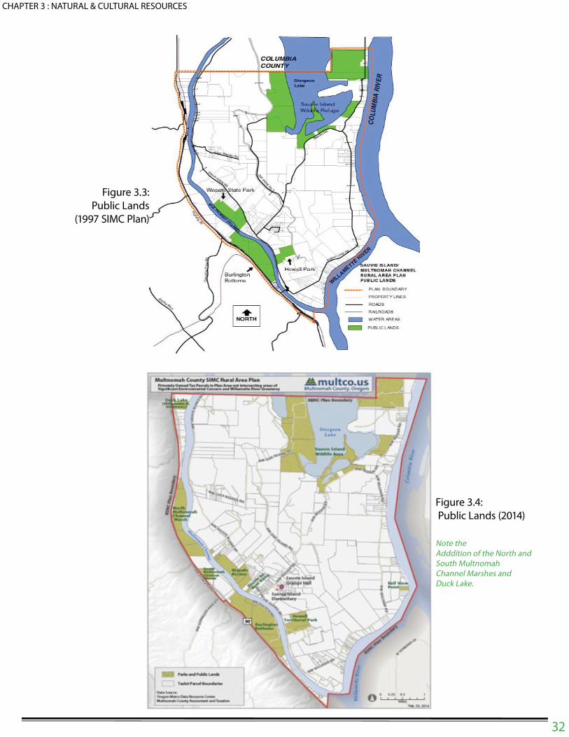
32
CHAPTER 3 : NATURAL & CULTURAL RESOURCES
Figure 3.3:
Public Lands
(1997 SIMC Plan)
Figure 3.4:
Public Lands (2014)
Note the Adddition of the North and South Multnomah Channel Marshes and Duck Lake.

33
CHAPTER 3 : NATURAL & CULTURAL RESOURCES
The ! oodplain maps below show the extent of the 100-year ! oodplain on Sauvie Island.
Note that Appendix 5: Public and Semi-Public Facilities Background Report includes a discus-
sion of the function and challenges of the Sauvie Island Drainage Improvement Company.
This report recognizes that there is a functional relationship between conservation of wetland sys-
tems and ! ooding – both on the Island and downstream from Sauvie Island.
Figure 3.5:
FLOODPLAIN
(1997 PLAN)
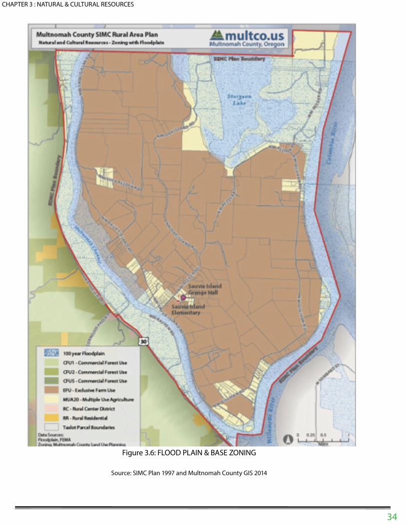
CHAPTER 3 : NATURAL & CULTURAL RESOURCES
Figure 3.6: FLOOD PLAIN & BASE ZONING
Source: SIMC Plan 1997 and Multnomah County GIS 2014
34

CHAPTER 3 : NATURAL & CULTURAL RESOURCES
35
As noted in the 1997 SIMC Plan:
The ! oods of 1996 showed the need for emergency communications and evacuation plans during natural
disasters such as ! ooding, or other potential disasters such as earthquakes or wild" re. Among the needs
the ! ooding demonstrated are: method of notice for evacuation, method of distributing emergency infor-
mation to Sauvie Island residents, and the need for coordination between Multnomah County, the Sauvie
Island Drainage District and the Sauvie Island Fire Protection District. Another expressed need is a ! ood
monitoring station for the reach of the Willamette and Columbia between Portland and St. Helens.
The 1997 SIMC Plan also recognizes high ground-water conditions on the Island:
In Multnomah County a high ground water table is de" ned as groundwater between 0 and 24 inches be-
low the surface. Areas with period high groundwater levels include parts of Sauvie Island. Groundwater is
a signi" cant factor in determining the suitability of an area for development. High groundwater tables can
cause septic tank malfunction, basement ! ooding and can a# ect surface drainage.
The 1997 SIMC Plan identi" ed three types of natural resource sites – and determined that all three were
“signi" cant”:
1. Large-Scale Signi" cant Resource Sites
2. Historical and Cultural Sites
3. Wetlands
Additionally, Multnomah County identi" ed large-scale signi" cant resources:
Multnomah County has conducted two levels of analysis for signi" cant natural and environmental re-
sources on Sauvie Island and Multnomah Channel. The " rst, done at the time of the initial adoption of
the Multnomah County Comprehensive Framework Plan in 1980, identi" ed several large-scale signi" cant
resource sites and historic and archaeological sites. The second, done in 1990, identi" ed signi" cant
wetlands.
Large-Scale Signi" cant Resource Sites:
Sturgeon Lake: This site of approximately 3,000 acres encompasses that portion of the State Wildlife
Refuge boundaries in Multnomah County as well as some adjacent private lands along Reeder Road
north of its con! uence with Gillihan Road. The site is designated as sensitive waterfowl habitat by the Or-
egon Department of Fish & Wildlife. Additionally, this area was found to have signi" cant natural areas, wa-
ter areas, wetlands, and groundwater resources, all categories for protection under Goal 5 of the Oregon
Statewide Planning Program. Multnomah County protected these natural and environmental resources
by placing the Signi" cant Environmental Concern (SEC) Zoning Overlay on the site. This overlay requires
review of all non-agricultural development in order to minimize or eliminate impacts to wildlife habitat, wet-
lands, water areas, and groundwater resources.
West Side of Multnomah Channel: This site is bounded by Highway 30 on the west. It includes open
space, " sh and wildlife habitat, natural areas, water areas, wetlands, and groundwater resources which
are signi" cant. Multnomah County protected these natural and environmental resources by placing the
Willamette River Greenway (WRG) Zoning Overlay on the site. This overlay requires review of all non-
agricultural development in order to minimize or eliminate impacts to open space, " sh & wildlife habitat,
natural areas, wetlands, water areas, and groundwater resources.
Howell Lake and Virginia Lakes: These two sites are found to be signi" cant as open space, " sh and
wildlife habitat, natural areas, water areas, wetlands, and groundwater resources. Howell Lake is located
on the Bybee-Howell County Park (now owned by Metro). Virginia Lakes (now known as the Wapato State
Park) are located on the east side of Multnomah Channel, west of Sauvie Island Road north of its inter-
section with Reeder Road. Multnomah County protected these natural and environmental resources

CHAPTER 3 : NATURAL & CULTURAL RESOURCES
36
by placing the Willamette River Greenway (WRG) Zoning Overlay on the sites. This overlay requires re-
view of all non-agricultural development in order to minimize or eliminate impacts to open space, " sh &
wildlife habitat, natural areas, wetlands, water areas, and groundwater resources.
Historical and Cultural SitesBybee-Howell House: This Greek revival styled home was constructed in 1856, and is the oldest struc-
ture in rural Multnomah County. It is part of the Bybee-Howell County Park (now administered by Metro.
The Oregon Historical Society has completely restored the house and it is listed on the National Register
of Historic Places. It is considered protected because of its listing and its location within a public park.
Native American Archaeological SitesThe area around the con! uence of the Willamette and Columbia Rivers was a well-known and favored
location for Native American settlements from perhaps 3,500 years ago up through the early 1800’s.
Sauvie Island has several known village sites which were mapped by the Lewis and Clark expedition,
as well as the Sunken Village site, located on Multnomah Channel near the southern end of the island.
Information about these sites is not made known to the general public, due to the potential for abuse and
concern for the private property rights of a# ected landowners.
WetlandsAs part of the State Goal 5 process, Multnomah County undertook a wetlands and riparian areas invento-
ry during the spring and summer of 1988. Areas surveyed included Sauvie Island and Multnomah Chan-
nel. Riparian areas adjacent to the wetlands and water areas were also evaluated and mapped as part
of the inventory because of the interrelationship they have for wildlife habitat. The consultant’s " nal report
produced the following signi" cant wetland and riparian areas for Sauvie Island and Multnomah Chan-
nel, along with each area’s wildlife assessment rating, which measures its value as wildlife habitat (More
detailed discussion of the wildlife habitat value of each site can be found in the original report):
1. Virginia Lakes (Score: 79-81 Points) -- now known as Wapato Access Greenway{:The Virginia
Lakes area is approximately 280 acres, bordered on the south by Multnomah Channel and Sauvie Island
Road to the north. It is a complex of six di# erent vegetative community types. Most of Virginia Lakes is
owned and managed by the State of Oregon as a state park. The site is protected by the Willamette River
Greenway Overlay Zone, which prevents all non-agricultural disruptions of the signi" cant wetland area.
2. Rafton Tract (Score: 74 Points): Rafton Tract (Burlington Bottoms) is located west of Sauvie
Island, on the west side of Multnomah Channel. The site is a mosaic of riparian forest, emergent wetland,
marshes and sloughs and grass/sedge meadows. Once a high quality wetland and wildlife habitat site,
due to its species and structural diversity, the area’s value has been greatly diminished by intensive cattle
grazing. In 1993 the Bonneville Power Administration (BPA) purchased most of the Rafton-Burlington Bot-
toms site as mitigation for impacts to wetlands elsewhere in the Northwest. It is anticipated that the BPA
will transfer ownership of its holdings to Metro. The BPA, in coordination with the Oregon Department of
Fish & Wildlife, produced an analysis of existing conditions on this land in 1994. In 1995, Portland area
voters approved a bond issue for Metro Parks and Greenspaces. This bond issue authorized Metro to
purchase lands to the north of the BPA holdings in Burlington Bottoms for protection as open space and
wetlands preservation. The Burlington Bottoms area has potential as a wildlife viewing area which could
relieve the pressure of such recreational uses on the Sauvie Island Wildlife Refuge. The site is protected
by the Willamette River Greenway Overlay Zone, which prevents all non-agricultural disruptions of the
signi" cant wetland area.
3. Sturgeon Lake (Score: 71-73 Points): Sturgeon Lake is a maze of ! oodplain lakes in! uenced by the Colum-
bia River. In! ow and out! ow of this shallow-bottomed lake is through the Gilbert River. The lake area is 2,928
acres with an elevation of eight feet and occupies the middle of Sauvie Island. Water levels are determined by
Willamette Valley and Columbia River tidal in! uences. The lake complex receives a lot of human use: bird watch-

ing, hiking, canoeing, " shing and seasonal hunting on some portions of the lake. Much of the land surrounding
Sturgeon Lake is owned by Oregon Department of Fish and Wildlife and is managed as a refuge, primarily for
water fowl. The oak woodlands of Oak Island border Sturgeon Lake to the west with agricultural land to the south.
Sturgeon Lake and the surrounding lands are zoned with the Signi" cant Environmental Concern (SEC) overlay
zone. This zone prevents all non-agricultural/forest disruptions of the signi" cant wetland areas.
4. Multnomah Channel (Score: 65 Points): Multnomah Channel, located on the west side of Sauvie Island, ! ows
north from the Willamette to the Columbia River. The Channel is approximately seven miles long. The degree of
slope and type and width of riparian vegetation varies along the channel. The greatest wildlife habitat function
of Multnomah Channel is as a travel corridor. The water and adjacent riparian vegetation provide habitat for wa-
terfowl, heron, cormorants and king" shers. Human use of the channel is high, including several boat moorages,
log rafts, day boaters and " shers. Multnomah Channel is zoned with the Willamette River Greenway (WRG) zoning
overlay district. This zone prevents all non-agricultural/forest disruptions of signi" cant wetland areas, and requires
review of all development proposals for their impact upon such wetlands and wildlife habitat.
5. Dairy Creek, Gilbert River and Misc. Drainage ways (Score: 56 Points): The riparian strips along the water
features are predominantly black cottonwood and Oregon Ash dominated with alder, willow, cherry, hawthorn
and big leaf maple. The wildlife habitat value of these riparian strips on Sauvie Island varies depending upon the
width of the riparian strip and the adjacent land uses. These waterways are mostly privately owned. The Gilbert
River serves as the main drainage way for the Sauvie Island Drainage District’s [now the SI Drainage Improvement
Company] system. Both of these streams are zoned with the SEC overlay zone which protects the wetlands as-
sociated with them from non-agricultural development. “Related drainage ways” are not protected with the SEC
overlay zone, because they are of relatively insigni" cant value as wetland wildlife habitat.
6. Sand Lake (Score: 49 Points): Sand Lake is a small isolated lake on Sauvie Island surrounded by agricultural
land and houses. The land around Sand Lake is privately owned. Residents pump water in and out of the lake and
have also treated the lake with chemicals to eradicate algal blooms. These activities e# ect the wildlife habitat value
and use of the lake. Sand Lake is zoned with the SEC overlay zone, which prevents non-agricultural disruptions of
the signi" cant wetland areas.
7. Howell Lake (Score: 47 Points): Howell Lake and the adjacent wetland are located north of the Bybee Howell
House. The lake is primarily open-water with about 5% of the surface area covered with emergent aquatic vegeta-
tion. Adjacent land use is agricultural. The lake receives limited human use by bird watchers and visitors to the By-
bee Howell House. Most of the wetland areas are part of the Bybee-Howell Park, administered by METRO. METRO
is currently preparing a master plan for the park. The site is zoned with the Willamette River Greenway (WRG) zon-
ing overlay district, which prevents all non- agricultural and non-forest disruptions of signi" cant wetland areas.
8. Small lake near Wagonwheel Hole Lake (Score: 47 Points): This small linear lake is densely vegetated with
willow, black cottonwood and ash on one side and steep banks with reed canary grass on the other. The impacts
of diking, roads and fences limit the wildlife use of this site. The site is privately owned. The SEC overlay zone which
has been placed on the site prevents all non-agricultural disruptions of the signi" cant wetland area.
9. Agricultural Ditches and Sloughs on Sauvie Island (Score: 37-40 Points): The majority of the waterways
bisect agricultural lands. The steep banks and dense mat of vegetation limit access to and from the water for some
wildlife species. Water quality may be a# ected by chemical runo# from adjacent agricultural " elds. Water levels in
these ditches ! uctuate seasonally. These ditches and sloughs are privately owned. Some of the ditches are main-
tained by the Sauvie Island Drainage District, while the rest are the responsibility of individual property owners.
These sites are not protected by the SEC overlay zone because of their small, fragmented nature, and the fact that
they are all zoned for rural uses. Most are zoned Exclusive Farm Use, and any non-agricultural use must be ap-
proved through a conditional use permit process. Such a process would serve to protect signi" cant wetlands from
development or degradation.
10. Wagonwheel Hole Lake (Score: 37 Points): This is a small body of open water at the northern limit of the
county on Sauvie Island. The banks have been severely disturbed and are eroding. Human use, primarily " shing,
is heavy. The site is mainly important due to its location between Sturgeon Lake and wetlands and Multnomah
Channel to the west. Signi" cant wetlands on this site are protected from non-agricultural disruptions by the SEC
zoning overlay.
CHAPTER 3 : NATURAL & CULTURAL RESOURCES
37

CHAPTER 3 : NATURAL & CULTURAL RESOURCES
38
Application of the SEC Overlay to Natural Resource Sites:Figure 3.7 shows water resource sites within the SIMC planning area that are currently protected by the
Signi" cant Environmental Concern (SEC) overlay. The general SEC overlay applies primarily to land
within the Sauvie Island Wildlife Refuge; however, some private land in the Sturgeon Lake area is also
protected by the SEC overlay. Note that this overlay does not limit normal agricultural operations. The
Willamette River Greenway overlay protects signi" cant natural resources along the Multnomah Channel.
Figure 3.8 shows the WRG and SEC overlays as they apply to public and private land within the SIMC
planning area.
Figure 3.7 SEC Overlay
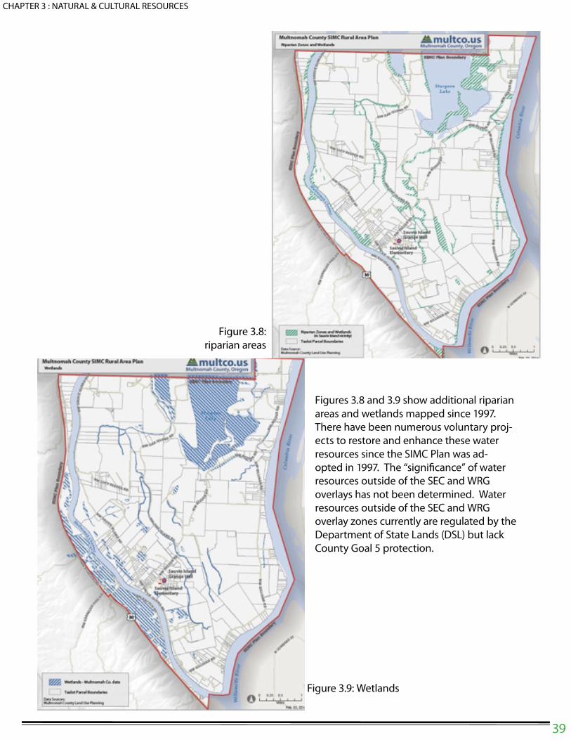
CHAPTER 3 : NATURAL & CULTURAL RESOURCES
39
Figures 3.8 and 3.9 show additional riparian
areas and wetlands mapped since 1997.
There have been numerous voluntary proj-
ects to restore and enhance these water
resources since the SIMC Plan was ad-
opted in 1997. The “signi" cance” of water
resources outside of the SEC and WRG
overlays has not been determined. Water
resources outside of the SEC and WRG
overlay zones currently are regulated by the
Department of State Lands (DSL) but lack
County Goal 5 protection.
Figure 3.9: Wetlands
Figure 3.8:
riparian areas

CHAPTER 3 : NATURAL & CULTURAL RESOURCES
40
Geography and Natural HistoryThe following maps provide some context for our current planning e# orts – and a reference point as we
collaboratively pursue programs to restore and enhance natural resources within this planning area. The
maps below provide a snapshot of the SIMC planning area before engineering projects changed the
Island’s ecology in the latter half of the 19th Century.
As the Island and vicinity developed over time:
• Bridge construction improved vehicular access;
• Levee construction protected agricultural areas; and
• Wetlands and water bodies were " lled or modi" ed to provide irrigation, drainage, and ! ood con-
trol.
This land “reclamation” process resulted in is a series of small wetlands and areas of vegetation that
are often isolated from each other, preventing the interaction that promotes biodiversity and functioning
as part of the regional natural resource network. The maps on the following page show existing wetlands
and vegetation.
• Figure 3.12 shows historic vegetation types that provide wildlife habitat that are valued by Indian
tribes.
• Figure 3.13 shows soil types based on information from a 1919 soil survey.
Figure 3.10: Geography Prior to Levees Figure 3.11: historic vegetation cover

CHAPTER 3 : NATURAL & CULTURAL RESOURCES
41
Collaborative Conservation
& Mapping E# orts
Over the last few decades, the need to
restore and enhance natural systems
within the SIMC planning area has re-
sulted in collaborative e# orts by Island
residents, governmental and non-pro" t
organizations. The following is a partial
listing of the ongoing voluntary projects
and mapping e# orts that are beginning to
change the ecological structure of area.
Figure 3.12:
Historic Vegetation/
Habitat
Figure 3.13: Historic
Soils Survey
(1919)

CHAPTER 3 : NATURAL & CULTURAL RESOURCES
42
Metro MapsMetro has prepared a number of natural resource inventories and maps. Speci" c to the SIMC Plan are
identi" cation of wetlands and historic vegetation, shown below. Note that Metro’s riparian and wetland
map shows a number of riparian areas and wetlands that do not appear on the 1997 SIMC Map – which
was based on wetlands identi" ed in the National Wetlands Inventory (NWI).
Figure 3.14: Wetlands (2014)
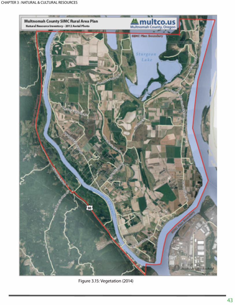
CHAPTER 3 : NATURAL & CULTURAL RESOURCES
43
Figure 3.15: Vegetation (2014)

CHAPTER 3 : NATURAL & CULTURAL RESOURCES
44
West Multnomah Soil & Water Conservation DistrictThe West Multnomah Soil & Water Conservation District (Conservation District) was established almost 70
years ago as the Sauvie Island Soil Conservation District. It provides funding and technical assistance on
restoration projects, farm and agricultural issues, invasive plants, native plants, and oak habitat protection.
The Conservation District has coordinated a variety of projects on Sauvie Island including:
• The Sturgeon Lake Restoration Project;
• Private landowner restoration projects (mud and manure management, riparian and oak habitat res-
toration, and pasture management);
• Technical assistance to the Sauvie Island Drainage Improvement Company with its hydrology study.
The Conservation District has also provided technical assistance on the SIMC Plan project team by providing
mapping of historic and present day soils, wetlands and water bodies, habitat public lands, upland oak loca-
tions, and cultural resources. This information is incorporated throughout Appendix 4 as speci" c resources or
resource areas are discussed. Figure 3.17 shows existing and potential oak habitat on the Island.
Sauvie Island Habitat
PartnershipThe mission of the Sauvie Island Habitat
Partnership (SIHAP) is conservation and
restoration of Sauvie Island habitats and
species. SIHAP has an unpaid director
and is loosely governed by representa-
tives of organizations that have a stake in
habitat work on the island.
Sauvie Island Wildlife RefugeThe 12,000-acre Sauvie Island Wildlife Ref-
uge is located on the north portion of Sauvie
Island, spanning Columbia and Multnomah
Counties. Owned by the State, it is habi-
tat for wintering waterfowl, swans, herons,
sandhill cranes, bald eagles and 250 other
species. Waterfowl number reach 200,000
and shorebird numbers reach 30,000. Bald
Eagles and Peregrine Falcons occur in the
Wildlife Area. These wetlands also play an
important role in the endangered salmo-
nid life cycles. Active Heron rookeries are
located in the Johnson Unit and Footbridge
Unit.
Access is restricted during hunting season and
spring. The Refuge includes wetlands, savan-
nah, cottonwood bottomlands, and upland Or-
egon White Oak forest managed by the Oregon
Department of Fish and Wildlife as a Wildlife
Area. On the southwest side of the island,
Oregon State Parks owns and manages a 180-acre parcel that contains many of the native habitats found elsewhere on
the island. Figure 3.16 shows the southern portion of the Sauvie Island Wildlife Refuge.
ThTh
ThTh

CHAPTER 3 : NATURAL & CULTURAL RESOURCES
45
The Wetland ConservancyThe Wetland Conservancy has recently applied
for a Bullitt Foundation grant to support a sub-
regional natural resource survey and community
outreach e# ort, with the intent of preparing a
voluntary conservation plan as part of a regional
conservation strategy.
Scappoose Bay Watershed The program complements The Regional Conser-
vation Strategy prepared by the Intertwine Alli-
ance in 2012, the vision of which is to create an
interconnected system of functioning natural areas
that protect the region’s air and water quality, help
species and habitats recover from past degrada-
tion and increase their resilience to change, and
promote the role of working lands and built land-
scape in supporting regional biodiversity.
ThTh
ThTh
Figure 3.17: Sauvie Island Wildlife Refuge-
Southern Portion
Scappoose Watershed Council:The Scappoose Bay Watershed consists of a series
of creeks on the west side of Multnomah Channel that
drain primarily portions of Columbia County, but also a
small area in Multnomah County (Jackson and South
Scappoose Creeks). Figure 3.19 shows the Scap-
poose Bay Watershed.
Oregon Natural Heritage ProgramThe PSU Institute for Natural Resources (successor to
the Oregon Natural Heritage Program) indicated that
there are no recognized “natural areas” in the SIMC
Plan area. Scappoose Bay is, however, a recognized
“natural area”.
Figure 3.18: scappose bay
watershed
CHAPTER 3 : NATURAL & CULTURAL RESOURCES
46
Grand Ronde Tribal E# orts to Restore Cultural & Archeological ResourcesThe Grand Ronde Tribe actively participates in cultural and archeological resource identi" cation and
protection e# orts by working collaboratively with property owners, local governments, the State Historic
Preservation O$ ce (SHPO) and the US Department of the Interior.
Flood Hazard MitigationFigure 3.6 shows the base ! ood (commonly referred to as the “100-year ! oodplain”) boundaries, encom-
passing the area that has a one percent chance of ! ooding each year based on FEMA (Federal Emer-
gency Management Agency) maps. The 1996 ! ood exceeded the base ! ood event. For a base ! ood,
the water level is established by FEMA at approximately 31 feet at the south end of the island and 29 feet
at the Multnomah/Columbia County boundary, so all land and development below that level within the
Multnomah County portion of the Island would be inundated.
Sauvie Island Drainage Improvement CompanyThe Sauvie Island Drainage Improvement Company (Drainage Company) was created to manage ! ood
control works constructed by the US Army Corps of Engineers in the late 1930’s and early 1940’s. The
Drainage Company is working collaboratively with state agencies and non-pro" t organizations to carry
out its mission in an environmentally sensitive manner.
Useful Resource CategoriesIt is useful to categorize resource inventories based on existing levels of Goal 5 protection. This can help
identify future programs and activities necessary to protect, enhance, or expand speci" c resources to
optimize their potential values. Suggested categories are:
• Resource Sites in Public Ownership. These lands are owned and managed for a speci" c conser-
vation purpose. The reason for their protection is well de" ned, and often accompanied by a man-
agement plan or future development plan that may be limiting, and will need to be considered in
analyzing future protection measures.
• Resource Sites in Private Ownership and Protected With Conservation Easements. Similar to pub-
lic ownership, resource protection through easement is well de" ned, although management of the
area may not be. Resource values protected through easements need to be considered, but de-
velopment or enhancement of additional values can be considered.
• Resource Sites in Private Ownership with WRG or SEC Protection. This category includes land
that is zoned WRG or SEC. These resources may also be regulated by state or federal agencies
(as is the case with wetlands and the Multnomah Channel).
• Resource Sites in Private Ownership without Regulatory or Ownership Protections. This category
may include resources that do not meet the regulatory de" nitions of wetland or water body, or are
upland habitats, but are important in the overall functioning of the Island ecosystem. Examples
may include small drainageways, wetlands that did not appear on the National Wetlands Inventory
(NWI), hedgerows, and forested areas or oak groves. These resources may be protected through
a combination of educational, incentive and regulatory programs.
Statewide Regulatory Framework and Relevant County and Agency Plans:
To the extent that additional natural resource sites are inventoried and determined to be “signi" cant” from a
Goal 5 perspective, the County must follow the “new Goal 5” rule (OAR 660 Division 023), which spells out ESEE
(economic, social, environmental and energy) analysis process and steps that must be followed prior to applica-
tion of the SEC-w or SEC-s overlay districts to signi" cant resource sites.

CHAPTER 3 : NATURAL & CULTURAL RESOURCES
47
Figure 3.19 and Figure 3.20 show land and water resource ownership within the SIMC planning area.
These maps also show the location of the Willamette River Greenway (WRG) and Signi" cant Environmen-
tal Concern (SEC) overlay zones in relation to property ownership. The majority of land protected by SEC
and WRG regulations is publicly-owned.Figure 3.19: public & private land

CHAPTER 3 : NATURAL & CULTURAL RESOURCES
48
Figure 3.20: willamette river greenway &
signi" cant overlay concen zoning

CHAPTER 3 : NATURAL & CULTURAL RESOURCES
49
Proposed Natural & Cultural Resources Policy Framework:
Policy 3.1
Collaborate and partner with private, public and non-pro" t organizations and tribes to address natu-
ral resource issues including but not limited to hydrology, climate change, changes in regional geog-
raphy, wildlife and habitat conservation, restoration enhancement, educational programs and inven-
tory of natural systems.
Policy 3.2
Consider extending the Wildlife Habitat tax deferral to MUA-20 lands, and community-based resto-
ration projects) that complement Multnomah County’s Goal 5 (Natural and Cultural Resources) and
Goal 15 (Willamette River Greenway) regulatory programs.
*Policy 3.3
Coordinate with federal and state agencies, including National Oceanic and Atmospheric Administra-
tion Fisheries Division (NOAA Fisheries) in considering development of design standards that protect
salmon habitat and " sh passage within, and along the Multnomah Channel and tributaries and en-
sure compliance with the Endangered Species Act (ESA).
*Policy 3.4
Update the surface water resources inventory, and associated riparian areas, and apply appropriate
protective zoning overlays in compliance with Goal 5 requirements (based on an evaluation of eco-
nomic, social, environmental and energy (ESEE) consequences).
Policy 3.5
Consider exemptions and process e$ ciencies to provide and encourage " sh and wildlife habitat
restoration and enhancement projects conducted by natural resource public agencies such as Metro,
Multnomah Soil and Water Conservation Districts and Oregon Department of Fish and Wildlife.
Policy 3.6
Multnomah County should work collaboratively with the Sauvie Island Drainage Improvement Com-
pany, state and federal agencies, and non-pro" t organizations to maintain the drainage and ! ood-
control functions provided by the Company while restoring natural systems where appropriate.
Policy 3.7
Consider a “dark sky” ordinance for the planning area and work with the City of Portland, Port of
Portland, and other adjacent jurisdictions and agencies towards reducing light pollution from sources
beyond the plan area.

CHAPTER 3 : NATURAL & CULTURAL RESOURCES
50
Policy 3.8
Support protection of cultural areas and archaeological resources and consider a process that in-
cludes noti" cation protocols and standards to evaluate comments received from tribes and the
Oregon State Historic Preservation O$ ce.
Policy 3.9
Support the inventory, recovery and protection of archaeological and cultural resources, and coordi-
nation with a# ected agencies during the land use process.
Policy 3.10
Consider standards to address comments received from SHPO and Native American Groups and sup-
port e# orts to report the discovery of cultural resources to SHPO and the Native American groups.
Policy 3.11
Encourage proposed development on areas of cultural signi" cance to evaluate alternative sites or
designs that reduce or eliminate impacts to the resource.
Policy 3.12
(a) Recognize the heritage value of natural resources for Native American groups and encourage
protection and restoration of historic wetlands, riparian areas, water bodies, and oak uplands.
(b) Encourage and support e# orts for natural resource restoration and historic activities such as
plant harvesting for heritage value.
Policy 3.13
Continue to explore and encourage opportunities to conduct selected dredging to increase depth,
! ows, ! ushing, and circulation action in Sturgeon Lake in coordination with partner agencies and
organizations.
Policy 3.14
The Multnomah County Health Department Vector Control sta# is encouraged to coordinate with
Oregon Department of Fish and Wildlife, using that agency’s map of sensitive areas and their Vector
Control Guidance for Sensitive Areas to identify important habitat for sensitive species like red-legged
frogs and painted turtles where an altered protocol should be used.
The county’s vector control sta# are encouraged to act as a resource in e# orts to educate and col-
laborate with landowners about natural means of mosquito control.
Policy 3.15
Recommend that any " ll generated as a result of dredging activities be located on Sauvie Island only
under the following conditions:
(a) To assist in ! ood control
(b) Not on designated wetlands
(c) Not on high value farmland unless placement of such " ll improves a farm’s soils or productivity
(d) In areas where it will not negatively impact wildlife habitat.
CHAPTER 3 : NATURAL & CULTURAL RESOURCES
51
Policy 3.16
Review internal protocols related to road and right-of-way maintenance, including roadside hedge-
row trimming and weed eradication. Work with the West Multnomah Soil &Water Conservation
District, ODFW and the Sauvie Island Habitat Partnership to protect wildlife, manage invasive plant
species, to ensure that habitat and water resource restoration projects are coordinated with county
road maintenance and drainage control programs.
Ensure that non-pro" t organizations and property owners are aware of country programs that may
limit wildlife habitat restoration projects, and that road county sta# are aware of existing and com-
pleted habitat restoration projects when they conduct their operations.
To implement this policy, the County Road Maintenance program will review the following recom-
mendations:
(a) Except in emergency situations, County road mowing should be done between August 15 and
March 15 to minimize impact to nesting birds, and workers should avoid mowing at identi" ed turtle,
frog and salamander crossings during nesting season (May and September).
(b) Culverts under county roads should be surveyed, then repaired and replaced as needed to limit
barriers to " sh and wildlife passage.
(c) County sta# should work with ODFW and the Sauvie Island Habitat Partnership to identify and
mitigate in areas where concentrations of small wildlife cross county roads.
(d) Mowing equipment should be regularly cleaned so that seeds of invasive plants are not spread
into areas where they have not yet been introduced.
(e) County sta# should confer with the West Multnomah Soil & Water Conservation District on best
management practices before removing invasive weeds along road right-of-way.
(f) County sta# should be trained to recognize invasive and desirable native plant species; Multnomah
County should prioritize plant species for control.
(g) County sta# should inform property owners of the existing Owner Vegetation Maintenance
Agreement, which allows abutting property owners to maintain right-of-way vegetation.
public
& semi-public
facilities
C H A P T E R 4 :

Introduction:Public and semi-public facilities serve residents, workers and visitors to Sauvie Island. Public facilities
include state, regional and local parks, wildlife refuges, the school, the water district, utilities and similar
publicly-owned facilities. Semi-public facilities are those which serve or pass through the plan area but
are not publicly-owned, such as railroads, the drainage company, natural gas pipeline, farm-worker hous-
ing and the grange.
The major issue identi" ed by the Public and Semi-Public Facilities subcommittee was tra$ c and other
impacts from increased use of public facilities.
Appendix 5 identi" es public and semi-public facilities within the SIMC planning area – as well as their
functions and impacts. As shown on Figure 4.1, the SIMC planning area includes Sauvie Island, the Mult-
nomah Channel, and land between US Highway 30 and the Multnomah Channel.
Key Public & Semi-Public Facility Issues (from Appendix 1)The following issues are quoted directly from the May 6, 2013 sta# report to the Multnomah County Plan-
ning Commission related to PC-2013-2659 (Scoping Report in support of updating to the 1997 Sauvie
Island – Multnomah Channel Rural Area Plan) or were identi" ed by the Public and Semi-Public Facilities
Subcommittee.
1. Concern regarding the increasing numbers of visitors to Sauvie Island and related issues, such as
increased tra$ c and increased demand on emergency service providers.
2. Consider policy acknowledging farm stand role as source of food and incidentals for local resi-
dents and tourists – partially ful" lling the role of ‘Rural Center’ uses that are lacking on the island.
(Note that new ‘Rural Center’ zones are not possible under the Rural Reserve Designation).
3. Consider new RAP policy that promotes coordination with ODFW and Columbia County regarding
managing impacts of beach users such as tra$ c, parking (and parking fees), and litter.
4. Consider update to natural disaster policies in RAP that recognize natural gas/petroleum products
pipelines that run through the Island and across the Channel.
5. Identify needed support facilities for seasonal farm workers and evaluate potential locations and
funding options for such facilities.
New Public and Semi-Public Facility Issues
(Identi" ed by Subcommittee)1. Increasing the amount of parking at parks could in turn accommodate more visitors. Care should
be taken regarding expansion of parking areas at parks. Sta# indicates that parking and visitation
data are important to help inform the transportation system plan.
2. Public safety agencies bear extra burden from high numbers of visitors. There is a desire to in-
crease public safety coverage during high visitation and a desire to seek additional funds for this
purpose.
3. Consider user fee concept that would help capture visitor impacts to roads and emergency servic-
es. User fee could apply to parks and possibly events parking.
4. The term carrying capacity should be de" ned. Perhaps this can be used as a baseline when con-
sidering applications for facilities and parks upgrades and/or expansion proposals.
5. There is a need to understand the number of farm workers commuting to the Island. Some out
reach is needed in this area.
6. Consider electrical transmission lines along the west side of Multnomah Channel as a facility in ad-
dition to gas pipeline.
7. Policy considering potential for rail disaster should be included along with any disasters and haz-
ards policies.
50
CHAPTER 4 : public & semi-public facilities

51
CHAPTER 4: public & semi-public facilities
Figure 4.1: PUBLIC LANDS IN THE SIMC PLAN AREA

Information Summary (from Appendix 5)
Information regarding public and semi-public facilities in the SIMC planning area is provided below.
Sauvie Island Wildlife Area (SIWA)The Sauvie Island Wildlife Area was established in 1947 and is managed by the Oregon Department of
Fish and Wildlife (ODFW). The wildlife area covers over 18 square miles in Columbia and Multnomah
County; about 3.75 square miles (2,398 acres) are located in Multnomah County portion of Sauvie Is-
land. The wildlife area includes Sturgeon Lake which straddles the County line and Columbia River public
beaches which are entirely within Columbia County.
The SIWA is zoned a combination of Multiple Use Agriculture (MUA-20) and Exclusive Farm Use (EFU).
The MUA-20 zone allows “Public and private conservation areas and structures for the protection of water,
soil, open space, forest and wildlife resources” and the EFU zone allows Wildlife Habitat Conservation and
Management Plan pursuant to ORS 215.800 to 215.802 and ORS 215.806 to 215.808.”
The SIWA Plan (ODFW 2010) is based on an ecosystem management philosophy. The primary goal of
the plan is to protect, enhance and manage wetland habitats to bene" t native " sh and wildlife species. The
plan also considers strategies to manage the impacts of increasing beach visitation.
As noted in the SIWA Plan:
“Sauvie Island has become one of the most visited locations in Oregon, even surpassing Crater Lake Nation-
al Park almost two fold (counts in 2008 - 415,686 visitors at Crater Lake and nearly 800,000 at SIWA). Public
use on the wildlife area was 989,361 visitor days in 2009. Due to its close proximity to the Portland Metropoli-
tan Area SIWA sta# expects public use to continue to climb. In particular, the beaches of SIWA receive 55%
of the total annual public use. Unfortunately, high levels of public use can impact " sh and wildlife species
through disturbance at critical times in their life cycle or physical alteration of their habitats. Public use can
also occasionally exceed the physical capacity of facilities needed to accommodate these uses (e.g. parking
areas). Depending on the level of impacts, it is likely that some public uses may need to be restricted in the
future. The department will determine when and how to restrict uses, and provide the physical means (e.g.
signage, kiosks) to implement such restrictions.
The number of visits by the public varies widely depending on weather conditions, with the heaviest use oc-
curring in the summer. For example, over the entire year of 2009, a peak number of 989,361 visitor use days
was recorded at SIWA, with 55% of all uses occurring on the beaches. During the summer of 2009, records
show that, among all wildlife area uses, 85% of visitors recreated on the beaches. The current estimate of
beach visitors is over 600,000 use days. Currently, seasonal entry restrictions are in place from October 1
through April 30. In recent years, biologists have recorded delayed spring migration of cackling Canada
geese; therefore this closure period has been temporarily adjusted to a later date (May 1) and will be re-
assessed with the intent of maintaining this date in the future.”
During the peak summer usage months, tra$ c must pass through the Multnomah County portion of the
Island to reach Columbia River beaches. Ongoing coordination with ODFW and Columbia County is
needed to address increased visitation and transportation impacts. Policies addressing this paramount
“cumulative impacts” issue is addressed in Chapter 5: Transportation.
Wapato Park
Wapato Park is a156-acre nature preserve located on the Sauvie Island side of the Multnomah Channel
and is managed by the Oregon State Parks and Recreation Department (OPRD). The park has a public
boat ramp. The park property was purchased by OPRD as part of a conservation “greenway” plan to pre-
serve lands of high resource value in the Willamette River/Multnomah Channel corridor, a critical habitat
52
CHAPTER 4: public & semi-public facilities

53
CHAPTER 4: public & semi-public facilities
area for resident and migratory " sh and wildlife in this region. The site has diverse and high quality habi-
tat; however, cattle grazing for several decades prior to OPRD ownership degraded the Wapato Access
wetland. In 2010, the Lower Columbia Estuary Partnership (Estuary Partnership) completed the Wapato
Access Floodplain Reconnection Feasibility Study, which identi" es potential restoration opportunities for
the site. The primary goal of this project is to restore the hydrologic connection between the disconnect-
ed ! oodplain wetland and the Multnomah Channel, and to enhance the capacity of the site for juvenile
salmonid rearing and refuge habitat, as well as habitat conditions for multiple native species including
birds, herptiles, plants and mammals.
Wapato Park is zoned EFU and MUA-20 with a Willamette River Greenway (WRG) overlay. Parks are allowed
through the conditional use / community service use processes.
Howell Territorial ParkMetro manages this 120 acre park which is located on the west side of Sauvie Island. The park includes
the Bybee-Howell House, which is on the National Register of Historic Places. This Greek revival struc-
ture was built in 1856. The park also includes picnic facilities, a pioneer orchard, Howell Lake and asso-
ciated wetlands. The restored farmhouse is closed to the public and no public tours are available at this
time.
Metro’s plans are to use of the farm house and park as an educational facility highlighting Native American cul-
ture and early Oregon events, and wildlife study and viewing. The site is zoned entirely EFU with a WRG overlay.
Future development of the site for park and educational uses is managed through the conditional use process,
where on- and o# -site impacts are considered.
J.R. Palensky Wildlife Mitigation Area (formerly Burlington Bottoms)The 417-acre Palensky Wildlife Mitigation Area is owned by the Bonneville Power Administration and man-
aged by ODFW as a wildlife habitat mitigation site on the west side of Multnomah Channel. The site is a
mosaic of riparian forest, emergent wetland, marshes and sloughs and grass/sedge meadows. Once a
high quality wetland and wildlife habitat site, due to its species and structural diversity, the area’s valuhas
been greatly diminished by intensive cattle grazing.
A 1994 Environmental Assessment and Management Plan recommended the site be managed for wildlife
values, recognizing the diversity of " sh and wildlife species. The management plan limits public access
consistent with protecting the habitat values of the site. Small groups may access the site for low-impact
activities, bird watching, and small research projects with local college students and volunteers who help
with habitat restoration activities.
In 1995, Portland area voters approved a bond issue for Metro Parks and Greenspaces. This bond issue autho-
rized Metro to purchase lands to the north of the BPA holdings in Burlington Bottoms for protection as open
space and wetlands preservation. The Burlington Bottoms area has potential as a wildlife viewing area which
could relieve the pressure of such recreational uses on the Sauvie Island Wildlife Refuge.
Sauvie Island Drainage Improvement CompanyThe Sauvie Island Drainage Improvement Company (Drainage Company) was created to maintain and manage
the ! ood control works built by the Army Corp of Engineers in the late 1930’s and early 1940s. Originally created
as a Drainage District, the district reorganized as an Oregon nonpro" t corporation in 1995 and is governed by a
three member Board of Directors, elected from within the district. The Drainage Company serves most of the Mult-
nomah County portion of the Island: the service area includes over 11 square miles (11,170 acres), 18 miles of levees,
over 35 miles of drainage ditches, four internal pump stations and four large volume pumps at the main pumping
plant. The main pumping plant has a pumping capacity of about 125,000 gallons per minute.

54
CHAPTER 4: public & semi-public facilities
The Drainage Company may need
to update the levee system in
the near term. Upgrades to infra-
structure typically require County
review of Grading and Erosion
Control and Flood Development
permits. Review by the US Army
Corps of Engineers and the Divi-
sion of State Lands will also be
required. Environmental impacts
and opportunities related to Sauvie
Island’s drainage system are also
considered in Chapter 4: Natural
and Cultural Resources. As noted in
Chapter 4, the Drainage Company
is working with Sauvie Island Habi-
tat Partnership, ODFW and other
organizations to manage drainage
in an environmentally conscious
manner.
Sauvie Island AcademySauvie Island Academy is a K-8
public charter school located o#
NW Reeder Road near the Sau-
vies Island Grange. The Academy
is within the Scappoose School
District. Academy students are
actively involved in restoration
and enhancement projects on the
Island.
According to the Academy website:
Through the philosophy of place-
based education, Sauvie Island
Academy o# ers a unique educa-
tional experience to all our stu-
dents. We give our students the
opportunity to learn through the
values of stewardship and by using the community and
natural surroundings as a learning environment that ex-
tends beyond the classroom, immersing children in the local heritage and cultural landscape.
The school site is zoned MUA-20, which allows schools expansions subject to a Community Service Permit.
Figure 4.2 Drainage Company Canal System
55
CHAPTER 4: public & semi-public facilities
Burlington Water District
The Burlington Water District serves nearly 200 homes, businesses and institutional customers along 4.0
miles of Hwy 30 as well as marinas and moorages along the mainland side of the Multnomah Channel. The
District has been in continuous operation since the 1920s. The District purchases drinking water from the
City of Portland Water Bureau through a master meter located near NW Harborton Road.
The Water System Master Plan was prepared in 1990 and, through periodic updates, generous grants and
loans has been systematically implemented. Most of the original recommendations for improvements have
been completed or will have been completed in 2014. The District has adequate capacity to provide safe
and reliable water supplies for all projected future conditions of population growth and " re protection within
its service area.
Fire DistrictsThe 1997 SIMC Plan includes the following discussion which remains valid today:
The Sauvie Island/Multnomah Channel Rural Area is served by three di# erent " re and emergency
services providers -- Multnomah County Rural Fire District # 30 (Sauvie Island FD), Scappoose
Fire District, and the City of Portland Fire Bureau.
• The Multnomah County Rural Fire District #30 serves Sauvie Island from a station on
Charlton Road. The District has a limited agreement with Portland for use of a " re boat
for marine " res. The District’s " re and emergency response force serve not only Sau-
vie Island residents, but also the 1.5 million visitors per year who visit Sauvie Island.
• The Scappoose Fire District serves the northern portion of the mainland side of Mult-
nomah Channel, south to Burlington. The Burlington Water District provides " re protection
services to land within its boundaries. Currently it contracts with the City of Portland to pro-
vide " re and emergency services.
• The Portland Fire Bureau services the Burlington area from Station # 22, located in St.
Johns, with a response time to the area of 15-20 minutes. Due to the lengthy response time
the district receives a low level of current services.
Sauvies Island Grange #840Located on property adjacent to the Sauvie Island Academy, the Grange hall serves as a community meet-
ing place and community focal point. Clubs and fraternal organizations are listed as “community service
uses” in the MUA-20 and are reviewed for on- and o# -site impacts through the conditional use process
.
Natural Gas PipelineWilliams Northwest Pipeline operates a natural gas pipeline that crosses the Multnomah Channel and the
southern portion of Sauvie Island. A facility on the southern portion of the island distributes some of the gas
into Northwest natural pipes that serve Island residents. The natural gas pipeline infrastructure crosses EFU
and MUA-20 zones. The EFU district treats utility infrastructure as a Review Use and the MUA-20 requires
a Community Service Permit review for new or expanded facilities. Concerns were raised during the com-
munity scoping process and at Public and Semi-Public Subcommittee level regarding potential pipeline
leak and/or explosion hazards. The pipeline operator has easements that follow the path of the pipeline
which include restrictions on development and activities on and over the pipelines.
Bonneville Power Transmission LinesBonneville Power Administration regional electric power transmission lines run north/south between Hwy.
30 and the Multnomah Channel. Typical high voltage transmission lines and related towers run north/south
along the west side of the Multnomah Channel.

56
CHAPTER 4: public & semi-public facilities
Seasonal Farm Worker Housing and Support Facilities & ServicesThere are two registered farm worker housing sites on Sauvie Island – one in each county. Seasonal
farm and construction workers also commute to the Island. Concerns were raised during the community
outreach process about the lack of choice in groceries and services on the Island, especially for workers
who do not own a private vehicle to travel o# the Island.
Statewide Regulatory Framework and Relevant County and Agency Plans
Statewide Planning Goal 11 (Public Facilities and Services) and its implementing rule (OAR 660 Division
011) limit the county’s ability to extend sanitary sewer systems outside of UGBs to serve rural areas:
“…Local Governments shall not allow the establishment or extension of sewer systems outside urban
growth boundaries or unincorporated community boundaries, or allow extensions of sewer lines from within
urban growth boundaries or unincorporated community boundaries to serve land outside those boundar-
ies, except where the new or extended system is the only practicable alternative to mitigate a public health
hazard and will not adversely a# ect farm or forest land.
Local governments may allow residential uses located on certain rural residential lots or parcels inside
existing sewer district or sanitary authority boundaries to connect to an existing sewer line under the terms
and conditions speci" ed by Commission rules.
Local governments shall not rely upon the presence, establishment, or extension of a water or sewer sys-
tem to allow residential development of land outside urban growth boundaries or unincorporated commu-
nity boundaries at a density higher than authorized without service from such a system.”
The Department of Environmental Quality (DEQ) has ultimate responsibility for approving on-site sew-
age disposal systems. Multnomah County contracts with the Portland Bureau of Development Services
(BDS) to review applications for on-site sewage disposal systems for marinas and ! oating home moor-
ages along Multnomah Channel. The provision of sewer and water systems to marinas and ! oating home
moorages is addressed further in the Marinas and Floating Homes Background Report.

57
CHAPTER 4: public & semi-public facilities
Proposed Public & Semi-Public Facilities
Policy Framework:
Policy 4.1
Cooperate with state and local agencies to address drainage, ! ood control, and road-
way functions of existing levees while restoring natural systems where appropriate.
Provide notice to the Drainage Company of any proposed code amendment or
development on lands on and/or adjacent to Drainage Company infrastructure.
Policy 4.2
Continue to coordinate with Metro to ensure compliance with Rural Reserve designa-
tions, implementation of Metro’s Greenspaces Master Plan and planning for Howell
Park. In particular, work with Metro to:
(a) Activities should complement natural and environmental resources of local and
regional signi" cance; and
(b) Ensure that Howell Territorial Park uses and improvements maintain harmony with
the rural character of the plan area as well as natural and cultural resources.
Policy 4.3
Support only those recreational activities within the rural plan area that are comple-
mentary to and do not negatively impact natural and environmental resources on
Sauvie Island and along the Multnomah Channel and its tributaries that are identi" ed
in Goal 5 and in the Metro Greenspaces Master Plan and lands approved in Metro’s
Acquisition Re" nement Plan.
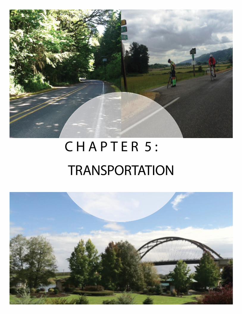
TRANSPORTATION
C H A P T E R 5 :
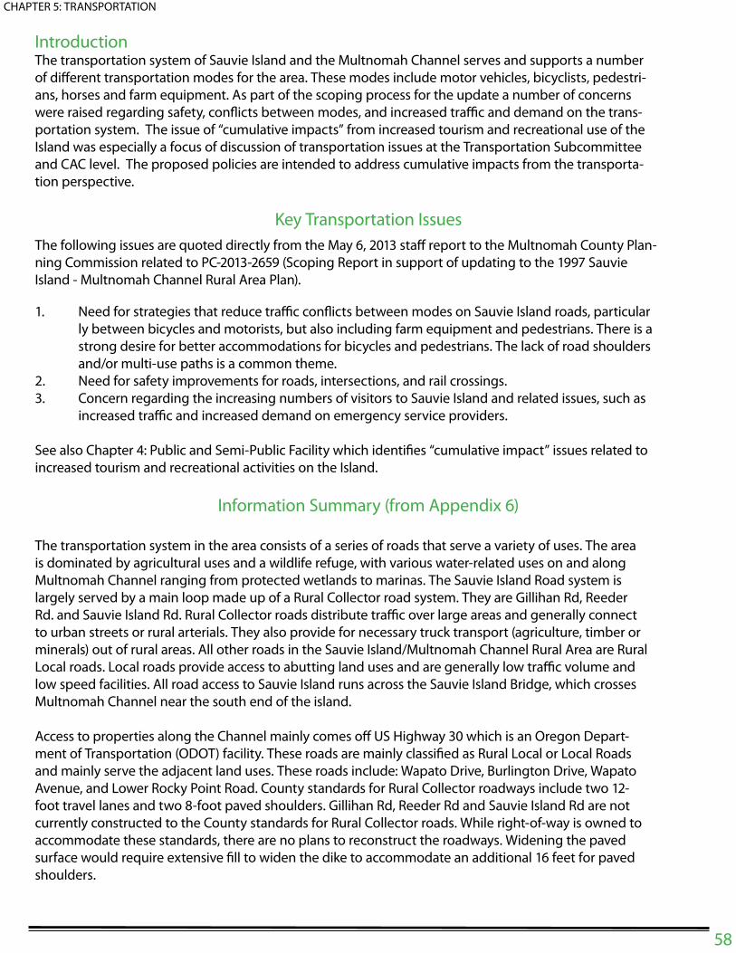
IntroductionThe transportation system of Sauvie Island and the Multnomah Channel serves and supports a number
of di# erent transportation modes for the area. These modes include motor vehicles, bicyclists, pedestri-
ans, horses and farm equipment. As part of the scoping process for the update a number of concerns
were raised regarding safety, con! icts between modes, and increased tra$ c and demand on the trans-
portation system. The issue of “cumulative impacts” from increased tourism and recreational use of the
Island was especially a focus of discussion of transportation issues at the Transportation Subcommittee
and CAC level. The proposed policies are intended to address cumulative impacts from the transporta-
tion perspective.
Key Transportation Issues
The following issues are quoted directly from the May 6, 2013 sta# report to the Multnomah County Plan-
ning Commission related to PC-2013-2659 (Scoping Report in support of updating to the 1997 Sauvie
Island - Multnomah Channel Rural Area Plan).
1. Need for strategies that reduce tra$ c con! icts between modes on Sauvie Island roads, particular
ly between bicycles and motorists, but also including farm equipment and pedestrians. There is a
strong desire for better accommodations for bicycles and pedestrians. The lack of road shoulders
and/or multi-use paths is a common theme.
2. Need for safety improvements for roads, intersections, and rail crossings.
3. Concern regarding the increasing numbers of visitors to Sauvie Island and related issues, such as
increased tra$ c and increased demand on emergency service providers.
See also Chapter 4: Public and Semi-Public Facility which identi" es “cumulative impact” issues related to
increased tourism and recreational activities on the Island.
Information Summary (from Appendix 6)
The transportation system in the area consists of a series of roads that serve a variety of uses. The area
is dominated by agricultural uses and a wildlife refuge, with various water-related uses on and along
Multnomah Channel ranging from protected wetlands to marinas. The Sauvie Island Road system is
largely served by a main loop made up of a Rural Collector road system. They are Gillihan Rd, Reeder
Rd. and Sauvie Island Rd. Rural Collector roads distribute tra$ c over large areas and generally connect
to urban streets or rural arterials. They also provide for necessary truck transport (agriculture, timber or
minerals) out of rural areas. All other roads in the Sauvie Island/Multnomah Channel Rural Area are Rural
Local roads. Local roads provide access to abutting land uses and are generally low tra$ c volume and
low speed facilities. All road access to Sauvie Island runs across the Sauvie Island Bridge, which crosses
Multnomah Channel near the south end of the island.
Access to properties along the Channel mainly comes o# US Highway 30 which is an Oregon Depart-
ment of Transportation (ODOT) facility. These roads are mainly classi" ed as Rural Local or Local Roads
and mainly serve the adjacent land uses. These roads include: Wapato Drive, Burlington Drive, Wapato
Avenue, and Lower Rocky Point Road. County standards for Rural Collector roadways include two 12-
foot travel lanes and two 8-foot paved shoulders. Gillihan Rd, Reeder Rd and Sauvie Island Rd are not
currently constructed to the County standards for Rural Collector roads. While right-of-way is owned to
accommodate these standards, there are no plans to reconstruct the roadways. Widening the paved
surface would require extensive " ll to widen the dike to accommodate an additional 16 feet for paved
shoulders.
58
CHAPTER 5: TRANSPORTATION

59
CHAPTER 5: TRANSPORTATION
Figure 5.1 functional class" cation of roadways

60
CHAPTER 5: TRANSPORTATION
Statewide and Local Regulatory FrameworkStatewide Planning Goal 12 (Transportation) and the Transportation Planning Rule (OAR 660 Division 012)
require that counties prepare transportation system plans to address rural transportation issues.
Proposed transportation Policy Framework:
Policy 5.1
The Multnomah County Bicycle and Pedestrian Advisory Committee should maintain continuous
Sauvie Island representation to the extent possible.
Policy 5.2
Identify and implement short- and long- term solutions to safely accommodate bicyclists, pedes-
trians, and motor vehicles on Sauvie Island including on-road bikeways, separated multi-use paths,
and funding options.
Policy 5.3
Oppose placement of new regional roadways in the Sauvie Island/Multnomah Channel Rural Area,
should such roadways be contemplated by any regional transportation authority in the future.
Policy 5.4
Consider context sensitive design when reviewing rural roadway standards to determine appropri-
ate paved shoulder widths to preserve the rural character of roads. Shoulder widening should aim
to achieve a minimum 3 foot paved width.
Policy 5.5
Coordinate with ODOT Rail and Public Transit Division to promote appropriate safety devices at
crossings.
*Policy 5.6
Coordinate with the Oregon Department of Fish and Wildlife (ODFW) and Columbia County to
manage and reduce demand on the Sauvie Island transportation system, especially during peak
use periods, by making more e$ cient use of capacity on the system through strategies such as
user fees, shuttles, and parking management programs.
Policy 5.7
Promote a transportation system that prioritizes and supports the e$ cient and safe movement of
farm vehicles and equipment.
Policy 5.8
Maintain and improve the transportation system for all modes of travel that reduce con! ict and
minimize impacts to the natural environment, and re! ects the community’s rural character while
ensuring e$ ciency and connectivity.

61
CHAPTER 5: TRANSPORTATION
*Policy 5.9
Implement a range of Transportation Demand Management (TDM) policies encouraging existing
businesses and requiring new development (beyond single family residential use and agricultural
uses) to help reduce vehicle miles traveled (VMT), maximize use of existing facilities, increase walk-
ing, biking and transit use and alleviate congestion on US 30 and county roads caused by seasonal
and special event tra$ c.
Policy 5.10
Work with the Oregon O$ ce of Emergency Management, Multnomah County Emergency Man-
agement and Multnomah County rural " re protection district to ensure that the transportation
system supports e# ective responses to emergencies and disasters.
Policy 5.11
Promote e# ective use of signage designed to educate the public about farm equipment using
roadways, wildlife crossings and bicycle and pedestrian safety and additional way " nding signage.
Policy 5.12
Coordinate and work with transit agencies and service providers to identify existing transit de" -
ciencies and the improvements necessary to increase access to transit services by potential users.

C H A P T E R 6 :
Policy Tasks

62
CHAPTER 6: POLICY TASKS
Policy PC Work Pro-gram
County Process
Im-prove-ment
Agency or Inter-depart-mental Coordi-nation
Legis-lative
Tracking
TSP
EquityPolicy 1.0Acknowledge the needs of low-income and minor-ity populations in future investments and programs, including an equity analysis consistent with required federal, state and local requirements.
p
Agriculture and Agri-tourism*Policy 1.1 Maximize retention of Sauvie Island’s agricultural land base for productive farm use.
p
*Policy 1.2Consider standards for limiting the area, location, de-sign, and function of farm stand promotional activities to the extent allowed by law to retain a maximum sup-ply of land in production for farm crops or livestock, to ensure public health and safety, and to minimize im-pacts on adjacent farming operations, residents, roads, tra! c circulation, wildlife and other natural resources.
p
Policy 1.3Consider a tiered review process for farm stand opera-tions on EFU land distinguishing between operations that include promotional activities and those that do not.
p
Policy 1.4Consider amending the Multiple Use Agriculture zon-ing code to include deed restrictions protecting sur-rounding agricultural practices as a requirement for approval of new and replacement dwellings and addi-tions to existing dwellings.
p p p
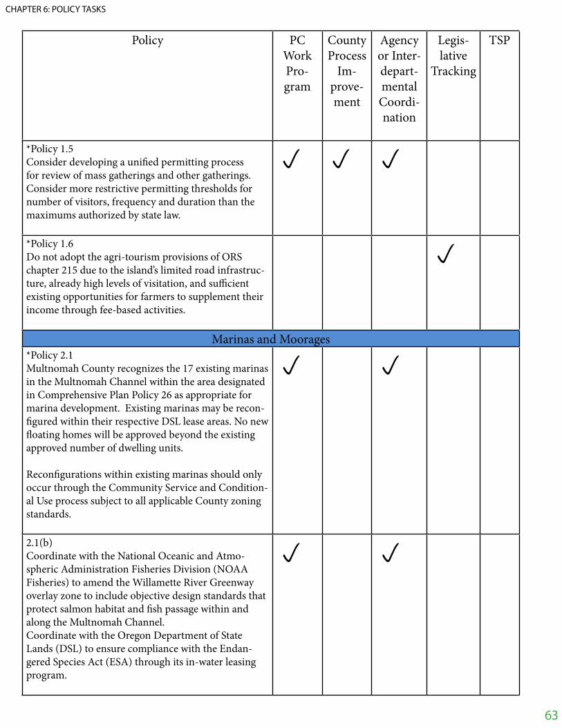
Policy PC Work Pro-gram
County Process
Im-prove-ment
Agency or Inter-depart-mental Coordi-nation
Legis-lative
Tracking
TSP
*Policy 1.5 Consider developing a uni" ed permitting process for review of mass gatherings and other gatherings. Consider more restrictive permitting thresholds for number of visitors, frequency and duration than the maximums authorized by state law.
p p p
*Policy 1.6 Do not adopt the agri-tourism provisions of ORS chapter 215 due to the island’s limited road infrastruc-ture, already high levels of visitation, and su! cient existing opportunities for farmers to supplement their income through fee-based activities.
p
Marinas and Moorages*Policy 2.1Multnomah County recognizes the 17 existing marinas in the Multnomah Channel within the area designated in Comprehensive Plan Policy 26 as appropriate for marina development. Existing marinas may be recon-" gured within their respective DSL lease areas. No new # oating homes will be approved beyond the existing approved number of dwelling units.
Recon" gurations within existing marinas should only occur through the Community Service and Condition-al Use process subject to all applicable County zoning standards.
p p
2.1(b)Coordinate with the National Oceanic and Atmo-spheric Administration Fisheries Division (NOAA Fisheries) to amend the Willamette River Greenway overlay zone to include objective design standards that protect salmon habitat and " sh passage within and along the Multnomah Channel. Coordinate with the Oregon Department of State Lands (DSL) to ensure compliance with the Endan-gered Species Act (ESA) through its in-water leasing program.
p p
63
CHAPTER 6: POLICY TASKS
Policy PC Work Pro-gram
County Process
Im-prove-ment
Agency or Inter-depart-mental Coordi-nation
Legis-lative
Tracking
TSP
2.1(c)Consider building, plumbing, electrical and mechani-cal standards for # oating structures.
p p
2.1(d)As directed by Portland’s Bureau of Environmental Services and/or Oregon’s Department of Environmen-tal Quality, marina owners must provide for safe and easy collection and disposal of sewage from marine uses in Multnomah Channel.(1) Require marinas with # oating structures to meet state standards for sewage collection and disposal simi-lar to those standards that apply to dwellings on land. (2) Boat slips serving boats with onboard cooking and/or sanitation facilities must be provided with an on-site mechanism for disposal of sewage, either through connections at each slip or through the availability of on-site alternative pump out facilities which are rea-sonably safe from accidental spillage.
p p
Policy 2.2Maintain a current inventory of all marinas moorages. Include all dwellings, boat slips, # oating structures, live-aboards and supporting infrastructure in the inventory.
p
Policy 2.3 Review de" nitions of # oating home, houseboats, boathouses, live-aboards, combos, etc. used by agen-cies such as the Multnomah County Assessor, the City of Portland and the State when amending the Zoning Ordinance.
p p
64
CHAPTER 6: POLICY TASKS

Policy PC Work Pro-gram
County Process
Im-prove-ment
Agency or Inter-depart-mental Coordi-nation
Legis-lative
Tracking
TSP
Policy 2.4Allow live-aboards to be used as full time residences within a marina and count the live-aboard slip in the total number of residences approved for the marina. $ is option requires Community Service (CS) ap-proval and requires that boats meet health, safety, and environmental standards (i.e. electrical, water and sanitation) for occupied boats docked in a marina).
p p
Policy 2.5 Consider standards to allow temporary use of live-aboard boats within marinas. $ is option requires that boats meet health, safety, and environmental standards (i.e. electrical, water and sanitation) for occupied boats docked in a marina).
p p
Policy 2.6 Amend Comprehensive Plan Policy 26 to be consistent with policy 2.1.
p
Natural and Cultural ResourcesPolicy 3.1Collaborate and partner with private, public and non-pro" t organizations and tribes to address natural resource issues including but not limited to hydrology, climate change, changes in regional geography, wildlife and habitat conservation, restoration enhancement, educational programs and inventory of natural sys-tems.
p
Policy 3.2 Consider extending the Wildlife Habitat tax deferral to MUA-20 lands, and community-based restoration projects) that complement Multnomah County’s Goal 5 (Natural and Cultural Resources) and Goal 15 (Wil-lamette River Greenway) regulatory programs.
p p p
65
CHAPTER 6: POLICY TASKS

Policy PC Work Pro-gram
County Process
Im-prove-ment
Agency or Inter-depart-mental Coordi-nation
Legis-lative
Tracking
TSP
*Policy 3.3 Coordinate with federal and state agencies, including National Oceanic and Atmospheric Administration Fisheries Division (NOAA Fisheries) in considering development of design standards that protect salmon habitat and " sh passage within, and along the Mult-nomah Channel and tributaries and ensure compliance with the Endangered Species Act (ESA).
p p
*Policy 3.4 Update the surface water resources inventory, and as-sociated riparian areas, and apply appropriate protec-tions in compliance with Goal 5 requirements (based on an evaluation of economic, social, environmental and energy (ESEE) consequences).
p p
Policy 3.5 Consider exemptions and process e! ciencies to pro-vide and encourage " sh and wildlife habitat restoration and enhancement projects conducted by natural re-source public agencies such as Metro, Multnomah Soil and Water Conservation Districts and Oregon Depart-ment of Fish and Wildlife.
p p
Policy 3.6Multnomah County should work collaboratively with the Sauvie Island Drainage Improvement Company, state and federal agencies, and non-pro" t organiza-tions to maintain the drainage and # ood-control func-tions provided by the Company while restoring natural systems where appropriate.
p
Policy 3.7 Consider a “dark sky” ordinance for the planning area and work with the City of Portland, Port of Portland, and other adjacent jurisdictions and agencies towards reducing light pollution from sources beyond the plan area.
p p
66
CHAPTER 6: POLICY TASKS

Policy PC Work Pro-gram
County Process
Im-prove-ment
Agency or Inter-depart-mental Coordi-nation
Legis-lative
Tracking
TSP
Policy 3.8 Support protection of cultural areas and archaeological resources and consider a process that includes noti" -cation protocols and standards to evaluate comments received from tribes and the Oregon State Historic Preservation O! ce.
p p
Policy 3.9 Support the inventory, recovery and protection of ar-chaeological and cultural resources, and coordination with a% ected agencies during the land use process.
p
Policy 3.10 Consider standards to address comments received from SHPO and Native American Groups and support e% orts to report the discovery of cultural resources to SHPO and the Native American groups.
p p
Policy 3.11 Encourage proposed development on areas of cultural signi" cance to evaluate alternative sites or designs that reduce or eliminate impacts to the resource.
p
Policy 3.12 (a) Recognize the heritage value of natural re-sources for Native American groups and encourage protection and restoration of historic wetlands, ripar-ian areas, water bodies, and oak uplands. (b) Encourage and support e% orts for natural re-source restoration and historic activities such as plant harvesting for heritage value.
p
Policy 3.13 Continue to explore and encourage opportunities to conduct selected dredging to increase depth, # ows, # ushing, and circulation action in Sturgeon Lake in co-ordination with partner agencies and organizations.
p
67
CHAPTER 6: POLICY TASKS
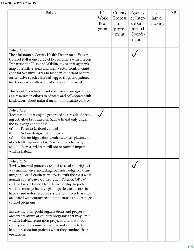
Policy PC Work Pro-gram
County Process
Im-prove-ment
Agency or Inter-depart-mental Coordi-nation
Legis-lative
Tracking
TSP
Policy 3.14$ e Multnomah County Health Department Vector Control sta% is encouraged to coordinate with Oregon Department of Fish and Wildlife, using that agency’s map of sensitive areas and their Vector Control Guid-ance for Sensitive Areas to identify important habitat for sensitive species like red-legged frogs and painted turtles where an altered protocol should be used.
$ e county’s vector control sta% are encouraged to act as a resource in e% orts to educate and collaborate with landowners about natural means of mosquito control.
p
Policy 3.15Recommend that any " ll generated as a result of dredg-ing activities be located on Sauvie Island only under the following conditions: (a) To assist in # ood control (b) Not on designated wetlands(c) Not on high value farmland unless placement of such " ll improves a farm’s soils or productivity(d) In areas where it will not negatively impact wildlife habitat.
p
Policy 3.16Review internal protocols related to road and right-of-way maintenance, including roadside hedgerow trim-ming and weed eradication. Work with the West Mult-nomah Soil &Water Conservation District, ODFW and the Sauvie Island Habitat Partnership to protect wildlife, manage invasive plant species, to ensure that habitat and water resource restoration projects are co-ordinated with county road maintenance and drainage control programs.
Ensure that non-pro" t organizations and property owners are aware of country programs that may limit wildlife habitat restoration projects, and that road county sta% are aware of existing and completed habitat restoration projects when they conduct their operations.
p
68
CHAPTER 6: POLICY TASKS
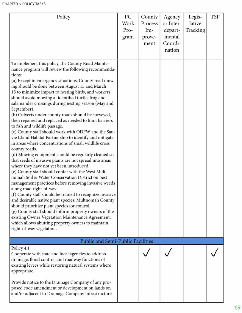
Policy PC Work Pro-gram
County Process
Im-prove-ment
Agency or Inter-depart-mental Coordi-nation
Legis-lative
Tracking
TSP
To implement this policy, the County Road Mainte-nance program will review the following recommenda-tions: (a) Except in emergency situations, County road mow-ing should be done between August 15 and March 15 to minimize impact to nesting birds, and workers should avoid mowing at identi" ed turtle, frog and salamander crossings during nesting season (May and September).(b) Culverts under county roads should be surveyed, then repaired and replaced as needed to limit barriers to " sh and wildlife passage.(c) County sta% should work with ODFW and the Sau-vie Island Habitat Partnership to identify and mitigate in areas where concentrations of small wildlife cross county roads.(d) Mowing equipment should be regularly cleaned so that seeds of invasive plants are not spread into areas where they have not yet been introduced.(e) County sta% should confer with the West Mult-nomah Soil & Water Conservation District on best management practices before removing invasive weeds along road right-of-way.(f) County sta% should be trained to recognize invasive and desirable native plant species; Multnomah County should prioritize plant species for control.(g) County sta% should inform property owners of the existing Owner Vegetation Maintenance Agreement, which allows abutting property owners to maintain right-of-way vegetation.
Public and Semi-Public FacilitiesPolicy 4.1 Cooperate with state and local agencies to address drainage, # ood control, and roadway functions of existing levees while restoring natural systems where appropriate.
Provide notice to the Drainage Company of any pro-posed code amendment or development on lands on and/or adjacent to Drainage Company infrastructure.
p p p
69
CHAPTER 6: POLICY TASKS

Policy PC Work Pro-gram
County Process
Im-prove-ment
Agency or Inter-depart-mental Coordi-nation
Legis-lative
Tracking
TSP
Policy 4.2 Continue to coordinate with Metro to ensure compli-ance with Rural Reserve designations, implementation of Metro’s Greenspaces Master Plan and planning for Howell Park. In particular, work with Metro to:(a) Activities should complement natural and environ-mental resources of local and regional signi" cance; and (b) Ensure that Howell Territorial Park uses and im-provements maintain harmony with the rural char-acter of the plan area as well as natural and cultural resources.
p
Policy 4.3 Support only those recreational activities within the rural plan area that are complimentary to and do not negatively impact natural and environmental resources on Sauvie Island and along the Multnomah Channel and its tributaries that are identi" ed in Goal 5 and in the Metro Greenspaces Master Plan and lands ap-proved in Metro’s Acquisition Re" nement Plan.
p
TransportationPolicy 5.1 $ e Multnomah County Bicycle and Pedestrian Advi-sory Committee should maintain continuous Sauvie Island representation to the extent possible.
p
Policy 5.2 Identify and implement short- and long- term solu-tions to safely accommodate bicyclists, pedestrians, and motor vehicles on Sauvie Island including on-road bikeways, separated multi-use paths, and funding op-tions.
p p p
Policy 5.3 Oppose placement of new regional roadways in the Sauvie Island/Multnomah Channel Rural Area, should such roadways be contemplated by any regional trans-portation authority in the future.
p
70
CHAPTER 6: POLICY TASKS

Policy PC Work Pro-gram
County Process
Im-prove-ment
Agency or Inter-depart-mental Coordi-nation
Legis-lative
Tracking
TSP
Policy 5.4 Consider context sensitive design when reviewing rural roadway standards to determine appropriate paved shoulder widths to preserve the rural character of roads. Shoulder widening should aim to achieve a minimum 3 foot paved width.
p p p
Policy 5.5 Coordinate with ODOT Rail and Public Transit Divi-sion to promote appropriate safety devices at crossings.
p p p p
*Policy 5.6 Coordinate with the Oregon Department of Fish and Wildlife (ODFW) and Columbia County to manage and reduce demand on the Sauvie Island transporta-tion system, especially during peak use periods, by making more e! cient use of capacity on the system through strategies such as user fees, shuttles, and park-ing management programs.
p p p
Policy 5.7 Promote a transportation system that prioritizes and supports the e! cient and safe movement of farm ve-hicles and equipment.
p
Policy 5.8Maintain and improve the transportation system for all modes of travel that reduce con# ict and minimize impacts to the natural environment, and re# ects the community’s rural character while ensuring e! ciency and connectivity.
p p p
71
CHAPTER 6: POLICY TASKS

Policy PC Work Pro-gram
County Process
Im-prove-ment
Agency or Inter-depart-mental Coordi-nation
Legis-lative
Tracking
TSP
*Policy 5.9 Implement a range of Transportation Demand Man-agement (TDM) policies encouraging existing busi-nesses and requiring new development (beyond single family residential use and agricultural uses) to help reduce vehicle miles traveled (VMT), maximize use of existing facilities, increase walking, biking and tran-sit use and alleviate congestion on US 30 and county roads caused by seasonal and special event tra! c
p p p p
Policy 5.10 Work with the Oregon O! ce of Emergency Manage-ment, Multnomah County Emergency Management and Multnomah County rural " re protection district to ensure that the transportation system supports e% ec-tive responses to emergencies and disasters.
p p p
Policy 5.11Promote e% ective use of signage designed to educate the public about farm equipment using roadways, wildlife crossings and bicycle and pedestrian safety and additional way " nding signage.
p p p
Policy 5.12Coordinate and work with transit agencies and service providers to identify existing transit de" ciencies and the improvements necessary to increase access to tran-sit services by potential users.
p p p
72
CHAPTER 6: POLICY TASKS


![[SF] Death Note - Change the World](https://img.dokumen.tips/doc/110x75/55cf9d8d550346d033ae1f85/sf-death-note-change-the-world.jpg)