Embed Size (px)
Citation preview

Prepared For: Northern Pass Transmission, LLC
and Public Service Company of New Hampshire
d/b/a Eversource Energy
October 2015
Prepared By: Normandeau Associates, Inc.
25 Nashua Road Bedford, NH 03110
www.normandeau.com
Northern Pass Transmission Project
Vegetation and Ecological Communities

Vegetation and Ecological Communities
Northern Pass Transmission Project ii Normandeau Associates, Inc.
Table of Contents List of Figures .............................................................................................................................iii
List of Tables ............................................................................................................................... iv
1 Introduction ........................................................................................................................ 1-1
2 Vegetation and Ecological Communities Definitions and Methodology .............. 2-1
3 Survey Results .................................................................................................................... 3-1
3.1 U.S./Canada Border to Existing Transmission Line ROW in Dummer (Section N1) ............. 3-1 3.1.1 Vegetation in the Project Vicinity .............................................................................................3-1 3.1.2 Vegetation within the Project Area ...........................................................................................3-3
3.2 Existing Transmission Line ROW in Dummer to Whitefield Substation (Section N2) .......... 3-5 3.2.1 Vegetation in the Project Vicinity .............................................................................................3-5 3.2.2 Vegetation within the Project Area ...........................................................................................3-7
3.3 Whitefield Substation to Transition Station 5 in Bethlehem (Section C1) ............................... 3-8 3.3.1 Vegetation in the Project Vicinity .............................................................................................3-8 3.3.2 Vegetation within the Project Area .........................................................................................3-10
3.4 Transition Station 5 in Bethlehem to Transition Station 6 in Bridgewater (Section UG1) ... 3-10 3.4.1 Vegetation in the Project Vicinity ...........................................................................................3-10 3.4.2 Vegetation within the Project Area .........................................................................................3-13
3.5 Transition Station 6 in Bridgewater to Franklin Converter Terminal (Section C2) .............. 3-14 3.5.1 Vegetation in the Project Vicinity ...........................................................................................3-14 3.5.2 Vegetation within the Project Area .........................................................................................3-15
3.6 Franklin Converter Terminal to Deerfield Substation (Section S1) ....................................... 3-16 3.6.1 Vegetation in the Project Vicinity ...........................................................................................3-16 3.6.2 Vegetation within the Project Area .........................................................................................3-18
3.7 Deerfield Substation to Scobie Pond Substation—Alternating Current (AC) System Support Project ........................................................................................................................ 3-19 3.7.1 Vegetation in the Project Vicinity ...........................................................................................3-19 3.7.2 Vegetation within the Project Area .........................................................................................3-21
4 Summary .............................................................................................................................. 4-1
5 Bibliography ....................................................................................................................... 5-1
6 Appendices .......................................................................................................................... 6-1
Appendix A. Figures ........................................................................................................................ A-1 Appendix B. USFS Ecoregion Tables ............................................................................................... B-1 Appendix C. Global and State Rank Codes ...................................................................................... C-1
Vegetation and Ecological Communities
Northern Pass Transmission Project iii Normandeau Associates, Inc.
List of Figures Figure A-1. Northern Pass Transmission Line Overview. ............................................................ A-2
Figure A-2. Ecoregion map. .............................................................................................................. A-3
Figure A-3. Calcium-rich Bedrock map. .......................................................................................... A-4
Figure A-4. Wildlife Action Plan (WAP) Habitats, Section N1—U.S./Canada Border to Dummer. ......................................................................................................................... A-5
Figure A-5. Wildlife Action Plan (WAP) Habitats, Section N2—Dummer to Whitefield Substation. ...................................................................................................................... A-6
Figure A-6. Wildlife Action Plan (WAP) Habitats, Section C1—Whitefield Substation to Transition Station 5 in Bethlehem. .......................................................................... A-7
Figure A-7. Wildlife Action Plan (WAP) Habitats, Section UG1—Transition Station 5 in Bethlehem to Transition Station 6 in Bridgewater. ................................................... A-8
Figure A-8. Wildlife Action Plan (WAP) Habitats, Section C2—Transition Station 6 in Bridgewater to Franklin Converter Terminal. ........................................................... A-9
Figure A-9. Wildlife Action Plan (WAP) Habitats, Section S1—Franklin Converter Terminal to Deerfield Substation. ............................................................................. A-10
Figure A-10. Wildlife Action Plan (WAP) Habitats, Deerfield Substation to Scobie Pond Substation. .................................................................................................................... A-11

Vegetation and Ecological Communities
Northern Pass Transmission Project iv Normandeau Associates, Inc.
List of Tables Table 1. Dominant and Characteristic Plant Communities, U.S./Canada Border to
Existing Transmission Line ROW in Dummer ........................................................... 3-2
Table 2. Dominant and Characteristic Plant Communities, Dummer to Whitefield Substation ........................................................................................................................ 3-5
Table 3. Dominant and Characteristic Plant Communities, Whitefield Substation to Transition Station 5 in Bethlehem ................................................................................ 3-9
Table 4. Dominant and Characteristic Plant Communities, Transition Station 5 in Bethlehem to Transition Station 6 in Bridgewater ................................................... 3-11
Table 5. Dominant and Characteristic Plant Communities, Transition Station 6 in Bridgewater to Franklin Converter Terminal ........................................................... 3-14
Table 6. Dominant and Characteristic Plant Communities, Franklin Converter Terminal to Deerfield Substation ............................................................................... 3-17
Table 7. Dominant and Characteristic Plant Communities, Deerfield Substation to Scobie Pond Substation ................................................................................................ 3-19
Table B-1. U.S. Forest Service National Hierarchical Framework of Ecological Units ........... B-1
Table B-2. U.S. Forest Service Ecoregions within the Northern Pass Transmission Line Route................................................................................................................................ B-1


Vegetation and Ecological Communities
Northern Pass Transmission Project 1-1 Normandeau Associates, Inc.
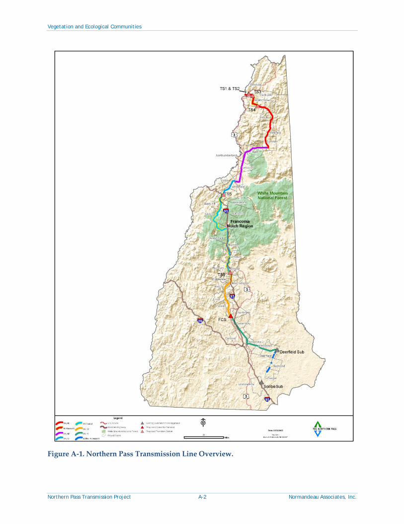
1 Introduction The Northern Pass Transmission Project (Northern Pass, or the Project) is a proposed 192-mile transmission line project that will carry 1,000 MW of renewable hydroelectric power from Canada to New Hampshire and greater New England. The Project will construct 158 miles of direct-current (DC) transmission line in New Hampshire from the Canadian border to a converter terminal to be built in Franklin, NH. Approximately 60 miles of this will be underground in existing road ROW, and the rest will be overhead line. There it will be converted to alternating current (AC) and sent via a 34-mile AC overhead transmission line to a substation in Deerfield (Figure A-1) where it will connect to the New England power grid, which serves all customers in the region. Approximately 82 miles of existing overhead transmission and distribution lines of various voltages that share the existing ROW will be relocated within the existing ROW to make room for the new line. Upgrades to existing AC facilities (“AC System Support facilities”) are required at Deerfield Substation in Deerfield and Scobie Pond Substation in Londonderry, where expansions of the existing facilities are planned as well as small modifications for the two existing 345-kV transmission lines between Deerfield and Scobie Pond substations. Upgrades to these lines do not require the construction of new transmission line, but will involve some minor temporary land disturbance.
Northern Pass follows an existing Eversource Energy (Eversource) transmission line right-of-way (ROW) or public road ROW for over 80% of its length. Approximately 32 miles of the project in northern New Hampshire would require the clearing of new ROW. Starting from the north, Northern Pass will enter New Hampshire from Canada at Halls Stream. The overhead line transitions to a short underground cable segment under the Connecticut River and Route 3 ROW, resurfacing less than a mile away in Clarksville, where the overhead transmission line continues to Route 145.
At this point the overhead line will transition to underground cable for approximately 7.6 miles following the ROW of Old County Road, North Hill Road, and Bear Rock Road to the junction of Bear Rock Road and Heath Road in Stewartstown. Here the line will resurface to an overhead transmission line and follow a proposed ROW through Stewartstown, Dixville, Millsfield, and Dummer until joining the existing overhead transmission line ROW in Dummer near Route 16. The route then follows existing ROW to Route 302 in Bethlehem, passing over the Upper Ammonoosuc River in Stark, Otter Brook and the Israel River in Lancaster, John’s River in Dalton, and the Ammonoosuc River in Bethlehem.
At Route 302, the line is proposed to go underground following the road ROW of Routes 302, 18, 112, 116 and 3 for approximately 52 miles through the towns of Bethlehem, Sugar Hill, Franconia, Easton, Woodstock, Thornton, Campton, Plymouth and Bridgewater, where the existing transmission line ROW crosses Route 3. Along the way, the line will be directionally drilled under the Gale River in Franconia, Moosilauke Brook in Woodstock and the Baker River in Plymouth.

Vegetation and Ecological Communities
Northern Pass Transmission Project 1-2 Normandeau Associates, Inc.
At Route 3 in Bridgewater, the line transitions back to overhead line, and follows existing transmission ROW though the towns of Bridgewater, Ashland, Bristol, New Hampton, Hill, Franklin, Northfield, Canterbury, the City of Concord, Pembroke and Allenstown to the terminus in Deerfield (Figure A-1). Within this portion of the ROW, the line will pass over the Squam River in Ashland, Pemigewasset River (in several towns), the Merrimack River at the Franklin/Northfield Town line, Turtle Pond in Concord, The Soucook River at the Concord/Pembroke line, the Suncook River at the Pembroke/Allenstown line, and the Lamprey River in Deerfield.
This report provides a summary of vegetation and ecological communities identified by Normandeau Associates, Inc., during the natural resource field review for Northern Pass.

Vegetation and Ecological Communities
Northern Pass Transmission Project 2-1 Normandeau Associates, Inc.
2 Vegetation and Ecological Communities Definitions and Methodology
The U.S. Forest Service (USFS) has defined geographic areas with generally similar characteristics into ecological units (referred to as ecoregions) within the United States. Ecoregions include areas with similar environmental resources. Ecoregion boundaries are determined by examining patterns of vegetation, wildlife, geology, soils, water quality, climate, and human land use as well as other important components of an ecosystem. Ecoregions are further divided into a hierarchical framework (Table B-1). USFS ecoregion subsections along the transmission corridor represent a unique combination of climate conditions, bedrock and topography, soils, and vegetation (Figure A-2, Table B-2). Natural communities are grouped according to size distribution within a particular ecoregion: “matrix” forest communities dominate the uplands of a region, covering tens of thousands of acres; “patch” communities are smaller, occupying areas from <1 to hundreds of acres or, less commonly, thousands of acres.
It should be noted that the existing Eversource ROW between Dummer and Londonderry consists primarily of shrubland, grassland, and early successional forest regeneration due to ongoing vegetation maintenance operations. Northern Pass crosses a diverse section of New Hampshire’s biophysical features and related natural vegetation. Forests in the north and the mountains typically experience 90 to 120 frost-free days while those near the south can have 150 or more frost-free days (Table B-2). This illustrates the substantial latitude- and elevation-driven shift in climate and vegetation conditions throughout the Project. Topography, surface materials and landforms, soils, and other features also change along the transmission corridor.
Information used to complete this analysis includes U.S. Geological Survey (USGS) topographic data, bedrock maps (Figure A-3), wildlife habitat maps from the New Hampshire Wildlife Action Plan (WAP 2010; Figure A-4 through Figure A-10), and NH Natural Heritage Bureau (NHNHB) natural community and natural community system classifications (Sperduto and Kimball 2011; Sperduto and Nichols 2011; Sperduto 2005). The NHNHB community classification system evaluates the rarity of a natural community, a species, or both within the state and across its range. The degree of rarity is identified by a ranking system. Definitions of natural community state rarity ranks (S-ranks) are found in Appendix C.
Natural communities (those communities that have not been altered by vegetation management) within the Project area are those that are too wet or too rocky to support significant tree growth. These include shrub thicket, meadow marsh, emergent marsh, aquatic bed, open peatland, and cliff natural community types. The great majority of the vegetation within the existing Eversource ROW represents early successional anthropogenic vegetation types comprised of mostly native shrub, herbaceous, and tree (sapling) species. These anthropogenic communities are often novel combinations of species that are partially analogous to natural communities that otherwise would occur. Some are unique to ROW environments or other similar openings maintained by regular cutting or mowing. Others with naturally low levels of tree cover more closely approximate a corresponding natural community type.

Vegetation and Ecological Communities
Northern Pass Transmission Project 2-2 Normandeau Associates, Inc.
The maintenance and recreational vehicle uses represent disturbance regimes that diminish the density of trees and shrubs and produce open conditions where certain native and non-native herbaceous species excel. These species (“disturbance colonizers”) rely on or respond to the disturbance regime. Many of the rare plants found within the ROW fall into this category. These plants typically do not occur in shrubbier portions of the ROW where they cannot compete successfully with shrubs and trees, but they also do not occur where disturbance levels are too great, such as directly in wheel tracks. Prior to European settlement, most of these species occurred in native habitats maintained by periodic, recurring natural disturbances such as wind throw, river flooding, or wild fire.
The absence of significant tree cover can result in additional water in the soil due to diminished evapotranspiration by trees. This can substantially influence the species assemblage present. On hydric soils, water retention tends to reinforce the predominance of wetland shrubs and herbaceous plants. On non-hydric soils, excess soil water drains more readily, and, in combination with increased solar radiation in the ROW environment, can result in seasonally dry or dry-mesic conditions. These tendencies do not apply to all sites within the ROW due to variation in soils, drainage, and other factors, but they do correspond to observations at many sites.
Differences in biophysical conditions and vegetation within each section of the Project area are the focus of this report. Each section of this report describes the vegetation at two scales: 1) vegetation in the project vicinity and 2) vegetation within the Project area. The Project area includes the existing road and transmission ROW, the proposed ROW, and site development footprints. Descriptions draw on field observations from surveys for rare species and exemplary natural communities on targeted sections within the Project area and the field surveys undertaken to delineate wetlands along the length of Project area. Vegetation and ecological communities are described below, presented beginning at the U.S./Canada Border and traveling south consistent with the sections identified in Figure A-1 for the length of the Northern Pass corridor.

Vegetation and Ecological Communities
Northern Pass Transmission Project 3-1 Normandeau Associates, Inc.
3 Survey Results 3.1 U.S./Canada Border to Existing Transmission Line ROW in Dummer (Section
N1)
3.1.1 Vegetation in the Project Vicinity
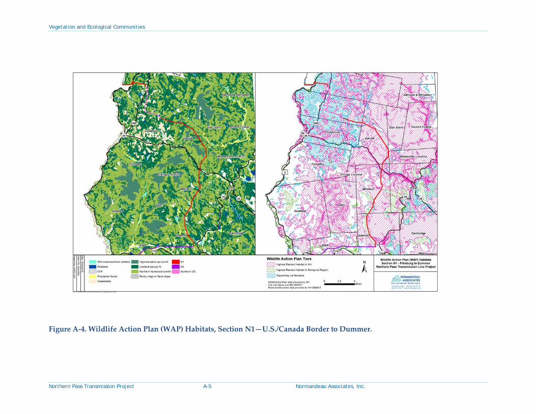
The proposed transmission line ROW in this area occurs within an area that is currently mostly forested. This project section extends from Halls Stream at the U.S./Canada Border to the eastern edge of the existing Eversource transmission line ROW in Dummer (Figure A-1). Elevations range from approximately 1,100 feet above mean sea level (msl) in the vicinity of Halls Stream and by the Connecticut River in Pittsburg and Clarksville to 2,985 feet above msl where the proposed Project crosses the summit of Sugar Hill in Stewartstown. This northernmost section of the Project area falls within the Connecticut Lakes and Mahoosic-Rangely Lakes ecoregion subsections (Figure A-2). The terrain is generally mountainous with large river valleys. Many rivers and streams are found in this portion of the Project, including high-gradient channel systems associated with mountainous areas, and moderate- and low-gradient channel systems associated with lower hills and broad valleys. Glacial till is abundant in surface deposits while calcium-rich bedrock (mafic and carbonate-bearing bedrock types) underlies much of the Project area in this section, especially from Dixville to the U.S. border (Figure A-3). Upon weathering, these rocks (or glacial till derived from them) can yield higher than average soil calcium levels and soil fertility, referred to as “rich” sites. A variety of other site conditions also affect soil fertility, resulting in uneven distribution of rich site conditions.
This sparsely developed and sparely populated cold climate region of the state has natural communities similar to those found in the boreal forest region of Canada. The dominant community types in this area are northern hardwood-conifer forests and lowland spruce-fir forests (Table 1, Figure A-4). High elevation spruce-fir forest is found on upper mountain slopes and ridgetops in the vicinity of the Project in Dixville and in Stewartstown near Sugar Hill. Seepage forests occur on lower mountain slopes. Northern white cedar-balsam fir swamps and rich mesic forests are relatively common in this region and reflect the influence of calcium-bearing bedrock and its influence on soil conditions and plant nutrition. Rare plant species in this area are mostly associated with rich woods, swamps, and fens, including northern white cedar swamps. Forest communities in the vicinity of this section have been strongly impacted by historic and on-going timber harvesting, which has affected forest structure, age and size classes of trees, and species composition.

Vegetation and Ecological Communities
Northern Pass Transmission Project 3-3 Normandeau Associates, Inc.
3.1.2 Vegetation within the Project Area
Much of the proposed Project area between the U.S. border and Dummer occurs within a remote forested area that is actively logged. In addition to logging roads, a network of all-terrain vehicle and snowmobile trails traverses this area. Approximately 8 miles of the proposed Project occurs along existing public roads in Clarksville and Stewartstown, where the transmission line is proposed to be installed underground. The transmission line will also be installed underground beneath the Connecticut River in Clarksville/Pittsburg.
Many pole-sized trees (5- to 11-inch diameter at breast height [dbh]), small sawtimber trees (12- to 18-inch dbh), and piles of slash are found in the forested areas managed for timber. A small number of larger-sized trees (>20-inch dbh) are scattered within these areas. Some intact forest patches also occur with larger-sized trees and a sparse shrub layer. Common tree species in upland areas include balsam fir (Abies balsamea), yellow birch (Betula alleghaniensis), sugar maple (Acer saccharum), red spruce (Picea rubens), and paper and heartleaf birch (Betula papyrifera and B. cordifolia) with eastern hemlock (Tsuga canadensis), American beech (Fagus grandifolia), red maple (Acer rubrum), northern white cedar (Thuja occidentalis), gray birch (Betula populifolia), quaking aspen (Populus tremuloides), white spruce (Picea glauca), and pin cherry (Prunus pensylvanica) present at some locations. Shrub and sapling species include hobblebush (Viburnum lantanoides), striped maple (Acer pensylvanicum), mountain maple (Acer spicatum), red elderberry (Sambucus racemosa), Canada honeysuckle (Lonicera canadensis), and mountain-ash (Sorbus decora). Red raspberry (Rubus idaeus), highbush blackberry (Rubus allegheniensis), and seedlings of balsam fir tend to abound in recently cut areas. Common groundcover species include bluebead lily (Clintonia borealis), mountain wood fern (Dryopteris campyloptera), evergreen woodfern (Dryopteris intermedia), whorled aster (Oclemena acuminata), narrow beech fern (Phegopteris connectilis), red and painted trillium (Trillium erectum and T. undulatum), tall rattlesnake-root (Nabalus altissimus), spring-beauty (Claytonia caroliniana), trout-lily (Erythronium americanum), bunchberry (Chamaepericlymenum canadense), rose-twisted stalk (Streptopus lanceolatus), false Solomon’s seal (Maianthemum racemosum), Canada mayflower (Maianthemum canadense), shining furmoss (Huperzia lucidula), bracken (Pteridium aquilinum ssp. latiusculum), and hay-scented fern (Dennstaedtia punctilobula).
In addition, the following species indicative of rich or semi-rich conditions are found at some locations within this section of the Project due to the prevalence of calcium-rich bedrock: blue cohosh (Caulophyllum thalictroides), foam-flower (Tiarella cordifolia), white and red baneberry (Actaea pachypoda and A. rubra), white snakeroot (Ageratina altissima), Christmas fern (Polystichum acrostichoides), Braun’s holly fern (Polystichum braunii), silvery false spleenwort (Deparia acrostichoides), zig-zag goldenrod (Solidago flexicaulis), Dutchman’s-breeches (Dicentra cucullaria), sweet-cicely (Osmorhiza claytonii), rattlesnake fern (Botrychium virginianum), Maryland sanicle (Sanicula marilandica), and maidenhair fern (Adiantum pedatum).
Common species in forested wetlands include red maple, yellow birch, balsam fir, red spruce, gray birch, balsam poplar (Populus balsamifera), and larch (Larix laricina), with some areas containing sugar maple, black ash (Fraxinus nigra), eastern hemlock, black spruce (Picea mariana), and northern white cedar. Other species occurring in wetlands (forested, scrub shrub,
Vegetation and Ecological Communities
Northern Pass Transmission Project 3-4 Normandeau Associates, Inc.
or emergent) include speckled alder (Alnus incana ssp. rugosa), hobblebush, red osier dogwood (Swida sericea), highbush cranberry (Viburnum opulus), sensitive fern (Onoclea sensibilis), evergreen woodfern, dwarf raspberry (Rubus pubescens), tall meadow-rue (Thalictrum pubescens), jewelweed (Impatiens capensis), nodding sedge (Carex gynandra), sallow sedge (Carex lurida), three-seeded sedge (Carex trisperma), bluejoint (Calamagrostis canadensis), false hellebore (Veratrum viride), spotted Joe-pye weed (Eutrochium maculatum), rattlesnake, northeastern and fowl manna grasses (Glyceria canadensis, G. melicaria, and G. striata), bulrushes (Scirpus spp.), goldenrods (Solidago spp.), cow-parsnip (Heracleum maximum), flat-topped white aster (Doellingeria umbellata), arrow-leaved tearthumb (Persicaria sagittata), common cattail (Typha latifolia), virgin’s-bower (Clematis virginiana), New York fern (Parathelypteris noveboracensis), Canada wood nettle (Laportea canadensis), Jack-in-the-pulpit (Arisaema triphyllum), bedstraw (Galium spp.), eastern rough sedge (Carex scabrata), golden-saxifrage (Chrysosplenium americanum), sphagnum moss (Sphagnum spp.), ostrich fern (Matteuccia struthiopteris), lady fern (Athyrium angustum), turtlehead (Chelone glabra), creeping snowberry (Gaultheria hispidula), and dwarf enchanter’s nightshade (Circaea alpina).
Proposed access routes located outside of the Project ROW consist primarily of existing dirt logging roads, and all-terrain vehicle (ATV) or snowmobile trails. The logging roads are largely devoid of vegetation except along the road shoulders. Vegetation in the vicinity of these access routes generally includes species typical of open disturbed areas such as red raspberry, strawberry (Fragaria sp.), fireweed (Chamerion angustifolium), and field cinquefoil (Potentilla simplex). Many introduced species occur in these areas including coltsfoot (Tussilago farfara), common dandelion (Taraxacum officinale) common plantain (Plantago major), common tansy (Tanacetum vulgare), orange hawkweed (Hieracium aurantiacum) and yellow clover (Trifolium aureum).
Ten plant species with state-level special status were observed in this section of the Project: Goldie’s fern (Dryopteris goldiana), Canada violet (Viola canadensis), pale jewelweed (Impatiens pallida), northern wild licorice (Galium kamtschaticum), wild leek (Allium tricoccum var. tricoccum), squirrel corn (Dicentra canadensis), millet grass (Milium effusum), dwarf scouring-rush (Equisetum scirpoides), and white-tinged sedge (Carex albicans var. albicans), which are state watch; and swamp buttercup (Ranunculus caricetorum), which is state indeterminate. Goldie’s fern, Canada violet, pale jewelweed, northern wild licorice, wild leek, millet grass, squirrel corn, and dwarf scouring-rush are normally found in forested habitats, while swamp buttercup and white-tinged sedge occur in both open and wooded areas. Also occurring in this segment of the Project area are an exemplary Moderate-gradient sandy-cobbly riverbank system, and six rare natural community types: Northern hardwood seepage forest, Rich mesic forest, Northern white cedar – balsam fir swamp, Lowland spruce-fir forest, Northern hardwood – black ash conifer swamp, and Boulder-cobble river channel. One Northern hardwood seepage forest and the three Northern white cedar – balsam fir swamps are potentially exemplary. Seven state watch species were observed within the potentially exemplary Northern hardwood seepage forest community. Further discussion of special-status plants and exemplary natural communities can be found in the Rare, Threatened, and Endangered Plants and Exemplary Natural Communities report prepared by Normandeau and dated October 2015.


Vegetation and Ecological Communities
Northern Pass Transmission Project 3-8 Normandeau Associates, Inc.
asters (Symphyotrichum spp. and Doellingeria umbellata), marsh fern (Thelypteris palustris var. pubescens), sensitive fern, interrupted fern (Osmunda claytoniana), cinnamon fern (Osmunda cinnamomea), ostrich fern, New York fern, common cattail, sallow sedge, common fox sedge (Carex vulpinoides), awl-fruited sedge (Carex stipata), woolly-fruited sedge (Carex lasiocarpa), eastern rough sedge, tussuck sedge (Carex stricta), prickly sedge (Carex echinata), bottle-shaped sedge (Carex utriculata), lesser purple-fringed bog orchid (Platanthera psycodes), arrow-leaf tearthumb, jewelweed, swamp candles (Lysimachia terrestris), fowl mannagrass, bluejoint, water pennywort (Hydrocotyle americana), nodding ladies’-tresses (Spiranthes cernua), creeping bentgrass (Agrostis stolonifera), water avens (Geum rivale), blueflag iris (Iris versicolor), and narrow-leaved gentian (Gentiana linearis).
Narrowleaf sedge was the only rare plant species observed in this section of the Project. Invasive plants were infrequently encountered and included reed canary grass, glossy buckthorn (Frangula alnus), forget-me-not, and purple loosestrife (Lythrum salicaria).
3.3 Whitefield Substation to Transition Station 5 in Bethlehem (Section C1)
3.3.1 Vegetation in the Project Vicinity
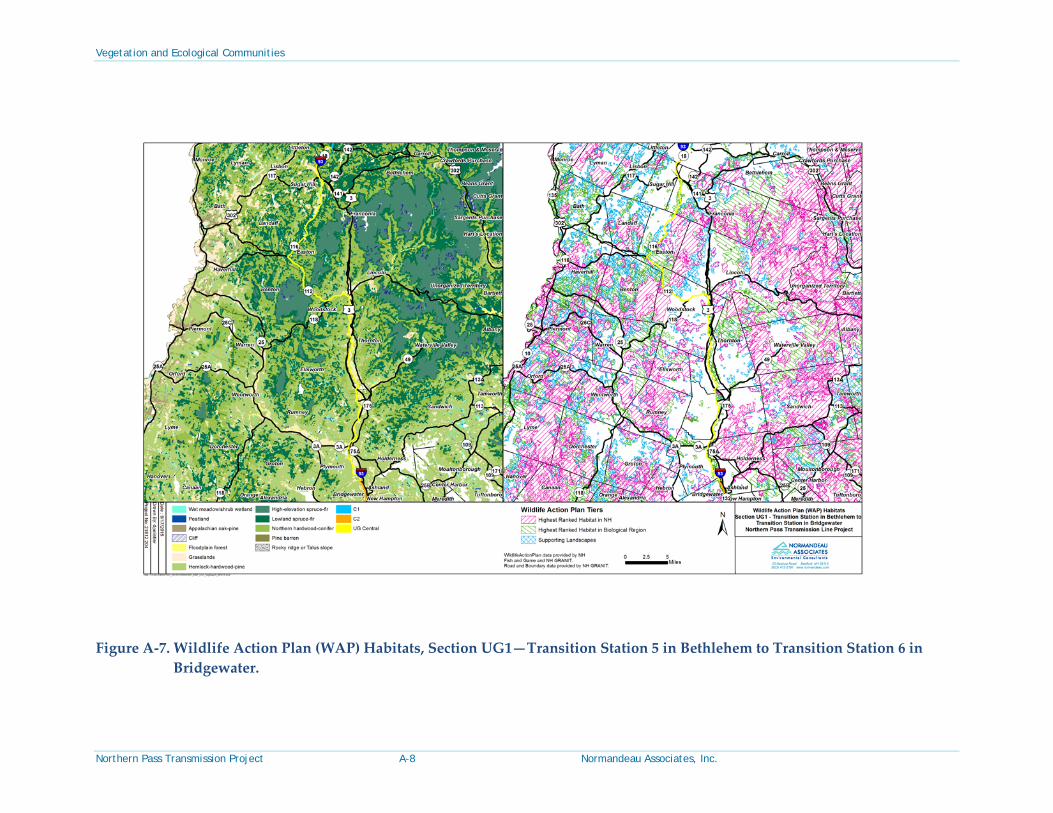
The Whitefield Substation to Bethlehem Transition Station section of the Project occurs within two ecoregion subsections: Mahoosic-Rangely Lakes and Vermont Piedmont (Figure A-2). These are mountainous, cold-climate regions with higher mountains occurring in the Mahoosic-Rangely Lakes subsection, with the two subsections receiving about equal amounts of precipitation (Table B-2). Many rivers and streams are located in the vicinity of the Project area in this section, including the Ammonoosuc River, Baker Brook, Black Brook, and Chase Brook. Elevations range from 860 feet above msl, by an unnamed stream in Dalton, to 1,300 feet above msl in Whitefield and Bethleham along the upper slopes of an unnamed hill. Northern species with centers of distribution in boreal Canada and adjacent portions of the United States predominate, including balsam fir, red spruce, paper birch, and heartleaf birch. Sugar maple and American beech, which have more temperate distributions centered in eastern North America, are also common. Northern hardwood-conifer forests and lowland spruce-fir forests are matrix communities in most of this area (Table 3, Figure A-6). Patch communities include floodplain forests (along the Ammonoosuc River in Bethlehem), wet meadow and shrub wetlands, swamps, a number of small peatlands, and hemlock-hardwood-pine forest systems.
This segment of the Project area does not cross any mapped areas of calcium-rich bedrock, although areas with calcium-rich bedrock are somewhat common elsewhere within the Vermont Piedmont ecoregion subsection (Figure A-3). Many rare plants in the Mahoosic-Rangely Lakes and Vermont Piedmont subsections are associated with calcium-rich cliff, talus slope, swamp, fen, or aquatic natural communities and habitats. Exemplary natural communities occurring in nearby areas include a Northern white cedar balsam fir swamp and a Northern white cedar seepage forest (both in Whitefield).


Vegetation and Ecological Communities
Northern Pass Transmission Project 3-16 Normandeau Associates, Inc.
Wetland species observed within this segment include speckled alder, red maple, gray birch, meadowsweet, winterberry (Ilex verticillata), crested wood fern, cinnamon fern, interrupted fern, sensitive fern, northern lady fern, Robbins’ ragwort, dark green bulrush (Scirpus atrovirens), and common cattail. Invasive plant species occurring within this section of the Project include glossy buckthorn, reed canary grass, autumn olive (Elaeagnus umbellata), and honeysuckles (Lonicera spp.). No state threatened, endangered, watch, or indeterminate plant species or exemplary natural communities were observed within this segment of the Project area.
3.6 Franklin Converter Terminal to Deerfield Substation (Section S1)
3.6.1 Vegetation in the Project Vicinity
The climate continues to be moderate on this section of corridor compared to sections farther north. South of Franklin, the Project enters the Merrimack River valley, part of the Gulf of Maine Coastal Plain subsection (Figure A-2), crossing extensive sand plains in the Concord vicinity, then climbs across low hills comprised of glacial till to Deerfield. Elevations range from 260 feet above msl along the Merrimack River to 340 feet above msl across much of the Merrimack River sand plain centered around Concord, with hills ranging between 400 and 800 feet between Pembroke and Deerfield.
The warmer climate in this region, in combination with frequent historical fires associated with the Merrimack River valley sand plain, has demonstrative effects on the vegetation. Numerous species, absent farther north, are present in this area including pitch pine (Pinus rigida), scrub oak (Quercus ilicifolia), black oak (Quercus velutina), white oak (Quercus alba), shagbark hickory (Carya ovata), and many others. These species have geographic distributions centered farther south in the Appalachian Mountain or coastal plain regions, reaching their northern extent in southern New Hampshire or adjacent southern Maine.
Hemlock-hardwood-pine forest is the dominant matrix forest type (Table 6, Figure A-9) on glacial till uplands and sand plains with no fire history. Various types of Appalachian oak and pine forests occur as small to large patches on low elevation sand plains and on warm, south-facing hillsides. Pitch pine-scrub oak woodlands dominate the sand plains of the Merrimack River, although development and fire suppression has initiated a progressive shift to compositions with more fire-intolerant species such as white pine, birches, and red maple.
Swamps, marshes, and small peatlands are occasional on the sand plains, but more abundant on the bedrock-controlled terrain eastward (from Pembroke to Deerfield). Rocky ridges, cliffs, and talus slopes are rare along this section of corridor. Peatlands are occasional. Floodplain forests occur along the Merrimack River between Franklin and Concord, along the Soucook River by the Concord/Pembroke border, by the Suncook River in Allenstown, and in association with Back Creek and Bean River near the Deerfield Substation (Figure A-9).
Calcium-rich bedrock (calc-silicates) is present in the Concord and Allenstown vicinity (Figure A-3). Much of this rock is buried deep beneath outwash deposits and has no influence on surface soils and plant communities. Historical botanical records in these towns contain a paucity of rare plants indicative of rich, fertile soils along this section of the Project area. Rare


Vegetation and Ecological Communities
Northern Pass Transmission Project 4-1 Normandeau Associates, Inc.
4 Summary The Project area between the U.S. border with Canada and the Scobie Pond Substation in Londonderry traverses a broad diversity of the state’s physical features and natural vegetation. Differences in climate, bedrock geology, surface geology, soil texture and fertility levels, topography, historical wildfire, land use history, and numerous other factors significantly affect the distribution of plants and natural communities.
Forests cover approximately 80% of the state; the remainder comprises a diverse mosaic of smaller woodlands, wetlands, riparian areas, fields, and human development. Spruce-fir and northern hardwood forests dominate in the White Mountains and northward; mixes of hardwoods, hemlock, and white pine dominate in central areas; and pitch pine and oaks appear in forests in the southern section where they are locally abundant on the extensive sand plains of the Merrimack River valley.
The pattern illustrated by this shift in tree composition from north to south is mirrored by similar changes among shrubs and herbaceous species. Similar changes occur within other groups of natural communities, such as peatlands and swamps, from north to south. Natural community types also shift within each section with local changes in topography, bedrock type, and soil conditions.
Other coarse-scale patterns are evident across the Project area. Peatlands are large and common in the cold climate and flat terrain north of the White Mountains and generally smaller and less frequent to the south of the mountains. Marshes, shrub thickets, and forested swamps occur throughout. Rocky ground, cliffs, rocky ridges, and talus slopes occur infrequently and occupy a small proportion of the landscape in the immediate vicinity of the Project. Floodplain forests occur along the major rivers. Most of the rare species in natural communities occur in wetlands, aquatic habitats, nutrient-rich forests, or pine barrens.
The maintenance regime in the existing Eversource ROW and other activities that occur along the transmission corridor, including mowing or cutting as well as recreational activities that produce wheel tracks, produces an environment that favors species tolerant of or reliant on disturbance, open canopy, and sunny conditions. This is also true for Project areas occurring within road ROWs. Many native early successional forest trees, upland shrubs, and marsh shrubs and herbs occur in these settings within the Project area. The vegetation assemblages are least similar to natural communities in areas that would otherwise be forested; vegetation assemblages are most similar to corresponding natural communities in portions of the Project where trees are naturally low in abundance, such as in open wetlands.
The vast majority of vegetation in the Project area consists of native species or non-invasive, non-native species (such as common pasture grasses). Native species predominate in the northern section of the Project that is currently forested. Non-native, invasive species are generally present at low frequencies, especially in the northern portion of the Project; they are most frequent and abundant near roads in developed areas and agricultural fields. Most of the

Vegetation and Ecological Communities
Northern Pass Transmission Project 4-2 Normandeau Associates, Inc.
documented rare plant species within the existing transmission line ROW are dependent on open (non-forested) conditions that are partially or entirely maintained by the maintenance regime, disturbance associated with recreational activities, or both. Much of the northern section of the Project has been intensively logged, although it does include some areas of intact forest that has not been disturbed in recent decades. Most of the rare plant species observed in the forested portions of the Project area are strongly associated with forested habitats and would unlikely be found in habitats with an open tree canopy.

Vegetation and Ecological Communities
Northern Pass Transmission Project 5-1 Normandeau Associates, Inc.
5 Bibliography Keys, J. E. Jr., C. A. Carpenter, S. L. Hooks, F. G. Koenig, W. H. McNab, W. E. Russell, and M. L.
Smith. 1995. Ecological Units of the Eastern United States: First Approximation. USDA Forest Service. Accessed 10/29/13. Available from: http://www.srs.fs.usda.gov/econ/data/keys/index.htm.
NHWAP. 2010. Wildlife Action Plan. New Hampshire Fish and Game Department. Concord, New Hampshire. 2010 habitat map revisions of original 2005 maps.
Sperduto, D., and B. Kimball. 2011. The Nature of New Hampshire: Natural Communities of the Granite State. University of New Hampshire Press, Durham, NH and University Press of New England, Lebanon, NH.
Sperduto, D. D., and W. F. Nichols. 2011. Natural communities of New Hampshire. New Hampshire Natural Heritage Bureau, Department of Resources and Economic Development. Concord, NH. UNH Cooperative Extension.
Sperduto, D. D. 2005. Natural community systems of New Hampshire. New Hampshire Natural Heritage Bureau, Department of Resources and Economic Development. Concord, NH.
Vegetation and Ecological Communities
Northern Pass Transmission Project 6-1 Normandeau Associates, Inc.
6 Appendices

Vegetation and Ecological Communities
Northern Pass Transmission Project A-1 Normandeau Associates, Inc.
Appendix A. Figures
Vegetation and Ecological Communities
Northern Pass Transmission Project A-2 Normandeau Associates, Inc.
Figure A-1. Northern Pass Transmission Line Overview.

Vegetation and Ecological Communities
Northern Pass Transmission Project A-3 Normandeau Associates, Inc.
Figure A-2. Ecoregion map.

Vegetation and Ecological Communities
Northern Pass Transmission Project A-4 Normandeau Associates, Inc.
Figure A-3. Calcium-rich Bedrock map.
Vegetation and Ecological Communities
Northern Pass Transmission Project A-5 Normandeau Associates, Inc.
Figure A-4. Wildlife Action Plan (WAP) Habitats, Section N1—U.S./Canada Border to Dummer.

Vegetation and Ecological Communities
Northern Pass Transmission Project A-6 Normandeau Associates, Inc.
Figure A-5. Wildlife Action Plan (WAP) Habitats, Section N2—Dummer to Whitefield Substation.

Vegetation and Ecological Communities
Northern Pass Transmission Project A-7 Normandeau Associates, Inc.
Figure A-6. Wildlife Action Plan (WAP) Habitats, Section C1—Whitefield Substation to Transition Station 5 in Bethlehem.
Vegetation and Ecological Communities
Northern Pass Transmission Project A-8 Normandeau Associates, Inc.
Figure A-7. Wildlife Action Plan (WAP) Habitats, Section UG1—Transition Station 5 in Bethlehem to Transition Station 6 in Bridgewater.

Vegetation and Ecological Communities
Northern Pass Transmission Project A-9 Normandeau Associates, Inc.
Figure A-8. Wildlife Action Plan (WAP) Habitats, Section C2—Transition Station 6 in Bridgewater to Franklin Converter Terminal.

Vegetation and Ecological Communities
Northern Pass Transmission Project A-10 Normandeau Associates, Inc.
Figure A-9. Wildlife Action Plan (WAP) Habitats, Section S1—Franklin Converter Terminal to Deerfield Substation.

Vegetation and Ecological Communities
Northern Pass Transmission Project A-11 Normandeau Associates, Inc.
Figure A-10. Wildlife Action Plan (WAP) Habitats, Deerfield Substation to Scobie Pond Substation.

Vegetation and Ecological Communities
Northern Pass Transmission Project B-2 Normandeau Associates, Inc.
Domain: Humid Temperate Domain: Located in the middle latitudes (30 to 60 degrees N). Climate is influenced by both tropical and polar air masses. Areas have pronounced seasons, with strong annual cycles of temperature and precipitation. Contains forests of broadleaf deciduous and needleleaf evergreen trees.
Divisions: Warm Continental Division: Located south of the eastern area of the subarctic climate, in the region between lat. 40 and 55 N. and from the continental interior to the east coast. Located between the source regions of polar continental air masses to the north and maritime or continental tropical air masses to the south, it is subject to strong seasonal contrasts in temperature. Precipitation is ample all year, but is substantially greater during the summer. This area has cold snowy winters and warm summers. The average temperature during the coldest month is below 32F. The average temperature during the hottest month never exceeds 72F. Includes needleleaf and mixed needleleaf-deciduous forest which grows throughout the colder northern parts, extending into the mountain regions of the Adirondacks and northern New England. Here soils are Spodosols with a low supply of bases and a horizon in which organic matter, iron, and aluminum have accumulated. They are strongly leached, but have an upper layer of humus. Cool temperatures inhibit bacterial activity that would destroy this organic matter in tropical regions. Soils are deficient in calcium, potassium, and magnesium, and are generally acid. Thus, they are poorly suited to crop production, even though adequate rainfall is generally assured; but conifers thrive in them.
Hot Continental Division: Characterized by hot summers and cool winters. The boundary between this division and the one above is the isotherm of 72F (22C) for the warmest month. In the warmer sections of the Hot Continental Division, the frost-free or growing season continues for 5 to 6 months, in the colder sections only 3 to 5 months. Snow cover is deeper and lasts longer in the northerly areas. Vegetation is winter deciduous forest, dominated by tall broadleaf trees that provide a continuous dense canopy in summer, but shed their leaves completely in winter. Lower layers of small trees and shrubs are weakly developed. In spring, a luxuriant ground cover of herbs quickly develops, but is greatly reduced after trees reach full foliage and shade the ground. Soils are chiefly Inceptisols, Ultisols, and Alfisols, rich in humus and moderately leached, with a distinct light-colored leached zone under the dark upper layer. The Ultisols have a low supply of bases and a horizon in which clay has accumulated. Where topography is favorable, diversified farming and dairying are the most successful agricultural practices.
Provinces: Adirondack-New England Mixed Forest-Coniferous Forest-Alpine Meadow: Has a modified continental climatic regime with long, cold winters and warm summers. Annual precipitation evenly distributed. Landscape is mountainous and was previously glaciated. Forest vegetation is a transition between boreal on the north and broadleaf deciduous to the south.

Vegetation and Ecological Communities
Northern Pass Transmission Project B-3 Normandeau Associates, Inc.
Eastern Broadleaf Forest: This province has a continental-type climate of cold winters and warm summers. Annual precipitation is greater during summer, water deficits infrequent. Topography is variable, ranging from plains to low hills of low relief along Atlantic coast. Interior areas are high hills to semi-mountainous, parts of which were glaciated. Vegetation is characterized by tall, cold-deciduous broadleaf forests that have a high proportion of mesophytic species.
Sections: White Mountains: has a maturely dissected, irregular highland characterized by clusters of low, rounded mountains and scattered monadnocks with many glacial features. Rock formations include sedimentary quartzite, slate, and schist with extensive area of igneous rocks including granites, diorite, gabbro, and basalt. Forest vegetation consists of spruce-fir, maple-beech-birch, and aspen-birch cover types.
New England Piedmont: This section is a maturely dissected peneplain with open, low mountains and monadnocks. Rocks are mainly quartzite, slate, and schist with large areas of gneiss metamorphics and a belt of volcanics. Forest vegetation consists of maple-beech-birch and aspen-birch cover types.
Lower New England Section: The landscape is a combination of broad, hilly plateaus with features including a basin, plain, and ridge. Bedrock geology is varied and complex, consisting of sedimentary, igneous, and metamorphic rocks. Forest vegetation includes oak-hickory, white-red-jack pine, maple-beech-birch, and aspen-birch cover types.
Subsections: Connecticut Lakes: low mountains (1,000–4,000 feet); Wis. sandy loam till; sand gravel deposits, bedrock: Dev. sandstone; Precam. Gneiss; soil taxa: Haplorthods, Borohemists, Epiaquents; Frigid-Cryic, udic, aquic; average precipitation: 41 inches; temperature: 39F; growing season: 107 days; potential vegetation: red spruce-balsam fir, sugar maple-birch-beech forests, alpine communities, calcareous fens; surface water: common lakes and ponds, few rivers and streams, few wetlands; human uses: forestry agriculture, recreation.
Mahoosic-Rangely Lakes: high mountains (1,200–1,400 feet); Wis. Sandy loam till, outwash sand-gravel, bedrock: Devonian granite-grandiorite; soil taxa: Haplorthods, Cryorthods, Borofolist; Frigid-Cryic, udic-aquic; average precipitation: 38 inches; temperature: 40F; growing season: 115 days; potential vegetation: red spruce-balsam fir, sugar maple-birch-beech forests, alpine communities; surface water: common lakes and ponds, common river and streams, few large wetlands; human uses: forestry, recreation.
White Mountains: high mountains (1,000–6,000 feet); Wis. Sandy till, outwash sand-gravel, bedrock: Paleozoic granite-tonalite-pelite; soil taxa: Haplorthods, Borofolists, Cryorthods, Epiaquents; Frigid-Cryic, udic-aquic; average precipitation: 47 inches; temperature: 41F; growing season: 116 days; potential vegetation: red-spruce- balsam fir, sugar maple-birch-beech

Vegetation and Ecological Communities
Northern Pass Transmission Project B-4 Normandeau Associates, Inc.
forests, alpine communities; surface water: common rivers and streams, few lakes and ponds, few wetlands; human uses: forestry, recreation, development.
Vermont Piedmont: open low mountains (500–2,500 feet); L. Wis. sandy loamy till; Paleozoic meta-sedimentary-limestone-intrusives, Proterozoic gneiss-amphibolite; soil taxa: Haplorthod, Fragiorthod, Humaquept, Haplaquept, Dystrochrept; Frigid, udic; average precipitation: 39 inches; temperature 42F; growing season: 114 days; potential vegetation: sugar maple-birch-beech, n. red oak-hardwood mesic forests, red spruce-balsam fir forest, n. white cedar limestone woodlands; surface water: streams, small-medium rivers-small lakes common, few large wetlands; human uses: agriculture, forestry, quarrying, recreation.
Sunapee Uplands: low mountains (50–1,600 feet); Wis. Sandy loam till, outwash sand-gravel, bedrock: Devonian metasedimentary rocks; soil taxa: Dystrochrepts, Haplorthods, Borohemists; Frigid, mesic, udic; average precipitation: 42 inches; temperature: 44 F; growing season: 121 days; potential vegetation: sugar maple-birch-beech forest, n. red oak hardwood mesic forest, red spruce-balsam fir forest; surface water: common ponds, lakes, and streams; human uses: forestry, agriculture, recreation.
Sebago-Ossipee Hills and Plains: glaciated high hills-open low mtns (100–2,200 feet); Wis. Sandy till; outwash sand-gravel; Paleozoic intrusive granite-gneiss-schist; soil taxa: Haplorthods, Dystrochrepts, Haplaquepts; Frigid, udic; average precipitation: 43 inches; temperature: 45F; growing season: 128 days; potential vegetation: hemlock-white pine-oak-sugar maple-birch-beech forest, red maple-red spruce swamp; surface water: large lake-wetland complexes; many streams; human uses: forest, residential, agriculture.
Gulf of Maine Coastal Plain: glaciated plain-hills (100–1,400 feet); Wis. Sandy till; sand-gravel-silt in valleys Paleozoic intrusives, schist-granite-gneiss; soil taxa: Dystrochrepts, Udorthents, Udipsamments; Mesic, udic; average precipitation: 44 inches; temperature: 48 F; growing season: 156 days; potential vegetation: hemlock-white pine-oak, sugar maple-birch-beech, red oak-hardwood mesic forests; surface water: many small lakes, reservoirs, streams; human uses: forest, agriculture, residential.

Vegetation and Ecological Communities
Northern Pass Transmission Project C-1 Normandeau Associates, Inc.
Appendix C. Global and State Rank Codes Ranks describe rarity both throughout a species’ range (globally, or “G” rank) and within New Hampshire (statewide, or “S” rank). The rarity of sub-species and varieties is indicated with a taxon (“T”) rank. For example, a G5T1 rank shows that the species is globally secure (G5) but the sub-species is critically imperiled (T1).
Code Examples Description
1 G1 S1 Critically imperiled because extreme rarity (generally one to five occurrences) or some factor of its biology makes it particularly vulnerable to extinction.
2 G2 S2 Imperiled because rarity (generally six to 20 occurrences) or other factors demonstrably make it very vulnerable to extinction.
3 G3 S3 Either very rare and local throughout its range (generally 21 to 100 occurrences), or found locally (even abundantly at some of its locations) in a restricted range, or vulnerable to extinction because of other factors.
4 G4 S4 Widespread and apparently secure, although the species may be quite rare in parts of its range, especially at the periphery.
5 G5 S5 Demonstrably widespread and secure, although the species may be quite rare in parts of its range, particularly at the periphery.
U GU SU Status uncertain, but possibly in peril. More information needed. H GH SH Known only from historical records, but may be rediscovered. A G5 SH species is
widespread throughout its range (G5), but considered historical in New Hampshire (SH).
X GX SX Believed to be extinct. May be rediscovered, but evidence indicates that this is less likely than for historical species. A G5 SX species is widespread throughout its range (G5), but extirpated from New Hampshire (SX).
Modifiers are used as follows.
Code Examples Description
Q G5Q GHQ Questions or problems may exist with the species’ or sub-species’ taxonomy, so more information is needed.
? G3? 3? The rank is uncertain due to insufficient information at the state or global level, so more inventories are needed. When no rank has been proposed the global rank may be “G?” or “G5T?”
When ranks are somewhat uncertain or the species’ status appears to fall between two ranks, the ranks may be combined. For example:
G4G5 The species may be globally secure (G5), but appears to be at some risk (G4). G5T2T3 The species is globally secure (G5), but the sub-species is somewhat imperiled (T2T3). G4?Q The species appears to be relatively secure (G4), but more information is needed to
confirm this (?). Further, there are questions or problems with the species’ taxonomy (Q).
G3G4Q S1S2 The species is globally uncommon (G3G4), and there are questions about its taxonomy (Q). In New Hampshire, the species is very imperiled (S1S2).