Embed Size (px)
Citation preview

T: +44 (0)28 9038 8462F: +44 (0)28 9038 8461E: [email protected]
www.bgs.ac.uk/gsni
_Slieve Binnian, Mourne Mountains, Co. Down
NorthernIreland
ProspectivityThe potential of Northern Ireland has become apparent in recent years and large areas of prospective terrain remain under-explored and unlicensed. Geological models are being used to re-evaluate areas previously considered less prospective. Although Northern Ireland is one of the smallest countries in Europe, it has a mineral potential to rival any of its near neighbours.
Government, administration and cultureNorthern Ireland is part of the United Kingdom, operating in the same time zone and sharing a similar regulatory environment and culture. Many aspects of government have been devolved to the power sharing Northern Ireland Executive with the advantage of local streamlined administrative procedures. Northern Ireland has a strong pro-business ethos with regulation kept to a minimum and a well established minerals licensing system in operation. The Executive has put sustainable development at the heart of their growth strategy and recognises the benefits that responsible development of its indigenous mineral resources can bring to Northern Ireland’s economy.
Competitive costs, financial assistance and supportNorthern Ireland’s operating costs are highly competitive and lower than the rest of the UK and much of Europe. Invest NI can provide advice on the attractive and competitive package of financial incentives, training, R&D, and other development support available to companies operating in Northern Ireland. www.investni.com/invest
Smart talent and skillsNorthern Ireland has a highly educated and skilled English speaking workforce to complement
the pool of experienced minerals and mining geologists who have worked on the major minerals discoveries in Ireland. Universities throughout Ireland are highly regarded and have a strong track record in producing top quality graduates and research.
Infrastructure and communicationsNorthern Ireland is readily accessible from Europe, North America and other parts of the world. Its airports have daily direct flights to London and many other European business centres, with onward flights to worldwide destinations via these and Dublin airport. London is only an hour away by air and Dublin is less than two hours away by rail or road. Northern Ireland is also served by four deep-water ports ensuring ease of access to international markets.
Northern Ireland has a well developed telecommunications network with 100% broadband access throughout. A new high speed 40Gbit/sec transatlantic and terrestrial telecommunications link between Northern Ireland, North America and Europe will provide secure reliable and competitive next generation services.
Exploration logisticsNorthern Ireland enjoys a mild temperate climate which allows active exploration all year round. The country is compact, approximately 5500 sq. miles/14,000 km2 in area and 90 miles wide by 110 miles long (140km by 175km), and you can drive from Belfast to anywhere in Northern Ireland within two hours. The population of 1.7 million is concentrated in Belfast and the eastern counties but even the more sparsely populated west is well served by the extensive network of minor roads.
An ideal place to exploreNorthern Ireland offers great opportunities for mineral exploration. It combines all the convenience of working in a developed country with a tremendously diverse geological, mineral and mining heritage.
_Harland and Wolff shipyard_Crown Bar_Belfast City
_Carlingford Lough_Mussenden Temple
_Giant’s Causeway

T: +44 (0)28 9038 8462F: +44 (0)28 9038 8461E: [email protected]
www.bgs.ac.uk/gsni
_Glenariff, Co. Antrim
Legislation
The Mineral Development Act (Northern Ireland) 1969 vested most minerals in Northern Ireland in the Department of Enterprise, Trade and Investment (DETI) and enables it to grant prospecting and mining licences for the exploration and development of Northern Ireland’s mineral resources. Gold and silver remain vested in the Crown and it is common for companies to apply simultaneously to the Crown Mineral Agent (CMA) and DETI so that two licences covering most minerals in an area can run concurrently.
Mineral Prospecting LicencesProspecting Licences are typically granted for an initial period of two years and may be renewed for two further periods of two years. Licensees must complete a scheme of prospecting agreed in advance with DETI (and the CMA, if applicable). Expenditure levels are also agreed before the start of the licence and DETI must be satisfied that the work has been completed before a renewal is granted. The licence expires at the end of the six-year period and further exploration requires the submission of an application for a new licence.
Licensees are required to submit annual work reports and expenditure accounts. The Mineral Development Act allows licensees to require that these be kept confidential for up to ten years after their submission. The licence granted gives the licensee exclusive rights to prospect an area up to 250km2 including right of entry onto lands, however, the agreement of the landowner should be sought. In processing any application, DETI consults other stakeholders in the area and the final licence document may include conditions to protect environmentally sensitive areas or to inform stakeholders of developments.
The application process normally takes about four months to complete once the applicant has provided all relevant information. Mineral prospecting licences cost £450 plus any related advertising costs. Any company interested in exploring in Northern Ireland is encouraged to contact DETI and the GSNI as well as the
CMA (if applicable) to discuss the licensing regimes, prospectivity of particular areas and the availability of existing exploration data.
Mining Licences and LeasesIf a company wishes to develop a deposit, it must apply for a mining licence and provide DETI with a detailed development plan to allow a proper assessment to be made. The company will also have to apply for planning permission from the Department of the Environment (DOE) through the Planning Service. On receipt of Planning Approval from the DOE, DETI may issue a mining licence although each application will be treated on its merits and will be subject to a consultation process. The current mining licence application fee is £2000 and, under the 1969 Act, compensation is payable to the ‘former mineral rights owners’. DETI will collect an agreed royalty from the Licensee, based on the quantity of material mined, to pay this compensation and cover its own costs. Any precious metals extracted will be the subject of royalties agreed with the CMA.
DETI GuidelinesDETI has issued a series of user-friendly guidelines designed to streamline the application process and standardise the reporting practices of companies operating in Northern Ireland. These guidelines take into account changes in exploration and mining best practice since 1969 and provide further information on licensing terms and conditions.
Minerals ActsMineral Development Act 1969Model Clause 1970Model Clause 1986Model Clause 1991
Link to relevant documentation is available online atwww.bgs.ac.uk/gsni/minerals/

T: +44 (0)28 9038 8462F: +44 (0)28 9038 8461E: [email protected]
www.bgs.ac.uk/gsni
_Cavehill overlooking Belfast City
Liaison &Contacts
Minerals and Petroleum BranchMinerals and Petroleum Branch (MAPB) is responsible for processing prospecting licence applications and ensuring that Licensees fulfil their obligations under the Licences. MAPB also collects statistics on mineral production (including aggregates) in Northern Ireland and publishes the Annual Minerals Statement detailing the quantity and value of materials extracted.
Geological Survey of Northern IrelandThe Geological Survey of Northern Ireland (GSNI) is the premier source for geoscience information in Northern Ireland. GSNI works closely with MAPB on minerals and petroleum licensing issues and it offers expert advisory services to government, industry and the public.
Although the GSNI is an office of DETI, the GSNI scientific staff are employees of the British Geological Survey (BGS) and the GSNI is able to draw on additional BGS expertise. The GSNI also works in close cooperation with other European geological surveys, universities and many other organisations working in earth science.
Geological Databases The GSNI maintains an extensive archive of exploration, drilling, geophysical and geochemical survey data. Much of this information, including exploration data, after it is released from confidentiality, can be made available to companies under licence.
These include published and digital geological maps and memoirs, technical reports, minerals and petroleum exploration reports, over 50,000 borehole logs and reports, quarries, mineral occurrences and abandoned mines databases.
Projects The GSNI is engaged in the systematic re-mapping of the geology of Northern Ireland and, on completion of this programme, will revise and update the digital geological model as new data is acquired. In addition to this, the GSNI undertakes or commissions specialised projects to improve the data and knowledge that underpins our understanding of the geology and resources of Northern Ireland. Examples include studies of lignite resources, potential for deep geothermal energy, underground energy storage, gold metallogeny, geophysical interpretation and 3D structural models The Tellus project comprised a high-resolution airborne geophysical and a comprehensive ground geochemical survey of the whole of Northern Ireland. Data collected included 88,000 line kilometres of airborne magnetics, radiometrics and electromagnetics and over 20,000 regional soil, sediment and water samples which were analysed for a wide range of elements. The Tellus Border project will extend the survey coverage to the six northern counties of the Republic of Ireland.
The regulatory system for exploration and mining in Northern Ireland is administered by Minerals and Petroleum Branch of the Department of Enterprise, Trade and Investment (DETI). DETI also works closely with other Northern Ireland departments and agencies such as the Department of the Environment on minerals-related matters. DETI is also responsible for InvestNI, the government agency charged with attracting inward investment to Northern Ireland, as well as the Health and Safety Executive for Northern Ireland.
Key contactsMinerals and Petroleum BranchRoom 102Colby HouseStranmillis CourtBelfastBT9 5BF
Geological Survey of Northern IrelandColby HouseStranmillis CourtBelfastBT9 5BF

T: +44 (0)28 9038 8462F: +44 (0)28 9038 8461E: [email protected]
www.bgs.ac.uk/gsni
_The Mourne Mountains and the drumlin fields of Co. Down
Geology
Northern Ireland represents one of the most complex and varied areas of geology in the world. The oldest rocks are Mesoproterozoic (c. 895Ma) and are succeeded by rocks representing every Phanerozoic system with the possible exception of the Cambrian. This diverse geological foundation has resulted in an equally diverse mineral heritage. Historical mining focussed on the production of iron ore, coal, lead and salt. However, since the 1970s economic deposits of gold and lignite, and a variety of other minerals, have been identified.
The bedrock geology map of Northern Ireland can be divided into quadrants, each with unique geological characteristics and mineral prospectivity.
The NorthwestThe northwest quadrant is underlain by the oldest rocks in Northern Ireland which belong predominantly to the Proterozoic Dalradian Supergroup and the early Ordovician Tyrone Igneous Complex. The Dalradian rocks are prospective for precious metals and host both the Curraghinalt gold deposit and Cavanacaw gold mine. The Middle Dalradian consists of metamorphic rocks which were originally deposited as sediments with minor submarine volcanics at the southern edge of the Laurentian continent in a tectonically unstable marine basin prior to the opening of the Iapetus Ocean (700–600Ma). The succeeding Upper Dalradian consists mainly of turbidites deposited in an unstable outer shelf environment. The Iapetus Ocean attained its maximum extent during the Cambrian when it would have resembled the present day Atlantic Ocean. Subsequent closure ensued during the Ordovician and early part of the Silurian and was accompanied, in the early stages, by the Grampian Orogeny (475–465Ma). All the sedimentary rocks deposited in the Iapetus Ocean were deformed in the late Silurian and early Devonian during the Caledonian Orogeny (425–400Ma). Much of the gold mineralisation is believed to be associated with tectonism and, in particular, thrusting. However, some mineralisation is also associated with the Variscan
orogenic cycle. A number of long-lived lineaments may also have played a role in the localisation of the gold bearing fluids and studies of their wider implications are continuing. Other mineralised localities in the northwest quadrant require further exploration before their genesis is properly understood.
The Tyrone Igneous Complex lies southeast of the Dalradian outcrop and comprises the Tyrone Plutonic (TPG) and Tyrone Volcanic (TVG) Groups. The basal TPG represents the upper part of an early Ordovician ophiolite and has the potential to contain chromite and PGM deposits. It was obducted onto the southern edge of the Laurentian continent (during the Grampian Orogeny). The structurally overlying TVG is interpreted as an island arc and is the easterly extension of the system that hosts mineralisation in the Buchans District of Newfoundland. Acid intrusions in the TVG have also proved prospective for porphyry copper-style mineralisation.
The SoutheastThe southeast quadrant is composed mainly of rocks of the Southern Uplands-Down-Longford terrane. The terrane is an allochthonous prism composed of an Ordovician and Silurian turbidite sequence comprising greywacke sandstone, siltstone and mudstone. The rocks consist of
_Granite tors, Mourne Mountains_Giant’s Causeway_Sperrin Mountains_The North Coast

siliciclastic material that was deposited in the Iapetus Ocean. As northwestward subduction of the oceanic plate proceeded, packets of these sediments were accreted onto the Laurentian continental margin as a growing stack of underthrust slices. Each packet of sediment is bounded by major faults that define individual tracts. Large scale sinistral strike-slip movements occurred on these faults which are directly related to base metal mineralisation. The rocks host the lead mines in Counties Armagh and Down which operated in the 19th century. Gold exploration programmes targeting these faults as conduits have identified potentially economic prospects in South Armagh.
The sedimentary rocks are intruded by granitoid bodies of which the oldest is the predominantly silicic late Caledonian Newry Igneous Complex (400Ma). This is itself intruded by the early Palaeogene Slieve Gullion Complex (c. 58Ma). In south Co. Down the Palaeogene Mourne Mountains Complex comprises five different granite units and is surrounded by a contact metamorphic aureole up to 1km wide. The mineral potential of this area (in particular REEs) remains to be fully explored and the source of alluvial gold found in streams draining the intrusive complexes is still elusive.
The SouthwestThe southwest quadrant is underlain mainly by Upper Palaeozoic sedimentary rocks. The fault-bounded Fintona Block consists of Early Devonian and Lower and Upper Carboniferous red beds and volcanic rocks. Surrounding Carboniferous (350–300Ma) rocks commence with a thin continental sequence but the remainder were deposited in predominantly marine environments which varied from shallow water carbonate platform and deltas to deeper water basinal mudstone and carbonate facies. The Lower Carboniferous limestones are host to the Irish Midlands zinc province and targets have been identified in Co. Fermanagh that remain to be fully evaluated.
The Upper Carboniferous comprises a cyclical sequence of largely deltaic sediments which also include thin coal seams which were worked until 1967.
The NortheastThe northeast quadrant is mostly underlain by the early Palaeogene (60–55Ma) Antrim Lava Group. However, the earliest eruptions were violent and formed localised rhyolitic volcanoes in central parts of Co. Antrim. Within the Tardree Rhyolite Complex, the largest area of silicic volcanic rocks, is a significant deposit of perlite. The main basalt lavas were then erupted in two main cycles separated by a period of relative quiescence when deep weathering of the
earlier basalts occurred in a sub-tropical climate and produced a conspicuous and thick layer of reddish lateritised basalt known as the Interbasaltic Formation. This represents the primary source of iron ore and bauxite in Northern Ireland which were mined mainly in the late 19th and early 20th Century.
The Antrim Lava Group has concealed and protected from erosion a Permian to Cretaceous sequence of softer sedimentary rock. These crop out at the margins of the Antrim Plateau but have been investigated more thoroughly in deep boreholes. In late Palaeogene (Oligocene) times (25Ma) localised non-marine basins which formed on top of the basalt plateau were filled mainly by deposits of lacustrine clay but also developed very thick beds of lignite at their margins. Exploration of the Oligocene lacustrine basins has revealed the presence of three large deposits containing about 1 billion tonnes of lignite.
In southeast Co. Antrim the Triassic (248–206Ma) rocks contain thick beds of halite (rock salt). This was historically mined at several locations but is now only worked by the room and pillar method at one mine producing about 500,000 tons per annum which is mainly used for gritting roads in the UK, Ireland and the USA. The suitability of deeper and thicker salt beds to host gas storage caverns is currently under investigation in the Larne area.
PublicationsA number of publications covering various aspects of the geology of Northern Ireland are available. The Geology of Northern Ireland - Our Natural Foundation accompanies the 1997 1:250,000 bedrock geological map and provides a detailed account of the geology of Northern Ireland.
The Last Glacial Termination in Northern Ireland (2007) chronicles the detailed sequence of events caused by the last great ice sheet in the Irish Sea Basin.
The Classic Geology of the North of Ireland (2010) is a six day tour guide for geologists and enthusiasts.
Between Rocks and Hard Places – Discovering Ireland’s Northern Landscape (2010) is an illustration of the variety of the Irish landscape, how it is linked to the rocks and how it has shaped modern life.
_Bedrock Geological map of Northern Ireland
© Crown Copyright. DMOU205.

T: +44 (0)28 9038 8462F: +44 (0)28 9038 8461E: [email protected]
www.bgs.ac.uk/gsni
_Fairhead sill on the Atlantic coast of north Co. Antrim
PlatinumGroupMetals
Platinum Group MetalsThe Platinum Group Metals (PGMs) have been increasingly sought after in recent times as demand from high technology industries has outpaced supply. The result has been a dramatic increase in prices. In addition, new metallogenic models have led to an upsurgence in PGM exploration worldwide and the identification of new sources is now essential.
_Platinum in soil_Palladium in soil
The potential for PGM mineralisation in Northern Ireland has recently been recognised from the occurrence of anomalous elemental concentrations in the Tellus regional geochemistry dataset. These highlighted new target areas in Counties Antrim, Tyrone and Fermanagh in addition to the Slieve Gullion igneous complex close to which significant float mineralisation has been recorded. The application of new models of PGM mineralisation should help to guide exploration strategies in these and additional areas.
Antrim Basalt PlateauNew areas for PGM exploration have been identified using Tellus geochemistry in northwest and east Antrim where extensive anomalies for Pt and Pd occur in both soils and stream sediments. Most of these anomalies are associated with lineaments highlighted by the Tellus geophysical dataset. Many of the PGM anomalies have coincident gold anomalies in soil and stream sediment.
Sperrin MountainsSoil and stream sediment anomalies for both Pt and Pd have been identified in the Sperrin Mountains. These anomalies indicate potential prospectivity and a possible stratigraphic correlation to source rocks.
Omagh Thrust ZoneA zone of Pt anomalies to the southwest of the town of Omagh are spatially related to the Omagh Thrust zone. To the southwest of Lower Lough Erne, soil Pd anomalies occur along the strike extension of the Omagh Thrust.
The Tyrone Plutonic GroupThe Tyrone Plutonic Group (TPG) represents the remains of an ophiolite obducted on the Laurentian foreland during the Caledonian Orogeny. The Group was not identified as part of an ophiolite sequence until 1985 and since then no serious attempt at PGM exploration has
been undertaken. Using analyses from three samples taken from the country rock contact, it was concluded that the original magma was capable of producing economic concentrations of PGMs. In terms of an exploration guideline it suggests targeting the lower ultramafic portions of the Group as well as any areas containing podiform chromite mineralisation. Developments in understanding and technology since 1986 mean that the potential of the TPG deserves to be re-examined.
The Dromore Gravity HighA broad PGM anomaly was identified from streams draining the area of the Dromore gravity high which is located less than 20km from the southwest end of the Tyrone Igneous Complex and lies directly along the regional strike. Further work is necessary to identify the geological feature responsible for the geophysical and geochemical anomalies.
Slieve GullionPGM mineralisation in float has been identified in the Republic of Ireland (within the Palaeogene Carlingford Complex). Given the genetic relationship between the Carlingford Complex and the Slieve Gullion complex in Northern Ireland, it is also possible that PGM mineralisation could be present here.
© Crown Copyright. DMOU205.
T: +44 (0)28 9038 8462F: +44 (0)28 9038 8461E: [email protected]
www.bgs.ac.uk/gsni
_Slieve Donnard, Mourne Mountains, Co. Down
RareEarthElements
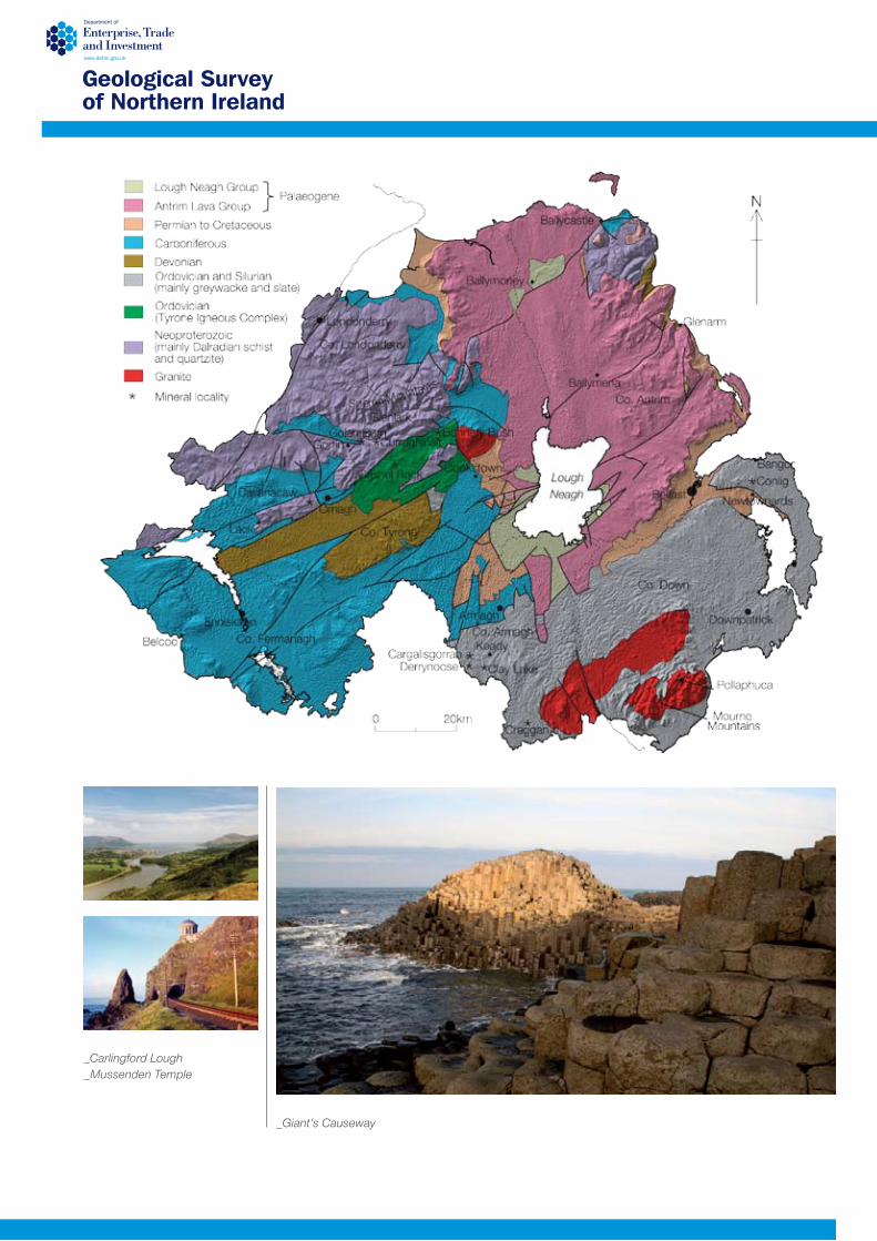
Rare Earth ElementsDemand for Rare Earth Elements (REEs) and tantalum continues to grow in line with our demands for smaller electronic technology and increased performance. Recent restrictions on export by China (which produces over 97% of the world’s rare earth supply) mean that there is growing concern that a global shortage may soon be faced. Searches for alternate sources are ongoing and previously uneconomic deposits are now becoming viable.
_Enhanced ternary airborne radiometric map
_Lanthanum in soils
Currently no REE deposits have been discovered in Northern Ireland but a number of grass roots opportunities exist for explorers with experience in this particular sub-sector. One of the classic geological environments for REE deposits to form is in pegmatite veins, near to the edges of large acid intrusions that have cooled slowly within the earth’s crust. This allows for the development of late stage fluids that can concentrate the REEs and certain other minerals (including tantalum and lithium). If the pegmatite size and density is great enough an economic deposit may be formed. There are three main acid intrusive centres in Northern Ireland that could be considered prospective for REE mineralisation.
The Mourne MountainsIn the late 1970s a limited amount of exploration work was completed but this focused on uranium and tin mineralisation. As such the REE potential of the Mourne Mountains complex has never been properly evaluated, but given the common association of Sn and U with REE deposits, the area can be considered geologically prospective. Radiometric and stream sediment surveys were completed and a number of coincident anomalies in the south and eastern Mournes were identified. Overall, the Mourne Mountains complex proved to have the highest background radiometric values of all the Irish intrusives but it was the tin anomalies that were followed-up. Bedrock cassiterite in quartz veins cross-cutting the granite was identified at the intersection of two fracture sets with values up to 0.4% Sn over 0.3m. No REE values were analysed. Some of the most extensive Nb, Ta, and Yb anomalies occur in the soils of the Mourne Mountains.
Slieve GallionThree of the REEs were analysed as part of the regional geochemical survey of the western half of Northern Ireland. Very similar patterns were produced for cerium, lanthanum and thorium with strong but possibly formational anomalies located over the extreme west of Co. Tyrone.
Perhaps more interestingly, anomalies also occur over the Slieve Gallion complex and parts of the Tyrone Igneous Complex. Given the prospective geological environment in these two regions follow up work is merited.
The Newry ComplexThe late Caledonian Newry intrusive complex is a multi-pulse intrusion similar in age and style to the Leinster Intrusion in the Republic of Ireland. Both intrusions resulted from crustal melting at the roots of the mountain range formed by the Caledonian orogeny and are dated at around 400Ma. Exploration in the Republic of Ireland has identified pegmatites up to 20m thick by 400m long containing 1.6% Li and accessory tin, niobium and tantalum. In Northern Ireland, radiometric anomalies believed to be related to uranium mineralisation were identified over areas of the Newry complex during the late 1970s work.
Other AreasThe Tellus geochemistry program has identified anomalous concentrations of Nb and Th in soils on Dalradian metasediments of the Claudy and Ballykelly Formations in Co. Londonderry.
© Crown Copyright. DMOU205.

T: +44 (0)28 9038 8462F: +44 (0)28 9038 8461E: [email protected]
www.bgs.ac.uk/gsni
_Cavanacaw gold mine, Omagh, Co. Tyrone has been in production since 2007
PreciousMetals
Precious MetalsGold has been valued for thousands of years. In addition to its common uses in jewellery and monetary standards, it is also used in the dental, electroplating and scientific industries. Silver, also prized for centuries, was widely used in coinage and nowadays it has many uses including jewellery.
_Underground at the Curraghinalt Gold deposit
_Ore from Cavanacaw
Northern Ireland is arguably the most prospective area of the United Kingdom and Republic of Ireland for precious metal deposits. Alluvial gold has been recovered since Celtic times when it was used to produce ornate artefacts. Modern-day exploration commenced in the late 1970s. GSNI regional geochemical and geophysical surveys have greatly assisted target selection and have helped exploration companies to define licence areas. The Dalradian basement rocks of the Sperrin Mountains have been the main focus of exploration but recent work has identified additional prospective areas.
The SperrinsThe Sperrin Mountains of Counties Tyrone and Londonderry have been the most explored area in recent times. The results of the 1976 GSNI survey, over areas underlain by the Neoproterozoic Dalradian rocks (c. 590Ma) confirmed the auriferous potential of the area and in the early 1980s bedrock gold mineralisation in quartz veins was discovered in Curraghinalt Burn. Work has continued on the Curraghinalt prospect (currently licenced to Dalradian Resources) and to date, approximately 26,000 meters of drilling in over 250 drill holes has brought the NI 43–101 compliant resource to 1.56Moz Au indicated and inferred.
About 20km to the southwest is the Cavanacaw deposit. Galantas Gold have developed the first modern gold mine in the British Isles and have proven reserves of 180,000t grading 7.4g/t Au and probable reserves of 186,000t grading 7.7g/t Au. An indicated resource of 1,200,000t grading 7.0g/t Au also occurs within the mine lease area. Across the rest of the Dalradian in this area there are a number of showings and drill intersections suggesting that further economic resources remain to be identified.
In 1996, a gold metallogeny study of northwest Northern Ireland identified a number of prospective areas and determined the multi-stage history of gold mineralisation in the region.
Northeast Co. DownExtensive Au anomalies have been identified in soils and stream sediments east of Belfast in the Holywood and Newtownards areas. These anomalies occur in proximity to the Orlock Bridge Fault, and the along strike continuation of this structure intersects Au anomalies near Keady in Co. Armagh.
Southeast Co. DownA soil gold anomaly has been identified by Tellus geochemistry stretching from Warrenpoint to Kilkeel. Gold grains have been recovered in pan concentrate samples from this area. Recent studies of these gold grains indicate that they represent a distinctive group in the Southern Uplands-Longford-Down terrain.
Co. ArmaghAn extensive zone of anomalous Au in both soil and stream sediment samples confirms gold prospectivity in the Keady area. Conroy Gold and Natural Resources have identified a one million oz JORC compliant resource just over the boarder in county Monaghan. Anomalies indicate possible association with the Orlock Bridge Fault and Lower Palaeozoic stratigraphy and recent drilling has confirmed gold in bedrock in the Clay Lake area of south Armagh.

T: +44 (0)28 9038 8462F: +44 (0)28 9038 8461E: [email protected]
www.bgs.ac.uk/gsni
_The Sperrin Mountains, Co. Londonderry
BaseMetals
Base MetalsThe base metals of copper, lead and zinc are important for today’s technologically driven society. Transport systems rely on these metals for the production of cars, aeroplanes and ships and the communications industry would never have reached its current level without the use of these metals in telephones, televisions, computers, satellites and cables.
Northern Ireland is one of the most prospective areas of the United Kingdom for base metal mineralisation. Historical production of lead has resulted in numerous small adits and shafts across parts of Counties Down, Armagh and Tyrone. Modern exploration commenced in the late 1960s, following the introduction of the Mineral Development Act (Northern Ireland) 1969 and continues to the present day. At present three main areas are considered to have the highest prospectivity for base metal deposits. However, as further data are collected and new models developed other areas may become targets.
The SperrinsThe Sperrin Mountains have the potential to host economic base metal deposits. The Glenlark prospect, 3km from the Curraghinalt gold deposit, is believed to represent a stratabound mineralisation system (Zn-Pb-Au-Ag). Surveys over areas underlain by Neoproterozoic Dalradian rocks (c. 590Ma) have highlighted targets which merit follow-up investigation. Bedrock base metal sulphide mineralisation has been discovered throughout the region.
Tyrone Igneous ComplexThe Tyrone Igneous Complex to the southeast of the Sperrins comprises the Tyrone Volcanic Group (TVG) and the Tyrone Plutonic Group. The volcanic, volcaniclastic and thin sedimentary rocks of the TVG are characteristic of an Island Arc setting making it highly prospective for Volcanogenic Massive Sulphide-style deposits. Porphyry-style mineralisation associated with acid intrusive bodies has been identified at Cashel Rock. Geologically this area represents the eastern extension of the ‘palaeo’ island arc that hosts the Buchans deposits in Newfoundland. The Northwest Irish Carboniferous BasinThe Lower Carboniferous lithologies of Counties Fermanagh and Tyrone are considered prospective for carbonate hosted Zn-Pb-Ag deposits. Exploration in the 1970s identified sub-
economic concentrations of base metal sulphides and as a result of the GSNI geochemical surveys, part of the Clogher Valley was highlighted as an area with enhanced prospectivity. Outcrops of Waulsortian stratigraphy (host to the majority of deposits in the Republic of Ireland) remain to be fully evaluated.
Other AreasThe Dalradian inlier of northeast Co. Antrim exposes similar rocks to those found in the Sperrins and may represent a target for base metal mineralisation. Drilling through the Palaeocene Antrim Lava Group also identified mineralised Dalradian bedrock at shallow depths. At Ballymoney, native copper was drilled in the basalt below the lignite deposit. The prospectivity of the Antrim Lava Group for copper and nickel remains largely unknown. A number of anomalous areas have been highlighted in south Co. Armagh which are not believed to be related to the historical workings. A belt of anomalous Zn values in soil extends from the area of known gold mineralisation at Keady to the southeastern part of Co. Down. This anomalous zone occurs within the Lower Palaeozoic sedimentary rocks.
___Pb-Zn mineralisation_Historical mining in Co. Antrim

T: +44 (0)28 9038 8462F: +44 (0)28 9038 8461E: [email protected]
www.bgs.ac.uk/gsni
_The aircraft that flew the Tellus Survey
TellusBorder
The first phase of the Tellus Project, which was managed by the Geological Survey of Northern Ireland, generated new geochemical and airborne geophysical maps that extend and deepen our knowledge of the geology, soils, natural resources and environment of Northern Ireland. These are the most comprehensive and detailed geoscience survey results ever acquired in the United Kingdom on a regional level. The geochemical surveys map the distribution of 55 elements in three sample media and geophysical imagery provides improved detail on structures associated with gold and base metal mineralisation.
These data are a major resource for industry, regulatory authorities and researchers. The results have already prompted renewed interest in mineral prospecting in Northern Ireland, half of which is now covered by exploration permits or applications.
Digital datasets are now available of the following:
Geochemical data (each medium sampled at one site per 2km2)• Soilanalysesat20and50cmdepths-XRF and ICP with fire-assay for gold and PGEs• StreamsedimentanalysesbyXRFandfire- assay for gold and PGEs• Streamwatersanalysesbyion chromatography and ICP.
Airborne data (line spacing 200m, ground clearance 56m)• Totalmagneticfieldandhorizontalgradient• FourfrequencyEM• Fourchannelradiometrics.
Geochemical samples have been collected from 13,000 rural sites. New anomalies in gold and platinum group elements have been mapped and the characteristics of gold mineralisation trends in the west, south and southeast are further defined. High nickel values characterise the Palaeogene volcanics and elevated nickel occurs elsewhere in
several locations, notably associated with some of the Palaeogene dykes. The geochemical surveys extended the G-BASE geochemical survey programme of the British Geological Survey.
Regionally, the airborne geophysical imagery refined existing structural mapping. Prominent magnetic anomalies correspond with major intrusive complexes and the extensive Palaeogene lava flows. The electromagnetic survey maps electrical conductivity differences between the Precambrian, Lower Palaeozoic and younger rocks. Radiometric results display significant differences in the radioactivity of different lithologies, including some of the most radioactive granites in the United Kingdom. At a local scale the imagery reveals outstanding structural detail.
The first phase of the Tellus Project was financed by the Department of Enterprise Trade and Investment and by the EU’s ‘Building Sustainable Prosperity’ programme.
The second phase of the programme in Northern Ireland, ‘Tellus2’, was funded between 2008 and 2011 by the Chancellor’s Fund for Innovation; this phase extended data analysis and promoted the use of the data widely amongst the research community.
_Soil sampling_Sediment sampling
The Tellus surveysThe Tellus Project collected high resolution airborne geophysics and ground geochemical data over Northern Ireland. This data is available under licence
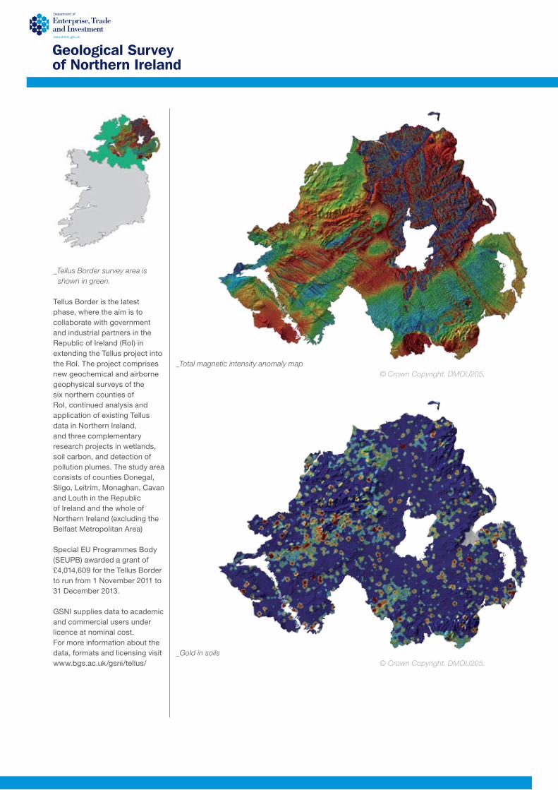
Tellus Border is the latest phase, where the aim is to collaborate with government and industrial partners in the Republic of Ireland (RoI) in extending the Tellus project into the RoI. The project comprises new geochemical and airborne geophysical surveys of the six northern counties of RoI, continued analysis and application of existing Tellus data in Northern Ireland, and three complementary research projects in wetlands, soil carbon, and detection of pollution plumes. The study area consists of counties Donegal, Sligo, Leitrim, Monaghan, Cavan and Louth in the Republic of Ireland and the whole of Northern Ireland (excluding the Belfast Metropolitan Area)
Special EU Programmes Body (SEUPB) awarded a grant of £4,014,609 for the Tellus Border to run from 1 November 2011 to 31 December 2013.
GSNI supplies data to academic and commercial users under licence at nominal cost. For more information about the data, formats and licensing visit www.bgs.ac.uk/gsni/tellus/
_Tellus Border survey area is shown in green.
_Total magnetic intensity anomaly map
_Gold in soils© Crown Copyright. DMOU205.
© Crown Copyright. DMOU205.