Embed Size (px)
Citation preview
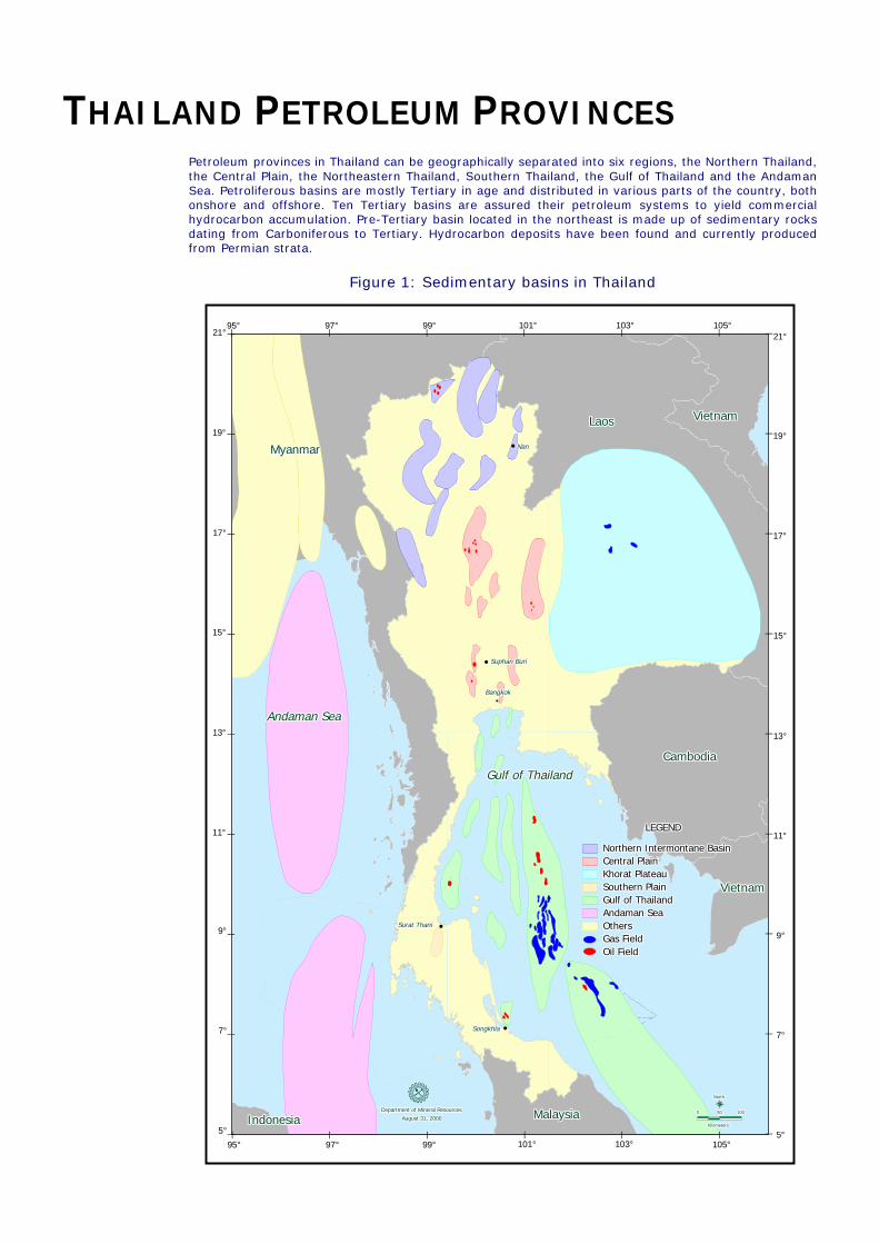
THAILAND PETROLEUM PROVINCES Petroleum provinces in Thailand can be geographically separated into six regions, the Northern Thailand, the Central Plain, the Northeastern Thailand, Southern Thailand, the Gulf of Thailand and the Andaman Sea. Petroliferous basins are mostly Tertiary in age and distributed in various parts of the country, both onshore and offshore. Ten Tertiary basins are assured their petroleum systems to yield commercial hydrocarbon accumulation. Pre-Tertiary basin located in the northeast is made up of sedimentary rocks dating from Carboniferous to Tertiary. Hydrocarbon deposits have been found and currently produced from Permian strata.
Figure 1: Sedimentary basins in Thailand
7°
13°
11°
9°
5°
||
||
|
17°
15° ||
|95°21°
19°
97° 99°
|| | |
95° 97° 99°
| || |105°101° 103°
5°|||
| 103°101°21°
19°
105°
||
| |
15°
17°||
13°
11°
9°
7°
||
||
IndonesiaIndonesiaIndonesiaIndonesiaIndonesiaIndonesiaIndonesiaIndonesiaIndonesia
MyanmarMyanmarMyanmarMyanmarMyanmarMyanmarMyanmarMyanmarMyanmar
!
"
BangkokBangkokBangkokBangkokBangkokBangkokBangkokBangkokBangkok
Andaman SeaAndaman SeaAndaman SeaAndaman SeaAndaman SeaAndaman SeaAndaman SeaAndaman SeaAndaman Sea
"Surat ThaniSurat ThaniSurat ThaniSurat ThaniSurat ThaniSurat ThaniSurat ThaniSurat ThaniSurat Thani
Department of Mineral ResourcesDepartment of Mineral ResourcesDepartment of Mineral ResourcesDepartment of Mineral ResourcesDepartment of Mineral ResourcesDepartment of Mineral ResourcesDepartment of Mineral ResourcesDepartment of Mineral ResourcesDepartment of Mineral ResourcesAugust 31, 2000August 31, 2000August 31, 2000August 31, 2000August 31, 2000August 31, 2000August 31, 2000August 31, 2000August 31, 2000
"SongkhlaSongkhlaSongkhlaSongkhlaSongkhlaSongkhlaSongkhlaSongkhlaSongkhla
Gulf of ThailandGulf of ThailandGulf of ThailandGulf of ThailandGulf of ThailandGulf of ThailandGulf of ThailandGulf of ThailandGulf of Thailand
MalaysiaMalaysiaMalaysiaMalaysiaMalaysiaMalaysiaMalaysiaMalaysiaMalaysia
"
LaosLaosLaosLaosLaosLaosLaosLaosLaos
NanNanNanNanNanNanNanNanNan
CambodiaCambodiaCambodiaCambodiaCambodiaCambodiaCambodiaCambodiaCambodia
Suphan BuriSuphan BuriSuphan BuriSuphan BuriSuphan BuriSuphan BuriSuphan BuriSuphan BuriSuphan Buri
000000000
KilometersKilometersKilometersKilometersKilometersKilometersKilometersKilometersKilometers
505050505050505050
!NorthNorthNorthNorthNorthNorthNorthNorthNorth
VietnamVietnamVietnamVietnamVietnamVietnamVietnamVietnamVietnam
100100100100100100100100100
VietnamVietnamVietnamVietnamVietnamVietnamVietnamVietnamVietnam
Northern Intermontane BasinNorthern Intermontane BasinNorthern Intermontane BasinNorthern Intermontane BasinNorthern Intermontane BasinNorthern Intermontane BasinNorthern Intermontane BasinNorthern Intermontane BasinNorthern Intermontane BasinCentral PlainCentral PlainCentral PlainCentral PlainCentral PlainCentral PlainCentral PlainCentral PlainCentral PlainKhorat PlateauKhorat PlateauKhorat PlateauKhorat PlateauKhorat PlateauKhorat PlateauKhorat PlateauKhorat PlateauKhorat PlateauSouthern PlainSouthern PlainSouthern PlainSouthern PlainSouthern PlainSouthern PlainSouthern PlainSouthern PlainSouthern PlainGulf of ThailandGulf of ThailandGulf of ThailandGulf of ThailandGulf of ThailandGulf of ThailandGulf of ThailandGulf of ThailandGulf of ThailandAndaman SeaAndaman SeaAndaman SeaAndaman SeaAndaman SeaAndaman SeaAndaman SeaAndaman SeaAndaman SeaOthersOthersOthersOthersOthersOthersOthersOthersOthersGas FieldGas FieldGas FieldGas FieldGas FieldGas FieldGas FieldGas FieldGas FieldOil FieldOil FieldOil FieldOil FieldOil FieldOil FieldOil FieldOil FieldOil Field
LEGENDLEGENDLEGENDLEGENDLEGENDLEGENDLEGENDLEGENDLEGEND

The area is presumably bounded to the south by the Uttaradit Fault Zone and its assumed south westward projection. The area consist of ten intermontane Tertiary basins ranging in various size. The basin were formed as a series of pull apart basins of mainly north-south trending half grabens. Basins are generally narrow but deep and occasionally emit an abnormal high heat flow. The exploration is intensively carried out in the Fang area whereas other parts are very limited.
Since the first oilfield, Chai Prakan, was found in the Fang Basin 50 years ago, a number of marginal oilfields were subsequently discovered. Petroleum is produced from fluvio-lacustrine sandstones which are sealed and sourced by lacustrine shales of similar age. A variety of structural traps presents such as antithetic and synthetic faults, rollover anticline and normal fault. Oil shows from well penetrated to Triassic sandstone basement does not rule out the possibility of finding hydrocarbon in pre-Tertiary rocks in the area.
Seven blocks are reserved and under the supervision of Department of Defense. These blocks cover Fang, Chiang Mai, Lampang, Phare, Chiang Rai and Payoa Basins. Five blocks delineated by the Department of Mineral Resources are available for bid in the area covering Mae Sod, Pua and Nan Basins. The first seismic survey acquired in 1997 over Mae Sod basin reveal the subsurface structure of the basin. Thick oil shale strata observed from outcrop and shallow wells are evident to the presence of excellent source rock in the area. Petroleum system in these basins is expected to be similar to Fang Basin.
Figure 2 Display the Seismic Section over the Mae Sod Basin
This region consists of a number of north-south trending half grabens formed by conjugate transtensional shear during early Tertiary age. A number of oil fields have been discovered in the Phitsanulok, Suphan Buri, Kamphaeng Saen and Petchabun Basins. The Phitsanulok, the largest basin, is filled up with 8 km of sediments. Ten oil fields have been discovered in the basin. Hydrocarbons are mainly produced from Oligocene-Miocene fluvio-lacustrine sandstone. However, a significant amount of oil produced from fractured and weathred granites of pre-Tertiary rocks are continually increasing.
The principal reservoir rocks in the area are sandstone of Miocene age. Source and seal are provided by Miocene lacustrine shales. A variety of play types exist including rollover, faulted anticline, tilted blocks, stratigraphic pinch-out and buried hill.
A large number of blocks are available for bid throughout the Central Plain. A number of untested prospects were left in surrounding area of existing concessions. Traces of very light oil found in vuggy Permian limestone south of Phitsanulok basin guide to the possibility of finding hydrocarbon in pre-Tertiary rock in this region.
Northern Intermontane Basin
Central Plain
0
250
500
750
1000
1250
1500
1750
2000
0
250
500
750
1000
1250
1500
1750
2000

Figure 3 Seismic Cross-section of Suphan Buri Basin
The Khorat Plateau named as a geographical entity covers an area of approximately 200,000 km2, occupying almost entire region of the northeast Thailand. The Khorat Plateau is underlain by Permo-Carboniferous, Triassic, Mesozoic and Tertiary basins. These complex sets of basins formed by several plate collisions and subsequent extensions during four different periods, from middle Paleozoic to Tertiary. The Permo-Carboniferous sequences consist of shallow marine siliclastic and carbonate sediments. During Late Triassic, a series of half-graben basins developed sporadically. The Triassic sequences are mainly lacustrine and fluviatile clastic sediments. After uplift and erosion in latest Triassic, the region was subside and subsequently overlained by thick non-marine Mesozoic Redbeds. The Tertiary sediments, consisting of Aeolian and alluvial deposits, are relatively thin and locally.
Permian carbonate is the gas-bearing reservoir whereas Permian shale and Triassic organic rich shales are potential source rocks. Secondary porosity from dolomitization and fracture enhance the reservoir quality and being the key factor for increasing the productivity. Long period and complex tectonic evolution resulted in a variety of structural and stratigraphic configurations which provide favorable conditions for hydrocarbon accumulation. Three significant gas fields were discovered. Apart from the established plays which are unconformity-related-carbonates, the Khorat Plateau still contains significant plays and prospects which have not yet been fully explored. Recent seismic data in the frontier area along the southern rim of Khorat Plateau and Nakhon Thai High reveals a hidden Permian structure which has been overlooked in the past and waiting to be investigated. Virtually all of Northeastern Thailand is available for licensing.
Figure 4 Schematic Cross-section and Play Type of Khorat Plateau
Khorat Plateau
0
1
2
3
0
1
2
3
!
seco
nd
2
4
6
2
4
6
km km
"""" """" #### #### #### $$$$ $$$$ $$$$ $$$$
Triassic Lacustrine Permian Carbonates / Clastics Permian Reefs
Basement
Khorat Redbeds
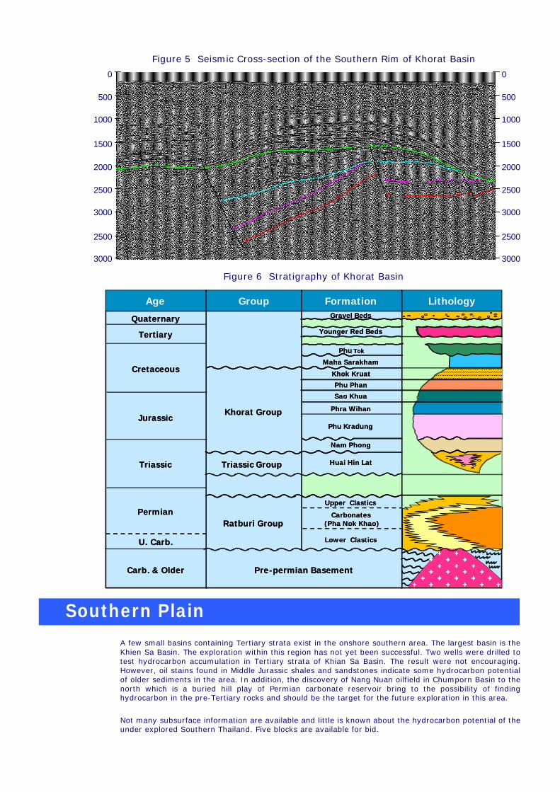
Figure 5 Seismic Cross-section of the Southern Rim of Khorat Basin
Figure 6 Stratigraphy of Khorat Basin
A few small basins containing Tertiary strata exist in the onshore southern area. The largest basin is the Khien Sa Basin. The exploration within this region has not yet been successful. Two wells were drilled to test hydrocarbon accumulation in Tertiary strata of Khian Sa Basin. The result were not encouraging. However, oil stains found in Middle Jurassic shales and sandstones indicate some hydrocarbon potential of older sediments in the area. In addition, the discovery of Nang Nuan oilfield in Chumporn Basin to the north which is a buried hill play of Permian carbonate reservoir bring to the possibility of finding hydrocarbon in the pre-Tertiary rocks and should be the target for the future exploration in this area.
Not many subsurface information are available and little is known about the hydrocarbon potential of the under explored Southern Thailand. Five blocks are available for bid.
Southern Plain
0
500
1000
1500
2000
2500
3000
2500
3000
0
500
1000
1500
2000
2500
3000
2500
3000
������������������������������������������
Upper Clastics
Carbonates(Pha Nok Khao)
Lower Clastics
Huai Hin Lat
Nam Phong
Sao Khua
Phra Wihan
Phu Kradung
Phu Tok
Maha Sarakham
Phu Phan
Khok Kruat
Younger Red Beds
Gravel Beds
Tertiary
Cretaceous
Jurassic
Triassic
Permian
U. Carb.
Quaternary
Carb. & Older
Ratburi Group
Triassic Group
Khorat Group
Pre-permian Basement
����������������������������������������������������������������������������������������������������������������������
++ ++
+ ++
++ +
+ + + + ++++ +++
++
Age Group Formation Lithology������������
������������������������������������������
Upper Clastics
Carbonates(Pha Nok Khao)
Lower Clastics
Huai Hin Lat
Nam Phong
Sao Khua
Phra Wihan
Phu Kradung
Phu Tok
Maha Sarakham
Phu Phan
Khok Kruat
Younger Red Beds
Gravel Beds
Upper Clastics
Carbonates(Pha Nok Khao)
Lower Clastics
Huai Hin Lat
Nam Phong
Sao Khua
Phra Wihan
Phu Kradung
Phu Tok
Maha Sarakham
Phu Phan
Khok Kruat
Younger Red Beds
Gravel Beds
Tertiary
Cretaceous
Jurassic
Triassic
Permian
U. Carb.
Quaternary
Carb. & Older
Tertiary
Cretaceous
Jurassic
Triassic
Permian
U. Carb.
Quaternary
Carb. & Older
Ratburi Group
Triassic Group
Khorat Group
Pre-permian Basement
Ratburi Group
Triassic Group
Khorat Group
Pre-permian Basement
����������������������������������������������������������������������������������������������������������������������
++ ++
+ ++
++ +
+ + + + ++++ +++
++
++ ++
+ ++
++ +
+ + + + ++++ +++
++
++ ++ ++ ++
+ ++ ++
++ + ++ +
+ + + + ++ + + + + ++++ +++ ++ +++
++
Age Group Formation Lithology������������������������

1.0
2.0
0.0
1.0
2.0
0.0
The majority of petroleum produced in Thailand comes from offshore Tertiary basins in the Gulf of Thailand. The Ko Kra Ridge splits the Gulf into two parts. The western portion contains ten main basins of various sizes. Discoveries have been made in Chumporn and Songkhla Basins. The eastern part is composed of Pattani, Khmer and Malay Basin. Pattani and Malay are hydrocarbon prolific basins.
Sediments are non-marine in origin, mainly fluvio-lacustrine deposits. However, the eastern portion was influenced by marine incursion during the early Miocene age. Hydrocarbons are found in Oligocene and Miocene sandstones. Source rocks are of Oligocene and Miocene sediments. The Oligocene sources are oil-prone source rocks which contains Type I kerogen. The Miocene sources are fluvial flood plain and delta plain sediments which mainly consits of Type III kerogen and tend to yield gas.
A variety of trap types present in the Gulf such as anticlinal faults, tilted faults, rollover and buried hills.
A number of oil and gas fields have been found in Pattani and North Malay Basin. Most of the gas fields are distributed all over the central part of the Pattani basin while oil fields are gathered in the shallower part of the basin margin.
Blocks are available for bid throughout the Gulf particulary in the northern and southern portions.
Figure 7 below, generalized stratigraphic schemes of Tertiary basins in the Gulf of Thailand.
Figure 7 Conceptual Play Types in the Gulf of Thailand
The Andaman Sea is located in the western Thailand. The region is divided into two parts by shelf margin, the shallow and deep water parts. The Mergui, the transtensional back arc basin, is situated mainly in the deep water. The basin is the northern extension of North Sumatra Basin. The Mergui Basin is the only one Tertiary basin of which sediments are truly marine origin. Two un-appraised gas prospects have been found and several gas show were encountered in the Oligocene sandstones. Early Miocene sandstones and carbonate build-ups formed on the horst and shelf margin are excellent in quality and would be potential reservoirs. Oligocene and Early Miocene shales with landplant-derived organic matters are potential source rocks. However, matured source rocks are mainly restricted in the deep part of the basin. A variety of play types can be found both structurally and stratigraphically. A number of structural traps presented are related to extensional and transtensional tectonics. The
Gulf of Thailand
Andaman Sea

0
1000
2000
3000
4000
5000
6000
0
1000
2000
3000
4000
5000
6000
%%%%""""
untested stratigraphic plays of Middle Miocene turbiditic sandstone and pinch-out of Oligocene sandstone against basement are the prime target for future exploration.
Three shallow water blocks and one deep water block are available for bid.
Figure 8 Seismic Cross-section
Figure 9 Stratigraphy of the Mergui Basin
AGE
Oligocene
Miocene
Pliocene
Holocene
EL
ME
ML
EM
L
���������������������������������������������������������������������
������������������������������������������������������������������������������������������������������������������������������������������
JULU RAYEUSEURULA
KEUTAPANG
BAONG
PEUTU
BELUMAI
BAMPO
PARAPAT
NORTH SUMATRABASIN
major unconformityminor unconformity
TAKUA PA
THALANG
TRANG
KANTANGTAI
MERGUIBASIN
Relative Changes ofsea level
(EXXON 1979)present sea level+ –
Pleistocene
RANONG
SURIN
PAYANG
YALA
ARUN
AGE
Oligocene
Miocene
Pliocene
Holocene
EL
ME
ML
EM
LE
LM
EM
LE
ML
���������������������������������������������������������������������
������������������������������������������������������������������������������������������������������������������������������������������
JULU RAYEUSEURULA
KEUTAPANG
BAONG
PEUTU
BELUMAI
BAMPO
PARAPAT
NORTH SUMATRABASIN
major unconformityminor unconformity
TAKUA PA
THALANG
TRANG
KANTANGTAI
MERGUIBASIN
Relative Changes ofsea level
(EXXON 1979)present sea level+ –present sea level+ –
Pleistocene
RANONG
SURIN
PAYANG
YALA
ARUN