Embed Size (px)
Citation preview
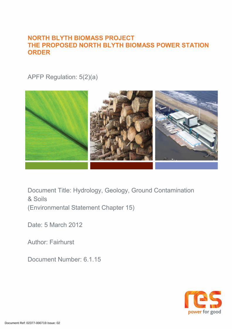
NORTH BLYTH BIOMASS PROJECTTHE PROPOSED NORTH BLYTH BIOMASS POWER STATION ORDER
APFP Regulation: 5(2)(a)
Document Title: Hydrology, Geology, Ground Contamination & Soils(Environmental Statement Chapter 15)
Date: 5 March 2012
Author: Fairhurst
Document Number: 6.1.15
Document Ref: 02377-000719 Issue: 02

Revision HistoryDocument Title: Hydrology, Geology, Ground Contamination & SoilsRevision Date Author
01 24 Oct 2011 Fairhurst02 5 March 2012 Fairhurst
Document Ref: 02377-000719 Issue: 02

North Blyth Renewable Energy ProjectVolume II Environmental Statement
Chapter 15 – Hydrogeology, Geology, Ground Contamination and Soils – Page 1
15 HYDROGEOLOGY, GEOLOGY, GROUND CONTAMINATION AND SOILS
15.1. Introduction
15.1.1 This assessment has been undertaken by Fairhurst and considers the impacts of the Project, as described in Chapter 4 Development Description, on the hydrogeological, geological and soils environment at the Facility Site, and surrounding area, and focuses on the following aspects:
Potential impacts of the Project associated with the disturbance of contaminated materials in relation to human health, controlled waters and the built development during construction, operation and decommissioning phases;
Potential impacts of the Project associated with the disturbance to the flow of both shallow and deep groundwater bodies during construction, operation and decommissioning phases; and
Potential impacts of the operation of the Project on the geology, hydrogeology and hydrology of the Application Site during construction, operation and decommissioning phases.
15.1.2 The assessment of hydrogeology and ground contamination is presented in Section 15.5. For the purpose of this assessment, geology and soils has been grouped as geology and are included within the same section.
15.1.3 Mitigation measures, where appropriate, are presented in Section 15.6.
15.1.4 The assessment of impacts on surface water hydrology and flooding are considered in a separate chapter (Chapter 14 Surface Water Hydrology and Flood Risk). The consideration of longshore drift impacts has been provided by SKM Enviros.
15.2. Assessment Methodology
15.2.1 The methodology used to establish the baseline ground conditions was by means of desk study and addendum report prepared by Scott Doherty Associates (SDA) (as presented in Appendices 15.1 and 15.2).
15.2.2 This Chapter has been prepared using all available historical site investigation data for the Battleship Wharf area and the detailed desk study carried out by SDA. Worst case conditions, as identified in these investigations and desk study have been used in the preparation of this statement. As part of the works, and to inform the detailed design phase, additional site investigation will be carried out which will confirm site conditions and if the mitigation measures identified in this statement are required. The risk assessments provided within the SDA reports (Appendices 15.1 and 15.2) were carried out initially to inform the Project design process. These initial risk assessments are developed further within this Chapter to reflect the proposed design for the Project. It should be noted that the assessment of risk in the context of an EIA is different to that of a contaminated land assessment, which assigns maximum likely risks based on advising on land liability issues.
National Planning Policy
15.2.3 Planning Policy Statement 23 (PPS 23) Planning and Pollution Control [Ref 15.1] provides guidance to planning authorities in relation to development on land affected by contamination. This chapter has taken account of the policies in PPS 23 and specifically the advice provided in the accompanying Annexes (Annex 1: Pollution Control, Air and Water Quality and Annex 2: Development on Land Affected by Contamination). These policies are material to decisions on individual planning applications.
15.2.4 Annex 2 to PPS 23, expands on the policy considerations in relation to development on land affected by contamination. It gives legislative and technical background and some examples of good practice to assist authorities in implementing the policies contained in PPS 23.
Document Ref: 02377-000719 Issue: 02
North Blyth Renewable Energy ProjectVolume II Environmental Statement
Chapter 15 – Hydrogeology, Geology, Ground Contamination and Soils – Page 2
15.2.5 Where new development is taking place, it is the developer’s responsibility to carry out the necessary remediation and, in most cases, the enforcement of remediation requirements will be through planning conditions and building control rather than through the “Part 2A” contaminated land regime.
15.2.6 In managing issues of potential contamination, the developer is responsible for the following:
Ensuring that the development is safe and suitable for use for the purpose for which it is intended;
Determining whether the land in question is already affected by contamination through contaminant-pathway-receptor linkages and how those linkages are represented in a conceptual model;
Determining whether the development proposed will create new linkages; and
Determining what action is needed to break those linkages and avoid new ones, dealing with any unacceptable risks and to enable safe development and future occupancy of the Facility Site and neighbouring land.
Local Planning Policy
15.2.7 Wansbeck District Local Plan [Ref 15.2] highlights the importance of assessing whether a proposed development has the potential to cause pollution or nuisance in accordance with Policy GP23. This is in relation to human health and safety, the amenity of local residents and other land users and the quality and enjoyment of all aspects of the environment.
15.2.8 A priority within the Wansbeck District Local Plan is to make use of previously-developed land and buildings in existing settlements before greenfield sites. Policy GP1 states that proposals should be permitted provided they are in accordance with other policies of the Plan and on previously developed sites as defined on the Proposals Map. The Project is, therefore, in accordance with this policy.
Other relevant guidance
15.2.9 Other relevant guidance documentation includes:
Various Pollution Prevention Guidance (PPGs) documents from the Environment Agency (EA) [Refs 15.1, 3, 4, 5, 6 and 7];
The Department for Food and Rural Affairs (DEFRA) and the EA ‘Contaminated Land Exposure Assessment Model’ (CLEA 2002) [Ref 15.8];
The Department for the Environment Transport and the Regions (DETR – now DEFRA), EA & Institute of Environmental Health (IEH) – Guidelines for Environmental Risk Assessment and Management [Ref 15.9];
DEFRA, Construction Code of Practice for the Sustainable Use of Soils on Construction Sites, September 2009 [Ref 15.10];
DEFRA, Safeguarding our Soils – a Strategy for England, 2009 [Ref 15.11];
The Control of Pollution (Oil Storage) (England) Regulations 2001 [Ref 15.12];
CIRIA. Contaminated Land Risk Assessment. A Guide to Good Practice [Ref 15.13];
British Standard BS 5930:1999 – Code of Practice for Site Investigations [Ref 15.14];
British Standard BS 10175:2001 – Investigation of Potentially Contaminated Sites – Code of Practice [Ref 15.15];
CIRIA C665 - Assessing the Risks Posed by Hazardous Ground Gases to Buildings [Ref 15.16];
Groundwater Regulations 1998 [Ref 15.17];
Document Ref: 02377-000719 Issue: 02
North Blyth Renewable Energy ProjectVolume II Environmental Statement
Chapter 15 – Hydrogeology, Geology, Ground Contamination and Soils – Page 3
UK Water Quality (Water Supply) Regulations 2000 [Ref 15.18];
EC Fisheries Directive (78/659/EEC) [Ref 15.19];
Water Framework Directive (2000/60/EC) [Ref 15.20];
Environment Act 1995 [Ref 15.21];
Land Drainage Act 1991 [Ref 15.22]; and
BRE Special Digest 1:2005 (Concrete in Aggressive Ground) [Ref 15.23].
Sources of Information
15.2.10 An Application Site walkover survey was undertaken by SDA in February 2010 as part of the desk study. Fairhurst also undertook various visits to the Application Site over the course of the EIA.
15.2.11 The principal sources of information used to establish the baseline conditions presented in the SDA Desk Study (Appendix 15.1) and the addendum report to the desk study (Appendix 15.2), were as follows:
The British Geological Survey (BGS) Technical Report for Morpeth, Bedlington and Ashington 1990 and relevant BGS Borehole records;
Extracts from George Wimpey Ltd. borehole records from 1957;
Selected Atkins Ltd trial pit records from 1985;
Ground Investigation Report for Battleship Wharf (Phase 2) prepared by Norwest Holst Soil Engineering Ltd. dated June 1995;
JB Site Investigation Ltd. rotary drilling daily records dated May 2003 for the Proposed Southern Quay Extension (Berth No. 1);
Ground Investigation at Battleship Wharf Letter report prepared by SDA for the Proposed Bulk Storage Warehouse 1 dated June 2003;
JB Site Investigation Ltd. cable percussion drilling daily records dated August 2003 for the Proposed Bulk Storage Warehouse 1;
Ground Investigation Report for Bulk Warehouse No. 2 prepared by SDA dated January 2005;
Battleship Wharf Geological Interpretative Report prepared by SDA dated August 2005;
Factual Ground Investigation Report for the Battleship Wharf Proposed Quay Extension prepared by SDA dated January 2006;
Ground Investigation Letter Report prepared by SDA dated January 2006 for a Proposed Rail Link;
Ground Investigation letter report for an Experimental Wind Engine at the Port of Blyth prepared by SDA dated August 2009;
OS maps included in Appendix C of Appendix 15.1 to this assessment;
Envirocheck Report included in Appendix D of Appendix 15.1 to this assessment;
Aerial photographs of the Application Site obtained by SDA from English Heritage;
Coal Mining Report received by SDA from The Coal Authority and included in Appendix E of Appendix 15.1 to this assessment;
Admiralty charts, underground service drawings, piling records, borehole records and various construction drawings procured by SDA and included in Appendix F and G of Appendix 15.1 to this assessment; and
Document Ref: 02377-000719 Issue: 02

North Blyth Renewable Energy ProjectVolume II Environmental Statement
Chapter 15 – Hydrogeology, Geology, Ground Contamination and Soils – Page 4
Records of reclamation works undertaken in the 1990’s obtained by SDA from Northumberland County Council (NCC) and included in Appendix C of Appendix 15.1 to this assessment.
15.2.12 The abundance of existing Application Site reports, listed above, including the findings from several previous site investigations has provided the basis on which this assessment has been undertaken. Further site investigation is recommended. Where uncertainty over the presence of contaminants exists, it has been assumed that they are currently present for the purposes of this assessment (and so a worst case is presented).
15.2.13 A Geophysical and Bathymetric Survey has also been undertaken by Centara Ltd and Port of Blyth respectively, in November 2010, for the coastal area in which it is proposed to locate the cooling water outfall and pipeline (Appendix 15.3). This has been carried out to provide information on the foreshore and sea bed areas beneath which the outfall pipeline will pass, and to confirm the depth of the sea bed where the outfall will be located. Appendix 15.3 provides a description of the methodology used to conduct these surveys.
Methodology
15.2.14 The methodology used to establish impacts of the Project in respect of ground contamination, geology (including soils), hydrogeology and hydrology is a risk based approach. The assessment identifies pollution linkages and assesses the possibility of significant harm or pollution to controlled waters. This approach is compliant with the requirements of the Environmental Protection Act 1990, Part IIA (Contaminated Land (Section 57 of the Environment Act 1995)) [Ref 15.24], the Contaminated Land Regulations 2000 [Ref 15.25] and PPS 23 [Ref 15.1].
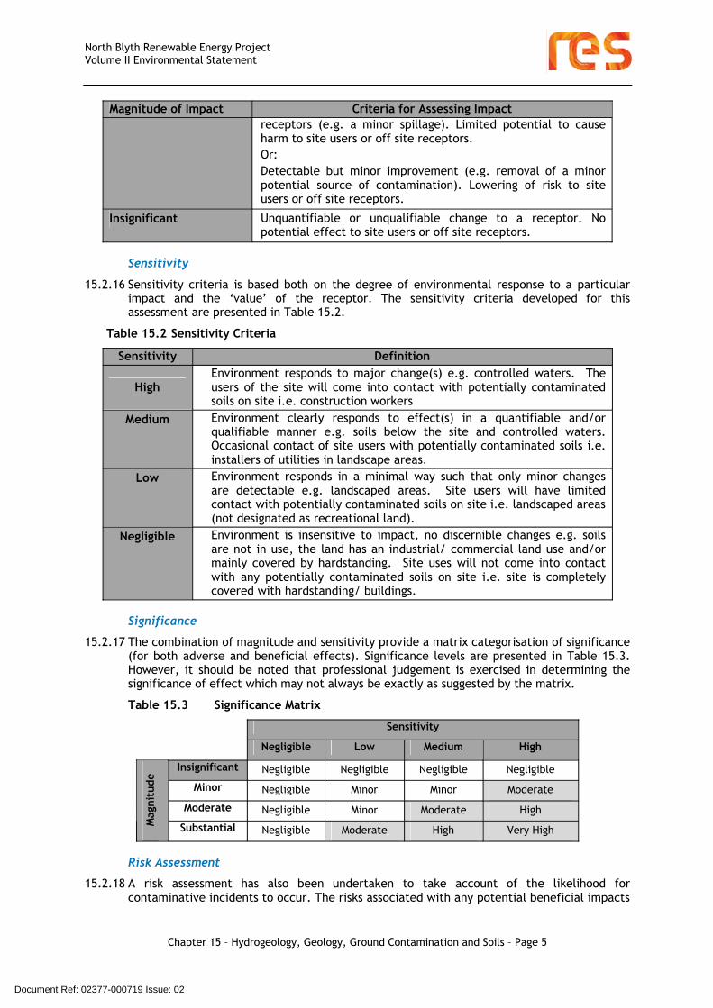
15.2.15 A qualitative assessment has been made of the significance of environmental and geotechnical impact on the construction, operation and decommissioning of the Project. The sensitivity of the receptor and the magnitude of any potential impact are considered to determine the significance of impacts. Magnitude, sensitivity and significance criteria are detailed in Table 15.1. This is followed by an assessment of the likelihood of the effect occurring to produce a final risk characterisation.
Table 15.1: Methodology behind qualitative assessment of impact magnitude
Magnitude of Impact Criteria for Assessing ImpactSubstantial Fundamental change to a receptor resulting in temporary or
permanent consequential changes (e.g. major spillage resulting in dangerous levels of contamination). Potential to cause severe harm to site users or off site receptors.Or: Fundamental improvement to a receptor resulting in temporary or permanent consequential changes (e.g. remediation of significantly contaminated area of the application Site). Removal of risk to site users or off site receptors.
Moderate Detectable change to a receptor resulting in non-fundamental temporary or permanent consequential changes. Some deterioration in quality likely to temporarily affect most sensitive receptors. Potential to cause harm to site users or off site receptors.Or:Detectable improvement to soil conditions resulting in non-fundamental temporary or permanent improvements. Improvement in soil quality likely to temporarily have a positive effect on most sensitive receptors. Significant lowering of risk to site users or off site receptors.
Minor Detectable but minor change to a receptor. Quality standards less than threshold and unlikely to affect most sensitive
Document Ref: 02377-000719 Issue: 02
North Blyth Renewable Energy ProjectVolume II Environmental Statement
Chapter 15 – Hydrogeology, Geology, Ground Contamination and Soils – Page 5
Magnitude of Impact Criteria for Assessing Impactreceptors (e.g. a minor spillage). Limited potential to cause harm to site users or off site receptors. Or: Detectable but minor improvement (e.g. removal of a minor potential source of contamination). Lowering of risk to site users or off site receptors.
Insignificant Unquantifiable or unqualifiable change to a receptor. No potential effect to site users or off site receptors.
Sensitivity
15.2.16 Sensitivity criteria is based both on the degree of environmental response to a particular impact and the ‘value’ of the receptor. The sensitivity criteria developed for this assessment are presented in Table 15.2.
Table 15.2 Sensitivity Criteria
Sensitivity Definition
HighEnvironment responds to major change(s) e.g. controlled waters. The users of the site will come into contact with potentially contaminated soils on site i.e. construction workers
Medium Environment clearly responds to effect(s) in a quantifiable and/or qualifiable manner e.g. soils below the site and controlled waters. Occasional contact of site users with potentially contaminated soils i.e. installers of utilities in landscape areas.
Low Environment responds in a minimal way such that only minor changes are detectable e.g. landscaped areas. Site users will have limited contact with potentially contaminated soils on site i.e. landscaped areas (not designated as recreational land).
Negligible Environment is insensitive to impact, no discernible changes e.g. soils are not in use, the land has an industrial/ commercial land use and/or mainly covered by hardstanding. Site uses will not come into contact with any potentially contaminated soils on site i.e. site is completely covered with hardstanding/ buildings.
Significance
15.2.17 The combination of magnitude and sensitivity provide a matrix categorisation of significance (for both adverse and beneficial effects). Significance levels are presented in Table 15.3. However, it should be noted that professional judgement is exercised in determining the significance of effect which may not always be exactly as suggested by the matrix.
Table 15.3 Significance Matrix
Sensitivity
Negligible Low Medium High
Insignificant Negligible Negligible Negligible Negligible
Minor Negligible Minor Minor Moderate
Moderate Negligible Minor Moderate High
Mag
nitu
de
Substantial Negligible Moderate High Very High
Risk Assessment
15.2.18 A risk assessment has also been undertaken to take account of the likelihood for contaminative incidents to occur. The risks associated with any potential beneficial impacts
Document Ref: 02377-000719 Issue: 02
North Blyth Renewable Energy ProjectVolume II Environmental Statement
Chapter 15 – Hydrogeology, Geology, Ground Contamination and Soils – Page 6
to quality (e.g. removal of any contaminated soils on site) are also included in this methodology.
Qualitative Risk Assessment Methodology
15.2.19 Risk assessment is the process of collating known information on a hazard or set of hazards in order to estimate the actual or potential risk to receptors. The receptors may be human health, agricultural land, a water system, a sensitive local ecosystem or even future construction materials. Receptors can be connected with the hazard under consideration via one or several exposure pathways (e.g. the pathway of direct contact or indirect transport by wind/water etc). Risks are generally managed by isolating or removing the hazard, isolating the receptor, or by intercepting the exposure pathway. Without the three essential components of a source (hazard), pathway and receptor, there can be no risk. Thus, the mere presence of a hazard at a site does not mean that there will necessarily be attendant risks. The following risk assessment thus focuses on those parts of the Application Site where hazards or potential hazards have been identified and is not general to the whole Application Site.
Sources
15.2.20 Potential sources of contamination have been identified for the Project, based on a review of the proposed, current and previous Facility Site uses. In addition to the nature of any contamination, the likely extent is considered, e.g. whether such contamination is likely to be localised or widespread.
Pathways
15.2.21 The presence of a contaminant does not necessarily present a risk. The exposure pathway determines the dose delivered to the receptor and the effective dose determines the extent of the adverse effect on the receptor. The pathway which transports the contaminants to the receptor or target may generally involve conveyance via soil, water or air, or may be direct.
Receptors
15.2.22 The varying effects of a hazard on individual receptors depend largely on the sensitivity of the receptor. Receptors include any people, animal or plant populations, or natural or economic resources within the range of the source which are connected to the source by a transport pathway, although in this instance the assessment is concerned primarily with soils.
Exposure Assessment (Likelihood of Occurrence)
15.2.23 By considering the source, pathway and receptor, an assessment is made for each contaminant on a receptor by receptor basis with reference to the significance and degree of the risk. In assessing this information, a judgement is made as to whether the source contamination can reach a receptor, and determining whether it is of a very high or minor significance.
15.2.24 The assessment of risk presented here has been based upon the procedure outlined in the Department for the Environment Transport and the Regions (DETR) Circular 02/2000 [Ref 15.26] and the subsequent Defra Circular 02/2006 [Ref 15.27]. In addition, the DETR (now DEFRA) with the Environment Agency and the Institute of Environment and Health, has published guidance on risk assessment (Guidelines for Environmental Risk Assessment and Management) [Ref 15.9]. This guidance states that the designation of risk is based upon a consideration of both:
The likelihood of an event; (taking into account both the presence of a hazard and receptor and the integrity of the pathway); and
The potential significance (taking into account both the potential severity of the hazard and the sensitivity of the receptor).
Document Ref: 02377-000719 Issue: 02
North Blyth Renewable Energy ProjectVolume II Environmental Statement
Chapter 15 – Hydrogeology, Geology, Ground Contamination and Soils – Page 7
15.2.25 Table 15.4 shows how the risk rating is achieved by combining the likelihood of the event and the degree of significance.
Table 15.4 Risk Assessment Matrix
Significance (adverse or beneficial effect)
Very high High Moderate Minor Insignificant
High likelihood Very high risk High risk Moderate risk
Low risk Very low risk
Likely High risk Moderate risk
Moderate/Low risk
Low risk Very low risk
Low likelihood Moderate risk Moderate/ low risk
Low risk Very low risk
Very low risk
Prob
abili
ty
(Lik
elih
ood)
Unlikely Moderate/ low risk
Low risk Very low risk
Very low risk
Very low risk
15.2.26 Under such a classification system the following categorisation of risk has been developed and the terminology adopted as shown in Table 15.5.
Table 15.5 Risk Criteria
Term Description
Very high risk (adverse or beneficial)
There is a high likelihood that severe harm to an identified receptor could arise from an identified hazard at the site without appropriate remedial action.There is a high potential that a major improvement could occur to a designated receptor from the identified action during the development and use of the site.
High risk(adverse or beneficial)
Harm to an identified receptor is likely to arise from an identified hazard at the site without appropriate remedial action.A major improvement is likely to occur to a designated receptor from the identified action during the development and use of the site.
Moderate risk(adverse or beneficial)
It is possible that, without appropriate remedial action, harm to an identified receptor could arise. It is relatively unlikely that any harm would be major, and if any harm were to occur it is more likely that such harm would be relatively minor.It is possible that an improvement could occur to the designated receptor. It is unlikely that the improvement will be major.
Low risk(adverse or beneficial)
It is possible that harm to an identified receptor could arise from an identified hazard but it is likely that, at worst, this harm, if realised, would normally be minor.It is possible that an improvement could occur to the designated receptor. If realised this improvement will only be minor.
Very low risk(adverse or beneficial)
The presence of an identified hazard does not give rise to the potential to cause significant harm to an identified receptor.The improvements of the site are unlikely to benefit the designated receptor.
15.2.27 The assessment of the potential significant impacts of the Project is initially based on potential impact before mitigation (for negative impacts only). Levels of assessed impact which are moderate or above require mitigation/management to reduce the level of impact
Document Ref: 02377-000719 Issue: 02
North Blyth Renewable Energy ProjectVolume II Environmental Statement
Chapter 15 – Hydrogeology, Geology, Ground Contamination and Soils – Page 8
to very low levels. Proposed mitigation is discussed and the residual effects after mitigation are presented, if required, following this section.
15.2.28 Final Risk Assessment - The process of assessing the risk posed by the Project involves several stages. As discussed previously, the receptor sensitivity and impact magnitude are combined to assess significance. Significance is combined with likelihood in order to assess the risk, as shown below.
15.2.29 Longshore drift could impact on the engineering design and construction processes undertaken for the installation of the cooling water outfall. A detailed study of longshore drift impacts has not been undertaken or considered justified at this time for the following reasons:
There is no evidence of significant longshore drift concerns in this location e.g. no beach groynes or evidence of nearby beach movement in the form of significant spits, bars or tombolos;
Admiralty Chart No. 1626 England East Coast – Blyth [Ref 15.28], scale 1:6250, indicates the near shore bed materials to consist of sand and rock. As such, it is inferred that any superficial deposits on the sea bed are likely to be thin – this was confirmed in the benthic survey. Information available from the construction of the Blyth offshore wind farm confirms that there is not significant sediment in this area;
The Rockers and exposed rock outcrops beneath the water would protect the beach areas from changes to current and wave impacts, should there be an impact. Given the location of the outfall, the Rockers and rock exposures on the sea bed would have the effect of protecting the beach from any changes in wave or tidal currents due to the outfall installation. In fact, tidal currents would need to be consistently from the south east for there to be an unaffected reach of current between the outfall and beach. According to the Shoreline Management Plan for the Northumberland Coast there is a strong southerly current created by prevailing south westerly winds. If this is the case, it would suggest that there would be a considerable distance between the outfall and beach (due to the location of the Rockers), between which the effects would be eliminated.
The footprint of the outfall will be small and is approximately 770 m from the low water mark and 490 m from the Rockers in 8 m depth of water. It is considered that this structure will have a similar footprint to a wind turbine foundation, although the outfall will only extend approximately 1 m into the water column compared to the turbine foundation extending throughout the water column. A DTI report managed by the Energy Technology Support Unit in 2002 [Ref 15.29], concluded that the potential effects of wind turbine foundations would be negligible on coastal processes. Based on
Document Ref: 02377-000719 Issue: 02
North Blyth Renewable Energy ProjectVolume II Environmental Statement
Chapter 15 – Hydrogeology, Geology, Ground Contamination and Soils – Page 9
this and given that there are no reported effects on longshore drift from the Blyth turbines, and due to the rocky nature of the sea bed, it was deemed that a study on longshore drift impacts would prove be a costly exercise to confirm that there will be negligible to no effects.
15.2.30 A study of local coastal processes is will be required at the detailed design stage to ensure that the design of the outfall footing and scour armour is appropriate. For the purposes of this application is it assumed that the proposed outfall structure is appropriate, and the effects on scour will be very much localised.
Extent of Study Area
15.2.31 The study area comprises the Application Site boundary (with the grid connection route), shown on Figure 15.1 and the surrounding area within a 250 m radius. However, as is standard practice for hydrogeological studies, the study area is not confined by the 250 m radius boundary. Where information collected indicates that groundwater linkages necessitate a wider search area, this has been included.
15.2.32 The Facility Site areas referred to in this document are illustrated in Figure 1.2.
15.2.33 The Project layout is shown in Figure 4.4, and for the purpose of this assessment has been referred to in terms of the following development areas:
Power Island and Fuel Store Area;
Grid connection;
Cooling Water Intake from the River Blyth Estuary; and
Cooling Water Outfall to the North Sea.
Key Consultations
15.2.34 A scoping study was undertaken and submitted to the Infrastructure Planning Commission (IPC) and its consultees in June 2010. A summary of scoping responses from the various statutory consultees is provided in Chapter 6 Environmental Impact Assessment Methodology which includes those responses relevant to this chapter. These are also provided in Table 15.6.
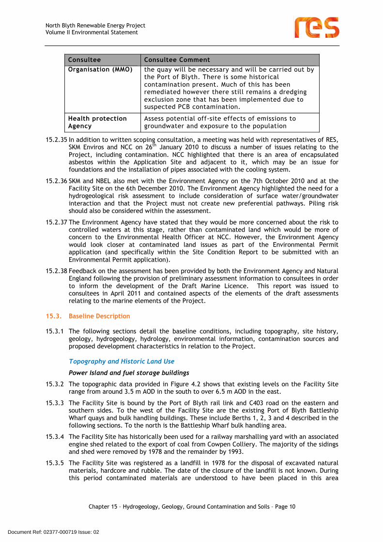
Table 15.6 Scoping Reponses Relating to Contamination of Geology, Soils and Groundwater
Consultee Consultee Comment
IPC Contaminated land - full risk assessment to be carried out
Coal Authority Past coal mining activities on the site should be considered in the ES together with any necessary mitigation
Coal Authority ES should consider: location and stability of abandoned mine entries, extent and stability of shallow mine workings, outcropping coal seams and unrecorded mine workings, hydrogeology, minewater and mine gas
Environment Agency Water and soils - consider whether identified risks from contamination can be reduced to an acceptable level
Environment Agency Assessment should be made of the risks posed to groundwater - both the flow and quality of shallow and deep groundwater
Marine Management Water and soils - some dredging works adjacent to
Document Ref: 02377-000719 Issue: 02
North Blyth Renewable Energy ProjectVolume II Environmental Statement
Chapter 15 – Hydrogeology, Geology, Ground Contamination and Soils – Page 10
Consultee Consultee CommentOrganisation (MMO) the quay will be necessary and will be carried out by
the Port of Blyth. There is some historical contamination present. Much of this has been remediated however there still remains a dredging exclusion zone that has been implemented due to suspected PCB contamination.
Health protection Agency
Assess potential off-site effects of emissions to groundwater and exposure to the population
15.2.35 In addition to written scoping consultation, a meeting was held with representatives of RES, SKM Enviros and NCC on 26th January 2010 to discuss a number of issues relating to the Project, including contamination. NCC highlighted that there is an area of encapsulated asbestos within the Application Site and adjacent to it, which may be an issue for foundations and the installation of pipes associated with the cooling system.
15.2.36 SKM and NBEL also met with the Environment Agency on the 7th October 2010 and at the Facility Site on the 6th December 2010. The Environment Agency highlighted the need for a hydrogeological risk assessment to include consideration of surface water/groundwater interaction and that the Project must not create new preferential pathways. Piling risk should also be considered within the assessment.
15.2.37 The Environment Agency have stated that they would be more concerned about the risk to controlled waters at this stage, rather than contaminated land which would be more of concern to the Environmental Health Officer at NCC. However, the Environment Agency would look closer at contaminated land issues as part of the Environmental Permit application (and specifically within the Site Condition Report to be submitted with an Environmental Permit application).
15.2.38 Feedback on the assessment has been provided by both the Environment Agency and Natural England following the provision of preliminary assessment information to consultees in order to inform the development of the Draft Marine Licence. This report was issued to consultees in April 2011 and contained aspects of the elements of the draft assessments relating to the marine elements of the Project.
15.3. Baseline Description
15.3.1 The following sections detail the baseline conditions, including topography, site history, geology, hydrogeology, hydrology, environmental information, contamination sources and proposed development characteristics in relation to the Project.
Topography and Historic Land Use
Power Island and fuel storage buildings
15.3.2 The topographic data provided in Figure 4.2 shows that existing levels on the Facility Site range from around 3.5 m AOD in the south to over 6.5 m AOD in the east.
15.3.3 The Facility Site is bound by the Port of Blyth rail link and C403 road on the eastern and southern sides. To the west of the Facility Site are the existing Port of Blyth Battleship Wharf quays and bulk handling buildings. These include Berths 1, 2, 3 and 4 described in the following sections. To the north is the Battleship Wharf bulk handling area.
15.3.4 The Facility Site has historically been used for a railway marshalling yard with an associated engine shed related to the export of coal from Cowpen Colliery. The majority of the sidings and shed were removed by 1978 and the remainder by 1993.
15.3.5 The Facility Site was registered as a landfill in 1978 for the disposal of excavated natural materials, hardcore and rubble. The date of the closure of the landfill is not known. During this period contaminated materials are understood to have been placed in this area
Document Ref: 02377-000719 Issue: 02

North Blyth Renewable Energy ProjectVolume II Environmental Statement
Chapter 15 – Hydrogeology, Geology, Ground Contamination and Soils – Page 11
including significant volumes of asbestos waste and waste materials containing significant concentrations of polychlorinated biphenyls (PCBs), derived from ship breaking operations.
15.3.6 The Facility Site was remediated in 1993 by NCC when the asbestos waste was encapsulated in an engineered repository within the embankment of the C403 road external to the eastern boundary of the Facility Site (see Figure 4.4). It is reported in the Desk Study, prepared by SDA, that as part of the remediation, all PCBs and other contamination impacted soils were excavated and removed from the Facility Site. The Facility Site was then refilled and capped with engineered fill. Since that date the Facility Site was redeveloped to its current use as a bulk handling facility.
15.3.7 Some improvement works will be required at the existing Port of Blyth site entrance to ensure vehicles from the Project do not impede Port of Blyth vehicles or other road users. This will include road widening works that will in turn require repair to the existing river wall. This is currently in a poor state of repair, with a partial collapse in one section and gaps in the wall leading to the wash out of retained materials in other sections. Initially it had been proposed that the walls be sealed to prevent washout and rock armour placed against them to prevent collapse. Discussions with Natural England, the Environment Agency and the MMO highlighted that the use of rock armour would result in the loss of mudflat habitat, and so an alternative construction technique using interlocking bored piles to form a new retaining wall on the landward side of the existing river wall is proposed. The existing rock revetment would then be reinstated against the new bored pile wall on the western section. The existing riverwall will be tied back to the new wall on the eastern section to prevent further collapse into the estuary. A description of these works is provided in Chapter 4 Development Description.
Grid Connection
15.3.8 The electricity export grid connection will be routed from the site to the Northern Powergrid substation at the former Blyth Power Station site via 66kV cables placed below ground. The planned alignment is from the site in the road verge to the west of the C403 north to the railway crossing. From this point it will be located below the road and will enter the Blyth Power Station site at the former site entrance.
15.3.9 It will consist of two 66kV cables placed within a trench a minimum of 450 mm apart, and a burial depth of at least 750 mm. The dimensions of the trench would be approximately 1 m deep and 1.2 m wide. The trench would only be open during the construction works. The cables will be laid close to encapsulated asbestos contaminated materials beneath the C403 road.
Cooling Water Intake from River Blyth
15.3.10 The cooling water intake structure is to be located on the land ward side of the existing river wall, beneath the existing Battleship Wharf Berth 4 and the hardstanding area to the rear, within the River Blyth Estuary. The location of the intake structure, and the route of the pipeline linking the intake structure to the plant, are shown in Figure 4.4. An engineering method statement describing the cooling water intake is provided in Appendix 4.2.
15.3.11 The topographic data provided on Figure 4.2 shows that existing river bed levels beneath the quay structure are around -2.0 m AOD with the deck level of Berth 4 at around 4.0 m AOD.
15.3.12 The intake will be bound to the east by the existing Battleship Wharf bulk handling facility and to the west by the existing river wall and the River Blyth Estuary. Battleship Wharf Berth 4 is located immediately adjacent to the northern boundary of the intake structure. Battleship Wharf Berths 2 and 3 are located to the south. The open decked structure of Berth 4, and the hardstanding to the rear of the quay, overlie the location of the intake structure.
15.3.13 Battleship Wharf Berth 4 was constructed as an open concrete deck with a sheet piled river wall to the rear as shown on Figure 15.3. The River Blyth Estuary openly flows beneath Berth
Document Ref: 02377-000719 Issue: 02

North Blyth Renewable Energy ProjectVolume II Environmental Statement
Chapter 15 – Hydrogeology, Geology, Ground Contamination and Soils – Page 12
4. Berths 2 and 3 comprise a cellular retaining river wall, with an integral wing wall oriented west-east along the sides of Berth 4.
15.3.14 The main pipeline route will run east from the pumphouse beneath Berth 4 and then south through the Battleship Wharf area to the Power Island.
15.3.15 The Facility Site has historically been occupied by the area of the Port of Blyth known as Battleship Wharf and its hinterland which included a ship breaking yard, and associated buildings, tanks and railway sidings. This area has been progressively developed to provide new quays, transhipment buildings and bulk material handling.
Cooling Water Outfall to the North Sea
15.3.16 The outfall to the North Sea is located to the north east of the Power Island. The outfall comprises a discharge pipeline orientated south west to north east, with its indicative location shown on Figure 15.1 and an engineering method statement describing the outfall is provided in Appendix 4.3. The pipeline, to be installed by directional drilling, will outfall at an approximate depth of -8.0 m CD (chart datum) on the sea bed.
15.3.17 The route of the proposed outfall is overlain by the Cambois Links sand dunes in the east and marine beach in the west. The rock formation known as ‘The Rockers’ is located in the central part of the pipeline route with the bed of the North Sea to the east.
15.3.18 Based on the information shown on the Admiralty Chart [Ref. 15.28] for the seabed and the results of a bathymetric survey, the minimum water depth is located approximately 770 m from the mean low water mark and 940 m from the mean high water mark at Ordnance Survey grid reference NZ 32025 83375 (432025,583375). This position is approximately 490m from the Rockers.
Geological Conditions
15.3.19 Geological data is included in SDA’s Desk Study (Appendix 15.1). The following geological sequence is taken from these findings.
Superficial Geology
Power Island and fuel storage buildings
15.3.20 Table 15.7 provides the Inferred geological sequence beneath the Power Island and fuel storage buildings
Table 15.7 – Inferred geological sequence beneath the Power Island and fuel storage buildings
StrataElevation of base of Unit (assumed ground level +6
m AOD)Sandy gravelly CLAY or clayey GRAVEL (Made Ground) 5.6 m – 4.3 m AODGrey black silty fine to coarse SAND and GRAVEL including mudstone and brick and lagoon pulverised fuel ash (Made Ground)
4.7 m – lower than 4 m AOD
Loose SAND (blown sand). -1.0 m – -1.25 m AODMiddle Coal Measures Rockhead Not Proved
15.3.21 It is reported that unexploded ordnance, as shells, were found during the PCBs remediation exercise which may be linked to the decommissioning of war ships.
Cooling Water Intake from River Blyth
15.3.22 The cooling water intake is located beneath Berth 4. Riverbed alluvium consisting of soft silts and clays is expected to be present to the riverward side of the quay’s sheet piled wall shown on Figure 15.3. Due to historical dredging at the front of the quay the surface of the silts is expected to slope steeply to the west.
Document Ref: 02377-000719 Issue: 02
North Blyth Renewable Energy ProjectVolume II Environmental Statement
Chapter 15 – Hydrogeology, Geology, Ground Contamination and Soils – Page 13
15.3.23 The area of the existing pumphouse and associated pipeline, to the rear of the quay’s retaining wall (Figure 15.3), has historically been covered by thick Made Ground overlying natural loose wind-blown sand. These materials are expected to be similar to the material located beneath the Power Island and fuel storage buildings.
15.3.24 It is understood that the bedrock surface slopes down westwards from the Power Island and fuel storage buildings towards the River Blyth and at the riverbank the bedrock is encountered at -3.0 m AOD. Outside the line of the quays the bedrock has been removed to depths ranging between -8.4 m and -11.1 m AOD to form berthing bays. As such, based on the geology detailed for the Power Island and fuel storage buildings (Table 15.2), it is inferred that varying thicknesses of estuarine alluvial deposits, Made Ground or natural sands will directly overlie bedrock at -3.0 m AOD beneath the proposed intake structure and along the line of the pipeline.
Cooling Water Outfall to the North Sea
15.3.25 The superficial geology along the pipeline route varies along its length. For descriptive purposes it can be summarised into three zones which are shown on Figure 15.2:
The road and rail embankment;
The beach to low water mark; and
The bed of the North Sea.
Road and Rail Embankment
15.3.26 It is understood that the road, which overlies the western section of the cooling water discharge pipeline, was constructed with an engineered repository, with asbestos impacted soils forming its core. The asbestos impacted material is sealed within a geo-membrane. The outfall pipeline will be drilled through the bedrock beneath the road and railway (See Appendix 4.4), and as such will not disturb the asbestos impacted material.
Beach to Low Water Mark
15.3.27 Between the C403 road and the North Sea the beach deposits consist of sand, including wind-blown sand which overlies shallow bedrock. The thickness of the sand is reported to vary between 0.5 m and 1.3 m across the beach and to be in excess of 2.1 m in the area of the sand dunes immediately adjacent to the C403.
Bed of the North Sea
15.3.28 The local Admiralty Chart [Ref. 15.28] indicates the near shore bed materials to consist of sand and rock. As such, it is inferred that any superficial deposits on the sea bed are likely to be thin.
Solid Geology
15.3.29 The bedrock beneath the Project comprises the Middle Coal Measures consisting of layers of sandstone, siltstone, mudstone and coal. It is understood that strata, at the bedrock horizon and visible on the shoreline adjacent to the Facility Site, is sandstone.
15.3.30 Shallow coal seams have been reported as likely to exist at shallow depths of between -6 m AOD and -8 m OD beneath the Project, and to be 0.2 m to 0.5 m thick. Due to their thickness and their location beneath a thin strip of land adjacent to the estuary, it is unlikely that these thin seams will have been worked.
15.3.31 Recorded mine workings are located in 4 seams between 70 m and 230 m depth. The last workings below Battleship Wharf were in 1983.
Hydrogeological Conditions
Power Island, fuel storage buildings and Cooling Water Intake from the River Blyth
15.3.32 The Groundwater Vulnerability Plan indicates the geology below the Project to be Minor or Secondary Aquifer (Variable Permeability). Minor Aquifers do not produce large quantities of water for abstraction but are important for base flows in rivers. Due to its proximity to the
Document Ref: 02377-000719 Issue: 02
North Blyth Renewable Energy ProjectVolume II Environmental Statement
Chapter 15 – Hydrogeology, Geology, Ground Contamination and Soils – Page 14
sea and the River Blyth Estuary, it is considered that the groundwater levels beneath the Power Island and fuel storage buildings will be tidally influenced and saline.
15.3.33 Groundwater strikes during previous ground investigations in the Battleship Wharf area, where recorded, tend to be located within the Made Ground. Water strikes occurred generally at 0.9 to 1.2 m AOD and rose to 1.2 to 1.8 m AOD. Based on the tidal range in the river, the granular nature of the superficial deposit and the Power Island’s close proximity to the river, groundwater levels could vary between 0.0 m AOD to 3.6 m AOD, in response to tidal variation in the estuary.
15.3.34 Based upon existing desk study and site investigation information it is considered that the groundwater below the Facility Site has been impacted by contaminative historical uses. As such, likely worst case conditions have been considered as part of this assessment. As part of the works, and to inform the detailed design of the Project, additional site investigation will be carried out to confirm the full extent of contamination and to confirm the design of proposed mitigation measures, if required.
Hydrological Conditions
Facility Site and Cooling Water Intake from River Blyth Estuary
15.3.35 The tidal range of the river is as follows:
Highest recorded +3.61 m AOD;
Mean High Water Springs +2.44 m AOD;
Mean High Water Neaps +1.35 m AOD;
Mean Low Water Neaps -0.79 m AOD;
Mean Low Water Springs -1.88 m AOD;
Lowest Astronomical Tide -2.60 m AOD; and
Lowest Recorded -3.61 m AOD.
15.3.36 The river is dredged by the Port of Blyth Authority (see Chapter 4 Development Description for further information on dredging by the Port of Blyth), to maintain navigation to an elevation of approximately -9.5 m AOD from the harbour entrance to the Tidal Basin north of the Battleship Wharf quay. The dredged depths in front of the Battleship Wharf quays, as reported on the Admiralty Chart for the river, are -8.4 m AOD at Berth 1 and -11.1 m AOD at Berths 2, 3 and 4. Berths 1-4 are shown on Figure 4.4.
Environmental Information
15.3.37 The following environmental information has been reported for the Facility Site, but can be inferred as relevant for the whole Project.
15.3.38 There are no Environmental Permits or Registered Radioactive Substances within 500 m of the Facility Site.
15.3.39 The Facility Site is shown as a registered landfill site and was registered in 1978. Authorised waste included natural materials, hardcore and rubble. Available information indicates that inert construction waste was placed in the landfill, and it has been treated as part of the 1993 remediation scheme. As such, low potential for gas generation. The license has now been surrendered. There are no other landfill sites within 500 m of the Facility Site and, there are no waste transfer sites within 1 km of the Facility Site.
15.3.40 There is one Notification of Installations Handling Hazardous Substances (NIHHS) within 500 m of the site. This is a Transco installation located in the centre of Blyth 450 m west of the Facility Site on the opposite side of the River Blyth Estuary. The Port of Blyth also holds a Control of Major Accident Hazards (COMAH) licence at Battleship Wharf.
15.3.41 There are no fuel station entries within 1 km of the Facility Site.
Document Ref: 02377-000719 Issue: 02

North Blyth Renewable Energy ProjectVolume II Environmental Statement
Chapter 15 – Hydrogeology, Geology, Ground Contamination and Soils – Page 15
15.3.42 There are three licensed water abstractions within 2 km of the Facility Site, however these are for cooling water or environmental remediation purposes.
15.3.43 Finally, as detailed in BRE Report 211 [Ref 15.30], there is no risk of radon gas emissions from beneath the Facility Site.
15.4. Sources of Contamination
Power Island and Fuel Storage Areas
15.4.1 The Power Island and Fuel storage area was remediated in 1993, as described in Section 15.3. This removed existing contamination as described in the SDA Desk study report (Appendix 15.1). Since 1993 the Facility Site has remained unused with the exception of being used as a lay down area for bulk materials from time to time. The coal handling facility is also located within the far northern part of this area.
15.4.2 Based on site investigation information that is available for the areas surrounding the Port of Blyth buildings (Appendix 15.1) adjacent to the Power Island, it is expected that residual concentrations and isolated hotspots of contamination could be present. Contamination could include heavy metals, sulphates, fuel, lubricating and mineral oils, polyaromatic hydrocarbons (PAHs), asbestos, PCBs, semi volatile organic compounds (sVOCs), volatile organic compounds (VOCs) and possibly combustible materials.
15.4.3 There are additional sources of contamination from fuels used by construction plant during site works which may impact soils and groundwater if a spillage occurs.
15.4.4 There is a potential for an adverse impact to groundwater in the vicinity of the Facility Site from the uncontrolled runoff of contaminated surface water.
15.4.5 Groundwater may be impacted from the mobilisation and leaching of existing contaminants present in the Made Ground and natural sands. Groundwater is likely to be in hydraulic continuity with the estuary and the sea and as such will likely be saline.
15.4.6 Due to the proximity to the North Sea, the Facility Site is likely to be impacted by seawater spray.
15.4.7 There is a low potential for soil and landfill gas emissions and vapours from Made Ground and natural superficial deposits below the Facility Site. This is due to the materials placed in the landfilled area reportedly being inert and the underlying natural sand strata having low organic content.
15.4.8 There is a potential for mine gases to be emitted from the deep coal measures beneath the Facility Site. Due to the depth of the workings it is considered that this risk is low.
Cooling Water Intake from the River Blyth Estuary
15.4.9 A site investigation of in the proximity to the existing Port of Blyth Shed No.2 showed heavy metal and sulphate contamination in the Made Ground. It is expected that the Made Ground retained by Berth 4 (retaining wall shown on Figure 15.3) could also contain residual contaminated soils and groundwater. The likely range of contaminants present in residual concentrations in the Made Ground are likely to include heavy metals, sulphates, fuel, lubricating and mineral oils, PAHs, asbestos, dibutyltin (DBT), tributyltin (TBT), PCBs, sVOCs, VOCs, and combustible materials in small quantities.
15.4.10 The alluvium deposits in front of the quay wall, in the area of the proposed intake structure, may have been impacted by historical port operations and land use. As such, they may contain the same range of contaminants as described above.
15.4.11 There is the low potential for soil and landfill gases and soil vapours to be emitted from Made Ground and natural superficial deposits beneath the Facility Site.
15.4.12 There is a potential for mine gases to be emitted from the deep coal measures beneath the Facility Site. Due to the depth of the workings it is considered that this risk is low.
Document Ref: 02377-000719 Issue: 02

North Blyth Renewable Energy ProjectVolume II Environmental Statement
Chapter 15 – Hydrogeology, Geology, Ground Contamination and Soils – Page 16
Cooling Water Outfall to North Sea
15.4.13 Contamination is not anticipated along the line of the outfall pipeline or beneath the outfall structure.
15.5. Impact Assessment
15.5.1 This section provides an assessment of potential impacts on geology, soils and hydrogeology, and potential impacts from existing ground contamination and soil gas during theconstruction, operation and decommissioning of the Project. A qualitative assessment is provided of the sensitivity, magnitude and significance of the impacts during construction, operation and decommissioning of the Project and the requirement and necessity for mitigation measures (outlined in Section 15.6). The assessment of residual effects is outlined within Section 15.7. As noted earlier, the risk assessments provided within the SDA reports (Appendices 15.1 and 15.2) were carried out initially to inform the Project design process. These initial risk assessments are developed further within this chapter to reflect the proposed design for the Project. It should be noted that the assessment of risk in the context of an EIA is different to that of a contaminated land assessment, which assigns maximum likely risks based on advising on land liability issues.
15.5.2 The environmental and geotechnical effects of the Power Island and storage sheds, including the grid connection, the cooling water intake from the River Blyth and the outfall system to the North Sea are considered to be very similar. As such, the three are assessed alongside each other in the following sections.
Construction and Decommissioning
15.5.3 The principal contamination, geology, and hydrogeology impacts relating to construction and decommissioning of the Project are presented in the following sections.
Human Health-Construction Workers
15.5.4 Construction workers are considered to be of medium sensitivity.
15.5.5 It is possible that construction workers will come into contact with contaminated soils and in particular TPH, PAH and PCBs. This is likely to be of moderate impact resulting in a moderate adverse effect. With the presence of such contaminants being possible there would be a moderate to low risk to construction workers.
15.5.6 It is understood that PCB impacted and remediated soils have been placed in a cell in the area of Berths 2 and 3. The cell consists of a former dry dock. The area where the PCB contaminated soils were placed is known and defined by the Port of Blyth and NCC. The works will be designed so that excavation for the cooling water intake structures, which could disturb this area, and impact on construction and maintenance workers, will be controlled as a result. This area will remain undisturbed through the construction process and therefore, apart from adequate signage and notices, no mitigation measures will be needed.
15.5.7 It is considered possible that construction workers could potentially inhale soil dust, landfill dust, mine gases and soil vapours when working in confined spaces and excavations. This would have a moderate to substantial impact resulting in moderate to high adverse impact. As such, this is considered to be a moderate risk to construction workers.
15.5.8 There is considered to be a low likelihood of construction workers coming into direct contact, or inhaling, soils and dust that are potentially contaminated with asbestos, if the asbestos repository is disturbed or residual asbestos is present in the Made Ground. This is considered to have substantial magnitude impact and present a high adverse impact to construction workers. As such, this is considered to be a low to moderate risk.
15.5.9 It is reported that shells were found during the PCB remediation exercise which may be linked to the decommissioning of war ships. As no Unexploded Ordnance (UXO) Survey has been undertaken a worst case assumption is made that live ordnance is likely to be present.
Document Ref: 02377-000719 Issue: 02

North Blyth Renewable Energy ProjectVolume II Environmental Statement
Chapter 15 – Hydrogeology, Geology, Ground Contamination and Soils – Page 17
As such, ground works during construction/ decommissioning may detonate such devices and pose a high risk to workers on the Facility Site.
Human Health -Adjacent Site Users
15.5.10 Adjacent site users are considered to be of medium sensitivity.
15.5.11 It is likely that there is the potential for mobilised residual contaminants as dust, and asbestos fibres in the Made Ground, to be inhaled by adjacent site users during construction. As residual concentrations are likely to be present in the ground, and dispersion is possible through the effects of the wind, this is considered to be a moderate magnitude impact to human health with the potential for moderate adverse effect. As such, this is considered to present low to moderate risk.
15.5.12 There is a low likelihood of a pathway between contaminated surface water runoff via direct contact and ingestion by adjacent site users. This is considered to present a minor adverse impact and, as such, presents a very low risk to adjacent site users. Appendix 15.1 shows there to be no licensed drinking water abstractions within 2km of the Facility Site.
Controlled Waters
15.5.13 Groundwater is considered to be of low sensitivity and surface water to be of medium sensitivity.
15.5.14 It is considered likely that there would be a minor to moderate magnitude of impact on controlled waters (perched and superficial groundwater) by leaching of contamination present in the Made Ground and natural superficial deposits if contaminants are mobilised during excavation. This groundwater is not considered suitable quality for drinking water and as such the risk to groundwater is considered to be low.
15.5.15 As the bedrock is in hydraulic conductivity with the sea it is considered that there is no risk of artesian conditions under the Facility Site which could release contaminated mine water into the estuary or the sea during excavations into the rock.
15.5.16 Surface water (River Blyth and the North Sea) is likely to be in direct hydraulic continuity with groundwater beneath the Facility Site. However, due to the effects of dispersion and dilution, it is considered that contaminated groundwater entering surface water as a result of the Project would be insignificant.
15.5.17 Uncontrolled discharges of contaminated groundwater, which has been pumped to surface during dewatering of excavations, could impact surface water. This would be a moderate magnitude of impact on surface water. This presents a low risk of impact to the quality of controlled waters.
15.5.18 It is understood that PCB contaminated soils are present in a remediation cell in the area of Berths 2 and 3. If disturbed these impacted soils and groundwater could be released into the Blyth Estuary with the potential for a substantial magnitude impact with high adverse impact. The location of the PCB contaminated soils is well known and defined by the Port of Blyth and NCC. This area will remain undisturbed through the construction process and therefore, with adequate signage and notices in place, the likelihood is considered to be unlikely. This presents a low risk of impact to controlled waters.
15.5.19 The ability of the soil matrix to contain liquid phase PCB’s, if present, is unknown and so are assumed to be present. It is reported that the PCB impacted soils may be in connection with the upper groundwater and tidal oscillation may provide a pressure difference to push liquids in and out of the material. The likelihood of this is considered unlikely however, due to their close proximity to controlled waters and the unlikely presence of an effective pathway, there is considered to be a moderate adverse effect to controlled waters by PCB’s which may be present at the Facility Site, and if they become mobilised by this Project. This is considered to present a low risk to controlled waters.
15.5.20 Foundation piling can create preferential pathways for contaminants, which in turn can migrate down into the local aquifer. As the existing Made Ground and superficial deposits are granular in nature and the natural migration of contaminants is understood not to be restricted under current conditions, it is therefore considered that piling operations cannot
Document Ref: 02377-000719 Issue: 02

North Blyth Renewable Energy ProjectVolume II Environmental Statement
Chapter 15 – Hydrogeology, Geology, Ground Contamination and Soils – Page 18
introduce additional potential pathways to lower water bodies. As such, the potential adverse impact of piling operations is considered insignificant.
15.5.21 There is a viable pollution linkage between flooding on Facility Site during construction and the wash out of uncovered contaminated soils during construction works. The magnitude of the impact is expected to be minor resulting in a minor significance effect. The likelihood of this occurring however is low and therefore the overall risk assessment of this effect is very low.
15.5.22 During construction works there is the potential for fuel spills and leaks to occur. The potential magnitude of the impact of a spill or leak to controlled waters is considered to be minor. The significance of any effect will therefore also be minor for both the effect on groundwater and surface water. Based on an unmitigated scenario and applying the risk assessment approach described previously these effects would pose a low risk of pollution to controlled waters due to a low likelihood of occurrence.
15.5.23 During site works there is a low likelihood that rainwater will collect on the surface of the Facility Site which may become contaminated on contact with contaminated soils exposed at the surface. In the event of uncontrolled releases of accumulated rainwater as surface water runoff there is the potential for this water to enter the River Blyth. The magnitude of the impact of this event is considered to be moderate, which has the potential to cause a moderate adverse effect. This risk to surface water is considered to be low.
15.5.24 It is considered that there would be a low likelihood for spillages or release of alkaline contaminated liquids during pouring of concrete to occur during any construction works that is near to the River Blyth. Due to the low volumes of material which are likely to be released the magnitude of the impact of a release is considered to be minor. This would present an insignificant adverse impact on groundwater and a moderate adverse impact to surface water. As such, this is considered to present a very low risk to groundwater but a low risk to surface water.
15.5.25 Elevated levels of contaminants are reported to be present in the river sediment (refer to the SDA Desk Study in Appendix 15.1). It is possible that sediments would be disturbed as a result of operations to construct the intake. The magnitude of this impact is considered to be minor due to the high volume of water in the estuary. Based on a medium sensitivity receiving environment the predicted significance of effect is considered to be minor. There is a high likelihood this would occur and the risk is predicted to be low.
15.5.26 It is possible that sediments could be disturbed as a result of operations to repair the River wall. These works will take place between the high and low mean water levels, with the work only taking place during low tide, when the working area is not covered by water. Therefore any disturbance will not be during inundation by water and will not cause sediment to be mobilised. The magnitude of this impact is considered to be minor due to the high volume of water in the estuary. Based on a medium sensitivity receiving environment the predicted significance of effect is considered to be minor. It is unlikely this would occur and the risk is predicted to be very low
15.5.27 During construction of the outfall, a jack up barge will be used during the works (as described in Appendix 4.3). The jack up barge will be supported by four spud legs up to 25-35m in length and 760-1200 mm in diameter. It is possible that sediment on the sea bed could be disturbed when the legs of the jack up barge are lowered. The magnitude of this impact is considered to be minor due to the high volume of water within the North Sea. Based on a medium sensitivity receiving environment the predicted significance of effect is considered to be minor. It is likely this will occur and the risk is predicted to be low.
15.5.28 Construction of the outfall requires the thin layer of sediment to be removed from the sea bed prior to the rock anchors being fixed to the underlying rock. It is possible that sediments could be disturbed and mobilised during this process. The magnitude of this impact is considered to be minor due to the high volume of water within the North Sea. Based on a medium sensitivity receiving environment the predicted significance of effect is considered to be minor. It is likely this will occur and the risk is predicted to be low.
Document Ref: 02377-000719 Issue: 02

North Blyth Renewable Energy ProjectVolume II Environmental Statement
Chapter 15 – Hydrogeology, Geology, Ground Contamination and Soils – Page 19
15.5.29 As described in Appendix 4.3, the foundation of the outfall will be constructed from concrete. There is, therefore, a potential for uncured concrete to escape during the works. Due to the high volume of water within the North Sea the magnitude of the impact of a release is considered to be minor. Based on a medium sensitivity receiving environment the predicted significance of effect is considered to be minor. It is likely this will occur and the risk is predicted to be low.
Ecology
15.5.30 The sensitivity of the ecological receptors is considered to be high.
15.5.31 Elevated levels of contaminants are reported to be present in the river sediment. It is considered that it is likely that sediments would be disturbed as a result of operations to construct the intake. The magnitude of this impact is considered to be insignificant due to the high volume of water in the estuary and that during construction of the intake, it is only the construction of the intake pipe manifold that protrudes into the river, requiring a hole/holes to be drilled in the existing river wall beneath Berth 4. As such, it is considered that there could be a moderate adverse effect on sensitive ecological receptors. This would present a very low risk to ecological receptors from mobilising these contaminants into the hydrological environment without any attenuation during construction.
15.5.32 During site works there is a likelihood that rainwater will collect on the surface of the Facility Site which may become contaminated on contact with contaminated soils exposed at the surface. In the event of an uncontrolled release of accumulated rainwater as surface water run-off there is the potential for this water to enter the River Blyth which is in direct hydraulic connection with the SSSIs in the river. The magnitude of the impact of this event on sensitive ecological receptors is considered to be low due to the effects of dispersal and dilution, and the Facility Site topography (See Figure 4.2 Facility Site Topography) would prevent surface water draining towards the SPA. This has the potential to cause a low to moderate adverse effect. This risk to designated sites is considered to be moderate and as such, mitigation measures as detailed in Section 15.6 will be implemented.
15.5.33 As the outfall pipeline is to be constructed by directional drilling, at a depth of approximately 20m below ground level, there is considered to be a negligible risk of impact to the coastal SPA, SSSI and RAMSAR sites during construction. As such, no mitigation measures will be implemented.
Hydrogeology
15.5.34 During construction works, localised dewatering of excavations by either sump pumping or well pointing will be required. As the groundwater in this area is tidally influenced these operations will not affect the wider groundwater regime.
15.5.35 It is not expected that ground anchors and piles will penetrate to a substantial depth into the sandstone aquifer below the Facility Site. This will be subject to further detailed engineering design based on the structural requirements of the buildings and further detailed intrusive geotechnical investigations. As such, construction and decommissioning of the plant are judged to represent an insignificant adverse effect on the flow of deeper groundwater within the Middle Coal Measures. As such, there is a very low risk to groundwater movement in the deeper groundwater and no mitigation measures will be implemented.
15.5.36 The pipeline to the outfall will be drilled at approximately 20m depth through the bedrock. The outer wall of the pipeline will be in close contact with soils and rock and as such would only form a very restricted pathway for contaminants to migrate to controlled waters. The volume of water which could migrate via this pathway is insignificant in comparison to the volume of water already flowing through the shallow soils and rock in this area as a result of tidal fluctuation. As such, there will not be any residual effects to environmental receptors from the presence of this pipeline.
15.5.37 It is considered that construction of the outfall structure and associated pipeline will have a negligible impact on the hydrology and hydrogeology in the area. As such, no mitigation measures will be implemented.
Document Ref: 02377-000719 Issue: 02

North Blyth Renewable Energy ProjectVolume II Environmental Statement
Chapter 15 – Hydrogeology, Geology, Ground Contamination and Soils – Page 20
Operation
15.5.38 The principal contamination, geology and hydrogeology impacts relating to operation of the Project are presented in the following sections.
Human Health – Operational Staff
15.5.39 Operational staff are considered to be of medium sensitivity.
15.5.40 Operational staff will be separated from potentially contaminated soils by bound surfacing materials such as tarmacadam flexible pavements and concrete slabs. Therefore, there is an insignificant potential for an adverse effect to human health from contaminated soils beneath the Facility Site. As such, there is a very low risk.
15.5.41 There is a low likelihood that operational staff could be adversely impacted by inhalation of soil, mine gas emissions and volatile gases collecting in confined spaces. If this were to occur the magnitude of the impact could be substantial. Based on a medium sensitivity a high adverse effect is predicted. As such, there would be a low to moderate risk to operational staff from the migration of soil and mine gases / vapours.
Maintenance Workers
15.5.42 Maintenance workers undertaking any future ground works during the operation phase of the Project will be subject to the same risks as the construction workers. As such, there is considered to be moderate risk of harm to their health.
Controlled Waters (Groundwater)
15.5.43 Hydrocarbon fuels such as oil and diesel, which are stored on the Facility Site for use in plant start up, are a potential source of contamination if spills and leaks occur. Spills and leaks could enter the ground and/or groundwater. There will be a significant quantity of chemicals (Table 15.8), which may also become a contamination source if they leak from fuel storage or are accidentally spilled.
Table 15.8 Chemicals to be Stored at the Project
Compound tonnes/year Storage quantity Sodium hypochlorite 15% solution 5300 70m3
Sodium bisulphite 20% solution 3
Antiscalant RO 6
Sulphuric acid 96% solution 60
Ammonium hydroxide 24% solution 0.5
Tri sodium phosphate 1
Hydrazine or carbohydrazide 14% solution 0.3
Sand 1600 70m3
Limestone / Calcium Hydroxide 4000 70m3
Bottom ash 5200 5 days equivalent
Dry fly ash 21000 5 days equivalent
Fuel oil boiler start-up 500 100 m3
Fuel oil mobile plant 100 100m3
15.5.44 Direct discharge of rainwater from the Project buildings, and hardstanding areas via surface water discharge pipes to the estuary is to be controlled under the Environmental Permit application, administered by the Environment agency.. All requirements of the Environmental Permit with respect to the quality of the discharge will be taken into account as part of the design of the system and will include oil separators, water and sewage treatment as necessary. Therefore, it is considered to present a very low risk during operation.
Document Ref: 02377-000719 Issue: 02
North Blyth Renewable Energy ProjectVolume II Environmental Statement
Chapter 15 – Hydrogeology, Geology, Ground Contamination and Soils – Page 21
15.5.45 There is a low likelihood of impact to groundwater by uncontrolled releases of process chemicals, fuels and lubricants via infiltration into the ground during the operational phase of the Project. The potential magnitude of the impact is substantial and could cause a moderate adverse effect on groundwater. This is considered to present a low risk to groundwater.
15.5.46 The operational Facility Site will incorporate hardstanding and managed drainage across the whole Facility Site preventing rainfall infiltration. However, the groundwater table is affected by tidal oscillation and therefore there will be no change to the underlying water table. Therefore, there are no predicted impacts on the groundwater table or contamination mobilisation once the Facility Site has been developed.
15.5.47 There is a slight possibility that major incidents, such as fire or flooding, could occur resulting in fuel tanks becoming ruptured or damaged. This could lead to fire fighting water becoming contaminated with combustion residues. Flooding may also result in a breach of fuel and chemical containment on Facility Site and may cause a moderate to substantial magnitude impact on adjacent water bodies. Therefore, the potential significance of the effect would be high. However, due to the low likelihood of such an event occurring there would be low to moderate risk during operation.
Controlled Waters (North Sea)
15.5.48 Direct discharge of water via the outfall during Facility Site operation, and associated quality, shall be controlled via an Environmental Permit to minimise impact on the aquatic environment. As such, there will be a negligible impact on the North Sea (see Chapter 11 Aquatic ecology for further details).
15.5.49 The outfall structure will have a low cross sectional profile which is unlikely to have a significant impact on longshore drift or the movement of currents given the nature of seabed geology and the position of the outfall. Infrastructure on the seabed is considered to be small enough that no measureable effects will be seen. As such the impact of this structure is insignificant and no mitigation measures will be implemented.
Geology
15.5.50 There will be no changes to the geology of the Project during operation.
15.5.51 Recorded mine workings are located in 4 seams between 70m and 230m depth below the Application Site ground level (6 m AOD). The last workings below the Battleship Wharf site were in 1983. Following the guidance given in CIRIA SP32 [Ref 15.31] it is considered that there is sufficient rock cover over these seams to prevent surface instability from the collapse of the workings. As such, the risk of an adverse effect is insignificant. Therefore, there is a very low risk from the collapse of mine workings.
Hydrogeology
15.5.52 The Facility Site will predominantly be covered with buildings and solid paved areas - see Figure 4.4 Proposed Project Layout. Because of the presence of bound hardstanding over the Facility Site, infiltration of rain water into the underlying Made Ground and superficial deposits will be significantly reduced. This rain water will instead be discharged directly to the River Blyth under an Environmental Permit. As such, the risk of an adverse effect to controlled water from mobilisation of contaminants in the soil via rainwater infiltration is insignificant. The direct runoff will not affect the groundwater table, which is influenced by tidal oscillations in the North Sea and the Blyth Estuary.
15.5.53 It is considered that the presence of piled foundations, basements, services and a below ground conveyor will, in the immediate vicinity of the Facility Site, impact the movement of shallow groundwater in the Made Ground and the natural sand. However, it is considered that there will be an insignificant effect on the wider groundwater regime. In the immediate vicinity of the Facility Site, there are no structures which could be adversely affected by changes in groundwater movement. The groundwater will also remain tidally influenced and, therefore, no changes in groundwater level will result due to the presence of large below ground structures.
Document Ref: 02377-000719 Issue: 02

North Blyth Renewable Energy ProjectVolume II Environmental Statement
Chapter 15 – Hydrogeology, Geology, Ground Contamination and Soils – Page 22
15.5.54 Operation of the Project will have an insignificant effect on the flow of the deep groundwater body within the Middle Coal measures and no mitigation measures will be implemented.
15.5.55 The construction of an intake structure below Berth 4 will cause insignificant changes to flows in the River Blyth around the structure. The pumphouse structure will be constructed to the rear of the existing retaining wall and adjacent to a cellular cofferdam and, therefore, the only projection into the river channel will be the intake pipe/pipes manifold projecting from the front of the structure (as illustrated in Figure 15.3). There is considered to be a very low risk of impact on local flows. In operation the cooling water intake will draw water into it from the river. However, the intake has been designed so that the velocity of the water entering the intake header is significantly less than tidal flows and an insignificant impact on water circulation within the estuary is expected.
Summary of Potential Impacts during Construction, Operation and Decommissioning
15.5.56 Presented in Table 15.9 is a summary of the potential impacts during the construction, operation and decommissioning of the Project.
Document Ref: 02377-000719 Issue: 02

North Blyth Renewable Energy ProjectVolume II Environmental Statement
Chapter 15 – Hydrogeology, Geology, Ground Contamination and Soils – Page 23
Table 15.9 - Summary of Potential Impacts (Pre-mitigation) during Construction, Operation and Decommissioning
Potential Impact Sensitivity Magnitude Significance Probability (Likelihood)
Potential Risk Need for Mitigation
Construction and Decommissioning Construction workers exposed to contaminated soils and waters
Medium Moderate Moderate Adverse Likely Low to Moderate Yes
Construction workers exposed to toxic and/or asphyxiating soil/mine gases and vapours
Medium Moderate to Substantial
Moderate to High Adverse
Likely Moderate Yes
Construction workers exposed to asbestos impacted soils and materials
Medium Substantial High Adverse Low Low to Moderate Yes
Construction workers exposed to live ordnance
Medium Substantial High Adverse Likely High Yes
Adjacent site users exposed to contaminated dust and asbestos fibres liberated from the Application Site
Medium Moderate Moderate Adverse Low Low to Moderate Yes
Adjacent site users exposed to contaminated surface water runoff
Medium Minor Minor Adverse Low Very Low No
Groundwater impacted by residual historical contamination and isolated hotspots which has become mobilised due to the Project
Low Moderate Minor Adverse Likely Low Yes
Surface water impacted by contamination migrating through groundwater
Medium Insignificant Insignificant Likely Very Low No
Uncontrolled discharge of potentially contaminated waters from excavation dewatering operations to surface water
Medium Moderate Moderate Adverse Low Low Yes
Exposure to sensitive receptors from PCB contaminated soils, held in containment cell at Berths 2 and 3, which become mobilised due to the Project
Medium Substantial High Adverse Unlikely Low Yes
New preferential pollution pathways created as a result of piling operations
Low Insignificant Insignificant Unlikely Very Low No
Wash out of excavated and uncovered Medium Minor Minor Adverse Low Very Low Yes
Document Ref: 02377-000719 Issue: 02

North Blyth Renewable Energy ProjectVolume II Environmental Statement
Chapter 15 – Hydrogeology, Geology, Ground Contamination and Soils – Page 24
Potential Impact Sensitivity Magnitude Significance Probability (Likelihood)
Potential Risk Need for Mitigation
contaminated surface soils during flooding eventsContamination of groundwater and surface water from accidental fuel spillages
Groundwater –Low
Surface water - Medium
Minor Minor Adverse Low Low Yes
Surface water and groundwater contaminated from uncontrolled release of surface water runoff from collected rainwater
Groundwater –Low
Surface water - Medium
Moderate Moderate adverse Low Low Yes
Concrete Pouring which could release alkaline liquids into groundwater and surface water
Groundwater –Low
Surface water - Medium
Minor Moderate Adverse (Surface Water)
Low Low Yes
Mobilisation of contaminated river sediments into the water column following construction of the intake
Medium Minor Minor High Low No
Mobilisation of contaminated river sediments into the water column following repair to the existing river walls
Medium Minor Minor Unlikely Very Low No
Mobilisation of sediment on the seabed when lowering the jack up barge
Medium Minor Minor Low Low Yes
Mobilisation of sediment when removing sea bed sediment prior to construction
Medium Minor Minor Low Low Yes
Concrete Pouring which could release alkaline liquids into surrounding sea water
Medium Minor Minor Low Low Yes
Impact on SSSIs and SPA from mobilisation of contaminated river sediments following construction activity
High Insignificant Insignificant adverse
Likely Very Low No
Impact on SSSIs and SPA from contaminants migrating via surface waters or surface water runoff
High Minor Moderate Adverse Likely Moderate Yes
Document Ref: 02377-000719 Issue: 02

North Blyth Renewable Energy ProjectVolume II Environmental Statement
Chapter 15 – Hydrogeology, Geology, Ground Contamination and Soils – Page 25
Potential Impact Sensitivity Magnitude Significance Probability (Likelihood)
Potential Risk Need for Mitigation
Impact on SSSI and SPA from construction of the outfall pipe
High Insignificant Insignificant Unlikely Very Low No
Localised Dewatering of excavations impacting on groundwater
Low Insignificant Insignificant Unlikely Very low No
Impact of piling on the flow of deeper groundwater
Low Insignificant Insignificant Unlikely Very low No
Impact upon longshore drift of the outfall structure
Medium Insignificant Insignificant Unlikely Very Low No
OperationEnd users potentially exposed to contaminated soils
Medium Insignificant Insignificant Adverse
Unlikely Very Low No
End users potentially exposed to toxic / asphyxiating soil/mine gases and vapours accumulating in confined spaces
Medium Substantial High Adverse Low Low to Moderate Yes
Maintenance workers exposed to contaminated soils and waters
Medium Moderate Moderate Adverse Likely Moderate Yes
Discharge of Rainwater Groundwater –Low
Surface water - Medium
Insignificant Insignificant Adverse
Groundwater –Unlikely
Surface Water -High
Very Low No
Uncontrolled release of fuels, lubricants, fire fighting and fire residues, and process chemicals/liquids impacting groundwater and surface water
Groundwater –Low
Surface water - Medium
Substantial Moderate Adverse Low Low Yes
Altering rainwater infiltration Groundwater –Low
Insignificant Insignificant Unlikely Very Low No
Damage to fuel storage by fire or flood events
Groundwater –Low
Surface water - Medium
Substantial High Adverse Low Low to Moderate Yes
Release of fire fighting water Groundwater – Moderate Moderate Adverse Low Likelihood Low Yes
Document Ref: 02377-000719 Issue: 02

North Blyth Renewable Energy ProjectVolume II Environmental Statement
Chapter 15 – Hydrogeology, Geology, Ground Contamination and Soils – Page 26
Potential Impact Sensitivity Magnitude Significance Probability (Likelihood)
Potential Risk Need for Mitigation
LowSurface water
- MediumImpact upon longshore drift of the outfall structure
Medium Insignificant Insignificant Unlikely Very Low No
Impact upon the stability of Coal Seams Low Moderate Minor Unlikely Very Low NoGroundwater movement impeded by the presence of large below ground structures
Low Insignificant Insignificant Unlikely Very Low No
Impact of the Project on the deep groundwater body within the Middle Coal Measures
Low Insignificant Insignificant Unlikely Very Low No
Changes to surface water movement around cooling water intake
Medium Insignificant Insignificant Unlikely Very Low No
Document Ref: 02377-000719 Issue: 02
North Blyth Renewable Energy ProjectVolume II Environmental Statement
Chapter 15 – Hydrogeology, Geology, Ground Contamination and Soils – Page 27
15.6. Mitigation and Monitoring
15.6.1 This section describes the likely mitigation measures that will be required to control the likely predicted impacts which have been discussed in Section 15.5.
15.6.2 The actual vertical and lateral distribution of contamination will be confirmed by a future pre-construction intrusive investigation to assist the detailed design of any required remediation and clean up works that will be required. This section outlines the likely mitigation measures required for the development areas, based on available information on contamination sources and risks.
Construction Phase Mitigation
15.6.3 Contractors will be required to adhere to an Environmental Management System (EMS) to ISO140001 or similar for the construction and decommissioning works, within the quality assurance component of the Contract. Contractors will be required to agree to and develop the overall Application Site Construction Environment Management Plan (CEMP) that will be agreed with NCC and the Environment Agency prior to commencement of the construction works.
15.6.4 The CEMP will define the specific mitigation measures to be applied on-site, and will demonstrate application of the relevant pollution prevention guidelines. The CEMP will therefore be required to address the management of soils and groundwater, with regard to potential contamination.
15.6.5 A site investigation will be undertaken, prior to construction, to identify the presence of contamination across the Application Site and identify the need for further site remediation(see DCO Requirement 8). As the Facility Site was remediated in 1993 in conjunction with NCC (refer to Appendix 15.1), it is not expected that extensive areas of contamination will be found. It is possible that some areas of contaminants, if found, would need to be remediated (see DCO Requirement 10). Where encountered these materials will be remediated on site or removed from the Application Site to a suitably licensed disposal facility in accordance with a proposed Requirement within the DCO application (see DCO Requirements 12 and 9) for a CEMP to be agreed with NCC and the Environment Agency prior to the commencement of construction. Alternatively, such areas may possibly be left in-situ beneath areas of developed hardstanding, which again will be agreed with the Local Authority and the Environment Agency.
15.6.6 A Site Waste Management Plan (SWMP) will also be developed prior to construction. This document will be treated as a live document during design and construction and anticipated quantities of wastes generated will be updated as and when information becomes available.
Human Health - Construction Workers
15.6.7 Appropriate PPE and hygiene procedures will mitigate the risk of harm to construction workers by preventing direct contact with potential contaminants in the superficial deposits and groundwater.
15.6.8 The risk of harm to construction workers from inhaling asphyxiating gases in confined spaces and deep excavations can be eliminated by using gas detectors before entering any confined space and ensuring all work areas are adequately ventilated. Additionally, appropriate PPE will be worn where there is a risk of elevated concentrations of soil gases. The required level of protection will be established as part of the health and safety planning in accordance with a proposed pre construction Requirement (see DCO Requirement 12), within the DCO application for a CEMP to be agreed with NCC.
15.6.9 The risk of harm to construction workers from disturbance of residual asbestos impacted soils will be controlled through the identification and removal of materials by a specialist contractor. Materials will be disposed of off-site at a suitably licensed landfill. No works will be carried out until all risk assessments and detailed method statements have been agreed with NCC and the Environment Agency (see DCO Requirement 24).
Document Ref: 02377-000719 Issue: 02

North Blyth Renewable Energy ProjectVolume II Environmental Statement
Chapter 15 – Hydrogeology, Geology, Ground Contamination and Soils – Page 28
15.6.10 A UXO Survey will be undertaken on Facility Site to inform the development of risk assessments and method statements, for construction and maintenance workers during piling and below ground excavation (see DCO Requirement 17). Potential mitigation measures include geophysical probing of pile locations prior to piling and employing specialist UXO banksmen to monitor excavations for the presence of ordnance. Where ordnance is identified it will be made safe (if appropriate) and removed from the Facility Site by a bomb disposal team mobilised by the UK Armed Forces. This results of this survey will be submitted to NCC, prior to the commencement of construction, including mitigation measures which will be agreed with NCC prior to the commencement of works.
15.6.11 It is understood that PCB impacted and remediated soils have been placed in a cell in the area of Berths 2 and 3. The cell consists of a former dry dock. The area where the PCB contaminated soils were placed is known and defined by the Port of Blyth and NCC. The works will be designed so that excavation which could disturb this area, and impact on construction and maintenance workers, will be controlled as a result. This area will remain undisturbed through the construction process and therefore, apart from adequate signage and notices, no mitigation measures will be needed.
Human Health - Adjacent Site Users
15.6.12 Dust monitoring and suppression measures such as dampening down surfaces during periods of dry weather and suspending earthworks during high winds, will be implemented during earthworks to mitigate a moderate potential for impact on adjacent site users from contaminated dust and liberated asbestos fibres (see DCO Requirement 13). This will identify and limit the risk presented by airborne contaminants to adjacent site users. This will be in accordance with the CEMP, agreed with NCC and the Environment Agency. With this mitigation in place, the residual impact will be reduced to an acceptable level.
Controlled Waters
15.6.13 Mitigation measures to reduce the leaching of contaminants into groundwater will be detailed within the CEMP and will be informed through further ground investigation undertaken to confirm the findings of the previous studies used as the basis of this assessment. Appropriate measures include phasing of the excavation work and hard standing removal so that large areas of made ground and potentially contaminated soil are not exposed all at once. Covering any exposed areas during high rainfall events to reduce leaching and making sure surface water from the Facility Site does not drain into excavations will also be considered. This will only be appropriate if hot spots of contamination have been identified and the materials remain on the Facility Site (see DCO Requirement 8).
15.6.14 All water removed from excavations during construction will be treated where necessary and discharged in accordance with relevant consents to discharge agreed with the Environment Agency.
15.6.15 As part of the CEMP, during site investigation and earthworks operations, where liquid phase contamination is visually identified, the presence of PCB contamination will be investigated by testing. Where PCBs are present in concentrations above threshold levels the liquid and affected soils shall be removed from site and incinerated. Where PCB contamination is encountered during earthworks operations the base and sides of the excavated area shall be sampled and tested to confirm all affected soils have been removed from the Application Site.
15.6.16 As part of the CEMP, mitigation to prevent the wash out of uncovered contaminated soils during construction works. Where appropriate, bunds shall be constructed around work areas where existing soils are exposed to prevent flood water inundating work areas and washing out potentially contaminated surface soils.
15.6.17 As part of the CEMP, areas for locating the storage of construction materials will be indentified outside the flood zone (away from the berths at Battleship Wharf). The delivery of construction materials will also be programmed to prevent stockpiling. Bulk materials such as aggregate, topsoil and excavated arisings will be stored in designated areas away from the Blyth Estuary.
Document Ref: 02377-000719 Issue: 02

North Blyth Renewable Energy ProjectVolume II Environmental Statement
Chapter 15 – Hydrogeology, Geology, Ground Contamination and Soils – Page 29
15.6.18 Specific guidance in dealing with silt contained in surface water runoff arising from construction activities is contained within PPG5. A number of measures can be put in place (see DCO Requirement 7) in order to minimise the actual transport of silt into surface water features, and will be agreed via the CEMP, including:
Use of sediment traps and installing settlement ponds or tanks where practical;
Use of designed drainage filters;
Provision of track or road side drainage channels with small dams to assist with silt retention;
Bunding – either earth bunds, cut-off ditches or other forms of diversion or sheeting of stockpiles will be used to minimise the potential for silt laden runoff. Where appropriate silt fences or straw / rock barriers at the toe of the stockpile would be put in place to mitigate runoff during rainfall events. A silt fence comprises a geotextile filter fabric, straw bales, or a combination of both, installed in the path of runoff and can filter out heavy sediments; and
Wheel washing to prevent soils being spread onto roads outside of the construction area.
15.6.19 Appropriate measures will be put in place through the CEMP to mitigate potential effects of contamination during concrete pouring (see DCO Requirement 7), for containment of fuelling operations, and during fire fighting events. Measures will be based on best practice (e.g. EA PPG Notes and CIRIA [Ref 15.32]) and will include the following:
designated facilities designed and used for oil and fuel storage and refuelling (incorporating appropriate bunds and drip trays);
a site oil, chemical and product inventory;
a list of emergency procedures, responsive to a risk assessment of areas of high sensitivity;
site induction of all personnel on emergency spillage procedures and staff trained in emergency procedures;
a contact list for the emergency services, the relevant environmental regulators, the local water supply and sewerage undertakers, the Health and Safety Executive and specialist clean up contractors, if required;
emergency response equipment available at appropriate locations; and
appropriate PPE for work in areas where there is potentially any contamination present, including where necessary gloves, protective suits and vapour masks.
15.6.20 Prior to the commencement of construction and as a proposed Requirement accompanying the DCO (DCO Requirement 25), a “Pollution Incident Response Plan” will be developed. In the event of an accidental spillage, the “Pollution Incident Response Plan” will become effective. This plan will be part of the contractor’s registered Quality Assurance programme to ISO 9001 and ISO 140001. This will include details for the relevant contact at the MMO, should a marine pollution incident occur. The Pollution Incident Response Plan will be agreed with consultees including the MMO and the Environment Agency prior to commencement of the works.
15.6.21 The storage of potentially polluting materials will be kept to a minimum where practicable and, where less hazardous or inert materials are available, these will be specified. In addition, absorbent mats/pads, absorbent granules and sand will be made available, and site operatives trained in their use, to deal with any spillages.
15.6.22 The positioning of fuel storage tanks and other potentially polluting materials and maintenance facilities will be on bunded areas of hard standing with dedicated drainage systems. Bunded areas will provide 110% storage volume to contain any possible leaks. Refuelling will also be undertaken only in designated areas, where small spills and leaks can be controlled. Drip trays and absorbent materials will be used to control spills.
Document Ref: 02377-000719 Issue: 02
North Blyth Renewable Energy ProjectVolume II Environmental Statement
Chapter 15 – Hydrogeology, Geology, Ground Contamination and Soils – Page 30
15.6.23 Construction of concrete structures during the construction phase would be monitored to prevent cementitious material contaminating controlled waters (both surface and groundwaters). Pre-cast work or permanent formwork will reduce the amount of in-situ concreting required and used during construction activities on the Power Island. Where wet concrete is to be used, the base of the excavation will be sealed prior to pouring with for example an impermeable membrane, to ensure that vertical fissures that might act as preferential flow pathways down to the groundwater table are blocked.
15.6.24 The following procedures will be undertaken to mitigate any environmental impact when concreting is required close to, or within the river bank, and within the tidal range. The procedures detail the containment of the uncured concrete and necessary preventative measures:
any joints on the inside of the shuttering will be taped prior to concrete pouring. The concrete will press the tape onto the shutter when it is poured preventing any leaks;
the concrete work will only take place at low tide so it will be easy to visually check the shuttering for leaks; and
an anti washout additive will be added if it is considered there will be wave action before the concrete sets.
15.6.25 The above measures are based upon good construction practice and would form part of the CEMP.
15.6.26 Washing out of concrete wagons or other equipment used in concreting operations will be undertaken in designated contained washout areas or offsite.
15.6.27 To mitigate the low risk of impact to controlled waters by riverside construction activities, silt screens will be utilised (such as the use of a silt curtain) used. These will screen the working area preventing suspended sediments from being transported away from the Facility Site works. This would remain in place for a further period of time after the construction works to allow settlement of sediments. This will comply with the requirements of Pollution Prevention Guidance note 5 (PPG5) [Ref 15.33].
15.6.28 Construction of the outfall structure will be subject to a detailed construction method statement. This will be agreed with the MMO prior to the commencement of works. Examples of typical mitigation practices are detailed below:
15.6.29 Significant currents and waves in the open water site of the outfall structure preclude the use of silt curtains. The spud legs of the jack up barge will be lowered at the turn in the tides to ensure there is minimal disturbance of sediments and so that any disturbed sediments will fall back to the sea bed in the immediate vicinity of the legs.
15.6.30 To minimise sediment disturbance during sediment removal activities, silts and other sediments at the site of the outfall structure will be removed by suction or an air blower, controlled by a diver.
15.6.31 Once the sediment has been removed the framework surround to the outfall will be bolted to the seabed. Gaps between the frame and the seabed will be plugged using concrete filled sandbags to prevent concrete seeping out of the base of the frame. The concrete within the frame will be placed by a diver pumping the concrete with a low pressure pump and hose nozzle system linked to the jack up barge.
15.6.32 Concrete will be of a marine specification to minimise loss of concrete paste into the marine environment. All underwater concrete overspill will be minimised and losses are expected to be minimal and at worst would create a haze around the nozzle.
15.6.33 Once poured, hessian mats will be placed over the concrete, and secured to the sea bed to prevent the concrete being washed out during its curing period. Setting of the concrete is expected within 1-2 hours, hardening within 12 hours, with full strength being reached within 28 days. All hessian matting will be removed following completion of the works.
15.6.34 Details of the staged construction are shown in Appendix 4.3.
Document Ref: 02377-000719 Issue: 02

North Blyth Renewable Energy ProjectVolume II Environmental Statement
Chapter 15 – Hydrogeology, Geology, Ground Contamination and Soils – Page 31
Ecology
15.6.35 The mitigation measures described above relating to controlled waters will also mitigate the impacts identified for the designated ecological sites.
Specific Mitigation Measures on Decommissioning
15.6.36 Removal of site plant and infrastructure will be in accordance with industry best practice available at the time. This will ensure that accidental spillages or release of potentially contaminative substances are prevented.
15.6.37 A Site Closure and Restoration Plan will be prepared in consultation with the Environment Agency (see DCO Requirement 45). The Plan will include the following information:
Site survey and ground investigation data, including soils testing and any proposed protection, decontamination and monitoring measures;
Details of the removal or flushing out of pipelines and tanks;
Plans of all underground pipes, tanks, services and foundations;
Details of the treatment and or removal of all potentially harmful materials;
Outline proposals for decommissioning, including method statements and risk assessment to be developed in detail prior to commencement of decommissioning of the plant.
15.6.38 Measures that will be used to minimise the potential release of contaminative substances during decommissioning are likely to include:
Isolate/ disconnect power supplies, drainage, gas and possibly re-route supplies (if required) during decommissioning and demolition;
In-situ decontamination of pipework and equipment by techniques including flushing, purging, blowing down where practicable;
Drain remaining liquids from the systems, remove filter bags, remove bulk dust and ash, undertake the controlled washdown of equipment/building fabric, washings to be collected/treated in existing separation/treatment plant prior to discharge/waste disposal; and
Demolition techniques will include - remote hydraulic machine shearing/pulverising, secondary machine processing, workface hot cutting, secondary hot cutting processing, controlled collapse, lifting/removal and manual removal of asbestos coated sheeting.
Operation Phase Mitigation
Human Health - End Users
15.6.39 The risk to the Project and end users from the collection of potentially asphyxiating and explosive mine gases in confined spaces will be eliminated by incorporating gas protection measures in accordance with CIRIA C665 [Ref 15.16] into the design of the Project. Investigation and gas monitoring will be implemented to determine if gas emissions are occurring.
15.6.40 Appropriate gas protection measures that will be incorporated into the building design to mitigate risks to human health could include:
perforated pipes installed within a granular layer below the building floor slabs to capture gas;
‘visqueen’ type plastic layer above the granular layer to prevent gas entering the buildings;
venting the perforated pipes to a perimeter trench which can be gently pumped should gas problems arise; and
Document Ref: 02377-000719 Issue: 02

North Blyth Renewable Energy ProjectVolume II Environmental Statement
Chapter 15 – Hydrogeology, Geology, Ground Contamination and Soils – Page 32
fitting buildings with a natural gas monitor for CH4/CO2.
Maintenance Workers
15.6.41 Appropriate PPE and hygiene procedures will mitigate the risk of harm to maintenance workers by preventing direct contact with potential contaminants in the superficial deposits and groundwater. However, intrusive investigation carried out during the construction phase, will also be undertaken in the near surface soils to confirm the nature of contamination and appropriate remedial measures where there could be a risk to workers on site.
15.6.42 The risk of harm to maintenance workers from inhaling asphyxiating gases in confined spaces and deep excavations will be eliminated by using gas detectors before entering any confined space and ensuring all work areas are adequately ventilated. Additionally, appropriate PPE will be worn where there is a risk of elevated concentrations of soil gases. The required level of protection will be established as part of the health and safety planning for the maintenance works.
15.6.43 The risk of harm to maintenance workers from disturbance of residual asbestos impacted soils will be controlled through the identification and removal of materials by a specialist contractor. Materials will be disposed of off-site at a suitably licensed landfill. No works will be carried out until all risk assessments and detailed method statements have been agreed with NCC and the Environment Agency.
Controlled Waters (Groundwater)
15.6.44 Mitigation measures will be implemented to address uncontrolled releases of process chemicals, fuels and lubricants via infiltration into the ground (see DCO Requirement 25). Measures will include chemical and oil storage bunded areas (to contain at least 110% of the volume of the storage vessel they are protecting), emergency spill procedures and interceptors will be incorporated into the plant drainage systems. These will be in accordance with the requirements of discharge consents agreed with the Environment Agency. In the event of an accidental spillage, a predefined “Pollution Incident Response Plan” will become effective. This plan will be part of the contractor’s registered Quality Assurance programme to ISO 9001 and ISO 140001.
15.6.45 Infrastructure, surfacing and subsurface structures (including bulk liquid storage tanks, road surfaces/ areas of hardstanding and drains etc.) will require regular and frequent inspections to check for leaks, cracks and other damage. Monitoring reports of the inspections undertaken will be issued to the Environment Agency on an agreed basis as stipulated within the Environmental Permitting system.
15.6.46 Regular auditing of the storage and use of potentially polluting substances will be undertaken.
15.6.47 Refuelling will occur only in areas of hardstanding with spill kits adjacent to all re-fuelling areas to enable a quick and effective response in the event that any leakages occur.
15.6.48 Any specific activities involving the storage or handling of oils and hydrocarbons will be subject to a separate task specific environmental risk assessment, under the requirements of the Environmental Permitting Regulations [Ref 15.33]. A Marine Pollution Contingency Plan will be developed and approved by the MMO prior to the commencement of works.
15.6.49 There is a slight possibility that major incidents, such as fire or flooding, could occur, resulting in fuel tanks becoming ruptured or damaged. This could lead to fire fighting water becoming contaminated with combustion residues. Flooding may also result in a breach of fuel and chemical containment on site and may cause a moderate to major impact on adjacent water bodies. To prevent the escape of vehicle fuel during a flood event, vehicle fuel storage will be located outside of the areas that are identified as being at risk from flooding in the Flood Risk Assessment (See Appendix 14.1).
15.6.50 The Project will be fitted with deluge sprinkler systems as will the large oil filled transformers, steam turbine lubricating oil system and boiler fuel feed area. The main fuel oil storage tank will be fitted with a dry riser tube allowing foam to be injected from
Document Ref: 02377-000719 Issue: 02

North Blyth Renewable Energy ProjectVolume II Environmental Statement
Chapter 15 – Hydrogeology, Geology, Ground Contamination and Soils – Page 33
outside of the bunded area into the top of the oil storage tank. Hydrant boxes, hose reels and fire extinguishers will be appropriately located around the Facility Site. The system will also include measures for the containment of runoff water from the fuel stores. Storage facilities will be included to contain fire water from the fuel stores and allow treatment before eventual discharge. Consideration will also be given in the detailed design to make runoff water available for fire fighting by inclusion of a sump with basic screening provisions, thereby minimising the total amount of effluent generated during a fire. Details of how fire fighting water would be contained and managed will be agreed with the Environment Agency and submitted with the future EP application and are included in DCO Requirement 21.
15.7. Cumulative Impacts
15.7.1 The location of the other proposed developments within the Blyth area is such that cumulative impacts, when considered alongside the Project, are not anticipated to occur. The nearest turbines for the Narec Offshore Demonstrator project are located approximately 1.3 km from the outfall location, and the other Narec developments within the Blyth Estuary, are located approximately 0.7 km from the Facility Site. The nearest developments are the Port of Blyth biomass storage building and the Blyth harbour wind farm, both of which are due to be constructed prior to the Project.
15.7.2 As noted in Chapter 14 Surface Water Hydrology and Flood Risk, the capital dredge that will be carried out by the Port of Blyth is beneficial to, but distinct from, the Applicant’s scheme. As such it does not form part of the Applicant’s suite of applications for consent. Instead the Port of Blyth will seek consent for the capital dredge. Dredging will not take place within the dredging exclusion zone.
15.7.3 As noted above elevated levels of contaminants are reported to be present in the river sediment. It is considered that it is likely that sediments would be disturbed as a result of dredging operations carried out by the Port of Blyth. The capital dredge would not take place at the same time as construction works within the Blyth Estuary for the intake, and so these impacts would not take place at the same time.
15.8. Residual Effects
15.8.1 Table 15.10 illustrates a summary of the predicted residual effects on geology and hydrogeology following the incorporation of the mitigation measures put forward in Section 15.6
Document Ref: 02377-000719 Issue: 02

North Blyth Renewable Energy ProjectVolume II Environmental Statement
Chapter 15 – Hydrogeology, Geology, Ground Contamination and Soils – Page 34
Table 15.10 - Summary of Residual Effects during Construction, Operation and Decommissioning
Residual Effect Risk Potential pre mitigation Need for Mitigation Risk Post mitigation
Construction and DecommissioningConstruction workers exposed to contaminated soils and waters Low to Moderate Yes LowConstruction workers exposed to toxic and/or asphyxiating soil/mine gases and vapours Moderate Yes Low
Construction workers exposed to asbestos impacted soils and materials Low to Moderate Yes Very Low
Construction workers exposed to live ordnance High Yes LowAdjacent site users exposed to contaminated dust liberated from the Application Site Low to Moderate Yes Very Low
Adjacent site users exposed to contaminated surface water run off Low Yes Very LowSurface waters impacted by contamination migrating through groundwater Very Low No Very Low
Groundwater impacted by residual historical contamination and isolated hotspots which has become mobilised due to the Project Low No Low
Uncontrolled discharge of potentially contaminated waters from excavation dewatering operations to surface water Low Yes Low
Exposure to sensitive receptors from PCB contaminated soils, held in containment cell at Berths 2 and 3, which become mobilised due to the Project
Low Yes Low
Wash out of excavated and uncovered contaminated surface soils during flooding events Very Low Yes Very Low
Contamination of groundwater and surface water from accidental fuel spillages Low Yes Low
Surface water and groundwater contaminated from uncontrolled release of surface water runoff from collected rainwater Low Yes Low
Concrete Pouring Low Yes LowMobilisation of contaminated river sediments into the water column following construction activity Very Low No Very Low
Mobilisation of sediment on the seabed when lowering the jack up barge Low Yes Very Low
Document Ref: 02377-000719 Issue: 02

North Blyth Renewable Energy ProjectVolume II Environmental Statement
Chapter 15 – Hydrogeology, Geology, Ground Contamination and Soils – Page 35
Residual Effect Risk Potential pre mitigation Need for Mitigation Risk Post mitigation
Mobilisation of sediment when removing sea bed sediment prior to construction Low Yes Very Low
Concrete Pouring which could release alkaline liquids into surrounding sea water Low Yes Very Low
Impact on SSSIs and SPA from mobilisation of contaminated river sediments following construction activity Very Low No Very Low
Impact on SSSI’s and SPA from contaminants migrating via surface waters or surface water runoff Moderate Yes Low
OperationEnd users potentially exposed to toxic / asphyxiating soil/mine gases and vapours accumulating in confined spaces Low to Moderate Yes Low
Maintenance workers exposed to contaminated soils and waters Moderate Yes LowUncontrolled release of fuels, lubricants, fire fighting and fire residues, and process chemicals/liquids impacting groundwater Low No but will be
implemented anyway Low
Damage to fuel storage by fire or flood events Low to Moderate Yes LowRelease of fire fighting water Low Yes Low
Document Ref: 02377-000719 Issue: 02
North Blyth Renewable Energy ProjectVolume II Environmental Statement
36
15.9. Conclusions
15.9.1 The Facility Site has historically contained contaminating land uses, however it was remediated in 1993. As such, it is only expected to contain residual contamination including isolated hotspots. The risks presented by any residual contamination which may remain will be assessed after detailed site investigation and appropriate mitigation measures implemented to prevent adverse impact on human health, controlled waters and ecological receptors. However, it is predicted that based on the information available (Appendix 15.1) with the described mitigation measures the residual risks to soils and controlled waters will be low.
15.9.2 The generation of dust from site works could cause a risk to site workers and Port of Blyth workers. As discussed with the residual risk of contamination on site there is the potential for dust to be contaminated, although this risk is evaluated to be of low likelihood. With the application of mitigation measures, which will be controlled through the CEMP, the residual risk is predicted to be very low.
15.9.3 The CEMP will be developed to control the risks of contamination occurring as a result of the construction activities. The CEMP will be a requirement of the DCO (DCO Requirement 12).
15.9.4 Once the Facility Site is developed, any residual contamination will either have been removed or assessed as safe to remain covered by the development. Either method will be agreed with the Local Authority and the Environment Agency.
15.9.5 There are no predicted effects on the groundwater regime beneath the Application Site, with the dominant control on groundwater remaining to be the tidally influenced groundwater levels.
15.9.6 The operation of a cooling water intake is not expected to have an adverse impact on surface water flows in the River Blyth. As part of the works, and to inform the detailed design, additional site investigation will be carried out to confirm the extent of any residual contamination. Where required appropriate mitigation measures, such as use of silt curtains, will be implemented to prevent adverse impacts occurring.
15.9.7 The construction and operation of the cooling water outfall is not expected to have an adverse impact on human receptors and controlled waters or ecological receptors.
15.9.8 The Project will be decommissioned in a planned and controlled manner which will be designed and implemented to prevent the uncontrolled release of fuels, lubricants and process chemicals which may still be present after the closure of the plant.
Document Ref: 02377-000719 Issue: 02

North Blyth Renewable Energy ProjectVolume II Environmental Statement
37
15.10. References
Ref 15.1 Office of the Deputy Prime Minister (2004). Planning Policy Statement 23 (PPS 23) Planning and Pollution Control
Ref 15.2 Wansbeck District Council. (2007). Wansbeck District Local Plan 2007,Ref 15.3 Office of the Deputy Prime Minister (2005). Planning Policy Statement 9
Biodiversity and Geological ConservationRef 15.4 Office of the Deputy Prime Minister (2004). Planning Policy Statement 23 (PPS 23)
Planning and Pollution ControlRef 15.5 Office of the Deputy Prime Minister. (1994). PPG24 Planning Policy Guidance 24:
Planning and noiseRef 15.6 Department for Communities and Local Government (2008), Planning Policy
Statement 25: Development and Flood Risk Practice Guide. London, HMSO.Ref 15.7 Environment Agency (2007),Pollution Prevention Guidance Note 5 (PPG5) Works
and maintenance in or near waterRef 15.8 DEFRA and the EA. (2002) ‘Contaminated Land Exposure Assessment Model’ (CLEA)Ref 15.9 DETR, EA & Institute of Environmental Health (IEH). (1995). Guidelines for
Environmental Risk Assessment and Management;Ref 15.10 DEFRA. (2009). Construction Code of Practice for the Sustainable Use of Soils on
Construction Sites, September 2009.Ref 15.11 DEFRA. (2009). Safeguarding our Soils – a Strategy for England, 2009Ref 15.12 Control of Pollution (Oil Storage)(England) Regulations 2001Ref 15.13 CIRIA. (2001). C552. Contaminated Land Risk Assessment. A Guide to Good
Practice, 2001Ref 15.14 BSI. (1999). BS 5930:1999 – Code of Practice for Site InvestigationsRef 15.15 BSI. (2001). BS 10175:2001 – Investigation of Potentially Contaminated Sites – Code
of PracticeRef 15.16 CIRIA. (2007). C665, Assessing risks posed by hazardous ground gases to buildings,
2007Ref 15.17 Groundwater Regulations 1998Ref 15.18 UK Water Quality (Water Supply) Regulations 2000Ref 15.19 EC Fisheries Directive (78/659/EEC)Ref 15.20 Water Framework Directive (2000/60/EC)Ref 15.21 Environment Act 1995Ref 15.22 Land Drainage Act 1991Ref 15.23 Buildings Research Establishment (BRE). (2005). Special Digest 1:2005 (Concrete in
Aggressive Ground)Ref 15.24 Environmental Protection Act 1990, Part IIA (Contaminated Land (Section 57 of the
Environment Act 1995))Ref 15.25 Contaminated Land Regulations 2006Ref 15.26 DETR. (2000). Circular 02/2000, Contaminated Land: Implementation of Part IIA of
the Environmental Protection Act 1990 Ref 15.27 DEFRA. (2006). Circular 02/2006, Contaminated Land: Implementation of Part IIA
of the Environmental Protection Act 1990Ref 15.28 UK Hydrographic Office, Admiralty Chart No. 1626 England East Coast – BlythRef 15.29 Energy Technology Support Unit. (2002). Potential Effects of Offshore Wind
Developments on Coastal Processes, on behalf of the Department of trade and Industry.
Ref 15.30 BRE. (2007). Report 211, Radon, Guidance on protective measures for new
Document Ref: 02377-000719 Issue: 02

North Blyth Renewable Energy ProjectVolume II Environmental Statement
38
buildingsRef 15.31 CIRIA. (1984). SP32, Construction over abandoned mine workingsRef 15.32 CIRIA. (2001). C532 Control of Water pollution from Construction Sites Guidance
for Consultants and ContractorsRef 15.33 Statutory Instrument 2010 No. 675. Environmental Protection, England and Wales.
The Environmental Permitting (England and Wales) Regulations 2010
Document Ref: 02377-000719 Issue: 02