Embed Size (px)
Citation preview

17 X-RAY MAG : 4 : 2005 EDITORIAL FEATURES TRAVEL NEWS EQUIPMENT BOOKS SCIENCE & ECOLOGY EDUCATION PROFILES PORTFOLIO CLASSIFIED
Pacific NorthwestThe waters of the northern Pacific coast of North America are some of the rich-est in the world in terms of marine life and natural resources due to a continual influx of nutrients brought by currents that circulate in the region. Divers will find both awe-inspiring and challeng-ing experiences to enjoy here. Wildlife on the large and small scale is abun-dant top side and below the surface. Great mountains and rivers reach right down to the ocean, so visitors can enjoy
breath-taking scenery and coastal beauty. It is a region that boasts some of of the wildest areas of America as well as several of the most cosmopolitan cit-ies on the continent. While the visibility is more fickle and the water is a bit cooler than most tropical divers can appreci-ate, those that enjoy a bit of adventure, cold water divers and dry suit divers, will find a wealth of underwater treasures to explore in this region for beginners and advanced divers alike.
North America
Puget Sound • San Juan Islands • Strait of Juan de Fuca • Vancouver Island • Alaska
Introduction by Gunild Pak Symes Photography by Jack Connick, Jon Gross, and Washington State TourismMap courtesy of The Living Earth / Earth Imaging
FROM LEFT TO RIGHT:◄ Dendronotid Nudibranch◄ Giant Pacific Octopus◄ Swimming Anemone◄ Orange Starfish◄ Lemon Nudibranch◄ Pink Anemone◄ Nudibranch eggs
ALL PHOTOS THIS PAGE BY JACK CONNICK

18 X-RAY MAG : 4 : 2005 EDITORIAL FEATURES TRAVEL NEWS EQUIPMENT BOOKS SCIENCE & ECOLOGY EDUCATION PROFILES PORTFOLIO CLASSIFIED
UNITED STATES OF AMERICAPicking the right dive site at the right time of year and the right time of day with the right dive operator, those of us who are avid underwater photographers can capture some fantastic images on film. The people
who live in the Pacific Northwest are friendly and casual, helpful folk.
Neighborhood operators, who know the region like the back of their hands because they dive these sights for personal enjoyment weekly, are very happy to help newcomers enjoy the riches of the underwater realm found practically in their back-yards. The complete scope of diving in the Pacific Northwest cannot be covered in one article alone, howev-er, highlights of both well known dive sites and lesser known sites can be provided here for curious dive travel-lers who are yearning to explore the Wild West. We start in the Puget Sound, the sea of emerald islands located in the northwest corner of the state of Washington, where the cities of Seattle and Tacoma border the lower and upper sound. Getting the inside scoop from local dive charter operator, Mike Ferguson of Porthole Dive Charters, readers will learn about the numerous places to dive and observe marine life, such as
Orca whales, close to the cities and out among the gentle islands. We, then, head north to the Strait of Juan de Fuca, Neah Bay and Cape Flattery at the most western point of the contiguous United States where the Makah Nation, the Native American tribe indigenous to the region, make their home. Local diver and member of Marker Buoy Dive Club, the largest dive club in Seattle, Jack Connick, gives us a bird’s eye view of the lesser known dive spots in the area. Continuing northwords, our cor-respondent, Jon Collins, explores the amazing diving in and around Vancouver Island in British Columbia, Canada, a fascinating place with a complex history that blends European, American and native cul-tures, nestled in a magestic natural setting. Finally, we head up to Alaska, where correspondent, Barb Roy, shares her dive adventure in Prince William Sound and points along the
southern Alaskan coast. A land of dramatic extremes, Alaska provides the visitor with a taste of how the planet was in its most pristine state. There, the midnight sun and the Northern Lights are a constant back-drop to the wilderness and remote cities that dot the southern coast of this region, which reaches up into the Arctic circle.
Puget SoundFor folks in Seattle and Tacoma, the Puget Sound is a neighborhood playground for divers, snorklers, hik-ers, whale watchers, anglers, kayak-ers and other outdoor enthusiasts. Because of the nutrient rich currents, the sound is abundant with sea life. Residents in the cities regularly spend time during the work week and weekends enjoying this beauti-ful area. What follows are a few high points regarding the incredible diving to be found so close to an urban area.
Two great PNW dive resources include these guides by writ-ers who know the area very well: The Pacific Northwest by Edward Weber and Northwest Boat Dives by Dave Bliss. Seewww.amazon.com
EDITORIAL FEATURES TRAVEL NEWS EQUIPMENT BOOKS SCIENCE & ECOLOGY EDUCATION PROFILES PORTFOLIO CLASSIFIED
Pacific Northwest
◄ FAR LEFT: Blood Starfish◄ CENTER: Alabaster Nudi-
branch and Shrimp▼ BELOW: Rockfish and soft
coral
South Puget Sound
South Puget Sound
North Puget Sound
North Puget Sound
Central Puget Sound
Central Puget Sound
Hood CanalHood
Canal
Strait of Juan de FucaStrait of Juan de Fuca
Vancouver IslandVancouver Island
Olympic Peninsula
ALL PHOTOS THIS PAGE BY JACK CONNICK

19 X-RAY MAG : 4 : 2005 EDITORIAL FEATURES TRAVEL NEWS EQUIPMENT BOOKS SCIENCE & ECOLOGY EDUCATION PROFILES PORTFOLIO CLASSIFIED
Although the northern end of the Puget Sound is known for several outstanding dive sites, south and cen-tral Puget Sound also has a good number of interesting sites with diverse and abun-dant sea life. Local divers including Jon Gross and Keith Clements, authors of a comprehensive online guide to over 45 sites in the Puget Sound, The Marine Life Index at seaotter.com, dive these areas regularly. They point to Point Defiance as one of the favorites. There is a massive shear wall at this site to explore. However, due to depth and currents, it is considered an advanced dive site. The recom-
mended approach is to dive the West Wall on the flooding tide and then the North Wall in the ebbing tide. The terrain of this site is uneven and full of life. Giant Pacific Octopus, Mosshead Wabonnets and Grunt Sculpins can be found here. Divers can also find Wolf-eel, Striped Sea Perch, Red Irish Lords, Buffalo Sculpins, Brown Rockfish, Ratfish and Painted Greenlings. Orange Sunflower Stars add brilliant color to the seascape. Point Defiance is a popular fishing spot, so divers should be care-ful of old fishing sinkers, lures and line lying on the seafloor as well as the boat traffic.
Shore DivesThere are popular shore
dives in the southern and central sections of the Puget Sound includ-ing Three Tree Point, which holds diverse marine life in a “junk yard” reef and eel grass beds—on rare occasions there may be a six gill shark looming here; Titlow Beach, a good place to check out sea life among pilings; Deadman Wall where you may have a rare encounter with eel-like creatures called Red Brotulas; Seahurst Park, a subtle site that is noted for being a fine place to find various large nudibranchs and sea pens; Les Davis Reef where you can find huge schools of perch; and Sunrise Beach, known for friendly Wolf-eels and large-sized Giant Pacific Octopus.
Edmonds Underwater ParkEdmonds Underwater Park is an
artificial reef developed in the harbor of Edmonds by a few heroic members of the community who took interest in marine conservation and diversity. Edmonds is a quaint little northwestern town of small cafés and boutiques on a gentle slope leaning down to the coast a few miles north of Seattle. It is probably the best-known dive location in the state. The dive park is located just north of the ferry landing at Edmonds. It offers terrific diving for several reasons. At this site, the depths are shal-low and there is an absense of strong currents, the beaches are well kept and scenic, the facilities are very good and include show-ers, there is easy parking, lots of different places to grab a bite to eat between dives, a well-equipped dive shop nearby called Underwater Sports, and close prox-imity to Seattle. The marine life here is in unique condition and serves as a testament to how it can bounce back if people give it a chance. The dive park is a favorite for begin-ning divers as it has a whole lot to see in easy dives. The reef is an extensive organ-ized hodge-podge of attractions marked by buoys including an old dry dock, wooden boats including a tug-boat “The Triumph”, tire collections, con-crete blocks, rock piles, wire hoops and other materials. It is also a site with a large number of enormous Lingcod that grow up to 4 or 5 feet long (1-2 m). Other spe-cies include Cabezon, Quillback and Copper
Rockfish, Plumose Anemones, Pile Perch, Striped Sea Perch, Shiner Perch, gunnels, Sailfin Sculpines, Rock Soles, some Red Irish Lords, Ratfish, lots of shrimp, crabs and massive Sunflower Stars.
Waterman’s WallConsidered one of the best wall dives in the state, Waterman’s wall
is located in the Port Orchard area, just south of Bainbridge Island. The terrain consists of shear faced walls, long ledges, rock piles and
EDITORIAL FEATURES TRAVEL NEWS EQUIPMENT BOOKS SCIENCE & ECOLOGY EDUCATION PROFILES PORTFOLIO CLASSIFIED
SOUTH PUGET SOUND:1. Alki Reef2. Seahurst Park3. Three Tree Point4. KVI Tower5. Maury Island Barges6. Dalco Wall7. Sunrise Beach8. Point Defiance9. Point Defiance, West Wall10.Deadman Wall11.Les Davis Reef12.Titlow Beach13.Day Island Wall14.Z’s Reef
► TOP RIGHT: Crimson Anem-one
1.
2.
3.4.
5.6.7.
8.9. 10.
11.12.14.
13.
Vashon Island
Olympia
Tacoma
South Puget Sound
Pacific Northwest
CENTRAL PUGET SOUND1. Waterman’s Wall2. Orchard Rocks3. Blakely Harbor4. The Boss5. China Wall6. Shangri-la7. Edmonds Underwater Park8. Golden Gardens9. Shilshole Breakwater10.Virginia Mason Hospital (Deco chamber)11.Alki Reef12.West Seattle Trench
1.2.
3.4.
5.
6.
8.9.
10.
11.12.
Central Puget Sound
Seattle
BainbridgeIsland
7.
PHO
TO B
Y JA
CK
CO
NN
ICK

20 X-RAY MAG : 4 : 2005 EDITORIAL FEATURES TRAVEL NEWS EQUIPMENT BOOKS SCIENCE & ECOLOGY EDUCATION PROFILES PORTFOLIO CLASSIFIED
boulders, large cracks and crevices. Marine life on the wall is abundant and representative of why the Puget Sound is considered by many divers to be a Mecca of marine life. Divers can find Giant Barnacles, scallops, and an assort-ment of sea stars including Leather Stars, Vermillion Stars, Morning Stars, Sunflower Stars and Pink Short Spined Stars. Brown, Copper and Quillback Rockfish are also present here as well as Lingcod and Buffalo Sculpins. Divers should bring a good light torch to enjoy the color of this site where you will also find orange, pur-ple and yellow sponges and yellow Sea Lemon Nudibranchs.
North Puget SoundThere are several spectacular dive sites in the northern end of the Puget Sound. Keystone is an extremely popular site among local divers who crowd there on the weekends. Octopus can be spotted here. Two hours drive north of Seattle is an inspiring wall dive at Skyline Marina. Experts say that it is a shore dive that provides plenty of subject matter for macro photography as it has a plentiful and colorful array of invertebrate life including Candy-Striped shrimp, Umbrella crabs, Giant barnacles, Crimson anemones, hard corals and sponges. Divers who know the region say that one of the best dives in the Puget Sound is located at Possession Point Fingers, which can be reached by boat from
Whidbey Island. Considered an advanced dive due to strong currents, the site sports an unique terrain of sheer vertical walls with countless caves sheltering Lingcod, rockfish, Wolf-eel, rather large Giant Pacific Octopus, and a splendid symphony of color-ful nudibranchs including Red Nudibranchs, Orange Spotted Nudibranchs, Sea Lemons, White Lined Dironas, Yellow-Edged Cadlinas and Hudson Dorids.
Wreck DivesAlthough not a major attrac-tion of the region, there are several wreck dives in the Puget Sound. Large sunken wooden barges can be explored on the northwest side of Gedney Island, a small island situated between Whidbey Island and the main-land. A 70-foot long wooden boat is wrecked at a site called “The Boss” located in Blakely Harbor. A verti-cal barge and tugboat can be explored at the Shilshole Bay and West Point area. There are also barge wrecks at Seahurst Park and Maury Island.
1.
2.
3.
4.
North Puget
Sound
WhidbeyIsland
NORTH PUGET SOUND1. Skyline Marina2. Keystone3. Gedney Island Barges4. Possession Point Fingers
► TOP CENTER: Lemon Nudibranch on Purple Encrusting Bryozoan
► BOTTOM CENTER: Mosshead Warbonnet
EDITORIAL FEATURES TRAVEL NEWS EQUIPMENT BOOKS SCIENCE & ECOLOGY EDUCATION PROFILES PORTFOLIO CLASSIFIED
Pacific Northwest
COASTAL FISH IDENTIFICATIONBY H. HALL & N. MCDANIELSPIRAL BOUNDPUBLISHER: NEW WORLD PUBLICATIONS ISBN: 1878348124
PACIFIC COAST FISHESBY ESCHMEYER, HERALD & HAMMANNPAPERBACK: 267 PAGESPUBLISHER: STANFORD UNIVERSITY PRESSISBN: 0804713855
FISHES OF THE PACIFIC COASTBY GAR GOODSONPAPERBACK: 336 PAGESPUBLISHER: HOUGHTON MIFFLIN ISBN: 0395331889SEEN AT $ 4.95 AT AMAZON.COM
FIELD GUIDES
ALL
PHO
TOS
THIS
PA
GE
BY J
AC
K C
ON
NIC
K
▲ Various invertebrates, Puget Sound Sponges, Puget Sound ►

21 X-RAY MAG : 4 : 2005 EDITORIAL FEATURES TRAVEL NEWS EQUIPMENT BOOKS SCIENCE & ECOLOGY EDUCATION PROFILES PORTFOLIO CLASSIFIED
San Juan IslandsLocal divers describe diving the San Juan Islands as an exercise in variety. According to Dareld and Janine Clark who wrote the guide, Diving the San Juans (Evergreen Pacific Publishing), there are over 60 dive spots in the San Juans, many of the more exciting ones accessible only by boat. Experts describe the strata, which supports plant and ani-
mal life in this area, as a combination of soft mud and sand as well as rocky formations upon which marine ecosystems have evolved. The area teems with life from some of the largest marine mammals, hump-back, minke and orca whales, to loveable harbour seals and sea otters, to the tiniest of sea life still viewable by the naked eye. Divers will find an abundance of colors and textures among the many species that call the San Juans their home including spong-es, barnacles, pectin scallops, tiny orange cup coral named stag-horn bryozoa, pink-tipped, white plumed and orange anemones, tiny ostrich plumed hydroids —a close relative to the jelly-fish—hairy sea squirts and giant red sea urchins, rockfish, quillback rockfish and kelp greenlings, warty sponges, purple-hinged rock scal-lops, haunting protrusions of dead
man’s fingers, banded feather dusters, tiny creeping pedal cucumbers with bright red tenta-cles, basket stars and tiny black and white brittle stars, brightly colored rose star and vermillion stars, sea cucumbers, red cancer crabs, nudibranchs and a host of other species. Fish that live in this area include lingcod, cabezon, painted green-
ling, black cod and flounder. You will also find wolf-eels, brilliant blue striped sea perch school-ing among cliffs, grunt and sailfin sculpin, spiney dogfish. There are dunge-ness and red rock crab, Puget Sound king crab, kelp crab and sunflower stars in brilliant shades of pink, orange and purple, red sea gherkins, sea pumpkins, vari-colored worms, reddish gum boot or giant chiton, Mosshead Warbonnet,
Pacific electric ray, por-poise and octopus. Bull kelp grows quite large here and sea pens loom up from the depths. Underwater photogra-phers recommend Goose Island and Skipjack Island, which is a private wildlife refuge, since visibility is often very good between 20-
45 feet (6-15 m). Killer whales have been spot-ted at Bellevue Point and Pile Point, which are regular feeding grounds, and Eagle Point where you can also spot eagles soaring over-head. Sucia Island is a marine state park and is very popular
for its unique beauty. The sheer numbers of fish make Parker Reef an exciting dive site. There a several protected wilderness areas and bird sanc-tuaries throughout the San Juan Islands where you can enjoy wildlife topside including Tufted Puffins, Bald Eagles, Pelagic Cormorants, Arctic Loons and Arctic Terns.
Strait of Juan de FucaIf you ask avid Puget Sound divers, Neah Bay gets the most votes for the best diving in the state. The clarity of water, diversity and abundance of marine life,
1. Belle Rocks2. Long Island3. Goose Island 4. Eagle Point5. Pile Point6. Bellevue Point7. Skipjack Island8. Parker Reef9. Puffin Island
► Harbour seal, San Juan Islands► Breaching killer whale, San
Juan Islands
1. Mushroom Rock 2. Waadah Island Fingers 3. Tiger Ridge 4. Third Beach Pinnacle 5. Snow Creek Ridge 6. One Mile Beach 7. Sekiu Jetty 8. Wreck of the Diamond Knot 9. Salt Creek State Park (Tongue Point)
Strait of Juan de Fuca1.
2.3.
4. 5.6.
7.
8. 9.
Pacific Northwest
PHO
TO B
Y J.
PO
TH. W
ASH
ING
TON
STA
TE T
OUR
ISM
▲ TOP: Aerial view, San Juan Islands▲ BOTTOM: People dining outside,
Dockside Restaurant, San Juans
PHOTO BY SUNNY WALTER. WASHINGTON STATE TOURISM
San Juan Islands
San Juan Island
Orcas Island
Shaw Island
Lopez Island
2
6
8
9
3
7
5 1
4
PHOTO BY SUNNY WALTER. WASHINGTON STATE TOURISM
WA
SHIN
GTO
N S
TATE
TO
URIS
M

22 X-RAY MAG : 4 : 2005 EDITORIAL FEATURES TRAVEL NEWS EQUIPMENT BOOKS SCIENCE & ECOLOGY EDUCATION PROFILES PORTFOLIO CLASSIFIED
topside scenery, challenging currents, thick kelp forests and unique underwa-ter topography add up to an incredible cold water diving experience. Diving in this area is for experienced advanced divers. This area is exposed to the storms of the Pacific Ocean, which can prevent divers from getting out beyond the Neah Bay breakwater. Locals say the best time to come is sum-mer or early fall when there is more pre-dictable weather. However, it is a good idea to try to avoid the height of the salmon fishing season. Dive sites in the strait are some of the best kept secrets. Notable sites for their color, diversity of marine life and odd topography due to volcanic formations are Mushroom Rock and Waadah Island Fingers. At Mushroom Rock, divers spot huge schools of Black Rockfish lounging around in the kelp, large gatherings of krill and shrimp covering the sea-floor and plentiful species of seasquirts, nudibranch, and chitons. Giant Pacific Octobups and Puget Sound King Crab can be spotted here as well as Red-Eyed Jellies, various Rockfish and Painted Greenlings. The area is covered with cor-als, sponges and large kelp forests.
Waadah Island FingersLocated just north of Neah Bay, the rug-ged Northwest topography of Waadah Island Fingers makes it an intriguing site to dive, where it is said one can see more marine species in one place than any other dive site in the Pacific Northwest region. Over millenia of being pounded by strong currents, sheer canyons over 20 ft (6 m) deep and up to 40 ft (13 m) wide in some places have been carved out of the rock. The canyons run parallel to each other and extend far out under the surf. This site is considered an advanced dive due to strong currents and storms. One must be able to handle over 80 ft (36 m) of free descents, over 50 feet (16 m) of free ascents, surge and strong cur-
rents, lots of boat traffic and discarded fishing gear such as stainless downrigger cable and monofilament. This spectacular terrain supports a wide variety of marine life. The canyon walls, which have small caves, deep ledges, some swim-throughs, lots of holes, crev-ices and cracks, make good homes for an assortment of marine species including Giant Pacific octopus, Wolf-eels, Vermillion Rockfish, rare Yellow-eye Rockfish, hard and soft corals, nudi-branchs and various invertebrates.
Ridge DivingSeveral other dive sites in the Strait and around Neah Bay have unusual rock formations and dramatic topog-raphy that make for intriguing dive experiences. Snow Creek Ridge has a 20-30 ft high (6-10 m) rock ridge. Its walls are teaming with huge schools of Blue and Black Rockfish as well as Canary, Quillback, Tiger, Yellowtail, Copper and China rockfish. Sponges, hydrocorals, nudibranchs, snails and numerous anemones create a color-ful show. Sekiu Jetty is another site with strange rock pinnacles, ledges, caves, crevices and thick beds of
kelp. Here, divers can discover that it is not always necessary to go deep to find a symphony of color and a great diversity of sea life. The spe-cies that populate this area include Kelp Greenlings, Copper, China, and Quillback Rockfish; volleyball-sized Brilliant Red and Purple Sea Urchins; massive and glamor-ous anemones; as well as hundreds of species of inverte-brates that one would
be hardpressed to find in the lower Puget Sound. Other specacular “ridge” dives include Tiger Ridge and Third Beach Pinnacle where the awe-inspiring mix of unusual underwater topography and ample marine life make for more examples of the typical Neah Bay diving experi-ence. There are also several shore dives in the strait including Tongue Point at Salt Creek State Park where you can swim through thick kelp beds and find an explosion of color among Green, Red, and Purple Sea Urchins and large, brightly colored anemones along a rocky bottom; and One Mile Beach, a remote location where there are carpets of purple urchins. The Diamond KnotIn 1946, the container ship the Diamond Knot, came down from Alaska with a huge load of canned salmon and rammed another boat in the middle of the channel. While it did not sink immediately, it did finally find a resting place on its side at about 130 ft depth (43 m) as it was towed to shore.
The wreck is now completely covered with marine life including giant pluose anemones, sponges, corals, and a varie-ty of invertebrate life. Divers can also find decorator crab, Sharpnose crab, Ling Cod and the occassional Red Irish Lord.
In addition, there are schools of Black Rockfish, Quillback and Yellowtail Rockfish making their home at this wreck. ■
SOURCES: Marine Life Index, by Keith Clements & Jon Gross; Diving the San Juans, by Dareld & Janine Clark; Mike Ferguson of Porthole Charters.
PHO
TO B
Y SU
NN
Y W
ALT
ER. W
ASH
ING
TON
STA
TE T
OUR
ISM
Pacific Northwest
PHO
TO B
Y JA
CK
CO
NN
ICK
CLOCKWISE FROM TOP LEFT:◄ Sunrise on the cliffs, Tongue
Point, Salt Creek State Park◄ Eye of the Red Irish Lord▲ Seastacks, beach, & tidepools
at the Point of Arches on Shi Shi Beach South of Neah Bay
◄ Bull Kelp
PHOTO BY JACK CONNICK
PHO
TO B
Y SU
NN
Y W
ALT
ER. W
ASH
ING
TON
STA
TE T
OUR
ISM
23 X-RAY MAG : 4 : 2005 EDITORIAL FEATURES TRAVEL NEWS EQUIPMENT BOOKS SCIENCE & ECOLOGY EDUCATION PROFILES PORTFOLIO CLASSIFIEDTDI SDI ERDI PADI CMAS
24 X-RAY MAG : 4 : 2005 EDITORIAL FEATURES TRAVEL NEWS EQUIPMENT BOOKS SCIENCE & ECOLOGY EDUCATION PROFILES PORTFOLIO CLASSIFIED
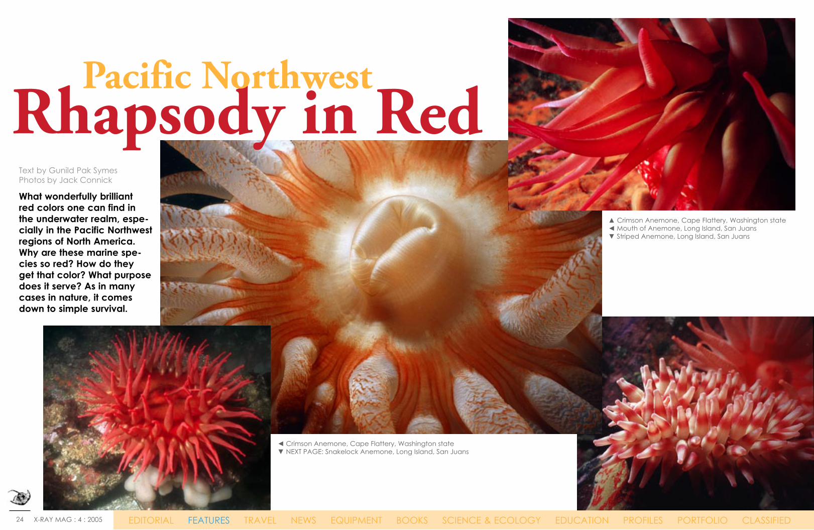
What wonderfully brilliant red colors one can find in the underwater realm, espe-cially in the Pacific Northwest regions of North America. Why are these marine spe-cies so red? How do they get that color? What purpose does it serve? As in many cases in nature, it comes down to simple survival. Quotes: Duis dic-
tum massa ac leo. Nam dictum dolor
in felis. Mauris quis libero at
wisi bibendum consectetuer.
Text by Gunild Pak SymesPhotos by Jack Connick
Rhapsody in Red▲ Crimson Anemone, Cape Flattery, Washington state◄ Mouth of Anemone, Long Island, San Juans▼ Striped Anemone, Long Island, San Juans
Pacific Northwest
EDITORIAL FEATURES TRAVEL NEWS EQUIPMENT BOOKS SCIENCE & ECOLOGY EDUCATION PROFILES PORTFOLIO CLASSIFIED
◄ Crimson Anemone, Cape Flattery, Washington state▼ NEXT PAGE: Snakelock Anemone, Long Island, San Juans

25 X-RAY MAG : 4 : 2005 EDITORIAL FEATURES TRAVEL NEWS EQUIPMENT BOOKS SCIENCE & ECOLOGY EDUCATION PROFILES PORTFOLIO CLASSIFIED
Pacific Northwest
26 X-RAY MAG : 4 : 2005 EDITORIAL FEATURES TRAVEL NEWS EQUIPMENT BOOKS SCIENCE & ECOLOGY EDUCATION PROFILES PORTFOLIO CLASSIFIED
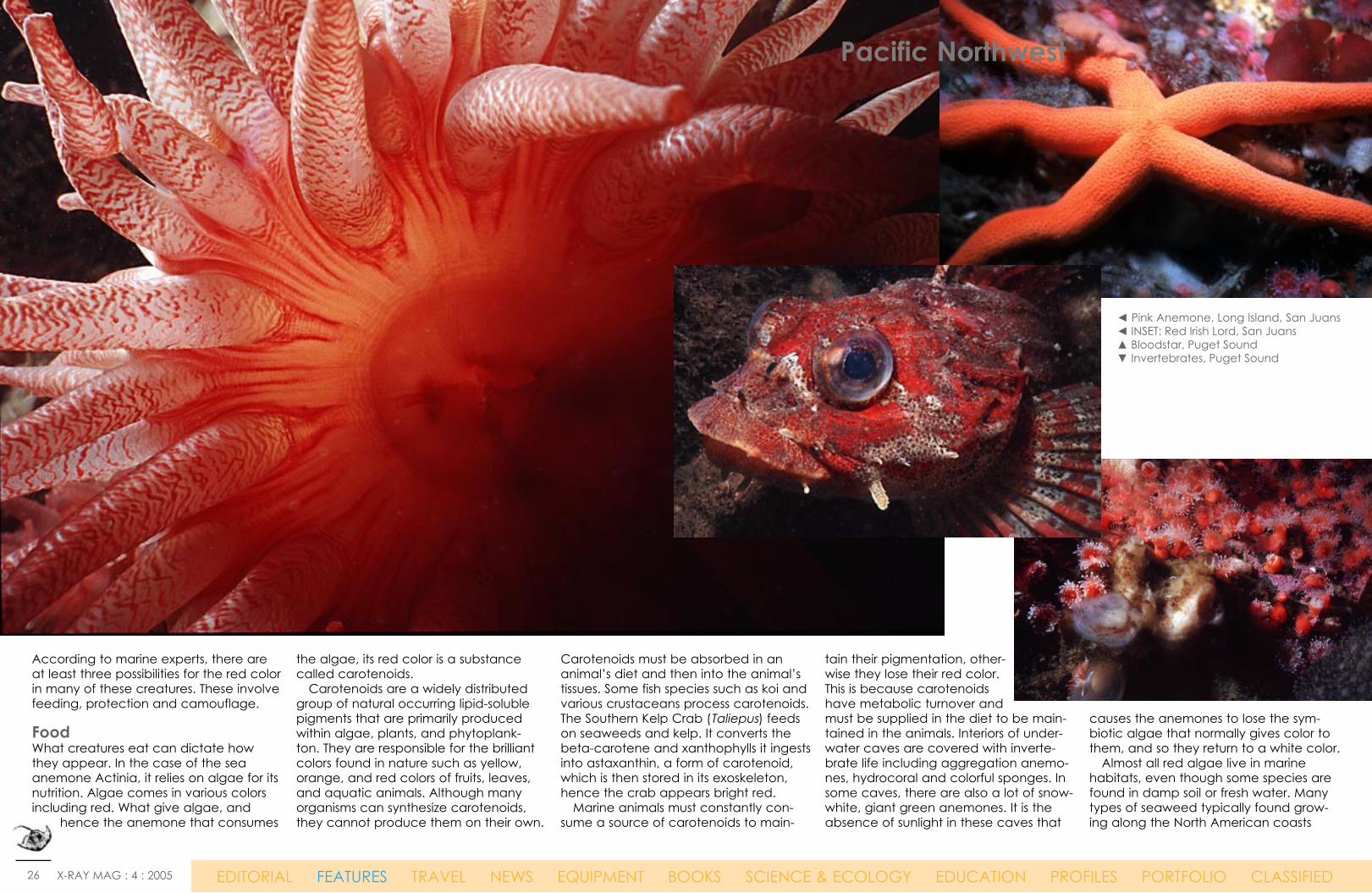
◄ Pink Anemone, Long Island, San Juans◄ INSET: Red Irish Lord, San Juans▲ Bloodstar, Puget Sound ▼ Invertebrates, Puget Sound
According to marine experts, there are at least three possibilities for the red color in many of these creatures. These involve feeding, protection and camouflage.
FoodWhat creatures eat can dictate how they appear. In the case of the sea anemone Actinia, it relies on algae for its nutrition. Algae comes in various colors including red. What give algae, and
hence the anemone that consumes
the algae, its red color is a substance called carotenoids. Carotenoids are a widely distributed group of natural occurring lipid-soluble pigments that are primarily produced within algae, plants, and phytoplank-ton. They are responsible for the brilliant colors found in nature such as yellow, orange, and red colors of fruits, leaves, and aquatic animals. Although many organisms can synthesize carotenoids, they cannot produce them on their own.
Carotenoids must be absorbed in an animal’s diet and then into the animal’s tissues. Some fish species such as koi and various crustaceans process carotenoids. The Southern Kelp Crab (Taliepus) feeds on seaweeds and kelp. It converts the beta-carotene and xanthophylls it ingests into astaxanthin, a form of carotenoid, which is then stored in its exoskeleton, hence the crab appears bright red. Marine animals must constantly con-sume a source of carotenoids to main-
tain their pigmentation, other-wise they lose their red color. This is because carotenoids have metabolic turnover and must be supplied in the diet to be main-tained in the animals. Interiors of under-water caves are covered with inverte-brate life including aggregation anemo-nes, hydrocoral and colorful sponges. In some caves, there are also a lot of snow-white, giant green anemones. It is the absence of sunlight in these caves that
causes the anemones to lose the sym-biotic algae that normally gives color to them, and so they return to a white color. Almost all red algae live in marine habitats, even though some species are found in damp soil or fresh water. Many types of seaweed typically found grow-ing along the North American coasts
Pacific Northwest
27 X-RAY MAG : 4 : 2005 EDITORIAL FEATURES TRAVEL NEWS EQUIPMENT BOOKS SCIENCE & ECOLOGY EDUCATION PROFILES PORTFOLIO CLASSIFIED
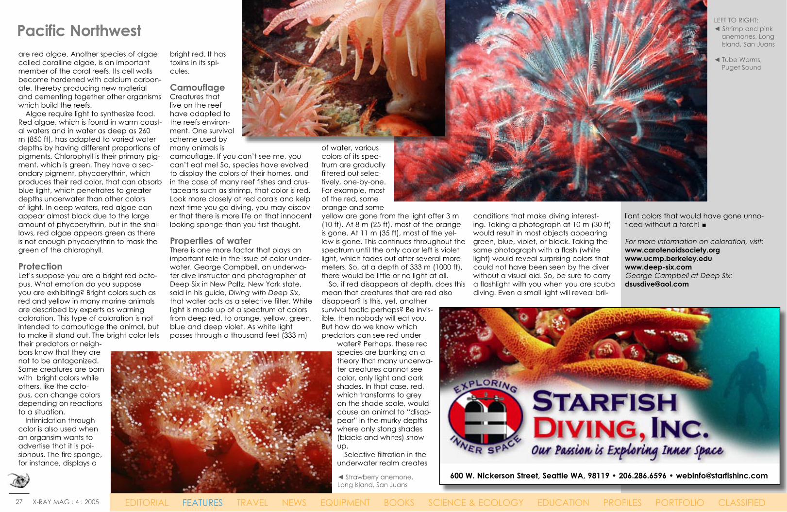
are red algae. Another species of algae called coralline algae, is an important member of the coral reefs. Its cell walls become hardened with calcium carbon-ate, thereby producing new material and cementing together other organisms which build the reefs. Algae require light to synthesize food. Red algae, which is found in warm coast-al waters and in water as deep as 260 m (850 ft), has adapted to varied water depths by having different proportions of pigments. Chlorophyll is their primary pig-ment, which is green. They have a sec-ondary pigment, phycoerythrin, which produces their red color, that can absorb blue light, which penetrates to greater depths underwater than other colors of light. In deep waters, red algae can appear almost black due to the large amount of phycoerythrin, but in the shal-lows, red algae appears green as there is not enough phycoerythrin to mask the green of the chlorophyll.
ProtectionLet’s suppose you are a bright red octo-pus. What emotion do you suppose you are exhibiting? Bright colors such as red and yellow in many marine animals are described by experts as warning coloration. This type of coloration is not intended to camouflage the animal, but to make it stand out. The bright color lets their predators or neigh-bors know that they are not to be antagonized. Some creatures are born with bright colors while others, like the octo-pus, can change colors depending on reactions to a situation. Intimidation through color is also used when an organsim wants to advertise that it is poi-sionous. The fire sponge, for instance, displays a
bright red. It has toxins in its spi-cules.
CamouflageCreatures that live on the reef have adapted to the reefs environ-ment. One survival scheme used by many animals is camouflage. If you can’t see me, you can’t eat me! So, species have evolved to display the colors of their homes, and in the case of many reef fishes and crus-taceans such as shrimp, that color is red. Look more closely at red corals and kelp next time you go diving, you may discov-er that there is more life on that innocent looking sponge than you first thought.
Properties of waterThere is one more factor that plays an important role in the issue of color under-water. George Campbell, an underwa-ter dive instructor and photographer at Deep Six in New Paltz, New York state, said in his guide, Diving with Deep Six, that water acts as a selective filter. White light is made up of a spectrum of colors from deep red, to orange, yellow, green, blue and deep violet. As white light passes through a thousand feet (333 m)
of water, various colors of its spec-trum are gradually filtered out selec-tively, one-by-one. For example, most of the red, some orange and some yellow are gone from the light after 3 m (10 ft). At 8 m (25 ft), most of the orange is gone. At 11 m (35 ft), most of the yel-low is gone. This continues throughout the spectrum until the only color left is violet light, which fades out after several more meters. So, at a depth of 333 m (1000 ft), there would be little or no light at all. So, if red disappears at depth, does this mean that creatures that are red also disappear? Is this, yet, another survival tactic perhaps? Be invis-ible, then nobody will eat you. But how do we know which predators can see red under
water? Perhaps, these red species are banking on a theory that many underwa-ter creatures cannot see color, only light and dark shades. In that case, red, which transforms to grey on the shade scale, would cause an animal to “disap-pear” in the murky depths where only stong shades (blacks and whites) show up. Selective filtration in the underwater realm creates
conditions that make diving interest-ing. Taking a photograph at 10 m (30 ft) would result in most objects appearing green, blue, violet, or black. Taking the same photograph with a flash (white light) would reveal surprising colors that could not have been seen by the diver without a visual aid. So, be sure to carry a flashlight with you when you are scuba diving. Even a small light will reveal bril-
liant colors that would have gone unno-ticed without a torch! ■
For more information on coloration, visit:www.carotenoidsociety.org www.ucmp.berkeley.eduwww.deep-six.comGeorge Campbell at Deep Six: [email protected]
LEFT TO RIGHT:◄ Shrimp and pink
anemones, Long Island, San Juans
◄ Tube Worms, Puget Sound
Pacific Northwest
600 W. Nickerson Street, Seattle WA, 98119 • 206.286.6596 • [email protected]
EDITORIAL FEATURES TRAVEL NEWS EQUIPMENT BOOKS SCIENCE & ECOLOGY EDUCATION PROFILES PORTFOLIO CLASSIFIED
◄ Strawberry anemone, Long Island, San Juans
28 X-RAY MAG : 4 : 2005 EDITORIAL FEATURES TRAVEL NEWS EQUIPMENT BOOKS SCIENCE & ECOLOGY EDUCATION PROFILES PORTFOLIO CLASSIFIED
Right or left-handed?Most octopuses favor one arm and use combinations of arms in particular orders when handling objects, zoologists at the University of Vienna have discovered. Although all of an octopus’ eight arms essentially operate equally, research-ers studied eight octopuses and found they tended to use a favorite arm when exploring new nooks or objects. This is the first time the eight-limbed animal has been found to show any preference in choosing which limb to use for a job. Researchers placed unfamiliar objects into an octopus’s tank or presented it with a T-shaped cavity to explore and found each octopus tended to favor front arms to explore and used rear limbs more for locomotion. They also observed the octopuses used only 49 different combinations of one, two or three limbs from a possible 448 combinations, and they found 92 percent of octopuses use a favored eye, which may dictate which arm is favored, researchers said. Unlike in humans, the scientists said, right or left handedness was split about 50-50 in the octopuses.
Quasi jointsTheoretically, there are any number of ways an octopus could use its long flex-ible arms to move an object. But the method they actually use is surprisingly close to how animals with rigid skel-etons—including humans—do, scientists say. When hunting and grabbing dinner, the octopus uses all the flexibility the arm is capable of. But to bring cap-tured prey to its mouth, the octopus turns the arm into a semi-rigid struc-ture that bends to form quasi joints. Just as a human arm has joints at the shoulder, elbow and wrist that allow our arms to bend and rotate, the octopus bends its arm to form-ing three segments of roughly equal length. The arms are composed almost entirely of muscle, with no bone or external skeleton—a structure known as a muscular hydrostat. Elephant trunks and tongues are other exam-ples of a muscular hydrostat. Earlier research funded by the U.S. Navy’s Office of Naval Research (ONR) suggests that, to keep the
arms from constantly tangling them-selves up, each arm has an independ-ent peripheral nervous system and neural circuitry. This allows the brain to essentially give a command—”Arm Four, fetch that tasty crab crawling by”—and have the arm carry out the order without the brain thinking about it again. This ability is combined with excel-lent eyesight. Once an octopus spots its prey, it has a remarkable ability to reach out with one of its arms and grab it with one of the suckers that form a double line up each of the octopus’s arms. Some scientists studying octopus arms conclude that they may represent the optimal design for robotic arms.
The brainy molluscOctopuses have intrigued scientists for years, because they have both long- and short-term memory, they remem-ber solutions to problems, and they can go on to solve the same or similar prob-lems. They have been known to climb aboard fishing boats and open holds in search of crabs. They can figure out
mazes, open jars, and break out of their aquariums in search of food. These characteristics are usually attributed to “higher animals” such as mammals. The Octupus however is a mollusc, related to snails, clams and mussels. Take a closer look: It has a shell (outer or inner) and siphon ■
Arms all over9001 South 19th StreetTacoma, WA 98466
Office/Reservations: (253)564-5335Mike Ferguson: cell (253) 405-3462
www.portholedivecharters.com
April Fools NewsTHE ENDANGERED PACIFIC NORTHWEST TREE OCTOPUS (OCTOPUS PAXARBOLIS) CAN BE FOUND IN THE TEMPERATE RAIN-FORESTS OF THE OLYMPIC PENINSULA IN THE REPUBLIC OF CASCADIA, PEACEFULLY FROL-ICING IN THE CONIFER TREES. LEARN MORE ABOUT THIS INTELLIGENT AND INQUISITIVE
CEPHALOPOD AT:
ZAPATOPI.NET/TREEOCTOPUS/
Octopus facts The CephalopodsWith more than a 250 species, octo-puses are members of an ancient group of animals called cephalopods. The giant Pacific octopus (Octopus dofleini) can grow to over 20 feet (6 meters) and weigh more than 100 pounds (45 kilograms). The tiny Californian octopus (Octopus micropyrsus), by contrast, is no more than half an inch to an inch (1.3 to 2.5 centimeters) long. There have been numerous accounts of (and searches for) an as yet unknown species of deep-sea octopus that is believed to grow to over 100 feet (30 meters) across and weigh several tons.
PHO
TO B
Y JA
CK
CO
NN
ICK
PHO
TO B
Y JA
CK
CO
NN
ICK
29 X-RAY MAG : 4 : 2005 EDITORIAL FEATURES TRAVEL NEWS EQUIPMENT BOOKS SCIENCE & ECOLOGY EDUCATION PROFILES PORTFOLIO CLASSIFIED
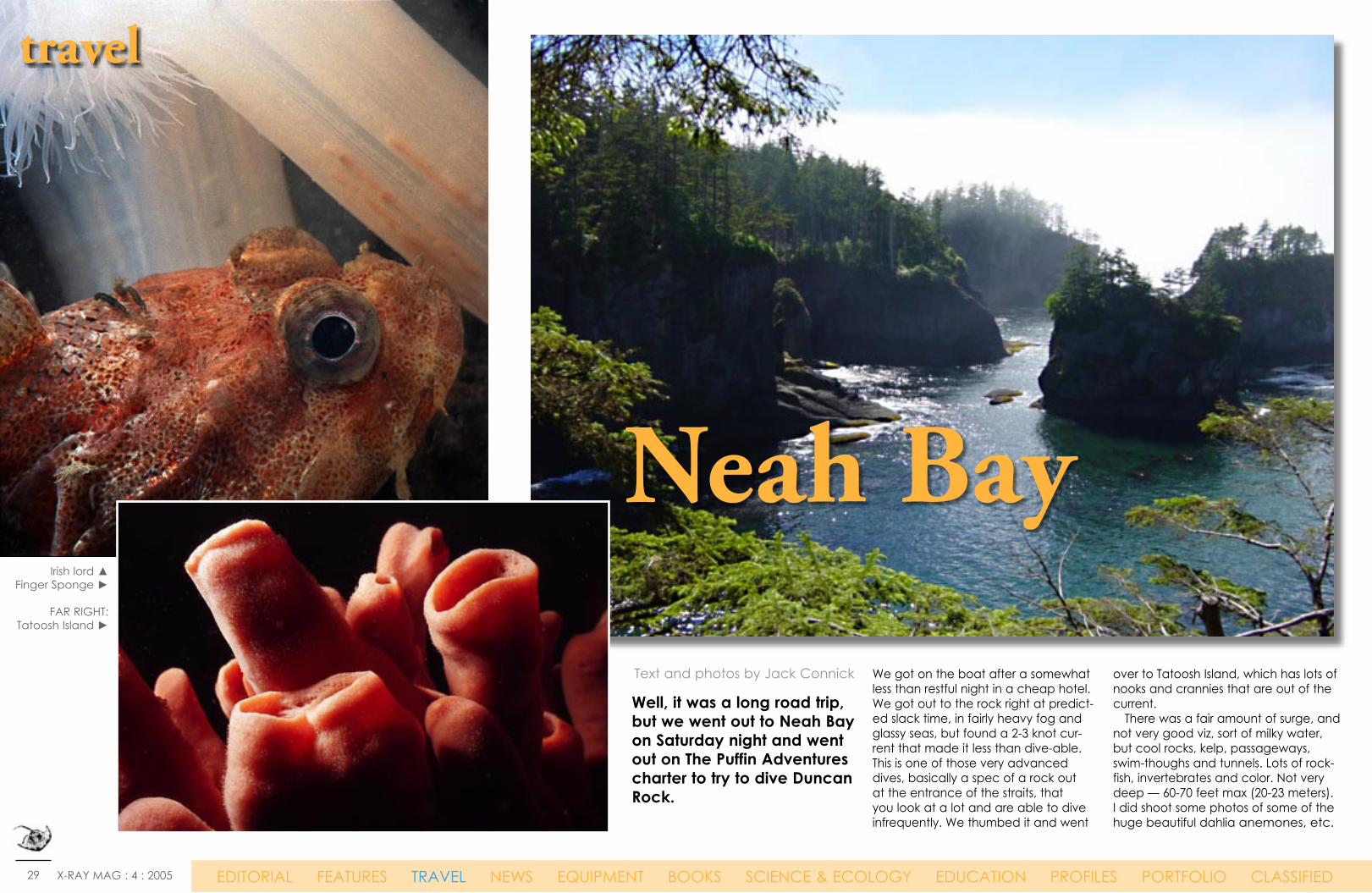
Neah Bay
Well, it was a long road trip, but we went out to Neah Bay on Saturday night and went out on The Puffin Adventures charter to try to dive Duncan Rock.
We got on the boat after a somewhat less than restful night in a cheap hotel. We got out to the rock right at predict-ed slack time, in fairly heavy fog and glassy seas, but found a 2-3 knot cur-rent that made it less than dive-able. This is one of those very advanced dives, basically a spec of a rock out at the entrance of the straits, that you look at a lot and are able to dive infrequently. We thumbed it and went
over to Tatoosh Island, which has lots of nooks and crannies that are out of the current. There was a fair amount of surge, and not very good viz, sort of milky water, but cool rocks, kelp, passageways, swim-thoughs and tunnels. Lots of rock-fish, invertebrates and color. Not very deep — 60-70 feet max (20-23 meters). I did shoot some photos of some of the huge beautiful dahlia anemones, etc.
travel
Irish lord ▲Finger Sponge ►
FAR RIGHT:Tatoosh Island ►
Text and photos by Jack Connick

30 X-RAY MAG : 4 : 2005 EDITORIAL FEATURES TRAVEL NEWS EQUIPMENT BOOKS SCIENCE & ECOLOGY EDUCATION PROFILES PORTFOLIO CLASSIFIED
Hole-in-the-WallWe went over to a little nook called Hole-in-the-Wall for our surface interval. After changing tanks and resting a bit out of the swell, we went back over to another corner of Tatoosh Island and dove there. The viz was better, but not great. There was a couple of long, somewhat deep cuts that we fol-lowed and enjoyed swimming about and taking pictures. There was a whole school of black rock-fish that we don’t see often and one rather large ling cod that was acting territorial — wished I’d had a speargun to make lunch out of him! At the end of the dive, I had some problems with my inflator leaking and had to make a somewhat
travel
Hole-in-the-Wall, Tatoosh Island ▲Dendrobum Anemone ►
Tunicates ►
EDITORIAL FEATURES TRAVEL NEWS EQUIPMENT BOOKS SCIENCE & ECOLOGY EDUCATION PROFILES PORTFOLIO CLASSIFIED
Neah Bay

31 X-RAY MAG : 4 : 2005 EDITORIAL FEATURES TRAVEL NEWS EQUIPMENT BOOKS SCIENCE & ECOLOGY EDUCATION PROFILES PORTFOLIO CLASSIFIED
quick, but not an emergency assent. The boat was on the other side of the rock that was covered in rather large fun seals and huge Stellar sea lions. They were looking at us as intruders and as they are easily 400 pounds (90 kg) or more, I blasted them with my DiveAlert horn to scare them away. About then the boat came around the corner with Steve (the captain, and a bit of a hot-head) yelling at us to get on quickly. All was well, and we motored back to Neah Bay in patchy fog and bright sun. Near Wahah Island, on the outside of Neah Bay, we saw a fairly large grey whale feeding on the krill that had been part of our visibility problem.
We later hiked up to Cape Flattery and enjoyed the view of the rocks and then very heavy fog. Then another long, but scenic, drive home. Dive notes The dives we went on were advanced in a fair amount of tidal surge. Duncan Rock is very advanced. If you are an out-of-town diver, I wouldn’t attempt it. Cold water experience in drysuits and poor conditions is recommended.■
travel
CLOCKWISE FROM TOP LEFT:◄ Neah Bay◄ Black Cod fish◄ Jelly fish▼ Stellar sea lions
EDITORIAL FEATURES TRAVEL NEWS EQUIPMENT BOOKS SCIENCE & ECOLOGY EDUCATION PROFILES PORTFOLIO CLASSIFIED
Neah Bay
Author and photographer Jack Connick is a Seattle-based graphic designer who develops highly-craft-ed and creative graphic communi-cations. www.deepics.com
32 X-RAY MAG : 4 : 2005 EDITORIAL FEATURES TRAVEL NEWS EQUIPMENT BOOKS SCIENCE & ECOLOGY EDUCATION PROFILES PORTFOLIO CLASSIFIED
Northern Central Plateau
& Mountains
Interior Plateau
Great Plains
The Islands
Kootenay Rockies
A diver experiences a close encounter with a wolf-eel
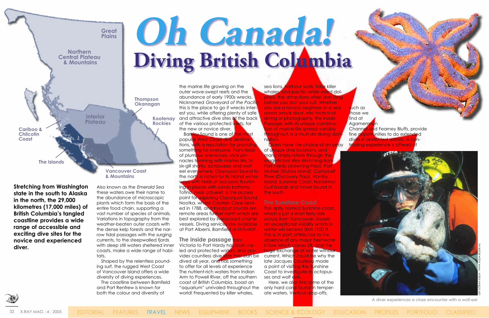
Stretching from Washington state in the south to Alaska in the north, the 29,000 kilometres (17,000 miles) of British Columbia’s tangled coastline provides a wide range of accessible and exciting dive sites for the novice and experienced diver.
LEIF
-GÖ
RAN
HJE
LM -
WW
W.A
QUA
-BIL
DER
.NU
Also known as the Emerald Sea these waters owe their name to the abundance of microscopic plants which form the basis of the entire food chain, supporting a vast number of species of animals. Variations in topography from the weather-beaten outer coasts with the dense kelp forests and the nar-row tidal passages with the surging currents, to the steepwalled fjords with deep still waters sheltered inner coasts, make a wide range of habi-tats. Shaped by the relentless pound-ing surf, the rugged West Coast of Vancouver Island offers a wide diversity of diving experiences. The coastline between Bamfield and Port Renfrew is known for both the colour and diversity of
EDITORIAL FEATURES TRAVEL NEWS EQUIPMENT BOOKS SCIENCE & ECOLOGY EDUCATION PROFILES PORTFOLIO CLASSIFIED
Oh Canada!Diving British Columbia
the marine life growing on the outer wave-swept reefs and the abundance of early 1900s wrecks. Nicknamed Graveyard of the Pacific this is the place to go if wrecks inter-est you, while offering plenty of safe and attractive dive sites at the back of the various protected inlets, for the new or novice diver. Barkley Sound is one of the most popular West Coast dive destina-tions, with a reputation for providing something for everyone. From fields of plumose anemones, rock pin-nacles teeming with marine life, to six-gill sharks, octopusses and wolf eel everywhere. Clayoquot Sound to the north is noted for its inland water-ways with fields of sea pens flourish-ing in places with sandy bottoms. Tofino, near Ucluelet, is the access point for exploring Clayoquot Sound. Nootka, where Captain Cook land-ed in 1788, and Kyuqout Sounds are remote areas further north which are best explored by liveaboard charter vessels. Diving services are available at Port Alberni, Bamfield or Ucluelet.
The inside passage from Victoria to Port Hardy has both var-ied and protected waters, and pro-vides countless dive sites that can be dived all year, and has something to offer for all levels of experience The nutrient-rich waters from Indian Arm to Powell River, off the southern coast of British Columbia, boast an “aquarium” unrivaled throughout the world! Frequented by killer whales,
sea lions, harbour seals, false killer whales, and pacific white-sided dol-phins, the attractions often start long before you don your suit. Whether you are a novice beginner or a sea-soned wreck diver, into technical diving or photography, the Inside Passage, with its unique combina-tion of marine life spread variably throughout, is a must-do diving desti-nation. Divers have the choice of an array of unique dive locations, and many simply rotate through the magnificent sites stretching from Port Hardy (Browning Pass), Port McNeil (Stubbs Island), Campbell River (Discovery Pass), Hornby Island, Sunshine Coast, Nanaimo/Gulf Islands and Howe Sound in the south The Sunshine Coast The aptly named Sunshine coast, which is just a short ferry ride across from Vancouver, boasts an exceptional visibility which in winter will exceed 30m /100 ft. This is, in part, attributed to the absence of any major freshwater inflow which carries silt, and the huge exchange of water without current. Which could be why the late Jacques Cousteau made a point of visiting the Sunshine Coast to investigate its octopus- ses and wolf eels. Here, we also find some of the only hard coral found in temper-ate waters. Vertical drop-offs,
such as those we find at Agamemnon Channel and Fearney Bluffs, provide fine opportunities to do extended dives in protected waters. A con-trasting experience is offered at
Vancouver Coast & Mountains
Thompson Okanagan
Cariboo & Chilcotin Coast

33 X-RAY MAG : 4 : 2005 EDITORIAL FEATURES TRAVEL NEWS EQUIPMENT BOOKS SCIENCE & ECOLOGY EDUCATION PROFILES PORTFOLIO CLASSIFIED
Skookumchuk Rapids – the sec-ond fastest tidal rapids in North America harbouring spectacu-lar sea life. The destroyer HMCS Chaudiere was scuttled here in 1992 to create an artificial reef.
South Vancouver Island has too many great sites to mention, but one of the most well known areas around Victoria is Race Rocks, only minutes away by boat from downtown Victoria. It is a spectacu-lar area above and below the water, and with good chances of diving with sea lions. Close by is the Saanich Inlet, which is a great site
to see six-gill sharks and it is without strong currents. The large boulders on the steep rocky under-water slopes also make ideal homes for octopusses and wolf eels, two favourite subjects for scuba enthusiasts. A short boat ride from Sidney
you will find the artificial reefs HMCS MacKenzie and the G.B. Church.
Howe Sound is a favorite dive destination for both visitors and locals, and is host to two shore-access marine protected areas – Whytecliff Park and Porteau Cove Provincial Park. These two parks are arguably the most popular dive sites in the province. Many ships and vessels have been scuttled over the past years to cre-
ate awe-inspiring artificial reefs and steep drop-offs provide the perfect environment to explore underwater walls However, vis-ibility can be an issue, as much of the bottom of Howe Sound is covered in a thick silt.
Hornby Island The waters around Hornby Island are full of a rich variety of marine life. In any season, you can encounter Giant Pacific octopusses, wolf eels, har-bour seals, large lingcod and rock fish, colourful anemones and nudi-branchs. Good visibility and gentle currents make the Hornby Island area easy to dive. Drift dives, wall dives, deep dives, and sculpted sandstone reefs are all part of the underwater terrain. Hornby is also well known for its excellent ‘big animal’ dives. Six-gill sharks are probably the best-known reason to dive Hornby. Swimming beside a six-gill is an experience of a life-time! During the winter, Stellar’s and California sea lions congre-gate near Hornby to feed on migrating herring. They are curious and love to interact with divers.
In Northern Vancouver Island just the topside scenery is enough to leave you breathless. Wild, untouched and with the blue mountains as a backdrop, and with a deep tranquility is that is all but enhanced by the blows of the passing whales. These more north-ern waters are cooler and more oxygen-rich, which means more life, producing an extraordinary array of invertebrates and a multi-tude of fish. Rumour has it, that up to 13 species of nudibranch have been seen on a single dive. Giant Pacific octopuses and wolf eels are abundant and many organ-isms often exceed the sizes stated in field guides. From the concen-tration of dives in the Broughton and Blackfish Archipelagos, to the gardens of the West Coast, to the expanses of life around Port
1 Port Hardy2 Port McNeill3 Telegraph Cove4 Quadra Island5 Campbell River6 Courtenay7 Union Bay8 Hornby Island9 Parksville10 Port Alberni11 Lantzville12 Nanaimo13 Gabriola Island14 Ladysmith15 Chemainus
16 Duncan17 Cobble Hill 18 Shawnigan Lake19 Galiano Island20 Mayne Island21 Sidney Area22 Brentwood Bay23 Victoria24 Sooke25 Bamfield26 Ucluelet27 Tolfino28 Tahsis29 Zeballos30 Greater Vancouver
▲ Exploring the bottom around God’s Pocket Resort in Northern Vancouver Island is like walking in beautifull gardens with flowers
◄ Also a macrohotographer’s paradise - God’s Pocket Resort in Northern Vancouver Island
LEIF
-GÖ
RAN
HJE
LM -
WW
W.A
QUA
-BIL
DER
.NULEIF-GÖRAN HJELM - WWW.AQUA-BILDER.NU
Diving BC1
23
54
67 8
910 1112
13
14 151618
17
2422
23
2019
2526
27
2829
21
30
Vancouver Island
CANADA
USA

34 X-RAY MAG : 4 : 2005 EDITORIAL FEATURES TRAVEL NEWS EQUIPMENT BOOKS SCIENCE & ECOLOGY EDUCATION PROFILES PORTFOLIO CLASSIFIED
The current issue of Xray-mag has as a theme the western seaboard of the USA, including Alaska. This coastal area is part of what is known as the Ring of Fire, an arc of volcanos and oceanic trenches partly encircling the Pacific Basin, forming a zone of frequent earthquakes and volcanic eruptions. This activity naturally has a large effect on the marine-biological diversity of the region. It will be seen from the map that the Ring of Fire stretches from New Zealand, along the eastern edge of Asia, north across the Aleutian Islands of Alaska, and south along the coast of North and South America. It is composed of over 75% of the world’s
active and dormant volcanos. More than half of the world’s approximately 1500 active volcanos above sea level are part of the ring. And about ten percent of these are located in the United States. This huge ring of volcanic and seismic activity was noticed and described long before the invention of the plate tectonics theory. It is now known that the Ring of Fire is located at the borders of the Pacific plate and other tectonic plates. TECTONIC PLATES Tectonic plates are like giant rafts of rock floating on the earth’s hot, soft mantle. These massive rigid plates are about 80 km thick, but change
size and position over time, moving at speeds of between 1 cm and 10 cm every year. As the plates move, intense geologic activity occurs at the plate edges, where one of three things may occur; the plates may be moving away from each other, leav-ing space for the creation of new ocean floor; the plates may be mov-ing towards each other, causing one to submerge beneath the other; or the boundaries of the plates may slide past each other without much distur-bance to either plate. There are 7 major plates and 8 minor plates, named according to where they are positioned on the earth’s surface. For example, we have the Nazca plate which is colliding with
the South American plate to form the Andes and the volcanos Cotopaxi and Azul. The major plate covering the Pacific ocean area is called, not surprisingly, the Pacific plate. Around the Ring of Fire, the Pacific plate is colliding with and sliding underneath other plates. This proc-ess is known as subduction, and the volcanically and seismically active area nearby is known as a subduc-tion zone. There is a tremendous amount of energy created by these plates and they easily melt rock into magma, which rises to the surface as lava and forms the volcanos of the Ring of Fire. Between Northern California and British Columbia, the Pacific plate,
Ring of Fire
Text by Michael Symes
Hardy and Browning Pass and the magic that is Haida Gwaii – these seemingly infinite stretches of coastline offer equally endless dive opportunities.
The interior is maybe not something that natu-rally springs to mind when it comes to scuba diving, but the interior of British Colombia actually boasts a number of historic wrecks, underwater cave sys-tems, ice diving, current dives and large marine life. Adams Lake offers cave systems and walls of peculiar limestone formations that begin high on the mountainside and continuing underwater, to include chimneys large enough for a diver to ascend through. Around the turn of the past century more than
80 side- and stern-wheelers steamed around the extensive lake system leaving numerous wrecks to dive, including the S.S. Whitesmith and the M.V. Lady Rose in Shuswap Lake, several wrecks in the Kootenays and numer-ous other small craft including houseboats, barges and tugboats. And not to forget a 1920’s Chevrolet towing five sleighs full of in mail in Shuswap lake. In Pavillion Lake,
the beautiful crystalline turquoise water acts as a catalyst for the development of fresh water stro-matolites, structures formed from fossilized remains of microorganisms in various shapes and sizes. The stromatolites are currently being studied by scien-tists. As the lake is extremely sensitive to human interaction the Underwater Council of BC is apply-ing to have Pavillion Lake recognized as a pro-tected area. It is recommended that you contact a local scuba shop for information and assistance in diving this site. Other unique dives include the world famous Adams River Sockeye run which takes place in the fall. Hundreds of thousands of sockeye salmon form a virtual wall of fish and is an amazing sight. ■
Diving BC

35 X-RAY MAG : 4 : 2005 EDITORIAL FEATURES TRAVEL NEWS EQUIPMENT BOOKS SCIENCE & ECOLOGY EDUCATION PROFILES PORTFOLIO CLASSIFIED
www.oceanfest.comOcean Fest Dive & Adventure Sports ExpoApril 15 through 17, 2005 • Ft. Lauderdale, Florida
the Juan de Fuca plate, and the Gorda tectonic plate have built the Cascades and Mount Saint Helens, which erupted in 1980. Alaska’s Aleutian Islands are growing as the Pacific plate hits the North American plate. The deep Aleutian Trench, with a maximum depth of 7679 m, has been created at the sub-duction zone here. SAN ANDREAS FAULT Although plates may slide past one another in opposite directions without much disturbance to either plate some may cause major earth-quakes, affecting thousands of peo-ple. This is the case with the infamous Californian San Andreas fault, where the Pacific and North American plates interact, whose shift caused the enormous earthquake in San Fransisco in 1906. EARTHQUAKE IN SAN FANCISCO On April 18, 1906, shortly after 05:00,
a great earthquake struck San Francisco and a long narrow band of towns, villages, and countryside to the northwest and southeast. Many buildings were wrecked, hundreds of people were killed, and electric power lines and gas mains were bro-ken. The ground had broken apart for more than 400 km along the San Andreas fault. The country on the east side of the fault had moved southward relative to the country on the west side of the fault. The greatest displacement had been 7 m about 50 km northwest of San
Francisco. As the plates never stop moving there is a fearful expectancy that a new major earthquake will occur in the near future. TSUNAMIS It is the earthquakes occur-ing in the more intensely inhabited land areas that generally cause the great-est devastation, like that in San Francisco. However, when there is an earth-
quake under the sea, one side of the ocean floor can suddenly drop downwards, beneath the top edge of the subducting plate. The resulting vertical fault will then generate a tsu-nami. The movements of the plates usually allow little warning for those at risk in coastal areas. One warning of a tsunami is that there is a rush of water away from the coastline, but this predictor may mean the forth-coming seismic wave is only minutes away. ■
USG
S
Marine images for editorial,commercial, scientific, and
fine art use
web: www.jongrossphotography.comemail: [email protected]
phone: 206-782-5864

36 X-RAY MAG : 4 : 2005 EDITORIAL FEATURES TRAVEL NEWS EQUIPMENT BOOKS SCIENCE & ECOLOGY EDUCATION PROFILES PORTFOLIO CLASSIFIED
The vast Pacific defines our water planet, when viewed from space. An seem-ingly endless blue mass, it covers half of spaceship Earth. In doing so, all of the ocean habitats are con-tained within it. Of its tem-perate waters, those along the western seaboard of North America have the greatest diversity and sheer mass of ocean life. Without the warming effect of the Gulf Stream, these waters are colder than comparable lati-tudes in Europe – a chilly five degrees Celcius in winter. The cold is invigorating, not just to the intrepid diver, but to the life in these rich seas. It brings oxygen and nutrients from the deep ocean that are distributed by upwelling currents and tidal streams along the coasts, from Alaska to California. Vancouver Island, off Canada’s British Columbia is bathed by particularly lush seas. In
▲ ABOVE: Red Anemone
CLOCKWISE FROM TOP LEFT: ▲ Vancouver Island► Lighthouse on Vancouver Island ► Sculpin portrait
Text and photos by John Collins
EDITORIAL FEATURES TRAVEL NEWS EQUIPMENT BOOKS SCIENCE & ECOLOGY EDUCATION PROFILES PORTFOLIO CLASSIFIED
Vancouver Island
Emerald Seas – The Pacific Northwest
LEIF
-GÖ
RAN
HJE
LM -
WW
W.A
QUA
-BIL
DER
.NU

37 X-RAY MAG : 4 : 2005 EDITORIAL FEATURES TRAVEL NEWS EQUIPMENT BOOKS SCIENCE & ECOLOGY EDUCATION PROFILES PORTFOLIO CLASSIFIED
early summer, as the plankton growth explodes, the sheer quan-tity of life is staggering. Thanks to modern diving equipment and dry-suits, diving here is especially rewarding. I made the journey to Vancouver in early June, when this action was at its peak. Joining a live-aboard boat, the Nautilus Explorer, we were going to circumnavigate the island, diving as we went. It would take eleven days. As we steamed north from Vancouver city, the quiet wildness of the island was a welcome contrast to the hustle of city life. The steep, forest-covered
coast tumbles quickly to depth beneath the surface. I inhaled the rich aroma of the cedars, preparing for the first dive in the fjord-like waters off Andersen Island. In the first few meters, the water was a dense emerald green. A single liter of this plank-tonic soup contains millions of tiny plants and animals. Suddenly, at depth, the cur-tains part and a darkened landscape emerged. Walls of cloud sponges, bright yel-low, appear in the dive lights. A community of busy fish life
moved among its folds and shadows, feeding and shelter-ing. The cold can make these dives short however, without the right equipment. Advances in scuba gear have brought about great changes in how we can visit even the cold-est waters. The Rebreather, a forerunner to the popular aqua-lung, has made a comeback in modern times. By re-using the diver’s breathing gas, dive times can be greatly extended. The exhaled breath is scrubbed of carbon dioxide with soda lime – a process that generates heat.
▲ Plumose anemones▲ Lost rifle, Tahsis,
Vancouver Island▲ Wreck of the Vanlene of
Austin Island◄ Detail of anemone
travel
Vancouver Island

38 X-RAY MAG : 4 : 2005 EDITORIAL FEATURES TRAVEL NEWS EQUIPMENT BOOKS SCIENCE & ECOLOGY EDUCATION PROFILES PORTFOLIO CLASSIFIED
The enriched gas is thus warmed and prevents heat loss through the lungs. This comfort, along with that from modern insulating fabrics and electrically-heated vests worn under the dry-suit, allows dives of an hour or more in cold water. My lips and face were starting to feel the chill after that first dive, as I spun around at the surface to look for the boat. A ris-ing full moon had just appeared in the twilight sky, sending pastel reflections along the water’s surface. The cold was forgotten, among anticipation of further exploration in these special waters. Much of the cliff hanging anemones and other plankton feeders are similar to those seen in northern European waters.
It’s the size of everything that is different. Flower-like anemones go from blossoms to bushes, dahlias to dinner plates. Their size causes them to hang limp from the rock faces, the super-rich plankton giv-ing everything a steroid boost. It is most noticeable in areas of strong tides, as billions of liters of water are channeled through the narrows and islets twice daily. The dive sites at the northern end of the island are best known for these forests of invertebrate life. The coral-like filter feeders blanket every surface and whole walls are color-washed red and white. The diffuse light, having pen-etrated the plankton layer is soft and subtle giving the large white anemones
▲ Giant Nudibranch, Dendronotus iris◄ Sea Pen, Ptilosarcus gurneyi▼ Opalescent Nudibranch,
Hermissenda crassicornis
▲ Sun star, Solaster stimpsoni◄ Mug-shot of friendly Wolf-eel,
Anarrhichthys ocellatus
travel Vancouver Island
39 X-RAY MAG : 4 : 2005 EDITORIAL FEATURES TRAVEL NEWS EQUIPMENT BOOKS SCIENCE & ECOLOGY EDUCATION PROFILES PORTFOLIO CLASSIFIED
Vancouver Island
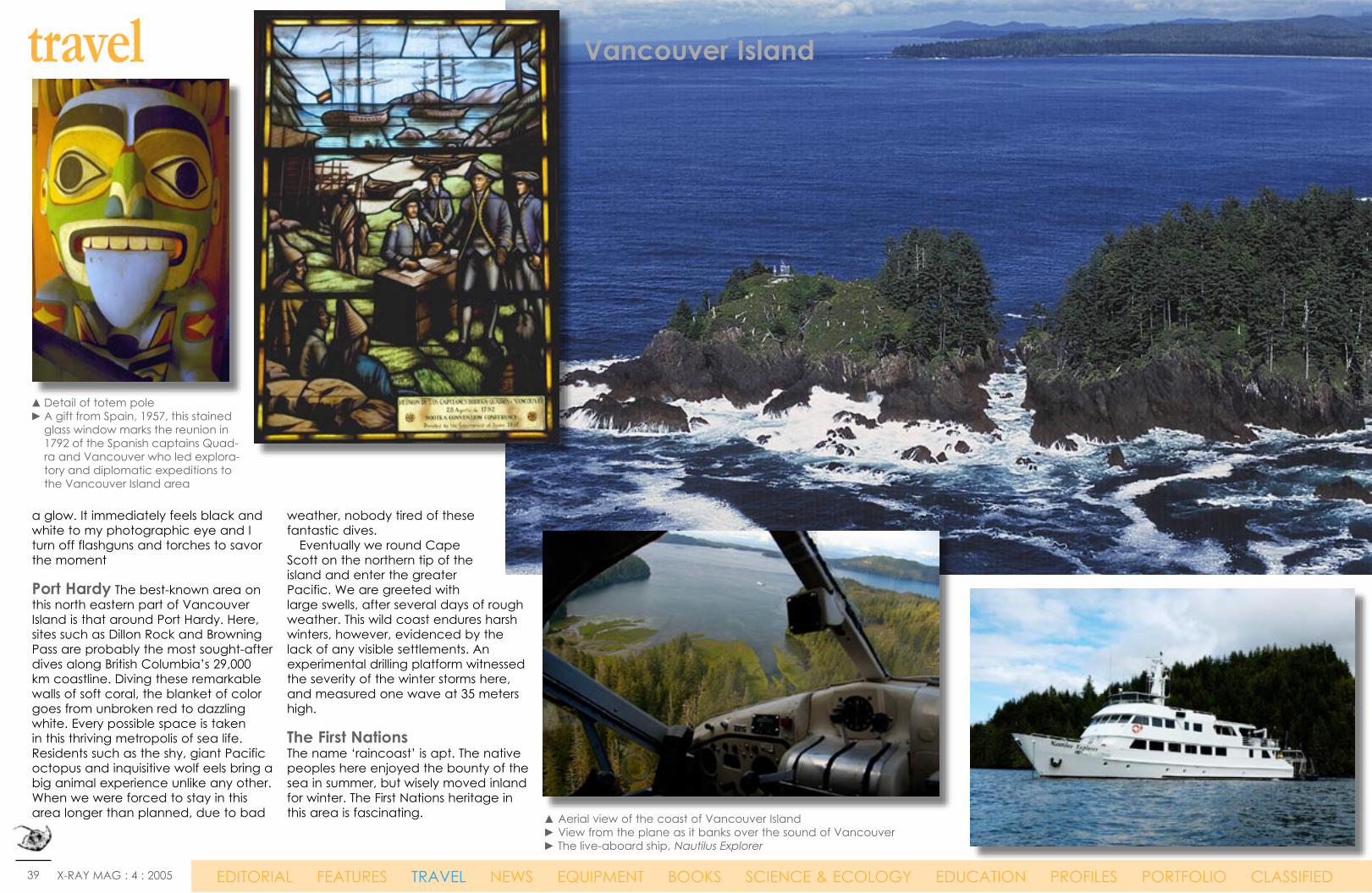
a glow. It immediately feels black and white to my photographic eye and I turn off flashguns and torches to savor the moment Port Hardy The best-known area on this north eastern part of Vancouver Island is that around Port Hardy. Here, sites such as Dillon Rock and Browning Pass are probably the most sought-after dives along British Columbia’s 29,000 km coastline. Diving these remarkable walls of soft coral, the blanket of color goes from unbroken red to dazzling white. Every possible space is taken in this thriving metropolis of sea life. Residents such as the shy, giant Pacific octopus and inquisitive wolf eels bring a big animal experience unlike any other. When we were forced to stay in this area longer than planned, due to bad
weather, nobody tired of these fantastic dives. Eventually we round Cape Scott on the northern tip of the island and enter the greater Pacific. We are greeted with large swells, after several days of rough weather. This wild coast endures harsh winters, however, evidenced by the lack of any visible settlements. An experimental drilling platform witnessed the severity of the winter storms here, and measured one wave at 35 meters high. The First Nations The name ‘raincoast’ is apt. The native peoples here enjoyed the bounty of the sea in summer, but wisely moved inland for winter. The First Nations heritage in this area is fascinating.
travel
▲ Detail of totem pole► A gift from Spain, 1957, this stained
glass window marks the reunion in 1792 of the Spanish captains Quad-ra and Vancouver who led explora-tory and diplomatic expeditions to the Vancouver Island area
▲ Aerial view of the coast of Vancouver Island► View from the plane as it banks over the sound of Vancouver► The live-aboard ship, Nautilus Explorer
40 X-RAY MAG : 4 : 2005 EDITORIAL FEATURES TRAVEL NEWS EQUIPMENT BOOKS SCIENCE & ECOLOGY EDUCATION PROFILES PORTFOLIO CLASSIFIED
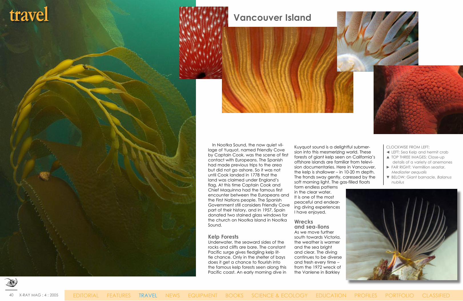
In Nootka Sound, the now quiet vil-lage of Yuquot, named Friendly Cove by Captain Cook, was the scene of first contact with Europeans. The Spanish had made previous trips to the area but did not go ashore. So it was not until Cook landed in 1778 that the land was claimed under England’s flag. At this time Captain Cook and Chief Maquinna had the famous first encounter between the Europeans and the First Nations people. The Spanish Government still considers Friendly Cove part of their history, and in 1957, Spain donated two stained glass windows for the church on Nootka Island in Nootka Sound. Kelp Forests Underwater, the seaward sides of the rocks and cliffs are bare. The constant Pacific surge gives fledgling kelp lit-tle chance. Only in the shelter of bays does it get a chance to flourish into the famous kelp forests seen along this Pacific coast. An early morning dive in
Kuyquot sound is a delightful submer-sion into this mesmerizing world. These forests of giant kelp seen on California’s offshore islands are familiar from televi-sion documentaries. Here in Vancouver, the kelp is shallower – in 10-20 m depth. The fronds sway gently, caressed by the soft morning light. The gas-filled floats form endless patterns in the clear water. It is one of the most peaceful and endear-ing diving experiences I have enjoyed. Wrecks and sea-lions As we move further south towards Victoria, the weather is warmer and the sea bright and clear. The diving continues to be diverse and fresh every time – from the 1972 wreck of the Vanlene in Barkley
CLOCKWISE FROM LEFT:◄ LEFT: Sea Kelp and hermit crab▲ TOP THREE IMAGES: Close-up
details of a variety of anemones► FAR RIGHT: Vermillion seastar,
Mediaster aequalis▼ BELOW: Giant barnacle, Balanus
nubilus
travel Vancouver Island

41 X-RAY MAG : 4 : 2005 EDITORIAL FEATURES TRAVEL NEWS EQUIPMENT BOOKS SCIENCE & ECOLOGY EDUCATION PROFILES PORTFOLIO CLASSIFIED
Sound to the aptly-named Race Rocks in the Strait of Juan de Fuca. Like the sites of Port Hardy in the north, these sites must be dived on a slack tide. Approaching in the dive skiff, the loud barks of Stellar sea-lions protest our arrival. Once in the water, however, the younger, curious sea-lions cannot resist checking out the divers. I find myself shooting some beautiful red-bodied sea anemones, only to feel a tug at my fin. Large black eyes plead to me for play instead of photography, but we humans are a poor match for these agile masters of the aquatic world.
Entering Victoria harbor signals the end of our circumnaviga-tion, as this is the final stop before our return to Vancouver city. It has been a superb trip, care-fully planned and organized by Captain Mike Lever and the crew of the Nautilus Explorer (www.nau-tilusexplorer.com). The only ques-tion in my mind on this final day is, when can I get back here and go north to Alaska? ■
To order prints of images from this story directly from the photographer, contact: [email protected]
travel Vancouver Island
▲ An underwater photographer passes through an archway of sea kelp
◄ Close-up portrait of a Kelp GreenlingPH
OTO
BY
BOB
WIL
SON
. NA
TION
AL
MA
RIN
E SA
NC
TUA
RIES
, NO
AA
▲ The vibrant city of Vancouver▲ INSET: Underwater photographer and dive writer, John Collins
▲ Stellar sea-lions nuzzle one another on the rocks

42 X-RAY MAG : 4 : 2005 EDITORIAL FEATURES TRAVEL NEWS EQUIPMENT BOOKS SCIENCE & ECOLOGY EDUCATION PROFILES PORTFOLIO CLASSIFIED
History Canada is a country of rich natural resources and vast distances. In 1867, Canada became a self-governing territory while retaining its relationship with the British crown. The country has developed economically and technologi-cally in parallel with its southen neighbor along an unfortified border, the United States. After a decade of budget cuts, the country’s great-est political issues are improving education and health care services. Recently, the issue of recon-ciling Quebec’s francophone heritage with the rest of the country’s population which is anglo-phone, has receded after a referendum held by the Quebec government failed to pass in 1995. Government: confederation with parliamentary democracy.
Geography Located on the northern half of the North American continent, Canada is bordered by three oceans: the North Atlantic Ocean on the east and the North Pacific Ocean on the west, as well as the Artic Ocean to the north. After Russia, Canada is the second largest country in the world. It has a strategic position between Russia and the US on the north polar route; about 90% of Canadian are concentrated in the area within 160 km of the border with the US. Terrain: wide plains with mountains in the west and lowlands in the southeast; Natural resources: iron ore, nickel, zinc, copper, gold, lead, mo-lybdenum, potash, diamonds, silver, fish, timber, wildlife, coal, petroleum, natural gas, hydro-power; Natural hazards: continuous permafrost in north is a serious obstacle to development; as a result of the mixing of air masses from the Arctic, Pacific, and North American interior, cyclonic storms form east of the Rocky Mountains and produce most of the country’s rain and snow east of the mountains.
Economy Canada closely resembles the US in its market-oriented economic system, pattern of production, and high living standards. It is an affluent, high-tech industrial society. Agriculture: wheat, barley, oilseed, tobacco, fruits, vegeta-bles; dairy products; forest products; fish; Indus-tries: transportation equipment, chemicals, proc-essed and unprocessed minerals, food products; wood and paper products; fish products, petro-leum and natural gas. Climate varies from temperate in the south to subarctic and arctic in the north
Population 32,507,874 (July 2004 est.) Ethnicity: British Isles origin 28%, French origin 23%, other European 15%, Amerindian 2%, other, most-ly Asian, African, Arab 6%, mixed background 26%; Religions: Roman Catholic 46%, Protestant 36%, other 18%
Currency Canadian dollar (CAD) Exchange rate: 1 CAD = $ .82 USD / € .63 EURO Language English 59.3% (official), French 23.2% (official), other 17.5%
Web sitesVancouver Island Tourismwww.islands.bc.caVancouver Island & Victoria BC Tourism Travel Guide www.vancouverisland.com Diving Vancouver Island www.bcdiving.com
Dive OperatorsBritish Columbia Dive Guidewww.bcdiveguide.comDive charter operators and dive resorts in British Columbia dive.bc.ca/links/charters.html Deco ChamberVancouver Coastal Health10th Floor, 601 West Broadway Vancouver, BC, V5Z 4C2 Information Line:1.866.884.0888 or 604.875.4252 www.vanhosp.bc.ca ■
Vancouver IslandBritish ColumbiaCanada
fact file
www.johncollinskinsale.com
43 X-RAY MAG : 4 : 2005 EDITORIAL FEATURES TRAVEL NEWS EQUIPMENT BOOKS SCIENCE & ECOLOGY EDUCATION PROFILES PORTFOLIO CLASSIFIED
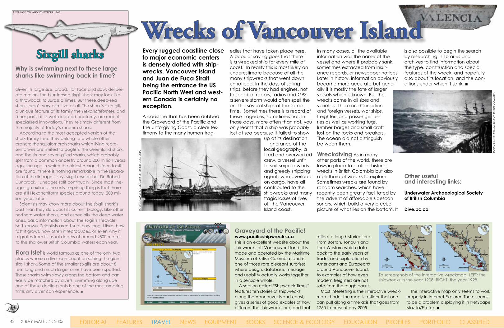
Sixgill sharks
Graveyard of the Pacific! www.pacificshipwrecks.caThis is an excellent website about the shipwrecks off Vancouver Island. It is made and operated by the Maritime Museum of British Columbia, and is one of those rare pleasant surprises where design, database, message and usability actually works together in a sensible whole. A section called “Shipwreck Times” features ten stories of shipwrecks along the Vancouver Island coast, gives a series of good exaples of how different the shipwrecks are, and that
reflect a long historical era. From Boston, Tonquin and Lord Western which date back to the early years of trade, and exploration by Americans and Europeans around Vancouver Island, to examples of how even modern freighters are not safe from the rough coast. Most interesting is the interactive wreck-map. Under the map is a slider that one can pull along a time axis that goes from 1750 to present day 2005.
The interactive map only seems to work properly in Internet Explorer. There seems to be a problem displaying it in NetScape Mozilla/Firefox. ■
Every rugged coastline close to major economic centers is densely dotted with ship-wrecks. Vancouver Island and Juan de Fuca Strait being the entrance the US Pacific North West and west-ern Canada is certainly no exception. A coastline that has been dubbed the Graveyard of the Pacific and The Unforgiving Coast, a clear tes-timony to the many human trag-
edies that have taken place here. A popular saying goes that there is a wrecked ship for every mile of coast. In reality this is most likely an underestimate because of all the many shipwrecks that went down unnoticed. In the days of sailing ships, before they had engines, not to speak of radars, radios and GPS, a severe storm would often spell the end for several ships at the same time. Sometimes there is a record of these tragedies, sometimes not. In those days, more often than not, you only learnt that a ship was probably lost at sea because it failed to show
up at its destination. Ignorance of the local geography, a tired and overworked crew, a vessel unfit to sail, surprise winds and greedy shipping agents who overload on cargo, have all contributed to the shipwrecks and many tragic losses of lives off the Vancouver Island coast.
In many cases, all the available information was the name of the vessel and where it probably sank, sometimes extracted from insur-ance records, or newspaper notices. Later in history, information obviously became more accurate but gener-ally it is mostly the fate of larger vessels which is known. But the wrecks come in all sizes and varieties. There are Canadian and foreign vessels, war ships, freighters and passenger fer-ries as well as working tugs, lumber barges and small craft lost on the rocks and breakers. The ocean did not distinguish between them.
Wreckdiving As in many other parts of the world, there are laws in place to protect historic wrecks in British Colombia but also a plethora of wrecks to explore. Sometimes wrecks are found by random searches, which have recently been greatly facilitated by the advent of affordable sidescan sonars, which build a very precise picture of what lies on the bottom. It
is also possible to begin the search by researching in libraries and archives to find information about the type, construction and special features of the wreck, and hopefully also about its location, and the con-ditions under which it sank. ■
Other useful and interesting links: Underwater Archaeological Society of British Columbia
Dive.bc.ca
Wrecks of Vancouver IslandWhy is swimming next to these large sharks like swimming back in time?
Given its large size, broad, flat face and slow, deliber-ate motion, the bluntnosed sixgill shark may look like a throwback to Jurassic Times. But these deep-sea sharks aren’t very primitive at all. The shark’s sixth gill, a unique feature of its family the Hexanchiformes, and other parts of its well-adapted anatomy, are recent, specialized innovations. They’re simply different from the majority of today’s modern sharks. According to the most accepted version of the shark family tree, they belong to a whole other branch: the squalomorph sharks which living repre-sentatives are limited to dogfish, the Greenland shark, and the six and seven-gilled sharks, which probably split from a common ancestry around 200 million years ago, the age in which the oldest Hexanchiform fossils are found. “There is nothing remarkable in the separa-tion of the lineage,” says sixgill researcher Dr. Robert Dunbrack. “Lineages split continually. Since most line-ages go extinct, the only surprising thing is that there are still Hexanchiform species around today, 200 mil-lion years later.” Scientists may know more about the sixgill shark’s past than they do about its current biology. Like other northern water sharks, and especially the deep water ones, basic information about the sixgill’s lifecycle isn’t known. Scientists aren’t sure how long it lives, how fast it grows, how often it reproduces, or even why it migrates from its usual depths of around 2500 metres to the shallower British Columbia waters each year.
Flora Islet is world famous as one of the only two places where a diver can count on seeing the giant sixgill shark. Some of the smaller sixgills are about 8 feet long and much larger ones have been spotted. These sharks swim slowly along the bottom and can easily be matched by divers. Swimming along side one of these docile giants is one of the most amazing thrills any diver can experience. ■
To screenshots of the interactive wreckmap. LEFT: the shipwrecks in the year 1908. RIGHT: the year 1928
SOUR
CE:
MA
RITIM
E M
USEU
M O
F BR
ITISH
CO
LUM
BIA
SOUR
CE:
MA
RITIM
E M
USEU
M O
F BR
ITISH
CO
LUM
BIA
AFTER BIGELOW AND SCHROEDER, 1948

44 X-RAY MAG : 4 : 2005 EDITORIAL FEATURES TRAVEL NEWS EQUIPMENT BOOKS SCIENCE & ECOLOGY EDUCATION PROFILES PORTFOLIO CLASSIFIED
Artificial reefs are created when vessels are sunk in a special area. This is where ARSBC comes into the pic-ture. The Artificial Reef Society of British Columbia is the Canadian non-profit organisa-tion behind a series of spec-tacular and highly publicised sinkings of predominantly decommisioned warships dur-ing the past decade.
Since 1990, the ARSBC has created six dive sites in British Columbia. The Coastal Freighter and former WW2 supplyship GB Church was was the first project of the ARSBC and Vancouver Island’s first artificial reef, sunk in Princess Margaret Marine Park in 1991. It served an important role as a prov-ing ground for the larger and more complex naval artificial reef projects that were to follow. Preparation of the ships meant cleaning them down completely, including cleaning all fuel and oil lines and removing all environmental haz-ards, often gutting them all the way
down to the bare steel. As diver safe-ty is, obviously, an important consid-eration it also means cutting holes for diver access, removing any hazardous obstacles and either sealing off con-fined spaces or opening them up for easy entry and exit. The sinking sites were often chosen for close proximity to local dive shop operators to enable positive economic
spin-offs from the new diving attrac-tion, and for a flat sandy bottom on which to land the ship. All coast guard and navigation requirements also had to be met when choosing locations. The sunken ships have quickly since became overcome with rich marine life including octopus and wolf-eels, and today they are testimonials to the positive environmental impact that
Artificial Reef Society of British ColumbiaMake reefs - not war
Sinking of HMCS Cape Breton
PHO
TO C
OUR
TESY
OF
DIV
ERS
CHO
ICE
CHA
RTER
S. W
WW
.DIV
ING
BCC
AN
AD
A.C
OM
Text edited by Peter SymesPhotos courtesy of the ARSBCand Divers Choice
ARS
BC

45 X-RAY MAG : 4 : 2005 EDITORIAL FEATURES TRAVEL NEWS EQUIPMENT BOOKS SCIENCE & ECOLOGY EDUCATION PROFILES PORTFOLIO CLASSIFIED
artificial reefs have on the marine ecosystem. Not only do artificial reefs pro-mote marine life, they also reduce diver impact on sur-rounding natural and histor-ical shipwreck dive sites by diverting diver traffic from those sites. The 111m destroyer escort Chaudiere was sunk in Sechelt Inlet in 1992, and aided by these experiences a second naval ship soon followed. On a beauti-ful September day in 1995 surrounded by more than 1,200 boats, aircraft and thousands of spectators, the former antisubmarine destroyer Mackenzie was sent to the bottom too. She now rests on the sea-floor off Sidney in about
33m of water. The site is just north of the USA - Canadian border and marker buoys are attached to the bow, bridge and stern of the ship for direct access to the ship from the surface. Columbia, located near Campbell River, was the third naval destroyer sunk by the ARSBC as an artificial reef, just nine months after Mackenzie. Again, know- ledge gained from two prior destroyer projects further improved the preparation efficiency, diver access and safety features incorporated into the ship. In addition to the explosives used to sink the ship, the crowd was treated to a spectacular display of pyrotechnics that lit the guns of Columbia as
a final salute to her tour of duty. She sank to the bottom in three minutes and forty-five seconds, bow first. Then followed the destroy-er Saskatchewan which was sunk in 1997 off Snake Island, a few miles east of Nanaimo. The site has mooring buoys adjacent to the ship and marker buoys attached at the bow, bridge, and stern of Saskatchewan. This fourth sinking of a destroyer was also the subject of a International contest to “push the button” and sink the ship. Cousteau Society sponsored the contest as a fund-raiser to replace its former ship Calypso which sank two years earlier follow-ing a collision in Singapore. The ARSBC writes on its website that it went through a great deal of trouble to make this wreck diveable for all skill levels by cutting many large holes at close proximity
to each other the length of the ship. Although an exit is visible from any entry point along the ship, it is still highly recommend-ed that divers receive proper wreck training before penetrat-ing the vessel. 2001 then saw the creation of the world’s largest artificial reef sinking when the 111m former WW2 Victory ship HMCS Cape Breton was also sent to the ocean floor near Snake Island where she now rests at 40 metres below the surface.
The ARS-540 is a decommis-sioned Boeing 737-200 airframe that was donated to the Artificial Reef Society by Qwest Airparts Ltd. of Memphis, Tennessee. Why the number 540? Why the cryp-tic name ARS-540? Well, the Air Canada internal designation of the plane was FIN-540, and ARS stands for Artificial Reef Society. The new reef project has been quite a while in the making, but the plane is still waiting for the sinking permit to be issued by Environment Canada. The plane is still in Comox, but is being stored on a lot, which the owner wants to develop, so he wants the plane out of there asap. The Comox Valley Dive Association has begun an impressive fund-
LEST
ER L
IGHT
STO
NE,
ARS
BC
▲ The HMCS Cape Breton before ARBSC took good care of her.
The HMCS The Saskatchewan was sunk in two steps. On the
day prior to the sinking, the engine room was flooded in an attempt to lower the ship’s center of gravity ►
Become an ARSBC Member!
Would you like to dive on the most interesting un-natural sites in B.C.? Would you like to help out to main-tain and monitor - or just dive for fun - the 6 (and soon to be 7) wreck sites which the ARSBC has created? Would you like to meet other divers with similar interests? Then we’d like to invite you to become a mem-ber. Visit ARSBCs Members’ Page for more details and an application form. Click here: www.artificialreef.bc.ca
▲ ABOVE: The 737 is the ARBSC’s next project. However as this magazine goes to press, the former jet is still waiting for the sinking permit to be issued by Environment Canada
▲ TOP LEFT: Diving the Saskatchewan
PHO
TO: A
RBSC
S W
EBSI
TE
PHO
TO: A
RBSC
’S W
EBSI
TE
PHO
TO: J
AY
STRA
ITH
PHO
TO: J
AY
STRA
ITH
Diving the Saskatchewan ►
RECOMMEND X-RAY MAG TO YOUR FRIENDS!
Place our banner link on your web site
Donate to our contributors
fund
Visit our sponsors or
become one
WWW.XRAY-MAG.COM

46 X-RAY MAG : 4 : 2005 EDITORIAL FEATURES TRAVEL NEWS EQUIPMENT BOOKS SCIENCE & ECOLOGY EDUCATION PROFILES PORTFOLIO CLASSIFIED
Rivtow Lion was sucessfully sunk on February 6th, 2005. The Rivtow Lion is a 157-foot (47 metre) long North Sea Rescue Tug. Built in 1940 in Selby England, she was originally named the HMRT (His Majesty’s Rescue Tug) Prudent, later named HMRT Cautious in 1947 and finally becoming Rivtow Lion in 1966. This 561-ton vessel was first stationed in Iceland and the Shetland Islands. Built to tow convoy ships dam-aged by German U-boats in WWII, these tugs accompanied convoys
across the North Atlantic on a three week voyage through winter gales and U-boat attacks, towing dam-aged ships in all kinds of weather. She was part of a rescue fleet that saved 140 American, 245 allied and neutral ships, 750 British and Commonwealth ships along with 245 allied warships and millions of tons of supplies during the war. ■ Source and photocredit: www.oceanexplorersdiving.com
raising and promotional effort for the 737 artificial reef. The CVDA has a limited number of advertising and sponsorship opportunities available, and would be happy to discuss the possibilities with you further. All gold level sponsors will receive a limited edition bronze statue by Simon Morris (morrissculpture.com) of Saltspring Island. Additionally, all donations can have tax receipts issued.Until the sinking date, the 737 is being stored beside a marina in Courtney, in full view of the public. Then, after it’s sunk, every diver to the new artificial reef will see your company’s logo for years to come. Click here for more information.
Underwater Treasure Hunting Along the east coast of Vancouver Island is the city of Nanaimo, one of North America’s premier dive destinations, but did you know that there are treasures to be found in the emerald waters that sur-round the harbour city? We are not just talking about the amazingly abundant sea life and healthy marine environment, we mean actual treasures. Well! Tokens for treasures — Citizen Watches to be exact. As a part of the promotion of the wrecks, a long-time locally-owned jew-elry store, Grassicks, donated women’s and men’s Citizen Watches. Tokens were created and hidden amongst the wrecks by members of the Nanaimo Dive Asso-ciation. To date, none of the three tokens have been found. For those planning to search for them, the only tip we can offer is that there are two tokens to be found within the Cape Breton wreck—one at recreational level and the second at technical level. The third token is some-where amidst the wreck of the Saskatch-ewan. ■ For information on dive charters in Nan-aimo, call 1- 250-756-0106 or visit Tourism Nanaimo’s website: www.tourismnanaimo.com
Tourism Vancouver Island’s website: www.islands.bc.ca
West Coast Dive Package Port Alberni’s Coast Hospitality Inn is offering a year-round West Coast Dive Package from CAD155 per person based on double occupancy. Package includes two dives with Six Gill Adventures, breakfast, boxed lunch, dinner, and one night accommodation in a Coast Comfort Guest Room. Guests will be whisked via the Alberni Inlet on a short ride to the dive sites. Experience the wonder of Barkley Sound…reefs covered in stunning sponges and hard corals, sea lions, and possibly a glimpse of the elusive Six Gill Sharks. Rental equipment available for additional charge. For more information, call 250-723-8111 or visit portalberni.coasthotels.com
Snorkelling with SealsGet up close and personal with harbour seals during a snorkelling experi-ence unique to Nanaimo. Guided excursions allow snorkellers to spend up to two hours in the water with the playful and curious critters that make their home at Snake Island, a short boat trip outside of Nanaimo’s har-bour. Dive operators offer snorkelling tours from CAD 75 per person which includes all necessary equipment. Stay and play in Nanaimo with a Seal Adventure Package starting at CAD189.95 per person based on double occupancy. Package includes two nights accommodation, two snorkelling adventures, and a number of extras. One night packages available. For more information or to book your snorkeling and accommodation package, call 1-250-753-1246 or visit www.buccaneerinn.com
Advertisements
▲ The sinking of the HMCS Mackenzie in 1995. She went under in 3 mins, 45 secs.
Photos: ARSBC’s website
Seafloor earthquakes signal eruption off Vancouver IslandSeismic activity on the Endeavour Ridge
An underwater eruption some 200 miles off the coast of Vancouver Island may be under way. Recently the area has been rocked by thousands tremors, most tiny, but some exceeding magnitude 4. “It has been going on long enough that we’re pretty sure lava is mov-ing,” said Edward Baker, an ocea-nographer at the Pacific Marine Environmental Laboratory, which is part of the National Oceanic and Atmospheric Administration (NOAA). Researchers keep scientific instruments packed and ready to go so they can act quickly when an under-water eruption starts. The Juan de Fuca plate, is a tectonic time bomb capable of producing earthquakes and tsunamis on par with the disaster that struck the Indian Ocean in December. “ An eruption along the ridge doesn’t directly raise the risk of an earthquake on the subduction zone. But the regions are closely linked, like pieces in a puz-zle.We really don’t know what to expect,” Baker said. Among the researchers tools is a network of Navy hydrophones originally used to monitor enemy submarines. The sensitive instruments can detect underwater earthquakes that are too faint and far away to be picked up by land-based seismographs. “It’s left over from the Cold War, and it’s become very use-ful,” Baker said. “But even I’m not allowed to know where the microphones are. The sen-sors located the shaking on the Juan de Fuca Ridge, where fresh oceanic crust forms as tectonic plates pull apart and magma wells up from deep within the earth. This seafloor spreading is slowly forcing the Juan de Fuca plate under the North American plate, creat-ing a subduction zone that has unleashed massive earthquakes in the past. ■
ARS
BC
•
THE LIVING EARTH® INC./EARTH IMAGING

47 X-RAY MAG : 4 : 2005 EDITORIAL FEATURES TRAVEL NEWS EQUIPMENT BOOKS SCIENCE & ECOLOGY EDUCATION PROFILES PORTFOLIO CLASSIFIED
Eureka Alaska!Colorful Northern Lights danced across a late evening sky in Whittier, Alaska. As my husband, Wayne Grant, and I donned our scuba gear for our first night dive in this mysterious Land of the Midnight Sun, I wondered if the native legends were actu-ally true, and that the dancing lights were actually happy spirits enjoying a night of play. At the same moment this beautiful and unusual phenomenon took place above us, we saw the water bub-bling in the boat’s wake sparkle with phosphorescence below us. The lights of the sea and sky glimmered as if waiting to illus-trate a magical story. Wayne handed me my camera, and we submerged into the glassy, calm realm of the aquatic world.
Within seconds, I spotted several Dungeness crabs, causing them to flee from our approaching path of light. Although the water was 49 degrees, visibility was particle-free and excellent. As the depth gradu-ally increased, we noticed an abun-dance of red rock and hermit crabs, huge sea stars, shrimp, and an odd-looking juve-nile Alaskan king crab. To walk, the baby king crab stood tall on its prickly pink spiky-thin legs and moved with uncanny speed. Just a few meters ahead, Wayne had a flounder in his sights and encouraged me to follow. In an undulating motion, the flat fish slowly moved forward trying to keep up with Wayne’s light. Little did we know we were following the small flounder along a pre-marked trail to the remains of an old ‘bush’ plane. Careful not to stir up the sediment, we surveyed the site
Text by Barb Roy
◄ LEFT: Mountains surround Resurrection Bay◄ CENTER: Snakelock Anemone▲ RIGHT: Nudibranch, White-lined Dirona
Diving the Land of the Midnight Sun...
Text by Barb Roy Photos by Barb Roy, NOAA Photo Library, Alaska Tourism
PHOTOS ON THIS PAGE BY BARB ROY

48 X-RAY MAG : 4 : 2005 EDITORIAL FEATURES TRAVEL NEWS EQUIPMENT BOOKS SCIENCE & ECOLOGY EDUCATION PROFILES PORTFOLIO CLASSIFIED
travel
with our torches. I noticed two big eyes peeking over a portion of debris. In the process of approaching the site, we must have attracted the attention of a curi-ous medium-sized giant Pacific octopus. Instantly a game of hide-and-seek devel-
oped. Needless to say, this quirky, almost comical, octopus held our
attention for the rest of the dive. We took the opportunity to take some close-up and macro shots. Alaska The state of Alaska encompasses 587,878 square miles (1,522,596 square km). Past explorers were drawn to this vast terri-
tory known in search of gold and fame. Today, visitors are held in awe of Alaska’s extremely long summer days— hence the reference, land of the midnight sun—and the seemingly endless supply of majestic scenic beauty. Among these adventur-ers, are often a number of curious divers yearning for a chance to explore a por-
tion of Alaska’s extensive underwater ter-rain. For the truly daring, this cold water haven can offer a seemingly endless sup-ply of exploratory possibilities. For our excursion, Wayne and I chose the month of September to explore the Alaskan coast. By doing this, we avoided large crowds of tourists and took advan-
▲ Anemone, Fish-eating Urticina
MALAYSIA. Coralreeefs after the Tsunami. Whalebeachings. Tragedy in South Africa. Nemos Nose The Science of Fish Fashion, Ice Diving in Russia. Tod Essick.
Diving in the Himalayas, Swimming with Orcas in Norway, El Dorado in the Philippines. Gaansbai in South Africa.
Featuring Belize’s Blue Hole; Tasmania; Balmorhea, Texas; Norways Egersund, Liveaboard on Lake Baikal, Siberia
Link: X-RAY #3
Did you get the previous issues of X-RAY MAG?
They are also free
Link: X-RAY#2
Link: X-RAY#1
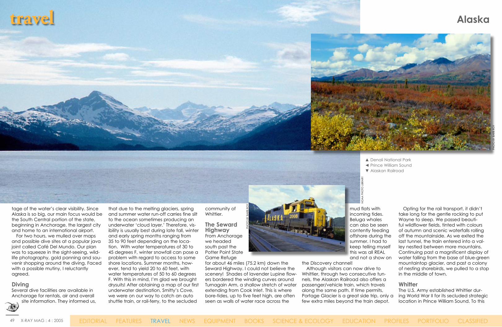
49 X-RAY MAG : 4 : 2005 EDITORIAL FEATURES TRAVEL NEWS EQUIPMENT BOOKS SCIENCE & ECOLOGY EDUCATION PROFILES PORTFOLIO CLASSIFIED
▲ Denali National Park◄ Prince William Sound▼ Alaskan Railroad
travel Alaska
tage of the water’s clear visibility. Since Alaska is so big, our main focus would be the South Central portion of the state, beginning in Anchorage, the largest city and home to an international airport. For two hours, we mulled over maps and possible dive sites at a popular java joint called Café Del Mundo. Our plan was to squeeze in the sight-seeing, wild-life photography, gold panning and sou-venir shopping around the diving. Faced with a possible mutiny, I reluctantly agreed. DivingSeveral dive facilities are available in Anchorage for rentals, air and overall
site information. They informed us,
that due to the melting glaciers, spring and summer water run-off carries fine silt to the ocean sometimes producing an underwater ‘cloud layer.’ Therefore, vis-ibility is usually best during late fall, winter and early spring months ranging from 35 to 90 feet depending on the loca-tion. With water temperatures of 30 to 45 degrees F, winter snowfall can pose a problem with regard to access to some shore locations. Summer months, how-ever, tend to yield 20 to 60 feet, with water temperatures of 50 to 60 degrees F. With this in mind, I’m glad we brought drysuits! After obtaining a map of our first underwater destination, Smitty’s Cove, we were on our way to catch an auto shuttle train, or rail-ferry, to the secluded
community of Whittier.
The Seward HighwayFrom Anchorage we headed south past the Potter Point State Game Refuge for about 46 miles (75.2 km) down the Seward Highway. I could not believe the scenery! Shades of lavender Lupine flow-ers bordered the winding curves around Turnagain Arm, a shallow stretch of water extending from Cook Inlet. This is where bore-tides, up to five feet high, are often seen as walls of water race across the
mud flats with incoming tides. Beluga whales can also be seen contently feeding offshore during the summer. I had to keep telling myself this was all REAL and not a show on
the Discovery channel! Although visitors can now drive to Whittier, through two consecutive tun-nels, the Alaskan Railroad also offers a passenger/vehicle train, which travels along the same path. If time permits, Portage Glacier is a great side trip, only a few extra miles beyond the train depot.
Opting for the rail transport, it didn’t take long for the gentle rocking to put Wayne to sleep. We passed beauti-ful wildflower fields, tinted with colours of autumn and scenic waterfalls rolling off the mountainside. As we exited the last tunnel, the train entered into a val-ley nestled between more mountains. Continuing past a magnificent display of water falling from the base of blue-green mountaintop glacier, and past a colony of nesting shorebirds, we pulled to a stop in the middle of town.
WhitterThe U.S. Army established Whittier dur-ing World War II for its secluded strategic location in Prince William Sound. To this
NO
AA
PHO
TO L
IBRA
RY
PHO
TO B
Y BA
RB R
OY
PHO
TO B
Y BA
RB R
OY
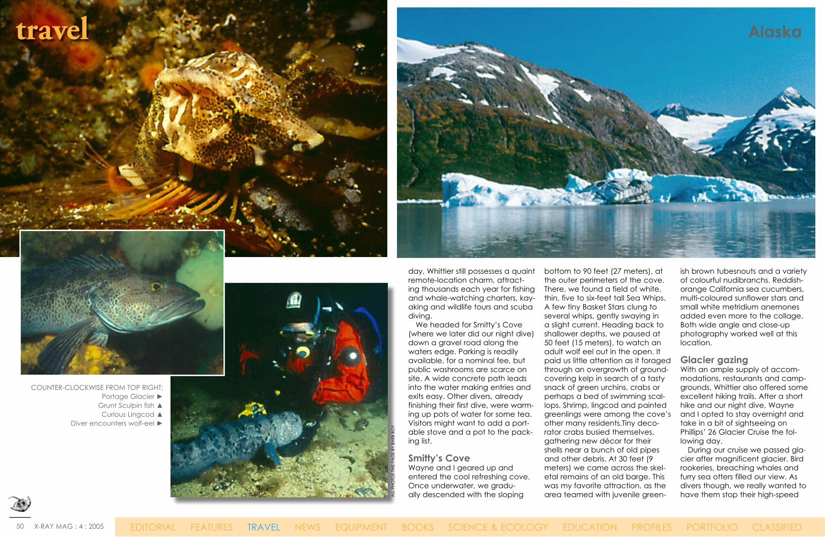
50 X-RAY MAG : 4 : 2005 EDITORIAL FEATURES TRAVEL NEWS EQUIPMENT BOOKS SCIENCE & ECOLOGY EDUCATION PROFILES PORTFOLIO CLASSIFIED
travel Alaska
COUNTER-CLOCKWISE FROM TOP RIGHT:Portage Glacier ►
Grunt Sculpin fish ▲Curious Lingcod ▲
Diver encounters wolf-eel ►
day, Whittier still possesses a quaint remote-location charm, attract-ing thousands each year for fishing and whale-watching charters, kay-aking and wildlife tours and scuba diving. We headed for Smitty’s Cove (where we later did our night dive) down a gravel road along the waters edge. Parking is readily available, for a nominal fee, but public washrooms are scarce on site. A wide concrete path leads into the water making entries and exits easy. Other divers, already finishing their first dive, were warm-ing up pots of water for some tea. Visitors might want to add a port-able stove and a pot to the pack-ing list.
Smitty’s CoveWayne and I geared up and entered the cool refreshing cove. Once underwater, we gradu-ally descended with the sloping
bottom to 90 feet (27 meters), at the outer perimeters of the cove. There, we found a field of white, thin, five to six-feet tall Sea Whips. A few tiny Basket Stars clung to several whips, gently swaying in a slight current. Heading back to shallower depths, we paused at 50 feet (15 meters), to watch an adult wolf eel out in the open. It paid us little attention as it foraged through an overgrowth of ground-covering kelp in search of a tasty snack of green urchins, crabs or perhaps a bed of swimming scal-lops. Shrimp, lingcod and painted greenlings were among the cove’s other many residents.Tiny deco-rator crabs busied themselves, gathering new décor for their shells near a bunch of old pipes and other debris. At 30 feet (9 meters) we came across the skel-etal remains of an old barge. This was my favorite attraction, as the area teamed with juvenile green-
ish brown tubesnouts and a variety of colourful nudibranchs. Reddish-orange California sea cucumbers, multi-coloured sunflower stars and small white metridium anemones added even more to the collage. Both wide angle and close-up photography worked well at this location.
Glacier gazingWith an ample supply of accom-modations, restaurants and camp-grounds, Whittier also offered some excellent hiking trails. After a short hike and our night dive, Wayne and I opted to stay overnight and take in a bit of sightseeing on Phillips’ 26 Glacier Cruise the fol-lowing day. During our cruise we passed gla-cier after magnificent glacier. Bird rookeries, breaching whales and furry sea otters filled our view. As divers though, we really wanted to have them stop their high-speed A
LL P
HOTO
S TH
IS P
AG
E BY
BA
RB R
OY

51 X-RAY MAG : 4 : 2005 EDITORIAL FEATURES TRAVEL NEWS EQUIPMENT BOOKS SCIENCE & ECOLOGY EDUCATION PROFILES PORTFOLIO CLASSIFIED
Trawling, in which boats drag mammoth nets along the sea bottom for miles, can easily crush the long-lived, brittle creatures on the Aleutian sea floor, which scientists believe may be the most diverse and abundant cold-water coral and sponge habitat on Earth. Scientists believe the coral may help incubate a fertile fishing area that helps supply a significant portion of U.S. seafood.
Therefore, in a plan to protect the deep-water corals and sponges that help nurse Alaska’s fishing grounds, commercial trawling nets will be
banned from more than a million square kilometers of ocean near the Aleutian Islands. This is the largest area ever closed to fishing solely for conservation. A whole new approach to protect-ing the rocky, colourful seafloor habi-tat has thus been initiated. Coming shortly after two scientific panels proclaimed the world’s seas were in ecological trouble, the decision signals a shift in thinking about how to manage oceans, and puts new pressure on the bodies that oversee fishing in Atlantic, Pacific and Gulf Coast waters to follow suit. Typically, entire oceans are open to fishing except in areas that have been specifically set aside to protect sea lions or rare birds, or to rebuild fallen crab stocks, for example. In this case, the opposite approach was taken. It recommended outlaw-ing bottom-trawling everywhere in the Aleutians, except in the some 65,000 square kilometers of seas where boats fish today, minus a few
coral-rich areas that already are off limits. It will prevent the industry from spreading out into the Aleutians and further destroying coral, which ulti-mately could prove to be essential to the ecosystem. The action was mainly fueled by an explosion in coral exploration, and the quest to understand its role in the ecosystem. In recent years, scientists have been taking deep-sea submersibles 350 meters or more deep along the volcanic flanks of the Aleutians. Here they found acres of coral gardens: red corals shaped like a Joshua tree; sponges shaped like spatulas, barrels or crooked human fingers; and a 1½ meter sponge that looked like a little girl’s pigtails. They were a brilliant green, violent shades of orange and bright yellow. Scientists even saw a lone predatory sponge that captured crustaceans for food. More than two dozen were coral species found nowhere else on earth. ■
It’s called
Earth Day.
That’s not to say
we need to treat it
like Dirt Day.
After more than thirty years, we thought it was time that the other 72% of the planet got some attention. Which is why we’re
asking people to Dive In To Earth Day the week of April 18 to 24. So grab some friends and install a mooring, do a reef survey,
or organize an underwater cleanup. Everybody into the water. For more information, visit www.coral.org or call (415) 834-0900.
CORAL_Dirt_Day_8.25x10.875.qxd 11/19/04 1:25 PM Page 1
Trawling to be banned near Aleutian Islands
WW
W.N
OA
A.G
OV
Bringing a huge trawl aboard a commercial fishing vessel. (Filephoto NOAA)
WW
W.N
OA
A.G
OV
. ALA
SKA
FIS
HERI
ES S
CIE
NC
E C
ENTE
R, M
ARI
NE
OBS
ERV
ER P
ROG
RAM

52 X-RAY MAG : 4 : 2005 EDITORIAL FEATURES TRAVEL NEWS EQUIPMENT BOOKS SCIENCE & ECOLOGY EDUCATION PROFILES PORTFOLIO CLASSIFIED
0
200
400
Aleutians Bering Sea Gulf of Alaska
Frequency
CupGorgonianHydrocoralSoft
1,849
catamaran, so we could jump in and check out all these critters below all the breathtaking scenery! Yes, another day in Alaska’s paradise, I thought to myself as we boarded the train.
SewardSeward, our next destination was another 80 miles (129 km) south over Turnagain Pass (elev. 988 feet / 301 m) and through Chugach National Forest. Coming into Seward, we detoured long enough to visit Exit Glacier. Although they do not permit this now, I had never touched a real glacier before today! It wasn’t as cold as I thought it would be… The Alaska SeaLife Center is another attraction wor-thy of investigation, located on the water down-town. A diver can see firsthand the various species of marine fish and invertebrates they may encoun-ter, before they even get wet. While shore diving in Seward is limited to a handful of sites, most requiring a climb over large boulders, there are several seasonal dive charters available. We came across two, one based in Anchorage, Dive Alaska, and another based in Sterling, The Dive Shop.
Barwell IslandIt was great to have an opportunity to explore Resurrection Bay, so we arranged a dive to Barwell Island the next morning with Ed Lindquist, owner of The Dive Shop. Ed met us at the boat harbor with his 22-foot (6.6 meters) Seasport boat. In no time at all we are heading down the long narrow pas-sage of Resurrection Bay. The water was as smooth as satin sheets, making it easy to spot a small group of sea otters lounging in the sun. Sea Lions, Bald Eagles, and shore birds were all around. I was really impressed with the rugged mountain coastline run-ning parallel on one side of the bay and the weath-er-beaten islands on the other. Barwell Island turned out to be a very remote chunk of rock, open to the fury or the Gulf of Alaska. It was surrounded by clean blue ocean water. Looking at the island up close, I could see
travel Alaska
◄ TOP LEFT: Barwell Island reef wall◄ BOTTOM LEFT: Chart of coral growth
in Alaska regions► TOP RIGHT: View of The Sleeping
Lady from Anchorage, Alaska► BOTTOM RIGHT: Map of marine parks
in south eastern Alaska
PHO
TO B
Y BA
RB R
OY
PHO
TO B
Y BA
RB R
OY
NO
AA
PHO
TO L
IBRA
RY
ALA
SKA
TO
URSI
M
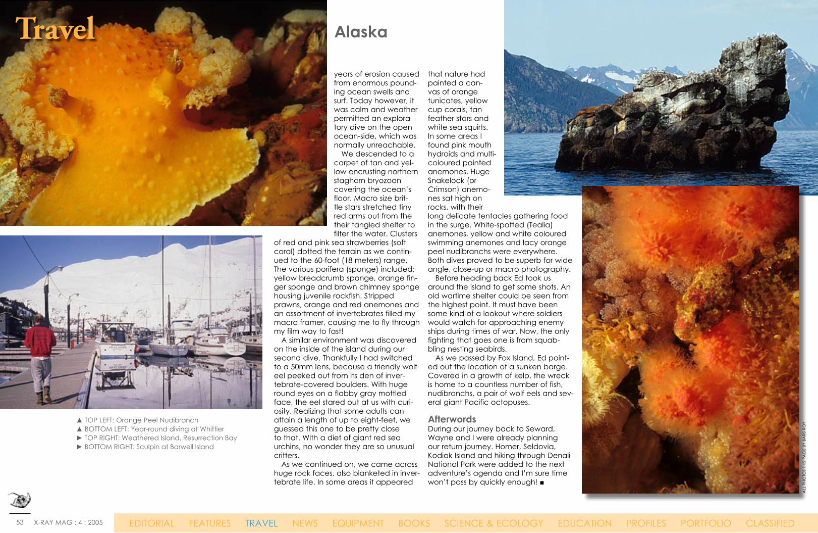
53 X-RAY MAG : 4 : 2005 EDITORIAL FEATURES TRAVEL NEWS EQUIPMENT BOOKS SCIENCE & ECOLOGY EDUCATION PROFILES PORTFOLIO CLASSIFIED
years of erosion caused from enormous pound-ing ocean swells and surf. Today however, it was calm and weather permitted an explora-tory dive on the open ocean-side, which was normally unreachable. We descended to a carpet of tan and yel-low encrusting northern staghorn bryozoan covering the ocean’s floor. Macro size brit-tle stars stretched tiny red arms out from the their tangled shelter to filter the water. Clusters
of red and pink sea strawberries (soft coral) dotted the terrain as we contin-ued to the 60-foot (18 meters) range.The various porifera (sponge) included; yellow breadcrumb sponge, orange fin-ger sponge and brown chimney sponge housing juvenile rockfish. Stripped prawns, orange and red anemones and an assortment of invertebrates filled my macro framer, causing me to fly through my film way to fast! A similar environment was discovered on the inside of the island during our second dive. Thankfully I had switched to a 50mm lens, because a friendly wolf eel peeked out from its den of inver-tebrate-covered boulders. With huge round eyes on a flabby gray mottled face, the eel stared out at us with curi-osity. Realizing that some adults can attain a length of up to eight-feet, we guessed this one to be pretty close to that. With a diet of giant red sea urchins, no wonder they are so unusual critters. As we continued on, we came across huge rock faces, also blanketed in inver-tebrate life. In some areas it appeared
that nature had painted a can-vas of orange tunicates, yellow cup corals, tan feather stars and white sea squirts. In some areas I found pink mouth hydroids and multi-coloured painted anemones. Huge Snakelock (or Crimson) anemo-nes sat high on rocks, with their long delicate tentacles gathering food in the surge. White-spotted (Tealia) anemones, yellow and white coloured swimming anemones and lacy orange peel nudibranchs were everywhere. Both dives proved to be superb for wide angle, close-up or macro photography. Before heading back Ed took us around the island to get some shots. An old wartime shelter could be seen from the highest point. It must have been some kind of a lookout where soldiers would watch for approaching enemy ships during times of war. Now, the only fighting that goes one is from squab-bling nesting seabirds. As we passed by Fox Island, Ed point-ed out the location of a sunken barge. Covered in a growth of kelp, the wreck is home to a countless number of fish, nudibranchs, a pair of wolf eels and sev-eral giant Pacific octopuses.
AfterwordsDuring our journey back to Seward, Wayne and I were already planning our return journey. Homer, Seldovia, Kodiak Island and hiking through Denali National Park were added to the next adventure’s agenda and I’m sure time won’t pass by quickly enough! ■
Travel Alaska
▲ TOP LEFT: Orange Peel Nudibranch▲ BOTTOM LEFT: Year-round diving at Whittier► TOP RIGHT: Weathered Island, Resurrection Bay► BOTTOM RIGHT: Sculpin at Barwell Island
ALL
PHO
TOS
THIS
PA
GE
BY B
ARB
RO
Y
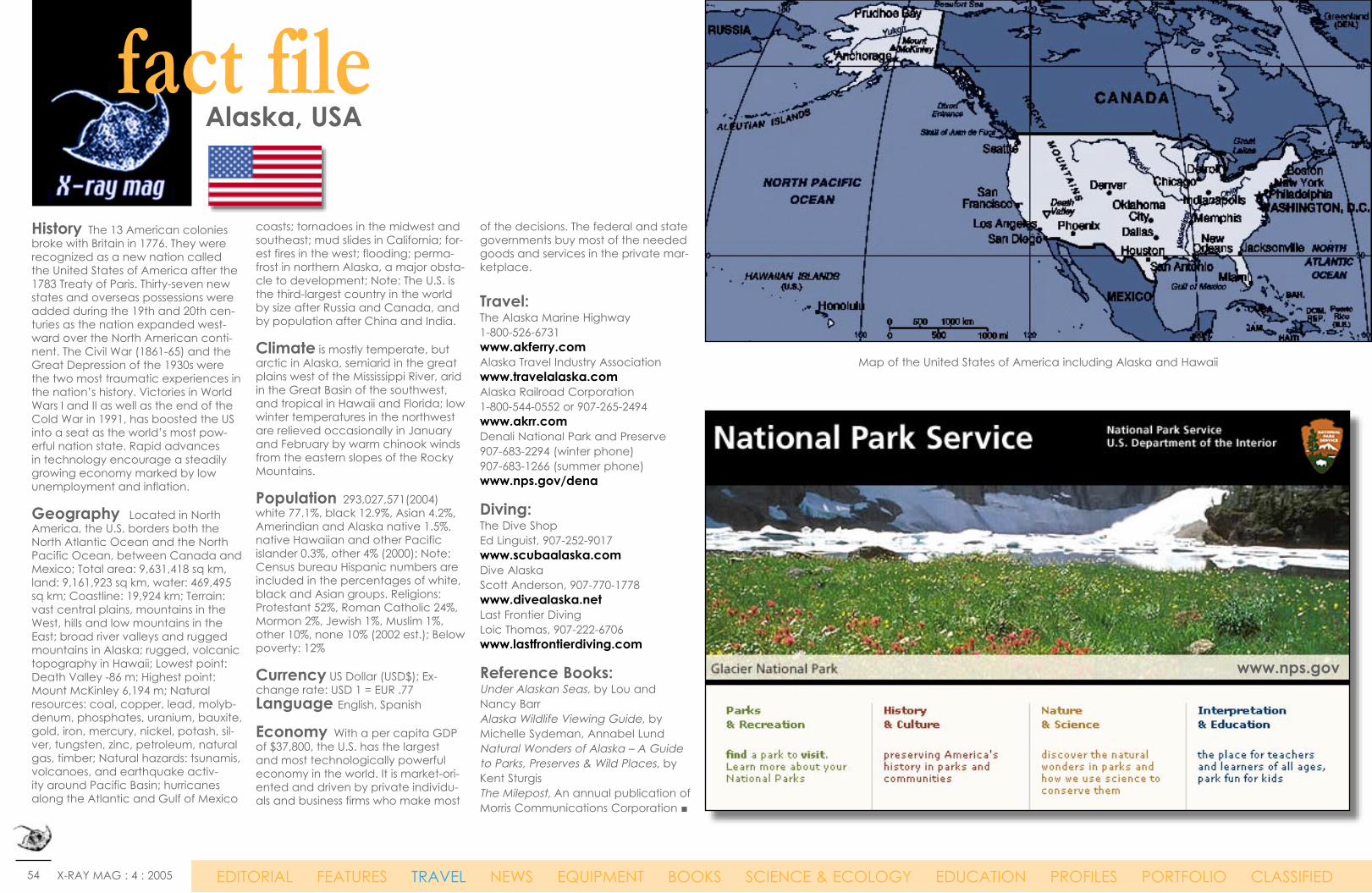
54 X-RAY MAG : 4 : 2005 EDITORIAL FEATURES TRAVEL NEWS EQUIPMENT BOOKS SCIENCE & ECOLOGY EDUCATION PROFILES PORTFOLIO CLASSIFIED
Alaska, USAfact file
History The 13 American colonies broke with Britain in 1776. They were recognized as a new nation called the United States of America after the 1783 Treaty of Paris. Thirty-seven new states and overseas possessions were added during the 19th and 20th cen-turies as the nation expanded west-ward over the North American conti-nent. The Civil War (1861-65) and the Great Depression of the 1930s were the two most traumatic experiences in the nation’s history. Victories in World Wars I and II as well as the end of the Cold War in 1991, has boosted the US into a seat as the world’s most pow-erful nation state. Rapid advances in technology encourage a steadily growing economy marked by low unemployment and inflation.
Geography Located in North America, the U.S. borders both the North Atlantic Ocean and the North Pacific Ocean, between Canada and Mexico; Total area: 9,631,418 sq km, land: 9,161,923 sq km, water: 469,495 sq km; Coastline: 19,924 km; Terrain: vast central plains, mountains in the West, hills and low mountains in the East; broad river valleys and rugged mountains in Alaska; rugged, volcanic topography in Hawaii; Lowest point: Death Valley -86 m; Highest point: Mount McKinley 6,194 m; Natural resources: coal, copper, lead, molyb-denum, phosphates, uranium, bauxite, gold, iron, mercury, nickel, potash, sil-ver, tungsten, zinc, petroleum, natural gas, timber; Natural hazards: tsunamis, volcanoes, and earthquake activ-ity around Pacific Basin; hurricanes along the Atlantic and Gulf of Mexico
coasts; tornadoes in the midwest and southeast; mud slides in California; for-est fires in the west; flooding; perma-frost in northern Alaska, a major obsta-cle to development; Note: The U.S. is the third-largest country in the world by size after Russia and Canada, and by population after China and India.
Climate is mostly temperate, but arctic in Alaska, semiarid in the great plains west of the Mississippi River, arid in the Great Basin of the southwest, and tropical in Hawaii and Florida; low winter temperatures in the northwest are relieved occasionally in January and February by warm chinook winds from the eastern slopes of the Rocky Mountains.
Population 293,027,571(2004)white 77.1%, black 12.9%, Asian 4.2%, Amerindian and Alaska native 1.5%, native Hawaiian and other Pacific islander 0.3%, other 4% (2000); Note: Census bureau Hispanic numbers are included in the percentages of white, black and Asian groups. Religions: Protestant 52%, Roman Catholic 24%, Mormon 2%, Jewish 1%, Muslim 1%, other 10%, none 10% (2002 est.); Below poverty: 12%
Currency US Dollar (USD$); Ex-change rate: USD 1 = EUR .77 Language English, Spanish
Economy With a per capita GDP of $37,800, the U.S. has the largest and most technologically powerful economy in the world. It is market-ori-ented and driven by private individu-als and business firms who make most
of the decisions. The federal and state governments buy most of the needed goods and services in the private mar-ketplace.
Travel:The Alaska Marine Highway 1-800-526-6731 www.akferry.comAlaska Travel Industry Association www.travelalaska.com Alaska Railroad Corporation 1-800-544-0552 or 907-265-2494 www.akrr.com Denali National Park and Preserve 907-683-2294 (winter phone) 907-683-1266 (summer phone) www.nps.gov/dena
Diving:The Dive ShopEd Linguist, 907-252-9017 www.scubaalaska.comDive Alaska Scott Anderson, 907-770-1778www.divealaska.netLast Frontier Diving Loic Thomas, 907-222-6706www.lastfrontierdiving.com
Reference Books:Under Alaskan Seas, by Lou and Nancy BarrAlaska Wildlife Viewing Guide, by Michelle Sydeman, Annabel Lund Natural Wonders of Alaska – A Guide to Parks, Preserves & Wild Places, by Kent SturgisThe Milepost, An annual publication of Morris Communications Corporation ■
www.nps.gov
Map of the United States of America including Alaska and Hawaii