Embed Size (px)
Citation preview
Bulletin of the Marine Geology, Vol. 35, No. 2, December 2020, pp. 91 to 102
91
Tectonics of Volcanogenic Massive Sulphide (VMS) Deposits at Flores Back Arc Basin: A Review
Kondisi Tektonik Deposit Sulfida Masif Volkanogenik pada Cekungan Busur Belakang Flores: Suatu Tinjauan
Noor Cahyo Dwi Aryanto* and Hananto Kurnio
Marine Geological Institute of Indonesia (MGI), Jalan Dr. Djundjunan No. 236, Bandung.
Corresponding author: *[email protected]; [email protected]
(Received 14 September 2020; in revised form 18 September 2020; accepted 26 November 2020)
ABSTRACT: The bathymetry, petrology, marine magnetic, and seismic-SBP data have identified thenorthwest-southeast direction submarine ridge that shows hydrothermal activity. This activity occurredthrough Mount Baruna Komba, Abang Komba, and Ibu Komba. The volcanic rocks are andesite basaltic lavaflows, tuff, and pumice. The andesite basaltic lava shows porphyritic, intergranular, intersertal toglomeroporphyritic textures. The rock composes anhedral minerals of k-feldspar, plagioclase, and pyroxene.These minerals present in small-sized, short prismatic dispersed in very fine groundmass minerals or glasses.Most of the volcanic rocks have experienced various degrees of alteration. The k-feldspar and plagioclase aremost dominantly transformed into sericite, clay mineral, carbonate, epidote and oxide mineral, opaquemineral, and secondary plagioclase through the albitization process, while pyroxene replaced by chlorite.Other minerals are biotite and quartz, and base metals are present Cu, Zn, Ag, As, Pb, and gold.Mineralization categorizes as the phyllic zone, sub-prophylithic zone, and phyllic-potassic zone that formedat a temperature range of 250-400oC. The submarine hydrothermal alteration in the Komba Ridge isassociated with a volcanogenic sulphide deposit controlled by crust thinning due to the crust rifts in the back-arc tectonic setting.
Keywords: volcanic rocks, submarine hydrothermal alterations, Komba ridge, volcanogenic massifsulphide (VMS), back-arc
ABSTRAK: Data batimetri, petrologi, magnetic laut dan seismic-SBP telah memetakan danmengidentifikasi suatu punggungan bawahlaut berarah baratlaut-tenggara yang memperlihatkan aktifitashidrotermal bawah laut. Aktifitas tersebut muncul melalui Gunung Baruna Komba, Abang Komba dan IbuKomba. Batuan gunungapi penyusun adalah aliran lava andesit basaltic, tuf dan pumis. Lava andesit basaltikmemperlihatkan tekstur porfiritik, intergranular, intersertal to glomeroporfiritik. Mineral penyusun berupak-felspar, plagioklas, dan piroksen dalam bentuk mineral anhedral, prismatik pendek berukuran kecil yangberada dalam masa dasar mineral sangat halus atau gelas. Batuan vulkanik telah mengalami ubahan dalamberbagai tingkat, dimana k-flespar dan plagioklas paling dominan terubah menjadi serisit, lempung,karbonat, epidot dan mineral oksida, opak atau plagioklas sekunder melalui proses albitisasi sedangkanpiroksen mengalami proses ubahan digantikan oleh klorit. Mineral ubahan lainnya adalah biotit dan kuarsadan logam dasar seperti Cu, Zn, Ag, As, Pb, dan emas. Mineralisasi dikategorikan sebagai zona filik,
zona sub-profillitik, dan zona filik-potasik yang terbentuk pada kisaran suhu 250-400oC. Alterasihidrotermal bawah laut di Punggungan Komba berasosiasi dengan suatu endapan sulfida volkanogenik yangdikontrol oleh penipisan kerak akibat peregangan kerak dalam tatan tektonik busur belakang.
Keywords: batuan gunungapi, alterasi hidrotermal bawah laut, punggungan Komba, sulfida massifvulkanogenik, busur belakang
Contributorship:The main contributors: Noor Cahyo Dwi Aryanto and Hananto Kurnio.
92 Noor Cahyo Dwi Aryanto and Hananto Kurnio
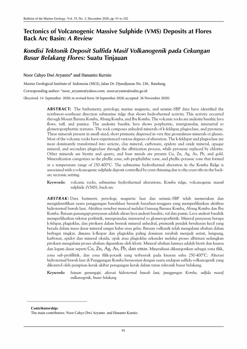
INTRODUCTIONThe study area is located in the Flores back-arc
basin (Karig, 1983; McCaffrey and Nabelek, 1984;Tikku, 2011; Gorsel, 2018 and Magni, 2019), northeastof Flores Island, East Nusa Tenggara Province (Figure1). The area is divided into three different submarineridges, the first ridge is the Komba active volcano island(Batutara island) on the most northern part, 400 meters
above sea level (Sarmili, and Suryoko, 2012). Next, thesecond, to southeastward, those are Baruna, and AbangKomba and third, is Ibu Komba ridge (Sarmili et al.,2003 and 2004). These ridges immediately place in thenorth of the Flores back-thrust and at the southwestmargin of South Banda Basin (Hamilton, 1979). Thepurpose of this paper is to assess and review theprevious result regarding the VMS deposition processin the Flores Sea, Indonesia, especially those related totectonic setting, and of mineral deposits results.
Volcanogenic Massive Sulphide (VMS) deposits
Volcanogenic massive sulphide ore deposits,VMS, are a type of metal sulphide ore depositcomposed mainly by copper and zinc. The VMSassociated with and created by volcanic hydrothermalevents in submarine environments (Colin-Garcia et al.,2016; Galley et al., 2007 and Mercier-Langevin et al.,2014). It occurs along mid-oceanic ridges, within back-arc basins and forearc rifts. It also termed as volcanichosted massive sulphide (VHMS) deposits. Specific
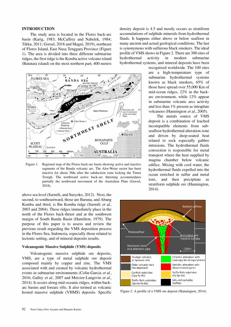
density deposit is 4.5 and mostly occurs as stratiformaccumulations of sulphide minerals from hydrothermalfluids. It happens either above or below seafloor inmany ancient and actual geological conditions. The lastis synonymous with sulfurous black smokers. The idealprofile of VMS shows in Figure 2. There are 300 sites ofhydrothermal activity in modern submarinehydrothermal systems, and mineral deposits have been
recognized worldwide. The 100 sitesare a high-temperature type ofsubmarine hydrothermal systemsknown as black smokers, 65% ofthose have spread over 55,000 Km ofmid-ocean ridges, 22% in the back-arc environment, while 12% appearin submarine volcanic arcs activityand less than 1% present as intraplatevolcanoes (Hannington et al., 2005).
The metals source of VMSdeposit is a combination of leachedincompatible elements from sub-seafloor hydrothermal alteration zoneand driven by deep-seated heatrelated to rock especially gabbrointrusions. The hydrothermal fluidsconvection is responsible for metaltransport where the heat supplied bymagma chamber below volcanicedifice. Mixing with cool water, thehydrothermal fluids expelled into theocean enriched in sulfur and metalions, and then precipitate asstratiform sulphide ore (Hannington,2014).
Figure 1. Regional map of the Flores back-arc basin showing active and inactivesegments of the Banda volcanic arc. The Alor-Wetar sector has beeninactive for about 3Ma after the subduction zone locking the TimorTrough. The northward active back-arc thrusting accommodatespartially the northward movement of the Australian Plate (Gorsel,2018).
Figure 2. A profile of a VMS ore deposit (Hannington, 2014).
Tectonics of Volcanogenic Massive Sulphide (VMS) Deposits at Flores Back Arc Basin: A Review 93
The caldera related VMS deposit formation can berecognized through its multiphase sill-like sub-volcanicintrusion. An abrupt change in thickness, orientation,and extensive-thick-pyroclastic/volcaniclastic depositsare characters of caldera related VMS depositformation. The other characters are thick-ponded flowsuccession, internal angular, erosional unconformities,megabreccias as a product of collapse, and numerousdikes and sills. The orthogonal, radial, or concentricsyn-volcanic faults and intense semi-conformablealteration controlled caldera related VMS deposit(Gibson, 2007).
Gibson (2007) pointed out that VMS deposits arelocated within and adjacent to a caldera where theyoccur within volcanic vents localized along syn-volcanic faults and fissures. VMS deposit and calderaformations occur in the late evolution of volcanoes,while caldera formation itself is associated with highheat flow and cross-stratal structures. Permeabilityfocused on time explains the time-stratigraphic controlof VMS deposit formation, while its focus on spaceexplains the clustering of deposits (Gibson, 2007). Onthe other hand, shallow magmatism offers potential fora magmatic-hydrothermal contribution of metalpreservation (Gibson, 2007).
Hydrothermal Fluid Mechanism in Producing VMS
Massive sulphide deposits formed at or near thesea floor where non-boiling fluids are cooled by steepthermal gradients or by quenching in cold seawater.Metal precipitation is rapid if boiling occurs(Drummond and Ohmoto, 1985). The main controls onthe vigour and pattern of convection are intrusiongeometry and depth, and the permeability of theintruded environment. These factors are broadly relatedto geologic setting and host-rock composition and thusto conventional classification of VMS deposits (Barrie,C., et al., 1999).
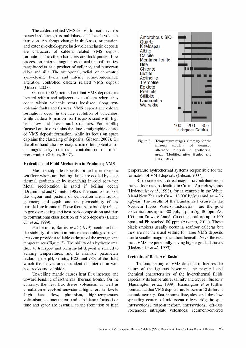
Furthermore, Barrie. et al. (1999) mentioned thatthe stability of alteration mineral assemblages in ventareas can provide a reliable estimate of the average venttemperatures (Figure 3). The ability of a hydrothermalfluid to transport and form metal deposit is related toventing temperatures, and to intrinsic parametersincluding the pH, salinity, H2S, and f O2 of the fluid,which themselves are dependent on interaction withhost rocks and sulphide.
Upwelling mantle causes heat flux increase andupward bending of isotherms (thermal fronts). On thecontrary, the heat flux drives volcanism as well ascirculation of evolved seawater at higher crustal levels.High heat flow, plutonism, high-temperaturevolcanism, sedimentation, and subsidence focused ontime and space are essential to the formation of high
temperature hydrothermal systems responsible for theformation of VMS deposits (Gibson, 2007).
Black smokers as direct magmatic contributions inthe seafloor may be leading to Cu and Au rich systems(Hedenquist et al., 1993), for an example in the WhiteIsland New Zealand: Cu – 110,000 kg/year and Au – 36kg/year. The results of the Bandamin-1 cruise in theNorthern Flores Waters, Indonesia, are the goldconcentrations up to 300 ppb, 4 ppm Ag, 80 ppm As,106 ppm Zn were found, Cu concentrations up to 100ppm and Pb reached 80 ppm (Aryanto, 2011). Theseblack smokers usually occur in seafloor calderas butthey are not the usual setting for large VMS depositsdue to smaller magma chambers beneath. Nevertheless,these VMS are potentially having higher grade deposits(Hedenquist et al., 1993).
Tectonics of Back Arc Basin
Tectonic setting of VMS deposits influences thenature of the igneous basement, the physical andchemical characteristics of the hydrothermal fluidsespecially its temperature, salinity and oxygen fugacity(Hannington et al., 1999). Hannington et al furtherpointed out that VMS deposits are known in 12 differenttectonic settings: fast, intermediate, slow and ultraslowspreading centers of mid-ocean ridges; ridge-hotspotintersections; ridge-transform intersections; off-axisvolcanoes; intraplate volcanoes; sediment-covered
Figure 3. Temperature ranges summary for themineral stability of commonalteration minerals in geothermalareas (Modified after Henley andEllis, 1982)
94 Noor Cahyo Dwi Aryanto and Hananto Kurnio
ridges; intracontinental rifts; intra-oceanic arcs;transitional or island arcs; continental margin arcs;intra-oceanic back-arc basins and intracontinentalback-arc basins. While on modern geodynamic, VMScould be found in intra-continental rifts, intra-oceanicarcs, transitional or island arcs, continental margin arcs,intra-oceanic back-arc basins and intra-continentalback-arc basins (Hannington et al., 2005). Gibson(2007) noticed that back Arc VMS occur at a rift, thatare fault-bounded basins produced by extension of thecrust.
Geological Setting of Flores back-arc Basin
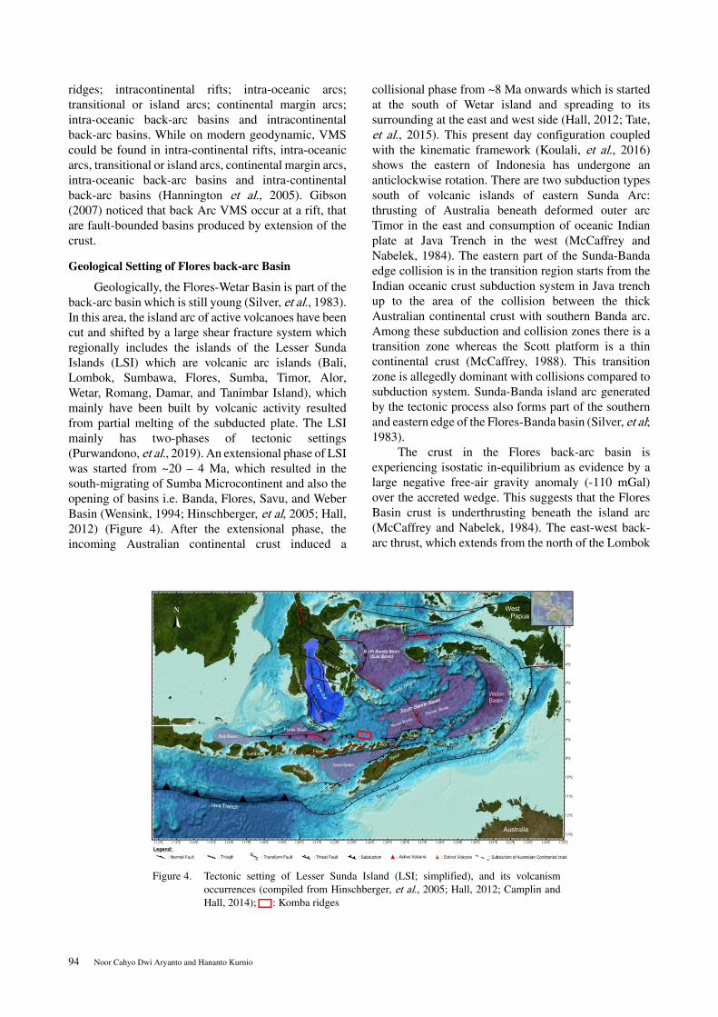
Geologically, the Flores-Wetar Basin is part of theback-arc basin which is still young (Silver, et al., 1983).In this area, the island arc of active volcanoes have beencut and shifted by a large shear fracture system whichregionally includes the islands of the Lesser SundaIslands (LSI) which are volcanic arc islands (Bali,Lombok, Sumbawa, Flores, Sumba, Timor, Alor,Wetar, Romang, Damar, and Tanimbar Island), whichmainly have been built by volcanic activity resultedfrom partial melting of the subducted plate. The LSImainly has two-phases of tectonic settings(Purwandono, et al., 2019). An extensional phase of LSIwas started from ~20 – 4 Ma, which resulted in thesouth-migrating of Sumba Microcontinent and also theopening of basins i.e. Banda, Flores, Savu, and WeberBasin (Wensink, 1994; Hinschberger, et al, 2005; Hall,2012) (Figure 4). After the extensional phase, theincoming Australian continental crust induced a
collisional phase from ~8 Ma onwards which is startedat the south of Wetar island and spreading to itssurrounding at the east and west side (Hall, 2012; Tate,et al., 2015). This present day configuration coupledwith the kinematic framework (Koulali, et al., 2016)shows the eastern of Indonesia has undergone ananticlockwise rotation. There are two subduction typessouth of volcanic islands of eastern Sunda Arc:thrusting of Australia beneath deformed outer arcTimor in the east and consumption of oceanic Indianplate at Java Trench in the west (McCaffrey andNabelek, 1984). The eastern part of the Sunda-Bandaedge collision is in the transition region starts from theIndian oceanic crust subduction system in Java trenchup to the area of the collision between the thickAustralian continental crust with southern Banda arc.Among these subduction and collision zones there is atransition zone whereas the Scott platform is a thincontinental crust (McCaffrey, 1988). This transitionzone is allegedly dominant with collisions compared tosubduction system. Sunda-Banda island arc generatedby the tectonic process also forms part of the southernand eastern edge of the Flores-Banda basin (Silver, et al;1983).
The crust in the Flores back-arc basin isexperiencing isostatic in-equilibrium as evidence by alarge negative free-air gravity anomaly (-110 mGal)over the accreted wedge. This suggests that the FloresBasin crust is underthrusting beneath the island arc(McCaffrey and Nabelek, 1984). The east-west back-arc thrust, which extends from the north of the Lombok
Figure 4. Tectonic setting of Lesser Sunda Island (LSI; simplified), and its volcanismoccurrences (compiled from Hinschberger, et al., 2005; Hall, 2012; Camplin andHall, 2014); : Komba ridges
Tectonics of Volcanogenic Massive Sulphide (VMS) Deposits at Flores Back Arc Basin: A Review 95
island to the Flores island, disappears around the studyarea. Furthermore, after being cut off by the Wetar faultwhich traverses northeast-southwest or parallel to thePantar fault, this upward fault appears again in the northof Wetar Island which extends to the east (Silver, et. al.,1983).
METHODOLOGYThis study is based on the review of various
published or unpublish data on a tectonic and a VMSformation topic. The principal data are published andunpublished data and marine expedition report on theexistence of submarine hydrothermal activities at thenortheast of the Flores Sea or Batutara (Komba) area inthe Flores back-arc environment. The marineexpeditions had carried out by MGI, namely Bandamin-1 Cruise in 2002, Bandamin-2 Cruise in 2003 (Halbach,et. al., 2003a) and Sangeang Cruise in 2013 (Sarmili, L.,et. al., Internal report, 2013). The marine expeditionshave produced very high-value data. These data ispresented in various related publications, such asbathymetry, processed seabed magnetic, rock type andmineralization, and single channel seismic or sub-bottom profiles.
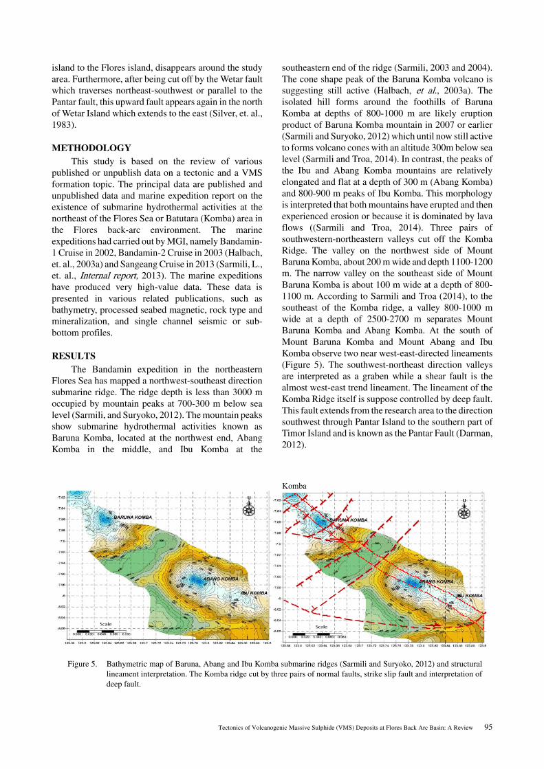
RESULTSThe Bandamin expedition in the northeastern
Flores Sea has mapped a northwest-southeast directionsubmarine ridge. The ridge depth is less than 3000 moccupied by mountain peaks at 700-300 m below sealevel (Sarmili, and Suryoko, 2012). The mountain peaksshow submarine hydrothermal activities known asBaruna Komba, located at the northwest end, AbangKomba in the middle, and Ibu Komba at the
southeastern end of the ridge (Sarmili, 2003 and 2004).The cone shape peak of the Baruna Komba volcano issuggesting still active (Halbach, et al., 2003a). Theisolated hill forms around the foothills of BarunaKomba at depths of 800-1000 m are likely eruptionproduct of Baruna Komba mountain in 2007 or earlier(Sarmili and Suryoko, 2012) which until now still activeto forms volcano cones with an altitude 300m below sealevel (Sarmili and Troa, 2014). In contrast, the peaks ofthe Ibu and Abang Komba mountains are relativelyelongated and flat at a depth of 300 m (Abang Komba)and 800-900 m peaks of Ibu Komba. This morphologyis interpreted that both mountains have erupted and thenexperienced erosion or because it is dominated by lavaflows ((Sarmili and Troa, 2014). Three pairs ofsouthwestern-northeastern valleys cut off the KombaRidge. The valley on the northwest side of MountBaruna Komba, about 200 m wide and depth 1100-1200m. The narrow valley on the southeast side of MountBaruna Komba is about 100 m wide at a depth of 800-1100 m. According to Sarmili and Troa (2014), to thesoutheast of the Komba ridge, a valley 800-1000 mwide at a depth of 2500-2700 m separates MountBaruna Komba and Abang Komba. At the south ofMount Baruna Komba and Mount Abang and IbuKomba observe two near west-east-directed lineaments(Figure 5). The southwest-northeast direction valleysare interpreted as a graben while a shear fault is thealmost west-east trend lineament. The lineament of theKomba Ridge itself is suppose controlled by deep fault.This fault extends from the research area to the directionsouthwest through Pantar Island to the southern part ofTimor Island and is known as the Pantar Fault (Darman,2012).
KOMBA???Komba
Figure 5. Bathymetric map of Baruna, Abang and Ibu Komba submarine ridges (Sarmili and Suryoko, 2012) and structurallineament interpretation. The Komba ridge cut by three pairs of normal faults, strike slip fault and interpretation ofdeep fault.
96 Noor Cahyo Dwi Aryanto and Hananto Kurnio
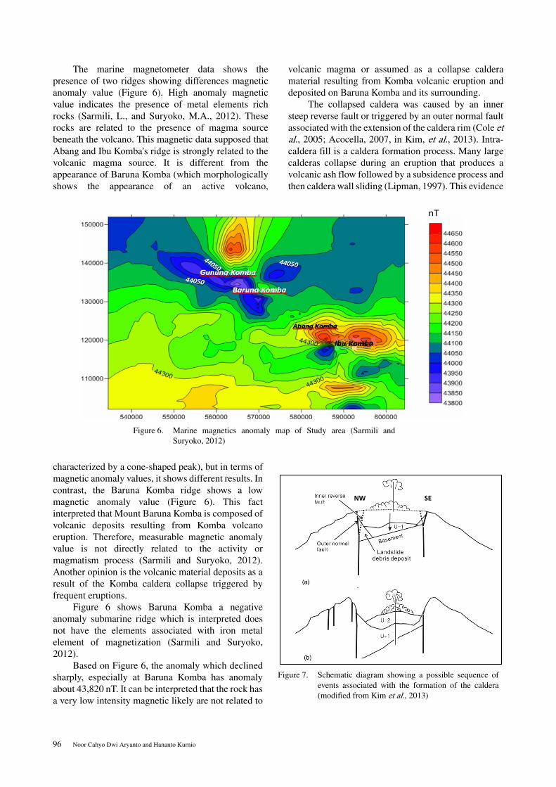
The marine magnetometer data shows thepresence of two ridges showing differences magneticanomaly value (Figure 6). High anomaly magneticvalue indicates the presence of metal elements richrocks (Sarmili, L., and Suryoko, M.A., 2012). Theserocks are related to the presence of magma sourcebeneath the volcano. This magnetic data supposed thatAbang and Ibu Komba's ridge is strongly related to thevolcanic magma source. It is different from theappearance of Baruna Komba (which morphologicallyshows the appearance of an active volcano,
characterized by a cone-shaped peak), but in terms ofmagnetic anomaly values, it shows different results. Incontrast, the Baruna Komba ridge shows a lowmagnetic anomaly value (Figure 6). This factinterpreted that Mount Baruna Komba is composed ofvolcanic deposits resulting from Komba volcanoeruption. Therefore, measurable magnetic anomalyvalue is not directly related to the activity ormagmatism process (Sarmili and Suryoko, 2012).Another opinion is the volcanic material deposits as aresult of the Komba caldera collapse triggered byfrequent eruptions.
Figure 6 shows Baruna Komba a negativeanomaly submarine ridge which is interpreted doesnot have the elements associated with iron metalelement of magnetization (Sarmili and Suryoko,2012).
Based on Figure 6, the anomaly which declinedsharply, especially at Baruna Komba has anomalyabout 43,820 nT. It can be interpreted that the rock hasa very low intensity magnetic likely are not related to
volcanic magma or assumed as a collapse calderamaterial resulting from Komba volcanic eruption anddeposited on Baruna Komba and its surrounding.
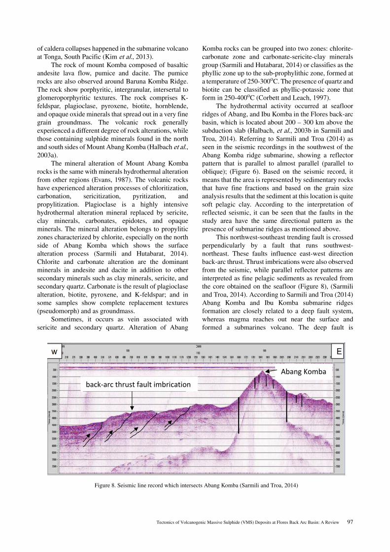
The collapsed caldera was caused by an innersteep reverse fault or triggered by an outer normal faultassociated with the extension of the caldera rim (Cole etal., 2005; Acocella, 2007, in Kim, et al., 2013). Intra-caldera fill is a caldera formation process. Many largecalderas collapse during an eruption that produces avolcanic ash flow followed by a subsidence process andthen caldera wall sliding (Lipman, 1997). This evidence
��
Figure 6. Marine magnetics anomaly map of Study area (Sarmili andSuryoko, 2012)
SENW
Figure 7. Schematic diagram showing a possible sequence ofevents associated with the formation of the caldera(modified from Kim et al., 2013)
Tectonics of Volcanogenic Massive Sulphide (VMS) Deposits at Flores Back Arc Basin: A Review 97
of caldera collapses happened in the submarine volcanoat Tonga, South Pacific (Kim et al., 2013).
The rock of mount Komba composed of basalticandesite lava flow, pumice and dacite. The pumicerocks are also observed around Baruna Komba Ridge.The rock show porphyritic, intergranular, intersertal toglomeroporphyritic textures. The rock comprises K-feldspar, plagioclase, pyroxene, biotite, hornblende,and opaque oxide minerals that spread out in a very finegrain groundmass. The volcanic rock generallyexperienced a different degree of rock alterations, whilethose containing sulphide minerals found in the northand south sides of Mount Abang Komba (Halbach et al.,2003a).
The mineral alteration of Mount Abang Kombarocks is the same with minerals hydrothermal alterationfrom other regions (Evans, 1987). The volcanic rockshave experienced alteration processes of chloritization,carbonation, sericitization, pyritization, andpropylitization. Plagioclase is a highly intensivehydrothermal alteration mineral replaced by sericite,clay minerals, carbonates, epidotes, and opaqueminerals. The mineral alteration belongs to propyliticzones characterized by chlorite, especially on the northside of Abang Komba which shows the surfacealteration process (Sarmili and Hutabarat, 2014).Chlorite and carbonate alteration are the dominantminerals in andesite and dacite in addition to othersecondary minerals such as clay minerals, sericite, andsecondary quartz. Carbonate is the result of plagioclasealteration, biotite, pyroxene, and K-feldspar; and insome samples show complete replacement textures(pseudomorph) and as groundmass.
Sometimes, it occurs as vein associated withsericite and secondary quartz. Alteration of Abang
Komba rocks can be grouped into two zones: chlorite-carbonate zone and carbonate-sericite-clay mineralsgroup (Sarmili and Hutabarat, 2014) or classifies as thephyllic zone up to the sub-prophylithic zone, formed ata temperature of 250-300oC. The presence of quartz andbiotite can be classified as phyllic-potassic zone thatform in 250-400oC (Corbett and Leach, 1997).
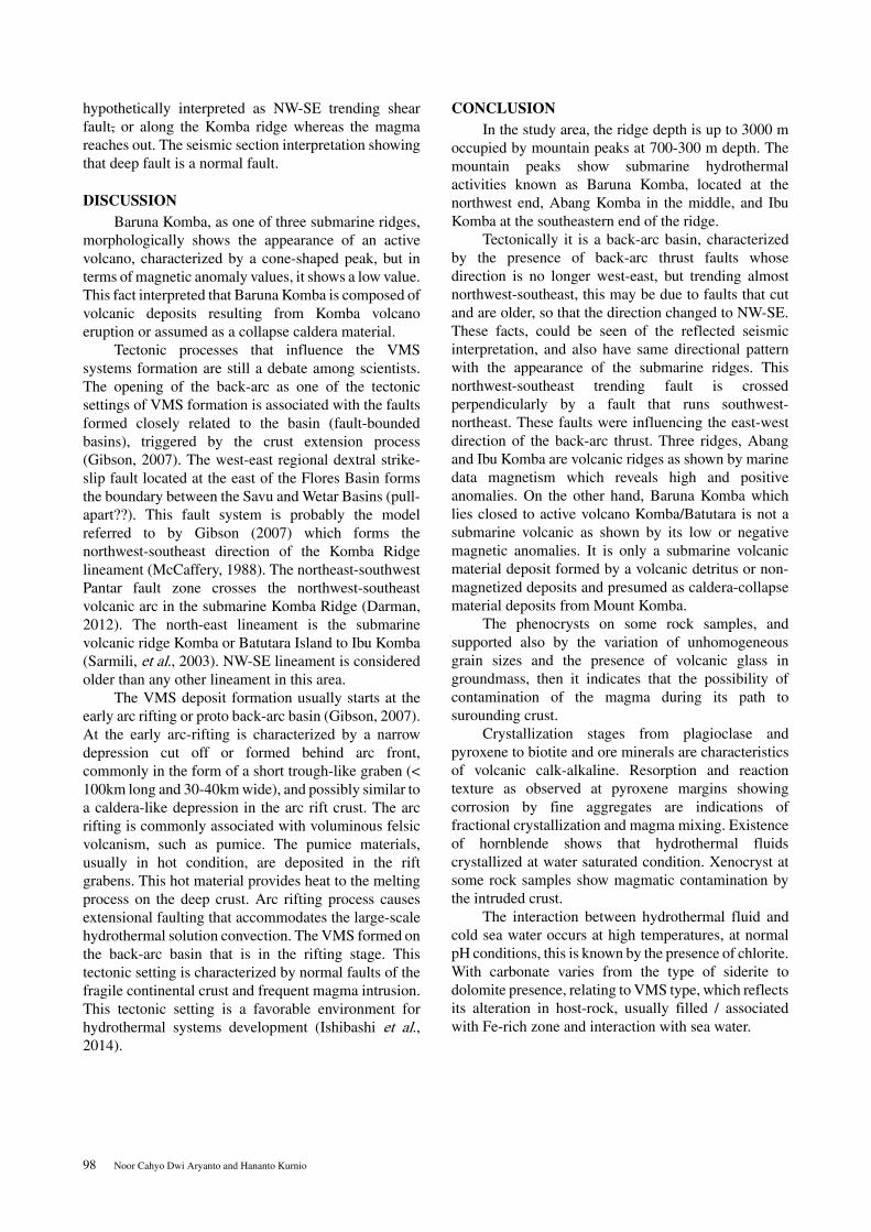
The hydrothermal activity occurred at seafloorridges of Abang, and Ibu Komba in the Flores back-arcbasin, which is located about 200 – 300 km above thesubduction slab (Halbach, et al., 2003b in Sarmili andTroa, 2014). Referring to Sarmili and Troa (2014) asseen in the seismic recordings in the southwest of theAbang Komba ridge submarine, showing a reflectorpattern that is parallel to almost parallel (parallel tooblique); (Figure 6). Based on the seismic record, itmeans that the area is represented by sedimentary rocksthat have fine fractions and based on the grain sizeanalysis results that the sediment at this location is quitesoft pelagic clay. According to the interpretation ofreflected seismic, it can be seen that the faults in thestudy area have the same directional pattern as thepresence of submarine ridges as mentioned above.
This northwest-southeast trending fault is crossedperpendicularly by a fault that runs southwest-northeast. These faults influence east-west directionback-arc thrust. Thrust imbrications were also observedfrom the seismic, while parallel reflector patterns areinterpreted as fine pelagic sediments as revealed fromthe core obtained on the seafloor (Figure 8), (Sarmiliand Troa, 2014). According to Sarmili and Troa (2014)Abang Komba and Ibu Komba submarine ridgesformation are closely related to a deep fault system,whereas magma reaches out near the surface andformed a submarines volcano. The deep fault is
back�arc�thrust�fault imbrication
Abang�Komba�
Figure 8. Seismic line record which intersects Abang Komba (Sarmili and Troa, 2014)
98 Noor Cahyo Dwi Aryanto and Hananto Kurnio
hypothetically interpreted as NW-SE trending shearfault, or along the Komba ridge whereas the magmareaches out. The seismic section interpretation showingthat deep fault is a normal fault.
DISCUSSIONBaruna Komba, as one of three submarine ridges,
morphologically shows the appearance of an activevolcano, characterized by a cone-shaped peak, but interms of magnetic anomaly values, it shows a low value.This fact interpreted that Baruna Komba is composed ofvolcanic deposits resulting from Komba volcanoeruption or assumed as a collapse caldera material.
Tectonic processes that influence the VMSsystems formation are still a debate among scientists.The opening of the back-arc as one of the tectonicsettings of VMS formation is associated with the faultsformed closely related to the basin (fault-boundedbasins), triggered by the crust extension process(Gibson, 2007). The west-east regional dextral strike-slip fault located at the east of the Flores Basin formsthe boundary between the Savu and Wetar Basins (pull-apart??). This fault system is probably the modelreferred to by Gibson (2007) which forms thenorthwest-southeast direction of the Komba Ridgelineament (McCaffery, 1988). The northeast-southwestPantar fault zone crosses the northwest-southeastvolcanic arc in the submarine Komba Ridge (Darman,2012). The north-east lineament is the submarinevolcanic ridge Komba or Batutara Island to Ibu Komba(Sarmili, et al., 2003). NW-SE lineament is consideredolder than any other lineament in this area.
The VMS deposit formation usually starts at theearly arc rifting or proto back-arc basin (Gibson, 2007).At the early arc-rifting is characterized by a narrowdepression cut off or formed behind arc front,commonly in the form of a short trough-like graben (<100km long and 30-40km wide), and possibly similar toa caldera-like depression in the arc rift crust. The arcrifting is commonly associated with voluminous felsicvolcanism, such as pumice. The pumice materials,usually in hot condition, are deposited in the riftgrabens. This hot material provides heat to the meltingprocess on the deep crust. Arc rifting process causesextensional faulting that accommodates the large-scalehydrothermal solution convection. The VMS formed onthe back-arc basin that is in the rifting stage. Thistectonic setting is characterized by normal faults of thefragile continental crust and frequent magma intrusion.This tectonic setting is a favorable environment forhydrothermal systems development (Ishibashi et al.,2014).
CONCLUSIONIn the study area, the ridge depth is up to 3000 m
occupied by mountain peaks at 700-300 m depth. Themountain peaks show submarine hydrothermalactivities known as Baruna Komba, located at thenorthwest end, Abang Komba in the middle, and IbuKomba at the southeastern end of the ridge.
Tectonically it is a back-arc basin, characterizedby the presence of back-arc thrust faults whosedirection is no longer west-east, but trending almostnorthwest-southeast, this may be due to faults that cutand are older, so that the direction changed to NW-SE.These facts, could be seen of the reflected seismicinterpretation, and also have same directional patternwith the appearance of the submarine ridges. Thisnorthwest-southeast trending fault is crossedperpendicularly by a fault that runs southwest-northeast. These faults were influencing the east-westdirection of the back-arc thrust. Three ridges, Abangand Ibu Komba are volcanic ridges as shown by marinedata magnetism which reveals high and positiveanomalies. On the other hand, Baruna Komba whichlies closed to active volcano Komba/Batutara is not asubmarine volcanic as shown by its low or negativemagnetic anomalies. It is only a submarine volcanicmaterial deposit formed by a volcanic detritus or non-magnetized deposits and presumed as caldera-collapsematerial deposits from Mount Komba.
The phenocrysts on some rock samples, andsupported also by the variation of unhomogeneousgrain sizes and the presence of volcanic glass ingroundmass, then it indicates that the possibility ofcontamination of the magma during its path tosurounding crust.
Crystallization stages from plagioclase andpyroxene to biotite and ore minerals are characteristicsof volcanic calk-alkaline. Resorption and reactiontexture as observed at pyroxene margins showingcorrosion by fine aggregates are indications offractional crystallization and magma mixing. Existenceof hornblende shows that hydrothermal fluidscrystallized at water saturated condition. Xenocryst atsome rock samples show magmatic contamination bythe intruded crust.
The interaction between hydrothermal fluid andcold sea water occurs at high temperatures, at normalpH conditions, this is known by the presence of chlorite.With carbonate varies from the type of siderite todolomite presence, relating to VMS type, which reflectsits alteration in host-rock, usually filled / associatedwith Fe-rich zone and interaction with sea water.
Tectonics of Volcanogenic Massive Sulphide (VMS) Deposits at Flores Back Arc Basin: A Review 99
ACKNOWLEDGEMENTAcknowledgements to Head of Marine Geological
Institute for his support and opportunity for authors towrite this paper. Thanks to all colleagues who had beenhelped by the completion of this paper. Also addressedto all editors of Bulletin Marine Geological who werehelping during preparing the manuscript.
REFERENCESAbadi PS., 1996. Mine planning at Kali Kuning pit, PT
Prima Lirang Mining, Indonesia, UnpublishedCompany Report, p 8.
Acocella, V., 2007. Understanding caldera structureand development: An overview of analoguemodels compared to natural calderas, Earth Sci.Rev., 85, 125–160.
Aryanto, Noor C.D., 2011. Eksplorasi Mineral LautDalam di Perairan Indonesia Sebagai UpayaInventarisasi Mineral Dasar Laut, BuletinPusdiklat Geologi, ISSN: 0216-1494.
Barker, P.F. and Hill, I.A., 1980, "Asymmetricspreading in back-arc basins".Nature. 285(5767): 652–654. Bibcode:1980Natur.285.652B. doi:10.1038/285652a0
Barrie, C.T., Cathles L. M., Erendi, A., Schwaiger, H.,and Murray, C., 1999. Heat and Fluid Flow inVolcanic-Associated Massive Sulphide-Forming Hydrothermal Systems In book:Volcanic-associated massive sulphide deposits:Processes and examples in modern and ancientsettings. Ed.8, Ch. 9. 201-220, Publisher:Society of Economic Geologists.
Cole, J. W., D. M. Milner, and K. D. Spinks, 2005.Caldera and caldera structures: A review, EarthSci. Rev., 69, 1–26.
Colin-García, M., A. Heredia,G. Cordero, A.Camprubí, A. Negrón-Mendoza, F. Ortega-Gutiérrez, H. Beraldi, S. Ramos-Bernal, 2016."Hydrothermal vents and prebiotic chemistry: areview". Boletín de la Sociedad GeológicaMexicana. 68 (3): 599?620. doi:10.18268/BSGM2016v68n3a13.
Darman., 2012. Tectonic map of the Lesser 64Sundalands, Berita Sedimentologi, theIndonesian Journal of Sedimentary GeologyNo. 25.
Drummond, S.E., and Ohmoto, H., 1985. Chemicalevolution and mineral deposition in boilinghydrothermal systems: Economic Geology, v.80, p. 126–147.
Evans, Anthony M., 1987. An Introduction to OreGeology, Second Edition Geoscience Text; V.2.Blackwell Scientific Publications, London.
Galley, Alan G., M. D. Hannington, and I. R. Jonasson,2007. Volcanogenic massive sulphide deposits".Geological Association of Canada, MineralDeposits Division, Special Publication. 5:141–161.
Gibson, H.L., 2007. The Role of Extension and Riftingin the Formation and Location of VolcanogenicMassive Sulphide Deposits. Criteria forRecognition. VMS Short Course „Explorationfor Volcanic Massive Sulphide Deposits‰,Manitoba Mining and Minerals Convention.Laurentian University MERC.
Gorsel, J.T. van, 2018. Banda Sea, Lesser SundaIslands (incl. Timor). Bibliography of theGeology of Indonesia and Surrounding Areas.Edition 7.0.
Halbach, P., Sarmili, L., Karg, N., Pracejus, B.,Melkert, B., Post, J., Rahdens, E., and Haryadi,Y., 2003a. The Break-up of a SubmarineVolcano in the Flores-Wetar Basin (Indonesia):Implication for Hydrothermal MineralDeposition. International Ridge News, 121/1:18-22.
Halbach, P., Sarmili, L., Pracejus, B., Karg, M.,Melchert, B., Post, J., Rahders, E., Haryadi, Y.,Supangat, A., 2003b. Tectonics of the „Komba-ridge‰ area in the Flores-Wetar Basin(Indonesia) and associated hydrothermalmineralisation of volcanic rocks, Bulletin ofMarine Geology, Marine Geological Institute,vol. 18, No. 3.
Hall, R., 2012. Late Jurassic–Cenozoic reconstructionsof the Indonesian region and the Indian Ocean.Tectonophysics 570-571, 1-41.
Hannington MD, Poulsen KH, Thompson JFH, SillitoeRH, 1999. Volcanogenic gold in the massivesulphide environment. Volcanic-associatedmassive sulphide deposits, processes andexamples in modern and ancient settings. RevEcon Geol 8:325–356.
Hannington, M.D., de Ronde, C.E.J., and Petersen, S.,2005. Sea-floor tectonicsand submarinehydrothermal systems, in Hedenquist, J.W., etal., eds., EconomicGeology 100th AnniversaryVolume, Society of Economic Geologists,p.111–141.
Hannington, M.D., 2014. "Volcanogenic massivesulphide deposits". Treatise on Geochemistry(Second Edition). 13: 463–488. doi:10.1016/
100 Noor Cahyo Dwi Aryanto and Hananto Kurnio
B978-0-08-095975-7.01120-7. ISBN9780080983004
Hedenquist, J.W., Matsuhisa, Y., Izawa, E., White,N.C., Giggenbach, W.F.,and Aoki, M., 1993.Geology, geochemistry, and origin of highsulfida-tion Cu-Au mineralization in theNansatsu district, Japan: EconomicGeology, v.89, p. 1–30.
Hinschberger, F., Malod, J.A., Réhault, J.P.,Villeneuve, M., Royer, J.Y. and Burhanuddin,S., 2005. Late Cenozoic geodynamic evolutionof eastern Indonesia. Tectonophysics, 404(1-2),pp.91-118.
Ishibashi, J., Ikegami, F., Tsuji, T. and Urabe, T., 2014.Hydrothermal Activity in the Okinawa TroughBack-Arc Basin: Geological Background andHydrothermal Mineralization. SubseafloorBiosphere Linked to Hydrothermal Systems, pp337-359.
Karig, D.E., 1983. Temporal relationships betweenback arc basin formation and arc volcanismwith special reference to the Philippine Sea. TheTectonic and Geologic Evolution of SoutheastAsian Seas and Islands: Part 2., Geophys.Monogr. Ser., vol. 27, edited by D. E. Hayes,pp. 318-325, AGU, Washington, D. C.
Kim, H.J., Hyeong-Tae Jou, Gwang Lee, Ji‐Hoon Na,Han‐Joon Kim, Bong‐Cool Suk. 2013. Calderastructure of submarine Volcano #1 on the TongaArc at 21009 S, southwestern Pacific: Analysisof multichannel seismic profiling. 2013. EarthPlanets and Space 65(8):893-900. DOI:10.5047/eps.2013.01.002
Koulali, A., Susilo, S., McClusky, S., Meilano, I.,Cummins, P., Tregoning, P., Lister, G., Efendi,J. and Syafi'i, M.A., 2016. Crustal strainpartitioning and the associated earthquakehazard in the eastern Sunda-Banda arc.Geophysical Research Letters, 43(5), pp.1943-1949.
Lipman, P. W., 1997. Subsidence of ash-?ow calderas:relation to caldera size and magma-chambergeometry, Bull. Volcanol., 59, 198–218.
Magni, V., 2019. The effects of back-arc spreading onarc magmatism. Earth and Planetary ScienceLetters 519 (2019) 141-151.
McCaffrey, R. and Nabelek, J., 1984. The Geometry ofBack Arc thrusting along the Eastern SundaArc, Indonesia; Constraints from Earthquakeand Gravity Data. Journal of GeophysicalResearch, Vol. 89, No. B7, pages 6171-6179,July 10.
McCaffrey R, 1988. Active tectonics of the easternSunda and Banda arcs. J Geophys Res93:15163–15182.
Mercier-Langevin, Patrick., Gibson, Harold L.,Hannington, Mark D., Goutier, Jean., Monecke,Thomas., Dubé, Benoît., Houlé, Michel G,2014. "A Special Issue on Archean Magmatism,Volcanism, and Ore Deposits: Part 2.Volcanogenic Massive Sulphide DepositsPreface". Economic Geology. 109 (1): 1–9.doi:10.2113/econgeo.109.1.1
Purwandono, A.F., Bonte, D., Utami, P. andPramuwijoyo, S., 2019. Tectonic andcompositional variation in Flores Island,Indonesia: implication for volcanic structureand geothermal occurrences. EuropeanGeothermal Congress 2019. Den Haag, TheNetherlands, 11-14.
Sarmili, L., Aryanto, Noor C.D., Halbach, P., Pracejus,B., Rahders, E., Susilo, J., Hutabarat, J. Djohor,S. D., Makarim, S., Purbani, D., Kusumah, G.,and Mubandi, A., 2003. Low TemperatureHydrothermal Komba Mountain ComplexWaters, Flores Sea, Indonesia. In: Proceedingsof the Forum for Research and Development ofEnergy and Mineral Resources, Jakarta.
Sarmili, L., Halbach, P., Pracejus, B., Rahders, E.,Burhanuddin, S., Makarim, S., Purbani, D.,Kusumah, G., Soesilo, J., dan Hutabarat, J.,2004. A New Prospect in HydrothermalMineralization of the Baruna Komba SubmarineVolcano in Flores-Wetar Sea, East Indonesia.In: Bulletin of Marine Geology, 19 (1): p. 19-26.
Sarmili, L. and Suryoko, M.A., 2012. The Formationof Submarine Baruna Komba Ridge onNorthwest Flores Waters in relation to lowanomaly of marine magnetism. Bulletin ofMarine Geology, Vol. 27, No. 1, December2012, pp. 67-75.
Sarmili, L., Widiatmoko, H.C., Mustafa, M.A.,Kamiludin, U., Aryanto, N.C.D., 2013. LaporanPenelitian Sumberdaya Mineral KelautanPerairan Sangeang, Sumbawa Nusa TenggaraTimur, Puslitbang Geologi Kelautan Bandung,Unpublish Report.
Sarmili, L., and Troa, R.A., 2014. The occurrence offaults and their relationship to the formation ofsubmarine volcanoes on Komba Waters, EastNusa Tenggara, Jurnal Geologi Kelautan, vol.12, no. 1, 55-64 (in Bahasa).
Tectonics of Volcanogenic Massive Sulphide (VMS) Deposits at Flores Back Arc Basin: A Review 101
Sarmili, L., and Hutabarat., J., 2014. Indication ofHydrothermal Alteration Activities Based onPetrography of Volcanic Rocks in AbangKomba Submarine Volcano, East Flores Sea.Bulletin of the Marine Geology, 28 (2): 51-60.
Silver, E.A., Reed D., McCaffrey R., Joyodiwiryo, Y.,1983. Back-arc thrusting in the eastern Sundaarc, Indonesia, a consequence of arc-continentcollision. J. Geophys Res 88:7429–7448.
Tate, G.W., McQuarrie, N., van Hinsbergen, D.J.,Bakker, R.R., Harris, R. and Jiang, H., 2015.Australia going down under: Quantifying
continental subduction during arc-continentaccretion in Timor-Leste. Geosphere, 11(6),pp.1860-1883
Tikku, A.A., 2011. A Revision to the Tectonics of theFlores Back-Arc Thrust Zone, Indonesia.American Geophysical Union, Fall Meeting2011, abstract id. T51A-2304.
Wensink, H., 1994. Paleomagnetism of rocks fromSumba: tectonic implications since the lateCretaceous. Journal of Southeast Asian EarthSciences, 9(1-2), pp.51-65.

102 Noor Cahyo Dwi Aryanto and Hananto Kurnio