Embed Size (px)
Citation preview

U.S. Department of Commerce
National Oceanic and Atmospheric Administration
National Environmental Satellite, Data, and
Information Service
NOAA Satellite Conference 2013
Summary Report
April 8-12, 2013
College Park, MD
Final Report
http://satelliteconferences.noaa.gov/2013/
ii
FOREWORD
Forwarded herewith is a Summary Report for the 2013 NOAA Satellite Conference (NSC) for Direct
Readout, GOES/POES, and GOES-R/JPSS Users. Born out of separate past events, namely the
Satellite Direct Readout Conferences and GOES Users’ Conferences, this was a major and dedicated
undertaking focused on NOAA/NESDIS customers and partners.
The theme of the conference was “Strengthening Partnerships to Enhance User Readiness, Reception, and
Utility” – with these robust Expected Outcomes:
1. Enhanced interaction, coordination, and communication between and among environmental
satellite programs.
2. Improved user access, reception and readiness for data, technology and applications from current
and future polar-orbiting and geostationary environmental satellite constellations.
3. Improved use of environmental satellite data by leveraging science advances, data fusion, blended
products, decision aids, advanced visualization, training, instrument and product calibration and
validation, and new data assimilation techniques.
4. Recognition as the premier environmental satellite users’ event in the Western Hemisphere.
5. Reduced costs of participation, travel and logistics by combining the Satellite Direct Readout,
GOES and POES/JPSS communities in one conference.
Based on feedback received during the week and in the Post-Conference Survey (Appendix J), this first-
ever “NSC” was clearly a success, thanks to the terrific efforts of and contributions by all involved – from
the Organizing Committee (Appendix F) to everyone who attended (Appendix E).
We hope that you enjoy reading this report, which was diligently prepared by Janel Thomas and Kathryn
Miretzky (AS&D) of Omitron, Inc., working for GOES-R (with contributions and editorial support from
many members of the NSC-2013 Organizing Committee).
iii
NOAA Satellite Conference 2013
Summary Report
U.S. Department of Commerce
National Oceanic and Atmospheric Administration
National Environmental Satellite, Data, and
Information Service

iv
v
Table of Contents
FOREWORD ................................................................................................................................................ ii
1 EXECUTIVE SUMMARY................................................................................................................... 1
2 SESSION 1 – Welcome/Special Guest Speakers.................................................................................. 2
3 SESSION 2 – Current and Future Programs and Systems .................................................................... 5
4 SESSION 3 – Data Access and Use .................................................................................................... 10
5 SESSION 4 – Applications ................................................................................................................. 15
6 No Host Dinner – “Satellites and Science Literacy: A Powerful Opportunity” ................................. 21
7 SESSION 5 – Closing Session ............................................................................................................ 22
8 CONCLUSION ................................................................................................................................... 25
APPENDIX A 2013 NOAA Satellite Conference Agenda .......................................................................... I
APPENDIX B List of Posters ................................................................................................................... VI
APPENDIX C List of Exhibitors ............................................................................................................... X
APPENDIX D NSC-2013 Recommendations/Questions/Suggestions ..................................................... XI
APPENDIX E 2013 NOAA Satellite Conference Attendance Summary .............................................. XVI
APPENDIX F The Organizing Committee ......................................................................................... XXVI
APPENDIX G Pre-Conference Survey Summary .............................................................................. XXVII
APPENDIX H User Feedback Session I Discussion ........................................................................... XXXI
APPENDIX I User Feedback Session II Discussion ...................................................................... XXXIV
APPENDIX J Post-Conference Survey Summary ........................................................................XXXVIII
APPENDIX K Post-Conference Survey: Subset of Extended Participant Responses ...................... XLIII
APPENDIX L Acronym Glossary ........................................................................................................... LII
APPENDIX M Sponsors .......................................................................................................................... LV
1
1 EXECUTIVE SUMMARY
The NOAA Satellite Conference (NSC) for Direct Readout, GOES/POES, and GOES-R/JPSS Users was
held April 8-12, 2013 at the NOAA Center for Weather and Climate Prediction (NCWCP) in College
Park, Maryland. Over 500 attendees including product developers, researchers, scientists, forecasters,
engineers, and satellite data users representing government, academia, the international community and
industry were present during the week. This conference was responsible for bringing together the satellite
operations, science, and user communities to share knowledge and best practices in using the existing
satellite systems and to prepare for the next generation of NOAA Satellites.
Most sessions included a Question and Answer section during which the audience and panel members
were able to engage in dialog that encouraged everyone’s participation. Most answers were provided
immediately with few questions left to be answered later. All questions and respective answers are
documented in this report. There were also opportunities available for interaction during dedicated user
feedback and poster sessions. The level of engagement provided by attendees and conference facilitators
was a contributing factor to the success of the event. Thursday evening included a No-Host dinner
featuring a talk by Dan Satterfield, Chief Meteorologist at CBS Affiliate WBOC-TV in Salisbury, MD.
He spoke about how satellite data is crucial and taken for granted by many in the operational meteorology
community.
The next NOAA Satellite Conference is being considered for early 2015, prior to GOES-R launch.
2
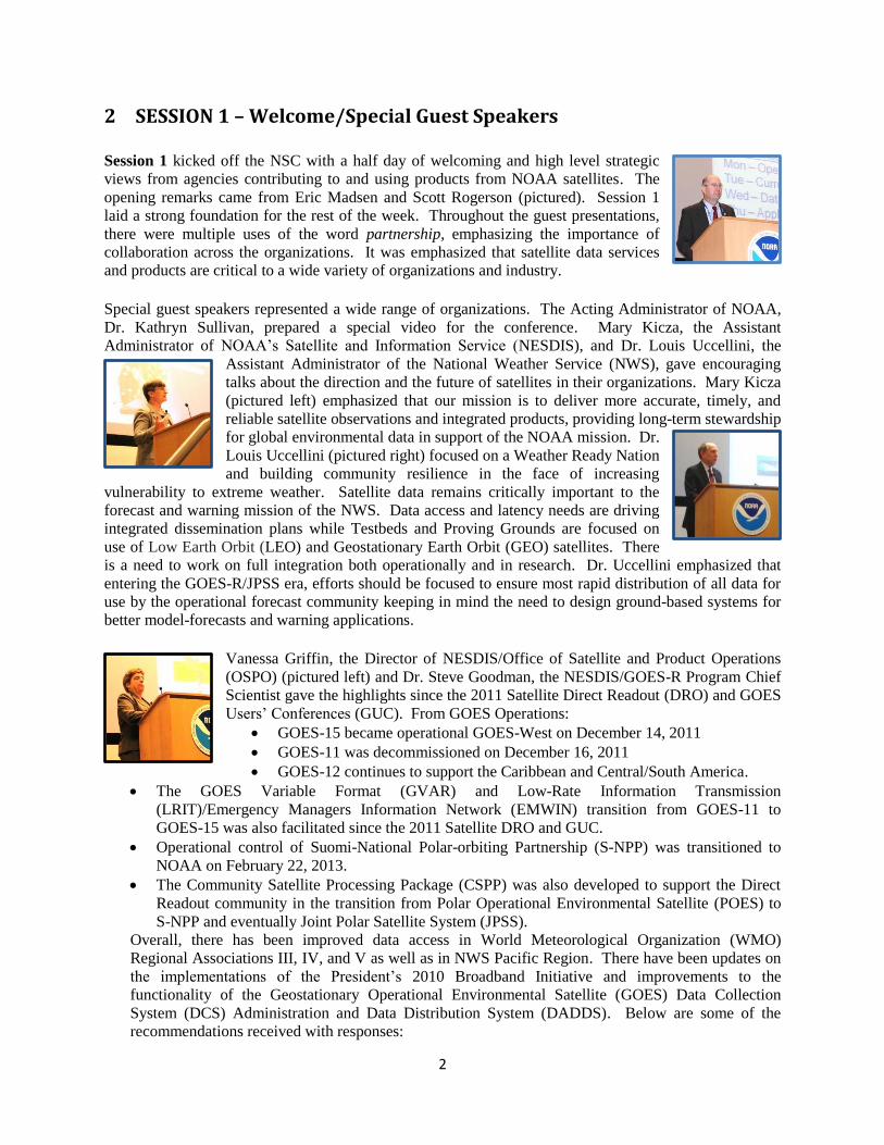
2 SESSION 1 – Welcome/Special Guest Speakers
Session 1 kicked off the NSC with a half day of welcoming and high level strategic
views from agencies contributing to and using products from NOAA satellites. The
opening remarks came from Eric Madsen and Scott Rogerson (pictured). Session 1
laid a strong foundation for the rest of the week. Throughout the guest presentations,
there were multiple uses of the word partnership, emphasizing the importance of
collaboration across the organizations. It was emphasized that satellite data services
and products are critical to a wide variety of organizations and industry.
Special guest speakers represented a wide range of organizations. The Acting Administrator of NOAA,
Dr. Kathryn Sullivan, prepared a special video for the conference. Mary Kicza, the Assistant
Administrator of NOAA’s Satellite and Information Service (NESDIS), and Dr. Louis Uccellini, the
Assistant Administrator of the National Weather Service (NWS), gave encouraging
talks about the direction and the future of satellites in their organizations. Mary Kicza
(pictured left) emphasized that our mission is to deliver more accurate, timely, and
reliable satellite observations and integrated products, providing long-term stewardship
for global environmental data in support of the NOAA mission. Dr.
Louis Uccellini (pictured right) focused on a Weather Ready Nation
and building community resilience in the face of increasing
vulnerability to extreme weather. Satellite data remains critically important to the
forecast and warning mission of the NWS. Data access and latency needs are driving
integrated dissemination plans while Testbeds and Proving Grounds are focused on
use of Low Earth Orbit (LEO) and Geostationary Earth Orbit (GEO) satellites. There
is a need to work on full integration both operationally and in research. Dr. Uccellini emphasized that
entering the GOES-R/JPSS era, efforts should be focused to ensure most rapid distribution of all data for
use by the operational forecast community keeping in mind the need to design ground-based systems for
better model-forecasts and warning applications.
Vanessa Griffin, the Director of NESDIS/Office of Satellite and Product Operations
(OSPO) (pictured left) and Dr. Steve Goodman, the NESDIS/GOES-R Program Chief
Scientist gave the highlights since the 2011 Satellite Direct Readout (DRO) and GOES
Users’ Conferences (GUC). From GOES Operations:
GOES-15 became operational GOES-West on December 14, 2011
GOES-11 was decommissioned on December 16, 2011
GOES-12 continues to support the Caribbean and Central/South America.
The GOES Variable Format (GVAR) and Low-Rate Information Transmission
(LRIT)/Emergency Managers Information Network (EMWIN) transition from GOES-11 to
GOES-15 was also facilitated since the 2011 Satellite DRO and GUC.
Operational control of Suomi-National Polar-orbiting Partnership (S-NPP) was transitioned to
NOAA on February 22, 2013.
The Community Satellite Processing Package (CSPP) was also developed to support the Direct
Readout community in the transition from Polar Operational Environmental Satellite (POES) to
S-NPP and eventually Joint Polar Satellite System (JPSS).
Overall, there has been improved data access in World Meteorological Organization (WMO)
Regional Associations III, IV, and V as well as in NWS Pacific Region. There have been updates on
the implementations of the President’s 2010 Broadband Initiative and improvements to the
functionality of the Geostationary Operational Environmental Satellite (GOES) Data Collection
System (DCS) Administration and Data Distribution System (DADDS). Below are some of the
recommendations received with responses:
3
I. Recommendation: Provide information on the transition from GVAR to GOES-R
Rebroadcast (GRB); L-Band spectrum change. When will the specs for the GRB be available
and where? Vendors need this so that they can build ingest equipment.
a. The specifications for the GRB were finalized at the Critical Design Review (CDR)
and are available in the Product User’s Guide (July 2012). (http://www.goes-
r.gov/users/grb.html)
II. Recommendation: The GOES-R Program is encouraged to identify resources and approaches
to train international users.
a. GOES-R supports funding of GOES-R Cooperative Program for Operational
Meteorology, Education and Training (COMET) modules and training through the
Virtual Institute for Satellite Integration Training (VISIT) Program. The link to
training resources can be found on GOES-R.gov under "User Information" and
"Training.”
III. Recommendation: Consider more Regional Association V (South-West Pacific) training in
satellite data interpretation and assimilation by the NOAA NWS Pacific Region.
a. The NOAA Satellite Proving Ground (PG) has become very active in Pacific Region
(Japan Meteorological Agency [JMA] bilateral for Advanced Himawari Imager
[AHI] access, recent installation of X-Band direct broadcast). NOAA recommends
users coordinate directly with the National Weather Service’s Pacific Region,
Satellite PG and International Affairs Offices.
IV. Recommendation: Make GOES-R test products available, GOES-R level 2 products for
research.
a. Several GOES-R level 2 products are demonstrated in the GOES-R Proving Ground.
Examples can be found on the PG blogs and through the website www.goes-r.gov.
V. Recommendation: Plan COMET monthly sessions with foreign users so the international
users can start asking questions and providing feedback. Develop outreach and more
information on how international users in various countries will be trained.
a. COMET has an active international training program funded through NOAA
International Affairs, Canada and the European Organisation for the Exploitation of
Meteorological Satellites (EUMETSAT). COMET's MetEd Online Website has over
265,000 users with over 90,000 international users. A summary of the 2012 COMET
Annual Program Plan is available on request.
VI. Recommendation: Regional forecasts and nowcasts necessary for a Weather Ready Nation
will have to make better use of the information content from Atmospheric Infrared Sounder
(AIRS), Cross-track Infrared Sounder (CrIS), and Infrared Atmospheric Sounding
Interferometer (IASI) data; Global Positioning System (GPS) data should also be included.
Between LEO sounding coverage, GOES-R data should be used to monitor temporal profile
(atmospheric stability, etc.) changes.
a. Numerical Weather Prediction (NWP) readiness for GOES-R should continue to be a
high priority activity.
The day wrapped up with special guest speaker Mikael Rattenborg, Director of Operations at
EUMETSAT, and a keynote address by David Grimes, President of the World Meteorological
Organization (WMO). Mikael Rattenborg addressed the topic of securing the low earth orbit system for
the future. The EUMETSAT Polar System (EPS) Second Generation (SG) Satellites’ primary mission is

4
to improve observational inputs to Numerical Weather Prediction models. He stated that Metop-B is
100% healthy and will become the prime satellite on April 24, 2013. The Metop-A/Metop-B operations
dual feasibility will be more robust against failures with opportunities for additional benefits to users.
The two satellites will run in the same orbital plane but due to the Earth’s rotation, the ground track and
instrument swaths will be different resulting in greater coverage. Due to the higher data rates, the
transmission through meteorological X-Band (7.75 – 7.90 GHz) has been selected for EPS-SG direct
broadcast.
David Grimes (pictured right) gave the keynote address on the WMO vision and
priorities. Some drivers behind the WMO priorities are: rising public and stakeholder
concerns, increasing temperature and precipitation extremes, and shifting
demographics. The past is no longer a trustworthy indicator of the future and new
paradigms are required to support adaptive decision-making. There is a growing sense
of urgency as natural variations compounded by global warming may yield
unprecedented extremes. Protecting society against extreme weather events in the
future requires predicting climate at regional and local scales. The WMO vision is one of world class
leadership, performance, and international cooperation. Some actions to achieve this vision are:
developing the capability of all members especially the least developed and most vulnerable; to share
weather, climate, water information and services world-wide; and fostering effective international and
interdisciplinary cooperation and partnerships. One of the strategic priorities for 2016 and beyond is
implementing the Global Framework for Climate Services (GFCS) offering an operational climate service
at global, regional, and national levels, accessible to all. The GFCS will place new demands for climate
based monitoring with respect to scale and scope as well as related satellite products in support of its
priorities on food and water availability, security, health, and disaster management. Mr. Grimes also
spoke to a space-based global observing system which is now essential to the world’s meteorological
enterprise and depends on contributions of its members.

5
3 SESSION 2 – Current and Future Programs and Systems
The first full day of the conference began with a weather brief by the Ocean Prediction Center (OPC) with
a focus on ocean prediction and relevant satellite data/product overview. Through numerous examples,
Joseph Sienkiewicz, Chief of the Ocean Applications Branch in OPC, demonstrated the value of satellite
products to OPC operations. Forecasters make use of all available scatterometers and four geostationary
satellites. The RGB (Red-Green-Blue) Airmass product has become a very important product in their
“tool box.” There were a few questions that followed the presentation. Kathy Ann Caesar asked if the
OPC puts out swell warnings for storms over the Atlantic, and what is the learning curve on the products
presented? Mr. Sienkiewicz replied, yes the OPC focuses on the waves associated with the storm and the
swell. He then responded to the “learning curve” question by stating that the RGB Airmass product for
example, does not have a steep learning curve and OPC is very impressed with the product. Another
participant asked which satellite systems were used to create the products, and where was the raw input?
The answer is a composite of four geostationary satellites, Metop-A/B scatterometer, OceanSat, OSCAT,
and OPC is just beginning to ingest imagery from S-NPP. OPC focuses on offshore convection and did
not show the Geostationary Lightning Mapper (GLM) but are anticipating it with a generated strike
density product using Jason-1/2, CryoSat, and French-1. Dr. Jack Beven asked if OPC is still using any
of the passive winds from SSMI, WindSat, etc. The response was that OPC is using passive remote
sensing for a variety of things but not for this purpose since the scatterometers are available.
Session 2, Current and Future Programs and Systems, began with a special
presentation by Dr. Wenjian Zhang, the Director of the WMO Space Programme
(pictured right) on the development of architecture for climate monitoring from space.
A GFCS will allow society to better manage risks from climate variability and change.
Climate services must be available; dependable; usable; and credible with the highest
priority application areas of agriculture, water, disaster risks, and health. After the
presentation, there were questions about methods to distribute the information and if
modern dissemination techniques such as cell phones or social media are being used. The answer was
yes. Fifty years ago the bottom up approach was being used and today the top down approach is being
used because the infrastructure is available.
Session 2.2, GOES/GOES-R, was moderated by the Program Chief Scientist, Dr.
Steve Goodman (pictured left), and the Ground Segment Project Scientist, Jim Gurka
(pictured right). Matthew Seybold, Satellite User Services Coordinator, opened the
topic session with an update on GOES current operations. He addressed the normal
and rapid scan schedules of GOES East and West, he reported that the GOES
constellation is remarkably healthy, and announced that GOES-12 is nearing the end of
its useful life for covering South America. The GOES-R update on current operations
was given by Rick Pickering (NASA) for Greg Mandt, the GOES-R System Program Director. He
described the progress of instrument and satellite development for GOES-R and announced that GOES-R
is still on schedule for an October 2015 launch. Tim Schmit, Cooperative Research
Program Advanced Satellite Products Branch Research Scientist, gave a presentation
on the Advanced Baseline Imager (ABI) on GOES-R. He said every existing product
from GOES-R will be better than those of today, plus many new products will be
available. He showed examples of proxy and synthetic ABI products and their
applications, including ABI scan scenarios, as well as a number of exciting examples
of 1-minute super rapid scan loops from GOES-14 which gave the audience a taste of
routine data that will be available from the ABI. Dr. Steve Goodman then closed the session with a
presentation about the GLM on GOES-R. He gave an overview of the expected GLM benefits providing
near continuous hemispheric coverage over land and ocean. He described research, applications, and
6
decision aids for severe storms and hurricanes being demonstrated with forecasters in the GOES-R
Proving Ground. There was then a discussion session for audience interaction.
Dr. Jack Beven asked about the Government Accountability Office (GAO) report and for a rundown on
how all of this has affected the GOES-R budget and launch date. Rick Pickering replied that maintaining
schedule is the main priority but there have been some delays. There have been some impacts but it is
unclear how those will play out and an October 2015 launch is still planned. Dr. Simon Keough asked
Dr. Goodman how he sees the future of the in situ based lightning mappers and how they can be best used
together with the GLM. Dr. Goodman replied that those systems improve all the time and the ground
based system has very high spatial accuracy. To get total lightning over the ocean, a satellite is needed.
Frank Alsheimer commented that his understanding is that when GOES-R is first launched it will be put
in the West position. He was wondering what Dr. Goodman had to say about the benefits to the areas that
are not directly underneath the ABI, such as the East Coast. Tim Schmit explained that is the current plan
because GOES-15 (current GOES-West) went into operations sooner. To get longer lead times in
numerical models, upstream data is needed and having GOES-R upstream will feed into the models and
allow eastward propagation. Dr. Goodman added that a decision will be made based on the health of the
constellation. Carven Scott asked Dr. Goodman if there are plans for a lightning mapper on the Canadian
Polar Communication and Weather mission satellite (PCW). Dr. Goodman replied that there is no plan
for any kind of lightning detection on the PCW. The GLM can sense up to 52 degrees and the use of
fused radar and satellite products, including lightning, can provide significant benefits.
Session 2.4, POES/JPSS, was moderated by Tom Schott, Satellite Product Manager,
and the Senior Program Scientist Dr. Mitch Goldberg. The first presentation was
given by Tom Schott on the Initial Joint Polar System. He briefed the status of the
POES program as part of the System IJPS with NOAA-19 as the primary satellite
flying in the early afternoon orbit. Next, an overview of JPSS was given by the
director, Harry Cikanek (pictured right). S-NPP has been operating successfully for
over a year, all JPSS-1 segments are on track to support a launch no later than the
second quarter of fiscal year 2017, and the JPSS Program System Definition Review is targeted for May
2013. Air Force Colonel Dan Edwards (pictured left) presented on the status of the Department of
Defense (DoD) environmental satellites. The National Polar-orbiting Environmental
Satellite System (NPOESS) was cancelled in February of 2010, The Defense Weather
Satellite System (DWSS) was cancelled in fiscal year 2012, and the Office of the
Secretary of Defense (OSD) directed the Air Force to perform analysis of defense
meteorological satellite requirements followed by an Analysis of Alternatives (AoA) to
determine how to replace the current Defense Meteorological Satellite Program
(DMSP). The current schedule is to complete an AoA Final Report in July 2013.
Dr. Goldberg (pictured right) then closed the session with a talk on S-NPP/JPSS
operational applications. The S-NPP instruments are performing exceptionally well
and JPSS is a major contributor to the global observing system. Sounding retrievals
provide quantitative interpretation of satellite imagery and 3D structure of storm
systems. Hyperspectral Infrared Sounders and Advanced Microwave Sounders are the
top two contributors for reducing forecast errors. The Cross Track Infrared Sounder
(CrIS) and Advanced Technology Microwave Sounder (ATMS) provide continuity of essential
atmospheric sounding information for weather forecasting. Dr. Jack Beven began the question and
answer session by stating that he is looking forward to using ATMS in terms of hurricane operations but
one disturbing thing is that there is not much enthusiasm about getting microwave imagers on these
satellites. It would be good to know the future of the microwave imager. Dr. Goldberg responded that
there is a partnership with the Japan Aerospace Exploration Agency (JAXA) and we are processing
AMSR-2 data through that and we are getting good results. Col. Edwards added that microwave imagery
7
is a key part of the AoA. Dr. Simon Keough said that he would like some confirmation that lessons
learned from this activity will be used in planning for the JPSS mission so there will be rapid transfer of
data worldwide. Dr. Goldberg responded that the dissemination is pretty good in terms of direct
broadcast. The ATMS feed to National Centers for Environmental Prediction (NCEP) was getting to the
systems the month after launch and took about seven months after launch to become operational. Dr.
Keough continued that in referring to the sounding data with respect to ATMS and CrIS, the United
Kingdon Meteorological Agency (UKMet) office assumed that they would be receiving real-time data.
Dr. Goldberg reminded that MetOp-A was launched in November but data was not available until the
following June unless there was access to the experimental feed. Tom Schott added that as part of the
NPOESS Data Exploitation (NDE) project and working with EUMETSAT for 5 years on strategy to
provide infrared (IR) and sounding data to EUMETSAT, there are a lot of challenges with NDE such as
upgrading communications links at the NOAA Satellite Operations Facility (NSOF) and at EUMETSAT
headquarters in Germany. Hopes are that communication upgrades will be completed in the fall and data
feeds to Europe will improve in the next eight months. Once JPSS-1 launches, data feeds from that
satellite will flow to Europe much faster than they did from NPP.
Session 2.5, Direct Readout, was moderated by Marlin Perkins (pictured left), Direct
Readout Program Manager, and the Rebroadcast Services Program Manager Paul
Seymour (pictured right). Marlin Perkins began the session with a presentation on the
POES to JPSS transition. Automated Picture Transmission (APT) and High
Resolution Picture Transmission (HRPT) service will be available until the end-of-life
of POES spacecraft and High Rate Data (HRD) service will be continuous through S-
NPP and JPSS-1 and 2. Steve Ambrose then spoke to the GOES to GOES-R
Transition. The transition includes data from six GOES-R instruments including 16
ABI channels requiring a new antenna, receiver hardware, and processing system to
handle the new data volumes. Kay Metcalf, GOES DCS Program Manager, gave a
presentation on the GOES DCS Transition. No uplink frequencies will change from
the GOES-N to the GOES-R satellites, only the downlinks. All other transitions are
transmitter and ground system based. This session provided information to transition
from POES to JPSS including cost estimates for the receive terminals; the characteristics of the GRB
downlink, antenna sizes, data rate and polarization; updates on the development of the High-Rate
Information Transmission (HRIT)/EMWIN system; and improvements in the GOES DCS system for
GOES-R.
Dave Cawley from the Remote Imaging Group (RIG) (pictured right) finished with a
presentation on the RIG which is a group of private individual users of satellites. The
group of approximately 1,600 members is indefinitely closing their doors after almost
30 years because there are no longer easily reproducible and/or low cost designs for
direct reception of geostationary imagery. Dave thanked NOAA for its services to the
private individual user and for the 45 years of direct reception that was given. There
were a few minutes left for comments. Dr. Jack Beven asked Kay Metcalf (pictured
left) about redundancy for the satellite itself in regards to DCS data. She responded that there are dual
transponders on all the satellites and if one fails, there will be a switch to the other.
GOES-R has a 3:2:2 ratios for DCS and HRIT/EMWIN (meaning there is one backup
transponder shared between the three services and 2 transponders, and if one fails then
it would get the backup transponder, so it has a built-in redundancy. Marlin Perkins
was asked about the lifetime expectancy of the current POES system, to which he
responded that they usually last about 10 years, so the current system will probably last
through 2019-2021.

8
Session 2.6 was a panel (pictured left) on frequency matters moderated by
Mark Mulholland, Senior Advisor/Program Executive for GOES-R. The
panel included Beau Backus from Aerospace Corporation, Karen Dubey from
SeaSpace, and Dave Lubar from Raytheon. The panel began with a short
presentation on NOAA’s L-Band environment followed by the discussion and
comments that are provided below.
What ideas do you see to help users outside of protection zones help themselves? Any things you
have seen in your experience, e.g., sharing other bands, etc.?
Beau: Having a good understanding of the electromagnetic (EM) environment around
you is necessary with mitigation so you know what you are trying to protect yourself
from and what you are trying to gain. Maximize direction to satellite and block the path
that would lead to the cellular telephone towers. It is not perfect but is one of the factors.
I suggest we share ideas.
David: The point that Mark made of a larger antenna will help you slightly but has a
narrow beam width, it’s not an ideal situation but as Beau said there are some things that
you can do. Every half millisecond there will be 9 cell phones at every tower. You are
dealing with these cell phones and tablets.
Karen: Some of our customers do use L-Band but we will not be mitigating and it is not
feasible for us to do so. Our company is still speaking out against the mitigations.
When people transition to X-Band there are some issues. We have dealt with that with S-NPP.
Please discuss particular issues with X-Band and how to mitigate those.
David: In the international arena, one of the agenda items was proposed by the French to
uplink from the maritime mobile network. We do not know what they are trying to do
but are assuming that if they are trying to uplink from a maritime ship etc., coastal users
could be impacted. Talk to your spectrum regulator.
Beau: I think it is very important to understand that we are fighting for resources. We are
in a continuous push for resources, there is a lot of industry and technology that depends
on spectrum and we need to be able to push for and protect that resource that we depend
on. We have to be vigilant to encourage this generation of users to work together as a
communicative group and know what we need to protect.
David: There was a great deal of pushback when we started this working group. The
pressure was enormous to shrink these zones down. The thing we need to figure out as
spectrum people is who needs the data. Look at it in a simple manner, if you have a
critical function, you need to figure out and let us know if there is any other way you can
receive the data and if not, you need to voice that before the auction. It is really
important that the users need to speak up. There is another element where someone is
affected when they have no idea that they will be impacted. The way spectrum is
managed has changed dramatically in the past year and a half and you need to be aware.
Silence in this environment means agreement.
Is there opportunity to get a win-win out of this? Can we either use other satellite or cell towers to
expand as we go along?
David: An interesting idea. Laws of EM say satellites are limited in power. They
routinely interfere with some ground systems. We will look at anything and any
solutions. It’s not practical to use cell towers. If you are interested in this topic, fill-out
9
sheets being passed around. We’d like to approach university partners and perhaps set up
a website.
Beau: Innovative ideas are worth exploring in a number of different ways. The
broadband folks moving into this band are proposing innovative ideas where we might be
able to coordinate with them. Our cell phones are multi-band devices. Innovative ideas
are encouraged and worth exploring.
Session 2.7, User Feedback Session 1, was moderated by Gary McWilliams, Outreach
Liaison of JPSS, and John Furgerson, User Liaison of JPSS (pictured right). There
were two talks in this session given by Liam Gumley, manager of the EOS direct
broadcast reception facility at the Space Science and Engineering Center, on the CSPP
and by Dr. Steven Miller, Deputy Director of the Cooperative Institute for Research in
the Atmosphere, on the Visible Infrared Imaging Radiometer Suite (VIIRS) Day-Night
Band (DNB). CSPP is a software system for processing direct broadcast data from
polar-orbiting meteorological satellites, supporting S-NPP/JPSS, POES, Metop, Terra, and Aqua,
developed and supported by Cooperative Institute for Meteorological Satellite Studies (CIMSS)/Space
Science and Engineering Center (SSEC) at the University of Wisconsin-Madison. The presentation
included information on updates to VIIRS Sensor Data Record (SDR) Multi-processing, CrIS full spectral
resolution, VIIRS Environmental Data Record (EDR) additions, CrIS, IASI, and AIRS retrievals, Clouds
from Advanced Very High Resolution Radiometer (AVHRR) Extended (CLAVR-X), and VIIRS
Projected Imagery. Dr. Miller finished the session with his presentation highlighting the VIIRS/DNB
where the moon can act as a surrogate to the sun. Since the amount of moonlight on any given night is
variable, the Lunar Reflectance Model was written. Other features such as the Aurora and “nightglow”
also illuminate features such as snow cover and sea ice. In summary, VIIRS/DNB offers significant
advances to legacy technology, and new research and operational applications abound. There was then a
discussion for audience interaction to finish Day 2 in which many questions revolved around merging
GEO and polar products. The CSPP may be a good platform for this. The CSPP currently serves polar
satellites, but is available for geostationary data and in the coming years, hopes to ingest Chinese and
Russian polar data (the main limit is funding). A full listing of the User Feedback Session 1 discussion
can be found in Appendix E.
10
4 SESSION 3 – Data Access and Use
Session 3, Data Access and Use, began with a weather brief by NOAA’s Climate
Prediction Center giving a climate prediction and satellite data/product overview. The
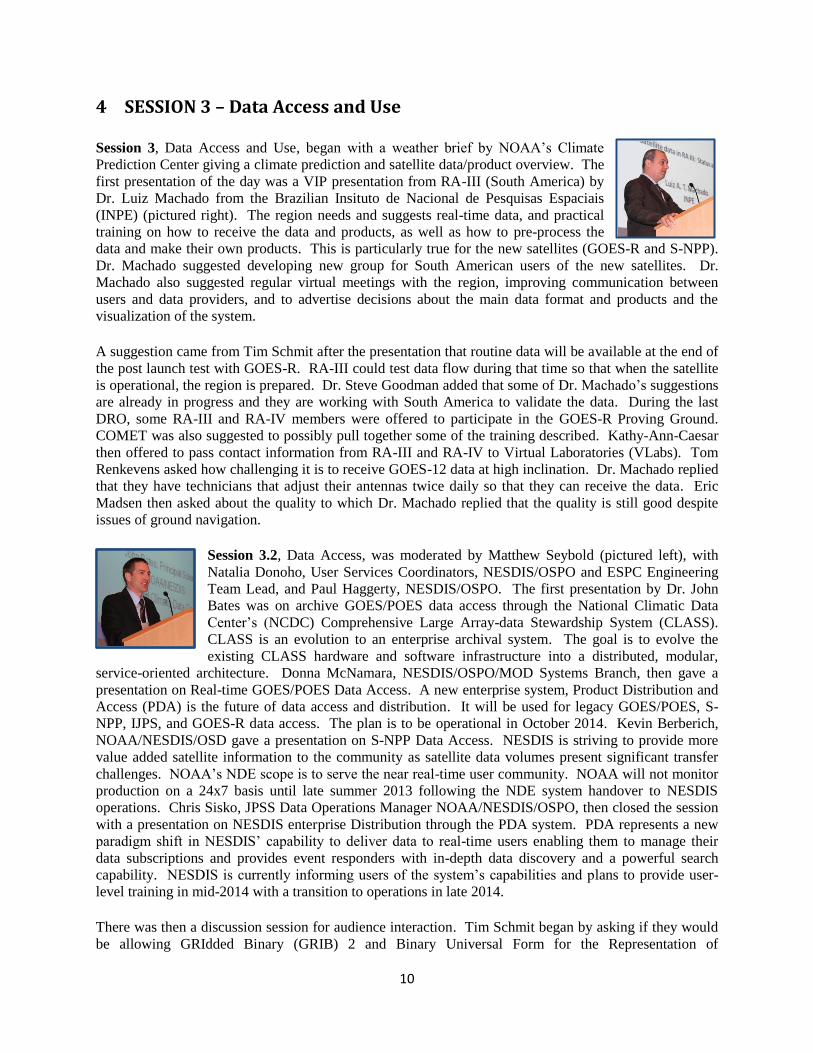
first presentation of the day was a VIP presentation from RA-III (South America) by
Dr. Luiz Machado from the Brazilian Insituto de Nacional de Pesquisas Espaciais
(INPE) (pictured right). The region needs and suggests real-time data, and practical
training on how to receive the data and products, as well as how to pre-process the
data and make their own products. This is particularly true for the new satellites (GOES-R and S-NPP).
Dr. Machado suggested developing new group for South American users of the new satellites. Dr.
Machado also suggested regular virtual meetings with the region, improving communication between
users and data providers, and to advertise decisions about the main data format and products and the
visualization of the system.
A suggestion came from Tim Schmit after the presentation that routine data will be available at the end of
the post launch test with GOES-R. RA-III could test data flow during that time so that when the satellite
is operational, the region is prepared. Dr. Steve Goodman added that some of Dr. Machado’s suggestions
are already in progress and they are working with South America to validate the data. During the last
DRO, some RA-III and RA-IV members were offered to participate in the GOES-R Proving Ground.
COMET was also suggested to possibly pull together some of the training described. Kathy-Ann-Caesar
then offered to pass contact information from RA-III and RA-IV to Virtual Laboratories (VLabs). Tom
Renkevens asked how challenging it is to receive GOES-12 data at high inclination. Dr. Machado replied
that they have technicians that adjust their antennas twice daily so that they can receive the data. Eric
Madsen then asked about the quality to which Dr. Machado replied that the quality is still good despite
issues of ground navigation.
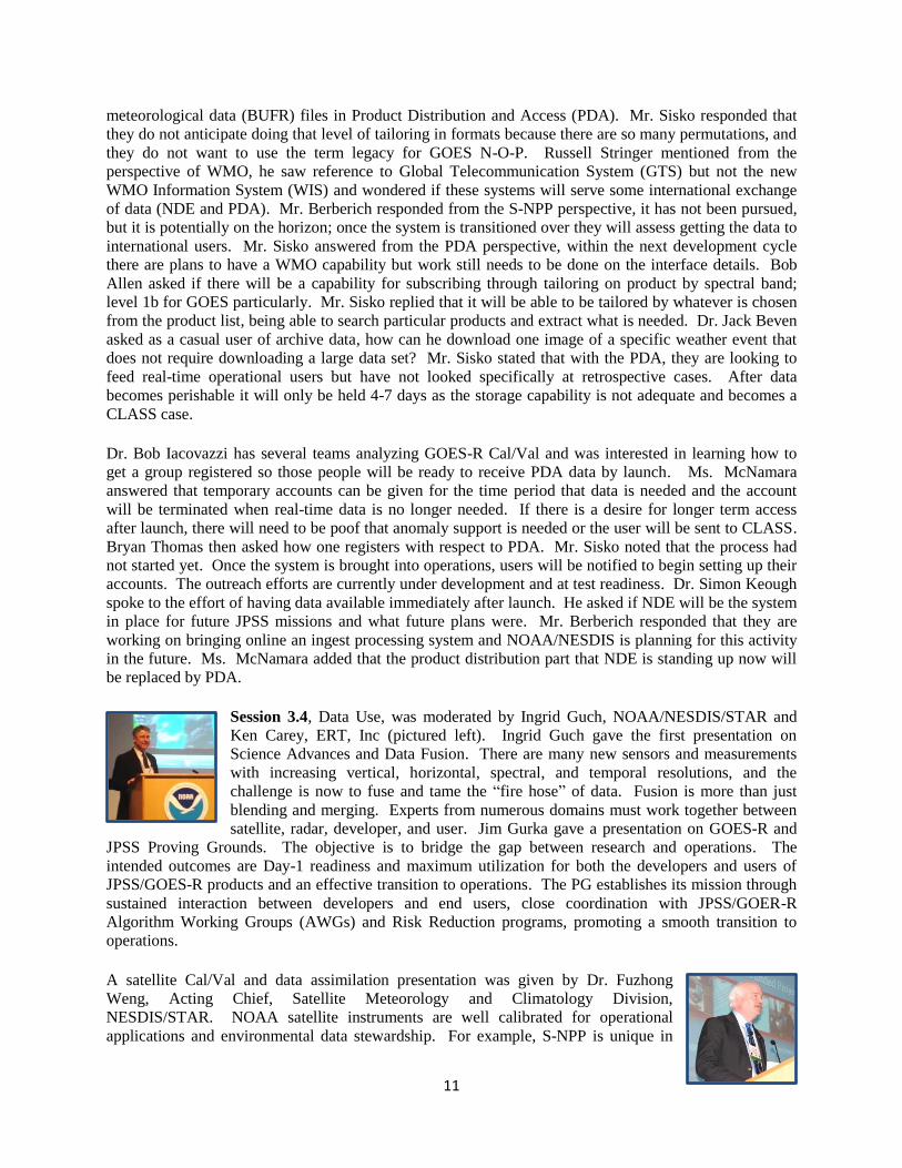
Session 3.2, Data Access, was moderated by Matthew Seybold (pictured left), with
Natalia Donoho, User Services Coordinators, NESDIS/OSPO and ESPC Engineering
Team Lead, and Paul Haggerty, NESDIS/OSPO. The first presentation by Dr. John
Bates was on archive GOES/POES data access through the National Climatic Data
Center’s (NCDC) Comprehensive Large Array-data Stewardship System (CLASS).
CLASS is an evolution to an enterprise archival system. The goal is to evolve the
existing CLASS hardware and software infrastructure into a distributed, modular,
service-oriented architecture. Donna McNamara, NESDIS/OSPO/MOD Systems Branch, then gave a
presentation on Real-time GOES/POES Data Access. A new enterprise system, Product Distribution and
Access (PDA) is the future of data access and distribution. It will be used for legacy GOES/POES, S-
NPP, IJPS, and GOES-R data access. The plan is to be operational in October 2014. Kevin Berberich,
NOAA/NESDIS/OSD gave a presentation on S-NPP Data Access. NESDIS is striving to provide more
value added satellite information to the community as satellite data volumes present significant transfer
challenges. NOAA’s NDE scope is to serve the near real-time user community. NOAA will not monitor
production on a 24x7 basis until late summer 2013 following the NDE system handover to NESDIS
operations. Chris Sisko, JPSS Data Operations Manager NOAA/NESDIS/OSPO, then closed the session
with a presentation on NESDIS enterprise Distribution through the PDA system. PDA represents a new
paradigm shift in NESDIS’ capability to deliver data to real-time users enabling them to manage their
data subscriptions and provides event responders with in-depth data discovery and a powerful search
capability. NESDIS is currently informing users of the system’s capabilities and plans to provide user-
level training in mid-2014 with a transition to operations in late 2014.
There was then a discussion session for audience interaction. Tim Schmit began by asking if they would
be allowing GRIdded Binary (GRIB) 2 and Binary Universal Form for the Representation of
11
meteorological data (BUFR) files in Product Distribution and Access (PDA). Mr. Sisko responded that
they do not anticipate doing that level of tailoring in formats because there are so many permutations, and
they do not want to use the term legacy for GOES N-O-P. Russell Stringer mentioned from the
perspective of WMO, he saw reference to Global Telecommunication System (GTS) but not the new
WMO Information System (WIS) and wondered if these systems will serve some international exchange
of data (NDE and PDA). Mr. Berberich responded from the S-NPP perspective, it has not been pursued,
but it is potentially on the horizon; once the system is transitioned over they will assess getting the data to
international users. Mr. Sisko answered from the PDA perspective, within the next development cycle
there are plans to have a WMO capability but work still needs to be done on the interface details. Bob
Allen asked if there will be a capability for subscribing through tailoring on product by spectral band;
level 1b for GOES particularly. Mr. Sisko replied that it will be able to be tailored by whatever is chosen
from the product list, being able to search particular products and extract what is needed. Dr. Jack Beven
asked as a casual user of archive data, how can he download one image of a specific weather event that
does not require downloading a large data set? Mr. Sisko stated that with the PDA, they are looking to
feed real-time operational users but have not looked specifically at retrospective cases. After data
becomes perishable it will only be held 4-7 days as the storage capability is not adequate and becomes a
CLASS case.
Dr. Bob Iacovazzi has several teams analyzing GOES-R Cal/Val and was interested in learning how to
get a group registered so those people will be ready to receive PDA data by launch. Ms. McNamara
answered that temporary accounts can be given for the time period that data is needed and the account
will be terminated when real-time data is no longer needed. If there is a desire for longer term access
after launch, there will need to be poof that anomaly support is needed or the user will be sent to CLASS.
Bryan Thomas then asked how one registers with respect to PDA. Mr. Sisko noted that the process had
not started yet. Once the system is brought into operations, users will be notified to begin setting up their
accounts. The outreach efforts are currently under development and at test readiness. Dr. Simon Keough
spoke to the effort of having data available immediately after launch. He asked if NDE will be the system
in place for future JPSS missions and what future plans were. Mr. Berberich responded that they are
working on bringing online an ingest processing system and NOAA/NESDIS is planning for this activity
in the future. Ms. McNamara added that the product distribution part that NDE is standing up now will
be replaced by PDA.
Session 3.4, Data Use, was moderated by Ingrid Guch, NOAA/NESDIS/STAR and
Ken Carey, ERT, Inc (pictured left). Ingrid Guch gave the first presentation on
Science Advances and Data Fusion. There are many new sensors and measurements
with increasing vertical, horizontal, spectral, and temporal resolutions, and the
challenge is now to fuse and tame the “fire hose” of data. Fusion is more than just
blending and merging. Experts from numerous domains must work together between
satellite, radar, developer, and user. Jim Gurka gave a presentation on GOES-R and
JPSS Proving Grounds. The objective is to bridge the gap between research and operations. The
intended outcomes are Day-1 readiness and maximum utilization for both the developers and users of
JPSS/GOES-R products and an effective transition to operations. The PG establishes its mission through
sustained interaction between developers and end users, close coordination with JPSS/GOER-R
Algorithm Working Groups (AWGs) and Risk Reduction programs, promoting a smooth transition to
operations.
A satellite Cal/Val and data assimilation presentation was given by Dr. Fuzhong
Weng, Acting Chief, Satellite Meteorology and Climatology Division,
NESDIS/STAR. NOAA satellite instruments are well calibrated for operational
applications and environmental data stewardship. For example, S-NPP is unique in
12
resolving hurricane warm core features through its high spatial oversampling and additional channels.
Dave Jones, President/CEO, StormCenter Communications, Inc. (pictured right), gave a presentation on
Collaborative Decision Making: Enhancing Situational Awareness with Satellite Data Use in Real-Time
to Improve Readiness, Response, and Recovery. StormCenter uses real-time data sharing and
collaboration, not screen sharing. It helps to facilitate collaboration since several users can be in the same
collaboration session (virtually). It helps to connect NWS forecasters to emergency managers, etc.
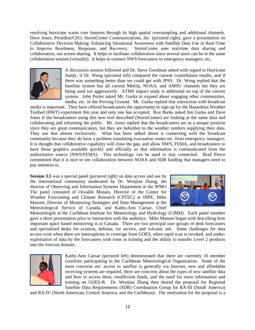
A discussion session followed and Dr. Steve Goodman asked with regard to Hurricane
Sandy, if Dr. Weng (pictured left) compared the current constellation results, and if
there was something better than we could get with JPSS. Dr. Weng replied that the
baseline system has all current MetOp, NOAA, and AMSU channels but they are
being used too aggressively. ATMS impact study is additional on top of the current
system. John Porter asked Mr. Gurka to expand about engaging other communities,
media, etc. in the Proving Ground. Mr. Gurka replied that interaction with broadcast
media is important. They have offered broadcasters the opportunity to sign up for the Hazardous Weather
Testbed (HWT) experiment this year and only one has accepted. Ron Burke asked Jim Gurka and Dave
Jones if the broadcasters using this new tool described (StormCenter) are looking at the same data and
collaborating and informing the public. Mr. Jones replied that the broadcasters are in a unique position
since they are great communicators, but they are beholden to the weather vendors supplying their data.
They use that almost exclusively. What has been talked about is connecting with the broadcast
community because they do have a problem translating evacuation routes etc. from emergency managers.
It is thought that collaborative capability will close the gap, and allow NWS, FEMA, and broadcasters to
have those graphics available quickly and officially so that information is communicated from the
authoritative source (NWS/FEMA). This technology can be used to stay connected. Brad Pierce
commented that it is nice to see collaboration between NOAA and SDR funding that managers need to
pay attention to.
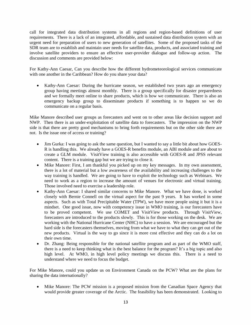
Session 3.5 was a special panel (pictured right) on data access and use by
the international community moderated by Dr. Wenjian Zhang, the
director of Observing and Information Systems Department at the WMO
The panel consisted of Osvaldo Moraes, Director of the Center for
Weather Forecasting and Climate Research (CPTEC) at INPE, Mike
Manore, Director of Monitoring Strategies and Data Management at the
Meteorological Service of Canada, and Kathy-Ann Caesar, Chief
Meteorologist at the Caribbean Institute for Meteorology and Hydrology (CIMH). Each panel member
gave a short presentation prior to interaction with the audience. Mike Manore began with describing how
important space based monitoring is to Canada. There are two principal user groups of desk forecasters
and specialized desks for aviation, defense, ice service, and volcanic ash. Some challenges for data
access exist when there are interruptions in coverage from GOES, when rapid scan is invoked, and under-
exploitation of data by the forecasters with roots in training and the ability to transfer Level 2 products
into the forecast domain.
Kathy-Ann Caesar (pictured left) demonstrated that there are currently 16 member
countries participating in the Caribbean Meteorological Organization. Some of the
main concerns are: access to satellite is generally via Internet, new and affordable
receiving systems are required, there are concerns about the types of new satellite data
and how to access them, insufficient funds, and the need for more information and
training on GOES-R. Dr. Wenjian Zhang then shared the proposal for Regional
Satellite Data Requirements (SDR) Coordination Group for RA-III (South America)
and RA-IV (North American, Central America, and the Caribbean). The motivation for the proposal is a
13
call for integrated data distribution systems in all regions and region-based definitions of user
requirements. There is a lack of an integrated, affordable, and sustained data distribution system with an
urgent need for preparation of users to new generation of satellites. Some of the proposed tasks of the
SDR team are to establish and maintain user needs for satellite data, products, and associated training and
involve satellite providers to ensure an effective user-provider dialogue and follow-up action. The
discussion and comments are provided below:
For Kathy-Ann Caesar, Can you describe how the different hydrometeorological services communicate
with one another in the Caribbean? How do you share your data?
Kathy-Ann Caesar: During the hurricane season, we established two years ago an emergency
group having meetings almost monthly. There is a group specifically for disaster preparedness
and we formally meet online to share products, which is how we communicate. There is also an
emergency backup group to disseminate products if something is to happen so we do
communicate on a regular basis.
Mike Manore described user groups as forecasters and went on to other areas like decision support and
NWP. Then there is an under-exploitation of satellite data to forecasters. The impression on the NWP
side is that there are pretty good mechanisms to bring forth requirements but on the other side there are
not. Is the issue one of access or training?
Jim Gurka: I was going to ask the same question, but I wanted to say a little bit about how GOES-
R is handling this. We already have a GOES-R benefits module, an ABI module and are about to
create a GLM module. VisitView training is also accessible with GOES-R and JPSS relevant
content. There is a training gap but we are trying to close it.
Mike Manore: First, I am thankful you picked up on my key messages. In my own assessment,
there is a lot of material but a low awareness of the availability and increasing challenges to the
way training is handled. We are going to have to exploit the technology such as Webinars. We
need to work as a region to increase the amount of venues for electronic and virtual training.
Those involved need to exercise a leadership role.
Kathy-Ann Caesar: I shared similar concerns to Mike Manore. What we have done, is worked
closely with Bernie Connell on the virtual aspect for the past 9 years. It has worked in some
aspects. Such as with Total Precipitable Water (TPW), we have more people using it but it is a
mindset. One good issue, now with competency issue in WMO training, is our forecasters have
to be proved competent. We use COMET and VisitView products. Through VisitView,
forecasters are introduced to the products slowly. This is for those working on the desk. We are
working with the National Hurricane Center (NHC) to have a session. We are encouraged but the
hard side is the forecasters themselves, moving from what we have to what they can get out of the
new products. Virtual is the way to go since it is more cost effective and they can do a lot on
their own time.
Dr. Zhang: Being responsible for the national satellite program and as part of the WMO staff,
there is a need to keep thinking what is the best balance for the program? It’s a big topic and also
high level. At WMO, in high level policy meetings we discuss this. There is a need to
understand where we need to focus the budget.
For Mike Manore, could you update us on Environment Canada on the PCW? What are the plans for
sharing the data internationally?
Mike Manore: The PCW mission is a proposed mission from the Canadian Space Agency that
would provide greater coverage of the Arctic. The feasibility has been demonstrated. Looking to
14
close the business case and make a proposal to the government in the year; proposed mission
launched in 2019-2020 time-frame.
For Kathy-Ann Caesar, there is always an issue of “well we can get it through the Internet,” for Caribbean
Islands. Why would you want direct readout or what about the benefits of using the Internet?
Kathy-Ann Caesar: Initially, it’s going to be cost effective. There is a growing dependency on
the Internet through the islands. It is easier to get info over the Internet. But when you have a
tropical storm, everything fails. A direct link might be an issue. When we get GEONETCAST
that might be way too much. When forecasters are aware of the good work being done and how
we can meet NOAA half way with products and what’s effective, we can do things more cost
effectively but need to communicate. We can’t be comfortable with what we have because there
are better products out there.
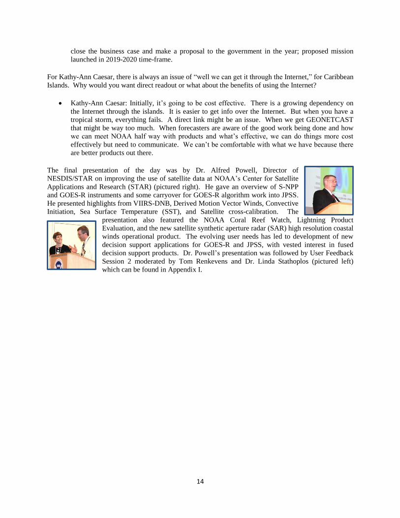
The final presentation of the day was by Dr. Alfred Powell, Director of
NESDIS/STAR on improving the use of satellite data at NOAA’s Center for Satellite
Applications and Research (STAR) (pictured right). He gave an overview of S-NPP
and GOES-R instruments and some carryover for GOES-R algorithm work into JPSS.
He presented highlights from VIIRS-DNB, Derived Motion Vector Winds, Convective
Initiation, Sea Surface Temperature (SST), and Satellite cross-calibration. The
presentation also featured the NOAA Coral Reef Watch, Lightning Product
Evaluation, and the new satellite synthetic aperture radar (SAR) high resolution coastal
winds operational product. The evolving user needs has led to development of new
decision support applications for GOES-R and JPSS, with vested interest in fused
decision support products. Dr. Powell’s presentation was followed by User Feedback
Session 2 moderated by Tom Renkevens and Dr. Linda Stathoplos (pictured left)
which can be found in Appendix I.
15
5 SESSION 4 – Applications
Day 4 began with a weather brief by NOAA’s Weather Prediction Center (WPC) with a presentation on
weather prediction and satellite data/product overview. Session 4 opened with a presentation by Dr.
James Yoe, Chief Administrative Officer of NWS/NCEP, on Leveraging Satellite Data at NOAA’s
National Centers for Environmental Prediction. NCEP relies on satellite data to support all of its
operational environmental predictions. As this continues and expands, NCEP will exploit the advanced
capabilities of future satellite sensors and data to help support a Weather Ready Nation using an
integrated approach, emphasizing high-impact services, and leveraging Testbeds and Proving Grounds.
Following Dr. Yoe’s presentation there were a few questions. Frank Alsheimer asked, “Looking forward,
what is the future of producing simulated radiances from models?” Dr. Yoe’s response was that it is a
trivial exercise, using current radiative transfer models. The question will be whether to use it for
distribution or not. Another question asked by an audience member was, “By observation type, what
percent is satellite?” Dr. Yoe replied that a breakdown has never been done and care should be taken
because it could be potentially misleading. The last question by an audience member asked, “Do new
computing powers catch up with all the new satellite information coming in, and is resolution added for
model improvement?” Dr. Yoe responded, “Hopefully, yes.” He showed a model improvement chart that
highlighted the end of the first phase of the current upgrade which is the computer and modeling system
together and a goal to close the gap by the end of 2018.
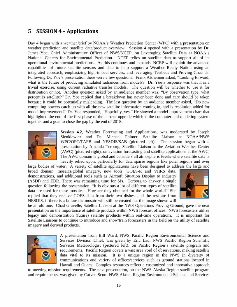
Session 4.2, Weather Forecasting and Applications, was moderated by Joseph
Sienkiewicz and Dr. Michael Folmer, Satellite Liaison at NOAA/NWS
WPC/OPC/TAFB and NESDIS/SAB (pictured left). The session began with a
presentation by Amanda Terborg, Satellite Liaison at the Aviation Weather Center
(AWC) (pictured right), on aviation forecasting and satellite applications at the AWC.
The AWC domain is global and considers all atmospheric levels where satellite data is
heavily relied upon, particularly for data sparse regions like polar regions and over
large bodies of water. A variety of satellite applications have been designed to address the large and
broad domain: mosaics/global imagery, new tools, GOES-R and VIIRS data,
demonstrations, and additional tools such as Aircraft Situation Display to Industry
(ASDI) and EDR. There was remaining time for Ms. Terborg to answer a single
question following the presentation, “It is obvious a lot of different types of satellite
data are used for these mosaics. How are they obtained for the whole world?” She
replied that they receive GOES data from their two dishes, and the rest are from
NESDIS, if there is a failure the mosaic will still be created but the image shown will
be an old one. Chad Gravelle, Satellite Liaison at the NWS Operations Proving Ground, gave the next
presentation on the importance of satellite products within NWS forecast offices. NWS forecasters utilize
legacy and demonstration (future) satellite products within real-time operations. It is important for
Satellite Liaisons to continue to introduce and show/train forecasters in the field on the utility of satellite
imagery and derived products.
A presentation from Bill Ward, NWS Pacific Region Environmental Science and
Services Division Chief, was given by Eric Lau, NWS Pacific Region Scientific
Services Meteorologist (pictured left), on Pacific Region’s satellite program and
requirements. Pacific Region covers a vast area void of observations, making satellite
data vital to its mission. It is a unique region in the NWS in diversity of
communications and variety of offices/services such as ground stations located in
Hawaii and Guam. Complex resources reflect a customized and innovative approach
to meeting mission requirements. The next presentation, on the NWS Alaska Region satellite program
and requirements, was given by Carven Scott, NWS Alaska Region Environmental Science and Services
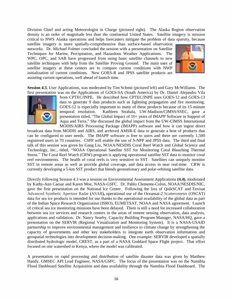
16
Division Chief and acting Meteorologist in Charge (pictured right). The Alaska Region observation
density is an order of magnitude less than the continental United States. Satellite imagery is mission
critical to NWS Alaska operations and helps forecasters mitigate the problem of data sparsity, because
satellite imagery is more spatially-comprehensive than surface-based observation
networks. Dr. Michael Folmer concluded the session with a presentation on Satellite
Techniques for Marine, Precipitation, and Hazardous Weather Applications. The
WPC, OPC, and SAB have progressed from using basic satellite channels to new
satellite techniques with help from the Satellite Proving Ground. The main uses of
satellite imagery at these centers are to compare current conditions with NWP
initialization of current conditions. New GOES-R and JPSS satellite products are
assisting current operations, well ahead of launch time.
Session 4.3, User Applications, was moderated by Tim Schmit (pictured left) and Gary McWilliams. The
first presentation was on the Applications of GOES-SA (South America) by Dr. Daniel Alejandro Vila
from CPTEC/INPE. He described how CPTEC/INPE uses GOES-12 and GOES-13
data to generate 9 data products such as lightning propagation and fire monitoring.
GOES-12 is especially important to many of these products because of its 15-minute
temporal resolution. Kathleen Strabala, UW-Madison/CIMSS/SSEC, gave a
presentation titled, “The Global Impact of 10+ years of IMAPP Software in Support of
Aqua and Terra.” She discussed the global impact from the UW-CIMSS International
MODIS/AIRS Processing Package (IMAPP) software and how it can ingest direct
broadcast data from MODIS and AIRS, and archived AMSR-E data to generate a host of products that
can be configured to user needs. The IMAPP software is free to users and there are currently 1,500
registered users in 70 countries. CSPP will enable the use of S-NPP and JPSS data. The third and final
talk of this session was given by Gang Liu, NOAA/NESDIS Coral Reef Watch and Global Science and
Technology, Inc., titled, “NOAA Operational Satellite SST for Monitoring Coral Bleaching Thermal
Stress.” The Coral Reef Watch (CRW) program is applying operational satellite SST data to monitor coral
reef environments. The health of coral reefs is very sensitive to SST. Satellites can uniquely monitor
SST in remote areas as well as provide global coverage, and data access in near real-time. CRW is
currently developing a 5-km SST product that blends geostationary and polar-orbiting satellite data.
Directly following Session 4.3 was a session on Environmental Assessment Applications (4.4), moderated
by Kathy-Ann Caesar and Karen Moe, NASA-GSFC. Dr. Pablo Clemente-Colon, NOAA/NESDIS/NIC,
gave the first presentation on the National Ice Center. Following the loss of QuikSCAT and Envisat
Advanced Synthetic Aperture Radar (ASAR), operational use of the Oceansat-2 Scatterometer (OSCAT)
data for sea ice products is intended for use thanks to the operational availability of the global data as part
of the Indian Space Research Organization (ISRO), EUMETSAT, NOAA and NASA agreement. Launch
of critical sea ice monitoring missions have been delayed. There is still a need for increased collaboration
between sea ice services and research centers in the areas of remote sensing observation, data analysis,
applications and validation. Dr. Nancy Searby, Capacity Building Program Manager, NASA/HQ, gave a
presentation on the SERVIR (Regional Visualization and Monitoring System). It is a NASA-USAID
partnership to improve environmental management and resilience to climate change by strengthening the
capacity of governments and other key stakeholders to integrate earth observation information and
geospatial technologies into development decision-making. One example: SERVIR developed a spatially
distributed hydrologic model, CREST, as a part of a NASA Goddard Space Flight project. That effort
focused on one watershed in Kenya, where the model was calibrated.
A presentation on rapid processing and distribution of satellite disaster data was given by Matthew
Handy, GMSEC API Lead Engineer, NASA/GSFC. The focus of the presentation was on the Namibia
Flood Dashboard Satellite Acquisition and data availability through the Namibia Flood Dashboard. The
17
problem is severe flooding in Namibia (south-western Africa) and existing flood warning models are not
very precise. Advance warning could reduce loss of life and property damage. In this case and globally,
dashboards for Sensor Webs can allow flexibility and rapid integration. Cloud technology allows huge
datasets, rapid processing, and improved reliability. Sensor Webs will also continue to improve satellite
tasking with global benefit for many remote sensing applications. The last presentation in this session
was given by Dick Werle, Partner/Associate, AERDE Environmental Research, titled “Practical
Experience with RADARSAT-2 Regarding Rapid and Detailed SAR Data Collection for the Caribbean
Satellite Disaster Pilot during the 2010-2012 Atlantic Hurricane Seasons.” Pre-emptive planning is
essential for collecting SAR data close to event impact. Transient nature, e.g. flash floods, poses
challenge for effective environmental observation (EO) data collection. Coordinated EO data planning
and collection is highly desirable. Timely coverage (e.g., first 48 hours) is critical for most events and for
EO success.
Dr. Jack Beven initiated the discussion session with the use of the RADARSAT data asking if it would
help if there was a radar satellite with a larger radar swath and less specific targeting with less turning on
and off. Would it be advantageous for the next generation to overcome this? Mr. Werle responded yes
and no. The fact is that RADARSAT has a small swath width; length is not so much a problem. Some
relief can be expected from the Canadian RADARSAT constellation missions that will provide 3 satellites
which might help to hit a two-day window better. Another participant question to Dr. Searby asked about
her visions on collaboration for NOAA/NASA and some of the SERVIR efforts/satellite products she was
offering. Nancy’s reply was that they already work with NOAA some, but there is room to improve that
relationship. There has been a recommendation to work better with boundary organizations. There was a
comment about the discussion of a science team that was started, there is also a NASA team who has
invited Weather Strategic Planning Aid and NOAA scientists to the team as well, and it may be a great
way to invite other agencies to that team. Dr. Searby agreed that it was a good idea. The Air Quality
(AQ) meeting is in June. We should invite other agencies to that meeting. Brad Pierce continued the
discussion session by asking to what extent is forecast uncertainty taken into account. Mr. Werle replied
that they are really confined by the orbital patterns of the RADARSAT and can't really mess with that, the
only thing they can do to improve is to cooperate with other radar satellite providers to provide useful
data. Kathy-Ann Caesar asked about re-imagery from the NHC and if they were direct links or just
information from the Internet. Mr. Werle’s reply was that they are not getting imagery from NHC. They
rely on the information that is provided over the Internet. Since it is provided in a timely manner, it is
good enough to do planning for the RADARSAT tasking. That time window can be as broad as 2-3 days
which gives time to determine RADARSAT coverage.
Session 4.5 on Climate Applications was moderated by Dr. John Bates, Principal Scientist for Remote
Sensing at NESDIS/NCDC and Dr. Pingping Xie, Research Meteorologist at the Climate Prediction
Center. The first presentation was given by Dr. John Bates on Climate Data Records (CDR) and their
applications. The CDR program supports private sector applications. Interim climate data records offer
many advantages over operational weather products as they are more complete in time and space,
consistent over multi-satellite period of record, better ancillary inputs, and better sensor functioning
knowledge. The next presentation was given by Dr. Wayne Higgins, Director of the Climate Prediction
Center (CPC), on satellite products and services. Collaboration between CPC and NESDIS/STAR is
strong and will help ensure improved satellite applications for climate such as next generation global
OLR and SW radiation data sets, pole-to-pole global precipitation (rainfall and snowfall) analyses, and
GOES-R high-resolution (2km) real-time (<= 1hr) CPC MORPHing technique (CMORPH). CPC is
working with NESDIS on products from the S-NPP to pave the way for future JPSS products. There are
future plans to improve delivery of tools to facilitate applications by users.
18
The third presentation during the session was given by Dr. Carl Schreck, Research Associate at the
Cooperative Institute for Climate and Satellites – North Carolina (CICS-NC), on the use of NOAA
satellite products by the energy sector. The energy industry needs 7-30 day temperature forecasts.
NOAA’s CDRs are critical for developing analogs. NCEP Global Forecast System (GFS) forecasts are
priced into the market, but skill drops off after about a week. A business opportunity is to hedge the GFS
at longer ranges. The analog approach can be used to try to hedge against other companies, and try and
find a historical situation that was similar. The final presentation was given by Jenny Dissen, Director of
the Summer Institute on Climate Change at CICS-NC, and Stephanie Uz, Faculty Research Assistant at
CICS-Maryland, on Climate Literacy and Outreach Using Satellite Data for the General Public and the
Private Sector, A CICS Perspective. The goals are broken down into three separate categories of K-12
students, general public, and the private sector. The goal is to get K-12 students as comfortable using
satellite data as YouTube and Instagram. The general public goal is for an improved understanding of
current climate issues, fostering stewardship and appreciation of satellite data in monitoring the Earth
system. The goal for the private sector is for improved use of weather and climate data and information
for managing climate risks and opportunities.
A discussion session followed where someone asked about how the 4-day course is being led. Dr.
Schreck responded that his background is private sector and management consulting. He struggled with
how to incorporate climate information into activities the customers would buy. He developed a program
that tackled a few things at once. His 4-day program has two parts focused on climate data information
and why we collect it with a wide range of climate literacy; then two parts of climate science background.
Companies have started to invest in the adaptation time scale. It is more business school oriented. The
audience member added that one of the things most positive about the 1-day workshop was the
framework since it was business led. It was information that business managers could go to CEOs to say,
“This is why we need NOAA products.”
Next, Dr. Jack Beven had a question for Dr. Bates, “The Atlantic hurricane records go back to 1851. Not
sure we have the consistency in that record given the changes in observations to call it a climate record.
What is your opinion?” Dr. Bates’ response was that the observation segment for hurricanes is a great
challenge. He showed the ability to get a consistent data set, for the last 30 years. Prior to that, it
becomes much more challenging, it is the aircraft era, and even farther is even more difficult. One of the
more interesting approaches to get a consistent record into history is to use paleo-records of surge
activities and sedimentation or coral records which offer indirect measure, but challenging because so
much has to do with ship logs which make it hard to quantify and image those records. One of the great
challenges is the homogeneity, and we do not have that except for the past 30 years. Dr. Schreck added
that to be more specific, what Dr. Bates was showing in his talk was that he was comparing his results
with Jim Kossin’s and the CDR. Dr. Bates asked about one of the CDR projects at NASA Langley and
Dr. Xie responded that that year is the gap between long term and short term climatology. Latency is an
issue and we should work together to narrow down that gap so we can take advantage of that technology.
Dr. Bates said he would agree that in the past there has been a gap in time scales and had heard that from
several users and that is why they have come up with the term “interim” climate record to fill that gap.
The idea is along the lines that there is a great need in the climate monitoring community to get
consistency with the short term record that is still timely with respect to the phenomena occurring.
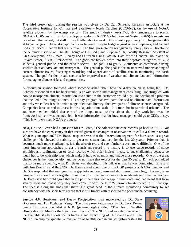
Session 4.6, Hurricanes and Heavy Precipitation, was moderated by Dr. Steve
Goodman and Dr. Fuzhong Weng. The first presentation was by Dr. Jack Beven,
Senior Hurricane Specialist at NHC (pictured right), titled, “The Use of Satellite
Observations to Monitor the Evolution of Sandy.” The NHC used an extensive array of
the available satellite tools for its tracking and forecasting of Hurricane Sandy. The
NHC often employs qualitative evaluation of satellite data in analyzing/forecasting the
19
track, intensity, and wind radii of a tropical cyclone. The ground-truth aircraft and surface data from
Sandy offers a great chance to compare/validate satellite data and techniques. Fred Toepfer,
NOAA/Hurricane Forecast Improvement Program (HFIP) Program Manager, gave an overview on HFIP.
It is a 10-year program with ambitious forecast improvement goals to reduce evacuation costs with a
focus on improving NWP model forecast guidance provided to the NHC. Some of the goals are to reduce
numerical forecast errors in track and intensity by 20% in 5 years, 50% in 10 years, extend forecasts to 7
days, and increase probability of detecting rapid intensification at day 1 to 90% and 60% at day 5.
The Use of Observations and Data Assimilation for Operational Hurricane Weather Research and
Forecasting (HWRF) was presented by Dr. Vijay Tallapragada, Hurricane Team Leader at
NWS/Environmental Modeling Center. For the first time, a high-resolution hurricane model operating at
cloud-permitting 3km resolution was implemented into NCEP operations; a result of multi-agency efforts
supported by HFIP. Advanced high-resolution products from operations include synthetic satellite
imagery, high-frequency track and intensity forecasts and additional large-scale and vortex scale
diagnostics. Experimental results from fiscal year 2013 pre-implementation testing and evaluation, from
a large sample of 3-season (2010-2011-2012) tests showed about 10-15% improvement in tracks and
about 20-25% improvement in intensity forecasts. A presentation on heavy precipitation was given by
Ralph Ferraro, Branch Chief for the NOAA/NESDIS Satellite Climate Studies Branch, to close the
session. Satellites are particularly useful where ground measurements are not taken or missing. An
example of merging various data sources to provide “seamless” products with limited data gaps is the
blended TPW product. It combines all available data sources into a product for the NWS forecaster:
ocean sources include satellite microwave imagery while the land sources include satellite microwave
imagery, GOES sounder, and GPS Met. The accuracy of all the data sources is comparable. The data are
biased adjusted using a histogram matching scheme. GPS is over CONUS land only.
A discussion session closed the day. One audience member asked about the successful flying of an
unmanned drone in a hurricane off coast and wanted to know if they will continue to be used to obtain
that sort of data. Dr. Beven responded that no formal program to use the unmanned drones continuously
exists, but the Hurricane and Severe Storm Sentinel (HS3) program with two global hawks stationed at
Wallops Flight Facility is taking place in August 2013 with one aircraft monitoring the environment and
one monitoring over storm environments. The audience member continued by asking which satellite is
more essential to predictions of hurricanes, GOES-R or JPSS? Dr. Beven’s response was that would have
to be asked to a numerical modeler; the NHC would say GOES-R while numerical modeling would say
JPSS. Moving on, Bob Allen asked which feature Dr. Beven was looking for in the DNB, to which he
replied that DNB in VIIRS will be much closer to visible imagery and will help to do a better job at
intensity estimates.
Another audience member asked Mr. Toepfer regarding HFIP, “What are the target areas for the next 5
years, and what is your opinion about latency?” Mr. Toepfer thought learning how to use the GOES-R
data in the models will be the most important and as far as latency, anything that improves it is a good
thing and one of the highest requirements. Dr. Tallapragada added that as a modeler they prefer as much
data as possible. It is important to make sure they get as much information as possible in the assimilation
window. Kathy-Ann Caesar asked about TPW products. They are one of the most revolutionary products
for those in the Caribbean. If there is no cloud signature, a moisture plume is visible. For modelers, can
that be used in high resolution models? Dr. Weng responded that radiance assimilation includes this
information. Mr. Ferraro mentioned that with a blended product, everything goes into it and sometimes
the users have a problem as a new satellite comes online. Each satellite needs to be online to make it
better.
20
An audience member transitioned into asking about ocean heat content and improvements to hurricane
intensity forecasting and what the role of that field is and input into intensity prediction. Dr. Beven
responded with a brief overview. The altimetry data is used operationally in a few ways, such as wave
heights, it also combines with sea surface data to get ocean heat content. Forecasters also look at the SST
and Ocean Heat Content (OHC) fields to get an idea of how they are changing as the storm is moving
along. Mr. Toepfer said that he fought hard a few years ago to get altimetry recognized as a requirement.
It is critical to what is done in ocean modeling. Dr. Simon Keough spoke to the role of human beings in
the forecast process in unprecedented cases asking how the role evolves in the forecast process. Dr.
Beven responded that he is not quite sure how it will evolve. There will always be room for the human
being in the loop. Models are not perfect and most times they remain divergent. While models are
improving, it is doubtful there will be a point where possibilities are eliminated. The models are used to
see the possibilities, not eliminate them. Track guidance models are getting better. There is plenty of
room to improve on intensity guidance and always room for the forecaster/analyst to look at products and
say there is something wrong with what the models have, and adjust for that.

21
6 No Host Dinner – “Satellites and Science Literacy: A Powerful
Opportunity”
Chief Meteorologist, Dan Satterfield, from CBS Affiliate WBOC in Salisbury, MD was the guest speaker
at Thursday night’s No-Host Dinner at the Marriott Hotel in Greenbelt, MD.
Mr. Satterfield (pictured right) grew up in Tulsa, Oklahoma and attended the
University of Oklahoma to study meteorology. He became fascinated with satellite
imagery after seeing his first satellite image in a weather briefing at the university. In
his early broadcast meteorology days, he recalls forecasting volcanic ash over the
Oklahoma City area after the Mount St. Helen’s eruption, using satellite imagery.
Mr. Satterfield made several key points about the broadcast meteorology community and the current state
of how satellite imagery is used in the industry.
1. The broadcast meteorology community is not ready for the fire hose of GOES-R data. They do
not realize that their world is about to change.
2. There is only one, big vendor of satellite and radar imagery for broadcast meteorologists to use
on-air. The satellite images are only 12km resolution because they must be shown in color to
appeal to the audience.
3. The process Mr. Satterfield has to go through to show a MODIS image, for example, on
television is to download it from the Internet, convert it to a TIP image because the graphics
system does not accept JPEG, email it to himself, download it, and then adjust it for the graphics
rendering system to show on-air. This is in addition to everything else and as a result, he does not
get to show these kinds of images on a regular basis.
4. The public loves the weather, especially on the news. However, they do not understand basic
concepts such as high and low pressure areas and fronts.
Mr. Satterfield then spoke about the differences between radar and satellite to
the general public. He credits radar applications to cell phones and tablets as a
major reason why radar technology seems to have no trouble when it comes to
budget. The public has easy access to radar and it is conveyed to them on a
daily basis. They understand the value in radar. Mr. Satterfield feels that
meteorologists need to show the public that satellite imagery is just as
valuable. People need to have a satellite application on their smart phone in addition to the radar
application. If they understand that their tax money is going to a valuable cause as they do with radar,
then the satellite community will have the support it needs to continue. Mr. Satterfield closed by reading
Carl Sagan’s piece, Pale Blue Dot.
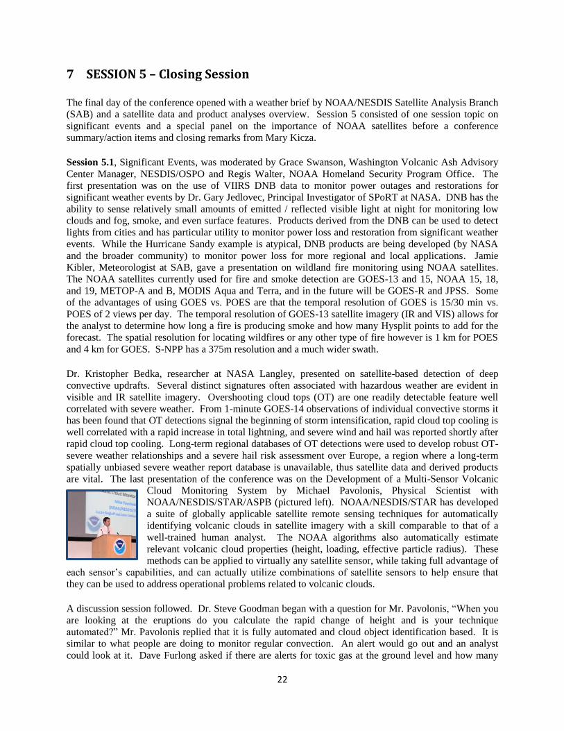
22
7 SESSION 5 – Closing Session
The final day of the conference opened with a weather brief by NOAA/NESDIS Satellite Analysis Branch
(SAB) and a satellite data and product analyses overview. Session 5 consisted of one session topic on
significant events and a special panel on the importance of NOAA satellites before a conference
summary/action items and closing remarks from Mary Kicza.
Session 5.1, Significant Events, was moderated by Grace Swanson, Washington Volcanic Ash Advisory
Center Manager, NESDIS/OSPO and Regis Walter, NOAA Homeland Security Program Office. The
first presentation was on the use of VIIRS DNB data to monitor power outages and restorations for
significant weather events by Dr. Gary Jedlovec, Principal Investigator of SPoRT at NASA. DNB has the
ability to sense relatively small amounts of emitted / reflected visible light at night for monitoring low
clouds and fog, smoke, and even surface features. Products derived from the DNB can be used to detect
lights from cities and has particular utility to monitor power loss and restoration from significant weather
events. While the Hurricane Sandy example is atypical, DNB products are being developed (by NASA
and the broader community) to monitor power loss for more regional and local applications. Jamie
Kibler, Meteorologist at SAB, gave a presentation on wildland fire monitoring using NOAA satellites.
The NOAA satellites currently used for fire and smoke detection are GOES-13 and 15, NOAA 15, 18,
and 19, METOP-A and B, MODIS Aqua and Terra, and in the future will be GOES-R and JPSS. Some
of the advantages of using GOES vs. POES are that the temporal resolution of GOES is 15/30 min vs.
POES of 2 views per day. The temporal resolution of GOES-13 satellite imagery (IR and VIS) allows for
the analyst to determine how long a fire is producing smoke and how many Hysplit points to add for the
forecast. The spatial resolution for locating wildfires or any other type of fire however is 1 km for POES
and 4 km for GOES. S-NPP has a 375m resolution and a much wider swath.
Dr. Kristopher Bedka, researcher at NASA Langley, presented on satellite-based detection of deep
convective updrafts. Several distinct signatures often associated with hazardous weather are evident in
visible and IR satellite imagery. Overshooting cloud tops (OT) are one readily detectable feature well
correlated with severe weather. From 1-minute GOES-14 observations of individual convective storms it
has been found that OT detections signal the beginning of storm intensification, rapid cloud top cooling is
well correlated with a rapid increase in total lightning, and severe wind and hail was reported shortly after
rapid cloud top cooling. Long-term regional databases of OT detections were used to develop robust OT-
severe weather relationships and a severe hail risk assessment over Europe, a region where a long-term
spatially unbiased severe weather report database is unavailable, thus satellite data and derived products
are vital. The last presentation of the conference was on the Development of a Multi-Sensor Volcanic
Cloud Monitoring System by Michael Pavolonis, Physical Scientist with
NOAA/NESDIS/STAR/ASPB (pictured left). NOAA/NESDIS/STAR has developed
a suite of globally applicable satellite remote sensing techniques for automatically
identifying volcanic clouds in satellite imagery with a skill comparable to that of a
well-trained human analyst. The NOAA algorithms also automatically estimate
relevant volcanic cloud properties (height, loading, effective particle radius). These
methods can be applied to virtually any satellite sensor, while taking full advantage of
each sensor’s capabilities, and can actually utilize combinations of satellite sensors to help ensure that
they can be used to address operational problems related to volcanic clouds.
A discussion session followed. Dr. Steve Goodman began with a question for Mr. Pavolonis, “When you
are looking at the eruptions do you calculate the rapid change of height and is your technique
automated?” Mr. Pavolonis replied that it is fully automated and cloud object identification based. It is
similar to what people are doing to monitor regular convection. An alert would go out and an analyst
could look at it. Dave Furlong asked if there are alerts for toxic gas at the ground level and how many
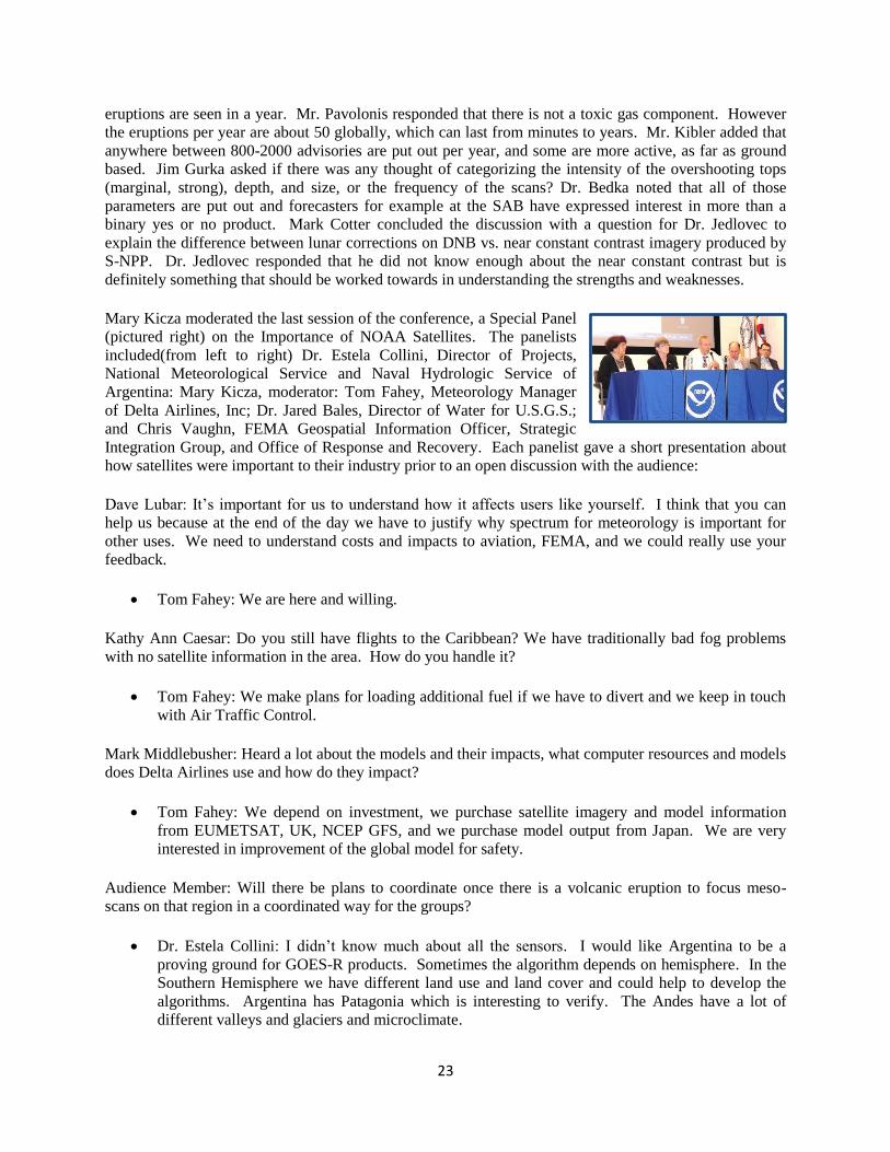
23
eruptions are seen in a year. Mr. Pavolonis responded that there is not a toxic gas component. However
the eruptions per year are about 50 globally, which can last from minutes to years. Mr. Kibler added that
anywhere between 800-2000 advisories are put out per year, and some are more active, as far as ground
based. Jim Gurka asked if there was any thought of categorizing the intensity of the overshooting tops
(marginal, strong), depth, and size, or the frequency of the scans? Dr. Bedka noted that all of those
parameters are put out and forecasters for example at the SAB have expressed interest in more than a
binary yes or no product. Mark Cotter concluded the discussion with a question for Dr. Jedlovec to
explain the difference between lunar corrections on DNB vs. near constant contrast imagery produced by
S-NPP. Dr. Jedlovec responded that he did not know enough about the near constant contrast but is
definitely something that should be worked towards in understanding the strengths and weaknesses.
Mary Kicza moderated the last session of the conference, a Special Panel
(pictured right) on the Importance of NOAA Satellites. The panelists
included(from left to right) Dr. Estela Collini, Director of Projects,
National Meteorological Service and Naval Hydrologic Service of
Argentina: Mary Kicza, moderator: Tom Fahey, Meteorology Manager
of Delta Airlines, Inc; Dr. Jared Bales, Director of Water for U.S.G.S.;
and Chris Vaughn, FEMA Geospatial Information Officer, Strategic
Integration Group, and Office of Response and Recovery. Each panelist gave a short presentation about
how satellites were important to their industry prior to an open discussion with the audience:
Dave Lubar: It’s important for us to understand how it affects users like yourself. I think that you can
help us because at the end of the day we have to justify why spectrum for meteorology is important for
other uses. We need to understand costs and impacts to aviation, FEMA, and we could really use your
feedback.
Tom Fahey: We are here and willing.
Kathy Ann Caesar: Do you still have flights to the Caribbean? We have traditionally bad fog problems
with no satellite information in the area. How do you handle it?
Tom Fahey: We make plans for loading additional fuel if we have to divert and we keep in touch
with Air Traffic Control.
Mark Middlebusher: Heard a lot about the models and their impacts, what computer resources and models
does Delta Airlines use and how do they impact?
Tom Fahey: We depend on investment, we purchase satellite imagery and model information
from EUMETSAT, UK, NCEP GFS, and we purchase model output from Japan. We are very
interested in improvement of the global model for safety.
Audience Member: Will there be plans to coordinate once there is a volcanic eruption to focus meso-
scans on that region in a coordinated way for the groups?
Dr. Estela Collini: I didn’t know much about all the sensors. I would like Argentina to be a
proving ground for GOES-R products. Sometimes the algorithm depends on hemisphere. In the
Southern Hemisphere we have different land use and land cover and could help to develop the
algorithms. Argentina has Patagonia which is interesting to verify. The Andes have a lot of
different valleys and glaciers and microclimate.
24
Mary Kicza: Yes, there are opportunities.
Dave Furlong: At Delta Airlines, have you calculated cost savings per year from meteorological data?
Tom Fahey: We have done that a number of different times, and the general outcome is that we
return 3-5 times the investment we make in the meteorology department.
Dr. Steve Goodman: Your presentation hits a core with us. We had a product for GOES-R that we
decided not to fund called tropopause folding. Our advisory committee said it was stove piping and not to
do it. How do we take tactical and strategic information on how we get from stovepipe algorithm to using
NWP intelligently to provide good information for you?
Tom Fahey: Currently from an avoidance standpoint, there still needs to be work done in that
area, the main point I glossed over, through the AMS effort there are a number of broader
focuses... to provide a specific solution now, no, but from a broader standpoint, we need to work
collaboratively to create a holistic approach to improve the models.
Karen Dubey: I would like to mention that it’s good NOAA has continued to support the DRO
community with GOES-R, that’s how almost all non-NOAA users will get their data. Request that you
go that last 1% and help us get the algorithms so we all don’t have to replicate the efforts. So that would
be putting the algorithms through CSPP. That’s how most polar satellite algorithms are and it would be
good for GEO to be the same way.
Mary: Thank you, we will make note of that.
Russel Stringer: Wondering as ground based centers are getting higher temporal resolution, is it forcing
putting more stress on the data collection system?
Kay Metcalf: We have been concerned for many years with the capacity of DCS and have
undertaken many projects to increase the capacity. We are getting more and more requests for 15
minute repeat cycles, and 5 minute repeat cycles, especially for tsunami warnings. We are still
working to make changes on the ground to work with the increasing capacity issues. We have
increased the speed of the transmitters, we have decreased the required bandwidth for each
channel, and we have decreased the length of each message. We will continue to make changes
on the ground side to make more efficient use of the system, and maximize the capacity.
25
8 CONCLUSION
The NOAA Satellite Conference was deemed a tremendous success with over 500 in-person attendees
and another 100 or so virtual attendees, 175 posters, more than 70 presentations, and 25 exhibits. There
were also panels, weather/center briefs, tours, user feedback sessions, and additional workshops. There
was a common theme throughout the week of the importance of partnerships. Dr. Kathryn Sullivan noted
in her welcome video on April 8, 2013, “Combining these different conferences co-mingles scientific,
engineering, and user communities, enabling a powerful cross-fertilization of ideas and experiences.
Partnerships have always been key to NOAA’s success, and they are especially important now with the
pioneering GOES-R and JPSS systems coming closer to reality.” Another common theme was the
importance of user feedback. Dave Furlong commented, “There was a lot said about GOES and GOES-R
and can be said about JPSS. Especially two years from now when people have the ability to exploit the
data.”
The decommissioning of NOAA-17 was also of importance to note. It is a significant milestone for
ongoing cooperation with EUMETSAT- NOAA now relying exclusively on EUMETSAT in the mid-
morning orbit. NOAA-17 retired after 11 years of service, one of NOAA's longest operating spacecraft.
NOAA will continue to operate NOAA-15, NOAA-16, NOAA-18, NOAA-19, and S-NPP. The
decommissioning of NOAA-17 provides a timely example of the critical value of partnerships. NOAA
began the deactivation process of NOAA-17 on February 18, with the final shut down occurring
Wednesday. Launched in June 2002, NOAA-17 made 55,000 orbits of the globe, traveling more than 1.5
billion miles while collecting huge amounts of valuable temperature, moisture and image data. NOAA-
17’s long life is a credit to the engineers who built and operated it and the technology that sustained it.
Although we say farewell to NOAA-17, we still operate a dependable fleet of satellites that continue to
provide crucial data. Presentations and posters can be found on the NSC website
http://satelliteconferences.noaa.gov/2013/.
In closing, big thanks was given to all who attended the conference and the people who helped to make it
a success:
Interpreters: Multilingual Experts
On-site catering: Kloud Kafe
Mobile caterer: Smoking Swine
Conference Hotel and Shuttle: Greenbelt Marriott and Dotty Beverly (Account Executive)
Sponsors and Exhibitors
NCWCP Facilities/Engineering/Janitorial/Security
NCWCP Tenant Board
Volunteers
Organizing Committee (listed in Appendix G)

I
APPENDIX A 2013 NOAA Satellite Conference Agenda
NOAA Center for Weather and Climate Prediction
College Park, Maryland April 8-12, 2013
“Strengthening Partnerships to Enhance User Readiness, Reception, and Utility” Organizer
Presenter
Saturday/Sunday April 6-7
"Train the Trainer" Workshop
9:30am - 4:00pm
"Train the Trainer" Workshop (NCWCP Conference Center)
Monday, April 8 Session Registration / Pre-Meetings / Opening Session
7:30am - 12:45pm
Registration; Sign-up for NCWCP Tours (Wed/Fri) and Dinner (Thu)
8:30am - 12:00pm
GSICS Users' Workshop (Auditorium)
8:30am - 12:00pm
WMO RA-III and RA-IV Meeting (NCWCP Conference Room 4552/53)
12:00pm - 12:45pm
Lunch
1:00pm 1.0 Opening Remarks
Eric Madsen (NESDIS/IIA; NSC Co-Chair) Scott Rogerson (Argos DCS Program Manager, NESDIS/OSPO; NSC Co-Chair)
1:20pm 1.1 Special Guest Speaker - NOAA Kathryn Sullivan (Acting Administrator, NOAA)
1:30pm 1.2 Special Guest Speaker - NESDIS Mary Kicza (Assistant Administrator, National Environmental Satellite, Data & Information Service (NESDIS), NOAA)
1:50pm 1.3 Special Guest Speaker - NWS Louis Uccellini (Assistant Administrator, National Weather Service (NWS), NOAA)
2:10pm 1.4
Highlights since the 2011 Satellite Direct Readout and GOES Users' Conferences - OSPO/GOES-R
Vanessa Griffin (Director, NESDIS/OSPO) Dr. Steve Goodman (Program Chief Scientist, NESDIS/GOES-R)
2:30pm
Break
3:00pm 1.5 Special Guest Speaker - EUMETSAT Mikael Rattenborg (Director of Operations, EUMETSAT)
3:20pm 1.6 Keynote Address - WMO David Grimes (President, WMO)
3:50pm 1.7 Wrap-up / End of Day 1
5:30pm
Icebreaker/Social (Hotel)
Tuesday, April 9
Current and Future Programs and Systems
8:00am
Ocean Prediction and Satellite Data/Product Overview NOAA's Ocean Prediction Center
8:25am 2.0 Opening Remarks Eric Madsen (NSC Co-Chair) Scott Rogerson (NSC Co-Chair)
8:30am 2.1
Development of an Architecture for Climate Monitoring from Space
Dr. Wenjian Zhang (Director, WMO Space Programme)
9:00am - 10:15am 2.2 GOES/GOES-R
Dr. Steve Goodman (Program Chief Scientist, NESDIS/GOES-R; NSC Co-Chair) Jim Gurka (Ground Segment Project Scientist, NESDIS/GOES-R; NSC Co-Chair)
9:00am 2.2a GOES - Update on Current Operations
Matthew Seybold (Satellite User Services Coordinator, NESDIS/OSPO/SPSD)
9:15am 2.2b GOES-R - Update on Future Operations
Rick Pickering (Deputy System Program Director, GOES-R)
9:30am 2.2c The ABI on GOES-R
Tim Schmit (NESDIS/STAR Advanced Satellite Products Branch)
9:45am 2.2d The GLM on GOES-R
Dr. Steve Goodman (Program Chief Scientist, NESDIS/GOES-R)
10:00am
Discussion
10:15am 2.3 Intro to Posters, Break, and Poster Session 1 Tim Schmit (Advanced Satellite Products Branch, NESDIS/STAR)
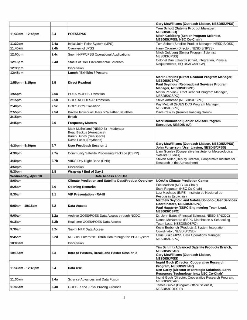
II
Gary McWilliams (Outreach Liaison, NESDIS/JPSS)
11:30am - 12:45pm 2.4 POES/JPSS
Tom Schott (Satelite Product Manager, NESDIS/OSD) Mitch Goldberg (Senior Program Scientist, NESDIS/JPSS; NSC Co-Chair)
11:30am 2.4a Initial Joint Polar System (IJPS) Tom Schott (Satellite Product Manager, NESDIS/OSD)
11:45am 2.4b Overview of JPSS Harry Cikanek (Director, NESDIS/JPSS)
12:00pm 2.4c Suomi-NPP/JPSS Operational Applications
Mitch Goldberg (Senior Program Scientist, NESDIS/JPSS)
12:15pm 2.4d Status of DoD Environmental Satellites
Colonel Dan Edwards (Chief, Integration, Plans & Requirements, HQ USAF/A3O-W)
12:30pm
Discussion
12:45pm
Lunch / Exhibits / Posters
1:55pm - 3:15pm 2.5 Direct Readout
Marlin Perkins (Direct Readout Program Manager, NESDIS/OSPO) Paul Seymour (Rebroadcast Services Program Manager, NESDIS/OSPO)
1:55pm 2.5a POES to JPSS Transition
Marlin Perkins (Direct Readout Program Manager, NESDIS/OSPO)
2:15pm 2.5b GOES to GOES-R Transition Steve Ambrose (NESDIS/OSPO)
2:40pm 2.5c GOES DCS Transition
Kay Metcalf (GOES DCS Program Manager, NESDIS/OSPO)
2:55pm 2.5d Private Individual Users of Weather Satellites Dave Cawley (Remote Imaging Group)
3:15pm
Break
3:45pm 2.6 Frequency Matters
Mark Mulholland (Senior Advisor/Program Executive, NESDIS AA)
Mark Mulholland (NESDIS) - Moderator Beau Backus (Aerospace) Karen Dubey (SeaSpace) David Lubar (Raytheon)
4:30pm - 5:30pm 2.7 User Feedback Session 1
Gary McWilliams (Outreach Liaison, NESDIS/JPSS) John Furgerson (User Liasion, NESDIS/JPSS)
4:30pm 2.7a Community Satellite Processing Package (CSPP)
Liam Gumley (Cooperative Institute for Meteorological Satellite Studies)
4:40pm 2.7b VIIRS Day-Night Band (DNB)
Steven Miller (Deputy Director, Cooperative Institute for Research in the Atmosphere)
4:50pm
Discussion
5:30pm 2.8 Wrap-up / End of Day 2
Wednesday, April 10
Data Access and Use
8:00am
Climate Prediction and Satellite Data/Product Overview NOAA's Climate Prediction Center
8:25am 3.0 Opening Remarks Eric Madsen (NSC Co-Chair) Scott Rogerson (NSC Co-Chair)
8:30am 3.1 VIP Presentation - RA-III
Luiz Machado (INPE - Instituto de Nacional de Pesquisas Espaciais)
9:00am - 10:15am 3.2 Data Access
Matthew Seybold and Natalia Donoho (User Services Coordinators, NESDIS/OSPO) Paul Haggerty (ESPC Engineering Team Lead, NESDIS/OSPO)
9:00am 3.2a Archive GOES/POES Data Access through NCDC Dr. John Bates (Principal Scientist, NESDIS/NCDC)
9:15am 3.2b Real-time GOES/POES Data Access
Donna McNamara (ESPC Distribution & Scheduling Team Lead, NESDIS/OSPO)
9:30am 3.2c Suomi NPP Data Access
Kevin Berberich (Products & System Integration Coordinator, NESDIS/OSD)
9:45am 3.2d NESDIS Enterprise Distribution through the PDA System
Chris Sisko (JPSS Data Operations Manager, NESDIS/OSPO)
10:00am
Discussion
10:15am 3.3 Intro to Posters, Break, and Poster Session 2
Tim Schmit (Advanced Satellite Products Branch, NESDIS/STAR) Gary McWilliams (Outreach Liaison, NESDIS/JPSS)
11:30am - 12:45pm 3.4 Data Use
Ingrid Guch (Director, Cooperative Research Program, NESDIS/STAR) Ken Carey (Director of Strategic Solutions, Earth Resources Technology, Inc.; NSC Co-Chair)
11:30am 3.4a Science Advances and Data Fusion
Ingrid Guch (Director, Cooperative Research Program, NESDIS/STAR)
11:45am 3.4b GOES-R and JPSS Proving Grounds
James Gurka (Program Office Scientist, NESDIS/GOES-R)

III
12:00pm 3.4c Satellite Cal/Val and Data Assimilation
Dr. Fuzhong Weng (Acting Chief, Satellite Meteorology and Climatology Division, NESDIS/STAR; NSC Co-Chair)
12:15pm 3.4d
Collaborative Decision Making: Enhancing Situational
Awareness with Satellite Data Use in Real‐Time to Improve Readiness, Response and Recovery
Dave Jones (President/CEO, StormCenter Communications, Inc.)
12:30pm
Discussion
12:45pm
Lunch / Exhibits / Posters
2:00pm 3.5
Special Panel on Data Access and Use by International Community
Eric Madsen (NESDIS/IIA; NSC Co-Chair)
Dr. Wenjian Zhang (Director, WMO Space Programme) - Moderator
Osvaldo Moraes (Director, Center for Weather Forecasting and Climate Research, INPE)
Mike Manore (Director, Monitoring Strategies and Data Management, Meteorological Service of Canada)
Kathy-Ann Caesar (Chief Meteorologist, Caribbean Institute for Meteorology and Hydrology)
3:00pm
Break
3:30pm 3.6
Improving the Use of Satellite Data at NOAA's Center for Satellite Applications and Research
Al Powell (Director, NESDIS/STAR)
4:00pm 3.7 User Feedback Session 2
Tom Renkevens (Deputy, Satellite Products and Services Division, NESDIS/OSPO) Dr. Linda Stathoplos (Deputy, Mission Operations Division, NESDIS/OSPO)
5:00pm 3.8 Wrap-up / End of Day 3
5:15pm - 6:00pm
NCWCP Tours
6:30pm
GOES-R Proving Ground Sidebar/Social (Hotel)
Thursday, April 11
Applications
8:00am
Weather Prediction and Satellite Data/Product Overview NOAA's Weather Prediction Center
8:25am 4.0 Opening Remarks Eric Madsen (NSC Co-Chair) Scott Rogerson (NSC Co-Chair)
8:30am 4.1
Leveraging Satellite Data at NOAA's National Centers for Environmental Prediction
Dr. James Yoe (Chief Administrative Officer, NWS National Centers for Environmental Prediction)
9:00am - 10:15am 4.2 Weather Forecasting Applications
Joseph Sienkiewicz (Chief, Ocean Applications Branch, NWS Ocean Prediction Center) Dr. Michael Folmer (Satellite Liaison at NOAA/NWS HPC/OPC/TAFB and NOAA/NESDIS SAB)
9:00am 4.2a
A Perspective from the Skies: Aviation Forecasting and Satellite Applications at the AWC
Amanda Terborg (Aviation Support Branch, Aviation Weather Center)
9:15am 4.2b
The Importance of Satellite Products within National Weather Service Forecast Offices
Chad Gravelle (Integrated Services Division, NWS Central Region)
9:30am 4.2c
Pacific Region's Satellite Products, Programs and Requirements
Eric Lau (Environmental Scientific and Services Division, NWS Pacific Region)
9:45am 4.2d NWS Alaska Region Satellite Program and Requirements Carven Scott (Chief, Environmental and Scientific Services, NWS Alaska Region)
9:00am - 10:15am 2.2 GOES/GOES-R
Dr. Steve Goodman (Program Chief Scientist, NESDIS/GOES-R; NSC Co-Chair) Jim Gurka (Ground Segment Project Scientist, NESDIS/GOES-R; NSC Co-Chair)
10:15am
Break
10:30am - 3:15pm
HRIT/EMWIN/GOES DCS Workshop (ESSICS Building)
10:45am - 11:30am 4.3 User Applications Tim Schmit (Advanced Satellite Products Branch, NESDIS/STAR) Gary McWilliams (Outreach Liaison, NESDIS/JPSS)
10:45am 4.3a Applications of GOES-SA (South America) Daniel Alejandro Vila (DSA/CPTEC/INPE)
11:00am 4.3b
The Global Impact of 10+ Years of IMAPP Software in Support of Aqua and Terra
Kathleen Strabala (UW-Madison, CIMSS)
11:15am 4.3c
NOAA Operational Satellite SST for Monitoring Coral Bleaching Thermal Stress: Coral Reef Watch’s Satellite Decision Support System for Coral Reef Managers
Gang Liu (NESDIS/STAR)
11:30am - 12:45pm 4.4 Environmental Assessment Applications
Kathy-Ann Caesar (Chief Meteorologist, Caribbean Institute for Meteorology and Hydrology) Karen Moe (Technology Leader, NASA Goddard Space Flight Center)
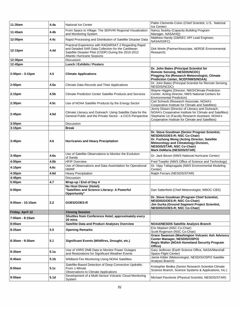
IV
11:30am 4.4a National Ice Center
Pablo Clemente-Colon (Chief Scientist, U.S. National Ice Center)
11:45am 4.4b
From Space to Village: The SERVIR Regional Visualization and Monitoring System
Nancy Searby (Capacity Building Program Manager, NASA/HQ)
12:00pm 4.4c Rapid Processing and Distribution of Satellite Disaster Data
Matthew Handy (GMSEC API Lead Engineer, NASA/GSFC)
12:15pm 4.4d
Practical Experience with RADARSAT-2 Regarding Rapid and Detailed SAR Data Collection for the Caribbean Satellite Disaster Pilot (CSDP) During the 2010-2012 Atlantic Hurricane Seasons
Dirk Werle (Partner/Associate, AERDE Environmental Research)
12:30pm
Discussion
12:45pm
Lunch / Exhibits / Posters
2:00pm - 3:15pm 4.5 Climate Applications
Dr. John Bates (Principal Scientist for Remote Sensing, NESDIS/NCDC) Pingping Xie (Research Meteorologist, Climate Prediction Center, NCEP/NWS/NOAA)
2:00pm 4.5a Climate Data Records and Their Applications
Dr. John Bates (Principal Scientist for Remote Sensing, NESDIS/NCDC)
2:15pm 4.5b Climate Prediction Center Satellite Products and Services
Wayne Higgins (Director, NWS/Climate Prediction Center; Acting Director, NWS National Centers for Environmental Prediction)
2:30pm 4.5c Use of NOAA Satellite Products by the Energy Sector
Carl Schreck (Research Associate, NOAA's Cooperative Institute for Climate and Satellites)
2:45pm 4.5d
Climate Literacy and Outreach: Using Satellite Data for the General Public and the Private Sector - a CICS Perspective
Jenny Dissen (Director of Literacy and Outreach, NOAA's Cooperative Institute for Climate and Satellites) Stephanie Uz (Faculty Research Assistant, NOAA's Cooperative Institute for Climate and Satellites)
3:00pm
Discussion
3:15pm
Break
3:45pm 4.6 Hurricanes and Heavy Precipitation
Dr. Steve Goodman (Senior Program Scientist, NESDIS/GOES-R; NSC Co-Chair) Dr. Fuzhong Weng (Acting Director, Satellite Meteorology and Climatology Division, NESDIS/STAR; NSC Co-Chair) Mark DeMaria (NESDIS/STAR)
3:45pm 4.6a
Use of Satellite Observations to Monitor the Evolution of Sandy
Dr. Jack Beven (NWS National Hurricane Center)
4:00pm 4.6b HFIP Overview Fred Toepfer (NWS Office of Science and Technology)
4:15pm 4.6c
Use of Observations and Data Assimilation for Operational HWRF
Dr. Vijay Tallapragada (NWS Environmental Modeling Center)
4:30pm 4.6d Heavy Precipitation Ralph Ferraro (NESDIS/STAR)
4:45pm
Discussion
5:00pm 4.7 Wrap-up / End of Day 4
6:00pm
No Host Dinner (Hotel): "Satellites and Science Literacy: A Powerful Opportunity"
Dan Satterfield (Chief Meteorologist, WBOC-CBS)
9:00am - 10:15am 2.2 GOES/GOES-R
Dr. Steve Goodman (Program Chief Scientist, NESDIS/GOES-R; NSC Co-Chair) Jim Gurka (Ground Segment Project Scientist, NESDIS/GOES-R; NSC Co-Chair)
Friday, April 12
Closing Session
7:00am - 8:15am
Shuttles from Conference Hotel; approximately every 20 mins
8:00am
Satellite Data and Product Analyses Overview NOAA/NESDIS Satellite Analysis Branch
8:25am 5.0 Opening Remarks Eric Madsen (NSC Co-Chair) Scott Rogerson (NSC Co-Chair)
8:30am - 9:30am 5.1 Significant Events (Wildfires, Drought, etc.)
Grace Swanson (Washington Volcanic Ash Advisory Center Manager, NESDIS/OSPO) Regis Walter (NOAA Homeland Security Program Office)
8:30am 5.1a
Use of VIIRS DNB Data to Monitor Power Outages and Restorations for Significant Weather Events
Gary Jedlovec (Earth Science Office, NASA/Marshall Space Flight Center)
8:40am 5.1b Wildland Fire Monitoring Using NOAA Satellites
Jamie Kibler (Meteorologist, NESDIS/OSPO Satellite Analysis Branch)
8:50am 5.1c
Satellite-Based Detection of Deep Convective Updrafts: From 1-Minute Observations to Climate Applications
Kristopher Bedka (Senior Research Scientist-Climate Science Branch, Science Systems & Applications, Inc.)
9:00am 5.1d
Development of a Multi-Sensor Volcanic Cloud Monitoring System
Michael Pavolonis (Physical Scientist, NESDIS/STAR)
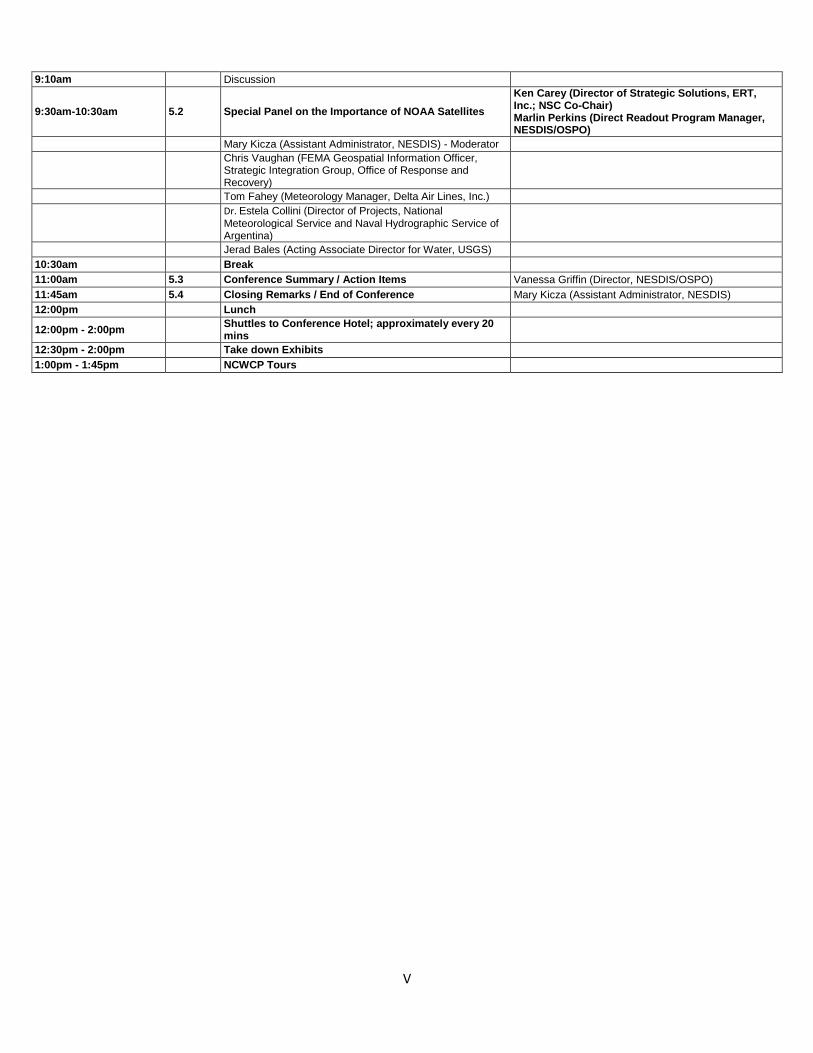
V
9:10am
Discussion
9:30am-10:30am 5.2 Special Panel on the Importance of NOAA Satellites
Ken Carey (Director of Strategic Solutions, ERT, Inc.; NSC Co-Chair) Marlin Perkins (Direct Readout Program Manager, NESDIS/OSPO)
Mary Kicza (Assistant Administrator, NESDIS) - Moderator
Chris Vaughan (FEMA Geospatial Information Officer, Strategic Integration Group, Office of Response and Recovery)
Tom Fahey (Meteorology Manager, Delta Air Lines, Inc.)
Dr. Estela Collini (Director of Projects, National
Meteorological Service and Naval Hydrographic Service of Argentina)
Jerad Bales (Acting Associate Director for Water, USGS)
10:30am
Break
11:00am 5.3 Conference Summary / Action Items Vanessa Griffin (Director, NESDIS/OSPO)
11:45am 5.4 Closing Remarks / End of Conference Mary Kicza (Assistant Administrator, NESDIS)
12:00pm
Lunch
12:00pm - 2:00pm
Shuttles to Conference Hotel; approximately every 20 mins
12:30pm - 2:00pm
Take down Exhibits
1:00pm - 1:45pm
NCWCP Tours
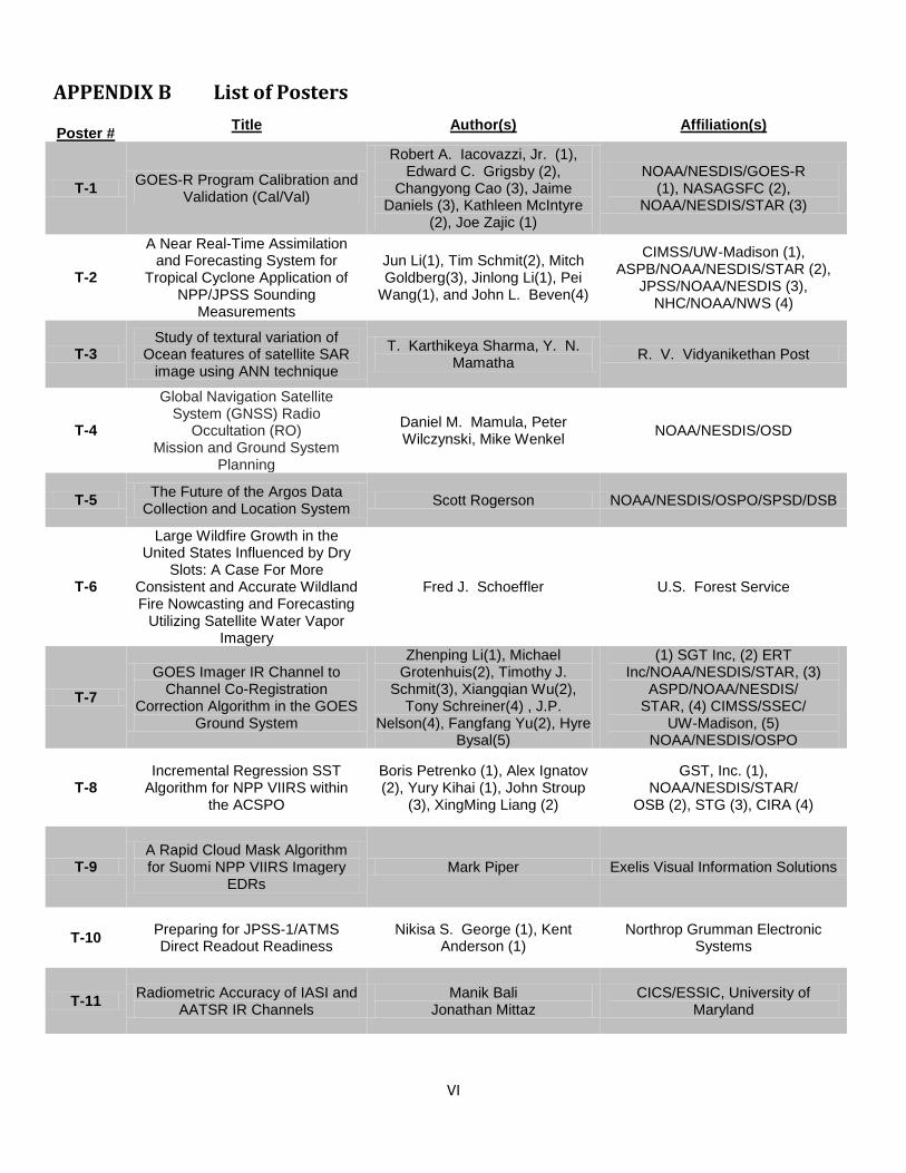
VI
APPENDIX B List of Posters
Poster # Title Author(s) Affiliation(s)
T-1 GOES-R Program Calibration and
Validation (Cal/Val)
Robert A. Iacovazzi, Jr. (1), Edward C. Grigsby (2),
Changyong Cao (3), Jaime Daniels (3), Kathleen McIntyre
(2), Joe Zajic (1)
NOAA/NESDIS/GOES-R (1), NASAGSFC (2),
NOAA/NESDIS/STAR (3)
T-2
A Near Real-Time Assimilation and Forecasting System for
Tropical Cyclone Application of NPP/JPSS Sounding
Measurements
Jun Li(1), Tim Schmit(2), Mitch Goldberg(3), Jinlong Li(1), Pei
Wang(1), and John L. Beven(4)
CIMSS/UW-Madison (1), ASPB/NOAA/NESDIS/STAR (2),
JPSS/NOAA/NESDIS (3), NHC/NOAA/NWS (4)
T-3 Study of textural variation of
Ocean features of satellite SAR image using ANN technique
T. Karthikeya Sharma, Y. N. Mamatha
R. V. Vidyanikethan Post
T-4
Global Navigation Satellite System (GNSS) Radio
Occultation (RO) Mission and Ground System
Planning
Daniel M. Mamula, Peter Wilczynski, Mike Wenkel
NOAA/NESDIS/OSD
T-5 The Future of the Argos Data
Collection and Location System Scott Rogerson NOAA/NESDIS/OSPO/SPSD/DSB
T-6
Large Wildfire Growth in the United States Influenced by Dry
Slots: A Case For More Consistent and Accurate Wildland Fire Nowcasting and Forecasting
Utilizing Satellite Water Vapor Imagery
Fred J. Schoeffler U.S. Forest Service
T-7
GOES Imager IR Channel to Channel Co-Registration
Correction Algorithm in the GOES Ground System
Zhenping Li(1), Michael Grotenhuis(2), Timothy J.
Schmit(3), Xiangqian Wu(2), Tony Schreiner(4) , J.P.
Nelson(4), Fangfang Yu(2), Hyre Bysal(5)
(1) SGT Inc, (2) ERT Inc/NOAA/NESDIS/STAR, (3)
ASPD/NOAA/NESDIS/ STAR, (4) CIMSS/SSEC/
UW-Madison, (5) NOAA/NESDIS/OSPO
T-8 Incremental Regression SST
Algorithm for NPP VIIRS within the ACSPO
Boris Petrenko (1), Alex Ignatov (2), Yury Kihai (1), John Stroup
(3), XingMing Liang (2)
GST, Inc. (1), NOAA/NESDIS/STAR/
OSB (2), STG (3), CIRA (4)
T-9 A Rapid Cloud Mask Algorithm for Suomi NPP VIIRS Imagery
EDRs Mark Piper Exelis Visual Information Solutions
T-10 Preparing for JPSS-1/ATMS Direct Readout Readiness
Nikisa S. George (1), Kent Anderson (1)
Northrop Grumman Electronic Systems
T-11 Radiometric Accuracy of IASI and
AATSR IR Channels Manik Bali
Jonathan Mittaz CICS/ESSIC, University of
Maryland
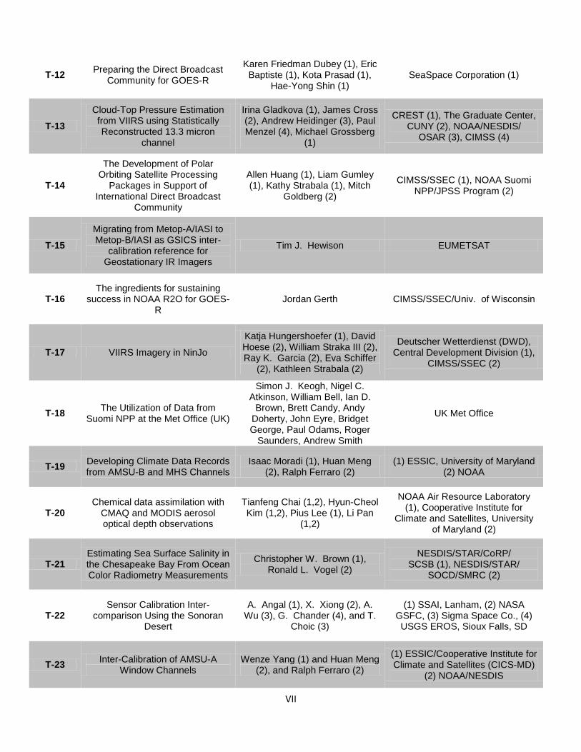
VII
T-12 Preparing the Direct Broadcast
Community for GOES-R
Karen Friedman Dubey (1), Eric Baptiste (1), Kota Prasad (1),
Hae-Yong Shin (1) SeaSpace Corporation (1)
T-13
Cloud-Top Pressure Estimation from VIIRS using Statistically Reconstructed 13.3 micron
channel
Irina Gladkova (1), James Cross (2), Andrew Heidinger (3), Paul Menzel (4), Michael Grossberg
(1)
CREST (1), The Graduate Center, CUNY (2), NOAA/NESDIS/
OSAR (3), CIMSS (4)
T-14
The Development of Polar Orbiting Satellite Processing
Packages in Support of International Direct Broadcast
Community
Allen Huang (1), Liam Gumley (1), Kathy Strabala (1), Mitch
Goldberg (2)
CIMSS/SSEC (1), NOAA Suomi NPP/JPSS Program (2)
T-15
Migrating from Metop-A/IASI to Metop-B/IASI as GSICS inter-
calibration reference for Geostationary IR Imagers
Tim J. Hewison EUMETSAT
T-16 The ingredients for sustaining
success in NOAA R2O for GOES-R
Jordan Gerth CIMSS/SSEC/Univ. of Wisconsin
T-17 VIIRS Imagery in NinJo
Katja Hungershoefer (1), David Hoese (2), William Straka III (2), Ray K. Garcia (2), Eva Schiffer
(2), Kathleen Strabala (2)
Deutscher Wetterdienst (DWD), Central Development Division (1),
CIMSS/SSEC (2)
T-18 The Utilization of Data from
Suomi NPP at the Met Office (UK)
Simon J. Keogh, Nigel C. Atkinson, William Bell, Ian D.
Brown, Brett Candy, Andy Doherty, John Eyre, Bridget George, Paul Odams, Roger
Saunders, Andrew Smith
UK Met Office
T-19 Developing Climate Data Records from AMSU-B and MHS Channels
Isaac Moradi (1), Huan Meng (2), Ralph Ferraro (2)
(1) ESSIC, University of Maryland (2) NOAA
T-20 Chemical data assimilation with
CMAQ and MODIS aerosol optical depth observations
Tianfeng Chai (1,2), Hyun-Cheol Kim (1,2), Pius Lee (1), Li Pan
(1,2)
NOAA Air Resource Laboratory (1), Cooperative Institute for
Climate and Satellites, University of Maryland (2)
T-21 Estimating Sea Surface Salinity in the Chesapeake Bay From Ocean Color Radiometry Measurements
Christopher W. Brown (1), Ronald L. Vogel (2)
NESDIS/STAR/CoRP/ SCSB (1), NESDIS/STAR/
SOCD/SMRC (2)
T-22 Sensor Calibration Inter-
comparison Using the Sonoran Desert
A. Angal (1), X. Xiong (2), A. Wu (3), G. Chander (4), and T.
Choic (3)
(1) SSAI, Lanham, (2) NASA GSFC, (3) Sigma Space Co., (4) USGS EROS, Sioux Falls, SD
T-23 Inter-Calibration of AMSU-A
Window Channels Wenze Yang (1) and Huan Meng
(2), and Ralph Ferraro (2)
(1) ESSIC/Cooperative Institute for Climate and Satellites (CICS-MD)
(2) NOAA/NESDIS
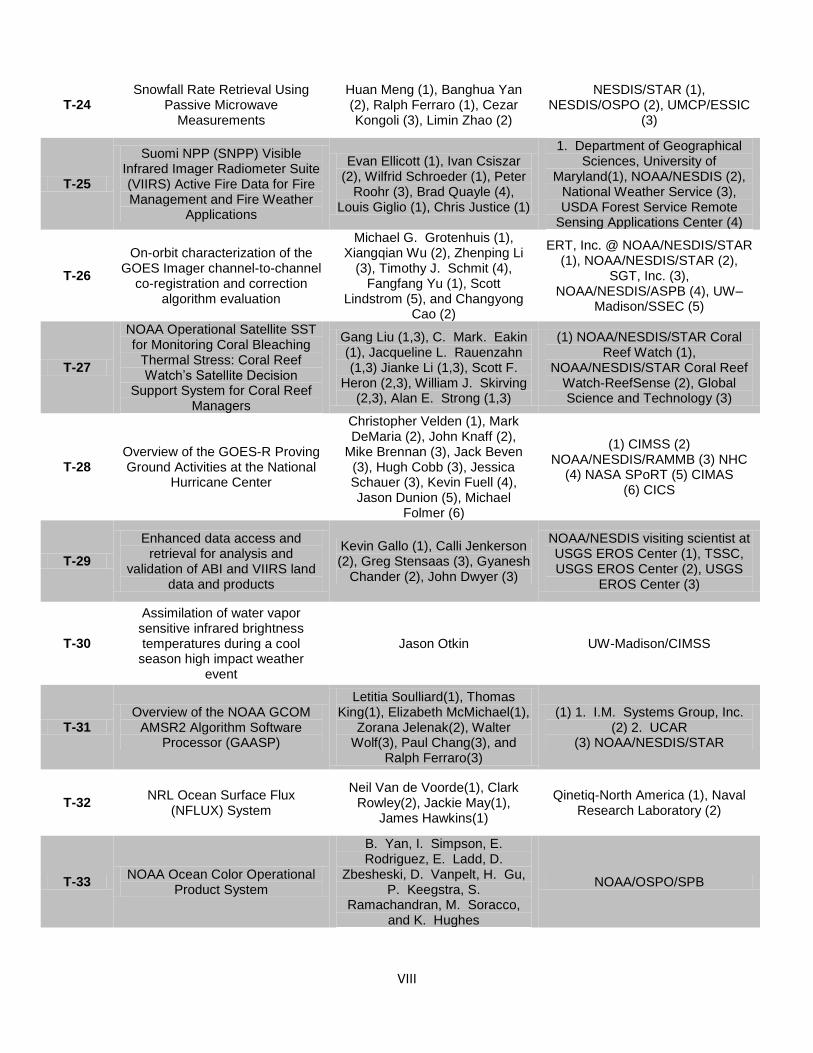
VIII
T-24 Snowfall Rate Retrieval Using
Passive Microwave Measurements
Huan Meng (1), Banghua Yan (2), Ralph Ferraro (1), Cezar Kongoli (3), Limin Zhao (2)
NESDIS/STAR (1), NESDIS/OSPO (2), UMCP/ESSIC
(3)
T-25
Suomi NPP (SNPP) Visible Infrared Imager Radiometer Suite (VIIRS) Active Fire Data for Fire Management and Fire Weather
Applications
Evan Ellicott (1), Ivan Csiszar (2), Wilfrid Schroeder (1), Peter
Roohr (3), Brad Quayle (4), Louis Giglio (1), Chris Justice (1)
1. Department of Geographical Sciences, University of
Maryland(1), NOAA/NESDIS (2), National Weather Service (3), USDA Forest Service Remote
Sensing Applications Center (4)
T-26
On-orbit characterization of the GOES Imager channel-to-channel
co-registration and correction algorithm evaluation
Michael G. Grotenhuis (1), Xiangqian Wu (2), Zhenping Li
(3), Timothy J. Schmit (4), Fangfang Yu (1), Scott
Lindstrom (5), and Changyong Cao (2)
ERT, Inc. @ NOAA/NESDIS/STAR (1), NOAA/NESDIS/STAR (2),
SGT, Inc. (3), NOAA/NESDIS/ASPB (4), UW–
Madison/SSEC (5)
T-27
NOAA Operational Satellite SST for Monitoring Coral Bleaching
Thermal Stress: Coral Reef Watch’s Satellite Decision
Support System for Coral Reef Managers
Gang Liu (1,3), C. Mark. Eakin (1), Jacqueline L. Rauenzahn (1,3) Jianke Li (1,3), Scott F.
Heron (2,3), William J. Skirving (2,3), Alan E. Strong (1,3)
(1) NOAA/NESDIS/STAR Coral Reef Watch (1),
NOAA/NESDIS/STAR Coral Reef Watch-ReefSense (2), Global Science and Technology (3)
T-28 Overview of the GOES-R Proving Ground Activities at the National
Hurricane Center
Christopher Velden (1), Mark DeMaria (2), John Knaff (2),
Mike Brennan (3), Jack Beven (3), Hugh Cobb (3), Jessica Schauer (3), Kevin Fuell (4), Jason Dunion (5), Michael
Folmer (6)
(1) CIMSS (2) NOAA/NESDIS/RAMMB (3) NHC
(4) NASA SPoRT (5) CIMAS (6) CICS
T-29
Enhanced data access and retrieval for analysis and
validation of ABI and VIIRS land data and products
Kevin Gallo (1), Calli Jenkerson (2), Greg Stensaas (3), Gyanesh
Chander (2), John Dwyer (3)
NOAA/NESDIS visiting scientist at USGS EROS Center (1), TSSC, USGS EROS Center (2), USGS
EROS Center (3)
T-30
Assimilation of water vapor sensitive infrared brightness temperatures during a cool
season high impact weather event
Jason Otkin UW-Madison/CIMSS
T-31 Overview of the NOAA GCOM
AMSR2 Algorithm Software Processor (GAASP)
Letitia Soulliard(1), Thomas King(1), Elizabeth McMichael(1),
Zorana Jelenak(2), Walter Wolf(3), Paul Chang(3), and
Ralph Ferraro(3)
(1) 1. I.M. Systems Group, Inc. (2) 2. UCAR
(3) NOAA/NESDIS/STAR
T-32 NRL Ocean Surface Flux
(NFLUX) System
Neil Van de Voorde(1), Clark Rowley(2), Jackie May(1),
James Hawkins(1)
Qinetiq-North America (1), Naval Research Laboratory (2)
T-33 NOAA Ocean Color Operational
Product System
B. Yan, I. Simpson, E. Rodriguez, E. Ladd, D.
Zbesheski, D. Vanpelt, H. Gu, P. Keegstra, S.
Ramachandran, M. Soracco, and K. Hughes
NOAA/OSPO/SPB
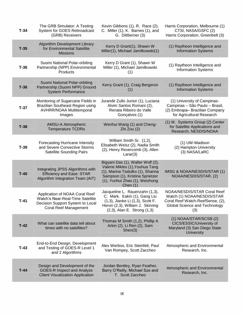
IX
T-34 The GRB Simulator: A Testing System for GOES Rebroadcast
(GRB) Receivers
Kevin Gibbons (1), R. Race (2), C. Miller (1), K. Barnes (1), and
G. Dittberner (3)
Harris Corporation, Melbourne (1) CTSI, NASA/GSFC (2)
Harris Corporation, Greenbelt (3)
T-35 Algorithm Development Library
for Environmental Satellite Missions
Kerry D Grant(1), Shawn W Miller(1), Michael Jamilkowski(1)
(1) Raytheon Intelligence and Information Systems
T-36 Suomi National Polar-orbiting
Partnership (NPP) Environmental Products
Kerry D Grant (1), Shawn W Miller (1), Michael Jamilkowski
(1)
(1) Raytheon Intelligence and Information Systems
T-36 Suomi National Polar-orbiting
Partnership (Suomi NPP) Ground System Performance
Kerry Grant (1), Craig Bergeron (1)
(1) Raytheon Intelligence and Information Systems
T-37
Monitoring of Sugarcane Fields in Brazilian Southeast Region using
AVHRR/NOAA Multitemporal Images
Jurandir Zullo Junior (1), Luciana Alvim Santos Romani (2), Renata Ribeiro do Valle
Gonçalves (1)
(1) University of Campinas-Campinas – São Paulo – Brasil,
(2) Embrapa– Brazilian Company for Agricultural Research
T-38 AMSU-A Atmospheric Temperature TCDRs
Wenhui Wang (1) and Cheng-Zhi Zou (2)
(1) M. Systems Group (2) Center for Satellite Applications and Research, NESDIS/NOAA
T-39 Forecasting Hurricane Intensity and Severe Convective Storms
Satellite Sounding Pairs
William Smith Sr. (1,2), Elisabeth Weisz (2), Nadia Smith (2), Henry Revercomb (3), Allen
Larar(3)
(1) UW-Madison (2) Hampton University
(3) NASA/LaRC
T-40 Integrating JPSS Algorithms with
Efficiency and Ease: STAR Algorithm Integration Team (AIT)
Bigyani Das (1), Walter Wolf (2), Valerie Mikles (1),Youhua Tang (1), Marina Tsidulko (1), Shanna Sampson (1), Kristina Sprietzer (1), Yunhui Zhao (1), Weizhong
Chen (1)
IMSG & NOAA/NESDIS/STAR (1) NOAA/NESDIS/STAR, (2)
T-41
Application of NOAA Coral Reef Watch’s Near-Real-Time Satellite Decision Support System to Local
Coral Reef Management
Jacqueline L. Rauenzahn (1,3), C. Mark. Eakin (1), Gang Liu (1,3), Jianke Li (1,3), Scott F.
Heron (2,3), William J. Skirving (2,3), Alan E. Strong (1,3)
NOAA/NESDIS/STAR Coral Reef Watch (1) NOAA/NESDIS/STAR
Coral Reef Watch-ReefSense, (2), Global Science and Technology
(3)
T-42 What can satellite data tell about
times with no satellites?
Thomas M Smith (1,2), Phillip A Arkin (2), Li Ren (2), Sam
Shen(3)
(1) NOAA/STAR/SCSB (2) CICS/ESSIC/University of
Maryland (3) San Diego State University
T-43 End-to-End Design, Development and Testing of GOES-R Level 1
and 2 Algorithms
Alex Werbos, Eric Steinfelt, Paul Van Rompey, Scott Zaccheo
Atmospheric and Environmental Research, Inc.
T-44 Design and Development of the GOES-R Inspect and Analyze Client Visualization Application
Jordan Bentley, Ryan Feather, Barry O’Reilly, Michael Sze and
T. Scott Zaccheo
Atmospheric and Environmental Research, Inc.
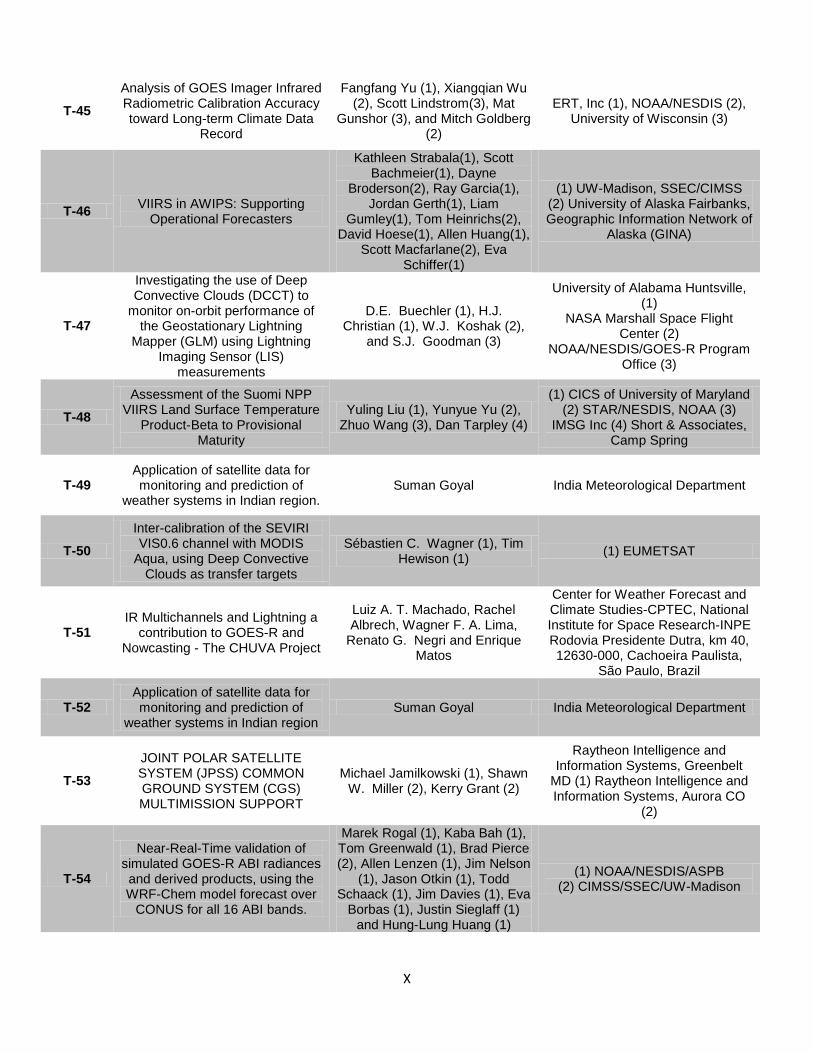
X
T-45
Analysis of GOES Imager Infrared Radiometric Calibration Accuracy toward Long-term Climate Data
Record
Fangfang Yu (1), Xiangqian Wu (2), Scott Lindstrom(3), Mat
Gunshor (3), and Mitch Goldberg (2)
ERT, Inc (1), NOAA/NESDIS (2), University of Wisconsin (3)
T-46 VIIRS in AWIPS: Supporting
Operational Forecasters
Kathleen Strabala(1), Scott Bachmeier(1), Dayne
Broderson(2), Ray Garcia(1), Jordan Gerth(1), Liam
Gumley(1), Tom Heinrichs(2), David Hoese(1), Allen Huang(1),
Scott Macfarlane(2), Eva Schiffer(1)
(1) UW-Madison, SSEC/CIMSS (2) University of Alaska Fairbanks, Geographic Information Network of
Alaska (GINA)
T-47
Investigating the use of Deep Convective Clouds (DCCT) to
monitor on-orbit performance of the Geostationary Lightning
Mapper (GLM) using Lightning Imaging Sensor (LIS)
measurements
D.E. Buechler (1), H.J. Christian (1), W.J. Koshak (2),
and S.J. Goodman (3)
University of Alabama Huntsville, (1)
NASA Marshall Space Flight Center (2)
NOAA/NESDIS/GOES-R Program Office (3)
T-48
Assessment of the Suomi NPP VIIRS Land Surface Temperature
Product-Beta to Provisional Maturity
Yuling Liu (1), Yunyue Yu (2), Zhuo Wang (3), Dan Tarpley (4)
(1) CICS of University of Maryland (2) STAR/NESDIS, NOAA (3)
IMSG Inc (4) Short & Associates, Camp Spring
T-49 Application of satellite data for monitoring and prediction of
weather systems in Indian region. Suman Goyal India Meteorological Department
T-50
Inter-calibration of the SEVIRI VIS0.6 channel with MODIS
Aqua, using Deep Convective Clouds as transfer targets
Sébastien C. Wagner (1), Tim Hewison (1)
(1) EUMETSAT
T-51 IR Multichannels and Lightning a
contribution to GOES-R and Nowcasting - The CHUVA Project
Luiz A. T. Machado, Rachel Albrech, Wagner F. A. Lima,
Renato G. Negri and Enrique Matos
Center for Weather Forecast and Climate Studies-CPTEC, National Institute for Space Research-INPE Rodovia Presidente Dutra, km 40, 12630-000, Cachoeira Paulista,
São Paulo, Brazil
T-52 Application of satellite data for monitoring and prediction of
weather systems in Indian region Suman Goyal India Meteorological Department
T-53
JOINT POLAR SATELLITE SYSTEM (JPSS) COMMON GROUND SYSTEM (CGS) MULTIMISSION SUPPORT
Michael Jamilkowski (1), Shawn W. Miller (2), Kerry Grant (2)
Raytheon Intelligence and Information Systems, Greenbelt
MD (1) Raytheon Intelligence and Information Systems, Aurora CO
(2)
T-54
Near-Real-Time validation of simulated GOES-R ABI radiances and derived products, using the WRF-Chem model forecast over
CONUS for all 16 ABI bands.
Marek Rogal (1), Kaba Bah (1), Tom Greenwald (1), Brad Pierce (2), Allen Lenzen (1), Jim Nelson
(1), Jason Otkin (1), Todd Schaack (1), Jim Davies (1), Eva
Borbas (1), Justin Sieglaff (1) and Hung-Lung Huang (1)
(1) NOAA/NESDIS/ASPB (2) CIMSS/SSEC/UW-Madison
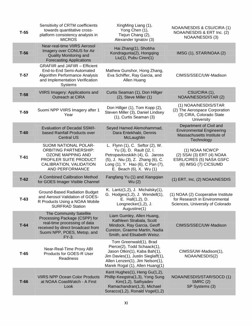
XI
T-55
Sensitivity of CRTM coefficients towards quantitative cross-
platform consistency analysis in MICROS
XingMing Liang (1), Yong Chen (1),
Tiejun Chang (2), Alexander Ignatov (3)
NOAA/NESDIS & CSU/CIRA (1) NOAA/NESDIS & ERT Inc. (2)
NOAA/NESDIS (3)
T-56
Near-real-time VIIRS Aerosol Imagery over CONUS for Air
Quality Monitoring and Forecasting Applications
Hai Zhang(1), Shobha Kondragunta(2), Hongqing
Liu(1), Pubu Ciren(1) IMSG (1), STAR/NOAA (2)
T-57
GRAFIIR and JAFIIR – Efficient End-to-End Semi-Automated
Algorithm Performance Analysis and Implementation Verification
Systems
Mathew Gunshor, Hong Zhang, Eva Schiffer, Ray Garcia, and
Allen Huang CIMSS/SSEC/UW-Madison
T-58 VIIRS Imagery: Applications and
Outreach at CIRA Curtis Seaman (1), Don Hillger
(2), Steve Miller (1) CSU/CIRA (1),
NOAA/NESDIS/STAR (2)
T-59 Suomi NPP VIIRS Imagery after 1
Year
Don Hillger (1), Tom Kopp (2), Steven Miller (3), Daniel Lindsey
(1), Curtis Seaman (3)
(1) NOAA/NESDIS/STAR (2) The Aerospace Corporation
(3) CIRA, Colorado State University
T-60 Evaluation of Decadal SSM/I-based Rainfall Products over
Central US
Seyed Hamed Alemohammad, Dara Entekhabi, Dennis
McLaughlin
Department of Civil and Environmental Engineering Massachusetts Institute of
Technology
T-61
SUOMI NATIONAL POLAR-ORBITING PARTNERSHIP:
OZONE MAPPING AND PROFILER SUITE PRODUCT CALIBRATION, VALIDATION
AND PERFORMANCE
L. Flynn (1), C. Seftor (2), W. Yu (3), D. Rault ()2, I.
Petropavlovskikh (4), G. Jaross (5), J. Niu (3), Z. Zhang (6), C. Long (1), Y. Hao (6), C Pan (7),
E. Beach (6), X. Wu (1)
(1) NOAA NCWCP (2) SSAI (3) ERT (4) NOAA
ESRL/CIRES (5) NASA GSFC (6) IMSG (7) CICSUMD
T-62 A Combined Calibration Method
for GOES Imager Visible Channel Fangfang Yu (1) and Xiangqian
Wu (2) (1) ERT, Inc, (2) NOAA/NESDIS
T-63
Ground-Based Radiation Budget and Aerosol Validation of GOES-R Products Using a NOAA Mobile
SURFRAD Station
K. Lantz(1,2), J. Michalsky(1), G. Hodges(1,2), J. Wendell(1),
E. Hall(1,2), D. Longnecker(1,2), J.
Augustine(1)
(1) NOAA (2) Cooperative Institute for Research in Environmental
Sciences, University of Colorado
T-64
The Community Satellite Processing Package (CSPP) for
real-time processing of data received by direct broadcast from Suomi NPP, POES, Metop, and
FY-3.
Liam Gumley, Allen Huang, Kathleen Strabala, Scott
Mindock, Ray Garcia, Geoff Cureton, Graeme Martin, Nadia
Smith, and Elisabeth Weisz.
CIMSS/SSEC/UW-Madison
T-65 Near-Real-Time Proxy ABI Products for GOES-R User
Readiness
Tom Greenwald(1), Brad Pierce(2), Todd Schaack(1), Jason Otkin(1), Kaba Bah(1),
Jim Davies(1), Justin Sieglaff(1), Allen Lenzen(1), Jim Nelson(1), Marek Rogal (1), Allen Huang(1)
CIMSS/UW-Madison(1), NOAA/NESDIS(2)
T-66 VIIRS NPP Ocean Color Products
at NOAA CoastWatch - A First Look
Kent Hughes(1), Heng Gu(1,2), Phillip Keegstra(1,3), Yong Sung
Kim(1,2), Sathyadev Ramachandran(1,3), Michael
Soracco(1,2), Ronald Vogel(1,2)
NOAA/NESDIS/STAR/SOCD (1) SMRC (2)
SP Systems (3)
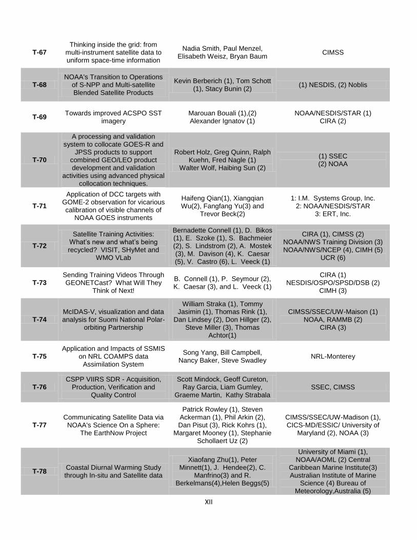
XII
T-67 Thinking inside the grid: from
multi-instrument satellite data to uniform space-time information
Nadia Smith, Paul Menzel, Elisabeth Weisz, Bryan Baum
CIMSS
T-68 NOAA's Transition to Operations
of S-NPP and Multi-satellite Blended Satellite Products
Kevin Berberich (1), Tom Schott (1), Stacy Bunin (2)
(1) NESDIS, (2) Noblis
T-69 Towards improved ACSPO SST
imagery Marouan Bouali (1),(2) Alexander Ignatov (1)
NOAA/NESDIS/STAR (1) CIRA (2)
T-70
A processing and validation system to collocate GOES-R and
JPSS products to support combined GEO/LEO product development and validation
activities using advanced physical collocation techniques.
Robert Holz, Greg Quinn, Ralph Kuehn, Fred Nagle (1)
Walter Wolf, Haibing Sun (2)
(1) SSEC (2) NOAA
T-71
Application of DCC targets with GOME-2 observation for vicarious calibration of visible channels of
NOAA GOES instruments
Haifeng Qian(1), Xiangqian Wu(2), Fangfang Yu(3) and
Trevor Beck(2)
1: I.M. Systems Group, Inc. 2: NOAA/NESDIS/STAR
3: ERT, Inc.
T-72
Satellite Training Activities: What’s new and what’s being recycled? VISIT, SHyMet and
WMO VLab
Bernadette Connell (1), D. Bikos (1), E. Szoke (1), S. Bachmeier (2), S. Lindstrom (2), A. Mostek (3), M. Davison (4), K. Caesar (5), V. Castro (6), L. Veeck (1)
CIRA (1), CIMSS (2) NOAA/NWS Training Division (3) NOAA/NWS/NCEP (4), CIMH (5)
UCR (6)
T-73 Sending Training Videos Through GEONETCast? What Will They
Think of Next!
B. Connell (1), P. Seymour (2), K. Caesar (3), and L. Veeck (1)
CIRA (1) NESDIS/OSPO/SPSD/DSB (2)
CIMH (3)
T-74 McIDAS-V, visualization and data analysis for Suomi National Polar-
orbiting Partnership
William Straka (1), Tommy Jasimin (1), Thomas Rink (1),
Dan Lindsey (2), Don Hillger (2), Steve Miller (3), Thomas
Achtor(1)
CIMSS/SSEC/UW-Maison (1) NOAA, RAMMB (2)
CIRA (3)
T-75 Application and Impacts of SSMIS
on NRL COAMPS data Assimilation System
Song Yang, Bill Campbell, Nancy Baker, Steve Swadley
NRL-Monterey
T-76 CSPP VIIRS SDR - Acquisition,
Production, Verification and Quality Control
Scott Mindock, Geoff Cureton, Ray Garcia, Liam Gumley,
Graeme Martin, Kathy Strabala SSEC, CIMSS
T-77 Communicating Satellite Data via
NOAA's Science On a Sphere: The EarthNow Project
Patrick Rowley (1), Steven Ackerman (1), Phil Arkin (2), Dan Pisut (3), Rick Kohrs (1),
Margaret Mooney (1), Stephanie Schollaert Uz (2)
CIMSS/SSEC/UW-Madison (1), CICS-MD/ESSIC/ University of
Maryland (2), NOAA (3)
T-78 Coastal Diurnal Warming Study through In-situ and Satellite data
Xiaofang Zhu(1), Peter Minnett(1), J. Hendee(2), C.
Manfrino(3) and R. Berkelmans(4),Helen Beggs(5)
University of Miami (1), NOAA/AOML (2) Central
Caribbean Marine Institute(3) Australian Institute of Marine
Science (4) Bureau of Meteorology,Australia (5)
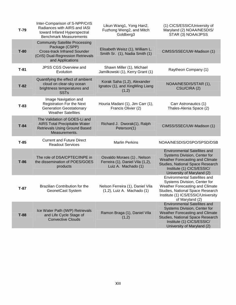
XIII
T-79
Inter-Comparison of S-NPP/CrIS Radiances with AIRS and IASI toward Infared Hyperspectral Benchmark Measurements
Likun Wang1, Yong Han2, Fuzhong Weng2, and Mitch
Goldberg3
(1) CICS/ESSIC/University of Maryland (2) NOAA/NESDIS/
STAR (3) NOAA/JPSS
T-80
Community Satellite Processing Package (CSPP)
Cross-track Infrared Sounder (CrIS) Dual-Regression Retrievals
and Applications
Elisabeth Weisz (1), William L. Smith Sr. (1), Nadia Smith (1)
CIMSS/SSEC/UW-Madison (1)
T-81 JPSS CGS Overview and
Evolution Shawn Miller (1), Michael
Jamilkowski (1), Kerry Grant (1) Raytheon Company (1)
T-82
Quantifying the effect of ambient cloud on clear-sky ocean
brightness temperatures and SSTs
Korak Saha (1,2), Alexander Ignatov (1), and XingMing Liang
(1,2)
NOAA/NESDIS/STAR (1), CSU/CIRA (2)
T-83
Image Navigation and Registration For the Next Generation Geostationary
Weather Satellites
Houria Madani (1), Jim Carr (1), Francis Olivier (2)
Carr Astronautics (1) Thales-Alenia Space (2)
T-84
The Validation of GOES-Li and AIRS Total Precipitable Water
Retrievals Using Ground Based Measurements.
Richard J. Dworak(1), Ralph Peterson(1)
CIMSS/SSEC/UW-Madison (1)
T-85 Current and Future Direct
Readout Services Marlin Perkins NOAA/NESDIS/OSPO/SPSD/DSB
T-86 The role of DSA/CPTEC/INPE in
the dissemination of POES/GOES products
Osvaldo Moraes (1) , Nelson Ferreira (1), Daniel Vila (1,2),
Luiz A. Machado (1)
Environmental Satellites and Systems Division, Center for
Weather Forecasting and Climate Studies, National Space Research
Institute (1) CICS/ESSIC/ University of Maryland (2)
T-87 Brazilian Contribution for the
GeonetCast System Nelson Ferreira (1), Daniel Vila
(1,2), Luiz A. Machado (1)
Environmental Satellites and Systems Division, Center for
Weather Forecasting and Climate Studies, National Space Research Institute (1) ICS/ESSIC/University
of Maryland (2)
T-88 Ice Water Path (IWP) Retrievals
and Life Cycle Stage of Convective Clouds
Ramon Braga (1), Daniel Vila (1,2)
Environmental Satellites and Systems Division, Center for
Weather Forecasting and Climate Studies, National Space Research
Institute (1) CICS/ESSIC/ University of Maryland (2)
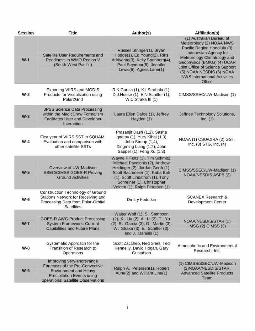
I
Session Title Author(s) Affiliation(s)
W-1 Satellite User Requirements and
Readiness in WMO Region V (South-West Pacific)
Russell Stringer(1), Bryan Hodge(1), Ed Young(2), Riris
Adriyanto(3), Kelly Sponberg(4), Paul Seymour(5), Jennifer Lewis(6), Agnes Lane(1)
(1) Australian Bureau of Meteorology (2) NOAA NWS Pacific Region Honolulu (3)
Indonesian Agency for Meteorology Climatology and
Geophysics (BMKG) (4) UCAR Joint Office of Science Support (5) NOAA NESDIS (6) NOAA NWS International Activities
Office
W-2 Exporting VIIRS and MODIS
Products for Visualization using Polar2Grid
R.K.Garcia (1), K.I.Strabala (1), D.J.Hoese (1), E.N.Schiffer (1),
W.C.Straka III (1) CIMSS/SSEC/UW-Madison (1)
W-3
JPSS Science Data Processing within the MagicDraw Formalism Facilitates User and Developer
Interaction
Laura Ellen Dafoe (1), Jeffrey Hayden (1)
Jeffries Technology Solutions, Inc. (1)
W-4 First year of VIIRS SST in SQUAM:
Evaluation and comparison with other satellite SSTs
Prasanjit Dash (1,2), Sasha Ignatov (1), Yury Kihai (1,3),
John Stroup (1,4), Xingming Liang (1,2), John Sapper (1), Feng Xu (1,3)
NOAA (1) CSU/CIRA (2) GST, Inc, (3) STG, Inc, (4)
W-5 Overview of UW-Madison
SSEC/CIMSS GOES-R Proving Ground Activities
Wayne F Feltz (1), Tim Schmit2, Michael Pavolonis (2), Andrew Heidinger (2), Jordan Gerth (1), Scott Bachmeier (1), Kaba Bah (1), Scott Lindstrom (1), Tony
Schreiner (1), Christopher Velden (1), Ralph Petersen (1)
CIMSS/SSEC/UW-Madison (1) NOAA/NESDIS ASPB (2)
W-6
Construction Technology of Ground Stations Network for Receiving and Processing Data from Polar-Orbital
Satellites
Dmitry Fedotkin SCANEX Research & Development Center
W-7 GOES-R AWG Product Processing
System Framework: Current Capibilities and Future Plans
Walter Wolf (1), S. Sampson (2), X. Liu (2), A. Li (2), T. Yu
(2), R. Garcia (3), G. Martin (3), W. Straka (3), E. Schiffer (3),
and J. Daniels (1)
NOAA/NESDIS/STAR (1) IMSG (2) CIMSS (3)
W-8 Systematic Approach for the
Transition of Research to Operations
Scott Zaccheo, Ned Snell, Ted Kennelly, David Hogan, Gary
Gustafson
Atmospheric and Environmental Research, Inc.
W-9
Improving very-short-range Forecasts of the Pre-Convective
Environment and Heavy Precipitation Events using
operational Satellite Observations
Ralph A. Petersen(1), Robert Aune(2) and William Line(1)
(1) CIMSS/SSEC/UW-Madison (2)NOAA/NESDIS/STAR,
Advanced Satellite Products Team

II
W-10
GENERATING REAL-TIME AND CLIMATE PRODUCTS IN
SUPPORT OF SOLAR ENERGY APPLICATIONS
Andrew Heidinger(1), Christine Molling(2), Willliam Straka III(2),
and Michael Foster(2)
NESDIS (1) UW/CIMSS(2)
W-11 Jason altimetry and NOAA's Sea
Level Climate Data Record
Eric Leuliette (1), Remko Scharroo (1,2), John Lillibridge (1), Gary Mitchum (3), Deirdre
Byrne (4), Laury Miller (1)
NOAA/NESDIS/STAR/Lab. for Satellite Altimetry (1), Altimetrics
LLC (2), University of South Florida (3),
NOAA/NESDIS/NODC (4)
W-12 CLOUD CLIMATE APPLICATIONS
FOR THE AVHRR RECORD Michael J Foster (1), Andrew
Heidinger (2)
CIMSS, University of Wisconsin, Madison, WI, USA (1)
NOAA/NESDIS/STAR UW-Madison (2)
W-13 Partnerships in the Use of GOES
SST in the CONUS P. Ted Strub (1), Alexandre Kurapov (1), David Foley (2)
(1) CIOSS (2) NOAA/NESDIS Center for
Satellite Applications and Research, CoastWatch West
Coast Node
W-14 The Jason Altimetry Missions - NOAA/EUMETSAT Operational
Products & Applications
John Lillibridge (1), David Donahue (2), Julia Figa-Saldaña
(3), and Olivier Thépaut (3)
(NOAA/NESDIS Center for Satellite Applications and Research, Laboratory for
Satellite Altimetry (1), NOAA/NESDIS Office of
Satellite and Product Operations, Satellite Products
Branch (2), EUMETSAT Technical and Scientific Support
Department, Remote Sensing and Products Division (3)
W-15
Satellite Data Collaborations Between NOAA and the University of Wisconsin SSEC Data Center -
Past, Present, and Future
Jerrold Robaidek(1), Thomas Achtor(1), Delores Wade(1)
SSEC/UW-Madison
W-16
Toward beter understanding of passive remote sensing of cloud
droplet effective radius: A combination of LES model and 3-D
radiative transfer model
Zhibo Zhang(1,2,3), Andrew S. Ackerman(4), Graham
Feingold(5), Steven Platnick(3), Robert Pincus(5,6) and Huiwen
Xue(7)
(1) University of Maryland Baltimore County, (2) Joint Center for Earth Systems
Technology, (3) Laboratory for Atmospheres, NASA GSFC (4)
NASA Goddard Institute for Space Studies (5) University of
Colorado (6) NOAA/Earth System Research Laboratory (7)
Peking University
W-17
The CrIS, IASI and AIRS - A Perspective on Hyper-Spectral Infrared Sounder Retrievals, Validation, and Applications
Murty Divakarla (1), Chris Barnet (2), M.Wilson (1), E. Maddy (3),
A. Gambacorta(1), N. Nalli (1),C. Tan(1), and X. Xiong(1)
IM Systems Group, Inc. (1) NOAA/STAR (2)
Science and Technology Corporation (3)
W-18
GOES-R Rain Estimation with Combined ABI and GLM Data--Development and Testing of a Technique with TRMM Data
Robert Adler, Weixin Xu, Nai-Yu Wang
ESSIC/CICS/University of Mayland
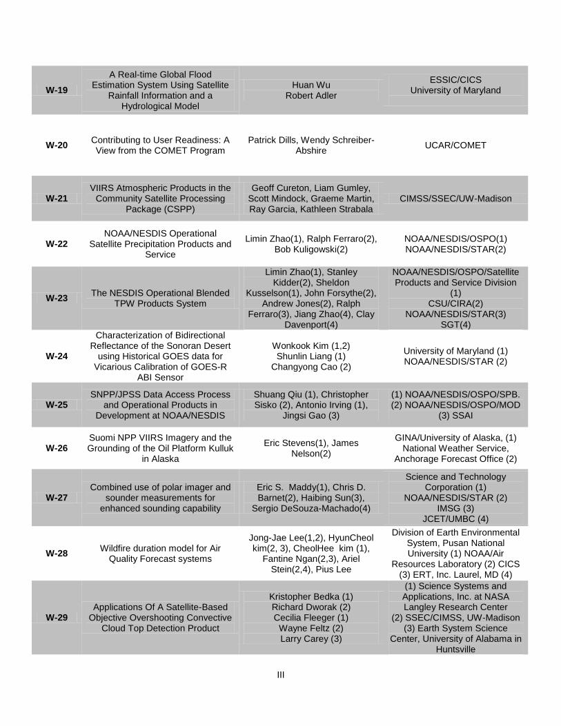
III
W-19
A Real-time Global Flood Estimation System Using Satellite
Rainfall Information and a Hydrological Model
Huan Wu Robert Adler
ESSIC/CICS University of Maryland
W-20 Contributing to User Readiness: A View from the COMET Program
Patrick Dills, Wendy Schreiber-Abshire
UCAR/COMET
W-21 VIIRS Atmospheric Products in the
Community Satellite Processing Package (CSPP)
Geoff Cureton, Liam Gumley, Scott Mindock, Graeme Martin, Ray Garcia, Kathleen Strabala
CIMSS/SSEC/UW-Madison
W-22 NOAA/NESDIS Operational
Satellite Precipitation Products and Service
Limin Zhao(1), Ralph Ferraro(2), Bob Kuligowski(2)
NOAA/NESDIS/OSPO(1) NOAA/NESDIS/STAR(2)
W-23 The NESDIS Operational Blended
TPW Products System
Limin Zhao(1), Stanley Kidder(2), Sheldon
Kusselson(1), John Forsythe(2), Andrew Jones(2), Ralph
Ferraro(3), Jiang Zhao(4), Clay Davenport(4)
NOAA/NESDIS/OSPO/Satellite Products and Service Division
(1) CSU/CIRA(2)
NOAA/NESDIS/STAR(3) SGT(4)
W-24
Characterization of Bidirectional Reflectance of the Sonoran Desert
using Historical GOES data for Vicarious Calibration of GOES-R
ABI Sensor
Wonkook Kim (1,2) Shunlin Liang (1)
Changyong Cao (2)
University of Maryland (1) NOAA/NESDIS/STAR (2)
W-25 SNPP/JPSS Data Access Process
and Operational Products in Development at NOAA/NESDIS
Shuang Qiu (1), Christopher Sisko (2), Antonio Irving (1),
Jingsi Gao (3)
(1) NOAA/NESDIS/OSPO/SPB. (2) NOAA/NESDIS/OSPO/MOD
(3) SSAI
W-26 Suomi NPP VIIRS Imagery and the Grounding of the Oil Platform Kulluk
in Alaska
Eric Stevens(1), James Nelson(2)
GINA/University of Alaska, (1) National Weather Service,
Anchorage Forecast Office (2)
W-27 Combined use of polar imager and
sounder measurements for enhanced sounding capability
Eric S. Maddy(1), Chris D. Barnet(2), Haibing Sun(3),
Sergio DeSouza-Machado(4)
Science and Technology Corporation (1)
NOAA/NESDIS/STAR (2) IMSG (3)
JCET/UMBC (4)
W-28 Wildfire duration model for Air
Quality Forecast systems
Jong-Jae Lee(1,2), HyunCheol kim(2, 3), CheolHee kim (1),
Fantine Ngan(2,3), Ariel Stein(2,4), Pius Lee
Division of Earth Environmental System, Pusan National University (1) NOAA/Air
Resources Laboratory (2) CICS (3) ERT, Inc. Laurel, MD (4)
W-29 Applications Of A Satellite-Based
Objective Overshooting Convective Cloud Top Detection Product
Kristopher Bedka (1) Richard Dworak (2) Cecilia Fleeger (1)
Wayne Feltz (2) Larry Carey (3)
(1) Science Systems and Applications, Inc. at NASA Langley Research Center
(2) SSEC/CIMSS, UW-Madison (3) Earth System Science
Center, University of Alabama in Huntsville
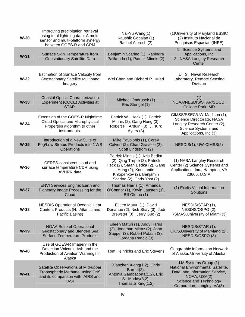
IV
W-30
Improving precipitation retrieval using total lightning data: A multi-sensor and multi-platform synergy
between GOES-R and GPM
Nai-Yu Wang(1) Kaushik Gopalan (1) Rachel Albrecht(2)
(1)University of Maryland ESSIC (2) Instituto Nacional de
Pesquisas Espacias (INPE)
W-31 Surface Skin Temperature from
Geostationary Satellite Data Benjamin Scarino (1), Rabindra Palikonda (1), Patrick Minnis (2)
1. Science Systems and Applications, Inc
2. NASA Langley Research Center
W-32 Estimation of Surface Velocity from Geostationary Satellite Multiband
Imagery Wei Chen and Richard P. Mied
U. S. Naval Research Laboratory, Remote Sensing
Division
W-33 Coastal Optical Characterization Experiment (COCE) Activities at
STAR.
Michael Ondrusek (1) Eric Stengel (1)
(1) NOAA/NESDIS/STAR/SOCD,
College Park, MD
W-34
Extension of the GOES-R Nighttime Cloud Optical and Microphysical
Properties algorithm to other instruments.
Patrick W. Heck (1), Patrick Minnis (2), Gang Hong (3),
Robert F. Arduini (3), J. Kirk Ayers (3)
CIMSS/SSEC/UW-Madison (1), Science Directorate, NASA
Langley Research Center (2), Science Systems and Applications, Inc (3)
W-35 Introduction of a New Suite of
Fog/Low Stratus Products into NWS Operations
Mike Pavolonis (1), Corey Calvert (2), Chad Gravelle (2),
Scott Lindstrom (2) NESDIS(1), UW-CIMSS(2)
W-36 CERES-consistent cloud and
surface temperature CDR using AVHRR data
Patrick Minnis (1), Kris Bedka (2), Qing Trepte (2), Patrick
Heck (2), Sarah Bedka (2), Gang Hong (2), Konstantin
Khlopenkov (2), Benjamin Scarino (2), Chris Yost (2)
(1) NASA Langley Research Center (2) Science Systems and Applications, Inc., Hampton, VA
23666, U.S.A.
W-37 ENVI Services Engine: Earth and
Planetary Image Processing for the Cloud
Thomas Harris (1), Amanda O'Connor (1), Kevin Lausten (1),
Bill Okubo (1)
(1) Exelis Visual Information Solutions
W-38 NESDIS Operational Oceanic Heat Content Products (N. Atlantic and
Pacific Basins)
Eileen Maturi (1), David Donahue (2), Nick Shay (3), Jodi
Brewster (3) , Jerry Guo (2)
NESDIS/STAR (1), NESDIS/OSPO (2),
RSMAS,University of Miami (3)
W-39 NOAA Suite of Operational
Geostationary and Blended Sea Surface Temperature Products
Eileen Maturi (1), Andy Harris (2), Jonathan Mittaz (2), John Sapper (3), Robert Potash (3),
Gordana Rancic (3)
NESDIS/STAR (1), CICS,University of Maryland (2),
NESDIS/OSPO (3)
W-40
Use of GOES-R Imagery in the Detection Volcanic Ash and the
Production of Aviation Warnings in Alaska
Tom Heinrichs and Eric Stevens Geographic Information Network of Alaska, University of Alaska,
W-41
Satellite Observations of Mid-upper Tropospheric Methane using CrIS and its comparison with AIRS and
IASI
Xiaozhen Xiong(1,2), Chris Barnet(2),
Antonia Gambacorta(1,2), Eric S. Maddy(3,2),
Thomas.S.King(1,2)
I.M.Systems Group (1) National Environmental Satellite, Data, and Information Service,
NOAA, USA(2) Science and Technology
Corporation, Langley, VA(3)
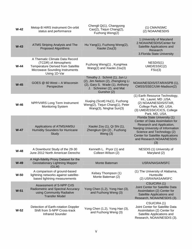
V
W-42 Metop-B HIRS instrument On-orbit
status and performance
Chengli Qi(1), Changyong Cao(2), Tiejun Chang(2),
Fuzhong Weng(2)
(1) CMA/NSMC (2) NOAA/NESDIS
W-43 ATMS Striping Analysis and The
Proposed Algorithms Hu Yang(1), Fuzhong Weng(2),
Xiaolei Zou(3)
1.University of Maryland 2.NOAA/NESDIS/Center for
Satellite Applications and Research
3.Florida State University
W-44
A Thematic Climate Data Record (TCDR) of Atmospheric
Temperature Derived from Satellite Microwave Sounding Instruments
Using 1D-Var
Fuzhong Weng(1) , KungHwa Wang(2) and Xiaolei Zou(3)
NESDIS(1) UMD/ESSIC(2)
FSU(3)
W-45 GOES @ 60 West – A Wisconsin
Perspective
Timothy J. Schmit (1), Jun Li (2), Jim Nelson (2), Zhenglong Li (2), Gary S. Wade (1), Anthony
J. Schreiner (2), and Mat Gunshor (2)
NOAA/NESDIS/STAR/ASPB (1), CMSS/SSEC/UW-Madison(2)
W-46 NPP/VIIRS Long Term Instrument
Monitoring System
Xiuqing (Scott) Hu(1), Fuzhong Weng(2), Tiejun Chang(1), Peter
Wang(3), Ninghai Sun(3)
(1) Earth Resource Technology, Int., Laurel, MD ,USA.
(2) NOAA/NESDIS/STAR, College Park, MD ,USA.
(3) UMD/ESSIC/CICS, College Park, MD, USA.
W-47 Applications of ATMS/AMSU
Humidity Sounders for Hurricane Study
Xiaolei Zou (1), Qi Shi (1), Zhengkun Qin (2) , Fuzhong
Weng (3)
Florida State University (1) Center of Data Assimilation for
Research and Application, Nanjing University of Information
Science and Technology (2) Center for Satellite Applications and Research,NOAA/NESDIS
(3)
W-48 A Downburst Study of the 29-30
June 2012 North American Derecho Kenneth L. Pryor (1) and
Colleen Wilson (2) NESDIS (1) University of
Maryland (2)
W-49 A High-fidelity Proxy Dataset for the
Geostationary Lightning Mapper (GLM)
Monte Bateman USRA/NASA/MSFC
W-50 A comparison of ground-based
lightning networks against satellite-based lightning measurements
Kelsey Thompson (1) Monte Bateman (2)
(1) The University of Alabama, Huntsville
(2) USRA/NASA/MSFC
W-51
Assessment of S-NPP CrIS Radiometric and Spectral Accuracy
using Community Radiative Transfer Model
Yong Chen (1,2), Yong Han (3), and Fuzhong Weng (3)
CSU/CIRA (1) Joint Center for Satellite Data
Assimilation (2) Center for Satellite Applications and
Research, NOAA/NESDIS (3).
W-52 Detection of Earth-rotation Doppler
Shift from S-NPP Cross-track Infrared Sounder
Yong Chen (1,2), Yong Han (3), and Fuzhong Weng (3)
CSU/CIRA (1) Joint Center for Satellite Data
Assimilation (2) Center for Satellite Applications and
Research, NOAA/NESDIS (3).
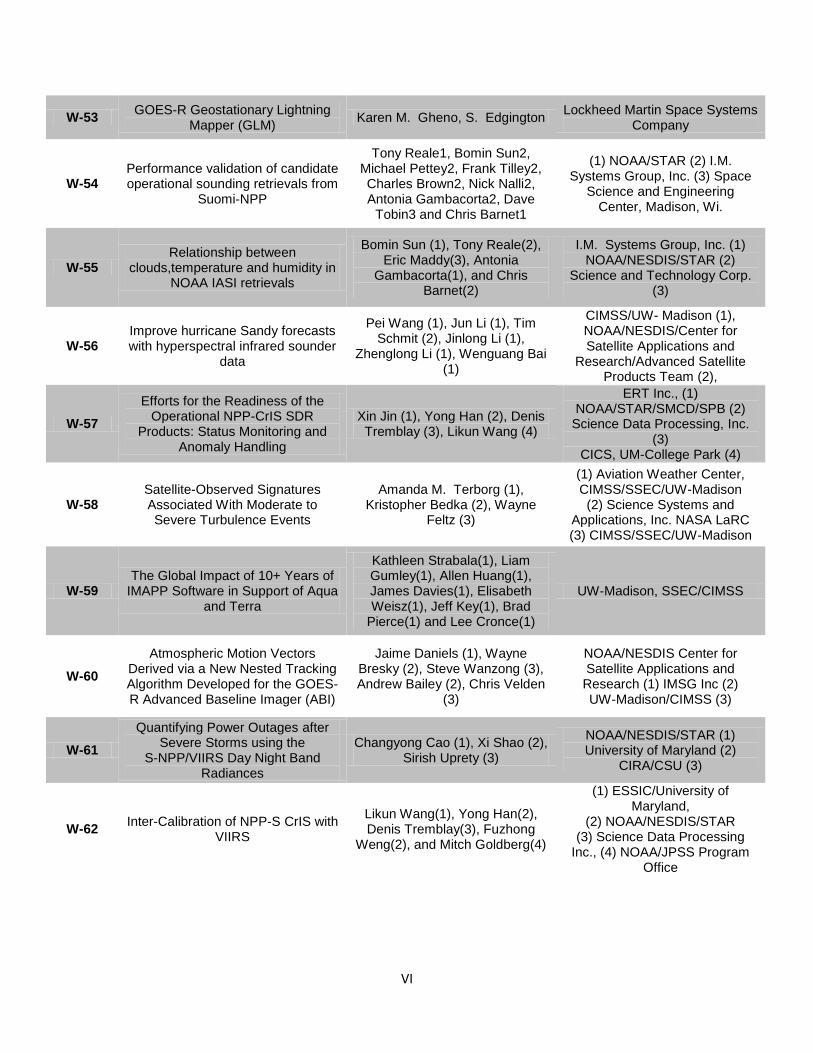
VI
W-53 GOES-R Geostationary Lightning
Mapper (GLM) Karen M. Gheno, S. Edgington
Lockheed Martin Space Systems Company
W-54 Performance validation of candidate operational sounding retrievals from
Suomi-NPP
Tony Reale1, Bomin Sun2, Michael Pettey2, Frank Tilley2, Charles Brown2, Nick Nalli2, Antonia Gambacorta2, Dave
Tobin3 and Chris Barnet1
(1) NOAA/STAR (2) I.M. Systems Group, Inc. (3) Space
Science and Engineering Center, Madison, Wi.
W-55 Relationship between
clouds,temperature and humidity in NOAA IASI retrievals
Bomin Sun (1), Tony Reale(2), Eric Maddy(3), Antonia
Gambacorta(1), and Chris Barnet(2)
I.M. Systems Group, Inc. (1) NOAA/NESDIS/STAR (2)
Science and Technology Corp. (3)
W-56 Improve hurricane Sandy forecasts with hyperspectral infrared sounder
data
Pei Wang (1), Jun Li (1), Tim Schmit (2), Jinlong Li (1),
Zhenglong Li (1), Wenguang Bai (1)
CIMSS/UW- Madison (1), NOAA/NESDIS/Center for Satellite Applications and
Research/Advanced Satellite Products Team (2),
W-57
Efforts for the Readiness of the Operational NPP-CrIS SDR
Products: Status Monitoring and Anomaly Handling
Xin Jin (1), Yong Han (2), Denis Tremblay (3), Likun Wang (4)
ERT Inc., (1) NOAA/STAR/SMCD/SPB (2)
Science Data Processing, Inc. (3)
CICS, UM-College Park (4)
W-58 Satellite-Observed Signatures Associated With Moderate to Severe Turbulence Events
Amanda M. Terborg (1), Kristopher Bedka (2), Wayne
Feltz (3)
(1) Aviation Weather Center, CIMSS/SSEC/UW-Madison (2) Science Systems and
Applications, Inc. NASA LaRC (3) CIMSS/SSEC/UW-Madison
W-59 The Global Impact of 10+ Years of
IMAPP Software in Support of Aqua and Terra
Kathleen Strabala(1), Liam Gumley(1), Allen Huang(1), James Davies(1), Elisabeth Weisz(1), Jeff Key(1), Brad
Pierce(1) and Lee Cronce(1)
UW-Madison, SSEC/CIMSS
W-60
Atmospheric Motion Vectors Derived via a New Nested Tracking Algorithm Developed for the GOES-R Advanced Baseline Imager (ABI)
Jaime Daniels (1), Wayne Bresky (2), Steve Wanzong (3), Andrew Bailey (2), Chris Velden
(3)
NOAA/NESDIS Center for Satellite Applications and Research (1) IMSG Inc (2) UW-Madison/CIMSS (3)
W-61
Quantifying Power Outages after Severe Storms using the
S-NPP/VIIRS Day Night Band Radiances
Changyong Cao (1), Xi Shao (2), Sirish Uprety (3)
NOAA/NESDIS/STAR (1) University of Maryland (2)
CIRA/CSU (3)
W-62 Inter-Calibration of NPP-S CrIS with
VIIRS
Likun Wang(1), Yong Han(2), Denis Tremblay(3), Fuzhong
Weng(2), and Mitch Goldberg(4)
(1) ESSIC/University of Maryland,
(2) NOAA/NESDIS/STAR (3) Science Data Processing
Inc., (4) NOAA/JPSS Program Office
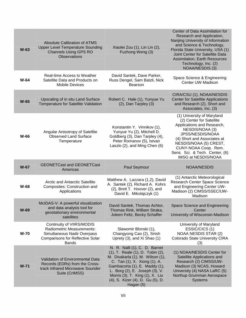
VII
W-63
Absolute Calibration of ATMS Upper Level Temperature Sounding
Channels Using GPS RO Observations
Xiaolei Zou (1), Lin Lin (2), Fuzhong Weng (3)
Center of Data Assimilation for Research and Application,
Nanjing University of Information and Science & Technology,
Florida State University, USA (1) Joint Center for Satellite Data Assimilation, Earth Resources
Technology, Inc. (2) NOAA/NESDIS (3)
W-64 Real-time Access to Weather Satellite Data and Products on
Mobile Devices
David Santek, Dave Parker, Russ Dengel, Sam Batzli, Nick
Bearson
Space Science & Engineering Center UW-Madison
W-65 Upscaling of in situ Land Surface
Temperature for Satellite Validation Robert C. Hale (1), Yunyue Yu
(2), Dan Tarpley (3)
CIRA/CSU (1), NOAA/NESDIS Center for Satellite Applications
and Research (2), Short and Associates, Inc. (3)
W-66 Angular Anisotropy of Satellite
Observed Land Surface Temperature
Konstantin Y. Vinnikov (1), Yunyue Yu (2), Mitchell D.
Goldberg (3), Dan Tarpley (4), Peter Romanov (5), Istvan
Laszlo (2), and Ming Chen (6)
(1) University of Maryland (2) Center for Satellite
Applications and Research, NESDIS/NOAA (3)
JPSS/NESDIS/NOAA (4) Short and Associates at NESDIS/NOAA (5) CREST, CUNY-NOAA Coop. Rem.
Sens. Sci. & Tech. Center, (6) IMSG at NESDIS/NOAA
W-67 GEONETCast and GEONETCast
Americas Paul Seymour NOAA/NESDIS
W-68 Arctic and Antarctic Satellite
Composites: Construction and Applications
Matthew A. Lazzara (1,2), David A. Santek (2), Richard A. Kohrs
(2), Brett T. Hoover (2), and David E. Mikolajczyk (1)
(1) Antarctic Meteorological Research Center Space Science
and Engineering Center UW-Madison (2) CIMSS/SSEC/UW-
Madison
W-69
McIDAS-V: A powerful visualization and data analysis tool for
geostationary environmental satellites
David Santek, Thomas Achtor, Thomas Rink, William Straka, Joleen Feltz, Becky Schaffer
Space Science and Engineering Center
University of Wisconsin-Madison
W-70
Continuity of VIIRS/MODIS Radiometric Measurements:
Simultaneous Nadir Overpass Comparisons for Reflective Solar
Bands
Slawomir Blonski (1), Changyong Cao (2), Sirish Uprety (3), and Xi Shao (1)
University of Maryland ESSIC/CICS (1)
NOAA NESDIS STAR (2) Colorado State University CIRA
(3)
W-71
Validation of Environmental Data Records (EDRs) from the Cross-track Infrared Microwave Sounder
Suite (CrIMSS)
N. R. Nalli (1), C. D. Barnet (1), T. Reale (1), D. Tobin (2),
M. Divakarla (1), M. Wilson (1), C. Tan (1), X. Xiong (1), A.
Gambacorta (1), E. Maddy (1), L. Borg (2), E. Joseph (3), V. Morris (3), T. King (1), X. Liu (4), S. Kizer (4), D. Gu (5), D.
Hagan (5)
(1) NOAA/NESDIS Center for Satellite Applications and Research (2) CIMSS/UW-
Madison (3) NCAS, Howard University (4) NASA LaRC (5) Northup Grumman Aerospace
Systems

VIII
W-71
Dedicated Radiosonde Campaign for Validation of Environmental Data
Records (EDRs) from the Suomi NPP Cross-track Infrared
Microwave Sounder Suite (CrIMSS)
N. R. Nalli (1), C. D. Barnet (1), D. Tobin (2), L. Borg (2), E. Joseph (3), V. R. Morris (3), D.
Wolfe (4), M. Oyola (3), T. Reale (1), A. Gambacorta (1),
E. S. Maddy (1), M. Wilson (1), C. Tan (1), X. Xiong (1), T. King (1), M. Divakarla (1)
(1) NOAA/NESDIS Center for Satellite Applications and Research (2) CIMSS/UW-
Madison (3) NCAS, Howard University (4) NOAA/ESRL,
W-72
Mesoscale assimilation of AIRS and other satellite data in the Rapid Refresh system: strategies and
impacts
Haidao Lin (1), Steve Weygandt (2), Tim Schmit (3)
(1) CIRA, (2) NOAA-ESRL/GSD, (3) NOAA/NESDIS/STAR
W-73 Current capabilities for identifying turbulence from real-time satellite
imagery
Anthony Wimmers Wayne Feltz
Sarah Monette CIMSS/UW-Madison
W-74
Atmospheric Motion Vectors Derived via a New Nested Tracking Algorithm Developed for the GOES-R Advanced Baseline Imager (ABI)
Jaime Daniels (1), Wayne Bresky (2), Steven Wanzong (3), Andrew Bailey (2), Chris Velden
(3)
(1) NOAA/NESDIS/OAR, (2) IMSG, (3) CIMSS/SSEC
W-75
Radiometric Comparison between Suomi NPP VIIRS and AQUA
MODIS using Extended Simultaneous Nadir Overpass
in the Low Latitudes
Sirish Uprety (1), Changyong Cao (2), Slawomir Blonski (3), Xi
Shao (3)
(1) CIRA, (2) NOAA/NESDIS/STAR, (3)
University of Maryland
W-76 Societal Impacts of Space Weather William Denig (1), Steven Hill (2) (1) NOAA/NESDIS/NGDC, (2)
NOAA/NWS/SWPC
W-77 Design and Implementation of a
Next-Generation Ground System for Jason/OSTM Mission
Abhishek Agarwal (1), Shahram Tehranian (1), Subir Vasanth (1), Ye Men (1), Inderjeet Saggu (1), Mark Sears (1), Desmond Smith
(1), Angelo Wade (2)
(1) Avaya Government Solution, (2) NOAA/NESDIS/OSD/GSD
W-78
Sustaining Ground System Operations for GOES-NOP Mission
with GOES Enterprise Managed System (GEMS)
Shahram Tehranian (1), Abhishek Agarwal (1), Subir
Vasanth (1), Keith McKenzie (2)
(1) Avaya Government Solution, (2) NOAA/NESDIS/OSD
W-79
Collaboration with NASA SPoRT: Supporting the Transition of New
Satellite Products into NWS Operational Forecasting and Decision Support Services
Brian Guyer and Deirdre Kann NWS Albuquerque
W-80
Training in the NOAA Satellite Proving Ground –
Getting Users Ready for Rapid Changes
LeRoy Spayd (1), Anthony Mostek (1), Brian Motta (1),
James Gurka (2), Mark DeMaria (2), Tim Schmit (2)
(1) NOAA/NWS/OCWWS/Training Division, (2) NOAA Satellite and
Information Service
W-81 Validation and Improvement of the GOES-R Rainfall Rate Algorithm
Robert J. Kuligowski and Yaping Li
NOAA/NESDIS/STAR, Camp Springs, MD
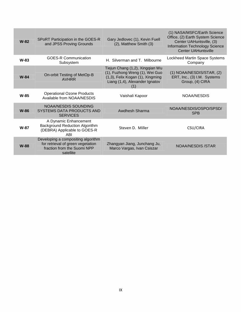
IX
W-82 SPoRT Participation in the GOES-R
and JPSS Proving Grounds Gary Jedlovec (1), Kevin Fuell
(2), Matthew Smith (3)
(1) NASA/MSFC/Earth Science Office, (2) Earth System Science
Center UAHuntsville, (3) Information Technology Science
Center UAHuntsville
W-83 GOES-R Communication
Subsystem H. Silverman and T. Milbourne
Lockheed Martin Space Systems Company
W-84 On-orbit Testing of MetOp-B
AVHRR
Tiejun Chang (1,2), Xingqian Wu (1), Fuzhong Weng (1), Wei Guo (1,3), Felix Kogan (1), Xingming Liang (1,4), Alexander Ignatov
(1)
(1) NOAA/NESDIS/STAR, (2) ERT, Inc., (3) I.M. Systems
Group, (4) CIRA
W-85 Operational Ozone Products
Available from NOAA/NESDIS Vaishali Kapoor NOAA/NESDIS
W-86 NOAA/NESDIS SOUNDING
SYSTEMS DATA PRODUCTS AND SERVICES
Awdhesh Sharma NOAA/NESDIS/OSPO/SPSD/
SPB
W-87
A Dynamic Enhancement Background Reduction Algorithm (DEBRA) Applicable to GOES-R
ABI
Steven D. Miller CSU/CIRA
W-88
Developing a compositing algorithm for retrieval of green vegetation
fraction from the Suomi NPP satellite
Zhangyan Jiang, Junchang Ju, Marco Vargas, Ivan Csiszar
NOAA/NESDIS /STAR

X
APPENDIX C List of Exhibitors
NOAA/NWS
NOAA/NESDIS
NOAA/NESDIS/STAR
ERT, Inc.
University of Wisconsin Space Science and Engineering Center
Vaisala
Orbital Systems, LTD (Silver Sponsor)
Stevens Water Monitoring Systems, Inc.
Sutron Corporation
SeaSpace Corporation
EMC Corporation
Global Imaging, Inc.
Lockheed Martin Space Systems Company
ASRC Federal Space & Defense
Hydrological Services USA
Design Analysis Associates
NOAA/NESDIS/OSPO/GEONETCast Americas
NOAA/NESDIS/OSPO/HRIT/EMWIN
Microcom Design
Harris Corporation
Kongsberg Spacetec
IM Systems Group, Inc.
Avaya Government Solutions
Global Science and Technologies (GST)
Morcom (Sponsor)
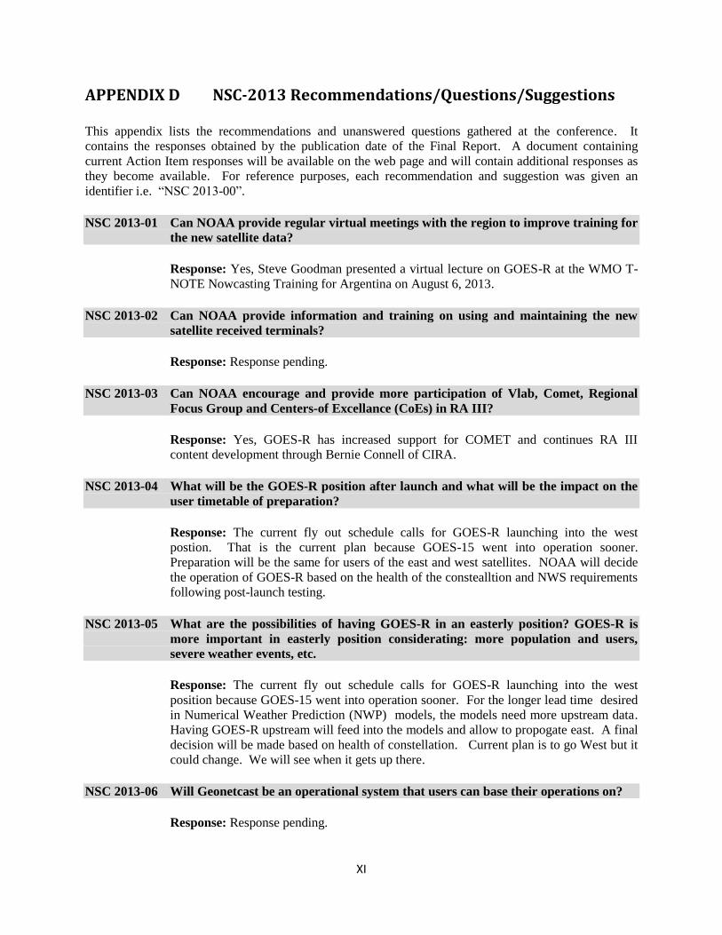
XI
APPENDIX D NSC-2013 Recommendations/Questions/Suggestions
This appendix lists the recommendations and unanswered questions gathered at the conference. It
contains the responses obtained by the publication date of the Final Report. A document containing
current Action Item responses will be available on the web page and will contain additional responses as
they become available. For reference purposes, each recommendation and suggestion was given an
identifier i.e. “NSC 2013-00”.
NSC 2013-01 Can NOAA provide regular virtual meetings with the region to improve training for
the new satellite data?
Response: Yes, Steve Goodman presented a virtual lecture on GOES-R at the WMO T-
NOTE Nowcasting Training for Argentina on August 6, 2013.
NSC 2013-02 Can NOAA provide information and training on using and maintaining the new
satellite received terminals?
Response: Response pending.
NSC 2013-03 Can NOAA encourage and provide more participation of Vlab, Comet, Regional
Focus Group and Centers-of Excellance (CoEs) in RA III?
Response: Yes, GOES-R has increased support for COMET and continues RA III
content development through Bernie Connell of CIRA.
NSC 2013-04 What will be the GOES-R position after launch and what will be the impact on the
user timetable of preparation?
Response: The current fly out schedule calls for GOES-R launching into the west
postion. That is the current plan because GOES-15 went into operation sooner.
Preparation will be the same for users of the east and west satellites. NOAA will decide
the operation of GOES-R based on the health of the constealltion and NWS requirements
following post-launch testing.
NSC 2013-05 What are the possibilities of having GOES-R in an easterly position? GOES-R is
more important in easterly position considerating: more population and users,
severe weather events, etc.
Response: The current fly out schedule calls for GOES-R launching into the west
position because GOES-15 went into operation sooner. For the longer lead time desired
in Numerical Weather Prediction (NWP) models, the models need more upstream data.
Having GOES-R upstream will feed into the models and allow to propogate east. A final
decision will be made based on health of constellation. Current plan is to go West but it
could change. We will see when it gets up there.
NSC 2013-06 Will Geonetcast be an operational system that users can base their operations on?
Response: Response pending.

XII
NSC 2013-07 Will users have pre-process software to convert raw data to Level-1b? If so, will
this software be available for free?
Response: Response pending.
NSC 2013-08 Can NOAA, in coordination with RA III, create a Satellite Application Partners
(SAP) team to address the following applications: lightning, winds, sounding, cloud
classification, precipitation estimation etc.?
Response: Yes, increased coordination with RA III is possible and will need to be
pursued virtually.
NSC 2013-09 Can NOAA, in coordination with RA III, create a Satellite Validation Partners
(SVP) team to address product validation?
Response: Yes, some of this is already planned in cooperation with Brazil and Argentina
research laboratories and universities.
NSC 2013-10 Can NOAA, in coordination with RA III, create a Satellite Archive and
Dissemination Partners (SADP) team to mirror data access and historical data
dissemination for the users mainly interested in products?
Response: Response Pending.
NSC 2013-11 Can NOAA start the concentrated effort of acquisition, processing and training in
the use of S-NPP with Region III?
Response: Response Pending.
NSC 2013-12 Can NOAA provide a better definition (use and planned use) of the Geonetcast
system?
Response: Response Pending.
NSC 2013-13 NOAA is asked to advertise (make more readily available and more public) the
decisions about main data format(s), products, as well as the analysis and
visualization systems. Can this information or some part be made available in
Spanish?
Response: Response Pending.
NSC 2013-14 In oder for RA III to make the transition and use of the new systems more effective,
can NOAA provide training in the basic Systems to meet the RA III opertional
needs?
Response: Response Pending.
NSC 2013-15 Can NOAA stimulate a new group at the U.S. NWS South American desk dedicated
to work with the new generation satellites?
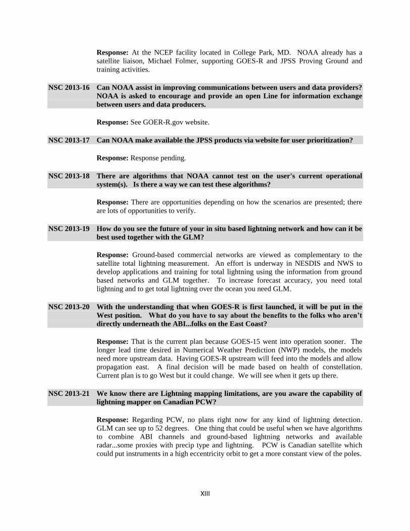
XIII
Response: At the NCEP facility located in College Park, MD. NOAA already has a
satellite liaison, Michael Folmer, supporting GOES-R and JPSS Proving Ground and
training activities.
NSC 2013-16 Can NOAA assist in improving communications between users and data providers?
NOAA is asked to encourage and provide an open Line for information exchange
between users and data producers.
Response: See GOER-R.gov website.
NSC 2013-17 Can NOAA make available the JPSS products via website for user prioritization?
Response: Response pending.
NSC 2013-18 There are algorithms that NOAA cannot test on the user's current operational
system(s). Is there a way we can test these algorithms?
Response: There are opportunities depending on how the scenarios are presented; there
are lots of opportunities to verify.
NSC 2013-19 How do you see the future of your in situ based lightning network and how can it be
best used together with the GLM?
Response: Ground-based commercial networks are viewed as complementary to the
satellite total lightning measurement. An effort is underway in NESDIS and NWS to
develop applications and training for total lightning using the information from ground
based networks and GLM together. To increase forecast accuracy, you need total
lightning and to get total lightning over the ocean you need GLM.
NSC 2013-20 With the understanding that when GOES-R is first launched, it will be put in the
West position. What do you have to say about the benefits to the folks who aren’t
directly underneath the ABI...folks on the East Coast?
Response: That is the current plan because GOES-15 went into operation sooner. The
longer lead time desired in Numerical Weather Prediction (NWP) models, the models
need more upstream data. Having GOES-R upstream will feed into the models and allow
propagation east. A final decision will be made based on health of constellation.
Current plan is to go West but it could change. We will see when it gets up there.
NSC 2013-21 We know there are Lightning mapping limitations, are you aware the capability of
lightning mapper on Canadian PCW?
Response: Regarding PCW, no plans right now for any kind of lightning detection.
GLM can see up to 52 degrees. One thing that could be useful when we have algorithms
to combine ABI channels and ground-based lightning networks and available
radar...some proxies with precip type and lightning. PCW is Canadian satellite which
could put instruments in a high eccentricity orbit to get a more constant view of the poles.
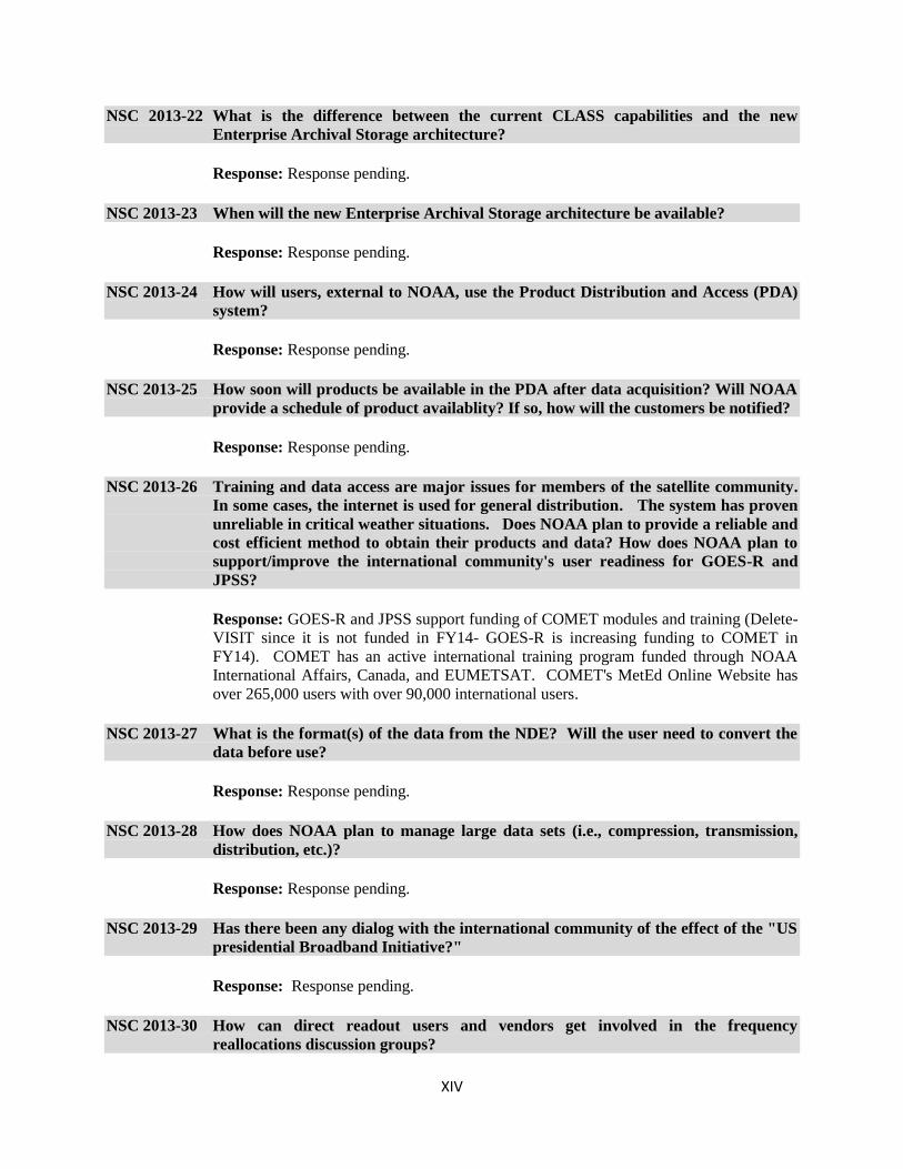
XIV
NSC 2013-22 What is the difference between the current CLASS capabilities and the new
Enterprise Archival Storage architecture?
Response: Response pending.
NSC 2013-23 When will the new Enterprise Archival Storage architecture be available?
Response: Response pending.
NSC 2013-24 How will users, external to NOAA, use the Product Distribution and Access (PDA)
system?
Response: Response pending.
NSC 2013-25 How soon will products be available in the PDA after data acquisition? Will NOAA
provide a schedule of product availablity? If so, how will the customers be notified?
Response: Response pending.
NSC 2013-26 Training and data access are major issues for members of the satellite community.
In some cases, the internet is used for general distribution. The system has proven
unreliable in critical weather situations. Does NOAA plan to provide a reliable and
cost efficient method to obtain their products and data? How does NOAA plan to
support/improve the international community's user readiness for GOES-R and
JPSS?
Response: GOES-R and JPSS support funding of COMET modules and training (Delete-
VISIT since it is not funded in FY14- GOES-R is increasing funding to COMET in
FY14). COMET has an active international training program funded through NOAA
International Affairs, Canada, and EUMETSAT. COMET's MetEd Online Website has
over 265,000 users with over 90,000 international users.
NSC 2013-27 What is the format(s) of the data from the NDE? Will the user need to convert the
data before use?
Response: Response pending.
NSC 2013-28 How does NOAA plan to manage large data sets (i.e., compression, transmission,
distribution, etc.)?
Response: Response pending.
NSC 2013-29 Has there been any dialog with the international community of the effect of the "US
presidential Broadband Initiative?"
Response: Response pending.
NSC 2013-30 How can direct readout users and vendors get involved in the frequency
reallocations discussion groups?

XV
Response: Response pending.
NSC 2013-31 Regarding the continuation of LEO and GEO with CSPP, having a common
algorithm to apply to other satellites is important. Does NOAA plan to include
sensors from other international polar-orbiting satellites (i.e., ESA, Chinese,
Russian, JAXA, etc,)? If so, what is the timeframe?
Response: Response pending.
NSC 2013-32 Recommendation to include a broad segment of users, especially weather
broadcasters, in satellite Proving Ground activities at the earliest possible time.
Response: Through coordination with AMS and broadcaster Dan Satterfield, a member
of the GOES-R Independent Advisory Committee, broadcasters will participate in the
satellite PG activities at the HWT spring experiment in Norman OK in 2014.
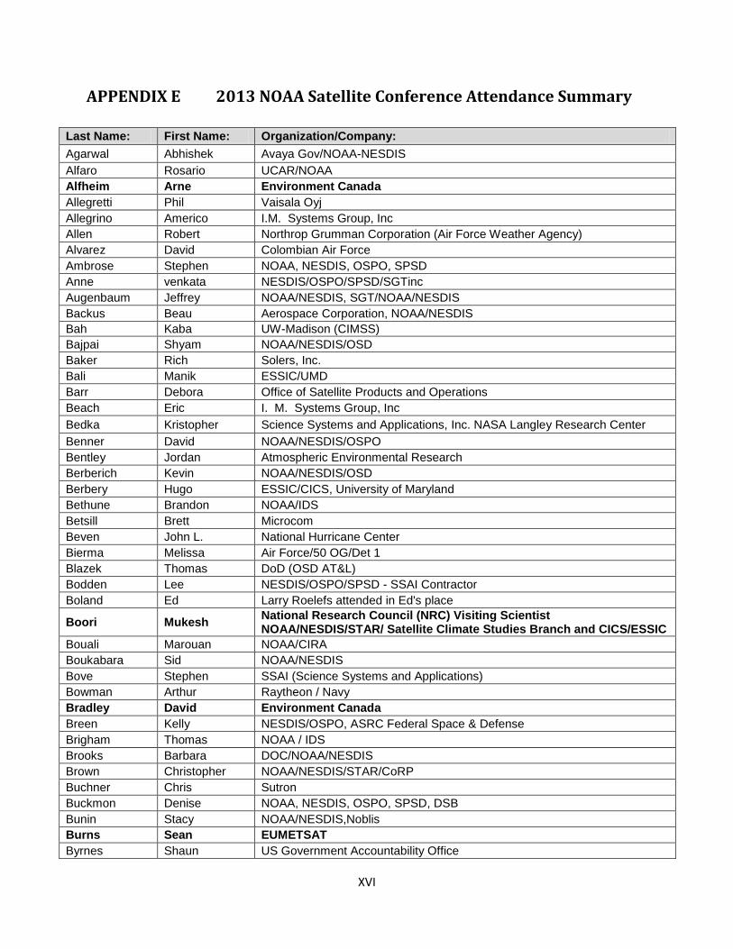
XVI
APPENDIX E 2013 NOAA Satellite Conference Attendance Summary
Last Name: First Name: Organization/Company:
Agarwal Abhishek Avaya Gov/NOAA-NESDIS
Alfaro Rosario UCAR/NOAA
Alfheim Arne Environment Canada
Allegretti Phil Vaisala Oyj
Allegrino Americo I.M. Systems Group, Inc
Allen Robert Northrop Grumman Corporation (Air Force Weather Agency)
Alvarez David Colombian Air Force
Ambrose Stephen NOAA, NESDIS, OSPO, SPSD
Anne venkata NESDIS/OSPO/SPSD/SGTinc
Augenbaum Jeffrey NOAA/NESDIS, SGT/NOAA/NESDIS
Backus Beau Aerospace Corporation, NOAA/NESDIS
Bah Kaba UW-Madison (CIMSS)
Bajpai Shyam NOAA/NESDIS/OSD
Baker Rich Solers, Inc.
Bali Manik ESSIC/UMD
Barr Debora Office of Satellite Products and Operations
Beach Eric I. M. Systems Group, Inc
Bedka Kristopher Science Systems and Applications, Inc. NASA Langley Research Center
Benner David NOAA/NESDIS/OSPO
Bentley Jordan Atmospheric Environmental Research
Berberich Kevin NOAA/NESDIS/OSD
Berbery Hugo ESSIC/CICS, University of Maryland
Bethune Brandon NOAA/IDS
Betsill Brett Microcom
Beven John L. National Hurricane Center
Bierma Melissa Air Force/50 OG/Det 1
Blazek Thomas DoD (OSD AT&L)
Bodden Lee NESDIS/OSPO/SPSD - SSAI Contractor
Boland Ed Larry Roelefs attended in Ed's place
Boori Mukesh National Research Council (NRC) Visiting Scientist NOAA/NESDIS/STAR/ Satellite Climate Studies Branch and CICS/ESSIC
Bouali Marouan NOAA/CIRA
Boukabara Sid NOAA/NESDIS
Bove Stephen SSAI (Science Systems and Applications)
Bowman Arthur Raytheon / Navy
Bradley David Environment Canada
Breen Kelly NESDIS/OSPO, ASRC Federal Space & Defense
Brigham Thomas NOAA / IDS
Brooks Barbara DOC/NOAA/NESDIS
Brown Christopher NOAA/NESDIS/STAR/CoRP
Buchner Chris Sutron
Buckmon Denise NOAA, NESDIS, OSPO, SPSD, DSB
Bunin Stacy NOAA/NESDIS,Noblis
Burns Sean EUMETSAT
Byrnes Shaun US Government Accountability Office
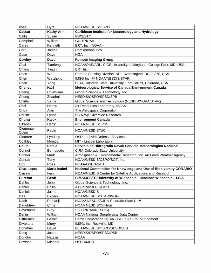
XVII
Bysal Hyre NOAA/NESDIS/OSPO
Caesar Kathy-Ann Caribbean Institute for Meteorology and Hydrology
Callis Susan NWS/STC
Campbell William GDIT/NOAA
Carey Kenneth ERT, Inc. (NOAA)
Carr James Carr Astronautics
Case Dave NGA
Cawley Dave Remote Imaging Group
Chai Tianfeng NOAA/OAR/ARL, CICS-University of Maryland, College Park, MD, USA
Chang Tiejun ERT Inc
Chen Wei Remote Sensing Division, NRL, Washington, DC 20375, USA
Chen Weizhong IMSG Inc. @ NOAA/NESDIS/STAR
Chen Yong CIRA-Colorado State University, Fort Collins, Colorado, USA
Cheney Karl Meteorological Service of Canada Environment Canada
Cheng Chieh-san Global Science & Technology, Inc.
Cheng Zhaohui NESDIS/OSPO/SPSD/SPB
Chettri Samir Global Science and Technology (NESDIS/NOAA/STAR)
Choi Heesu Air Resources Laboratory, NOAA
Choy Alan The Aerospace Corporation
Christel Lynne US Navy, Riverside Research
Chung Kwok Environment Canada
Cikanek Harry NOAA NESDIS/JPSS
Clemente-Colon
Pablo NOAA/NESDIS/NIC
Clouatre Lyndsey OSD, Innovim Defense Services
Coakley Monica MIT - Lincoln Laboratory
Collini Estela Servicio de Hidrografia Naval/ Servicio Meteorologico Nacional
Connell Bernadette CIRA-Colorado State University
Conner Mark Atmospheric & Environmental Research, Inc. Air Force Weather Agency
Conrad Tony NOAA/NESDIS/OSPO/SGT, Inc.
Cox Ross NOAA-OSD/AS&D
Cruz Lopez Maria Isabel National Commission for Knowledge and Use of Biodiversity CONABIO
Csiszar Ivan NOAA/NESDIS Center for Satellite Applications and Research
Cureton Geoff CIMSS/SSEC/University of Wisconsin – Madison Wisconsin, U.S.A
Dahlia John Global Science & Technology, Inc.
Daniel Philip Air Force/50 OG/Det 1
Daniels Jaime NOAA/NESDIS
Das Bigyani NOAA/NESDIS/STAR/IMSG
Dash Prasanjit NOAA/ NESDIS/CIRA-Colorado State Univ
Daughtrey Chris NOAA NESDIS/Omitron
Davenport Clay SGT (NOAA/NESDIS)
Denig William NOAA National Geophysical Data Center
Dittberner Gerald Harris Corporation NOAA - GOES-R Ground Segment
Divakarla Murty IMSG, Inc. Rockville, MD
Donahue David NOAA/NESDIS/OSPO/SPSD/SPB
Dong Jason NESDIS/OSPO/SPSD/DSB
Donoho Natalia NOAA
Downes Michael OSPO/MOD
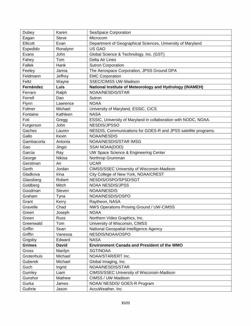
XVIII
Dubey Karen SeaSpace Corporation
Eagan Steve Microcom
Ellicott Evan Department of Geographical Sciences, University of Maryland
Espedido Ronalynn US GAO
Evans John Global Science & Technology, Inc. (GST)
Fahey Tom Delta Air Lines
Fallek Hank Sutron Corporation
Feeley Janna The Aerospace Corporation, JPSS Ground DPA
Feldmann Jeffrey EMC Corporation
Feltz Wayne SSEC/CIMSS UW-Madison
Fernández Luis National Institute of Meteorology and Hydrology (INAMEH)
Ferraro Ralph NOAA/NESDIS/STAR
Ferrell Dan Sutron
Flynn Lawrence NOAA
Folmer Michael University of Maryland, ESSIC, CICS
Fontaine Kathleen NASA
Foti Gregg ESSIC, University of Maryland in collaboration with NODC, NOAA.
Furgerson John NESDIS/JPSSO
Gaches Lauren NESDIS, Communications for GOES-R and JPSS satellite programs.
Gallo Kevin NOAA/NESDIS
Gambacorta Antonia NOAA/NESDIS/STAR IMSG
Gao Jingsi SSAI NOAA(DOD)
Garcia Ray UW Space Science & Engineering Center
George Nikisa Northrop Grumman
Gerstman Ari UCAR
Gerth Jordan CIMSS/SSEC University of Wisconsin-Madison
Gladkova Irina City College of New York, NOAA/CREST
Glassberg Robert NESDIS/OSPO/SPSD/SGT
Goldberg Mitch NOAA NESDIS/JPSS
Goodman Steven NOAA/NESDIS
Graham Tyna NOAA/NESDIS/OSPO
Grant Kerry Raytheon, NASA
Gravelle Chad NWS Operations Proving Ground / UW-CIMSS
Green Joseph NOAA
Green Russ Northern Video Graphics, Inc.
Greenwald Tom University of Wisconsin, CIMSS
Griffin Sean National Geospatial-Intelligence Agency
Griffin Vanessa NESDIS/NOAA/OSPO
Grigsby Edward NASA
Grimes David Environment Canada and President of the WMO
Gross Marilyn SGT/NOAA
Grotenhuis Michael NOAA/STAR/ERT Inc.
Guberek Michael Global Imaging, Inc.
Guch Ingrid NOAA/NESDIS/STAR
Gumley Liam CIMSS/SSEC University of Wisconsin-Madison
Gunshor Mathew CIMSS / UW-Madison
Gurka James NOAA/ NESDIS/ GOES-R Program
Guthrie Jason AccuWeather, Inc

XIX
Haar Audrey NASA Goddard Space Flight Center/Telophase Corporation
Han Jing NOAA/NESDIS/OSPO
Handy Matthew NASA
Hansen Dennis Harris Corp. GCSD NOAA GOES-R Ground System Project Office
Harris Andy CICS-UMD
Harris Thomas Exelis Visual Information Solutions
Hart Caitlin Exelis, inc
Hartzell David NOAA N-Wave, NOAA contractor at Boulder, CO with CSG, Inc.
Hawkins Jamison Lockheed Martin
Heggli Anne Hydrological Services America
Heidinger Andrew NOAA/NESDIS/STAR/CoRP/ASPB
Heil James NOAA National Weather Service
Helfrich Sean NOAA/NESDIS/OSPO National Ice Center
Hellstern Brandt Design Analysis Associates
Hewison Tim EUMETSAT + GSICS
Hodge Bryan Australian Bureau of Meteorology
Holz Robert UW SSEC
Howell Kelly NESDIS (Contracting Agency: SGT, Inc.)
Huang Jingfeng NOAA/NESDIS/STAR/CICS/ESSIC University of Maryland
Hughes Brian Unisys Corporation
Hungershoefer Katja Deutscher Wetterdienst, Germany
Iacovazzi Jr. Robert Riverside Technology, Inc. supporting NESDIS/GOES-R Program
Islam Tanvir NOAA/NESDIS/STAR
Jackson Nina NOAA/NESDIS Chief of Staff Office (HDQ)
Jairam Laura Exelis, Inc. Geospatial Systems
Jamilkowski Michael Raytheon IIS (Under contract to NASA for JPSS)
Jankot Josh NESDIS/Satellite Analysis Branch
Jeffries Alan Jeffries Technology Solutions, Inc.
Jin Xin NOAA/STAR/SMCD/SPB and ERT, Inc.
Johnson Melissa Innovim Defense Services
Johnson Mike Office of Science and Technology (NWS)
Jones Dave StormCenter Communications, Inc.
Kalb Mike NOAA/NESDIS/STAR
Kapoor Vaishali NOAA/NESDIS/OSPO
Karlson Daniel NOAA/NESDIS/GOES-R Program
Kelley Judy ATK
Keogh Simon Met Office
Kianicka Jan GeoModel Solar s.r.o.
Kibler Jamie NESDIS/OSPO/SPSD/Satellite Analysis Branch
Kicza Mary NOAA/NESDIS
Kim Hyun Air Resources Laboratory/NOAA
Kim Wonkook NOAA/NESDIS/STAR/SMCD University of Maryland
Kondragunta Shobha NOAA
Koner Prabhat ESSIC, UMD
Kong Kwan-yin Weather Prediction Center
Korose Marsha TASC, Inc
Kosaka Yuki Japan Meteorological Agency
Kujawa Brian OSD ESPDS PMO for IDS

XX
Kuligowski Robert NOAA/NESDIS/Center for Satellite Applications and Research
Kumar Vadlamani Climate Prediction Center and WYLE, Inc.
Kusselson Sheldon NOAA/NESDIS/OSPO/SPSD/Satellite Analysis Branch
Lan George NOAA NSOF/STG Inc
Lantz Kathleen NOAA/ESRL, CU CIRES (Cooperative Institute for Environmental Science)
Lau Eric NOAA - National Weather Service
Laufer Michael NOAA/NESDIS/OSD/GSD Columbus Technologies & Service Inc.
Lee Pius Air Resources Lab / NOAA
Leiling Joshua GAO
Leslie John NOAA/Office of Public and Constituent Affairs
Leuliette Eric NOAA/Laboratory for Satellite Altimetry
Levitski Stephen NASA GSFC
Lewis Jennifer NOAA- NWS- International Activities Office
Li Aiwu IMSG Inc.
Li Jian NESDIS/STAR/SMCD George Mason University
Li Jianke Global Science & Technology, Inc. Coral Reef Watch, NOAA
Li Juan Florida State University
Li Jun University of Wisconsin-Madison
Li Xiaofan NOAA NESDIS STAR
Li Zhenping SGT Inc, NOAA/NESDIS/OSPO
Liang Ding IMSG
Liang Ellen NOAA/NESDIS/Center for Satellite Applications and Research
Lillibridge John NOAA/NESDIS/STAR Laboratory for Satellite Altimetry
Lin Haidao CIRA/CSU and NOAA/ESRL/GSD
Lin Lin NESDIS/STAR/SMCD/SCDAB
Lipscy Sarah Ball Aerospace & Technologies Corp. NASA
Liu Gang NOAA/NESDIS Coral Reef Watch, Global Science and Technology, Inc.
Liu Jicheng NOAA/NESDIS/STAR, George Mason University
Liu Yuling CICS/University of Maryland, College Park
Loesch Martin Astrium Services GmbH
Lopes Edwina Environment Canada, Meteorological Service of Canada Weather and Environmental Operations - Ontario
Lubar David G NASA/Raytheon Company
Ludlum Kevin NOAA/NESDIS/OSPO
Ma Liqun NOAA/NESIDIS/OSPO/SPB
Ma Zaizhong ESSIC/UMD
MacKenzie Wayne NOAA/NESDIS/STAR Science & Technology Corp.
Madani Houria Carr Astronautics
Madsen Eric NOAA/NESDIS/IIA
Maeland Ole Jorgen Kongsberg Spacetec AS
Mainelli Michelle NWS NCEP Central Operations
Malay Jonathan Lockheed Martin Corp.
Manore Michael Environment Canada
Marley Stephen NOAA/NESDIS Harris Corporation
Martin Graeme University of Wisconsin - SSEC
Maturi Eileen NOAA/NESDIS/STAR/SOCD/MECB
McCoy Steve Stevens Water
McHenry Ronald Stinger Ghaffarian Technologies, Inc.
McMichael Elizabeth IMSG at NOAA/NESDIS/STAR/SMCD
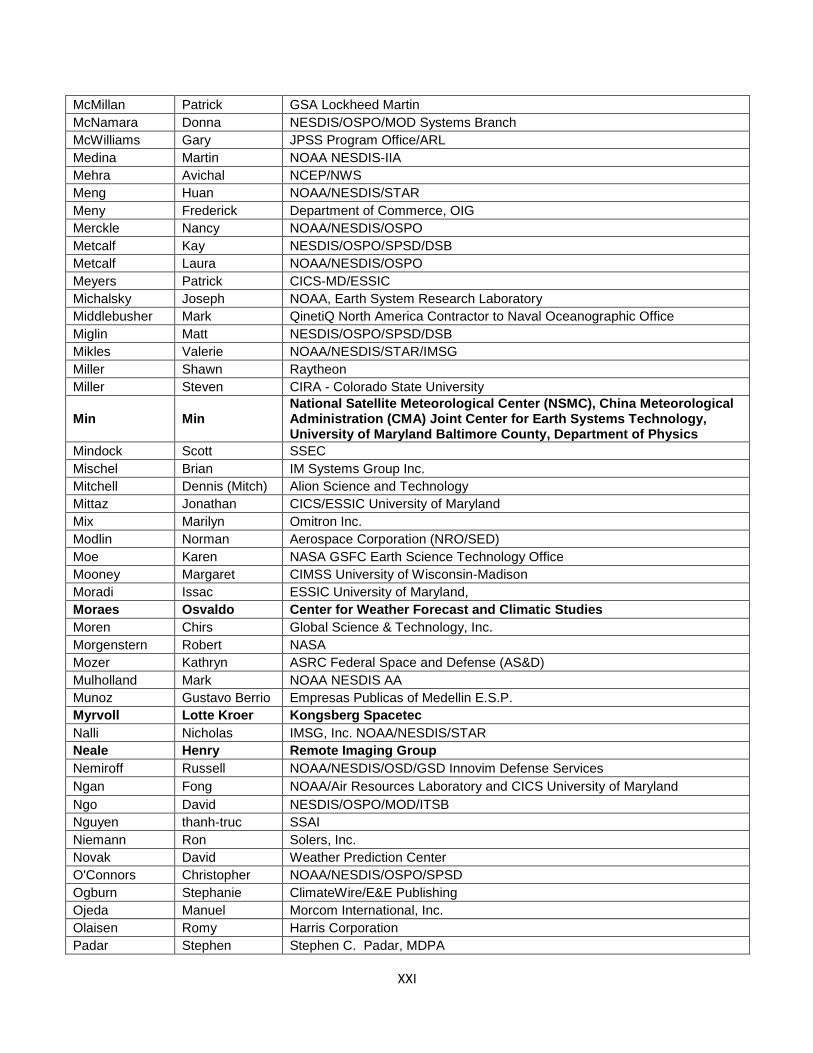
XXI
McMillan Patrick GSA Lockheed Martin
McNamara Donna NESDIS/OSPO/MOD Systems Branch
McWilliams Gary JPSS Program Office/ARL
Medina Martin NOAA NESDIS-IIA
Mehra Avichal NCEP/NWS
Meng Huan NOAA/NESDIS/STAR
Meny Frederick Department of Commerce, OIG
Merckle Nancy NOAA/NESDIS/OSPO
Metcalf Kay NESDIS/OSPO/SPSD/DSB
Metcalf Laura NOAA/NESDIS/OSPO
Meyers Patrick CICS-MD/ESSIC
Michalsky Joseph NOAA, Earth System Research Laboratory
Middlebusher Mark QinetiQ North America Contractor to Naval Oceanographic Office
Miglin Matt NESDIS/OSPO/SPSD/DSB
Mikles Valerie NOAA/NESDIS/STAR/IMSG
Miller Shawn Raytheon
Miller Steven CIRA - Colorado State University
Min Min National Satellite Meteorological Center (NSMC), China Meteorological Administration (CMA) Joint Center for Earth Systems Technology, University of Maryland Baltimore County, Department of Physics
Mindock Scott SSEC
Mischel Brian IM Systems Group Inc.
Mitchell Dennis (Mitch) Alion Science and Technology
Mittaz Jonathan CICS/ESSIC University of Maryland
Mix Marilyn Omitron Inc.
Modlin Norman Aerospace Corporation (NRO/SED)
Moe Karen NASA GSFC Earth Science Technology Office
Mooney Margaret CIMSS University of Wisconsin-Madison
Moradi Issac ESSIC University of Maryland,
Moraes Osvaldo Center for Weather Forecast and Climatic Studies
Moren Chirs Global Science & Technology, Inc.
Morgenstern Robert NASA
Mozer Kathryn ASRC Federal Space and Defense (AS&D)
Mulholland Mark NOAA NESDIS AA
Munoz Gustavo Berrio Empresas Publicas of Medellin E.S.P.
Myrvoll Lotte Kroer Kongsberg Spacetec
Nalli Nicholas IMSG, Inc. NOAA/NESDIS/STAR
Neale Henry Remote Imaging Group
Nemiroff Russell NOAA/NESDIS/OSD/GSD Innovim Defense Services
Ngan Fong NOAA/Air Resources Laboratory and CICS University of Maryland
Ngo David NESDIS/OSPO/MOD/ITSB
Nguyen thanh-truc SSAI
Niemann Ron Solers, Inc.
Novak David Weather Prediction Center
O'Connors Christopher NOAA/NESDIS/OSPO/SPSD
Ogburn Stephanie ClimateWire/E&E Publishing
Ojeda Manuel Morcom International, Inc.
Olaisen Romy Harris Corporation
Padar Stephen Stephen C. Padar, MDPA
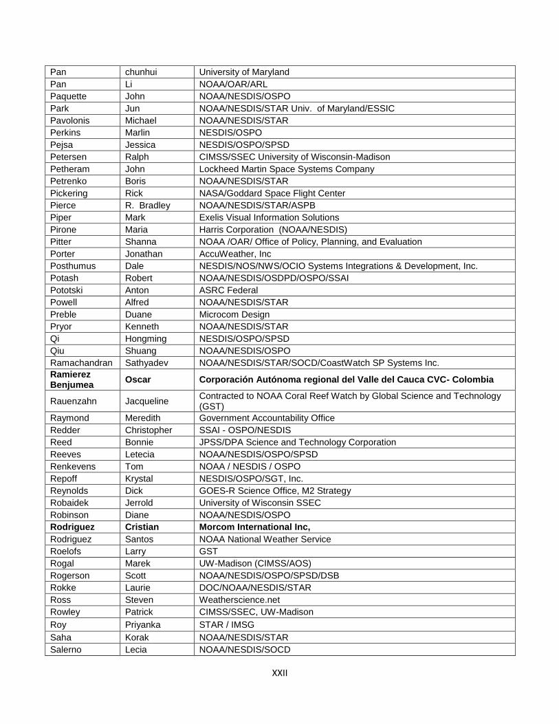
XXII
Pan chunhui University of Maryland
Pan Li NOAA/OAR/ARL
Paquette John NOAA/NESDIS/OSPO
Park Jun NOAA/NESDIS/STAR Univ. of Maryland/ESSIC
Pavolonis Michael NOAA/NESDIS/STAR
Perkins Marlin NESDIS/OSPO
Pejsa Jessica NESDIS/OSPO/SPSD
Petersen Ralph CIMSS/SSEC University of Wisconsin-Madison
Petheram John Lockheed Martin Space Systems Company
Petrenko Boris NOAA/NESDIS/STAR
Pickering Rick NASA/Goddard Space Flight Center
Pierce R. Bradley NOAA/NESDIS/STAR/ASPB
Piper Mark Exelis Visual Information Solutions
Pirone Maria Harris Corporation (NOAA/NESDIS)
Pitter Shanna NOAA /OAR/ Office of Policy, Planning, and Evaluation
Porter Jonathan AccuWeather, Inc
Posthumus Dale NESDIS/NOS/NWS/OCIO Systems Integrations & Development, Inc.
Potash Robert NOAA/NESDIS/OSDPD/OSPO/SSAI
Pototski Anton ASRC Federal
Powell Alfred NOAA/NESDIS/STAR
Preble Duane Microcom Design
Pryor Kenneth NOAA/NESDIS/STAR
Qi Hongming NESDIS/OSPO/SPSD
Qiu Shuang NOAA/NESDIS/OSPO
Ramachandran Sathyadev NOAA/NESDIS/STAR/SOCD/CoastWatch SP Systems Inc.
Ramierez Benjumea
Oscar Corporación Autónoma regional del Valle del Cauca CVC- Colombia
Rauenzahn Jacqueline Contracted to NOAA Coral Reef Watch by Global Science and Technology (GST)
Raymond Meredith Government Accountability Office
Redder Christopher SSAI - OSPO/NESDIS
Reed Bonnie JPSS/DPA Science and Technology Corporation
Reeves Letecia NOAA/NESDIS/OSPO/SPSD
Renkevens Tom NOAA / NESDIS / OSPO
Repoff Krystal NESDIS/OSPO/SGT, Inc.
Reynolds Dick GOES-R Science Office, M2 Strategy
Robaidek Jerrold University of Wisconsin SSEC
Robinson Diane NOAA/NESDIS/OSPO
Rodriguez Cristian Morcom International Inc,
Rodriguez Santos NOAA National Weather Service
Roelofs Larry GST
Rogal Marek UW-Madison (CIMSS/AOS)
Rogerson Scott NOAA/NESDIS/OSPO/SPSD/DSB
Rokke Laurie DOC/NOAA/NESDIS/STAR
Ross Steven Weatherscience.net
Rowley Patrick CIMSS/SSEC, UW-Madison
Roy Priyanka STAR / IMSG
Saha Korak NOAA/NESDIS/STAR
Salerno Lecia NOAA/NESDIS/SOCD
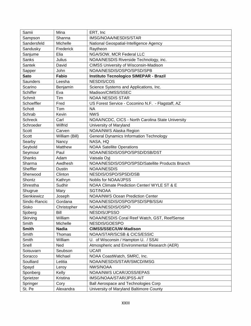
XXIII
Samii Mina ERT, Inc
Sampson Shanna IMSG/NOAA/NESDIS/STAR
Sandersfeld Michelle National Geospatial-Intelligence Agency
Sandusky Frederick Raytheon
Sanjume Elia NGA/SOW, MCR Federal LLC
Sanks Julius NOAA/NESDIS Riverside Technology, inc.
Santek David CIMSS University of Wisconsin-Madison
Sapper John NOAA/NESDIS/OSPO/SPSD/SPB
Sato Fabio Instituto Tecnologico SIMEPAR - Brazil
Saunders Leesha NESDIS/COS
Scarino Benjamin Science Systems and Applications, Inc.
Schiffer Eva Madison/CIMSS/SSEC
Schmit Tim NOAA NESDIS STAR
Schoeffler Fred US Forest Service - Coconino N.F. - Flagstaff, AZ
Schott Tom NA
Schrab Kevin NWS
Schreck Carl NOAA/NCDC, CICS - North Carolina State University
Schroeder Wilfrid University of Maryland
Scott Carven NOAA/NWS Alaska Region
Scott William (Bill) General Dynamics Information Technology
Searby Nancy NASA, HQ
Seybold Matthew NOAA Satellite Operations
Seymour Paul NOAA/NESDIS/OSPO/SPSD/DSB/DST
Shanks Adam Vaisala Oyj
Sharma Awdhesh NOAA/NESDIS/OSPO/SPSD/Satellite Products Branch
Sheffler Dustin NOAA/NESDIS
Sherwood Clinton NESDIS/OSPO/SPSD/DSB
Shontz Kathryn Noblis for NOAA/JPSS
Shrestha Sudhir NOAA Climate Prediction Center/ WYLE ST & E
Shugrue Mary SGT/NOAA
Sienkiewicz Joseph NOAA/NWS Ocean Prediction Center
Sindic-Rancic Gordana NOAA/NESDIS/OSPO/SPSD/SPB/SSAI
Sisko Christopher NOAA/NESDIS/OSPO
Sjoberg Bill NESDIS/JPSSO
Skirving William NOAA/NESDIS Coral Reef Watch, GST, ReefSense
Smith Michelle NESDIS/GOESPO
Smith Nadia CIMSS/SSEC/UW-Madison
Smith Thomas NOAA/STAR/SCSB & CICS/ESSIC
Smith William U. of Wisconsin / Hampton U. / SSAI
Snell Ned Atmospheric and Environmental Research (AER)
Soisuvarn Seubson UCAR
Soracco Michael NOAA CoastWatch, SMRC, Inc.
Soulliard Letitia NOAA/NESDIS/STAR/SMCD/IMSG
Spayd Leroy NWS/NOAA
Sponberg Kelly NOAA/NWS UCAR/JOSS/IEPAS
Sprietzer Kristina IMSG/NOAA/STAR/JPSS-AIT
Springer Cory Ball Aerospace and Technologies Corp
St. Pe Alexandra University of Maryland Baltimore County
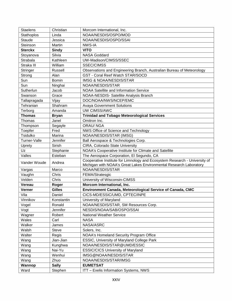
XXIV
Staelens Christian Morcom International, Inc.
Stathoplos Linda NOAA/NESDIS/OSPO/MOD
Staude Jessica NOAA/NESDIS/OSPO/SSAI
Steinson Martin NWS-IA
Sterckx Sindy VITO
Stoyanova Silvia NASA Goddard
Strabala Kathleen UW-Madison/CIMSS/SSEC
Straka III William SSEC/CIMSS
Stringer Russell Observations and Engineering Branch, Australian Bureau of Meteorology
Strong Alan GST - Coral Reef Watch STAR/SOCD
Sun Bomin IMSG & NOAA/NESDIS/STAR
Sun Ninghai NOAA/NESDIS/STAR
Sutherlun Jacob NOAA Satellite and Information Service
Swanson Grace NOAA-NESDIS- Satellite Analysis Branch
Tallapragada Vijay DOC/NOAA/NWS/NCEP/EMC
Tehranian Shahram Avaya Government Solutions
Terborg Amanda UW CIMSS/AWC
Thomas Bryan Trinidad and Tobago Meteorological Services
Thomas Janel Omitron Inc.
Thompson Segayle ORAU/ NGA
Toepfer Fred NWS Office of Science and Technology
Tsidulko Marina NOAA/NESDIS/STAR (IMSG)
Turner-Valle Jennifer Ball Aerospace & Technologies Corp.
Uprety Sirish CIRA, Colorado State University
Uz Stephanie NOAA's Cooperative Institute for Climate and Satellite
Valles Esteban The Aerospace Corporation, El Segundo, CA
Vander Woude Andrea Cooperative Institute for Limnology and Ecosystem Research - University of Michigan with NOAA's Great Lakes Environmental Research Laboratory
Vargas Marco NOAA/NESDIS/STAR
Vaughn Chris FEMA/Stratesgic
Velden Chris University of Wisconsin-CIMSS
Vereau Roger Morcom International, Inc.
Verner Gilles Environment Canada, Meteorological Service of Canada, CMC
Vila Daniel CICS-MD/ESSIC/UMD, CPTEC/INPE
Vinnikov Konstantin University of Maryland
Vogel Ronald NOAA/NESDIS/STAR, SM Resources Corp.
Vogt Jennifer NESDIS/NOAA/SAB/OSPO/SSAI
Wagner Robert National Weather Service
Wales Carl NASA
Walker James NASA/ASRC
Walsh Steve Solers, Inc.
Walter Regis NOAA's Homeland Security Program Office
Wang Jian-Jian ESSIC, University of Maryland College Park
Wang Kunghwa NOAA/NESDIS/STAR@UMD/ESSIC
Wang Nai-Yu ESSIC/CICS University of Maryland
Wang Wenhui IMSG@NOAA/NESDIS/STAR
Wang Zhuo NOAA/NESDIS/STAR/IMSG
Wannop Sally EUMETSAT
Ward Stephen ITT – Exelis Information Systems, NWS
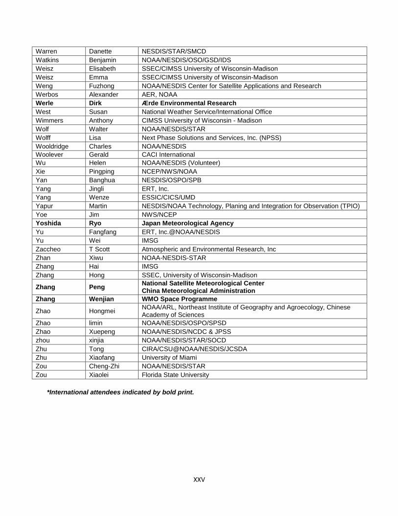
XXV
Warren Danette NESDIS/STAR/SMCD
Watkins Benjamin NOAA/NESDIS/OSO/GSD/IDS
Weisz Elisabeth SSEC/CIMSS University of Wisconsin-Madison
Weisz Emma SSEC/CIMSS University of Wisconsin-Madison
Weng Fuzhong NOAA/NESDIS Center for Satellite Applications and Research
Werbos Alexander AER, NOAA
Werle Dirk Ærde Environmental Research
West Susan National Weather Service/International Office
Wimmers Anthony CIMSS University of Wisconsin - Madison
Wolf Walter NOAA/NESDIS/STAR
Wolff Lisa Next Phase Solutions and Services, Inc. (NPSS)
Wooldridge Charles NOAA/NESDIS
Woolever Gerald CACI International
Wu Helen NOAA/NESDIS (Volunteer)
Xie Pingping NCEP/NWS/NOAA
Yan Banghua NESDIS/OSPO/SPB
Yang Jingli ERT, Inc.
Yang Wenze ESSIC/CICS/UMD
Yapur Martin NESDIS/NOAA Technology, Planing and Integration for Observation (TPIO)
Yoe Jim NWS/NCEP
Yoshida Ryo Japan Meteorological Agency
Yu Fangfang ERT, Inc.@NOAA/NESDIS
Yu Wei IMSG
Zaccheo T Scott Atmospheric and Environmental Research, Inc
Zhan Xiwu NOAA-NESDIS-STAR
Zhang Hai IMSG
Zhang Hong SSEC, University of Wisconsin-Madison
Zhang Peng National Satellite Meteorological Center China Meteorological Administration
Zhang Wenjian WMO Space Programme
Zhao Hongmei NOAA/ARL, Northeast Institute of Geography and Agroecology, Chinese Academy of Sciences
Zhao limin NOAA/NESDIS/OSPO/SPSD
Zhao Xuepeng NOAA/NESDIS/NCDC & JPSS
zhou xinjia NOAA/NESDIS/STAR/SOCD
Zhu Tong CIRA/CSU@NOAA/NESDIS/JCSDA
Zhu Xiaofang University of Miami
Zou Cheng-Zhi NOAA/NESDIS/STAR
Zou Xiaolei Florida State University
*International attendees indicated by bold print.
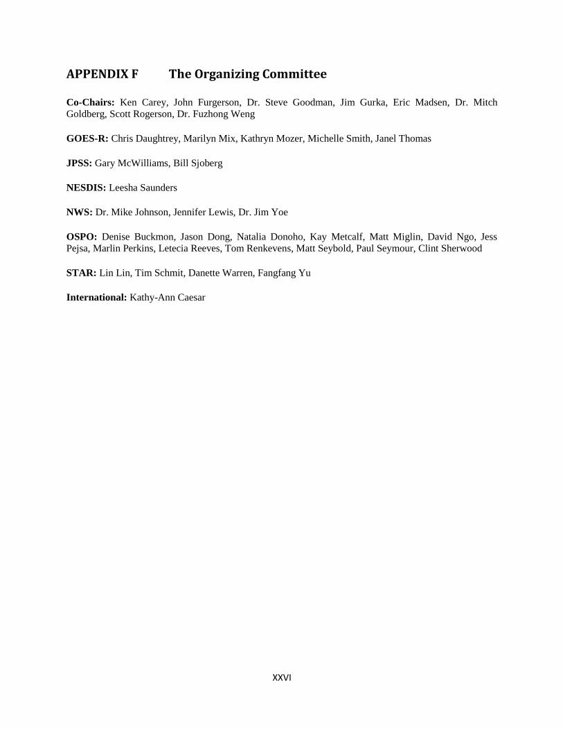
XXVI
APPENDIX F The Organizing Committee
Co-Chairs: Ken Carey, John Furgerson, Dr. Steve Goodman, Jim Gurka, Eric Madsen, Dr. Mitch
Goldberg, Scott Rogerson, Dr. Fuzhong Weng
GOES-R: Chris Daughtrey, Marilyn Mix, Kathryn Mozer, Michelle Smith, Janel Thomas
JPSS: Gary McWilliams, Bill Sjoberg
NESDIS: Leesha Saunders
NWS: Dr. Mike Johnson, Jennifer Lewis, Dr. Jim Yoe
OSPO: Denise Buckmon, Jason Dong, Natalia Donoho, Kay Metcalf, Matt Miglin, David Ngo, Jess
Pejsa, Marlin Perkins, Letecia Reeves, Tom Renkevens, Matt Seybold, Paul Seymour, Clint Sherwood
STAR: Lin Lin, Tim Schmit, Danette Warren, Fangfang Yu
International: Kathy-Ann Caesar

XXVII
APPENDIX G Pre-Conference Survey Summary
The purpose of the pre-conference survey was to gather feedback from invited 2013 NOAA Satellite
Conference attendees on potential agenda components and areas of emphasis. The survey was organized
in two main sections: logistics information and interest in the specific threads/sessions. There were 73
total responses to the survey.
The pre-conference survey indicated that the vast majority of respondents were planning to attend the
conference in person, and didn’t need an interpreter (Chart G-1).
Chart G-1. Conference Logistics
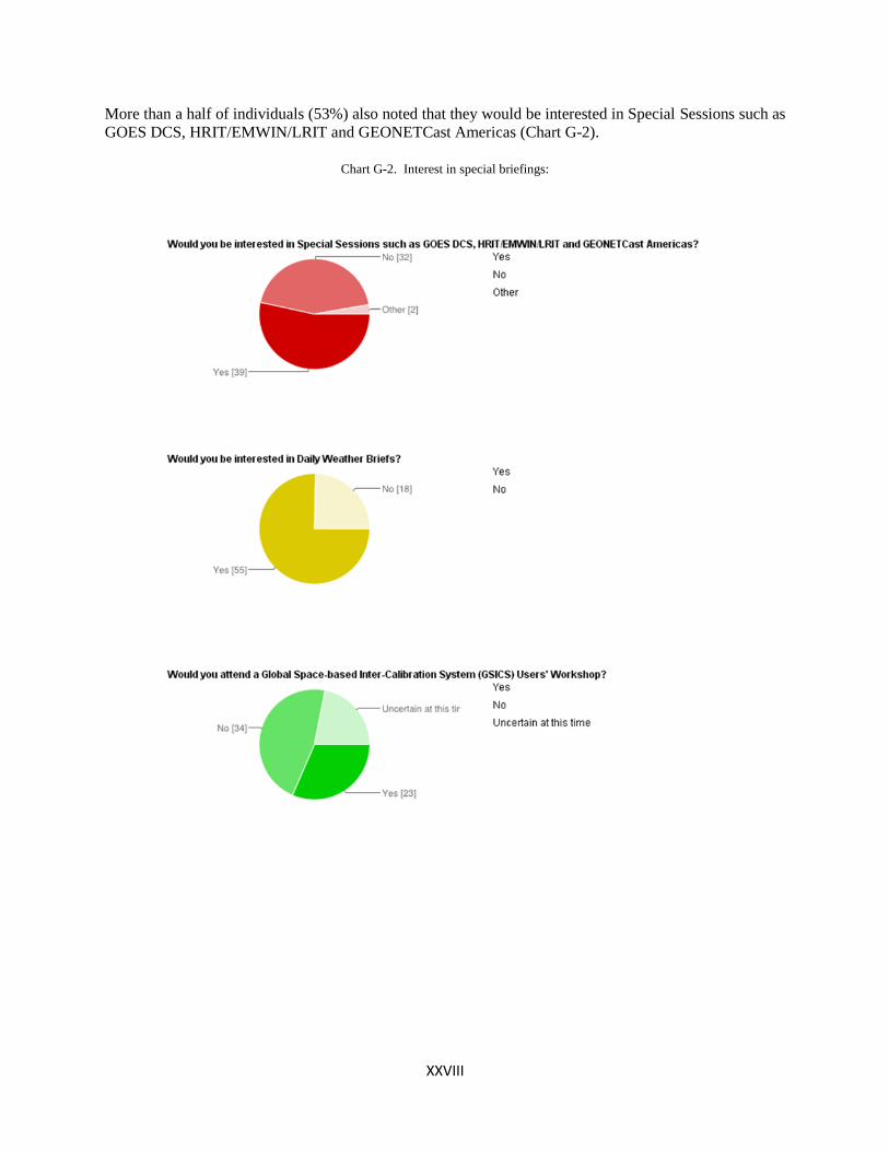
XXVIII
More than a half of individuals (53%) also noted that they would be interested in Special Sessions such as
GOES DCS, HRIT/EMWIN/LRIT and GEONETCast Americas (Chart G-2).
Chart G-2. Interest in special briefings:
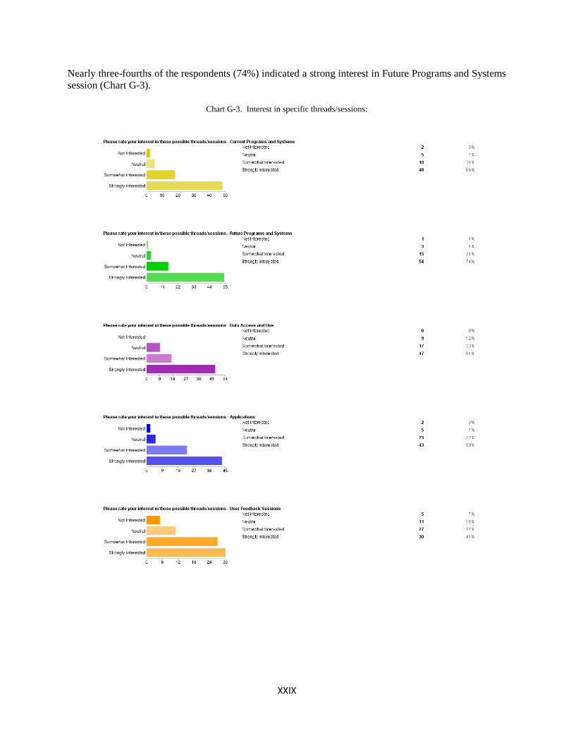
XXIX
Nearly three-fourths of the respondents (74%) indicated a strong interest in Future Programs and Systems
session (Chart G-3).
Chart G-3. Interest in specific threads/sessions:
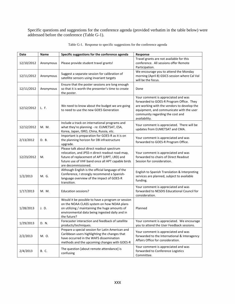
XXX
Specific questions and suggestions for the conference agenda (provided verbatim in the table below) were
addressed before the conference (Table G-1).
Table G-1. Response to specific suggestions for the conference agenda
Date Name Specific suggestions for the conference agenda Response
12/10/2012 Anonymous Please provide student travel grants! Travel grants are not available for this conference. All sessions offer Remote Participation.
12/11/2012 Anonymous Suggest a separate session for calibration of satellite sensors using invariant targets
We encourage you to attend the Monday morning (April 8) GSICS session where Cal Val will be the focus.
12/11/2012 Anonymous Ensure that the poster sessions are long enough so that it is worth the presenter's time to create the poster.
Done
12/12/2012 L. F. We need to know about the budget we are going to need to use the new GOES Generation
Your comment is appreciated and was forwarded to GOES-R Program Office. They are working with the vendors to develop the equipment, and communicate with the user community regarding the cost and availability.
12/12/2012 M. M. Include a track on international programs and what they're planning - re: EUMETSAT, ESA, Korea, Japan, ISRO, China, Russia, etc.
Your comment is appreciated. There will be updates from EUMETSAT and CMA.
2/13/2012 D. B. Important is preparation for GOES-R as it is on the planning horizon for DB infrastructure upgrade.
Your comment is appreciated and was forwarded to GOES-R Program Office.
12/23/2012 M.
Please talk about direct readout spectrum relocation, and JPSS-n direct readout road-map, future of replacement of APT (LRPT, LRD) and future use of VHF band once all APT capable birds are decommissioned.
Your comment is appreciated and was forwarded to chairs of Direct Readout Session for consideration.
1/2/2013 M. G.
Although English is the official language of the Conference, I strongly recommend a Spanish-language overview of the impact of GOES-R transition.
English to Spanish Translation & Interpreting services are planned, subject to available funding.
1/17/2013 M. M. Education sessions? Your comment is appreciated and was forwarded to NESDIS Educational Council for consideration.
1/28/2013 J. D.
Would it be possible to have a program or session on the NOAA CLASS system on how NOAA plans on utilizing / maintaining the huge amounts of environmental data being ingested daily and in the future?
Planned
1/29/2013 D. N. Forecaster interaction and feedback of satellite products/techniques.
Your comment is appreciated. We encourage you to attend the User Feedback sessions.
2/2/2013 M. O.
Prepare a special session for Latin American and Caribbean users highlighting the changes that have occurred in the WAFS dissemination methods and the upcoming changes with GOES-R
Your comment is appreciated and was forwarded to the International & Interagency Affairs Office for consideration.
2/4/2013 B. C. The question [about remote attendance] is confusing
Your comment is appreciated and was forwarded to Conference Logistics Committee.
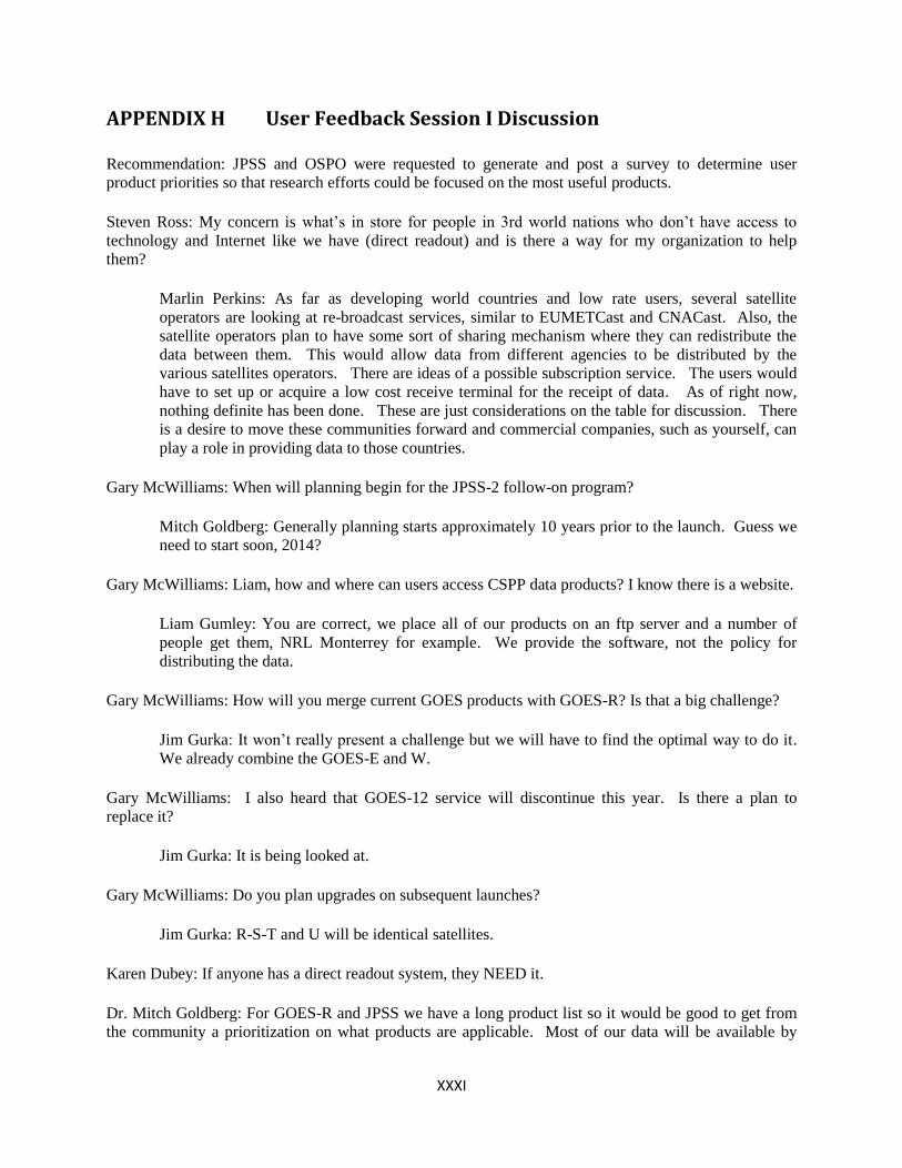
XXXI
APPENDIX H User Feedback Session I Discussion
Recommendation: JPSS and OSPO were requested to generate and post a survey to determine user
product priorities so that research efforts could be focused on the most useful products.
Steven Ross: My concern is what’s in store for people in 3rd world nations who don’t have access to
technology and Internet like we have (direct readout) and is there a way for my organization to help
them?
Marlin Perkins: As far as developing world countries and low rate users, several satellite
operators are looking at re-broadcast services, similar to EUMETCast and CNACast. Also, the
satellite operators plan to have some sort of sharing mechanism where they can redistribute the
data between them. This would allow data from different agencies to be distributed by the
various satellites operators. There are ideas of a possible subscription service. The users would
have to set up or acquire a low cost receive terminal for the receipt of data. As of right now,
nothing definite has been done. These are just considerations on the table for discussion. There
is a desire to move these communities forward and commercial companies, such as yourself, can
play a role in providing data to those countries.
Gary McWilliams: When will planning begin for the JPSS-2 follow-on program?
Mitch Goldberg: Generally planning starts approximately 10 years prior to the launch. Guess we
need to start soon, 2014?
Gary McWilliams: Liam, how and where can users access CSPP data products? I know there is a website.
Liam Gumley: You are correct, we place all of our products on an ftp server and a number of
people get them, NRL Monterrey for example. We provide the software, not the policy for
distributing the data.
Gary McWilliams: How will you merge current GOES products with GOES-R? Is that a big challenge?
Jim Gurka: It won’t really present a challenge but we will have to find the optimal way to do it.
We already combine the GOES-E and W.
Gary McWilliams: I also heard that GOES-12 service will discontinue this year. Is there a plan to
replace it?
Jim Gurka: It is being looked at.
Gary McWilliams: Do you plan upgrades on subsequent launches?
Jim Gurka: R-S-T and U will be identical satellites.
Karen Dubey: If anyone has a direct readout system, they NEED it.
Dr. Mitch Goldberg: For GOES-R and JPSS we have a long product list so it would be good to get from
the community a prioritization on what products are applicable. Most of our data will be available by
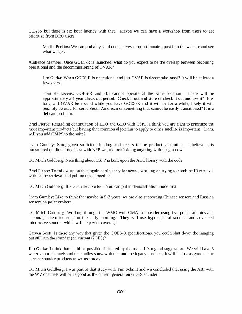
XXXII
CLASS but there is six hour latency with that. Maybe we can have a workshop from users to get
prioritize from DRO users.
Marlin Perkins: We can probably send out a survey or questionnaire, post it to the website and see
what we get.
Audience Member: Once GOES-R is launched, what do you expect to be the overlap between becoming
operational and the decommissioning of GVAR?
Jim Gurka: When GOES-R is operational and last GVAR is decommissioned? It will be at least a
few years.
Tom Renkevens: GOES-R and -15 cannot operate at the same location. There will be
approximately a 1 year check out period. Check it out and store or check it out and use it? How
long will GVAR be around while you have GOES-R and it will be for a while, likely it will
possibly be used for some South American or something that cannot be easily transitioned? It is a
delicate problem.
Brad Pierce: Regarding continuation of LEO and GEO with CSPP, I think you are right to prioritize the
most important products but having that common algorithm to apply to other satellite is important. Liam,
will you add OMPS to the suite?
Liam Gumley: Sure, given sufficient funding and access to the product generation. I believe it is
transmitted on direct broadcast with NPP we just aren’t doing anything with it right now.
Dr. Mitch Goldberg: Nice thing about CSPP is built upon the ADL library with the code.
Brad Pierce: To follow-up on that, again particularly for ozone, working on trying to combine IR retrieval
with ozone retrieval and pulling those together.
Dr. Mitch Goldberg: It’s cost effective too. You can put in demonstration mode first.
Liam Gumley: Like to think that maybe in 5-7 years, we are also supporting Chinese sensors and Russian
sensors on polar orbiters.
Dr. Mitch Goldberg: Working through the WMO with CMA to consider using two polar satellites and
encourage them to use it in the early morning. They will use hyperspectral sounder and advanced
microwave sounder which will help with coverage.
Carven Scott: Is there any way that given the GOES-R specifications, you could shut down the imaging
but still run the sounder (on current GOES)?
Jim Gurka: I think that could be possible if desired by the user. It’s a good suggestion. We will have 3
water vapor channels and the studies show with that and the legacy products, it will be just as good as the
current sounder products as we use today.
Dr. Mitch Goldberg: I was part of that study with Tim Schmit and we concluded that using the ABI with
the WV channels will be as good as the current generation GOES sounder.

XXXIII
Dr. Mike Johnson: For Steve, I liked the briefing. In operations we underestimated how valuable the
DNB would be. You said under different moon phases and lighting, you have expectations that you can
derive cloud properties at night and they will show a similar result from night to night?
Dr. Steve Miller: Yes that is correct; the model we developed is a normalization factor. The moonlight is
varying but reflectance is not. The hope is to truly turn it into a quantitative measurement like you use
during the day.
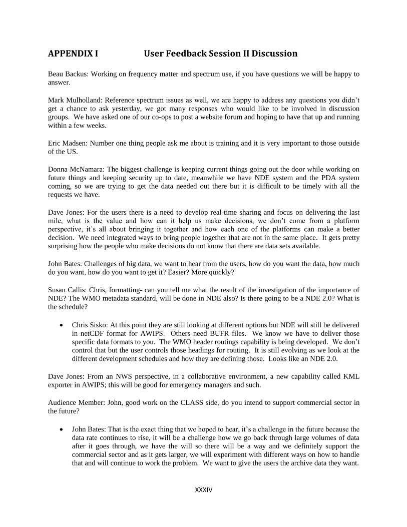
XXXIV
APPENDIX I User Feedback Session II Discussion
Beau Backus: Working on frequency matter and spectrum use, if you have questions we will be happy to
answer.
Mark Mulholland: Reference spectrum issues as well, we are happy to address any questions you didn’t
get a chance to ask yesterday, we got many responses who would like to be involved in discussion
groups. We have asked one of our co-ops to post a website forum and hoping to have that up and running
within a few weeks.
Eric Madsen: Number one thing people ask me about is training and it is very important to those outside
of the US.
Donna McNamara: The biggest challenge is keeping current things going out the door while working on
future things and keeping security up to date, meanwhile we have NDE system and the PDA system
coming, so we are trying to get the data needed out there but it is difficult to be timely with all the
requests we have.
Dave Jones: For the users there is a need to develop real-time sharing and focus on delivering the last
mile, what is the value and how can it help us make decisions, we don’t come from a platform
perspective, it’s all about bringing it together and how each one of the platforms can make a better
decision. We need integrated ways to bring people together that are not in the same place. It gets pretty
surprising how the people who make decisions do not know that there are data sets available.
John Bates: Challenges of big data, we want to hear from the users, how do you want the data, how much
do you want, how do you want to get it? Easier? More quickly?
Susan Callis: Chris, formatting- can you tell me what the result of the investigation of the importance of
NDE? The WMO metadata standard, will be done in NDE also? Is there going to be a NDE 2.0? What is
the schedule?
Chris Sisko: At this point they are still looking at different options but NDE will still be delivered
in netCDF format for AWIPS. Others need BUFR files. We know we have to deliver those
specific data formats to you. The WMO header routings capability is being developed. We don’t
control that but the user controls those headings for routing. It is still evolving as we look at the
different development schedules and how they are defining those. Looks like an NDE 2.0.
Dave Jones: From an NWS perspective, in a collaborative environment, a new capability called KML
exporter in AWIPS; this will be good for emergency managers and such.
Audience Member: John, good work on the CLASS side, do you intend to support commercial sector in
the future?
John Bates: That is the exact thing that we hoped to hear, it’s a challenge in the future because the
data rate continues to rise, it will be a challenge how we go back through large volumes of data
after it goes through, we have the will so there will be a way and we definitely support the
commercial sector and as it gets larger, we will experiment with different ways on how to handle
that and will continue to work the problem. We want to give the users the archive data they want.

XXXV
Frank Alshiemer: For Dave, concerning collaboration in general, one of the fears that I have through
using even Twitter and Facebook, is we are still losing some of the communication when we aren’t
showing the non-verbal communication. Have you looked or have any ideas on thing like web cameras
where the person on the other end has a more personal connection to the one giving the message? Might
be better received or understood.
Dave Jones: We have worked over the years with different types of relationship building before
the remote communication. Collaborative technologies can be used to impact emergency
operations. We did not integrate VoIP or webcam due to network restrictions but the benefits far
outweigh the costs of not having those built in.
Linda Stathoplos: Does that mean that you have to have the connections in place before you start the
collaborative process?
Dave Jones: Yes, and by trusted partners, we’ve been told many times that FEMA doesn’t want to
make a decision based on a graduate student’s model data from their laptop. They want to know
the data is coming from NOAA and NWS.
Mark Mulholland: We are learning in the spectrum world that there is a lot of analysis that needs to take
place to understand how bad adjacent spectrum sharing will be. Geographic separation requirements are
in place for operations that run in the same frequency, with sharing bandwidth those will not be in place
aside from restricted zones. We will need to figure out mitigation techniques as well.
Beau Backus: It depends, to start off with we are facing a challenge we have not been faced with before,
federal and nonfederal have operated in different bands. It is harder when you deal between federal and
nonfederal with different needs. The differences make coordinated more challenging. Innovative
solutions are needed, we need to continue the dialog where we met with that hopes to win the auction and
build in the relationship to create innovative solutions. Protection zones which is the traditional way, but
we do not have that kind of separation in the bandwidth. We need to be working for mitigation solutions
and how we coordinate the new people operating within the band.
Mark Mulholland: When the interference occurs is important too. By examples, most interference
analysis is forensics. For a satellite operator, you want to fix the satellite and it’s far down the road that
you realize it might not have been your fault. After you do forensics sometimes you don’t know where
the interference came from.
Dr. Jack Beven: Chris and Donna, could you give us an update on how you intend to increase the
bandwidth at the source with the upgrade in data coming from NPP, JPSS, and GOES-R?
Donna McNamara: One of the things that we are pushing on my side is ensuring users only pull
the data once. Sometimes we catch people doing that. We are ensuring that if we give access to a
user they are only pulling it once, making sure a place pulls it once and distributes it to their
groups.
Mike Manore: simple answer, the architecture of the internal NOAA system will go to 10MB to
assist in the data flow. It is a project that we will be starting soon; we are looking into innovative
methodologies to deliver the data.
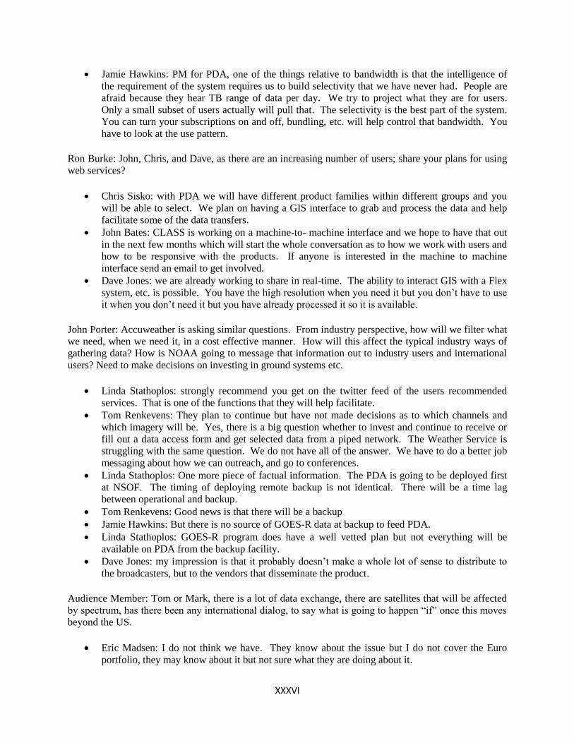
XXXVI
Jamie Hawkins: PM for PDA, one of the things relative to bandwidth is that the intelligence of
the requirement of the system requires us to build selectivity that we have never had. People are
afraid because they hear TB range of data per day. We try to project what they are for users.
Only a small subset of users actually will pull that. The selectivity is the best part of the system.
You can turn your subscriptions on and off, bundling, etc. will help control that bandwidth. You
have to look at the use pattern.
Ron Burke: John, Chris, and Dave, as there are an increasing number of users; share your plans for using
web services?
Chris Sisko: with PDA we will have different product families within different groups and you
will be able to select. We plan on having a GIS interface to grab and process the data and help
facilitate some of the data transfers.
John Bates: CLASS is working on a machine-to- machine interface and we hope to have that out
in the next few months which will start the whole conversation as to how we work with users and
how to be responsive with the products. If anyone is interested in the machine to machine
interface send an email to get involved.
Dave Jones: we are already working to share in real-time. The ability to interact GIS with a Flex
system, etc. is possible. You have the high resolution when you need it but you don’t have to use
it when you don’t need it but you have already processed it so it is available.
John Porter: Accuweather is asking similar questions. From industry perspective, how will we filter what
we need, when we need it, in a cost effective manner. How will this affect the typical industry ways of
gathering data? How is NOAA going to message that information out to industry users and international
users? Need to make decisions on investing in ground systems etc.
Linda Stathoplos: strongly recommend you get on the twitter feed of the users recommended
services. That is one of the functions that they will help facilitate.
Tom Renkevens: They plan to continue but have not made decisions as to which channels and
which imagery will be. Yes, there is a big question whether to invest and continue to receive or
fill out a data access form and get selected data from a piped network. The Weather Service is
struggling with the same question. We do not have all of the answer. We have to do a better job
messaging about how we can outreach, and go to conferences.
Linda Stathoplos: One more piece of factual information. The PDA is going to be deployed first
at NSOF. The timing of deploying remote backup is not identical. There will be a time lag
between operational and backup.
Tom Renkevens: Good news is that there will be a backup
Jamie Hawkins: But there is no source of GOES-R data at backup to feed PDA.
Linda Stathoplos: GOES-R program does have a well vetted plan but not everything will be
available on PDA from the backup facility.
Dave Jones: my impression is that it probably doesn’t make a whole lot of sense to distribute to
the broadcasters, but to the vendors that disseminate the product.
Audience Member: Tom or Mark, there is a lot of data exchange, there are satellites that will be affected
by spectrum, has there been any international dialog, to say what is going to happen “if” once this moves
beyond the US.
Eric Madsen: I do not think we have. They know about the issue but I do not cover the Euro
portfolio, they may know about it but not sure what they are doing about it.

XXXVII
Mark Mulholland: I have learned just how separated the satellite operators are from the spectrum
world. There will be potential interference between satellites, we need to be prepared for satellite
crossings but the probability of the interference is very low.
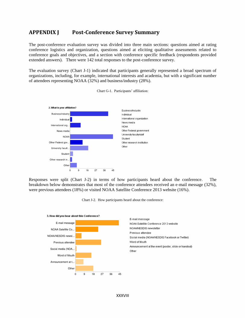
XXXVIII
APPENDIX J Post-Conference Survey Summary
The post-conference evaluation survey was divided into three main sections: questions aimed at rating
conference logistics and organization, questions aimed at eliciting qualitative assessments related to
conference goals and objectives, and a section with conference specific feedback (respondents provided
extended answers). There were 142 total responses to the post-conference survey.
The evaluation survey (Chart J-1) indicated that participants generally represented a broad spectrum of
organizations, including, for example, international interests and academia, but with a significant number
of attendees representing NOAA (32%) and business/industry (28%).
Chart G-1. Participants’ affiliation:
Responses were split (Chart J-2) in terms of how participants heard about the conference. The
breakdown below demonstrates that most of the conference attendees received an e-mail message (32%),
were previous attendees (18%) or visited NOAA Satellite Conference 2013 website (16%).
Chart J-2. How participants heard about the conference:
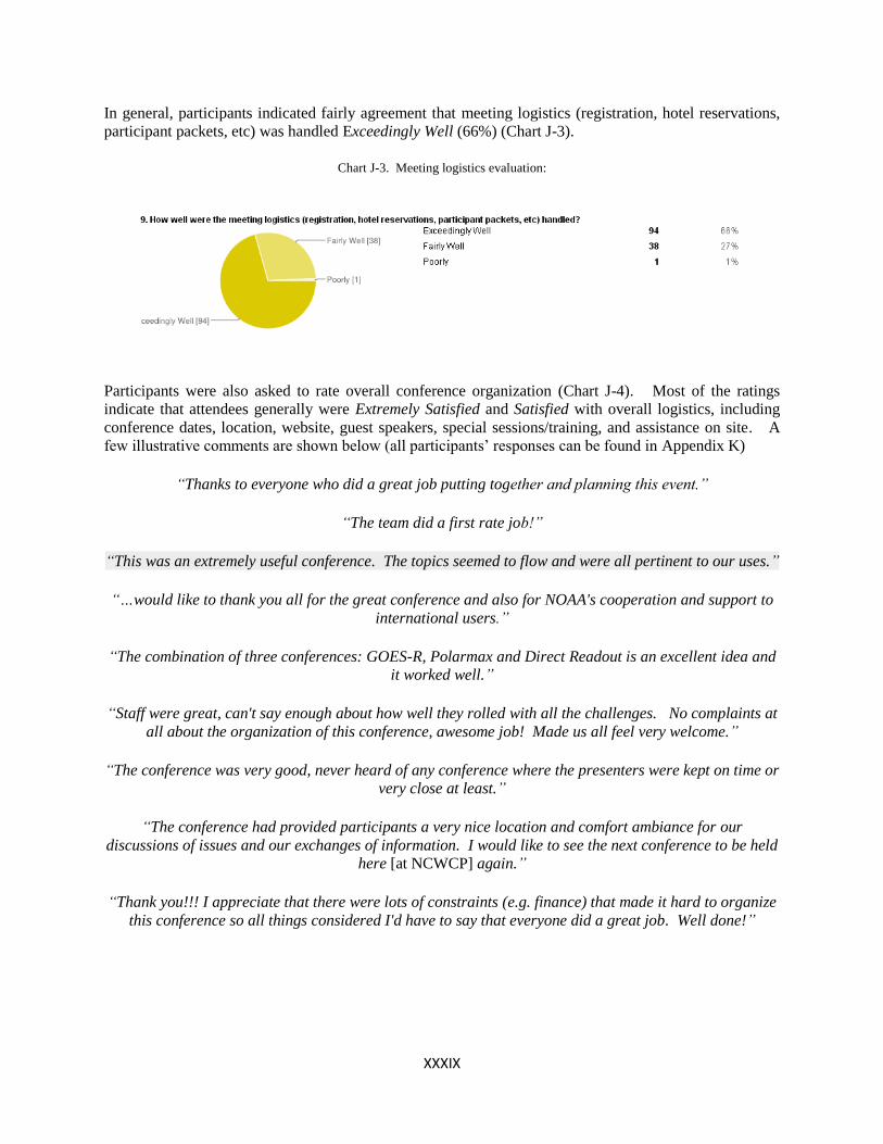
XXXIX
In general, participants indicated fairly agreement that meeting logistics (registration, hotel reservations,
participant packets, etc) was handled Exceedingly Well (66%) (Chart J-3).
Chart J-3. Meeting logistics evaluation:
Participants were also asked to rate overall conference organization (Chart J-4). Most of the ratings
indicate that attendees generally were Extremely Satisfied and Satisfied with overall logistics, including
conference dates, location, website, guest speakers, special sessions/training, and assistance on site. A
few illustrative comments are shown below (all participants’ responses can be found in Appendix K)
“Thanks to everyone who did a great job putting together and planning this event.”
“The team did a first rate job!”
“This was an extremely useful conference. The topics seemed to flow and were all pertinent to our uses.”
“…would like to thank you all for the great conference and also for NOAA's cooperation and support to
international users.”
“The combination of three conferences: GOES-R, Polarmax and Direct Readout is an excellent idea and
it worked well.”
“Staff were great, can't say enough about how well they rolled with all the challenges. No complaints at
all about the organization of this conference, awesome job! Made us all feel very welcome.”
“The conference was very good, never heard of any conference where the presenters were kept on time or
very close at least.”
“The conference had provided participants a very nice location and comfort ambiance for our
discussions of issues and our exchanges of information. I would like to see the next conference to be held
here [at NCWCP] again.”
“Thank you!!! I appreciate that there were lots of constraints (e.g. finance) that made it hard to organize
this conference so all things considered I'd have to say that everyone did a great job. Well done!”
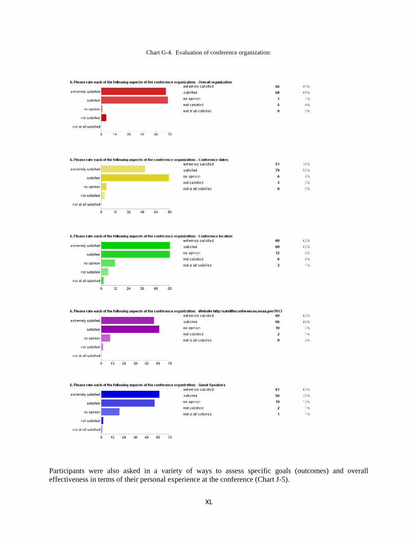
XL
Chart G-4. Evaluation of conference organization:
Participants were also asked in a variety of ways to assess specific goals (outcomes) and overall
effectiveness in terms of their personal experience at the conference (Chart J-5).
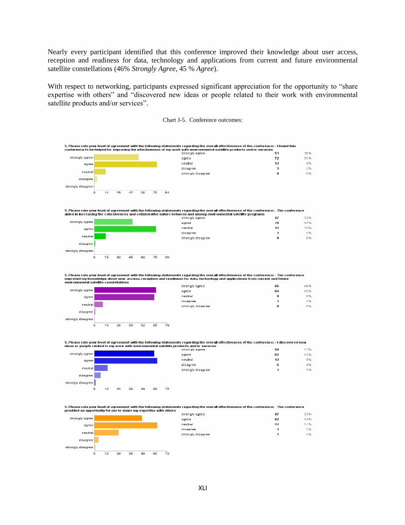
XLI
Nearly every participant identified that this conference improved their knowledge about user access,
reception and readiness for data, technology and applications from current and future environmental
satellite constellations (46% Strongly Agree, 45 % Agree).
With respect to networking, participants expressed significant appreciation for the opportunity to “share
expertise with others” and “discovered new ideas or people related to their work with environmental
satellite products and/or services”.
Chart J-5. Conference outcomes:
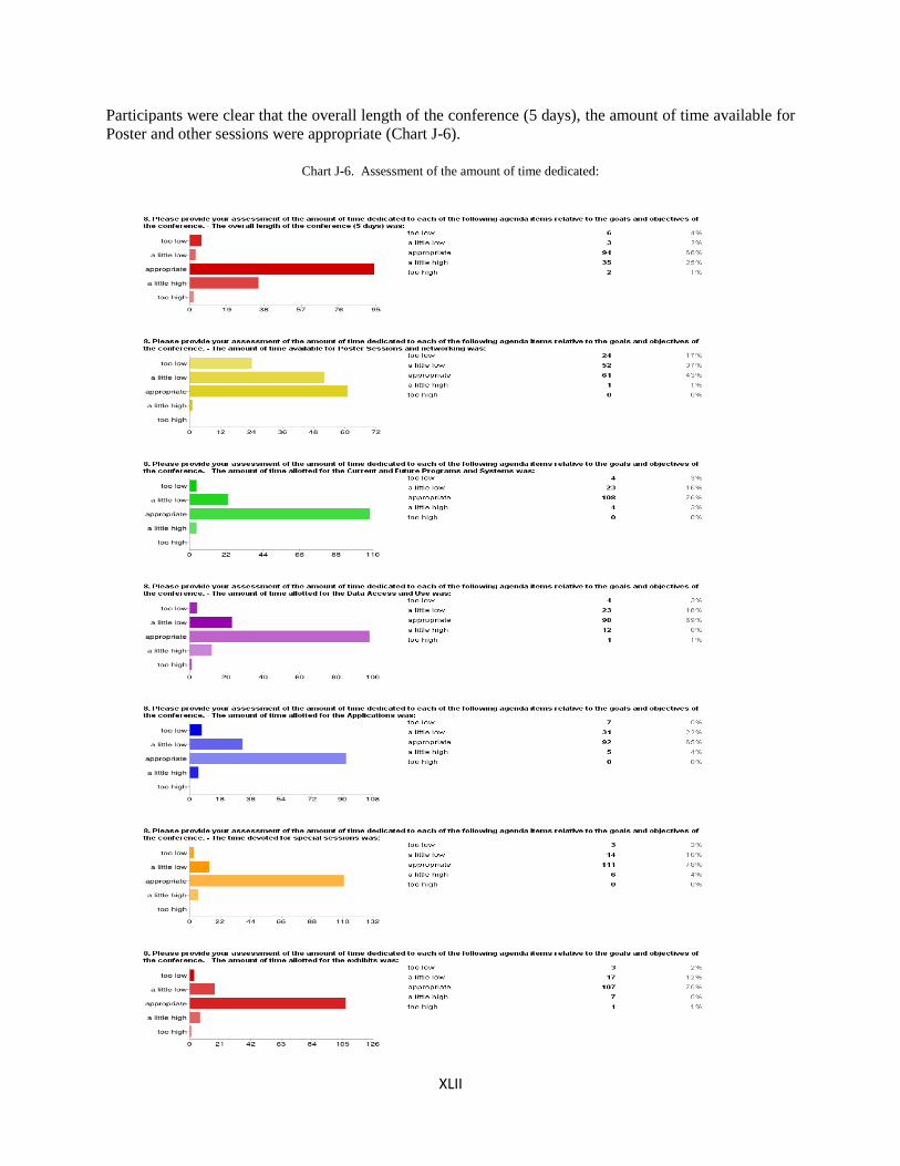
XLII
Participants were clear that the overall length of the conference (5 days), the amount of time available for
Poster and other sessions were appropriate (Chart J-6).
Chart J-6. Assessment of the amount of time dedicated:
XLIII
APPENDIX K Post-Conference Survey: Subset of Extended Participant
Responses
Question: What are the most important follow-up items/actions you hope will take place following
the conference?
Presentations and Posters [Available at http://satelliteconferences.noaa.gov/2013]
Posting of presentations and posters.
Easy access to the charts presented.
The availability of the slides on the website.
Please remind us the website where we can find presentation slides to review.
Access to presentation material for download.
GOES-R Topics
I would like to see a plan for whether GOES-R will be GOES-East or GOES-West, and the future scan
strategies for GOES-R in light of that selection.
It will be interesting whether GOES-R will become WEST or EAST.
Finally placement of GOES-R satellite (West or East?) to determine the institutional planning to get
access or not to the data.
Resolving uncertainties in future satellite programs as early as possible is in everyone's interest. For
the Pacific, resolving the undercurrent of uncertainty about whether GOES-R will go west (as now
planned) or east will help clarify the planning in this region for future reception/access systems and
applications.
Planning hardware and software changes necessary for next generation satellites.
More discussion between stakeholders-- it was troubling to hear the person from Delta said that an
important product to him was deleted from GOES-R. Just because there may be other products higher
priority to scientists, operational needs should be high priority. GOES is an operational satellite first
and a science satellite second.
I will continue work with GOES-R and JPSS proving ground partner's in evaluating products for NWS
operations in my forecast office.
User’s feedback and their inputs to the future programs.
[translated from Spanish] Users need information on the practical aspects of the advances in meeting
requirements that present themselves during the development of new satellite systems like GOES-R
related to criteria established by the NOAA DCS program, vendors, users and others. Also, detailing
the efforts of other solutions developed in the U.S. by organizations such as the U.S. corps of
engineers, NWS and USGS.

XLIV
International Topics
How to maintain coverage of South America once GOES-12 is decommissioned.
A sustained interaction with the users from the Region III and Region IV would be a great issue. In
addition, to look for the possibility to establish a proving ground network over the Region III and
Region IV to test and improve the quality of the satellite products. One of the most important subjects
to highlight is that GOES R should cover the domain of the VAAC Buenos Aires. Also, to provide the
availability of images with frequency and coverage, that allows an efficient monitoring of VAAC
Buenos Aires (10°S-90°S and 90°W-10°W)
Something that was not discussed in the forum, but maybe a web based discussion forum would make
it easier for international users to communicate with NOAA and exchange information between them.
For outsiders it takes a little bit longer to understand how NOAA is organized and who or which
department should be contacted in each case (operations, data access, etc.).
JMA's plan to disseminate Himawari.
Discuss the outcomes with EUMETSAT in order that they better represent our (UK) views at bilateral
meetings with NOAA.
I hope to make a cooperation Project with NOAA, WMO, and AR4 and AR3 countries
Data Access
Follow up on User access to the new data (SNPP)
I hope that OSPO's PDA system is scaled large enough to handle the large amounts of data it will
receive.
For us raw data delivery systems and data archives are most important. Thus we need to know and
meet people from this field. The good point was that there were also users and companies providing
different ground bases solutions.
Conference Logistics
Repeat the Satellite Conference in 2015!
I hope there will be enough feedback from these surveys to warrant doing another event in two years.
If not, then I will wonder what the point was, and what was really accomplished from everyone's hard
work.
Expansion of Wi-Fi connections in NCWCP
List of contact information from the presenters
Would like to attain a list of attendees
Take note on how well the conference was run.
Consider creating GOES version of the Community Satellite Processing Package.
It would be nice to offer a discussion location for presentations/presenters to answer questions that
were not asked during the conference. If people had questions for speakers, it would be nice to have a
forum where the presentation could be viewed then questions asked of the presenter. This could start
excellent dialogues and generate new collaborations.
The two items of concern -- the length of time for the conference and the parking / unloading / loading.
The conference should have been no longer than three days. It would also have been helpful if there
were more evening activities that would encourage more networking. Parking was adequate, but we
were not permitted to unload or load close to the facility. This made it very difficult.
XLV
Data Topics
I hope the dialog among the users regarding data fusion and the value of data from all of the satellites
to forecasters will continue.
Evaluation of data
Begin utilizing the GOES data products
GOES DCS
More information about the DCS GOES program.
Question: If you were a presenter in a session, and you have suggestions on how to improve your
experience planning for and giving your presentation, please provide them.
Facilitation of presentations was fabulous!
As a presenter, I want to highlight the excellent media provided by the Conference organization.
Better instructions for when presentations are due and where (online locations, etc) would have helped.
Despite the smaller screen in front of presenters some of them still turned to the large screen. When that
happened I could not hear what they were saying. Also, some people put just too much stuff and small
text in each slide. They should be invited to use large text with bullet points.
If there is 15 minutes for each presenter there should be a mandatory number of slides (like no more than
20 slides for a 15 minute presentation). Scientists always seem to think they can get through 60 slides in
15 minutes which makes it very uncomfortable for the audience to digest. The speakers are not
defending a thesis; they are communicating the benefits of their work to the audience.
It was very difficult dealing with security to get in and out of the poster area. Security was not
particularly friendly and they did not seem to operate under consistent protocol.
Try not to repeat information
More time for posters
More time for posters, possibly a bit more time for questions.
Translated from Spanish: I have no suggestions as presenter. I think it was very good presenters and
presentations.
Posters should have been placed outside the security so that people could have better access.
Too many posters all at once in a crowded area. It would have been better to have 2 poster-viewing
times each day, with only 1/2 of the posters being 'presented' at each time.
Question: Were there any topics you did not feel were discussed in enough detail or should have
been included in the agenda at the conference? If so, what were they?
In my opinion it was enough material considering the extent of the Conference.
I think you should include the international desk in this conference, because the Latin American users
use this product very frequently.
We should have heard more the international participants, and perhaps a bit more from the National
Weather Service. It seems like there were too many agency heads and program managers there,
especially early in the conference that did not have much to add with respect to satellites.
A little bit more on the international context (the full global satellite constellation) might have been
interesting.
A quick synopsis of the environment satellites in use today by other nations.
A session from the Japan Meteorological Agency on the future of Himawari. How our international

XLVI
partners obtain and utilize satellite data and how it is transported in remote locations with low
bandwidth.
We should have focused on applications of the data with more time for discussing future user needs. I
really liked hearing from NWS Pacific Region. They seemed to articulate their needs very well. I hope
they are invited back for the next conference.
A full update on the POES on-orbit satellites. And a full update on ESPC's non-NOAA satellite data
acquisition & distribution.
Industry/private ventures in Environmental sensing.
Future Programs!
No avenue for research. EUMETSAT meetings have special sessions for more in-depth subjects. NSC
should consider this.
Maybe more on validation plans.
I feel the conference was too short on end users. By end users I mean users of the data where they use
the data to make decisions. GOES & POES are first an operational series and research is important but
second. We did not hear from the operational ends users that much. We heard from intermediate users
but not end users.
End User's easy access/use of data and relevant issues, not discussed in depth. How would weather
satellite data play a role in people's day-to-day life? How would we improve the communications with
the public on uncertainties?
A session on views and uses of data from the commercial non-NOAA community. For example, Delta
Airlines, Accuweather, and the Weather Channel.
It would be nice to have a satellite-oriented conference that would cater to limnologists or aquatic
ecologists who would like to learn more about the technologies for monitoring water resources without
needing to focus so much on operational and technical details of satellite platforms.
Recent advances in the benefits of the data since the last conference would be beneficial.
Wildland Fire Weather forecasting and nowcasting, using satellite imagery for fire weather forecasting
and NOT fire detection and /or tracking smoke.
I would have liked to see more specifics on accessing data from the OSPO DDS or CLASS.
Products and Services, Product Are Leads should have given talks to present their products and services.
What existing products including on the web are available for the users.
The topic of NOAA data center consolidation was also not discussed. If this happens, it would affect
how all data is processed and distributed. Please include in next year's topics.
Learning more about downstream satellite product consumption, and the status of AWIPS-II would have
been good to see.
[translated from Spanish] Latin American users, in general, do not have continuity in attendance at
meetings. So, it is very necessary to add special sessions about operations, maintenance and
management of hydro-meteorological information systems with Geostationary Environmental Satellites.
I'd be interested in actually how various sensors on the satellites worked to gather all the data presented;
a technical forum. (Why 16 IR channels on GOES-R? I'd like to hear how/why these channels will
detect various elements etc…)
A history of environmental satellites to supplement the current and future satellites presentations.
More on space weather! In particular I would have been willing to provide an update on the GOES-R
space weather instruments.
Maybe a little more about the topic of radiance data assimilation.
I have missed a bit some overall idea or map of raw data systems and organizations involved in ground
segment development.
Mainly "Presenting options (with pros and cons) for getting the data from the satellite and into the hands
of users as fast as possible after launch (e.g. Geonetcast, EUMETCast, Internet, GTS, Direct Broadcast,
WIS etc)". Benefits can't be "leveraged" until the data is actually being used operationally by national
XLVII
weather services, private companies and academia.
I would have liked to see more outreach components related to all areas of NOAA / NESDIS. Also
would have wanted more information on the NOAA / NESDIS CLASS Enterprise System.
There was a lot of information given out to the conference participants on what we are doing and what
products but not enough information on how to use the products and apply these products to prediction,
management of their organizations.
Questions: Additional thoughts
General Comments
I would like to thank you all for the great conference and also for NOAA's cooperation and support to
international users.
Thanks for a great conference!
This was an extremely useful conference. The topics seemed to flow and were all pertinent to our uses.
While I've not attended the two conferences in the past, I felt that having one conference worked well.
I look forward to attending in person next time. (I attended remotely this time due to a scheduling
conflict.)
The team did a first rate job. Please consider allowing other parts of NOAA to obtain daily webinar
briefings from NCEP centers. (NOAA is a potential host for the 2014 Space Frequency Working
Group), assuming it can be done on a very low cost basis. Adding those daily briefings to the SFCG
for some of their 10 days would be a real hit.
Staff were great, can't say enough about how well they rolled with all the challenges. No complaints at
all about the organization of this conference, awesome job! Made us all feel very welcome.
Thank you!!! I appreciate that there were lots of constraints (e.g. finance) that made it hard to organize
this conference so all things considered I'd have to say that everyone did a great job. Well done!
The conference organizers deserve credit for making the best of a bad situation. While this was better
than no conference, it did not provide anywhere near the information exchange as in past conferences.
For example, with trying to cram too much into one week, there were no breakout sessions. Because
of travel limitations there were not enough NWS forecasters present. It is critical to have the true end
users present to talk to product developers and to participate in poster sessions and breakout sessions.
While the venue in the D.C. metro area allowed for many local participants, it also allowed for the
local participants to go back to their offices (note the many empty seats). Recommend: go back to the
hotel Miami for the DRO, and have separate conferences for GOES and JPSS preferably in locations
away from the D.C. area. Also, the internet access (rather the lack of access) was the worst I have ever
seen at a conference. One more thing.... to not allow water bottles in the auditorium is ridiculous!
It would be helpful to avoid National Space Symposium, which was same week.
That limits access to resources which may be committed to the symposium - for example I know
Raytheon had a nice historical video or photos of the evolution of weather satellite products which was
displayed at the Space Symposium. That could have been provided at this conference, but the people
and equipment were at the other symposium.
The conference was very good, never heard of any conference where the presenters were kept on time
or very close at least.
Consider publishing a participant's contact list and any news articles generated by the press from the
conference.
Very much like combining GUC and DRO. Having it in DC is fine, I know I was looking forward to
Miami but given distribution of attendees DC makes a lot of sense.

XLVIII
Logistics and Organization
Thanks to everyone who did a great job putting together and planning this event. There needs to be a
registration fee for the next conference to cover the cost of break food. I could not be reimbursed for
any break food that I purchased due to travel regulations, but I would have been reimbursed a
registration fee. Also, please allow water in the meeting room.
There should have been a small registration fee charged even if it was only $25.00. This would have
covered the cost of the breaks for food and drinks.
I would never cut off registration…
I was told that I could no longer register my post-doc but there were other people that were registered
after my request was denied. I was very disappointed that he was not allowed to attend even though he
works in this building.
I know the logistics of the venue prevented this to some extent, but there wasn't enough time for people
to engage each other or for chance encounters in front of posters. The Exhibit area was too small to be
inviting for many people to get in there and converse.
Hotel seems too far from meeting facility; Nearby supporting business is still too sparse to give people
more opportunities to interact.
Exhibit loading and unloading was difficult at the facility due to security restrictions.
While I liked the facility itself and the low cost associated with using a Gov facility, I think NCWCP
facility is hard pressed to host a conference of this size. If everyone showed who had registered, I
don't think the crowd could have been handled. I think having to commit to at least a nominal
conference fee (say $50 to cover breakfast/snack/beverage) would have given a better idea of who
would actually come.
I recommend strongly that future conferences should continue to be held at NWCPC, College Park.
Attendees have opportunity to listen to all satellite systems and the users in the same hall.
Also, it would be nice to hold the conference at a venue where security restrictions were less of a
problem for conference activities than those at the NCWCP.
The location was very good in my opinion, providing an excellent opportunity for local NOAA staff to
participate. Joining the 3 events into one is also an excellent idea, and I gathered information from
each component. I would suggest maintaining the format and location.
In terms of supporting other aspects of a conference, there are numerous areas where improvements
could be made. The meeting area outside the NCWCP was far too small a space for the number of
attendees and was very hard to navigate and network in. The placement of the poster sessions inside
the turnstiles was not conducive to attendees being able to fully browse them at their leisure. The time
allowed for poster access was insufficient. The facility is beautiful, but unfortunately, has not been
designed practically speaking to support this size of conference. Further, it is unreasonable to expect
that people will not bring water bottles into the auditorium; water is a basic human need and
conferences go on for hours. It is not easy for everyone to get up and go outside every time a person
needs a drink of water. I also was not able to get online using the guest Wi-Fi -- clearly that system
was overwhelmed and that was a limiting factor to how many days I could attend since I cannot be
unreachable for more than a day. Thank you for considering my comments.
The set up of the registration desk was poor. It was not clear where the registration desk was at. The
people who sat at the registration did not appear to engage the participants in acquiring their badges.
There were several badges that were not picked up yet the conference attendees were also there.
Consider having companies sponsor the break time snacks again. That worked our quite well.
The Satellite Science Week material should be combined into this conference. This conference should
grow to the American Satellite Remote Sensing Conference.
Pay as you go lunch worked quite well.
Lunches were excellent, but seating was too limited. Got very lucky on weather. If it had been cold
XLIX
or raining, I think it would have been a disaster. Maybe a temporary tent out front?
The location was remote. Miami is a better location.
If held again at NCWCP, set aside one of the outer rooms with tables/chairs for discussion rather than
all for exhibits. The Conference Center lobby is not very big and was congested between sessions.
Consider adding tables and chairs outside the front entrance if the weather is forecast to be good.
The main suggestion I have is that NOAA should work through a meeting planning company. I know
you feel you did the conference for free, but you did not. You had a lot of people in many different
departments working on it. Things like the pre-paid meals weren't advertised until a few days before.
That should have been set up at registration. About two weeks before, I had to email asking for some
sort of exhibitor packet that gave me shipping directions. These types of things may just be
inexperience, but should every person in your building have to learn their own lessons each time there
is an event? One common person or company would have all this knowledge, and be able to cut down
on the time NOAA needs to plan the event.
The conference had provided participants a very nice location and comfort ambiance for our
discussions of issues and our exchanges of information. I would like to see the next conference to be
held here again.
I hope that the problems associated with holding a conference of this size at the new site (e.g., lack of
internet access) will be resolved before the next meeting.
I didn't attend the whole conference - it was too long! Maybe three days (Tuesday thru Thursday) next
time.
Could condense to 3 days. The specific use data (after Wed) was not applicable to the group at large,
resulting in attendance decline the last few days.
I would appreciate more room in near neighborhood with easy internet access and possibility to meet
with people and work with someone on my own laptop. In the conference we had to entreat some
people from exhibitors to borrow us a table for a while.
In regards to the conference location and lodging: The conference center and the hotel were both fine.
However, neither one had restaurants nor other food options within walking distance - a big problem
when faced with a travel budget that didn't permit a rental car. The next conference needs to remedy
this.
I believe the conference should be in Miami, FL. I really noticed the lack of attendance from GOES
Users in Latin America in particular. As an exhibitor I mainly attend the conferences to find new
customers as well as improve my relationship with current customers. There were very few Latin
America or other users of the GOES DCS network at the conference.
Poster Session
Keeping a conference of this size in a single session format meant that most of the interesting details
were squeezed out into the poster session. Unfortunately these were far too short and hampered by
access limitations. I suggest in future conferences, the poster sessions are extended to 3 two hour
sessions, with all posters being displayed - and accessible - throughout the week.
I had to pull out due to budget issues and withdrew my poster. It would have been nice to be able to
'display' my poster electronically and perhaps get some feedback on the work.
The poster sessions were invaluable to me, and I wish they could have been longer in duration. It was
difficult to view all the posters and talk with the presenters in the time allowed.
Poster area too crowded, too cumbersome with security.
The security issues around the poster session were a little tough to navigate.
Having and open poster space would be helpful.

L
Suggestion: have posters in the same area as the conference.
Given current budget situation, may programs/projects are still redundant /duplicate especially viewing
from posters. Hard to find a focal point for a special domain knowledge.
Even though the posters were up for a couple of days, it was difficult to view due to security.
Poster presentations were good but more talks on the products and services would have been nice.
The NOAA building did not lend itself to conferences; the poster area being in high security was very
bad planning.
The security at NCWCP was bordering on ridiculous. Having to ring a buzzer to simply open the front
door is silly. Having to constantly show a badge to get to the posters was very annoying. The
amount of time for posters (1 hr 15 min sessions) was far too short and made poster presenters feel like
second class citizens. There should have been a 2nd poster session in the afternoon. No one will go
to the posters at lunch which was the other advertised poster slot.
Agenda
Too many administrative review presentations by the directors and chiefs, which should be put as
posters. This conference needs more technique presentations, which is more helpful to users.
Many of the talks were on pertinent topics, but were not interesting enough to be worth having. I'm
not sure what was said in the first 1.5 hours by upper level NOAA folks that couldn't have been all in
one condensed talk, leaving more room for talks with science and more from the users. The keynote
address was not engaging. In general, too many talks by managers giving overviews of things that I
suspect most people in the room already are familiar with. People either already understand these
things at the overview level or they're not interested in the topic. There are a lot of scientists in the
room but instead we got a talk on science advances from a manager. Then most of the managers aren't
around the rest of the time to interact with anyone or to learn anything.
Need more breakout sessions and in-depth exchanges, rather than getting all people into the auditorium
regardless of relevance for all most all oral presentations.
The previous format of NOAA Direct Readout Conferences with parallel sessions and much more time
for group discussion (fewer presentations, more group discussions) was more appropriate to hear the
user's needs and foster discussion among participants and satellite program managers.
Besides hearing from users already using the data, I'd like to hear what work was done to develop the
particular sensors, why they work, what we can expect to accomplish with them and a session(s) with a
more technical nitty-gritty focus, included within the next conference. Thanks!
For the organizers of future Conferences, to consider the possibility to add some practical workshop
oriented to the use of image processing software.
This is my first time that I attended. The combination of three conferences: GOES-R, Polarmax and
Direct Readout is an excellent idea and it worked well.
Firstly, let me say I think the concept of this conference is great, i.e. combining GOES/POES User
conferences so the full satellite community can get together. I enjoyed the presentations and thought
the agenda was very informative.
There were very few South American Delegates. In fact bearing in mind there were three conferences
in one, the actual attendance was very low.
GOES-R Program needs to have a focused meeting or information on GRB and PDA connections for
GOES-R data in the near future (cannot wait 2 years). With launch in 2 years, users need DETAILED
and SPECIFIC information NOW so users can make informed decisions on if to upgrade to GRB, or to
access PDA for product information.
Although I may be alone from industry in saying this, I really enjoyed the fact that there were no
industry presentations and we were able to hear from the user community in their own words. This
really provided me with a valuable perspective on the needs that exist among the users and how well
LI
(or poorly) some of those needs may currently be met. In general the speakers were of very high
quality-- you folks did a nice job of organizing everything! Thanks.
Thank you for allowing the updates on the spectrum issues.
IT Services
NCWCP facility has serious cell phone signal attenuation. This probably caused the high usage of Wi-
Fi - if people had 3G/4G access they probably would not use the Wi-Fi as much. Most Android
phones will connect to open Wi-Fi automatically now unless set otherwise. Either expand Wi-Fi
capability to more IP addresses or install a 3G/4G active/passive repeater to cover inside the
auditorium. Bandwidth seemed adequate but number of IPs seemed to be the limiting factor.
The NOAA building could not support the conference Internet service as it was maxed-out within
minutes of the conference opening each day.
Remote Attendance
The dial-in capability was good. I thought the agenda was laid out well, though there were some
presenters who provided more political platform than worthy information exchange.
Please provide a sound channel with the Webinar Internet Video service. It only needs to be a one way
link. Questions could be sent in by email.
How could remote participants see posters or ask questions?
It is important to assure that the sound quality for remote attendance be excellent. We had some
troubles with the conference call sound because some speakers talked too low or too far from
microphone. The sound must be taken out directly from the amplification source and transmitted
through the webinar session / call conference. For offshore attendees would be easier to listen to
sessions directly from internet and not making a long-distance call.
Audio was a problem with the webinar. Because it wasn't working through the webinar platform,
people had to call in on the 888 number. At least 1-2 people did not have their phone on mute, which
made it difficult to hear the presentations. It would be nice to have a work around for this type of
problem. I definitely appreciated the opportunity to join in via webinar, thanks for offering this
option!
The location was excellent and the LIVE webinar format worked well. It would be good to support
more than 100 on-line participants. This is the way of the future so refining the on-line presence is
critical.
For future meetings, I would recommend looking into audio capabilities to "broadcast" and not receive
audio from attendees. This issue was less disruptive later in the week, but was highly disruptive in the
beginning of the week, especially with the keynote and other featured speakers. Also providing a
recorded session with the slides afterward would be appreciated!

LII
APPENDIX L Acronym Glossary
ABI Advanced Baseline Imager
AHI Advanced Himawari Imager
AIRS Atmospheric Infrared Sounder
AMSU Advanced Microwave Sounding Unit
AoA Analysis of Alternatives
APT Automated Picture Transmission
AQ Air Quality
Aqua NASA Earth Satellite mission named for the large amount of information being obtained
about water in the Earth system
ASAR Advanced Synthetic Aperture Radar
ASDI Aircraft Situation Display to Industry
ATMS Advanced Technology Microwave Sounder
AVHRR Advanced Very High Resolution Radiometer
AWC Aviation Weather Center
AWG Algorithm Working Group
BUFR Binary Universal Form for the Representation of Meteorological Data
Cal/Val Calibration/Validation
CDR Critical Design Review
CDR Climate Data Record
CICS Cooperative Institute for Climatic Studies
CIMH Caribbean Institute for Meteorology and Hydrology
CIMSS Cooperative Institute for Meteorological Satellite Studies
CIRA Cooperative Institute for Research in the Atmosphere
CLASS Comprehensive Large Array-data Stewardship System
CLAVR-X Clouds from AVHRR Extended
COMET Cooperative Program for Operational Meteorology, Education, and Training
CONUS CONtinental United States
CPC Climate Prediction Center
CPCMORPH CPC Morphing Technique
CPTEC Center for Weather Forecasting and Climate Research
CrIS Cross-track Infrared Sounder
CRW Coral Reef Watch
CSPP Community Satellite Processing Package
DCS Data Collection System
DADDS DCS Administration and Data Distribution System
DMSP Defense Meteorological Satellite Program
DNB Day Night Band
DoD Department of Defense DRO Direct Readout
DWSS Defense Weather Satellite System
EDR Environmental Data Record
EM Electromagnetic
EMWIN Emergency Managers Weather Information Network
EO Environmental Observation
EPS EUMETSAT Polar System
ESPC Earth System Prediction Capability
EUMETSAT European Organization for the Exploitation of Meteorological Satellites
FEMA Federal Emergency Management Agency
LIII
GAO Government Accountability Office
GEO Geostationary Earth Orbit
GFCS Global Framework for Climate Services
GLM Geostationary Lightning Mapper
GOES Geostationary Operational Environmental Satellite
GOES-R GOES-R series
GPO GOES-R Program Office
GPS Global Positioning System
GRIB Gridded Binary
GRB GOES-R Rebroadcast
GTS Global Telecommunications System
GUC GOES Users’ Conference
GVAR GOES Variable Format
HFIP Hurricane Forecast Improvement Program
HRD High Rate Data
HRIT High-Rate Information Transmission
HRPT High Resolution Picture Transmission
HWRF Hurricane Weather Research and Forecasting
HWT Hazardous Weather Testbed
IASI Infrared Atmospheric Sounding Interferometer
IJPS Initial Joint Polar System
IMAPP International MODIS/AIRS Processing Package
INPE Brazilian Instituto de Nacional de Pesquisas Espaciais
IR InfraRed
JAXA Japan Aerospace Exploration Agency
JMA Japan Meteorological Agency
JPSS Joint Polar Satellite System
LEO Low Earth Orbit
LRIT Low Rate Information Transmission
METEOSAT Geostationary meteorological satellites operated by EUMETSAT
MODIS MODerate-resolution Imaging Spectroradiometer
NASA National Aeronautics and Space Administration
NCAR National Center for Atmospheric Research
NCDC National Climatic Data Center
NCEP National Centers for Environmental Prediction
NCWCP NOAA Center for Weather and Climate Prediction
NDE NPOESS Data Exploitation
NESDIS National Environmental Satellite, Data, and Information Service
NHC National Hurricane Center
NOAA National Oceanic and Atmospheric Administration
NPOESS National Polar-orbiting Operational Environmental Satellite System
NPP NPOESS Preparatory Project
NSC NOAA Satellite Conference
NSOF National Satellite Operations Facility
NWP Numerical Weather Prediction
NWS National Weather Service
OHC Ocean Heat Content
OLR Outgoing Longwave Radiation
OPC Ocean Prediction Center
OSD Office of the Secretary of Defense
OSPO Office of Satellite & Product Operations

LIV
OT Overshooting Cloud Tops
PCW Canadian Polar Communication and Weather Mission Satellite
PDA Product Distribution and Access
PG Proving Ground
PGLM Pseudo GOES-R Lightning Mapper
POES Polar Operational Environmental Satellite
RADARSAT Canadian Remote Sensing Satellite Constellation
RIG Remote Imaging Group
RGB Red-Green-Blue
SAB Satellite Analysis Branch
SAR Synthetic Aperture Radar
SDR Sensor Data Record
SDR Satellite Data Requirements
SERVIR Joint venture between NASA and U.S. Agency for International Development which
provides satellite-based Earth observation data and science applications to help
developing nations improve their environmental decision making.
SG Second Generation
S-NPP Suomi-National Polar-Orbiting Partnership
SPoRT Short-Term Prediction Research and Transition Center
SSEC Space Science and Engineering Center
SST Sea Surface Temperature
STAR Center for Satellite Applications and Research
SW Shortwave Radiation
Terra The EOS flagship satellite (EOS AM)
TPW Total Precipitable Water
UKMET United Kingdom Meteorological Agency
VIIRS Visible/Infrared Imager/Radiometer Suite
VLabs Virtual Laboratories
VISIT Virtual Institute for Satellite Integration Training
WFO Weather Forecast Office
WIS WMO Information System
WMO World Meteorological Organization
WPC Weather Prediction System
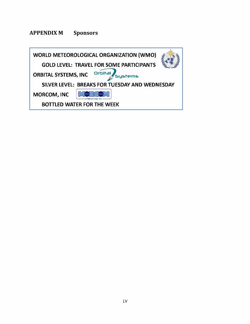
LV
APPENDIX M Sponsors