Embed Size (px)
Citation preview

Identifying Place-Based Habitat Priorities: NOAA Habitat Blueprint and the
Habitat Focus Area Regional Pilot
Joint GFNMS/CBNMS Advisory Council Meeting January 24, 2013

TESTING THE PROCESS – THE CALIFORNIA PILOT
Pilot Region Southern portion of NOAA Western Collaboration Region
NOAA Regional Collaboration Framework

What is NOAA’s Habitat Blueprint?
Components: – Establish Habitat Focus Areas – Enhanced Habitat Science – Strengthen Policy and Legislation – Regional Habitat Initiatives
Drivers: – Difficulty demonstrating impact of NOAA’s habitat conservation
activities – Perceived lack of LO collaboration – Declining habitat funding – Concerns with NOAA’s level of support for habitat

FIRST STEPS • Developed Process Guidance
• Used cross-NOAA Working Group to develop initial Guidance for how to select habitat focus areas
• Cross-NOAA review • Editorial Board made final decisions on edits • Process took over four months
• Formed a Regional Planning Team (RPT) • The RPT is responsible for organizing, coordinating, and
facilitating the habitat focus area selection process • Includes representatives from all NOAA Line Offices • Led by co-leads from the three main Line Offices
involved

TOP FAQS ABOUT HABITAT FOCUS AREAS • What is a habitat focus area?
• an area where collaboration among NOAA and external partners can yield measurable results and address multiple habitat-dependent objectives
• How many focus areas will there be? And how big will the areas be?
• One or more in each NOAA region • Big enough to make an impact, small enough to show a
difference
• Why establish habitat focus areas? • We have been successful but we can always do better • Need to prioritize with limited resources • Desire to increase collaboration with partners
• Will all of NOAA’s resources be directed to these areas? • No, but some activities taking place in these areas
will receive priority

• Must support at least one of the five Blueprint Outcomes • Sustainable and abundant fish populations • Recovered threatened and endangered species • Protected coastal and marine areas and habitats at risk • Resilient coastal communities • Increased coastal/marine tourism, access, and recreation
• Eight Decision Criteria identified with proposed scoring rubric • Potential to Demonstrate Long-Term Impact • Measurable Progress over the Next Three to Five Years (Feasibility) • External Partnership Potential • External Resources and Leveraging • Cross-NOAA Collaboration • Alignment with NOAA-wide Priorities • Improves Scientific Understanding of Habitat Function • Transferability
HABITAT FOCUS AREA CRITERIA

THE FOCUS AREA SELECTION PROCESS
Develop Implementation / Action Plan
9 Alert Opinion Leaders and
Stakeholders about Process
1
Research • Candidate area 1 • Candidate area 2 • Candidate area 3 • Candidate area 4 • Candidate area 5 • Candidate area 6 • Candidate area 7 • Candidate area 8 • Candidate area 9
Ocean Service • Candidate area 1 • Candidate area 2 • Candidate area 3 • Candidate area 4 • Candidate area 5 • Candidate area 6 • Candidate area 7 • Candidate area 8 • Candidate area 9
Fisheries • Candidate area 1 • Candidate area 2 • Candidate area 3 • Candidate area 4 • Candidate area 5 • Candidate area 6 • Candidate area 7 • Candidate area 8 • Candidate area 9
Line Offices Identify Candidate Habitat Focus Areas
2
Staff compiles info on all candidate areas into a single package
3
Stakeholders provide input on candidate areas
4
Staff incorporates stakeholder input
5
Participants at Cross-NOAA Workshop select one or more
NOAA-level Habitat Focus Area (s)
6
Recommendations approved by NOAA
leadership 7 Follow-up with stakeholders
to identify partnership opportunities
8

NOAA Candidate Focus Areas
Humboldt Bay
Russian River
Tijuana River
Channel Islands
Cordell Bank
Gulf of Farallones
San Francisco Bay NERR
Carmel River
Elkhorn Slough
Monterrey Bay NMS
Ventura
Santa Clara
Morro Bay
Klamath River
Eel River
San Francisco Bay and Delta.
San Joaquin River
Pajaro River Monterey Canyon
Southern CA Bight - North
Southern CA Bight - South
Huntington Beach Wetlands Complex

Main Criteria for California RPT
The Habitat Focus Areas had to be: Valuable for telling a clear story about the need for
and benefits from NOAA’s habitat conservation efforts
Demonstrate clear progress in 3-5 years Multiple line office collaboration

Russian River Watershed

Why the Russian River?
Habitat restoration needed for ESA-listed Coho, chinook, steelhead stocks
Communities and businesses subject to frequent and severe flooding
Competing uses for the River’s water Multiple cross-NOAA projects already underway Active stakeholder / partner community NOAA leadership will make a significant difference Real progress achievable in 3 to 5 years
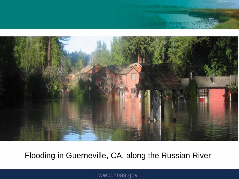
Flooding in Guerneville, CA, along the Russian River

Atmospheric Rivers (ARs) • Atmospheric Rivers (ARs) are
narrow regions in the atmosphere that transport lots of water vapor
• Significant AR events contribute to strong winds and can stall, causing extreme rainfall and floods
• Significant events can disrupt travel, induce mud slides, and cause damage to life and property
• Not all ARs cause damage – many are weak and provide beneficial rain and snow that are crucial for water supply
AR Quick Facts • 30-50% of annual precipitation in west coast states occurs in just a few AR events • A well-known type of AR that can hit the U.S. west coast is called the “Pineapple Express” due to their
ability to bring moisture from the tropical regions near HI to the U.S. west coast • ARs are about 200-400 miles wide
AR impacting the U.S. west coast: Nov. 26 – Dec. 4

Frost Protection Measures

15

NOAA Training Programs
• Model vulnerabilities from sea level rise and storm hazards, including factors such as water levels, wave heights, flooding, and erosion.
• Obtain insight and feedback on stakeholder information needs through regional workshops.
• Map infrastructure and ecosystem vulnerabilities to sea level rise and storm hazards at the scale needed for management action.
• Communicate the products in accessible, user friendly formats to apply to local adaptation and response strategies.
• Provide training on the use of the decision support tools and interactive maps.
Our Coast – Our Future Hazards and Climate Adaptation Habitat Priority Planner Coastal Inundation Toolkit

Dry Creek Restoration


Side Channel Habitat in Action

Off-channel habitat from gravel mines

Captive Broodstock Program

Lagoon improvements for steelhead


Russian River Deliverables In 3 – 5 Years
More streams with coho salmon and steelhead trout 3 miles of stream restored in Dry Creek Better management of the lagoon at the river
mouth Improved flood prediction Gravel mines developed into off-channel habitat
for salmon Better information for water management Better frost prediction models Progress on improved flood forecasting
Additional projects to be determined

25

26