Embed Size (px)
Citation preview

no class this Friday, 4/4
so study forQuiz, Monday, 4/7
~ 10-20 Questions will be taken from
Chapter 14:2,5,6,9,10,18,19,28,33,50
Chapter 15:3,4,13,16,17,29,31,43,57
Chapter 16:1,12,14,15,17,30,41,45
Chapter 17:1,3,6,10,11,12,13,14,15,19,20,21,28
Chapter 18:1,4,5,7,10,16,17,18,21,24,28,29,30,50lectures at:
http://www.msubillings.edu/sciencefaculty/spring_2008_handouts.htm


Our moon: Luna

Lunar impact craters

Crater Tycho

Close up of Tycho

The Moon
• 380,000 km distant
• Characterized by craters, lunar highlands and maria(ancient lava flows)
• No atmosphere
• Subject of 12 Apollo missions

Composition and features of the Moon
• 3 m of fine gray dust on the surface– Accumulated from micrometeorite impacts
– Glass beads formed from melted material
• Rocks are basalts– Formed from molten lava
– Light colored highland rock formed 4 billion years ago
– Dark colored maria rocks range from 3.1 to 3.8 billion years old
• Internal structure – 65-130 km of outer rock (thickest on far side)
– 900 km partly molten iron core

Current hypothesis: Luna was formed as a result of
an impact by a Mars-sized object in the early
stages of Solar System formation.

History of the Moon
Stage 1 - origin stage– Formed from material ejected
from a collision of a large object with Earth
Stage 2 - molten surface stage– Molten surface 100 km deep
– 200 million years after formation
– Heating from solar system debris
impacts
Stage 3 - molten interior stage– Accumulated heat from
radioactive decay
– Began 3.8 million years ago; ended about 3.1 million years ago
Stage 4 - cold and quiet stage– 3.1 million years ago to present
– Surface scarred by micrometeorites and meteorites
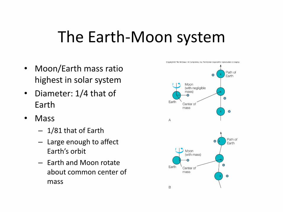
The Earth-Moon system
• Moon/Earth mass ratio highest in solar system
• Diameter: 1/4 that of Earth
• Mass – 1/81 that of Earth
– Large enough to affect Earth’s orbit
– Earth and Moon rotate about common center of mass

Eclipses of the Sun and Moon
• Moon’s orbit inclined 5º from that of Earth
• Proper alignment of Earth, Moon and Sun needed
• Conical shadows have two parts
– Umbra: inner cone, complete shadow
– Penumbra: outer cone, partial shadow
• Solar eclipses
– Where tip of umbra touches Earth
– Annular eclipse: when umbra doesn’t reach Earth
• Lunar eclipses
– Moon engulfed by Earth’s umbra

Tides
• Result from different gravitational pulls on front and back of Earth
Three factors1. Earth, Moon and Sun positions
• Spring tides when aligned; neap tides when Moon and Sun at 90º
2. Elliptical orbit of Moon• Greatest pull at perigee; less effect at
apogee
• 48,000 km difference
3. Size, shape and depth of water basin• Ranges from 1/3 m in Gulf of Mexico
to 15 m in Bay of Fundy

Our moon: Luna

Meteor Crater, Arizona
http://www.solarviews.com/eng/tercrate.htm
1.2 kilometers (0.7 miles)
40,000 years old

Wolfe Creek, Australia
0.9 kilometers (0.5 miles)
300,000 years old

Aorounga, Chad, Africa
17 kilometers (10.5 miles)
200 million years old

Manicouagan, Quebec, Canada
100 kilometers (62 miles)
212 million years old
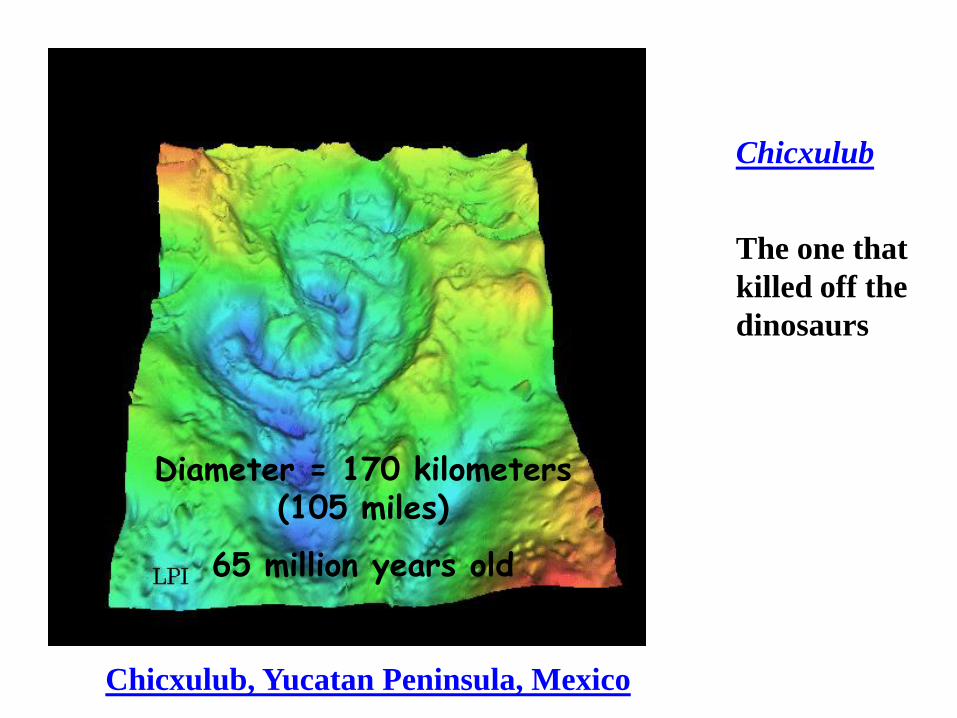
Chicxulub
The one that
killed off the
dinosaurs
Chicxulub, Yucatan Peninsula, Mexico
Diameter = 170 kilometers (105 miles)
65 million years old

http://www.scotese.com/earth.htm
http://www.scotese.com/earth.htm

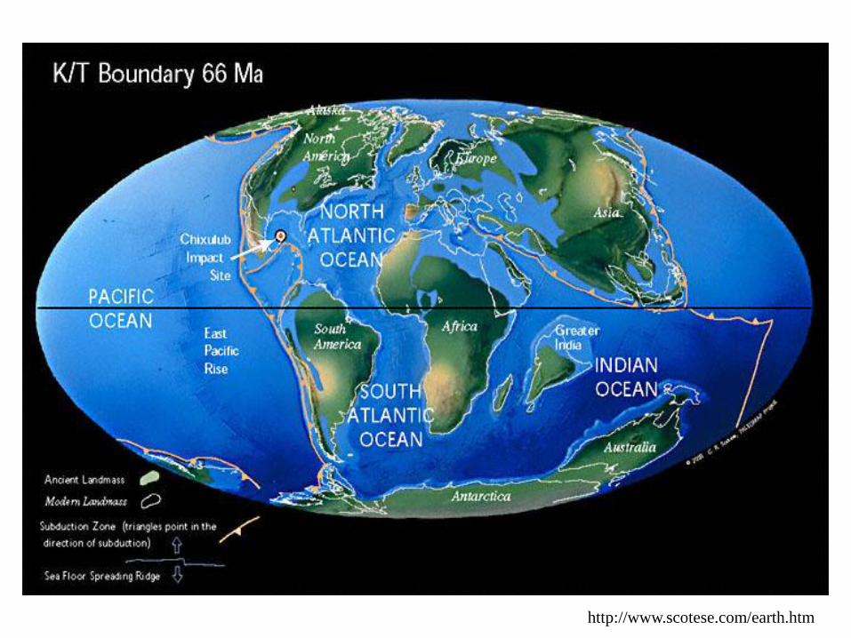
So where did the rest of the Earth’s impact craters go?
Answer:
They have been destroyed by tectonic activity (creation and destruction of crust)
and by erosion.
We will cover that later.

Earth’s internal structure
• Three main zones
• Crust
– Outer thin shell
• Mantle
– Much thicker than crust
• Core
– Central part
First we need to understand a little more about the Earth’s internal structure…

Evidence of Earth’s internal structure
• Earth’s magnetic field
• Gravity effects
• Heat flow
• Vibrations in the Earth
– Seismic waves
– Radiate outward from earthquakes
– Also noted from nuclear explosions

Seismic waves
• P-wave
– Longitudinal (compressional)
– Fastest waves
– Move through surface rocks and interior solid and liquid materials
• S-wave
– Transverse (shear) wave
– Second fastest
– Do not travel through liquids
• Up & down (crest & trough) wave
– Surface waves
– Much like water waves
– Slowest of the three
– Occur where S- or P-waves reach the surface

The core, cont.
• S-wave seismic data– Larger S-wave shadow
zone– Extends beyond 103º from
epicenter– Core acts like a liquid, not
allowing S-wave propagation
• Core has two parts1. Liquid outer core2. Solid inner core– Supported by S-wave and
P-wave data

The core
• Makes up 15% of Earth’s volume; 1/3 of Earth’s mass
• P-wave seismological data
– P-wave refracted by the core produces the P-wave shadow zone
– No direct P-waves seen between 103º and 142º of arc from the earthquake
– Used to calculate the shape and size of the core
– Source of data on interior makeup of core

Other core evidence
• Iron meteorites
– Mostly iron or iron-nickel alloy
– Thought to mimic chemical composition of core
• Earth’s magnetic field
– Source is turbulent flow within the liquid core
– Material must conduct electricity
• Meteorite and magnetic field data consistent with an iron core

The mantle
• Thick shell between crust and core
• Takes up 80% of Earth’s volume
• Accounts for 2/3 of Earth’s mass
• Composed mainly of olivine– Ferromagnesian silicate
Three data sources1. Seismological data
2. The nature of meteorites
3. Materials ejected by volcanoes
• Basalt correlation – Close to silicate chemical
composition of stony meteorites
– Most common volcanic rock

The crust
• Covers entire Earth
• Oceanic crust– Much thinner
– Basaltic rock, denser
• Continental crust– Granite rock, less dense
• Mohorovicic discontinuity– Mantle/crust boundary
– Seismic wave velocity increases sharply from crust to mantle


Heat driven
convection
1. Bottom water is warmed
2. It expands an is therefore less
dense
3. It rises to the surface and then
spreads out
4. Cooler water at the sides
descends to fill the void

A convective thunderstorm

Plate Tectonics
Basic idea of plate tectonics -
Earth’s surface is composed of
a few large, thick plates that
move slowly and change in
size
Intense geologic activity is
concentrated at plate boundaries, where plates move
away, toward, or past each other
Combination of continental drift and seafloor spreading
hypotheses in late 1960s

Where do we see deep earthquakes? What is happening there?


The ‘Ring of Fire’

What can happen at a plate
boundary?
1. Plates can collide
2. Plates can pull (or be pushed) apart
3. Plates can slide by one another

Convergent boundaries
• Occur when two plates move toward each other
• Old crust destroyed in the process
• Subduction zone– Belt with one crust
subducting under another
– Subducted material partially melts and joins mantle
• Three possibilities
1. Converging continental and oceanic plates
2. Converging oceanic plates
3. Converging continental plates

Ocean-continent plate convergence
• Oceanic plate of denser basaltic material subducted under less dense granite-type continental shelf
• Marked by oceanic trench, deep-seated earthquakes and volcanic mountains
• Example: convergence of South American Plate with Nazca Plate

Where do we see deep earthquakes? What is happening there?


Ocean-ocean plate convergence
• Trench and underwater ridge created by subduction
• Associated with deep-seated volcanoes
• Island arcs form where melted, subducted material rises up above sea level through the overriding plate


The Aleutian Island Chain

Continent-continent plate convergence
• Less dense, granite-type materials resist subduction
• Colliding plates pile up, producing a deformed and thicker crust of lighter materials
• Example: Tibetan Plateau and Himalayan Mountains

Transform boundaries
• Occur when two plates slide by each other
• Crust is neither created nor destroyed in the process
• Irregularities in movement along boundary
• Sudden jerks produce earthquakes
• Example: San Andreas Fault along California coastline

Juan de
Fuca plate

Divergent boundaries
• Occur between two plates moving away from each other
• Molten material from mantle rises to fill fissures
• New crust zone
• Often accompanied by volcanic activity
• Example: Mid-Atlantic Ridge


Seafloor Spreading
In 1962, Harry Hess proposed
seafloor spreading Seafloor moves away from the mid-
oceanic ridge due to mantle convection
Convection is circulation driven by
rising hot material and/or sinking
cooler material
Hot mantle rock rises under
mid-oceanic ridge Ridge elevation, high heat flow,
and abundant basaltic volcanism
are evidence of this

Seafloor Spreading
Seafloor rocks, and mantle rocks beneath them, cool and become
more dense with distance from mid-oceanic ridge
When sufficiently cool and dense, these rocks may sink back into
the mantle at subduction zones
Downward plunge of cold rocks gives rise to oceanic trenches
Overall young age for sea floor rocks (everywhere <200 million
years) is explained by this model


Divergent Plate Boundaries
At divergent plate boundaries, plates move away
from each other
Can occur in the middle of the ocean
or within a continent
Divergent motion eventually creates a
new ocean basin
Marked by rifting, basaltic volcanism, and eventual
ridge uplift
During rifting, crust is stretched and thinned
Graben valleys mark rift zones
Volcanism common as magma rises through
thinner crust along normal faults
Ridge uplift by thermal expansion of hot rock
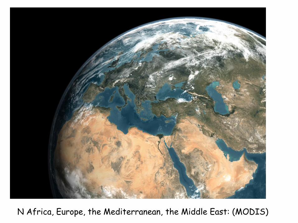
N Africa, Europe, the Mediterranean, the Middle East: (MODIS)

Nile Delta and Sinai Peninsula (MODIS)

North
South
Normally the orientation of the Earth’s magnetic field is like this.

South
North
But every once in a while (~100,000 years) the magnetic field flips

Hot magma ‘erupts’ from the center of a divergent zone and spreads out laterally as it cools and subsides

Present-day understandings
• Major remaining question: What drives the plates?
• Current working hypothesis: convective cells in asthenosphere– Hot fluid materials rise at
diverging boundaries
– Some escapes to form new crust
– Remainder spreads beneath the lithosphere, dragging overlying plates with it
– Problem: little supporting evidence

Mantle Plumes and Hot Spots
Mantle plumes - narrow columns of hot
mantle rock rise through the mantle
Stationary with respect to moving plates
Large mantle plumes may spread out and
tear apart the overlying plate
• Flood basalt eruptions
• Rifting apart of continental land masses
New divergent boundaries may form

Mantle Plumes and Hot Spots
Mantle plumes may form “hot spots”
of active volcanism at Earth’s surface
Approximately 45 known hotspots
Hot spots in the interior of a plate
produce volcanic chains
Orientation of the volcanic chain shows
direction of plate motion over time
Age of volcanic rocks can be used to
determine rate of plate movement
Hawaiian islands are a good example

Identifying place
• Position on flat surface– Intersection of two straight
lines
– Won’t work for Earth’s curved surface
• Position on Earth– Intersection of parallels and
meridians defined with respect to rotation axis
– Parallels - latitude
– Meridians - longitude
• Special parallels climate related

Seasons & Sun's Distance
Earth is 5 million kilometers further from the sun in July than in January, indicating that seasonal warmth is controlled by more than solar proximity.
Figure 3.1


Solar intensity, defined as the energy per area, governs Earth's seasonal climate changes
A sunlight beam that strikes at an angle is spread across a greater surface area, and is a less intense heat source than a beam impinging directly.
Seasons & Solar Intensity


Solstice & Equinox
• Earth's tilt of 23.5° and revolution around the sun creates seasonal solar exposure and heating patterns
• At solstice, tilt keeps a polar region with either 24 hours of light or darkness
• At equinox, tilt provides exactly 12 hours of night and 12 hours of day everywhere

Midnight Sun
The region north of the Arctic Circle experiences a period of 24 hour sunlight in summer, where the Earth's surface does not rotate out of solar exposure

Motion of Earth through space
Seven conspicuous motions:
1. Daily rotation at 1,670 km/h (at the equator)
2. Monthly rotation about Earth-Moon center of mass
3. Yearly rotation about the Sun at 106,000 km/h
4. Orbit of solar system about center of Milky Way at 370,000 km/h
5. Orbital motion within the Sun’s local star group at 1,000,000 km/h
6. Motion of Milky Way galaxy relative to remote galaxies at 580,000 km/h
7. Minor motions– Changes in shape and size of
Earth’s orbit
– Changes in the tilt of Earth’s axis
– Slowing of Earth’s rotation rate

Shape and size of Earth
• Very close to an oblate spheroid
• Deviations– Slightly pear-shaped
– Lump in the Pacific
– Depression in Indian Ocean
– Elevations and depressions of deviations less than 85 m.
Radius is about 4000 miles!!!!

Motions of Earth
Three of Earth’s motions are independent of the motions of the Sun and galaxy
1. Yearly revolution about the Sun
2. Daily rotation about its axis
3. Clockwise wobble of its rotation axis (multiple frequencies/periods)

What Causes Cycles?

Precession
• Slow wobble of Earth’s rotation axis
• Reaction of Earth to gravitation pull on its equatorial bulge by the Moon and Sun
• 26,000 years for one precession
• Changes direction of rotation axis on celestial sphere – Polaris not always the North
Star
– Position of equinoxes in the zodiac changes

Milankovitch Cycles

Place and time
• Earth’s periodic motions provide a basis for determining place and time
• Rotation provides an axis of rotation useful in determining locations on the globe
• Rotation and revolution determine cycles which can be used for time standards

Measuring time
• Time standards depend on measuring intervals between evenly spaced periodic events
• Astronomical examples: rotation of Earth on its axis, revolution of Earth around the Sun
– Basis for day, month, season and year
– Different ways to measure day, month and year

• The Egyptians had subdivided daytime and nighttime into twelve hours each since at least 2000 BC, hence their hours varied seasonally.
• The day was subdivided sexagesimally, that is by 1⁄60, by 1⁄60 of that, by 1⁄60 of that, etc., to at least six places after the sexagesimal point by the Babylonians after 300 BC,…
• In 1956 the second was defined in terms of the period of revolution of the Earth around the Sun for a particular epoch, because by then it had become recognized that the Earth's rotation on its own axis was not sufficiently uniform as a standard of time.

• With the development of the atomic clock, it was decided to use atomic clocks as the basis of the definition of the second, rather than the revolution of the Earth around the Sun.
• During the 1970s it was realized that gravitational time dilation caused the second produced by each atomic clock to differ depending on its altitude.
• Currently defined as “ the duration of 9 192 631 770 periods of the radiation corresponding to the transition between the two hyperfine levels of the ground state of the caesium 133 atom.[1]

Standard time zones
• 360º of longitude divided into 24 15º zones
• Adjusted for local consistency
• Daylight saving time– clocks set ahead in spring and
back in fall for one extra hour of sunlight during summer evenings
• International date line– The 180º meridian
– Designated to correlate days with 24 hour time zones