Embed Size (px)
Citation preview
Herefordshire Past
The Newsletter of The Trust for theVictoria County History of Herefordshire
Registered charity no. 1070427
Series 2, No. 10 Autumn 2010

- 2 -
Chairman’s Letter
In this issue ...News from the CentreLaunch of the Second Ledbury BookStaffordshire HoardRecording Farm BuildingsUnravelling the History of a FarmBosbury Field NamesBook Review - Herefordshire Place-names
- 2 -
It is about six months since I wrote my spring letter, and much has happened since then. On the positive side, the second EPE book, Ledbury: people and parish before the Reformation, has been published; those of you who were not there can read an account of the launch later in this newsletter. Work on the history of Eastnor has continued, albeit more slowly than it would have done had we been able to pay for more research. Other happen-ings have been less encouraging, particularly the recent Spending Review. The cuts in gov-ernment spending on heritage and higher ed-ucation are going to make funding projects like the Victoria County History even more difficult in future than it has been in recent years. The two main supporters of the VCH nationally – local authorities and universities – have been particularly hard-hit by the cuts. We in Herefordshire already knew that there was no possibility of further direct financial support from either Herefordshire Council or the University of Gloucestershire in the immediate future, but the new cuts mean it is likely to be longer than we had hoped before we can find a major funder. All grant-giving bodies will have more calls on their resources as organisations that have lost government funding look for alternative sources of money. The failure this summer of our application to the Malvern Hills AONB for a project on Eastnor, which fell very much within their remit, is an early indication of the problem.

- 3 -
In the next few months we must rely on small-scale fund-raising ventures, and any suggestions or offers of help would be gratefully received! To this effect there will be a lecture on the history of the Malvern Hills area by the well-known local historian, Professor Christopher Dyer of Leicester University, on the evening of Wednesday 11 May 2011 in Ledbury. Professor Dyer is a good lecturer, so please put this date in your diary. Details of time and place will be announced later.
In the slightly longer term, we plan to apply to the Heritage Lottery for support for a project in Bosbury centred on a survey of the old houses in the parish; it will be a study both of their architecture and of their inhabitants over the years. Like the EPE Ledbury project, this one would involve a number of volunteers working with professional historians. The immediate outcome would be a scholarly report on the buildings and a popular publication, perhaps in the form of a parish trail. Ultimately we hope that the material gathered would be used in a full VCH history of Bosbury. Before we can start the process of applying to the Heritage Lottery, however, we have to raise about £20,000 both to match the Lottery funding and to help pay for the project.
The new coalition government has been stressing the importance of Communities and the part they can play in our lives. Local history projects like the Bosbury one should help strengthen communities. A knowledge of how a place grew into what it is today, and even more helping to research and write that history, can foster a sense of community among the residents of a parish or village. The problem is that to do the work properly, to produce a complete history based on original sources which does not perpetuate any earlier errors or omit any aspects of the story, requires the direction of a professional historian. I think it is important that the Victoria County History should produce such histories: ones that do not see the past through rose-tinted spectacles or, on the other hand, see nothing but lives which were ‘nasty, brutish and short’. It is for this reason that I am convinced we must try our hardest to carry on in difficult times. Once the project stops it will be almost impossible to start up again.
Editorial Note - As a result of my note in the Spring number about the costs of printing and distributing the Newsletter, several people have suggested distributing it electronically where possible. Email would certainly save time and money, so, if you are willing to receive your next copy by email (PDF, file size 2-3MB), please let me know: [email protected]. If we do not hear from you, we will assume that you want to continue to receive the Newsletter by post.

- 4 -
News from the CentreProfessor John Beckett’s five-year secondment to the Victoria County History as its Director ended on 30 August, and he has now returned to his post at Nottingham University. On 12 October a small reception was given in his honour at the Institute of Historical Research, with Professor Miles Taylor, Director of the IHR, and Dr Nick Kingsley, Chairman of the VCH Board, thanking John for his hard work. John was
presented with a mini ‘Red Book’ made of good wishes from county staff.
The new Executive Editor of the VCH is Elizabeth Williamson, formerly Architectural Editor. Elizabeth has worked on the VCH, and latterly EPE, for about 15 years, and her architectural work has taken her into each of the VCH counties, thus giving her a feel for work in county offices as well as in the central office. She is assisted by Matt Bristow, formerly the EPE architectural assistant, as Research Editor responsible for managing photography, contracts, the progress of research and the academic content of the websites. Jessica Davies, as Production Manager, will see the red books and any future paperbacks through the press.
The England’s Past for Everyone website was so successful in sharing a wide range of resources, images and articles that the VCH is committed not only to maintaining the site but to improving and expanding it. Over the past few months a great deal of work has been done ‘behind the scenes’ to make the site easier to use and more comprehensive. It is possible to ‘explore’ geographically; originally this was limited to the place of an EPE project (eg Ledbury), but now all VCH researchers are being encouraged to put up material, in addition to the well-established draft parish histories, on the VCH county sites. The ‘explore by themes’ section has been greatly improved, enhanced by brief introductory articles written by VCH authors. There are eight main themes: Settlement and Topography; Transport and Communications; Government and Administration; Trade and Commerce; Industry; People and Communities; Religious Life and Buildings; War and Conflict. Within each theme there are sub-themes such as prehistoric settlements, farms and farmsteads, canals, railways, pubs and inns, fishing, brick making, poor relief, education, parish churches, war memorials…

- 5 -
So visit http://explore.englandspastforeveryone.org.uk/ and start exploring your locality or topic of interest. And remember to look at the VCH Herefordshire website www.victoriacountyhistory.ac.uk/Counties/Herefordshire, where you will find information to supplement the Newsletter.
Launch of Second Ledbury Book Ledbury: people and parish before the Reformation
The second Ledbury book written as part of the England’s Past for Everyone project, Ledbury: people and parish before the Reformation, was launched in St Katherine’s Hall, Ledbury, on Wednesday 28 April, the occasion bringing the successful four-year long EPE project to a fitting end.
Janet Cooper, as chairman of the Herefordshire Victoria County History Trust, welcomed all those present and expressed the Trust’s thanks to its major supporters and funders: the Heritage Lottery Fund, Herefordshire Council, the University of Gloucester-shire and the central EPE staff at the Institute of Historical Research, University of London. Laurence Banks, representing the Lord Lieutenant as patron of the Trust, then formally launched the book, followed by Andy Tector, then Deputy Director of Environ-ment and Culture for Herefordshire, who spoke on behalf of the Council. Sylvia Pinches talked about her book, thanking all those involved in its research and writing, especially the many EPE volunteers, along with Nigel Baker, Janet Cooper and Keith Ray, each of whom had contributed a chapter. Finally Professor John Beckett, Director of the VCH, spoke on behalf of the Institute of Historical Research, presenting copies of the book to Lawrence Banks, Herefordshire Council, the University of Gloucestershire and David Whitehead in recognition of his many years of service as Hon. Secretary of the Trust.
The launch was attended by 70 - 80 people, mostly EPE volunteers and other individuals who had contributed to the book by providing support or informa-tion. There was also a good turn-out of central EPE staff from London. Every-one had a chance to chat and reminisce about their work over the last four years while enjoying the excellent refreshments. Copies of the book were sold by Ledbury Books and Maps, and Sylvia was kept very busy signing them!

On Saturday 11 September the Trust for the VCH Herefordshire presented a lecture by Stephen Dean, Staffordshire County Council's Principal Archaeologist, about the amazing find of metal detectorist Terry Herbert in July 2009, which we now call the Staffordshire Hoard.
The field in which the find was discovered lies beside the A5 (formerly the Roman road called Watling Street), just west of Hammerwich near Lichfield. Through a careful examination of the whole field, plus a more thorough excavation of the find-site, nearly 3,000 items have been unearthed. The items had been scattered somewhat by recent ploughing, but no further treasure now remains in this field. The evidence suggested that the hoard was originally contained in a leather bag, although no trace of it remains. The top soil on the site is about 30cm deep, and the items were all found in this layer, which lies above a thick layer of clay.
The Staffordshire Hoard, which has tentatively been dated to the 7th-8th centuries, is the largest ever found in what would have been the Kingdom of Mercia at that time. The hoard contains about 5kg of gold and 2kg of silver, many times in excess of the weight (1.5kg) of the precious metal found at Sutton Hoo in 1939, a burial site containing grave goods including a bronze helmet and a decorated shield.
The Staffordshire Hoard does not contain such large pieces as the Sutton Hoo burial, but there are many exquisite smaller pieces, such as the minia-ture pyramids that would have decorated sword hilts or shields. Other martial items are set with garnets, which analysis has shown came from India; the gold has been shown to be Byzantine. The garnets had gold behind them to increase their brilliance. The workmanship was exquisite, especially consid-ering that the craftsmen so long ago had no magnifying glasses to help them see their work better. There are only ten larger items, including three crosses, but no domestic items nor any feminine jewellery.
Some of the finds show patterns that mirror designs found at Sutton Hoo and are reminiscent of the carpet page designs of the Lindisfarne Gospels and the earlier Book of Durrow, both dating from the so-called Dark Ages. These designs depict Celtic knotwork together with intertwined animals, including birds and snakes, which illustrate those early manuscripts and which survive for us today.
The Staffordshire Hoard
- 6 -

- 7 -
The money to buy the hoard was raised by public donations together with other funding from the Art Fund and the Heritage Lottery Fund. The conser-vation of the hoard will cost a great deal, but money for it still remains to be found, and this work will take many more years to complete.
This was a truly fascinating lecture giving us a great deal of background information about the Staffordshire hoard, which can be viewed at the Birmingham Museum & Art Gallery and the Potteries Museum in Stoke-on-Trent.
Celia G Kellett
Recording Farm Buildings
In July this year Sylvia Pinches introduced the Ledbury EPE group to Dr Peters whose lifelong interest has been the study and recording of farm buildings – there may be a Greek word for that. He has written a book on the subject in the Shire Books Series, which is still in print. He showed us diagrams of the various structures one is likely to find in the older farm yard – sheds and barns, for oast and cider, pigs, cows and horses, their roof trusses and arrangements of beams and their brick size and bond. They also showed
where one threshed and stored grain and straw, where it’s convenient for cows to be and where not, and so on.
Since the group has been looking at the wills and Parish Registers of Eastnor, Sylvia arranged for us to visit some of the farms owned by Eastnor Castle Estate, to see Dr Peters at work and to try our hands measuring these interesting and historic farms. Measuring the cart shed at Netherton,
an 18thC building probably rebuilt in the 19thC.

- 8 -
On the morning of 22 July we met up at Ockeridge Farm in a beautiful spot below British Camp, then on the following weeks at nearby Netherton, Fowlet Farm, Eastnor estate’s Home Farm, and so on.
We saw substantial, rough hewn timbers indicating earlier buildings and later thinner, sawn beams that made better use of positioning for load bearing.
Older local materials like Here-fordshire oak of course and the familiar fossiliferous Silurian limestone were common with imported pine, brick and slates with cast and corrugated iron coming in increasingly through the 19th and 20th centuries.
Most contemporary farm buildings are great roofed open spaces used to store enormous machinery under, but grain drying and storing is needed, and a surprising use is still made of 17th-19th century structures. The farmers tended to show a very un-hard nosed desire to preserve their older buildings even when they were in poor condition, in the way and probably a danger. All were keen to know how old they were and had their own theories and family memories. Dr Peters didn’t include the farm houses in his researches, but we did and found the farmers very keen to show wonderful roof spaces and the eccentric development of their homes.
These were the homes and work places of the people whose births and deaths, marriages and babies we had been recording. Their continuity is remarkable. As we went about we watched Big Chill City spring up on Eastnor’s rolling acres, souring the milk and keeping farmers awake at night, but it had gone again before we got round to measuring it.
Philip Weaver
Cider mill at Whitehouse Farm
The south range of the barn contains the cider mill, probably built late 18th /early 19thC, with a little outshoot tacked on to house the press.
- 9 -
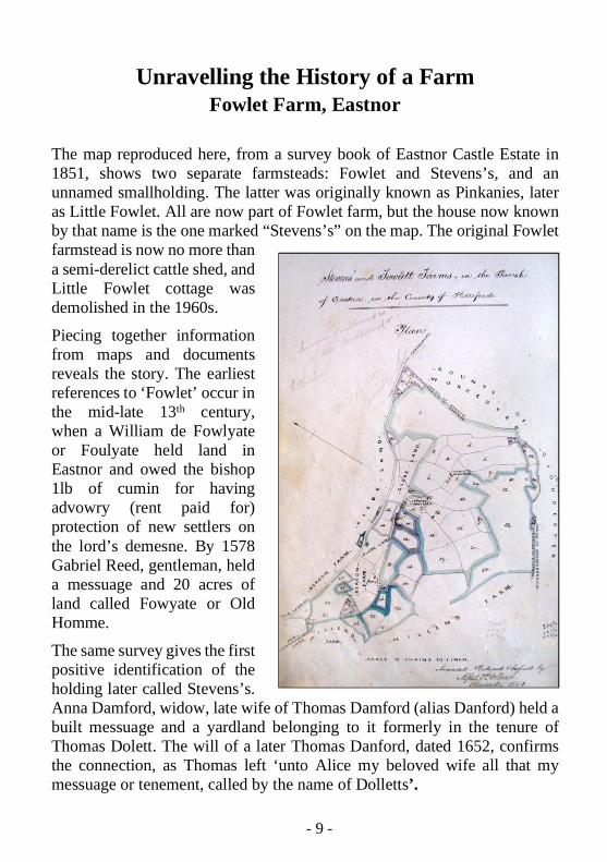
Unravelling the History of a FarmFowlet Farm, Eastnor
The map reproduced here, from a survey book of Eastnor Castle Estate in 1851, shows two separate farmsteads: Fowlet and Stevens’s, and an unnamed smallholding. The latter was originally known as Pinkanies, later as Little Fowlet. All are now part of Fowlet farm, but the house now known by that name is the one marked “Stevens’s” on the map. The original Fowlet farmstead is now no more than a semi-derelict cattle shed, and Little Fowlet cottage was demolished in the 1960s.
Piecing together information from maps and documents reveals the story. The earliest references to ‘Fowlet’ occur in the mid-late 13th century, when a William de Fowlyate or Foulyate held land in Eastnor and owed the bishop 1lb of cumin for having advowry (rent paid for) protection of new settlers on the lord’s demesne. By 1578 Gabriel Reed, gentleman, held a messuage and 20 acres of land called Fowyate or Old Homme.
The same survey gives the first positive identification of the holding later called Stevens’s. Anna Damford, widow, late wife of Thomas Damford (alias Danford) held a built messuage and a yardland belonging to it formerly in the tenure of Thomas Dolett. The will of a later Thomas Danford, dated 1652, confirms the connection, as Thomas left ‘unto Alice my beloved wife all that my messuage or tenement, called by the name of Dolletts’.

- 10 -
A bundle of deeds at Eastnor Castle shows later generations mortgaging the property and eventually selling it to John Cocks of Castleditch in 1767. Fowlet farm was bought by the Cocks in 1827, and soon Fowlet and Stevens’s farms were let together. The farm buildings at Stevens’s were rebuilt c. 1830, and it seems likely that the old farmhouse at Fowlet was abandoned about this time. The tenants can be traced in estate documents, census records, trade directories and parish registers, from John Stephens in the 1770s to Mr Pritchard today.
Meanwhile, Pinkanys was a small copyhold tenure, first mentioned by that name in the late 15th century, when it was described as ‘one nook of custom-ary land called Pyncanyesland, lately [occupied] by John Michell’. The 1578 survey makes it clear that the six acres of pasture were then divided into two closes and that the original house had fallen down. A new cottage was built at some time, and it continued until after the Second World War as a smallholding of some 12 acres. Mr WG Coulston told the Ministry of Agriculture in 1941 that he had 5 acres of permanent grazing, 4 acres of orchard, 2½ acres of rough grazing and ½ acre of potatoes and he grew vegetables in his ¼ acre garden. He had one milking cow, a heifer in calf, three other cattle and 25 fowl. Eking out a living in his small cottage, with no electricity and only the well for water, his life was probably not that different from that of John Michell 500 years before. Sylvia Pinches
Current views of Fowlet Farm

- 11 -
The Bosbury tithe apportionment is dated 1839 while its accompanying map is dated 1840. The parish name itself, which Ekwall suggests means Bôsa's burg, denotes a probable fortified place. As the name appears as Boseberge in the 1086 Domesday Survey, it further suggests that this fortified place predates the Norman Conquest, referring perhaps to a Roman fort or fortified Mercian (Saxon) manor. Such place-names and field-names are archaeo-logical indicators, and they do require corroborative evidence. Particular names elsewhere, identifying certain types of site, can be useful reference points. Investigation can be done by using documentary evidence and through building surveys, fieldwalking, hedge dating and geophysical surveying.
Research can start with the Woolhope Transactions, and the Herefordshire Through Time website (www.herefordshire.gov.uk/htt/) for field-names and the SMR (Sites and Monuments Record). Bosbury is used here as an example, but these sources are useful for investigating any parish. The easiest way to do this is to gather all the information possible and divide it into periods, producing a series of regressive maps. The first map would locate evidence from prehistory, the next would show that for the medieval and so forth. The individual maps depend on how much information is found for a particular period – it may be that two medieval maps are needed, for early and late. This simple method helps organise the information, which can then include detailed accounts of individual sites.
The SMR shows that flints have been found in the parish. Lynchets may date from an early period or may be medieval. Field 402 Camp field on the tithe map has a curved boundary, which suggests the possibility of an Iron Age site. This may be significant as 50% of Iron Age hillforts have the field-name camp. Roman sites may be indicated by names such as 1079 Harbour Hill and Cold Green because there is a possibility that these originated as Cold Harbour, possibly an earth fortification or encampment. With this possibility it is worth looking closely at 1327 Blackmoor because this could be a Blacklands site, and Stone or Stoney might also be of the same period. Mercian (Saxon) sites are clearly suggested by the -burg name in Bosbury itself, but 25 Winserdine just might be a -wardine name.
Bosbury Field-Names and Field Patterns

- 12 -
A glance at the tithe map shows a wealth of surviving medieval strips and some of these will have relevant names that would allow the recognition of the extent of the large open fields, such as Southfield. In the paper Herefordshire Field-Names I was able to deduce the size of the open fields in Much Marcle using the field-names. Bosbury parish was divided into the three townships of Bosbury, Upleadon and Catley. Upleadon was the site of a preceptory belonging to the Knights Templar for which some evidence survives at Temple Court, in particular 331 Moat and 324 Moat Meadow. This land had been granted to the Templars by William Marshall, Earl of Pembroke, and eventually extended to 740 acres. When the Templars were suppressed in 1308 the estate passed to the Knights Hospitaller of St John of Jersusalem, but, unlike Garway, Upleadon remained independent of Dinmore, the most important Hospitaller preceptory in the area. The field evidence in the SMR also records medieval ridge-and-furrow and dovecotes.
Reproduced from 1926 6-inch Ordnance Survey Map
Later periods are also well represented. The kiln fields and quarry fields can be examined for connections to the road system and also for the geological reasons for their locations. Among the barns and other farm buildings note

- 13 -
Further sources of information:The Concise Oxford Dictionary of English Place-Names, by Eilert EkwallWoolhope Transactions, vol.XLVIII 1996Herefordshire Past and Present, an Aerial View, by Ruth E. Richardson and Chris
Musson, 2004 Logaston Press Herefordshire Miscellany, Commemorating 150 Years of the Woolhope Club,
edited by David Whitehead & John Eisel, 2000 Lapridge PublicationsA History of the Order of St John of Jerusalem in Wales and on the Welsh Border,
by William Rees, 1947 CardiffA Survey of Historic Parks & Gardens in Herefordshire, by David Whitehead,
edited Jane Patton, 2001 Hereford & Worcester Gardens TrustStephen Ballard's diaries in HRO, which describe his survey work for this canal
can be taken of 152 Windmill Hill as windmills were a necessary power source which had to be carefully sited. 417 Perry Hill may be indicative of perry production, and mapping of orchard fields can show the extent of cider production, which may link to surviving traces of cider mills. Other mills may have a longer history, perhaps from the medieval period. Bosbury tithe map is very unusual in showing the line of the Hereford to Gloucester Canal overlaid onto the existing fields. This canal needed an Act of Parliament so detailed surveyed plans had to be produced. It would be useful to compare the records of the canal company at the Gloucestershire Record Office to see if these plans still exist in HRO and to compare if the tithe map shows exactly the same the route…and if not, why not? Inett Holmes' papers and photo-graphs in the Herefordshire RO may prove extremely helpful.
The River Leadon bisects the parish, and it may be that the earliest settle-ments were along the river. Medieval villages required assured water, mead-ows, arable land, pasture land, and woodland for pigs, forage and timber. The quality of the soil was all important, and field names often preserve the crop best suited to a particular field. Field-names were a way of recording neces-sary information that could, incidentally, be passed to future generations. In periods when instant communication was not possible, field-names were also a practical way of identifying which field was being worked at any one time and also of remembering agricultural information about each field. Bosbury has a wealth of interesting information surviving in field-names, place-names and field evidence. It should prove an excellent parish for detailed study and a valuable contribution to the Herefordshire VCH.
Ruth E. Richardson 2010

- 14 -
Herefordshire Place-namesBook Review
Author: Bruce Coplestone-CrowPublished by Logaston Press, 2009252 pp, paperback £12.95
Herefordshire Place-names, originally published in 1989, was the first mod-ern attempt at interpreting and classi-fying the village and settlement names of the county since AT Bannister’s The Place-Names of Herefordshire published in 1916. Today both books are difficult to find and expensive to buy, so a new and revised edition of Coplestone-Crow’s book is very timely. Indeed, this is probably the most useful countywide history book of recent years. Not only does it explain the origins and meaning of every parish name, but also in extensive parishes, most of the hamlets, townships and farmsteads – lost and existing – are similarly interpreted.
If, for example, you wished to study the early history of Colwall –‘Cool-spring’ – eight versions of the name are quoted, from Colewelle in 1086 to Colowella in 1506, which introduces the aspiring historian of Colwall to eight separate medieval texts. A quick glance at Coplestone-Crow’s sources indicates that most of these can be found in Hereford Cathedral Library, but some might be on-line and one or two might require a visit to a regional or university library. If you add to this the other references relating to Barton Court ‘Barley grange’, Brockhill Farm ‘Brook hill’ and two lost landmarks on the county boundary, you have assembled a useful collection of referenc-es to the early history of the parish of Colwall. Each document, when viewed in full, will add something valuable to the general history of the parish in the Middle Ages.
Obviously, the point of the book is to provide meanings for the modern place-names. The first and most important lesson to be learnt by the begin-ner, interpreting place-names for the first time, is that the obvious is not always correct. For example, Kingsland is not ‘land belonging to the king’

- 15 -
but much more interesting as ‘an estate belonging to the king in the district of Leen’ – a very early, possibly Dark Age territory, which predates the Anglo-Saxon era in the Welsh border. On the other hand, Ledbury is certain-ly the ‘settlement on the river Leadon’ with the Old English burh referring to the enclosure around an ancient church, as, for example, at Shaftesbury and Malmesbury.
For the historian, the most useful aspect of place-name studies is what it has to say about origins and the early character of the landscape. If we turn in the book to Bosbury ‘Bosa’s manor house’ (or ‘enclosure’), Upleadon Court is also discussed. This is a long way from the river Leadon and seems to be recorded in Domesday Book as simply Ledene – a settlement, presumably, much closer to the river – which Coplestone-Crow suggests was Temple Court, having changed its name when William the Marshal (d.1219) gave the estate to the Knights of the Temple. Thus Upleadon came into existence before this date, when Temple Court still had its original name. Of course, if you refer to Eilert Ekwall’s Concise Oxford Dictionary of English Place-Names (several editions from 1935) or the more recent Cambridge Diction-ary of English Place-Names (2004), you will find that Leadon derives from a British or Old Welsh word meaning ‘broad’, which seems to rather over-state the character of this small river. However, it suits a lowland stream with an extensive floodplain. River names are studied in detail by Ekwall in English River Names (1928).
Herefordshire Place-Names provides endless illumination and should be kept close at hand – a ‘coffee table book’, perhaps – for those difficult social occasions when the ice can be broken quite decisively with an interjection, such as: ‘Did you know that Mainstone Court (near The Trumpet in the parish of Pixley) means ‘great stone’, or that Marcle means ‘boundary wood’ on the frontier between the sub-kingdoms of the Magonsaete and the Hwic-ce’? The result: the end of an impasse and the commencement of an evening of interesting conversation about local place-names and, if you get fed-up with that, get a dictionary of surnames!
David Whitehead

This Newsletter is published in May and November. Back copies can be viewed on
www.englandspastforeveryone.org.uk/Counties/Herefordshire
The CommitteeThe chairman is Dr Janet Cooper, formerly Editor of the Essex VCH and a member of the central VCH committee. The other trustees are Professor Chris Dyer (Leicester University, formerly chairman of the VCH central committee) and the Herefordshire historians Ron Shoesmith, Brian Smith and David Whitehead (our Vice Chairman), plus Tom Davies (our Hon. Treasurer), Angela Bishop (our Hon. Secretary) and Gill Murray (formerly of the 6th Form College, Hereford).
They are joined by committee members Joe Hillaby (Herefordshire and Ledbury medieval historian), Ruth Richardson (lately 6th Form College, Hereford) and Dr Charles Watkins (Nottingham University).
Our Herefordshire patrons are: Mr Lawrence Banks, CBE, DL, representing the Lord Lieutenant of Herefordshire; The Right Revd Anthony Priddis, the Lord Bishop of Hereford; Sir Roy Strong; Mr James Hervey-Bathurst, CBE, DL; Mr Edward Harley.
Contact details:Dr. Janet Cooper
16 Merrivale Crescent, Ross-on-Wye HR9 5JUemail: [email protected]
The Trust’s aim is to support the writing of the history of the towns and parishes of Herefordshire as part of the Victoria History of the Counties of England. The VCH, ‘the greatest
publishing project in English local history’, is managed by the Institute of Historical Research, University of London. It is
renowned for its scholarship but also aims to be accessible to the growing number of local historians throughout the country.