Embed Size (px)
Citation preview
#
#
#
#
#
#
##
#
#
#
#
#
#
#
#
#
# #
#
#
#
#
#
#
#
#
#
#
#
##
#
##
#
#
##
#
#
#
#
#
##
#
#
##
#
#
#
#
#
#
#
#
#
#
#
#
#
#
#
#
#
#
#
#
##
#
##
#
#
#
#
#
#
#
#
#
#
#
#
#
##
#
#
#
#
#
#
#
# #
#
#
#
#
#
#
#
#
##
#
#
#
###
#
##
##
#
#
#
#
##
#
#
#
#
#
#
#
##
#
#
#
#
#
#
#
#
#
#
#
###
##
#
#
#
##
#
#
#
#
#
##
#
##
#
##
#
#
#
#
##
#
#
#
#
#
#
#
#
#
#
##
#
#
#
#
#
#
#
#
#
#
#
#
#
#
##
#
OCEAN
SUSSEX
ATLANTIC
BURLINGTON
MORRIS
SALEM
WARREN
MONMOUTH
CUMBERLAND
HUNTERDON
BERGEN
MIDDLESEX
SOMERSET
MERCER
CAMDEN
CAPE_MAY
GLOUCESTER
PASSAIC
ESSEX
UNION
HUDSON
East
Fault
Ramapo Fault
Longwood
Valley Fault
New B
runsw
ick Fa
ult
Jenny Jump Thrust Fault
Rockaw
ay Va
lley Fa
ult
Flemin
gton F
ault
Zero F
ault
Wawaya
nda Fa
ult
Wright Po
nd Fau
lt
Pequest Allamuchy Fault
Kennedy
s Fault
Mount Hope Fault
Tanners Brook Fault
Hambur
g Faul
t
Musconetcong Thrust Fault
Ledg
ewoo
d Fau
lt
Tranq
uility T
hrust F
ault
Hope
well F
ault
Pohatcong Thrust Fault
Mountain
Lake F
ault
Longw
ood Va
lley Fa
ult
Ramapo Fault
Ramapo
Fault
Wright Pond
Fault
Muscone
tcong
Thrust
Fault
Tanners Brook Fault
Flemi
ngton
Fault
Ramapo
Fault
Hopewell Fault
9
87
6
5
4
3
2
1
9998
97
96
95
94
93
92
91
9088
87
8685
84
83
82
81
80
79
7877
76
75
7372
69
68
67
66
65
64
63
62
61
60
59
5857
56
55
54
53
52
51
50 49
48
47
46 45
44
43
42
41
40
3938
37
36
35 34
33
3231
30
29
28
27
26
25
24
23
22
21
20
1918
17
16
1514
13
12
11
10
204
203202
201
200
199
198
197
196
195
194
193
192
191
190
189
187186
185
184
183
182
181
180
179
178
177
176
175174
173
172
171
170
168
167
166165
164
163162
161
160
159
158
157155
154
153
152151
150
149148 147
146
145
144
143
142
141
140
138
137
133
132
131
130
129
128
127
126
124
122121
118117
115 114
112
111
110
107
106
105
103
102
101
100
ExplanationMAGNITUDES
# 0.0 - 0.3# 0.4 - 1.3# 1.4 - 2.3# 2.4 - 3.3# 3.4 - 4.3# 4.4 - 5.3
Named Faults
CountiesGeneralized Bedrock Geology
Tertiary sand, silt, clayCretaceous sand, silt, clayJurassic siltstone, shale, sandstone, conglomerateJurassic basaltJurassic diabaseTriassic siltstone, shale, sandstone, conglomerateDevonian conglomerate, sandstone, shale, limestoneSilurian conglomerate, sandstone, shale, limestoneOrdovician shale, limestoneCambrian limestone, sandstonePrecambrian marblePrecambrian gneiss, granite
´
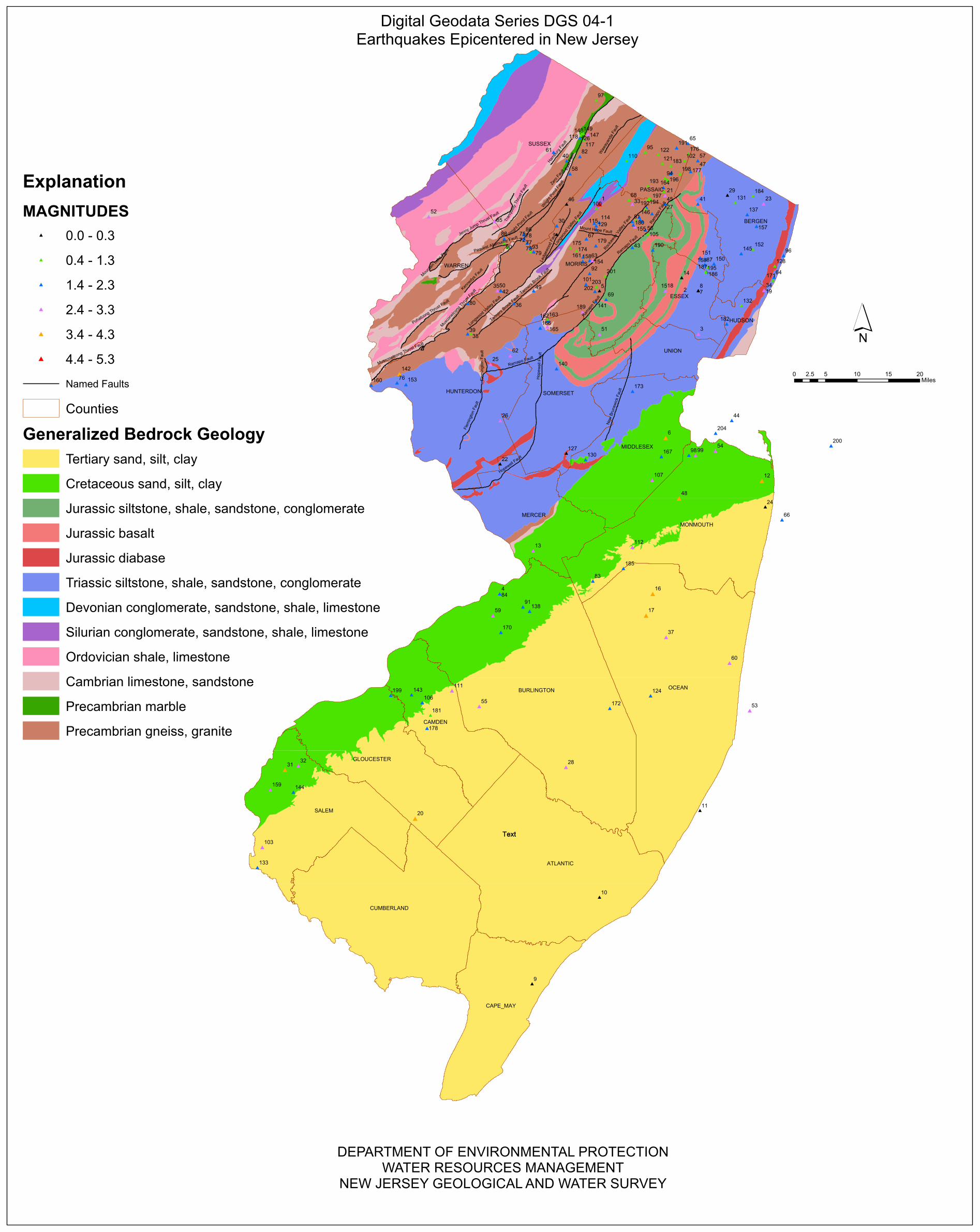
Digital Geodata Series DGS 04-1Earthquakes Epicentered in New Jersey
0 5 10 15 202.5Miles
TextText
DEPARTMENT OF ENVIRONMENTAL PROTECTIONWATER RESOURCES MANAGEMENT
NEW JERSEY GEOLOGICAL AND WATER SURVEY

ID NORTHING EASTING QUAD MUNICIPALITY COUNTY DATE TIME (UTC) LAT_N LON_W DEPTH (KM) MAGNITUDE LOCATION COMMENTS DATA SOURCE
1 789196 492125 Franklin, NJ ROCKAWAY TWP MORRIS 11/30/1783 3:50 41.000 74.500 0.00 5.3 West of New York City 2 Foreshocks (11/24 and 11/30) and 1 aftershock LCSN, Stover, NESN2 712791 561345 Caldwell, NJ WEST ORANGE TWP ESSEX 1/25/1841 5:30 40.790 74.250 0.00 2.9 West Orange, NJ NEIC, NESN, LCSN3 680047 575301 Elizabeth, NJ NEWARK CITY ESSEX 3/5/1861 17:00 40.700 74.200 0.00 2.4 Newark, NJ NEIC4 461482 408207 Bristol, PA FLORENCE TWP BURLINGTON 9/10/1877 14:59 40.100 74.800 0.00 2.9 Burlington, NJ NEIC, LCSN5 716335 492125 Mendham, NJ MORRIS TWP MORRIS 8/10/1880 17:15 40.800 74.500 0.00 0.0 Near Morristown, NJ 1 aftershock 9/1/1880. NEIC6 592540 547774 South Amboy, NJ SAYREVILLE BORO MIDDLESEX 09/01/1895 11:09 40.460 74.300 0.00 4.1 Near South Amboy, NJ Location changed. LCSN, Eppley, NESN, Smith, Coffman, Sykes & others7 716477 575177 Orange, NJ BLOOMFIELD TWP ESSEX 5/27/1902 0:00 40.800 74.200 0.00 0.0 Bayonne-Wayne, NJ NEIC, NESN8 716477 575177 Orange, NJ BLOOMFIELD TWP ESSEX 8/11/1902 0:00 40.800 74.200 0.00 0.0 Bayonne-Wayne, NJ NEIC, NESN9 133598 435450 Sea Isle City NJ UPPER TWP CAPE_MAY 4/23/1910 0:00 39.200 74.700 0.00 0.0 Near Atlantic City, NJ NEIC, NESN, Eppley
10 206377 492125 Pleasantville, NJ PLEASANTVILLE CITY ATLANTIC 11/6/1912 18:40 39.400 74.500 0.00 0.0 Near Long Beach, NJ NEIC11 279361 576654 Beach Haven, NJ LONG BEACH TWP OCEAN 8/5/1919 5:00 39.600 74.200 0.00 0.0 Cinnaminson, NJ NEIC12 556427 628668 Long Branch, NJ RUMSON BORO MONMOUTH 6/1/1927 12:20 40.360 74.010 0.00 3.9 Near Asbury Park, NJ Location changed. LCSN, Stover, Smith, Eppley, NESN, Sykes & others13 497829 436262 Trenton E, NJ HAMILTON TWP MERCER 1/25/1933 2:00 40.200 74.700 0.00 2.8 Near Trenton, NJ NEIC, Eppley, Coffman14 727363 561303 Caldwell, NJ VERONA TWP ESSEX 9/30/1937 22:08 40.830 74.250 0.00 0.0 Verona, NJ Location changed. NEIC, NESN, Sykes and others15 716398 547493 Caldwell, NJ LIVINGSTON TWP ESSEX 5/16/1938 19:25 40.800 74.300 0.00 2.3 Verona, NJ NEIC, NESN16 461381 536881 Lakehurst, NJ JACKSON TWP OCEAN 8/23/1938 3:36 40.100 74.340 13.80 3.8 NE of New Egypt, NJ Eppley, Coffman, NESN17 443159 531315 Lakehurst, NJ JACKSON TWP OCEAN 8/23/1938 5:04 40.050 74.360 20.70 4.0 Freehold, NJ 4 aftershocks felt. NESN18 716398 547493 Weehawken, NJ LIVINGSTON TWP ESSEX 12/6/1938 19:38 40.800 74.300 0.00 2.6 Verona, NJ NEIC, NESN, Smith19 716730 630545 Weehawken, NJ NORTH BERGEN TWP HUDSON 9/13/1939 1:22 40.800 74.000 0.00 2.2 Union City, NJ NEIC, NESN, Smith20 272410 337110 Newfield, NJ FRANKLIN TWP GLOUCESTER 11/15/1939 2:53 39.580 75.050 3.00 3.4 Salem County, NJ NESN21 796546 547310 Wanaque, NJ WANAQUE BORO PASSAIC 4/1/1947 13:25 41.020 74.300 0.00 2.7 Pompton Lakes NJ Location changed. NESN, Sykes and others22 570762 408577 Hopewell, NJ HOPEWELL TWP MERCER 10/16/1949 23:33 40.400 74.800 0.00 0.0 Hopewell, NJ NEIC23 789592 630128 Weehawken, NJ-NY OLD TAPPAN BORO BERGEN 8/17/1953 4:22 40.870 74.070 0.00 3.2 Bergen County, NJ Location changed. NESN, Sykes and others24 534586 631578 Long Branch, NJ LONG BRANCH CITY MONMOUTH 3/31/1954 21:25 40.300 74.000 0.00 0.0 Long Branch, NJ NEIC25 654577 400536 Califon, NJ CLINTON TWP HUNTERDON 3/23/1957 19:02 40.630 74.830 0.00 2.9 Schooley's Mountain, NJ Walls cracked, dishes broke. Location changed. NESN, Stover, Coffman, Eppley, Sykes & others26 607190 408701 Flemington, NJ RARITAN TWP HUNTERDON 12/27/1961 17:06 40.500 74.800 0.00 2.7 5 km W of Flemington, NJ NEIC, NESN, Eppley, Coffman27 789260 547326 Wanaque, NJ RIVERDALE BORO MORRIS 10/13/1962 0:00 41.000 74.300 0.00 2.2 Pompton Lakes, NJ 1 aftershock 12/20/1962. NEIC, NESN28 315659 463989 Jenkins, NJ WASHINGTON TWP BURLINGTON 12/10/1968 9:12 39.700 74.600 0.00 2.7 SE of Camden, NJ NESN29 796723 599735 Franklin, NJ SADDLE RIVER BORO BERGEN 4/25/1969 0:14 41.020 74.110 25.00 0.0 Near Sussex, NJ NEIC30 771008 456217 Franklin, NJ JEFFERSON TWP MORRIS 10/6/1969 02:27 40.950 74.630 0.00 2.1 Ogdensburg, NJ Location changed. NEIC, Sykes &others31 313387 227609 Penns Grove, NJ-Del CARNEYS POINT TWP SALEM 2/28/1973 8:21 39.690 75.440 11.90 3.5 E.OF Wilmington, DE NESN32 316914 238902 Penns Grove, NJ-Del OLDMANS TWP SALEM 7/10/1973 4:38 39.700 75.400 0.00 2.6 E.OF Wilmington, DE NESN33 789212 519726 Newfoundland, NJ KINNELON BORO MORRIS 3/11/1976 21:07 41.000 74.400 1.00 2.8 Pompton Lakes, NJ 1 aftershock, some damage. LCSN, NEIC, Stover, NESN34 716730 630545 Weehawken, NJ-NY NORTH BERGEN TWP HUDSON 4/13/1976 15:39 40.800 74.000 0.00 3.1 Near Ridgefield, NJ The shock felt widely. LCSN, NEIC, Stover, NESN35 716477 409073 Hackettstown, NJ WASHINGTON TWP MORRIS 12/5/1976 13:00 40.800 74.800 0.00 0.0 SRA36 705513 420115 Hackettstown, NJ WASHINGTON TWP MORRIS 12/5/1976 16:32 40.770 74.760 3.40 1.8 Schooley's Mountain, NJ 1 aftershock 12/07/1976. Location changed. NESN, Sykes & others37 424978 548152 Lakehurst, NJ MANCHESTER TWP OCEAN 1/21/1977 20:50 40.000 74.300 6.00 2.7 Lakehurst, NJ LCSN, NESN38 680145 383996 High Bridge, NJ LEBANON TWP HUNTERDON 6/10/1977 12:48 40.700 74.890 6.00 1.1 High Bridge, NJ Location changed. LCSN, NESN, Sykes & others39 680158 381223 High Bridge, NJ LEBANON TWP HUNTERDON 7/2/1977 11:13 40.700 74.900 7.30 2.3 Hampton, NJ NESN40 825644 464566 Franklin, NJ FRANKLIN BORO SUSSEX 10/27/1977 9:22 41.100 74.600 6.00 1.5 Sparta, NJ LCSN41 789339 574927 Ramsey, NJ-NY FRANKLIN LAKES BORO BERGEN 11/27/1977 13:57 41.000 74.200 5.00 1.8 Oakland, NJ LCSN42 716477 409073 Hackettstown, NJ WASHINGTON TWP MORRIS 12/23/1977 4:55 40.800 74.800 0.00 2.3 Schooley's Mountain, NJ 5 foreshocks 12/4 to12/8 and 5 aftershocks 12/2 NESN43 752781 519767 Boonton, NJ BOONTON TOWN MORRIS 2/15/1978 5:28 40.900 74.400 6.00 1.6 Boonton, NJ LCSN, NESN44 607300 603358 The Narrows, NY MIDDLETOWN TWP MONMOUTH 4/3/1978 23:57 40.500 74.100 0.00 2.0 Off Sandy Hook NESN45 789260 547326 Wanaque, NJ RIVERDALE BORO MORRIS 5/18/1978 1:29 41.000 74.300 6.00 1.5 Bloomingdale, NJ NESN46 789212 464524 Franklin, NJ JEFFERSON TWP MORRIS 6/16/1978 4:49 41.000 74.600 0.00 0.0 Sparta, NJ NESN47 818484 574827 Ramsey, NJ-NY MAHWAH TWP BERGEN 6/30/1978 20:13 41.080 74.200 5.00 2.9 Mahwah-Oakland, NJ 1 aftershock on same day. Location changed. NESN, Sykes & others48 541569 559043 Freehold, NJ MARLBORO TWP MONMOUTH 1/30/1979 16:30 40.320 74.260 5.00 3.5 Cheesequake, NJ Location changed. NESN, Sykes and others49 716398 436757 Chester, NJ CHESTER TWP MORRIS 2/2/1979 2:26 40.800 74.700 0.00 1.9 Chester, NJ NESN50 716487 406305 Chester, NJ WASHINGTON TWP MORRIS 2/23/1979 10:23 40.800 74.810 13.00 2.9 Chester, NJ NEIC51 679905 492125 Bernardsville, NJ LONG HILL TWP MORRIS 3/10/1979 4:49 40.700 74.500 3.00 3.1 Bernardsville, NJ LCSN52 778694 348537 Portland, NJ-Pa BLAIRSTOWN TWP WARREN 3/25/1980 18:54 40.970 75.020 5.00 2.8 Hainesburg, NJ LCSN, NESN53 363312 618498 Barnegat Light, NJ BERKELEY TWP OCEAN 4/5/1980 11:49 39.830 74.050 6.20 2.9 S. of Seaside, NJ NESN54 581741 589555 Keyport, NJ-NY HAZLET TWP MONMOUTH 8/2/1980 17:21 40.430 74.150 7.60 2.8 Keyport, NJ NESN55 366839 391041 Medfor Lakes, NJ MEDFORD TWP BURLINGTON 8/30/1980 9:19 39.840 74.860 2.00 3.0 Medford Lakes, NJ NESN, NEIC56 767369 530801 Pompton Plains, NJ MONTVILLE TWP MORRIS 3/19/1981 8:51 40.940 74.360 9.60 2.0 Boonton, NJ NESN57 825770 574802 Ramsey, NJ-NY MAHWAH TWP BERGEN 5/18/1981 7:22 41.100 74.200 8.70 2.1 Ramsey, NJ NESN58 814711 467311 Franklin, NJ OGDENSBURG BORO SUSSEX 6/21/1981 5:04 41.070 74.590 8.50 1.8 Denville, NJ NESN59 443289 402547 Bristol, Pa-NJ BURLINGTON TWP BURLINGTON 4/12/1982 22:14 40.050 74.820 7.30 2.4 Mt Holly, NJ NEIC, NESN60 403299 601473 Seaside Park, NJ DOVER TWP OCEAN 7/29/1982 4:37 39.940 74.110 10.00 2.4 Seaside Heghts, NJ NESN61 832945 453554 Newton East, NJ LAFAYETTE TWP SUSSEX 9/16/1982 6:36 41.120 74.640 0.50 1.6 Franklin, NJ NESN62 661806 417211 Califon, NJ READINGTON TWP HUNTERDON 2/19/1983 5:45 40.650 74.770 6.10 2.7 Oldwick, NJ NESN63 741838 483829 Mendham, NJ RANDOLPH TWP MORRIS 6/1/1983 9:50 40.870 74.530 5.10 1.5 Dover, NJ NESN64 727708 638784 Central Park, NY-NJ EDGEWATER BORO BERGEN 9/6/1983 10:44 40.830 73.970 7.10 1.5 Fort Lee, NJ NESN65 840316 566489 Sloatsburg, NY-NJ RINGWOOD BORO PASSAIC 9/15/1983 23:17 41.140 74.230 9.10 1.5 Ringwood, NJ NESN66 523741 645591 Long Branch, NJ LONG BRANCH CITY OCEAN 3/12/1984 6:34 40.270 73.950 10.00 2.0 Asbury Park, NJ NESN67 760054 481071 Dover, NJ ROCKAWAY TWP MORRIS 5/13/1984 3:18 40.920 74.540 5.60 2.1 Mount Hope, NJ NESN68 792852 516962 Newfoundland, NJ KINNELON BORO MORRIS 6/3/1984 7:04 41.010 74.410 0.20 1.3 Kinnelon, NJ NESN69 709050 497663 Morristown, NJ MORRIS TWP MORRIS 6/6/1984 17:44 40.780 74.480 7.00 1.7 Near Morristown, NJ NESN70 752835 434076 Stanhope, NJ STANHOPE BORO SUSSEX 8/2/1984 1:03 40.900 74.710 5.70 1.7 Mount Olive, NJ NESN71 760135 428567 Stanhope, NJ BYRAM TWP SUSSEX 8/12/1984 21:03 40.920 74.730 3.10 2.4 Byram, NJ NESN72 756485 431321 Stanhope, NJ MOUNT OLIVE TWP MORRIS 8/12/1984 21:12 40.910 74.720 4.66 2.1 Byram, NJ NESN73 749186 436832 Stanhope, NJ ROXBURY TWP MORRIS 10/25/1984 7:18 40.890 74.700 7.10 2.0 Near Mt. Olive, NJ NESN74 763778 428576 Stanhope, NJ BYRAM TWP SUSSEX 12/3/1984 1:52 40.930 74.730 1.00 1.5 Byram, NJ NESN75 760135 428567 Stanhope, NJ BYRAM TWP SUSSEX 12/13/1984 20:13 40.920 74.730 3.70 1.7 Byram, NJ NESN76 638969 321879 Frenchtown, NJ-PA HOLLAND TWP HUNTERDON 12/14/1984 1:00 40.586 75.113 1.45 1.7 N of Milford, NJ NEIC, Stover77 752835 434076 Stanhope, NJ STANHOPE BORO SUSSEX 12/15/1984 14:02 40.900 74.710 7.80 1.8 Byram, NJ NESN78 763778 428576 Stanhope, NJ BYRAM TWP SUSSEX 12/17/1984 6:52 40.930 74.730 4.80 1.6 Byram, NJ NESN79 749186 436832 Stanhope, NJ ROXBURY TWP MORRIS 2/8/1986 9:18 40.890 74.700 5.70 1.7 Flanders, NJ NESN80 705659 381340 Washington, NJ LEBANON TWP HUNTERDON 2/23/1986 4:03 40.770 74.900 1.10 1.8 Port Murray, NJ NESN81 774640 519742 Boonton, NJ KINNELON BORO MORRIS 6/29/1986 6:32 40.960 74.400 4.10 1.5 Kinnelon, NJ NESN82 829277 475592 Franklin, NJ HARDYSTON TWP SUSSEX 7/15/1986 4:22 41.110 74.560 5.60 1.5 Franklin, NJ NESN83 472269 486533 Allentown, NJ UPPER FREEHOLD TWP MONMOUTH 9/15/1986 22:34 40.130 74.520 3.50 2.3 Near New Egypt, NJ NESN84 461482 408207 Bristol, Pa-NJ FLORENCE TWP BURLINGTON 9/15/1986 22:45 40.100 74.800 5.00 1.9 Near Roebling, NJ NESN85 774786 403750 Tranquility, NJ GREEN TWP SUSSEX 11/23/1986 21:29 40.960 74.820 7.36 2.8 Tranquility, NJ Felt in Sussex and Warren. NESN, NEIC86 763778 428576 Stanhope, NJ BYRAM TWP SUSSEX 4/24/1987 7:07 40.930 74.730 3.40 1.9 South of Lake Mohawk, NJ NESN87 738355 580634 Orange, NJ CLIFTON CITY PASSAIC 5/16/1987 10:01 40.860 74.180 3.06 1.4 Near Patereson, NJ NEIC88 760184 411987 Tranquility, NJ ALLAMUCHY TWP WARREN 8/5/1987 4:47 40.920 74.790 2.60 1.7 SW of Newton NESN89 752889 414727 Tranquility, NJ MOUNT OLIVE TWP MORRIS 8/6/1987 0:07 40.900 74.780 1.79 1.1 SW of Newton NESN90 756541 411974 Tranquility, NJ ALLAMUCHY TWP WARREN 8/6/1987 0:25 40.910 74.790 1.92 1.1 SW of Newton, NJ NESN91 450496 427760 Columbus, NJ MANSFIELD TWP BURLINGTON 12/6/1987 8:36 40.070 74.730 2.53 2.1 Burlington, NJ NESN92 730909 483825 Mendham, NJ DENVILLE TWP MORRIS 4/13/1988 9:48 40.840 74.530 4.82 1.4 Dover, NJ NESN93 749192 434067 Stanhope, NJ MOUNT OLIVE TWP MORRIS 8/20/1988 11:46 40.890 74.710 0.77 1.0 10 KM NW of Morristown, NJ NESN94 811119 547276 Wanaque, NJ RINGWOOD BORO PASSAIC 12/22/1988 7:44 41.060 74.300 2.70 1.0 Wanaque, NJ NESN95 832945 530696 Wanaque, NJ WEST MILFORD TWP PASSAIC 12/23/1988 2:30 41.120 74.360 5.70 1.1 Wanaque, NJ NESN96 745975 646969 Yonkers, NJ-NY ENGLEWOOD CLIFFS BORO BERGEN 1/22/1989 8:27 40.880 73.940 5.90 2.0 Englewood, NJ NESN97 876634 489375 Hamburg, NJ VERNON TWP SUSSEX 1/27/1989 3:09 41.240 74.510 1.60 1.1 NY-NJ Border NESN98 578020 567296 Keyport, NJ MATAWAN BORO MONMOUTH 9/3/1989 8:24 40.420 74.230 5.75 2.0 S of Staten Island NESN99 578038 572864 Keyport, NJ HAZLET TWP MONMOUTH 9/3/1989 11:10 40.420 74.210 5.23 2.5 S of Staten Island NESN
100 785553 489365 Dover, NJ ROCKAWAY TWP MORRIS 1/26/1990 4:27 40.990 74.510 11.90 1.0 Franklin, NJ NESN101 721802 480777 Mendham, NJ MENDHAM TWP MORRIS 5/10/1990 3:41 40.815 74.541 7.60 1.8 Mt. Freedom, NJ NESN102 825735 563778 Ramsey, NJ-NY RINGWOOD BORO PASSAIC 8/21/1990 9:08 41.100 74.240 8.57 0.7 Wanaque, NJ NESN103 248387 208589 Delaware City, Del-NJ ELSINBORO TWP SALEM 10/23/1990 1:34 39.511 75.505 10.00 2.9 Hancock's Bridge, NJ Felt in NJ, DE and PA. NEIC, LCSN104 799822 546198 Wanaque, NJ WANAQUE BORO PASSAIC 5/12/1991 9:36 41.029 74.304 5.70 1.3 Wanaque, NJ NESN105 764093 532740 Pompton Plains, NJ MONTVILLE TWP MORRIS 7/5/1991 16:26 40.931 74.353 8.80 1.3 Pompton Plains, NJ NESN106 369993 343044 Runnemede, NJ SOMERDALE BORO CAMDEN 9/29/1991 12:21 39.848 75.031 5.00 2.2 Somerdale Boro, NJ NEIC, LCSN107 557182 536430 Freehold, NJ OLD BRIDGE TWP MIDDLESEX 1/9/1992 8:50 40.363 74.341 8.00 3.1 New Brunswick, NJ LCSN108 776106 526368 Boonton, NJ KINNELON BORO MORRIS 3/4/1992 10:31 40.964 74.376 10.00 1.4 Kinnelon, NJ LCSN109 776088 474451 Dover, NJ JEFFERSON TWP MORRIS 6/7/1992 23:51 40.964 74.564 6.00 0.4 Jefferson Towship, NJ LCSN110 825639 514999 Newfoundland, NJ WEST MILFORD TWP PASSAIC 10/13/1992 16:11 41.100 74.417 7.00 1.0 West Milford, NJ LCSN111 380055 368081 Moorestown, NJ CHERRY HILL TWP CAMDEN 2/26/1993 21:13 39.876 74.942 5.00 2.5 Cherry Hill, NJ NEIC112 500696 519774 Roosevelt, NJ MILLSTONE TWP MONMOUTH 5/15/1993 16:02 40.208 74.401 13.60 2.6 Perrineville, NJ LCSN113 773167 487706 Dover, NJ ROCKAWAY TWP MORRIS 5/23/1994 0:45 40.956 74.516 4.00 1.6 Butler, N.J. LCSN114 773895 491849 Dover, NJ ROCKAWAY TWP MORRIS 1/27/1995 2:37 40.958 74.501 3.00 2.3 Rockaway, NJ LCSN115 770981 489363 Dover, NJ ROCKAWAY TWP MORRIS 4/1/1995 5:50 40.950 74.510 5.00 1.5 Rockaway, NJ LCSN116 786314 531599 Pompton Plains, NJ BUTLER BORO MORRIS 5/26/1995 5:24 40.992 74.357 1.00 1.5 Kinnelon, NJ LCSN117 843119 478906 Hamburg, NJ HARDYSTON TWP SUSSEX 10/27/1995 1:46 41.148 74.548 7.00 1.3 NE of Newton, NJ LCSN118 844943 475603 Hamburg, NJ HARDYSTON TWP SUSSEX 10/27/1995 6:52 41.153 74.560 8.00 1.4 NE of Newton, NJ LCSN119 815868 552779 Wanaque, NJ RINGWOOD BORO PASSAIC 2/18/1996 13:23 41.073 74.280 1.00 1.5 Ringwood LCSN120 814773 551955 Wanaque, NJ WANAQUE BORO PASSAIC 2/19/1996 13:01 41.070 74.283 1.00 1.7 Ringwood, NJ 1 aftershock 22 minutes later. LCSN121 823500 545043 Wanaque, NJ RINGWOOD BORO PASSAIC 2/19/1996 17:08 41.094 74.308 1.00 0.8 5 km W Ringwood, NJ LCSN122 830780 541720 Wanaque, NJ WEST MILFORD TWP PASSAIC 2/23/1996 8:30 41.114 74.320 5.00 0.8 6.4 km W of Ringwood, NJ LCSN123 763721 456206 Stanhope, NJ MOUNT ARLINGTON BORO MORRIS 2/26/1996 16:00 40.930 74.630 6.00 0.0 Near Mt. Arlington, NJ NEIC124 375779 535070 Brookville, NJ LACEY TWP OCEAN 10/24/1996 6:44 39.865 74.347 9.00 2.0 9 km S Crestwood Village, NJ LCSN125 850771 477259 Hamburg, NJ HARDYSTON TWP SUSSEX 11/12/1996 6:37 41.169 74.554 1.00 1.3 21 km NE Newton, NJ LCSN126 848584 478634 Hamburg, NJ HARDYSTON TWP SUSSEX 11/12/1996 11:23 41.163 74.549 1.00 0.8 21 km NE Newton, NJ LCSN127 579743 464286 Monmouth Junction, NJ FRANKLIN TWP SOMERSET 3/11/1997 18:31 40.425 74.600 10.00 0.0 3 km W of Rendall Park, NJ LCSN128 737185 639556 Central Park, NY-NJ FORT LEE BORO BERGEN 5/25/1997 6:23 40.856 73.967 12.00 0.5 1 km NE Fort Lee, NJ LCSN129 768067 489363 Dover, NJ ROCKAWAY TWP MORRIS 6/27/1997 20:58 40.942 74.510 2.00 1.6 4.6 km N of Rockaway, NJ LCSN130 574266 480430 Monmouth Junction, NJ SOUTH BRUNSWICK TWP MIDDLESEX 7/15/1997 17:29 40.410 74.542 5.00 2.3 12 km NE of Princeton, NJ LCSN131 790560 606386 Park Ridge, NJ-NY HO-HO-KUS B0RO BERGEN 10/21/1997 1:10 41.003 74.086 14.00 0.5 3 km SW Woodcliff Lake, NJ LCSN132 703878 611505 Weehawken, NJ-NY SECAUCUS TOWN HUDSON 10/24/1997 3:32 40.765 74.069 7.00 0.5 3 km SW Secaucus, NJ LCSN133 231312 204445 Taylors Bridge, Del-NJ LOWER ALLOWAYS CREEK TWP SALEM 3/25/1998 7:13 39.464 75.519 10.00 1.9 13 km S Salem, NJ LCSN134 785220 531048 Pompton Plains, NJ KINNELON BORO MORRIS 6/20/1998 12:54 40.989 74.359 6.00 1.2 2 km SE Kinnelon, NJ LCSN135 781222 536301 Pompton Plains, NJ KINNELON BORO MORRIS 6/30/1998 6:18 40.978 74.340 7.00 1.9 3 km S Butler, NJ LCSN136 742731 581724 Orange, NJ CLIFTON CITY PASSAIC 1/12/1999 5:45 40.872 74.176 7.00 1.4 1 km NW of Clifton, NJ LCSN137 780409 616375 Hackensack, NJ EMERSON BORO BERGEN 1/31/1999 10:39 40.975 74.050 3.00 1.5 2 km W of Emerson, NJ LCSN138 446840 433348 Columbus, NJ MANSFIELD TWP BURLINGTON 5/31/1999 1:16 40.060 74.710 10.00 2.3 8 km W of Fort Dix, NJ LCSN139 774651 528027 Pompton Plains, NJ KINNELON BORO MORRIS 7/14/2001 20:08 40.960 74.370 7.00 1.9 7.1 km NE of Boonton, NJ LCSN140 650789 456039 Raritan NJ BRIDGEWATER TWP SOMERSET 8/9/2002 14:59 40.620 74.630 3.80 1.5 5.4 km N of Somerville, NJ LCSN141 707228 489079 Mendham, NJ MORRIS TWP MORRIS 8/24/2003 9:21 40.775 74.511 1.00 1.5 6 km SW of Morris Plains, LCSN142 646241 323873 Frenchtown, NJ-Pa HOLLAND TWP HUNTERDON 8/26/2003 18:24 40.606 75.106 3.00 3.5 3 km North of Milford, NJ LCSN143 376604 334101 Runnemede, NJ BELLMAWR BORO CAMDEN 3/22/2004 15:21 39.866 75.063 2.40 2.1 2km NE from Runnemede, NJ LCSN, NEIC144 294735 234736 Penns Grove, NJ MANNINGTON TWP SALEM 12/17/2004 5:30 39.639 75.414 7.00 2.0 6km ESE from Pennsville, NJ LCSN145 747594 611290 Hackensack, NJ LODI BORO BERGEN 04/23/2005 14:24 40.885 74.069 6.60 1.9 1.3 Km East of Lodi, NJ NEIC, LCSN146 778290 525537 Boonton, NJ KINNELON BORO MORRIS 12/09/2005 3:35 40.790 74.379 4.70 2.1 16 km W of Franklin Lakes,NJ Aftershock 55 min later, 1.3 M LCSN147 847854 482488 Hamburg, NJ VERNON TWP SUSSEX 02/16/2006 23:43:23 41.161 74.535 8.00 2.6 22km NE of Newton, NJ LCSN148 847128 476431 Hamburg, NJ HARDYSTON TWP SUSSEX 02/17/2006 00:00:30 41.159 74.557 8.00 0.9 20km NE of Newton, NJ LCSN149 848585 477257 Hamburg, NJ HARDYSTON TWP SUSSEX 02/21/2006 00:31:19 41.163 74.554 5.00 1.3 20.4km NE of Newton,NJ LCSN150 739113 588375 Orange, NJ CLIFTON CITY PASSAIC 05/15/2006 8:25:26 40.862 74.152 8.00 2.0 9 km S of Fair Lawn, NJ LCSN151 744170 576741 Patterson, NJ WEST PATERSON BORO PASSAIC 06/28/2007 6:18:09 40.876 74.194 2.00 2.1 7 km E of Fairfield, NJ LCSN152 751288 621224 Hackensack, NJ HACKENSACK CITY BERGEN 10/05/2007 12:48:54 40.895 74.033 8.00 1.3 5 km NNE of Teterboro, NJ LCSN153 637461 329368 Frenchtown NJ-PA HOLLAND TWP HUNTERDON 07/28/2008 15:20:10 40.582 75.086 1.00 2.1 15 km SE of Phillipsburg, NJ LCSN154 741837 486041 Mendham, NJ DENVILLE TWP MORRIS 2/3/2009 03:34:19 40.870 74.522 5.00 3.0 3.5km SSW of Rockaway, NJ LCSN155 770380 521902 Boonton, NJ MONTVILLE TWP MORRIS 02/14/2009 22:22:22 40.948 74.392 2.00 2.4 5 km NNE of Boonton, NJ LCSN156 775736 522779 Boonton, NJ KINNELON BORO MORRIS 2/18/2009 18:17:55 40.963 74.389 2.00 1.1 3 km SSW of Kinnelon, NJ LCSN157 770613 624160 Hackensack, NJ NEW MILFORD BORO BERGEN 2/16/2009 19:38:31 40.948 74.022 7.00 1.4 1 km ESE of Oradell, NJ LCSN158 741112 478021 Mendham, NJ RANDOLPH TWP MORRIS 2/16/2009 06:42:35 40.868 74.551 4.00 2.3 2 km SSE of Dover, NJ LCSN159 296761 215325 Penns Grove, NJ-Del PENNSVILLE TWP SALEM 7/01/09 13:44:43 39.644 75.483 5.00 2.8 2.25km ESE of Pennsville, NJ LCSN160 636944 300199 Riegelsville, NJ-PA HOLLAND TWP HUNTERDON 12/21/2009 05:36:12 40.580 75.191 3.00 2.3 13 km S of Phillipsburg, NJ LCSN161 744755 478299 Dover, NJ DOVER TOWN MORRIS 12/26/2009 23:53:14 40.878 74.550 6.00 2.0 8 km NW of Morris Plains, NJ LCSN162 691237 448893 Gladstone, NJ PEAPACK GLADSTONE BORO SOMERSET 02/05/2010 10:58:28 40.731 74.656 2.00 1.5 3 km NW of Far Hills, NJ LCSN163 692331 448341 Gladstone, NJ PEAPACK GLADSTONE BORO SOMERSET 02/07/2010 2:52:48 40.734 74.658 2.00 1.2 3 km NW of far Hills, NJ LCSN164 803101 545915 Wanaque, NJ WANAQUE BORO PASSAIC 02/10/2010 01:17:30 41.038 74.305 4.00 2.2 1 km W of Wanaque LCSN165 686138 448330 Gladstone, NJ PEAPACK GLADSTONE BORO SOMERSET 02/21/2010 13:59:25 40.717 74.658 5.00 2.6 4 km NW of Far Hills, NJ LCSN166 685057 442230 Gladstone, NJ BEDMINSTER TWP SOMERSET 02/21/2010 17:31:57 40.714 74.680 5.00 2.3 5 km NW of Far Hills, NJ LCSN167 576868 544190 South Amboy, NJ-NY OLD BRIDGE TWP MIDDLESEX 06/06/2010 8:13:45 40.417 74.313 5.00 2.3 6 km SE of Sayreville, NJ LCSN168 737992 580912 Orange, NJ CLIFTON CITY PASSAIC 12/25/2010 18:32:31 40.859 74.179 2.00 2.1 1km W of Clifton, NJ LCSN169 736179 583408 Orange, NJ CLIFTON CITY PASSAIC 05/08/2011 12:32:00 40.854 74.170 5.60 1.2 1 km SW of Clifton, NJ LCSN170 429060 409218 Bristol, PA-NJ MOUNT HOLLY TWP BURLINGTON 05/10/2011 8:19:59 40.011 74.796 5.00 1.9 2 km N of Mt. Holly, NJ LCSN171 725153 637969 Central Park, NY-NJ EDGEWATER BORO BERGEN 05/29/2011 8:33:07 40.823 73.973 8.00 1.3 3 km S of Fort Lee, NJ LCSN172 365181 500830 Woodmansie, NJ WOODLAND TWP BURLINGTON 05/29/2011 14:48:03 39.836 74.469 5.00 1.9 24 km SSW of Lakehurst, NJ LCSN173 631835 519905 Plainfield, NJ SOUTH PLAINFIELD BORO MIDDLESEX 6/9/2011 16:21:51 40.568 74.400 5.00 1.6 2 km SE of S. Plainfiled, NJ LCSN174 749859 472773 Dover, NJ WHARTON BORO MORRIS 07/17/2012 2:25:45 40.892 74.570 2.00 1.1 16 km NW of Morristown, NJ LCSN175 752413 467799 Dover, NJ WHARTON BORO MORRIS 07/18/2012 8:04:10 40.899 74.588 2.00 1.1 18 km NW of Morristown, NJ LCSN176 831573 566791 Ramsey, NJ-NY RINGWOOD BORO PASSAIC 8/23/2012 15:57:36 41.116 74.229 5.20 1.2 1.4 km E of Ringwood, NJ LCSN177 816642 568768 Ramsey, NJ-NY MAHWAH TWP BERGEN 11/5/2012 6:19:11 41.075 74.222 5.00 2.0 3 km SW of Mahwah, NJ LCSN178 348478 347131 Runnemede, NJ GLOUCESTER TWP CAMDEN 11/23/2012 05:13:20 39.789 75.016 5.00 2.2 17 km S of Ramblewood, NJ LCSN179 754223 489085 Dover, NJ ROCKAWAY BORO MORRIS 06/23/2013 15:54:40 40.904 74.510 2.00 2.1 1 km E of Rockaway, NJ LCSN180 771726 520574 Boonton, NJ MONTVILLE TWP MORRIS 5/31/2014 9:28:36 40.952 74.397 8.00 1.9 6 km N of Boonton, NJ LCSN181 359389 350003 Runnemede, NJ LAUREL SPRINGS BORO CAMDEN 6/19/2014 4:09:50 39.819 75.006 5.20 1.0 13 km SW of Ramblewood, NJ LCSN182 688519 599108 Jersey City, NJ KEARNY TOWN HUDSON 7/8/2014 9:08:26 40.723 74.114 11.10 1.6 3 km W of Jersey City, NJ LCSN183 821331 552214 Wanaque, NJ RINGWOOD BORO PASSAIC 7/18/2014 15:43:50 41.088 74.282 5.00 1.2 4 km SW of Ringwood, NJ LCSN184 796100 621261 Park Ridge, NJ-NY WOODCLIFF LAKE BORO BERGEN 9/3/2014 10:47:13 41.018 74.032 14.00 1.3 2 km S of Park Ridge, NJ LCSN185 482840 512248 Roosevelt, NJ MILLSTONE TWP MONMOUTH 12/13/2014 12:13:36 40.159 74.428 5.00 1.9 13 km SE of Twin Rivers, NJ LCSN186 731804 582318 Orange, NJ BLOOMFIELD TWP ESSEX 12/28/2014 14:19:18 40.842 74.174 4.20 1.5 2 km SW of Clifton, NJ LCSN187 732529 581485 Orange, NJ BLOOMFIELD TWP ESSEX 3/27/2015 20:19:44 40.844 74.177 4.60 1.2 2 km SW of Clifton, NJ LCSN188 808936 548660 Wanaque, NJ RINGWOOD BORO PASSAIC 7/12/2015 4:05:55 41.054 74.295 6.20 1.2 2 km N of Wanaque, NJ LCSN189 698598 477802 Mendham, NJ BERNARDSVILLE BORO SOMERSET 8/14/2015 7:41:24 40.751 74.552 3.50 2.7 3.5 km N of Bernardsville, NJ LCSN190 750621 536910 Pompton Plains, NJ FAIRFIELD TWP ESSEX 8/22/2015 19:16:58 40.894 74.338 7.90 1.4 5 km WNW of Fairfield, NJ LCSN191 836573 556997 Greenwood Lake, NJ-NY RINGWOOD BORO PASSAIC 1/2/2016 5:58:01 41.130 74.265 8.38 2.1 2.4 km NW of Ringwood, NJ LCSN192 794079 534263 Wanaque, NJ BLOOMINGDALE BORO PASSAIC 2/19/2016 1:17:00 41.013 74.347 4.11 1.1 1.1 km NW of Butler, NJ LCSN193 804532 532810 Wanaque, NJ BLOOMINGDALE BORO PASSAIC 5/27/2016 16:48:43 41.042 74.353 2.93 0.8 4.4 km N of Butler, NJ LCSN194 793166 532912 Wanaque, NJ BUTLER BORO MORRIS 7/4/2016 4:06:49 41.011 74.352 2.00 1.1 1 km NW of Butler, NJ LCSN195 731545 581433 Orange, NJ BLOOMFIELD TWP ESSEX 7/31/2016 0:34:45 40.841 74.177 4.71 0.8 2.2 km SW of Clifton, NJ LCSN196 809485 549679 Wanaque, NJ WANAQUE BORO PASSAIC 8/9/2016 2:01:45 41.056 74.291 5.61 1.0 2 km N of Wanaque, NJ LCSN197 792988 535313 Wanaque, NJ BLOOMINGDALE BORO PASSAIC 8/9/2016 2:33:00 41.010 74.344 1.62 0.5 1 km N of Butler, NJ LCSN198 814721 560006 Wanaque, NJ RINGWOOD BORO PASSAIC 9/20/2016 3:04:04 41.070 74.254 7.90 0.6 5 km NE of Wanaque, NJ LCSN199 376174 316610 Woodbury, NJ WESTVILLE BORO GLOUCESTER 11/6/2016 10:11:15 39.865 75.125 5.00 1.5 2.6 km W of Bellmawr, NJ LCSN200 585963 686872 Atlantic Ocean MIDDLETOWN TWP MONMOUTH 11/6/2016 12:15:02 40.440 73.800 4.48 2.0 16.3 km E of Highlands, NJ LCSN201 728649 496884 Morristown, NJ MORRIS PLAINS BORO MORRIS 3/25/2017 17:44:50 40.8338 74.4828 6.03 1.31 1.4 km S Morris Plains, NJ LCSN202 715862 488305 Mendham, NJ MORRIS TWP MORRIS 9/25/2017 22:35:07 40.7987 74.5138 5.00 1.71 3.7 km SW of Morris Plains, NJ LCSN203 719723 489495 Mendham, NJ MORRIS TWP MORRIS 9/30/2017 12:05:54 40.8093 74.5095 11.50 0.98 2.7 km SW of Morris Plains, NJ LCSN204 596569 589774 Keyport, NJ-NY KEANSBURG BORO MONMOUTH 11/8/2017 13:33:44 40.471 74.149 4.34 1.38 3.5 km NW of Keansburg, NJ Sandy Hook Bay LCSN
NJDEP - NJGWS DGS04-1 EARTHQUAKES EPICENTERED IN NEW JERSEY

Metadata:
Identification_InformationData_Quality_InformationSpatial_Data_Organization_InformationSpatial_Reference_InformationEntity_and_Attribute_InformationDistribution_InformationMetadata_Reference_Information
Identification_Information:Citation:
Citation_Information:Originator:
New Jersey Department of Environmental Protection NJDEP, New Jersey Geological Survey NJGS
Publication_Date: 20041217Title:
Earthquakes Epicentered In New Jersey, DGS 04-1, Edition 20171108
Edition: 20171108Geospatial_Data_Presentation_Form: Vector Digital Data Set (Point)Series_Information:
Series_Name: Digital Geodata SeriesIssue_Identification: DGS04-1
Publication_Information:Publication_Place: Trenton, New JerseyPublisher: New Jersey Geological Survey
Online_Linkage: http://www.state.nj.us/dep/njgs/geodata/dgs04-1.htm
Description:Abstract:
The New Jersey Geological Survey Digital Geodata Series DGS04-1 dataset shows earthquakes that hadepicenters in New Jersey. This data has 204 earthquakes with epicenters in New Jersey. Most are minorwith magnitudes ranging from 0.4 to 5.3 and depths up to 25 km below sea level. Earthquakes withmagnitude of 0 (zero) implies that the magnitude is unknown.
Following earthquake added since Oct. 2, 2017 version:
1) 3.5 km NW of Keansburg, NJ on 11-08-2017, 08:33:44 (EST), Magnitude 1.38, Depth 4.34 km.
Purpose:To provide information on earthquakes which had epicenters in New Jersey.
Supplemental_Information:Various Data Sources and References:
Coffman, J. L. and von Hake, C. A., ed., 1973, Earthquake history of the United States: U. S. Departmentof Commerce, National Oceanic and Atmospheric Administration Publication 41-1, Revised edition

(through 1970).
Dombroski, D. R., 1992, Catalog of NJ Earthquakes Through 1990: N.J. Geological Survey, GeologicalSurvey Report 31, 16p.
Eppley, R. A., ed., 1965, Earthquake history of the United States: U.S. Department of Commerce, Coastand Geodetic Survey Publication 41-1 Revised (through 1963).
Richter, C.F., 1935, An instrumental earthquake magnitude scale: Seismological Society of AmericaBulletin, v. 25 p.1-32.
Smith, W.E.T., 1962, Earthquakes of eastern Canada and adjacent areas, 1534-1927: Publication of theDominion Observatory, Ottawa, v.24, no. 5.
Smith, W.E.T., 1966, Earthquakes of eastern Canada and adjacent areas, 1928-1959: Publication of theDominion Observatory, Ottawa, v.32, no. 3.
Sykes, Lynn R., John Ambruster, Won-Young Kim , Leonardo Seeber and Klaus Jacob, Appendices topaper Earthquakes in the Greater NY City-Philadelphia Area: 1677-2004. (http://www.ldeo.columbia.edu/~sykes/pages/EqCatNYC-Phil.html)
Stover, C.W., and Coffman, J.L., 1993, Seismicity of the United States, 1568-1989 (Revised) U.S.Geological Survey Professional Paper 1527.
Stover, C.W., Reagor, G., and Algermissen, S.T., 1984, United States earthquake data file: U.S. GeologicalSurvey, Open-file Report 84-225, 123p.
Wood, H. O, and Neumann, Frank, 1931, Modified Mercalli scale of 1931: Seismological Society ofAmerica Bulletin, v.21 no. 4, p. 277-283.
LCSN - Lamont Doherty Cooperative Seismographic Network. (http://www.ldeo.columbia.edu/LCSN/)
NEIC- National Earthquake Information Center.(http://earthquake.usgs.gov/regional/neic/index.php)
NESN - New England Seismic Network. Weston Observatory. (http://www.bc.edu/research/westonobservatory/)
PDE (Preliminary Determination of Epicenters) -USGS/NEIC PDE Monthly list. (ftp://hazards.cr.usgs.gov/pde/manuscript/)
Time_Period_of_Content:Time_Period_Information:
Single_Date/Time:Calendar_Date: 20171108
Currentness_Reference: publication date
Status:Progress: In workMaintenance_and_Update_Frequency: As needed
Spatial_Domain:Bounding_Coordinates:
West_Bounding_Coordinate: -75.546016802East_Bounding_Coordinate: -73.791860951North_Bounding_Coordinate: 41.239949622South_Bounding_Coordinate: 39.195749044

Keywords:Theme:
Theme_Keyword_Thesaurus: NoneTheme_Keyword: EarthquakeTheme_Keyword: MagnitudeTheme_Keyword: DepthTheme_Keyword: EpicenterTheme_Keyword: ForeshockTheme_Keyword: AftershockTheme_Keyword: FaultTheme_Keyword: SeismicTheme_Keyword: SeismographTheme_Keyword: IntensityTheme_Keyword: SeismologicalTheme_Keyword: Seismicity
Theme:Theme_Keyword_Thesaurus: ISO 19115 Topic CategoryTheme_Keyword: geoscientificInformation
Place:Place_Keyword_Thesaurus: USGS Place Names GazetteerPlace_Keyword: New JerseyPlace_Keyword: State of New Jersey
Stratum:Stratum_Keyword_Thesaurus: noneStratum_Keyword: Underground
Access_Constraints: NoneUse_Constraints:
New Jersey Department of Environmental Protection (NJDEP) Data Distribution Agreement
The data provided herein are distributed subject to the following conditions and restrictions: NJDEP assumes noresponsibility to maintain them in any manner or form and disclaims any duty or obligation to either maintainavailability of or to update the data.
Terms of Agreement
1. All data is provided, as is, without any representation or warranty of any kind, implied, expressed or statutoryincluding, but not limited to, the warranties of non-infringement of third party rights, title, merchantability orfitness for a particular use, freedom from computer virus nor are any such warranties to be implied with respectto the digital data layers furnished hereunder. User is responsible for understanding the accuracy limitations ofall digital data layers provided herein, as documented in the accompanying cross-reference files (seeSUPPLEMENTAL INFORMATION). Any reproduction or manipulation of the above data must ensure that thecoordinate reference system remains intact.
2. Digital data received from the NJDEP may not be reproduced or redistributed without all the metadataprovided.
3. Any maps, publications, reports, or other documents produced as a result of this project that utilize thisdigital data will credit the NJDEP's Geographic Information System (GIS) as the source of the data with thefollowing credit/disclaimer: "This (map/publication/report) was developed using New Jersey Department ofEnvironmental Protection Geographic Information System digital data, but this secondary product has not beenverified by NJDEP and is not state-authorized or endorsed."

4. NJDEP makes no warranty that digital data are free of Copyright or Trademark claims or other restrictions orlimitations on free use or display. Making a copy of this data may be subject to the copyright of trademark laws.
Point_of_Contact:Contact_Information:
Contact_Person_Primary:Contact_Person: Suhas GhatgeContact_Organization:
New Jersey Department of Environmental Protection, New Jersey Geological Survey
Contact_Position: Research ScientistContact_Address:
Address_Type: mailing and physical addressAddress: 29 Arctic Parkway P.O. Box 420, Mail Code: 29-01City: TrentonState_or_Province: New JerseyPostal_Code: 08625-420
Contact_Voice_Telephone: (609) 292-1185Contact_Facsimile_Telephone: (609) 633-1004Contact_Electronic_Mail_Address: [email protected]
Browse_Graphic:Browse_Graphic_File_Name: http://www.state.nj.us/dep/njgs/geodata/dgs04-1.htm#imageBrowse_Graphic_File_Description: imageBrowse_Graphic_File_Type: JPEG
Security_Information:Security_Classification_System: noneSecurity_Classification: UnclassifiedSecurity_Handling_Description: none
Native_Data_Set_Environment:Environment as of Metadata Creation: Microsoft [Unknown] Version 6.2 (Build 9200) ; Esri ArcGIS 10.4(Build 5524) Service Pack N/A (Build N/A)
Data_Quality_Information:Attribute_Accuracy:
Attribute_Accuracy_Report: unknown
Logical_Consistency_Report: unknownCompleteness_Report:
Some earthquake locations were in Latitude and Longitude degrees and minutes, rounded to the nearest minuteand converted to decimal degrees. Others were in decimal degree and they were converted to NJ State Planecoordinate system. Earthquakes with magnitude of 0 (zero) implies that the magnitude is unknown.
Positional_Accuracy:Horizontal_Positional_Accuracy:
Horizontal_Positional_Accuracy_Report:Instrumental epicenter accuracy is estimated to be within 0.0 degrees to 0.5 degrees and non-instrumental accuracy ranges from 0 degrees to 2.0 degrees (Stover, 1984 and NEIC).
Vertical_Positional_Accuracy:Vertical_Positional_Accuracy_Report:
A formal accuracy assessment of the vertical positional information in the data set has either not beenconducted, or is not applicable.
Lineage:Process_Step:

Process_Description:Data on earthquake epicenters were gathered from the regional seismic network at Lamont DohertyObservatory, Bulletins of the Northeast Seismic Network, New England Seismic Network,information from the U.S. Geological Survey and other books and reports. A table was created withthis information in Microsoft Excel software. The tabular information was then imported into ESRIArcMap software and converted into a shapefile.
Most of the earthquakes in this database were recorded with seismic equipment. The olderearthquakes, included were not recorded by seismic equipment but were documented by NEIC, andthe USGS. Instrumental epicenter accuracy is estimated to be within 0.0 degrees to 0.5 degrees andnon-instrumental accuracy ranges from 0 degrees to 2.0 degrees (Stover, 1984 and NEIC).Earthquakes with magnitude of 0 (zero) implies that the magnitude is unknown.
Process_Date: 20040322
Process_Step:Process_Description:
Following earthquake added since July 13, 2015 version:
1) 3.5 km N of Bernardsville, NJ on 08-14-2015, 03:41 (EDT), Magnitude 2.7, Depth 3.5 km.
Process_Date: 20150814
Process_Step:Process_Description:
Following earthquake added since Aug 14, 2015 version:
1) 5 km WNW of Fairfield, NJ on 08-24-2015, 03:17 (EDT), Magnitude 1.4, Depth 8 km.
Process_Date: 20150824
Process_Step:Process_Description:
Following earthquake added since Jan 4, 2016 version:
1) 1.1 km NW of Butler, NJ on 02-18-2016, 20:17 (EST), Magnitude 1.1, Depth 4.11 km.
Process_Date: 20160219
Process_Step:Process_Description:
Following earthquake added since Feb 19, 2016 version:
1) 1 km NW of Butler, NJ on 07-4-2016, 00:06:49 (EDT), Magnitude 1.1, Depth 2 km.
Process_Date: 20160705
Process_Step:Process_Description:
Following earthquake added since July 5, 2016 version:
1) 4.4 km NW of Butler, NJ on 05-27-2016, 12:48:43 (EDT), Magnitude 0.8, Depth 2.9 km.
2) 2.2 km SW of Clifton, NJ on 07-30-2016, 20:34:45 (EDT), Magnitude 0.8, Depth 4.7 km.
Process_Date: 20160801
Process_Step:Process_Description:
The following earthquakes added since Aug. 1, 2016 version:
1) 2 km N of Wanaque, NJ on 08-8-2016, 22:01:45 (EDT), Magnitude 1.0, Depth 5.61 km.

2) 1 km N of Butler, NJ on 08-8-2016, 22:33:00 (EDT), Magnitude 0.54, Depth 1.62 km.
Process_Date: 20160809
Process_Step:Process_Description:
Following earthquake added since Aug. 9, 2016 version:
1) 5 km NE of Wanaque, NJ on 09-19-2016, 23:04:04 (EDT), Magnitude 0.6, Depth 7.91 km.
Process_Date: 20160921
Process_Step:Process_Description:
Following earthquakes added since Sep. 20, 2016 version:
1) 2.6 km W of Bellmawr, NJ on 11-06-2016, 05:11:15 (EST), Magnitude 1.46, Depth 5 km.
2) 16.3 km E of Highlands, NJ on 11-06-2016, 07:15:02 (EST), Magnitude 1.98, Depth 4.48 km.
Process_Date: 20161107
Process_Step:Process_Description:
Following earthquake added since Nov. 7, 2016 version:
1) 1.4 km S of Morris Plains, NJ on 3-25-2017, 13:14:50 (EDT), Magnitude 1.31, Depth 6.03 km.
Process_Date: 20170327
Process_Step:Process_Description:
Following earthquake added since Mar. 27, 2017 version:
1) 3.7 km SW of Morris Plains, NJ on 9-25-2017, 18:35:07 (EDT), Magnitude 1.71, Depth 5 km.
Process_Date: 20170926
Process_Step:Process_Description:
Following earthquake added since Sept. 26, 2017 version:
1) 2.7 km SW of Morris Plains, NJ on 9-30-2017, 08:05:54 (EDT), Magnitude 0.98, Depth 11.5 km.
Process_Date: 20171002
Process_Step:Process_Description:
Following earthquake added since Oct. 2, 2017 version:
1) 3.5 km NW of Keansburg, NJ on 11-08-2017, 08:33:44 (EST), Magnitude 1.38, Depth 4.34 km.
Process_Date: 20171108
Spatial_Data_Organization_Information:Direct_Spatial_Reference_Method: PointPoint_and_Vector_Object_Information:
SDTS_Terms_Description:SDTS_Point_and_Vector_Object_Type: Entity pointPoint_and_Vector_Object_Count: 204
Spatial_Reference_Information:

Horizontal_Coordinate_System_Definition:Planar:
Grid_Coordinate_System:Grid_Coordinate_System_Name: State Plane Coordinate System 1983State_Plane_Coordinate_System:
SPCS_Zone_Identifier: 2900Transverse_Mercator:
False_Easting: 492125.0False_Northing: 0.0Longitude_of_Projection_Center: -74.5Latitude_of_Projection_Center: 38.8333333333
Planar_Coordinate_Information:Planar_Coordinate_Encoding_Method: coordinate pairCoordinate_Representation:
Abscissa_Resolution: [Unknown]Ordinate_Resolution: [Unknown]
Planar_Distance_Units: Foot_US
Geodetic_Model:Horizontal_Datum_Name: D_North_American_1983Ellipsoid_Name: GRS_1980Semi-major_Axis: 6378137.0Denominator_of_Flattening_Ratio: 298.257222101
Entity_and_Attribute_Information:Detailed_Description:
Entity_Type:Entity_Type_Label: Attribute TableEntity_Type_Definition:
Table containing attribute information associated with the data set.
Entity_Type_Definition_Source: Producer defined
Attribute:Attribute_Label: FIDAttribute_Definition: Internal feature number.Attribute_Definition_Source: EsriAttribute_Domain_Values:
Unrepresentable_Domain:Sequential unique whole numbers that are automatically generated.
Attribute:Attribute_Label: ShapeAttribute_Definition: Feature geometry.Attribute_Definition_Source: EsriAttribute_Domain_Values:
Unrepresentable_Domain: Coordinates defining the features.
Attribute:Attribute_Label: IDAttribute_Definition: Unique ID for each earthquake.Attribute_Definition_Source: New Jersey Geological SurveyAttribute_Domain_Values:
Unrepresentable_Domain: Unique input
Attribute:

Attribute_Label: NORTHINGAttribute_Definition: In NJ State Plane feet.Attribute_Definition_Source: New Jersey Geological SurveyAttribute_Domain_Values:
Unrepresentable_Domain: Unique input
Attribute:Attribute_Label: EASTINGAttribute_Definition: In NJ State Plane feet.Attribute_Definition_Source: New Jersey Geological SurveyAttribute_Domain_Values:
Unrepresentable_Domain: Unique input
Attribute:Attribute_Label: QUADAttribute_Definition:
USGS 7.5 minute quadrangle the earthquake epicenter was located.
Attribute_Definition_Source: New Jersey Geological SurveyAttribute_Domain_Values:
Unrepresentable_Domain: unique input
Attribute:Attribute_Label: MUNAttribute_Definition: MunicipalityAttribute_Definition_Source: New Jersey Geological SurveyAttribute_Domain_Values:
Unrepresentable_Domain: unique input
Attribute:Attribute_Label: COUNTYAttribute_Definition: CountyAttribute_Definition_Source: New Jersey Geological SurveyAttribute_Domain_Values:
Unrepresentable_Domain: Unique input
Attribute:Attribute_Label: DATEAttribute_Definition: UnknownAttribute_Definition_Source: Producer definedAttribute_Domain_Values:
Unrepresentable_Domain: Unique input
Attribute:Attribute_Label: TIMEAttribute_Definition:
Time earthquake was recorded in UTC or GMT (-5 hours for EST, -4 for EDT)
Attribute_Definition_Source: NJDEP/NJGSAttribute_Domain_Values:
Unrepresentable_Domain: unique input
Attribute:Attribute_Label: LAT_NAttribute_Definition: Latitude of the earthquake in decimal degrees.Attribute_Definition_Source: NJDEP/NJGSAttribute_Domain_Values:
Unrepresentable_Domain: Unique input

Attribute:Attribute_Label: LON_WAttribute_Definition: Longitude of the earthquake in decimal degrees.Attribute_Definition_Source: NJDEP/NJGSAttribute_Domain_Values:
Unrepresentable_Domain: Unique input
Attribute:Attribute_Label: DEPTH_KMAttribute_Definition: Depth of the earthquake in kilometers.Attribute_Definition_Source: NJDEP/NJGSAttribute_Domain_Values:
Unrepresentable_Domain: Unique input
Attribute:Attribute_Label: MAGNITUDESAttribute_Definition:
Magnitude is a logarithmic measure of the size of the earthquake related to the energy released asseismic waves at the focus of an earthquake.
Attribute_Definition_Source: USGSAttribute_Domain_Values:
Unrepresentable_Domain: Unique input
Attribute:Attribute_Label: LOCATIONAttribute_Definition: Location of the earthquake.Attribute_Definition_Source: NJDEP/NJGSAttribute_Domain_Values:
Unrepresentable_Domain: unique input
Attribute:Attribute_Label: COMMENTSAttribute_Definition: Information about the earthquake if available.Attribute_Definition_Source: NJDEP/NJGSAttribute_Domain_Values:
Unrepresentable_Domain: Unique input
Attribute:Attribute_Label: DATA_SOURCAttribute_Definition: Source of the data.Attribute_Definition_Source: NJDEP/NJGSAttribute_Domain_Values:
Unrepresentable_Domain:Source of the data. See "Supplemental Information" for definitions
Overview_Description:Entity_and_Attribute_Overview:
The entity and attribute information provided here describes the tabular data associated with the data set.Please review the detailed descriptions that are provided (the individual attribute descriptions) forinformation on the values that appear as fields/table entries of the data set.
Entity_and_Attribute_Detail_Citation:The entity and attribute information was generated by the individual and/or agency identified as theoriginator of the data set. Please review the rest of the metadata record for additional details andinformation.
Distribution_Information:

Distributor:Contact_Information:
Contact_Person_Primary:Contact_Organization:
New Jersey Department of Environmental Protection, New Jersey Geological Survey
Contact_Position: WebmasterContact_Address:
Address_Type: mailing and physical addressAddress: 29 Arctic Parkway, P.O. Box 420, Mail Code: 29-01City: TrentonState_or_Province: New JerseyPostal_Code: 08625-420
Contact_Voice_Telephone: (609) 292-1185Contact_Facsimile_Telephone: (609) 633-1004Contact_Electronic_Mail_Address: [email protected]
Resource_Description: Downloadable DataDistribution_Liability:
This organization provides the geographic data as is. This organization makes no guarantee or warrantyconcerning the accuracy of information contained in the geographic data. Also, this organization makes nowarranty either expressed or implied, regarding the condition of the product or its fitness for any particularpurpose. The burden for determining fitness for use lies entirely with the user. Although these files have beenprocessed successfully on computers at this organization, no warranty is made by this organization regardingthe use of these data on any other system, nor does the fact of distribution constitute or imply any suchwarranty.
Standard_Order_Process:Digital_Form:
Digital_Transfer_Information:Format_Name: Vector Digital Data Set (Point)Format_Version_Number: 9xFile_Decompression_Technique: WinZipTransfer_Size: 0.004
Digital_Transfer_Option:Online_Option:
Computer_Contact_Information:Network_Address:
Network_Resource_Name: http://www.state.nj.us/dep/njgs/geodata/dgs04-1.htm
Offline_Option:Offline_Media: noneRecording_Format: none
Fees: NoneOrdering_Instructions:
Available by downloading from New Jersey Geological Survey website.
Technical_Prerequisites:Internet access and web browser for viewing in internet mapping applications and software capable of viewingESRI shapefiles for the downloadable shapefile.
Available_Time_Period:Time_Period_Information:
Single_Date/Time:Calendar_Date: 20171108

Metadata_Reference_Information:Metadata_Date: 20171108Metadata_Contact:
Contact_Information:Contact_Person_Primary:
Contact_Person: Suhas GhatgeContact_Organization:
New Jersey Department of Environmental Protection (NJDEP), New Jersey Geological Survey(NJGS)
Contact_Position: Research ScientistContact_Address:
Address_Type: mailing and physical addressAddress: 29 Arctic Parkway P.O box 420, Mail Code: 29-01City: TrentonState_or_Province: New JerseyPostal_Code: 08625-420
Contact_Voice_Telephone: (609) 984-6587Contact_Facsimile_Telephone: (609) 633-1004Contact_Electronic_Mail_Address: [email protected]
Metadata_Standard_Name: FGDC Content Standard for Digital Geospatial MetadataMetadata_Standard_Version: FGDC-STD-001-1998Metadata_Time_Convention: local timeMetadata_Access_Constraints: NoneMetadata_Use_Constraints: NoneMetadata_Security_Information:
Metadata_Security_Classification_System: noneMetadata_Security_Classification: UnclassifiedMetadata_Security_Handling_Description: none
Generated by mp version 2.9.44 on Wed Nov 8 10:16:55 2017