Embed Size (px)
Citation preview

NI 43-101 Technical Report on Resources Cajueiro Project
States of Mato Grosso and Para, Brazil
Prepared for:
Equitas Resource Corp.
1450 – 789 West Pender Street Vancouver, British Columbia
V6C 1H2
Effective Date: March 8, 2016 Report Date: March 24, 2016
Prepared by:
274 Union Boulevard, Suite 450 Lakewood, CO 80228
Qualified Persons:
M. Claiborne Newton, III, PhD, CPG Donald E. Hulse, P.E.

DATE AND SIGNATURE PAGES
DONALD E. HULSE, P.E. Vice President
Gustavson Associates, LLC
274 Union Boulevard, Suite 450
Lakewood, Colorado 80228
Telephone: 720-407-4062 Facsimile: 720-407-4067
Email: [email protected]
CERTIFICATE of AUTHOR I, Donald E. Hulse do hereby certify that:
1. I am currently employed as Vice President Mining by Gustavson Associates, LLC at:
274 Union Boulevard Suite 450 Lakewood, Colorado 80228
2. I am a graduate of the Colorado School of Mines with a Bachelor of Science in Mining Engineering (1982), and have practiced my profession continuously since 1983.
3. I am a registered Professional Engineer in the State of Colorado (35269), and a registered member of the Society of Mining Metallurgy & Exploration (1533190RM).
4. I have worked as a mining engineer for a total of 32 years since my graduation from university; as an employee of a major mining company, a major engineering company, and as a consulting engineer. I have estimated the mineral resources of over 40 gold and silver deposits (mostly epithermal veins or stockworks) on 30 different properties as well as 11 base metals deposits including both porphyry copper and volcanogenic massive sulfides deposits on three continents, and a number of industrial minerals deposits, both evaporites and coastal sediments. During resource estimation and mine operation I have studied the geology of the deposits, working closely with site geologists to utilize geological controls of mineralization to improve the mineral resource estimates. As a successful Resource Estimator with 33 years of experience in the mining industry, including teaching professional development classes at two universities, I have used and trained others to utilize geological inputs for mineral resource modeling.

5. I have read the definition of “qualified person” set out in National Instrument 43-101 (“NI 43-101”) and certify that by reason of my education, affiliation with a professional association (as defined in NI 43-101) and past relevant work experience, I fulfill the requirements to be a “qualified person” for the purposes of NI 43-101.
6. I am responsible for the preparation of the technical report entitled “NI 43-101 Technical Report on Resources, Cajueiro Project, States of Mato Gross and Para, Brazil”, effective date March 8, 2016, and dated February 25, 2016 (the “Technical Report”), with specific responsibility for Sections 1 through 5, 13 and 14. I have not visited the property.
7. I have had prior involvement with the property that is the subject of this Technical Report. I previously published “NI 43-101 Technical Report on Resources, Cajueiro Project, States of Mato Gross and Para, Brazil”, effective date March 22, 2013, and dated May 10, 2013.
8. I am independent of the issuer applying all of the tests in Section 1.5 of National Instrument 43-101.
9. I have read National Instrument 43-101 and Form 43-101, and the Technical Report has been prepared in compliance with that instrument and form.
10. As of the date of this certificate, to the best of my knowledge, information and belief, the Technical Report contains all scientific and technical information that is required to be disclosed to make the Technical Report not misleading.
Dated this 24th day of March, 2016 /s/ (Signature)
Signature of Qualified Person
Donald E. Hulse
Print name of Qualified Person

M. Claiborne Newton, III, Ph.D., C.P.G. President
TECTONEX, LLC 1110 Lay St.
Winnemucca, Nevada 89445 Telephone: 276-245-6033 Facsimile: 720-407-4067
Email: [email protected]
CERTIFICATE of AUTHOR I, M. Claiborne Newton, III, do hereby certify that:
1. I am currently employed as President by TECTONEX, LLC at: 1110 Lay St. Winnemucca, Nevada 89445
2. I am a graduate of North Carolina State University with a Bachelor of Arts in
Geology (1977), a Master of Science degree in Geological Sciences (1983) from Virginia Polytechnic Institute and State University and a Doctor of Philosophy degree in Geosciences (1990) from the University of Arizona. I have practiced my profession continuously since 1977.
3. I am a Registered Member in good standing of the Society for Mining, Metallurgy and Exploration (#4145342RM), a Qualified Professional Member in good standing of the Mining and Metallurgical Society of America (#01396QP) with recognized special expertise in geology, mining, and ore reserves and a registered Professional Geologist in the State of Virginia (#2801001736). I am also a member of the Society of Economic Geologists.
4. I have worked as a geologist for a total of 36 years since graduation from university - as an employee of three major mining companies and two major engineering and geological consulting firms, as a consulting geologist and as a university instructor.
5. I have read the definition of “qualified person” set out in National Instrument 43-101 (“NI 43-101”) and certify that by reason of my education, affiliation with a professional association (as defined in NI 43-101) and past relevant work experience, I fulfill the requirements to be a “qualified person” for the purposes of NI 43-101.
6. I am responsible for the preparation of the technical report entitled “NI 43-101 Technical Report on Resources, Cajueiro Project, States of Mato Gross and Para, Brazil”, effective date March 8, 2016, and dated February 25, 2016 (the “Technical Report”), with specific responsibility for Sections 6 through 12, and 15 through 20. I most recently visited the property in for two days in December 27-29, 2012.

7. I have had prior involvement with the property that is the subject of this Technical Report. I previously published “NI 43-101 Technical Report on Resources, Cajueiro Project, States of Mato Gross and Para, Brazil”, effective date March 22, 2013, and dated May 10, 2013.
8. I am independent of the issuer applying all of the tests in Section 1.5 of National Instrument 43-101.
9. I have read National Instrument 43-101 and Form 43-101, and the Technical Report has been prepared in compliance with that instrument and form.
10. As of the date of this certificate, to the best of my knowledge, information and belief, the Technical Report contains all scientific and technical information that is required to be disclosed to make the Technical Report not misleading.
Dated this 24th day of March, 2016 /s/ (Signature)
Signature of Qualified Person
M. Claiborne Newton, III
Print name of Qualified Person

Equitas Resources Corp. i Cajueiro Project NI 43-101 Technical Report on Resources
Gustavson Associates, LLC March 24, 2016 Equitas_Cajueiro_NI43-101 FINAL_03_24_2016b.docx
1 Summary (Item 1) This report was originally written by Gustavson Associates LLC (Gustavson) for ECI Exploration. On March 14, 2014 Alta Floresta Gold Ltd (AFG), a Vancouver based private limited company, entered into an Investment Agreement with ECI, whereby it took over operating and commercial control of Alta Floresta Gold Mineracao S.A. ("AFM"). AFM was an ECI subsidiary which owns licences in the Juruena belt area of central Brazil, including the Cajueiro Project area. Today AFG owns over 60% of AFM with a right to earn up to 70% by direct investment. Under the Investment Agreement AFG has the ability to dilute ECI from its remaining equity stake by further investment in AFM.
In January 2016 Equitas Resources ("Equitas"), a TSX-V public company, made an accepted offer to acquire all of the equity of Alta Floresta Gold Ltd ("AFG") in return for Equitas shares. A refreshed NI43-101 technical report on the Cajueiro property was required as part of the conditions of the acquisition, to be made directly to Equitas as the future potential owner of the AFG business. As a result, Gustavson was commissioned to re-issue their most recent report on the property, titled “NI-43-101 Technical Report on Resources, Cajueiro Project, States of Mato Gross and Para, Brazil”, dated May 10, 2013 with an effective date of March 22, 2013. The re-issue of Gustavson’s previous work has an effective date of March 8 2016 and uses the mineral resource estimate from their previous report. However, mineral resources in this latest report have been recalculated at different cutoff grades to reflect the change in the price of gold and the level of operating costs since the original issue. No additional exploration work was conducted within the area of the 2013 mineral resource estimate.
It is important to note that additional work from 2014 through 2015 which consisted of three east-west trenches to investigate the northeast extension of the Baldo structure is not within the area of the mineral resource estimate.
Dr. Newton, Qualified Professional of this report, most recently visited the Cajueiro Project area for two days from December 27 to December 29, 2012. Four resource areas were field-checked by Gustavson in the project area – Crente, Baldo, Matrincha and Marines. Drill sites were examined, located by GPS and photographed in each of the four resource areas. Outcrops, float and trench cuts were examined and sampled. Core from multiple drill holes from each area was examined. Assays were provided from the ECI database and checked against the intervals in core.
This technical report complies with the Canadian Institute of Mining, Metallurgy and Petroleum (CIM) Definition Standards for Mineral Resources and Mineral Reserves adopted by the CIM Council on May 14, 2014 and satisfies the requirements for the

Equitas Resources Corp. ii Cajueiro Project NI 43-101 Technical Report on Resources
Gustavson Associates, LLC March 24, 2016 Equitas_Cajueiro_NI43-101 FINAL_03_24_2016b.docx
preparation and contents of a technical report under the Canadian National Instrument (NI) Form 43-101F.The effective date of this report is March 8, 2016.
1.1 Property Description and Location The Cajueiro Project area is located in the Juruena Gold Province in central Brazil, within the states of Para and Mato Grosso. The Teles Pires River runs through the project area. The project area is geographically centered at approximately N8,965,000 meters, E550,000 meters, UTM Zone 21L, WGS84. Local operations are conducted by Alta Floresta Gold Mineração S.A.. (AFGM), the Brazilian Operating company.The Cajueiro property consists of a total permitted area of 39,053 hectares, consisting of 11 permits as shown on Figure 4-2. Six of the 11 exploration permits have been granted by DNPM for exploration and/or mining. AFGM applied for five additional exploration permits between 2006 and 2016: these permits are under review by DNPM, and exploration may occur in these areas once the permits are granted. Based on information provided by ECI/Alta Floresta in March 2016, all claims are in good standing with DNPM. Gold production from the DNPM permit areas is subject to 1% net smelter royalty, known as a CFEM tax.
Historical mining activities have resulted in several pits that have filled with water. In the project environmental permit, environmental impacts of the historically mined areas are stated to be well mitigated. Specifically, erosion and sedimentation are being managed by natural vegetation in the drainage, waste, and pit areas. No required reclamation requirements for the historically mined areas are identified in the environmental permit.
Gustavson reviewed environmental permits for exploration and mining evaluation for two areas: DNPM Permit Nos. 866.160/2007 and 866.070/2004.
1.2 Ownership Farms owned by Alvaro Tavares and Ricardo Cardoso cover areas that are anticipated for future exploration. Formal agreements are in place for exploration in both areas.
1.3 Geology and Mineralization The Cajueiro Project area lies on the Amazon Craton. The main lithologies of this region are known as the São Pedro and Juruena Intrusive Suite, Paranaita Intrusive Suite, Nhandu Granites, Colider Volcanic Suite, Teles Pires Intrusive Suite and Beneficente Group - the extensive sedimentary platform which forms the hills of the Serra do Cachimbo. The Cajueiro Project is located in the area known as the Juruena Arc, which is Proterozoic in age (1.75 Ga-1.85 Ga). The arc has a NW-SE structural trend and is

Equitas Resources Corp. iii Cajueiro Project NI 43-101 Technical Report on Resources
Gustavson Associates, LLC March 24, 2016 Equitas_Cajueiro_NI43-101 FINAL_03_24_2016b.docx
composed of two crustal segments, granitic-volcanic and medium to high grade metamorphic rocks.
Within the granite-volcanic group, rocks of a potassic, calc-alkaline magmatism are monzonites and granites of the Teles Pires Suite and the Paranaita Suite. These are associated with acid and intermediate volcanics of the Colider Suite, in which rhyolites, rhyodacites, andesites and microgranites predominate.
Colider Suite rocks have been mapped in the Cajueiro Project area and dominantly consist of microgranite and rhyolite. Zones of hydrothermal alteration with sericite alteration have been recognized on surface within the granites and are commonly coincident with fracture zones. Four main structural trends have been identified in the area: NE-SW, NW-SE, E-W and NNW-SSE, which control the location and orientation of drainages. Previous artisanal mining in these drainages has exploited the alteration zones producing high grade gold from the saprolitic material. Localized gossanous boulders are also mapped over the areas of mineralized fracture zones. Garimpeiros have mined alluvial or placer gold in many drainages which likely overlie or are adjacent to bedrock mineralized zones.
Four discrete target areas have been identified in the central portion of the Cajueiro project: Marines, Baldo, Matrincha, and Crente. In these areas, two variations of the felsic rocks are present: 1) reddish microgranite/rhyolite with negligible quartz veining or pyrite, and 2) green microgranite/rhyolite, hydrothermally altered with sericite, epidote, chlorite and quartz with abundant quartz veining and pyrite. The green microgranitic/rhyolitic rocks contain gold mineralization. The hydrothermal alteration zones vary in width from 1 to 50 meters and are easily identified due to the strong color change from red in unaltered granite/rhyolite to green in the altered zones. Gold primarily occurs in the form of fine native gold and is also associated with pyrite.
1.4 Exploration Status
1.4.1 Trench Sampling In 2011, ECI conducted trench sampling in 10 locations and collected 334 samples. Trench samples generally were identified as saprolite with quartz fragments. Based on review of assay data, the saprolite is gold-bearing and generally located within the target areas in the Cajueiro property. As described by ECI, “All trench and rock samples were collected in possible mineralized outcrops and zones.”
1.4.2 Rock Sampling ECI provided Gustavson with the gold assay results for 304 rock samples.

Equitas Resources Corp. iv Cajueiro Project NI 43-101 Technical Report on Resources
Gustavson Associates, LLC March 24, 2016 Equitas_Cajueiro_NI43-101 FINAL_03_24_2016b.docx
1.4.3 Geophysical Survey In July 2011, on behalf of ECI, Lasa Prospecções S.A., the Brazilian subsidiary of Fugro Airborne Surveys, conducted airborne magnetic and radiometric surveys of the Cajueiro Project area.
Aeromagnetic surveying has proven useful for highlighting structural trends of magnetic dike-filled fractures which also channeled gold-bearing hydrothermal fluids.
1.4.4 Drilling ECI provided Gustavson with drilling data for 13 historical drill holes completed by Chapleau and 42 drill holes completed by ECI. Observations from drilling and exploration activities to date have identified two gold-bearing zones: a surficial weathered saprolitic layer, underlain by competent unweathered bedrock. For the purpose of this section, the “saprolite” layer is defined as the overlying weathered rock layer, underlain by unweathered bedrock. The saprolite layer at Cajueiro ranges in thickness from 0 to approximately 40 meters.
Gustavson concludes the Cajueiro drilling data is acceptable for use in a resource estimation to NI 43-101 standards.
1.5 Metallurgy and Processing Metallurgical testing has been completed for four rhyolite unweathered bedrock samples from the Crente target area. The head grades of the four samples approximate the grade in the resource estimates for all four target areas, as shown in Table 14-12. Gustavson concludes that the samples are representative for this stage of the study.
Samples were ground to particle size with 80% passing rate (P80) of 150 and 75 microns, followed by gravity gold recovery and cyanide leaching for gold. Overall recoveries ranged from 85% to 96%. Gustavson recommends reagent consumption be reported for all future metallurgical testing.
1.6 Mineral Resource Estimate The mineralized resource estimate at Cajueiro is in four distinct zones. Crente averages approximately 60 meters wide, 890 meters long with a , and 400 meters of vertical extent. Matrincha averages approximately 25 meters wide, 280 meters long, and with 240 meters of vertical extent. Both Marines and Baldo are much more discontinuous. Marines is made up of approximately five clusters averaging 10 meters wide, 90 meters long, and with 130 meters of vertical extents. Baldo is made up of approximately three clusters averaging 15 meters wide, 80 meters long, and with 110 meters of vertical extent.

Equitas Resources Corp. v Cajueiro Project NI 43-101 Technical Report on Resources
Gustavson Associates, LLC March 24, 2016 Equitas_Cajueiro_NI43-101 FINAL_03_24_2016b.docx
Observations from drilling and exploration activities to date have identified two gold-bearing zones: a surficial weathered saprolitic layer, underlain by competent unweathered bedrock. For the purpose of this section, the “saprolite” layer is defined as the overlying weathered rock layer, underlain by unweathered bedrock. Gustavson has estimated the gold resource in the surficial saprolite separately from the mineral resources in the underlying bedrock.
Drilling data used to model the geology and mineral resources of the Cajueiro Project consists of 48 drill holes in 4 target areas (Crente, Baldo, Matrincha, and Marines) which Gustavson believes provide sufficient data on which to base an indicated and inferred mineral resource estimate in the unweathered bedrock zone. For the saprolite zone, drill hole data that intersected the saprolite plus rock and trench sample data were utilized for the mineral resource estimate. Gustavson believes these data are sufficient for an inferred estimate within the saprolite zone.
The database used for resource estimation contains 48 core holes, 51 surface rock samples, and 187 trench samples within the four target areas. All block models used blocks that are 10 meters along strike, 5 meters normal to the structure, and 3 meters high. Drill hole samples were composited to a length of 3 meters. Gold was capped at 10 g/t in the unweathered bedrock at Crente and 5 g/t in saprolite. Unweathered bedrock and saprolite in the other three target areas were capped at 5 g/t gold.
Anomalous gold values recorded in both narrow and wide alteration zones indicate that there are narrow higher grade fracture zones surrounded by an irregular low grade selvage in the microgranite/rhyolite. Both styles of mineralization are discontinuous and were accounted for by using a probabilistic single indicator estimation methodology in the resource estimate.
Gustavson created variograms based on the data from the Crente target area and utilized these directional parameters for both the saprolite and unweathered bedrock in all four target areas. Resource estimate results for the combined saprolite and unweathered bedrock, which may be considered oxide and sulfide zones respectively, are reported in Table 1-1.
In both the saprolite and unweathered bedrock zones, Gustavson reported to a cutoff grade of 0.25 g/t gold, based on a near-surface deposit that can be processed by cyanidation or gravity processing.

Equitas Resources Corp. vi Cajueiro Project NI 43-101 Technical Report on Resources
Gustavson Associates, LLC March 24, 2016 Equitas_Cajueiro_NI43-101 FINAL_03_24_2016b.docx
Table 1-1 Mineral Resource Estimate (Fresh Rock - Sulfide Zone)
Crente Indicated Inferred
Cutoff Tonnes Au Oz Au Cutoff Tonnes Au Oz Au g/t (000s) g/t (000s) g/t (000s) g/t (000s) 0.3 7,400 0.854 203.2 0.3 4,904 0.695 109.5
0.25 8,636 0.771 214.1 0.25 5,826 0.628 117.7 0.2 10,131 0.690 224.8 0.2 7,161 0.553 127.2
Baldo
Inferred
Cutoff Tonnes Au Oz Au
g/t (000s) g/t (000s)
0.3 1,108 0.872 31.1
0.25 1,319 0.777 33.0
0.2 1,500 0.711 34.3 Matrincha
Inferred
Cutoff Tonnes Au Oz Au
g/t (000s) g/t (000s)
0.3 1,410 0.867 39.3
0.25 1,596 0.797 40.9
0.2 1,884 0.710 43.0 Marines
Inferred
Cutoff Tonnes Au Oz Au
g/t (000s) g/t (000s)
0.3 686 0.500 11.0
0.25 785 0.472 11.9
0.2 1,055 0.408 13.8 Total
Indicated Inferred Cutoff Tonnes Au Oz Au Cutoff Tonnes Au Oz Au
g/t (000s) g/t (000s) g/t (000s) g/t (000s) 0.3 7,400 0.854 203.2 0.3 8,108 0.732 190.9
0.25 8,636 0.771 214.1 0.25 9,526 0.664 203.5 0.2 10,131 0.690 224.8 0.2 11,600 0.585 218.3
Effective date March 8, 2016

Equitas Resources Corp. vii Cajueiro Project NI 43-101 Technical Report on Resources
Gustavson Associates, LLC March 24, 2016 Equitas_Cajueiro_NI43-101 FINAL_03_24_2016b.docx
Table 1-2 Mineral Resource Estimate (Saprolite – Oxide Zone)
Crente Indicated Inferred
Cutoff Tonnes Au Oz Au Cutoff Tonnes Au Oz Au g/t (000s) g/t (000s) g/t (000s) g/t (000s) 0.3 0.3 357 1.562 17.9
0.25 0.25 381 1.482 18.2 0.2 0.2 419 1.367 18.4
Baldo
Inferred
Cutoff Tonnes Au Oz Au
g/t (000s) g/t (000s)
0.3 309 3.029 30.1
0.25 309 3.029 30.1
0.2 309 3.021 30.0 Matrincha
Inferred
Cutoff Tonnes Au Oz Au
g/t (000s) g/t (000s)
0.3 155 2.726 13.6
0.25 155 2.717 13.5
0.2 198 2.184 13.9 Marines
Inferred
Cutoff Tonnes Au Oz Au
g/t (000s) g/t (000s)
0.3 481 1.046 16.2
0.25 529 0.977 16.6
0.2 607 0.880 17.2 Total
Indicated Inferred Cutoff Tonnes Au Oz Au Cutoff Tonnes Au Oz Au
g/t (000s) g/t (000s) g/t (000s) g/t (000s) 0.3 0.3 1,302 1.858 77.8
0.25 0.25 1,374 1.775 78.4 0.2 0.2 1,533 1.613 79.5
NOTE Numbers in the table may not precisely add up due to rounding errors
Effective date March 8, 2016
Mineral resources are not mineral reserves and do not demonstrate economic viability. There is no certainty that all or any part of the mineral resource will be converted to mineral reserves. Quantity and grade are estimates and are rounded to reflect the fact that the resource estimate is an approximation.

Equitas Resources Corp. viii Cajueiro Project NI 43-101 Technical Report on Resources
Gustavson Associates, LLC March 24, 2016 Equitas_Cajueiro_NI43-101 FINAL_03_24_2016b.docx
1.7 Significant Risks and Uncertainties
1.7.1 Geology Gustavson notes that the lithology logged in the drill hole database did not consistently contain color or alteration intensity information, which is relevant as mineralization is associated with the green sericite-altered microgranite/rhyolite as opposed to the reddish unaltered microgranite/rhyolite. For this resource estimate, Gustavson modeled the microgranite/rhyolite as one unit. Further, the lithology logs did not consistently contain observations of oxide versus sulfide mineralization, nor identify brittle fracture zones.
Within the unweathered bedrock zone, Gustavson found the highest grade gold occurred in the brittle fractures, with gold grades decreasing away from the fractures. Where the brittle fractures were identified, Gustavson utilized the directional orientations of the brittle fractures within each target area.
Gustavson feels that completing a geologic model , to include identifying brittle fractures, followed by a revised mineral resource estimate would provide a more robust modeled interpretation of the resource.
As a result of the limitations in the data, Gustavson has classified the mineral resource as indicated and inferred.
1.7.2 Mineral Resource Estimate Mineral resource estimates were completed for the saprolite zone within the four target areas. The estimate was completed using discrete trench and rock samples collected from mineralized outcrops. The intent of the trench samples and rock samples to date was to determine whether the surficial saprolite layer is gold-bearing, thus justifying sampling only in those locations where mineralized outcrops were identified. This sampling scheme may produce results that are biased high (i.e., samples were selective in those mineralized areas only, without considering the effect of the surrounding gangue rock). To account for any potential sampling bias, Gustavson classified resources in the saprolite layer as inferred and capped assay results at 5 g/t gold.
Historically mined pits in the project area generally coincide with the areas where the mineral resources were estimated. As of the effective date of this report, no survey data of the pits were made available to Gustavson, which could be accounted for in the mineral resource estimate. However, as the saprolite mined has been local and shallow (estimated at less than 3 meters deep), Gustavson feels the resource estimate is not significantly impacted by past mining activities.

Equitas Resources Corp. ix Cajueiro Project NI 43-101 Technical Report on Resources
Gustavson Associates, LLC March 24, 2016 Equitas_Cajueiro_NI43-101 FINAL_03_24_2016b.docx
For the three target areas other than Crente, the quantity of drill hole and assay data was not adequate to support variogram analysis. As such, Gustavson conducted a geostatistical analysis of assay data in the Crente area and applied the resulting parameters to the other target areas. Gustavson recognizes the resource estimate for the target areas other than Crente may be more representative if they were completed utilizing the variography for each target area. That will be accomplished when drill hole density in each target area has sufficiently increased.
1.7.3 Other Risks There are several other potential common risk factors not associated with the mining or resource (for example legal, political or environmental) which could affect the development of a commercial mining facility at Cajueiro. These have not affected other operations in the area and the Equitas management do not believe any of these to be material enough in their own right to warrant detailed analysis."
1.8 Recommendations ECI/Alta Floresta has provided Gustavson with the environmental permits for the
areas covered by DNPM Permit Nos. 866.070/2004 and 866.160/2007, which may not cover all exploration target areas. If this permit is not in place, Gustavson recommends that Equitas acquire environmental permits for those areas where exploration and drilling are planned, or mining activities will be conducted in the foreseeable future.
Gustavson recommends that Equitas log the geology of the new drill holes, as well as re-log the geology of the retained drill core and chips, to include color, mineralization, and alteration variation of the microgranite/rhyolite. Geologic data should be evaluated as part of the next resource estimate for the project and included in a geologic model.
Gustavson recommends a topographic survey of the project area including locations, dimensions and soundings of the historical pits to refine their impact on the mineral resource estimate.
Gustavson recommends a combination of drilling and trenching to better define the Baldo area. This should consist of trenching and supplemental core drilling to better define the oxide blanket. This improves the definition of the resource and meets the work commitments to maintain the mineral concession. Mineral resource estimation should be updated with the new drilling and assaying results.

Equitas Resources Corp. x Cajueiro Project NI 43-101 Technical Report on Resources
Gustavson Associates, LLC March 24, 2016 Equitas_Cajueiro_NI43-101 FINAL_03_24_2016b.docx
The estimated cost of continued exploration and a planned preliminary economic assessment report on the Cajueiro Property is 675 thousand dollars, as shown in Table 1-3.
Table 1-3 Recommended Budget for Exploration and PEA
Phase I Budget Exploration Drilling $250,000
Trenching and Mapping $40,000
Laboratory and Assaying $80,000
Other Exploration Expenditures $200,000
Preliminary Economic Assessment $145,000 Total $675,000

Equitas Resources Corp. I Cajueiro Project NI 43-101 Technical Report on Resources
Gustavson Associates, LLC March 24, 2016 Equitas_Cajueiro_NI43-101 FINAL_03_24_2016b.docx
Table of Contents
1 SUMMARY (ITEM 1) ....................................................................................................................................... I
1.1 PROPERTY DESCRIPTION AND LOCATION ................................................................................................................... II 1.2 OWNERSHIP ........................................................................................................................................................ II 1.3 GEOLOGY AND MINERALIZATION ............................................................................................................................. II 1.4 EXPLORATION STATUS .......................................................................................................................................... III
1.4.1 Trench Sampling ................................................................................................................................... iii 1.4.2 Rock Sampling ....................................................................................................................................... iii 1.4.3 Geophysical Survey ............................................................................................................................... iv 1.4.4 Drilling ................................................................................................................................................... iv
1.5 METALLURGY AND PROCESSING ............................................................................................................................. IV 1.6 MINERAL RESOURCE ESTIMATE .............................................................................................................................. IV 1.7 SIGNIFICANT RISKS AND UNCERTAINTIES ............................................................................................................... VIII
1.7.1 Geology ............................................................................................................................................... viii 1.7.2 Mineral Resource Estimate ................................................................................................................. viii
1.8 RECOMMENDATIONS ........................................................................................................................................... IX
2 INTRODUCTION (ITEM 2) .............................................................................................................................. 1
2.1 TERMS OF REFERENCE AND PURPOSE OF THE REPORT .................................................................................................. 1 2.2 QUALIFICATIONS OF CONSULTANTS (GUSTAVSON) ...................................................................................................... 1 2.3 DETAILS OF INSPECTION ......................................................................................................................................... 1
2.3.1 May 2011 Site Inspection ....................................................................................................................... 2 2.3.2 December 2012 Site Inspection .............................................................................................................. 2
2.4 SOURCES OF INFORMATION .................................................................................................................................... 2 2.5 EFFECTIVE DATE ................................................................................................................................................... 3 2.6 UNITS OF MEASURE .............................................................................................................................................. 3
3 RELIANCE ON OTHER EXPERTS (ITEM 3) ........................................................................................................ 4
4 PROPERTY DESCRIPTION AND LOCATION (ITEM 4) ....................................................................................... 5
4.1 PROPERTY DESCRIPTION AND LOCATION ................................................................................................................... 5 4.2 MINERAL TITLES ................................................................................................................................................... 7 4.3 ROYALTIES, AGREEMENTS AND ENCUMBRANCES ...................................................................................................... 10 4.4 ENVIRONMENTAL LIABILITIES AND PERMITTING ........................................................................................................ 10
4.4.1 Environmental Liabilities ...................................................................................................................... 10 4.4.2 Required Permits and Status ................................................................................................................ 12
4.5 OTHER SIGNIFICANT FACTORS AND RISKS ................................................................................................................ 12
5 ACCESSIBILITY, CLIMATE, LOCAL RESOURCES, INFRASTRUCTURE AND PHYSIOGRAPHY (ITEM 5) ................ 13
5.1 TOPOGRAPHY, ELEVATION AND VEGETATION ........................................................................................................... 13 5.2 CLIMATE AND LENGTH OF OPERATING SEASON ........................................................................................................ 15 5.3 SUFFICIENCY OF SURFACE RIGHTS .......................................................................................................................... 15 5.4 ACCESSIBILITY AND TRANSPORTATION TO THE PROPERTY ............................................................................................ 17 5.5 INFRASTRUCTURE AVAILABILITY AND SOURCES ......................................................................................................... 19
5.5.1 Power ................................................................................................................................................... 19 5.5.2 Water ................................................................................................................................................... 22 5.5.3 Mining Personnel ................................................................................................................................. 22 5.5.4 Additional Infrastructure for Mining .................................................................................................... 23 5.5.5 Significant Results and Interpretations ................................................................................................ 23
6 HISTORY (ITEM 6) ....................................................................................................................................... 24

Equitas Resources Corp. II Cajueiro Project NI 43-101 Technical Report on Resources
Gustavson Associates, LLC March 24, 2016 Equitas_Cajueiro_NI43-101 FINAL_03_24_2016b.docx
6.1 PRIOR OWNERSHIP ............................................................................................................................................. 24 6.2 HISTORICAL EXPLORATION AND DRILLING RESULTS (2006-2007) ............................................................................... 24
6.2.1 Geologic Mapping ................................................................................................................................ 24 6.2.2 Rock Sampling ...................................................................................................................................... 28 6.2.3 Soil Sampling ........................................................................................................................................ 28 6.2.4 Trench Sampling .................................................................................................................................. 30 6.2.5 Drilling .................................................................................................................................................. 32
6.3 HISTORIC MINERAL RESOURCE AND RESERVE ESTIMATES ........................................................................................... 33 6.4 HISTORICAL DEVELOPMENT AND PRODUCTION ......................................................................................................... 34
7 GEOLOGICAL SETTING AND MINERALIZATION (ITEM 7) .............................................................................. 35
7.1 REGIONAL, LOCAL AND PROPERTY GEOLOGY ........................................................................................................... 35 7.1.1 Regional Geology ................................................................................................................................. 35 7.1.2 Local Geology ....................................................................................................................................... 38 7.1.3 Property Geology ................................................................................................................................. 40
8 DEPOSIT TYPES (ITEM 8) ............................................................................................................................. 46
8.1 MINERAL DEPOSIT .............................................................................................................................................. 46 8.2 GEOLOGICAL MODEL .......................................................................................................................................... 47
9 EXPLORATION (ITEM 9) ............................................................................................................................... 48
9.1 RELEVANT EXPLORATION WORK ............................................................................................................................ 48 9.1.1 Soil Sampling ........................................................................................................................................ 48 9.1.2 Rock Sampling ...................................................................................................................................... 50 9.1.3 Trench Sampling .................................................................................................................................. 50
9.2 SURVEYS AND INVESTIGATIONS ............................................................................................................................. 53 9.2.1 Aeromagnetic and Radiometric Surveys in July 2011 .......................................................................... 53
9.3 SIGNIFICANT RESULTS AND INTERPRETATION ............................................................................................................ 57 9.4 ADDITIONAL WORK ............................................................................................................................................ 57
10 DRILLING (ITEM 10) ..................................................................................................................................... 58
10.1 DRILLING PROCEDURES ................................................................................................................................... 59 10.2 DRILLING RESULTS ......................................................................................................................................... 60
11 SAMPLE PREPARATION, ANALYSIS AND SECURITY (ITEM 11) ...................................................................... 61
11.1 CORE HANDLING AND SPLITTING METHODS ........................................................................................................ 61 11.2 SECURITY MEASURES ..................................................................................................................................... 62 11.3 SAMPLE PREPARATION AND ANALYSIS ............................................................................................................... 62 11.4 LABORATORY QA/QC SAMPLES ....................................................................................................................... 63
11.4.1 Results of Blank and Standard Samples .......................................................................................... 63 11.4.2 Duplicate Samples ........................................................................................................................... 64
11.5 OPINION ON ADEQUACY ................................................................................................................................. 65
12 DATA VERIFICATION (ITEM 12) ................................................................................................................... 66
12.1 PROCEDURES ................................................................................................................................................ 66 12.1.1 Assays .............................................................................................................................................. 66 12.1.2 Lithology .......................................................................................................................................... 70 12.1.3 Collar ............................................................................................................................................... 70
12.2 DATA ADEQUACY .......................................................................................................................................... 70
13 MINERAL PROCESSING AND METALLURGICAL TESTING (ITEM 13) .............................................................. 71
13.1 SAMPLES...................................................................................................................................................... 71 13.2 PROCEDURES AND RESULTS ............................................................................................................................. 71
Equitas Resources Corp. III Cajueiro Project NI 43-101 Technical Report on Resources
Gustavson Associates, LLC March 24, 2016 Equitas_Cajueiro_NI43-101 FINAL_03_24_2016b.docx
13.3 SAMPLE REPRESENTATIVENESS ......................................................................................................................... 75 13.4 SIGNIFICANT FACTORS .................................................................................................................................... 75
14 MINERAL RESOURCE ESTIMATE (ITEM 14) .................................................................................................. 76
14.1 DEPOSIT GEOLOGY PERTINENT TO RESOURCE ESTIMATION .................................................................................... 77 14.2 DATA USED FOR THE GOLD GRADE ESTIMATION .................................................................................................. 77 14.3 DENSITY....................................................................................................................................................... 85 14.4 METHODOLOGY ............................................................................................................................................ 85 14.5 CAPPING OF ASSAYS ....................................................................................................................................... 86 14.6 COMPOSITING ............................................................................................................................................... 88 14.7 VARIOGRAPHY .............................................................................................................................................. 89 14.8 ESTIMATION ................................................................................................................................................. 90
14.8.1 Estimate Validation ......................................................................................................................... 92 14.9 MINERAL RESOURCE CLASSIFICATION ................................................................................................................ 98 14.10 MINERAL RESOURCE ESTIMATION ..................................................................................................................... 99
15 ADJACENT PROPERTIES (ITEM 23) ............................................................................................................. 103
16 OTHER RELEVANT DATA AND INFORMATION (ITEM 24) ........................................................................... 104
17 INTERPRETATION AND CONCLUSIONS (ITEM 25) ...................................................................................... 105
17.1 SITE INSPECTION .......................................................................................................................................... 105 17.2 PROPERTY LOCATION.................................................................................................................................... 105
17.2.1 Land Position ................................................................................................................................. 105 17.2.2 Net Smelter Royalties .................................................................................................................... 105 17.2.3 Environmental Liability and Permits ............................................................................................. 105
17.3 SITE OPERATIONS ........................................................................................................................................ 106 17.3.1 Operating Seasons ........................................................................................................................ 106 17.3.2 Infrastructure ................................................................................................................................ 106
17.4 METALLURGY AND PROCESSING ..................................................................................................................... 106 17.5 MINERAL RESOURCE ESTIMATE ...................................................................................................................... 106 17.6 SIGNIFICANT RISKS AND UNCERTAINTIES .......................................................................................................... 107
17.6.1 Geology ......................................................................................................................................... 107 17.6.2 Mineral Resource Estimate ........................................................................................................... 108 17.6.3 Metallurgy and Processing ............................................................................................................ 109
17.7 CONCLUSIONS ............................................................................................................................................. 109
18 RECOMMENDATIONS (ITEM 26) ............................................................................................................... 111
18.1 RECOMMENDED WORK PROGRAMS ................................................................................................................ 111 18.1.1 Costs .............................................................................................................................................. 111
19 REFERENCES (ITEM 27).............................................................................................................................. 113
20 GLOSSARY ................................................................................................................................................. 114
20.1 MINERAL RESOURCES ................................................................................................................................... 114 20.2 MINERAL RESERVES ..................................................................................................................................... 115 20.3 GLOSSARY .................................................................................................................................................. 115 20.4 DEFINITION OF TERMS .................................................................................................................................. 116

Equitas Resources Corp. IV Cajueiro Project NI 43-101 Technical Report on Resources
Gustavson Associates, LLC March 24, 2016 Equitas_Cajueiro_NI43-101 FINAL_03_24_2016b.docx
List of Figures
FIGURE 4-1 CAJUEIRO PROPERTY LOCATION ........................................................................................................................... 6 FIGURE 4-2 CAJUEIRO PROJECT MINERAL CLAIMS .................................................................................................................... 9 FIGURE 4-3 FORMER MINE AREAS ...................................................................................................................................... 11 FIGURE 5-1 CAJUEIRO SITE MAP ........................................................................................................................................ 14 FIGURE 5-2 SURFACE RIGHTS FOR CAJUEIRO PROJECT ............................................................................................................. 16 FIGURE 5-3 CAJUEIRO SITE MAP ........................................................................................................................................ 18 FIGURE 5-4 CAMP INFRASTRUCTURE MAP ............................................................................................................................ 20 FIGURE 6-1 REGIONAL GEOLOGY MAP ................................................................................................................................ 25 FIGURE 6-2 RESOURCE ZONE GEOLOGY DETAIL ..................................................................................................................... 26 FIGURE 6-3 CHAPLEAU’S PROJECT GEOLOGY MAP ................................................................................................................. 27 FIGURE 6-4 CHAPLEAU’S SOIL SAMPLING RESULTS ................................................................................................................. 29 FIGURE 6-5 CHAPLEAU’S TRENCH SAMPLING AREAS ............................................................................................................... 31 FIGURE 7-1 REGIONAL GEOLOGIC MAP ............................................................................................................................... 36 FIGURE 7-2 LOCAL GEOLOGY MAP...................................................................................................................................... 37 FIGURE 7-3 CAJUEIRO STRUCTURAL TRENDS ......................................................................................................................... 39 FIGURE 7-4 CAJUEIRO TARGET EXPLORATION AREAS .............................................................................................................. 41 FIGURE 7-5 DRILLHOLE BR_CJO_008_07 .......................................................................................................................... 43 FIGURE 7-6 DRILLHOLE BR_CJO_010_07 SECTION .............................................................................................................. 44 FIGURE 7-7 GROTA CRENTE SECTION .................................................................................................................................. 45 FIGURE 8-1 PYRITE STRINGERS IN CUT CORE SAMPLE, CAJUEIRO .............................................................................................. 46 FIGURE 9-1 ECI SOIL SAMPLING LOCATIONS ......................................................................................................................... 49 FIGURE 9-2 ECI TRENCH AND DRILL HOLE LOCATIONS ............................................................................................................ 52 FIGURE 9-3 RESULTS OF AEROMAGNETIC SURVEY .................................................................................................................. 54 FIGURE 9-4 RESULTS OF EULER DEPTH ANALYSIS ................................................................................................................... 55 FIGURE 9-5 STRUCTURAL INTERPRETATION FROM MAGNETIC SURVEY ....................................................................................... 56 FIGURE 9-6 - CURRENT ALLUVIAL BULK SAMPLING (SOURCE ALTA FLORESTA 2016) ..................................................................... 57 FIGURE 11-1 ECI CORE SAMPLE PROTOCOL ......................................................................................................................... 61 FIGURE 14-1 CAJUEIRO DRILL HOLE LOCATION MAP SHOWING TARGET AREAS AND TOPOGRAPHY ................................................. 84 FIGURE 14-2 CFPS FOR TARGET AREAS BY ROCK TYPE ............................................................................................................ 87 FIGURE 14-3 DOWN DIP VARIOGRAM FOR CRENTE ................................................................................................................ 90 FIGURE 14-4 CRENTE VALIDATION SECTION, 15 M WIDE ........................................................................................................ 94 FIGURE 14-5 BALDO VALIDATION SECTION, 100 M WIDE ....................................................................................................... 95 FIGURE 14-6 MATRINCHA VALIDATION SECTION, 20 M WIDE.................................................................................................. 96 FIGURE 14-7 MARINES VALIDATION SECTION, 30 M WIDE ...................................................................................................... 97

Equitas Resources Corp. V Cajueiro Project NI 43-101 Technical Report on Resources
Gustavson Associates, LLC March 24, 2016 Equitas_Cajueiro_NI43-101 FINAL_03_24_2016b.docx
List of Tables
TABLE 1-1 MINERAL RESOURCE ESTIMATE (FRESH ROCK - SULFIDE ZONE)................................................................................... VI TABLE 1-2 MINERAL RESOURCE ESTIMATE (SAPROLITE – OXIDE ZONE) ...................................................................................... VII TABLE 1-3 RECOMMENDED BUDGET FOR EXPLORATION AND PEA ............................................................................................... X TABLE 4-1 EXPLORATION PERMITS OF THE CAJUEIRO PROJECT.................................................................................................... 8 TABLE 6-1 DRILL HOLE SUMMARY FOR CHAPLEAU'S 2007 DRILL PROGRAM ............................................................................... 32 TABLE 6-2 SIGNIFICANT INTERCEPTS FOR CHAPLEAU'S 2007 DRILL PROGRAM ............................................................................ 33 TABLE 10-1 SUMMARY OF ECI’S DRILL PROGRAM ................................................................................................................. 58 TABLE 11-1 SUMMARY OF SAMPLE PREPARATION AND ASSAY PROCEDURES ............................................................................... 63 TABLE 11-2 CHAPLEAU’S LABORATORY QC SAMPLE RESULTS .................................................................................................. 64 TABLE 12-1 SUMMARY OF ASSAY DATA VERIFICATION ........................................................................................................... 66 TABLE 12-2 GUSTAVSON SAMPLE ASSAY RESULTS FROM MAY 2011 SITE INSPECTION ................................................................. 68 TABLE 12-3 RESULTS OF GUSTAVSON SAMPLING IN THE FOUR TARGET AREAS ............................................................................ 70 TABLE 13-1 SAMPLES SUBMITTED FOR METALLURGICAL TESTING ............................................................................................. 71 TABLE 13-2 RESULTS OF GOLD RECOVERY BY GRAVITY AND LEACHING FOR P80 = 150 MICRONS .................................................... 73 TABLE 13-3 RESULTS OF GOLD RECOVERY BY GRAVITY AND LEACHING FOR P80 = 75 MICRONS .................................................... 74 TABLE 14-1 CAJUEIRO DRILL HOLES .................................................................................................................................... 79 TABLE 14-2 ROCK SURFACE AND TRENCH SAMPLES USED FOR MODELING, BY TARGET AREA ......................................................... 80 TABLE 14-3 SAMPLE STATISTICS ......................................................................................................................................... 85 TABLE 14-4 BLOCK MODEL PARAMETERS ............................................................................................................................ 86 TABLE 14-5 CAP VALUES .................................................................................................................................................. 88 TABLE 14-6 COMPOSITE LENGTHS ...................................................................................................................................... 88 TABLE 14-7 COMPOSITE STATISTICS .................................................................................................................................... 89 TABLE 14-8 UNWEATHERED BEDROCK ESTIMATION PARAMETERS ............................................................................................ 91 TABLE 14-9 GOLD INDICATOR VALUES ................................................................................................................................. 92 TABLE 14-10 DESCRIPTIVE STATISTICS FOR GOLD IN COMPOSITE SAMPLES AND MODEL ............................................................... 93 TABLE 14-11 ID2 AND NN MODEL COMPARISON ................................................................................................................. 98 TABLE 14-12 MINERAL RESOURCE ESTIMATE (FRESH ROCK - SULFIDE ZONE)............................................................................ 100 TABLE 14-13 MINERAL RESOURCE ESTIMATE (SAPROLITE – OXIDE ZONE) ................................................................................ 101 TABLE 18-1 RECOMMENDED BUDGET FOR EXPLORATION AND PEA ......................................................................................... 112 TABLE 20-1 GLOSSARY ................................................................................................................................................... 115 TABLE 20-2 ABBREVIATIONS ............................................................................................................................................ 117
Equitas Resources Corp. 1 Cajueiro Project NI 43-101 Technical Report on Resources
Gustavson Associates, LLC March 24, 2016 Equitas_Cajueiro_NI43-101 FINAL_03_24_2016b.docx
2 Introduction (Item 2) 2.1 Terms of Reference and Purpose of the Report Gustavson Associates, LLC (Gustavson) was commissioned by Equitas Resources Corp. (ECI) to estimate and report mineral resources for the Cajueiro Project located in the states of Mato Grosso and Para, Brazil (Site). The report was originally written for ECI Exploration. A controlling interest in whose assets was acquired by Alta Floresta Gold. Local operations are conducted by Alta Floresta Gold Mineração Ltd. (AFGM), the Brazilian Operating company. Mineral resources were previously estimated by Gustavson using assay data from eight holes drilled by ECI in the Crente target zone and presented in a Canadian National Instrument 43-101 (NI 43-101) Technical Report on Resources dated September 13, 2011. Since then, ECI has drilled and assayed 42 additional holes, and has acquired the data for 13 drill holes completed by Chapleau Mineral Exploration Limited (Chapleau).
The purpose of this report is to present the mineral resource estimate completed with updated data available since September 13, 2011. This technical report complies with the Canadian Institute of Mining, Metallurgy and Petroleum (CIM) Definition Standards for Mineral Resources and Mineral Reserves adopted by the CIM Council on May 14, 2014 and satisfies the requirements for the preparation and contents of a technical report under the Canadian National Instrument (NI) Form 43-101F.The effective date of this report is March 8, 2016.
2.2 Qualifications of Consultants (Gustavson) The Qualified Persons, as defined by NI 43-101, responsible for this report are:
Dr. M. Claiborne Newton, III, Ph.D., C.P.G., Chief Geologist, Gustavson
Mr. Donald E. Hulse, P.E., Principal Mining Engineer, Gustavson
Dr. Newton acted as project manager during preparation of this NI 43-101 Technical Report on Resources, is specifically responsible for Sections 6 through 12, 15 through 20, as well as review of the entire document. Dr. Newton has conducted two site visits to the Cajueiro property area, most recently in December 2012. Mr. Hulse is responsible for Sections 1 through 5, 13 and 14.
2.3 Details of Inspection Activities during Gustavson’s two site inspections are described in this section, with additional details in Section 12.

Equitas Resources Corp. 2 Cajueiro Project NI 43-101 Technical Report on Resources
Gustavson Associates, LLC March 24, 2016 Equitas_Cajueiro_NI43-101 FINAL_03_24_2016b.docx
2.3.1 May 2011 Site Inspection Dr. Newton and Ms. Jennifer J. Brown, Qualified Persons (QP) of Gustavson’s September 2011 Technical Report on Resources, visited the Site for three days from May 7 through 9, 2011. During this visit, Dr. Newton was accompanied in the field by Michael Bennett, ECI/Alta Floresta Vice President of Exploration, and Rogerio R. Rubert, ECI/Alta Floresta Project Chief. While on site, Dr. Newton verified drill collar locations using hand-held GPS equipment, inspected abandoned mine workings, examined and channel-sampled open test trenches, sampled and took structural measurements on altered and mineralized outcrops, examined core and correlated SGS laboratory assay sheets, ECI’s digital database entries and altered and mineralized sections in the core, discussed ECI’s drill, trench, and soil sampling QA/QC procedures, and reviewed hard copy project documents. Dr. Newton also conducted general field reconnaissance in order to verify previous explanations of the geology of the project site and observed the operation of two core drilling rigs. The results of field reconnaissance of bedrock lithologies and orientation measurements with regard to structures exposed in garimpo pit walls and bedrock outcrops is generally conformable in structure, gross geometry, and apparent map units to figures presented by ECI.
2.3.2 December 2012 Site Inspection Dr. Newton most recently visited the site of the Cajueiro Project area for two days from December 27 to December 29, 2012. Four resource areas were field-checked by Gustavson in the project area – Crente, Baldo, Matrincha and Marines. Drill sites were examined, located by GPS and photographed in each of the four resource areas. Outcrops, float and trench cuts were examined and sampled. Core from multiple drill holes from each area was examined. Assays were provided from the ECI database and checked against the intervals in core.
2.4 Sources of Information The information, opinions, conclusions, and estimates presented in this report are based on the following:
Information and technical data provided by ECI;
Observations made by Gustavson personnel on site;
Review and assessment of previous investigations;
Assumptions, conditions, and qualifications as set forth in the report; and
Review and assessment of data, reports, and conclusions from other consulting organizations and previous property owners.

Equitas Resources Corp. 3 Cajueiro Project NI 43-101 Technical Report on Resources
Gustavson Associates, LLC March 24, 2016 Equitas_Cajueiro_NI43-101 FINAL_03_24_2016b.docx
Historical exploration and development activities were reported in Chapleau Resources Limited’s Cajueiro Project, Mato Grosso and Para State, Brazil, Exploration Progress, August 2006 – July 2007, dated August 2007. Gustavson sourced information from referenced documents as cited in the text and those summarized in Section 19, References, of this report.
2.5 Effective Date All analyses and interpretations of the mineral resource estimate are based on information available on March 22, 2013. The drilling and sampling affecting these resources has not changed. The land position and project economics were reviewed as of March 8, 2016.
2.6 Units of Measure Unless stated otherwise, all measurements reported here are in metric units, tonnes are metric tonnes, ounces are troy ounces, and currencies are expressed in constant 2016 US dollars.

Equitas Resources Corp. 4 Cajueiro Project NI 43-101 Technical Report on Resources
Gustavson Associates, LLC March 24, 2016 Equitas_Cajueiro_NI43-101 FINAL_03_24_2016b.docx
3 Reliance on Other Experts (Item 3) The Qualified Persons relied in good faith on information provided by ECI regarding property ownership, mineral tenure and royalty information (Sections 4.2 and 4.3). The Qualified Persons have not independently verified the status of the property ownership or exploration permits.

Equitas Resources Corp. 5 Cajueiro Project NI 43-101 Technical Report on Resources
Gustavson Associates, LLC March 24, 2016 Equitas_Cajueiro_NI43-101 FINAL_03_24_2016b.docx
4 Property Description and Location (Item 4) 4.1 Property Description and Location The Cajueiro Project area is located in the Juruena Gold Province in central Brazil, within the states of Para and Mato Grosso. The Teles Pires River runs through the project area (Figure 4-1).
The total surface area of the Cajueiro property is 39,053 hectares. The exploration/mining permits are controlled by AFGM. The area is geographically centered at approximately N8,965,000 meters, E550,000 meters, UTM Zone 21L, WGS84.

Equitas Resources Corp. 6 Cajueiro Project NI 43-101 Technical Report on Resources
Gustavson Associates, LLC March 24, 2016 Equitas_Cajueiro_NI43-101 FINAL_03_24_2016b.docx
Source: Alta Floresta (2016)
Figure 4-1 Cajueiro Property Location

Equitas Resources Corp. 7 Cajueiro Project NI 43-101 Technical Report on Resources
Gustavson Associates, LLC March 24, 2016 Equitas_Cajueiro_NI43-101 FINAL_03_24_2016b.docx
4.2 Mineral Titles The Cajueiro property is permitted for exploration by the Brazilian national government’s Departmento Nacional de Produção Mineral (DNPM) in the name of AFGM. Exploration permit status for the Cajueiro Project was provided from data received from ECI in March 2016.
The Cajueiro property consists of a total permitted area of 39,053 hectares, consisting of 11 permits as shown on Figure 4-2. Six of the 11 exploration permits have been granted by DNPM for exploration and/or mining. AFGM applied for five additional exploration permits between 2006 and 2016: these permits are under review by DNPM, and exploration may occur in these areas once the permits are granted. Based on information provided by ECI/Alta Floresta in March 2016, all claims are in good standing with DNPM. Gold production from the DNPM permit areas is subject to 1% net smelter royalty, known as a CFEM tax. Some permits have been dropped and others granted since 2013. None of these are in areas that effect the mineral resource estimate presented herein.
On March 14, 2014 Alta Floresta Gold Ltd (AFG), a Vancouver based private limited company, entered into an Investment Agreement with ECI, whereby it took over operating and commercial control of AFGM. In January 2016 Equitas Resources ("Equitas"), a TSX-V public company, made an accepted offer to acquire all of the equity of AFG in return for Equitas shares.

Equitas Resources Corp. 8 Cajueiro Project NI 43-101 Technical Report on Resources
Gustavson Associates, LLC March 24, 2016 Equitas_Cajueiro_NI43-101 FINAL_03_24_2016b.docx
Table 4-1 Exploration Permits of the Cajueiro Project
Claim Number Initial Permittee Original Date of Claim
Expiration Date Permit Type Area (ha)
Permits Granted for Exploration
850.224/2009 Carlos Fernando Ulema Ribeiro April 2009 August 2016 Exploration 9,559
850.310/2007 Chapleau Mineral Exploration Limited Oct 2007 Oct 2016 Exploration 6,243
866.933/2012
Electrum Capital Pesquisa de Recursos Minerais Ltda
Nov 2012 Dec 2017 Exploration 270
866.611/2012
Electrum Capital Pesquisa de Recursos Minerais Ltda
Sep 2012 Dec 2017 Exploration 50
Total Area of Permitted for Exploration 22,405
Permits Under Review by DNPM
866.404/2015 ECI Aug 2015 Not applicable
Exploration permit Pending 2,912
866.070/2004 2 Carlos Fernando Ulema Ribeiro Feb 2004 Not
applicable
Exploration (conversion to mining permit Pending
1,107
866.160/2007 2 Chapleau Mineral Exploration Limited Apr 2007 Not
applicable
Exploration (conversion to mining permit Pending
5,176
866.044/2016
ECI Jan 2016 Not applicable
Exploration permit application Pending
615
866.045/2016
ECI Jan 2016 Not applicable
Exploration permit application Pending
906
867.093/2011
ECI Nov 2011 Not applicable
Exploration permit application Pending
2,218
850.648/2006
ECI Aug 2006 Not applicable
Exploration permit application Pending
9,997
Total Area under Review by DNPM 16,648
Source – Exploration permit data from data supplied by ECI/Alta Floresta (2016).
Note 1 –From ECI (2013), ECI submitted a request for transfer the permit from Chapleau to ECI in May 5, 2011: this request is pending approval by DNPM. ECI has paid the mining tax for this permit
Note 2 -866.070/2004 and 866.160/2007 are in the conversion process and have received positive support for a mining permit, and the PEA is under review. Once an environmental licence is provided, then the DNPM will publish a full mining permit. This could take a year to complete. Permit 866.070/2004 contains estimated mineral resources.

Equitas Resources Corp. 9 Cajueiro Project NI 43-101 Technical Report on Resources
Gustavson Associates, LLC March 8, 2016 Equitas_Cajueiro_NI43-101 FINAL_03_24_2016b.docx
Figure 4-2 Cajueiro Project Mineral Claims
Source: Alta Floresta, 2016
APPROXIMATE EXTENT OF RESOURCE ESTIMATION
(SEE SECTION 14)

Equitas Resources Corp. 10 Cajueiro Project NI 43-101 Technical Report on Resources
Gustavson Associates, LLC March 8, 2016 Equitas_Cajueiro_NI43-101 FINAL_03_24_2016b.docx
4.3 Royalties, Agreements and Encumbrances Any production from three permit areas (866.070/2004, 866.933/2012 and 850.224/2009) are subject to a 1% net smelter return payable to Elvio Schelle, Mr. Ulema, and vendors to ECI/Alta Floresta of the central part of the Cajueiro property. No royalties apply to the other claim blocks.
4.4 Environmental Liabilities and Permitting
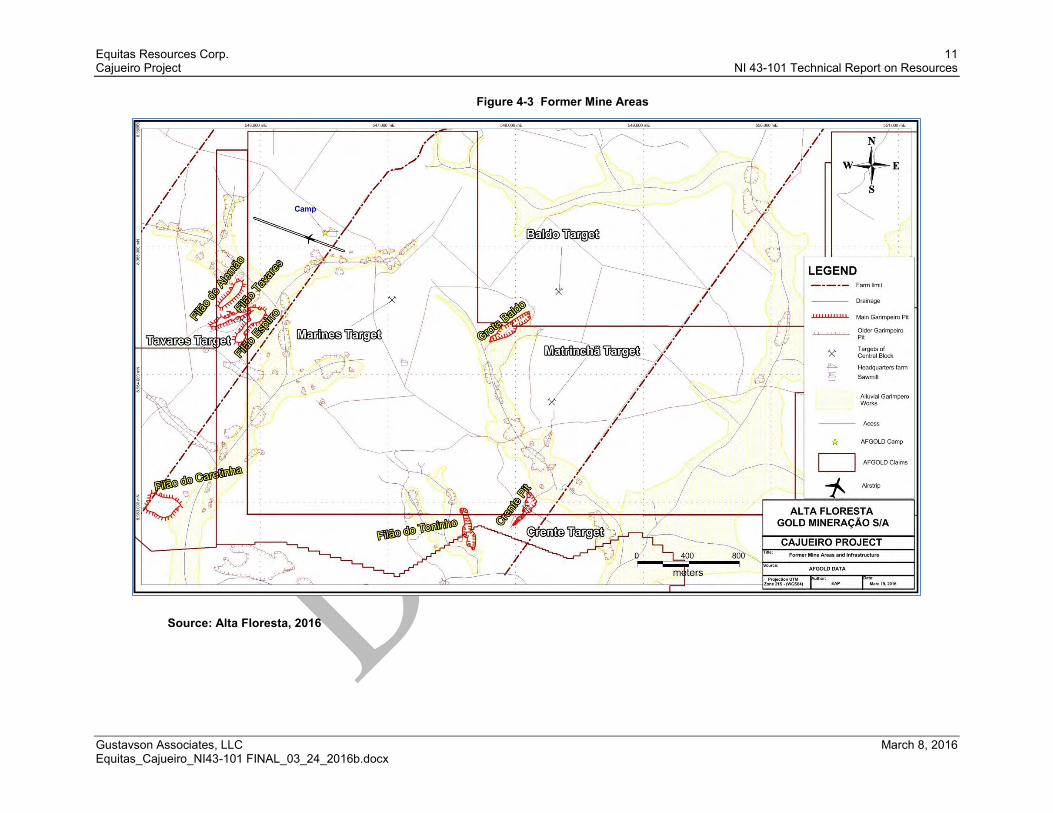
4.4.1 Environmental Liabilities As further described in Section 0, artisanal mining, also referred to as “garimpeiro” mining, at the Cajueiro property occurred from the 1970s to the 1990s. Historical mining activities have resulted in several pits, as shown on Figure 4-3, which have filled with water. Environmental impacts at the Cajueiro property are permitted by the State of Mato Grosso’s Secretary of Environment (Secretaria de Estado do Meio Ambiente, or SEMA). In the project environmental permit (SEMA, 2012), SEMA generally describes the environmental impacts of the the historically mined areas to be well mitigated. Specifically, erosion and sedimentation are being managed by natural vegetation in the drainage, waste, and pit areas. No reclamation requirements for the historically mined areas are identified in SEMA (2012).
Equitas Resources Corp. 11 Cajueiro Project NI 43-101 Technical Report on Resources
Gustavson Associates, LLC March 8, 2016 Equitas_Cajueiro_NI43-101 FINAL_03_24_2016b.docx
Figure 4-3 Former Mine Areas
Source: Alta Floresta, 2016

Equitas Resources Corp. 12 Cajueiro Project NI 43-101 Technical Report on Resources
Gustavson Associates, LLC March 8, 2016 Equitas_Cajueiro_NI43-101 FINAL_03_24_2016b.docx
Environmental requirements for on-site activities are permitted by SEMA (2012). Gustavson requested and received environmental permits for two areas: DNPM Permit Nos. 866.160/2007 and 866.070/2004. This permit covers exploration (i.e., trench sampling and drilling), evaluation of economic viability of mining, and associated infrastructure (i.e., camp) to support exploration. As shown on Figure 4-2, ECI’s exploration and drilling are in areas outside the areas covered by DNPM Permit Nos. 866.160/2007 and 866.070/2004. Gustavson is of the opinion that moving forward Equitas should hold up to date environmental permitting for those areas subject to exploration and drilling.
4.4.2 Required Permits and Status From ECI (2013b), the area covered by DNPM Permit No. 866.070/2004 was converted from an area permitted for exploration to an area permitted for mining by DNPM in January 2013. ECI/Alta Floresta is in the process of converting the area covered by DNPM Permit No. 866.160/2007 from exploration to mining status.
4.5 Other Significant Factors and Risks As described in Section 4.2, Equitas currently holds exploration rights for 6 of the 12 DNPM-permitted areas that are part of the Cajueiro project. These five permitted areas contain the exploration targets that have been identified for the project to date (i.e., Crente, Baldo, Matrincha, Marines, and Alvaro Tavares – described in Section 7). As such, for foreseeable exploration activities, ECI’s land position appears acceptable.
To date, ECI has provided Gustavson with the environmental permits for the areas covered by DNPM Permit Nos. 866.070/2004 and 866.160/2007, which may not cover all exploration target areas. If such permits are not in place, Gustavson recommends that Equitas apply for environmental permits in all areas where exploration and drilling, or mining activities will be conducted in the foreseeable future.

Equitas Resources Corp. 13 Cajueiro Project NI 43-101 Technical Report on Resources
Gustavson Associates, LLC March 8, 2016 Equitas_Cajueiro_NI43-101 FINAL_03_24_2016b.docx
5 Accessibility, Climate, Local Resources, Infrastructure and Physiography (Item 5)
5.1 Topography, Elevation and Vegetation The Cajueiro Project is generally located in the valley of the Teles Pires River, which flows to the northwest where it drains into the Tapajos River, and ultimately to the Amazon River.
Within the Cajueiro Project area, topography is characterized by hills with perennial and ephemeral streams that flow into the Teles Pires River. Elevation within the Cajueiro Project area ranges from 200 to 300 meters above sea level. The elevation of the target exploration areas is shown on Figure 5-1.
The Cajueiro Project area is located within the Amazon tropical rainforest, although most of the project area has been cleared and is now planted with grass for cattle farming. A portion of the property is virgin tropical rainforest with the tree canopy reaching 30 meters in height.

Equitas Resources Corp. 14 Cajueiro Project NI 43-101 Technical Report on Resources
Gustavson Associates, LLC March 8, 2016 Equitas_Cajueiro_NI43-101 FINAL_03_24_2016b.docx
Figure 5-1 Cajueiro Site Map
Source: Alta Floresta, 2016

Equitas Resources Corp. 15 Cajueiro Project NI 43-101 Technical Report on Resources
Gustavson Associates, LLC March 8, 2016 Equitas_Cajueiro_NI43-101 FINAL_03_24_2016b.docx
5.2 Climate and Length of Operating Season The climate at the Cajueiro Project is marked by a rainy season from December through May, and dry season that occurs from May through November. The average annual rainfall ranges between 1,500 to 2,000 millimeters per year. Annual average high temperature ranges from 30 to 34° Celsius, and annual average low temperature ranges from 18 to 22° Celsius (World Weather, 2013).
Exploration activities are conducted on the Cajueiro property year round.
5.3 Sufficiency of Surface Rights AFGM has written agreements with Alvaro Tavares for use of his property for exploration, and with Ricardo Cardoso for use of his property for both exploration and production. The limits of the two areas are shown on Figure 5-2 and appear to be sufficient for foreseeable exploration and drilling activities.

Equitas Resources Corp. 16 Cajueiro Project NI 43-101 Technical Report on Resources
Gustavson Associates, LLC March 8, 2016 Equitas_Cajueiro_NI43-101 FINAL_03_24_2016b.docx
Figure 5-2 Surface Rights for Cajueiro Project
Source: Alta Floresta, 2016

Equitas Resources Corp. 17 Cajueiro Project NI 43-101 Technical Report on Resources
Gustavson Associates, LLC March 8, 2016 Equitas_Cajueiro_NI43-101 FINAL_03_24_2016b.docx
5.4 Accessibility and Transportation to the Property The nearest international airport to the Cajueiro property is in the city of Cuiabá, in the state of Mato Grosso, as shown on Figure 4-1. Driving directions to the Cajueiro Project area from the Cuiabá airport are as follows: (1) drive 650 kilometers north on paved highway BR 163 to Santa Helena, (2) drive 185 kilometers northwest on paved highway MT208 to Alta Floresta, (3) drive 95 kilometers northwest on dirt roads, through the town of Paranaíta, to Cajueiro project. The drive from Cuiabá to the project site ranges from 11 to 14 hours, depending on road conditions.
Conversely, commercial daily flight service is available from Cuiabá to Alta Floresta. An airplane landing strip is located within the Cajueiro property, as shown on Figure 5-1; however, no commercial flight service to the on-site landing strip is available.

Equitas Resources Corp. 18 Cajueiro Project NI 43-101 Technical Report on Resources
Gustavson Associates, LLC March 8, 2016 Equitas_Cajueiro_NI43-101 FINAL_03_24_2016b.docx
Figure 5-3 Cajueiro Site Map
Source: Equitas (2013)

Equitas Resources Corp. 19 Cajueiro Project NI 43-101 Technical Report on Resources
Gustavson Associates, LLC March 8, 2016 Equitas_Cajueiro_NI43-101 FINAL_03_24_2016b.docx
5.5 Infrastructure Availability and Sources Gustavson assessed availability and adequacy of infrastructure based on recent on-site activities, foreseeable activities for the project, and mining activities. For the next two years, Equitas expects to conduct further diamond drilling, trenching, ground geophysics and metallurgical testing. Currently, there is small scale mining of alluvial gold in areas where there is no effect on the mineral resource estimate.
Infrastructure on the Cajueiro Project supported artisanal mining from 1970s to 1990s. More recently, ECI conducted exploration and drilling activities. A camp is located within the Cajueiro Project to support exploration activities and is adequate for 30 people. General location of the camp is shown on Figure 5-2.
5.5.1 Power As of the effective date of this report, the site is not connected to the power grid. During 2012, power needed for lighting and operation of appliances at the camp was provided by diesel generators. Diesel fuel for the generators, vehicles, and drilling equipment is brought by fuel trucks on an as-needed basis.
On site is a generator of 33KWA, linked to a MWM motor, that produces monophasic, biphasic and triphasic current. The generator is powered by diesel fuel that is stored in a 10,000 liter tank with sufficient capacity for approximately 3 months of use. Diesel is brought to the Cajueiro property by truck and is refilled year round.
Existing power infrastructure is adequate for foreseeable exploration activities.

Equitas Resources Corp. 20 Cajueiro Project NI 43-101 Technical Report on Resources
Gustavson Associates, LLC March 8, 2016 Equitas_Cajueiro_NI43-101 FINAL_03_24_2016b.docx
Figure 5-4 Camp Infrastructure Map
Source: Alta Floresta, 2016

Equitas Resources Corp. 21 Cajueiro Project NI 43-101 Technical Report on Resources
Gustavson Associates, LLC March 8, 2016 Equitas_Cajueiro_NI43-101 FINAL_03_24_2016b.docx

Equitas Resources Corp. 22 Cajueiro Project NI 43-101 Technical Report on Resources
Gustavson Associates, LLC March 8, 2016 Equitas_Cajueiro_NI43-101 FINAL_03_24_2016b.docx
Existing power infrastructure is not expected to be adequate for mining activities as the power demand is likely to be greater than what can be reasonably supplied by generators. Potential power source may be hydroelectric power along the Teles Pires River, such as the Teles Pires hydroelectric dam which is located approximately 22 kilometers west of the Cajueiro property. Unit one of the plant was commissioned in November of 2015 and a new power line serving the project area is planned The design capacity is 1820 megawatts.
5.5.2 Water From ECI (2013b), process water, such as for drilling purposes, is pumped from shallow lakes or flooded pits to where the water is utilized. In 2012, the water supply from this well was adequate for supporting exploration activities.
From ECI (2013b), drinking water is supplied in 20 liters bottles purchased in Paranaita or in Alta Floresta. Bath water is pumped from the well on site to tanks in the different blocks of the farm accommodation. There is no limit to the amount of water that can be used from the well.
Existing water supply is adequate for foreseeable exploration activities.
Existing water supply are not expected to be adequate for mining activities. Water rights may be claimed with DNPM for areas that are permitted for mining.
5.5.3 Mining Personnel The population centers in the vicinity of the Cajueiro Project include Paranaíta, located approximately 40 kilometers south of the Cajueiro Project area, and Alta Floresta, located approximately 95 kilometers south and east of the Cajueiro Project area. The populations in these two cities are approximately 10,000 in Paranaíta, and 40,000 in Alta Floresta. The capital city of the state of Mato Grosso is Cuiabá, located 900 kilometers from the Cajueiro Project area, with a population of 650,000.
In 2012, exploration and drilling personnel was adequate. Drilling crews, oversight and support personnel were mobilized from Belo Horizonte, Brazil. For the foreseeable activities, personnel is expected to be adequate.
For mining activities, several producing gold mines are located in the state of Mato Grosso; and mining personnel are expected to be available within the vicinity of the Cajueiro Project area.

Equitas Resources Corp. 23 Cajueiro Project NI 43-101 Technical Report on Resources
Gustavson Associates, LLC March 8, 2016 Equitas_Cajueiro_NI43-101 FINAL_03_24_2016b.docx
5.5.4 Additional Infrastructure for Mining Generally, mining is not expected to occur within the next two years, and as such, mining infrastructure such as tailings and waste storage areas, and processing plant sites have not been evaluated.
5.5.5 Significant Results and Interpretations Land position and infrastructure are expected to be adequate for the exploration and drilling activities; but will require further evaluation to determine adequacy for mining operations.

Equitas Resources Corp. 24 Cajueiro Project NI 43-101 Technical Report on Resources
Gustavson Associates, LLC March 8, 2016 Equitas_Cajueiro_NI43-101 FINAL_03_24_2016b.docx
6 History (Item 6) 6.1 Prior Ownership Table 4-1 shows the original owners of the areas covering the five mineral claims for exploration include Carlos Ulema, Chapleau Mineral Exploration Limited, and Caystar Exploracao Mineral Ltda. The interests of Chapleau were acquired by ECI and they are currently controlled by Alta Floresta Gold.
6.2 Historical Exploration and Drilling Results (2006-2007) Chapleau has conducted exploration activities in the Cajueiro property area. This work was described in Chapleau (2007) and is summarized in this section.
6.2.1 Geologic Mapping Chapleau conducted geologic mapping of the Cajueiro Project area which Gustavson used for general reference in this report (Figure 6-1 and 6-2).

Equitas Resources Corp. 25 Cajueiro Project NI 43-101 Technical Report on Resources
Gustavson Associates, LLC March 8, 2016 Equitas_Cajueiro_NI43-101 FINAL_03_24_2016b.docx
Figure 6-1 Regional Geology Map
Note – Regional geologic map was provided to Gustavson from Alta Floresta (2016), and was adapted from Chapleau (2007).

Equitas Resources Corp. 26 Cajueiro Project NI 43-101 Technical Report on Resources
Gustavson Associates, LLC March 8, 2016 Equitas_Cajueiro_NI43-101 FINAL_03_24_2016b.docx
Figure 6-2 Resource Zone Geology Detail

Equitas Resources Corp. 27 Cajueiro Project NI 43-101 Technical Report on Resources
Gustavson Associates, LLC March 8, 2016 Equitas_Cajueiro_NI43-101 FINAL_03_24_2016b.docx
Figure 6-3 Chapleau’s Project Geology Map
Source: Chapleau (2007)

Equitas Resources Corp. 28 Cajueiro Project NI 43-101 Technical Report on Resources
Gustavson Associates, LLC March 8, 2016 Equitas_Cajueiro_NI43-101 FINAL_03_24_2016b.docx
6.2.2 Rock Sampling In 2006, 82 rock samples were collected from the project area. Chapleau (2007) described many of the samples as highly oxidized, displaying a box-work texture after pyrite and surface enrichment processes containing enhanced gold values (gold assays in Filão Alemão area are as high as 104 g/t).
6.2.3 Soil Sampling The area investigated by the first phase exploration program at Cajueiro is primarily pasture land with thick saprolitic soil cover and limited outcrops on the occasional higher rolling hills. Low whale back topographic highs (which are often so subtle that they may only be recognized in the dry season when the grass is short) often represent the lines of fracture zones and silicification within the rhyolitic host rock. The fracture zones can generally be identified and mapped on surface by the greenish color imposed by sericite and chlorite alteration and by the presence of oxidization and associated box-works after pyrite. Gray-colored quartz veinlets are common in areas adjacent to fractures, and blocks of gossanous material often occur as float in areas near to the surface expression of mineralized zones.
Chapleau collected soil samples at 50-meter intervals along lines on lines spaced 200-meter apart. A total of 1,337 soil samples were collected from hand dug pits. Samples were collected at depths less than 50 centimeters and sent to the ALS Chemex laboratory in Belo Horizonte for preparation and subsequently to the ALS Chemex laboratory in Lima, Peru for assaying. Results for gold assays are shown in Figure 6-3. From the soil sampling results, Chapleau identified five anomalous zones (Figure 6-4) which were subsequently trenched and tested with diamond drill tested.

Equitas Resources Corp. 29 Cajueiro Project NI 43-101 Technical Report on Resources
Gustavson Associates, LLC March 8, 2016 Equitas_Cajueiro_NI43-101 FINAL_03_24_2016b.docx
Figure 6-4 Chapleau’s Soil Sampling Results
Source: Chapleau (2007)

Equitas Resources Corp. 30 Cajueiro Project NI 43-101 Technical Report on Resources
Gustavson Associates, LLC March 8, 2016 Equitas_Cajueiro_NI43-101 FINAL_03_24_2016b.docx
6.2.4 Trench Sampling Chapleau excavated 17 trenches in five zones identified as “A” through “E” as shown on Figure 6-4. The total length of excavation was 2,671 meters. Trenches were dug using a backhoe to depths between 4 and 6 meters. Samples were collected from the base of the trench at one meter intervals and panned. The pan concentrates were examined using a hand lens to count the gold colors and to classify them in coarse, medium and fine sizes. The trenches were used to identify the dip of the mineralized structures and identify gold-bearing structures within the wider soil anomalies. The trenches permitted better definition of planned drill hole sites.
Chapleau did not collect samples for gold assay from the trench locations. The gold color results were not substantiated with calibration assay, and as such, are subjective. Gustavson did not utilize Chapleau’s trench pan sampling results as part of the resource estimateand and these results are not discussed further in this report.

Equitas Resources Corp. 31 Cajueiro Project NI 43-101 Technical Report on Resources
Gustavson Associates, LLC March 8, 2016 Equitas_Cajueiro_NI43-101 FINAL_03_24_2016b.docx
Figure 6-5 Chapleau’s Trench Sampling Areas
Source: Chapleau (2007)

Equitas Resources Corp. 32 Cajueiro Project NI 43-101 Technical Report on Resources
Gustavson Associates, LLC March 8, 2016 Equitas_Cajueiro_NI43-101 FINAL_03_24_2016b.docx
6.2.5 Drilling A diamond drill program was conducted by Chapleau in early 2007 to investigate the down dip extension of fracture zones worked by the garimpeiros, and to test soil anomalies identified during early soil sample analysis. A total of 13 HQ diamond drill holes tested eight individual structures. Drill hole information from the 2007 drilling program is summarized in Table 6-1, and drill hole locations are shown on Figure 9-1.
Table 6-1 Drill Hole Summary for Chapleau's 2007 Drill Program
BOREHOLE ID EASTING (meters)
NORTHING (meters)
AZIMUTH (°)
DIP (°)
LENGTH (meters)
Target Area
BR_CJO_DDH01_07 545873 8964457 55 -50 100 Alvaro Tavares
BR_CJO_DDH02_07 545596 8964339 345 -60 38.6 Alvaro Tavares
BR_CJO_DDH03_07 548378 8964311 40 -50 61.3 Baldo
BR_CJO_DDH04_07 547170 8964438 345 -50 110.5 Marines
BR_CJO_DDH05_07 547096 8964373 345 -50 89.5 Marines
BR_CJO_DDH06_07 546985 8964328 345 -50 117.45 Marines
BR_CJO_DDH07_07 548666 8964281 335 -50 128 Baldo
BR_CJO_DDH08_07 548153 8963626 335 -50 82.2 Matrincha
BR_CJO_DDH09_07 548211 8963679 325 -50 85 Matrincha
BR_CJO_DDH10_07 548093 8962876 320 -50 83.6 Crente
BR_CJO_DDH11_07 548969 8964561 335 -50 124.5 Baldo
BR_CJO_DDH12_07 548600 8964594 335 -50 118.5 Baldo
BR_CJO_DDH13_07 548369 8964664 335 -50 98.5 Baldo
Note - Drill hole locations are shown on WGS84 datum, in the 21L UTM Zone.
As discussed with ECI at the onset of the project, the scope of this mineral resource does not include the Alvaro Tavares area, and as such, this area is identified as “Non-Target Area” on Figure 9-1. Chapleau’s drill holes from the Crente, Baldo, Matrincha, and Marines target areas were utilized for the resource estimate presented in Section 14.
Drilling was conducted by Geoserv Pesquisas Geologicas S.A., a Brazilian subsidiary of Boart Longyear, whose base is in Rio de Janeiro, Brazil. Geoserv used a Longyear 38 skid-mounted hydraulic rig capable of drilling 250+ meters of HQ core. Holes were drilled to produce HQ core from surface down to the end of all 13 holes. The weathering profile in the project area is such that unweathered unoxidized bedrock was encountered at between 10 and 50 meters. The upper levels, where saprolite was well developed, required casing of the drill holes to prevent caving.
All holes, except hole BR_CJO_DDH2 (drilled at 60 degrees), were drilled at 50 degrees from the horizontal, usually at right angles to the long-axis of the

Equitas Resources Corp. 33 Cajueiro Project NI 43-101 Technical Report on Resources
Gustavson Associates, LLC March 8, 2016 Equitas_Cajueiro_NI43-101 FINAL_03_24_2016b.docx
mineralized structure. None of the holes drilled in the Chapleau drill campaign were surveyed, since it was considered that the holes were all relatively shallow and that the HQ diameter was maintained for the entire program reducing the chance of great deflection of the holes.
All cores were cut in half on site using a water-cooled diamond bladed saw. Core cutting and sampling were supervised by both the Chapleau project geologist and the Chapleau technicians. One half of the core was sent for assay while the second half has been kept on site for geological studies. Holes were designed to test both down dip extensions of previously mined structures and structures discovered by geological mapping, soil sampling and trenching. Locations of all drill holes provided in the database to Gustavson on October 5, 2012 are shown on Figure 14-1.
Significant intercepts from the 2007 drilling program are summarized in Table 6-2.
Table 6-2 Significant Intercepts for Chapleau's 2007 Drill Program
BOREHOLE ID FROM (m)
TO (m)
TRUE WIDTH (m)
Au (g/t)
BR_CJO_DDH03_07 53.2 55.3 1.97 3.37
BR_CJO_DDH04_07 71.7 103.7 31.50 0.32
BR_CJO_DDH05_07 60 61 0.93 9.12
BR_CJO_DDH07_07 95.0 99.5 4.43 1.50
BR_CJO_DDH08_07
51.5 56.5 4.33 4.15
52.0 52.5 0.43 19.9
BR_CJO_DDH09_07
29.5 30.5 0.93 4.47
53.5 54.5 0.93 0.82
62 64 1.87 3.62
BR_CJO_DDH10_07
45 76 28.00 1.37
53.5 55 1.35 4.65
61.5 62.5 0.90 6.39
66 67.5 1.35 6.38
BR_CJO_DDH11_07 51 52 0.64 1.19
BR_CJO_DDH13_07 70 70.5 0.45 2.82
77 78 0.90 0.98
6.3 Historic Mineral Resource and Reserve Estimates No historical mineral resource estimates are known to exist for the Cajueiro project.

Equitas Resources Corp. 34 Cajueiro Project NI 43-101 Technical Report on Resources
Gustavson Associates, LLC March 8, 2016 Equitas_Cajueiro_NI43-101 FINAL_03_24_2016b.docx
6.4 Historical Development and Production As described by Chapleau (2007), “During the late 1980s and 1990s, primary gold mineralization was worked from saprolitic material in the vicinity of mineralized fracture zones using high power hoses. Official government estimate of total placer gold production (to 1993) is between 7 million and 10 million ounces, but actual production is believed to be two to three times higher.” “It is estimated that some 8 tons of gold were produced from alluvial and primary sources on the property of Alvaro Tavares where Filao Alemao, Filao Alvaro, Filao Espiro, Grota Baldo, Grota Crente, Filao do Torinho, and Garimpo do Caretinha were worked.” Gustavson did not verify the historical production rates.
Historical processing methods include gravity concentration and amalgamation of gold using mercury.

Equitas Resources Corp. 35 Cajueiro Project NI 43-101 Technical Report on Resources
Gustavson Associates, LLC March 8, 2016 Equitas_Cajueiro_NI43-101 FINAL_03_24_2016b.docx
7 Geological Setting and Mineralization (Item 7) 7.1 Regional, Local and Property Geology
7.1.1 Regional Geology The Cajueiro Project forms part of the Amazon Craton (Figure 7-1). The main lithologies of this region are known as São Pedro and Juruena Intrusive Suites(monzogranites to granodiorites), Colider Suite(rhyolites, andesites, tuffs breccias and microgranites), Paranaita Suite (porphyritic monzogranites, Nhandu Granites, Teles Pires Intrusive Suite(sienogranites) and the Beneficente Group - the extensive sedimentary platform which forms the hills of the Serra do Cachimbo.
The Cajueiro Project is located in the area known as the Juruena Arc, which is Proterozoic in age (1.75 Ga-1.85 Ga, Santos et al., 2000). The arc has a NW-SE structural trend and is composed of two crustal segments, granitic-volcanic and medium to high grade metamorphic rocks (Figures 7-1 and 7-2).
Within the granite-volcanic group, rocks of a potassic, calc-alkaline magmatism are monzonites and granites of the Teles Pires Suite and the Paranaita Suite: these are associated with acid and intermediate volcanics of the Colider Suite, in which rhyolites, rhyodacites, andesites and microgranites predominate.
Alkaline granites of the post orogenic stage intrude into rocks of the Colider Suite and into granitoids of the Paranaita Suite. The final stage of stable sedimentation within this unit is marked by the Transamazonic platform sedimentation of the Beneficente Group which is distributed in W-E to NW-SE directions.

Equitas Resources Corp. 36 Cajueiro Project NI 43-101 Technical Report on Resources
Gustavson Associates, LLC March 8, 2016 Equitas_Cajueiro_NI43-101 FINAL_03_24_2016b.docx
Figure 7-1 Regional Geologic Map
Source: Alta Floresta (2016)

Equitas Resources Corp. 37 Cajueiro Project NI 43-101 Technical Report on Resources
Gustavson Associates, LLC March 8, 2016 Equitas_Cajueiro_NI43-101 FINAL_03_24_2016b.docx
Figure 7-2 Local Geology Map
Source: Alta Floresta (2016)

Equitas Resources Corp. 38 Cajueiro Project NI 43-101 Technical Report on Resources
Gustavson Associates, LLC March 8, 2016 Equitas_Cajueiro_NI43-101 FINAL_03_24_2016b.docx
7.1.2 Local Geology Colider Suite rocks have been mapped in the Cajueiro Project area and dominantly consist of microgranite and rhyolite, breccias, and tuffs. Zones of hydrothermal alteration with sericite alteration have been recognized on surface within the granites and are commonly coincident with fracture zones. Rock samples collected from these zones which display box-work after pyrite gave high gold assays.
Four main structural trends have been identified in the area: NE-SW, NW-SE, E-W and NNW-SSE (Figure 7-3), which control the location and orientation of drainages along which artisanal mining took place. Localized gossanous boulders are also mapped over the areas of mineralized fracture zones. Garimpeiros have mined alluvial or placer gold in many drainages which likely overlie or are adjacent to bedrock mineralized zones.

Equitas Resources Corp. 39 Cajueiro Project NI 43-101 Technical Report on Resources
Gustavson Associates, LLC March 8, 2016 Equitas_Cajueiro_NI43-101 FINAL_03_24_2016b.docx
Figure 7-3 Cajueiro Structural Trends
Source Alta Floresta (2016)

Equitas Resources Corp. 40 Cajueiro Project NI 43-101 Technical Report on Resources
Gustavson Associates, LLC March 8, 2016 Equitas_Cajueiro_NI43-101 FINAL_03_24_2016b.docx
7.1.3 Property Geology Within the areas explored, eight distinct zones of quartz veining and alteration have been identified by diamond drilling and another six by mapping and soil sampling, all of which fall within five discrete target areas (Figure 7-4). The five discrete target areas were identified by Chapleau as “A” through “E”, but more contemporarily were identified by ECI as Alvaro Tavares (Area A), Marines (Area B), Baldo (Area C), Matrincha (Area D), and Crente (Area E). The last four of these areas have had resource estimations performed on them.
In the resource areas, two variations of the felsic rocks are present. The dominant type is rhyolite and microgranite which is reddish in color with no quartz veining and negligible pyrite. These rhyolites and granites are oxidized and contain abundant fine Fe-oxide minerals in the matrix and phenocrysts. The granites contain abundant pink, orange, or red alkali feldspar phenocrysts, gray-white plagioclase phenocrysts, blue-gray quartz phenocrysts and black biotite phenocrysts in a fine-grained matrix. These rocks are generally interpreted to be shallow intrusive rocks, dikes of which may be responsible for the strong aeromagnetic highs mapped on the property.
The second common felsic rock type is green rhyolite and granite altered with sericite, epidote, chlorite and quartz. These rocks are reduced versions of the red oxidized granites/rhyolites and occasionally have relict faintly reddish feldspars, however, more commonly, visible feldspars are sericitized. The rocks commonly have disseminated pyrite clusters, some of which are pseudomorhs after biotite phenocrysts. Other pyrite clusters and coarse cubic crystals occur with gray-white quartz in veinlets along fractures. The green rocks are coincident with strong fracture sets, which generally trend WNW-ESE and NE-SW. Most drainages and garimpos are aligned with these orientations and strong linear aeromagnetic high anomalies dominantly have these two orientations. Secondary trends run E-W and N-S.
Some of the drainages appear to have developed directly on top of alteration zones, although in several locations drainages are adjacent to ridges underlain by sericitized and weakly silicified gray-green granite. Some garimpos and soil anomalies adjacent to ridges may reflect gold transported off the alteration highs.
To date, diamond drilling carried out on the Cajueiro property shows intercepted zones of strong hydrothermal alteration within the granites/rhyolites, where sericite, epidote, chlorite, and pyrite alteration are predominant. These altered zones vary in width from 1 to 50 meters and are easily identified due to the strong color change from red in unaltered granite/rhyolite to green in the altered zones.

Equitas Resources Corp. 41 Cajueiro Project NI 43-101 Technical Report on Resources
Gustavson Associates, LLC March 8, 2016 Equitas_Cajueiro_NI43-101 FINAL_03_24_2016b.docx
Figure 7-4 Cajueiro Target Exploration Areas
Source: Chapleau (2007)

Equitas Resources Corp. 42 Cajueiro Project NI 43-101 Technical Report on Resources
Gustavson Associates, LLC March 8, 2016 Equitas_Cajueiro_NI43-101 FINAL_03_24_2016b.docx
Gold primarily occurs in the form of fine native gold and is also associated with pyrite. Gold mineralization is hosted by strongly sericite-altered, fine-matrix granitic rocks. Some zones are narrow and show signs of incipient shearing, but mineralization also occurs in zones of sericite-chlorite-quartz alteration up to 50 meters wide with associated disseminated pyrite. These wider zones are fractured but show little evidence of shearing. Thin quartz-pyrite veins are common and also carry gold. The overall pyrite content of the mineralized zones varies from 1 to 20 percent.
The best single assay value is seen in hole DDH CJO 026, with one meter assaying 32.9 g/t Au. Diamond drill hole BR_CJO_DDH10, drilled beneath the Crente pit by Chapleau, intersected a wider zone of alteration which assayed 1.37 g/t Au over 31 meters. Examples of significant intercepts and drill hole orientations are presented graphically in Figures 7-5 through 7-7.

Equitas Resources Corp. 43 Cajueiro Project NI 43-101 Technical Report on Resources
Gustavson Associates, LLC March 8, 2016 Equitas_Cajueiro_NI43-101 FINAL_03_24_2016b.docx
Figure 7-5 Drillhole BR_CJO_008_07
Source: ECI, 2013b

Equitas Resources Corp. 44 Cajueiro Project NI 43-101 Technical Report on Resources
Gustavson Associates, LLC March 8, 2016 Equitas_Cajueiro_NI43-101 FINAL_03_24_2016b.docx
Figure 7-6 Drillhole BR_CJO_010_07 Section
Source: ECI, 2013b

Equitas Resources Corp. 45 Cajueiro Project NI 43-101 Technical Report on Resources
Gustavson Associates, LLC March 8, 2016 Equitas_Cajueiro_NI43-101 FINAL_03_24_2016b.docx
Figure 7-7 Grota Crente Section
Source: ECI, 2013b

Equitas Resources Corp. 46 Cajueiro Project NI 43-101 Technical Report on Resources
Gustavson Associates, LLC March 8, 2016 Equitas_Cajueiro_NI43-101 FINAL_03_24_2016b.docx
8 Deposit Types (Item 8) 8.1 Mineral Deposit At Cajueiro, gold deposits are associated with strong sericite alteration in granitic and rhyolitic bedrock. Shearing in much of the altered rock is minor and the deposits are not shear zone hosted. Rather, alteration and mineralization appear to be related to brittle fractures in the granite/rhyolites which formed prior to shearing. Shearing is more evident in narrow zones, 1 to 8 meters wide. However, mineralization is associated with sericite-epidote-chlorite alteration and minor silicification in wider fractured zones (up to 50 meters wide). Gold occurs as both fine native gold and as inclusions in disseminated and stringer pyrite in quartz-pyrite veinlets (Figure 8-1).
The deposits appear to be related to hydrothermal alteration by sulfur-rich fluids rising along brittle fracture zones which had previously been intruded by granitic dikes. In terms of depth of formation, the deposits appear to be epithermal to mesothermal.
Figure 8-1 Pyrite Stringers in Cut Core Sample, Cajueiro

Equitas Resources Corp. 47 Cajueiro Project NI 43-101 Technical Report on Resources
Gustavson Associates, LLC March 8, 2016 Equitas_Cajueiro_NI43-101 FINAL_03_24_2016b.docx
8.2 Geological Model Gold mineralization at Cajueiro is associated with coarse crystals or aggregates of pyrite, either disseminated or clustered in quartz-pyrite veinlets. This gold-pyrite mineralization occurs in zones of green reduced sericite-epidote-chlorite altered granite /rhyolite in brittle fractured zones up to 50 meters wide. The green altered zones are commonly adjacent to or intercalated with unaltered red granite/rhyolite, which appears to be responsible for strong linear aeromagnetic highs in the area (see Figure 9-3) and are probably dikes. Alteration was caused by hydrothermal fluids, the flow of which was controlled by fracture sets parallel with the dikes. Detailed ground magnetic surveys are recommended which may be able to differentiate mineralized sericite-quartz-pyrite altered zones (magnetic lows) from nearby magnetic high zones.
The mineralized zones at Crente, Matrincha and Marines generally strike NE and dip steeply SE. At Baldo, two mineralized trends appear to intersect – one striking NE and dipping very steeply SE and the other striking ENE and dipping moderately steeply to the SE. The two fractures sets were observed by the QP in outcrop at Baldo; the NE-striking fractures were formed later and are more altered than the ENE-striking ones.
Areas where NE-striking and ENE-striking fracture zones intersect are thought to be the loci of focused fluid flow and may host high-grade ore shoots which would generally be plunging moderately to steeply SSW. Such areas are recommended for targeting in future exploration.
The geologic model and its relation to the resource modeling is discussed in Section 14.

Equitas Resources Corp. 48 Cajueiro Project NI 43-101 Technical Report on Resources
Gustavson Associates, LLC March 8, 2016 Equitas_Cajueiro_NI43-101 FINAL_03_24_2016b.docx
9 Exploration (Item 9) 9.1 Relevant Exploration Work ECI conducted the following exploration activities:
Soil sampling
Trench sampling
Rock sampling
Geophysical survey.
ECI’s exploration activitiy based on data provided to Gustavson on October 2012 and updated in March 2016 is described in this section.
9.1.1 Soil Sampling Beginning in 2007, ECI further explored target areas identified during Chapleau’s initial exploration by collecting soil geochemical samples on 50-meter intervals from lines that are spaced at 200 and 400 meters. Through February 2013, ECI collected a total of 5,419 soil samples, but the October 2012 database contains 4,457 soil samples assayed for gold. Figure 9-1 shows the soil sampling results from Chapleau and ECI. ECI’s soil sampling locations were north of those soil samples collected by Chapleau with sampling lines oriented from north to south.
ECI’s soil sampling was conducted for general site characterization. Gustavson did not use ECI’s soil data as part of our resource estimate, and therefore, ECI’s soil data are not discussed further in this report.

Equitas Resources Corp. 49 Cajueiro Project NI 43-101 Technical Report on Resources
Gustavson Associates, LLC March 8, 2016 Equitas_Cajueiro_NI43-101 FINAL_03_24_2016b.docx
Figure 9-1 ECI Soil Sampling Locations
Source: Alta Floresta, 2016

Equitas Resources Corp. 50 Cajueiro Project NI 43-101 Technical Report on Resources
Gustavson Associates, LLC March 8, 2016 Equitas_Cajueiro_NI43-101 FINAL_03_24_2016b.docx
9.1.2 Rock Sampling The October 2012 database contained results for 304 rock samples assayed for gold, as shown on Figure 9-2. In general channel samples were collected in saprolite zones while chip and grab samples were collected in competent bedrock (hard rock). ECI’s rock sampling procedures are described as follows:
Describe lithology of rock sample;
Document type of sample (chip, grab or channel) and intervals being sampled (in the case of channel samples, up to a 3 meter interval);
Collecting samples in 2 kg bags identified numerically and described on a sample card;
Preparation of batches with a maximum of 40 samples including 2 blanks and 1 standard (alternating patterns of oxide high and oxide low) for each batch;
Input of data into database (samples, batches and QA/QC information);
Send samples to the lab for analysis (50g Fire Assay);
Receipt of results and update of the database.
9.1.3 Trench Sampling In 2011, ECI conducted trench sampling in 10 locations as shown on Figure 9-2. Assay data for ECI’s 334 samples from the 10 trenches were provided to Gustavson.
ECI’s trench sampling procedures were as follows:
Demarcation and trenching;
Describe lithology of trench;
Demarcation of intervals to be sampled; type channel sampling with samples every 2 to 3 meters, with samples to 3 kg bags identified numerically and described in sample card;
Preparation of batches with a maximum of 40 samples including 2 blanks and 1 standard (alternating patterns of high oxide and low oxide) for each batch.
Input of data into database (samples, batches and QA/QC information);

Equitas Resources Corp. 51 Cajueiro Project NI 43-101 Technical Report on Resources
Gustavson Associates, LLC March 8, 2016 Equitas_Cajueiro_NI43-101 FINAL_03_24_2016b.docx
Send samples to the lab for analysis (50g Fire Assay with 10 to 20% of analysis with ICP.
Receipt of results and update of the database accordingly.
Trench samples were generally identified as saprolite with quartz fragments. Based on a review of assay and location data, gold-bearing saprolite is generally located within the target areas in the Cajueiro property. During the visit ECI stated that, “All trench and rock samples were collected in possible mineralized outcrops and zones.”
Additional work from 2014 through 2015 has consisted of three east-west trenches to investigate the northeast extension of the Baldo structure. This has extended the mapped length of Baldo closer to the headwaters of the Baldo drainage. This work, while on the Cajueiro property, is not within the area of the mineral resource estimate.

Equitas Resources Corp. 52 Cajueiro Project NI 43-101 Technical Report on Resources
Gustavson Associates, LLC March 8, 2016 Equitas_Cajueiro_NI43-101 FINAL_03_24_2016b.docx
Figure 9-2 ECI Trench and Drill Hole Locations
Note – Soil, trench, rock, and drill hole locations were taken from the database provided to Gustavson in October 2012. Aerial photo was provided by ECI.

Equitas Resources Corp. 53 Cajueiro Project NI 43-101 Technical Report on Resources
Gustavson Associates, LLC March 8, 2016 Equitas_Cajueiro_NI43-101 FINAL_03_24_2016b.docx
9.2 Surveys and Investigations
9.2.1 Aeromagnetic and Radiometric Surveys in July 2011 In July 2011, Lasa Prospecções S.A., the Brazilian subsidiary of Fugro Airborne Surveys, conducted airborne magnetic and radiometric surveys of the Cajueiro Project area. Procedures and results were reported in ECI’s internal Microsoft PowerPoint presentation (ECI, 2011) and are summarized in this section.
A total of 3,603.4 line kilometers (including tie-lines) covering an area of 35,480 hectares were completed. Line spacing was 100 meter with line direction north-south and east-west tie-lines every 1000 meters. The specified sensor height was 100 meters and a mean of 113 meters is calculated from the survey data.
The northeast portion of the survey area has low magnetic values with associated elevated thorium and uranium values (these radiometric elements are normally higher in more felsic rocks). The bulk of the survey area is made up of elevated magnetics readings and dominated by an east-west striking magnetic feature along which several magnetic bodies have intruded. A robust east-west striking dike-like feature dominates the survey area, with a consistent amplitude of about 100 nT. At least two large (km scale) magnetic bodies are noted directly adjacent to the dike. The general strike direction of the regional magnetic trend is WNW that is disrupted by NE and ENE striking trends (later dikes).
In general the regional east-west and northwest linear magnetic anomalies are related to magnetic intrusive rocks. The northeast magnetic local strikes are more numerous but with less spatial expression .
In Gustavson’s review of the aeromagnetic survey data, mineralized areas are commonly seen along linear aeromagnetic high anomalies, which appear to be related to magnetite bearing granitic/rhyolitic dikes. Fracturing, minor shearing and hydrothermal activity took place along the dike-filled fractures. In some areas, the magnetic dikes have been sericite altered and contain gold mineralization. It is expected that the sericite altered areas would be relative magnetic low zones which may be on too small a scale to be discriminated by an aerial magnetic survey.

Equitas Resources Corp. 54 Cajueiro Project NI 43-101 Technical Report on Resources
Gustavson Associates, LLC March 8, 2016 Equitas_Cajueiro_NI43-101 FINAL_03_24_2016b.docx
Figure 9-3 Results of Aeromagnetic Survey
Source: Alta Floresta, 2016
APPROXIMATE EXTENT OF RESOURCE ESTIMATION
(SEE SECTION 14)

Equitas Resources Corp. 55 Cajueiro Project NI 43-101 Technical Report on Resources
Gustavson Associates, LLC March 8, 2016 Equitas_Cajueiro_NI43-101 FINAL_03_24_2016b.docx
Euler depth analysis were done for structural indices 0 (for high-throw contact/fault) and 2 (for line source) where depths to the top (for SI=0) and depths to the center (for SI=2) are calculated for the magnetic sources. Code used to do the Euler analysis comes from the USGS (Potential Field Geophysical Software) series of programs. A structural index of 0 represents a high-throw contact/fault model. The minimum possible depth to an isolated magnetic source is calculated from a grid and plotted as a color dot. The main dike magnetic anomaly is always located in the lower elevations, with depth to the top of the feature generally shallow (within 25 meters from surface).
Figure 9-4 Results of Euler Depth Analysis
Source: Alta-Floresta, 2016

Equitas Resources Corp. 56 Cajueiro Project NI 43-101 Technical Report on Resources
Gustavson Associates, LLC March 8, 2016 Equitas_Cajueiro_NI43-101 FINAL_03_24_2016b.docx
The radiometric data has not been particularly helpful for exploration but does show potassium alteration in areas where sericite alteration is strongest in the project area. Some subtle circular radiometric features have been noted, but any implications for exploration are unclear. There are no direct associations observed between radiometric responses and anomalous gold values that could be used as a direct exploration tool.
The two ENE striking faults (a and b) are seen to be prospective along their total strike lengths. The magnetic anomaly labeled ‘m1’ is anomalous in the survey area (clearly some magnetic remenance present), has been deformed and should be further investigated in the field. The large magnetic anomaly labeled ‘m2’ appears to be a poor exploration target based on soil geochemistry values in the area. However the complex structural patterns, specifically its elongated and rotated shape, suggests potential for dilation in and around the area and warrant further investigation of the associated magnetic lows.
Figure 9-5 Structural Interpretation from Magnetic Survey
Source: Alta-Floresta, 2016
The geophysical survey results were used to guide ECI’s drilling efforts. These results were not utilized by Gustavson as part of our resource estimate and are therefore omitted from further discussion.

Equitas Resources Corp. 57 Cajueiro Project NI 43-101 Technical Report on Resources
Gustavson Associates, LLC March 8, 2016 Equitas_Cajueiro_NI43-101 FINAL_03_24_2016b.docx
9.3 Significant Results and Interpretation In summary, the exploration data used in Gustavson’s mineral resource estimate includes outcrop and trench sampling. Gustavson concludes that the outcrop and trench samples may be used for characterization of gold in the saprolite with capping values applied.
Aeromagnetic surveying has proven useful for highlighting structural trends of magnetic dike-filled fractures which acted as channels for the gold-bearing hydrothermal fluids.
9.4 Additional Work Current work on the property consists of bulk sampling of the alluvium and elluvium in paleochannels near the Corregao stream. The stream is about 2km to the east of the four identified lode deposits. This is shown in Figure 9-6.
Figure 9-6 - Current Alluvial Bulk Sampling (Source Alta Floresta 2016)

Equitas Resources Corp. 58 Cajueiro Project NI 43-101 Technical Report on Resources
Gustavson Associates, LLC March 8, 2016 Equitas_Cajueiro_NI43-101 FINAL_03_24_2016b.docx
10 Drilling (Item 10) ECI completed drilling between 2010 and 2012. A summary of drilling data in the database transmitted to Gustavson on October 5, 2012 is provided in Table 10-1
Table 10-1 Summary of ECI’s Drill Program
BOREHOLE ID
EASTING (meters)
NORTHING (meters)
ELEVATION (meters)
LENGTH (meters)
AZIMUTH (°) DIP (°)
TARGET AREA
Locations Drilled in 2010
CJO_014 545847 8964427 242 120 335 55 Alvaro Tavares
CJO_015 545894 8964268 236 153 315 55 Alvaro Tavares
CJO_016 545756 8964386 248 152 335 55 Alvaro Tavares
CJO_017 545851 8964629 234 150 315 55 Alvaro Tavares
CJO_018 548166 8962942 227 213 330 50 Crente
CJO_019 548035 8962817 229 120 320 55 Crente
CJO_020 548107 8963572 224 224 310 54 Matrincha
CJO_021 545895 8964528 227 219 135 60 Alvaro Tavares
CJO_022 546934 8964216 241 181 315 55 Marines
CJO_023 548046 8964276 234 144 345 50 Baldo
CJO_024 547962 8962751 228 120 320 55 Crente
Locations Drilled in 2011
CJO_025 548144 8962758 228 260 320 65 Crente
CJO_026 548242 8963006 225 142 315 55 Crente
CJO_027 548197 8962827 228 235 315 65 Crente
CJO_028 548330 8963066 220 163 315 50 Crente
CJO_029 548381 8963120 220 324 320 55 Crente
CJO_030 548275 8962908 225 235 315 65 Crente
CJO_031 547913 8962655 223 148 315 55 Crente
CJO_032 547849 8962583 217 207 315 55 Crente
CJO_033 548083 8962687 227 314 315 65 Crente
CJO_034 548338 8962969 223 272 315 65 Crente
CJO_035 548208 8962758 227 397 315 75 Crente
CJO_036 548140 8962703 227 376 315 75 Crente
CJO_037 548005 8962642 225 263 315 65 Crente
CJO_038 547905 8962530 217 157 315 50 Crente

Equitas Resources Corp. 59 Cajueiro Project NI 43-101 Technical Report on Resources
Gustavson Associates, LLC March 8, 2016 Equitas_Cajueiro_NI43-101 FINAL_03_24_2016b.docx
BOREHOLE ID
EASTING (meters)
NORTHING (meters)
ELEVATION (meters)
LENGTH (meters)
AZIMUTH (°) DIP (°)
TARGET AREA
CJO_039 548268 8962849 226 359 315 70 Crente
CJO_040 548046 8962661 226 354 315 75 Crente
CJO_041 547981 8962586 226 344 317 76 Crente
CJO_042 547927 8962573 226 228 315 65 Crente
CJO_043 548333 8962918 233 397 315 70 Crente
CJO_044 547895 8962464 224 266 315 65 Crente
CJO_045 548688 8964261 243 315 355 65 Baldo
CJO_046 548090 8964209 236 238 355 65 Baldo
CJO_047 548316 8964238 253 188 40 65 Baldo
CJO_048 548209 8963569 229 297 320 66 Matrincha
CJO_049 548283 8963747 228 177 315 50 Matrincha
CJO_050 547214 8964450 270 306 315 70 Marines
CJO_051 548392 8962954 231 312 330 65 Crente
CJO_052 547231 8964517 272 144 315 50 Marines
CJO_053 547260 8964735 262 242 330 55 Marines
CJO_054 548253 8963637 227 343 315 65 Matrincha
CJO_055 548141 8964418 257 254 325 50 Baldo
Note - Drill hole locations are shown on WGS84 datum, in the 21S UTM Zone.
10.1 Drilling Procedures In 2010, ECI completed an 11-hole HQ-size diamond drill program. The drilling was performed by Geologica Sondagem Ltda. located in Nova Lima, Minas Gerais, Brazil using Macsondas 1200 drills. The drillholes were surveyed for downhole deviations at approximatly 50 meter intervals by Geologica Sondagens.
The 2011 holes are HQ-size diamond core holes drilled by Albecht e Albecht – Centergeo, located in Cuiabá, Mato Grosso, Brazil; GEOSOL Geologia e Sondagem S/A, located in Belo Horizonte, Minas Gerais, Brazil; and Fuad Rassi Engenharia Industria e Comercio Ltda, located in Goiana, Goias, Brazil. ECI conducted downhole surveys for the 2011 drillholes.
All cores samples were cut in half on site using a water-cooled diamond bladed saw. Core cutting and sampling were supervised by both the ECI project geologist and the ECI technicians. One half of the core was sent for assay while the other half has been kept on site for geological studies.

Equitas Resources Corp. 60 Cajueiro Project NI 43-101 Technical Report on Resources
Gustavson Associates, LLC March 8, 2016 Equitas_Cajueiro_NI43-101 FINAL_03_24_2016b.docx
10.2 Drilling Results All drill hole information from the four target areas has been incorporated into the resource model presented in Section 14.

Equitas Resources Corp. 61 Cajueiro Project NI 43-101 Technical Report on Resources
Gustavson Associates, LLC March 8, 2016 Equitas_Cajueiro_NI43-101 FINAL_03_24_2016b.docx
11 Sample Preparation, Analysis and Security (Item 11)
This section describes sample preparation, analysis, and security utilized by Chapleau and ECI.
11.1 Core Handling and Splitting Methods Drill core is stored at the on-site core shack. Core boxes are marked sequentially with the hole number, box number and depth. In the core shack, each box was photographed to provide a visual record of the core.
The core was cut in half along the indicated line using a water-cooled diamond-bladed rock saw. After cutting the core in half, the core-cutting laborer placed both halves of the core back into the core-box and placed the core-box on a logging table (Figure 11-1).
Figure 11-1 ECI Core Sample Protocol
The cut core was then logged by the project’s geologist. A specially prepared log sheet was used and the geologist mades note of the lithology, structural information,

Equitas Resources Corp. 62 Cajueiro Project NI 43-101 Technical Report on Resources
Gustavson Associates, LLC March 8, 2016 Equitas_Cajueiro_NI43-101 FINAL_03_24_2016b.docx
alteration, mineralization and other important features of the core. The geologist also marked the core boxes with the intervals to be sampled. The core was sampled at intervals ranging from 0.4 to 8.9 meter intervals. The sampling technicians placed half of the core into new plastic sample bags and clearly marked the interval on the rib of the core box. Aluminum tags showed the sample number and are attached to the core boxes to identify the sample intervals. The bagged sample was marked and tagged, the bag being sealed with a special plastic fastener. Groups of bagged samples were placed in larger sacks. These large sacks were marked, showing sample numbers and sent to the laboratory.
Detailed core logs are stored in a computer data base along with sample intervals and numbers.
11.2 Security Measures Core samples are stored in an on-site building dedicated for core storage. The core is well protected from rain. The building is not locked but on private property manned year-round. Returned laboratory samples are stored outside under plastic tarps.
11.3 Sample Preparation and Analysis A summary of Chapleau and ECI’s sample preparation and assay requirements is provided in Table 11-1.

Equitas Resources Corp. 63 Cajueiro Project NI 43-101 Technical Report on Resources
Gustavson Associates, LLC March 8, 2016 Equitas_Cajueiro_NI43-101 FINAL_03_24_2016b.docx
Table 11-1 Summary of Sample Preparation and Assay Procedures
Sample Preparation Sample Analysis Exploring Party
Sample Date Medium Laboratory Sample
Preparation Laboratory Analytes
Chapleau Aug 2006 – Feb 2007
Rock, channel, soil samples
ALS Laboratory, Belo Horizonte, Brazil
Dried, crushed to -200 mesh
ALS Laboratory, Lima, Peru
Gold by fire assay and atomic absorption (AA), metals by ICP1
Chapleau Mar 2007 – Jun 2007
Drill core
SGS Geosol Laboratories, Belo Horizonte, Brazil (SGS)
Dried, crushed to -150 mesh SGS
Gold by fire assay and AA, metals by ICP1
ECI 2011 Drill core SGS
Dried, crushed to 2 mm and total spaying to-150 mesh.
SGS
Gold by fire assay and AA, and Metals by ICP
ECI 2008, 2011-12
Rock samples SGS
Dried, crushed to 2 mm and total spaying to-150 mesh.
SGS Gold by fire assay and AA
ECI 2011 Trench samples SGS
Dried, crushed to 2 mm and total spaying to-150 mesh.
SGS Gold by fire assay and AA
ALS Brasil Ltda and ALS Peru S.A. both hold current ISO certification. Laboratories in The laboratories utilized by Chapleau and ECI were third-party entities and independent of the exploring parties. SGS Geosol holds current ISO certification.
11.4 Laboratory QA/QC Samples
11.4.1 Results of Blank and Standard Samples Gustavson reviewed the QA/QC sample results for the 6,181 assayed samples for ECI’s 42 drill holes (identified as CJO_14 through CJO_55).
ECI submitted blanks, known standards, and duplicates to the laboratory for analysis. ECI provided Gustavson with a summary of QA/QC sample results from 2008 and 2011.

Equitas Resources Corp. 64 Cajueiro Project NI 43-101 Technical Report on Resources
Gustavson Associates, LLC March 8, 2016 Equitas_Cajueiro_NI43-101 FINAL_03_24_2016b.docx
Table 11-2 Chapleau’s Laboratory QC Sample Results
Standard Standard Acceptance Range Samples within No. of Percent Sample Value Lower Upper Range Standards Passing Blank Samples
Cement 0.002 ND 0.01 80 83 96% AuBlank34B 0.002 ND 0.01 83 88 94% AuBlank38A 0.003 ND 0.01 380 409 93%
Standard Samples SE 44 0.606 0.555 0.657 31 34 91%
OxE 56 0.611 0.566 0.656 22 22 100% OxF 65 0.805 0.703 0.907 64 65 98% OxF 85 0.805 0.73 0.88 75 76 99% OxG 70 1.007 0.902 1.112 3 3 100%
Rocklabs 1.286 not available -- 7 -- SH 41 1.344 1.221 1.467 14 15 93% OxK 79 3.532 3.298 3.766 39 42 93% SK 43 4.086 3.807 4.365 11 12 92% SL 34 5.893 5.473 6.313 1 1 100% SL 51 5.909 5.501 6.317 14 16 88%
For blanks, ECI deemed acceptable values as non-detects, or any detects that are less the detection limit (typically 0.005 ppm) times 2. Statistics showing blank samples that passed the acceptance criteria are shown in Table 11-3.
ECI ran a series of commercially-prepared standard samples from Rocklabs with gold standard values ranging from 0.606 to 5.909 ppm with reported standard deviations. Gustavson applied an acceptance criterion of standard value plus or minus 3-times the standard deviation. As shown in Table 11-3, each standard sample met the acceptance criterion at a rate of 88% to 100%. Gustavson has determined that the results from testing the standard samples are acceptable.
11.4.2 Duplicate Samples Gustavson reviewed laboratory duplicate results and flagged those duplicate pairs with a relative percentage difference (RPD) greater than 15%. Relative percentage difference is calculated as the absolute difference between two results, divided by the average of the two results.
For the Chapleau samples, Gustavson noted that 52 of the 54 duplicate pairs, or greater than 96% of the duplicate pairs, met the RPD acceptability criterion. For the ECI samples, of the 238 laboratory duplicate samples reviewed by Gustavson, 209 pairs, or 88% of duplicates, met the acceptance criteria of 15% of the RPD. Gustavson concludes that the data quality of the laboratory duplicate results is acceptable.
Equitas Resources Corp. 65 Cajueiro Project NI 43-101 Technical Report on Resources
Gustavson Associates, LLC March 8, 2016 Equitas_Cajueiro_NI43-101 FINAL_03_24_2016b.docx
11.5 Opinion on Adequacy Gustavson concludes that the sample preparation, analysis, and security are adequate to support a resource estimation.
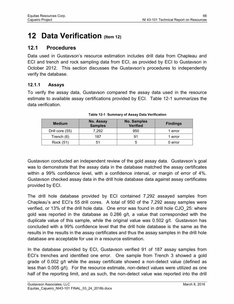
Equitas Resources Corp. 66 Cajueiro Project NI 43-101 Technical Report on Resources
Gustavson Associates, LLC March 8, 2016 Equitas_Cajueiro_NI43-101 FINAL_03_24_2016b.docx
12 Data Verification (Item 12) 12.1 Procedures Data used in Gustavson’s resource estimation includes drill data from Chapleau and ECI and trench and rock sampling data from ECI, as provided by ECI to Gustavson in October 2012. This section discusses the Gustavson’s procedures to independently verify the database.
12.1.1 Assays To verify the assay data, Gustavson compared the assay data used in the resource estimate to available assay certifications provided by ECI. Table 12-1 summarizes the data verification.
Table 12-1 Summary of Assay Data Verification
Medium No. Assay Samples
No. Samples Verified Findings
Drill core (55) 7,292 950 1 error Trench (6) 187 91 1 error Rock (51) 51 5 0 error
Gustavson conducted an independent review of the gold assay data. Gustavson’s goal was to demonstrate that the assay data in the database matched the assay certificates within a 99% confidence level, with a confidence interval, or margin of error of 4%. Gustavson checked assay data in the drill hole database data against assay certificates provided by ECI.
The drill hole database provided by ECI contained 7,292 assayed samples from Chapleau’s and ECI’s 55 drill cores. A total of 950 of the 7,292 assay samples were verified, or 13% of the drill hole data. One error was found in drill hole CJO_25: where gold was reported in the database as 0.286 g/t, a value that corresponded with the duplicate value of this sample, while the original value was 0.502 g/t. Gustavson has concluded with a 99% confidence level that the drill hole database is the same as the results in the results in the assay certificates and thus the assay samples in the drill hole database are acceptable for use in a resource estimation.
In the database provided by ECI, Gustavson verified 91 of 187 assay samples from ECI’s trenches and identified one error. One sample from Trench 3 showed a gold grade of 0.002 g/t while the assay certificate showed a non-detect value (defined as less than 0.005 g/t). For the resource estimate, non-detect values were utilized as one half of the reporting limit, and as such, the non-detect value was reported into the drill

Equitas Resources Corp. 67 Cajueiro Project NI 43-101 Technical Report on Resources
Gustavson Associates, LLC March 8, 2016 Equitas_Cajueiro_NI43-101 FINAL_03_24_2016b.docx
hole database as 0.0025 g/t. Gustavson concludes with a 99% confidence level that the trench assay samples in the database are the same as the results in the results in the assay certificates. In Gustavson’s opinion, the data quality of trench samples are acceptable for use in a resource estimation.
Gustavson verified 5 of 51 assay samples from ECI’s rock samples and found no errors in the data. Gustavson concludes that the quality of the rock samples data is acceptable for use in a resource estimation.
May 2011 Site Visit
During Gustavson’s on-site visit in May 2011, Dr. Newton visually compared original laboratory assay results with associated core sample intervals. Core samples were well marked and assay results compared favorably with visual inspection of associated sample intervals.
During the May 2011 site visit, Gustavson took two channel samples ( as shown in Table 12-2) from the Matrincha resource area. The trench walls were composed of saprolitic, buff-colored, sericitized microgranite with widely spaced, very thin quartz veins striking N50E and dipping 53 SE. Sample CJ5-1 was taken from a 3.7 meter section of the west trench wall and included a 2-cm wide quartz vein. Sample CJ5-2 was taken over 5.5 meters contiguous to the east with sample CJ5-1. The two samples together averaged 1.15 g/t gold over 9.1 meters. The samples were panned and approximately 50 colors were observed in each pan, composed mostly of very fine gold with a few coarser flakes.
A grab sample was taken from float at the base of an outcrop on the side of a ridge adjacent to an extensive soil anomaly in the northeast part of the property. The sample returned an assay of 0.46 g/t gold in sericitized granite with disseminated euhedral limonite after pyrite cubes and a stringer of limonite after pyrite.
All samples remained in Gustavson custody until personally handed by the qualified person to personnel with ACME laboratories, where they were analyzed by a 30 gram fire assay with an atomic absorption finish in ACME’s Santiago laboratory.
Gustavson’s independent sampling (Table 12-2) verifies anomalous gold in the Cajueiro system, and substantiates trenching and soil sampling results of ECI.

Equitas Resources Corp. 68 Cajueiro Project NI 43-101 Technical Report on Resources
Gustavson Associates, LLC March 8, 2016 Equitas_Cajueiro_NI43-101 FINAL_03_24_2016b.docx
Table 12-2 Gustavson Sample Assay Results from May 2011 Site Inspection
Method WGHT G6 Analyte Wgt Au Ag Al As Au Ba Be Bi Ca Cd Ce Co Cr Cu Fe Hf K La Li Mg Mn Mo
Unit KG PPM PPM % PPM PPM PPM PPM PPM % PPM PPM PPM PPM PPM % PPM % PPM PPM % PPM PPM
MDL 0 0.005 0.1 0 1 0.1 1 1 0.1 0 0.1 1 0.2 1 0.1 0.01 0.1 0 0.1 0.1 0 1 0.1
CJ5-1 Rock 1.74 1.202 0.2 9.23 11 0.9 148 2 2.4 0.01 0.2 194 0.7 3 66.1 3.15 7.2 0.90 34.8 5.8 0.08 155 7.5
CJ5-2 Rock 1.39 1.110 0.1 9.06 10 0.6 130 1 3.6 0.01 0.2 58 0.6 4 69.0 3.54 7.0 0.99 15.0 6.4 0.08 170 8.3
CJ-6 Rock 1.36 0.462 0.6 6.29 68 1.5 137 2 0.7 0.02 <0.1 57 0.3 2 20.1 6.24 5.4 2.50 24.5 16.0 0.09 1181 12.2
Method Analyte Na Nb Ni P Pb Rb S Sb Sc Sn Sr Ta Th Ti U V W Y Zn Zr
Unit % PPM PPM % PPM PPM % PPM PPM PPM PPM PPM PPM % PPM PPM PPM PPM PPM PPM
MDL 0 0.1 0.1 0 0.1 0.1 0.1 0.1 1 0.1 1 0.1 0.1 0 0.1 1 0.1 0.1 1 0.1
CJ5-1 Rock 0.012 19.6 1.0 0.008 18.0 89.0 <0.1 0.3 12 18.5 10 1.3 22.9 0.263 4.6 12 5.0 12.8 23 214.9
CJ5-2 Rock 0.012 21.2 0.9 0.006 14.1 87.9 <0.1 0.3 12 15.9 5 1.4 21.6 0.284 4.6 14 3.9 8.8 28 224.3
CJ-6 Rock 0.031 14.3 0.6 0.016 68.5 234.1 <0.1 1.1 5 42.7 5 1.0 19.6 0.106 3.6 8 3.7 7.3 25 163.7

Equitas Resources Corp. 69 Cajueiro Project NI 43-101 Technical Report on Resources
Gustavson Associates, LLC March 8, 2016 Equitas_Cajueiro_NI43-101 FINAL_03_24_2016b.docx
December 2012 Site Visit
Qualified Person Dr. Newton visited the site of the Cajueiro Project area for two days from December 27 to December 29, 2012. Four resource areas were field-checked by Gustavson in the project area – Crente, Baldo, Matrincha and Marines. Outcrops, float and trench cuts were examined and sampled. Samples were sealed in the field and remained in the QP’s possession until sealed in a box for shipment to SGS Laboratories in Cuiaba, Brazil. Results of these independent samples for each of the four resource areas are presented in Table 12-3. The results show that all samples carried gold values up to 1.4 ppm Au and compare favorably with the grades of samples in those areas.
Core from multiple drill holes in each area was examined with observations and interpretations recorded. Assays from the ECI database were checked against the same intervals in core. In all cases, higher grade gold assays corresponded with green sericite-altered and quartz-pyrite veined felsic porphyry. All laboratory assay certificates were compared with the associated data in the ECI database with no discrepancies identified. Drill hole numbers, assay intervals and density measurements are well marked in core boxes.
Numerous drill sites were examined by the QP as discussed in Section 12.1.3.

Equitas Resources Corp. 70 Cajueiro Project NI 43-101 Technical Report on Resources
Gustavson Associates, LLC March 8, 2016 Equitas_Cajueiro_NI43-101 FINAL_03_24_2016b.docx
Table 12-3 Results of Gustavson Sampling in the Four Target Areas
Sample ID Au ppb Description
CR-1 228 Crente, 2 m. chip sample of green sericite-altered felsic porphyry
CR-2 808 Crente, 1 m . chip sample in trench of saprolitic sercite-altered felsic porphyry
BA-1 1412 Baldo, grab sample, sericite/silica altered quartz porphyry with limonite after pyrite
BA-2 95 Baldo, float, pyrite/limonite veined sericitized quartz porphyry
MAR-1 3101 Marines, float of green sericitized and pink silicified quartz porphyry
CJ5-1 1202 Matrincha, 3.7 m. chip sample in trench of sericite-altered quartz-veined felsic porphyry
CJ5-2 1110 Matrincha, 5.5 m. chip sample in trench adjacent to CJ5-1, same rock type.
12.1.2 Lithology Gustavson’s QP verified lithology during the site visits in May 2011 and December 2012 by examination of outcrops and core. Gustavson’s Clay Newton conducted an onsite visit to the Cajueiro property on May 7 through 9, 2011. The onsite visit included a tour of historical garimpo workings, open and reclaimed exploration trenches, drill hole collar locations, and exploration target areas. The results of field reconnaissance of bedrock lithologies and orientation measurements with regard to structures exposed in garimpo pit walls and bedrock outcrops is generally conformable in structure, gross geometry, and apparent map units to figures presented by ECI. Lithologic units however were not used in the resource model.
12.1.3 Collar During the site visits, three to five drill sites were chosen at random by the QP for examination in each of the four resource areas. The drill holes were located with GPS; the azimuth and dip angle of exposed pipe was measured and the drill hole collar was photographed. The exposed pipes in the drill holes adequately corresponded in azimuth and inclination to what ECI has reported. The drill hole collars are permanently marked with PVC pipe, which represent the rough orientation of the hole, and are embedded in a square concrete slab. A metal tag is embedded in the concrete and inscribed with the hole ID, UTM coordinates, azimuth, inclination and depth.The orientation of each PVC pipe was taken and found to roughly correspond with the recorded azimuth and inclination in the database.
12.2 Data Adequacy Based on the results of data verification, the QP is of the opinion that the data quality is adequate for supporting a resource estimate.

Equitas Resources Corp. 71 Cajueiro Project NI 43-101 Technical Report on Resources
Gustavson Associates, LLC March 8, 2016 Equitas_Cajueiro_NI43-101 FINAL_03_24_2016b.docx
13 Mineral Processing and Metallurgical Testing (Item 13)
ECI conducted mineral processing testing based on comminution, gravity separation of gold, following by cyanide leaching of the tailings. Testing was conducted by SGS Geosol Laboratorios Ltda (SGS) and reported on April 5, 2012. A summary of the test work that was conducted, along with results and interpretations are provided in this section.
13.1 Samples On December 14, 2011, ECI submitted four samples identified as AM002 through AM005 to SGS. These samples were taken from the mineralized zone in the Crente area and consisted of hydrothermally altered rhyolite with pyrite. Pyrite occurred disseminated in the rock mass and and in quartz veins. Drill holes and depth ranges as shown in Table 13-1. Each sample consisted of a quarter of the drill core.
Table 13-1 Samples Submitted for Metallurgical Testing
Sample Name Drill Hole Depth Interval (meters)
Observed Lithology
AM002 CJO_010 45.5 – 57.5 Rhyolite (RY)
AM003 CJO_025 182.6 – 191.75 Rhyolite (RY)
AM004 CJO_030 154.15 – 162.15 Rhyolite (RY)
AM005 CJO_033 249 – 262.7 Rhyolite (RY)
13.2 Procedures and Results Gravity recovery gold (GRG) followed by cyanide leaching of tailings was conducted on the four samples ground to a particle size of 150 and 75 microns (100 and 200 mesh Tyler) with 80% passing rate (P80).
SGS developed grind curves to attain the P80 of 150 and 75 microns using 2 kilograms of each sample.
Six kilograms of samples at P80 of 150 and 75 microns were subject to gravity recovery using a Falcon Concentration L40 operated in 250 G with a water flow rate of 14 liters per minute. Gold was recovered from the water stream.
An aliquot of approximately 1,500 gram of the gravity tailings underwent a 48-hour cyanide leaching in a bottle. The solids were mixed with approximately 2,300 milliliters

Equitas Resources Corp. 72 Cajueiro Project NI 43-101 Technical Report on Resources
Gustavson Associates, LLC March 8, 2016 Equitas_Cajueiro_NI43-101 FINAL_03_24_2016b.docx
of cyanide solution such that the free cyanide concentration was fixed at 1,000 parts per million (ppm) at a pH of 10.5 to 11. Gold from cyanide leaching was recovered from the aqueous cyanide stream.
Recoveries from the gravity recovery and leach steps were calculated, along with an overall recovery. Results as reported in SGS (2012) from gravity gold recovery and cyanide leaching of tailings are provided in Tables 13-2 and 13-3.

Equitas Resources Corp. 73 Cajueiro Project NI 43-101 Technical Report on Resources
Gustavson Associates, LLC March 8, 2016 Equitas_Cajueiro_NI43-101 FINAL_03_24_2016b.docx
Table 13-2 Results of Gold Recovery by Gravity and Leaching for P80 = 150 Microns
Gravity Sample Name Separation Note AM002 AM003 AM004 AM005
Head Grade – Gold (g/t) Head grade of samples. 1.057 1.070 3.481 0.401
Grind Time (min) Time required to grind sample to P80 of 150 microns. 40 38 36 42
Gravity Recovery Amount of gold recovered from processing the ground sample through a Falcon concentrator. 47.4% 46.3% 58.4% 32.2%
Grade Gravity Concentrate (ppm)
Grade of the concentrate from the Falcon concentrator. 32.0 31.3 93.6 9.4
Grade Tailings (g/t) Grade of tailings from the Falcon concentrator. 0.59 0.58 1.48 0.27
Leach Recovery
Leach Recovery 1 Gold recovered from leaching the Falcon concentrator tailings in cyanide.
79.5% 71.7% 77.9% 69.4%
Leach Recovery 2 78.8% 73.8% 84.6 71.6%
Overall Recovery
Overall Recovery 1 Sum of gold recovery from gravity recovery and tailings cyanide leach.
89.2% 84.8% 90.8% 79.3%
Overall Recovery 2 88.9% 85.9% 93.6% 80.7%
Residue
Grade Leach Residue1 (g/t) Gold grade in the tailings following cyanide leach.
0.12 0.17 0.33 0.08
Grade Leach Residue2 (g/t) 0.12 0.15 0.22 0.08

Equitas Resources Corp. 74 Cajueiro Project NI 43-101 Technical Report on Resources
Gustavson Associates, LLC March 8, 2016 Equitas_Cajueiro_NI43-101 FINAL_03_24_2016b.docx
Table 13-3 Results of Gold Recovery by Gravity and Leaching for P80 = 75 Microns
Gravity Note Sample Name
Separation AM002 AM003 AM004 AM005 Head Grade – Gold (g/t) Head grade of samples. 1.057 1.070 3.481 0.401
Grind Time (min) Time required to grind 2 kg sample to P80 of 150 microns. 72 72 64 72
Gravity Recovery Amount of gold recovered from processing the ground sample through a Falcon concentrator in a 250 G field and water flow of 14 liters per minute.
42.5% 53.7% 80.2% 40.4%
Grade Gravity Concentrate (ppm)
Grade of the concentrate from the Falcon concentrator. 45.2 81.8 121.9 13.1
Grade Tailings (g/t) Grade of tailings from the Falcon concentrator. 0.61 0.50 0.7 0.24
Leach Recovery
Leach Recovery 1 Gold recovered from leaching the Falcon concentrator tailings in cyanide.
84.5% 84.6% 80.1% 75.6%
Leach Recovery 2 85.1% 84.4% 79.5% 75.9%
Overall Recovery
Overall Recovery 1 Sum of gold recovery from gravity recovery and tailings cyanide leach.
91.1% 92.9% 96.1% 85.4%
Overall Recovery 2 91.4% 92.8% 96.0% 85.7%
Residue
Grade Leach Residue1 (g/t) Gold grade in the tailings following cyanide leach.
0.10 0.08 0.14 0.06
Grade Leach Residue2 (g/t) 0.09 0.08 0.15 0.06

Equitas Resources Corp. 75 Cajueiro Project NI 43-101 Technical Report on Resources
Gustavson Associates, LLC March 8, 2016 Equitas_Cajueiro_NI43-101 FINAL_03_24_2016b.docx
13.3 Sample Representativeness The four samples that were submitted for metallurgical testing represented rhyolite/microgranite from the Crente target area. The head grades of the four samples span the average gold grade in the resource estimates for all four target areas, as shown in Table 14-12. Gustavson concludes that the samples are representative of potential head grades of mined materials for this stage of the study.
13.4 Significant Factors Results from ECI’s bench scale testing suggest gold may be recovered by gravity separation and cyanide leaching.
Gustavson noted that the SGS report did not provide reagent consumption (i.e., amount of cyanide added to maintain target free cyanide and pH levels). Gustavson suggests reagent consumption be reported for all future metallurgical testing.

Equitas Resources Corp. 76 Cajueiro Project NI 43-101 Technical Report on Resources
Gustavson Associates, LLC March 8, 2016 Equitas_Cajueiro_NI43-101 FINAL_03_24_2016b.docx
14 Mineral Resource Estimate (Item 14) The Cajueiro mineral resource estimate was completed under the supervision of Donald E. Hulse, P.E., Principal Mining Engineer, and a Qualified Person, in accordance with NI 43-101 standards.
Observations from drilling and exploration activities to date have identified two gold-bearing zones: a surficial weathered saprolite layer, underlain by competent bedrock. For the purpose of this section, the “saprolite” layer is defined as the overlying weathered rock layer, underlain by unweathered bedrock. The saprolite layer ranges in thickness from 0 to approximately 40 meters (see cross sections in Figures 14-4 through 14-7). Exploration observations show the saprolite to be weathered and thus, gold deposition may potentially be affected by either supergene enrichment or depletion. Given the differences in mineral deposition patterns, Gustavson has estimated the gold resource in the surficial saprolite separately from the resources in the underlying bedrock. Some of the saprolite has been mined by garimpeiros although the amount is undocumented. This depletion is considered to be small although it has not been accounted for in this resource model. Also not considered is placer gold that was mined by the garimpeiros though this material is not included in the mineral resource. Any remaining alluvial gold would not be counted in a “unweathered bedrock plus saprolite” model.
Drilling in the Cajueiro Project by Chapleau and ECI consists of 48 drill holes in 4 target areas (Crente, Baldo, Matrincha, and Marines) which Gustavson believes provide sufficient data on which to base an indicated and inferred mineral resource estimate in the unweathered bedrock zone. In the case of the saprolite zone, drill hole data that intersect the saprolite plus rock and trench sample data were utilized for the mineral resource estimate. Gustavson believes these data are sufficient for an inferred estimate within the saprolite zone. For both the saprolite and unweathered bedrock zones, Gustavson reported to a cutoff grade of 0.25 g/t gold, assuming mineral extraction of a near-surface deposit that can be processed by cyanidation.
The Alvaro Tavares target area was not included in the resource estimation by Gustavson. From the limited drilling (5 drill holes) done on the Alvaro target to date, insufficient mineralized intercepts were cut to be able to confirm the presence of the mineralized zone. Additional drilling should be conducted in this area before mineral resources can be evaluated.

Equitas Resources Corp. 77 Cajueiro Project NI 43-101 Technical Report on Resources
Gustavson Associates, LLC March 8, 2016 Equitas_Cajueiro_NI43-101 FINAL_03_24_2016b.docx
14.1 Deposit Geology Pertinent to Resource Estimation Mineralization is related to brittle fractures that strike predominantly northeast and east-northeast and dip moderately steeply south-southeast in the microgranite/rhyolite country rock. As discussed in Section 8.2, these fracture zones are associated with sericite-epidote-chlorite-quartz alteration and easily distinguishable from unaltered rock by a change from red unaltered rock to green altered rocks.
The anomalous gold values recorded in both narrow and wide alteration zones indicate that there are narrow higher grade fracture zones with an irregular, lower-grade selvage in the microgranite/rhyolite. Both styles of mineralization are discontinuous and were accounted for by using a probabilistic single indicator estimation methodology. The fracture zones were not modeled individually, but an indicator was selected to differentiate zones of higher grade from the more disseminated mineralization. The model also utilized the strike and dip of the mineralized zones, determined from drill intercept modeling and surface observations. Mineralized zones were identified on the surface by alteration style and soil and surface sampling. The country rock is consistent throughout the project area and was modeled as a microgranite/rhyolite.
14.2 Data Used for the Gold Grade Estimation Based on this study, drill logging practices could be revisited to refine the structural controls of mineralization and better delineate styles and distributions of alterations. Gustavson Associates created a 3D block model of each target area mineral resource based on data provided by ECI. Quality control procedures were reviewed and are discussed in Section 12 of this report.
Drill hole data including collar coordinates, down hole surveys, sample assay intervals, and geologic logs were provided by ECI in Microsoft Access™ format. Surficial geology maps and cross-sections detailing alteration and lithology were also provided in electronic format.
The Cajueiro database contains 48 core holes, 51 surface rock samples, and 187 trench samples for the four target areas. The drill holes listed by target are given in Table 14-1, and the surface rock and trench samples listed by target are given in Table 14-2. Figure 14-1 shows the location of the data and target area boundaries used in this estimate.
Gustavson used the lithology logs to model the saprolite zone within each target area using Leapfrog 3D® software. The bottom of this zone became a hard boundary for resource estimates. Samples and composites were coded as either saprolite (within the saprolite zone) or unweathered bedrock (below the saprolite zone). All rock surface

Equitas Resources Corp. 78 Cajueiro Project NI 43-101 Technical Report on Resources
Gustavson Associates, LLC March 8, 2016 Equitas_Cajueiro_NI43-101 FINAL_03_24_2016b.docx
samples and trench samples lie within the saprolite zone. Sections showing the depth of saprolite by zone are provided in Figures 14-4 through 14-7.

Equitas Resources Corp. 79 Cajueiro Project NI 43-101 Technical Report on Resources
Gustavson Associates, LLC March 8, 2016 Equitas_Cajueiro_NI43-101 FINAL_03_24_2016b.docx
Table 14-1 Cajueiro Drill Holes
Hole Name Depth (m)
Crente CJO_010 83.6 CJO_018 212.6 CJO_019 120.3 CJO_024 120.05 CJO_025 260.09 CJO_026 141.52 CJO_027 235.1 CJO_028 162.6 CJO_029 323.6 CJO_030 235.35 CJO_031 148.35 CJO_032 207.15 CJO_033 313.5 CJO_034 272.35 CJO_035 397.3 CJO_036 375.85 CJO_037 262.8 CJO_038 157.3 CJO_039 359.3 CJO_040 354.3 CJO_041 344.05 CJO_042 228 CJO_043 319.9 CJO_044 266.35 CJO_051 311.5
Hole Name Depth (m)
Baldo CJO_003 61.3 CJO_007 128 CJO_011 124.5 CJO_012 118.5 CJO_013 98.5 CJO_023 144.15 CJO_045 315.1 CJO_046 237.65 CJO_047 188.35 CJO_055 254.2
Matrincha CJO_008 82.2 CJO_009 85 CJO_020 223.65 CJO_048 296.6 CJO_049 176.55 CJO_054 342.65
Marines CJO_004 110.5 CJO_005 89.5 CJO_006 117.45 CJO_022 180.8 CJO_050 305.8 CJO_052 143.6 CJO_053 242.4

Equitas Resources Corp. 80 Cajueiro Project NI 43-101 Technical Report on Resources
Gustavson Associates, LLC March 8, 2016 Equitas_Cajueiro_NI43-101 FINAL_03_24_2016b.docx
Table 14-2 Rock Surface and Trench Samples Used for Modeling, by
Target Area
Sample Easting Northing Elevation Crente Target Area
R1 548034 8962900 228.89
R2 548038 8962894 228.91
R3 548023 8962890 229.43
R4 547980 8962808 229.38
R5 547979 8962808 229.38
R6 548043 8962870 229
R7 548042 8962866 229
R8 548041 8962864 229
R9 548038 8962856 229
R10 547999 8962860 230.48
R55 548088 8963021 228.91
R211 547983 8962810 229.34
R212 547985 8962810 229.28
R213 547987 8962810 229.28
R214 547989 8962810 229.22
R215 547991 8962810 229.15
R216 547985 8962838 230.21
R217 548000 8962857 230.32
R218 548067 8962917 228
R219 548072 8962997 228.82
R220 548075 8963000 228.84
R221 548152 8963030 227.07
R222 548152 8963027 227.09
R223 548152 8963025 227.11
R225 548057 8962920 228
T06
548350 8963004 218.13
548362 8962990 219.406
548362 8962989 219.406
548363 8962988 219.693
548370 8962979 221.678
548371 8962978 222.073
548372 8962978 222.468
548372 8962977 222.468
Sample Easting Northing Elevation Baldo Target Area
R69 548110 8964535 249.86
R70 548326 8964130 262.57
R74 548497 8964218 253.73
R77 548091 8964341 238.41
R88 548525 8964170 251.58
R175 548814 8964387 249.57
R176 548608 8964570 288.9
R177 548091 8964342 238.41
R178 548404 8964732 276.69
R182 548099 8964537 249.91
R184 548387 8964371 255.66
R185 548050 8964555 249.06
R188 548589 8964344 268.19
R189 548389 8964575 271.26
R194 548552 8964214 249.45
R195 548412 8964211 254.96
R198 548209 8964734 272.44
R208 548403 8964148 261.7
R209 548274 8964111 262.7
Matrincha Target Area R202 548061 8963693 233.87
R204 548059 8963694 233.88
R262 548322 8963891 249.02
T05
548246 8963857 241.548
548260 8963840 240.386
548263 8963836 239.917
548264 8963835 239.927
548277 8963820 238.779
Marines Target Area
R239 546828 8964224 240.24
R240 546875 8964407 246.2
R247 547205 8964689 260.98
R252 547122 8964507 258.98
T01 546824 8964158 235.579

Equitas Resources Corp. 81 Cajueiro Project NI 43-101 Technical Report on Resources
Gustavson Associates, LLC March 8, 2016 Equitas_Cajueiro_NI43-101 FINAL_03_24_2016b.docx
Sample Easting Northing Elevation Marines Target Area (cont.)
T02
546823 8964158 235.42
546823 8964159 235.42
546779 8964224 235.665
546772 8964232 235.703
546770 8964237 235.94
546990 8964341 240.892
546985 8964342 240.839
546985 8964344 240.941
546985 8964346 240.941
546987 8964345 240.969
546981 8964346 240.911
546982 8964350 241.131
546980 8964354 241.25
546979 8964358 241.335
546981 8964361 241.493
546980 8964366 241.738
546974 8964366 241.664
546972 8964366 241.627
546970 8964380 242.202
546972 8964382 242.237
546968 8964387 242.451
546966 8964391 242.55
546968 8964395 242.832
546982 8964397 242.958
546963 8964406 243.169
546959 8964404 243.145
546957 8964408 243.25
546960 8964410 243.403
546960 8964413 243.532
546956 8964412 243.379
546957 8964412 243.379
546954 8964416 243.613
546951 8964418 243.588
546952 8964418 243.588
546951 8964421 243.715
546948 8964425 243.919
546945 8964428 243.985
Sample Easting Northing Elevation Sample Easting Northing Elevation
Marines Target Area (cont.)
T03
546945 8964434 244.096
546947 8964438 244.148
546942 8964444 244.21
546940 8964444 244.199
546937 8964447 244.23
546935 8964451 244.27
546935 8964456 244.352
546933 8964460 244.382
547191 8964484 262.032
547192 8964489 264.129
547193 8964489 265.035
547191 8964491 265.007
547190 8964492 265.007
547190 8964493 265.007
547189 8964493 264.059
547187 8964494 265.009
547187 8964495 265.009
547187 8964437 248.579
547171 8964518 265.298
547169 8964519 265.298
547170 8964523 265.528
547167 8964518 264.767
547164 8964520 264.215
547166 8964523 265.088
547164 8964524 264.71
547164 8964526 264.71
547164 8964528 264.814
547165 8964529 264.814
547163 8964531 264.953
547164 8964532 264.953
547164 8964533 265.089
547163 8964535 265.089
547163 8964536 265.157
547162 8964537 264.839
547159 8964538 264.508
547162 8964538 264.839

Equitas Resources Corp. 82 Cajueiro Project NI 43-101 Technical Report on Resources
Gustavson Associates, LLC March 8, 2016 Equitas_Cajueiro_NI43-101 FINAL_03_24_2016b.docx
Sample Easting Northing Elevation 547159 8964541 264.529
Sample Easting Northing Elevation Marines Target Area (cont.)
T03 cont.
547159 8964542 264.524
547156 8964542 264.19
547156 8964543 264.19
547156 8964553 264.156
547155 8964545 264.186
547156 8964546 264.186
547155 8964548 264.177
547154 8964549 264.177
547153 8964553 263.84
547149 8964559 263.493
547160 8964550 264.719
547145 8964561 263.156
547144 8964564 262.815
547141 8964568 262.474
547138 8964577 262.125
547130 8964589 261.431
547122 8964600 260.41
547120 8964602 260.069
547118 8964605 260.063
547103 8964627 258.354
547087 8964650 257.006
547081 8964660 256.411
547075 8964671 252.605
T04
547270 8964711 254.518
547269 8964712 254.518
547268 8964713 255.829
547267 8964714 255.963
547266 8964714 255.963
547266 8964715 255.963
547266 8964716 256.686
547265 8964717 256.686
547253 8964733 256.996
547251 8964734 256.872
547250 8964735 256.872
547248 8964737 256.07
Sample Easting Northing Elevation 547248 8964739 256.07 547246 8964739 255.472
Sample Easting Northing Elevation Marines Target Area (cont.)
T04 cont.
547244 8964742 253.77 547244 8964743 251.485 547243 8964743 250.275 547243 8964744 250.275 547242 8964745 250.275 547241 8964746 247.975 547238 8964750 245.564 547228 8964763 243.079 547227 8964764 242.788 547225 8964765 242.633 547225 8964767 242.343 547224 8964767 242.343 547223 8964768 242.343 547223 8964769 242.343 547215 8964779 240.682 547214 8964780 240.682 547213 8964776 240.805 547212 8964780 240.52 547211 8964781 240.52 547211 8964782 240.253 547211 8964783 240.253 547210 8964785 239.897 547209 8964786 239.897 547200 8964794 239.121 547200 8964796 239.121 547198 8964798 238.904 547202 8964799 239.1 547198 8964794 239.026 547195 8964805 238.653 547194 8964806 238.601 547193 8964807 238.601 547193 8964808 238.601 547191 8964808 238.499 547186 8964815 238.145 547186 8964816 238.145

Equitas Resources Corp. 83 Cajueiro Project NI 43-101 Technical Report on Resources
Gustavson Associates, LLC March 8, 2016 Equitas_Cajueiro_NI43-101 FINAL_03_24_2016b.docx
Sample Easting Northing Elevation 547183 8964817 238.037 547183 8964818 237.984 547183 8964819 237.984 547182 8964820 237.984
Sample Easting Northing Elevation Marines Target Area (cont.)
T04 cont.
547181 8964821 237.931 547180 8964822 237.812 547179 8964825 237.758 547178 8964826 237.758 547177 8964827 237.584 547177 8964828 237.584 547176 8964829 237.584 547175 8964830 237.537 547174 8964832 237.413 547172 8964834 237.366 547171 8964835 237.241 547170 8964836 237.194 547169 8964837 237.194 547169 8964838 237.194 547168 8964839 237.013 547167 8964839 237.013 547166 8964840 237.013 547166 8964841 237.013 547165 8964842 236.819 547164 8964843 236.819 547164 8964844 236.819 547163 8964845 236.764 547163 8964846 236.764

Equitas Resources Corp. 84 Cajueiro Project NI 43-101 Technical Report on Resources
Gustavson Associates, LLC March 8, 2016 Equitas_Cajueiro_NI43-101 FINAL_03_24_2016b.docx
Figure 14-1 Cajueiro Drill Hole Location Map Showing Target Areas and Topography
A statistical analysis of the sample data is presented by target area and rock type in Table 14-3

Equitas Resources Corp. 85 Cajueiro Project NI 43-101 Technical Report on Resources
Gustavson Associates, LLC March 8, 2016 Equitas_Cajueiro_NI43-101 FINAL_03_24_2016b.docx
Table 14-3 Sample Statistics
Target Area Rock Zone Number Samples Min Max Mean Std. Dev. Median
Crente Unweathered
Bedrock 3499 0.0025 32.978 0.163 1.087 0.0025
Saprolite 205 0.0025 4.511 0.264 0.669 0.038
Baldo Unweathered
Bedrock 1029 0.0025 10.431 0.138 0.729 0.005
Saprolite 97 0.0025 92.105 2.065 10.588 0.018
Matrincha Unweathered
Bedrock 826 0.0025 19.895 0.192 0.992 0.007
Saprolite 49 0.0025 79.987 1.908 11.435 0.012
Marines Unweathered
Bedrock 768 0.0025 47.834 0.160 1.827 0.005
Saprolite 251 0.0025 26.239 0.472 2.372 0.052
14.3 Density ECI provided Gustavson with an estimated average in place density of 2.60 g/cm3 for the unweathered bedrock, and 1.80 g/cm3 for the saprolite. Gustavson is of the opinion that these values are realistic and adequate for an early-stage mineral resource estimate.
14.4 Methodology Gustavson estimated the mineral resources by utilizing a single indicator (discriminator) estimation methodology in each of the four target areas. This allows the modeling of mineralized portions of blocks where mineral and grade boundaries are transitional. This decision was predicated by the presence of discontinuous gold grades seen outside of the brittle fracture zones. An indicator estimation methodology accounts for discontinuities in grade, and allows resource estimation outside of a hard boundary of the fracture zone. Four block models were established, one for each target area. Each block model was rotated about the Z-axis to align the Y-axis of the model with the strike direction of the veins in each area. The outlines of the block models and the drill hole locations are shown in Figure 14-1. The drill data were geostatistically analyzed to define the parameters used to estimate gold grades in the 3D block model. MicroModel™ mining software was used to estimate gold grades.
All block models use blocks that are 10 meters along strike, 5 meters normal to the structure, and 3 meters high. Each of the blocks was assigned attributes of gold grade, rock density, rock type and indicator value. Block model parameters are shown in Table 14-4.

Equitas Resources Corp. 86 Cajueiro Project NI 43-101 Technical Report on Resources
Gustavson Associates, LLC March 8, 2016 Equitas_Cajueiro_NI43-101 FINAL_03_24_2016b.docx
Table 14-4 Block Model Parameters
Target Axis Origin (UTM) Number of Blocks Block Size (m) Rotation from North
Crente
X 5476000 90 5 48°
Y 8962730 90 10
Z -200 150 3
Baldo
X 547950 212 5 0°
Y 8964100 70 10
Z -100 150 3
Matrincha
X 547965 65 5 49°
Y 8963645 50 10
Z -100 125 3
Marines
X 546680 70 5 36°
Y 8964220 100 10
Z -35 120 3
14.5 Capping of Assays Cumulative frequency plots (CFPs) were created for the samples within each target area for both saprolite and unweathered bedrock zones. These plots were used to assess the data distribution and determine an appropriate cap value for each target area in the unweathered bedrock and saprolite zones. The CFPs for each area by rock type are shown in Figure 14-2. The red lines indicate an approximate linear best fit, which is used to help determine a reasonable cap value.

Equitas Resources Corp. 87 Cajueiro Project NI 43-101 Technical Report on Resources
Gustavson Associates, LLC March 8, 2016 Equitas_Cajueiro_NI43-101 FINAL_03_24_2016b.docx
Figure 14-2 CFPs for Target Areas by Rock Type

Equitas Resources Corp. 88 Cajueiro Project NI 43-101 Technical Report on Resources
Gustavson Associates, LLC March 8, 2016 Equitas_Cajueiro_NI43-101 FINAL_03_24_2016b.docx
Based on a review of the sample statistics, Gustavson capped gold grades in each target area as noted in Table 14-5. Capping occurred prior to compositing.
Table 14-5 Cap Values
Target Unweathered Bedrock Cap Value (g/t) Saprolite Cap Value (g/t)
Crente 10 5
Baldo 5 5
Matrincha 5 5
Marines 5 5
14.6 Compositing Gustavson evaluated each target area to determine the appropriate interval for compositing drill holes. The composite interval provides common sample support by using equal length samples to represent the data without smoothing the natural variability needed to adequately model grade. The average sample length and block size were considered when choosing an appropriate composite length. The composite lengths for each target area are shown in Table 14-6.
Table 14-6 Composite Lengths
Target Composite Length (m)
Crente 3
Baldo 3
Matrincha 3
Marines 3
For the unweathered bedrock zone, assay data from drilling were utilized. For the saprolite zone, assay data from drilling through the saprolite zone, plus results from rock and trench sampling were utilized. A statistical analysis of the capped and composited data is presented in Table 14-7.

Equitas Resources Corp. 89 Cajueiro Project NI 43-101 Technical Report on Resources
Gustavson Associates, LLC March 8, 2016 Equitas_Cajueiro_NI43-101 FINAL_03_24_2016b.docx
Table 14-7 Composite Statistics
Target Area Rock Zone Number Samples Min Max Mean Std. Dev. Median
Crente Unweathered Bedrock 1925 0.0025 7.041 0.090 0.399 0.005
Saprolite 183 0.0025 4.511 0.287 0.698 0.038
Baldo Unweathered Bedrock 499 0.0025 3.368 0.070 0.295 0.005
Saprolite 77 0.0025 5 0.614 1.461 0.025
Matrincha Unweathered Bedrock 371 0.0025 2.670 0.103 0.344 0.007
Saprolite 38 0.0025 5 0.415 1.173 0.012
Marines Unweathered Bedrock 356 0.0025 1.894 0.055 0.192 0.005
Saprolite 214 0.0025 5 0.324 0.815 0.068
14.7 Variography Gustavson conducted a geostatistical analysis of all assay data in the Crente area which was the only target area with sufficient data to perform a variographic analysis. It was determined through variography that the down-dip range of the gold grade continuity was 115 meters (Figure 14-3). The continuity along strike was approximately 90 meters. The variogram for the third anisotropic direction was not definitive, and Gustavson chose to assign a value of 10 meters in this direction based on typical vein anisotropies. These parameters were assigned to the other 3 target areas based on similarities of structure and mineralization between the areas. Further drilling would improve the data density and allow each target area to have its own variography.

Equitas Resources Corp. 90 Cajueiro Project NI 43-101 Technical Report on Resources
Gustavson Associates, LLC March 8, 2016 Equitas_Cajueiro_NI43-101 FINAL_03_24_2016b.docx
Figure 14-3 Down Dip Variogram for Crente
14.8 Estimation Estimation parameters for all target areas and rock types were defined by the variography described above. All search distances were determined from the variography at Crente. Estimation parameters for the unweathered bedrock zones are summarized in Table 14-8.

Equitas Resources Corp. 91 Cajueiro Project NI 43-101 Technical Report on Resources
Gustavson Associates, LLC March 8, 2016 Equitas_Cajueiro_NI43-101 FINAL_03_24_2016b.docx
Table 14-8 Unweathered Bedrock Estimation Parameters
Target 1st Pass
(half variogram distance)
2nd Pass (one variogram
distances)
3rd Pass (two variogram
distances)
Crente
X Axis (meters) 58 115 230 Y Axis (meters) 45 90 180 Z Axis (meters) 5 10 20 Azimuth (°) 138 138 138 Dip (°) 73 73 73
Baldo North
X Axis (meters) 58 n/a n/a Y Axis (meters) 45 n/a n/a Z Axis (meters) 5 n/a n/a Azimuth (°) 135 n/a n/a Dip (°) 80 n/a n/a
Baldo South
X Axis (meters) 58 n/a n/a Y Axis (meters) 45 n/a n/a Z Axis (meters) 5 n/a n/a Azimuth (°) 180 n/a n/a Dip (°) 65 n/a n/a
Matrincha
X Axis (meters) 58 n/a n/a Y Axis (meters) 45 n/a n/a Z Axis (meters) 5 n/a n/a Azimuth (°) 145 n/a n/a Dip (°) 60 n/a n/a
Marines
X Axis (meters) 58 n/a n/a Y Axis (meters) 45 n/a n/a Z Axis (meters) 5 n/a n/a Azimuth (°) 150 n/a n/a Dip (°) 75 n/a n/a
All Target Areas
Min # Samples 1 1 1 Max # Samples 10 10 10 Max Samples per Drill Hole 4 4 4
The unweathered bedrock portion of the Cajueiro deposit is characterized by relatively high grade gold bearing fracture zones with a partial halo of relatively lower grade mineralization. Gustavson chose a single indicator (discriminator) approach to model the proportion of higher grade vein material within each block and the surrounding halo of disseminated mineralization. This type of estimate limits the extrapolation of higher grade mineralization into lower grade zones. Intervals with composite values greater than the gold indicator value (Table 14-9) were assumed to be higher grade material for this estimate, and were assigned an indicator of 1; composite intervals with gold values equal to or less than the indicator value were assigned an indicator of 0 (wallrock). An indicator value for each block was then estimated from the 1 or 0 composite values

Equitas Resources Corp. 92 Cajueiro Project NI 43-101 Technical Report on Resources
Gustavson Associates, LLC March 8, 2016 Equitas_Cajueiro_NI43-101 FINAL_03_24_2016b.docx
using an Inverse Distance Squared (ID2) method. This estimate returns a value between 0 and 1 for each block (the indicator value) that represents the percentage of higher grade material within each block.
The grade of the higher grade portion of each block was estimated from the composites that had been coded with a 1. The wallrock portion of the block was estimated in a similar fashion, using only wallrock (0 indicator) composites. The unweathered bedrock blocks were estimated using an ID2 algorithm for all estimations. The total average grade of each block was then calculated using the percentage of the block that is higher grade, times the grade of the higher grade portion of the block, plus the percentage of the block that is wallrock, times the grade of the wallrock portion of the block. The resource was estimated in 3 passes for the Crente target area, and one pass for all other areas. Baldo was estimated in two separate pieces, one to the north and one in the south, to account for the distinct structural trends.
Table 14-9 Gold Indicator Values
Target Indicator Value (g/t)
Crente 0.0025
Baldo 0.005
Matrincha 0.0025
Marines 0.005
The saprolite zone was estimated using only an ID2 method, with no indicator. One estimation pass was run using a half-variogram search ellipse distance (same as Table 14-5, 1st pass) and the orientations for each target area noted in Table 14-5.
Unweathered bedrock blocks were estimated using only composites from within the unweathered bedrock zone, and saprolite blocks were estimated using only composites and surface grab and trench samples from the saprolite zone.
14.8.1 Estimate Validation The model was first evaluated by comparing the composite statistics to the block model statistics for each rock type in each target area. Results are shown in Table 14-10.

Equitas Resources Corp. 93 Cajueiro Project NI 43-101 Technical Report on Resources
Gustavson Associates, LLC March 8, 2016 Equitas_Cajueiro_NI43-101 FINAL_03_24_2016b.docx
Table 14-10 Descriptive Statistics for Gold in Composite Samples and Model
Composites Block Model
Target area Min Max Mean Std. Dev. Median Min Max Mean Std. Dev. Median Crente Unweathered Bedrock 0.0025 7.041 0.090 0.399 0.005 0.000 7.041 0.065 0.212 0.010
Crente Saprolite 0.0025 4.511 0.287 0.698 0.038 0.0025 4.511 0.405 0.838 0.070 Baldo Unweathered Bedrock 0.0025 3.368 0.070 0.295 0.005 0.001 3.368 0.069 0.244 0.005
Baldo Saprolite 0.0025 5 0.614 1.461 0.025 0.0025 5 0.967 1.692 0.046 Matrincha Unweathered Bedrock 0.0025 2.670 0.103 0.344 0.007 0.000 2.641 0.097 0.267 0.011
Matrincha Saprolite 0.0025 5 0.415 1.173 0.012 0.0025 5 0.750 1.501 0.047 Marines Unweathered Bedrock 0.0025 1.894 0.055 0.192 0.005 0.000 1.894 0.051 0.125 0.007
Marines Saprolite 0.0025 5 0.324 0.815 0.068 0.0025 3.847 0.318 0.622 0.084
NOTE: Gold grades are reported in g/t.
The model was validated by evaluating the blocks against actual composite assay data to determine if the estimated blocks fit the grade and parameters of the various veins of the deposit. Both assay and vein constraints were visually examined. Cross sections looking along the Y-axis displaying the block model gold content with the composite gold data for each target is presented in Figures 14-4 to 14-7. Note that both the blocks and the composites use the legend shown. Sections widths may vary in order to show composite data from two drill holes; widths are shown in the caption of each figure.

Equitas Resources Corp. 94 Cajueiro Project NI 43-101 Technical Report on Resources
Gustavson Associates, LLC March 8, 2016 Equitas_Cajueiro_NI43-101 FINAL_03_24_2016b.docx
Figure 14-4 Crente Validation Section, 15 m Wide

Equitas Resources Corp. 95 Cajueiro Project NI 43-101 Technical Report on Resources
Gustavson Associates, LLC March 8, 2016 Equitas_Cajueiro_NI43-101 FINAL_03_24_2016b.docx
Figure 14-5 Baldo Validation Section, 100 m Wide

Equitas Resources Corp. 96 Cajueiro Project NI 43-101 Technical Report on Resources
Gustavson Associates, LLC March 8, 2016 Equitas_Cajueiro_NI43-101 FINAL_03_24_2016b.docx
Figure 14-6 Matrincha Validation Section, 20 m Wide

Equitas Resources Corp. 97 Cajueiro Project NI 43-101 Technical Report on Resources
Gustavson Associates, LLC March 8, 2016 Equitas_Cajueiro_NI43-101 FINAL_03_24_2016b.docx
Figure 14-7 Marines Validation Section, 30 m Wide
The unweathered bedrock resource was also evaluated using a nearest neighbor (NN) estimation as a check. For validation purposes a zero cutoff grade NN is used to compare to the ID2 model, the 0 g/t cutoff is shown for illustrative purposes only. The resource estimate produced using this method, as well as the percent change between the ID2 and NN methods are shown in Table 14-11.

Equitas Resources Corp. 98 Cajueiro Project NI 43-101 Technical Report on Resources
Gustavson Associates, LLC March 8, 2016 Equitas_Cajueiro_NI43-101 FINAL_03_24_2016b.docx
Table 14-11 ID2 and NN Model Comparison
Crente
Model Cutoff (g/t) Tonnes (000s)
Volume (000s, m3) Au (g/t) Ounces Au
(000s)
ID2 0 428,681 164,877 0.0351 484
NN 0 428,681 164,877 0.0349 481
% Diff 0 0% 0% 1% 1%
Baldo
Cutoff (g/t) Tonnes Volume (m3) Au (g/t) Ounces Au (000s)
ID2 0 556,241 213,939 0.002 35
NN 0 556,241 213,939 0.002 41
% Diff 0 0% 0% 0% -15%
Matrincha
Model Cutoff (g/t) Tonnes (000s)
Volume (000s, m3) Au (g/t) Ounces Au
(000s)
ID2 0 132,488 50,957 0.0128 55
NN 0 132,488 50,957 0.0129 55
% Diff 0 0% 0% -1% 0%
Marines
Model Cutoff (g/t) Tonnes (000s)
Volume (000s, m3) Au (g/t) Ounces Au
(000s)
ID2 0 241,958 93,061 0.0026 20
NN 0 241,958 93,061 0.0027 21
% Diff 0 0% 0% -4% -4%
14.9 Mineral Resource Classification It is the QP’s assessment that gold distribution occurs within narrow higher grade fracture zones with an irregular, lower-grade selvage and that mineralization is associated with sericite-epidote-chlorite-quartz discontinuous alteration packages which have distinct boundaries with unaltered rock. Therefore sample distance and abundance criteria are appropriate for resource classification. Indicated resources in unweathered bedrock at Crente were classified by requiring blocks to be less than 40 m from a sample, and that two separate drill holes were used to estimate the block grade;

Equitas Resources Corp. 99 Cajueiro Project NI 43-101 Technical Report on Resources
Gustavson Associates, LLC March 8, 2016 Equitas_Cajueiro_NI43-101 FINAL_03_24_2016b.docx
all other blocks, in both unweathered bedrock and saprolite, and in all other targets, were classified as inferred.
14.10 Mineral Resource Estimation Gustavson’s mineral resource estimate results are summarized in Table 14-12.
The mineralized zones at Cajueiro are four distinct zones. Crente averages approximately 60 meters wide, 890 meters long, and 400 meters of vertical extent. Matrincha averages approximately 25 meters wide, 280 meters long, and with 240 meters of vertical extent. Both Marines and Baldo are much more discontinuous. Marines is made up of approximately five clusters averaging 10 meters wide, 90 meters long, and with 130 meters of vertical extents. Baldo is made up of approximately three clusters averaging 15 meters wide, 80 meters long, and with 110 meters of vertical extent. The results in Table 14-12 are for the combined saprolite and unweathered bedrock zones, which may respectively be considered as oxide and sulfide facies. This mineral resource estimate includes all drill hole data available as of October 5, 2012. Mineral resources are reported on a 0.25 g/t cutoff grade assuming a three-year trailing average gold price of about $1,250 per ounce as of March 2016. Gustavson believes that this price is adequate for the reporting of mineral resources at this time. This cut off reflects the potential economic, marketing, and other issues relevant to a surface mining method followed by gravity separation and cyanide leaching.
Mineral resources are not mineral reserves and may be materially affected by environmental, permitting, legal, socio-economic, marketing, political, or other factors. There is no certainty that all or any part of the mineral resource will be converted to mineral reserves. Quantity and grade are estimates and are rounded to reflect the fact that the resource estimate is an approximation.
Current topographic surface data does not include the existing pit lake. Previously depleted resources from the saprolite mined by garimpeiros have not been accounted in this study. Gustavson is of the opinion that mining below the saprolite boundary is negligible and does not materially impact the indicated and inferred resource estimated herein.

Equitas Resources Corp. 100 Cajueiro Project NI 43-101 Technical Report on Resources
Gustavson Associates, LLC March 8, 2016 Equitas_Cajueiro_NI43-101 FINAL_03_24_2016b.docx
Table 14-12 Mineral Resource Estimate (Fresh Rock - Sulfide Zone)
Crente Indicated Inferred
Cutoff Tonnes Au Oz Au Cutoff Tonnes Au Oz Au g/t (000s) g/t (000s) g/t (000s) g/t (000s) 0.3 7,400 0.854 203.2 0.3 4,904 0.695 109.5
0.25 8,636 0.771 214.1 0.25 5,826 0.628 117.7 0.2 10,131 0.690 224.8 0.2 7,161 0.553 127.2
Baldo
Inferred
Cutoff Tonnes Au Oz Au
g/t (000s) g/t (000s)
0.3 1,108 0.872 31.1
0.25 1,319 0.777 33.0
0.2 1,500 0.711 34.3 Matrincha
Inferred
Cutoff Tonnes Au Oz Au
g/t (000s) g/t (000s)
0.3 1,410 0.867 39.3
0.25 1,596 0.797 40.9
0.2 1,884 0.710 43.0 Marines
Inferred
Cutoff Tonnes Au Oz Au
g/t (000s) g/t (000s)
0.3 686 0.500 11.0
0.25 785 0.472 11.9
0.2 1,055 0.408 13.8 Total
Indicated Inferred Cutoff Tonnes Au Oz Au Cutoff Tonnes Au Oz Au
g/t (000s) g/t (000s) g/t (000s) g/t (000s) 0.3 7,400 0.854 203.2 0.3 8,108 0.732 190.9
0.25 8,636 0.771 214.1 0.25 9,526 0.664 203.5 0.2 10,131 0.690 224.8 0.2 11,600 0.585 218.3
Effective date March 8, 2016

Equitas Resources Corp. 101 Cajueiro Project NI 43-101 Technical Report on Resources
Gustavson Associates, LLC March 8, 2016 Equitas_Cajueiro_NI43-101 FINAL_03_24_2016b.docx
Table 14-13 Mineral Resource Estimate (Saprolite – Oxide Zone)
Crente Indicated Inferred
Cutoff Tonnes Au Oz Au Cutoff Tonnes Au Oz Au g/t (000s) g/t (000s) g/t (000s) g/t (000s) 0.3 0.3 357 1.562 17.9
0.25 0.25 381 1.482 18.2 0.2 0.2 419 1.367 18.4
Baldo
Inferred
Cutoff Tonnes Au Oz Au
g/t (000s) g/t (000s)
0.3 309 3.029 30.1
0.25 309 3.029 30.1
0.2 309 3.021 30.0 Matrincha
Inferred
Cutoff Tonnes Au Oz Au
g/t (000s) g/t (000s)
0.3 155 2.726 13.6
0.25 155 2.717 13.5
0.2 198 2.184 13.9 Marines
Inferred
Cutoff Tonnes Au Oz Au
g/t (000s) g/t (000s)
0.3 481 1.046 16.2
0.25 529 0.977 16.6
0.2 607 0.880 17.2 Total
Indicated Inferred Cutoff Tonnes Au Oz Au Cutoff Tonnes Au Oz Au
g/t (000s) g/t (000s) g/t (000s) g/t (000s) 0.3 0.3 1,302 1.858 77.8
0.25 0.25 1,374 1.775 78.4 0.2 0.2 1,533 1.613 79.5
NOTE Numbers in the table may not precisely add up due to rounding errors
Effective date March 8, 2016

Equitas Resources Corp. 102 Cajueiro Project NI 43-101 Technical Report on Resources
Gustavson Associates, LLC March 8, 2016 Equitas_Cajueiro_NI43-101 FINAL_03_24_2016b.docx

Equitas Resources Corp. 103 Cajueiro Project NI 43-101 Technical Report on Resources
Gustavson Associates, LLC March 8, 2016 Equitas_Cajueiro_NI43-101 FINAL_03_24_2016b.docx
15 Adjacent Properties (Item 23) There are no other mineralized zones with resource estimates in the immediate vicinity to the Cajueiro Project. No resource estimates exist in properties immediately adjacent to the Cajueiro Project area. Gustavson is not aware of relevant information concerning an adjacent property that may affect the Cajueiro project.

Equitas Resources Corp. 104 Cajueiro Project NI 43-101 Technical Report on Resources
Gustavson Associates, LLC March 8, 2016 Equitas_Cajueiro_NI43-101 FINAL_03_24_2016b.docx
16 Other Relevant Data and Information (Item 24) Gustavson is not aware of any data or information that has not been included in this Technical Report on Resources.

Equitas Resources Corp. 105 Cajueiro Project NI 43-101 Technical Report on Resources
Gustavson Associates, LLC March 8, 2016 Equitas_Cajueiro_NI43-101 FINAL_03_24_2016b.docx
17 Interpretation and Conclusions (Item 25) 17.1 Site Inspection Qualified Person Dr. Newton most recently visited the site of the Cajueiro Project area for two days from December 27 to December 29, 2012. Four resource areas were field-checked by Gustavson in the project area – Crente, Baldo, Matrincha and Marines. Drill sites were examined, located by GPS and photographed in each of the four resource areas. Outcrops, float and trench cuts were examined and sampled. Core from multiple drill holes from each area was examined. Assays were provided from the ECI database and checked against the intervals in core.
17.2 Property Location
17.2.1 Land Position The Cajueiro property consists of a total permitted area of 39,053 hectares, consisting of 11 permits. Six of the 12 exploration permits have been granted by DNPM for exploration and/or mining. ECI applied for seven additional exploration permits between 2010 and 2012: these permits are under review by DNPM, and exploration may occur on these areas once the permits are grantedby DNPM. From information provided from Alta Floresta in March 2016, all claims appear to be in good standing with DNPM. Gustavson concludes the permitted areas appear acceptable.
ECI had previously acquired written agreements with both landowners Alvaro Tavares and Ricardo Cardoso for use of the properties for exploration purposes. Surface rights appear adequate for the foreseeable exploration activities.
17.2.2 Net Smelter Royalties Production from three permit areas (866.070/2004, 866.933/2012 and 850.224/2009) are subject to a 1% net smelter return payable to Elvio Schelle, Mr. Ulema, and the sellers of the central part of the Cajueiro property. No royalties apply to the other claim blocks. Gustavson concludes that the NSR for the project appear reasonable.
17.2.3 Environmental Liability and Permits Historical mining activities have resulted in several pits which have since filled with water. Environmental impacts at the Cajueiro property are permitted by the State of Mato Grosso’s Secretary of Environment (Secretaria de Estado do Meio Ambiente, or SEMA). In the project environmental permit (SEMA, 2012), SEMA generally describes the environmental impacts of the the historically mined areas to be well mitigated. Specifically, erosion and sedimentation is being being managed by natural vegetation in the drainage, waste, and pit areas. No required reclamation requirements for the

Equitas Resources Corp. 106 Cajueiro Project NI 43-101 Technical Report on Resources
Gustavson Associates, LLC March 8, 2016 Equitas_Cajueiro_NI43-101 FINAL_03_24_2016b.docx
historically mined areas are identified in SEMA (2012). Gustavson concludes the historical mining pits are not expected to pose a risk which may keep the project from moving forward.
Environmental requirements for on-site activities are permitted by SEMA (2012). Gustavson requested and received environmental permits for two areas: DNPM Permit Nos. 866.160/2007 and 866.070/2004. This permit covers exploration (i.e., trench sampling and drilling), evaluation of economic viability of mining, and associated infrastructure (i.e., camp) to support exploration. As shown on Figure 4-2, ECI’s exploration and drilling areas include portions not covered by DNPM Permit Nos. 866.160/2007 and 866.070/2004. Gustavson believes that Equitas should hold up-to-date environmental permitting for those areas subject to exploration and drilling.
17.3 Site Operations
17.3.1 Operating Seasons As communicated from ECI, exploration activities can be conducted on the Cajueiro property year round.
17.3.2 Infrastructure Following review of infrastructure (including on site superstructure, communications, power, water, personnel, and waste disposal methods), Gustavson concludes that infrastructure at the Cajueiro Project appears adequate for foreseeable exploration and drilling activities. The planned electric power line serving the area should Additional evaluation will be needed to determine if infrastructure is adequate for activities beyond mineral exploration.
17.4 Metallurgy and Processing Metallurgical testing has been completed for four rhyolite unweathered bedrock samples from the Crente target area. Samples were ground to particle size with 80% passing rate (P80) of 150 and 75 microns, followed by gravity gold recovery, and cyanide leach for gold. Overall gold recoveries ranged from 85% to 96%. No reagent consumption has been reported for the testing completed to date.
17.5 Mineral Resource Estimate Observations from drilling and exploration activities to date have identified two gold-bearing zones: a surficial weathered saprolite layer underlain by competent bedrock. For the purpose of this section, the “saprolite” layer is defined as the overlying weathered rock layer and is underlain by unweathered bedrock. Gustavson has

Equitas Resources Corp. 107 Cajueiro Project NI 43-101 Technical Report on Resources
Gustavson Associates, LLC March 8, 2016 Equitas_Cajueiro_NI43-101 FINAL_03_24_2016b.docx
estimated the gold resource in the surficial saprolite separately from the resources in the underlying bedrock.
Drilling in the Cajueiro Project consists of 48 drill holes in 4 target areas (Crente, Baldo, Matrincha, and Marines) which Gustavson believes provide sufficient data on which to base an indicated and inferred mineral resource estimate in the unweathered bedrock zone. In the case of the saprolite zone, drill hole data that intersected the saprolite plus rock and trench sample data were utilized for the mineral resource estimate. Gustavson believes these data are sufficient for an inferred estimate within the saprolite zone.
The database used for resource estimation contains 48 core holes, 51 surface rock samples, and 187 trench samples that fall with assay values that fall within one of 4 target areas. All block models use blocks that are 10 meters along strike, 5 meters normal to the structure, and 3 meters high. Samples were composited at 3 meters. Gold was capped at 10 g/t in the Crente target area unweathered bedrock, and at 5 g/t in saprolite at Crente and in unweathered bedrock and saprolite for the other three target areas.
The anomalous gold values recorded in both narrow and wide alteration zones indicate that there are narrow higher grade fracture zones with an irregular, lower-grade selvage in the microgranite/rhyolite. Both styles of mineralization are discontinuous and were accounted for by using a probabilistic single indicator estimation methodology.
Gustavson created variograms based on the data from the Crente target area and utilized the directional parameters for both saprolite and unweathered bedrock all four target areas. Resource estimate results are reported in Table 14-12.
Gustavson reported mineral resources based on a cutoff grade of 0.25 g/t gold for both the saprolite and unweathered bedrock zones, assuming the near-surface deposit can be extracted by surface methods and processed by cyanidation.
17.6 Significant Risks and Uncertainties
17.6.1 Geology Gustavson notes that the lithology logged in the drill hole database did not consistently contain color or intensity of alteration information, which is relevant as mineralization is associated with the green sericite-altered microgranite/rhyolite as opposed to the reddish unaltered microgranite/rhyolite. For this resource estimate, Gustavson modeled the microgranite/rhyolite as one unit. Further, the lithology logs did not consistently contain observations of oxide versus sulfide mineralization, and observations of brittle

Equitas Resources Corp. 108 Cajueiro Project NI 43-101 Technical Report on Resources
Gustavson Associates, LLC March 8, 2016 Equitas_Cajueiro_NI43-101 FINAL_03_24_2016b.docx
fracture zones. To account for potential limitations in the data, Gustavson has classified the resource as indicated and inferred.
Gustavson notes that the relationship between gold grade in the two variations of microgranite/rhyolite should be evaluated and the resource estimate refined if indicated.
17.6.2 Mineral Resource Estimate Mineral resource was completed for the saprolite zone within the four target areas. The estimate was completed using discrete trench and rock samples collected from mineralized outcrops. The intent of the trench samples and rock samples to date was to determine whether the surficial saprolite layer is gold-bearing, thus justifying sampling only in those locations where mineralized outcrops were identified. This sampling scheme may produce results that are biased high (i.e., samples were selective in those mineralized areas only, without considering the effect of the surrounding gangue rock). To account for any potential sampling bias, Gustavson classified resources in the saprolite layer as inferred.
Within the unweathered bedrock zone, Gustavson interprets that the highest grade gold is carried in the brittle fractures, with gold grades decreasing at distance from the fractures. In the drill hole database provided to Gustavson from ECI, Gustavson notes that the alterations are not consistently identified in the drill logs such that they can be modeled as part of this resource estimate. For the resource estimate presented in this report, Gustavson utilized the directional orientations of the brittle fractures within each target area. Future mineral resource estimates should be based on a geologic model to provide a more robust estimate.
Historically mined pits in the project area generally coincide with the areas where the mineral resources were estimated. As of the effective date of this report, no survey data of the pits were made available to Gustavson, which could be accounted for in the mineral resource estimate. However, as the saprolite mined has been local and shallow (estimated at less than 3 meters deep), Gustavson feels the resource estimate is not significantly impacted by past mining activities.
Gustavson recognizes the resource estimate may be more representative of site conditions if survey data of the pits were available and could be accounted for in the estimate.
For the three target areas other than Crente, the quantity of drill hole and assay data is not adequate to support variogram analysis. As such, Gustavson conducted a geostatistical analysis of all assay data in the Crente area, and applied the resulting parameters variograms analysis from Crente to the other target areas. Gustavson

Equitas Resources Corp. 109 Cajueiro Project NI 43-101 Technical Report on Resources
Gustavson Associates, LLC March 8, 2016 Equitas_Cajueiro_NI43-101 FINAL_03_24_2016b.docx
recognizes the resource estimate for the target areas other than Crente may be more representative if they were completed using unique variogram parameters from each target zone.
17.6.3 Metallurgy and Processing ECI conducted metallurgical testing on four samples, which show greater than 85% gold recovery by gravity separation and cyanide leaching. Based on the bench scale testing completed, Gustavson believes that there is potential for eventual economic metal recovery.
17.6.4 Other Risks While there are several other potential non-mining or resource based risk factors (for example legal, political or environmental) which could affect the development of a commercial mining facility at Cajueiro. The Equitas management do not believe any of these to be material enough in their own right to warrant detailed analysis.
17.7 Conclusions Independent observations and sampling by Gustavson indicate that there are multiple potentially economic gold-bearing zones on the Cajueiro property. Gold is associated with coarse pyrite which occurs as disseminations and with vein quartz. Pyrite, quartz veining and gold mineralization are found in green sericite-epidote-chlotite altered zones in otherwise unaltered reddish magnetite-bearing granitic/rhyolitic rocks which, as dikes, are probably responsible for the prominent linear aeromagnetic highs. The dike trends also appear to mark fracture zones in the granitic/rhyolitic rocks along which hydrothermal alteration and gold mineralization took place.
Gustavson’s resource modeling from all available drilling data suggests that altered mineralized zones from a few to 50 meters thick are stacked as multiple intervals in thick packages of rocks with structural control. Individual mineralized zones are discontinuous along strike but have downdip continuity for several hundred meters and some are open-ended at depths of current drilling.
The mineral resource at a 0.25g/t gold cutoff contains an indicated mineral resource of 8.6 million tonnes containing 214,000 ounces of gold at 0.771 g/t; and an inferred mineral resource of 10.9 million tonnes containing 282,000 ounces of gold at 0.804 g/t.. Continued exploration drilling is deemed by Gustavson likely to prove up significantly more gold resources and is recommended to advance the project to preliminary economic assessment stage.

Equitas Resources Corp. 110 Cajueiro Project NI 43-101 Technical Report on Resources
Gustavson Associates, LLC March 8, 2016 Equitas_Cajueiro_NI43-101 FINAL_03_24_2016b.docx

Equitas Resources Corp. 111 Cajueiro Project NI 43-101 Technical Report on Resources
Gustavson Associates, LLC March 8, 2016 Equitas_Cajueiro_NI43-101 FINAL_03_24_2016b.docx
18 Recommendations (Item 26) 18.1 Recommended Work Programs
ECI/Alta Floresta has provided Gustavson with the environmental permits for the areas covered by DNPM Permit Nos. 866.070/2004 and 866.160/2007, which may not cover all exploration target areas. If this permit is not in place, Gustavson recommends that Equitas acquire environmental permits for those areas where exploration and drilling are planned, or mining activities will be conducted in the foreseeable future.
Gustavson recommends that Equitas log the geology of the new drill holes, as well as re-log the geology of the retained drill core and chips, to include color, mineralization, and alteration variation of the microgranite/rhyolite. Geologic data should be evaluated as part of the next resource estimate for the project and included in a geologic model.
Gustavson recommends a topographic survey of the project area including locations, dimensions and soundings of the historical pits to refine their impact on the mineral resource estimate.
Gustavson recommends a combination of drilling and trenching to better define the Baldo area. This should consist of trenching and supplemental core drilling to better define the oxide blanket. This improves the definition of the resource and meets the work commitments to maintain the mineral concession. Mineral resource estimation should be updated with the new drilling and assaying results.
18.1.1 Costs A single phase of next-round drilling and trenching is recommended, totaling 2,000 meters of core drilling and 4,000 linear meters of trenching. The estimated cost of continued exploration and a planned preliminary economic assessment report on the Cajueiro Property is 675 thousand dollars, as shown in Table 18-1.

Equitas Resources Corp. 112 Cajueiro Project NI 43-101 Technical Report on Resources
Gustavson Associates, LLC March 8, 2016 Equitas_Cajueiro_NI43-101 FINAL_03_24_2016b.docx
Table 18-1 Recommended Budget for Exploration and PEA
Phase I Budget Exploration Drilling $250,000
Trenching and Mapping $40,000
Laboratory and Assaying $80,000
Other Exploration Expenditures $200,000
Preliminary Economic Assessment $145,000 Total $675,000

Equitas Resources Corp. 113 Cajueiro Project NI 43-101 Technical Report on Resources
Gustavson Associates, LLC March 8, 2016 Equitas_Cajueiro_NI43-101 FINAL_03_24_2016b.docx
19 References (Item 27) Chapleau, 2007. Cajueiro Project, Mato Grosso and Para State, Brazil, Exploration Progress, August 2006 – July 2007. Prepared by Chapleau Resources Limited, August 2007.
DNPM, 2013. Exploration permits information from Brazil’s Ministry of Mines and Energy (Ministério de Minas e Energia), National Department of Mineral Production (Departamento Nacional de Produção Mineral) website. Information retrieved in January 2013.
ECI, 2011. PowerPoint presentation entitled, Cajueiro geophysics. Prepared by ECI, November 1, 2011.
ECI, 2013a. ECI website. Information retrieved in January 2013.
ECI, 2013b. Correspondence between ECI and Gustavson describing mineral titles for the Cajueiro project. Information received by Gustavson in February and March 2013.
Gustavson, 2013. NI 43-101 Technical Report on Resources, Cajueiro Project, States of Mato Gross and Para, Brazil. Prepared by Gustavson Associates for ECI, dated May 10, 2013.
Gustavson, 2011. NI 43-101 Technical Report, Mineral Resource Estimate for the Cajueiro Project, Mato Gross and Para States, Brazil. Prepared by Gustavson Associates for ECI, dated September 13, 2011.
SEMA, 2010. License for Mineral Exploration (Licença de Operação para Pesquisa Mineral) No. 099/2010 for DNPM Permit No. 866.070/2004 from the State of Mato Grosso’s Environment Secretary (Secretaria de Estado do Ambiente, or “SEMA”). Permitted to Electrum Capital Inc., dated March 4, 2010.
SEMA, 2012. License for Mineral Exploration (Licença de Operação para Pesquisa Mineral) No. 305724/2012 for DNPM Permit No. 866.160/2007 from the State of Mato Grosso’s Environment Secretary (Secretaria de Estado do Ambiente, or “SEMA”). Permitted to Electrum Capital Pesquisa de Recursos Minerais Ltda, December 7, 2012.
SGS, 2012. Relatorio Tecnico, Testes de Separação Gravitica e Lixiviação em Amostras de Minério de Ouro de Cajueiro. Prepared by SGS Geosol for ECI, April 5, 2012.
World Weather, 2013. Information retrieved from the website in January 2013.

Equitas Resources Corp. 114 Cajueiro Project NI 43-101 Technical Report on Resources
Gustavson Associates, LLC March 8, 2016 Equitas_Cajueiro_NI43-101 FINAL_03_24_2016b.docx
20 Glossary 20.1 Mineral Resources The mineral resources and mineral reserves have been classified according to the “CIM Standards on Mineral Resources and Reserves: Definitions and Guidelines” (November 27, 2010). Accordingly, the Resources have been classified as Measured, Indicated or Inferred, the Reserves have been classified as Proven, and Probable based on the Measured and Indicated Resources as defined below.
A Mineral Resource is a concentration or occurrence of natural, solid, inorganic or fossilized organic material in or on the Earth’s crust in such form and quantity and of such a grade or quality that it has reasonable prospects for economic extraction. The location, quantity, grade, geological characteristics and continuity of a Mineral Resource are known, estimated or interpreted from specific geological evidence and knowledge.
An ‘Inferred Mineral Resource’ is that part of a Mineral Resource for which quantity and grade or quality can be estimated on the basis of geological evidence and limited sampling and reasonably assumed, but not verified, geological and grade continuity. The estimate is based on limited information and sampling gathered through appropriate techniques from locations such as outcrops, trenches, pits, workings and drillholes.
An ‘Indicated Mineral Resource’ is that part of a Mineral Resource for which quantity, grade or quality, densities, shape and physical characteristics can be estimated with a level of confidence sufficient to allow the appropriate application of technical and economic parameters, to support mine planning and evaluation of the economic viability of the deposit. The estimate is based on detailed and reliable exploration and testing information gathered through appropriate techniques from locations such as outcrops, trenches, pits, workings and drillholes that are spaced closely enough for geological and grade continuity to be reasonably assumed.
A ‘Measured Mineral Resource’ is that part of a Mineral Resource for which quantity, grade or quality, densities, shape, physical characteristics are so well established that they can be estimated with confidence sufficient to allow the appropriate application of technical and economic parameters, to support production planning and evaluation of the economic viability of the deposit. The estimate is based on detailed and reliable exploration, sampling and testing information gathered through appropriate techniques from locations such as outcrops, trenches, pits, workings and drillholes that are spaced closely enough to confirm both geological and grade continuity.

Equitas Resources Corp. 115 Cajueiro Project NI 43-101 Technical Report on Resources
Gustavson Associates, LLC March 8, 2016 Equitas_Cajueiro_NI43-101 FINAL_03_24_2016b.docx
20.2 Mineral Reserves A Mineral Reserve is the economically mineable part of a Measured or Indicated Mineral Resource demonstrated by at least a Preliminary Feasibility Study. This Study must include adequate information on mining, processing, metallurgical, economic and other relevant factors that demonstrate, at the time of reporting, that economic extraction can be justified. A Mineral Reserve includes diluting materials and allowances for losses that may occur when the material is mined.
A ‘Probable Mineral Reserve’ is the economically mineable part of an Indicated, and in some circumstances a Measured Mineral Resource demonstrated by at least a Preliminary Feasibility Study. This Study must include adequate information on mining, processing, metallurgical, economic, and other relevant factors that demonstrate, at the time of reporting, that economic extraction can be justified.
A ‘Proven Mineral Reserve’ is the economically mineable part of a Measured Mineral Resource demonstrated by at least a Preliminary Feasibility Study. This Study must include adequate information on mining, processing, metallurgical, economic, and other relevant factors that demonstrate, at the time of reporting, that economic extraction is justified.
20.3 Glossary The following general mining terms may be used in this report.
Table 20-1 Glossary
Term Definition Assay: The chemical analysis of mineral samples to determine the metal content. Capital Expenditure:
All other expenditures not classified as operating costs.
Composite: Combining more than one sample result to give an average result over a larger distance.
Concentrate: A metal-rich product resulting from a mineral enrichment process such as gravity concentration or flotation, in which most of the desired mineral has been separated from the waste material in the ore.
Crushing: Initial process of reducing ore particle size to render it more amenable for further processing.
Cutoff Grade (CoG):
The grade of mineralized rock, which determines as to whether or not it is economic to recover its gold content by further concentration.
Dilution: Waste, which is unavoidably mined with ore. Dip: Angle of inclination of a geological feature/rock from the horizontal. Fault: The surface of a fracture along which movement has occurred. Footwall: The underlying side of an orebody or stope. Gangue: Non-valuable components of the ore. Grade: The measure of concentration of gold within mineralized rock. Hangingwall: The overlying side of an orebody or slope. Haulage: A horizontal underground excavation which is used to transport mined ore.

Equitas Resources Corp. 116 Cajueiro Project NI 43-101 Technical Report on Resources
Gustavson Associates, LLC March 8, 2016 Equitas_Cajueiro_NI43-101 FINAL_03_24_2016b.docx
Term Definition Hydrocyclone: A process whereby material is graded according to size by exploiting centrifugal
forces of particulate materials. Igneous: Primary crystalline rock formed by the solidification of magma. Kriging: An interpolation method of assigning values from samples to blocks that
minimizes the estimation error. Level: Horizontal tunnel the primary purpose is the transportation of personnel and
materials. Lithological: Geological description pertaining to different rock types. LoM Plans: Life-of-Mine plans. LRP: Long Range Plan. Material Properties:
Mine properties.
Milling: A general term used to describe the process in which the ore is crushed and ground and subjected to physical or chemical treatment to extract the valuable metals to a concentrate or finished product.
Mineral/Mining Lease:
A lease area for which mineral rights are held.
Mining Assets: The Material Properties and Significant Exploration Properties. Ongoing Capital: Capital estimates of a routine nature, which is necessary for sustaining
operations. Ore Reserve: See Mineral Reserve. Pillar: Rock left behind to help support the excavations in an underground mine. RoM: Run-of-Mine. Sedimentary: Pertaining to rocks formed by the accumulation of sediments, formed by the
erosion of other rocks. Shaft: An opening cut downwards from the surface for transporting personnel,
equipment, supplies, ore and waste. Sill: A thin, tabular, horizontal to sub-horizontal body of igneous rock formed by the
injection of magma into planar zones of weakness. Smelting: A high temperature pyrometallurgical operation conducted in a furnace, in which
the valuable metal is collected to a molten matte or doré phase and separated from the gangue components that accumulate in a less dense molten slag phase.
Stope: Underground void created by mining. Stratigraphy: The study of stratified rocks in terms of time and space. Strike: Direction of line formed by the intersection of strata surfaces with the horizontal
plane, always perpendicular to the dip direction. Sulfide: A sulfur bearing mineral. Tailings: Finely ground waste rock from which valuable minerals or metals have been
extracted. Thickening: The process of concentrating solid particles in suspension. Total Expenditure: All expenditures including those of an operating and capital nature. Variogram: A statistical representation of the characteristics (usually grade).
20.4 Definition of Terms The following abbreviations may be used in this report.

Equitas Resources Corp. 117 Cajueiro Project NI 43-101 Technical Report on Resources
Gustavson Associates, LLC March 8, 2016 Equitas_Cajueiro_NI43-101 FINAL_03_24_2016b.docx
Table 20-2 Abbreviations
Abbreviation Unit or Term A ampere AA atomic absorption A/m2 amperes per square meter ANFO ammonium nitrate fuel oil Ag silver Au gold AuEq gold equivalent grade °C degrees Centigrade CCD counter-current decantation CIL carbon-in-leach CoG cutoff grade cm centimeter cm2 square centimeter cm3 cubic centimeter cfm cubic feet per minute ConfC confidence code CRec core recovery CSS closed-side setting CTW calculated true width ° degree (degrees) dia. diameter EIS Environmental Impact Statement EMP Environmental Management Plan FA fire assay ft foot (feet) ft2 square foot (feet) ft3 cubic foot (feet) g gram gal gallon g/L gram per liter g-mol gram-mole Gpm gallons per minute g/t grams per tonne Ha hectares HDPE Height Density Polyethylene Hp horsepower HTW horizontal true width ICP induced couple plasma ID2 inverse-distance squared ID3 inverse-distance cubed IFC International Finance Corporation ILS Intermediate Leach Solution kA kiloamperes kg kilograms km kilometer km2 square kilometer koz thousand troy ounce
Equitas Resources Corp. 118 Cajueiro Project NI 43-101 Technical Report on Resources
Gustavson Associates, LLC March 8, 2016 Equitas_Cajueiro_NI43-101 FINAL_03_24_2016b.docx
Abbreviation Unit or Term kt thousand tonnes kt/d thousand tonnes per day kt/y thousand tonnes per year kV kilovolt kW kilowatt kWh kilowatt-hour kWh/t kilowatt-hour per metric tonne L liter L/sec liters per second L/sec/m liters per second per meter Lb pound LHD Long-Haul Dump truck LLDDP Linear Low Density Polyethylene Plastic LOI Loss On Ignition LoM Life-of-Mine m meter m2 square meter m3 cubic meter masl meters above sea level MARN Ministry of the Environment and Natural Resources MDA Mine Development Associates mg/L milligrams/liter mm millimeter mm2 square millimeter mm3 cubic millimeter MME Mine & Mill Engineering Moz million troy ounces Mt million tonnes MTW measured true width MW million watts m.y. million years NGO non-governmental organization NI 43-101 Canadian National Instrument 43-101 OSC Ontario Securities Commission oz troy ounce % percent PLC Programmable Logic Controller PLS Pregnant Leach Solution PMF probable maximum flood ppb parts per billion ppm parts per million QA/QC Quality Assurance/Quality Control RC rotary circulation drilling RoM Run-of-Mine RQD Rock Quality Description SEC U.S. Securities & Exchange Commission sec second SG specific gravity
Equitas Resources Corp. 119 Cajueiro Project NI 43-101 Technical Report on Resources
Gustavson Associates, LLC March 8, 2016 Equitas_Cajueiro_NI43-101 FINAL_03_24_2016b.docx
Abbreviation Unit or Term SPT standard penetration testing st short ton (2,000 pounds) t tonne (metric ton) (2,204.6 pounds) t/h tonnes per hour t/d tonnes per day t/y tonnes per year TSF tailings storage facility TSP total suspended particulates µm micron or microns V volts VFD variable frequency drive W Watt XRD x-ray diffraction y Year