Embed Size (px)
Citation preview

Nganhurra Operations Cessation Environment Plan Summary
Developments Division Revision 0
December 2017
Nganhurra Operations Cessation Environment Plan Summary
This document is protected by copyright. No part of this document may be reproduced, adapted, transmitted, or stored in any form by any process (electronic or otherwise) without the specific written consent of Woodside. All rights are reserved.
Revision: 0 Page 4 of 148
Uncontrolled when printed. Refer to electronic version for most up to date information.
TABLE OF CONTENTS
1. INTRODUCTION .................................................................................................... 7 1.1 Defining the Activity ............................................................................................................ 7
2. LOCATION OF THE ACTIVITY .............................................................................. 8
3. DESCRIPTION OF THE ACTIVITY ...................................................................... 10 3.1 Purpose of the Activity ...................................................................................................... 10
3.2 Timing of the Activity ........................................................................................................ 10
3.3 Facility Overview .............................................................................................................. 10
3.3.1 FPSO ................................................................................................................................ 12
3.3.2 Well Configuration ............................................................................................................ 12
3.3.3 Flowline and Riser System ............................................................................................... 12
3.3.4 Subsea Infrastructure ....................................................................................................... 12
3.3.5 Riser Turret Mooring System ............................................................................................ 12
3.4 Well Isolations .................................................................................................................. 15
3.5 Nganhurra FPSO Disconnection ...................................................................................... 16
3.6 Riser Turret Mooring System Removal ............................................................................ 16
3.6.1 Flowline and Riser Disconnection .................................................................................... 16
3.6.2 As Left Status ................................................................................................................... 17
3.7 Subsea Wells .................................................................................................................... 17
3.8 Well Intervention ............................................................................................................... 17
3.8.1 Drilling Fluids .................................................................................................................... 17
3.8.2 Well Inspection ................................................................................................................. 18
3.8.3 Unplanned Contingency Activities .................................................................................... 18
3.9 Preservation ..................................................................................................................... 18
3.9.1 Subsea System ................................................................................................................ 18
3.9.2 Inspection and Maintenance ............................................................................................. 19
3.10 Project Vessels ................................................................................................................. 20
3.10.1 MODU ............................................................................................................................... 21
3.10.2 Intervention Vessel ........................................................................................................... 22
3.10.3 Primary Installation Vessel ............................................................................................... 22
3.10.4 Support and Other Vessels .............................................................................................. 22
3.10.5 SIMOPS ............................................................................................................................ 23
3.10.6 Refuelling .......................................................................................................................... 23
3.10.7 Remotely Operated Vehicles (ROVs) ............................................................................... 23
3.10.8 Helicopters ........................................................................................................................ 24
3.10.9 Routine Vessel Activities .................................................................................................. 24
3.10.10 Mooring Installation and Anchor Holding Testing ......................................................... 24
3.11 Assessment of Project Chemicals .................................................................................... 25
4. DESCRIPTION OF THE RECEIVING ENVIRONMENT ....................................... 28 4.1 Physical Environment ....................................................................................................... 28

Nganhurra Operations Cessation Environment Plan Summary
This document is protected by copyright. No part of this document may be reproduced, adapted, transmitted, or stored in any form by any process (electronic or otherwise) without the specific written consent of Woodside. All rights are reserved.
Revision: 0 Page 5 of 148
Uncontrolled when printed. Refer to electronic version for most up to date information.
4.2 Biological Environment ..................................................................................................... 29
4.2.1 Habitats ............................................................................................................................ 29
4.2.2 Species ............................................................................................................................. 31
4.2.3 Socio-economic and Cultural ............................................................................................ 34
4.3 Values and Sensitivities .................................................................................................... 38
5. ENVIRONMENTAL IMPACTS AND RISKS ......................................................... 41 5.1 Risk Identification and Evaluation ..................................................................................... 41
5.2 Hydrocarbon Spill Risk Assessment Methodology ........................................................... 46
6. ENVIRONMENTAL RISKS AND IMPACTS SUMMARY ..................................... 48
7. ONGOING MONITORING OF ENVIRONMENTAL PERFORMANCE ................. 53 7.1 Environment Plan Revisions and Management of Change .............................................. 54
8. OIL POLLUTION EMERGENCY RESPONSE ARRANGEMENTS ...................... 55 8.1 Woodside Oil Pollution Emergency Arrangements (Australia) ......................................... 55
8.2 Nganhurra Oil Pollution First Strike Plan .......................................................................... 55
8.3 Oil Spill Preparedness and Response Mitigation Assessment ......................................... 55
9. CONSULTATION ................................................................................................. 58 9.1 Ongoing Consultation ....................................................................................................... 59
10. TITLEHOLDER NOMINATED LIAISON PERSON .............................................. 60
11. ABBREVIATIONS AND ACRONYMS ................................................................. 61 A.1 Physical Presence: Interference with or Displacement of Other Users .................................... 64
A.2 Physical Presence: Disturbance to Seabed from Infrastructure Laydown and Subsea Equipment ....................................................................................................................................... 68
A.3 Routine Acoustic Emissions: Project Vessels .......................................................................... 70
A.4 Routine and Non-routine Discharges: Hydrocarbons, Chemicals and Drilling Fluids ............... 71
A.5 Routine Light Emissions ........................................................................................................... 74
A.6 Routine Acoustic Emissions ..................................................................................................... 76
A.7 Routine and Non-routine Atmospheric Emissions .................................................................... 79
A.8 Unplanned Hydrocarbon Release: Loss of Well Containment during Intervention Activities .... 81
A.9 Unplanned Hydrocarbon Release: Loss of Well Containment from Wellhead Damage ......... 102
A.10 Accidental Hydrocarbon Release: Vessel Collision .............................................................. 105
A.11 Unplanned Hydrocarbon Discharges: Bunkering ................................................................. 111
A.12 Unplanned Discharges: Loss of Chemicals / Hydrocarbons from Project Vessels............... 113
A.13 Unplanned Discharges: Loss of Solid Hazardous / Non-hazardous Wastes ........................ 115
A.14 Unplanned Discharges: Vessel Collision with Marine Fauna ............................................... 116
A.15 Physical Presence: Disturbance to Seabed from Dropped Objects ..................................... 117
A.16 Physical Presence: Accidental Introduction of Invasive Marine Species .............................. 119
APPENDIX A: DETAILED ENVIRONMENTAL IMPACTS AND RISKS ........................... 63
APPENDIX B: CONTROL MITIGATION MEASURES FOR POTENTIAL ENVIRONMENTAL IMPACTS ASSOCIATED WITH SPILL RESPONSE ACTIVITIES . 122

Nganhurra Operations Cessation Environment Plan Summary
This document is protected by copyright. No part of this document may be reproduced, adapted, transmitted, or stored in any form by any process (electronic or otherwise) without the specific written consent of Woodside. All rights are reserved.
Revision: 0 Page 6 of 148
Uncontrolled when printed. Refer to electronic version for most up to date information.
APPENDIX C: SUMMARY OF STAKEHOLDER FEEDBACK AND WOODSIDE’S ASSESSMENTS AND REPONSES ................................................................................ 137

Nganhurra Operations Cessation Environment Plan Summary
This document is protected by copyright. No part of this document may be reproduced, adapted, transmitted, or stored in any form by any process (electronic or otherwise) without the specific written consent of Woodside. All rights are reserved.
Revision: 0 Page 7 of 148
Uncontrolled when printed. Refer to electronic version for most up to date information.
1. INTRODUCTION
Woodside Energy Ltd (Woodside), as Titleholder, under the Offshore Petroleum and Greenhouse Gas Storage (Environment) Regulations 2009 (referred to as the Environment Regulations), proposes to disconnect the Nganhurra floating production, storage and offloading (FPSO) facility (NGA Facility) from the Enfield field and to isolate and preserve the riser turret mooring (RTM) (until its removal) and subsea infrastructure, in preparation for future decommissioning activities (referred to in this document as the Petroleum Activities Program).
This Environment Plan (EP) Summary has been prepared to meet the requirements of Regulations 11(3) and 11(4) of the Environment Regulations, as administered by the National Offshore Petroleum Safety and Environmental Management Authority (NOPSEMA). This document summarises the Nganhurra Operations Cessation Environment Plan (the EP) accepted by NOPSEMA under Regulation 10A of the Environment Regulations.
1.1 Defining the Activity
The Petroleum Activities Program is to be undertaken in Production Licence Area WA-28-L (herein referred to as WA-28-L) and is anticipated to include:
Removal of the FPSO from WA-28-L;
Isolation and preservation the subsea systems;
Removal of the RTM from field following disconnection of risers, electro-hydraulic umbilical (EHU), removal of buoyancy modules and disconnection of mooring lines from RTM;
Implementation of an inspection regime during preservation period until all wells are abandoned and subsea infrastructure is decommissioned (which will be subject to a future, separate EP); and
Well intervention and abandonment of selected wells (if required).
Nganhurra Operations Cessation Environment Plan Summary
This document is protected by copyright. No part of this document may be reproduced, adapted, transmitted, or stored in any form by any process (electronic or otherwise) without the specific written consent of Woodside. All rights are reserved.
Revision: 0 Page 8 of 148
Uncontrolled when printed. Refer to electronic version for most up to date information.
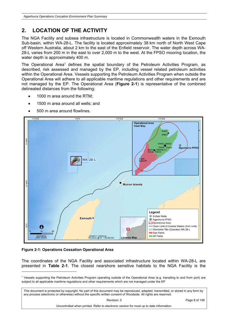
2. LOCATION OF THE ACTIVITY The NGA Facility and subsea infrastructure is located in Commonwealth waters in the Exmouth Sub-basin, within WA-28-L. The facility is located approximately 38 km north of North West Cape off Western Australia, about 2 km to the east of the Enfield reservoir. The water depth across WA-28-L varies from 200 m in the east to over 2,000 m to the west. At the FPSO mooring location, the water depth is approximately 400 m.
The Operational Area1 defines the spatial boundary of the Petroleum Activities Program, as described, risk assessed and managed by the EP, including vessel related petroleum activities within the Operational Area. Vessels supporting the Petroleum Activities Program when outside the Operational Area will adhere to all applicable maritime regulations and other requirements and are not managed by the EP. The Operational Area (Figure 2-1) is representative of the combined delineated distances from the following:
1000 m area around the RTM;
1500 m area around all wells; and
500 m area around flowlines.
Figure 2-1: Operations Cessation Operational Area
The coordinates of the NGA Facility and associated infrastructure located within WA-28-L are presented in Table 2-1. The closest nearshore sensitive habitats to the NGA Facility is the 1 Vessels supporting the Petroleum Activities Program operating outside of the Operational Area (e.g. transiting to and from port) are subject to all applicable maritime regulations and other requirements which are not managed under the EP

Nganhurra Operations Cessation Environment Plan Summary
This document is protected by copyright. No part of this document may be reproduced, adapted, transmitted, or stored in any form by any process (electronic or otherwise) without the specific written consent of Woodside. All rights are reserved.
Revision: 0 Page 9 of 148
Uncontrolled when printed. Refer to electronic version for most up to date information.
Commonwealth boundary of the Ningaloo Reef Commonwealth Marine Reserve approximately 17 km to the south, the Gascoyne Commonwealth Marine Park approximately 17 km to the west, and the Muiron Islands Marine Management and Conservation Area approximately 30 km to the south east.
Table 2-1: Approximate locations details for the Petroleum Activities Program
Structure Latitude Longitude
NGA FPSO 21° 28' 53.268" S 114° 00' 29.249" E
Production Well ENA01 21° 28' 54.064" S 113° 59' 21.678" E
Production Well ENA02 21° 28' 53.564" S 113° 59' 21.236" E
Production Well ENA03 21° 28' 54.289" S 113° 59' 20.402" E
Production Well ENA04 21° 28' 55.221" S 113° 59' 21.573" E
Production Well ENA05 21° 28' 54.803" S 113° 59' 21.012" E
Production Well ENE01 21° 28' 53.335" S 113° 59' 17.083" E
Production Well ENE02 21° 28' 53.958" S 113° 59' 17.693" E
Production Well ENE03 21° 28' 52.842" S 113° 59' 17.851" E
Water Injection Well ENB01 21° 27' 55.752" S 113° 59' 34.297" E
Water Injection Well ENB02 21° 27' 55.337" S 113° 59' 34.719" E
Water Injection Well ENB03 21° 27' 56.005" S 113° 59' 35.450" E
Water Injection Well ENC01 21° 29' 14.814" S 113° 58' 30.698" E
Water Injection Well ENC02 21° 29' 15.281" S 113° 58' 30.267" E
Water Injection Well ENC03 21° 29' 15.457" S 113° 58' 31.396" E
Water Injection Well ENC04 21° 29' 14.920" S 113° 58' 30.020" E
Water Injection Well ENC05 21° 29' 15.920" S 113° 58' 31.392" E
Gas Injection Well END01 21° 30' 3.582" S 113° 57' 51.152" E
Gas Injection Well END02 21° 30' 3.853" S 113° 57' 50.826" E

Nganhurra Operations Cessation Environment Plan Summary
This document is protected by copyright. No part of this document may be reproduced, adapted, transmitted, or stored in any form by any process (electronic or otherwise) without the specific written consent of Woodside. All rights are reserved.
Revision: 0 Page 10 of 148
Uncontrolled when printed. Refer to electronic version for most up to date information.
3. DESCRIPTION OF THE ACTIVITY
3.1 Purpose of the Activity
The purpose of the Petroleum Activities Program is to disconnect the NGA Facility from the field and to isolate and preserve the RTM and subsea infrastructure, in preparation for future decommissioning activities.
3.2 Timing of the Activity
The current schedule of the Petroleum Activity Program is outlined in Table 3-1. Timing and duration may be subject to change due to MODU/vessel availability, unforeseen circumstances and weather. The Petroleum Activities Program is anticipated to commence in Q4 2018.
Table 3-1: Indicative timing of Petroleum Activities Program
Activity Indicative Timing Duration Comment
FPSO disconnection and xmas tree isolations.
Approximately Q4 2018 subject to final cessation of production (COP) date.
25 days. Preparation for FPSO sail away and disconnection including flushing support, valve operations and well isolations.
RTM removal. Following FPSO disconnection. Schedule or weather delays may result in RTM removal being delayed 45-200 days post FPSO disconnection.
Planned duration of 30 days, depending on operational efficiency and weather.
Requires disconnection of risers, EHU, removal of buoyancy modules and disconnection of mooring lines from RTM prior to removal from field.
Well intervention (if required).
Between FPSO disconnection and field decommissioning.
10-20 days per well is expected.
Up to eight wells may be intervened on .
Preservation. Between FPSO disconnection and field decommissioning.
Ongoing. Following FPSO disconnection, a subsea system preservation period will commence following the Petroleum Activities Program, and will extend until the remaining subsea infrastructure is decommissioned and remaining wells are abandoned.
The EP has assessed risks relevant to the activities throughout the year (all seasons), to provide operational flexibility in the event of project schedule changes. The schedule and timeframe presented in the EP may be subject to change due to operational requirements and external influences such as contract award, vessel/MODU/equipment/materials availability and/or metocean conditions.
3.3 Facility Overview This section provides a high level overview of the infrastructure relevant to consideration of the environmental risks and impacts of the operations cessation activities. The subsea layout of the NGA Facility is provided in Figure 3-1. Further details of the facility and field layout are provided in the sections to follow.

Nganhurra Operations Cessation Environment Plan Summary
This document is protected by copyright. No part of this document may be reproduced, adapted, transmitted, or stored in any form by any process (electronic or otherwise) without the specific written consent of Woodside. All rights are reserved.
Revision: A Page 11 of 148
Uncontrolled when printed. Refer to electronic version for most up to date information.
Figure 3-1: Nganhurra facility subsea layout

Nganhurra Operations Cessation Environment Plan Summary
This document is protected by copyright. No part of this document may be reproduced, adapted, transmitted, or stored in any form by any process (electronic or otherwise) without the specific written consent of Woodside. All rights are reserved.
Revision: 0 Page 12 of 148
Uncontrolled when printed. Refer to electronic version for most up to date information.
3.3.1 FPSO The NGA Facility is a new build double-hulled disconnectable FPSO based on a Suezmax tanker design. The hull has an overall length of 262 m and moulded breadth of 46 m. The topsides processing facilities consists of oil, water and gas separation, and water injection and gas compression equipment.
The FPSO has a bow-mounted disconnectable RTM system. The RTM enables the FPSO to freely weathervane whilst allowing production from the reservoir through the swivel stack. The FPSO can be disconnected from RTM to enable sail away from the field under its own power.
3.3.2 Well Configuration Oil from the Enfield reservoir is produced through six horizontal wells and two deviated wells, configured in a cluster arrangement around two production manifolds. Reservoir lift is facilitated through eight water injection wells with two manifolds, and two gas injection wells, tied back to the NGA Facility. Wells are controlled by a multiplexed subsea control system and electro-hydraulic umbilicals connected via the manifolds to the FPSO, operated from the integrated control system in the CCR. Each well is completed with a subsea tree incorporating wellhead controls for opening and closing the valves to isolate and regulate flow. The primary down-hole safety system is surface controlled sub-surface safety valves (SCSSSV) on each well, which are installed in the production tubing approximately 100 m below the mudline.
3.3.3 Flowline and Riser System The production fluids are transported to the NGA Facility via two 9-inch production flowlines. There is also one 8-inch production test flowline, one 10-inch water re-injection flowline, one 6-inch gas injection flowline and one 6-inch gas lift flowline. There are two production dynamic risers, one test dynamic riser, one water reinjection, one gas lift and one gas reinjection dynamic riser.
3.3.4 Subsea Infrastructure The scope of the EP includes all subsea infrastructure associated with production from the Enfield reservoir. The Enfield subsea system facilitated the production of reservoir fluids and transports these fluids to the NGA Facility, with reinjection of produced formation water (PFW) and gas back into the reservoir.
The subsea system consists of:
Trees/wells;
Rigid spools;
Manifolds;
Electric and hydraulic jumpers;
Flexible flowlines;
Umbilicals; and
Risers.
3.3.5 Riser Turret Mooring System The RTM consists of two main components. These are a rigid arm structure permanently mounted at the FPSO bow and integrated into the hull structure, and a riser column which is anchored to the seabed by three sets of three catenary mooring chains. The lower end of each anchor leg is connected to a drag anchor embedded into the seabed.

Nganhurra Operations Cessation Environment Plan Summary
This document is protected by copyright. No part of this document may be reproduced, adapted, transmitted, or stored in any form by any process (electronic or otherwise) without the specific written consent of Woodside. All rights are reserved.
Revision: 0 Page 13 of 148
Uncontrolled when printed. Refer to electronic version for most up to date information.
When the FPSO is connected, the riser column top deck is suspended from the rigid arm via a structural connector. The flexible risers and electrohydraulic umbilicals are suspended from the riser column top deck to the wells/subsea manifolds. Relative motion between the riser column and the rigid arm is provided through a universal joint (for pitch and roll), and a main roller bearing (for weathervaning).
The RTM is approximately 83 m in length and between 4.5 m and 8.5 m in diameter. The riser column extends six metres above the water line when disconnected from the FPSO. The structure weighs approximately 2452 tonnes, which includes solid and sea water ballast.
The RTM has 11 ballast compartments separated by horizontal watertight bulkheads. The bottom compartment is partially filled with approximately 396 tonnes of iron ore and sea water. The second bottom compartment contains sea water ballast which was designed to manage RTM draft should additional risers be added. The upper compartment contains approximately 65 m3 of polyurethane foam. The remaining compartments are ballastable through a ballast piping system.
The general arrangement of the RTM is shown in Figure 3-2. The arrangement of the RTM ballast compartments is shown in Figure 3-3.

Nganhurra Operations Cessation Environment Plan Summary
This document is protected by copyright. No part of this document may be reproduced, adapted, transmitted, or stored in any form by any process (electronic or otherwise) without the specific written consent of Woodside. All rights are reserved.
Revision: 0 Page 14 of 148
Uncontrolled when printed. Refer to electronic version for most up to date information.
Figure 3-2: General arrangements of the RTM

Nganhurra Operations Cessation Environment Plan Summary
This document is protected by copyright. No part of this document may be reproduced, adapted, transmitted, or stored in any form by any process (electronic or otherwise) without the specific written consent of Woodside. All rights are reserved.
Revision: 0 Page 15 of 148
Uncontrolled when printed. Refer to electronic version for most up to date information.
Figure 3-3: Ballast arrangements of the RTM
3.4 Well Isolations The primary and secondary well integrity barriers, being the surface controlled sub surface safety valve (SCSSV) and a minimum of two Xmas tree valves, will be the tested and verified. A mechanical barrier between the production tubing and the production/gas injection spools will be installed by ROV. The blind seal plates provide positive isolation between the production (and gas / water injection) systems and the flushed manifold, flowline and riser system. These blind seal plates provide positive isolation and hence minimise the requirement for subsea system inspection frequency in the five year suspended phase.

Nganhurra Operations Cessation Environment Plan Summary
This document is protected by copyright. No part of this document may be reproduced, adapted, transmitted, or stored in any form by any process (electronic or otherwise) without the specific written consent of Woodside. All rights are reserved.
Revision: 0 Page 16 of 148
Uncontrolled when printed. Refer to electronic version for most up to date information.
3.5 Nganhurra FPSO Disconnection The disconnection of the NGA Facility from the riser column is a controlled activity conducted in accordance with specific procedures. The time taken for disconnection is approximately four hours. In preparation for disconnection, production is shut down and all the risers, flowlines, jumpers and manifolds are fully depressurised and flushed for the final FPSO disconnect prior to closure of the Riser Emergency Shutdown Valves (RESDVs) and isolation valves. The production, water and gas injection and hydraulic stab plates are then disconnected from the local control panel located at the retractor deck. The subsea electrics are also disconnected.
Flushing will continue until an As Low As Reasonable Practicable (ALARP) position has been reached. This is determined by monitoring hydrocarbon concentrations in the flushing water. Flushing will be continued until the concentration approaches an asymptote and hydrocarbon concentrations in flushing water are no longer decreasing.
Once outside the Operational Area, all activities associated with the FPSO are subject to applicable maritime regulations and other requirements and are not within the scope of the EP. The destination and fate of the NGA Facility are not within the scope of the EP.
Refer to Section 3.9 for field preservation and Section 3.9.2 for inspection and maintenance activities post FPSO disconnection.
3.6 Riser Turret Mooring System Removal Following the FPSO disconnection and sail away, the RTM appurtenances will be disconnected. The base case is to remove the RTM post FPSO sail away as part of the same campaign. However, RTM removal may occur 45-200 days after FPSO disconnection, if there are schedule and weather delays. During this period, the RTM has a navigation lighting system consisting of solar powered marine warning lights and a passive radar reflector to enhance marine radar detectability.
A primary installation vessel (PIV) together with ROVs will be used to complete the scope to disconnect the subsea production system and RTM. The RTM will then be towed, horizontally to shore for disposal. Alternate RTM disposal methodologies may be considered but will be subject to a separate approval.
3.6.1 Flowline and Riser Disconnection
Subsea system will be isolated with the installation of blind seal plates between the well flow base and the spool of each production and gas injection well. Work will be conducted both on the RTM (above water line) and subsea via ROV. Following the disconnection, approximately 800 m3 of treated seawater may be open to the marine environment. Riser removal methodology from the RTM is subject to further analysis which will be finalised with detailed engineering.
All risers (three production, one gas injection, one gas lift, one water injection, one electro hydraulic umbilical) will be cut below the water line prior to lay down. Individual buoyancy elements will be removed subsea using a ROV. The methodology and as left status of the risers is subject to engineering analysis and contractor definition. After removal, the buoyancy modules will be recovered and transferred to shore for disposal or reuse. An as left survey will be conducted following buoyancy module removal.
Following disconnection of all risers, towing bridle rigging will be installed on to the RTM. It is anticipated that tow tugs will be used to hold the RTM in position while the PIV individually disconnects the nine mooring chains from the RTM (most likely by ROV cutting of the mooring chains). Each chain will be lowered to the seabed into predetermined lay corridors and the mooring lines will be laid on the seabed to prevent obstructing future removal of the subsea infrastructure. It is anticipated that during mooring disconnect the RTM will be re-ballasted to maintain vertical alignment prior to towing to shore for disposal.

Nganhurra Operations Cessation Environment Plan Summary
This document is protected by copyright. No part of this document may be reproduced, adapted, transmitted, or stored in any form by any process (electronic or otherwise) without the specific written consent of Woodside. All rights are reserved.
Revision: 0 Page 17 of 148
Uncontrolled when printed. Refer to electronic version for most up to date information.
3.6.2 As Left Status
The disconnected flowlines, risers, umbilicals, mooring lines and anchors will be left in-situ and laid down on the sea bed for future field decommissioning.
3.7 Subsea Wells The subsea wells will be suspended by closing the SCSSSV, closing a minimum of two Xmas tree valves and the installation of blind seal plates on the flow base. There will be a minimum of two tested and verified mechanical barriers between the production tubing and the production/gas injection spools. Well integrity of subsea production, gas injector and water injector wells is considered in the current Well Operations Management Plan (WOMP) to be acceptable for suspension for an extended period of time.
3.8 Well Intervention During the preservation period, several wells may be intervened on prior to undertaking permanent abandonment activities at a later date as subject to a subsequent EP (Table 3-1). The decision on whether a well is intervened on will be based on the availability of a MODU or intervention vessel of opportunity. There is no well integrity driver for intervention on any wells. Any intervention activities that may be undertaken would be opportunistic (e.g. a contracted rig/vessel on standby), to setup for a more cost effective and efficient well abandonment program at a later time. For example, intervention to set additional barriers such as deep set temporary plugs may open up subsequent final decommissioning/abandonment scope to a wider range of vessels/rigs. Well intervention involves re-establishing barriers via a MODU or intervention vessel. During well intervention, barriers will be established via the installation of wireline plugs, cement plugs, or a combination of both. The operations will be conducted through a blowout preventer (BOP) and marine riser or subsea lubricator. The installation of the barriers will require the use of kill weight brine and corrosion inhibitors. Production tubing may be cut and recovered to surface to allow the placement of barriers. The casing strings, wellhead and Xmas Tree will be left in place for future final abandonment. The tubing and annulus fluids will either be re-injected downhole, taken back to the mainland for processing and disposal or treated and disposed over board.
3.8.1 Drilling Fluids
Cement
Cementing operations are also undertaken to either suspend or abandon selected wells. Cementing fluids will generally consist of Portland cement with additives (such as inorganic salts, lignins, bentonite, barite, defoamers and surfactants). Cementing fluids are not routinely discharged to the marine environment, however, volumes of approximately 2 m3 per well will be released when surplus fluids require disposal after cementing operations at the surface. Cement spacers can be used as part of the cementing process within the well casing to assist with cleaning of the casing sections prior to cement flow through. The spacers may consist of either seawater or a mixture of seawater and suitable dye. The dye is used to provide a pre-indicator of cement overflow to the seabed surface, to ensure adequate cement height. Such a solution is typically used in turbid or strong current conditions where cement overflow from the casing to the seabed is not visually obvious.
Excess cement may be held on board for use on subsequent wells, provided to the next operator at the end of the drilling program or, is infrequently discharged to the marine environment below the sea surface, if it does not meet technical requirements as a result of contamination.

Nganhurra Operations Cessation Environment Plan Summary
This document is protected by copyright. No part of this document may be reproduced, adapted, transmitted, or stored in any form by any process (electronic or otherwise) without the specific written consent of Woodside. All rights are reserved.
Revision: 0 Page 18 of 148
Uncontrolled when printed. Refer to electronic version for most up to date information.
Well Fluids
Production wells may have residual hydrocarbons in the well and there is the potential that the drilling fluids will become contaminated with hydrocarbons. If hydrocarbon contamination of the drilling fluids has occurred, treatment of the fluid will occur on the MODU/intervention vessel, to ensure hydrocarbon content prior to discharge is 1% by volume, or less.
BOP Control Fluids
The BOP is required to be regularly function tested when on the well, as defined by legislative requirements. The BOP is also function tested during assembly and maintenance. As part of the testing process, when subsea, small volumes of BOP control fluid (generally consisting of water mixed with a glycol-based detergent or equivalent water based anti-corrosive additive) is released to the marine environment. The hydraulic control fluid used for the operation of the BOP rams is likely to be similar to StackMagic (commercial name), which is fully biodegradable. Approximately 300 to 350 litres of the base chemical diluted in water (at 2% maximum) may be discharged to the marine environment during the drilling of a typical well intervention.
Marine Growth Removal
Prior to undertaking well intervention activities, it may be required to remove excess marine growth on subsea infrastructure. Marine growth removal is undertaken with an ROV using either acid (typically sulphamic acid), water jetting or sand/abrasive blasting. The most likely type of removal will be the use of acid. In addition, there may also be a minor localised seabed disturbance from the placement of ROV tool baskets and dynamic positioning (DP) transponders on the seabed.
3.8.2 Well Inspection Subsea well inspection will be managed under the accepted WOMP which outlines the approach to inspection and maintenance activities to verify the ongoing integrity of the wells. An ongoing risk based process is prescribed under the WOMP. This process involves assessment of inspection data, which is used to re-evaluate risks and define inspection frequencies and if maintenance or repair is required.
3.8.3 Unplanned Contingency Activities
Emergency Disconnect Sequence
An Emergency Disconnect Sequence (EDS) may be implemented if the MODU is required to rapidly disengage from the well. The EDS closes the BOP (i.e. shutting in the well) and disconnects the riser to break the conduit between the wellhead and MODU. Common examples of when this system may be initiated include the movement of the MODU outside of its operating circle (e.g. failure of one or more of the moorings) or the movement of the MODU to avoid a vessel collision (e.g. third-party vessel on collision course with the MODU). EDS aims to leave the wellhead in a secure condition, but will result in the loss of the fluids in the riser following disconnection.
3.9 Preservation
3.9.1 Subsea System Prior to the FPSO disconnection and sail away, the subsea infrastructure (risers, flowlines and manifolds) will be depressurised, flushed and filled with treated seawater in order to preserve the infrastructure for future field decommissioning. Seawater will be treated with Hydrosure O-376R or similar for preservation purposes and to reduce and maintain low levels of H2S. If required to mitigate any existing scale build-up, a scale dissolver may be used in flowlines and the risers. All

Nganhurra Operations Cessation Environment Plan Summary
This document is protected by copyright. No part of this document may be reproduced, adapted, transmitted, or stored in any form by any process (electronic or otherwise) without the specific written consent of Woodside. All rights are reserved.
Revision: 0 Page 19 of 148
Uncontrolled when printed. Refer to electronic version for most up to date information.
chemicals in the treated seawater will be selected subject to Woodside’s chemical selection process, detailed in Section 3.11. Preservation chemicals have a timeframe beyond which their effectiveness is reduced.
The subsea system preservation period will commence during the Petroleum Activities Program, and will extend until the remaining subsea infrastructure is decommissioned. The work plan for future decommissioning is yet to be determined and as such, the scope of the EP includes the maintenance of a preservation period of up to the remainder of five years from the acceptance date of the EP.
3.9.2 Inspection and Maintenance
Inspections
Subsea inspections, if required, are undertaken to confirm subsea infrastructure remains in a suitable condition and state following operations cessation. Typical inspections will be visual using a support vessel and if required, a ROV. Typical support vessels use a DP system so as to allow manoeuvrability when undertaking works. A subsea inspection of subsea infrastructure (manifold, flowlines, spools, umbilical, riser and tether bases) will not be undertaken following FPSO sail away, aside from an as left survey. The subsea wells will be inspected five-yearly until well plug and abandon (P&A) scope is complete.
Maintenance
Maintenance of subsea infrastructure is required at regular and/or planned intervals to maintain performance, reliability and prevent deterioration or failure of equipment. Maintenance activities may include leak and pressure testing. Maintenance is not a planned activity for the Petroleum Activities Program. The only maintenance activities that may be undertaken are marine growth removal in order to facilitate further visual inspection.
Inspection and Maintenance Frequencies
The frequency and type of inspection and maintenance activities will be subject to a risk based inspection (RBI) program. The RBI program is undertaken by subject matter experts to determine what future activities are required and at what frequency. Frequencies are designed to suit the isolated and shut in condition of the wells and flushed condition of the flowlines, risers, and structures. With the FPSO off-station, online monitoring of the subsea system is redundant and therefore condition monitoring is reduced to visual inspections.
It is not possible to precisely determine timing, frequency and location of inspection and maintenance activities during the preservation period, however, all work is planned to be immediately adjacent to subsea infrastructure and are typically short duration scopes. Based on experience and input from subject matter experts, the approximate frequencies and potential locations of inspection and maintenance activities planned during the Petroleum Activities Program are presented in Table 3-2. Inspection and maintenance activities and frequency are subject to RBI evaluation and assessment.
Table 3-2: Inspection and Maintenance activities and frequencies
Activity Location Description Approximate Frequency
Visual inspection Subsea wells Routine visual inspection of subsea wells undertaken using a support vessel and ROV (as required).
Five yearly
Pressure testing Subsea infrastructure
Within the scope of the EP, pressure testing is unlikely to be required other than for isolation verification following an event requiring intrusive intervention to rectify.
Five yearly

Nganhurra Operations Cessation Environment Plan Summary
This document is protected by copyright. No part of this document may be reproduced, adapted, transmitted, or stored in any form by any process (electronic or otherwise) without the specific written consent of Woodside. All rights are reserved.
Revision: 0 Page 20 of 148
Uncontrolled when printed. Refer to electronic version for most up to date information.
Marine growth removal
Subsea infrastructure
Subsea wells
It may be necessary to remove excess marine growth prior to undertaking subsea inspections; RTM external hull and mooring system inspections; and maintenance activities.
Marine growth removal is undertaken using an ROV. Typical removal would be by ROV water jetting. A chemical discharge (e.g. sulphamic acid) may be associated with marine growth removal activities. In addition, there may be a minor localised seabed disturbance from the placement of ROV tool baskets and DP transponders on the seabed.
Five yearly
Subsea intervention
Subsea infrastructure
Within the scope of the EP, an intervention would only be required to rectify / repair an anomaly or event that has occurred or where proactive intervention for equipment recovery is required for analysis.
Five yearly
Corrosion Surveys Subsea infrastructure
Surveys are undertaken using probes (e.g. electrical resistance probes) to assess the effectiveness of corrosion protection (e.g. corrosion protection layers or anode skids).
If a survey identifies the corrosion protection layer requires repairs, appropriate remediation options will be investigated. If additional anode skids are required, they will be placed on the seabed using an ROV support vessel. A typical anode has a seabed footprint of approximately 8 m2. It is necessary to remove marine growth around the point where the anode skid is to be connected to establish good connectivity through clamping and/or welding.
No chemical release is anticipated for this activity but they may result in some minor disturbance due to placement of skids, removal of marine growth, sediment relocation and the placement of ROV tool baskets and DP transponders on the seabed.
Five yearly
Tree cap replacement
Subsea infrastructure
Not required in the EP unless an inspection found an anomaly or point of concern.
Five yearly
3.10 Project Vessels Several vessel types will be required for the Petroleum Activities Program:
Semi-submersible moored MODU or intervention vessel;
PIV; and
Activity support vessels.
A brief description of vessel type and planned activities is provided in Table 3-3 with more detailed information provided in Sections 3.10.1 – 3.10.4.
Table 3-3: Petroleum Activities Program Project Vessels
Activity Vessel Type Planned Activities
Well Intervention MODU Well suspension and abandonment activities.

Nganhurra Operations Cessation Environment Plan Summary
This document is protected by copyright. No part of this document may be reproduced, adapted, transmitted, or stored in any form by any process (electronic or otherwise) without the specific written consent of Woodside. All rights are reserved.
Revision: 0 Page 21 of 148
Uncontrolled when printed. Refer to electronic version for most up to date information.
Intervention Vessel
MODU Anchor Handling Vessel
Deployment and recovery of the mooring system.
MODU Support Vessel Run and set anchors and support the MODU or intervention vessel during operations.
FPSO Disconnection
PIV Well isolations.
Support Vessel Provide support and supplies to PIV .
Inspection and Maintenance
Support Vessel Inspection and maintenance activities.
RTM Removal PIV Flowline disconnection.
Disconnection of risers.
Mooring system release.
Deballasting of RTM.
RTM towing.
Anchor Handling Vessel RTM control and towing.
All vessels (MODU, intervention vessel, PIV and support vessels), which have not yet been confirmed, will be subject to a Marine Assurance Inspection Audit and Offshore Vessel Inspection Database (OVID) inspection. These audits and inspections will assess compliance with the laws of the international shipping industry, which includes safety management requirements, and maritime legislation including International Convention for the Prevention of Pollution from Ships, 1973 as modified by the Protocol of 1978 (MARPOL) and other International Maritime Organization (IMO) standards. In the case of short term hire, vessel inspections may be replaced by a risk assessment as per Woodside’s Marine Vessel Risk Evaluation Guidelines. This risk assessment considers a variety of vessel parameters including previous audit/inspection outcomes, the age of the vessel, and its incident record. The risk assessment also considers environmental factors such as credible spill scenarios for the vessel and the sensitivity of the area of operation. Description and assessment of support vessel environmental impacts and risks, credible spill scenarios and environmental sensitivities for the activities within the scope of the EP are included in Appendix A. Some support vessels may be required on an ad-hoc basis to support periods of high activity and will be subject to the above processes.
3.10.1 MODU A MODU has not been assigned but is likely to have similar specifications to the Atwood Osprey. Table 3-4 provides specifications for the Atwood Osprey.
Table 3-4: Specifications for the Atwood Osprey
Particulars
Rig Type/Design/Class Semi-submersible mobile offshore drilling unit.
Accommodation 200 personnel (maximum persons on board).
Station Keeping Minimum eight point mooring system.
Bulk Mud and Cement Storage Capacity
770 m3
Liquid Mud Storage Capacity 2500 m3
Fuel Oil Storage Capacity 1400 m3
Drill Water storage capacity 3500 m3

Nganhurra Operations Cessation Environment Plan Summary
This document is protected by copyright. No part of this document may be reproduced, adapted, transmitted, or stored in any form by any process (electronic or otherwise) without the specific written consent of Woodside. All rights are reserved.
Revision: 0 Page 22 of 148
Uncontrolled when printed. Refer to electronic version for most up to date information.
3.10.2 Intervention Vessel The intervention vessel has not been assigned but is likely to have similar specifications to the SapuraKencana Constructor. Specifications for the SapuraKencana Constructor are detailed in Table 3-5. In the event that the SapuraKencana Constructor is not available, a vessel with similar specifications will be contracted.
Table 3-5: Specifications for SapuraKencana Constructor
Particulars
Type Subsea Operational Support Vessel
Length overall (LOA) 117.35 m
Breadth 22.0 m
Draft 6.9 m
Dead weight tonnage ~6500 mt
Accommodation 120 personnel (maximum persons on board)
Dynamic Positioning System Kongsberg Maritime AS, SDP21
Helideck 22.2 m
Performance
Max speed ~16 knots
Machinery
Power Plant 5 x diesel generators (5 x 690 V)
1 x emergency generator
Engines 5 x 3516, each 2,100 kW
Propulsion 2 x EL. driven FP AZP120, each 3,000 kW
Capacities
Fuel (@ 90% capacity) 1,006 m2
Potable water 1,253 m3
Lube oil 35 m2
Deck area ~1,300 m2
3.10.3 Primary Installation Vessel The Petroleum Activities Program will require PIV to support for the RTM removal scope. A PIV is yet to be assigned, however, the vessel is likely to have similar specifications to the SapuraKencana Constructor, referenced above. Table 3-5 provides specifications for the SapuraKencana Constructor. In the event that the SapuraKencana Constructor is not available, a vessel with similar specifications will be contracted. A separate vessel will be used for ongoing inspection and maintenance.
A typical PIV will be a dynamically positioned vessel (DP2 Class) equipped with a primary differential global surface positioning system (DGPS) and an independent secondary DGPS backup system. The vessel will have ROVs.
3.10.4 Support and Other Vessels During the Petroleum Activities Program, the MODU/intervention vessels and PIV will be supported by other vessels, such as anchor handling and support vessels. Support vessels are required for

Nganhurra Operations Cessation Environment Plan Summary
This document is protected by copyright. No part of this document may be reproduced, adapted, transmitted, or stored in any form by any process (electronic or otherwise) without the specific written consent of Woodside. All rights are reserved.
Revision: 0 Page 23 of 148
Uncontrolled when printed. Refer to electronic version for most up to date information.
activities such as transport equipment and materials from port to the MODU/ intervention vessel or PIV, and re-supply and support the MODU/intervention vessel and the PIVs, during the Petroleum Activities Program.
Support vessels will not anchor within the Operational Area during the activities due to water depth; instead the vessels use DP systems. The support vessels are also available to provide support, should an environmental event occur (e.g. spills).
3.10.5 SIMOPS Simultaneous operations (SIMOPS) may occur throughout the Petroleum Activities Program, should vessel and equipment availabilities permit. SIMOPS encompasses the operation of existing facilities/infrastructure within the Petroleum Activities Program Operational Area. A SIMOPS plan will be developed for the Petroleum Activities Program. Execution of the Petroleum Activities Program around existing infrastructure has been included in the scope of risk assessment for the EP.
3.10.6 Refuelling The project vessels may be refuelled via support vessels, as required. This activity will take place within the Operational Area of the Petroleum Activities Program and has been included in the risk assessment for the EP. Other fuel transfers that may occur include refuelling of cranes, helicopters or other equipment as required.
3.10.7 Remotely Operated Vehicles (ROVs)
The project vessels will be equipped with a ROV system that is maintained and operated by a specialised contractor aboard the vessel. The requirements for ROV use, is provided in Table 3-6.
Table 3-6: ROV use during Petroleum Activities Program
Activity Indicative ROV Scope
FPSO disconnection Well isolations and manual valve operations.
RTM Removal Disconnection of risers;
Disconnection of mooring system; and
Contingency re-ballasting (if required).
Well Intervention and Abandonment
Anchor holding testing;
Pre-intervention/abandonment seabed and hazard survey;
BOP land-out and recovery;
BOP well control contingency;
Open water tool observation and guidance;
Marine growth removal (if required); and
Post-well intervention/abandonment seabed survey.
Inspection and Maintenance
Visual inspections; and
Maintenance (as required) (Refer to Table 3-2).
Other The ROV may also be used in the event of an incident for the deployment of the Subsea First Response Toolkit in response to a Loss of Containment (LOC) Event.

Nganhurra Operations Cessation Environment Plan Summary
This document is protected by copyright. No part of this document may be reproduced, adapted, transmitted, or stored in any form by any process (electronic or otherwise) without the specific written consent of Woodside. All rights are reserved.
Revision: 0 Page 24 of 148
Uncontrolled when printed. Refer to electronic version for most up to date information.
3.10.8 Helicopters During the Petroleum Activities Program, crew changes are undertaken using helicopters as required. Helicopters may be refuelled on the heli-deck of the MODU/ intervention vessel or PIV. This activity will take place within the Operational Area of the Petroleum Activities Program and has been included in the risk assessment for the EP.
All other helicopter operations have been excluded from the EP on the basis that (with the exception of refuelling) helicopter operations within the Operational Area is limited to the landing and take-off of the helicopter on the heli-deck of the MODU/intervention vessel or PIV.
3.10.9 Routine Vessel Activities The MODU/intervention vessel, PIV and support vessels (referred as project vessels) will utilise diesel-powered generators for power generation and will be refuelled via support vessels, approximately weekly during activities. Other fuel transfers that may occur on-board the MODU/intervention vessel or PIV include refuelling of cranes, helicopters or other equipment as required (Section 3.10.6).
The project vessels will display navigational lighting. Lighting levels will be determined primarily by operational safety and navigational requirements under relevant legislation, specifically the Navigation Act 2012. The project vessels will be lit to maintain operational safety on a 24 hour basis.
A variety of materials are routinely bulk transferred from support vessels to the MODU/intervention vessel including drilling fluids and cements. A range of bulk transfer stations and equipment are in place to accommodate the bulk transfer of each type of material. There is also a capacity to bulk transfer drilling fluids and waste oil from the MODU/intervention vessel to the support vessel, for back loading and disposal on shore.
The loading and back-loading of equipment, materials and wastes will be one of the most common supporting activities conducted during the Petroleum Activities Program. Loading and back-loading is undertaken using cranes to lift materials from the MODU/intervention vessel or PIV in appropriate offshore rated containers (ISO tanks, skip bins, containers) to a support vessel.
Potable water, primarily for accommodation and associated domestic areas, will be generated on the project vessels using a reverse osmosis plant. This process will produce brine, which is diluted and discharged at the sea surface.
The project vessels will also discharge deck drainage from open drainage areas, bilge water from closed drainage areas, putrescible waste and treated sewage and grey water. Hazardous and non-hazardous waste generated are removed from the project vessels and disposed of on shore.
3.10.10 Mooring Installation and Anchor Holding Testing MODU mooring uses a system of chains/ropes and anchors, which may be pre-laid before the MODU arrives at the location, to maintain position during intervention. A mooring analysis will be undertaken to determine the appropriate mooring system for the Petroleum Activities Program. The mooring analysis will identify whether the mooring system be pre-laid, proof tension values, or using synthetic fibre mooring ropes are appropriate. A pre-laid system can withstand higher sea states, to account for loads associated with cyclones if operations were to occur during cyclone season.
Installation and proof tensioning of anchors involves some disturbance to the seabed. Anchor handling vessels (AHV) are used in the deployment and recovery of the mooring system.
As part of mooring preparations, anchor holding testing may be conducted at the well locations. Anchor holding testing would be undertaken if Woodside decides that further assurance is required to ensure a robust mooring design.

Nganhurra Operations Cessation Environment Plan Summary
This document is protected by copyright. No part of this document may be reproduced, adapted, transmitted, or stored in any form by any process (electronic or otherwise) without the specific written consent of Woodside. All rights are reserved.
Revision: 0 Page 25 of 148
Uncontrolled when printed. Refer to electronic version for most up to date information.
Anchor holding testing may consist of an AHV or similar vessel dropping an anchor at a potential mooring location. The AHV would then tension the anchor to determine its ability to hold, embed and not drag at location. This may have to be repeated several times at each location. A ROV may also be utilised to judge how deep the anchor has embedded and independently verify the seabed condition (Section 3.10.7). Anchor holding testing activities would occur prior to the MODU arriving on location.
3.11 Assessment of Project Chemicals All chemicals that may be operationally released or discharged to the marine environment by the Petroleum Activities Program are selected and approved in accordance with the Woodside Chemical Selection and Assessment Environment Guideline. This guideline is used to demonstrate that the potential impacts of the chemicals selected are acceptable, ALARP and consistent with the Environmental Performance Standards Procedure.
The chemical assessment process follows the principles outlined in the Offshore Chemical Notification Scheme (OCNS) which manages chemical use and discharge in the United Kingdom and the Netherlands. It applies the requirements of the Convention for the Protection of the Marine Environment of the North-East Atlantic (OSPAR Convention). The OSPAR Convention is widely accepted as best practice for chemical management.
All chemical substances listed on the OCNS ranked list of registered products have an assigned ranking based on toxicity and other relevant parameters such as biodegradation, and bioaccumulation, in accordance one of two schemes (as shown Figure 3-4):
Hazard Quotient (HQ) Colour Band: Gold, Silver, White, Blue, Orange and Purple (listed in order of increasing environmental hazard); or
OCNS Grouping: E, D, C, B or A (listed in order of increasing environmental hazard). Used for inorganic substances, hydraulic fluids and pipeline chemicals only.
Figure 3-4: OCNS ranking scheme Chemicals fall into the following assessment types:
No further assessment: Chemicals with an HQ band of Gold or Silver or an OCNS ranking of E or D with no substitution or product warnings do not require further assessment. Such chemicals do not represent a significant impact on the environment under standard use scenarios and are therefore, are considered ALARP and acceptable.
Further assessment / ALARP justification required: The following types of chemicals require further assessment to understand the environmental impacts of discharge into the marine environment:
- Chemicals with no OCNS ranking;
- Chemicals with an HQ band of white, blue, orange, purple or an OCNS ranking of A, B or C; and
- Chemicals with an OCNS product or substitution warning.

Nganhurra Operations Cessation Environment Plan Summary
This document is protected by copyright. No part of this document may be reproduced, adapted, transmitted, or stored in any form by any process (electronic or otherwise) without the specific written consent of Woodside. All rights are reserved.
Revision: 0 Page 26 of 148
Uncontrolled when printed. Refer to electronic version for most up to date information.
Further Assessment/ALARP Justification
This includes assessment of the ecotoxicity, biodegradation and bioaccumulation of the chemicals in the marine environment in accordance with the Environment, Fisheries and Aquaculture Science (CEFAS) Hazard assessment and the Environmental Risk Assessment of Chemicals used in WA Petroleum Activities Guideline.
Ecotoxicity
Chemical ecotoxicity is assessed using the criteria used by CEFAS to group chemicals based on ecotoxicity results (Table 3-7). If a chemical has an aquatic or sediment toxicity within the criteria for the OCNS grouping of D or E this is considered acceptable in terms of ecotoxicity.
Table 3-7: CEFAS OCNS grouping based on ecotoxicity results
Initial grouping A B C D E
Results for aquatic-toxicity data (ppm) <1 >1-10 >10-100 >100-1,000
>10,000
Result for sediment toxicity data (ppm) <10 >10-100 >100-1,000
>1,000-10,000
>10,000
Note: Aquatic toxicity refers to the Skeletonema constatum EC50, Acartia tonsa LC50 and Scophthalmus maximus (juvenile turbot) LC50 toxicity tests
Biodegradation
The biodegradation of chemicals is assessed using the CEFAS biodegradation criteria, which aligns with the categorisation outlined in the Department of Mines, Industry Regualtion and Safety Chemical Assessment Guide: Environmental Risk Assessment of Chemicals used in WA Petroleum Activities Guideline.
CEFAS categories biodegradation into the following groups:
Readily biodegradable: results of > 60% biodegradation in 28 days to an OSPAR harmonised offshore chemical notification format (HOCNF) accepted ready biodegradation protocol;
Inherently biodegradable: results > 20% and < 60% to an OSPAR HOCNF accepted ready biodegradation protocol or result of > 20% by OSPAR accepted inherent biodegradation study; and
Not biodegradable: results from OSPAR HOCNF accepted biodegradation protocol or inherent biodegradation protocol are < 20%, or half live values derived from aquatic simulation test indicate persistence.
Chemicals with > 60% biodegradation in 28 days or not persist where the half-life is < 60 days the OSPAR HOCNF accepted ready biodegradation protocol are considered acceptable in terms of biodegradation.
Bioaccumulation
The bioaccumulation of chemicals is assessed using the CEFAS bioaccumulation criteria, which aligns with the categorisation outlined in the Environmental Risk Assessment of Chemicals used in WA Petroleum Activities Guideline (DMP 2013). Bioaccumulation is determined by calculating the partitioning of the substances between water and n-octanol (LogPow) or experimentally in a full bioconcentration test utilising either fish or a bivalve mollusc (OECD 305 and ASTM E1022) to give an Experimental Bioconcentration Factor (BCF).
The following guidance is used by CEFAS:
Non-bioaccumulative: LogPow < 3, or BCF ≤ 100 and molecular weight is ≥ 700; and

Nganhurra Operations Cessation Environment Plan Summary
This document is protected by copyright. No part of this document may be reproduced, adapted, transmitted, or stored in any form by any process (electronic or otherwise) without the specific written consent of Woodside. All rights are reserved.
Revision: 0 Page 27 of 148
Uncontrolled when printed. Refer to electronic version for most up to date information.
Bioaccumulative: LogPow ≥ 3 or BCF > 100 and molecular weight is < 700.
Chemicals that meet the non-bioaccumulative criteria are considered acceptable.
If a chemical has no specific ecotoxicity, biodegradation or bioaccumulation data available the following options are considered:
Environmental data for analogous chemicals can be referred to where chemical ingredients and composition are largely identical; or
Environmental data may be referenced for each separate component ingredient (if known) within the chemical.
Alternatives
If no environmental data is available for a chemical or if the environmental data does not meet the acceptability criteria outlined above, potential alternatives for the chemical will be investigated, with preference for options with an HQ band of Gold or Silver, or are OCNS Group E or D with no substitution or product warnings.
If no more environmentally suitable alternatives are available, further risk reduction measures (e.g. controls related to use and discharge) will be considered for the specific context and implemented where relevant to ensure the risk is ALARP and acceptable.
Decision
Once the further assessment/ALARP justification has been completed concurrence from the relevant environment team lead or manager that the environmental risk as results of chemical use is ALARP and acceptable.

Nganhurra Operations Cessation Environment Plan Summary
This document is protected by copyright. No part of this document may be reproduced, adapted, transmitted, or stored in any form by any process (electronic or otherwise) without the specific written consent of Woodside. All rights are reserved.
Revision: 0 Page 28 of 148
Uncontrolled when printed. Refer to electronic version for most up to date information.
4. DESCRIPTION OF THE RECEIVING ENVIRONMENT In determining the spatial extent of the environmental sensitivities that may be affected, Woodside considered both the Operational Area (for planned and unplanned activities), as well as the credible zone of consequence (ZoC) of the credible worst case hydrocarbon spill scenario (Section 5.2).
4.1 Physical Environment
The Operational Area is located in Commonwealth waters within the Northwest Province, in water depths ranging from 400 to 600 m. The Northwest Province is part of the wider North West Marine Region (NWMR) as defined under the Integrated Marine and Coastal Regionalisation of Australia. The Northwest Province is located offshore (beyond the continental shelf break) between Exmouth and Port Hedland. Water depths in the Northwest Province typically range 1000 and 3000 m, although the Operational Area is situated on the shallower upper continental slope.
The climate of the NWMR is dry tropical, exhibiting a hot summer season from October to April and a milder winter season between May and September. There are often distinct transition periods between the summer and winter regimes, which are characterised by periods of relatively low winds. Rainfall in the NWMR typically occurs during the wet season (summer), with highest falls observed during late summer and autumn, often associated with the passage of tropical low pressure systems and cyclones. Rainfall outside this period is typically low. Tropical cyclones are a relatively frequent event for the NWMR, with the Pilbara coast experiencing more cyclonic activity than any other region of the Australian mainland coast.
Winds vary seasonally, with a tendency for winds from the south-west quadrant during summer months (October to January) and the north-east quadrant in autumn and winter months (Apr - Aug). Tropical cyclone activity can occur between November and April and is most frequent during January to March, with an annual average of approximately one storm per month.
The large-scale ocean circulation of the NWMR is primarily influenced by the Indonesian Throughflow (ITF) and the Leeuwin Current. The ITF and Leeuwin Current are strongest during late summer and winter. In addition to the synoptic-scale current dynamics, tidally driven currents are a significant component of water movement in the NWMR. Tides in the NWMR are semi-diurnal and have a pronounced spring-neap cycle, with tidal currents flooding towards the south-east and ebbing towards then north-west.
The offshore, oceanic seawater characteristics of the Operational Area exhibit seasonal and water depth variation in temperature and salinity being influenced by currents in the region. Surface waters are relatively warm year round due to the tropical water supplied by the ITF and the Leeuwin Current. Variation in surface salinity along the North West Shelf (NWS) Province (adjacent to the Northwest Province) throughout the year is minimal, with slight increases occurring during the summer months due to intense coastal evaporation. Turbidity is primarily influenced by sediment transport by oceanic swells and primary productivity.
The Operational Area is located in waters approximately 400 to 600 m deep on the upper continental slope. Bathymetry data acquired within the Operational Area indicates the seabed is relatively flat and featureless, although the subsea infrastructure in the western portion of the Operational Area overlaps the Enfield Escarpment.
Within the Operational Area, sediments are characterised by silts and sands, with patches of coarser sediments (gravels). This is consistent with sediments in the upper continental slope of the Northwest Province, which are relatively homogenous and are typically dominated by carbonate silts and muds, with sand and gravel fractions increasing closer to the shelf break. Carbonate sediments typically account for the bulk of sediment composition, with both biogenic and precipitated sediments present on the outer shelf.

Nganhurra Operations Cessation Environment Plan Summary
This document is protected by copyright. No part of this document may be reproduced, adapted, transmitted, or stored in any form by any process (electronic or otherwise) without the specific written consent of Woodside. All rights are reserved.
Revision: 0 Page 29 of 148
Uncontrolled when printed. Refer to electronic version for most up to date information.
4.2 Biological Environment
4.2.1 Habitats
No Critical Habitats or Threatened Ecological Communities as listed under the Environment Protection and Biodiversity Conservation Act 1999 (EPBC Act) are known to occur within the Operational Area and wider ZoC.
Enfield Canyon Environmental Survey
A targeted survey of the Enfield Canyon system, as well as the surrounding seabed, was undertaken in 2015. The primary objective of the survey was to investigate physical and biological characteristics of the deepwater geomorphological seabed features within the Operational Area, and adjacent representative canyon features.
The following survey activities were undertaken through the deployment of a work class ROV fitted with ancillary survey equipment:
habitat mapping of key physical and biological characteristics as derived from the physical and biological attributes
description and high level classification of physical attributes (seabed habitat, sediment composition and physico-chemical characteristics)
description of the biological attributes (benthic community composition/structure and description of benthic biota; epifauna and infauna)
description of fish populations
observations/evidence of environmental pressures such as natural or anthropogenic perturbations (seabed disturbance, fishing gear abandonment etc.)
The areas of interest were chosen to provide comparisons of the canyon environment within the development area and non-development areas. The deepest survey location was in the development area and encompassed a portion of the North and South Enfield Canyons. Non-development survey areas included a representative portion of North Enfield Canyon as well as incorporated the head of the North Enfield Canyon.
Benthic Habitats in the Operational Area
Sea floor communities in deeper shelf waters receive insufficient light to sustain ecologically sensitive primary producers such as seagrasses, macroalgae or reef-building corals. Given the depth of water at the Operational Area (approximately 400 to 600 m), these benthic primary producer groups will not occur in the Operational Area but are present within the ZoC.
Plankton within the Operational Area is expected to reflect the conditions of the NWMR. Primary productivity of the NWMR appears to be largely driven by offshore influences, with periodic upwelling events and cyclonic influences driving coastal productivity with nutrient recycling and advection.
Benthic community assessment has been carried out for WA-28-L, including visual surveys in the vicinity of the Operational Area. Surveys revealed four main invertebrate groups of deep water benthos including crustaceans, sponges, echinoderms and cnidarians (octocorals). Recent observations of epifauna in the Enfield canyon indicated the density of deposit-feeding fauna was low and sparsely distributed throughout the surveyed area, which is consistent with results from other investigations in the region. Deposit-feeding fauna (e.g. holothurians and echinoids) were relatively more abundant in the continental slope portion of the canyon than the head of the canyon (on the continental shelf break). This was consistent with casual observation of stronger currents at the canyon head during the survey. Bioturbation was observed within the Enfield canyon, indicating the presence of burrowing epifauna and infauna.

Nganhurra Operations Cessation Environment Plan Summary
This document is protected by copyright. No part of this document may be reproduced, adapted, transmitted, or stored in any form by any process (electronic or otherwise) without the specific written consent of Woodside. All rights are reserved.
Revision: 0 Page 30 of 148
Uncontrolled when printed. Refer to electronic version for most up to date information.
Benthic Habitats in the Wider Region
Within the wider region, benthic primary producer habitat such as zooxanthellate corals, seagrasses, macroalgae and mangroves are known to occur. Coral reefs habitats have a high diversity of corals, associated fish and other species. Coral reef habitats are an integral part of the marine environment within the wider region of the ZoC, in particular, the Ningaloo Coast (the Ningaloo World Heritage Area and associated Marine Parks lie approximately 17 km from the Operational Area at the closest point). Note that other prominent reefs, such as those associated with the Muiron Islands, Barrow Island, Montebello Islands and Rankin Bank lie beyond the ZoC.
Seagrass beds, macroalgae habitats and mangroves are present in the wider ZoC (Ningaloo Coast in particular), and are widely distributed in shallow coastal waters that receive sufficient light to support these communities.
A survey of the Enfield canyon observed 80 species from 41 families, which is consistent with data from the region more broadly. Ichthyofauna observed during the survey was characterised by macrourid, berycid, morid, liparid, halosaurid and congrid species, which is consistent with other observations of continental slope fish assemblages in the region, although differed from the assemblages observed in the Greater Enfield area which also observed sternoptychid, oreosomatid and nettastomatid fishes. Given the high diversity and low abundance that characterised fish assemblages in the upper continental slope, these differences are expected to be the result of relatively low sampling effort rather than actual differences between the assemblages observed, given the similar habitat in surveyed areas. Note the families observed during surveys in the vicinity of the Operational Area are widely distributed in continental slope habitats, both in Australia and other ocean basins, likely due to widespread nature of such continental slope habitats and lack of barriers to dispersal.
The Enfield canyon survey investigated three different sections of the canyon, ranging from the head of the canyon at the edge of the continental shelf (365-560 m water depth), an upper portion of the canyon (560-690 m water depth) and a lower portion of the canyon (800-870 m water depth). Abundance and diversity of fishes within each of the canyon sections surveyed was greater than the adjacent non-canyon habitats, although no differences between the three surveyed sections of the canyon were found. As such, the habitat within the surveyed portions canyon appears to host a distinct fish assemblage. Note the surveyed portions of the canyons did not appear to differ significantly physically on a fine scale than the adjacent non-canyon habitat (i.e. relatively flat, unconsolidated sediments characterised by silt and sand-sized fractions).
The Continental Slope Demersal Fish Communities is a KEF that lies approximately 1 km from the Operational Area. It has been identified as one of the most diverse slope assemblages in Australian waters. Diversity of demersal fish assemblages on the continental slope between North West Cape and the Montebello Trough is among the highest in Australia (>500 species of which up to 76 are endemic), with the North West Cape region cited as a transition between tropical and temperate demersal and continental slope fish assemblages. Fish assemblage species richness in the region has been shown to decrease with depth and be positively correlated with habitat complexity.
Fish species in the NWMR comprise small and large pelagic fish, as well as demersal species. Small pelagic fish inhabit a range of marine habitats, including inshore and continental shelf waters. They feed on pelagic phytoplankton and zooplankton and represent a food source for a wide variety of predators including large pelagic fish, sharks, seabirds and marine mammals. Large pelagic fish in the NWMR include commercially targeted species such as mackerel, wahoo, tuna, swordfish and marlin. Large pelagic fish are typically widespread, found mainly in offshore waters (occasionally on the shelf) and often travel extensively.
The NWMR has been identified as a sponge diversity hotspot with a high variety of areas of potentially high and unique sponge biodiversity, particularly in the Commonwealth waters of Ningaloo Marine Park.

Nganhurra Operations Cessation Environment Plan Summary
This document is protected by copyright. No part of this document may be reproduced, adapted, transmitted, or stored in any form by any process (electronic or otherwise) without the specific written consent of Woodside. All rights are reserved.
Revision: 0 Page 31 of 148
Uncontrolled when printed. Refer to electronic version for most up to date information.
4.2.2 Species
A total of 53 EPBC Act listed species considered to be MNES (i.e. listed as threatened or migratory) were identified as potentially occurring within the wider ZoC, of which a subset of 29 were identified as potentially occurring within the Operational Area (Table 4-1). Each of these MNES, including relevant conservation advice, was considered during the development of the EP.
Table 4-1: Threatened and migratory marine species listed under the EPBC Act potentially occurring with the Operational Area and wider ZoC
Species Common name Threatened status
Migratory status
Operational Area / ZoC
Marine Mammals
Balaenoptera bonaerensis Antarctic minke whale, dark-shoulder minke whale
N/A Migratory Ops Area
Balaenoptera borealis Sei whale Vulnerable Migratory
Balaenoptera edeni Bryde's whale N/A Migratory
Balaenoptera musculus Blue whale Endangered Migratory
Balaenoptera physalus Fin whale Vulnerable Migratory
Eubalaena australis Southern right whale Endangered Migratory
Megaptera novaeangliae Humpback whale Vulnerable Migratory
Orcinus orca Killer whale, orca N/A Migratory
Physeter macrocephalus Sperm whale N/A Migratory
Dugong dugon Dugong N/A Migratory ZoC
Sousa chinensis Indo-Pacific humpback dolphin
N/A Migratory
Tursiops aduncus (Arafura/Timor Sea populations)
Spotted bottlenose dolphin (Arafura/Timor sea populations)
N/A Migratory
Neophoca cinerea Australian Sea Lion Vulnerable N/A
Marine Reptiles
Caretta Loggerhead turtle Endangered Migratory Ops Area
Chelonia mydas Green turtle Vulnerable Migratory
Dermochelys coriacea Leatherback turtle, leathery turtle, luth
Endangered Migratory
Eretmochelys imbricata Hawksbill turtle Vulnerable Migratory
Natator depressus Flatback turtle Vulnerable Migratory
Aipysurus apraefrontalis Short-nosed seasnake Critically endangered
N/A ZoC
Fishes and Elasmobranchs
Carcharodon carcharias White shark, great white shark
Vulnerable Migratory Ops Area
Isurus oxyrinchus Shortfin mako, mako shark N/A Migratory
Isurus paucus Longfin mako N/A Migratory
Manta birostris Giant manta ray, chevron N/A Migratory

Nganhurra Operations Cessation Environment Plan Summary
This document is protected by copyright. No part of this document may be reproduced, adapted, transmitted, or stored in any form by any process (electronic or otherwise) without the specific written consent of Woodside. All rights are reserved.
Revision: 0 Page 32 of 148
Uncontrolled when printed. Refer to electronic version for most up to date information.
Species Common name Threatened status
Migratory status
Operational Area / ZoC
manta ray, Pacific manta ray, pelagic manta ray, oceanic manta ray
Pristis clavata Dwarf sawfish, queensland sawfish
Vulnerable Migratory
Pristis zijsron Green sawfish, dindagubba, narrowsnout sawfish
Vulnerable Migratory
Carcharias taurus (west coast population)
Grey nurse shark (west coast population)
Vulnerable N/A ZoC
Lamna nasus Porbeagle, mackerel shark N/A Migratory
Manta alfredi Reef manta ray, coastal manta ray, inshore manta ray, Prince Alfred's ray, resident manta ray
N/A Migratory
Rhincodon typus Whale shark Vulnerable Migratory
Birds
Anous stolidus Common noddy N/A Migratory Ops Area
Calidris ferruginea Curlew sandpiper Critically endangered
Migratory
Fregata ariel Lesser frigatebird, least frigatebird
N/A Migratory
Macronectes giganteus Southern giant-petrel, southern giant petrel
Endangered Migratory
Numenius madagascariensis
Eastern curlew, far eastern curlew
Critically endangered
Migratory
Pandion haliaetus Osprey N/A Migratory
Pterodroma mollis Soft-plumaged petrel Vulnerable N/A
Puffinus carneipes Flesh-footed shearwater, fleshy-footed shearwater
N/A Migratory
Sternula nereis Australian fairy tern Vulnerable N/A
Charadrius veredus Oriental plover, oriental dotterel
N/A Migratory ZoC
Glareola maldivarum Oriental pratincole N/A Migratory
Limosa lapponica Bar-tailed godwit N/A Migratory
Limosa lapponica baueri Bar-tailed godwit (baueri), western Alaskan bar-tailed godwit
Vulnerable Migratory
Limosa lapponica menzbieri
Northern Siberian bar-tailed godwit, bar-tailed godwit (menzbieri)
Critically endangered
Migratory
Macronectes halli Northern giant petrel Vulnerable Migratory
Sterna anaethetus Bridled tern N/A Migratory

Nganhurra Operations Cessation Environment Plan Summary
This document is protected by copyright. No part of this document may be reproduced, adapted, transmitted, or stored in any form by any process (electronic or otherwise) without the specific written consent of Woodside. All rights are reserved.
Revision: 0 Page 33 of 148
Uncontrolled when printed. Refer to electronic version for most up to date information.
Species Common name Threatened status
Migratory status
Operational Area / ZoC
Sterna caspia Caspian tern N/A Migratory
Sterna dougallii Roseate tern N/A Migratory
Thalassarche carteri Indian yellow-nosed albatross
Vulnerable Migratory
Thalassarche cauta Shy albatross, Tasmanian shy albatross
Vulnerable Migratory
Thalassarche cauta steadi White-capped albatross Vulnerable Migratory
Thalassarche impavida Campbell albatross, Campbell black-browed albatross
Vulnerable Migratory
Thalassarche melanophris
Black-browed albatross Vulnerable Migratory
Thalasseus bergii Crested tern N/A Migratory
Tringa nebularia Common greenshank, greenshank
N/A Migratory
Species in the Operational Area
The pygmy blue whale migration Biologically Important Area (BIA) off the coast of Western Australia overlaps the Operational Area and wider ZoC. Based on pygmy blue whale migration timing, the species may occur in the Operational Area and wider ZoC between April and August (northbound migration) and October to January (southbound migration). The humpback whale annual migration BIA also overlaps the Operational Area. Humpback whales are likely to be present in the Operational Area at the end of September, likely migrating south, and from late June to mid-August in deeper water, nearer to the continental shelf, likely migrating north. The peak of the northward migration in the vicinity of the Operational Area is during July, whilst the southern migration peak is late August/early September.
Other cetacean species, including Antarctic minke whale, sei whale, Bryde's whale, fin whale, southern right whale, humpback whale, orca, and sperm whale, may infrequently transit the Operational Area. However, the Operational Area does not overlap any BIAs or critical habitat (feeding, resting or breeding aggregation areas) for these cetacean species.
There is the potential for five species of marine turtle (listed as threatened and migratory) to occur within the Operational Area. These are the loggerhead turtle, green turtle, leatherback turtle, hawksbill turtle and the flatback turtle. There is no emergent habitat within the Operational Area, and therefore, nesting aggregations of marine turtles are unlikely to occur in the vicinity of the Operational Area. Given the water depth and lack of suitable benthic prey, foraging adult turtles are not expected to occur within the Operational Area, with the exception of the leatherback turtle which feed predominantly on gelatinous pelagic fauna such as jellyfish.
Several shark/ray species, including the great white shark, shortfin mako, longfin mako, giant manta ray, dwarf sawfish, and green sawfish may be present within the Operational Area, for short durations when individuals transit the area. Thirty-seven species of pipefish and seahorse were identified as potentially occurring within the Operational Area. However, data indicates they are uncommon in deeper continental shelf waters (50–200 m) and therefore, are unlikely to occur within the Operational Area. Given the water depth of the Operational Area, seasnake sightings will be infrequent and likely comprise few individuals within the Operational Area.
The Operational Area may be occasionally visited by migratory and oceanic birds, such as sandpipers, petrels and osprey, but does not contain any emergent land that could be utilised as

Nganhurra Operations Cessation Environment Plan Summary
This document is protected by copyright. No part of this document may be reproduced, adapted, transmitted, or stored in any form by any process (electronic or otherwise) without the specific written consent of Woodside. All rights are reserved.
Revision: 0 Page 34 of 148
Uncontrolled when printed. Refer to electronic version for most up to date information.
roosting or nesting habitat and contains no known critical habitats for any species. A BIA for the migratory wedge-tailed shearwater overlaps the Operational Area, which related to breeding between mid-August and April in the Pilbara.
Species in the Wider Region
In addition to the marine mammals identified within the Operational Area, other species of marine mammal are expected to occur in the wider region, including cetaceans, dugongs (associated with seagrass habitats), coastal dolphins and Australian sea lions (closest known colony at the Abrolhos Islands).
Seasnakes occur along the NWS and are reported to occur in offshore and nearshore waters. They occupy diverse habitats including coral reefs, turbid water habitats and deeper water. Species exhibit habitat preferences depending on water depth, benthic habitat, turbidity and season. The short-nosed seasnake, as well as other non-MNES species will occur throughout the wider ZoC.
The whale shark was identified as potentially occurring within the wider ZoC, although not the Operational Area. Whale sharks aggregate annually to feed in the waters of the Ningaloo Coast (this feeding BIA lies approximately 29 km south of the Operational Area, within the wider ZoC) from March to July with the largest numbers recorded in April and May. A foraging BIA for whale sharks lies to the east and north-east of the Operational Area (approximately 9 km at the closest point). Though the BIA has been defined as a foraging area for whale sharks, it is more likely to be a migration pathway with whale sharks undertaking opportunistic foraging. Other threatened and migratory elasmobranch species which may be present within the ZoC include grey nurse sharks, porbeagles and reef manta ray.
Migratory shorebirds may be present in, or fly through the region between July and December and again between March and April as they complete migrations between Australia and offshore locations. Within the wider ZoC, the Ningaloo Coast hosts seabird and migratory shorebird habitat. Note that no Ramsar wetlands were identified within the Operational Area or wider ZoC. The nearest Ramsar wetland is Eight Mile Beach, over 600 km north-east of the Operational Area.
4.2.3 Socio-economic and Cultural
Fisheries - Commonwealth, State and Traditional
There are no known sites of Indigenous or European cultural heritage significance within the vicinity of the Operational Area. A search of the National Shipwreck Database indicated that there are no known historic shipwrecks within the Operational Area.
Commonwealth fisheries designated management areas within the Operational Area or ZoC include the following:
North West Slope Trawl Fishery;
Southern Bluefin Tuna Fishery;
Western Deepwater Trawl Fishery;
Western Skipjack Fishery; and
Western Tuna and Billfish Fishery.
The majority of fishing effort for these fisheries occurs outside of the Operational Area.
State fisheries designated management areas within the Operational Area or ZoC include the following:
Abalone Managed Fishery;
Gascoyne Demersal Scalefish Managed Fishery;

Nganhurra Operations Cessation Environment Plan Summary
This document is protected by copyright. No part of this document may be reproduced, adapted, transmitted, or stored in any form by any process (electronic or otherwise) without the specific written consent of Woodside. All rights are reserved.
Revision: 0 Page 35 of 148
Uncontrolled when printed. Refer to electronic version for most up to date information.
Mackerel Managed Fishery;
Marine Aquarium Fishery;
Pearl Oyster Managed Fishery;
Pilbara Demersal Scalefish Managed Fisheries (Pilbara Trawl, Trap and Line);
Shark Bay Prawn and Scallop Managed Fisheries;
South West Coast Salmon Managed Fishery;
Specimen Shell Fishery;
West Coast Deep Sea Crustacean Managed Fishery; and
West Coast Rock Lobster Fishery.
There are no aquaculture activities within the Operational Area or wider ZoC.
There are no traditional, or customary, fisheries within the Operational Area, as these are typically restricted to shallow coastal waters and/or areas with structure such as reef. However, it is recognised that Ningaloo Reef has a known history of fishing when areas were occupied (as from historical records).
Tourism and Recreation
No tourism activities take place specifically within the Operational Area but it is acknowledged that there are growing tourism and recreational sectors in Western Australia and these sectors have expanded in area over the last couple of decades. Potential for growth and further expansion in tourism and recreational activities in the Pilbara and Gascoyne regions is recognised, particularly with the development of regional centres and a workforce associated with the resources sector. Due to the Operational Area’s water depths (approximately 400-600 m) and distance offshore, recreational fishing is unlikely to occur in the Operational Area.
Shipping
The NWMR supports significant commercial shipping activity, the majority of which is associated with the mining and oil and gas industries. The Australian Maritime Safety Authority (AMSA) has introduced a network of marine fairways across the NWMR off Western Australia to reduce the risk of vessel collisions with offshore infrastructure. The fairways are not mandatory but AMSA strongly recommends commercial vessels remain within the fairway when transiting the region. It is noted that none of these fairways intersect with the Operational Area; the nearest fairway is approximately 42 km north-west of the Operational Area (Figure 4-1).

Nganhurra Operations Cessation Environment Plan Summary
This document is protected by copyright. No part of this document may be reproduced, adapted, transmitted, or stored in any form by any process (electronic or otherwise) without the specific written consent of Woodside. All rights are reserved.
Revision: 0 Page 36 of 148
Uncontrolled when printed. Refer to electronic version for most up to date information.
Figure 4-1: Vessel density map for the Operational Area from 2016, derived from AMSA satellite tracking system data (vessels include Cargo, LNG Tanker, Passenger Vessels, support vessels and others/unnamed vessels).
Oil and Gas Infrastructure
The Operational Area is located within an area of established oil and gas operations in the broader NWMR. Several FPSOs are currently in operation in the vicinity of the Operational Area, the nearest of which is the Woodside-operated Ngujima Yin FPSO (7 km north-east). While the Stybarrow Venture FPSO is no longer on station, the subsea infrastructure associated with the development remains in situ. The closest field tied back to the Stybarrow Venture is the Skiddaw field, approximately 8 km west of the Operational Area at the closest point (Figure 4-2).

Nganhurra Operations Cessation Environment Plan Summary
This document is protected by copyright. No part of this document may be reproduced, adapted, transmitted, or stored in any form by any process (electronic or otherwise) without the specific written consent of Woodside. All rights are reserved.
Revision: 0 Page 37 of 148
Uncontrolled when printed. Refer to electronic version for most up to date information.
Figure 4-2: Oil and gas Infrastructure with reference to the location of the Operational Area
Defence
There are designated defence practice areas in the offshore marine waters off Ningaloo and the North West Cape. The Operational Area is within the northern tip of one of the defence practice areas. A Royal Australian Air Force base is located at Learmonth, on North West Cape, lies approximately 81 km south of the Operational Area (Figure 4-3).

Nganhurra Operations Cessation Environment Plan Summary
This document is protected by copyright. No part of this document may be reproduced, adapted, transmitted, or stored in any form by any process (electronic or otherwise) without the specific written consent of Woodside. All rights are reserved.
Revision: 0 Page 38 of 148
Uncontrolled when printed. Refer to electronic version for most up to date information.
Figure 4-3: Department of Defence Demarcated Marine Offshore Areas for military and defence practice with reference to the location of the Operational Area
4.3 Values and Sensitivities
The offshore environment of the NWMR contains environmental assets (such as habitat and species) of high value or sensitivity including Commonwealth offshore waters, as well as the wider regional context including coastal waters and habitats such as the Ningaloo World Heritage Area, and the associated resident, temporary or migratory marine life including species such as marine mammals, turtles and birds. Many sensitive receptor locations are protected as part of Commonwealth and State managed areas (Figure 4-4).
The closest marine protected areas to the Operational Area are the Ningaloo Commonwealth Marine Reserve and Gascoyne Marine Reserve, which are both located approximately 17 km from the Operational Area. One Key Ecological Feature (KEF) overlaps the Operational Area, the Canyons linking the Cuvier Abyssal Plain and the Cape Range Peninsula KEF. Values and sensitivities of the established marine protected areas and other sensitive areas in the ZoC are listed in Table 4-2.

Nganhurra Operations Cessation Environment Plan Summary
This document is protected by copyright. No part of this document may be reproduced, adapted, transmitted, or stored in any form by any process (electronic or otherwise) without the specific written consent of Woodside. All rights are reserved.
Revision: A Page 39 of 148
Uncontrolled when printed. Refer to electronic version for most up to date information.
Figure 4-4: Established and Proposed Commonwealth and State Marine Protected Areas in relation to the Operational Area
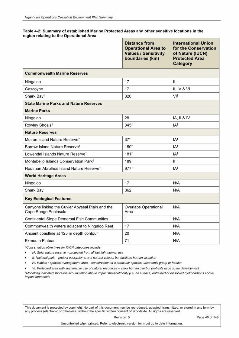
Nganhurra Operations Cessation Environment Plan Summary
This document is protected by copyright. No part of this document may be reproduced, adapted, transmitted, or stored in any form by any process (electronic or otherwise) without the specific written consent of Woodside. All rights are reserved.
Revision: 0 Page 40 of 148
Uncontrolled when printed. Refer to electronic version for most up to date information.
Table 4-2: Summary of established Marine Protected Areas and other sensitive locations in the region relating to the Operational Area
Distance from Operational Area to Values / Sensitivity boundaries (km)
International Union for the Conservation of Nature (IUCN) Protected Area Category
Commonwealth Marine Reserves
Ningaloo 17 II
Gascoyne 17 II, IV & VI
Shark Bay† 320† VI†
State Marine Parks and Nature Reserves
Marine Parks
Ningaloo 28 IA, II & IV
Rowley Shoals† 345† IA†
Nature Reserves
Muiron Island Nature Reserve† 37† IA†
Barrow Island Nature Reserve† 150† IA†
Lowendal Islands Nature Reserve† 181† IA†
Montebello Islands Conservation Park† 189† II†
Houtman Abrolhos Island Nature Reserve† 977 † IA†
World Heritage Areas
Ningaloo 17 N/A
Shark Bay 362 N/A
Key Ecological Features
Canyons linking the Cuvier Abyssal Plain and the Cape Range Peninsula
Overlaps Operational Area
N/A
Continental Slope Demersal Fish Communities 1 N/A
Commonwealth waters adjacent to Ningaloo Reef 17 N/A
Ancient coastline at 125 m depth contour 20 N/A
Exmouth Plateau 71 N/A
*Conservation objectives for IUCN categories include:
IA: Strict nature reserve – protected from all but light human use
II: National park – protect ecosystems and natural values, but facilitate human visitation
IV: Habitat / species management area – conservation of a particular species, taxonomic group or habitat
VI: Protected area with sustainable use of natural resources – allow human use but prohibits large scale development †Modelling indicated shoreline accumulation above impact threshold only (i.e. no surface, entrained or dissolved hydrocarbons above impact thresholds

Nganhurra Operations Cessation Environment Plan Summary
This document is protected by copyright. No part of this document may be reproduced, adapted, transmitted, or stored in any form by any process (electronic or otherwise) without the specific written consent of Woodside. All rights are reserved.
Revision: 0 Page 41 of 148
Uncontrolled when printed. Refer to electronic version for most up to date information.
5. ENVIRONMENTAL IMPACTS AND RISKS
5.1 Risk Identification and Evaluation
Woodside undertook an environmental risk assessment to identify the potential environmental impacts and risks associated with the Petroleum Activities Program, and the control measures to manage the identified environmental impacts and risks to ALARP and an acceptable level. This risk assessment and evaluation was undertaken using Woodside’s Risk Management Framework.
The key steps of Woodside’s Risk Management Framework are shown in Figure 5-1. A summary of each step and how it is applied to the Petroleum Activities Program is provided below.
Figure 5-1: Woodside’s risk management framework
Establish the Context
The objective of a risk assessment is to assess identified risks and apply appropriate control measures to eliminate, control or mitigate the risk to ALARP and to determine if the risk is acceptable.
Hazard identification workshops aligned with NOPSEMA’s Hazard Identification Guidance Note were undertaken by multidisciplinary teams made up of relevant personnel with sufficient breadth

Nganhurra Operations Cessation Environment Plan Summary
This document is protected by copyright. No part of this document may be reproduced, adapted, transmitted, or stored in any form by any process (electronic or otherwise) without the specific written consent of Woodside. All rights are reserved.
Revision: 0 Page 42 of 148
Uncontrolled when printed. Refer to electronic version for most up to date information.
of knowledge, training and experience to reasonably assure that risks and associated impacts were identified and assessed.
Risk Identification
The risk assessment workshop for the Petroleum Activities Program was used to identify risks with the potential to harm the environment. Risks were identified for both planned (routine and non-routine) and unplanned (accidents/incidents) activities.
Risk Analysis (Decision Support Framework)
Risk analysis further develops the understanding of a risk by defining the impacts and assessing appropriate controls. Risk analysis considered previous risk assessments for similar activities, review of relevant studies, review of past performance, external stakeholder consultation feedback and review of the existing environment.
The following key steps were undertaken for each identified risk during the risk assessment and are described in the following sections:
identification of decision type in accordance with the decision support framework;
identification of appropriate control measures (preventative and mitigation) aligned with the decision type; and
calculation of the current risk rating.
To support the risk assessment process, Woodside applied the Guidance on Risk Related Decision Making during the workshops to determine the level of supporting evidence that may be required to draw sound conclusions regarding risk level and whether the risk is acceptable and ALARP.
This is to confirm:
activities do not pose an unacceptable environmental risk;
appropriate focus is placed on activities where the risk is anticipated to be acceptable and demonstrated to be ALARP; and
appropriate effort is applied to the management of risks based on the uncertainty of the risk, the complexity and risk rating.
The framework provides appropriate tools, commensurate to the level of uncertainty or novelty associated with the risk (referred to as the decision type A, B or C). The decision type is selected based on an informed discussion around the uncertainty of the risk, and it is agreed by environmental hazard identification (ENVID) workshop participants and documented in ENVID worksheets.
Identification of Control Measures
Woodside applies a hierarchy of control measures when considering Good Practice and Professional Judgement. The hierarchy of control is applied in order of importance as follows; elimination, substitution, engineering control measures, administrative control measures and mitigation of consequences/impacts.
Risk Rating Process
The current risk rating process is undertaken to assign a level of risk to each impact measured in terms of consequence and likelihood. The assigned risk level is the current risk (i.e. risk with controls in place) and is therefore determined following the identification of the decision type and appropriate control measures.

Nganhurra Operations Cessation Environment Plan Summary
This document is protected by copyright. No part of this document may be reproduced, adapted, transmitted, or stored in any form by any process (electronic or otherwise) without the specific written consent of Woodside. All rights are reserved.
Revision: 0 Page 43 of 148
Uncontrolled when printed. Refer to electronic version for most up to date information.
The risk rating process considers the environmental impacts and where applicable, the reputational and brand, legal/compliance and social and cultural impacts of the risk. The risk ratings are assigned using the Woodside Risk Matrix (refer to Figure 5-2).

Nganhurra Operations Cessation Environment Plan Summary
This document is protected by copyright. No part of this document may be reproduced, adapted, transmitted, or stored in any form by any process (electronic or otherwise) without the specific written consent of Woodside. All rights are reserved.
Revision: 0 Page 44 of 148
Uncontrolled when printed. Refer to electronic version for most up to date information.
Figure 5-2: Woodside risk matrix

Nganhurra Operations Cessation Environment Plan Summary
This document is protected by copyright. No part of this document may be reproduced, adapted, transmitted, or stored in any form by any process (electronic or otherwise) without the specific written consent of Woodside. All rights are reserved.
Revision: 0 Page 45 of 148
Uncontrolled when printed. Refer to electronic version for most up to date information.
The ENVID (undertaken in accordance with the methodology described above) identified 23 sources of environmental risk, comprising 14 planned, which are all assessed as having a low current risk rating, and nine unplanned sources of risk, which are assessed as having a low to high current risk rating following the implementation of identified preventative and mitigation control measures. Control measures have been presented in Appendix A.
The risk analysis and evaluation for the Petroleum Activities Program indicate that all of the current environmental risks and impacts associated with the activity are reduced to ALARP and are of an acceptable level.
Risk Evaluation
Environmental risks, as opposed to safety risks, cover a wider range of issues, differing species, persistence, reversibility, resilience, cumulative effects and variability in severity. The degree of environmental risk and the corresponding threshold for whether a risk/impact has been reduced to ALARP and is acceptable (refer to Figure 5-2) has been adapted to include principles of ecological sustainability (given as an objective in the Environment Regulations and defined in the EPBC Act), the Precautionary Principle and the corresponding environmental risk threshold decision-making principles used to determine acceptability.
With regard to assigned consequence and likelihood as per the Woodside Risk Matrix (Figure 5-2), it should be noted that the application of a consequence can relate to both an impact and/or a risk. In respect of impacts (e.g. laying of a pipeline) this consideration includes both the physical impact from the presence of the pipeline being laid on the seabed and the impacts associated from the installation activity (e.g. turbidity). For the presence of the line an ‘F’ consequence is appropriate as it recognises a planned low level of impact will occur, although with minimal physical impact on the seabed deemed not to be significant (i.e. “Localised impacts not significant to environment receptors”). For the installation activity (turbidity generation) the “no lasting effect” description applies as any turbidity plume generated will be minimal and dissipate rapidly. When considering likelihood for planned impacts, the likelihood level assigned relates to the risk that the impact could exceed that of the defined impact (for example, could laying of a pipeline impact a greater area than planned). In the case of this example it is deemed highly unlikely (likelihood of ‘1’) based on knowledge of the activity and receiving environment, while the consequence remains an ‘F’ as the impact is still localised.
Demonstration of ALARP
In accordance with Regulation 10A(b) of the Environment Regulations, Woodside demonstrates risks are reduced to ALARP where:
The current risk is Low or Moderate:
good industry practice or comparable standards have been applied to control the risk, because any further effort towards risk reduction is not reasonably practicable without sacrifices grossly disproportionate to the benefit gained.
The current risk is High, Very High or Severe:
good industry practice is applied for the situation/risk;
alternatives have been identified and the control measures selected reduce the risks and impacts to ALARP. This may require assessment of Woodside and industry benchmarking, review of local and international codes and standards, consultation with stakeholders etc.
In addition when a current risk is at a high level is it communicated to the Senior Vice President (SVP) / Vice President (VP) of the business unit or function, and a current risk level of very high or severe communication to the divisional Executive Vice President /SVP with concurrent communication to the VP of Risk and Compliance.

Nganhurra Operations Cessation Environment Plan Summary
This document is protected by copyright. No part of this document may be reproduced, adapted, transmitted, or stored in any form by any process (electronic or otherwise) without the specific written consent of Woodside. All rights are reserved.
Revision: 0 Page 46 of 148
Uncontrolled when printed. Refer to electronic version for most up to date information.
Demonstration of Acceptability
In accordance with Regulation 10A(c) of the Environmental Regulations, Woodside applies the following process to demonstrate acceptability:
Low and Moderate current risks are 'Broadly Acceptable', if they meet legislative requirements, industry codes and standards, regulator expectations, Woodside Standards and industry guidelines.
High to Severe risks are ‘Acceptable’ if ALARP can be demonstrated using good industry practice and risk based analysis (RBA), if legislative requirements are met and societal concerns are accounted for and the alternative control measures are grossly disproportionate to the benefit gained.
In undertaking this process for moderate and high current risks, Woodside evaluates the following criteria:
o principles of Ecologically Sustainable Development (ESD) as defined under the EPBC Act;
o internal context – the proposed controls and current risk level are consistent with Woodside policies, procedures and standards;
o external context – consideration of the environment consequence and stakeholder acceptability; and
o other requirements – the proposed controls and current risk level are consistent with national and international standards, laws and policies.
Very high and severe current risks require further investigation and mitigation to reduce the risk to a lower and more acceptable level. If after further investigation the risk remains in the severe category, the risk requires appropriate business sign-off to accept the risk.
5.2 Hydrocarbon Spill Risk Assessment Methodology
Quantitative hydrocarbon spill modelling was undertaken using a three-dimensional hydrocarbon spill trajectory and weathering model which is designed to simulate the transport, spreading and weathering of specific hydrocarbon types under the influence of changing meteorological and oceanographic forces.
ZoC and Hydrocarbon Contact Thresholds
The outputs of the quantitative hydrocarbon spill modelling are used to assess the environmental risk, if a credible hydrocarbon spill scenario occurred, solely in terms of delineating which areas of the marine environment could be exposed to hydrocarbon concentrations exceeding the impact thresholds. All areas where hydrocarbon levels are exceeded are evaluated in the impact assessment. As the weathering of different fates of hydrocarbons (surface, accumulated, entrained and dissolved) differs due to the influence of the metocean mechanism of transportation, the locations potentially affected by each fate will different.
The summary of all the locations where hydrocarbon thresholds could be exceeded by any of the simulations modelled is defined as the ZoC. A stochastic modelling approach was applied to the quantitative hydrocarbon spill modelling. Stochastic modelling is the combination of a number of individual spill trajectory simulations, modelled under a range of historical metocean data considered seasonally and geographically representative for the scenario modelled. The stochastic results indicate the probability of where hydrocarbon might travel and the time take by the hydrocarbon to reach a given sensitive receptor for all modelled simulations. When considering the ZoC, it is important to understand that the ZoC does not represent the extent of any single spill event, which would be significantly smaller in spatial extent than a ZoC presenting stochastic modelling probabilities.

Nganhurra Operations Cessation Environment Plan Summary
This document is protected by copyright. No part of this document may be reproduced, adapted, transmitted, or stored in any form by any process (electronic or otherwise) without the specific written consent of Woodside. All rights are reserved.
Revision: 0 Page 47 of 148
Uncontrolled when printed. Refer to electronic version for most up to date information.
Surface fate and shoreline accumulation concentrations are expressed as grams per square metre (g/m2), with entrained and dissolved aromatic hydrocarbon concentrations expressed as parts per billion (ppb). Hydrocarbon thresholds are presented in the table below (Table 5-1) and described in the following subsections.
Table 5-1: Summary of thresholds applied to the quantitative hydrocarbon spill risk modelling results
Surface Hydrocarbon (g/m2)
Entrained hydrocarbon (ppb)
Dissolved aromatic hydrocarbon (ppb)
Accumulated Hydrocarbon (g/m2)
10 500 500 100
Surface Hydrocarbon Threshold Concentrations
The spill modelling outputs defined for surface hydrocarbon spills (contact on surface waters) using the ≥10 g/m2 (dull metallic colours) based on the relationship between film thickness and appearance. This threshold concentration expressed in terms of g/m2 is geared towards informing potential oiling impacts for wildlife groups and habitats that may break through the surface slick from the water or the air (for example: emergent reefs, vegetation in the littoral zone and air-breathing marine reptiles, cetaceans, seabirds and migratory shorebirds).
Thresholds for registering biological impacts resulting from contact of surface slicks have been estimated by different researchers at approximately 10–25 g/m2.
Dissolved Aromatic Hydrocarbon Threshold Concentrations
The threshold concentration value for dissolved aromatic hydrocarbons has been set with reference to results from ecotoxicity tests on hydrocarbons that can credible be released from a loss of well containment event. The purpose of the threshold is to inform the assessment of the potential for toxicity impacts to sensitive marine biota. The ecotoxicity tests were undertaken on a broad range of taxa of ecological relevance for which accepted standard test protocols are well established. These ecotoxicology tests are focused on the early life stages of test organisms, when organisms are typically at their most sensitive. The ecotoxicology tests were conducted on six mainly tropical-subtropical species representatives from six major taxonomic groups.
Based on these ecotoxicology tests, a dissolved aromatic hydrocarbon threshold of 500 ppb has been adopted. This 500 ppb threshold is significantly less than the lowest no observable effect concentration (NOEC) for most of the sensitive organisms tested. Therefore, it is considered that the 500 ppb dissolved aromatic threshold is a conservative threshold to apply to condensate that may be encountered during the Petroleum Activities Program.
Entrained Hydrocarbon Threshold Concentrations
The threshold concentration of entrained hydrocarbons that could result in a biological impact cannot be determined directly using available ecotoxicity data for water accommodated fraction (WAF) of hydrocarbons. However, it is likely these data specific to dissolved oil hydrocarbon represents a worst-case scenario. This is owing to the fact that entrained hydrocarbons are less biologically available to organisms through absorption into their tissues than dissolved hydrocarbons. It is therefore expected that the entrained threshold concentration of 500 ppb will represent a potential impact substantially lower than the NOEC concentrations.
Accumulated Hydrocarbon Threshold Concentrations
Published data define accumulated hydrocarbon <100 g/m2 to have an appearance of a stain on shorelines, with an accumulated hydrocarbons ≥100 g/m2 considered to be the threshold that could impact the survival and reproductive capacity of benthic epifaunal invertebrates living in intertidal habitat.

Nganhurra Operations Cessation Environment Plan Summary
This document is protected by copyright. No part of this document may be reproduced, adapted, transmitted, or stored in any form by any process (electronic or otherwise) without the specific written consent of Woodside. All rights are reserved.
Revision: 0 Page 48 of 148
Uncontrolled when printed. Refer to electronic version for most up to date information.
6. ENVIRONMENTAL RISKS AND IMPACTS SUMMARY Table 6-1 presents a summary of the sources of risk, analysis and evaluation for the Petroleum Activities program, using the methodology described above in Section 5 of the EP. There are two types of environmental risk sources identified for the Petroleum Activities Program which relate to activities which are planned and either undertaken on a routine or non-routine basis or which may occur from unplanned activities were also identified. These sources of risk range from small scale chemical spills with a low environmental consequence to hydrocarbon spill events with high environmental consequence.
A detailed description of environmental risks and potential impacts together with a summary of control measures have been presented in Appendix A.

Nganhurra Operations Cessation Environment Plan Summary
This document is protected by copyright. No part of this document may be reproduced, adapted, transmitted, or stored in any form by any process (electronic or otherwise) without the specific written consent of Woodside. All rights are reserved.
Revision: 0 Page 49 of 148
Uncontrolled when printed. Refer to electronic version for most up to date information.
Table 6-1: Environmental Risk and Impacts Register Summary
Source of Risk Areas of Impact / Environmental Impacts
Residual Risk Rating
Co
nse
qu
ence
Potential Consequence level of impact
Lik
elih
oo
d
Res
idu
al R
isk
Planned Activities (Routine and Non-routine)
Presence of MODU / intervention vessel, project vessels and subsea infrastructure causing interference with or displacement to third party vessels (commercial shipping and commercial / recreational fishing)
Isolated social impact potentially resulting from interference with other sea users (e.g. commercial and recreational fishing, and shipping)
E Reputation and brand – slight, short-term local impact (1-2 years) to reputation and brand
1 L
Retention of RTM in situ prior to removal causing interference with or displacement to third party vessels (commercial shipping and commercial / recreational fishing)
Isolated social impact potentially resulting from interference with other sea users (e.g. commercial and recreational fishing, and shipping)
E Reputation and brand – slight, short-term local impact (1-2 years) to reputation and brand
1 L
Presence of subsea infrastructure causing interference with or displacement to commercial fishing
Isolated social impact potentially resulting from interference with other sea users (e.g. commercial fishing)
F Reputation and brand – no lasting effect (<1 month) 1 L
Disturbance to benthic habitat from laydown of infrastructure (risers, mooring lines)
Localised disturbance to seabed within laydown footprint
E Environment – Slight, short-term impact (<1 year) on species, habitat, physical or biological attributes
1 L
Deployment of subsea equipment (MODU anchors and ROV activities)
Localised disturbance to seabed from anchoring and ROV activities
E Environment – Slight, short-term impact (<1 year) on species, habitat, physical or biological attributes
1 L
Routine discharge of sewage, grey water and putrescible wastes to marine environment from project vessels
Localised and temporary effects to water quality and marine biota in offshore waters
F Environment – No lasting effect (<1 month). Localised impact not significant to environmental receptors
2 L
Routine discharge of deck and bilge water to marine environment from project vessels
Localised and temporary effects to water quality and marine biota in offshore waters
F Environment – No lasting effect (<1 month). Localised impact not significant to environmental receptors
2 L

Nganhurra Operations Cessation Environment Plan Summary
This document is protected by copyright. No part of this document may be reproduced, adapted, transmitted, or stored in any form by any process (electronic or otherwise) without the specific written consent of Woodside. All rights are reserved.
Revision: 0 Page 50 of 148
Uncontrolled when printed. Refer to electronic version for most up to date information.
Source of Risk Areas of Impact / Environmental Impacts
Residual Risk Rating
Co
nse
qu
ence
Potential Consequence level of impact
Lik
elih
oo
d
Res
idu
al R
isk
Routine discharge of cooling water or brine to the marine environment from project vessels
Localised and temporary effects to water quality and marine biota in offshore waters
F Environment – No lasting effect (<1 month). Localised impact not significant to environmental receptors
2 L
Routine and non-routine discharges to the marine environment from:
Treated seawater;
Hydraulic fluid;
Methanol;
Kill weight brine;
BOP control fluids; and
Marine growth removal; and
Cement.
Localised and temporary effects to water quality and marine biota in offshore waters.
F Environment – No lasting effect (<1 month). Localised impact not significant to environmental receptors
1 L
External light emissions on-board project vessels
Localised and temporary behavioural disturbance to marine fauna F
Environment – No lasting effect (<1 month). Localised impact not significant to environmental receptors
0 L
Generation of noise from project vessels during normal operations
Localised and temporary behavioural disturbance to marine fauna F
Environment – No lasting effect (<1 month). Localised impact not significant to environmental receptors
1 L
Exhaust emissions from internal combustion engines and incinerators on project vessels
Bleed off of hydrocarbon gas during well intervention
Bleed off of hydrocarbon gas from flushed subsea infrastructure
Localised and temporary reduction in air quality
F Environment – No lasting effect (<1 month). Localised impact not significant to environmental receptors
2 L

Nganhurra Operations Cessation Environment Plan Summary
This document is protected by copyright. No part of this document may be reproduced, adapted, transmitted, or stored in any form by any process (electronic or otherwise) without the specific written consent of Woodside. All rights are reserved.
Revision: 0 Page 51 of 148
Uncontrolled when printed. Refer to electronic version for most up to date information.
Source of Risk Areas of Impact / Environmental Impacts
Residual Risk Rating
Co
nse
qu
ence
Potential Consequence level of impact
Lik
elih
oo
d
Res
idu
al R
isk
Unplanned Activities (Accidents / Incidents)
Loss of hydrocarbons to marine environment due to loss of well control
Short to medium term impacts to the offshore marine environment. Long-term impacts to sensitive nearshore areas of coastal shorelines (e.g. Ningaloo Coast). Disruption to marine fauna, including protected species.
Potential medium-term interference with or displacement of other sea users (e.g. fishing and shipping)
B
Environment – Major, long-term impact on highly values ecosystems, species, habitats or physical or biological attributes
Reputation and Brand – National concern and / or international interest. Medium to long-term impact to reputation and brand. Venture and / or asset operations restricted
Social and Cultural – Major, long-term impact to a community, social infrastructure or highly valued areas / items of national cultural significance
2 H
Loss of hydrocarbons to marine environment due to loss of well containment as a result of accidental damage to, or removal of, Xmas Tree
Minor and temporary disruption to marine fauna, including protected species. Minor and/or temporary impacts to water quality
D
Environment – No lasting effect (<1 month). Localised impact not significant to environmental receptors
Social and Cultural – No lasting effect (<1 month). Localised impact not significant to areas / items of cultural significance
0 L
Loss of hydrocarbons to marine environment due to a vessel collision (e.g. activity support vessels or other marine users).
Minor and temporary disruption to marine fauna, including protected species.
Minor and/or temporary impacts to water quality D
Environment – Minor, short-term impact on species, habitat (but not affecting ecosystem function), physical or biological attributes
1 M
Loss of hydrocarbons to marine environment from bunkering.
Minor and temporary disruption to marine fauna, including protected species.
Minor and/or temporary impacts to water quality. E
Environment – Slight, short-term impact (<1 year) on species, habitat, physical or biological attributes
3 M
Accidental discharge of other hydrocarbons / chemicals from project vessel deck activities and equipment (e.g. cranes) to the marine environment, including helicopter refuelling and
Minor and temporary disruption to marine fauna, including protected species.
Minor and/or temporary impacts to water quality. E Environment – Slight, short-term impact (<1 year) on species, habitat, physical or biological attributes
2 M

Nganhurra Operations Cessation Environment Plan Summary
This document is protected by copyright. No part of this document may be reproduced, adapted, transmitted, or stored in any form by any process (electronic or otherwise) without the specific written consent of Woodside. All rights are reserved.
Revision: 0 Page 52 of 148
Uncontrolled when printed. Refer to electronic version for most up to date information.
Source of Risk Areas of Impact / Environmental Impacts
Residual Risk Rating
Co
nse
qu
ence
Potential Consequence level of impact
Lik
elih
oo
d
Res
idu
al R
isk
subsea ROV hydraulic leaks.
Accidental loss of hazardous or non-hazardous wastes to the marine environment (excludes sewage, grey water, putrescible waste and bilge water).
Minor and temporary disruption to marine fauna, including protected species.
Minor and/or temporary impacts to water quality. F Environment – No lasting effect (<1 month). Localised impact not significant to environmental receptors
2 L
Accidental collision between project vessels and threatened and migratory marine fauna.
Minor and temporary disruption to marine fauna, including protected species. E
Environment – Slight, short-term impact (<1 year) on species, habitat, physical or biological attributes
1 L
Dropped subsea infrastructure during laydown or removal activities / dragged subsea equipment
Localised short-term damage of benthic subsea habitats in the immediate location of the dropped object.
E Environment – Slight, short-term impact (<1 year) on species, habitat, physical or biological attributes
1 L
Accidental sinking of the RTM Localised short-term damage of benthic subsea habitats in the immediate location of the dropped object.
E Environment – Slight, short-term impact (<1 year) on species, habitat, physical or biological attributes
1 L
Introduction of invasive marine species Introduction of invasive marine species possibly resulting in an alteration of the localised environment.
E
Environment – Minor, short term impact (1-2 years) on species, habitat (but not effecting ecosystem function), physical or biological attributes
1 L

Nganhurra Operations Cessation Environment Plan Summary
This document is protected by copyright. No part of this document may be reproduced, adapted, transmitted, or stored in any form by any process (electronic or otherwise) without the specific written consent of Woodside. All rights are reserved.
Revision: 0 Page 53 of 148
Uncontrolled when printed. Refer to electronic version for most up to date information.
7. ONGOING MONITORING OF ENVIRONMENTAL PERFORMANCE The Petroleum Activities Program will be managed in compliance with the Nganhurra Operations Cessation EP accepted by NOPSEMA under the Environment Regulations, other relevant environmental legislation and Woodside’s Management System (e.g. Woodside Environment Policy).
The objective of the Nganhurra Operations Cessation EP is to identify, mitigate and manage potentially adverse environmental impacts associated with the Petroleum Activities Program, during both planned and unplanned operations, to ALARP and an acceptable level.
For each environmental aspect (risk) and associated environmental impacts (identified and assessed in the Environmental Risk Assessment of the EP) specific environmental performance outcomes, controls, environmental performance standards and measurement criteria have been developed. The control measures (available in Appendix A) will be implemented in accordance with the relevant environmental performance standards to achieve the environmental performance outcomes. The specific measurement criteria provide the evidence base to demonstrate that the environmental performance standards and outcomes are achieved.
The implementation strategy detailed in the Nganhurra Operations Cessation EP identifies the roles/responsibilities and training/competency requirements for all personnel (Woodside and its contractors) in relation to implementing controls, managing non-conformance, emergency response and meeting monitoring, auditing, and reporting requirements during the activity.
Woodside and its contractors will undertake a program of periodic monitoring during the Petroleum Activities Program, starting at mobilisation of each activity and continuing through the duration of each activity until activity completion. This information is collected using appropriate tools and systems, based on the environmental performance outcomes, performance standards and measurement criteria in the Nganhurra Operations Cessation EP.
The tools and systems collect, as a minimum, the data (evidence) referred to in the measurement criteria. The collection of this data (and assessment against the measurement criteria) forms part of the permanent record of compliance maintained by Woodside and the basis for demonstrating that the environmental performance outcomes and standards are met, which is then summarised in a series of routine reporting documents.
Monitoring of environmental performance is undertaken as part of the following:
Environmental Performance Report will be submitted to NOPSEMA within twelve months of commencement of the activity to assess and confirm compliance with the accepted environmental performance objectives, standards and measurement criteria outlined in the Nganhurra Operations Cessation EP;
Activity-based inspections undertaken by Woodside’s environment function to review compliance against the Nganhurra Operations Cessation EP, verify effectiveness of the implementation strategy and to review environmental performance;
Environmental performance is also monitored daily via daily progress reports during operations; and
Senior management regularly monitors and reviews environmental performance via a monthly report which details environmental performance and compliance with Woodside standards.
Woodside employees and contractors are required to report all environmental incidents and non-conformance with environmental performance outcomes and standards in the Nganhurra Operations Cessation EP. Incidents will be reported using an Incident and Hazard Report Form, which includes details of the event, immediate actions taken to control the situation, and corrective actions to prevent reoccurrence. An internal computerised database is used for the recording and

Nganhurra Operations Cessation Environment Plan Summary
This document is protected by copyright. No part of this document may be reproduced, adapted, transmitted, or stored in any form by any process (electronic or otherwise) without the specific written consent of Woodside. All rights are reserved.
Revision: 0 Page 54 of 148
Uncontrolled when printed. Refer to electronic version for most up to date information.
reporting of these incidents. Incident corrective actions are monitored to ensure they are closed out in a timely manner.
The Nganhurra Operations Cessation EP is supported by an assessment of the environmental impacts and risks associated with potential hydrocarbon spill scenarios and hydrocarbon spill preparedness and response measures in relation to the risk assessment and the identified hydrocarbon spill scenarios. A summary of Woodside’s response arrangements in the Oil Pollution Emergency Plan (OPEP) is provided in Section 8.
7.1 Environment Plan Revisions and Management of Change
Revision of the Nganhurra Operations Cessation EP will be undertaken in accordance with the requirements outlined in Regulations 17, Regulation 18 and Regulation 19 of the Environment Regulations. Woodside will submit a revision to the EP due to all or any of the following:
at least 14 days before the end of each period of five years commencing on the day on which the original and subsequent revisions of the EP is accepted under Regulation 11 of the Environment Regulations; and
as requested by NOPSEMA.
MoCs relevant to the Nganhurra Operations Cessation EP, concerning the scope of the activity description including review of advances in technology at stages where new equipment may be selected such as vessel contracting, changes in understanding of the environment, including all current advice on species protected under EPBC Act and current requirements for Australian Marine Parks and potential new advice from external stakeholders will be managed in accordance with internal procedures for management of change. These provide guidance on the Environment Regulations that may trigger a revision and resubmission of the EP to NOPSEMA. They also provide guidance on what constitutes a significant new risk or increase in risk. A risk assessment will be conducted in accordance with Woodside’s Environmental Risk Management Methodology to determine the significance of any potential new environmental impacts or risks not provided for in the Nganhurra Operations Cessation EP. Risk assessment outcomes are reviewed in compliance with Regulation 17 of the Environment Regulations.
Minor changes where a review of the activity and the environmental risks and impacts of the activity do not trigger a requirement for a revision, under Regulation 17 of the Environment Regulations, will be considered a ‘minor revision’. Minor administrative changes to the Nganhurra Operations Cessation EP, where an assessment of the environmental risks and impacts is not required (e.g. document references, phone numbers, etc.), will also be considered a ‘minor revision’. Minor revisions and administrative changes as defined above will be made to the Nganhurra Operations Cessation EP using Woodside’s document control process. Minor revisions will be tracked and incorporated during scheduled internal reviews.

Nganhurra Operations Cessation Environment Plan Summary
This document is protected by copyright. No part of this document may be reproduced, adapted, transmitted, or stored in any form by any process (electronic or otherwise) without the specific written consent of Woodside. All rights are reserved.
Revision: 0 Page 55 of 148
Uncontrolled when printed. Refer to electronic version for most up to date information.
8. OIL POLLUTION EMERGENCY RESPONSE ARRANGEMENTS Woodside’s OPEP for the Petroleum Activities Program has the following components:
Oil Pollution Emergency Arrangements (Australia);
Nganhurra Operations Cessation Oil Pollution First Strike Plan; and
Oil Spill Preparedness and Response Mitigation Assessment for Nganhurra Operations Cessation petroleum program.
8.1 Woodside Oil Pollution Emergency Arrangements (Australia)
This document outlines the emergency and crisis management incident command structure (ICS) and Woodside’s response arrangements to competently respond to and escalate a hydrocarbon spill event. The document interfaces externally with Commonwealth, State and industry response plans and internally with Woodside’s ICS.
Woodside’s Oil Pollution Emergency Arrangements (Australia) details the following support arrangements:
Access to MODU to drill intervention well via Memorandum of Understanding (MoU) with other industry participants;
Master services agreement with Australian Marine Oil Spill Centre (AMOSC) for the supply of experienced personnel and equipment;
Access to Wild Well Control’s capping stack, equipment and experienced personnel for the rapid deployment and installation of a capping stack, where feasible (may require well intervention prior to deployment);
Other support services such as 24/7 hydrocarbon spill trajectory modelling and satellite monitoring services as well as aerial, marine, logistics and waste management support; and
Mutual Aid Agreements with other oil and gas operators in the region for the provision of assistance in a hydrocarbon spill response.
8.2 Nganhurra Oil Pollution First Strike Plan
The Nganhurra Operations Cessation Oil Pollution First Strike Plan is an activity specific document which provides details on the tasks required to mobilise a first strike response for the first 24 hours of a hydrocarbon spill event. These tasks include key response actions and regulatory notifications. The intent of the document is to provide immediate oil spill response guidance to the Incident Management Team until a full Incident Action Plan specific to the oil spill event is developed.
The activity vessels will have Ship Oil Pollution Emergency Plans (SOPEPs) in accordance with the requirements of the International Convention for the Prevention of Pollution from Ships (MARPOL) 73/78 Annex I. These plans outline responsibilities, specify procedures and identify resources available in the event of a hydrocarbon or chemical spill from vessel activities. The Nganhurra Cessation of Operation Oil Pollution First Strike Plan is intended to work in conjunction with the SOPEPs.
Woodside’s oil spill arrangements are tested by conducting periodic exercises. These exercises are conducted to test the response arrangements outlined in the Nganhurra Oil Pollution First Strike Plan and to ensure that personnel are familiar with spill response procedures, in particular, individual roles and responsibilities and reporting requirements.
8.3 Oil Spill Preparedness and Response Mitigation Assessment
Woodside has developed an oil spill preparedness and response position in order to demonstrate that risks and impacts associated with loss of hydrocarbons from the Petroleum Activities Program would be mitigated and managed to ALARP and would be of an acceptable level.
Nganhurra Operations Cessation Environment Plan Summary
This document is protected by copyright. No part of this document may be reproduced, adapted, transmitted, or stored in any form by any process (electronic or otherwise) without the specific written consent of Woodside. All rights are reserved.
Revision: 0 Page 56 of 148
Uncontrolled when printed. Refer to electronic version for most up to date information.
The following oil spill response strategies were evaluated and subsequently pre-selected for a significant oil spill event (level 2 or 3 under the National Plan) from the Petroleum Activities Program:
Monitor and Evaluate (Operational Monitoring) – Operational Monitoring commences immediately following a spill and includes the gathering and evaluation of data to inform the oil spill response planning and operations. It includes fate and trajectory modelling, spill tracking, weather updates and field observations. Woodside would implement the following operational monitoring plans to satisfy the requirements of this strategy. The following operational monitoring programs are available for implementation:
o Predictive modelling of hydrocarbons to assess resources at risk;
o Surveillance and reconnaissance to detect hydrocarbons and resources at risk;
o Monitoring of hydrocarbon presence, properties, behaviour and weathering in water;
o Pre-emptive assessment of sensitive receptors at risk; and
o Monitoring of contaminated resources and the effectiveness of response and clean-up operations.
The following response strategies may be applied based on the outcomes of implemented Operational Monitoring programs:
o Surface dispersant application - Surface dispersant application may reduce surface hydrocarbons and therefore prevent, or reduce the scale of, shoreline contact. Priority would be placed on treating high volume surface hydrocarbons closest to the release location as this is where they are expected to achieve the greatest environmental benefit.
o Containment and recovery - The aim of this response strategy is to reduce damage to sensitive resources by the physical containment and mechanical removal of hydrocarbons from the marine environment.
o Subsea dispersant injection - Subsea dispersant injection involves the deployment of a subsea dispersant manifold with associated equipment to inject chemical dispersant directly into the oil plume in the event of a loss of well control. As it may take some time to mobilise subsea dispersant equipment, surface dispersants are generally used in the interim to treat oil that makes it to the surface. The use of subsea dispersants has similar benefits to surface dispersant application including a potential reduction in the volume of hydrocarbons that reach the shoreline thereby reducing impacts to sensitive receptors. In addition to these benefits, subsea dispersant application may greatly reduce volatile organic compound (VOC) levels during surface response operations, reducing risks and hazards to responders.
o Source control - A loss of well control is the identified worst case spill scenario. Woodside’s primary mitigation strategy is to minimise the volume of hydrocarbons released. Woodside plans to drill a deploy the following response options specific to a loss of well control event:
Well intervention - BOP intervention / ROV survey, Top kill / mud kill;
Subsea first response toolkit (SFRT) - Debris clearance/removal, Subsea dispersant injection;
Capping stack deployment; and/or
Relief well drilling.

Nganhurra Operations Cessation Environment Plan Summary
This document is protected by copyright. No part of this document may be reproduced, adapted, transmitted, or stored in any form by any process (electronic or otherwise) without the specific written consent of Woodside. All rights are reserved.
Revision: 0 Page 57 of 148
Uncontrolled when printed. Refer to electronic version for most up to date information.
o Shoreline protection and deflection - The placement of containment, protection or deflection booms on and near a shoreline is a response strategy to reduce the potential volume of hydrocarbons contacting or spreading along shorelines, which may reduce the scale of shoreline clean-up. Hydrocarbons contained by the booms would be collected where practicable. Shorelines would be protected where accessible via vessel or shore. Where hydrocarbon contact has already occurred, there may still be value in deploying protection equipment to limit further accumulations and preventing remobilisation of deposited hydrocarbons.
o Shoreline clean-up - Shoreline clean-up is undertaken when residual hydrocarbons not collected through previously described response strategies make contact with shorelines. The timing, location, and extent of shoreline clean-up can vary from one scenario to another, depending on the hydrocarbon type, shoreline type and access, degree of oiling and area oiled. A shoreline clean-up can limit injury to wildlife, prevent or reduce remobilisation of hydrocarbons in the tidal zone, facilitate habitat recovery and meet societal expectations.
o Wildlife response - An oiled wildlife response would be undertaken in accordance with Woodside’s Health, Safety, Environment and Quality Policy and values and recognition of societal expectations. The response would involve reconnaissance from vessels, aircraft and shoreline surveys, the capture, transport, rehabilitation and release of oiled wildlife.
o Scientific monitoring - A scientific monitoring program (SMP) would be activated following a Level 2 or 3 hydrocarbon release, or any release event with the potential to contact sensitive environmental receptors. This would consider receptors at risk (ecological and socio-economic) for the entire predicted ZoC and in particular, the identified Pre-emptive Baseline Areas (PBAs) in the event of a loss of well control from the PAP drilling activities (refer to response planning assumptions). The SMP would be informed by the operational monitoring programs, but differs from the operational monitoring program in being a long-term program independent of, and not directing, the operational oil spill response. Key objectives of the Woodside oil spill scientific monitoring program are:
Assess the extent, severity and persistence of the environmental impacts from the spill event; and
Monitor subsequent recovery of impacted key species, habitats and ecosystems.
o Waste management - Waste management is considered a support strategy to the response strategies examined above.

Nganhurra Operations Cessation Environment Plan Summary
This document is protected by copyright. No part of this document may be reproduced, adapted, transmitted, or stored in any form by any process (electronic or otherwise) without the specific written consent of Woodside. All rights are reserved.
Revision: 0 Page 58 of 148
Uncontrolled when printed. Refer to electronic version for most up to date information.
9. CONSULTATION In support of the Nganhurra Operations Cessation EP, Woodside conducted a stakeholder assessment and engaged with relevant stakeholders to inform decision-making and planning for continued production activities in accordance with the requirements of Regulation 11A and 14(9) of the Environment Regulations.
Woodside conducted a stakeholder assessment based on the activity location, timing and potential impacts. A consultation fact sheet was sent electronically to all stakeholders identified through the stakeholder assessment process prior to lodgement of the Nganhurra Operations Cessation EP with NOPSEMA for assessment and acceptance. Woodside provided information about the Petroleum Activities Program to the relevant stakeholders listed in Table 9-1. Woodside considers relevant stakeholders for routine operations as those that undertake normal business or lifestyle activities in the vicinity of the existing facility (or their nominated representative) or have a State or Commonwealth regulatory role.
Table 9-1: Relevant stakeholders identified for the Petroleum Activities Program
Stakeholder Relevance
Department of Industry Innovation and Science Department of relevant Commonwealth Minister
Department of Mines, Industry Regulation and Safety (DMIRS) (formerly known as Department of Mines and Petroleum)
Department of relevant State Minister
Australian Maritime Safety Authority Oil spill preparedness (Australian waters)
Maritime safety
Australian Hydrographic Service (AHS) Maritime safety
Pearl Producers Association Commercial fishery management
Department of Primary Industries and Regional Development (DPIRD) (formerly known as Department of Fisheries)
Commercial fishery management
Commonwealth fisheries Commercial fisheries – Commonwealth
Western Skipjack Fishery
Western Tuna and Billfish Fishery
North-West Slope Trawl Fishery
Southern Bluefin Tuna Fishery
Western Deepwater Trawl Fishery
Western Australian Fisheries Commercial fishery – State
Mackerel Fishery
Pilbara Trawl Fishery
Pilbara Trap Fishery
Gascoyne Demersal Scalefish Fishery
South West Coast Salmon
Department of Transport Oil spill preparedness (Western Australian waters)
Western Australian Fishing Industry Council (WAFIC)
Commercial fishery – State
Exmouth Community Reference Group Government, industry and community groups
Department of Defence Protection of National interests

Nganhurra Operations Cessation Environment Plan Summary
This document is protected by copyright. No part of this document may be reproduced, adapted, transmitted, or stored in any form by any process (electronic or otherwise) without the specific written consent of Woodside. All rights are reserved.
Revision: 0 Page 59 of 148
Uncontrolled when printed. Refer to electronic version for most up to date information.
Woodside also made available advice about the Petroleum Activities Program to other stakeholders who may be interested in the activity or who have previously expressed an interest in being kept informed about Woodside’s activities in the region. The following are stakeholders that have been identified as ‘interested’ in the Petroleum Activities Program:
Australian Maritime Safety Authority (marine pollution);
Department of Biodiversity, Conservation and Attractions (formally known as Department of Parks and Wildlife);
Australian Customs Service – Border Protection Command;
Commonwealth Fisheries Association;
Recfishwest;
World Wildlife Fund (WWF);
Australian Conservation Foundation;
Wilderness Society;
International Fund for Animal Welfare;
APPEA; and
AMOSC.
Woodside received feedback on the Petroleum Activities Program from a range of stakeholders, including government agencies and commercial fishing organisations. Issues of interest or concern included the location of the activities across commercial fishing areas. Woodside considered this feedback in its development of control measures specific to the Petroleum Activities Program. A summary of feedback and Woodside‘s response is presented in Appendix C.
9.1 Ongoing Consultation
Consultation activities for the Petroleum Activities Program build upon Woodside’s extensive and ongoing stakeholder consultation for offshore petroleum activities in this area.
Feedback received through community engagement and consultation will be captured in Woodside’s stakeholder database and actioned where appropriate through the Petroleum Activities Program Project Manager. Implementation of ongoing engagement and consultation activities for the Petroleum Activities Program will be undertaken by Woodside Corporate Affairs consistent with Woodside’s External Stakeholder Engagement Operating Standard.
Woodside will continue to accept feedback from all stakeholders throughout the duration of the accepted Nganhurra Operations Cessation EP. Stakeholder feedback should be made to the nominated liaison person, identified in Section 10 of this EP Summary.

Nganhurra Operations Cessation Environment Plan Summary
This document is protected by copyright. No part of this document may be reproduced, adapted, transmitted, or stored in any form by any process (electronic or otherwise) without the specific written consent of Woodside. All rights are reserved.
Revision: 0 Page 60 of 148
Uncontrolled when printed. Refer to electronic version for most up to date information.
10. TITLEHOLDER NOMINATED LIAISON PERSON For further information on this Petroleum Activities Program, please contact:
Kate McCallum
Corporate Affairs Adviser
240 St Georges Terrace
Perth WA 6000
Toll free: 1800 442 977

Nganhurra Operations Cessation Environment Plan Summary
This document is protected by copyright. No part of this document may be reproduced, adapted, transmitted, or stored in any form by any process (electronic or otherwise) without the specific written consent of Woodside. All rights are reserved.
Revision: 0 Page 61 of 148
Uncontrolled when printed. Refer to electronic version for most up to date information.
11. ABBREVIATIONS AND ACRONYMS
Term Description / Definition
Abbreviations
µm Micrometer
AFMA Australian Fisheries Management Authority
AHV Anchor Handling Vehicle
ALARP As Low As Reasonably Practicable
AMOSC Australian Maritime Oil Spill Centre
AMSA Australian Maritime Safety Authority
API American Petroleum Institute
APPEA Australian Petroleum Production and Exploration Association
BCF Bioconcentration Factor
BIA Biologically Important Area
BOP Blow-out Preventer
CEFAS Centre for Environment Fisheries and Aquaculture Science
CMR Commonwealth Marine Reserve
DGPS Differential Global Surface Position System
DMP Department of Mines and Petroleum
DP Dynamically Positioned
DSV Driving Support Vehicle
EDS Emergency Disconnect Sequence
EHU Electrical Hydraulic Umbilical System
ENVID Environmental Hazard Identification workshop
EP Environment Plan
EPBC Act Environment Protection and Biodiversity Conservation Act, 1999.
FPSO Floating Production, Storage and Offloading vessel
g/m2 Grams per square metre
HOCNF Harmonised offshore chemical notification format
ICS incident command structure
IMO International Maritime Organisation
ITF Indonesian Through Flow
IUCN International Union for Conservation of Nature
KEF Key Ecological Feature
km Kilometre
L Litres
LNG Liquefied Natural Gas
LOC Loss of Containment

Nganhurra Operations Cessation Environment Plan Summary
This document is protected by copyright. No part of this document may be reproduced, adapted, transmitted, or stored in any form by any process (electronic or otherwise) without the specific written consent of Woodside. All rights are reserved.
Revision: 0 Page 62 of 148
Uncontrolled when printed. Refer to electronic version for most up to date information.
LogPow Partitioning of the substances between water and n-octanol
MARPOL International Convention for the Prevention of Pollution from Ships
MNES Matters of National Environmental Significance
MODU Mobile Offshore Drilling Unit
MoU Memorandum of Understanding
NGA Nganhurra
nm Nautical mile (1,852 m) a unit of distance on the sea
NOEC No-observed-effect concentration
NOPSEMA National Offshore Petroleum Safety and Environmental Management Authority
NWMR North west marine region
NWS Northwest Shelf
NY Ngujima Yin
OCNS Offshore Chemical Notification Scheme
OVID Offshore Vessel Inspection Database
P&A Plug and Abandon
PFW Produced Formation Water
PIV Primary Installation Vessel
ppb Parts Per Billion
ppm Parts Per Million
RBI Risk Based Inspection
RSEDVs Riser Emergency Shutdown Valves
ROV Remotely Operated Vehicle
RTM Riser Turret Mooring
SCSSSV Surface Controlled Sub-Surface Safety Valves
SIMOPS Simultaneous Operations
SOPEP Ship Oil Pollution Emergency Plan
SFRT subsea first response toolkit
WA Western Australia
WAF water accommodated fraction
WAFIC Western Australian Fishing Industry Council
WHA World Heritage Area
WOMP Well Operation Management Plan
Woodside Woodside Energy Ltd
WWF World Wildlife Fund
ZoC Zone of Consequence

Nganhurra Operations Cessation Environment Plan Summary
This document is protected by copyright. No part of this document may be reproduced, adapted, transmitted, or stored in any form by any process (electronic or otherwise) without the specific written consent of Woodside. All rights are reserved.
Revision: 0 Page 63 of 148
Uncontrolled when printed. Refer to electronic version for most up to date information.
APPENDIX A: DETAILED ENVIRONMENTAL IMPACTS AND RISKS

Nganhurra Operations Cessation Environment Plan Summary
This document is protected by copyright. No part of this document may be reproduced, adapted, transmitted, or stored in any form by any process (electronic or otherwise) without the specific written consent of Woodside. All rights are reserved.
Revision: 0 Page 64 of 148
Uncontrolled when printed. Refer to electronic version for most up to date information.
PLANNED ACTIVITIES (ROUTINE AND NON-ROUTINE)
A.1 Physical Presence: Interference with or Displacement of Other Users
Source of Risk
Environmental Value Potentially Impacted Evaluation
Soi
l and
G
rou
ndw
ate
r
Mar
ine
Sed
imen
t
Wat
er Q
ual
ity
Air
Qua
lity
(incl
. od
our)
Eco
syst
ems
/ H
abita
ts
Spe
cies
Soc
io-e
cono
mic
Con
sequ
ence
Like
lihoo
d
Res
idua
l Ris
k
Presence of project vessels causing interference with or displacement to third party vessels (commercial shipping and commercial / recreational fishing)
X E 1 L
Retention of RTM in situ prior to removal causing interference with or displacement to third party vessels (commercial shipping and commercial / recreational fishing)
X E 1 L
Presence of subsea infrastructure causing interference with or displacement to commercial fishing
X F 1 L
Proximity of helicopters causing interference with other aerial operations
X F 1 L
Description of Source of Risk
Presence of project vessels
In order to undertake well intervention, a MODU or intervention vessel will be on station above the wells within the Operational Area. Well intervention is expected to require 10-20 days per well to complete. The number of well interventions will be dependent on the availability of MODU’s over the five years of the EP. Based on the assumptions of up to eight undergoing intervention, and each intervention taking 20 days, the total period during which the MODU or intervention vessel will be on station is 160 days. This estimate is considered to be a credible worst case, as not all wells are expected to require intervention and not all interventions are expected to require 20 days to complete.
Project vessels will support the Petroleum Activities Program throughout. Indicative project vessels numbers and timeframes for the Petroleum Activities Program are provided in Table A- 1. Note that the environmental risks and impacts, and associated controls, performance standards and measurement criteria, for support vessels for the NGA Facility are managed under the NGA Operations EP.
Table A- 1: Indicative durations of vessel-based activities during the Petroleum Activities Program
Activity Vessels Duration (days)
Well intervention MODU Up to 160 (8 wells)
Intervention vessel Up to 160 (8 wells)
MODU anchor handling vessel Up to 160 (8 wells)
MODU support vessels Up to 160 (8 wells)
FPSO disconnection PIV 25
Support vessel 25
Inspection and maintenance Support vessel To be determined by risk-based inspection schedule

Nganhurra Operations Cessation Environment Plan Summary
This document is protected by copyright. No part of this document may be reproduced, adapted, transmitted, or stored in any form by any process (electronic or otherwise) without the specific written consent of Woodside. All rights are reserved.
Revision: 0 Page 65 of 148
Uncontrolled when printed. Refer to electronic version for most up to date information.
RTM removal PIV 30 days
Anchor handling Vessel 30 days
Helicopters
During petroleum activities crew changes will be undertaken using helicopters as required.
Retention of RTM in situ prior to removal
Following disconnection of the FPSO, the RTM (including the riser column) will be removed. It is expected that the RTM removal will occur immediately after the installation of the blind seal plates. However, if there are schedule or weather delays then the timeframe between FPSO disconnection and RTM removal may be 45 – 200 days. The RTM is a floating, partially submerged structure that is maintained in position by the attached mooring lines and risers. The presence of the RTM within the Operational Area may present a navigational hazard during this timeframe to shipping and commercial fishing activities, resulting in continued displacement of third party vessels.
The RTM is located within an established 500 m Petroleum Safety Zone and is clearly marked on current nautical charts. The RTM will be maintained in the same position following FPSO departure from the Operational Area.
While the FPSO is routinely connected to the RTM during production operations, it is not uncommon for FPSO facilities to disconnect from RTM systems (e.g. to avoid cyclones, drydock for major repairs etc.). As such, the need for other users to avoid the RTM within the Petroleum Safety Zone when the FPSO is absent is not considered unusual.
The RTM is approximately 6 m above the sea surface when disconnected from the FPSO. The RTM is painted in high visibility paint, as per good maritime practice for fixed hazards; warning lights are fitted to the RTM. The outer casing of the RTM is constructed of steel and is reflective of radar emissions, resulting in a clear signal return for anti-collision radars fitted on-board commercial vessels. Additionally, a passive radar reflector is installed on the RTM to enhance the detectability of the RTM by shipboard radar.
Presence of subsea infrastructure
Following departure of the NGA FPSO, subsea infrastructure will be retained in situ in a preserved state (i.e. wells isolated, production system flushed of hydrocarbons, filled with preservation fluid at hydrostatic pressure). During removal of the RTM, the risers and mooring lines will be disconnected from the RTM and lowered to the seabed in a controlled manner. These will remain in situ for future field decommissioning.
Potential Environmental Impacts
Value Description of Potential Environmental Impact
Socio-economic values
Interference with commercial shipping
The presence of project vessels and the RTM could potentially cause temporary disruption to commercial shipping. Consultation with AMSA confirms that vessel traffic may be encountered within the Operational Area, however, it is noted that no shipping fairways intersect the Operational Area. The nearest shipping fairway designated by AMSA lies approximately 42 km north-west of the Operational Area. Additionally, most vessel traffic in the vicinity of the Operational Area Vessel tracking data provided by AMSA indicates that the majority of traffic will be vessels associated with existing oil and gas infrastructure. Removal of the RTM (including riser and mooring laydown) and well interventions (if undertaken) are relatively short duration activities (approximately 30 and 20 days respectively); in the context of the duration of the Petroleum Activities Program; the potential for disruption of other users from these activities is expected to be limited. Once removed, the RTM will be eliminated as a potential source of displacement for vessel traffic.
Woodside intends to undertake the Greater Enfield tieback, which comprises the drilling and tying back to the Ngujima Yin (NY) FPSO of a series of production and water injection wells, and installation of subsea infrastructure to tieback the NY FPSO. The proposed Operational Area for the Greater Enfield tieback partially overlaps the Operational Area for the Petroleum Activities Program considered in the EP. As such, there is the potential for interactions between project vessels undertaking these petroleum activities. Woodside routinely manages such interactions using its management systems and practices. Woodside is not aware of any other petroleum activities or infrastructure within the Operational Area. No interference with oil and gas industry operators is expected as a result of the Petroleum Activities Program.
There may be commercial vessels infrequently in the area. The use of the shipping fairways is strongly recommended by AMSA, but is not mandatory, and shipping vessels still have to adhere to the International Regulations for Preventing Collisions at Sea 1972, as implemented under Australian laws and regulations. The potential impacts could include short-term displacement of vessels as they make slight course alteration to avoid project vessels. Therefore, the potential impact is considered to be low.
Displacement of commercial and recreational fishing activity
A number of Commonwealth and State managed fisheries overlap the Operational Area:

Nganhurra Operations Cessation Environment Plan Summary
This document is protected by copyright. No part of this document may be reproduced, adapted, transmitted, or stored in any form by any process (electronic or otherwise) without the specific written consent of Woodside. All rights are reserved.
Revision: 0 Page 66 of 148
Uncontrolled when printed. Refer to electronic version for most up to date information.
Commonwealth ‐ North West Slope Trawl Fishery; ‐ Southern Bluefin Tuna Fishery; ‐ Western Deepwater Trawl Fishery; ‐ Western Skipjack Fishery; and ‐ Western Tuna and Billfish Fishery.
State ‐ Mackerel Managed Fishery; ‐ South West Coast Salmon Managed Fishery; and ‐ West Coast Deep Sea Crustacean Managed Fishery.
This overlap of the Operational Area with commercial fishing activity may exclude fishers from the area, resulting in a perceived loss of catch and potential for loss of gear. Additionally, the presence of subsea infrastructure such as well heads, manifolds, flowlines and risers may present a snagging hazard to benthic trawls.
Of the fisheries managed areas that overlap the Operational Area, none were identified as having significant activity in the vicinity of the Operational Area. Additionally, consultation in relation to the Petroleum Activities Program indicated no claims or objections were raised by participants in fisheries that overlap the Operational Area.
Additionally, the NGA Facility commenced operations in 2006, and is marked on standard nautical charts. Given the period in which the facility has been in operation and its location is marked on nautical charts, commercial fishers are reasonably expected to be aware of the existing of the facility and associated infrastructure.
Potential impacts to commercial fishing activities within the Operational Area are considered localised displacement/avoidance by commercial trawling and line fishery vessels within the immediate vicinity of the Operational Area. However, there was no direct response from title holders during the stakeholder consultation period, and as such the potential impact is considered to be localised and of no lasting effect.
Recreational fishing and nature-based tourism in the region is concentrated in shallow coastal waters, particularly those in proximity to access nodes such as boat ramps. Recreational fishing effort in the Operational Area is expected to be minimal to nil, given the water depth (400-600 m), lack of reef habitat hosting sought-after demersal species, and distance offshore (49 km from Exmouth). Additionally, consultation in relation to the Petroleum Activities Program indicated no claims or objections were raised by recreational fishers. No tourism has been documented in the Operational Area since commencement of NGA operation in 2006. As such, no impacts to recreational fishing and tourism are expected during the Petroleum Activities Program.
Interference with other aerial operations
The Operational Area is located within the northern tip of one of the designated defence practice areas of the Royal Australian Air Force base located at Learmonth. While it is unlikely that helicopter activities from the petroleum activity program could interfere with defence activities, the use of helicopters to transfer crew has the potential to interact with defence activities and therefore defence stakeholders were consulted. No concerns were raised during the consultation process.
Summary Given the adopted controls, it is considered that the physical presence of project vessels, helicopters and RTM will not result in a potential impact greater than isolated and short-term impact to shipping, commercial/recreational fishing, oil and gas interests or other aerial operations
Vessel-based activities for the Petroleum Activities Program will lead to a small increase in the overall vessel traffic in the Operational Area with a peak period expected to be for no more than 160 days (which may or may not be consecutive), however, vessels associated with other oil and gas activities are not expected in the Operational Area, and no cumulative impacts from the interference with or displacement of third party vessels are expected.
Summary of Control Measures
Marine Orders 30 (Prevention of Collisions) 2009
Marine Order 21 (Safety of navigation and emergency procedures) 2012
Passive radar reflectors to be maintained on RTM following FPSO departure
SIMOPs Plan prepared to manage vessel interactions within petroleum activity program
Establishment of a 500 m safety exclusion zone around MODU / intervention vessel and RTM, and

Nganhurra Operations Cessation Environment Plan Summary
This document is protected by copyright. No part of this document may be reproduced, adapted, transmitted, or stored in any form by any process (electronic or otherwise) without the specific written consent of Woodside. All rights are reserved.
Revision: 0 Page 67 of 148
Uncontrolled when printed. Refer to electronic version for most up to date information.
communicated to marine users
Project vessel(s) on standby during FPSO disconnection, RTM removal and well intervention activities to communicate with third-party vessels and assist in maintaining the safety exclusion zone
Activity support vessel(s) assigned to surveillance will maintain a 24 hour radio channel, undertake continuous surveillance and warn of any approaching vessels, warn off any vessel attempting to transit closer than the exclusion zone, monitoring and advise if navigation signals are defective or if visibility becomes restricted
Notify AHS before commencement of well intervention and final FPSO disconnection and RTM removal to allow generation of navigation warnings (Maritime Safety Information Notifications (MSIN) and Notice to Mariners (NTM) [including AUSCOAST warnings where relevant])
Notify Department of Primary Industries and Regional Development (Western Australia) (DPIRD) (formerly the WA Department of Fisheries) of activities
Notify AMSA Joint Rescue Coordination Centre (JRCC) before commencement of well intervention and, FPSO disconnection and RTM removal
Communicate any navigational hazards associated with the activity on completion
Notify the Department of Mines Industry Regulation and Safety (DMIRS) once cease of production date is confirmed

Nganhurra Operations Cessation Environment Plan Summary
This document is protected by copyright. No part of this document may be reproduced, adapted, transmitted, or stored in any form by any process (electronic or otherwise) without the specific written consent of Woodside. All rights are reserved.
Revision: 0 Page 68 of 148
Uncontrolled when printed. Refer to electronic version for most up to date information.
A.2 Physical Presence: Disturbance to Seabed from Infrastructure Laydown and Subsea Equipment
Source of Risk
Environmental Value Potentially Impacted Evaluation
Soi
l and
G
rou
ndw
ate
r
Mar
ine
Sed
imen
t
Wat
er Q
ual
ity
Air
Qua
lity
(incl
. od
our)
Eco
syst
ems
/ H
abita
ts
Spe
cies
Soc
io-e
cono
mic
Con
sequ
ence
Like
lihoo
d
Res
idua
l Ris
k
Laydown of infrastructure (risers and mooring lines) X X X E 1 L
Disturbance to the seabed from the deployment of subsea equipment (MODU anchors and ROV activities)
X X X E 1 L
Description of Source of Risk
Laydown of infrastructure
During the Petroleum Activities Program, several components attached to the RTM will be laid upon the seabed, until final decommissioning, in the Operational Area:
Risers; and Mooring lines.
Laydown of risers and mooring lines on the seabed will result in localised and temporary disturbance to the seabed. The laydown of the risers and mooring lines will placed alongside existing infrastructure as to limit the amount of disturbance to the seabed, until final decommissioning. During disconnection of the riser and mooring lines, it is possible that a minor release of produced sand could occur. Residual produced sand has the potential to be present throughout the risers and flowlines and may be released to the seabed during disconnection and removal activities.
Laydown of risers and mooring lines is expected to result in seabed disturbance, with a total disturbance footprint of approximately 8.73 ha in total (4.5 ha for risers, 4.23 ha for mooring lines). A corridor of 1.5km from existing infrastructure has been selected to provide the project vessels the ability to laydown the risers and mooring lines within a previously disturbed area, thereby limiting further seabed disturbance.
Deployment of subsea equipment
Equipment deployed to the seabed during the Petroleum Activities Program includes:
Mooring installation; and ROVs
Seabed disturbance will result from the anchor holding testing and MODU anchor mooring system, including placement of anchors on the seabed, potential dragging during tensioning and recovery of anchors. The mooring of the MODU and anchor holding testing activities will result in a very small scale seabed disturbance in relation to the spatial extent of benthic habitats within the Operational Area.
The use of the ROV during Petroleum Activities Program may result in temporary seabed disturbance and suspension of sediment as a result of working close to, or occasionally on, the seabed. ROV use close to or on the seabed is limited to that required for effective and safe subsea activities. The footprint of a typical work class ROV is approximately 2.5 m by 7 m, hence the potential for disturbance is localised.
Potential Environmental Impacts
Value Description of Potential Environmental Impact
Marine Sediment, Water Quality and Ecosystems / Habitats
Ecosystems / Habitats
The laydown of risers and mooring lines on the seabed will affect a relatively small footprint on the seabed within the Operational Area below the RTM. The deployment, use and retrieval of the mooring system for a MODU and anchor hold testing is likely to result in a localised short term physical modification to a small area of the seabed and disturbance to soft sediment. Benthic habitats within the footprint of the infrastructure laydown consist of soft, unconsolidated sediments which host sparse assemblages of filter- and deposit-feeding epifauna and infauna, as well as demersal fishes. This soft sediment habitat, as associated biological communities, are widely

Nganhurra Operations Cessation Environment Plan Summary
This document is protected by copyright. No part of this document may be reproduced, adapted, transmitted, or stored in any form by any process (electronic or otherwise) without the specific written consent of Woodside. All rights are reserved.
Revision: 0 Page 69 of 148
Uncontrolled when printed. Refer to electronic version for most up to date information.
represented throughout the Northwest Province and is not considered to be of particular conservation significance. The laydown of infrastructure will not overlap canyon habitat, and will be restricted to the area surrounded by the existing FPSO mooring anchors.
The potential discharge of minor quantities of produced sand and scale at or near the seabed may lead to localised smothering and increased sedimentation, as well as localised contamination of the seabed surface sediments. Produced sands and scale within the riser may contain minor quantities of naturally occurring radioactive material (NORM), however, given the routine use of scale inhibitor and flushing of subsea infrastructure, the potential for scale to develop within the risers is considered to be very low.
Marine Sediments
The risers and mooring lines were designed for long-term use in the marine environment and are constructed to resist corrosion / decomposition. Additionally, flushed subsea infrastructure will be filled with preservation fluid and capped to further inhibit corrosion and degradation through biological activity. As such, no significant decomposition is expected to occur during the period of the EP. Note that the fate of subsea infrastructure has not been finalised and will be the subject to a future environmental approval by Woodside.
Water quality
The laydown of infrastructure, deployment of anchors and use of ROVs near the seabed is expected to lead to localised, minor resuspension of sediments. Sediments in the Operational Area are characterised by silts and muds, which may remain suspended in the water column and advected beyond the Operational Area. Given the discrete, one-off nature of laydown and MODU anchoring activities, sediment resuspension events will be of short duration and involve relatively small quantities of sediment. Impacts are expected to consist of a short duration increase in total suspended sediment load in the vicinity of the Operational Area. Sedimentation is a naturally occurring process, and benthic organisms are adapted to survive sedimentation. As such, no significant impacts to benthic fauna are expected.
Canyons KEF
The ecological values of the Canyons KEF (and the Enfield Canyon in particular) include the potential of enhanced productivity due to upwelling and increased connectivity between the continental shelf and the deep ocean. Woodside’s environmental survey of the Enfield Canyon indicated that the canyon habitat hosts more diverse and abundant fish assemblages relative to surrounding non-canyon habitat. While the Operational Area overlaps a small portion of the Canyons KEF. The ecological functions of the Canyons KEF (enhanced upwelling, conduit between continental shelf and deep sea, diverse biological assemblages) are not predicted to be impacted by the Petroleum Activities Program.
Summary Given the adopted controls, seabed disturbance will result in minor localised impact to benthic habitat, water quality and marine sediment within the Operational Area.
Summary of Control Measures
Laydown of risers and mooring lines in pre-defined corridors to limit the extent of disturbance to the seabed
Woodside Well Location and Site Appraisal Data Sheet (WLSADS) includes environmental sensitivity and seabed topography to inform the selection of the MODU mooring locations

Nganhurra Operations Cessation Environment Plan Summary
This document is protected by copyright. No part of this document may be reproduced, adapted, transmitted, or stored in any form by any process (electronic or otherwise) without the specific written consent of Woodside. All rights are reserved.
Revision: 0 Page 70 of 148
Uncontrolled when printed. Refer to electronic version for most up to date information.
A.3 Routine Acoustic Emissions: Project Vessels
Source of Risk
Environmental Value Potentially Impacted Evaluation
Soi
l and
G
rou
ndw
ate
r
Mar
ine
Sed
imen
t
Wat
er Q
ual
ity
Air
Qua
lity
(incl
. od
our)
Eco
syst
ems
/ H
abita
ts
Spe
cies
Soc
io-e
cono
mic
Con
sequ
ence
Like
lihoo
d
Res
idua
l Ris
k
Routine discharge of sewage, grey water and putrescible wastes to marine environment from project vessels
X F 2 L
Routine discharge of deck and bilge water to marine environment from project vessels
X F 2 L
Routine discharge of cooling water or brine to the marine environment from project vessels
X F 2 L
Description of Source of Risk
The project vessels are expected to routinely generate/discharge the following:
Small volumes (typically 15 m3 per project vessel per day) of treated sewage, grey water and putrescible wastes to the marine environment;
Routine/periodic discharge of relatively small volumes of bilge water. Bilge tanks on project vessels receive fluids from many parts of the vessel. Bilge water can contain water, oil, detergents, solvents, chemicals, particles and other liquids, solids or chemicals;
Variable water discharge from project vessel decks directly overboard or via deck drainage systems. Water sources could include rainfall events and/or from deck activities such as cleaning/wash-down of equipment/decks.; and
Cooling water from machinery engines and brine water produced during the desalination process of reverse osmosis to produce potable water on board project vessels.
Environmental risk relating to the disposal/discharges above regulated levels or incorrect disposal/discharge of waste would be unplanned (non-routine/accidental) and are addressed in risk: Unplanned Discharge: Loss of Chemicals / Hydrocarbons from Project Vessels.
Potential Environmental Impacts
Value Description of Potential Environmental Impact
Water Quality No significant impacts from the planned (routine and non-routine) discharges that are listed above are anticipated because of the minor quantities involved, the expected localised mixing zone and high level of dilution into the open water marine environment of the Operational Area. The Operational Area is located more than 12 nm from land, which is beyond the distance required by Marine Order 96 (Marine pollution prevention – sewage) 2009 and Marine Order 95 (Marine pollution prevention – garbage) 2013 at which untreated sewage may be discharged.
Summary Given the adopted controls, it is considered that routine or non-routine discharges from project vessels will not result in a potential impact greater than localised minor and/or temporary contamination above background levels, water quality standards, or known effect concentrations.
Summary of Control Measures
Marine Orders 95 – pollution prevention – Garbage (as appropriate to vessel class)
Marine Orders 96 - pollution prevention – sewage (as appropriate to vessel class)
Woodside Engineering Standard for Rig Equipment specifies requirements for deck drainage and management of oily water for MODU
Marine Orders 91 – oil (as relevant to vessel class)

Nganhurra Operations Cessation Environment Plan Summary
This document is protected by copyright. No part of this document may be reproduced, adapted, transmitted, or stored in any form by any process (electronic or otherwise) without the specific written consent of Woodside. All rights are reserved.
Revision: 0 Page 71 of 148
Uncontrolled when printed. Refer to electronic version for most up to date information.
A.4 Routine and Non-routine Discharges: Hydrocarbons, Chemicals and Drilling Fluids
Source of Risk
Environmental Value Potentially Impacted Evaluation
Soi
l and
G
rou
ndw
ate
r
Mar
ine
Sed
imen
t
Wat
er Q
ual
ity
Air
Qua
lity
(incl
. od
our)
Eco
syst
ems
/ H
abita
ts
Spe
cies
Soc
io-e
cono
mic
Con
sequ
ence
Like
lihoo
d
Res
idua
l Ris
k
Routine and non-routine discharges to the marine environment from:
Treated seawater; Hydraulic fluid; Methanol; Kill weight brine; BOP control fluids; and Marine growth removal.
X X F 1 L
Routine discharge of cement to the seabed and the marine environment.
X X E 1 L
Description of Source of Risk
During the Petroleum Activities Program, small volumes of hydrocarbons, chemicals and drilling fluids may be discharged intermittently and for short durations as a result of planned breaking of containment of the preserved subsea system, and non-routine operations and inspection and maintenance activities. This includes discharges of treated seawater during the disconnection of subsea infrastructure, release of control fluid from valves (including the BOP) and minor discharge of the contents of umbilicals.
Expected worst case releases are detailed below:
Small quantities (10-20 L) of biocide, corrosion inhibitor and residual hydrocarbons present in treated seawater when breaking containment of subsea system (e.g. during installation of blind seal plates on flow base and during disconnection of risers from riser column). Note that the subsea infrastructure has been flushed until the residual hydrocarbon concentration was considered to be ALARP;
Small quantities of hydraulic fluid and methanol (approximately 20 L) during the disconnection of the umbilical from the riser prior to being capped and laid down.
Small quantities of hydraulic fluid released from the RTM during removal; Disconnection of the risers from the riser column may result in small releases of treated seawater containing
preservation chemicals prior to capping. Note the subsea system will be left capped in situ during the preservation period.
Small quantities of BOP control fluid may be released during testing of the BOP during well intervention activities; Small quantities of corrosion inhibitor and residual hydrocarbons contaminating the kill weight brine may be
discharged from the MODU; and Small quantities of cement discharged to the marine environment during well intervention, with potential discharge of
small quantities of excess cement following completion of well intervention.
Kill weight brine (including corrosion inhibitors) will be used to maintain control of wells during intervention activities. Residual hydrocarbons within wells may contaminate the brine. Brine may be re-injected, recovered and disposed of onshore, or treated and discharged at sea. Brine will be treated prior to discharge to ≤1% hydrocarbon by volume.
Cementing fluids are not routinely discharged to the marine environment; however, volumes of up to approximately 2 m3 per well when surplus fluids require disposal after cementing operations. Cement spacers can be used as part of the cementing process within the well casing to assist with cleaning of the casing sections prior to cement flow through. The spacers may consist of either seawater or a mixture of seawater and dye. The dye is used to provide a pre-indicator of cement overflow to the seabed surface, to ensure adequate cement height.
Excess cement (dry bulk, after well operations are completed) or cement which does not meet technical requirements will either be used for subsequent wells, provided to the next operator at the end of the drilling program or if these options aren’t practicable discharged to the marine environment as a slurry.

Nganhurra Operations Cessation Environment Plan Summary
This document is protected by copyright. No part of this document may be reproduced, adapted, transmitted, or stored in any form by any process (electronic or otherwise) without the specific written consent of Woodside. All rights are reserved.
Revision: 0 Page 72 of 148
Uncontrolled when printed. Refer to electronic version for most up to date information.
Marine growth removal from subsea infrastructure may also be required. Marine growth removal may involve the following activities:
Water jetting using high pressure water to remove marine growth; Use of brushes attached to ROV; Use of acid (typically sulphamic acid) to dissolve calcium deposits; and Use of sand/abrasive blasting using staurolite products (naturally occurring mineral).
Minor discharges of chemicals (e.g. sulphamic acid) or sand are likely from marine growth removal activities.
All chemicals that may be released or discharged to the marine environment during the Petroleum Activities Program are assessed as per Woodside Chemical Selection and Assessment Guideline. This guideline is used to demonstrate that the potential impacts of the chemicals that may be released are acceptable and ALARP.
Potential Environmental Impacts
Value Description of Potential Environmental Impact
Marine Sediment, Water Quality and Species
The release of minor hydrocarbon and chemical discharges may reduce local water quality through contamination of the water column, resulting in potential adverse effects to marine biota as a result of hydrocarbon and chemical toxicity. The discharges present a risk to the marine environment due to the contaminants within them.
Potential impacts to sensitive receptors may be attributable to dissolved hydrocarbons and suspended oil droplets and nutrients, as well as low residual concentrations of a small number of chemicals such as corrosion and scale inhibitors and biocides. Hydrocarbons however are considered the constituent of most concern to marine fauna, particularly polycyclic aromatic hydrocarbons (PAHs).
Minor Hydrocarbon Discharges
Hydrocarbon exposure may lead to mortality to marine organisms within the immediate vicinity of the discharge plume, as well as sub-lethal chronic (long exposure) effects such as decreased genetic diversity in communities, decreased growth and fecundity, lower reproductive success, respiratory problems, behavioural and physiological problems, decreased developmental success and endocrine disruption.
Further details on potential biological and ecological impacts associated with hydrocarbon spills are presented in risk: Unplanned Hydrocarbon Release: Loss of Well Containment during Intervention Activities. A minor loss of hydrocarbon will be much reduced in terms of spatial and temporal scales, and given the minor quantities expected to be released, impacts to limited transient megafauna, plankton and fish populations (water column biota) are considered to be highly unlikely. No impacts to commercial fisheries, sensitive environmental receptors or KEFs are expected.
Cement
Cement discharges are not expected to widely disperse and are expected to settle on the seabed in the immediate vicinity of the well head. The impact of cement discharge at the seabed will therefore, be limited to affecting sediment quality and any surrounding benthic and/or infauna communities, in a small localised area immediately around the well. The seabed which may be impacted around the well heads are expected to have residual cuttings, and has been previously disturbed. The seabed in the Operational Area is comprised of soft, unconsolidated sediments hosting sparse infauna and epifauna assemblages. This habitat is widely represented in the region. As such, the seabed subject to potential cement discharges is considered to be of low sensitivity. No impacts to the ecosystem functions of the Canyons KEF are expected.
Chemical Discharges
The release of treated seawater containing preservation chemicals, marine growth removal chemicals and the minor discharge of control fluid from subsea valves (e.g. BOP) and umbilicals may decrease the water quality in the immediate area of the release; however, the impacts are expected to be slight, temporary, and localised due to rapid dilution in the open ocean environment.
Marine fauna may be affected if they come in direct contact with a release (i.e. by traversing the immediate discharge area), however given the very small expected release quantities. There are no EPBC listed critical habitats within the Operational Area. However, given the small volumes that represent the worst credible releases, and the dilution of any such discharge, the likelihood of ecological impacts to these marine fauna is considered to be highly unlikely.
The release of treated seawater containing small quantities of biocide and corrosion inhibitor in the treated seawater during breaking of containment of the subsea system may result in a localised, temporary minor decrease in water quality. The chemicals were added to the subsea system as components of the preservation fluid (note the system is depressurised). Given the dosage

Nganhurra Operations Cessation Environment Plan Summary
This document is protected by copyright. No part of this document may be reproduced, adapted, transmitted, or stored in any form by any process (electronic or otherwise) without the specific written consent of Woodside. All rights are reserved.
Revision: 0 Page 73 of 148
Uncontrolled when printed. Refer to electronic version for most up to date information.
concentration of biocide sticks and oxygen scavenger and the subsea system has been depressurised to ambient hydrostatic pressure, potential impacts from any such releases are expected to be minor.
No impacts to commercial or recreational fisheries or KEFs are expected.
Summary Given the adopted controls, it is considered that routine and non-routine discharges of hydrocarbons, chemicals and drilling fluids described will not result in a potential impact greater than localised and short term impacts to minor and/or temporary contamination of water above background levels.
Summary of Control Measures
Implement Woodside Chemical Selection and Assessment Environment Guideline for all subsea and drilling chemicals
Brine recovered from wells will be treated to reduce hydrocarbon concentration prior to discharge
Bulk operational discharges conducted under rigs’s permit to Work (PTW) system (to operate discharge valves/pumps)
Intervention fluids or suspension brine which may have come into contact with NWBM or reservoir hydrocarbons should be processed through a water treatment package on the MODU prior to discharge
Excess bulk cement will be used on subsequent wells or passed onto subsequent operator, where feasible – cost effective and technically viable

Nganhurra Operations Cessation Environment Plan Summary
This document is protected by copyright. No part of this document may be reproduced, adapted, transmitted, or stored in any form by any process (electronic or otherwise) without the specific written consent of Woodside. All rights are reserved.
Revision: 0 Page 74 of 148
Uncontrolled when printed. Refer to electronic version for most up to date information.
A.5 Routine Light Emissions
Source of Risk
Environmental Value Potentially Impacted Evaluation
Soi
l and
G
rou
ndw
ate
r
Mar
ine
Sed
imen
t
Wat
er Q
ual
ity
Air
Qua
lity
(incl
. od
our)
Eco
syst
ems
/ H
abita
ts
Spe
cies
Soc
io-e
cono
mic
Con
sequ
ence
Like
lihoo
d
Res
idua
l Ris
k
External light emissions on-board project vessels X F 0 L
Description of Source of Risk
Project vessels will routinely use external lighting to facilitate navigation and safe operations at night throughout the Petroleum Activities Program. External light emissions from project vessels are typically managed to maintain good night vision for crew members. Lighting on project vessels will also be used to communicate the MODU’s presence and activities to other marine users (i.e. navigation / warning lights). Lighting is required for the safe operation of project vessels, and cannot reasonably be eliminated. Note that flaring, which is a relatively bright light source, will not occur during the activity.
External lighting is located over the entire MODU, as well as external decks of project vessels, with most external lighting directed towards working areas such as the main decks, pipe rack etc. These areas are typically lower than 20 m above sea level for the project vessels whilst in the Operational Area. The highest point of all potential artificial light sources during the activity is the top of the derrick of the MODU, which is typically approximately 50 m above sea level. The distance to the horizon at which components of the MODU will be directly visible can be estimated using the formula below:
Where horizon distance is the distance to the horizon at sea level in kilometres and height is the height above sea level of the light source in metres. Using this formula, the approximate distances at which the highest lit component of all project vessels will be visible at sea level is approximately 25 km from MODU (derrick top ~50 m above sea level).
Potential Environmental Impacts
Value Description of Potential Environmental Impact
Species Light emissions can affect fauna in two main ways:
Behaviour: many organisms are adapted to natural levels of lighting and the natural changes associated with the day and night cycle as well as the night time phase of the moon. Artificial lighting has the potential to create a constant level of light at night that can override these natural levels and cycles; and
Orientation: organisms such as marine turtles and birds may also use lighting from natural sources to orient themselves in a certain direction at night. In instances where an artificial light source is brighter than a natural source, the artificial light may act to override natural cues leading to disorientation.
The fauna within the Operational Area are predominantly pelagic fish and zooplankton, with a low abundance of transient species such as marine turtles, whale sharks and large whales within the Operational Area. Additionally, there is no known critical habitat within the Operational Area for EPBC listed species. Given the fauna expected to occur within the Operational Area, impacts from light emissions are considered to be remote.
Marine Turtles - Hatchlings
Light emissions reaching turtle nesting beaches is widely considered detrimental owing to interference with important nocturnal activities including the choice of nesting sites and orientation/navigation to the sea by post-nesting females and hatchlings. Hatchling turtles use light as a visual cue to orientate themselves towards the sea during the post-hatching dash after emerging from the nest, orientating themselves towards the relatively bright horizon above the sea and away from the relatively dark dunes. Artificial light from coastal developments has been identified as potentially disorientating hatchling turtles during the post-hatching movements, with hatchling turtles orientated towards artificial light sources away from the sea. Turtles disorientated by artificial lighting may take longer, or fail, to reach the sea, potentially resulting in increased mortality through dehydration, predation or exhaustion.

Nganhurra Operations Cessation Environment Plan Summary
This document is protected by copyright. No part of this document may be reproduced, adapted, transmitted, or stored in any form by any process (electronic or otherwise) without the specific written consent of Woodside. All rights are reserved.
Revision: 0 Page 75 of 148
Uncontrolled when printed. Refer to electronic version for most up to date information.
Once hatchling turtles reach the sea, the primary cue for hatchling turtle orientation is water movement, with hatchlings swimming directly towards oncoming waves. Hatchling and adult turtles may also use the Earth’s magnetic field for larger scale navigation. As such, hatchling turtles are only likely to be disorientated by artificial light between leaving the nest and reaching the sea.
The nearest potential nesting site in relation to the Operational Area is North West Cape Island (approximately 38 km from the Operational Area). The North West Cape area is a known turtle nesting area. Several islands in the vicinity of the Operational Area are known to host turtle nesting beaches, including:
South and North Muiron Island (approximately 38 km and 39 km from the Operational Area respectively);
Sunday Island (approximately 48 km from the Operational Area); and Peak Island (approximately 52 km from the Operational Area).
Given the nature of the light emitted from project vessels and the distance to the nearest landfall (and nearest significant rookeries), artificial light is not expected to be directly visible to hatchling turtles. Disorientation of hatchling turtles in response to artificial lighting from project vessels is considered to be a remote possibility. In the event that hatchling turtles were attracted to light from project vessels during the post-hatching movement from the nest to the sea, such hatchlings would be encouraged to reach the water rather than be misdirected, as the Operational Area is offshore from potential turtle nesting locations. Therefore, potential impacts such as failure to reach the sea or increased exposure to terrestrial predators would not occur. As such, the potential for hatchling turtles to become disorientated by artificial lighting on-board project vessels is considered to be remote. In the event such disorientation occurred, the potential impacts are considered to be negligible.
Marine Turtles - Adults
Artificial lighting may affect the location that turtles emerge to the beach, the success of nest construction, whether nesting is abandoned, and even the seaward return of adults. Such lighting is typically from residential and industrial development overlapping the coastline, rather than offshore from nesting beaches. The Operational Area does not contain any known critical habitat for any species of marine turtle (nearest landfall (North West Cape) is located approximately 38 km from Operational Area), nor do any BIAs for turtles overlap the Operational Area. It is acknowledged that marine turtles may be present transiting the Operational Area in low densities; given the water depth (approximately 400-600 m) turtles are unlikely to be foraging within the Operational Area. Given the distance between the Operational Area and the North West Cape (approximately 38 km), light from the MODU is not expected to be visible from the nearest known turtle rookery.
Other Marine Fauna
The risk associated with collision from seabirds attracted to the light is considered to be low given the there is no critical habitat for these species within the Operational Area and slow moving speeds associated with activity support vessels. Seabird may be attracted to project vessels operating at night, including foraging wedge-tailed shearwaters (for which a foraging BIA overlaps the Operational Area); however, this is not expected to result in impacts to seabird beyond a temporary change in behaviour.
Demersal fish communities in the Continental Slope Demersal Fish Communities KEF, approximately 1 km from the Operational Area, are highly unlikely to be affected by artificial lighting given the water depth (400-600 m). Lighting from the presence of project vessels may result in the localised aggregation of fish below the vessel. These aggregations of fish are considered localised and temporary and any long term changes to fish species composition or abundance is considered remote.
Summary Light emissions from project vessels will not result in an impact greater than a localised, minor and temporary disturbance to fauna in the vicinity of the Operational Area.
Summary of Control Measures
The potential impacts and risks from light emissions are deemed to be ALARP in its current risk state. No reasonable additional/alternative controls were identified that would further reduce the impacts and risks without grossly disproportionate sacrifice.

Nganhurra Operations Cessation Environment Plan Summary
This document is protected by copyright. No part of this document may be reproduced, adapted, transmitted, or stored in any form by any process (electronic or otherwise) without the specific written consent of Woodside. All rights are reserved.
Revision: 0 Page 76 of 148
Uncontrolled when printed. Refer to electronic version for most up to date information.
A.6 Routine Acoustic Emissions
Source of Risk
Environmental Value Potentially Impacted Evaluation
Soi
l and
G
rou
ndw
ate
r
Mar
ine
Sed
imen
t
Wat
er Q
ual
ity
Air
Qua
lity
(incl
. od
our)
Eco
syst
ems
/ H
abita
ts
Spe
cies
Soc
io-e
cono
mic
Con
sequ
ence
Like
lihoo
d
Res
idua
l Ris
k
Generation of noise from project vessels during normal operations. X F 1 L
Generation of noise from helicopter transfers X F 1 L
Description of Source of Risk
Project vessels will generate noise both in the air and underwater, due to the operation of thruster engines, propeller cavitation, drilling operations, on-board machinery etc. These noises will contribute to and have the potential to exceed ambient noise levels which range from around 90 dB re 1 μPa (root square mean sound pressure level (rms SPL)) under very calm, low wind conditions, to 120 dB re 1μPa (rms SPL) under windy conditions (McCauley 2005).
Note that noise emissions from the NGA Facility have been assessed in the NGA Operations EP and are beyond the scope of the EP.
MODU Noise
Noise associated with a moored MODU will be restricted to well intervention activities. For a DP MODU, noise will also be generated by thrusters used for station keeping. For a DP MODU the main source of underwater noise emissions relates to the use of DP, rather than drilling activities. A DP MODU will typically produce low intensity but continuous sound. A range of broadband values (59 to 185 dB re 1 μPa (rms SPL)) have been quoted for various MODUs (Oceans of noise 2004), where noise is likely to be between 100 to 190 dB re 1 μPa (rms SPL) during drilling and between 85 to 135 dB re 1 μPa (rms SPL) when not actively drilling. Given that no drilling will be undertaken during the Petroleum Activities Program, noise emitted by the MODU (if utilised) is expected to be at the lower end of this range. McCauley (1998) recorded received noise levels approximately 117 dB re 1 μPa (rms SPL) at 125 m from a moored MODU whilst actively drilling (with support vessel on anchor). The MODU may to be on location for up to 160 days (based on an estimated maximum of eight well interventions required under the EP).
Project Vessel Noise
The intervention vessel, PIV and activity support vessels may maintain DP for varying duration during the Petroleum Activities Program, depending on the activity the vessel is undertaking. The intervention vessel, PIV and activity support vessels will utilise DP to hold station during the Petroleum Activities Program. Additionally, the routine operations of a moored MODU during well interventions will produce low intensity noise (e.g. machinery noise).
McCauley (1998) measured underwater broadband noise equivalent to approximately 182 dB re 1 μPa at 1 m (rms SPL) from an activity support vessel holding station in the Timor Sea; it is expected that similar noise levels will be generated by the intervention vessel, PIV and activity support vessels used for this Petroleum Activities Program.
Note that all project vessels are required to comply with EPBC Regulation 2000 – Part 8 Interacting with Cetaceans to reduce the likelihood of collisions with cetaceans. Implementing this control may incidentally reduce the noise generated by vessels in proximity to cetaceans as vessels will be travelling slower; slower vessel speeds may reduce underwater noise from machinery noise (main engines) and propeller cavitation.
Helicopter Noise
Helicopter engines and rotor blades are recognised as a source of noise emissions, which may constitute a source of environmental risk resulting in behavioural disturbance to marine fauna. Activities relevant to the Operational Area will relate to the landing and take-off of helicopters on the MODU or vessel helideck. During these critical stages of helicopter operations, safety takes precedence. Helicopter flights are at their lowest (i.e. closest point to the sea surface) during these periods of take-off and landing from helidecks, which constitutes a relatively short phase of routine flight operations.
Helicopter noise is emitted to the atmosphere during routine helicopter flights. Noise levels for typical helicopters used in offshore operations (Eurocopter Super Puma AS332) at 150 m separation distance have been measured at up to a maximum of 90.6 dB.
Potential Environmental Impacts
Value Description of Potential Environmental Impact

Nganhurra Operations Cessation Environment Plan Summary
This document is protected by copyright. No part of this document may be reproduced, adapted, transmitted, or stored in any form by any process (electronic or otherwise) without the specific written consent of Woodside. All rights are reserved.
Revision: 0 Page 77 of 148
Uncontrolled when printed. Refer to electronic version for most up to date information.
Species Underwater Noise
The Operational Area of the Petroleum Activities Program is located in continental slope waters approximately 400-600 m deep. The fauna associated with this area will be predominantly pelagic species of fish, with migratory species such as cetaceans present in the area seasonally.
Elevated underwater noise can affect marine fauna, including cetaceans, fish, sharks and rays in three main ways:
(1) By causing direct physical effects on hearing or other organs (injury);
(2) By masking or interfering with other biologically important sounds (including vocal communication, echolocation, signals and sounds produced by predators or prey); and
(3) Through disturbance leading to behavioural changes or displacement from important areas.
The thresholds of recommended root square mean sound pressure level (rms SPL) that could result in behavioural response for cetaceans is expected to be:
120 dB (rms SPL) for continuous noise sources; and
160 dB RMS SPL for impulsive noise sources.
These thresholds are consistent with the levels presented in recent studies. More permanent injury would be expected to occur at 230 dB re 1 μPa (peak).
Project Vessel Noise Impacts
Noise generated by the moored MODU, intervention vessel, PIV and activity support vessels likely to be used for this Petroleum Activities Program does not exceed that level so permanent injury to protected species is not anticipated.
Listed threatened and listed migratory species that could be potentially impacted by noise and vibration may be present within the Operational Area and primarily include cetaceans. The Operational Area overlaps BIAs for the following species:
Humpback whales (migration BIA): seasonally present June to September;
Pygmy blue whales (migration BIA: seasonally present April to May (northbound) and November to December (southbound).
The likelihood of these species being present within the Operational Area is increased during the seasonal periods described above. However, even with an increased likelihood of interaction, the potential impacts are considered to be minor given the noise levels associated with routine operations of project vessels. Woodside has undertaken long-term monitoring of humpback whale abundance off North West Cape, which has indicated the majority of seasonally present migrating humpback whales occur east of the Operational Area. Interactions between blue / humpback whales and vessels typically results in avoidance behaviour, with whales generally moving away from vessels. It is reasonable to expect that fauna may demonstrate avoidance or attraction behaviour to the noise generated by the Petroleum Activities Program. For example, when transiting through the area, cetaceans may deviate from their migration corridor, but continue on their migration pathway. Note that the Operational Area is surrounded by open water, with no restrictions (e.g. shallow waters, embayments) to an animal’s ability to avoid the Operational Area. Therefore, any avoidance or attraction behaviours displayed are expected to be localised and temporary.
Predicted noise levels from project vessels are not considered to be ecologically significant at a population level.
The fauna associated with the Operational Area will be predominantly pelagic species of fish with migratory species such as marine turtles, whale sharks and cetaceans transiting through the Operational Area. Therefore, potential impacts from vessel noise are likely to be restricted to temporary avoidance behaviour to individuals transiting through the Operational Area, and are therefore, considered low.
Helicopter Noise Impacts
(1) Helicopter noise is emitted to the atmosphere during routine helicopter flights. Noise levels for typical helicopters used in offshore operations at 150 m separation distance have been measured at up to a maximum of 90.6 dB. Unconstrained point source noise in the atmosphere (such as helicopter noise) spreads spherically, with noise received at the sea surface decreasing with increasing distance from the aircraft. Based on spherical geometric spreading (and not considering transmission loss from atmospheric absorption), the sound level is expected to decrease by 6 dB for every doubling of the distance from the source. Using this model, a maximum sound level of approximately 90
Nganhurra Operations Cessation Environment Plan Summary
This document is protected by copyright. No part of this document may be reproduced, adapted, transmitted, or stored in any form by any process (electronic or otherwise) without the specific written consent of Woodside. All rights are reserved.
Revision: 0 Page 78 of 148
Uncontrolled when printed. Refer to electronic version for most up to date information.
dB at 150 m would be reduced to approximate 76 dB directly below a helicopter travelling at an altitude of 500 m.
(2) Water has a very high acoustic impedance contrast compared to air, and the sea surface is a strong reflector of noise energy (i.e. very little noise energy generated above the sea surface crosses into and propagates below the sea surface (and vice versa) – the majority of the noise energy is reflected). The angle at which the sound path meets the surface influences the transmission of noise energy from the atmosphere through the sea surface; angles ±>13° from vertical being almost entirely reflected. Given this, and the typical characteristics of helicopter flights within the Operational Area (duration, frequency, altitude and air speed), the opportunity for underwater noise levels that may result in behavioural disturbance to marine fauna is considered non credible. Note that helicopter noise during approach, landing and take-off is more likely to propagate through the sea surface due to the reduced air speed and lower altitude. However, helicopter noise during approach, landing and take-off will be mingled with underwater noise generated by the facility hosting the helipad (e.g. thruster noise from vessels, machinery noise from MODU etc.). Additionally, approach, landing and take-off are relatively short phases of the flight, resulting in little opportunity for underwater noise to be generated.
(3) Helicopter surveys of humpback whales in Antarctic waters noted behavioural responses attributed to the presence of the helicopter on three occasions out of a total of 221 animal sightings, all of which occurred with a separation of <500 m between the helicopter and the animal. Given the standard flight profile of a helicopter transfer and the predominantly seasonal presence of whales within the operational area, interactions between helicopters and cetaceans resulting in behavioural impacts are considered to be highly unlikely. In the highly unlikely event that cetaceans are disturbed by helicopters, responses are expected to consist of short-term behavioural responses, such as increased swimming speed; the consequence of such disturbance is considered to have no lasting effect.
Summary It is considered that noise generated by project vessels and helicopters will not result in a potential impact greater than minor and temporary disruption to a small proportion of the populations of marine fauna associated with the Operational Area.
Summary of Control Measures
The potential impacts and risks from light emissions are deemed to be ALARP in its current risk state. No reasonable additional/alternative controls were identified that would further reduce the impacts and risks without grossly disproportionate sacrifice.

Nganhurra Operations Cessation Environment Plan Summary
This document is protected by copyright. No part of this document may be reproduced, adapted, transmitted, or stored in any form by any process (electronic or otherwise) without the specific written consent of Woodside. All rights are reserved.
Revision: 0 Page 79 of 148
Uncontrolled when printed. Refer to electronic version for most up to date information.
A.7 Routine and Non-routine Atmospheric Emissions
Source of Risk
Environmental Value Potentially Impacted Evaluation
Soi
l and
G
rou
ndw
ate
r
Mar
ine
Sed
imen
t
Wat
er Q
ual
ity
Air
Qua
lity
(incl
. od
our)
Eco
syst
ems
/ H
abita
ts
Spe
cies
Soc
io-e
cono
mic
Con
sequ
ence
Like
lihoo
d
Res
idua
l Ris
k
Exhaust emissions from internal combustion engines and incinerators on project vessels
X F 2 L
Bleed off of hydrocarbon gas during well intervention X F 2 L
Bleed off of hydrocarbon gas from flushed subsea infrastructure. X E 1 L
Description of Source of Risk
Internal combustion engines and incinerators
Atmospheric emissions will be generated by the project vessels from internal combustion engines (including all equipment and generators) during the Petroleum Activities Program. Emissions will include SO2, NOx, ozone depleting substances, CO2, particulates and volatile organic compounds (VOCs).
Bleed off of hydrocarbon gas during well intervention
During well intervention activities, hydrocarbon gas may be released from the well. In the event that gas is released from the well, the gas may bubble to the sea surface (if released at the seabed) or be vented from the MODU (if well intervention undertaken by a MODU). Gas vented via the MODU will not be flared.
Bleed off of hydrocarbon during subsea infrastructure flushing
Following flushing of the subsea infrastructure and FPSO sail away, there is the potential for small quantities of residual hydrocarbons to be vented prior to the installation of blind seal plate between the well flow base and the spool of each production and gas injection well. Over time, these hydrocarbons may accumulate within the subsea infrastructure which may lead to small quantities of hydrocarbon gas being vented to the atmosphere.
Potential Environmental Impacts
Value Description of Potential Environmental Impact
Air Quality (incl. Odour)
Fuel combustion has the potential to result in localised, temporary reduction in air quality. Potential impacts include a localised reduction in air quality, generation of dark smoke and contribution to greenhouse gas emissions. Given the short duration and exposed location of project vessels (which will lead to the rapid dispersion of the low volumes of atmospheric emissions), the potential impacts are expected to be localised and minor.
Venting of hydrocarbon gases may result in a short-lived localised gas plume and a minor contribution to greenhouse gas emissions. There is potential for human health effects for workers in the immediate vicinity of atmospheric emissions. However, the closest sensitive residential receptor is the town of Exmouth, approximately 49 km south-east of the Operational Area; therefore, any risks associated with off-site human health effects are negligible beyond the immediate zone of release and dispersion.
Given the short duration and isolated location of the Petroleum Activities Program (which will lead to the rapid dispersion of the low volumes of atmospheric emissions) the potential impacts are expected to be localised and minor.
Summary Given the adopted controls, it is considered that the release of a small volume of greenhouse gases will not result in a potential impact greater than a minor and temporary impact to local air quality.
Summary of Control Measures
Marine Order 97 (Marine Pollution Prevention – Air Pollution)
Offshore Petroleum and Greenhouse Gas Storage (Resource Management and Administration) Regulations

Nganhurra Operations Cessation Environment Plan Summary
This document is protected by copyright. No part of this document may be reproduced, adapted, transmitted, or stored in any form by any process (electronic or otherwise) without the specific written consent of Woodside. All rights are reserved.
Revision: 0 Page 80 of 148
Uncontrolled when printed. Refer to electronic version for most up to date information.
2011: Accepted Well Operations Management Plan (WOMP)
Woodside Engineering Standards Well Barriers specifies the process to be undertaken to maintain an overbalance on the reservoir during well intervention

Nganhurra Operations Cessation Environment Plan Summary
This document is protected by copyright. No part of this document may be reproduced, adapted, transmitted, or stored in any form by any process (electronic or otherwise) without the specific written consent of Woodside. All rights are reserved.
Revision: 0 Page 81 of 148
Uncontrolled when printed. Refer to electronic version for most up to date information.
UNPLANNED ACTIVITIES (ACCIDENTS / INCIDENTS / EMERGENCY SITUATIONS)
A.8 Unplanned Hydrocarbon Release: Loss of Well Containment during Intervention Activities
Source of Risk
Environmental Value Potentially Impacted Evaluation
Soi
l and
G
rou
ndw
ate
r
Mar
ine
Sed
imen
t
Wat
er Q
ual
ity
Air
Qua
lity
(incl
. od
our)
Eco
syst
ems
/ H
abita
ts
Spe
cies
Soc
io-e
cono
mic
Con
sequ
ence
Like
lihoo
d
Res
idua
l Ris
k
Loss of hydrocarbons to marine environment due to loss of well containment during well intervention
X X X X X X B 2 H
Description of Source of Risk
Background
A loss of well containment is an uncontrolled release of reservoir hydrocarbon or other well fluids to the surface. Woodside has identified a blowout as the scenario with the worst case credible environmental outcome as a result of loss of well containment. A blowout is an incident where formation fluid flows out of the well or between formation layers after all the predefined technical well barriers (e.g. the BOP) or activation of the same has failed.
Industry Experience
A risk assessment by AMSA of oil spills in Australian ports and waters concluded that:
overall national exceedance frequency for oil spills from offshore drilling in Australia is 0.033 for spills > 1 tonne/year decreasing to 0.008 for spills > 100 tonnes/year
probability of a blow-out from a well intervention is 1 x 10⁻⁴ (0.0001, or 0.01%), considerably lower than drilling activities.
Woodside has a good history of implementing industry standard practice in well design and construction. In the company’s 60 year history, it has not experienced any well containment events that have resulted in significant releases or significant environmental impacts.
Therefore, in accordance with the Woodside Risk Matrix, a loss of well containment and resulting blowout event corresponds to an ‘unlikely’ event as it has occurred many times in the industry, but not in the Company.
Credible Scenario – Loss of Well Containment during Intervention
Several wells may be intervened or abandoned during the Petroleum Activities Program if a suitable opportunity (e.g. MODU of convenience) arises during the Petroleum Activities Program. The well intervention involves re-establishing barriers via a MODU or intervention vessel. The credible scenario to be considered during well intervention or abandonment is:
Uncontrolled release to environment during well intervention. Note that other credible loss of well containment scenarios not associated with well intervention are considered in following risk sections.
Note that the loss of well containment scenario is considerably smaller in volume (<29% of the total volume over 77 days) than that presented in the NGA Facility Operations EP. This is due to reservoir depletion resulting in an increased water cut and decreased reservoir pressure. Consequently, the nature and scale of the spill scenarios and associated ZoCs are considerably different.
Quantitative Hydrocarbon Spill Modelling – Loss of Well Containment
Spill modelling was undertaken by RPS APASA, on behalf of Woodside, to determine the fate of hydrocarbon released from the loss of well containment scenario, based on the assumptions in Table A- 2. Modelling considered metocean conditions throughout the year; this was done to inform the determination of consequence of loss of well control during intervention at any time of the year.
Table A- 2: Summary of modelled credible scenario – loss of well containment during intervention
Loss of well containment

Nganhurra Operations Cessation Environment Plan Summary
This document is protected by copyright. No part of this document may be reproduced, adapted, transmitted, or stored in any form by any process (electronic or otherwise) without the specific written consent of Woodside. All rights are reserved.
Revision: 0 Page 82 of 148
Uncontrolled when printed. Refer to electronic version for most up to date information.
Total discharge2 at surface 5 days
1,177 m3
Total discharge at Seabed 72 days
13, 279 m3
Water Depth 522.3 m
Fluid Enfield Crude
Hydrocarbon Characteristics
Enfield crude oil will have a tendency to persist on the sea surface, with negligible levels of entrainment and only around 15% of the spilled volume expected to evaporate with the first 24 hours under light winds. Biological and photochemical degradation is predicted to contribute to the decay of the floating slicks at an approximate rate of 2% per day, for an accumulated total of about 15% after seven days. Adding to this the loss through evaporation (2—25%) and entrained/dissolved losses (~5%) indicates that the proportion of oil remaining afloat will be around 55-60% after seven days under both light and moderate winds.
The bulk of the spilled mass of Enfield Crude that does not evaporate with the first 48 hours will be expected to remain floating on the water surface. Some components of the remaining oil will evaporate and/or degrade over time scales of several weeks to a few months. This long weathering duration will extend the area of potential effect, requiring the break-up and dispersion of the slicks to reduce concentrations below the thresholds considered in this study (Refer to Figure A- 1).
Figure A- 1: Proportional mass balance plot representing the weathering of Enfield Crude spilled onto the water surface as a one-off release (50 m3 over 1 hour) and subject to variable wind at 27 °C water temperature and 25 °C air temperature Subsea Plume dynamics
The well blowout surface/subsea release that has been modelled forecasts the size of the hydrocarbon droplets that would be released from the well as determined by the OILMAP-Deep model. Table A- 3 shows a summary of the results of the OILMAP Deep modelling for the well blowout.
2 The discharge volumes in this table are predicted using reservoir modelling software packages that take into account a number of factors (well design, reservoir properties and environmental conditions (e.g. water depth, temperature and pressure) to provide a production profile over the oil spill modelling period.

Nganhurra Operations Cessation Environment Plan Summary
This document is protected by copyright. No part of this document may be reproduced, adapted, transmitted, or stored in any form by any process (electronic or otherwise) without the specific written consent of Woodside. All rights are reserved.
Revision: 0 Page 83 of 148
Uncontrolled when printed. Refer to electronic version for most up to date information.
Table A- 3: Near-field blowout model parameters for loss of well containment
OILMAP Parameter Value
Inputs Release Depth (m BMSL) 522.3
Oil Density (g/cm3) (at 15 °C) 0.921
Oil Viscosity (cP (at 20 °C) 46.022
Oil Temperature (°C) 68.0
Gas:Oil Ratio (scf/bbl) 2,101
Oil Flow Rate (bbl/d) [m3/d] 1,160 [184.4]
Diameter of Hole (m) [in] 0.157 [6.184]
Outputs Plume Diameter (m) 25.3
Plume Height (m ASB) 114.8
Plume Initial Rise Velocity (m/s) 0.8
Plume Terminal Rise Velocity (m/s) 0.0
Predicted Oil Droplet Size Distribution -
9.7% droplets size (µm) 1,666.7
17.6% droplets size (µm) 3,333.3
20.2% droplets size (µm) 5,000.0
19.9% droplets size (µm) 6,666.7
17.8% droplets size (µm) 8,333.3
14.8% droplets size (µm) 10,000.0
The results of the OILMAP simulation predicted that the discharge would generate a cone of rising gas that would entrain the oil droplets and ambient sea water up to a “trapping depth” (where the gas plume becomes neutrally buoyant and its vertical velocity drops to zero) approximately 115 m above the seabed and 407 m below the surface. The mixed plume is initially forecast to accelerate towards the water surface with a vertical velocity of 0.8 m/s, gradually slowing and increasing in plume diameter as more ambient water is entrained. The diameter of the central cone at the neutral buoyancy point is predicted to be approximately 25 m.
The discharge velocity and turbulence generated by the expanding gas plume is predicted to produce large oil droplets, of diameter ranging from 11,667-10,000 µm, which will rise to the surface at rates determined by their buoyancy relative to the surrounding water density and the viscous resistance imposed by the water. These droplets will be subject to mixing due to turbulence generated by the lateral displacement of the rising plume, as well as vertical mixing induced by wind and breaking waves. With theoretical rise velocities ranging from 4.1-11.6 cm/s, the surfacing times with range from approximately 1-3 hours in the absence of turbulence or strong stratification of the water column. Floating slicks are likely to be formed under calm wind conditions.
The results suggest that beyond the immediate vicinity of the blowout the majority of the released hydrocarbons will be present on the ocean surface, with the oil’s high in viscosity meaning it will tend to resist entrainment under typical local wind conditions.
Potential Environmental Impacts
Description of Potential Environmental Impact
Zone of Consequence
Surface Hydrocarbons
In the event of the loss of well containment scenario occurring, surface hydrocarbons at or above 1 g/m2 are forecast to potentially occur up to 750 km from the release site. The oil slick is forecast to drift in all directions, reflecting the competing influence of both surface currents and winds across the wide area in which a large and persistent slick could travel over the long duration of the release, with higher-probability trajectories reaching the Ningaloo Coast. At the surface threshold of 10 g/m2, floating oil is forecast to potentially occur up to 100 km from the release site.
The largest potential volume of oil accumulating on any shoreline is expected to be 1065 m3 at Ningaloo Coast. Large potential volumes are also forecast at Barrow and Lowendal Island (510 m3).
Entrained Hydrocarbons
The most likely direction of drift is south-westerly around the Ningaloo Coast and then southwards, reflecting the

Nganhurra Operations Cessation Environment Plan Summary
This document is protected by copyright. No part of this document may be reproduced, adapted, transmitted, or stored in any form by any process (electronic or otherwise) without the specific written consent of Woodside. All rights are reserved.
Revision: 0 Page 84 of 148
Uncontrolled when printed. Refer to electronic version for most up to date information.
prevailing current patterns. Results also indicate that entrained oil may also be likely to drift towards the northeast and in the offshore directions at lower probabilities. The probability of contact by entrained oil at concentrations above 500 ppb is predicted to be 3% at both Ningaloo Coast North WHA and Ningaloo Coast Middle WHA, and 1% at Ningaloo Coast South WHA (based on the outputs of 100 model runs. No other shoreline receptors are predicted to be contacted at this threshold.
The cross-sectional transects of maximum entrained oil concentrations in the vicinity of the release site indicate a zone of low concentrations (<500 ppb) in the upper 200 m of the water column, representing the oil droplets rising from the trapping depth. Concentrations above 1000 ppb are only found in the upper 20 m within around 30 km of the release site, the result of wind- and wave-induced mixing entraining portions of the floating slicks. This process will also occur at greater distances, but with thinner floating slicks and lower concentrations.
Dissolved Hydrocarbons
In the event of the loss of well containment scenario occurring, dissolved hydrocarbons at or above 500 ppb are forecast to potentially occur only in isolated patches up to around 50 km from the release site. No receptors are forecast to be contacted by dissolved aromatic hydrocarbons at concentrations of 500 ppb or greater. The worst-case instantaneous dissolved aromatic hydrocarbon concentrations reaching receptors are forecast at Ningaloo Coast North WHA (191 ppb) and Ningaloo Coast Middle WHA (134 ppb).
The cross-sectional transects of maximum dissolved aromatic hydrocarbon concentrations in the vicinity of the release site show how concentrations are forecast to be below the 500 ppb threshold, and insignificant below a depth of around 75 m. This reflects dissolution of aromatic compounds in the wave-mixed surface layer during infrequent entrainment events.
Accumulated Hydrocarbons
Quantitative hydrocarbon spill modelling results for maximum local accumulated hydrocarbon concentrations indicated that the following sensitive receptors have potential to experience shoreline accumulation above threshold concentrations (100 g/m2); Ningaloo Coast, Muiron Islands, Montebello/Barrow/Lowendal Islands Group, Pilbara Southern Island Group, Rowley Shoals (Clerke and Imperieuse Reef), Abrolhos Islands and Shark Bay (including the WHA).

Nganhurra Operations Cessation Environment Plan Summary
This document is protected by copyright. No part of this document may be reproduced, adapted, transmitted, or stored in any form by any process (electronic or otherwise) without the specific written consent of Woodside. All rights are reserved.
Revision: A Page 85 of 148
Uncontrolled when printed. Refer to electronic version for most up to date information.
Table A- 4: ZoC – Key Receptor Locations and Sensitivities with the Summary Hydrocarbon Spill Contact for a 77 day subsea blowout of Enfield Crude E
nvi
ron
men
tal s
etti
ng
Lo
cati
on
/ n
ame
Environmental, Social, Cultural, Heritage and Economic Aspects presented as per the Environmental Risk Definitions
Hydrocarbon contact and fate
(Condensate/Crude/marine diesel)
Physical Biological Socio-economic and Cultural
Wat
er Q
ual
ity
Sed
imen
t Q
ual
ity
Marine Primary Producers
Other Communities / Habitats
Protected Species Other
Species
Fis
her
ies
– co
mm
erc
ial
Fis
her
ies
– tr
ad
itio
nal
To
uri
sm a
nd
Rec
reat
ion
Pro
tect
ed A
reas
/ H
erit
age
– E
uro
pea
n a
nd
Ind
igen
ou
s /
Sh
ipw
reck
s
Off
sho
re O
il &
Gas
Infr
astr
uct
ure
(to
psi
de
and
su
bse
a)
Op
en w
ater
– (
pri
stin
e)
Mar
ine
Sed
imen
t -
(pri
stin
e)
Co
ral r
eef
Sea
gra
ss b
eds
/ Mac
roal
gae
Man
gro
ves
Sp
awn
ing
/nu
rser
y ar
eas
Op
en w
ater
– P
rod
uct
ivit
y/u
pw
ellin
g
No
n b
iog
enic
co
ral
reef
s
Off
sho
re f
ilter
fee
der
s an
d/o
r D
eep
wat
er
ben
thic
co
mm
un
itie
s
Nea
rsh
ore
filt
er f
eed
ers
San
dy
sho
res
Est
uar
ies
/ tri
bu
tari
es /
cree
ks /
lag
oo
ns
(in
clu
din
g m
ud
flat
s)
Ro
cky
sho
res
Cet
ace
ans
– m
igra
tory
wh
ales
Cet
ace
ans
– d
olp
hin
s an
d p
orp
ois
es
Du
go
ng
s
Pin
nip
eds
(sea
lio
ns
and
fu
r se
als)
Mar
ine
turt
les
(in
clu
din
g f
ora
gin
g a
nd
in
tern
esti
ng
are
as
and
sig
nif
ican
t n
esti
ng
b
each
es)
Sea
sna
kes
Wh
ale
shar
ks
Sh
arks
an
d r
ays
Sea
bir
ds
and
/or
mig
rato
ry s
ho
reb
ird
s
Pel
agic
fis
h p
op
ula
tio
ns
Res
iden
t /D
emer
sal F
ish
Su
rfac
e h
ydro
carb
on
(≥1
0 g
/m2)
En
trai
ned
hyd
roca
rbo
n (
≥50
0 p
pb
)
Dis
solv
ed a
rom
atic
hyd
roca
rbo
n (
≥500
pp
b)
Acc
um
ula
ted
hyd
roca
rbo
ns
(>10
0 g
/m2)
Off
sho
re
Commonwealth Waters
X X X
Ningaloo CMR X X
Gascoyne CMR X X X
Shark Bay CMR/WHA
X
Oce
anic
Ree
fs a
nd
O
ffsh
ore
Isla
nd
s Clerke Reef and State Marine Park
X
Imperieuse Reef and State Marine Park
X
Isla
nd
s
Montebello Islands (including State Marine Park)
X
Lowendal Islands (including State Nature Reserve)
X
Barrow Island (including State Nature Reserves, State Marine Park and Marine
X

Nganhurra Operations Cessation Environment Plan Summary
This document is protected by copyright. No part of this document may be reproduced, adapted, transmitted, or stored in any form by any process (electronic or otherwise) without the specific written consent of Woodside. All rights are reserved.
Revision: A Page 86 of 148
Uncontrolled when printed. Refer to electronic version for most up to date information.
En
viro
nm
enta
l set
tin
g
Lo
cati
on
/ n
ame
Environmental, Social, Cultural, Heritage and Economic Aspects presented as per the Environmental Risk Definitions
Hydrocarbon contact and fate
(Condensate/Crude/marine diesel)
Physical Biological Socio-economic and Cultural
Wat
er Q
ual
ity
Sed
imen
t Q
ual
ity
Marine Primary Producers
Other Communities / Habitats
Protected Species Other
Species
Fis
her
ies
– co
mm
erc
ial
Fis
her
ies
– tr
ad
itio
nal
To
uri
sm a
nd
Rec
reat
ion
Pro
tect
ed A
reas
/ H
erit
age
– E
uro
pea
n a
nd
Ind
igen
ou
s /
Sh
ipw
reck
s
Off
sho
re O
il &
Gas
Infr
astr
uct
ure
(to
psi
de
and
su
bse
a)
Op
en w
ater
– (
pri
stin
e)
Mar
ine
Sed
imen
t -
(pri
stin
e)
Co
ral r
eef
Sea
gra
ss b
eds
/ Mac
roal
gae
Man
gro
ves
Sp
awn
ing
/nu
rser
y ar
eas
Op
en w
ater
– P
rod
uct
ivit
y/u
pw
ellin
g
No
n b
iog
enic
co
ral
reef
s
Off
sho
re f
ilter
fee
der
s an
d/o
r D
eep
wat
er
ben
thic
co
mm
un
itie
s
Nea
rsh
ore
filt
er f
eed
ers
San
dy
sho
res
Est
uar
ies
/ tri
bu
tari
es /
cree
ks /
lag
oo
ns
(in
clu
din
g m
ud
flat
s)
Ro
cky
sho
res
Cet
ace
ans
– m
igra
tory
wh
ales
Cet
ace
ans
– d
olp
hin
s an
d p
orp
ois
es
Du
go
ng
s
Pin
nip
eds
(sea
lio
ns
and
fu
r se
als)
Mar
ine
turt
les
(in
clu
din
g f
ora
gin
g a
nd
in
tern
esti
ng
are
as
and
sig
nif
ican
t n
esti
ng
b
each
es)
Sea
sna
kes
Wh
ale
shar
ks
Sh
arks
an
d r
ays
Sea
bir
ds
and
/or
mig
rato
ry s
ho
reb
ird
s
Pel
agic
fis
h p
op
ula
tio
ns
Res
iden
t /D
emer
sal F
ish
Su
rfac
e h
ydro
carb
on
(≥1
0 g
/m2)
En
trai
ned
hyd
roca
rbo
n (
≥50
0 p
pb
)
Dis
solv
ed a
rom
atic
hyd
roca
rbo
n (
≥500
pp
b)
Acc
um
ula
ted
hyd
roca
rbo
ns
(>10
0 g
/m2)
Management Area)
Muiron Islands (WHA, State Marine Park)
X
Pilbara Islands – Southern Island Group (Serrurier, Thevenard and Bessieres Islands – State Nature Reserves)
X
Abrolhos Islands X
Mai
nla
nd
(n
ears
ho
re w
ate
rs)
Ningaloo Coast (North/North West Cape, Middle and South) (WHA, and State Marine Park)
X X X

Nganhurra Operations Cessation Environment Plan Summary
This document is protected by copyright. No part of this document may be reproduced, adapted, transmitted, or stored in any form by any process (electronic or otherwise) without the specific written consent of Woodside. All rights are reserved.
Revision: 0 Page 87 of 148
Uncontrolled when printed. Refer to electronic version for most up to date information.
Summary of Potential Impacts to Environmental Values
Summary of Potential Impacts to Protected Species
Setting Receptor Group
Offshore (including Oceanic Reefs and Offshore Islands)
Cetaceans
Marine mammals are highly mobile and a number of field and experimental observations indicate whales and dolphins may be able to detect and avoid surface slicks. However, instances have been observed where animals have swum directly into oiled areas without seeming to detect the slicks or because the slicks could not be avoided. Cetaceans may exhibit avoidance behaviour and move away from the spill-affected area.
Marine mammals that have direct physical contact with surface slicks and entrained hydrocarbons may suffer surface fouling or ingestion of hydrocarbons and inhalation of toxic vapours. This may result in the irritation of sensitive membranes such as the eyes, mouth, digestive and respiratory tracts and organs, impairment of the immune system or neurological damage. For example, fouling of baleen whales (e.g. humpback and pygmy blue whales) may disrupt feeding by decreasing the ability to intake prey. If prey (fish and plankton) is also hydrocarbon contaminated, this can result in the absorption of toxic components of the hydrocarbons (PAHs). Feeding appears to be rare during humpback whale migration so the potential for impacts associated with ingestion of hydrocarbons may be low for this particular species during migration. Toothed whales including dolphins, are ‘gulp-feeders’ targeting specific prey at depth in the water column away from any potential surface slick and are likely to be less susceptible to the ingestion of hydrocarbons. Furthermore, given cetaceans are smooth skinned and hydrocarbons would not tend to adhere to body surfaces, the likely biological consequences of physical contact with surface hydrocarbons is likely to be in the form of irritation and sub-lethal stress.
In the event of a well blowout, there is potential that surface and entrained hydrocarbons exceeding threshold concentrations will be transported across the north and southbound migratory route (BIA) of EPBC Act listed humpback and pygmy blue whales. Surface hydrocarbons, above threshold concentrations, may extend up to 100 km from the release site while entrained hydrocarbons may extend 200 km from the release site.
If the well blowout occurred in July to September, it would coincide with humpback whale migration through the waters off the North West Cape (Ningaloo), Shark Bay (open ocean) and the Pilbara. If the well blowout occurred in April to August or October to January, it would coincide with pygmy blue whale migration. While opportunistic feeding may occur during migration, it is considered rare, therefore, a well blowout could result in a disruption to a significant portion of the population but it is not predicted to impact on the overall population viability.
A loss of well containment resulting in a well blowout could result in a disruption to a significant portion of the humpback or pygmy blue whale populations. Such disruption could include behavioural impacts (e.g. avoidance of impacted areas), sub-lethal biological effects (e.g. skin irritation, irritation from ingestion or inhalation) and, in rare circumstances, death. However, such disruptions or impacts are not predicted to impact on the overall population viability of cetaceans within the ZoC.
Marine Turtles
Adult sea turtles exhibit no avoidance behaviour when they encounter hydrocarbon slicks. Contact with surface slicks, or entrained hydrocarbon, can therefore, result in hydrocarbon adherence to body surfaces causing irritation of mucous membranes in the nose, throat and eyes leading to inflammation and infection. Oiling can also irritate and injure skin which is most evident on pliable areas such as the neck and flippers. A stress response associated with this exposure pathway includes an increase in the production of white blood cells, and even a short exposure to hydrocarbons may affect the functioning of their salt gland.
Hydrocarbons in surface waters may also impact turtles when they surface to breathe and inhale toxic vapours. Their breathing pattern, involving large ‘tidal’ volumes and rapid inhalation before diving, results in direct exposure to petroleum vapours which are the most toxic component of the hydrocarbon spill. This can lead to lung damage and congestion, interstitial emphysema, inhalant pneumonia and neurological impairment. Contact with entrained hydrocarbons can result in hydrocarbon adherence to body surfaces causing irritation of mucous membranes in the nose, throat and eyes leading to inflammation and infection.
Due to the absence of potential nesting habitat and location offshore, the Operational Area is unlikely to represent important habitat for marine turtles (approximately 40 km from the Muiron Islands and 38 km from the north Ningaloo Coast and water depths of approximately 400 to 600 m deep). It is however acknowledged that ZoC overlaps BIAs for several species of marine turtle in particular the interesting BIA for flatback turtles which extends ~80 km from known nesting

Nganhurra Operations Cessation Environment Plan Summary
This document is protected by copyright. No part of this document may be reproduced, adapted, transmitted, or stored in any form by any process (electronic or otherwise) without the specific written consent of Woodside. All rights are reserved.
Revision: 0 Page 88 of 148
Uncontrolled when printed. Refer to electronic version for most up to date information.
locations.
In the event of a well blowout, there is potential that surface and entrained hydrocarbons exceeding threshold concentrations will be present in offshore waters extending up to 100 km and 200 km, respectively, from the release site. Therefore, a hydrocarbon spill may have a minor disruption to a portion of the population; however, there is no threat to overall population viability.
Potential impacts to internesting marine turtles are discussed in the Mainland and Islands (nearshore) impacts discussion.
Seasnakes
Impacts to seasnakes from direct contact with hydrocarbons are likely to result in similar physical effects to those recorded for marine turtles and may include potential damage to the dermis and irritation to mucus membranes of the eyes, nose and throat. They may also be impacted when they return to the surface to breathe and inhale the toxic vapours associated with the hydrocarbons, resulting in damage to their respiratory system.
In general, seasnakes frequent the waters of the continental shelf area around offshore islands and potentially submerged shoals (water depths <100 m; see Submerged Shoals below) and while individuals may be present in the ZoC, their abundance is not expected to be high given the deep water and offshore location of the activity. Therefore, a hydrocarbon spill may have a minor disruption to a portion of the population but there is no threat to overall population viability.
Sharks (including Whale Sharks) and Rays
Hydrocarbon contact may affect whale sharks through ingestion (entrained/dissolved hydrocarbons), particularly if feeding. Whale sharks may transit offshore open waters when migrating to and from Ningaloo Reef, where they aggregate for feeding from March to July.
While not overlapping the Operational Area, whale shark foraging BIAs lie within the ZoC in close proximity to the north and south of the Operational Area. Therefore, individual whale sharks that have direct contact with hydrocarbons within the spill affected area may be impacted but the consequences to migratory whale shark populations are likely to be minor.
Impacts to sharks and rays may occur through direct contact with hydrocarbons and contaminate the tissues and internal organs either through direct contact or via the food chain (consumption of prey). In the offshore environment, it is probable that pelagic shark species are able to detect and avoid surface waters underneath hydrocarbon spills by swimming into deeper water or away from the affected areas. Therefore, any impact on sharks and rays is predicted to be minor and only a temporary disruption.
Seabirds and/or Migratory Shorebirds
Offshore waters are potential foraging grounds for seabirds associated with the coastal roosting and nesting habitat (Ningaloo and the Barrow/Montebello/Lowendal Island Group). There are confirmed foraging grounds off Ningaloo and the Barrow/Montebello/Lowendal Island Group and BIAs for the wedge-tailed shearwater (breeding season August-April) and the Australian fairy tern (peak use July–October) and roseate tern (mid-March to July) occur within the Operational Area and wider ZoC respectively.
Seabirds generally do not exhibit avoidance behaviour to floating hydrocarbons. Physical contact of seabirds with surface slicks is by several exposure pathways, primarily, immersion, ingestion and inhalation. Such contact with hydrocarbons may result in plumage fouling and hypothermia (loss of thermoregulation), decreased buoyancy and potential to drown, inability to fly or feed, anaemia, pneumonia and irritation of eyes, skin, nasal cavities and mouths and result in mortality due to oiling of feathers or the ingestion of hydrocarbons. Longer term exposure effects that may potentially impact seabird populations include a loss of reproductive success (loss of breeding adults) and malformation of eggs or chick. The extent of the ZoC for a surface slick as a result of a loss of well containment is predicted to be up to 100 km from the release location. This may result in impacts on feeding habitat and a disruption to a significant portion of the habitat however this is not expected to result in a threat to the overall population viability of seabirds or shorebirds.
Mainland and Islands (nearshore waters
Cetaceans and Dugongs
In addition to a number of dolphin species that may occur in nearshore waters (such as spotted bottlenose dolphins, Indo-Pacific humpback dolphins and snubfin dolphins), coastal populations of small cetaceans and dugongs are known to reside or frequent nearshore waters, including the Ningaloo Coast and Shark Bay, which may be potentially impacted by surface, entrained and dissolved hydrocarbons exceeding threshold concentrations in the event of a loss of well containment. The BIA for the dugong lies within the ZoC.
The predicted ZoC for surface hydrocarbons is located in offshore and coastal waters off the

Nganhurra Operations Cessation Environment Plan Summary
This document is protected by copyright. No part of this document may be reproduced, adapted, transmitted, or stored in any form by any process (electronic or otherwise) without the specific written consent of Woodside. All rights are reserved.
Revision: 0 Page 89 of 148
Uncontrolled when printed. Refer to electronic version for most up to date information.
Ningaloo Coast and North West Cape, while the predicted ZoC for entrained extends from offshore and coastal waters from North West Cape Shark Bay.
The potential impacts of exposure are as discussed previously in Offshore – Cetaceans. However, nearshore populations of cetaceans and dugongs are known to exhibit site fidelity and are often resident populations. Therefore, avoidance behaviour may have greater impacts to population functioning. Nearshore dolphin species (e.g. spotted bottlenose dolphins) may exhibit higher site fidelity than oceanic species although studies have observed relatively little impacts beyond behavioural disturbance. Additional potential environment impacts may also include the potential for dugongs to ingest hydrocarbons when feeding on oiled seagrass stands or indirect impacts to dugongs due to loss of this food source due to dieback in worse affected areas.
Therefore, a hydrocarbon spill may have an impact on feeding habitats and result in a disruption to a significant portion of the local population but it is not predicted to result in impacts on overall population viability of either dugongs or coastal cetaceans.
Pinnipeds
Australian sea lions are found in the Houtman Abrolhos Islands Nature Reserve, which may be affected by accumulated hydrocarbons above impact thresholds. Given the considerable distance from the Operational Area to these receptors, and that no surface or entrained hydrocarbons above impact thresholds were identified as potentially reaching the Abrolhos Islands, accumulated hydrocarbons at this receptor are likely to be heavily weathered and are expected to have minor or no impacts on sea lions.
Marine Turtles
Several marine turtle species utilise nearshore waters and shorelines for foraging and breeding (including internesting), with significant nesting beaches along the mainland coast and islands in potentially impacted locations such as the Ningaloo Coast. There are distinct breeding seasons as detailed in Section 4.2.2. The nearshore waters of these turtle habitat areas may be exposed to surface, entrained and dissolved hydrocarbons exceeding threshold concentrations, and accumulated hydrocarbons above threshold concentrations.
The potential impacts of exposure are as discussed previously in Offshore – Marine Turtles. In the nearshore environment, turtles can ingest hydrocarbons when feeding (e.g. on oiled seagrass stands/macroalgae) or can be indirectly affected by loss of food source (e.g. seagrass due to dieback from hydrocarbon exposure). In addition, hydrocarbon exposure can impact on turtles during the breeding season at nesting beaches. Contact with gravid adult females or hatchlings may occur on nesting beaches (accumulated hydrocarbons) or in nearshore waters (entrained hydrocarbons) where hydrocarbons are predicted to make shoreline contact. Female turtles attempting to nest may avoid oiled beaches, or become oiled externally after contacting stranded hydrocarbons. Note that turtles typically nest well above the high tide level, beyond the high tide level where stranded hydrocarbons typically accumulate. Oiled nesting female turtles may be subject to acute and chronic toxic effects, including reduced reproductive success and mortality. Hatchling turtles may encounter stranded oil when exiting the nest, and surface and entrained oil upon reaching the sea. Hatchling turtles are expected to be more vulnerable to oil exposure than adult turtles, due to the relatively smaller size and greater portion of time spend at the sea surface (i.e. more likely to encounter floating oil). In the event that accumulated hydrocarbons (Ningaloo Coast only) or entrained hydrocarbons reach the shoreline or internesting coastal waters (as predicted for the Ningaloo Coast), there is the potential for impacts to turtles utilising the affected area.
During the breeding season, turtle aggregations near nesting beaches in the NWMR, within the wider ZoC, are most vulnerable due to greater turtle densities and potential impacts may occur at the population level but it is not expected to impact on overall population viability. Several important nesting areas were identified as potentially being subject to shoreline accumulation of hydrocarbons >100 g/m2, including Ningaloo Coast, Montebello Islands, Barrow Island and Lowendal Island. While these are regionally significant nesting areas, all marine turtle species have significant nesting areas beyond the ZoC.
Seasnakes
As discussed previously (see ‘Offshore – seasnakes’) impacts to seasnakes for the mainland and island nearshore waters (including the Ningaloo Coast, and Shark Bay) from direct contact with hydrocarbons may occur but there is expected to be no threat to overall population viability.
Sharks (including whale sharks) and Rays
Whale sharks and manta rays, known to frequent the Ningaloo Reef system (and form feeding aggregations in late summer/autumn) and transit along the Pilbara coast are vulnerable to entrained and dissolved aromatic hydrocarbon spill impacts, with both taxa having similar modes of

Nganhurra Operations Cessation Environment Plan Summary
This document is protected by copyright. No part of this document may be reproduced, adapted, transmitted, or stored in any form by any process (electronic or otherwise) without the specific written consent of Woodside. All rights are reserved.
Revision: 0 Page 90 of 148
Uncontrolled when printed. Refer to electronic version for most up to date information.
feeding. Two BIAs in the vicinity of the Operational Area are associated with foraging during these annual aggregations. Whale sharks are versatile feeders, filtering large amounts of water over their gills, catching planktonic and nektonic organisms. Whale sharks at Ningaloo Reef have been observed using two different feeding strategies, including passive sub-surface ram-feeding and active surface feeding. Passive feeding consists of swimming slowly at the surface with the mouth wide open. During active feeding sharks swim high in the water with the upper part of the body above the surface with the mouth partially open. These feeding methods would result in potential for individuals that are present in worse affected spill areas to ingest potentially toxic amounts of entrained/dissolved aromatic hydrocarbons into their body. Large amounts of ingested hydrocarbons may affect their endocrine and immune system in the longer term. The presence of hydrocarbons may cause displacement of whale sharks from the area where they normally feed and rest, and potentially disrupt migration and aggregations to these areas in subsequent seasons. Whale sharks may also be affected indirectly by entrained/dissolved aromatic hydrocarbons through the contamination of their prey. If the spill event were to occur during the spawning season, this important food supply (in worse spill affected areas of the reef) may be diminished or contaminated. The contamination of their food supply and the subsequent ingestion of this prey by the whale shark may also result in long term impacts as a result of bioaccumulation.
Several threatened species of sawfish (Pristis spp.) may occur in coastal areas, particularly tidal creeks and estuaries. Given the ZoC does not significantly overlap the preferred habitats of Pristis spp., and that the distribution of Pristis spp. is predominantly north of the Operational Area, these species are not expected to be significantly impacted.
There is the potential for other resident shark and ray populations to be impacted directly from hydrocarbon contact or indirectly through contaminated prey or loss of habitat. However, it is probable that shark species will move away from the affected areas. Stochastic spill model outputs indicate potential impacts from entrained and/or dissolved aromatic hydrocarbons to the benthic communities of nearshore, subtidal communities of the Ningaloo Coast and Shark Bay it is considered that there is the potential for habitat loss to occur. Shark populations displaced or no longer supported due to habitat loss would be expected to redistribute to other locations. However, widespread habitat loss is unlikely and the consequences to resident shark and ray population (if present) are expected to be minor.
Seabirds and/or Migratory Shorebirds
In the unlikely event of a major spill, there is potential for seabirds, and resident and non-breeding overwintering shorebirds that use the nearshore waters for foraging and resting, to be exposed to surface, entrained and dissolved hydrocarbons. This could result in lethal or sub-lethal effects. Although breeding oceanic seabird species can travel long distances to forage in offshore waters, most breeding seabirds tend to forage in nearshore waters near their breeding colony, resulting in intensive feeding by higher seabird densities in these areas during the breeding season and making these areas particularly sensitive in the event of a spill.
Pathways of biological exposure that can result in impact may occur through ingestion of contaminated fish (nearshore waters) or invertebrates (intertidal foraging grounds such as beaches, mudflats and reefs). Ingestion can also lead to internal injury to sensitive membranes and organs. Whether the toxicity of ingested hydrocarbons is lethal or sub-lethal will depend on the weathering stage and its inherent toxicity. Exposure to hydrocarbons may have longer term effects, with impacts to population numbers due to decline in reproductive performance and malformed eggs and chicks, affecting survivorship and loss of adult birds.
Migratory shorebirds may be exposed to stranded hydrocarbon when foraging or resting in intertidal habitats, however, direct oiling is typically restricted to relatively small portion of birds, and such oiling is typically restricted to the birds’ feet. Unlike seabirds, shorebird mortality due to hypothermia from matted feathers is relatively uncommon. Indirect impacts, such as reduced prey availability, may occur.
Seabirds typically nest above the high water mark and as such, are not likely to encounter stranded hydrocarbons. As detailed in the preceding offshore setting summary, seabirds may be exposed to floating hydrocarbons, resulting in lethal and sub-lethal impacts.
Important areas for foraging seabirds and migratory shorebirds are identified in Section 4.2.2. Refer to Table A- 4 for locations within the predicted extent of the ZoC that are identified as habitat for seabirds/migratory shorebirds. Suitable habitat or seabirds and shorebirds are broadly distributed along the mainland and nearshore island coasts within the ZoC. Of note are important nesting and resting areas, including:
Ningaloo Coast
North West Cape

Nganhurra Operations Cessation Environment Plan Summary
This document is protected by copyright. No part of this document may be reproduced, adapted, transmitted, or stored in any form by any process (electronic or otherwise) without the specific written consent of Woodside. All rights are reserved.
Revision: 0 Page 91 of 148
Uncontrolled when printed. Refer to electronic version for most up to date information.
Shark Bay
Abrolhos Islands.
A hydrocarbon spill may result in sub-lethal or lethal impacts to seabirds in the event that entrained hydrocarbons overlap foraging areas and result in the contamination of prey species. Migratory birds/shorebirds may also be affected, with entrained hydrocarbons potentially affecting birds through impacts to prey species.
Protected Species Populations (all settings)
Based on the deterministic modelling approach outlined in the EP, the environmental sensitivities listed in Table A- 5 were identified as potentially being affected by the deterministic model run with the greatest area of shoreline accumulation. Potential population-scale impacts for the fauna groups in Table A- 5 are considered below.
Table A- 5: Key receptor locations and sensitivities for a 77 day loss of well containment of Enfield crude, as determined by the deterministic run with greatest area of shoreline accumulation above impact thresholds
Location
Cet
ace
ans
– m
igra
tory
w
hal
es
Cet
ace
ans
– d
olp
hin
s an
d
po
rpo
ises
Du
go
ng
s
Pin
nip
eds
Tu
rtle
s
Sea
sna
kes
Wh
ale
shar
ks
Sh
arks
an
d r
ays
Bir
ds
Muiron Islands
Ningaloo Coast (north, middle and south)
Shark Bay
Abrolhos Islands
Cetaceans – Migratory Whales
Humpback and blue whales migrate seasonally through the wider ZoC, and may be impacted by exposure to spilled hydrocarbons from a worst case loss of well containment as described in the preceding section (Offshore (including Oceanic Reefs and Offshore Islands)). Such exposure may result in a range of sub-lethal and lethal impacts, depending on the nature of hydrocarbon exposure. Baleen whales are considered relatively resistant to spilled oil compared to other marine mammals (e.g. pinnipeds, sea otters etc.).
The humpback whale population off Western Australia has exhibited considerable recovery following the significant decline due to commercial whaling, with the rate of increase in the order of 10% per annum. The migration of humpback whales along the Western Australian coastline is protracted, and the entire population will not credibly be within the area affected by spilled hydrocarbons from a worst case loss of well containment. Migration patterns of blue whales are similar (although further offshore), in that the distribution of migrating animals is protracted, and the entire population will not occur within the area affected by a worst case hydrocarbon spill.
The portion of the humpback and blue whale populations exposed to spilled hydrocarbons from a worst case loss of well containment would not experience total mortality; impacts to animals exposed to hydrocarbons above impact thresholds are expected to largely be sub-lethal. Population scale impacts to humpback and blue whales in the event of a worst case loss of well containment are not expected to occur based on:
a portion of each population can credibly be exposed to spilled hydrocarbons; potential impacts to the exposed portion of the population are expected to largely be sub-
lethal; and blue whale and humpback whale populations have shown considerable recovery potential.
Cetaceans – Dolphins and Porpoises
Populations of coastal dolphins and porpoises may be affected by a worst case loss of well containment, although oceanic species (e.g. spinner dolphins) will not experience population-scale impacts due to their widespread distribution. Coastal dolphin species with resident populations

Nganhurra Operations Cessation Environment Plan Summary
This document is protected by copyright. No part of this document may be reproduced, adapted, transmitted, or stored in any form by any process (electronic or otherwise) without the specific written consent of Woodside. All rights are reserved.
Revision: 0 Page 92 of 148
Uncontrolled when printed. Refer to electronic version for most up to date information.
include bottlenose dolphins and Indo-Pacific humpback dolphins within the areas identified by the worst case deterministic model run.
Indo-Pacific humpback dolphins may have localised populations with relatively little exchange between populations. The distribution of this species lies largely to the north of wider ZoC, although there is a resident population in coastal waters around North West Cape. Given the nature of impacts to dolphins exposed to hydrocarbons are expected to be largely sub-lethal, the potential for population scale impacts to the resident Indo-Pacific humpback dolphins at North West Cape is considered to be unlikely. It is expected that this population would recover over time through local recruitment and migration of individuals (although Woodside acknowledges that genetic studies indicates relatively little gene flow between populations discrete populations along the Western Australian coastline). This is consistent with the decline and recovery of coastal cetacean populations within the area affected by oil spills during the Gulf War, which were significantly larger than the worst case credible spill considered in the EP.
Bottlenose dolphins show site fidelity, although studied populations do show transient movements of individuals between populations and genetic exchange at relatively large spatial scales (100’s of km). As such, no population-scale impacts to bottlenose dolphins are expected to occur, as any population within an affected area is expected to recover through an influx of animals and natural recruitment.
Dugongs
Potential impacts to dugongs from exposure to spilled hydrocarbons are described above in Mainland and Islands (nearshore waters). Dugongs are broadly (although often sparsely) distributed in coastal waters, with relatively high densities in coastal embayments such as Exmouth Gulf and Shark Bay. Stochastic modelling results indicated little potential for spilled hydrocarbons to impact directly upon Exmouth Gulf and Shark Bay, both of which host significant dugong populations.
Tagging studies of dugongs have indicated individual animals undertake long distance movements. Additionally, there is evidence of considerable genetic exchange between populations within Australia, and between populations in Australia and south-east Asia. This suggests that dugong populations cover a considerable spatial extent, and that a worst-case hydrocarbon spill from a loss of well containment would affect only a small portion of the dugong population off Western Australia.
Dugong populations exposed to large-scale oil spills have been shown to be resilient, with no significant decrease in population size. When considering this resilience and the species’ widespread population, the potential for population-scale impacts in the event of a worst-case loss of well containment is considered to be low.
Pinnipeds
The only significant pinniped population within the wider ZoC is the Australian sea lion population at the Abrolhos Islands. Given the distance of this population from the release location, any spilled hydrocarbons from a worst-case loss of well containment are expected to be highly weathered prior to reaching this population. Lethal impacts resulting from acute toxicity or hypothermia due to smothering are not expected to occur. No impacts to pinnipeds at a population scale are expected to occur in the event of a worst-case loss of well containment.
Turtles
Several species of turtle were identified as potentially occurring within the wider ZoC. The distributions of each of these species extends beyond the wider ZoC, although significant habitats, including nesting beach (discussed below) do occur within the wider ZoC. The worst case loss of well containment deterministic modelling results indicated that a number of known turtle nesting beaches may be contacted by accumulated hydrocarbons, including the Ningaloo Coast, Muiron Islands and Shark Bay. These areas are known to host nesting beaches for green, loggerhead and flatback turtles.
The behaviour and biology of marine turtles makes these species relatively vulnerable to population-scale impacts compared to other fauna, such as dugongs. All species of marine turtles exhibit high nesting site fidelity by females, with gene flow between populations primarily mediated by movements of male turtles. Additionally, marine turtles rely on nesting beaches to reproduce, which makes them vulnerable to impacts from spilled hydrocarbon accumulations on shorelines through oiling of nesting females and emergent hatchlings, disturbance of nests from spill response activities. A spill during nesting and hatching season poses an increased to marine turtle populations.
Results from studies of nesting beaches subject to extensive oil pollution from the Deepwater Horizon spill indicated a significant reduction (approximately 44%) in turtle nest density during the nesting season immediately following the spill. One study partially attributed this reduction to direct (e.g. direct mortality of adults due to oiling or toxicity) and indirect (e.g. shoreline disturbance from
Nganhurra Operations Cessation Environment Plan Summary
This document is protected by copyright. No part of this document may be reproduced, adapted, transmitted, or stored in any form by any process (electronic or otherwise) without the specific written consent of Woodside. All rights are reserved.
Revision: 0 Page 93 of 148
Uncontrolled when printed. Refer to electronic version for most up to date information.
response activities) impacts from the spill. A significant increase in nesting density in the years immediately following the spill; nesting density returning to levels comparable to pre-spill densities within two nesting seasons. This indicates that adult female turtles that avoided mortality may have deferred nesting during the spill until subsequent years. The significant decline in nesting density observed following the Deepwater Horizon spill represents a decline of approximately 36% of reproductive output of the turtle population in the study area; given turtles may take over a decade to reach sexual maturity, the effects of such a reduction in reproductive output may take over a decade to appear in nesting related metrics (which are commonly used to monitor turtle populations).
Based on the deterministic modelling results and the potential for impact and recovery of turtles, a worst case hydrocarbon spill from a loss of well containment may result in reductions in turtle numbers and nesting density, however, it would not be expected to result in elimination of a population. Impacts and subsequent recovery may take decades to occur. To date, no oil spills have been demonstrated to have resulted in elimination of a turtle population at any scale. Disastrous spills impacting important turtle habitat (including nesting areas) have not been shown to eliminate turtle populations, although direct and indirect impacts have been documented. Turtle populations have been shown to be able to recover, even when populations have been reduced to small sizes after experiencing significant declines. As such, population scale impacts to marine turtles from a worst-case loss of well containment would be expected to exhibit recovery, although may take several decades to reach pre-impact population levels due to the relatively long lifespan and late sexual maturity of marine turtle species.
Seasnakes
Seasnake species in the area, identified by the worst case deterministic run, are widely distributed, with considerable genetic exchange between populations. Connectivity of suitable seasnake habitat (i.e. shallow coastal waters) exists between the areas identified by the worst case deterministic run and unaffected areas, facilitating movement of individuals into affected areas following recovery. As such, population scale impacts to seasnakes are not expected to occur in the event of a worst case loss of well containment.
Whale Sharks
Deterministic modelling of a worst case loss of well containment indicated the potential for hydrocarbons above impact thresholds off the Ningaloo Coast, which hosts annual aggregations of whale sharks. Studies of whale sharks aggregating at Ningaloo have shown individuals returning to the area over multiple years, suggesting these animals form a population of approximately 300 to 500 individuals. Inter-annual resighting typically occurred over a timeframe of 1-3 years, although resighting after a period of 12 years was recorded for one individual. This suggests a worst case loss of well containment during the seasonal aggregation would not affect all whale sharks known to aggregate off Ningaloo, as a portion of these animals would be absent at any particular time. Population genetics studies of whale sharks indicate relatively little differentiation between populations, indicating gene flow within and between populations at an ocean basin scale. As such, population scale impacts to whale sharks are not expected to occur in the event of a worst case loss of well containment.
Sharks and Rays
Migratory oceanic shark species (excluding whale sharks, refer to discussion above) have wide distributions and are not considered to be particularly susceptible to a hydrocarbon spill from a worst case loss of well containment. Inshore shark species such as sawfish are more vulnerable to population scale impacts due to their life history and spatial restriction of preferred habitats; however, worst case deterministic modelling did not indicate impacts to critical sawfish habitat such as estuaries.
Birds
Seabird species with resident populations in the area potentially affected by a worst case loss of well containment have broad distributions. Potential impacts such as mortality or reduced reproductive output may result in minor impacts to local populations.
Migratory shorebirds are seasonally present in the area potentially affected (as determined by the worst case deterministic scenario). However, entire populations of migratory species will not occur within the area potentially impacted, and hence, there is no potential for a worst case loss of well containment. Studies of migratory bird populations impacted by the Deepwater Horizon spill indicated direct sub-lethal impacts to approximately 8.6% of individuals, and little evidence of direct mortality. Potential impacts from a worst case loss of well containment are expected to be consistent with these results, and population scale impacts to migratory birds are not expected to occur.
Summary of Potential Impacts to Marine Primary Producers

Nganhurra Operations Cessation Environment Plan Summary
This document is protected by copyright. No part of this document may be reproduced, adapted, transmitted, or stored in any form by any process (electronic or otherwise) without the specific written consent of Woodside. All rights are reserved.
Revision: 0 Page 94 of 148
Uncontrolled when printed. Refer to electronic version for most up to date information.
Setting Receptor Group
Mainland and islands (nearshore waters)
Coral Reef
The quantitative spill risk assessment and output ZoC indicate there would be potential for entrained and dissolved aromatic hydrocarbons (≥500 ppb threshold concentration) to contact shallow nearshore waters and therefore exposure of subtidal corals associated with the fringing reefs located at a number of mainland and island locations. Areas that may be contacted by entrained hydrocarbons and dissolved hydrocarbons (≥500 ppb threshold concentration) include the Ningaloo Coast. There is the potential for reefs along the Ningaloo Coast to be exposed to entrained and/or dissolved aromatic hydrocarbons concentrations that are considered to induce toxicity effects, particularly for reproductive and juvenile stages of invertebrate and fish species. Shoreline accumulation above impact thresholds may occur at the Rowley Shoals (Clerke and Imperieuse Reef), which host inter-tidal and shallow subtidal corals.
Exposure to entrained hydrocarbons/dissolved aromatic hydrocarbons (≥500 ppb) has the potential to result in lethal or sub-lethal toxic effects to corals and other sensitive sessile benthos within the upper water column, including upper reef slopes (subtidal corals), reef flat (intertidal corals) and lagoonal (back reef) coral communities (with reference to Ningaloo Coast). Mortality in a number of coral species is possible and this would result in the reduction of coral cover and change in the composition of coral communities. Sub-lethal effects to corals may include polyp retraction, changes in feeding, bleaching (loss of zooxanthellae), increased mucous production resulting in reduced growth rates and impaired reproduction. This could result in impacts to the shallow water fringing coral communities/reefs of the mainland coast (e.g. Ningaloo Coast). In the unlikely event of a spill occurring at the time of coral spawning at potentially affected coral locations or in the general peak period of biological productivity, there is potential for a significant reduction in successful fertilization and coral larval survival due to the sensitivity of coral early life stages to hydrocarbons. Such impacts are likely to result in the failure of recruitment and settlement of new population cohorts. In addition, some non-coral species may be affected via direct contact with entrained and dissolved aromatic hydrocarbons, resulting in sub-lethal impacts and in some cases mortality. This is with particular reference to the early life-stages of coral reef animals (reef attached fishes and reef invertebrates), which can be relatively sensitive to hydrocarbon exposure. Coral reef fish are site attached, have small home ranges and as reef residents they are at higher risk from hydrocarbon exposure than non-resident, more wide-ranging fish species. The exact impact on resident coral communities (which may include fringing reefs of the offshore islands and/or the Ningaloo reef system) will be entirely dependent on actual hydrocarbon concentration, duration of exposure and water depth of the affected communities.
Over the worst affected sections of reef habitat, coral community live cover, structure and composition is predicted to reduce, manifested by loss of corals and associated sessile biota. Recovery of these impacted reef areas relies on coral larvae from neighbouring coral communities that have either not been affected or only partially impacted. For example, there is evidence that Ningaloo Reef corals and fish are partly self-seeding with the supply of larvae from locations within Ningaloo Reef of critical importance to the healthy maintenance of the coral communities. Therefore, a hydrocarbon spill may result in large-scale impacts to coral reefs, with long-term effects (recovery >10 years) likely.
Seagrass Beds / Macroalgae and Mangroves
Spill modelling has predicted entrained hydrocarbons ≥500 ppb and dissolved aromatic hydrocarbons ≥500 ppb, have the potential to contact a number of shoreline sensitive receptors such as those supporting biologically diverse, shallow subtidal and intertidal communities. The variety of habitat and communities types, from the upper subtidal to the intertidal zones support a high diversity of marine life and are utilised as important foraging and nursery grounds by a range of invertebrate and vertebrate species.
Seagrass and macroalgal beds occurring in the intertidal and subtidal zone may be susceptible to impacts from entrained/dissolved hydrocarbons. Toxicity effects can also occur due to absorption of soluble fractions of hydrocarbons into tissues. The potential for toxicity effects of entrained hydrocarbons may be reduced by weathering processes that should serve to lower the content of soluble aromatic components before contact occurs. Exposure to entrained/dissolved aromatic hydrocarbons may result in mortality, depending on actual entrained/dissolved aromatic hydrocarbon concentration received and duration of exposure. Physical contact with entrained hydrocarbon droplets could cause sub-lethal stress, causing reduced growth rates and a reduction in tolerance to other stress factors. Impacts on seagrass and macroalgal communities are likely to occur in areas where hydrocarbon threshold concentrations are exceeded.
Depending on the trajectory of the entrained and dissolved hydrocarbon plume, macroalgal/seagrass communities at the Ningaloo Coast (patchy and low cover associated with the shallow limestone lagoonal platforms); refer to Table A- 4 for a list of identified
Nganhurra Operations Cessation Environment Plan Summary
This document is protected by copyright. No part of this document may be reproduced, adapted, transmitted, or stored in any form by any process (electronic or otherwise) without the specific written consent of Woodside. All rights are reserved.
Revision: 0 Page 95 of 148
Uncontrolled when printed. Refer to electronic version for most up to date information.
seagrass/macroalgae receptors, that may be exposed.
Mangrove habitat and associated mud flats and salt marsh at Ningaloo Coast (small habitat areas), have the potential to be exposed (See Table A- 4 for the full list of receptors). Hydrocarbons coating prop roots of mangroves can occur from surface hydrocarbons when hydrocarbons are deposited on the aerial roots. Hydrocarbons deposited on the aerial roots can block the pores used to breathe or interfere with the trees’ salt balance resulting in sub-lethal and potential lethal effects. Mangroves can also be impacted by entrained/dissolved aromatic hydrocarbons that may adhere to the sediment particles. In low energy environments such as in mangroves, deposited sediment-bound hydrocarbons are unlikely to be removed naturally by wave action and may be deposited in layers by successive tides.
Entrained/dissolved hydrocarbon impacts may include sub-lethal stress and mortality to certain sensitive biota in these habitats, including infauna and epifauna. Larval and juvenile fish, and invertebrates that depend on these shallow subtidal and intertidal habitats as nursery areas, may be directly impacted due to the loss of habitats and/or lethal and sub-lethal in-water toxic effects. This may result in mortality or impairment of growth, survival and reproduction. In addition, there is the potential for secondary impacts on shorebirds, fish, sea turtles, rays, and crustaceans that utilise these intertidal habitat areas for breeding, feeding and nursery habitat purposes.
Summary of Potential Impacts to Other Habitats and Communities
Setting Receptor Group
Offshore Benthic Fauna Communities
Benthic infauna communities in the vicinity of the well may be impacted resulting in changes to community structure. Furthermore, the low sensitivity benthic communities associated with the unconsolidated, soft sediment habitat and any epifauna (filter feeders) associated with the consolidated sediment habitat/limestone ridge habitat (e.g. the Ancient Coastline KEF, approximately 20 km away) within and outside the Operational Area are not expected to have widespread exposure to released hydrocarbons. A localised area relating to the hydrocarbon plume at the point of release is predicted, which would result in a small area of seabed and associated epifauna and infauna exposed to hydrocarbons.
Evidence from the Deepwater Horizon spill in the Gulf of Mexico recorded low taxa richness and high nematode/harpacticoid-copepod ratios within 3 km of the release location and moderate impacts up to 17 km away. The communities were likely exposed to dispersed hydrocarbons as the response included subsea dispersant application. A loss in benthic biodiversity has been correlated to a decline in deep-water ecosystem functioning. The location of the petroleum activity and the ZoC largely affect continental shelf waters, which are shallower than the Deepwater Horizon spill and as such may host more diverse infauna communities although the impacts are considered to be similar. Therefore, a loss of well containment may result in localised but long-term effects on community structure.
Demersal Fish
The continental slope demersal fish communities KEF in the region have been identified as a key ecological feature, and occurs in close proximity (approximately 1 km) to the Operational Area. Additionally, demersal species have also been observed within the Enfield Canyon (also within the Operational Area), associated with the occurrence of isolated boulders.
Mortality and sub lethal effects may impact populations located close to the loss of well containment and within the ZoC for entrained/dissolved aromatic hydrocarbons (≥500 ppb). Additionally, if prey (infauna and epifauna) surrounding the well location and within the ZoC is contaminated, this can result in the absorption of toxic components of the hydrocarbons (PAHs) potentially impacting fish populations that feed on these. These impacts may result in localised medium/long term impacts on demersal fish habitat, e.g. seafloor.
Open Water – Productivity/Upwelling
Primary production by plankton (triggered by sporadic upwelling events in the offshore waters of the Northwest Province) is an important component of the primary marine food web. Planktonic communities are generally mixed including phytoplankton (cyanobacteria and other microalgae) and secondary consuming zooplankton (crustaceans (e.g. copepods), and the eggs and larvae of fish and invertebrates (meroplankton). Exposure to hydrocarbons in the water column can result in changes in species composition with declines or increases in one or more species or taxonomic groups. Phytoplankton may also experience decreased rates of photosynthesis. For zooplankton, direct effects of contamination may include suffocation, changes in behaviour, or environmental changes that make them more susceptible to predation. Impacts on plankton communities are likely to occur in areas where surface, entrained or dissolved aromatic hydrocarbon threshold concentrations are exceeded, but communities are expected to recover relatively quickly (within

Nganhurra Operations Cessation Environment Plan Summary
This document is protected by copyright. No part of this document may be reproduced, adapted, transmitted, or stored in any form by any process (electronic or otherwise) without the specific written consent of Woodside. All rights are reserved.
Revision: 0 Page 96 of 148
Uncontrolled when printed. Refer to electronic version for most up to date information.
weeks or months). This is due to high population turnover with copious production within short generation times that also buffers the potential for long-term (i.e. years) population declines. Therefore, any impacts are likely to be on exposed planktonic communities present in the ZoC and temporary.
Open Water – Physical Displacement of Fauna from Gas Plume
The effect of the physical extent of the gas plume in the environment is expected to have a limited and localised effect on identified receptors such as the physical barrier created by the gas plume, which may cause the displacement of transient and/or mobile biota such as pelagic fish, megafauna species (migratory whales) and plankton. It is acknowledged that the physical extent of the plume may displace some open water species transiting the offshore waters of this area of the NWS. The extent of the plume is relatively small in comparison to the surrounding offshore environment but the overall impact to the in-water biota and the marine environment in general is expected to be slight to minor short-term impact to communities present in the ZoC.
Mainland and Islands (nearshore waters)
Open Water – Productivity/Upwelling
Nearshore waters and adjacent offshore waters surrounding the offshore islands (e.g. Barrow and Montebello Islands) and to the west of the Ningaloo reef system are known locations of seasonal upwelling events and productivity. The seasonal productivity events are critical to krill production, which supports megafauna aggregations such as whale sharks and manta rays in the region. This has the potential to result in lethal and sub-lethal impacts to a certain portion of plankton in affected areas, depending on concentration and duration of exposure and the inherent toxicity of the hydrocarbon. However, recovery would occur (see offshore description above). Therefore, any impacts are likely to be on exposed planktonic communities present in the ZoC and temporary in nature.
Spawning/Nursery Areas
Fish (and other commercially targeted taxa) in their early life stages (eggs, larvae and juveniles) are at their most vulnerable to lethal and sub-lethal impacts from exposure to hydrocarbons, particularly if a spill coincides with spawning seasons or if a spill reaches nursery areas close to the shore (e.g. seagrass and mangroves). Fish spawning (including for commercially targeted species such as snapper and mackerel) occurs in nearshore waters at certain times of the year and nearshore waters are also inhabited by higher numbers of juvenile fishes than offshore waters.
Modelling indicated that in the unlikely event of a major spill there is potential for entrained hydrocarbons to occur in the surface water layers above threshold concentrations in nearshore waters including, but not limited to the Ningaloo Coast and Shark Bay. This, and the potential for possible lower concentration exposure for dissolved aromatic hydrocarbons, have the potential to result in lethal and sub-lethal impacts to a certain portion of fish larvae in affected areas, depending on concentration and duration of exposure and the inherent toxicity of the hydrocarbon. Although there is the potential for spawning/nursery habitat to be impacted (e.g. mangroves and seagrass beds, discussed above), losses of fish larvae in worst affected areas are unlikely to be of major consequence to fish stocks compared with significantly larger losses through natural predation, and the likelihood that most nearshore areas would be exposed is low (i.e. not all areas in the region would be affected). This is supported by a recent study in the Gulf of Mexico which used juvenile abundance data, from shallow-water seagrass meadows, as indices of the acute, population-level responses of young fishes to the Deepwater Horizon (DWH) spill. Results indicated that there was no change to the juvenile cohorts following the DWH spill. Additionally there were no significant post-spill shifts in community composition and structure, nor were there changes in biodiversity measures. Any impacts to spawning and nursery areas are expected to be minor and short term, as would flow on effects to adult fish stocks into which larvae are recruited.
Non Biogenic Coral Reefs
The coral communities fringing the offshore Ningaloo Coast region may be exposed to entrained hydrocarbons (at or above 500 ppb) and consequently exhibit lethal or sub-lethal impacts resulting in partial or total mortality of keystone sessile benthos, particularly, hard corals and thus potential community structural changes to these shallow, nearshore benthic communities may occur. In the event that these reefs are exposed to entrained hydrocarbons, impacts are expected to result in localised long-term effects.
Filter Feeders
Hydrocarbon exposure to offshore, filter-feeding communities (e.g. deep water communities of Ningaloo coast in 20–200 m) may occur depending on the depth of the entrained and dissolved aromatic hydrocarbons. See discussion above on potential impacts.
Sandy Shores/Estuaries/Tributaries/Creeks (Including Mudflats)/Rocky Shores

Nganhurra Operations Cessation Environment Plan Summary
This document is protected by copyright. No part of this document may be reproduced, adapted, transmitted, or stored in any form by any process (electronic or otherwise) without the specific written consent of Woodside. All rights are reserved.
Revision: 0 Page 97 of 148
Uncontrolled when printed. Refer to electronic version for most up to date information.
Shoreline exposure for the upper and lower areas differ, the upper shore has the potential to be exposed to surface slicks, while the lower shore is subjected to dissolved or entrained hydrocarbon.
Potential impacts may occur due to surface hydrocarbon contact with intertidal areas, including sandy shores, mudflats and rocky shores, listed in Table A- 4. Hydrocarbon at sandy shores is incorporated into fine sediments through mixing in the surface layers from wave energy, penetration down worm burrows and root pores. Hydrocarbon in the intertidal zone can adhere to sand particles however high tide may remove some or most of the hydrocarbon back of the sediments. Typically hydrocarbon is only incorporated into the surface layers to a maximum of 10 cm. As described earlier, accumulated hydrocarbons ≥ 100 g/m2 could impact the survival and reproductive capacity of benthic epifaunal invertebrates living in intertidal habitat. The persistent of the hydrocarbon will be dependent on the wave exposure but can be months to years. It is predicted that a number of sandy shores along at Barrow Island, Montebello Island, Lowendal Islands and the Muiron Islands in the nearfield ZoC may have accumulation of hydrocarbons ≥ 100 g/m2.
The impact of hydrocarbon on rocky shores will be largely dependent on the incline and energy environment. On steep/vertical rock faces on wave exposed coasts there is likely to be no impact from a spill event. However, a gradually sloping boulder shore in calm water can potentially trap large amounts of hydrocarbon. The impact of the spill on marine organisms along the rocky coast will be dependent on the toxicity and weathering of the hydrocarbon. Similar to sandy shores accumulated hydrocarbons ≥ 100 g/m2 could coat the epifauna along rocky coasts and impact the reproductive capacity and survival. The location of rocky shores where impacts are predicted are at Barrow Island, Montebello Island, Lowendal Islands and the Muiron Islands.
Intertidal mudflats are susceptible to potential impacts from hydrocarbons as they are typically low energy environments and therefore trap hydrocarbons. The extent of oiling is influenced by the neap and spring tidal cycle and seasonal highs and lows affecting mean sea level. Potential impacts to tidal flats include heavy accumulations covering the flat at low tide however it is unlikely that hydrocarbon will penetrate the water-saturated sediments. However, hydrocarbon can penetrate sediments through animal burrows and root pores. It has been demonstrated that infaunal burrows allow hydrocarbons to subsurface sediments where it can be retained for months.
Potential impacts may occur due to entrained contact with shallow, subtidal and intertidal zones of the Ningaloo Coast, and shoreline accumulation at Barrow Island, Montebello Islands and the Muiron Islands. In-water toxicity of the entrained hydrocarbons reaching these shores will determine impacts to the marine biota such as sessile barnacle species and/or mobile gastropods and crustaceans such as amphipods. Lethal and sub-lethal impacts may be expected where the entrained hydrocarbon concentration threshold is >500 ppb. Impacts may result in localised changes to the community structure of these shoreline habitats which would be expected to recover in the medium term (2-5 years).
Key Ecological Features
Key Ecological Features
Potentially impacted by the hydrocarbon spill from a loss of well containment event are:
• Canyons that link the Cuvier Abyssal Plan with the Cape Range Peninsula
• Continental slope demersal fish communities
• Ancient coastline at 125 m depth contour’
• Commonwealth waters adjacent to Ningaloo Reef
• Exmouth Plateau
Although these KEFs are primarily defined by seabed geomorphological features, they are described to identify the potential for increased biological productivity and, therefore, ecological significance.
The consequences of a hydrocarbon spill from a loss of well containment may impact the values of the KEFs affected. Potential impacts include: the contamination of sediments, impacts to benthic sediment fauna and associated impacts to demersal fish populations and reduced biodiversity as described above and below. Most of the KEFs within the ZoC have relatively broad-scale distributions and are unlikely to be significantly impacted.
Summary of Potential Impacts to Water Quality
Setting Receptor group
Nganhurra Operations Cessation Environment Plan Summary
This document is protected by copyright. No part of this document may be reproduced, adapted, transmitted, or stored in any form by any process (electronic or otherwise) without the specific written consent of Woodside. All rights are reserved.
Revision: 0 Page 98 of 148
Uncontrolled when printed. Refer to electronic version for most up to date information.
Offshore Open Water – Water Quality
Water quality would be affected due to hydrocarbon contamination which is described in terms of the biological effect concentrations. These are defined by the ZoC descriptions for each of, entrained and dissolved hydrocarbon fates and their predicted extent. Furthermore, water quality is predicted to have minor long term and/or significant short term hydrocarbon contamination above background and/or national/international quality standards.
Mainland and Islands (Nearshore Waters)
Open Water – Water Quality
Water quality would be affected/reduced due to hydrocarbon contamination, with modelling predictions indicating that hydrocarbon contact is at or above biological effect concentrations for entrained and dissolved hydrocarbons in nearshore waters of identified islands and the mainland coast. Such reduction in water quality is predicted to have minor long term or significant short term hydrocarbon contamination above background and/or national/international quality standards.
Summary of Potential Impacts to Marine Sediment Quality
Setting Receptor Group
Mainland and Islands (Nearshore waters)
Marine Sediment Quality
Entrained hydrocarbons (at or above the defined thresholds) are predicted to potentially contact shallow, nearshore waters of identified islands and mainland coastlines and hydrocarbons may accumulate (at or above the ecological threshold) at the Ningaloo Coast and Muiron Islands. Such hydrocarbon contact may lead to reduced marine sediment quality by several processes, such as adherence to sediment and deposition shores or seabed habitat.
Summary of Potential Impacts to Air Quality
A hydrocarbon release during a loss of well containment has the potential to result in localised, temporary reduction in air quality. Potential impacts are expected to be a slight and temporary localised effect to ecosystems, species and/or habitats in the area.
There is potential for human health effects for workers in the immediate vicinity of atmospheric emissions. The ambient concentrations of methane and volatile organic carbons (VOCs) released from diffuse sources is difficult to accurately quantify, although their behaviour and fate is predictable in open offshore environments as it is dispersed rapidly by meteorological factors such as wind and temperature. Methane and VOC emissions from a hydrocarbon release in such environments are rapidly degraded in the atmosphere by reaction with photo chemically-produced hydroxyl radicals.
Due to the unlikely occurrence of a loss of well containment; the temporary nature of any methane or VOC emissions (from either gas surfacing or weathering of liquid hydrocarbons from a loss of well containment); the predicted behaviour and fate of methane and VOCs in open offshore environments; and the significant distance from the Operational Area to the nearest sensitive air shed (town of Exmouth approximately 49 km away), the potential impacts are expected to be minor and temporary.

Nganhurra Operations Cessation Environment Plan Summary
This document is protected by copyright. No part of this document may be reproduced, adapted, transmitted, or stored in any form by any process (electronic or otherwise) without the specific written consent of Woodside. All rights are reserved.
Revision: 0 Page 99 of 148
Uncontrolled when printed. Refer to electronic version for most up to date information.
Summary of impacts to Protected Areas
The quantitative spill risk assessment results indicate that the open water environment protected within the Australian Marine Parks listed in refer to Table A- 4 may be affected by the released hydrocarbons. In the unlikely event of a major spill and entrained hydrocarbons and/or dissolved hydrocarbons may contact the identified key receptor locations of islands and mainland coastlines resulting in the actual or perceived contamination of protected areas as identified for the ZoC.
Many of the protected areas identified contain marine fauna and biological communities, which are considered to be of important environmental value that the protected areas are intended to protect. As outlined in the preceding table sections, a worst case loss of well containment may impact upon a range of these values simultaneously, and different receptors in an affected area may recover at different rates. In the event of simultaneous impacts to environmental values within a protected area, the collective environment of the protected area may be compromised to a greater extent than the assessments of each individual value would indicate.
Impact on the protected areas is discussed in the sections above for ecological the values and sensitivities and below for socio-economic values. Additionally, such hydrocarbon contact may alter stakeholder understanding and/or perception of the protected marine environment, given these represent areas largely unaffected by anthropogenic influences and contain biological diverse environments.
Summary of Potential Impacts to Socio-Economic Values
Setting Receptor Group
Offshore Fisheries – Commercial
Spill scenarios modelled are unlikely to cause significant direct impacts on the target species of Commonwealth and offshore State fisheries within the defined ZoC. Further details are provided below (impact assessment relating to spawning is discusses above under ‘Summary of potential impacts to other habitats and communities’).
Western Tuna and Billfish, Southern Bluefin Tuna, Western Skipjack Fishery and West Australian Mackerel Fisheries: The tuna fisheries (Western Tuna and Billfish, Western Skipjack Fishery Southern Bluefin Tuna fisheries for which limited fishing activity has occurred in this area in recent years) and the Western Australian Mackerel fishery target pelagic fish species. Adult fish are highly mobile and able to move away from the spill affected area or avoid the surface waters; however, hydrocarbon concentrations in the upper water column could lead to potential exposure through direct absorption of hydrocarbons and indirectly by the consumption of contaminated prey. Given these pelagic species are distributed over a wide geographical area, the impacts at the population or species level are considered minor in the unlikely event of a spill.
State Fisheries: The predicted ZoC resulting from a major spill may impact on the area fished by a number of State fisheries. These fisheries generally use a range of gear types (trawl, trap and line) and operate from shallow inshore water to water depths up to 200 m, targeting demersal and pelagic finfish species and prawns. In the unlikely event of a major hydrocarbon spill, there is the potential for the targeted fish species to be exposed to entrained and/or dissolved aromatic hydrocarbons in the water column. However, the potential for direct impact would be reduced as target species such as mackerel and snapper are likely to avoid the surface water layer underneath oil slicks. Demersal species (such as finfish and crustaceans) have limited mobility and therefore, will not be able to easily move away from a spill. Mortality/sub lethal effects may impact populations located close to the well blowout location. A major loss of hydrocarbons from the Petroleum Activities Program may lead to an exclusion of fishing from the spill affected area for an extended period.
A number of other State and Commonwealth fisheries, further afield in the ZoC, may also be affected by a major spill, however, the impacts to these far field fisheries will be similar to that described below for ‘General Fisheries Impacts’.
General Fisheries Impacts: Fish exposure to hydrocarbon can result in ‘tainting’ of their tissues. Even very low levels of hydrocarbons can impart a taint or ‘off’ flavour or smell in seafood. Tainting is reversible through the process of depuration which removes hydrocarbons from tissues by metabolic processes, although it is dependent upon the magnitude of the hydrocarbon contamination. Fish have a high capacity to metabolise these hydrocarbons while crustaceans (such as prawns) have a reduced ability. Seafood safety is a major concern associated with spill incidents. Therefore, actual or potential contamination of seafood can affect commercial and recreational fishing, and can impact seafood markets long after any actual risk to seafood from a spill has subsided. A major spill would result in the establishment of an exclusion zone around the spill affected area. There would be a temporary prohibition on fishing activities for a period of time and subsequent potential for economic impacts to affected commercial fishing operators.

Nganhurra Operations Cessation Environment Plan Summary
This document is protected by copyright. No part of this document may be reproduced, adapted, transmitted, or stored in any form by any process (electronic or otherwise) without the specific written consent of Woodside. All rights are reserved.
Revision: 0 Page 100 of 148
Uncontrolled when printed. Refer to electronic version for most up to date information.
Tourism including Recreational Activities
Recreational fishers predominantly target tropical species, such as emperor, snapper, grouper, mackerel, trevally and other game fish. Recreational angling activities include shore-based fishing, private boat and charter boat fishing, with the peak in activity between April and October. Limited recreational fishing takes place in the offshore waters of the Operational Area. Impacts on species that are recreationally fished are described above and under ‘Summary of potential impacts to other species’ above.
A major loss of hydrocarbon from the Petroleum Activities Program may lead to exclusion of marine nature-based tourist activities, resulting in a loss of revenue for operators.
Offshore Oil and Gas Infrastructure
In the unlikely event of a major spill, surface hydrocarbons may affect production from existing petroleum facilities (platforms and FPSOs). For example, facility water intakes for cooling and fire hydrants could be shut off which could in turn lead to the temporary cessation of production activities. Spill exclusion zones established to manage the spill could also prohibit activity support vessel access as well as offtake tankers approaching facilities off the North West Cape. The impact on ongoing operations of regional production facilities would be determined by the nature and scale of the spill and metocean conditions. Furthermore, decisions on the operation of production facilities in the event of a spill would be based primarily on health and safety considerations. The closest production is the Ngujima Yin FPSO (operated by Woodside). Other nearby facilities include the Quadrant operated Ningaloo Vision FPSO and the BHP operated Pyrenees Venture FPSO. Operation of these facilities is likely to be affected in the event of a well blow-out spill.
Mainland and Islands (Nearshore Waters)
Fisheries – Commercial
Nearshore Fisheries and Aquaculture: In the unlikely event of a loss of well containment, there is the possibility that target species in some areas utilised by a number of state fisheries in nearshore waters of the Ningaloo Coast and Shark Bay, and aquarium fisheries in the nearshore waters that are within the ZoC could be affected. Targeted fish resources could experience sub-lethal stress, or in some instances, mortality depending on the concentration and duration of hydrocarbon exposure and its inherent toxicity.
Prawn Managed Fisheries: In the event of a major spill, the modelling indicated the entrained ZoC may extend to nearshore waters closest to the mainland coasts, including the actively fished areas of the designated Shark Bay Prawn and Scallop Managed Fishery.
Prawn habitat utilisation differs between species in the post-larval, juvenile and adult stages and direct impacts to benthic habitat due to a major spill has the potential to impact prawn stocks. For example, juvenile banana prawns are found almost exclusively in mangrove-lined creeks, whereas juvenile tiger prawns are most abundant in areas of seagrass. Adult prawns also inhabit coastline areas but tend to move to deeper waters to spawn. In the event of a major spill, the model predicted shallow subtidal and intertidal habitats at the Ningaloo Coast, and mangrove and seagrass habitats of the Ningaloo Coast are located within the ZoC and could be exposed to hydrocarbon concentrations above threshold concentrations, depending on the trajectory of the plume. Localised loss of juvenile prawns in worse spill affected areas is possible. Whether lethal or sub-lethal effects occur will depend on duration of exposure, hydrocarbon concentration and weathering stage of the hydrocarbon and its inherent toxicity. Furthermore, seafood consumption safety concerns and a temporary prohibition on fishing activities may lead to subsequent potential for economic impacts to affected commercial fishing operators.
Fisheries – traditional
Although no designated traditional fisheries have been identified it is recognised that indigenous communities fish in the shallow coastal and nearshore waters of Ningaloo Reef, and therefore, may be potentially impacted if a hydrocarbon spill from a loss of well containment were to occur. Impacts would be similar to those identified for commercial fishing in the form of a potential exclusion zone and contamination/tainting of fish stocks.
Tourism and recreation
In the unlikely event of a major spill, the nearshore waters of the Ningaloo Coast could be reached by entrained hydrocarbon, depending on prevailing wind and current conditions. Shoreline accumulation above threshold concentrations is also predicted for the Ningaloo Coast. This location offers a number of amenities such as fishing, swimming and utilisation of beaches and surrounds have a recreational value for local residents and visitors (regional, national and international). If a major spill resulted in hydrocarbon contact, there could be restricted access to beaches for a period of days to weeks, until natural weathering or tides and currents remove the
Nganhurra Operations Cessation Environment Plan Summary
This document is protected by copyright. No part of this document may be reproduced, adapted, transmitted, or stored in any form by any process (electronic or otherwise) without the specific written consent of Woodside. All rights are reserved.
Revision: 0 Page 101 of 148
Uncontrolled when printed. Refer to electronic version for most up to date information.
hydrocarbons. In the event of a major spill, tourists and recreational users may also avoid areas due to perceived impacts, including after the hydrocarbon spill has dispersed.
There is potential for stakeholder perception that this remote environment will be contaminated over a large area and for the longer term resulting in a prolonged period of tourism decline. A study assessed the duration of hydrocarbon spill related tourism impacts and found that on average, it took 12 to 28 months to return to baseline visitor spending. There is likely to be significant impacts to the tourism industry, wider service industry (hotels, restaurants and their supply chain) and local communities in terms of economic loss as a result of spill impacts to tourism. Recovery and return of tourism to pre-spill levels will depend on the size of the spill, effectiveness of the spill clean-up and change in any public misconceptions regarding the spill.
Cultural Heritage: There are a number of historic shipwrecks identified in the vicinity of the Operational Area, with the closest to the Operational Area being the Beatrice, located approximately 11 km away. Shipwrecks occurring in the subtidal zone will be exposed to entrained and dissolved hydrocarbons and marine life that shelter and take refuge in and around these wrecks may be affected by in-water toxicity of dispersed hydrocarbons, The consequences of such hydrocarbon exposure may include all or some of the following: large fish species moving away and/or resident fish species and sessile benthos such as hard corals exhibiting sub-lethal and lethal impacts (which may range from physiological issues to mortality).
Accumulated hydrocarbons above threshold concentrations (> 100 g/m2) are predicted at Ningaloo Coast. It is acknowledged that the area contains numerous Indigenous sites such as burial grounds, middens and fish traps that provide a historical account of the early habitation of the area and a tangible part of the culture of local Indigenous groups (Department of Conservation and Land Management 1990). Additionally, artefacts, scatter and rock shelter are contained on Barrow and Montebello islands (no contact by surface hydrocarbons or accumulated hydrocarbons predicted for these areas).
Within the wider ZoC a number of places are designated World, National and Commonwealth heritage places. These places are also covered by other designations such as WHA, marine parks, and listed shipwrecks. Potential impacts have, therefore been discussed in the sections above.
Summary of Potential Impacts to environmental values(s)
In the unlikely event of a major hydrocarbon spill due to a loss of well containment, the ZoC includes the areas listed in Table A- 4, including but not limited to, the sensitive marine environments and associated receptors of the Ningaloo Coast, Shark Bay, and any sensitive receptors in the open waters amongst these key receptor locations. In summary, long term impacts may occur at sensitive nearshore and shoreline habitats, particularly, areas of the Ningaloo Coast, as a result of a major spill of hydrocarbon from the Petroleum Activities Program.
The overall environmental consequence is defined as B ‘Major, long term impact (10-50 years) on highly valued ecosystem, species, habitat, physical or biological attributes’.
Summary of Control Measures
Offshore Petroleum and Greenhouse Gas Storage (Resource Management and Administration) Regulations 2011: Accepted Well Operations Management Plan (WOMP)
Woodside Engineering Standards Well Barriers specifies the process to be undertaken to maintain an overbalance on the reservoir during well intervention
Woodside Suspension and Abandonment Procedure details requirements for permanent well abandonment
Woodside Well Blowout Contingency Planning Procedure details specifications for well design to assess the feasibility of performing a well kill operation
Subsea BOP specification and function testing is undertaken in accordance with internal Woodside Standards and international requirements

Nganhurra Operations Cessation Environment Plan Summary
This document is protected by copyright. No part of this document may be reproduced, adapted, transmitted, or stored in any form by any process (electronic or otherwise) without the specific written consent of Woodside. All rights are reserved.
Revision: 0 Page 102 of 148
Uncontrolled when printed. Refer to electronic version for most up to date information.
A.9 Unplanned Hydrocarbon Release: Loss of Well Containment from Wellhead Damage
Source of Risk
Environmental Value Potentially Impacted Evaluation
Soi
l and
G
rou
ndw
ate
r
Mar
ine
Sed
imen
t
Wat
er Q
ual
ity
Air
Qua
lity
(incl
. od
our)
Eco
syst
ems
/ H
abita
ts
Spe
cies
Soc
io-e
cono
mic
Con
sequ
ence
Like
lihoo
d
Res
idua
l Ris
k
Loss of hydrocarbons to marine environment due to loss of well containment due to accidental damage to, or removal of, Xmas Tree.
X X X X X D 0 L
Description of Source of Risk
Credible Scenario – Loss of Well Containment due to Accidental Removal of Xmas Tree
All subsea wells have the Xmas Tree retained in situ during the Petroleum Activities Program. The Xmas Tree, along with the SCSSSV, provides barriers between the reservoir and the environment. Wells plugged during the Petroleum Activities Program will have a minimum of two permanent barriers (i.e. cement plugs) installed, with the Xmas Tree planned to be retained following installation of cement plugs.
Woodside has identified that damage to, or removal of, the Xmas Tree has the potential to occur over the life of the EP, potentially leading to a release of hydrocarbons.
The credible scenarios leading to a loss of containment from damage to, or accidental removal of, wellheads are:
Scenario 1 Subsea release of fluid from the well via ongoing leak from the annulus due to passing gas lift valve ongoing – release rate of approximately 63.6 m3 per day; The release scenario is for an accidental, complete removal of the wellhead with the SSSV closed due to external impact from O&G activities. In this scenario the release pathway for the well fluids flow is via the non-sealing downhole gas lift valve through the well annulus to the environment at the well location. The release rate provided assumes a release from the Nganhurra’s highest producing well (ENA-01) which has a 95% water cut (as per the latest reservoir testing). The release scenario has been modelled as the worst case credible event using these inputs to determine the maximum release rate of 63.6m3 at the release location;
Any Woodside or O&G Industry activity which results in a dropped object or anchor drag will trigger further action (further inspection and notification) in order to address any potential damage to infrastructure. Therefore, it is not credible that any Woodside or industry activity in the area would result in an unreported incident resulting in a release duration longer than 77 days.
Scenario 2 The most likely cause of damage to, wellheads by an unknown 3rd party is only credible, when it occurs as a result of a dropped object from an 3rd party vessel as opposed to anchor drag or trawling. The release rate for this scenario would be 6 m3 per day (for a potential period of 5 years).
This is concluded from the following assumptions:
The loss of a wellhead occurring from a dragged 3rd party anchor is deemed not credible as the expected vessel limit for anchoring is ~60m, and the activity area is in water depths of 400-500 meters. Therefore, it is not credible that a well head could be removed from a dragged 3rd party anchor.
The removal of a wellhead following trawling requires a snag load of 20t which is not credible from a fishing vessel and in 400-500 metres water depth. There is also low commercial trawling fishing effort in the region which is confirmed by stakeholder consultation. In addition, infrastructure is marked on navigation charts as a ‘Cautionary Area’ requiring vessels to avoid navigating, anchoring or fishing within the area. All these factors add to the position that the removal of a wellhead from trawling activity is not credible.
Scenario 3 Subsea release of fluid above a deep set plug (plugged wells only) – total volume approximately 16 m3 instantaneously released. The release volume is based on the volume of well fluids between deep set plug and subsea tree.
Scenario 1 is considered to represent the largest environmental impact from this risk, due to the higher rate of release. Scenario 2, despite lasting for a longer period of time, is considered to represent a smaller potential impact (i.e. 4,897.2 m3 over 77 days’ vs 10,950 m3 over 5 years), Woodside considered both to be represented by the Oil Spill Modelling which has been discussed further below, because both are of a lower volume.

Nganhurra Operations Cessation Environment Plan Summary
This document is protected by copyright. No part of this document may be reproduced, adapted, transmitted, or stored in any form by any process (electronic or otherwise) without the specific written consent of Woodside. All rights are reserved.
Revision: 0 Page 103 of 148
Uncontrolled when printed. Refer to electronic version for most up to date information.
These release volumes / rates are considered to be the maximum credible spills for the scenarios. Smaller releases may occur, which are considered to be assessed in the maximum credible spill scenarios considered. It’s also noted that this leak scenario, once detected, could result in a release that occurs until a relief well has been drilled to intercept the well, this is the most credible scenario in the event.
Quantitative Hydrocarbon Spill Modelling – Loss of Well Containment due to Accidental Removal of Xmas Tree
Spill modelling was undertaken by RPS APASA, on behalf of Woodside, to determine the fate of hydrocarbon released from the ongoing loss of well containment scenario, based on the assumptions in Table A- 6. A leak from subsea infrastructure may go undetected for some time, therefore, modelling was carried out in a deterministic manner using SIMAP and OILMAP to understand behaviour of released oil over time.
The instantaneous release of 16 m3 was not modelled, as this volume is much lower than that associated with the release already studied in the loss of well containment during intervention scenario and discussed in the previous risk section.
Table A- 6: Summary of modelled credible scenario – loss of well containment due to accidental removal of Xmas Tree
Loss of well containment Modelled
Scenario 1 Scenario 2
Total discharge at seabed 180 days
11,447 m3
77 days
4,897.2m3
1825 days
10,950m3
Water Depth 515 m 515 m 515 m
Fluid Enfield Crude Enfield Crude Enfield Crude
Three simulations with arbitrary commencement times (1st January 2006, 1st April 2006 and 1st July 2006) and durations of 180 days were modelled, (the maximum capable by the modelling software) with outputs (spatially and temporally) compared to the impact thresholds and relevant environmental sensitivities. A duration of 180 days is considered to conservatively represent the worst case credible scenarios discussed above (i.e. equivalent volume over a representative duration).
Each simulation indicated that the released hydrocarbon is highly likely to disperse in close proximity to the release location, with no surface hydrocarbons above impact threshold (10 g/m2), with 1 g/m2 concentration occurring only in small isolated patches. Entrained hydrocarbons above impact threshold (500 ppb) were concentrated in the vicinity of the Operational Area; this is consistent with the relatively slow release rate, water depth and hydrocarbon characteristics. No shoreline contact above surface or entrained thresholds or shoreline accumulations ≥100 g/m2 was predicted. No dissolved hydrocarbons ≥500 ppb were predicted in any model run.
Potential Environmental Impacts
Potential Impacts Overview
The deterministic modelling results indicate the expected behaviour over time of hydrocarbons in the marine environment resulting from a slow ongoing loss of containment and inform a spill and are of use in undertaking an assessment of environmental impact and risk. This, in conjunction with the ZoC and associated impact assessment for the loss of well containment during well intervention and abandonment, is considered to provide a suitable basis for the assessment of environmental impacts, given the nature and scale of the credible worst case spill scenario resulting from accidental removal of the Xmas Tree.
The potential environmental impacts and risks associated with a considerably larger spill scenario are presented in the previous risk section. The results of deterministic modelling show that hydrocarbons released at the slow ongoing release rate are only present in excess of thresholds in small isolated patches around the area of operation. The time periods modelled were 180 days which is the upper limit capable of by the modelling software, and during this timeframe patches of oil in excess of thresholds were observed to accumulate and then dissipate in the domain. Based on this understanding, and the much lower total release volume, it is highly unlikely that these isolated patches would migrate outside of the ZoC defined for the scenario, and impacts are expected to be lower than the scenario described in the previous risk section. Additional assessment of the environmental risk and impacts from a loss of well containment due to accidental removal of the Xmas Tree is provided below.
The biological consequences of a release of Enfield crude from the accidental removal of the Xmas Tree on open water sensitive receptors relate to the potential for minor impacts to megafauna, plankton and fish populations (water column biota) in the vicinity of the Operational Area.
No impacts to other users, such as commercial fishing or oil and gas operators are expected due to the expected localised extent of the spilled hydrocarbons.
Summary of Potential Impacts to environmental values(s)

Nganhurra Operations Cessation Environment Plan Summary
This document is protected by copyright. No part of this document may be reproduced, adapted, transmitted, or stored in any form by any process (electronic or otherwise) without the specific written consent of Woodside. All rights are reserved.
Revision: 0 Page 104 of 148
Uncontrolled when printed. Refer to electronic version for most up to date information.
In the unlikely event of an unplanned hydrocarbon release to the marine environment due to loss of well containment due to wellhead damage, combined with the adopted controls, it is considered that any potential impact would be minor and short-term in nature to water quality in comparison to background levels and/or international standards with minor and short-term impacts to habitats, populations and shipping/fishing concerns.
The highest environmental consequence identified for the assessment of an unplanned hydrocarbon release to the marine environment due to loss of containment due to wellhead damage is defined as D, which equates to ‘minor, short-term impact (1-2 years) on species, habitat (but not affecting ecosystem function), physical or biological attributes’.
This scenario has a likelihood of 0 (Remote) which takes into consideration the water depth (400 m), limited presence of third party marine users in the area. While the risk ranking of an undetected leak from a well is low, additional controls have been considered in order to reduce the overall timeframe of the leak scenario.
Summary of Control Measures
Offshore Petroleum and Greenhouse Gas Storage (Resource Management and Administration) Regulations 2011: Accepted Well Operations Management Plan (WOMP)
Woodside Suspension and Abandonment Procedure details requirements for permanent well abandonment
Woodside Well Blowout Contingency Planning Procedure details specifications for well design to assess the feasibility of performing a well kill operation
Integrity Inspection of subsea wells on a 5 yearly basis
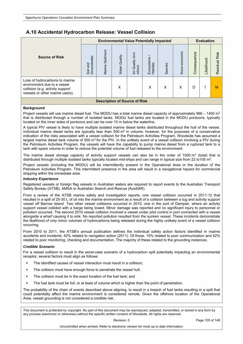
Nganhurra Operations Cessation Environment Plan Summary
This document is protected by copyright. No part of this document may be reproduced, adapted, transmitted, or stored in any form by any process (electronic or otherwise) without the specific written consent of Woodside. All rights are reserved.
Revision: 0 Page 105 of 148
Uncontrolled when printed. Refer to electronic version for most up to date information.
A.10 Accidental Hydrocarbon Release: Vessel Collision
Source of Risk
Environmental Value Potentially Impacted Evaluation
Soi
l and
G
rou
ndw
ate
r
Mar
ine
Sed
imen
t
Wat
er Q
ual
ity
Air
Qua
lity
(incl
. od
our)
Eco
syst
ems
/ H
abita
ts
Spe
cies
Soc
io-e
cono
mic
Con
sequ
ence
Like
lihoo
d
Res
idua
l Ris
k
Loss of hydrocarbons to marine environment due to a vessel collision (e.g. activity support vessels or other marine users).
X X X X D 1 M
Description of Source of Risk
Background
Project vessels will use marine diesel fuel. The MODU has a total marine diesel capacity of approximately 966 – 1400 m3 that is distributed through a number of isolated tanks. MODU fuel tanks are located in the MODU pontoons, typically located on the inner sides of pontoons and can be over 10 m below the waterline.
A typical PIV vessel is likely to have multiple isolated marine diesel tanks distributed throughout the hull of the vessel. Individual marine diesel tanks are typically less than 500 m3 in volume; however, for the purposes of a conservative indication of the risks associated with a vessel collision for the Petroleum Activities Program, Woodside has assumed a largest marine diesel tank volume of 500 m3 for the PIV. In the unlikely event of a vessel collision involving a PIV during the Petroleum Activities Program, the vessels will have the capability to pump marine diesel from a ruptured tank to a tank with spare volume in order to reduce the potential volume of fuel released to the environment.
The marine diesel storage capacity of activity support vessels can also be in the order of 1000 m3 (total) that is distributed through multiple isolated tanks typically located mid-ships and can range in typical size from 22 to105 m3.
Project vessels (including the MODU) will be intermittently present in the Operational Area or the duration of the Petroleum Activities Program. This intermittent presence in the area will result in a navigational hazard for commercial shipping within the immediate area.
Industry Experience
Registered vessels or foreign flag vessels in Australian waters are required to report events to the Australian Transport Safety Bureau (ATSB), AMSA or Australian Search and Rescue (AusSAR).
From a review of the ATSB marine safety and investigation reports, one vessel collision occurred in 2011-12 that resulted in a spill of 25-30 L of oil into the marine environment as a result of a collision between a tug and activity support vessel off Barrow Island. Two other vessel collisions occurred in 2010, one in the port of Dampier, where an activity support vessel collided with a barge being towed. Minor damage was reported and no significant injury to personnel or pollution occurred. The second 2010 vessel collision involved a vessel under pilot control in port connected with a vessel alongside a wharf causing it to sink. No reported pollution resulted from the sunken vessel. These incidents demonstrate the likelihood of only minor volumes of hydrocarbons being released during the highly unlikely event of a vessel collision occurring.
From 2010 to 2011, the ATSB’s annual publication defines the individual safety action factors identified in marine accidents and incidents: 42% related to navigation action (2011). Of those, 15% related to poor communication and 42% related to poor monitoring, checking and documentation. The majority of these related to the grounding instances.
Credible Scenario
For a vessel collision to result in the worst-case scenario of a hydrocarbon spill potentially impacting an environmental receptor, several factors must align as follows:
The identified causes of vessel interaction must result in a collision;
The collision must have enough force to penetrate the vessel hull;
The collision must be in the exact location of the fuel tank; and
The fuel tank must be full, or at least of volume which is higher than the point of penetration.
The probability of the chain of events described above aligning, to result in a breach of fuel tanks resulting in a spill that could potentially affect the marine environment is considered remote. Given the offshore location of the Operational Area, vessel grounding is not considered a credible risk.
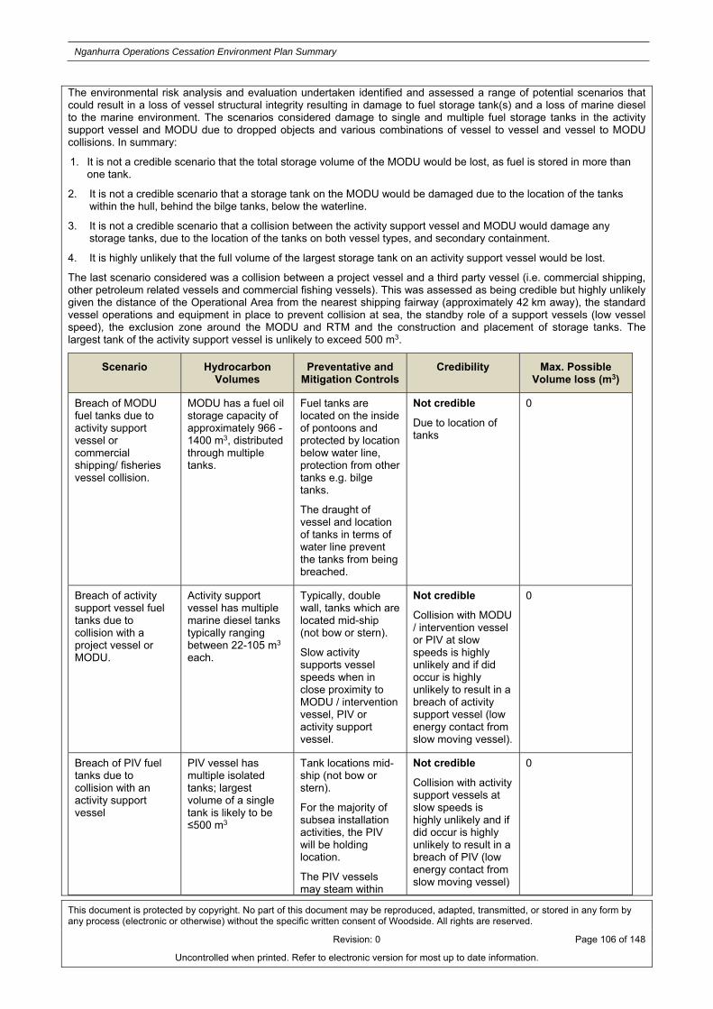
Nganhurra Operations Cessation Environment Plan Summary
This document is protected by copyright. No part of this document may be reproduced, adapted, transmitted, or stored in any form by any process (electronic or otherwise) without the specific written consent of Woodside. All rights are reserved.
Revision: 0 Page 106 of 148
Uncontrolled when printed. Refer to electronic version for most up to date information.
The environmental risk analysis and evaluation undertaken identified and assessed a range of potential scenarios that could result in a loss of vessel structural integrity resulting in damage to fuel storage tank(s) and a loss of marine diesel to the marine environment. The scenarios considered damage to single and multiple fuel storage tanks in the activity support vessel and MODU due to dropped objects and various combinations of vessel to vessel and vessel to MODU collisions. In summary:
1. It is not a credible scenario that the total storage volume of the MODU would be lost, as fuel is stored in more than one tank.
2. It is not a credible scenario that a storage tank on the MODU would be damaged due to the location of the tanks within the hull, behind the bilge tanks, below the waterline.
3. It is not a credible scenario that a collision between the activity support vessel and MODU would damage any storage tanks, due to the location of the tanks on both vessel types, and secondary containment.
4. It is highly unlikely that the full volume of the largest storage tank on an activity support vessel would be lost.
The last scenario considered was a collision between a project vessel and a third party vessel (i.e. commercial shipping, other petroleum related vessels and commercial fishing vessels). This was assessed as being credible but highly unlikely given the distance of the Operational Area from the nearest shipping fairway (approximately 42 km away), the standard vessel operations and equipment in place to prevent collision at sea, the standby role of a support vessels (low vessel speed), the exclusion zone around the MODU and RTM and the construction and placement of storage tanks. The largest tank of the activity support vessel is unlikely to exceed 500 m3.
Scenario Hydrocarbon Volumes
Preventative and Mitigation Controls
Credibility Max. Possible Volume loss (m3)
Breach of MODU fuel tanks due to activity support vessel or commercial shipping/ fisheries vessel collision.
MODU has a fuel oil storage capacity of approximately 966 - 1400 m3, distributed through multiple tanks.
Fuel tanks are located on the inside of pontoons and protected by location below water line, protection from other tanks e.g. bilge tanks.
The draught of vessel and location of tanks in terms of water line prevent the tanks from being breached.
Not credible
Due to location of tanks
0
Breach of activity support vessel fuel tanks due to collision with a project vessel or MODU.
Activity support vessel has multiple marine diesel tanks typically ranging between 22-105 m3 each.
Typically, double wall, tanks which are located mid-ship (not bow or stern).
Slow activity supports vessel speeds when in close proximity to MODU / intervention vessel, PIV or activity support vessel.
Not credible
Collision with MODU / intervention vessel or PIV at slow speeds is highly unlikely and if did occur is highly unlikely to result in a breach of activity support vessel (low energy contact from slow moving vessel).
0
Breach of PIV fuel tanks due to collision with an activity support vessel
PIV vessel has multiple isolated tanks; largest volume of a single tank is likely to be ≤500 m3
Tank locations mid-ship (not bow or stern).
For the majority of subsea installation activities, the PIV will be holding location.
The PIV vessels may steam within
Not credible
Collision with activity support vessels at slow speeds is highly unlikely and if did occur is highly unlikely to result in a breach of PIV (low energy contact from slow moving vessel)
0

Nganhurra Operations Cessation Environment Plan Summary
This document is protected by copyright. No part of this document may be reproduced, adapted, transmitted, or stored in any form by any process (electronic or otherwise) without the specific written consent of Woodside. All rights are reserved.
Revision: 0 Page 107 of 148
Uncontrolled when printed. Refer to electronic version for most up to date information.
the project area at ~ 12 knots; however normal maritime procedures would apply during such vessel movements.
Breach of PIV, intervention vessel or activity support vessel fuel tanks due to activity support vessel - other vessel collision including commercial shipping/ fisheries
Intervention vessel, PIV and activity support vessels have multiple marine diesel tanks typically ranging between 22-500 m3 each.
Typically, double wall, tanks which are located mid-ship (not bow or stern)
Vessels are not anchored and steam at low speeds when relocating within the Operational Area or providing stand-by cover. Normal maritime procedures would apply during such vessel movements
Credible
Project vessel – other vessel collision could potentially result in the release from a fuel tank
500 m3
Quantitative Hydrocarbon Risk Assessment
Modelling was undertaken by RPS APASA, on behalf of Woodside, to determine the fate of marine diesel released from a collision within the Operational Area. The modelling assessed the extent of marine diesel spill volume of 500 m3 for all seasons, using an historic sample of wind and current data for the region. A total of 100 simulations for each season were modelled with each simulation tracked for 42 days.
Hydrocarbon characteristics
Marine diesel is a mixture of both volatile and persistent hydrocarbons. Predicted weathering of marine diesel, based on typical conditions in the region, indicates that approximately 50% by mass would be expected to evaporate over the first day or two (Figure A- 2). After this time the majority of the remaining hydrocarbon is entrained into the upper water column. In calm conditions, entrained hydrocarbons are likely to resurface. Up to 95% of the spill volume is expected to evaporate over time (Figure A- 2). The remaining 5% is persistent and will reduce in concentration through degradation and dissolution.
Given the environmental conditions experienced in the Operational Area, marine diesel is expected to undergo rapid spreading and this, together with evaporative loss, is likely to result in a rapid dissipation of the spill. Marine diesel distillates tend not to form emulsions at the temperatures found in the region. Therefore, there is no potential for the spill to extend to sensitive shorelines or mainland receptors above threshold concentrations. The characteristics of the marine diesel used in the modelling are given in Table A- 7.
Table A- 7: Characteristics of the marine diesel used in the modelling
Hydrocarbon Type
Initial Density (g/cm3) at 25°C
Viscosity (cP @ 25°C)
Component BP (°C)
Volatiles <180
Semi volatiles 180-265
Low Volatility (%) 265-380
Residual (%) >380
Non-Persistent Persistent
Marine Diesel (surrogate for marine gas oil – MGO)
0.829 4.0 % of total 6 34.6 54.4 5

Nganhurra Operations Cessation Environment Plan Summary
This document is protected by copyright. No part of this document may be reproduced, adapted, transmitted, or stored in any form by any process (electronic or otherwise) without the specific written consent of Woodside. All rights are reserved.
Revision: 0 Page 108 of 148
Uncontrolled when printed. Refer to electronic version for most up to date information.
Figure A- 2: Proportional mass balance plot representing the weathering of marine diesel spilled onto the water surface as a one-off release (50 m3 over 1 hour) and subject to variable wind at 27 °C water temperature and 25 °C air temperature
Potential Environmental Impacts
Potential Impacts Overview
Zone of Consequence
Surface hydrocarbons: In the event that this scenario occurred, a surface hydrocarbon slick would form down current of the release location with the trajectory dependent on prevailing wind and current conditions at the time. The modelling indicates that the ZoC would be localised and confined to open water, extending up to approximately 150 km from the release location. No contact to sensitive shoreline receptors by surface hydrocarbons > 10 g/m2 is predicted.
Entrained hydrocarbons: In the event that this vessel collision scenario occurred, a plume of entrained hydrocarbons ≥500 ppb would form down current of the release location with the trajectory dependent on prevailing current conditions at the time. The modelling indicates locations within reach of entrained hydrocarbon ZoC to threshold concentrations are restricted to offshore areas up to approximately 70 km from the release site with the main drift direction either towards the southwest.
Dissolved hydrocarbons: Dissolved hydrocarbons above threshold concentrations (>500 ppb) were not predicted by the modelling to occur at any location. Therefore, no contact with any sensitive receptors is predicted, and a ZoC figure is not presented.
Accumulated hydrocarbons: Accumulated hydrocarbons above threshold concentrations (>100 g/m2) were not predicted by the modelling to occur at any location.
Summary of potential impacts
In the unlikely event of a spill of marine diesel as a result of vessel collision, the ZoC is expected to remain small and localised, restricted to the open ocean only (Commonwealth waters). Consequently, a ZoC summary table is not
Nganhurra Operations Cessation Environment Plan Summary
This document is protected by copyright. No part of this document may be reproduced, adapted, transmitted, or stored in any form by any process (electronic or otherwise) without the specific written consent of Woodside. All rights are reserved.
Revision: 0 Page 109 of 148
Uncontrolled when printed. Refer to electronic version for most up to date information.
presented.
Potential Impacts to Protected Species, Other Habitats and Communities, Water Quality, Protected Areas and Socio-Economic Sensitivities
The potential biological and ecological impacts associated with hydrocarbon spills are presented in risk section: Loss of Well Containment during Intervention Activities. Further detail on impacts specific to a spill of marine diesel are provided below. It is noted that the toxic components in marine diesel include alkylated naphthalenes which can be rapidly accumulated by marine biota including invertebrates such as marine oysters, clams, shrimp, as well as a range of vertebrates, such as finfish. Marine diesel also contains additives that contribute to its toxicity.
Protected Species
Protected species, including pygmy blue whales, humpback whales, whale sharks, and marine turtles may be encountered within the Operational Area and therefore, could be impacted by a marine diesel spill. Although the ZoC may spatially overlap with the BIAs, it is considered that protected species that are present will be predominantly transiting through the area. Additionally, the ZoC may overlap with the whale shark aggregation area (March to July) off the Ningaloo Coast. In the event that marine fauna come into contact with a release, they could suffer fouling, ingestion, inhalation of toxic vapours, irritation of sensitive membranes in the eyes, mouth, digestive and respiratory tracts and organ or neurological damage. Given the dilution and weathering of any spill, the likelihood of ecological impacts to marine fauna (protected species), it is expected that any potential impacts will be low magnitude and temporary in nature.
Other Habitats, Species and Communities
Within the ZoC for a marine diesel spill resulting from a vessel collision, there is the potential for plankton communities to potentially be impacted where entrained hydrocarbon threshold concentrations are exceeded. Communities are expected to recover quickly (weeks/months) due to high population turnover (ITOPF 2011). With the relatively small ZoC and the fast population turn-over of open water plankton populations, it is considered that any potential impacts would be low magnitude and temporary in nature.
Pelagic fish populations in the open water offshore environment of the ZoC are highly mobile and have the ability to move away from a marine diesel spill. The spill affected area would likely be confined to the upper surface layers. It is therefore, unlikely that fish populations would be exposed to widespread hydrocarbon contamination. Fish populations are likely to be distributed over a wide geographical area so impacts on populations or species level are considered to be negligible. Combined with these factors, the relatively small ZoC and the rapid dispersion of marine diesel, it is considered that any potential impacts will be negligible. While other communities (e.g. demersal fish, benthic infauna and epifauna) and key sensitivities may be within the ZoC, they are unlikely to be directly impacted by a marine diesel spill as hydrocarbons are confined to the top 40 m of the water column.
Water Quality
It is likely that water quality will be reduced at the release location of the spill to contamination levels above background levels and/or national/international quality standards; however, such impacts to water quality would be temporary and localised in nature due to the relatively reduced extent of the ZoC and the rapid dispersion of marine diesel. The potential impact is therefore expected to be low.
Protected Areas
The ZoC may extend into the Ningaloo Coast WHA and CMR. In the unlikely event of a spill, with surface or entrained hydrocarbons above threshold concentrations contacting the WHA or CMR, the potential impacts to ecological sensitivities are considered to be similar to those discussed above. No shoreline accumulation above threshold values is predicted for the Ningaloo coast (including the WHA).
Socio-economic
A marine diesel spill is considered unlikely to cause significant direct impacts on the target species fished by the Commonwealth and State Fisheries which overlap with the ZoC. Active fisheries within the ZoC primarily target demersal and benthic species (finfish and crustaceans) that inhabit waters in the range of >60–200 m depth or pelagic species which are highly mobile. Therefore, a marine diesel spill due is expected to only result in negligible impacts, considering the relatively small area of the ZoC and hydrocarbons are confined to the top 40 m of the water column. However, there is the potential that a fishing exclusion zone would be applied in the area of the spill, which would put a temporary ban on fishing activities and therefore potentially lead to subsequent economic impacts on commercial fishing operators if they were planning on undertaking fishing within the area of the spill.
A loss of hydrocarbons due to vessel collision during the Petroleum Activities Program may lead to exclusion of marine nature-based tourist activities at Ningaloo coast, resulting in a loss of revenue for operators. Tourism is a major industry for the region and visitor numbers would likely reduce if a hydrocarbon spill were to occur. Given the nature of a marine diesel spill, impacts would be expected to be temporary in nature.
Summary of Potential Impacts to environmental values(s)

Nganhurra Operations Cessation Environment Plan Summary
This document is protected by copyright. No part of this document may be reproduced, adapted, transmitted, or stored in any form by any process (electronic or otherwise) without the specific written consent of Woodside. All rights are reserved.
Revision: 0 Page 110 of 148
Uncontrolled when printed. Refer to electronic version for most up to date information.
In the unlikely event of an unplanned hydrocarbon release to the marine environment due to vessel collision, combined with the adopted controls, it is considered that any potential impact would be minor and short-term in nature to water quality in comparison to background levels and/or international standards with minor and short-term impacts to habitats, populations and shipping/fishing concerns.
The highest environmental consequence identified for the assessment of an unplanned hydrocarbon release to the marine environment due to vessel collision is defined as D, which equates to ‘minor, short-term impact (1-2 years) on species, habitat (but not affecting ecosystem function), physical or biological attributes’.
Summary of Control Measures
Marine Orders 30 (Prevention of Collisions) 2009
Marine Order 21 (Safety of navigation and emergency procedures) 2012
Establishment of a 500 m safety exclusion zone around MODU / intervention vessel and RTM, and communicated to marine users
Activity support vessel(s) on standby during well intervention activities to communicate with third-party vessels and assist in maintaining the safety exclusion zone
Activity support vessel(s) assigned to surveillance will maintain a 24 hour radio channel, undertake continuous surveillance and warn of any approaching vessels, warn off any vessel attempting to transit closer than the exclusion zone, monitoring and advise if navigation signals are defective or if visibility becomes restricted
Notify AHS before commencement of well intervention and final FPSO disconnection and RTM removal to allow generation of navigation warnings (Maritime Safety Information Notifications (MSIN) and Notice to Mariners (NTM) [including AUSCOAST warnings where relevant])
Notify Department of Primary Industries and Regional Development (Western Australia) (DPIRD) (formerly the WA Department of Fisheries) of activities
Notify AMSA Joint Rescue Coordination Centre (JRCC) before commencement of well intervention and, FPSO disconnection and RTM removal

Nganhurra Operations Cessation Environment Plan Summary
This document is protected by copyright. No part of this document may be reproduced, adapted, transmitted, or stored in any form by any process (electronic or otherwise) without the specific written consent of Woodside. All rights are reserved.
Revision: 0 Page 111 of 148
Uncontrolled when printed. Refer to electronic version for most up to date information.
A.11 Unplanned Hydrocarbon Discharges: Bunkering
Source of Risk
Environmental Value Potentially Impacted Evaluation
Soi
l and
G
rou
ndw
ate
r
Mar
ine
Sed
imen
t
Wat
er Q
ual
ity
Air
Qua
lity
(incl
. od
our)
Eco
syst
ems
/ H
abita
ts
Spe
cies
Soc
io-e
cono
mic
Con
sequ
ence
Like
lihoo
d
Res
idua
l Ris
k
Loss of hydrocarbons to marine environment from bunkering. X X E 3 M
Description of Source of Risk
Credible Scenario
Bunkering of marine diesel of project vessels may occur within the Operational Area. Two credible scenarios for the loss of containment of marine diesel during bunkering operations were identified:
Partial or total failure of a bulk transfer hose or fittings during bunkering, due to operational stress or other integrity issues could spill marine diesel to the deck and/or into the marine environment. This would be in the order of less than 200 L, based on the likely volume of a bulk transfer hose (assuming a failure of the dry break and complete loss of hose volume); and
Partial or total failure of a bulk transfer hose or fittings during bunkering, combined with a failure in procedure to shutoff fuel pumps, for a period of up to five minutes, resulting in approximately 8 m3 marine diesel loss to the deck and/or into the marine environment.
Partial or total failure of a bulk transfer hose or fittings during helicopter refuelling could spill aviation jet fuel to the helicopter deck and/or into the marine environment. All helicopter refuelling activities are closely supervised and leaks on the helideck are considered to be easily detectable. In the event of a leak, transfer would be ceased immediately. The credible volume of such a release during helicopter refuelling would be in the order of <100 L.
Quantitative Spill Risk Assessment
Given the physical and chemical similarities, and the relatively small credible spill volumes, marine diesel is considered to be a suitable substitution for aviation jet fuel for the purpose of this environmental risk assessment. Woodside has commissioned RPS APASA to model a surface spill volume of 8 m3 in the offshore waters of northwest Western Australia. The results of these models have indicated that exposure to surface hydrocarbons above the 10 g/m2 threshold is limited to the immediate vicinity of the release site, with little potential to extend beyond 1 km. Therefore, it is considered that exposure to thresholds concentrations from an 8 m3 surface spill from bunkering activities would be well within the ZoC for the vessel collision scenario detailed in risk section Loss of Well Containment from Wellhead Damage. Given this, the offshore location of the Operational Area, and the fact that the same hydrocarbon type is involved for both scenarios, specific modelling for an 8 m3 marine diesel release was not undertaken for this Petroleum Activities Program.
Hydrocarbon Characteristics
Refer to risk section Loss of Well Containment from Wellhead Damage for a description of the characteristics of marine diesel, including detail on the predicted fate and weathering of a spill to the marine environment.
Potential Environmental Impacts
Potential Impacts to Water Quality and Protected Species
Previous modelling studies for 8 m3 marine diesel releases, spilt at the surface as result of bunkering activities, indicated that the potential for exposure to surface hydrocarbons exceeding 10 g/m2 was confined to within the immediate vicinity (approximately 1 km) of the release sites. Therefore, it is considered that there is no potential for contact with sensitive receptor locations above surface (10 g/m2), entrained (500 ppb) or dissolved (500 ppb) threshold concentrations from an 8 m3 spill of marine diesel within the Operational Area.
Summary of Potential Impacts to environmental values(s)

Nganhurra Operations Cessation Environment Plan Summary
This document is protected by copyright. No part of this document may be reproduced, adapted, transmitted, or stored in any form by any process (electronic or otherwise) without the specific written consent of Woodside. All rights are reserved.
Revision: 0 Page 112 of 148
Uncontrolled when printed. Refer to electronic version for most up to date information.
The potential biological and ecological impacts associated with much larger hydrocarbon spills are presented in pervious hydrocarbon release risk sections: Loss of Well Containment during Intervention Activities and Loss of Well Containment from Wellhead Damage, further detail on impacts specific to a spill of marine diesel from a bunkering loss are provided below.
The biological consequences of such a small volume spill on identified open water sensitive receptors relate to the potential for minor impacts to megafauna, plankton and fish populations (surface and water column biota) that are within the spill affected area and no impacts to commercial fisheries are expected. Refer to potential impacts of unplanned hydrocarbon release to the marine environment from risk section: Vessel Collision for the detailed potential impacts; however, the extent of the ZoC associated with a marine diesel spill from loss during bunkering will be much reduced in terms of spatial and temporal scales, and hence, potential impacts from bunkering are considered very minor.
Summary of Control Measures
Marine Order 91 (Marine pollution prevention – oil) 2006
The Woodside Engineering Standard – Rig Equipment details requirements for the management of bunkering equipment to prevent bunkering spills
The contractor bunkering/helicopter refuelling procedures specify control measures to be implemented during bunkering/refuelling, to prevent bunkering spills from occurring

Nganhurra Operations Cessation Environment Plan Summary
This document is protected by copyright. No part of this document may be reproduced, adapted, transmitted, or stored in any form by any process (electronic or otherwise) without the specific written consent of Woodside. All rights are reserved.
Revision: 0 Page 113 of 148
Uncontrolled when printed. Refer to electronic version for most up to date information.
A.12 Unplanned Discharges: Loss of Chemicals / Hydrocarbons from Project Vessels
Source of Risk
Environmental Value Potentially Impacted Evaluation
Soi
l and
G
rou
ndw
ate
r
Mar
ine
Sed
imen
t
Wat
er Q
ual
ity
Air
Qua
lity
(incl
. od
our)
Eco
syst
ems
/ H
abita
ts
Spe
cies
Soc
io-e
cono
mic
Con
sequ
ence
Like
lihoo
d
Res
idua
l Ris
k
Accidental discharge of other hydrocarbons / chemicals from project vessels deck activities and equipment (e.g. cranes) to the marine environment, including helicopter refuelling and subsea ROV hydraulic leaks.
X X X E 2 M
Description of Source of Risk
Deck spills can result from spills from stored hydrocarbons/chemicals or equipment. Project vessels typically store hydrocarbon/chemicals in various volumes (20 L, 205 L; up to approximately 4000–6000 L). Storage areas are typically set up with effective primary and secondary bunding to contain any deck spills. Releases from equipment are predominantly from the failure of hydraulic hoses, which can either be located within bunded areas or outside of bunded or deck areas (e.g. over water on cranes). Helicopter refuelling may also take place within the Operational Area, on the helipad of project vessels.
Minor leaks during wire line activities (i.e. intervention activities) with a live well are described to include leaks such as:
Leaks from the lubricator, stuffing box and hose or fitting failure, which are expected to be less than 10 L (0.01 m3); Loss of containment - fluids - surface holding tanks; Back loading of raw slop fluids in an Intermediate Bulk Containers (IBC); Stuffing box leak / under pressure; Draining of lubricator contents; Excess grease / lubricant leaking from the grease injection head; Wind-blown lubricant dripping from cable / on deck; and Lubricant used to lubricate hole.
Woodside’s operational experience demonstrates that spills are most likely to originate from hydraulic hoses and have been less than 100 L, with an average volume <10 L.
Subsea spills can result from a loss of containment of fluids from subsea equipment including the BOP or ROVs. A review of these spills to the marine environment in the past 12 months showed subsea spills did not exceed approximately 26 L in Woodside’s Drilling function.
The ROV hydraulic fluid is supplied through hoses containing approximately 20 L of fluid. Hydraulic lines to the ROV arms and other tooling may become caught resulting in minor leaks to the marine environment. Small volume hydraulic leaks may occur from equipment operating via hydraulic controls subsea (subsea control fluid). These include the diamond wire cutter, bolt tensioning equipment, ROV tooling etc.
Potential Environmental Impacts
Potential Impacts to Water Quality, Ecosystems/Habitats and Protected Species
Accidental spills of hydrocarbons or chemicals from project vessels will decrease the water quality in the immediate area of the spill; however, the impacts are expected to be temporary and very localised due to dispersion and dilution in the open ocean environment.
The potential biological and ecological impacts associated with hydrocarbon spills are presented in risk section: Loss of Well Containment during Intervention Activities, further detail on impacts specific to minor deck and subsea spills is provided below.
The biological consequences of such a small volume spill on identified open water sensitive receptors relate to the potential for minor impacts to megafauna, plankton and fish populations (surface and water column biota) and sediment quality (minor subsea spill) that are within the spill affected area and no impacts to commercial fisheries are expected. Please refer to risk section: Loss of Well Containment from Wellhead Damage (potential impacts of unplanned hydrocarbon release to the marine environment from vessel collision) for the detailed potential impacts. However, given

Nganhurra Operations Cessation Environment Plan Summary
This document is protected by copyright. No part of this document may be reproduced, adapted, transmitted, or stored in any form by any process (electronic or otherwise) without the specific written consent of Woodside. All rights are reserved.
Revision: 0 Page 114 of 148
Uncontrolled when printed. Refer to electronic version for most up to date information.
the minor volumes likely to be involved, the potential for impacts is likely to be highly localised to the immediate spill locations and hence potential impacts are considered very minor.
No impacts on socio-economic receptors are expected due to the low levels of fishing activity in the Operational Area, the small volumes of hydrocarbons/chemicals that could be accidentally spilt and the localised and temporary nature of the impacts.
Summary of Potential Impacts to environmental values(s)
Given the adopted controls, it is considered that minor hydrocarbon/chemical spills to the marine environment will not result in a potential impact to water quality greater than slight and temporary contamination above background levels, quality standards or known effect concentrations and will not result in a potential impact greater than slight and temporary disruption to a small proportion of biological populations with no impact on critical habitat or activity.
Summary of Control Measures
Marine Order 91 (Marine pollution prevention – oil) 2006
The Australian Government Civil Aviation Safety Authority CAAP 92-4(0) ‘Guidelines for the development and operation of off-shore helicopter landing sites, including vessels’ include recommendations on fuel storage to prevent spills
Environmental Performance Standards Procedure details expectations on chemical storage and handling to prevent spills
Woodside’s Engineering Standard – Rig Equipment details deck drainage system requirements to ensure that engineered barriers are in place to prevent loss of deck spills to the marine environment
Woodside’s Engineering Standard – Rig Equipment includes requirements for on-board spill kits to be used to clean up deck spills
PIV has self-containing hydraulic oil drip tray management system to contain any on-deck spills of hydraulic oil from ROVs
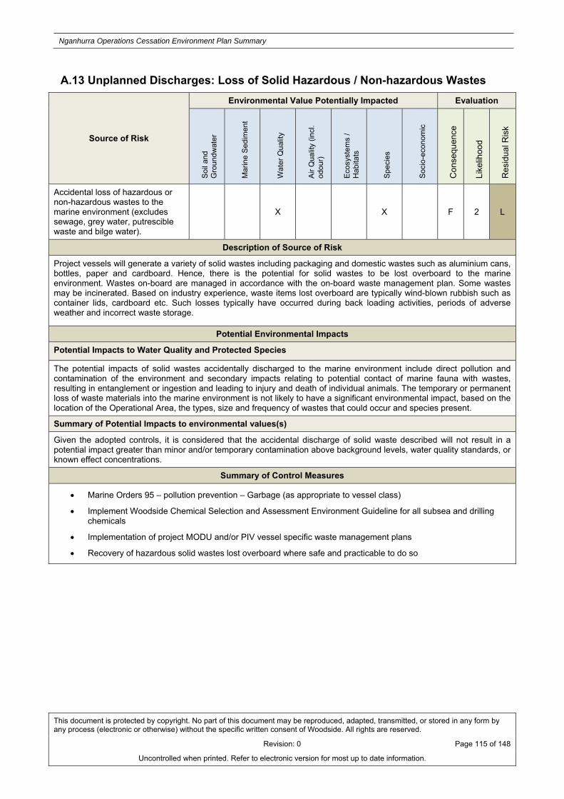
Nganhurra Operations Cessation Environment Plan Summary
This document is protected by copyright. No part of this document may be reproduced, adapted, transmitted, or stored in any form by any process (electronic or otherwise) without the specific written consent of Woodside. All rights are reserved.
Revision: 0 Page 115 of 148
Uncontrolled when printed. Refer to electronic version for most up to date information.
A.13 Unplanned Discharges: Loss of Solid Hazardous / Non-hazardous Wastes
Source of Risk
Environmental Value Potentially Impacted Evaluation
Soi
l and
G
rou
ndw
ate
r
Mar
ine
Sed
imen
t
Wat
er Q
ual
ity
Air
Qua
lity
(incl
. od
our)
Eco
syst
ems
/ H
abita
ts
Spe
cies
Soc
io-e
cono
mic
Con
sequ
ence
Like
lihoo
d
Res
idua
l Ris
k
Accidental loss of hazardous or non-hazardous wastes to the marine environment (excludes sewage, grey water, putrescible waste and bilge water).
X X F 2 L
Description of Source of Risk
Project vessels will generate a variety of solid wastes including packaging and domestic wastes such as aluminium cans, bottles, paper and cardboard. Hence, there is the potential for solid wastes to be lost overboard to the marine environment. Wastes on-board are managed in accordance with the on-board waste management plan. Some wastes may be incinerated. Based on industry experience, waste items lost overboard are typically wind-blown rubbish such as container lids, cardboard etc. Such losses typically have occurred during back loading activities, periods of adverse weather and incorrect waste storage.
Potential Environmental Impacts
Potential Impacts to Water Quality and Protected Species
The potential impacts of solid wastes accidentally discharged to the marine environment include direct pollution and contamination of the environment and secondary impacts relating to potential contact of marine fauna with wastes, resulting in entanglement or ingestion and leading to injury and death of individual animals. The temporary or permanent loss of waste materials into the marine environment is not likely to have a significant environmental impact, based on the location of the Operational Area, the types, size and frequency of wastes that could occur and species present.
Summary of Potential Impacts to environmental values(s)
Given the adopted controls, it is considered that the accidental discharge of solid waste described will not result in a potential impact greater than minor and/or temporary contamination above background levels, water quality standards, or known effect concentrations.
Summary of Control Measures
Marine Orders 95 – pollution prevention – Garbage (as appropriate to vessel class)
Implement Woodside Chemical Selection and Assessment Environment Guideline for all subsea and drilling chemicals
Implementation of project MODU and/or PIV vessel specific waste management plans
Recovery of hazardous solid wastes lost overboard where safe and practicable to do so
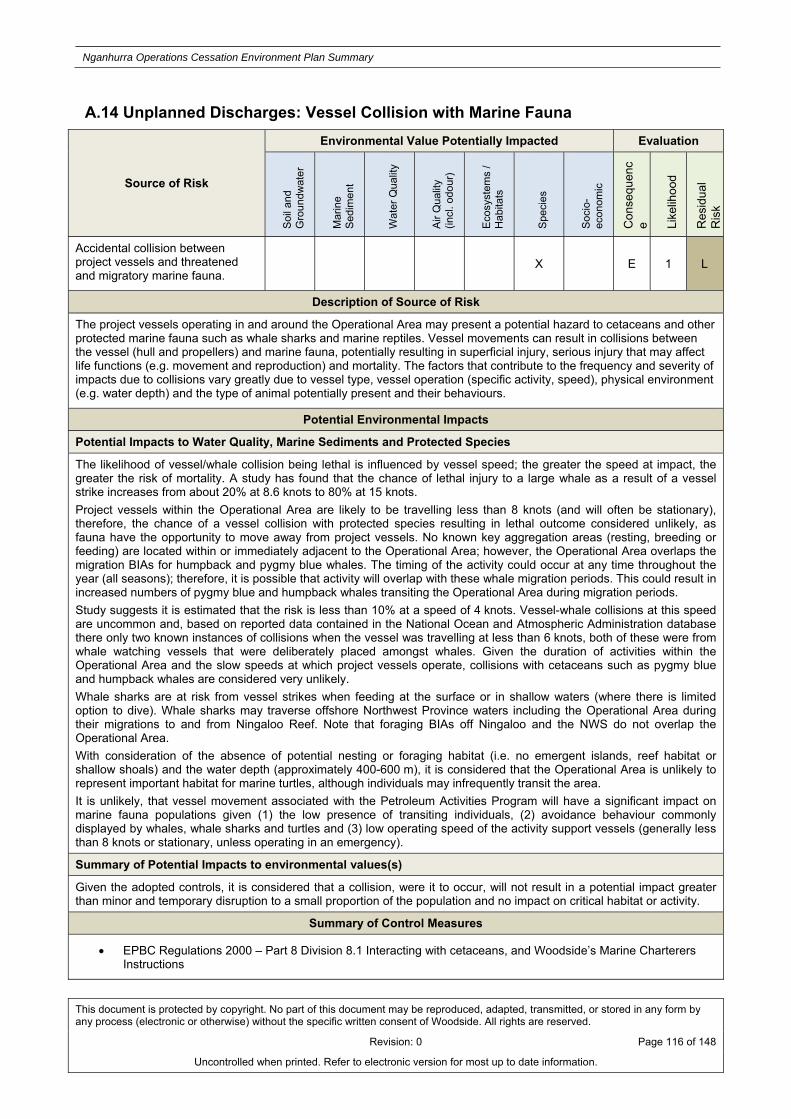
Nganhurra Operations Cessation Environment Plan Summary
This document is protected by copyright. No part of this document may be reproduced, adapted, transmitted, or stored in any form by any process (electronic or otherwise) without the specific written consent of Woodside. All rights are reserved.
Revision: 0 Page 116 of 148
Uncontrolled when printed. Refer to electronic version for most up to date information.
A.14 Unplanned Discharges: Vessel Collision with Marine Fauna
Source of Risk
Environmental Value Potentially Impacted Evaluation
Soi
l and
G
rou
ndw
ate
r
Mar
ine
Sed
imen
t
Wat
er Q
ual
ity
Air
Qu
alit
y (in
cl. o
dour
)
Eco
syst
ems
/ H
abita
ts
Spe
cies
Soc
io-
econ
omic
Con
sequ
enc
e Like
lihoo
d
Res
idua
l R
isk
Accidental collision between project vessels and threatened and migratory marine fauna.
X E 1 L
Description of Source of Risk
The project vessels operating in and around the Operational Area may present a potential hazard to cetaceans and other protected marine fauna such as whale sharks and marine reptiles. Vessel movements can result in collisions between the vessel (hull and propellers) and marine fauna, potentially resulting in superficial injury, serious injury that may affect life functions (e.g. movement and reproduction) and mortality. The factors that contribute to the frequency and severity of impacts due to collisions vary greatly due to vessel type, vessel operation (specific activity, speed), physical environment (e.g. water depth) and the type of animal potentially present and their behaviours.
Potential Environmental Impacts
Potential Impacts to Water Quality, Marine Sediments and Protected Species
The likelihood of vessel/whale collision being lethal is influenced by vessel speed; the greater the speed at impact, the greater the risk of mortality. A study has found that the chance of lethal injury to a large whale as a result of a vessel strike increases from about 20% at 8.6 knots to 80% at 15 knots.
Project vessels within the Operational Area are likely to be travelling less than 8 knots (and will often be stationary), therefore, the chance of a vessel collision with protected species resulting in lethal outcome considered unlikely, as fauna have the opportunity to move away from project vessels. No known key aggregation areas (resting, breeding or feeding) are located within or immediately adjacent to the Operational Area; however, the Operational Area overlaps the migration BIAs for humpback and pygmy blue whales. The timing of the activity could occur at any time throughout the year (all seasons); therefore, it is possible that activity will overlap with these whale migration periods. This could result in increased numbers of pygmy blue and humpback whales transiting the Operational Area during migration periods.
Study suggests it is estimated that the risk is less than 10% at a speed of 4 knots. Vessel-whale collisions at this speed are uncommon and, based on reported data contained in the National Ocean and Atmospheric Administration database there only two known instances of collisions when the vessel was travelling at less than 6 knots, both of these were from whale watching vessels that were deliberately placed amongst whales. Given the duration of activities within the Operational Area and the slow speeds at which project vessels operate, collisions with cetaceans such as pygmy blue and humpback whales are considered very unlikely.
Whale sharks are at risk from vessel strikes when feeding at the surface or in shallow waters (where there is limited option to dive). Whale sharks may traverse offshore Northwest Province waters including the Operational Area during their migrations to and from Ningaloo Reef. Note that foraging BIAs off Ningaloo and the NWS do not overlap the Operational Area.
With consideration of the absence of potential nesting or foraging habitat (i.e. no emergent islands, reef habitat or shallow shoals) and the water depth (approximately 400-600 m), it is considered that the Operational Area is unlikely to represent important habitat for marine turtles, although individuals may infrequently transit the area.
It is unlikely, that vessel movement associated with the Petroleum Activities Program will have a significant impact on marine fauna populations given (1) the low presence of transiting individuals, (2) avoidance behaviour commonly displayed by whales, whale sharks and turtles and (3) low operating speed of the activity support vessels (generally less than 8 knots or stationary, unless operating in an emergency).
Summary of Potential Impacts to environmental values(s)
Given the adopted controls, it is considered that a collision, were it to occur, will not result in a potential impact greater than minor and temporary disruption to a small proportion of the population and no impact on critical habitat or activity.
Summary of Control Measures
EPBC Regulations 2000 – Part 8 Division 8.1 Interacting with cetaceans, and Woodside’s Marine Charterers Instructions

Nganhurra Operations Cessation Environment Plan Summary
This document is protected by copyright. No part of this document may be reproduced, adapted, transmitted, or stored in any form by any process (electronic or otherwise) without the specific written consent of Woodside. All rights are reserved.
Revision: 0 Page 117 of 148
Uncontrolled when printed. Refer to electronic version for most up to date information.
A.15 Physical Presence: Disturbance to Seabed from Dropped Objects
Source of Risk
Environmental Value Potentially Impacted Evaluation
Soi
l and
G
rou
ndw
ate
r
Mar
ine
Sed
imen
t
Wat
er Q
ual
ity
Air
Qua
lity
(incl
. od
our)
Eco
syst
ems
/ H
abita
ts
Spe
cies
Soc
io-e
cono
mic
Con
sequ
ence
Like
lihoo
d
Res
idua
l Ris
k
Dropped subsea infrastructure during laydown or removal activities
X E 1 L
Accidental sinking of the RTM during removal. X E 1 L
Description of Source of Risk
Dropped Objects
During the Petroleum Activities Program, the controlled lifting and laydown of subsea infrastructure within the Operational Area is expected to occur. During these activities there is the potential for subsea infrastructure to disturb the seabed. There is also the potential for objects to be dropped overboard from project vessels to the marine environment. The area of disturbance to the seabed that could result from dropping subsea infrastructure could range depending on the size of the object.
In the event of a dropped object landing on the seabed, there is the potential for damage to the subsea infrastructure. During the preservation period, there is the potential for dropped objects to rupture flushed infrastructure, which could lead to the unintentional discharge of treated seawater and minor quantities of residual hydrocarbons. In the unlikely event of a dropped object landing on a Xmas tree, there is the potential for a well loss of containment leading to the release of hydrocarbons. Note the release volume for this scenario is significantly smaller than the credible worst case loss of well control during intervention, as the SSSV and / or cement plug(s) are assumed to be unaffected by the dropped object. (refer to other relevant risk sections for more information)
RTM Sinking
There is potential for the RTM to sink to the sea bed prior to or during the removal of the structure from the Operational Area. Given the risers and mooring lines would still be attached, the riser column is expected to settle within the area bound by the mooring anchors.
In the highly unlikely event that the RTM sinks to the seabed, it will result in localised disturbance to the seabed at that location. The potential disturbance footprint of the RTM would be approximately 83 m by 8.5 m (i.e. approximately 700 m2). Note that there are no residual hydrocarbon or chemicals on-board the RTM during the preservation period. The RTM is composed almost entirely of steel, with a paint coating. The risers, which remain attached to the RTM prior to being laid on the seabed, will contain preservation fluid and trace hydrocarbons.
Potential Environmental Impacts
Potential Impacts to Ecosystems / Habitats
In the unlikely event that a piece of subsea infrastructure was dropped to the seabed, or the RTM sinks, such an event would add to the estimated seabed disturbance footprint for planned activities (approximately 700 m2). However, additional disturbance would be confined to the Operational Area, within which the seabed consists of soft sediments, widely represented throughout the region. Therefore, any cumulative impacts would be minor, in addition to the expected disturbance footprint for planned activities.
In the unlikely event of a dropped object rupturing infrastructure containing preservation fluid (treated seawater), the credible volume of discharged treated seawater is consistent with the planned discharge volume. Refer to risk section: Routine and Non-routine Discharges: Hydrocarbons, Chemicals and Drilling Fluids for an assessment of the environmental risks and impacts from a discharge of treated seawater.
In the unlikely event of a dropped object leading to a loss of well containment, the worst-case credible hydrocarbon release scenario is consistent with the loss of well containment presented in risk section: Unplanned Hydrocarbon Release: Loss of Well Containment during Intervention Activities; refer this section for an assessment of the environmental risks and impacts due to a loss of well containment during the preservation period.
Summary of Potential Impacts to environmental values(s)

Nganhurra Operations Cessation Environment Plan Summary
This document is protected by copyright. No part of this document may be reproduced, adapted, transmitted, or stored in any form by any process (electronic or otherwise) without the specific written consent of Woodside. All rights are reserved.
Revision: 0 Page 118 of 148
Uncontrolled when printed. Refer to electronic version for most up to date information.
Given the adopted controls and the predicted small footprint of a dropped object, it is considered that a dropped object will not result in a potential impact greater than localised short-term damage of benthic subsea habitats. Refer to the relevant risk sections for discussion of seabed disturbance, treated seawater discharge and loss of well containment respectively.
Summary of Control Measures
Project vessels may be used to attempt recovery of objects lost overboard, where safe and practicable
Work procedures for lifts, bulk transfers and cargo loading
Inductions include control measures and training for crew in dropped object prevention

Nganhurra Operations Cessation Environment Plan Summary
This document is protected by copyright. No part of this document may be reproduced, adapted, transmitted, or stored in any form by any process (electronic or otherwise) without the specific written consent of Woodside. All rights are reserved.
Revision: 0 Page 119 of 148
Uncontrolled when printed. Refer to electronic version for most up to date information.
A.16 Physical Presence: Accidental Introduction of Invasive Marine Species
Source of Risk
Environmental Value Potentially Impacted Evaluation
Soi
l and
G
rou
ndw
ate
r
Mar
ine
Sed
imen
t
Wat
er Q
ual
ity
Air
Qua
lity
(incl
. od
our)
Eco
syst
ems
/ H
abita
ts
Spe
cies
Soc
io-e
cono
mic
Con
sequ
ence
Like
lihoo
d
Res
idua
l Ris
k
Introduction of invasive marine species X X E 1 L
Description of Source of Risk
During the Petroleum Activities Program, vessels undertaking petroleum activities will be transiting to and from the Operational Area; potentially including traffic mobilising from beyond Australian waters. These vessels may include the MODU, AHVs, intervention vessel, PIVs and project vessels.
All vessels are subject to some level of marine fouling. Organisms attach to the vessel hull, particularly in areas where organisms can find a good surface (e.g. seams, strainers and unpainted surfaces) or where turbulence is lowest (e.g. niches, sea chests etc). Commercial vessels typically maintain anti-fouling coatings to reduce the build-up of fouling organisms. Organisms can also be drawn into ballast tanks during onboarding of ballast water as cargo is loaded or to balance vessels under load.
During the Petroleum Activities Program, the following project vessel activities have the potential to lead to the introduction of Invasive Marine Species (IMS):
vessel to vessel interactions within the Operational Area; and vessel interactions with infrastructure/FPSO.
Potential Environmental Impacts
Potential Impacts to Protected Species
Non-indigenous Marine Species (NIMS) are species that have been introduced into a region beyond their natural biogeographic range and have the ability to survive, reproduce and establish founder populations. Not all NIMS introduced into an area will thrive or cause demonstrable impacts. Indeed, the majority of NIMS around the world are relatively benign and few have spread widely beyond sheltered ports and harbours. Only a subset of NIMS that become abundant and impact on social/cultural, human health, economic and/or environmental values can be considered Invasive Marine Species (IMS).
Potential IMS have historically been introduced and translocated around Australia by a variety of natural and human means including biofouling and ballast water. Potential IMS are those that are:
not native to the region; are likely to survive and establish in the region; and are able to spread by human mediated or natural means.
Potential IMS vary from one region to another depending on various environmental factors such as water temperature, salinity, nutrient levels and habitat type. These factors dictate their survival and invasive capabilities.
Introducing IMS into the local marine environment may alter the ecosystem, as IMS have characteristics that make them superior (in a survival and/or reproductive sense) to the indigenous species. They may predate on local species (which had previously not been subject to this kind of predation and therefore not have evolved protective measures against the attack), they may outcompete indigenous species for food, space or light and can also interbreed with local species, creating hybrids such that the endemic species is lost.
IMS have also proven economically damaging to areas where they have been introduced and established. Such impacts include direct damage to assets (fouling of vessel hulls and infrastructure) and depletion of commercially harvested marine life (e.g. shellfish stocks). Given the offshore location of the Operational Area, exploited fisheries in the vicinity of the Operational Area are not expected to be vulnerable to credible introduction of IMS. IMS have proven particularly difficult to eradicate from areas once established. If the introduction is detected early, eradication may be effective but is likely to be expensive, disruptive and, depending on the method of eradication, harmful to other local marine life.
Despite the potential consequence of the establishment of a marine pest within a high value environment as a result of introduction, unlike coastal or sheltered nearshore waters, the deep offshore open waters of the Operational Area are not conducive to the settlement and establishment of IMS. IMS typically require hard substrate in the photic zone to become established; the only hard substrate in the Operational Area within the photic zone consists of:

Nganhurra Operations Cessation Environment Plan Summary
This document is protected by copyright. No part of this document may be reproduced, adapted, transmitted, or stored in any form by any process (electronic or otherwise) without the specific written consent of Woodside. All rights are reserved.
Revision: 0 Page 120 of 148
Uncontrolled when printed. Refer to electronic version for most up to date information.
the FPSO, which will be removed from the Operational Area during the Petroleum Activities Program; the RTM, which will be removed from the Operational Area during the Petroleum Activities Program; and risers, which will be lowered to the seabed during the Petroleum Activities Program.
Given the depth of Operational Area, facility components on the seabed are not considered suitable for the establishment of IMS, as potential IMS are generally restricted to relatively shallow coastal water.
In addition, Woodside has historically been applying the Woodside’ s IMS risk assessment process to activities undertaken in the Operational Area prior to cessation of operations and the current risk of established IMS is low.
Removal of the FPSO and RTM will eliminate these substrates from the Operational Area, reducing the potential habitat for IMS. Fouling communities (including potential IMS) on the upper ends of the risers (i.e. those attached to the RTM) are expected to die once lowered to the seabed due to the significant changes in environmental conditions (e.g. temperature, light availability, water depth etc.). Once lowered to the seabed, new fouling communities are expected to develop on these portions of the risers over time. These communities are expected to be consistent with those on the lower sections of the risers.
The Petroleum Activities Program will be undertaken in an open ocean, offshore location away from shorelines and/or critical habitat, more than 12 nm from a shore and in waters 400 – 600 m deep. The hard substrate in the Operational Area that may be suitable for IMS attachment will either be removed during the Petroleum Activities Program, or become unsuitable for IMS establishment (i.e. lowered to the seabed). The impacts of IMS establishment in this offshore location would have a lower consequence than introduction within a nearshore location, as the introduction of IMS and associated establishment is considered highly unlikely.
Summary of Potential Impacts to Environmental Values(s)
Given the adopted controls and the remote likelihood of the introduction, establishment and impact of an IMS occurring within the Operational Area, IMS is considered to only present a slight potential impact to marine ecosystems or habitats.
Summary of Control Measures
All activity support vessels will undertake ballast water exchange or treat ballast water using an approved ballast water treatment system
Woodside’s IMS risk assessment process will be applied to project vessels which enter the operational area
RTM disposed of onshore

Nganhurra Operations Cessation Environment Plan Summary
This document is protected by copyright. No part of this document may be reproduced, adapted, transmitted, or stored in any form by any process (electronic or otherwise) without the specific written consent of Woodside. All rights are reserved.
Revision: 0 Page 121 of 148
Uncontrolled when printed. Refer to electronic version for most up to date information.

Nganhurra Operations Cessation Environment Plan Summary
This document is protected by copyright. No part of this document may be reproduced, adapted, transmitted, or stored in any form by any process (electronic or otherwise) without the specific written consent of Woodside. All rights are reserved.
Revision: 0 Page 122 of 148
Uncontrolled when printed. Refer to electronic version for most up to date information.
APPENDIX B: CONTROL MITIGATION MEASURES FOR POTENTIAL ENVIRONMENTAL IMPACTS ASSOCIATED WITH SPILL RESPONSE
ACTIVITIES Monitor and Evaluate
Response Strategy Risk & Impact Evaluation
Description of Source of Risk
Additional risks associated with the monitor and evaluate response not included within the scope of the EP include:
Vessel anchoring
During the implementation of response strategies, where water depths allow, it is possible that response vessels will be required to anchor (e.g. during shoreline surveys). The use of vessel anchoring will be minimal, and likely to occur when the impacted shoreline is inaccessible via road to shoreline response teams.
Presence of personnel on the shoreline
During the implementation of response strategies, it is possible that personnel may have minimal, localised impacts on habitats, wildlife and coastlines.
Previously Assessed Environmental Risks
Field-based activities undertaken during the Monitor and Evaluate Response Strategy including monitoring, surveillance and reconnaissance involving vessel, aircraft operations, and shoreline surveys present risks to the environment. Several of these risks have been previously assessed within the scope of the EP (Section 5) including;
Atmospheric emissions –
Routine and non-routine discharges –
Physical presence, proximity to other vessels (shipping and fisheries)-
Routine acoustic emissions vessels –
Lighting for night work/navigational safety –
Collision with marine fauna-
Refer to the EP for details regarding how these risks are being managed to an ALARP and acceptable level.
*Note, any additional controls and environmental performance outcomes relating to these risks that are not presented in the EP but are specific to the monitor and evaluate response are assessed and referenced below.
Impacts and Risks Evaluation Summary
Environmental Value Potentially Impacted
So
il &
G
rou
nd
wat
er
Mar
ine
Sed
imen
t Q
ual
ity
Wat
er Q
ual
ity
Air
Qu
alit
y
Eco
syst
ems/
H
abit
at
Sp
ecie
s
So
cio
-Eco
no
mic
Standard Control Measures X X
X X
Impact Assessment
Potential Impacts to marine sediments, water quality, protected species, and protected areas

Nganhurra Operations Cessation Environment Plan Summary
This document is protected by copyright. No part of this document may be reproduced, adapted, transmitted, or stored in any form by any process (electronic or otherwise) without the specific written consent of Woodside. All rights are reserved.
Revision: 0 Page 123 of 148
Uncontrolled when printed. Refer to electronic version for most up to date information.
Vessel anchoring
Anchoring in the nearshore environment, such as the RPAs, may impact nearshore coral reefs, seagrass beds and benthic communities. Impacts would be highly localised (restricted to the footprint of the vessel anchor) and temporary, with full recovery expected.
Key control measure to mitigate potential impacts will be limiting vessel anchoring locations. Presence of personnel on the shoreline
Presence of personnel on the shoreline during shoreline operations could potentially result in disturbance to wildlife and habitats. The impacts associated with human presence on shorelines during shoreline surveys may include:
Damage to vegetation/habitat to gain access to areas of shoreline oiling;
Damage or disturbance to wildlife during shoreline surveys;
Removal of surface layers of intertidal sediments (potential habitat depletion); and
Excessive removal of substrate causing erosion and instability of localised areas of the shoreline.
Control Measures for Response Strategy Risks and Impacts
Vessel anchoring and access in the nearshore environment
Any impacts associated with the anchoring of vessels in the nearshore environment or the use of vessels to access remote shorelines are expected to be highly localised. However, a number of control measures will be implemented to further reduce the risk to nearshore environments.
Where available and suitable, existing mooring points would be used for anchoring. Where existing fixed anchoring points are not available, locations will be selected to minimise impact to nearshore benthic environments with a preference for areas of sandy seabed where they can be identified.
Shallow draft vessels will be used to access remote shorelines to minimise the impacts associated with seabed disturbance on approach to the shorelines.
The impacts of anchoring in the nearshore environment will be assessed during operational NEBAs giving consideration to the appropriate potential environmental impacts, when considering the selection of nearshore response strategies.
Acceptability Statement
Given that the initial risk demonstrated that impacts would be localised with full recovery expected, these additional controls further reduce the risk to an ALARP and acceptable level.
Presence of personnel on the shoreline
Impacts associated with personnel on the shoreline conducting shoreline assessment operations including disturbance to wildlife, habitats and local sediments can be minimised through the oversight by trained personnel who are aware of the risks. Trained unit leaders would make all personnel aware of the environmental risks prior to commencing operations. The risks associated with this response are localised with full recovery expected.
Additionally the impacts of personnel conducting shoreline assessments will be considered during operational NEBAs giving consideration to the appropriate, potential environmental impacts, when considering the selection of nearshore response strategies.
Acceptability Statement
This additional control will further reduce the risks associated with the presence of personnel conducting shoreline assessments to an ALARP and acceptable level.

Nganhurra Operations Cessation Environment Plan Summary
This document is protected by copyright. No part of this document may be reproduced, adapted, transmitted, or stored in any form by any process (electronic or otherwise) without the specific written consent of Woodside. All rights are reserved.
Revision: 0 Page 124 of 148
Uncontrolled when printed. Refer to electronic version for most up to date information.
Surface Dispersant Application Response Strategy Risk & Impact Evaluation
Description of Source of Risk
Distribution of entrained hydrocarbons The application of dispersants at the surface removes hydrocarbons from surface waters, thereby reducing the risk of air breathing marine fauna (e.g. cetaceans, dugongs, marine turtles, seabirds and shorebirds) from becoming oiled and has the potential to reduce/eliminate contamination of sensitive intertidal habitats such as mangroves, coral reefs, salt marshes and sandy shores (recreational and tourist areas) through the reduction in shoreline loadings.
Chemical dispersants act to break up hydrocarbons by reducing surface tension between the oil and the surrounding water. Dispersants, whether applied on the surface or subsea, result in the breakup of hydrocarbons into micron-sized droplets, which are easier to disperse throughout the water column. In addition, these small, dispersed hydrocarbons droplets are degraded more rapidly by bacteria due to the increased surface area presented by the droplets and therefore, the application of dispersants can enhance biodegradation and dissolution, reducing the volume of hydrocarbons that have the potential to impact shorelines.
Surface application of dispersants results in the micron-sized droplets being mixed into the upper layer of the water column, usually the first 10 to 20 m, through wave action. These elevated concentrations of dispersed hydrocarbons within the upper layer of the water column are rapidly diluted through vertical and horizontal mixing. Therefore, by dispersing surface hydrocarbons, there is a greater risk that water column and subtidal habitats could be exposed to elevated concentrations of dispersed hydrocarbons.
Toxicity of dispersants
The evaluation of the potential impacts to the receiving environment needs to consider not only the redistribution of hydrocarbons into the water column, but also the potential toxic nature of the dispersant applied and the toxicity effects of dispersed hydrocarbons.
The potential toxicity to the marine environment can be from the chemical/dispersant itself but also chemical dispersion of hydrocarbon can increase the concentration of toxic hydrocarbon compounds in the water column (Anderson et al 2014). Subtidal habitats and communities such as coral reefs, seagrass meadows, plankton, fish, known spawning grounds and periods of increased reproductive outputs (early life stages of fish and invertebrates i.e. meroplankton) are susceptible to toxic effects of chemically dispersed hydrocarbons.
Impacts and Risks Evaluation Summary
Response Strategy
Environmental Value Potentially Impacted
So
il &
G
rou
nd
wat
er
Mar
ine
Sed
imen
t Q
ual
ity
Wat
er Q
ual
ity
Air
Qu
alit
y
Eco
syst
ems/
H
abit
at
Sp
ecie
s
So
cio
-Eco
no
mic
Surface Dispersant Application X X X X X
Previously Assessed Environmental Risks
Potential risks to the environment from activities associated with the surface dispersant response that are covered within the scope of the EP (Section 5), include:
Atmospheric emissions –
Routine and non-routine discharges –
Physical presence, proximity to other vessels (shipping and fisheries)-
Routine acoustic emissions –
Lighting for night work/navigational safety –
Invasive marine species –
Collision with marine fauna-
Refer to the EP for details regarding how these risks are being managed to an ALARP and acceptable level.
Impact Assessment
Potential Impacts to marine sediments, water quality, protected species, socio-economic and protected areas

Nganhurra Operations Cessation Environment Plan Summary
This document is protected by copyright. No part of this document may be reproduced, adapted, transmitted, or stored in any form by any process (electronic or otherwise) without the specific written consent of Woodside. All rights are reserved.
Revision: 0 Page 125 of 148
Uncontrolled when printed. Refer to electronic version for most up to date information.
Assessment of Likely Redistribution of Hydrocarbons for this Petroleum Activities Program
An assessment of the use of dispersant (both subsea and surface application) was undertaken for a loss of well control scenario utilising dispersant modelling. The modelling was based on conservative hydrocarbon release volumes to compare the fate and trajectory of dispersed hydrocarbons, compared to untreated hydrocarbons, in order to evaluate the use of this response strategy as appropriate to a hydrocarbon spill, as part of the Petroleum Activities Program. The results indicated:
application of dispersant, is effective in reducing the proportion of realised hydrocarbons that would remain floating on the surface
the amount of hydrocarbon predicted to be entrained in the water column increases at most receptor locations but only increases above the impact assessment threshold for entrained hydrocarbons at isolated locations.
overall, the application of dispersant reduces the maximum local concentrations and maximum accumulated volumes at receptors predicted to be contacted by floating hydrocarbons, and reduces the overall volume of hydrocarbons reaching the shoreline. It also results in some reduction in the overall length of shorelines affected
The assessment has shown that the application of dispersants is likely to reduce local surface concentrations and accumulated volumes at the RPAs of the Ningaloo Coast, Montebello/Barrow Islands Group and Shark Bay, as well as sensitive areas with longer times to contact above thresholds (e.g. Murion Islands). However, it is likely that the entrained concentrations at these receptors would increase as a result. However, for spills where there is a longer time between dispersant application and shoreline contact, entrained concentrations may be reduced at sensitive receptors due to the increased biodegradation of the entrained oil. Therefore the application of dispersant, whilst leading to increased concentrations of entrained hydrocarbons, it will reduce the concentrations and volumes of surface hydrocarbons, resulting in decreased impacts to sensitive biological receptors. Impacts to marine-based tourism (including recreational beaches) including along the Ningaloo Coast and the coastline south to Shark Bay may also be reduced.
Toxicity of Dispersant and Dispersed Hydrocarbons
The toxicity effects of entrained hydrocarbons depend on the hydrocarbon exposure in terms of type (e.g. bioavailability of PAH components), concentration and duration. Toxicity testing has been undertaken on eight commercial dispersant types on the National Contingency Plan (NCP) Product Schedule. However, the sensitivity of organism to dispersants and dispersed hydrocarbons is species and situation specific and will vary from near shore subtidal habitats to offshore open water.
It is known that redistributing surface expressions of the hydrocarbon into entrained plumes (small droplets) exposes biological sensitivities to more of the toxic compounds in the hydrocarbon source, such as PAHs, but in general, the mechanisms of dispersed hydrocarbon toxicity to marine organisms are poorly understood (NRC, 2010). The degree of dispersed hydrocarbon exposure would depend on the dilution of the dispersed hydrocarbons before they reach the subtidal environment.
Furthermore, a range of factors such as the distance from the response area, type of dispersant, dispersant effectiveness, application methods, relative buoyancy of the dispersed oil droplets and the extent of their vertical distribution in the water column, water depth and near-shore wave energy are expected to influence exposure concentrations.
Generally, the application of dispersants is expected to result in a decrease in entrained hydrocarbons in the near shore environment away from the wellhead. However, there are instances where the use of dispersants may increase the entrained hydrocarbons, therefore, potentially increasing the exposure of subtidal habitats, including corals, to elevated hydrocarbons over a larger area. Corals are considered more sensitive than other subtidal habitats and have therefore been used as a bioindicator for toxicity from dispersants and dispersed hydrocarbons. Both field and laboratory studies have assessed impacts on corals because of exposure to undispersed and dispersed hydrocarbons and there is evidence that the reproductive life stages including fertilisation, larval survivorship, settlement and metamorphosis are most sensitive and more likely to be impacted than adult corals. Studies have indicated significant impacts to coral early life stages which range from as low as 0.325 mg L-1 for coral fertilisation exposed to crude oil and Corexit ® 9527 (Negri and Heyward, 2000) and up to 6.9 mg L-1 for larval survivorship of 12-day old coral larvae exposed to heavy fuel oil (HFO) and Ardrox 6120 (Harrison, 1999). Therefore, the use of dispersant should be assessed through an operational NEBA during coral spawning periods. Recent Deepwater Horizon-related studies have shown the chemical dispersant Corexit® 9500 has the potential to negatively impact coral larvae settlement and survivorship with settlement failure and complete larval mortality after exposure to 50 and 100 mg L-1 (ppm) for Montastrea faveolata and 100 ppm for Porites astreoides (Goodbody-Grinley et al., 2013). Chemically-dispersed hydrocarbons also have potential to cause significant mortality to adult stages at high dispersant concentrations (Shafir et al., 2007). Adult coral findings range from increased impacts to limited differences or temporary impacts (reviewed in NAS, 2005; Le Gore et al., 1989). A field experiment in Panama showed treatment of crude oil with dispersant over corals resulted in long-term reduction in coral cover (Ward et al., 2003); however, the actual concentrations of dispersed hydrocarbons were not measured.
The use of dispersants is likely to increase entrained hydrocarbons in the offshore environment in the vicinity of the wellhead. Therefore, it is likely that impacts will be to pelagic organisms in the water column in the offshore environment, including plankton, invertebrates and fish. The exposure of planktonic organisms to dissolved hydrocarbon is likely to
Nganhurra Operations Cessation Environment Plan Summary
This document is protected by copyright. No part of this document may be reproduced, adapted, transmitted, or stored in any form by any process (electronic or otherwise) without the specific written consent of Woodside. All rights are reserved.
Revision: 0 Page 126 of 148
Uncontrolled when printed. Refer to electronic version for most up to date information.
increase with the application of dispersants, thereby resulting in greater hydrocarbon exposure for planktonic organisms with a given amount of hydrocarbon in the water column when dispersant is present. This has been recorded in studies where chemically enhanced water accommodated fraction (CEWAF) had higher TPH concentrations for given nominal loads (Cohen et al 2014). A recent Deepwater Horizon-related study assessed the toxicity (LC50) of dispersed hydrocarbons (CEWAF), using Corexit®EC9500A, for Labidocera aestiva, a copepod. Acute toxicity for CEWAF was 27.5ug/L (measured in 48h LC50 tests) and acute effects on L. aestiva included impaired swimming upon CEWAF exposure (Cohen et al 2014). Another Deepwater Horizon related study looked at eight different dispersants for two aquatic species, mysid shrimp (Americamysis bahia) and inland silversides (Menidia beryllina), acute toxicity ranged from 0.39 mg/l to 9.7 mg/l and 0.64 mg/l to 13.1 mg/l, respectively. These results indicate that dispersed hydrocarbons can cause mortality and sublethal effects, dependent on concentration, on planktonic organisms within the water column (Hemmer et al 2011).
Given that the toxicity associated with an increased entrained fraction of the oil and the dispersant may increase it is important relevant controls are in place to assess the trade-off between potential negative impacts and the positive impacts associated with reduced shoreline loading and surface concentration in a spill response.
Control Measures for Response Strategy Risks and Impacts
Assessment of Likely Redistribution of Hydrocarbons for this Petroleum Activities Program
The OM03 program provides for the monitoring of entrained hydrocarbons to ensure the application of subsea dispersants is effectively reducing surface concentrations and to monitor the presence of the entrained plume.
Acceptability Statement
It is important to assess the potential redistribution of hydrocarbons through the water column to provide appropriate data to inform the operational NEBA. The OM03 program has been designed to provide an assessment of entrained hydrocarbons, to ensure dispersed hydrocarbons remain entrained and do not recoalesce and re-surface. The program provides relevant information to the IMT to make an informed decision around the application of surface dispersants. Providing relevant information to the IMT to make an informed assessment in a response reduces the risk associated with the redistribution of hydrocarbons through the water column to an ALARP and acceptable level.
Toxicity of Dispersant and Dispersed Hydrocarbons
Only OSCA approved or transitional dispersants would be used during the surface application to reduce impacts on sensitive nearshore and shoreline environmental receptors. Sufficient volumes of “transitional” or “approved” dispersant are available to support the response.
The application of surface dispersants will be assessed through an operational NEBA prior to application to assess the trade-off between and increase in entrained hydrocarbons and a reduction in shoreline loadings based on the latest operational monitoring data.
Acceptability statement
Acceptance on the OSCA register ensures the toxicity of dispersants have been assessed against species local to Australia and approved for use in Australian waters. It is considered that this test provides a representative assessment of toxicity against the vulnerable life stages and species.
Limiting the use of dispersants to those on the OSCA register and the assessment of the application of surface dispersants in the operational NEBA reduces these risks to an ALARP and acceptable level.
Containment and Recovery
Description of Source of Risk
Nganhurra Operations Cessation Environment Plan Summary
This document is protected by copyright. No part of this document may be reproduced, adapted, transmitted, or stored in any form by any process (electronic or otherwise) without the specific written consent of Woodside. All rights are reserved.
Revision: 0 Page 127 of 148
Uncontrolled when printed. Refer to electronic version for most up to date information.
Containment and Recovery typically involves the deployment of boom and skimmers from suitable vessels, as well as the collection, transfer and disposal of oily water recovered during the response.
Additional risks associated with a Containment and Recovery response not included within the scope of the EP include:
Secondary Contamination from Containment and Recovery operations
1) Secondary contamination from the release of recovered oily water from Containment and Recovery vessels.
2) Oily water may also be decanted during operations to maximise waste capacity on board the Containment and Recovery vessels and increase the efficiency of the response strategy. This could potentially lead to a small localised decrease in water quality.
3) Secondary contamination from the management and transport of waste associated with Containment and Recovery operations is possible.
Containment and Recovery response equipment obstructing wildlife
Containment and recovery equipment such as booms, and skimmers have the potential to act as obstacles or trap wildlife during Containment and Recovery operations resulting in the injury or death of trapped fauna.
Impacts and Risks Evaluation Summary
Response Strategy
Environmental Value Potentially Impacted
Soi
l &
Gro
und
wat
er
Mar
ine
Sed
imen
t Q
ualit
y
Wat
er Q
ualit
y
Air
Qua
lity
Eco
syst
ems/
Hab
itat
Spe
cies
Soc
io-E
cono
mic
Containment & Recovery X X X X X
Previously Assessed Environmental Risks
Potential risks to the environment from activities associated with the containment and recovery response that are covered within the scope of the EP (Section 5), include:
Atmospheric emissions –
Routine and non-routine discharges –
Physical presence, proximity to other vessels (shipping and fisheries)-
Routine acoustic emissions –
Lighting for night work/navigational safety –
Invasive marine species –
Collision with marine fauna-
Refer to the EP for details regarding how these risks are being managed to an ALARP and acceptable level.
*Note, any additional controls and environmental performance outcomes relating to these risks that are not presented in the EP but are specific to the containment and recovery response are assessed below.
Impact Assessment
Potential Impacts to marine sediments, water quality, protected species, socio-economic and protected areas
Secondary Contamination from Containment and Recovery operations
1) Secondary contamination refers to the release of hydrocarbons back to the environment during a Containment and Recovery response.
Secondary contamination from the release of recovered oily water from a vessel has been assessed. The largest volume of oily water that could be released is conservatively considered to be 180 m3, i.e. the equivalent to the maximum oily water volume recovered from one containment and recovery operation per day. Given the maximum daily recovery rates and estimated oil to water ratio, the maximum volume of hydrocarbon that could be released is 36 m3.
The environmental consequences associated with the release of the small volume of hydrocarbons on identified open water sensitive receptors would be similar to those associated with the unplanned release of hydrocarbons from bunkering operations (Section 5.7.5 of the EP). Impacts include minor impacts to megafauna, plankton and fish populations that are in close proximity to the release. No impacts to commercial fisheries are expected. Section 5.7.5 of the EP (potential impacts of unplanned hydrocarbon release to the marine environment from bunkering operations) describes the detailed potential impacts from bunkering operations and hence, the potential impacts are expected to be minor.

Nganhurra Operations Cessation Environment Plan Summary
This document is protected by copyright. No part of this document may be reproduced, adapted, transmitted, or stored in any form by any process (electronic or otherwise) without the specific written consent of Woodside. All rights are reserved.
Revision: 0 Page 128 of 148
Uncontrolled when printed. Refer to electronic version for most up to date information.
2) During decanting operations oil would be discharged into the apex of the boom and is not expected to contribute to contribute to a degradation in water quality beyond the impacts associated with the spill. This technique is likely to increase the efficiency of the operations leading to a decrease in overall environmental impact associated with the spill.
3) Implementing a Containment and Recovery response will result in the generation of the following waste streams that will require management and disposal:
Liquids (recovered oil/water mixture), recovered from containment and recovery operations
Semi-solids/solids (oily solids), collected during containment and recovery operations
Debris (e.g. seaweed, sand, woods, plastics), collected during containment and recovery operations.
If not managed and disposed of correctly, wastes generated during the response have the potential for secondary contamination potentially including impacts to wildlife through contact with or ingestion of waste materials and contamination of terrestrial sediments if not disposed of correctly onshore.
Containment and Recovery response equipment obstructing wildlife
Typical booms used in containment and recovery operations are designed to sit on the water surface, meaning that fauna capable of diving, such as cetaceans, marine turtles and sea snakes can readily avoid contact with the boom. Impacts to species that inhabit the water column such as sharks, rays and fish are not expected to become entangled in the boom. Additionally, many fauna, such as cetaceans, are likely to detect and avoid the spill area, and are not expected to be present in the proximity of containment and recovery operations.
Control Measures for Response Strategy Risks and Impacts
Secondary contamination from Containment and Recovery operations
1) Project vessels will be compliant with Marine Order 30 (Prevention of Collisions) 2009 during the Petroleum Activities Program to prevent unplanned interaction with marine users and all project vessels will be compliant with Marine Order Marine Order 21 (Safety of navigation and emergency procedures) 2012 during the Petroleum Activities Program to prevent unplanned interaction with marine users.
Acceptability Statement
The adopted controls are appropriate to manage the impacts and risks of secondary contamination from Containment and Recovery vessels to an ALARP and acceptable level through the use of industry standards and legislation with the risk unlikely to be greater than that posed by the initial spill.
2) Decanting operations would only occur during daylight hours to ensure decanting into the apex of the boom is an effective control. To ensure the oil has settled and to minimise the hydrocarbon content of the released oily water mixture a minimum residence time of thirty minutes would apply prior to decanting operations. Additionally the operational NEBA must demonstrate a net environmental benefit to conducting decanting operations.
Acceptability Statement
The additional control measures are expected to further reduce the risk of conducting ineffective decanting operations. Given that decanting is likely to increase the efficiency of Containment and Recovery operations and decrease the overall impacts of a spill it is considered that the controls in place would lead to an effective operation that reduces impacts to an ALARP and acceptable level.
3) Woodside has in place a waste management plan to manage the waste from a containment and recovery operation. This plan includes controls to appropriately manage this waste stream in accordance with regulations and best industry practice. All controlled waste will be transported by a controlled waste contractor and all hazardous waste by a licensed hazardous waste contractor. The transport of all waste onshore will use licenced vehicles in accordance with environmental protection regulations 2004.
Acceptability Statement
The use of licensed contractors and vehicles in accordance with the relevant regulations ensures systems and processes will be in place to minimise the risk of secondary contamination during the handling of waste from a Containment and Recovery operation reducing risks to an ALARP and acceptable level.
Containment and Recovery response equipment obstructing wildlife
Boom would be monitored during in Containment and Recovery operations to immediately identify any wildlife that becomes entangled, allowing for the early release of any trapped wildlife and maximising the likelihood of releasing any wildlife without injury. Additionally Containment and Recovery operations will only take place during daylight hours to ensure effective monitoring of the boom at all times. This is the most effective control measure to ensure impacts to wildlife are minimised whilst retaining an effective response operation.
Acceptability statement
Given that it is unlikely that wildlife would become entangled in containment and recovery boom due to natural avoidance and the slow transit speed of containment and recovery operations and that the further control provides for the early release of any entangled wildlife it is considered that the risk is reduced to an ALARP and acceptable level.

Nganhurra Operations Cessation Environment Plan Summary
This document is protected by copyright. No part of this document may be reproduced, adapted, transmitted, or stored in any form by any process (electronic or otherwise) without the specific written consent of Woodside. All rights are reserved.
Revision: 0 Page 129 of 148
Uncontrolled when printed. Refer to electronic version for most up to date information.
Subsea Dispersant Injection Response Strategy Risk and Impact Evaluation
Description of Source of Risk
Distribution of entrained hydrocarbons
Subsea dispersant injection is intended to prevent hydrocarbons from reaching surface waters (subsea application), thereby reducing the risk to air breathing marine fauna and seabirds. Additionally the response may be used to reduce shoreline loadings.
Chemical dispersants act to break up hydrocarbons by reducing surface tension between the oil and the surrounding water. Dispersants, whether applied on the surface or subsea, result in the breakup of hydrocarbons into micron-sized droplets, which are easier to disperse throughout the water column. In addition, these small, dispersed hydrocarbons droplets are degraded more rapidly by bacteria due to the increased surface area presented by the droplets and therefore, the application of dispersants can enhance biodegradation and dissolution.
The application of subsea dispersant results in the dispersed hydrocarbon droplets becoming trapped at depth in the water column due to their reduced buoyancy. This results in a larger proportion of hydrocarbons remaining entrained, at depth near the application location. Therefore, by dispersing hydrocarbons, there is a greater risk that water column and subtidal habitats could be exposed to elevated concentrations of dispersed and entrained hydrocarbons.
Toxicity of dispersants
The evaluation of the potential impacts to the receiving environment needs to consider not only the redistribution of hydrocarbons into the water column, but also the potential toxic nature of the dispersant applied and the toxicity effects of dispersed hydrocarbons.
The potential toxicity to the marine environment can be from the chemical/dispersant itself but also chemical dispersion of hydrocarbon can increase the concentration of toxic hydrocarbon compounds in the water column (Anderson et al 2014). Subtidal habitats and communities such as coral reefs, seagrass meadows, plankton, fish, known spawning grounds and periods of increased reproductive outputs (early life stages of fish and invertebrates i.e. meroplankton) are susceptible to toxic effects of chemically dispersed hydrocarbons.
Impacts and Risks Evaluation Summary
Response Strategy
Environmental Value Potentially Impacted
Soi
l &
Gro
und
wat
er
Mar
ine
Sed
imen
t Q
ualit
y
Wat
er Q
ualit
y
Air
Qua
lity
Eco
syst
ems
/ H
abita
t
Spe
cies
Soc
io-E
cono
mic
Subsea Dispersant Injection X X X X X

Nganhurra Operations Cessation Environment Plan Summary
This document is protected by copyright. No part of this document may be reproduced, adapted, transmitted, or stored in any form by any process (electronic or otherwise) without the specific written consent of Woodside. All rights are reserved.
Revision: 0 Page 130 of 148
Uncontrolled when printed. Refer to electronic version for most up to date information.
Source Control Response Strategy Risk & Impact Evaluation
Description of Source of Risk
In the event of a worst-case loss of well containment, source control would be the primary response strategy to reduce the volume of hydrocarbons released, potentially involving the following activities:
Vessel based deployment of the subsea first response toolkit (SFRT) to facilitate debris clearance by ROV
Vessel based deployment of a capping stack
Well intervention/relief well drilling.
Impacts and Risks Evaluation Summary
Response Strategy
Environmental Value Potentially Impacted
Soi
l &
Gro
und
wat
er
Mar
ine
Sed
imen
t Q
ualit
y
Wat
er Q
ualit
y
Air
Qua
lity
Eco
syst
ems/
Hab
itat
Spe
cies
Soc
io-E
cono
mic
Source Control X X X X X
Previously Assessed Environmental Risks
The risks and impacts of drilling a relief well are similar to those described in the EP for drilling activities. The remaining risks to the environment from vessel activities associated with the implementation of the Source control response fall within the scope of the EP (Section 5), including:
Atmospheric emissions –
Routine and non-routine discharges –
Physical presence, proximity to other vessels (shipping and fisheries)-
Routine acoustic emissions –
Lighting for night work/navigational safety –
Collision with marine fauna-
Disturbance to Seabed –
Refer to the EP for details regarding how these risks are being managed to an ALARP and acceptable level.
*Note, any additional controls and environmental performance outcomes relating to these risks that are not presented in the EP but are specific to the source control response are assessed below.
Impact Assessment
The risks to the environment from vessel activities associated with the implementation of the Source control response fall within the scope of the EP. The risks associated with the drilling of a relief well align with those referenced in the EP above. Any additional risks (such as drilling muds) are considered to be negligible in the context of the application of a relief well i.e. the environment will already be contaminated from the release. Thus there is a net environmental benefit in all situations to drilling a relief well and it could be expected that the drilling of a relief well would always lead to a reduction in overall environmental impact.
Implementing a source control response strategy will not result in a potential impact greater than localised, minor and temporary contamination above background levels at the time of application of the response strategy.
Control Measures for Response Strategy Risks and Impacts
Having evaluated the risks and impacts of implementing source control activities and finding that they are similar to those risks and impacts outlined in the EP for the Petroleum Activity, the associated risks and impacts are reduced to ALARP and Acceptable levels using the performance standards and measurement criteria in Section 5 of the EP.

Nganhurra Operations Cessation Environment Plan Summary
This document is protected by copyright. No part of this document may be reproduced, adapted, transmitted, or stored in any form by any process (electronic or otherwise) without the specific written consent of Woodside. All rights are reserved.
Revision: 0 Page 131 of 148
Uncontrolled when printed. Refer to electronic version for most up to date information.
Shoreline Protection and Deflection Response Strategy Risk and Impact Evaluation
Description of Source of Risk
Additional risks associated with the shoreline protection and deflection response not included within the scope of the EP include:
Obstruction to wildlife associated with boom deployments
Response equipment (such as booms) could act as obstacles restricting wildlife movement or trap wildlife
Human Presence (boom deployment)
Vehicle and foot traffic to and from deployment locations could damage habitats and disturb wildlife.
Waste Generation/ Disposal
Secondary contamination from the management of waste associated with shoreline protection and deflection operations is possible. This could lead to secondary contamination during the transport of the waste.
Seabed disturbance from vessel anchoring
Anchoring in the nearshore environment, such as the RPAs, may impact nearshore coral reefs, seagrass beds and benthic communities in these areas.
Impacts and Risks Evaluation Summary
Response Strategy
Environmental Value Potentially Impacted
Soi
l &
Gro
und
wat
er
Mar
ine
Sed
imen
t Q
ualit
y
Wat
er Q
ualit
y
Air
Qua
lity
Eco
syst
ems/
Hab
itat
Spe
cies
Soc
io-E
cono
mic
Shoreline Protection and Deflection
X X X X X
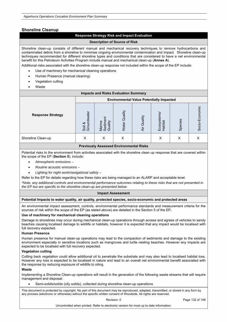
Nganhurra Operations Cessation Environment Plan Summary
This document is protected by copyright. No part of this document may be reproduced, adapted, transmitted, or stored in any form by any process (electronic or otherwise) without the specific written consent of Woodside. All rights are reserved.
Revision: 0 Page 132 of 148
Uncontrolled when printed. Refer to electronic version for most up to date information.
Shoreline Cleanup Response Strategy Risk and Impact Evaluation
Description of Source of Risk
Shoreline clean-up consists of different manual and mechanical recovery techniques to remove hydrocarbons and contaminated debris from a shoreline to minimise ongoing environmental contamination and impact. Shoreline clean-up techniques recommended for different shoreline types and conditions that are considered to have a net environmental benefit for this Petroleum Activities Program include manual and mechanical clean-up (Annex A).
Additional risks associated with the shoreline clean-up response not included within the scope of the EP include:
Use of machinery for mechanical cleaning operations
Human Presence (manual cleaning)
Vegetation cutting
Waste
Impacts and Risks Evaluation Summary
Response Strategy
Environmental Value Potentially Impacted
Soi
l &
Gro
und
wat
er
Mar
ine
Sed
imen
t Q
ualit
y
Wat
er Q
ualit
y
Air
Qua
lity
Eco
syst
ems/
H
abita
t
Spe
cies
Soc
io-E
cono
mic
Shoreline Clean-up X X X X X X
Previously Assessed Environmental Risks
Potential risks to the environment from activities associated with the shoreline clean up response that are covered within the scope of the EP (Section 5), include:
Atmospheric emissions –
Routine acoustic emissions –
Lighting for night work/navigational safety –
Refer to the EP for details regarding how these risks are being managed to an ALARP and acceptable level.
*Note, any additional controls and environmental performance outcomes relating to these risks that are not presented in the EP but are specific to the shoreline clean-up are presented below.
Impact Assessment
Potential Impacts to water quality, air quality, protected species, socio-economic and protected areas
An environmental impact assessment, controls, environmental performance standards and measurement criteria for the sources of risk within the scope of the EP (as stated above) are detailed in the Section 5 of the EP.
Use of machinery for mechanical cleaning operations
Damage to shorelines may occur during mechanical clean-up operations through access and egress of vehicles to sandy beaches causing localised damage to wildlife or habitats, however it is expected that any impact would be localised with full recovery expected.
Human Presence
Human presence for manual clean-up operations may lead to the compaction of sediments and damage to the existing environment especially in sensitive locations such as mangroves and turtle nesting beaches. However any impacts are expected to be localised with full recovery expected.
Vegetation cutting
Cutting back vegetation could allow additional oil to penetrate the substrate and may also lead to localised habitat loss. However any loss is expected to be localised in nature and lead to an overall net environmental benefit associated with the response by reducing exposure of wildlife to oiling.
Waste
Implementing a Shoreline Clean-up operations will result in the generation of the following waste streams that will require management and disposal:
Semi-solids/solids (oily solids), collected during shoreline clean-up operations

Nganhurra Operations Cessation Environment Plan Summary
This document is protected by copyright. No part of this document may be reproduced, adapted, transmitted, or stored in any form by any process (electronic or otherwise) without the specific written consent of Woodside. All rights are reserved.
Revision: 0 Page 133 of 148
Uncontrolled when printed. Refer to electronic version for most up to date information.
PPE
Oiled debris (seaweed, drift wood etc.)
If not managed and disposed of correctly, wastes generated during the response have the potential for secondary contamination potentially including impacts to wildlife through contact with or ingestion of waste materials and contamination of terrestrial sediments if not disposed of correctly onshore.
Control Measures for Response Strategy Risks and Impacts
Use of machinery for mechanical cleaning operations
Access for machinery for shoreline clean-up operations will be considered as part of the tactical response planning. An assessment of the most suitable access will be undertaken.
Additionally mechanical clean-up operations would not be conducted on turtle nesting beaches during periods of nesting nor in proximity to mangroves.
OM04 and OM05 would be used to guide the presence/absence of wildlife sensitive to mechanical clean-up operations and this information would be considered in the operational NEBA.
Acceptability statement
The control measures will reduce the risk associated with the use of machinery in a shoreline clean-up operation. It is expected that any impacts once the control measures are implemented would be highly localised and full recovery would be expected ensuring the risk is ALARP and acceptable.
Human Presence
Due consideration to sensitive environments will be given during the pre-emptive assessment and shoreline assessment programs. Defined access/egress routes will be included. .
Acceptability statement
The proposed control measures would ensure that the risks associated with human presence are minimised and assessed in the context of the overall spill response ensuring there is a net environmental benefit associated with shoreline clean-up operations. The consideration of the environmental risks in the shoreline assessment and pre emptive assessment (OM04 and OM05) will ensure that the risks associated with human presence are ALARP and acceptable
Vegetation cutting
Vegetation cutting would be minimised with only moderately or heavily oiled vegetation removed
Acceptability statement
Ensuring that only moderately or heavily oiled vegetation is removed will ensure the preservation of vegetation that would naturally recover from a spill ensuring the risks associated with the removal of excess vegetation are reduced to an ALARP and acceptable level.
Waste
Woodside has in place a waste management plan to manage the waste from shoreline clean-up operations. This plan includes controls to appropriately manage this waste stream in accordance with regulations and best industry practice. All controlled waste will be transported by a controlled waste contractor and all hazardous waste by a licensed hazardous waste contractor. The transport of all waste onshore will use licenced vehicles in accordance with environmental protection regulations 2004.
Acceptability Statement
The use of licensed contractors and vehicles in accordance with the relevant regulations ensures systems and processes will be in place to minimise the risk of secondary contamination during the handling of waste from a shoreline clean-up operation reducing risks to an ALARP and acceptable level.

Nganhurra Operations Cessation Environment Plan Summary
This document is protected by copyright. No part of this document may be reproduced, adapted, transmitted, or stored in any form by any process (electronic or otherwise) without the specific written consent of Woodside. All rights are reserved.
Revision: 0 Page 134 of 148
Uncontrolled when printed. Refer to electronic version for most up to date information.
Oiled Wildlife Response Response Strategy Risk and Impact Evaluation
Description of Source of Risk
An oiled wildlife response would involve reconnaissance from vessels, aircraft and shoreline surveys, the capture, transport, rehabilitation and release of oiled wildlife.
Additional environmental risks associated with the oiled wildlife response not included within the scope of the EP include:
Additional stress or injury caused to wildlife
Additional stress or injury to wildlife could be caused through the following phases of a response:
Capturing wildlife
Transporting wildlife
Stabilisation of wildlife
Cleaning and rinsing of oiled wildlife
Rehabilitation (e.g. diet, cage size, housing density)
Release of treated wildlife
Presence of personnel on the shoreline
During the implementation of response strategies, it is possible that personnel may have minimal, localised impacts on habitats, wildlife and coastlines.
Secondary contamination from the management of waste
Inappropriate handling of waste generated from oiled wildlife operations could lead to secondary contamination
Impacts and Risks Evaluation Summary
Response Strategy
Environmental Value Potentially Impacted
Soi
l &
Gro
und
wat
er
Mar
ine
Sed
imen
t Q
ualit
y
Wat
er Q
ualit
y
Air
Qua
lity
Eco
syst
ems/
H
abita
t
Spe
cies
Soc
io-E
cono
mic
Oiled Wildlife X X
Previously Assessed Environmental Risks
Potential risks to the environment from activities associated with the oiled wildlife response that are covered within the scope of the EP (Section 5), include:
Atmospheric emissions –
Routine and non-routine discharges –
Physical presence, proximity to other vessels (shipping and fisheries)-
Routine acoustic emissions –
Lighting for night work/navigational safety –
Invasive marine species –
Collision with marine fauna-
Refer to the EP for details regarding how these risks are being managed to an ALARP and acceptable level.
*Note, any additional controls and environmental performance outcomes relating to these risks that are not presented in the EP but are specific to the wildlife are assessed below.
Impact Assessment
Potential Impacts to habitats and protected species
An environmental impact assessment, controls, environmental performance standards and measurement criteria for the sources of risk within the scope of the EP (as stated above) are detailed in the Section 5.
Additional stress or injury caused to wildlife
Inefficient capture techniques have the potential to cause undue stress, exhaustion or injury to wildlife, additionally pre-emptive capture could cause undue stress and impacts to wildlife when there are uncertainties in the forecast trajectory

Nganhurra Operations Cessation Environment Plan Summary
This document is protected by copyright. No part of this document may be reproduced, adapted, transmitted, or stored in any form by any process (electronic or otherwise) without the specific written consent of Woodside. All rights are reserved.
Revision: 0 Page 135 of 148
Uncontrolled when printed. Refer to electronic version for most up to date information.
of the spill. During the transportation and stabilisation phases there is the potential for additional thermoregulation stress on captured wildlife. Additionally during the cleaning process it is important personnel undertaking the tasks are familiar with the relevant techniques to ensure that further injury and the removal of water proofing feathers are managed and mitigated. Finally during the release phase it’s important that wildlife are not released back into a contaminated environment.
Presence of personnel on the shoreline
Presence of personnel on the shoreline during shoreline operations could potentially result in disturbance to wildlife and habitats. The impacts associated with human presence on shorelines during an oiled wildlife response may include:
Damage to vegetation/habitat to gain access to areas of shoreline oiling;
Damage or disturbance to wildlife during shoreline surveys;
Removal of surface layers of intertidal sediments (potential habitat depletion); and
Excessive removal of substrate causing erosion and instability of localised areas of the shoreline. Secondary contamination from the management of waste
Implementing the selected response strategies will result in the generation of the following waste streams that will require management and disposal:
Liquids (recovered oil/water mixture), recovered from wildlife response operations
Semi-solids/solids (oily solids), collected during wildlife response operations
Carcasses, collected during wildlife response operations.
If not managed and disposed of correctly, wastes generated during the response have the potential for secondary contamination.
Control Measures for Response Strategy Risks and Impacts
Additional stress or injury caused to wildlife
To ensure appropriate techniques are used through all phases of an oiled wildlife response operations would be conducted with advice from the DBCA Oiled Wildlife Advisor and in accordance with the processes and methodologies described in the WA OWRP and the relevant regional plan.
Acceptability Statement
The controls referenced above will minimise the risk of additional stress or injury to wildlife in a response through the use of best industry practice. Ensuring relevant techniques are used throughout a response under trained and expert supervision ensures the risks associated with additional stress or injury to oiled wildlife are reduced to an ALARP and acceptable level.
Presence of personnel on the shoreline
Impacts associated with personnel on the shoreline conducting oiled wildlife operations including disturbance to wildlife, habitats and local sediments can be minimised through the oversight by trained personnel who are aware of the risks. Trained unit leaders would make all personnel aware of the environmental risks prior to commencing operations. The risks associated with this response are localised with full recovery expected.
Acceptability Statement
This additional control will further reduce the risks associated with the presence of personnel conducting shoreline assessments to an ALARP and acceptable level.
Secondary contamination from the management of waste
Woodside has in place a waste management plan to manage the waste from shoreline clean-up operations. This plan includes controls to appropriately manage this waste stream in accordance with regulations and best industry practice. All controlled waste will be transported by a controlled waste contractor and all hazardous waste by a licensed hazardous waste contractor. The transport of all waste onshore will use licenced vehicles in accordance with environmental protection regulations 2004.
Acceptability Statement
The use of licensed contractors and vehicles in accordance with the relevant regulations ensures systems and processes will be in place to minimise the risk of secondary contamination during the handling of waste from an oiled wildlife operation reducing risks to an ALARP and acceptable level.

Nganhurra Operations Cessation Environment Plan Summary
This document is protected by copyright. No part of this document may be reproduced, adapted, transmitted, or stored in any form by any process (electronic or otherwise) without the specific written consent of Woodside. All rights are reserved.
Revision: 0 Page 136 of 148
Uncontrolled when printed. Refer to electronic version for most up to date information.
Scientific Monitoring Response Strategy Risk and Impact Evaluation
Description of Source of Risk
Field-based activities undertaken during SMP implementation include vessel operations in the nearshore and offshore environments, in addition to coastal monitoring and data collection at intertidal and subtidal habitats, resulting in potential impacts to the receiving environment.
Additional risks associated with Scientific Monitoring implementation not included within the scope of the EP include:
Seabed disturbance that may be associated with Vessel anchoring
During the implementation of response strategies, where water depths allow, it is possible that response vessels will be required to anchor (e.g. during shoreline surveys). The use of vessel anchoring will be minimal, and likely to occur when the impacted shoreline is inaccessible via road to SMP teams.
Impacts and Risks Evaluation Summary
Response Strategy
Environmental Value Potentially Impacted
Soi
l &
Gro
und
wa
ter
Mar
ine
Sed
imen
t Q
ualit
y
Wat
er
Qua
lity
Air
Qua
lity
Eco
syst
em
s/H
abita
t
Spe
cies
Soc
io-
Eco
nom
ic
Scientific Monitoring X X X X X X X
Previously Assessed Environmental Risks
Potential risks to the environment from activities associated with the SMP field activities that are covered within the scope of the EP (Section 5), include:
Atmospheric emissions –
Routine and non-routine discharges –
Physical presence, proximity to other vessels (shipping and fisheries)-
Routine acoustic emissions vessels –
Lighting for night work/navigational safety –
Collision with marine fauna-
Refer to the EP for details regarding how these risks are being managed to an ALARP and acceptable level.
*Note, any additional controls and environmental performance outcomes relating to these risks that are not presented in the EP but are specific to the SMP are presented below.
Impact Assessment
Potential Impacts to water quality, air quality, protected species, socio-economic and protected areas
Seabed disturbance that may be associated with Vessel anchoring
Anchoring in the nearshore environment at sensitive receptor locations will have potential to impact coral reef, seagrass beds and other benthic communities in these areas Recovery of benthic communities from anchor damage depends on the size of anchor and frequency of anchoring. Impacts would be highly localised (restricted to the footprint of the vessel anchor) and temporary, with full recovery expected.
See Section 8.10.10 for controls, environmental performance standards listed above and measurement criteria for management of the impacts described above.
Control Measures for Response Strategy Risks and Impacts
Seabed disturbance from vessel anchoring
Any impacts associated with the anchoring of vessels in the nearshore environment or the use of vessels to access remote shorelines is expected to be highly localised. However, a number of control measures will be implemented to further reduce the risk to nearshore environments.
Where available and suitable existing mooring points would be used for anchoring. Where existing fixed anchoring points are not available locations will be selected to minimise impact to nearshore benthic environments.
Acceptability Statement
Given that the initial risk demonstrated that impacts would be localised with full recovery expected, these additional controls further reduce the risk to an ALARP and acceptable level.

Nganhurra Operations Cessation Environment Plan Summary
This document is protected by copyright. No part of this document may be reproduced, adapted, transmitted, or stored in any form by any process (electronic or otherwise) without the specific written consent of Woodside. All rights are reserved.
Revision: 0 Page 137 of 148
Uncontrolled when printed. Refer to electronic version for most up to date information.
APPENDIX C: SUMMARY OF STAKEHOLDER FEEDBACK AND WOODSIDE’S ASSESSMENTS AND REPONSES

Nganhurra Operations Cessation Environment Plan Summary
This document is protected by copyright. No part of this document may be reproduced, adapted, transmitted, or stored in any form by any process (electronic or otherwise) without the specific written consent of Woodside. All rights are reserved.
Revision: 0 Page 138 of 148
Uncontrolled when printed. Refer to electronic version for most up to date information.
Relevant Stakeholder feedback for the Petroleum Activities Program
Organisation Method Feedback Woodside assessment Woodside’s Response
Department of Industry Innovation and Science
Email with fact sheet
Date: 1 March 2017
Feedback summary: No response at the time of submission.
Woodside will accept and assess feedback from stakeholder post EP submission to NOPSEMA.
Response/Action: No further action required.
Email advice about revised timing for proposed activity
Date: 24 July 2017
Feedback summary: No response at the time of submission.
Woodside will accept and assess feedback from stakeholder post EP submission to NOPSEMA.
Response/Action: No further action required.
Department of Mines, Industry Regulation and Safety (DMIRS)
Email with fact sheet
Date: 1 March 2017
Feedback summary: No response at the time of submission.
Woodside will accept and assess feedback from stakeholder post EP submission to NOPSEMA.
Response/Action: No further action required.
Email advice about revised timing for proposed activity
Date: 24 July 2017
Feedback summary: The Department acknowledged Woodside’s advised on the revised timing of the proposed activity.
The Department requested to be advised once the cessation of production date is confirmed.
The stakeholder raised no claims or objections.
Response/Action: Woodside to inform the Department on confirmed date for cessation of production

Nganhurra Operations Cessation Environment Plan Summary
This document is protected by copyright. No part of this document may be reproduced, adapted, transmitted, or stored in any form by any process (electronic or otherwise) without the specific written consent of Woodside. All rights are reserved.
Revision: 0 Page 139 of 148
Uncontrolled when printed. Refer to electronic version for most up to date information.
Organisation Method Feedback Woodside assessment Woodside’s Response
Australian Maritime Safety Authority
Email with fact sheet Date: 6 March 2017
Feedback summary: The Authority advised that there will be no impacts to commercial shipping as the activities will not occur within the PSZ gazetted.
The Authority also advised that there is no requirement to promulgate a notice to mariners or an AUSCOAST warning.
The Authority requested Woodside notify AHS when the FPSO disconnects to ensure the marine charts can be updated.
The stakeholder raised no claims or objections.
Response/Action:
Woodside to observe communication requirements for vessel interactions. Requested advice to be supplied to AMSA’s JRCC and AHS within outlined timeframes.
Email advice about revised timing for proposed activity
Date: 24 July 2017
Feedback summary: AMSA acknowledged Woodside’s advice that the environment plan submission date has been revised to August 2017.
The stakeholder raised no claims or objections.
Response/Action: No further action required.
Australian Hydrographic Service (AHS)
Email with fact sheet Date: 3 March 2017
Feedback summary: AHS confirmed receipt of Woodside’s advice via email.
The stakeholder raised no claims or objections.
Response/Action:
No further action required.
Email with fact sheet Date: 6 March 2017
Feedback summary: AHS asked to be kept informed to
The stakeholder raised no claims or objections.
Response/Action: Woodside to engage AHS closer to commencement of
Nganhurra Operations Cessation Environment Plan Summary
This document is protected by copyright. No part of this document may be reproduced, adapted, transmitted, or stored in any form by any process (electronic or otherwise) without the specific written consent of Woodside. All rights are reserved.
Revision: 0 Page 140 of 148
Uncontrolled when printed. Refer to electronic version for most up to date information.
Organisation Method Feedback Woodside assessment Woodside’s Response
action the appropriate Notice to Mariners.
activities.
Email advice about revised timing for proposed activity
Date: 25 July 2017
Feedback summary:
AHS confirmed receipt of Woodside’s advice via email.
The stakeholder raised no claims or objections.
Response/Action: No further action required.
Pearl Producers Association Email with fact sheet
Date: 1 March 2017
Feedback summary: No response at the time of submission.
Woodside will accept and assess feedback from stakeholder post EP submission to NOPSEMA.
Response/Action: No further action required.
Email advice about revised timing for proposed activity
Date: 24 July 2017
Feedback summary: No response at the time of submission.
Woodside will accept and assess feedback from stakeholder post EP submission to NOPSEMA.
Response/Action: No further action required.
Department of Primary Industries and Regional Development (Western Australia) (formerly Department of Fisheries)
Email with fact sheet
Teleconference
Date: 10 April 2017
Feedback summary: Woodside phoned the Department to discuss the proposed activities. A voicemail was left on 10 April 2017. No response was received at the time of submission.
Woodside will accept and assess feedback from stakeholder post EP submission to NOPSEMA.
Response/Action: No further action required.
Email Date: 11 April 2017
Feedback summary: The Department via email recommends Woodside engages with WAFIC, Pearl Producers Association, Recfishwest, relevant Traditional Owner groups
Woodside acknowledged the Department’s advice via email on 20 April 2017.
Woodside confirmed the stakeholders that it had engaged and will continue to engage with about the proposed activity.
Response/Action: If the six month validity period of the department’s advice expires Woodside will
notify the Department of Primary Industries and Regional Development (formerly known as

Nganhurra Operations Cessation Environment Plan Summary
This document is protected by copyright. No part of this document may be reproduced, adapted, transmitted, or stored in any form by any process (electronic or otherwise) without the specific written consent of Woodside. All rights are reserved.
Revision: 0 Page 141 of 148
Uncontrolled when printed. Refer to electronic version for most up to date information.
Organisation Method Feedback Woodside assessment Woodside’s Response
and fishers and charter boat operators in the area.
The Department advised that its advice remains valid should the proposed activity commence within six months, otherwise advice may be updated.
The Department requests to be consulted in a reasonable period of time should the activities occur outside of this timeframe.
The Department recommended resources for Woodside to demonstrate it has taken reasonable measures to reduce its chances of carrying out offences under the Fish Resources Management Act 1994 and associated regulations.
The Department requested that suspected or confirmed marine pest or disease is report within 24 hours.
The Department requested contact by phone and email in the event of a hydrocarbon spill within 24 hours of Woodside reporting the incident to the relevant Authority.
Woodside acknowledged the timeframe that the Department’s advice remains valid.
Woodside ensures compliance with biosecurity requirements through its implementation of its own Invasive Marine Species Management Plan, which is supported at a Commonwealth level.
This process demonstrates compliance with the Fish Resources Management Act 1994.
Woodside strongly encourages its contractors to use the Department’s Vessel Check tool to proactively manage Invasive Marine Species risk when not on contract to the company.
Woodside advised that suspected or confirmed presence of marine pest or disease will be reported to the Department within 24 hours.
In the unlikely event of an oil spill or discharge into the environment, Woodside will notify relevant agencies and organisations as appropriate
Department of Fisheries) 3 months prior to the commencement of the Petroleum Activity Program

Nganhurra Operations Cessation Environment Plan Summary
This document is protected by copyright. No part of this document may be reproduced, adapted, transmitted, or stored in any form by any process (electronic or otherwise) without the specific written consent of Woodside. All rights are reserved.
Revision: 0 Page 142 of 148
Uncontrolled when printed. Refer to electronic version for most up to date information.
Organisation Method Feedback Woodside assessment Woodside’s Response
The Department requested that specific strategies are developed in the EP to mitigate impacts on fish spawning.
The Department requests consultation on plug and abandonment, and decommissioning activities associated with this project.
to the nature and scale of the event, as soon as practicable following the occurrence.
Woodside selects oil spill response strategies based on Net Environmental Benefit Analysis (NEBA). The NEBA process takes into account potential benefits/impacts of response strategies to all environmental sensitivities.
Woodside confirms that the NEBA process includes analysis of potential benefits/impacts of spawning grounds and nursery areas.
Woodside confirms that the Department will be engaged on future EPs for Enfield and decommissioning activities.
Email advice about revised timing for proposed activity
Date: 24 July 2017
Feedback summary: The Department acknowledged Woodside’s advice and noted it had no further comments at this point in time.
Woodside will accept and assess feedback from stakeholder post EP submission to NOPSEMA.
Response/Action: No further action required.
Commonwealth fisheries Email with fact sheet
Date: 1 March 2017
Feedback summary: No response at the time of submission.
Woodside will accept and assess feedback from stakeholder post EP submission to NOPSEMA.
Response/Action: No further action required.
Email advice about revised timing for proposed activity
Date: 24 July 2017
Feedback summary: No
Woodside will accept and assess feedback from stakeholder post EP
Response/Action: No further action required.

Nganhurra Operations Cessation Environment Plan Summary
This document is protected by copyright. No part of this document may be reproduced, adapted, transmitted, or stored in any form by any process (electronic or otherwise) without the specific written consent of Woodside. All rights are reserved.
Revision: 0 Page 143 of 148
Uncontrolled when printed. Refer to electronic version for most up to date information.
Organisation Method Feedback Woodside assessment Woodside’s Response
response at the time of submission.
submission to NOPSEMA.
Western Australian Fisheries Letter with fact sheet
Date: 1 March 2017
Feedback summary: No response at the time of submission.
Woodside will accept and assess feedback from stakeholder post EP submission to NOPSEMA.
Response/Action: No further action required.
Department of Transport Email with fact sheet Date: 3 March 2017
Feedback summary: The Department acknowledged Woodside’s advice via email. The Department provided a copy of its Offshore Petroleum Industry Guidance Note for ‘Marine Oil Pollution: Response and Consultation Arrangements’.
The stakeholder raised no claims or objections.
Response/Action: Woodside is addressing the Department’s Guidance Note in the First Strike Plan for the Nganhurra FPSO.
Email with Nganhurra Operations Cessation Oil Pollution First Strike Plan
Date: 11 April 2017
Feedback summary: No response at the time of submission.
Woodside will accept and assess feedback from stakeholder post EP submission to NOPSEMA.
Response/Action: No further action required.
Email with updated Nganhurra Operations Cessation Oil Pollution First Strike Plan
Date: 13 October 2017
Feedback summary: No response at the time of submission.
Woodside will accept and assess feedback from stakeholder post EP submission to NOPSEMA.
Response/Action: No further action required.
Email advice about revised timing for proposed activity
Date: 24 July 2017
Feedback summary: No response at the time of submission.
Woodside will accept and assess feedback from stakeholder post EP submission to NOPSEMA.
Response/Action: No further action required.
Meeting to brief DoT on upcoming EP submissions.
Date: 1 August 2017
Feedback summary: The DoT requested Woodside to
The stakeholder raised no claims or objections.
Response/Action: Woodside submitted requested information to DoT

Nganhurra Operations Cessation Environment Plan Summary
This document is protected by copyright. No part of this document may be reproduced, adapted, transmitted, or stored in any form by any process (electronic or otherwise) without the specific written consent of Woodside. All rights are reserved.
Revision: 0 Page 144 of 148
Uncontrolled when printed. Refer to electronic version for most up to date information.
Organisation Method Feedback Woodside assessment Woodside’s Response
provide details regarding the NGA Cessation of Operations activity as associated oil spill response controls.
on 3 August 2017
No further action required.
Western Australian Fishing Industry Council (WAFIC)
Email with fact sheet
Teleconference
Date: 10 April 2017
Feedback summary: Woodside phoned the Department to discuss the proposed activities. A voicemail was left on 10 April 2017.
Woodside will accept and assess feedback from stakeholder post EP submission to NOPSEMA.
Response/Action:
No further action required.
Email Date: 10 April 2017
Feedback summary: WAFIC advised via email that the proposed activity is business as usual proceeding eventual decommissioning.
WAFIC noted the exclusion zones that are in place for the proposed in-field activities.
WAFIC asked for confirmation that the exclusion zones will be removed once the RTM and MODU have left the field.
WAFIC advised that the site does not interact with any state-managed trawl fisheries in the broader region.
WAFIC suggested further
Woodside advised WAFIC via email that the exclusion zone will only exist while the RTM and MODU are in place.
Woodside will update AHS records once the RTM has been removed from field.
Woodside confirmed that it has identified the Western Deepwater Trawl fishery as relevant for the EP.
Woodside confirmed that WAFIC’s comments in relation the 2.5 km radius precautionary zone as relevant.
Fishers are permitted within this zone and are encouraged to exercise caution. Woodside advised
Response/Action:
Woodside to communicate with contractors that fishers have a right to traverse, anchor and fish within the requested 2.5 km precautionary zone around the MODU.

Nganhurra Operations Cessation Environment Plan Summary
This document is protected by copyright. No part of this document may be reproduced, adapted, transmitted, or stored in any form by any process (electronic or otherwise) without the specific written consent of Woodside. All rights are reserved.
Revision: 0 Page 145 of 148
Uncontrolled when printed. Refer to electronic version for most up to date information.
Organisation Method Feedback Woodside assessment Woodside’s Response
analysis of the Commonwealth-managed trawl fishery, the Western Deepwater Trawl fishery to understand if the site overlaps with this fishery. WAFIC also provided fishery efforts for this fishery.
WAFIC advised that fishers still have a right to traverse, anchor and fish within the requested 2.5 km precautionary zone around the MODU.
that it would communicate this information with contractors working in the area.
Meeting Date: 18 July 2017
Feedback summary: Woodside held a meeting with WAFIC to provide an overview of current Woodside activities.
Woodside provided advice on the revised timing for Nganhurra cessation of production. WAFIC provided no further comments.
The stakeholder raised no claims or objections.
Response/Action: No further action required.
Email advice about revised timing for proposed activity
Date: 24 July 2017
Feedback summary: No response at the time of submission.
Woodside will accept and assess feedback from stakeholder post EP submission to NOPSEMA.
Response/Action: No further action required.
Exmouth Community Reference Group
Email with fact sheet
Date: 2 March 2017
Feedback summary: Gun Marine Services, a member of the Exmouth Community
The stakeholder raised no claims or objections.
Response/Action: No further action required.

Nganhurra Operations Cessation Environment Plan Summary
This document is protected by copyright. No part of this document may be reproduced, adapted, transmitted, or stored in any form by any process (electronic or otherwise) without the specific written consent of Woodside. All rights are reserved.
Revision: 0 Page 146 of 148
Uncontrolled when printed. Refer to electronic version for most up to date information.
Organisation Method Feedback Woodside assessment Woodside’s Response
Reference Group, acknowledged Woodside’s advice via email.
Email advice about revised timing for proposed activity
Date: 24 July 2017
Feedback summary: Base Marine, a member of the Exmouth Community Reference Group, acknowledged Woodside’s advice via email.
The stakeholder raised no claims or objections.
Response/Action:
No further action required.
Department of Defence Email with fact sheet
Date: 1 March 2017
Feedback summary: No response at the time of submission.
Woodside will accept and assess feedback from stakeholder post EP submission to NOPSEMA.
Response/Action: No further action required.
Email advice about revised timing for proposed activity
Date: 24 July 2017
Feedback summary: No response at the time of submission.
Woodside will accept and assess feedback from stakeholder post EP submission to NOPSEMA.
Response/Action: No further action required.
Nganhurra Operations Cessation Environment Plan Summary
This document is protected by copyright. No part of this document may be reproduced, adapted, transmitted, or stored in any form by any process (electronic or otherwise) without the specific written consent of Woodside. All rights are reserved.
Revision: 0 Page 147 of 148
Uncontrolled when printed. Refer to electronic version for most up to date information.
Interested Stakeholder feedback for the Petroleum Activities Program
Organisation Method Feedback Woodside assessment Woodside’s Response
Australian Maritime Safety Authority (marine pollution)
Email with fact sheet
Date: 1 March 2017
Feedback summary: No response at the time of submission.
Woodside will accept and assess feedback from stakeholder post EP submission to NOPSEMA.
Response/Action: No further action required.
Australian Maritime Safety Authority (marine pollution)
Email with Nganhurra Operations Cessation Oil Pollution First Strike Plan
Date: 11 April 2017
Feedback summary: No response at the time of submission.
Woodside will accept and assess feedback from stakeholder post EP submission to NOPSEMA.
Response/Action: No further action required.
Email with updated Nganhurra Operations Cessation Oil Pollution First Strike Plan
Date: 13 October 2017
Feedback summary: No response at the time of submission.
Woodside will accept and assess feedback from stakeholder post EP submission to NOPSEMA.
Response/Action: No further action required.
Department of Biodiversity, Conservation and Attractions (formerly known as Department of Parks and Wildlife)
Email with fact sheet
Date: 1 March 2017
Feedback summary: No response at the time of submission.
Woodside will accept and assess feedback from stakeholder post EP submission to NOPSEMA.
Response/Action: No further action required.
Australian Customs Service – Border Protection Command
Email with fact sheet
Date: 1 March 2017
Feedback summary: No response at the time of submission.
Woodside will accept and assess feedback from stakeholder post EP submission to NOPSEMA.
Response/Action: No further action required
Commonwealth Fisheries Association
Email with fact sheet
Date: 1 March 2017
Feedback summary: No response at the time of submission.
Woodside will accept and assess feedback from stakeholder post EP submission to NOPSEMA.
Response/Action: No further action required
Recfishwest Email with fact sheet
Date: 1 March 2017
Feedback summary: No response at the time of
Woodside will accept and assess feedback from stakeholder post EP
Response/Action: No further action required.

Nganhurra Operations Cessation Environment Plan Summary
This document is protected by copyright. No part of this document may be reproduced, adapted, transmitted, or stored in any form by any process (electronic or otherwise) without the specific written consent of Woodside. All rights are reserved.
Revision: 0 Page 148 of 148
Uncontrolled when printed. Refer to electronic version for most up to date information.
submission. submission to NOPSEMA.
WWF Email with fact sheet
Date: 1 March 2017
Feedback summary: No response at the time of submission.
Woodside will accept and assess feedback from stakeholder post EP submission to NOPSEMA.
Response/Action: No further action required.
Australian Conservation Foundation
Email with fact sheet
Date: 1 March 2017
Feedback summary: No response at the time of submission.
Woodside will accept and assess feedback from stakeholder post EP submission to NOPSEMA.
Response/Action: No further action required.
Wilderness Society Email with fact sheet Date: 1 March 2017
Feedback summary: No response at the time of submission.
Woodside will accept and assess feedback from stakeholder post EP submission to NOPSEMA.
Response/Action: No further action required.
International Fund for Animal Welfare
Email with fact sheet Date: 1 March 2017
Feedback summary: No response at the time of submission.
Woodside will accept and assess feedback from stakeholder post EP submission to NOPSEMA.
Response/Action: No further action required.
APPEA Email with fact sheet Date: 1 March 2017
Feedback summary: No response at the time of submission.
Woodside will accept and assess feedback from stakeholder post EP submission to NOPSEMA.
Response/Action: No further action required.
AMOSC Email with fact sheet Date: 1 March 2017
Feedback summary: No response at the time of submission.
Woodside will accept and assess feedback from stakeholder post EP submission to NOPSEMA.
Response/Action: No further action required.
Email advice about revised timing for proposed activity
Date: 24 July 2017 Feedback summary:
AHS confirmed receipt of Woodside’s advice via email.
The stakeholder raised no claims or objections.
Response/Action: No further action required.