Embed Size (px)
Citation preview
Next Generation Flood Forecasting and Warning System Evaluation and Work Plan Development
March 8, 2018
Nick Lorrain, CETManager, Capital ProjectsToronto and Region Conservation [email protected]
Sam Bellamy, P.EngPrincipal Water Resources EngineerMatrix Solutions Inc. [email protected]

1) Background
2) TRCA’s Future DSS Requirements
3) Study Process
4) Decision Support System Evaluation
5) Conclusions
6) Next Steps
Presentation Overview

Background
Current version of the Daily Planning Cycle

Background
Current version of the Daily Planning Cycle
• Provides decision making support based on precipitation forecasts counted in 24 hour increments
• Consists of basic excel hydrology calculations for tracking soil moisture and estimating peak flow at discrete sites
• Uses a single soil-moisture and recorded rainfall value to be representative for the entire jurisdiction
• Currently forecasts flows for 14 sites

Background
Limitations of the current version of the Daily Planning Cycle
• Advancements in hydrology and hydraulic modelling capabilities, the underlying equations for calculating flood thresholds in the DPC are outdated
• Spatial distribution of weather data and the resulting hydrologic impacts at a sub watershed scale is non-existent
• The DPC uses a single soil moisture and recorded rainfall value to be representative for the entire jurisdiction
• The DPC does not allow for the intake of real-time watershed information or radar
Current DPC is completely applicable for what it was intended to do, at the time it was made!

TRCA’s Future DSS RequirementsForecast horizon 3 days-24 hours 24 to 12 hours and 12-3 hours out 3 hours out - nowcastingAvailable data sources (for precipitation and weather)
Environment Canada (EC) text forecasts GEM weather model (Canada) HRDPS weather model (Canada) NAM model (US) QPF model (US) NOAA Snow cover and other satellite based snow-
water equivalent products EC 3-day thunderstorm outlook and map Weather network Thunderstorm outlook SREF model (US) Tracked Snow-Water Equivalent (tracked via
spreadsheet between biweekly readings)
(In addition to those shown to the left) HRDPS (Local Area Model, 2.5km – gridded output,
Canada) HRRR – gridded output (US, High Resolution Rapid
Refresh) EC forecaster comments Weather Network hourly precipitation prediction –
supposedly a forecaster’s interpretation of multiple models
Forecast gridded radar (NEXRAD) Forecast gridded radar (EC) (King City Radar) – may or
may not be available Forecast radar – Weather Network – may or may not
be gridded, may or may not be publicly available Other satellite derived products
Real-time Buffalo Radar (via Intellicast) NEXRAD forecast radar HRRR hourly model Real-time King City Radar Real-time TRCA Rain and stream gauges (ours) CoCoRAHs rain gauges Lightning maps (Solma, CLDM) EC Watches and warnings
Functionality we need – Wish List
Intake and consideration of multiple weather and precipitation forecast sources (NAM, GEM, etc.)
Quick check of current and expected watershed conditions
Heads up for deciding if a) need to issue a message, b) enhanced monitoring, or c) close out for the day
Decision and record keeping tool (place for forecaster comments)
Support for post-event dam operations (are we clear to draw-down the dam?)
Tracking of antecedent conditions, if hydrologic models/equations require it, in a way that accounts for spatial distribution (ie: by watershed, and by headwater versus main branch areas)
Ability to consider runoff or peak flow thresholds for each watershed, since thresholds vary.
Consider spatial and temporal distribution of forecast data, combined with soil moisture or SWE information (depending on equations) to determine flow rate predictions at key locations, including dam sites.
Complementary to what is already shown to the left, Riverine flash flood prediction in the form of flow rate
predictions at key locations (ideally, someday inundation areas, but that is not anticipated for the current DSS)
Consideration of the spatial distribution of expected precipitation
Quick run-time Easy to use interface (no DOS command prompt, clear
ability to understand the underlying processes) Well-understood, can test multiple scenarios at user
command Ability to intake hourly/15 min forecasts Remote access Graphical representation of weather forecast overlays,
and a map-based GUI component Sharable visuals (evac areas, etc – this is a future nice-
to-have, not anticipated as part of this DSS build)
Riverine flash flood prediction in the form of flow rate predictions at key locations (ideally, someday inundation areas, but that is not anticipated for the current DSS)
Consideration of the spatial distribution of expected precipitation
Quick run-time Easy to use interface (no DOS command prompt, clear
ability to understand the underlying processes) Good level of service for FVA Clusters Ability to test dam operation scenarios Intake of real-time gauging data for display and
calculation purposes, ideally intake of real-time gauging data for data correction/assimilation purposes
Comparison of predicted and actual rainfall and flow rates at key locations, ideally data correction or assimilation to increase accuracy of predictions
Ability to rank data sources and use the best one for the time (ie: radar data supersedes model data, gauged data supersedes radar data, etc.)
Sharable visuals (evac areas, etc – this is a future nice-to-have, not anticipated as part of this DSS build)
Data outputs and products needed
Aggregated precipitation forecasts in 6 hour blocks, and predicted peak flow rates
Tracking or assessment of antecedent conditions -snow and/or soil moisture
Parameters needed to estimate snowpack depletion (temperature, air, etc. – depends on snowmelt method used)
In addition to those to the left, Precipitation forecasts in hourly increments, and
predicted peak flow rates/hydrographs. Comparison against flow thresholds Comparison against dam operations rules
15-min precip- accurate forecasts/data (can be from gauges)
Good interpretation of radar to rainfall or composite gridded precipitation product that can be read by models.
Projected hydrographs to compare against thresholds Accurate thresholds, tied to flow rates
Dam ops rules

Decision Support System Wish List:
• Ability to use multiple weather forecasts and radar for long, short, and now casting
• Functionality– Decision and record keeping tool – Tracking of antecedent conditions– Consider spatial and temporal distribution of forecast data– Quick run-time– Easy to use interface– Intake of real-time gauging data for display and calculation purposes– Comparison of predicted and actual rainfall and flow rates at key locations– Ability to rank data sources and use the best available forecast
• Data outputs and products
TRCA’s Future DSS Requirements

TRCA’s Future DSS Requirements
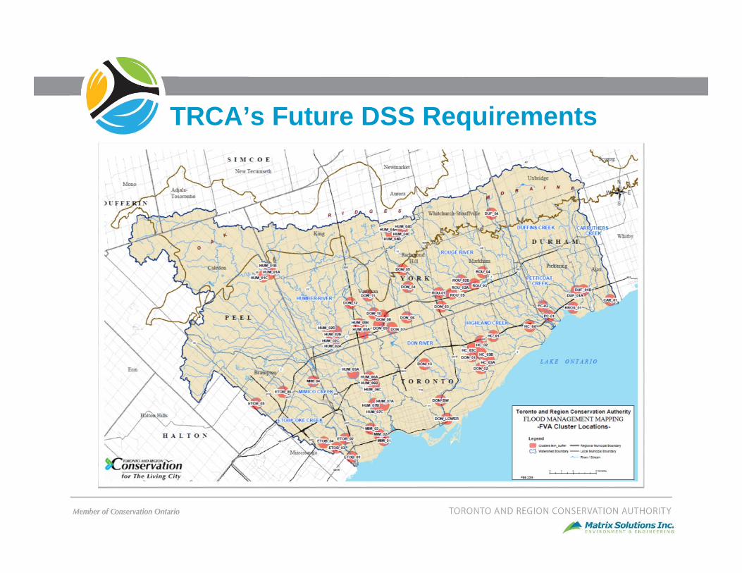
TRCA’s Future DSS Requirements

Study Process
DSS Evaluation • Identify DSS Software• Complete evaluation matrix and scoring• Identify preferred platform
DSS Standards Development• Gauging network, density and location• Hydrology modelling methodology
DSS Work Plan Development• Prioritise watersheds• Complete cost estimate• Document the work plan
Summary Report

What is a DSS?
Forecast Data- Met forecasts
- Radar products
Realtime Network-Climate-Flows
-Water Levels
DSS- User Interface
- Imports, consolidates, validates, and manipulates forecast/climate data
- Preps Data Input files for Forecast Model- Manages and displays Forecast Model
output- Archiving
- Job Control
Forecast Model• Flows
• Real-time inundation• Reservoir Operations
Flood Messaging /Warning

DSS Evaluation Approach
Preliminary Review• Screening for minimum
requirements• 7 DSSs identified
Detailed Review and Interviews• Interviews and Live
Demo’s• 5 DSSs underwent
detailed review
Evaluation and Scoring• Standardized scoring
matrix DSS Recommendation

Key Considerations
• Selected DSS must be a long-term product from a stable supplier
• Must already be in regular use by water management agencies– Preferably in Canada
• Ability to integrate multiple climate forecast products
• Leverage past investment– Existing flood forecast system– Hydrologic models

Preliminary Review
• Initial review of 7 potential DSS platforms • Initial assessment focused on the following criteria:
– Company Software and Support: DSS product is currently in use and well supported by the company with a long term vision.
– Data Acquisition and Processing: DSS has the ability to gather, validate and process multiple data sources including TRCA’s real-time data collection system, radar sources, and commonly used climate forecasts
– Model Integration and Analysis: DSS can support multiple hydrology/hydraulic modelling platforms.
• Based on the above criteria, DSS platforms were narrowed down to 5 for secondary evaluation

DSSs included in Detailed ReviewFlood Forecasting & Warning DSS Program Operational Flood Forecasting Projects
CHIPCSWMM – Real‐time
Sao Paulo, BrazilToronto, Ontario (Don River Watershed, Pilot Project)Cooksville Creek Watershed, Toronto, Canada
USACEHEC‐RTS
San Diego River Watershed, USASatluj and Beas Basin, TibetMill Creek, Tennessee
DHIMike Operations
National Institute of Hydrology, IndiaChao Phraya River Basin, ThailandSlovenian Environmental Agency (ARSO)ARPA Piedmont, Italy
DeltaresDelft‐FEWs
Tennessee Valley Authority, USASaint John River Basin, New Brunswick, CanadaNational Weather Service (NOAA)> 30 watersheds
InnovyzeFloodWorks/Now ICMLive
Thames River, United KingdomSan Antonio River, USACork County, IrelandBangkok Thailand
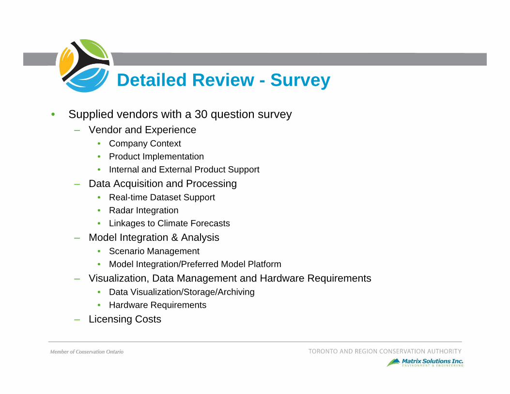
Detailed Review - Survey
• Supplied vendors with a 30 question survey– Vendor and Experience
• Company Context• Product Implementation• Internal and External Product Support
– Data Acquisition and Processing• Real-time Dataset Support• Radar Integration• Linkages to Climate Forecasts
– Model Integration & Analysis• Scenario Management• Model Integration/Preferred Model Platform
– Visualization, Data Management and Hardware Requirements• Data Visualization/Storage/Archiving• Hardware Requirements
– Licensing Costs

Detailed Review – Interviews & Demos
• Following survey, interviews were held– Live demonstration– Technical Q&A
• Themes– Limited implementation of flood forecasting and DSS platforms within Canada.
• Platforms has largely been implemented in Europe, Asia, and USA– Development of Flood Forecasting DSS’s have largely been extensions of
existing model platforms• Delft-FEWs is the only platform evaluated that commonly interfaces with differing
modelling platforms. – Technical capabilities are generally similar between DSS’s. Differences include
• Level of local support• How broadly the DSS has been applied• Ease at which multiple climate forecasts can be considered and displayed• Differing levels of user freedom that can be implemented• Cost

Evaluation Summary
Vendor & Experience Data Acquisition and Processing
Model Integration and Analysis
Visualization,Data Management and Hardware Requirements
SoftwareCost
PCSWMMReal‐time
- Well established commercial vendor- Forecast product recently marketed - Local support
- Similar linkages to common climate model forecasts and radar sources
- Scripting ability to link to alternative forecast sources
- Developed to support PCSWMM- 3rd party model adaptors possible
- Similar abilities related to data management/visualization.
- Common scripting abilities allow customization
- Hardware requirements are minimal
- 4K + model license
HEC‐RTS
- Well established institutionalvendor- Long product history- Website states no support to non USACE members…..but
- Developed to support HEC-HMS- 3rd party model adaptors possible
- No licensing costs
MIKEOperations
- Well established commercial vendor- Long product history- Local support
- Developed to supportMIKE-11/SHE- Developing adaptorsfor WATFLOOD, HEC-HMS/RAS
- 20K + model license
Delft‐FEWs
- Well established institutionalvendor- Long product history- North American support
- 80 adaptors for differing hydrologic / hydraulic models
- No licensing costs
FloodWorks(ICMLive)
- Well established commercial vendor- Recent entrant to FF- Canadian support
- Developed to support InfoWorks ICM- 3rd party model adaptors possible
- 40K + model license

Conclusions
• Evaluation considered seven DSS’s, short-listed to five– Focused on literature review, vendor questionnaire, interview, live demonstration
and technical Q&A session
• Delft-FEWs was identified as the recommended DSS– Long history of product development and support (> 15 years)
• Institutional support• Active user community/annual conference
– Has been operationalized at a variety of scales• ~50 worldwide, ~ 20 in North America• Ranging from continental (NOAA National Weather Service, Australian Bureau of
Meteorology,) to regional (St. John River Basin NB and Netherlands)
– Demonstrated ability to integrate with many different modelling platforms
– Highly modular• Riverine flooding/inundation, water quality, groundwater, coastal flooding, real-time
control and optimization

Next Steps
Complete the standards development
Complete the work plan include cost assessment
Prepare NDMP Intake 5 ask for initial system build

Thank You