Embed Size (px)
Citation preview

July 2006NEWSLETTER
PO Box 17-719, Christchurch www.summitroadsociety.org.nz [email protected] President: Mike White 03-3121551 secretary: John Goodrich 03-3267330
Annual General Meeting
The Society 's Annual General Meet ing was held on the 22nd March. At a wel l attended gathering, in add i t ion to rou t ine bus iness , Pro fessor J im Cole from the Department of Geological Sciences, Universi ty of Canterbury, gave an i l lustrated talk ent i t led "Banks Peninsu la Volcanoes" . You wi l l recal l that last year, J im led a geology f ie ld t r ip for us, and an abridged version of the notes from th is is inc luded in th is newslet ter.
President, Mike White, summarised a successful year fo r the Soc ie ty, and opened h is repor t as fol lows, expressing sentiments that we al l share:
"The importance of the Port Hi l ls to Christchurch and i ts c i t izens is undeniable. The Summit Road Soc ie ty i s p roud o f the impor tan t ro le i t p lays a m o n g s t a n e t w o r k o f o r g a n i s a t i o n s a n d indiv iduals who t reasure these hi l ls and work to m a i n t a i n , p r o t e c t a n d e n h a n c e t h i s u n i q u e e n v i r o n m e n t . E a r l i e r i n o u r h i s t o r y w e w e r e poss i b l y t he on l y o rgan i sa t i on w i t h any r ea l concern fo r the open spaces o f the Por t H i l l s , fo l low ing the lone ' vo ice in the w i lderness ' o f Harry Ell . Now, thankful ly, there are many groups doing their b i t , led strongly by Chr istchurch City C o u n c i l . I t i s g r a t i f y i n g t o a c k n o w l e d g e t h e importance the Counci l p laces on the Por t Hi l ls and the resources they make avai lab le for land purchases and the management of their reserves t h r o u g h t h e P o r t H i l l s R a n g e r S e r v i c e .
To i l lus t rate how protect ion of the open spaces of our hil ls has improved in recent years, in 1980, just 6% of the land area had some form of reserve status. By June of last year 22% was protected,
compr is ing near ly 3,000 ha. of the tota l area of 13,000 ha.
However, we be l i eve tha t we canno t become c o m p l a c e n t . T h e R a n g e r S e r v i c e d o e s a magn i f i cen t job , bu t a re resources adequate? Continuous vigi lance and hard work are required to cont ro l weeds and an imal pests , to mainta in new plantings of native seedlings, and to manage r e c r e a t i o n a l f a c i l i t i e s . Vo l u n t e e r s m a k e a c o n s i d e r a b l e c o n t r i b u t i o n t o t h i s w o r k , w i t h Society members being in the forefront. Pressure on local body budgets wil l continue, and priorit ies m a y c h a n g e . P r e s s u r e f r o m c r e e p i n g u r b a n d e v e l o p m e n t w i l l c o n t i n u e t o b e a t h r e a t . "
R e f e r r i n g t o t h e m a s t h e " b a c k b o n e o f t h e Society" , Mike was able to repor t that our work part ies carr ied out 3,500 volunteer hours on Port Hi l ls parks and reserves in 2005.
In a vo te o f con f idence in the work tha t your Board is do ing, a l l ex is t ing o f f i cers and Board members were re-e lected unanimously. Jeremy Agar, p rev ious ly the Banks Pen insu la Counc i l representa t ive is now a member in a persona l c a pa c i t y, b u t w e h o p e t h a t t h e Ly t t e l t o n / M t Herbert Community Board wil l agree to him being t h e i r r e p r e s e n t a t i v e . We w e l c o m e o n e n e w member, Richard Picker ing. Richard, a sc ient is t at Crop and Food Research in Lincoln, is a keen t r a m p e r a n d a n a c t i v e m e m b e r o f t h eWeekenders.
A Well-earned rest for the Eastenders and Barnett Park
The Ohinetahi work party
From the Weedbusters website:
"Weedbusters is a weeds awareness and education programme that aims to protect New Zealand's environment from the increasing weed problem. Pest animals and plants (weeds) are the greatest threat to New Zealand's biodiversity. People play a large part in spreading environmental weeds, often without knowing it, and Weedbusters aims to educate people and raise awareness to turn this problem around."
Weedbusters is a national organisation, supported in our area by Environment Canterbury, the Department of Conservation and the City Council via the Port Hills Rangers. Recently, nominations were invited for Regional Awards, and the main award was won by the Governors Bay Landcare Group in recognition of the work they have been doing to eradicate old man's beard from covenanted land in Zephyr Terrace. The
awards were presented in Governors Bay on Saturday 27 May, by Bryan Jenkins, Chief Executive Officer of Environment Canterbury.
We are pleased to be able to report that the Society's work was also recognised. The Ohinetahi group was nominated by Jenny Wil l iams of Ecan, for their weedbusting efforts in Ohinetahi Reserve, and the Weekenders, by Di Carter (Port Hills Rangers) for the work it has been carrying out in Sugarloaf Reserve. Both groups were presented with certif icates and native seedlings.
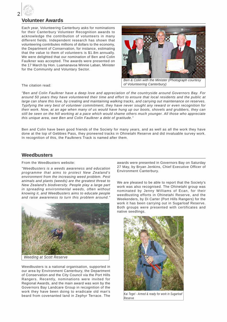
Volunteer AwardsEach year, Volunteering Canterbury asks for nominations for their Canterbury Volunteer Recognition awards to acknowledge the contribution of volunteers in many different fields. Independent research has shown that volunteering contributes millions of dollars to the economy, the Department of Conservation, for instance, estimating that the value to them of volunteers is $1.8m annually. We were delighted that our nomination of Ben and Colin Faulkner was accepted. The awards were presented on the 17 March by Hon. Luamanavoa Winnie Laban, Minister for the Community and Voluntary Sector.
"Ben and Colin Faulkner have a deep love and appreciation of the countryside around Governors Bay. For around 50 years they have volunteered their time and effort to ensure that local residents and the public at large can share this love, by creating and maintaining walking tracks, and carrying out maintenance on reserves. Typifying the very best of volunteer commitment, they have never sought any reward or even recognition for their work. Now, at an age when many of us would have hung up our boots, shovels and grubbers, they can still be seen on the hill working at a pace which would shame others much younger. All those who appreciate this unique area, owe Ben and Colin Faulkner a debt of gratitude."
Ben and Colin have been good friends of the Society for many years, and as well as all the work they have done at the top of Gebbies Pass, they pioneered tracks in Ohinetahi Reserve and did invaluable survey work. In recognition of this, the Faulkners Track is named after them.
Weedbusters
Ben & Colin with the Minister (Photograph courtesy of Volunteering Canterbury)
Kai Tegel - Armed & ready for work in Sugarloaf Reserve
Weeding at Scott Reserve
The citation read:
2

President Mike White 03-312 1551
Vice-President Maurice McGregor 332 0597
Secretary John Goodrich 326 7330
Treasurer Paul Loughton 322 7082
Board Members Anne Kennedy 377 0364 Bill Woods 03-318 4825 Geoff Bendall 384 9254Janey Thomas 03-314 9514 Jeremy Agar 328 9956Richard Pickering 332 2171 Steve Cottrell 337 9049
Summit Road Society (Inc)PO Box 17-719, ChristchurchWebsite: www.summitroadsociety.org.nzEmail: [email protected]
We are a voluntary society working to enhance, preserve and protect the natural environment, beauty and open character of the Port Hills of Banks Peninsula for people to enjoy.We need and welcome contr ibut ions to our work through memberships, donations and corporate sponsorships, participation in work parties (non-members welcome - but why not join us as well!), and bequests.
Pest Control At Ohinetahi Reserve
Resource Management
Details of our plans for animal pest control were explained in the last Newsletter. The first phase of this has been implemented, following the receipt of a grant of $1,800 from Transpower Landcare Trust. We are now delighted to be able to confirm that the balance of $2,200 has been obtained from the Eureka Trust, and this will enable us to extend the programme to the reserve's upper boundary. We feel that this is important, as it will complement the intensive work underway by the City Council in Kennedy's Bush. Robin Collie has been doing the lion's share of the work, which is quite intensive and will remain so. The Society owes a debt of gratitude to Robin for his enthusiasm and commitment.
Stoats feed on eggs and their birdsPossum browse on many native plants
The resource management area has been dominated by the ongoing appeal against the Rural Provisions of the Banks Peninsula District Plan, and the Long Term Council Community Plan process. As reported in the last newsletter, the next stage of the process for the Banks Peninsula District Plan is the landscape and indigenous vegetation studies, which will involve consultation with all stakeholders. Tenderers for the landscape study will be asked to present their tenders to the City Council shortly after 16 June, and it is anticipated that those for the indigenous vegetation study will present shortly afterwards. It is evident that it will still be some considerable time before both are completed, but hopefully, this will result at long last in having an agreed definition of 'outstanding landscape' on the peninsula, and a set of rules and policies for these areas and for indigenous vegetation.
Long Term Council Community Plans were introduced by the last Local Government Act, are intended to set a policy framework for a period of 10 years within which there is a range of "community outcomes". In Christchurch City Council's "Our Community Plan", there are a number of aspects that are positive in respect of parks and reserves and the Port Hills, such as a net increase in the amount of land per head of population, and some funds set aside for new land purchases, which we are keen to support. However, we did raise concerns about the lack of explicit recognition of the importance of the Port Hills, the amount set aside for strategic purchases, and the fact that the recently prepared Biodiversity Strategy will not be implemented. We also made a brief submission to Environment Canterbury's LTCCP, supporting its proposals for biodiversity, which includes proposals for plant and animal pest control.
3
Biodiversity Day, Little River
Membership
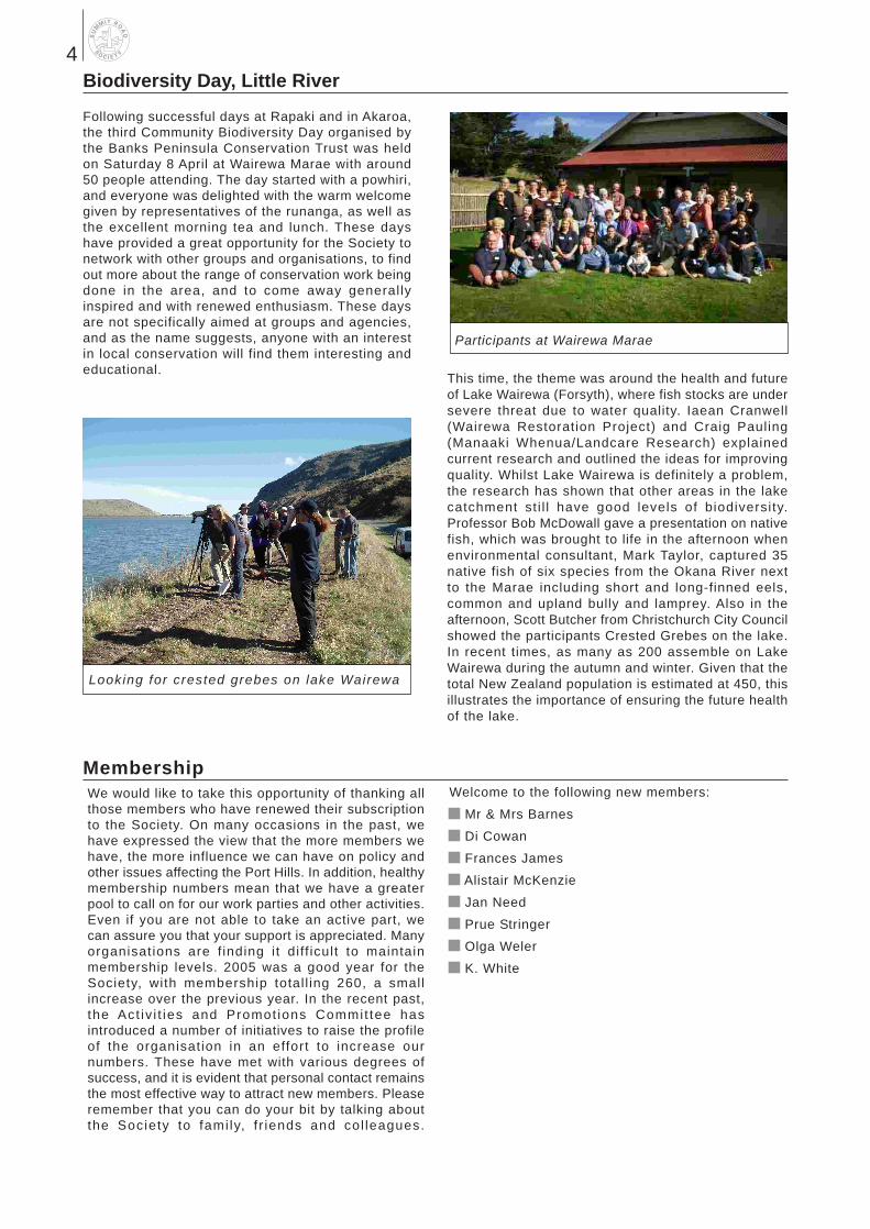
Following successful days at Rapaki and in Akaroa, the third Community Biodiversity Day organised by the Banks Peninsula Conservation Trust was held on Saturday 8 April at Wairewa Marae with around 50 people attending. The day started with a powhiri, and everyone was delighted with the warm welcome given by representatives of the runanga, as well as the excellent morning tea and lunch. These days have provided a great opportunity for the Society to network with other groups and organisations, to find out more about the range of conservation work being done in the area, and to come away generally inspired and with renewed enthusiasm. These days are not specifically aimed at groups and agencies, and as the name suggests, anyone with an interest in local conservation will find them interesting and educational.
This time, the theme was around the health and future of Lake Wairewa (Forsyth), where fish stocks are under severe threat due to water quality. Iaean Cranwell (Wairewa Restoration Project) and Craig Pauling (Manaaki Whenua/Landcare Research) explained current research and outlined the ideas for improving quality. Whilst Lake Wairewa is definitely a problem, the research has shown that other areas in the lake catchment st i l l have good levels of biodiversity. Professor Bob McDowall gave a presentation on native fish, which was brought to life in the afternoon when environmental consultant, Mark Taylor, captured 35 native fish of six species from the Okana River next to the Marae including short and long-finned eels, common and upland bully and lamprey. Also in the afternoon, Scott Butcher from Christchurch City Council showed the participants Crested Grebes on the lake. In recent times, as many as 200 assemble on Lake Wairewa during the autumn and winter. Given that the total New Zealand population is estimated at 450, this illustrates the importance of ensuring the future health of the lake.
We would like to take this opportunity of thanking all those members who have renewed their subscription to the Society. On many occasions in the past, we have expressed the view that the more members we have, the more influence we can have on policy and other issues affecting the Port Hills. In addition, healthy membership numbers mean that we have a greater pool to call on for our work parties and other activities. Even if you are not able to take an active part, we can assure you that your support is appreciated. Many organisations are f inding i t di ff icult to maintain membership levels. 2005 was a good year for the Society, with membership total l ing 260, a small increase over the previous year. In the recent past, the Act iv i t ies and Promot ions Commit tee has introduced a number of initiatives to raise the profile of the organisation in an effort to increase our numbers. These have met with various degrees of success, and it is evident that personal contact remains the most effective way to attract new members. Please remember that you can do your bit by talking about the Society to fami ly, f r iends and col leagues.
Welcome to the following new members:
Mr & Mrs Barnes
Di Cowan
Frances James
Alistair McKenzie
Jan Need
Prue Stringer
Olga Weler
K. White
Looking for crested grebes on lake Wairewa
Participants at Wairewa Marae
4

Lyttelton Harbour Landscape Protection AssociationThe Association was formed in 2004, largely as a way of putting more weight behind local objections to a proposed subdivision on the southern side of the harbour basin. The Society is a member. The main objects of the Association are:
To promote the preservation and protection of the outstanding landscapes of the Lyttelton Harbour bas in, par t icu lar ly the coasta l env i ronment , headlands, ridges and outstanding natural features that form part of the Lyttel ton Harbour basin landscape.
To advocate for the Lyt te l ton Harbour basin landscape
Despite its small size, the Association has been very active in resource management issues. In the latest of these, the Environment Court has upheld the Council's decision to allow a house to be built above Charteris Bay, at an elevation of 245m. This is largely the result of inconsistencies in the Interim Landscape Protection Area in the District Plan, which hopefully will be sorted out as a result of the landscape study. However, in view of the Association's involvement, the Court added conditions to prevent further subdivision and to impose covenants on areas of regenerating
bush. The decision also sets a very high standard for anyone wishing to build in the Interim Landscape Protection Area.
We would urge anyone who lives in the harbour basin to join the Association. The contact is Ollie Rolton, telephone 328 7283. Your Executive would also appreciate it i f someone would come forward to represent the Society at the Association's meetings and to be a contact point. If you are interested, please contact John Goodrich on 326 7330.
Arbor Day
Arbor Day originated in the USA, when in 1872, Julius Sterling Morton, a former governor of the Nebraska Territory and a keen proponent of afforestation, after many years of lobbying, succeeded in establishing a holiday to encourage tree planting. In response to growing concerns about the loss of native forest, the idea was taken up by far-sighted New Zealanders, with our first Arbor Day plantings taking place in Greytown in the Wairarapa in 1892.
Arbor Day, which marks the start of the planting season, is a time to celebrate the unique biodiversity of our country. It is a reminder that we can all play a part in protecting the native forests and wildlife which are left. Since 1977 New Zealand has celebrated Arbor Day on June 5, which is also World Environment Day. Across the country, many groups, supported by local councils and the Department of Conservation play their part by planting native trees to be enjoyed by future generations.
One of the first activities of the Summit Road Society when it was founded in 1948 by John Jameson, grandson of Harry Ell, was to reinstate Arbor Day in Christchurch. In August of that year, 300 school children planted trees in Cracroft Reserve. John, still an active Society member at 85, recalls that Deputy Mayor, Councillor Carole Evans, took part in that first Arbor Day as a student. Every year since, the Society and children from a number of schools have taken part in Arbor Day, resulting in the planting of thousands of native trees in the parks and reserves of the Port Hills, and introducing the younger generation to the importance of conservation.
In recent years, Arbor Day has been a partnership between the Society and the City Council's Port Hills Ranger staff, who recognise the importance of involving children in their planting and conservation efforts on the Port Hi l ls.
After the poor weather of Queen's Birthday weekend, Wednesday 7 June was a perfect winter's day, mild, sunshine and no wind. Children from Cashmere, Rudolf Steiner and Thorrington schools planted nearly 400 native t r ees on La t t e r s Spu r i n uppe r V i c to r i a Pa rk .
These were a mix of hardwood species including kowhai, manatu (ribbonwood), houhere (hoheria), kanuka and a mix of fruiting trees and shrubs, with long-lived totara
Lyttelton Harbour from above Little Port Cooper
5

Arbor Day (Continued)
Publicising the Society
An area that continually occupies the minds of the Activities and Promotions Committee is that of publicity for the Society and its Activities. Sometimes, however, something unexpected crops up, and this was the case for the Eastenders in April. Someone in the group knows broadcaster Liz Grant, who interviewed Geoff Bendall and Nick Singleton from the Port Hills Rangers, about the work the group has done in Barnett Park, and then spent some t ime with the Eastenders, including interviewing a number of members, as they
worked on the new track linking Barnett Park with Clifton Spur. Both these were broadcast on National Radio's 'Afternoons with Jim Mora'. Geoff has since been contacted by a couple of other groups doing similar work, and also found out that there is a group working on tracks in England's Lake District National Park. Cd copies of the broadcasts can be borrowed by contacting the Secretary.
interspersed through the plantings. These plantings on the eastern side of Victoria Park wi l l eventual ly create a podocarp/hardwood forested corridor to the Bowenvale Valley to connect with other restoration plantings and native forest remnants on the Port Hills. This is an area that has been planted on previous Arbor Days, and it is encouraging to see the success rate of the plants and to visualise what this area will look like in a few years. It is also heartening to see the enthusiasm of the children and their teachers, and to realise that yet another group of chi ldren wil l appreciate the impor tance o f conserva t ion and o f the Por t H i l l s .
Thanks go to the Eastenders for preparing the site, and to the City Council for providing the venue and the plants.
Lyttelton Volcano
Introduction:
Banks Peninsula has been recognised since the pioneering work of Sir Julius von Haast as the eroded remnants of two large composite volcanoes - Lyttelton volcano in the northwest and the younger Akaroa volcano in the southeast. The present diameters of the volcanoes are 25 and 35km, respectively, but on the basis of evidence from boreholes both extend for some distance beneath the adjacent plains, and they probably had original diameters close to 35 and 50km. Banks Peninsula covers an area of 1200km2 and is founded on continental crust at the western end of the Chatham Rise.
Volcanic activity at Banks Peninsula began with the eruption of the 11 million year old Governors Bay Volcanics. Basalts and rhyolites crop out, mostly within the southern part of the eroded crater of Lyttelton volcano as lava flows and exogenous domes beneath the main Lyttelton pile. Pillow lavas in these and the overlying succession are absent, and so the eruptions were probably subaerial. The main landscape-forming activity that formed Banks Peninsula consists of four main phases: Lyttelton, Mt Herbert, Akaroa and Diamond Harbour. The locations of these represents movement of the crust, as a result of plate movement, over a mantle hotspot.
Lyttelton volcano consists dominantly of basaltic lava flows, trachyte and dacite lava domes and interbedded
pyroclastic deposits of different thicknesses. The volcanic products reflect a Hawaiian style of eruptive activity, although locally thick sections of stratified airfall pyroclastic material represent parasitic cones of Strombolian type. Most rocks were erupted between 11 and 10 million years ago. Radial dikes appear to have been emplaced throughout the period of activity and the main cone is thought to have been constructed to a height of about 1500m above sea level. The Mt Herbert volcano is a complex of basalt plugs, lava flows, and intercalated clastic deposits within central Banks Peninsula. These rocks are dated at between 9.7 and 8.0 mi l l ion years . There is ev idence
Maurice McGregor lending a hand
6

Lyttelton Volcano
Post-volcanic geological history:
When activity on Lyttelton Volcano ceased about 9.7 million years ago, a pattern of radial drainage channels had already become established on the volcanic cone. One channel on the east-north-east side became dominant and cut back into the centre of the volcano. With the rise in sea level following the last glacial episode, the crater was partly drowned and the modern Lyttelton Harbour formed. Two earlier breaches of the Lyttelton cone have been recognised. One on the southern side was subsequently completely filled by lavas and pyroclastic deposits of the Mt Herbert Group, the other in the vicinity of Gebbies Pass removed all Lyt te l ton mater ia l and exposed the basement. Similarly, Akaroa Harbour was formed owing to the predominance of a channel draining to the south. There are few better examples of large erosional valleys anywhere. By the start of the Pleistocene the two eroded volcanoes of Lyttelton and Akaroa formed an island some 50 kilometres from the mainland (where the Southern Alpine mountain chain was actively rising). During the late Pleistocene, glacial outwash gravels finally filled in the shallow seaway between the volcanic island and the mainland. Evidence of higher sea level can be seen in old sea cliffs, caves and stacks between Redcliffs and Sumner, and along the Halswell-Motukarara Road. The gravels of the Canterbury Plains are continuing to bury and surround
for a lake that occupied a part of Lyttelton volcano that had collapsed (sector collapse). Eruptions took place initially from vents within the crater, but later shifted southeastwards, culminating in the accumulation of a thick pile of lava in the vicinity of Mt Herbert, now the highest point on the Peninsula. Base-surge deposits in the upper parts of the succession are evidence for episodic phreatomagmatic eruptions (erupted through water).
Eruption of lavas took place from several monogenetic cones on the flanks and within the crater of Lyttelton volcano during the transitional period between the end of Akaroa volcanism and beginning of Diamond Harbour volcanism. These have been dated at between 8.1 and 7.3 million years. Interbedded conglomerate and cross-bedded sandstone on the floor of the crater are evidence that drainage occurred through a breach in the crater wall at the site of the present entrance to Lyttelton Harbour.
The Diamond Harbour flows consist of basalt lavas that represent the final period of volcanism on the peninsula. Eruption took place from several monogenetic cones on the flanks and within the crater of Lyttelton volcano between 7.0 and 5.8 million years. The Diamond Harbour flows are much more voluminous than lavas erupted during the transitional period, and typically have the features of Hawaiian-type effusion. They were erupted mostly as valley infillings and broad sheets, the best known forming the low-angle, northward-dipping slope into Lyttelton Harbour.
Lyttelton and Akaroa volcanoes were deeply eroded and breached by the sea at the end of the volcanism. A minimum estimate for the volume of the Banks Peninsula volcanoes is 1800km3. Akaroa represents about 1200km3, and Lyttelton about 350km3.
Banks Peninsula. Longshore drift has built up the New Brighton Spit and pushed the estuary of the Avon and Heathcote Rivers south against the hard volcanic rocks at Sumner. Southwest of the Peninsula, longshore drift has built Kaitorete Spit, ponding Lake Ellesmere behind it. Over the last six thousand years, the coast has been prograding eastwards at a rate of about two metres per year.
During the glaciations, vegetation cover over the Canterbury Plains was sparse and erosional activity high. Rock flour formed by glacial and periglacial activity was blown by north-westerly winds and
Diamond Harbour lava flow
Lahar deposit, Summit Road
7
Lyttelton Volcanodeposited on the irregular slopes of Banks Peninsula. In places the yellowish, fine-grained loess deposits reach 20m in thickness. The instability of slopes in the loess and its susceptibility to erosion has produced many engineering geological problems as urban development has progressed.
Volcanic Features:
The following illustrate some of the features referred to.
The cliff below Clifton and nearby sea-stack, known as Shag Rock, at the entrance to the Avon/Heathcote estuary represent a post-glacial sea level stand, slightly higher than at present. The sea cliff is a cross-section through a sequence of massive and scoriaceous basic lavas, inclined gently towards the observer. Flows vary laterally in appearance and thickness. Six separate lava flows can be seen here.
On the climb up Evans Pass, thick, bouldery lahar deposits may be seen on the left and a sequence of uniformly dipping lavas on the right. Round the hairpin bend near the top of the pass, loess is exposed. This is an accumulation of wind-blown quartz-silt, derived from the Torlesse greywackes of the Southern Alps and picked up from the Canterbury Plains by northwest winds during the glacial periods.
horizontal basalt flows (Church Basalts) stand out. These were erupted onto the floor of the Lyttelton crater about 7.5 Ma ago. The two highest peaks on Banks Peninsula, Mt. Herbert (9820m) and Mt. Bradley (855m) are opposite. The succession beneath these peaks, from an elevation of about 250m, postdates Lyttelton volcanism and has infilled a major breach in the southeast crater wall. Two prominent ribs of rock cutting the ridge west of Mt. Bradley, and known as Remarkable Dykes, are part of the Lyttelton radial swarm. The long, smooth slope from Mt. Herbert to Diamond Harbour is the dip slope of the Diamond Harbour Volcanic Group, the youngest flows on Banks Peninsula erupted about 6 Ma ago. A trachyte dike near the Bridle path has been dated at 9.7 0.3 Ma. Lyttelton Volcano had two centres, an earlier one in Head of the Bay and a later one in Charteris Bay about 2km farther east.
Further along the Summit Road, Castle Rock can be seen. This is an elongate trachyte dome fed at its proximal (crater) end by a radial dike. Columnar jointing in the roof zone indicates a domal form. At the margins of the dome, complex relationships can be seen where trachyte has intruded Lyttelton basaltic lava flows.
A short distance south of Dyers Pass Road multiple dikes can be seen. These are exposed in the bank on the left (east) side of the road, 800m from the Sign of the Kiwi. The dikes are part of the Lyttelton Volcano radial swarm. A 12m wide trachyte dike with glassy selvages is cut by two porphyritic basalt dikes. A fourth dike has intruded at the margin of the main dike.
[Much of the information above is taken from: Weaver, S.D. 2002. Volcanic Geology of Banks Peninsula. Tour - Mid 1, Gondwana 11 Conference, Christchurch, August 2002. 16pp.]
Professor J im Cole, Department of Geological Sciences, University of Canterbury. September 2005.
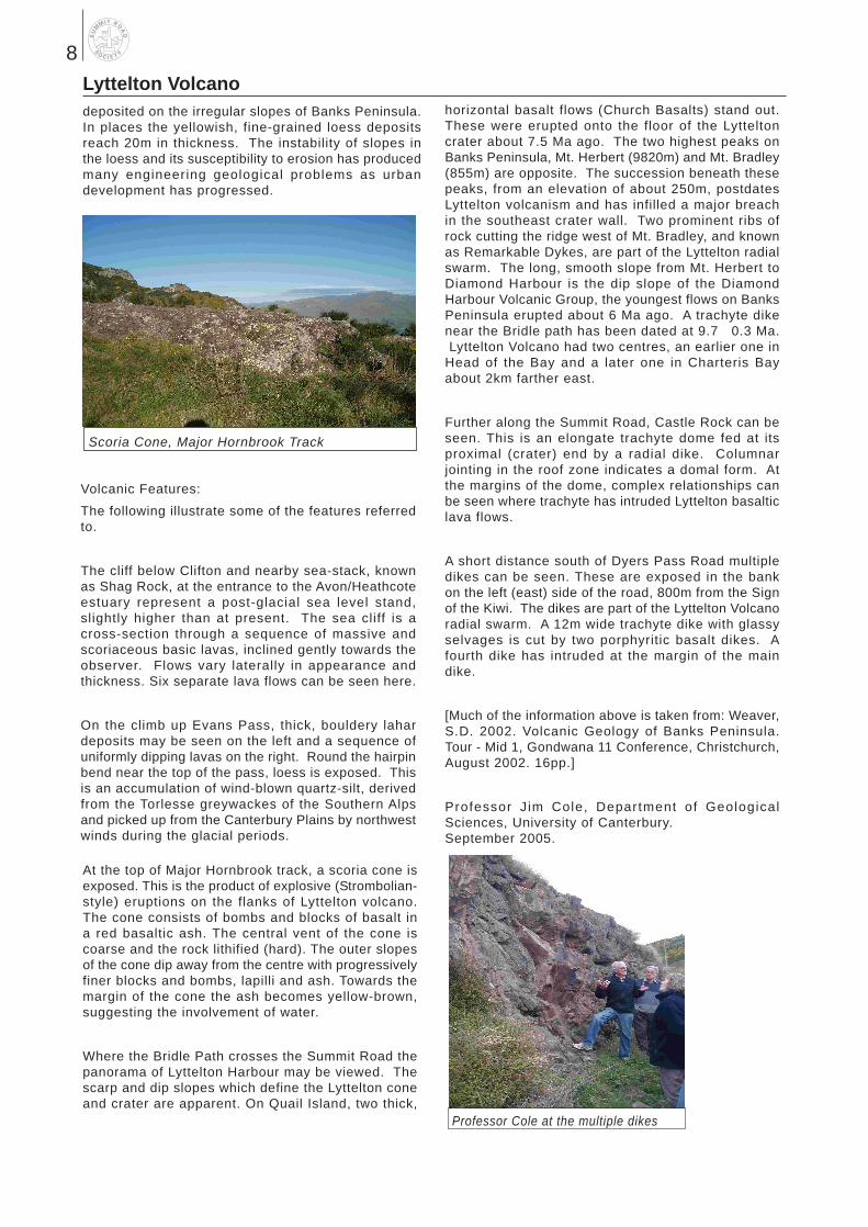
At the top of Major Hornbrook track, a scoria cone is exposed. This is the product of explosive (Strombolian-style) eruptions on the flanks of Lyttelton volcano. The cone consists of bombs and blocks of basalt in a red basaltic ash. The central vent of the cone is coarse and the rock lithified (hard). The outer slopes of the cone dip away from the centre with progressively finer blocks and bombs, lapilli and ash. Towards the margin of the cone the ash becomes yellow-brown, suggesting the involvement of water.
Where the Bridle Path crosses the Summit Road the panorama of Lyttelton Harbour may be viewed. The scarp and dip slopes which define the Lyttelton cone and crater are apparent. On Quail Island, two thick,
Professor Cole at the multiple dikes
Scoria Cone, Major Hornbrook Track
8