Embed Size (px)
Citation preview
Page 1 of 70
Neutral or Beneficial Effect on Water Quality
Assessment Guideline
2015

Page 2 of 70
Disclaimer
A reference to the State Environmental Planning Policy (Sydney Drinking Water Catchment) 2011 (the SEPP) includes a reference to the SEPP as amended from time to time and to any replacement SEPP. The purpose of the ‘Neutral or Beneficial Effect on Water Quality Assessment Guideline’ (the guideline) is to provide information to help people who are assessing development proposals in the declared drinking water catchment. The information in the guideline is current, accurate and complete at the time of publication.
The Sydney Catchment Authority^ does not make or give any representation or warranty that compliance with the Guideline will result in a neutral or beneficial effect on water quality, and will not be liable in negligence, breach of contract or statutory duty for failure of the proposal or the consequences of that failure.
^ From the 1 January 2015, the Sydney Catchment Authority (SCA) joined with State Water to form Water NSW, the new single organisation responsible for managing bulk water supply across the State. All references in the NorBE Assessment Tool and NorBE Assessment Guideline 2015 to the SCA should be taken to mean Water NSW.
Copyright Note
© State of New South Wales through Water NSW, 2015. You may copy, distribute, display, download or otherwise freely deal with this work for any purpose, provided that you attribute Water NSW as the owner. However, you must obtain permission if you wish to (1) charge others for access to the work (other than at cost), (2) include the work in advertising or a product for sale, or (3) modify the work. www.sca.nsw.gov.au ISBN 978-0-9874680-3-1 Published FEBRUARY 2015

Page 3 of 70
CONTENTS 1. Introduction ....................................................................................................... 4
1.1 Context ..................................................................................................... 4
1.2 Purpose of the Guideline ........................................................................... 4
1.3 Audience ................................................................................................... 4
1.4 Principles .................................................................................................. 4
2. Statutory context ............................................................................................... 5 2.1 Environmental Planning and Assessment Act ........................................... 5
2.2 SEPP (Sydney Drinking Water Catchment) 2011 ...................................... 5
2.3 Assumed Concurrence .............................................................................. 5
3. What is a Neutral or Beneficial Effect? ............................................................ 6 3.1 Definition of neutral or beneficial effect...................................................... 6
4. Assessment and Approvals Process ............................................................... 7 4.1 Roles and responsibilities ......................................................................... 7
4.2 SCA involvement ...................................................................................... 7
4.3 Development type and information to be supplied with an application ....... 7
4.4 Steps in the assessment process .............................................................. 8
4.4.1 No identifiable potential impacts on water quality ......................... 8
4.4.2 Exempt and complying development ............................................ 9
4.5 The NorBE Tool for Part 4 Development Applications ............................. 11
4.5.1 The NorBE Tool ............................................................................ 12
a. Site considerations .................................................................... 12
b. Assessment of stormwater impacts ........................................... 12
c. Assessment of wastewater impacts ........................................... 13
d. General considerations and assumptions .................................. 13
4.5.2 The Electronic NorBE Tool ............................................................ 14
4.6 Current recommended practices and performance standards ................. 14
4.7 Compliance with conditions of consent.................................................... 15
5. Supporting Tools and User Guidelines .......................................................... 16 5.1 Wastewater effluent model ......................................................... 16
5.2 MUSIC and the S3QM ................................................................ 16
DEFINITIONS ............................................................................................................ 17
ACRONYMS .............................................................................................................. 21
REFERENCES ........................................................................................................... 22
APPENDIX 1 .............................................................................................................. 23

Page 4 of 70
1. Introduction
1.1 Context
The ‘Neutral or Beneficial Effect on Water Quality Assessment Guideline 2015’ (the guideline) is a revised version of the guideline published in 2011. The 2011 guideline was developed in response to State Environmental Planning Policy (Sydney Drinking Water Catchment) 2011 (the SEPP).
The guideline responds to the requirement for all development in the Sydney drinking water catchment to have a neutral or beneficial effect on water quality.
1.2 Purpose of the Guideline
This guideline supports the implementation of the SEPP by providing clear direction on what a neutral or beneficial effect means, how to achieve it, and how to assess an application against the neutral or beneficial effect on water quality test using the ‘Neutral or Beneficial Effect on Water Quality Assessment Tool’ (the NorBE Tool). The guideline also provides the decision-making framework for the NorBE Tool (Appendix 1).
1.3 Audience
The guideline will help consent and public authorities to consider whether or not the proposals in the drinking water catchment will have a neutral or beneficial effect on water quality. The guideline will also help applicants and their consultants to prepare development proposals for consent and public authorities.
1.4 Principles
The following principles apply to this guideline:
• Assessment for a neutral or beneficial effect on water quality is required under the Environmental Planning and Assessment Act 1979.
• It is the development proponent’s responsibility to demonstrate that a development will have a neutral or beneficial effect on water quality.
• The level of assessment required matches the level of risk of the development - developments with a greater potential risk to water quality will require more thorough assessment.
• Good project design leading to source management and control, and retaining natural features of waterways, is better than structural and ‘end of pipe’ solutions. All measures must be taken to contain on-site any potential impacts resulting from a proposed development.
• The guideline outlines a practical and simple process to minimise the cost to developers, the community and the consent or public authority while providing the flexibility to achieve the best outcomes.
This guideline builds on the extensive experience of the Sydney Catchment Authority and input from various specialist consultants and government agencies.

Page 5 of 70
2. Statutory context2.1 Environmental Planning and Assessment Act
The Environmental Planning and Assessment Act 1979 (EP&A Act) provides the statutory framework for planning and environmental impact assessment in NSW.
This guideline relates directly to developments being assessed under Part 4 of the Act. The guideline may be of assistance to public authorities when considering whether an activity would have a neutral of beneficial effect on water quality.
2.2 SEPP (Sydney Drinking Water Catchment) 2011
Under section 34B of the EP&A Act, provision is to be made in a State Environmental Planning Policy requiring consent authorities to refuse consent to development applications relating to any part of the Sydney drinking water catchment, unless the consent authority is satisfied that the proposed development would have a neutral of beneficial effect on water quality.
State Environmental Planning Policy (Sydney Drinking Water Catchment) 2011 (the SEPP) has been made to satisfy this obligation. It sets out the planning and assessment requirements for all new developments in the Sydney drinking water catchment to have a neutral or beneficial effect (NorBE) on water quality.
The SEPP requires consent authorities to refuse approval to new developments under Part 4 of the EP&A Act unless they are satisfied that the proposal would have a neutral or beneficial effect on water quality.
For new activities under Part 5 of the EP&A Act, the SEPP requires public authorities to consider whether the activity would have a neutral or beneficial effect on water quality.
Although not specified in the SEPP, the neutral or beneficial effect on water quality guideline may provide a framework to consider state significant development (SSD) under Part 4.1 of the EP&A Act and state significant infrastructure (SSI) under Part 5.1 of the EP&A Act. The Minister for Planning is the consent authority for SSD and approval authority for SSI and determines these projects and which water quality test will be applied. A consultation protocol has been established between the SCA and the Department of Planning and Environment for SSD and SSI projects proposed in the Sydney drinking water catchment requiring the consideration of the principal of achieving a neutral or beneficial effect on water quality.
2.3 Assumed Concurrence
Regulations made under the EP&A Act provide that a concurrence authority (such as the SCA) may give written notice to a consent authority (such as a local council) that concurrence may be assumed, subject to such qualifications or conditions specified in the notice. The Chief Executive of the SCA has issued a notice to all councils in the Sydney drinking water catchment.
The notice issued to councils for the purposes of the SEPP lists the types of development for which a council, as the consent authority, may assume concurrence provided the council is satisfied that the proposal will have a neutral or beneficial effect on water quality. The notice was issued to councils at the same time as the publication of the SEPP and an amended notice issued to councils prior to the 2015 version of the NorBE Tool going live on 20 February 2015.

Page 6 of 70
3. What is a Neutral or Beneficial Effect?
3.1 Definition of neutral or beneficial effect
Consent authorities must consider a number of matters to determine a development application, including that it will have a neutral or beneficial effect on water quality (NorBE). The consent authority may refuse an application on other grounds even if NorBE is satisfied.
A neutral or beneficial effect on water quality is satisfied if the development:
(a) has no identifiable potential impact on water quality, or
(b) will contain any water quality impact on the development site and prevent it from reaching any watercourse, waterbody or drainage depression on the site, or
(c) will transfer any water quality impact outside the site where it is treated and disposed of to standards approved by the consent authority.
Public authorities undertaking activities in the Sydney drinking water catchment must also consider whether the proposed activity will have a neutral or beneficial effect on water quality.
The site of a proposed development or activity, to determine water quality impacts, is the land described in the development application, the Part 5 activity documentation, or where relevant, the SSD or SSI application. Pollutant loads or concentrations for each pollutant leaving a site are measured at the site boundary, or at the point where the pollutant enters a drainage depression, waterbody or watercourse.
Section 4 describes how a neutral or beneficial effect is assessed and the matters that a proponent must address in an application.

Page 7 of 70
4. Assessment and Approvals Process
4.1 Roles and responsibilities
Local government has primary responsibility for granting development consents for most applications under their local environmental plan (LEP). Developments that require consent under an LEP must apply for consent from the relevant local council.
The council will review the application and refer it to other government agencies that may be required to provide input or approvals by other Acts.
A public authority proposing to carry out a Part 5 activity must consider whether the proposed activity will have a neutral or beneficial effect on water quality for the life of the activity, including construction, operation, and decommissioning.
The Planning Assessment Commission and the Joint Regional Planning Panels may be involved in determining developments.
Consultants have the responsibility of preparing a NorBE assessment on behalf of the proponent and submitting this to councils with the development application.
4.2 SCA involvement
Councils must seek and obtain concurrence from the Chief Executive of the SCA before they can grant consent for a development application in the Sydney drinking water catchment.
Regulations made under the EP&A Act provide that the Chief Executive of the SCA may issue a notice listing the circumstances where the consent authority may assume the Chief Executive’s concurrence (see Section 2.3). The Chief Executive has issued a notice to take effect when the SEPP commences that lists certain types of development where council may assume the Chief Executive’s concurrence and make a NorBE assessment using the NorBE Tool. The notice includes, but is not limited to, developments such as sewered and unsewered dwellings, certain multi dwelling housing, smaller sewered and unsewered subdivisions, and some types of demolitions and earthworks.
Developments that must actually be referred to the SCA for concurrence include, but are not limited to, larger sewered and unsewered subdivisions and larger multi-dwelling proposals, large earthworks, commercial and industrial developments, and designated development. The SEPP requires councils and other consent authorities to forward a copy of their determination to the SCA within 10 days.
4.3 Development type and information to be supplied with an application
The development type will determine the type and extent of information needed to demonstrate that a development has a neutral or beneficial effect on water quality. Councils making determinations under the EP&A Act must also consider other planning matters in addition to water quality. Most applications must meet requirements and standards in addition to the neutral or beneficial effect test before council can give consent.
In most cases, the first step in the consent process is for the applicant to discuss the proposed development with council to decide the type of application and information needed. Schedule 1 of the EP&A Regulation lists the information that must be supplied with a development application. This includes a statement of environmental effects.

Page 8 of 70
The SCA requires extra information that must be included with a development application, including a water cycle management study (WCMS), which varies according to the type and scale of development. The WCMS must include information addressing:
erosion and sediment control
stormwater
contamination and
wastewater.
The type of report or model that must be included depends on the complexity of the development. Without this information, the council and the SCA cannot adequately assess whether the application meets the NorBE test. Information requirements are detailed in a document developed by the SCA: ‘Developments in Sydney’s drinking water catchments – water quality information requirements’ (SCA, 2015).
The document – ‘Using a Consultant to Prepare Your Water Cycle Management Study’ (SCA, 2010) – explains the development application process in relation to the water cycle management study requirements, as well as information about choosing and using a consultant to prepare the required WCMS. The documents are available to download from the SCA’s website at www.sca.nsw.gov.au.
An application for designated development (refer to Schedule 3 of the EP&A Regulation for a list of development declared to be ‘designated development’ under the EP&A Act) must include an environmental impact statement. Designated development assessed under Part 4 of the EP&A Act follows the same approval process under the SEPP.
4.4 Steps in the assessment process
There are two steps to assess an application to determine whether it has a neutral or beneficial effect on water quality, as shown in the NorBE Part 4 assessment flowchart (Figure 1). The first applies to an assessment by the consent authority when actual concurrence may be assumed in accordance with the notice issued under the EP&A Regulation. The second applies when concurrence from the SCA is required.
If the council, by using the NorBE Tool, is satisfied that the proposed development will have a neutral or beneficial effect on water quality, they can issue consent based on water quality grounds. If the council is not satisfied that the proposed development would have a neutral or beneficial effect on water quality, they must refuse consent based on water quality grounds or discuss further options to amend the development application with the proponent.
When the SCA issues concurrence, the council must consider the SCA’s expert advice and either refuse or grant consent (as in Figure 1).
4.4.1 No identifiable potential impacts on water quality
It is safe to assume that a development will have no identifiable potential impact on water quality if the development is unlikely to result in:
a concentration of flow of water
the impedance of flow of water
discharge of effluent, dust pollutants or stormwater, and
other matters considered to result in a water quality impact, such as the potential for contamination.
Page 9 of 70
In this case, the neutral or beneficial effect test is satisfied and consent can be issued with respect to water quality, without further detailed assessment regardless of the development type.
Development proposals that would generally satisfy these criteria include, but are not limited to, minor boundary adjustments not involving new construction, or adding an ensuite bathroom without changing the number of bedrooms in a development. Other developments that are unlikely to have an impact on water quality may include a picket fence, a pergola with either no roof or a shade cloth roof, or an office fit out. Many minor forms of development may actually be exempt or complying development as identified in an environmental planning instrument.
4.4.2 Exempt and complying development
Exempt development
Development that is listed as exempt development under the State Environmental Planning Policy (Exempt and Complying Development Codes) (Development Codes SEPP) or under a council’s LEP does not require a neutral or beneficial effect on water quality assessment.
Complying development
Many types of complying development listed under the Development Codes SEPP do not require a neutral or beneficial effect on water quality assessment, but there are a number of exceptions to this. The exceptions also apply to complying development listed in LEPs as the SEPP overrides LEPs where there are inconsistencies.
Clause 1.19 of the Development Codes SEPP lists the land on which complying development cannot be carried out. As at July 2014 this included:
All complying development under the General Housing Code and Rural Housing Code on land that is declared to be a Special Area under the Sydney Water Catchment Management Act 1998.
Complying development under the General Housing Code, Rural Housing Code, Housing Alterations Code and General Development Codes on unsewered land in the Sydney drinking water catchment, if that development will result in an increase to the number of bedrooms on the site or a site disturbance area of more than 250 m2.
All complying development under the Commercial and Industrial (New Building and Additions ) Code on unsewered land in the Sydney drinking water catchment.

Page 10 of 70
Figure 1 – NorBE Part 4 Assessment
Note: (1) if a consultant submits a NorBE assessment to the consent authority, then the process involves
certifying that the information and assessment is correct. (2) if the information supplied with the development application is incomplete or incorrect, then the
council or possibly the SCA will requires and request further information before continuing with the assessment.
Applicant submits application to
council
Council determines whether
concurrence may be assumed
Council undertakes a comprehensive
NorBE assessment using the NorBE
Tool and Assessment Guidelines
Council determines whether or not it is
satisfied that the proposed
development will have a neutral or
beneficial effect on water quality
NOT
satisfiedSatisfied
NOYESConcurrence is not assumed: Council
refers application to the SCA
Council must refuse consent on
the grounds that NorBE is not
satisfied
Council may grant consent to the
development subject to other
factors of the DA process being
satisfied
The SCA determines whether or not it
is satisfied that the proposed
development will have a neutral or
beneficial effect on water quality
NOT
satisfiedSatisfied
SCA issues
concurrence with or
without conditions
SCA withholds
concurrence
Council undertakes an initial
assessment in NorBE Tool
Council determines whether the
proposed development will have no
identifiable impact on water quality
YESNO
(2)
(1)
(2)

Page 11 of 70
4.5 The NorBE Tool for Part 4 Development Applications
The SCA developed the NorBE Tool (Appendix 1) to help local government planners assess whether development under Part 4 of the EP&A Act will have a neutral or beneficial effect on water quality.
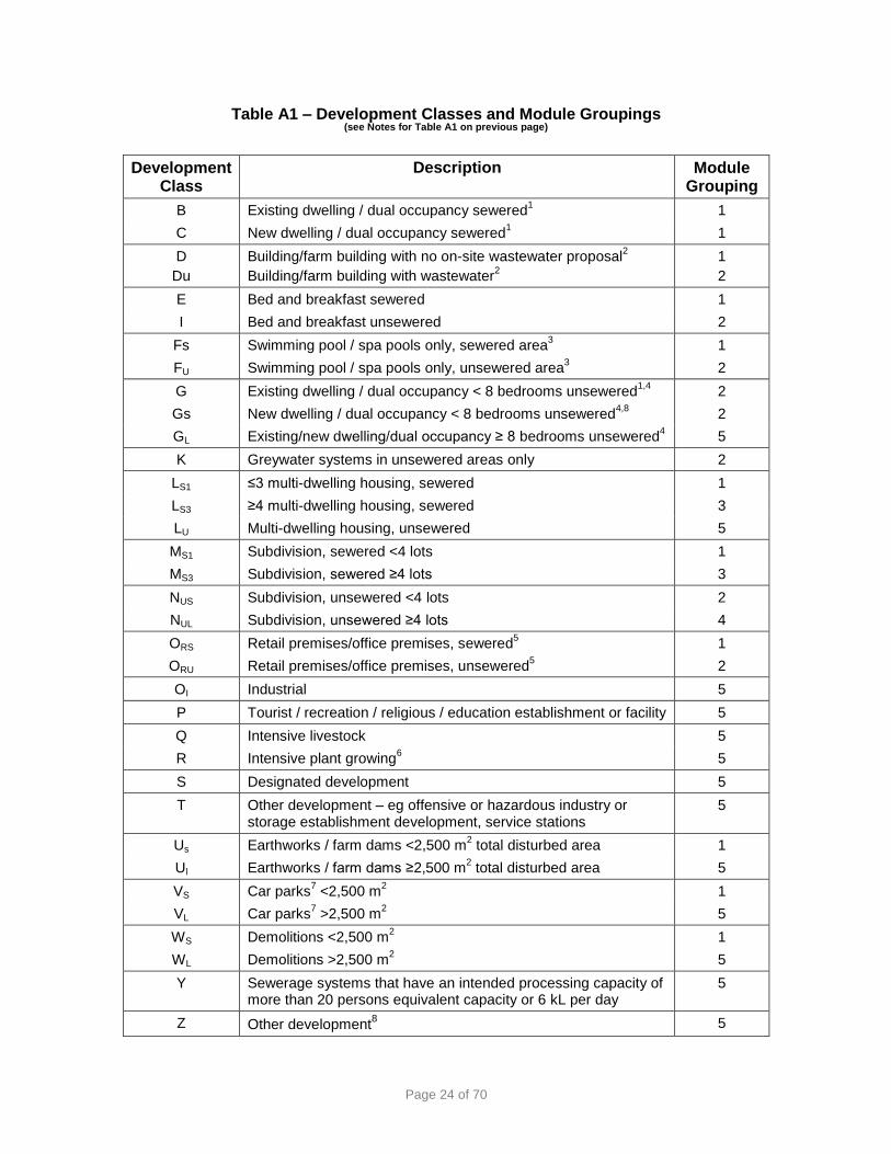
Development types have been divided into different development classes consistent with the Standard Instrument – Principal Local Environmental Plan (the Standard Instrument). The development classes are then grouped into modules according to the required development assessment process and the level of potential risk from the development.
Module 1 – These developments typically involve a sewered new single dwelling or dual occupancy, or an alteration/addition to a dwelling. They can also involve swimming pools and subdivisions of three lots or less in sewered areas, car parks and small demolitions (less than 2,500 square metres). This module addresses standard stormwater questions for site risks and management responses that differ according to the size of the construction area.
The concurrence of the SCA Chief Executive can be assumed except where:
the total proposed impervious area or construction area is greater than or equal to 2,500 square metres
the development is proposed to be carried out on crown perpetual leasehold land
there are inconsistencies with any Section 88 instruments placed by the SCA under the Conveyancing Act 1919.
Module 2 – Developments typically involve an unsewered new dwelling or dual occupancy, or alterations/additions. They can also involve swimming pools and subdivisions of three lots or less in unsewered areas. The main focus of this module is to assess wastewater systems, including design loadings and site risks.
The concurrence of the SCA Chief Executive can be assumed except where:
the development proposal involves non-standard systems
the total proposed impervious area or construction area is greater than or equal to 2,500 square metres
there are inconsistencies with any Section 88 instruments placed by the SCA under the Conveyancing Act 1919
the development is proposed to be carried out on crown perpetual leasehold land.
Module 3 – Developments typically involve a sewered urban subdivision of four lots or greater that may or may not involve the construction of dwellings. Module 3 addresses standard stormwater site risks such as soils and slope, development risks, standard sewerage questions, and in most cases requires MUSIC model evaluation. In this module, subdivision means lot layout and any construction proposed by the development application.
Module 4 – Developments typically involve a rural subdivision of four lots or greater with on-site wastewater disposal that may or may not involve the construction of dwellings. This module addresses standard stormwater site risks such as soils and slope, development risks, and in most cases requires MUSIC model evaluation, as for Module 3. It also considers standard wastewater questions, and subdivision layout issues such as roads/rights-of-way, and dwelling and internal access issues. In this module, subdivision means lot layout and any construction proposed by the development application.

Page 12 of 70
Module 5 – Other development.
A full list of development classes and module groupings is in Appendix 1 – Table A1.
4.5.1 The NorBE Tool
The NorBE Tool was developed using a risk-based approach. It is consistent with, and uses, assumptions and benchmark indicators of risk and recommended management practices, while providing consistent and transparent assessments.
The Modules include a series of questions that lead to an action or conclusion which may include, but is not limited to:
more information must be provided to determine a neutral or beneficial effect on water quality
the development application must be referred to the SCA for concurrence
NorBE is satisfied
NorBE is not satisfied
the proponent withdraws the application.
The NorBE Tool will help determine whether there will be a predicted neutral or beneficial effect on water quality based on information entered by council. The information specifically relates to site and development risks, including effluent management and stormwater. Some sections of the NorBE Tool can be completed during a desktop assessment (assuming all documents and relevant information are available or have been provided by the proponent with the development application). Other sections must be completed after a site inspection.
a. Site considerations
Risks associated with development proposals vary greatly depending on site characteristics. Many aspects that may impact on water quality must be considered, including:
rainfall
slope (steep slopes pose a greater risk than flat terrain)
distance from watercourses (developments closer to watercourses pose higher potential risk to water quality)
soil characteristics (including permeability, depth, type, soil loss class, salinity, phosphorus sorption capacity, sodicity and rock outcropping)
site issues specific to subdivision design, such as layout, roads and rights-of-way, contamination, extent of cut and fill required, vegetation clearing and watercourse crossings.
Management responses will differ according to site risks and size of the construction area.
b. Assessment of stormwater impacts
Stormwater can impact on water quality, especially if the amount of impervious surface is increased by the development. For example, stormwater leaving an undeveloped lot covered in vegetation will differ in quality and quantity from stormwater leaving a lot with a dwelling (with an impervious roof area) and other associated impervious development (such as driveways, sheds and paved areas).
To assess the impact of development on stormwater, the NorBE Tool includes questions on the proposed size of the impervious area and construction, and slope. These

Page 13 of 70
questions can be addressed by preparing either a small scale stormwater quality model (S3QM) or a model for urban stormwater improvement conceptualisation (MUSIC) for larger, more complex developments. Refer to Table A3 for the thresholds that apply for each model.
c. Assessment of wastewater impacts
Potential impacts from wastewater on ambient water quality are a significant issue in the Sydney drinking water catchment due to the large number of existing on-site systems and proposals for unsewered development. The choice of an appropriate on-site system for a particular development proposal will be greatly influenced by site considerations. These include slope, depth and type of soil, distance from watercourses, and the area available to set aside as an effluent management area. Certain site constraints, including the presence of shallow soils or steep slopes, will automatically preclude some system types. The SCA has developed a GIS-based, effluent plume generation modelling tool (the wastewater effluent model, or WEM - see Section 5.1.1) to support the design and assessment of on-site wastewater systems.
A sewerage system with a proposed capacity of more than 20 persons equivalent or six kilolitres per day is a designated development and requires a full environmental impact statement and the actual concurrence of the SCA.
d. General considerations and assumptions
The NorBE Tool makes a number of general assumptions that must be considered by the assessor using the NorBE Tool. These include but are not limited to:
the assessor can access certain software applications such as the S3QM/MUSIC and the WEM (The S3QM will be available through the SCA’s website www.sca.nsw.gov.au. The WEM is embedded in the on-line NorBE Tool)
the comparison between the predicted effect of the proposal on water quality with the estimated effect of the current (legal) use and condition of the site is based on conditions that, for example, exclude breaches of the Protection of the Environment Operations Act 1997
consultants’ reports may not match information from SCA databases related to site and soil characteristics, rainfall and evaporation
a neutral or beneficial effect for certain low-risk developments can be satisfied by adopting current recommended practices (CRPs – see Section 3.6 below)
any existing wastewater systems must be considered
any effluent management area is located wholly within each lot or covered by an appropriate easement
any proposed roads and/or rights-of-way are defined as including roads and associated drainage works
the number of lots fronting a watercourse in a subdivision proposal is minimised
where there is a technical challenge to the assessment that council cannot resolve they will seek assistance from the SCA about the technical challenge (with relevant documentation). The development application will not be submitted to the SCA for concurrence unless the development type is consistent with those types outlined in Clause 64 notice for which SCA concurrence must be sought

Page 14 of 70
the site was not deliberately degraded, such as through the clearing of vegetation or sealing, before the development application was submitted to lower the neutral or beneficial effect pre-development baseline
references to a dwelling include all associated structures and development such as garages, sheds, tennis courts, driveways, swimming pools and gazebos
councils may contact the SCA for help and advice about their assessments.
The NorBE test is not an exact science. The SCA’s approach to decide a neutral or beneficial effect will be a mixture of:
using various guidelines, standards and practices to show that NorBE is satisfied
quantitative neutral or beneficial effect evaluation or assessment using the WEM and/or the S3QM / MUSIC stormwater models
assessment of water quality risks
qualitative assessment of internal offsets to ensure a neutral or beneficial effect.
4.5.2 The Electronic NorBE Tool
A web based software application has been developed for ease of use and access to the NorBE Tool. Users and assessors should refer to the NorBE Assessment Tool User Guides for councils and consultants for detailed step by step instructions and illustrated examples on how to use the NorBE Tool.
The NorBE Tool helps consultants prepare development applications that have a neutral or beneficial effect on water quality. It also helps councils decide whether the proposed development will have a neutral or beneficial effect on water quality, or whether the actual concurrence of the SCA’s Chief Executive is required. It records the decision process for each development application.
The NorBE Tool uses answers from the questions in each module to make an assessment. Some parameters are automatically filled in, while others require the user to choose an option or enter a value. An assessment summary including all responses can be printed.
Where an assessment needs to be referred to the SCA for concurrence, the assessment summary must be attached to the development application.
4.6 Current recommended practices and performance standards
In the SEPP, management practices that have been endorsed by the SCA are referred to as current recommended practices (CRPs) and performance standards.
CRPs and standards provide best practice methods to manage the water quality impacts of a range of land uses, developments and activities including urban and rural subdivisions, agriculture, industrial developments, waste and recycling, stormwater and wastewater management, service stations and preparing environmental management plans.
Landholders can get information about CRPs from the SCA website www.sca.nsw.gov.au to include in the project design phase of a development, in property management planning, or in their day-to-day activities (eg controlling bank erosion on their property).

Page 15 of 70
The SEPP requires new developments or activities to incorporate CRPs and standards endorsed by the SCA or to adopt approaches that achieve the same or better water quality outcomes. This applies to public and private development. The use of CRPs are therefore an important means for helping to ensure that NorBE is met for development proposed to be carried out in the Sydney drinking water catchment.
To ensure continual improvement in land and water management, the SCA will assess innovative practices that deliver the same or better water quality outcomes and, where appropriate, endorse them as CRPs. This process to allow existing good management practices to be endorsed and new management practices to be developed, will include communication with relevant stakeholders, technical assessment and regular review.
All CRPs and standards are listed on the SCA’s website at www.sca.nsw.gov.au.
4.7 Compliance with conditions of consent
The consent authority is responsible for enforcing development consent conditions. The SCA will inspect developments to check whether the SCA’s advice or conditions are included in council determinations, and whether the development complies with the SCA’s conditions. Some conditions are automatically generated by the electronic NorBE Tool.

Page 16 of 70
5. Supporting Tools and User Guidelines This guideline and the NorBE Tool refer to a number of different supporting tools and guides, such as the WEM, S3QM and MUSIC.
5.1 Wastewater effluent model
The wastewater effluent model (WEM) is a GIS-based, effluent plume generation modelling tool that supports the design of on-site wastewater management systems. The WEM is integrated into the electronic NorBE Tool. It uses natural resource spatial data for model inputs and design calculations to predict the potential extent of an effluent plume. This allows a visual interpretation and assessment of the potential impact of a development on water quality.
If the effluent plume is predicted to leave the site, or reach a watercourse, waterbody or drainage depression or defined buffers, then the proposed on-site system will not have a neutral or beneficial effect on water quality. The site or size of the proposed effluent disposal field, or type of on-site system, can be changed in various scenarios to help ensure the proposed system can meet the NorBE test.
The WEM provides an objective way to determine whether a proposal will have a neutral or beneficial effect on water quality. It also reduces costs and produces consistent design and assessment. The WEM will help designers and assessment officers to identify and locate an appropriate site for an on-site system for developments proposed in the Sydney drinking water catchment.
5.2 MUSIC and the S3QM
MUSIC The model for urban stormwater improvement conceptualisation (MUSIC) is a tool to estimate stormwater pollutant generation and the performance of stormwater treatments from proposed land development. It is the preferred stormwater model to determine a neutral or beneficial effect in SCA catchment areas for larger developments where the impervious area is greater than or equal to 2,500 square metres.
These types of developments may be found in all Modules of the NorBE Tool and will all be referred to the SCA for concurrence. Reference should be made to the SCA’s ‘Using MUSIC in Sydney’s Drinking Water Catchment’ (2012b).
S3QM The small scale stormwater quality model (S3QM) estimates stormwater pollutant generation and the performance of stormwater treatments from proposed development for smaller, less complex development proposals. The SCA is exploring the use of the S3QM for Modules 1 and 2, including the use of thresholds. The SCA will advise councils and other stakeholders should this eventuate.
The SCA will also accept an S3QM model, in place of a MUSIC model, for Modules 3, 4 and 5 where the total proposed impervious area is less than 2,500 square metres.
A certificate from an assessment completed using the S3QM will need to be submitted with these proposals. The S3QM is available on the SCA’s website at www.sca.nsw.gov.au.

Page 17 of 70
DEFINITIONS Note: these definitions also apply to the NorBE Tool. Activity
Has the same meaning as in Part 5 of the Environmental Planning and Assessment Act 1979.
Activity is: (a) the use of land, and (b) the subdivision of land, and (c) the erection of a building, and (d) the carrying out of a work, and (e) the demolition of a building or work, and (f) any other act, matter or thing referred to in section 26 of the EP&A Act that
is prescribed by the regulations for the purposes of this definition but does not include:
(g) any act, matter or thing for which development consent under Part 4 is required or has been obtained, or
(h) any act, matter or thing that is prohibited under an environmental planning instrument, or
(i) exempt development, or (j) development carried out in compliance with an order under Division 2A of
Part 6, or (k) any development of a class or description that is prescribed by the regulations for the purposes of this definition
Annual exceedance probability (AEP)
The chance of a flood of a given size (or larger) occurring in any one year, usually expressed as a percentage. For example, a flood with a 1% AEP has a one in a hundred chance of being exceeded in any year.
Clearing native vegetation
Has the same meaning as in the Native Vegetation Act 2003.
Clearing native vegetation is any one or more of the following: (a) cutting down, felling, thinning, logging or removing native vegetation, (b) killing, destroying, poisoning, ringbarking, uprooting or burning native
vegetation. (See Division 3 of Part 3 of the Native Vegetation Act 2003 for the exclusion of routine agricultural management and other farming activities from constituting the clearing of native vegetation if the landholder can establish that any clearing was carried out for the purpose of those activities).
Consent authority
Has the same meaning as in the Environmental Planning and Assessment Act 1979.
Consent authority, in relation to a development application or an application for a complying development certificate, is: (a) the council having the function to determine the application, or (b) if a provision of this Act, the regulations or an environmental planning
instrument specifies a Minister, the Planning Assessment Commission, a joint regional planning panel or public authority (other than a council) as having the function to determine the application—that Minister, Commission, panel or authority, as the case may be.
Page 18 of 70
Controlled activity
Has the same meaning as in the Water Management Act 2000. Controlled activity is: (a) the erection of a building or the carrying out of a work (within the meaning
of the Environmental Planning and Assessment Act 1979), or (b) the removal of material (whether or not extractive material) or vegetation
from land, whether by way of excavation or otherwise, or (c) the deposition of material (whether or not extractive material) on land,
whether by way of landfill operations or otherwise, or (d) the carrying out of any other activity that affects the quantity or flow of
water in a water source (WM Act).
Critical habitat Critical habitat has the same meaning as in the Threatened Species Conservation Act 1995 or (subject to section 5C) Part 7A of the Fisheries Management Act 1994.
Development Has the same meaning as in Environmental Planning and Assessment Act 1979.
Development is:
(a) the use of land, and (b) the subdivision of land, and (c) the erection of a building, and (d) the carrying out of a work, and (e) the demolition of a building or work, and (f) any other act, matter or thing referred to in section 26 that is controlled by
an environmental planning instrument,
but does not include any development of a class or description prescribed by the regulations for the purposes of this definition.
Development application
Has the same meaning as in Environmental Planning and Assessment Act 1979.
A development application is an application for consent under Part 4 to carry out development but does not include an application for a complying development certificate.
Disturbed area The building footprint plus 25%.
Drainage depression
A drainage depression is a low point that carries water during rainfall events, but dries out quickly when rainfall stops. A gully or incised drainage depression is considered to be a watercourse.
Fill Has the same meaning as in the Standard Instrument – Principle Local Environmental Plan.
Fill is the depositing of soil, rock or other similar extractive material obtained from the same or another site, but does not include:
(a) the depositing of topsoil or feature rock imported to the site that is intended for use in garden landscaping, turf or garden bed establishment or top dressing of lawns and that does significantly alter the shape, natural form or drainage of the land, or
(b) a waste disposal landfill operation.

Page 19 of 70
Gully erosion Gully erosion is erosion that forms deep sided channels or gullies, usually due to the removal of riparian vegetation (Australia State of the Environment Report 2001 (Theme Report), Department of the Environment and Heritage, 2001).
Intermittent watercourse
An intermittent watercourse is an area with banks and beds or ponds that stays wet for considerable periods between rainfall events and may be characterised by supporting moisture tolerant vegetation.
Potential bedroom
A potential bedroom is a room that could reasonably be used as a bedroom. A potential bedroom is a room with a closable door, at least one window and a minimum of 8 square metres. A room in a separate building such as a studio could be a potential bedroom if it has a toilet and washing facilities or close access to same.
Riparian land Riparian land is land that adjoins or directly influences a body of water. It includes riverbanks and land immediately alongside gullies, streams, creeks, rivers and wetlands that interact with the flows. There are approximately 110,000 kilometres of riparian land in the SCA catchment.
Section 88 Section 88 is the imposition of a restriction or public positive covenant by a prescribed authority on land under the Conveyancing Act 1919.
Severe frosts Areas of severe frost are defined as those where the overnight minimum air temperatures (Stephenson screen) are regularly below -3°C, corresponding to a ground temperature of approximately -5°C. Note that frost hollows and areas of cold air drainage may result in localised areas where frost is more severe than indicated by temperature records for the region.
Site The site of a proposed development is the area of land described in the development application or the Part 5 assessment.
Site area Has the same meaning as in the Standard Instrument – Principle Local Environmental Plan: The site area is any land where development will be carried out, or proposed. The land may include all or part of one lot, or more than one lot, if they are connected to each other.
Waterbody (artificial)
An artificial waterbody is a body of water, including any constructed waterway, canal, inlet, bay, channel, dam, pond, lake or artificial wetland. This does not include a dry detention basin or other stormwater management construction that is only intended to hold water intermittently.
Waterbody (natural)
A natural waterbody is a naturally occurring body of water, constant or intermittent, fresh, brackish or saline, including where the course has been artificially modified or diverted. This includes a river, creek, stream, lake, lagoon, natural wetland, estuary, bay, inlet or tidal waters (including the sea).
Watercourse Has the same meaning as in the Standard Instrument – Principle Local Environmental Plan.
A watercourse is any river, creek, stream or chain of ponds, whether artificially modified or not, in which water usually flows, either continuously or intermittently, in a defined bed or channel, but does not include a waterbody (artificial).

Page 20 of 70
Waterfront land Waterfront land is:
(a) the bed of any river, together with any land lying between the bed of the river and a line drawn parallel to, and the prescribed distance inland, of the highest bank of the river, or
(b) the bed of any lake, together with any land lying between the bed of the lake and a line drawn parallel to, and the prescribed distance inland of, the shore of the lake,
where the prescribed distance is 40 metres or (if the regulations prescribe a lesser distance, either generally or in relation to a particular location or class of locations) that lesser distance.
Waterway A waterway is the whole or any part of a watercourse, wetland, waterbody (artificial) or waterbody (natural).
Wetland Has the same meaning as in the Standard Instrument – Principle Local Environmental Plan.
A wetland is:
(a) natural wetland, including marshes, mangroves, backwaters, billabongs, swamps, sedgelands, wet meadows or wet heathlands that form a shallow waterbody (up to 2 metres in depth) when inundated cyclically, intermittently or permanently with fresh, brackish or salt water, and where the inundation determines the type and productivity of the soils and the plant and animal communities, or
(b) artificial wetland, including marshes, swamps, wet meadows, sedgelands or wet heathlands that form a shallow water body (up to 2 metres in depth) when inundated cyclically, intermittently or permanently with water, and are constructed and vegetated with wetland plant communities.
Water cycle management study
A water cycle management study includes: - a conceptual soil and water management plan or erosion and
sediment control plan for the construction phase - an on-site effluent management plan if unsewered - water sensitive design features, and - a determination of pre-and post-development loads and
concentrations.

Page 21 of 70
ACRONYMS
AEP Annual exceedance probability
CRP Current recommended practice
DA Development application
DLG Department of Local Government (now the Division of Local Government in the Department of Premier & Cabinet)
EMA Effluent management area
EP&A Act Environmental Planning and Assessment Act 1979
ESCP Erosion and sediment control plan
FPL Flood planning level
GIS Geographic information systems
LEP Local environmental plan
MUSIC Model for urban stormwater improvement conceptualisation
NHMRC National Health and Medical Research Council
NorBE Neutral or beneficial effect
NRMMC Natural Resource Management Ministerial Council
SCA (the former) Sydney Catchment Authority (now Water NSW)
SEPP State Environmental Planning Policy (Sydney Drinking Water Catchment) 2011
SLEP Standard Instrument – Principal Local Environmental Plan
SSD State significant development
SSI State significant infrastructure
S3QM Small scale stormwater quality model
STP Sewage treatment plant
SWMP Soil and water management plan
WEM Wastewater effluent model
WM Act Water Management Act 2000
WCMS Water cycle management study

Page 22 of 70
REFERENCES 1. Cromer, WC, Gardner EA and Beavers PD (2001). ‘An Improved Viral Die-Off Method
for Estimating Setback Distances’. Proceedings of On-site ’01 Conference: Advancing On-site Wastewater Systems, University of New England Armidale, 15-27 September 2001.
2. Department of Local Government, ‘Environment and Health Protection Guidelines – On-Site Sewage Management for Single Households’, DLG, Sydney, 1998 (the ‘Silver Book’).
3. Landcom, ‘Managing Urban Stormwater: Soils and Construction, Vol. 1, 4th Ed’, Landcom, Sydney, 2004 (the ‘Blue Book’ Vol.1).
4. Standards Australia, ‘Australian/New Zealand Standard 1547:2012 – On-site domestic wastewater management’, Standards Australia (Strathfield) and Standards New Zealand (Wellington), 2012.
5. Sydney Catchment Authority, ‘Using a Consultant to Prepare Your Water Cycle Management Study’, SCA, Penrith, 2010.
6. Sydney Catchment Authority, ‘Water Sensitive Design Guide for Rural Residential Subdivisions’, SCA, Penrith, 2011.
7. Sydney Catchment Authority, ‘Designing and Installing On-Site Wastewater Systems’, SCA, Penrith, 2012a.
8. Sydney Catchment Authority, ‘Using MUSIC in Sydney’s Drinking Water Catchment’, SCA, Penrith, 2012b.
9. Sydney Catchment Authority, ‘Developments in Sydney’s drinking water catchments – water quality information requirements’, SCA, Penrith, 2015.
10. Water NSW, ‘NorBE assessment tool consultants and consultant administrators’ user guide’, SCA, Penrith, 2015a.
11. Water NSW, ‘NorBE assessment tool council and council administrators’ user guide’, SCA, Penrith, 2015b.

Page 23 of 70
APPENDIX 1
Neutral or Beneficial Effect on Water Quality Assessment Tool 2015
This Appendix describes how to assess a NorBE on water quality for development applications for land in the Sydney drinking water catchment, as defined in the SEPP.
Types of development are divided into different development classes, consistent with the Standard Instrument—Principal Local Environmental Plan 2006 (SLEP). The development classes are grouped into modules, according to the required development assessment process. The development classes and module groupings are listed in Table A1. Notes for Table A1:
1. Where an attached dwelling is proposed, as defined under the SLEP, and the maximum number of dwellings is three it can be included as development class B or C for sewered areas or development class G for unsewered areas.
2. Farm buildings, as defined in the standard local environmental plan (SLEP), in both sewered and unsewered areas, and sheds in sewered areas, can be included in Development Class D (sewered) or DU (unsewered).
3. Emptying spa baths can flush out on-site systems and substantially deteriorate treatment performance. A wastewater surge tank should be installed for these systems.
4. Replacement of an on-site system or disposal system is to be assessed under development classes G, Gs or GL.
5. Retail referred to in Development Class ORS and ORU includes the development types of retail premises and offices premises as defined in the SLEP.
6. Orchards and vineyards require buffers of 20 metres to watercourses and water supply reservoirs, and 10 metres to drainage depressions.
7. Covering an unsealed car park in bitumen is construction. If the proposal involves using bitumen in a car park of area more than 2,500 square metres, it must be referred to the SCA for concurrence. All car parks, sealed or not, are considered to be impervious for assessment purposes.
8. Vacant lots that have an existing dwelling entitlement (eg in an unsewered village) should be assessed under Module 5 (ie sent to the SCA for concurrence).
During the assessment the council assessor may need to pause the NorBE Tool to:
seek advice from the SCA or another agency such as NSW Health, the Office of Environment and Heritage, or the Office of Water
discuss the proposal with the proponent or consultant
revise the size of the effluent management area (and reflect this in conditions of consent)
amend plans or reports.
Page 24 of 70
Table A1 – Development Classes and Module Groupings (see Notes for Table A1 on previous page)
Development Class
Description Module Grouping
B Existing dwelling / dual occupancy sewered1 1
C New dwelling / dual occupancy sewered1 1
D
Du
Building/farm building with no on-site wastewater proposal2
Building/farm building with wastewater2
1
2
E Bed and breakfast sewered 1
I Bed and breakfast unsewered 2
Fs Swimming pool / spa pools only, sewered area3 1
FU Swimming pool / spa pools only, unsewered area3 2
G Existing dwelling / dual occupancy < 8 bedrooms unsewered1,4
2
Gs New dwelling / dual occupancy < 8 bedrooms unsewered4,8
2
GL Existing/new dwelling/dual occupancy ≥ 8 bedrooms unsewered4 5
K Greywater systems in unsewered areas only 2
LS1 ≤3 multi-dwelling housing, sewered 1
LS3 ≥4 multi-dwelling housing, sewered 3
LU Multi-dwelling housing, unsewered 5
MS1 Subdivision, sewered <4 lots 1
MS3 Subdivision, sewered ≥4 lots 3
NUS Subdivision, unsewered <4 lots 2
NUL Subdivision, unsewered ≥4 lots 4
ORS Retail premises/office premises, sewered5 1
ORU Retail premises/office premises, unsewered5 2
OI Industrial 5
P Tourist / recreation / religious / education establishment or facility 5
Q Intensive livestock 5
R Intensive plant growing6 5
S Designated development 5
T Other development – eg offensive or hazardous industry or storage establishment development, service stations
5
Us Earthworks / farm dams <2,500 m2 total disturbed area 1
Ul Earthworks / farm dams ≥2,500 m2 total disturbed area 5
VS Car parks7 <2,500 m
2 1
VL Car parks7 >2,500 m
2 5
WS Demolitions <2,500 m2 1
WL Demolitions >2,500 m2 5
Y Sewerage systems that have an intended processing capacity of more than 20 persons equivalent capacity or 6 kL per day
5
Z Other development8 5

Page 25 of 70
Pre-Assessment Checklist
This checklist is a series of general questions to be asked at the start of each assessment, for each development application, modification of consent, or amendment of the application (before every Module 1-5). They help focus the assessment on the nature of the proposal and the adequacy and completion of all documentation with the proposal.
These questions should be asked at the start of every assessment. They are the same for all development types. 1. Is the site of the proposed development in the drinking water catchment?
? If any part of the application falls within the catchment, then a NorBE assessment
is required (for that part of the site). If wholly outside the SCA catchment a NorBE assessment is not required.
If yes, (inside the catchment), continue to assess NorBE.
If no, (outside the catchment), NorBE assessment is not required for SCA purposes.
2. Is the proposed development consistent with any SCA instruments, restrictions or covenants on the title?
? For example, where a dwelling site, including asset protection zone, is to be
located where no vegetation clearing is required, or where the location of an effluent management area has been specifically identified on the lot. This may imply a highly constrained lot.
If yes, or not applicable, continue to the next question.
If no, either comply with the instrument, OR request variation to the covenant in the water cycle management study (WCMS) then continue to next question, otherwise refer to SCA for concurrence.
3. Is the proposed development Crown perpetual leasehold land?
If yes, refer to the SCA for concurrence.
If no, continue to the next question.
4. Does the proposal have an identifiable potential impact on water quality?
? The criteria for determining that a proposal has an identifiable impact on water
quality includes: ; concentration of flow of water; impedance of flow of water; activity involving discharge (effluent, dust pollutants, stormwater) or any other matter, such as potential site contamination. The assessment officer will be required to address each of the criteria to justify the decision – see Table A2.
If yes, continue to the next question.
If no, NorBE is satisfied.

Page 26 of 70
Table A2 – Identifiable potential impact on water quality checklist
Criteria for identifiable water quality impact
Yes No Comments
Flow of water is concentrated on part of the site during construction or operation
Flow of water is impeded on part of the site during construction or operation
Proposed development during construction or operation will involve a discharge of effluent, dust, stormwater or other pollutants
Any other matter considered to result in an identifiable impact on water quality
5. To which Development Class does the proposal belong?
? This is to help focus subsequent questions and identify likely issues. If more than
one module applies, choose the relevant module representing the highest risk (where Module 5 developments are of highest risk, ranging to Module 1 developments of least risk).
See Table A1 above.
6. Is the documentation complete?
? This is to ensure there is full documentation before beginning an assessment of
the development application – see Table A3. The assessment cannot continue if full documentation is not provided.
If yes, continue to the next question.
If no, provide the required information, then continue to the next question.
7. Does the water cycle management study meet SCA requirements?
? WCMS’s that are not consistent with SCA / Council requirements will invariably
not contain the information or address contemporary requirements and issues necessary for this NorBE analysis. Old subdivision options reports are not suitable for new dwellings and will not address contemporary requirements. Refer to the SCA publication ‘Developments in Sydney’s Drinking Water Catchments – Water Quality Information Requirements’ on the SCA’s website (http://www.sca.nsw.gov.au/publications/publications/developments-in-sydneys-drinking-water-catchments-water-quality-information-requirements)
If yes, proceed to the appropriate module (Module 1 or Module 2) OR refer to the SCA for concurrence (for development classes under Modules 3, 4 and 5).
If no, provide a complete WCMS consistent with SCA requirements before proceeding to the appropriate module or referring the application to the SCA for concurrence.

Page 27 of 70
Table A3 – Documentation Requirements
Module 1 Module 2 Module 3 Module 4 Module 5
Documentation
WCMS –
including specific components identified below
Y Y Y Y Y
On-site wastewater management report
Y Y
Y – where on-site
wastewater management is proposed
Conceptual erosion and sediment control plan (ESCP)
Y for construction
area ≥250 m2
and <2,500 m2
Y for construction
area ≥250 m2
and <2,500 m2
Y for construction
area ≥250 m2
and <2,500 m2
Y for construction
area ≥250 m2
and <2,500 m2
Y for construction
area ≥250 m2
and <2,500 m2
Conceptual soil and water management plan (SWMP) OR Primary and Progressive ESCP for access or road works
Y for construction or
impervious areas
≥2,500 m2
Y for construction or
impervious areas
≥2,500 m2
Y for construction or
impervious areas
≥2,500 m2
Y for construction or
impervious areas
≥2,500 m2
Y for construction or
impervious areas
≥2,500 m2
Small scale stormwater quality modelling (S3QM)
Y for <2,500 m
2
impervious area
Y for <2,500 m
2
impervious area
Y for <2,500 m
2 impervious
area
MUSIC stormwater modelling (including electronic copy)
Y for ≥2,500 m
2
impervious area*
Y for ≥2,500 m
2
impervious area*
Y for ≥2,500 m
2
impervious area * #
Y for ≥2,500 m
2
impervious area * #
Y for ≥2,500 m
2
impervious * #
Contamination report
Y where historical land
use of the development area indicates
potential contamination
Y where historical land
use of the development area indicates
potential contamination
Y where historical land
use of the development area indicates
potential contamination
Y where historical land
use of the development area indicates
potential contamination
Y where historical land
use of the development area indicates
potential contamination
Flood study Y where the development area is within or potentially
within the AEP and the water sensitive parts
of the development are located in the flood area
Y where the development area is within or potentially
within the AEP and the water sensitive parts
of the development are located in the flood area
Y where the development area is within or potentially
within the AEP and the water sensitive parts
of the development are located in the flood area
Y where the development area is within or potentially
within the AEP and the water sensitive parts
of the development are located in the flood area
Y where the development area is within or potentially
within the AEP and the water sensitive parts
of the development are located in the flood area

Page 28 of 70
Module 1 Module 2 Module 3 Module 4 Module 5
Documentation
Covenant check (identify any relevant covenant on the title)
Y Y Y Y Y
Any SEPP 1 objection
Y Y Y Y Y
* A complying MUSIC model must accompany the development application when forwarded to the SCA for concurrence.
# Generally ≥2,500 m2 but special cases are outlined in the SCA’s manual ‘Using MUSIC in Sydney’s
Drinking Water Catchment’ (SCA, 2012b). Note: as it is very difficult to accurately determine the impervious area for a larger development (particularly where this involves irregular car parking or driveway areas), any impervious area above 2,000 m
2 will be
rounded up to the nearest hundred ie 2,490 m2 or 2,437 m
2 both become 2,500 m
2.
Page 29 of 70
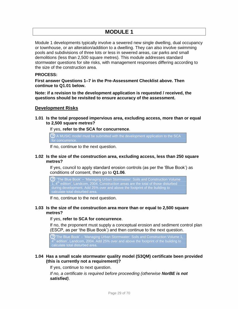
MODULE 1
Module 1 developments typically involve a sewered new single dwelling, dual occupancy or townhouse, or an alteration/addition to a dwelling. They can also involve swimming pools and subdivisions of three lots or less in sewered areas, car parks and small demolitions (less than 2,500 square metres). This module addresses standard stormwater questions for site risks, with management responses differing according to the size of the construction area.
PROCESS:
First answer Questions 1–7 in the Pre-Assessment Checklist above. Then continue to Q1.01 below.
Note: if a revision to the development application is requested / received, the questions should be revisited to ensure accuracy of the assessment.
Development Risks
1.01 Is the total proposed impervious area, excluding access, more than or equal to 2,500 square metres?
If yes, refer to the SCA for concurrence.
? A MUSIC model must be submitted with the development application to the SCA
for concurrence.
If no, continue to the next question.
1.02 Is the size of the construction area, excluding access, less than 250 square metres?
If yes, council to apply standard erosion controls (as per the ‘Blue Book’) as conditions of consent, then go to Q1.06.
? ‘The Blue Book’ – ‘Managing Urban Stormwater: Soils and Construction Volume
1, 4th
edition’, Landcom, 2004. Construction areas are the total of those disturbed during development. Add 25% over and above the footprint of the building to calculate total disturbed area.
If no, continue to the next question.
1.03 Is the size of the construction area more than or equal to 2,500 square metres?
If yes, refer to SCA for concurrence.
If no, the proponent must supply a conceptual erosion and sediment control plan (ESCP, as per ‘the Blue Book’) and then continue to the next question.
? ‘The Blue Book’ – ‘Managing Urban Stormwater: Soils and Construction Volume 1,
4th
edition’, Landcom, 2004. Add 25% over and above the footprint of the building to calculate total disturbed area.
1.04 Has a small scale stormwater quality model (S3QM) certificate been provided
(this is currently not a requirement)?
If yes, continue to next question.
If no, a certificate is required before proceeding (otherwise NorBE is not satisfied).

Page 30 of 70
1.05 Does the certificate from the small scale stormwater quality model (S3QM):
show consistency with the proposed development, and
indicate that NorBE has been achieved for stormwater, and
certify that measures are suitably located to ensure stormwater capture?
If yes to all, continue to the next question.
If no to any, a valid certificate that addresses all the above matters is required, and then continue to the next question (otherwise NorBE is not satisfied).
? An S3QM certificate is required to indicate that NorBE is achieved for stormwater
and that proposed management measures are being shown in a suitable location and can be practically implemented.
Site Risks (confirmed with a site inspection)
1.06 Does the area to be developed have a slope greater than 20% (11.40)?
If yes, include measures for long-term ground stabilisation techniques to be applied to disturbed areas, or council to include these as a condition of consent, and then continue to the next question.
If no, continue to the next question.
? The SCA strongly discourages development on sites with slopes greater than
20% because of the amount of cut and fill involved and the potential for erosion, unless the development is a low impact development specifically designed for the slope, such as a pole house, and/or incorporates long-term ground stabilisation techniques for steep disturbed areas.
1.07 Is the area to be developed within a 1% annual exceedance probability (AEP)
flood level or flood prone area associated with watercourses and drainage depressions?
If yes, council to include condition of consent as follows:
(1) All fixtures capable of draining to the sewer system, including the overflow relief gully, are to be above the 1% AEP flood level and fully sealed; and
(2) Any required termite controls are to be physical barriers only, and chemical barriers or termite protection systems are not to be used below the 1% AEP flood level.
Then continue to the next question.
If no, continue to the next question.
? AEP refers to annual exceedance probability of flooding. Include conditions to
minimise impact from development occurring within AEP.
The SCA opposes effluent management areas and any other part of an on-site system being located in the floodway, and encourages all parts of on-site systems to be located above the 1% AEP. If an EMA is located between these levels it should be a subsurface system. Tanks and active treatment components should be located above the 1% AEP.
1.08 Are there any other site constraints that may impact on the proposed
development?
? Use site plans and aerial photography, and confirm through a site inspection.
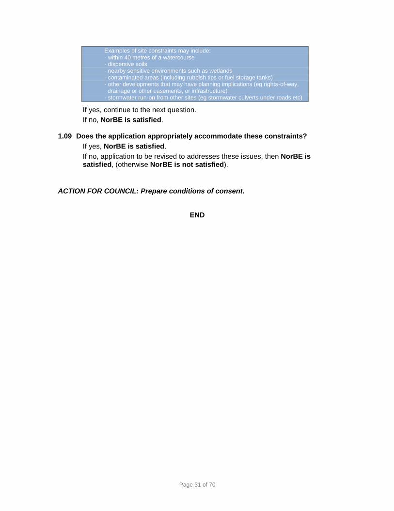
Page 31 of 70
Examples of site constraints may include: - within 40 metres of a watercourse - dispersive soils - nearby sensitive environments such as wetlands - contaminated areas (including rubbish tips or fuel storage tanks) - other developments that may have planning implications (eg rights-of-way, drainage or other easements, or infrastructure) - stormwater run-on from other sites (eg stormwater culverts under roads etc)
If yes, continue to the next question.
If no, NorBE is satisfied.
1.09 Does the application appropriately accommodate these constraints?
If yes, NorBE is satisfied.
If no, application to be revised to addresses these issues, then NorBE is satisfied, (otherwise NorBE is not satisfied).
ACTION FOR COUNCIL: Prepare conditions of consent.
END

Page 32 of 70
MODULE 2
Module 2 developments typically involve an unsewered new dwelling, dual occupancy or townhouse, or alterations/additions. It may also involve an unsewered subdivision of three lots or less. The main focus of this module is to assess wastewater systems, including design loadings and site risks, and also design aspects for subdivisions.
GENERAL CONSIDERATIONS:
Where there are significant discrepancies between a consultant’s wastewater report and information from the SCA’s databases or site-specific soil or other information, seek clarification from the consultant then seek advice from the SCA if the discrepancy remains unresolved.
If the proposed effluent management area is located wholly in the same lot as the existing dwelling, include setback distances as a minimum as per Table 2.4 of the SCA’s ‘Designing and Installing On-Site Wastewater Systems’ (SCA, 2012a).
Pump out systems are not acceptable – as they are not sustainable and are often the worst performing systems – except under certain circumstances such as imminent connection to reticulated sewer. The SCA is to be contacted in circumstances where a pump out system is considered to be the only viable option.
Greywater systems are treated as wastewater systems for the purposes of this Module, except that the greywater design loading is to be 65% of the calculated design wastewater loading.
Emerging technology or non-standard on-site wastewater systems such as membrane systems, textile filters systems, high nutrient removal AWTS, or reed beds should be referred to the SCA for concurrence.
PROCESS:
First answer Questions 1–7 in the Pre-Assessment Checklist above. Then continue to question 2.01 below. Desktop Assessment 2.01 Is the on-site wastewater system an emerging technology or non-standard
system?
? Standard systems include septic tanks, absorption and evapotranspiration
absorption (ETA) beds, 10EP aerated wastewater treatment systems (AWTS), irrigation systems, sand mounds, amended soil mounds, wet or dry composting systems, sand filters (both single pass and recirculating), and greywater treatment systems. Refer to the SCA’s ‘Designing and Installing On-Site Wastewater Systems’ (SCA, 2012a).
If yes, refer to the SCA for concurrence.
If no, continue to the next question.

Page 33 of 70
2.02 Is the application for the same type of system as recommended in the on-site wastewater management report?
If yes, or not applicable, continue to the next question.
If no, applicant is to clarify, and then continue to the next question.
Site Evaluation 2.03 Can the proposed effluent management area (EMA) be located within the lot
or property, and does it correspond to the proposed location specified and discussed in the report (map or GPS coordinates)?
? Any discrepancy between map location and GPS coordinates provided in the
report need to be clarified and resolved.
If no, consultant/proponent to clarify, (otherwise NorBE is not satisfied). Then continue to the next question.
If yes, continue to the next question.
2.04 Is the size of the construction area less than 250 square metres?
If yes, apply standard erosion controls (as per the ‘Blue Book’), then go to Q2.06.
? ‘The Blue Book’ – ‘Managing Urban Stormwater: Soils and Construction Volume
1, 4th
edition’, Landcom, 2004. Add 25% over and above the footprint of the building to calculate total disturbed area.
If no, continue to the next question.
2.05 Is the size of the construction area and/or total proposed impervious area, excluding access, equal to or greater than 2,500 square metres?
If yes, refer to the SCA for concurrence.
? A MUSIC model must be submitted with the development application to the SCA
for concurrence.
If no, a conceptual erosion and sediment control plan (ESCP, as per ‘the Blue Book’) is required, and then continue to the next question.
? ‘The Blue Book’ – ‘Managing Urban Stormwater: Soils and Construction Volume
1, 4th
edition’, Landcom, 2004.
Standard Stormwater and Development Site Risks 2.06 Does the area to be developed have a slope greater than 20% (11.40)?
? The SCA strongly discourages development on sites with slopes greater than
20% because of the amount of cut and fill involved and the potential for erosion, unless the development is a low impact development specifically designed for the slope, such as a pole house, and/or incorporates long-term ground stabilisation techniques for steep disturbed areas.
If yes, continue to the next question.
If no, go to Q2.10.

Page 34 of 70
2.07 Can the area to be developed be relocated to avoid the slope of 20% (11.40)?
If yes, provide a suitable alternative location, and then continue to the next question.
If no, include measures for long-term ground stabilisation techniques to be applied to disturbed areas, or council to include these as a condition of consent, (otherwise NorBE is not satisfied). Then continue to the next question.
2.08 Does the area to be developed have a slope greater than 32% (180)?
If yes, it may be State Protected Land (see the Native Vegetation Act 2003), then continue to the next question.
? See your Local Land Services agency for information regarding State Protected
Land.
If no, go to Q2.10.
2.09 Can the area to be developed be relocated to avoid the slope of 32% (180)?
If yes, provide a suitable alternative location, and then continue to the next question.
If no, NorBE is not satisfied.
2.10 Is the area to be disturbed in the development proposal within a 1% annual exceedance probability (AEP) flood level or flood prone area associated with watercourses and drainage depressions?
If yes, council to include condition of consent as follows:
(1) All fixtures capable of draining to the sewer system, including the overflow relief gully, are to be above the 1% AEP flood level and fully sealed; and
(2) Any required termite controls are to be physical barriers only, and chemical barriers or termite protection systems are not to be used below the 1% AEP flood level.
Then continue to the next question.
If no, continue to the next question.
? AEP refers to annual exceedance probability of flooding. Include conditions to
minimise impact from development occurring within AEP.
The SCA opposes effluent management areas and any other part of an on-site system being located in the floodway, and encourages all parts of on-site systems to be located above the 1% AEP. If an EMA is located between these levels it should be a subsurface system. Tanks and active treatment components should be located above the 1% AEP.
2.11 Are proposed dwellings or building envelopes, and associated works located
within 40 metres of a watercourse or waterbody?
? This could involve discussions with the NSW Office of Water and SCA - a
controlled activity approval under the Water Management Act 2000 may be required from the NSW Office of Water if works are in or on waterfront land. Any new position is to be reflected clearly in the conditions of consent. NB: wastewater systems are expected to be located more than, 100 metres from watercourses or water supply reservoir, and 40 metres from drainage depressions, farm dams and waterbodies.
If yes, continue to the next question.

Page 35 of 70
If no, go to Q2.13.
2.12 Can the proposed dwellings or building envelopes, and associated works be relocated within their lots to meet the watercourse or waterbody setback?
If yes, provide suitable alternative location(s), and then continue to the next question.
If no, either revise the proposal or lot layout (if a subdivision) and return to Q2.01, OR propose appropriate measures for managing the risk (including these in the WCMS) (otherwise NorBE is not satisfied). Then continue to the next question.
2.13 Will more than 250 square metres of native trees and understorey vegetation be removed on the lot (or each proposed lot if a subdivision) including clearing for roads, dwelling access and Asset Protection Zones (APZ)?
? NB clearing of vegetation may require approval from Local Land Services under
the Native Vegetation Act 2003. Clearing of Endangered Ecological Communities
should not be undertaken at all.
If yes, continue to the next question.
If no, go to Q2.15.
2.14 Can the works (including for the APZ) be relocated to minimise vegetation clearing?
If yes, provide a suitable alternative location, and then continue to the next question.
If no, either revise proposal or lot layout (if a subdivision) and return to Q2.01 OR include water quality impacts and offset measures in the WCMS (otherwise NorBE is not satisfied). Then continue to the next question.
2.15 Do the soils in the area to be developed have a wide-spread salinity or sodicity risk?
If yes, continue to the next question.
If no, go to Q2.17.
2.16 Can the area to be developed be relocated to avoid the salinity or sodicity risk?
If yes, provide a suitable alternative location(s), and then continue to the next question.
If no, either revise the lot layout (if a subdivision) and return to Q2.01 OR appropriate measures for managing the salinity or sodicity risk must be included in the WCMS (otherwise NorBE is not satisfied). Then continue to the next question.
? See the SCA’s ‘Developments in Sydney’s drinking water catchments – water
quality information requirements’ (2015) for information on preparing a WCMS.

Page 36 of 70
2.17 Do any of the proposed construction works associated with the development occur where more than 10% of the soils on the site are dispersive?
? See dispersive soils in Section 3.2.6 of the ‘Blue Book’ (Managing Urban
Stormwater: Soils and Construction Volume 1, 4th
edition, Landcom, 2004).
If yes, appropriate measures for managing dispersive soils must be included in the conceptual SWMP (otherwise NorBE is not satisfied). Then continue to the next question.
If no, continue to the next question.
2.18 Are there any potentially contaminated sites on the lot (or proposed lots if a subdivision)?
? For example livestock dips, rubbish tips, old industrial sites, fuels storage tanks,
etc.
If yes, identify appropriate management measures in the WCMS consistent with the SCA’s current recommended practices (otherwise NorBE is not satisfied). Then continue to the next question.
? A list of SCA endorsed current recommended practices (CRPs) is available on the
website www.sca.nsw.gov.au. For subdivisions, contaminated sites generally need to be decontaminated, remediated and then re-evaluated.
If no, continue to the next question.
2.19 For the lot (or each lot in the case of a subdivision), are there any other site constraints that may impact on the proposed development?
? Use site plans and aerial photography, and confirm through a site inspection.
Examples of site constraints may include: - rock outcrops - nearby sensitive environments such as wetlands and National Parks - shallow soils, scalding, high or low permeability soils - gullying, highly erosive soils, existing erosion control works (including revegetation areas - existing developments, including dwellings, access tracks, quarries etc - other developments that may have planning implications (eg rights-of-way, drainage or other easements, or infrastructure) - stormwater run-on from other sites (eg stormwater culverts under roads etc) - existing or failing on-site wastewater management system.
If yes, continue to the next question.
If no, go to Q2.21.
2.20 Does the proposal appropriately accommodate these other constraints?
If yes, continue to the next question.
If no, address these issues and revise proposal, then continue to the next question (otherwise NorBE is not satisfied).
? The design should be consistent with the ‘Water Sensitive Design Guide for Rural
Residential Subdivisions’ (SCA, 2011), or justification provided for alternative measures for addressing these constraints.

Page 37 of 70
Standard Wastewater Questions:
These are applicable for each lot if a subdivision is proposed.
? If the proposal is a ‘paper’ subdivision, and no on-site systems are proposed, the
answer to some of the following questions will be ‘not applicable’.
2.21 Does the application include a swimming pool?
If yes, council to apply conditions that backwash water is not to be disposed of to the wastewater system, or within 40 metres of a dam, waterbody, roadside drains or swales, or drainage depression, 100 metres of a watercourse or water supply reservoir, or upslope or within an EMA. Then continue to the next question.
? Within established village areas where these buffer distances cannot be achieved
on a lot, the buffer distance must instead be maximised.
See ‘Reuse and Recycling of Swimming Pool Backwash Water’ by NSW Health http://www.health.nsw.gov.au/environment/factsheets/Pages/swimming-pool-ackwash.aspx.
If no or not applicable, go to the next question.
2.22 Does the application include other elements such as dwellings and on-site wastewater systems (in addition to a swimming pool)?
If yes, continue to the next question.
If no, NorBE is satisfied.
2.23 Is the proposed wastewater system a pump-out?
? Pump out systems are not sustainable and are often the worst performing as a
result of misuse or poor practices.
If yes, continue to the next question.
If no, or not applicable, continue to Q2.25.
2.24 Is the pump-out system in an area that is proposed to be connected to a reticulated sewer in the near future?
If yes, council to apply conditions and continue to the next question.
If no, NorBE is not satisfied.
2.25 Is the use of the wastewater system intermittent (eg holiday cottage)?
If yes, applicant to choose a system that is appropriate for intermittent loading (otherwise NorBE is not satisfied) - then continue to the next question.
? For example, a septic tank is suitable for intermittent loading whereas an aerated
wastewater treatment system (AWTS) is generally not.
If no, continue to the next question.

Page 38 of 70
Lot size:
2.26 Is the lot size less than 2,000 square metres?
? 2,000 m2 is considered the minimum whereby a dwelling with setbacks and a
suitable EMA with setbacks and buffers may be located on a lot. However, there is no guarantee that 2,000 m
2 will be adequate, especially if the site is steep, or the soils
are highly permeable or there are extensive rock outcrops.
If yes, surface irrigation is not suitable and a suitable small footprint effluent disposal system must be proposed (otherwise NorBE is not satisfied).Then continue to the next question.
? Effluent irrigation may not be possible at all and a small footprint system will be
required (eg an amended soil mound, a sand mound or absorption systems). A specific wastewater treatment and disposal system will be reflected in a covenant on the title for constrained sites.
If no, continue to the next question.
Slope:
2.27 Is the slope of the EMA more than 7% (40)?
If yes, surface irrigation and amended soil mound systems are not suitable – an alternative system must be used (otherwise NorBE is not satisfied). Then continue to the next question.
If no, go to Q2.30.
2.28 Is the slope of the EMA more than 20% (11.40)?
If yes, continue to the next question.
If no, go to Q2.30.
2.29 Can the proposed EMA be moved to avoid the slope of more than 20% (11.40)?
If yes, a suitable alternative location(s) to be provided, then continue to the next question.
If no, NorBE is not satisfied.
Climate:
2.30 Is the site located in an area with more than 1,200 millimetres annual average rainfall?
If yes, surface irrigation is not suitable (and NorBE is not satisfied). If sub-surface irrigation is proposed, a water balance calculation should be undertaken, and wet weather storage may be required. If such requirements for a sub-surface irrigation system are met or a non-irrigation disposal system is proposed, then continue to the next question.
If no, continue to the next question.
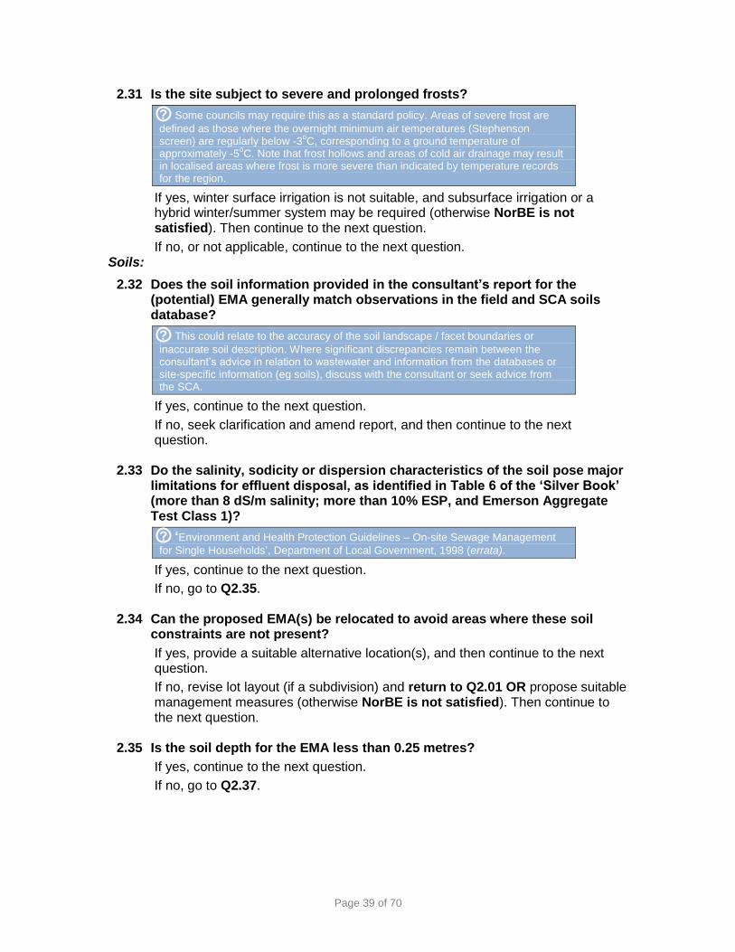
Page 39 of 70
2.31 Is the site subject to severe and prolonged frosts?
? Some councils may require this as a standard policy. Areas of severe frost are
defined as those where the overnight minimum air temperatures (Stephenson screen) are regularly below -3
oC, corresponding to a ground temperature of
approximately -5oC. Note that frost hollows and areas of cold air drainage may result
in localised areas where frost is more severe than indicated by temperature records for the region.
If yes, winter surface irrigation is not suitable, and subsurface irrigation or a hybrid winter/summer system may be required (otherwise NorBE is not satisfied). Then continue to the next question.
If no, or not applicable, continue to the next question. Soils:
2.32 Does the soil information provided in the consultant’s report for the (potential) EMA generally match observations in the field and SCA soils database?
? This could relate to the accuracy of the soil landscape / facet boundaries or
inaccurate soil description. Where significant discrepancies remain between the consultant’s advice in relation to wastewater and information from the databases or site-specific information (eg soils), discuss with the consultant or seek advice from the SCA.
If yes, continue to the next question.
If no, seek clarification and amend report, and then continue to the next question.
2.33 Do the salinity, sodicity or dispersion characteristics of the soil pose major
limitations for effluent disposal, as identified in Table 6 of the ‘Silver Book’ (more than 8 dS/m salinity; more than 10% ESP, and Emerson Aggregate Test Class 1)?
? ‘Environment and Health Protection Guidelines – On-site Sewage Management
for Single Households’, Department of Local Government, 1998 (errata).
If yes, continue to the next question.
If no, go to Q2.35.
2.34 Can the proposed EMA(s) be relocated to avoid areas where these soil constraints are not present?
If yes, provide a suitable alternative location(s), and then continue to the next question.
If no, revise lot layout (if a subdivision) and return to Q2.01 OR propose suitable management measures (otherwise NorBE is not satisfied). Then continue to the next question.
2.35 Is the soil depth for the EMA less than 0.25 metres?
If yes, continue to the next question.
If no, go to Q2.37.

Page 40 of 70
2.36 Can the EMA be moved to avoid the area where the soil depth is greater than 0.25 metres, or can a mound system be negotiated?
If yes, provide a suitable alternative location with a soil depth of more than 0.25 m OR a mound system, and then continue to the next question (otherwise NorBE is not satisfied).
If no, NorBE is not satisfied.
2.37 Is the soil depth less than 0.75 metres or is the dominant soil type a medium or heavy clay?
? The ‘C’ horizon is not to be included in calculating the soil depth. Refer to
AS/NZS1547:2012 ‘On-site domestic wastewater management’, Standards Australia, 2012. Where an absorption trench or bed is proposed on medium or heavy clay, a design that includes special design criteria, such as soil modification and soil permeability testing, may be accepted.
If yes to either, absorption trenches or beds are not suitable (noting special design requirements may be accepted for such systems on medium to heavy clays deeper than 0.75 metres), and an alternative system will need to be used for effluent disposal (otherwise NorBE is not satisfied). Then continue to the next question.
If no to both, continue to the next question.
2.38 Is the soil depth less than 0.75 metres or is the dominant soil type a gravel, sand or sandy loam?
? The ‘C’ horizon is not to be included in calculating the soil depth. Refer to
AS/NZS1547:2012 ‘On-site domestic wastewater management’, Standards Australia, 2012.
If yes to either, ETA systems are not suitable and an alternative system will need to be used for effluent disposal (otherwise NorBE is not satisfied). Then continue to the next question.
If no to both, continue to the next question. Design Wastewater Loading:
2.39 Is the design wastewater loading in the consultant’s report consistent with
the SCA’s requirements of loading determined per number of potential bedrooms and tank or reticulated/bore water supply?
? If the proposed system involves the augmentation of an existing system, all
potential bedrooms must be included. Where a separate dwelling is proposed to be connected to an existing system, the design wastewater loading must be considered separately for each dwelling (in such a case, the design loading rate should not be based on the total potential bedrooms in both dwellings).
Design wastewater loading per potential bedroom
Reticulated/Bore Water Tank Water
1-2 potential bedrooms 600 L/d 400 L/d
3 potential bedrooms 900 L/d 600 L/d
4 potential bedrooms 1200 L/d 800 L/d
More than 4 potential bedrooms
1200 L/d plus 150 L/d for each additional bedroom
800 L/d plus 100 L/d for each additional bedroom
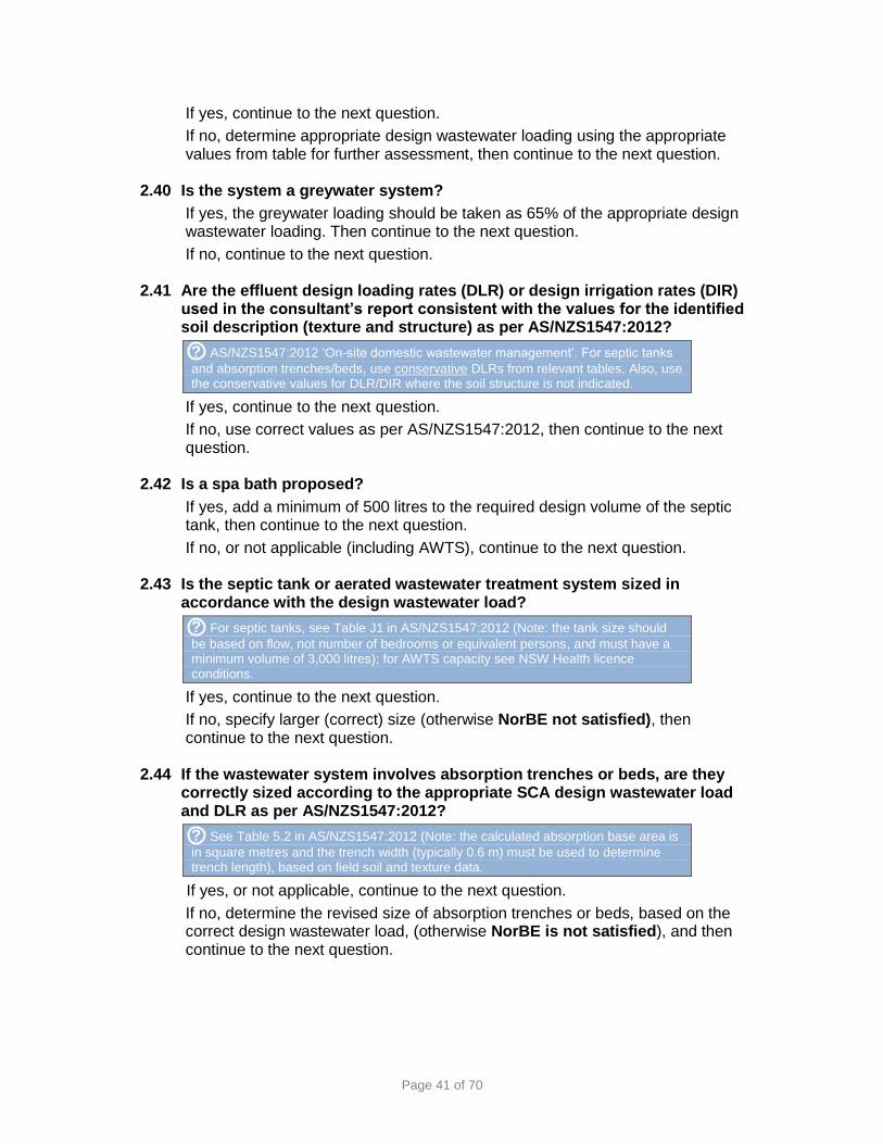
Page 41 of 70
If yes, continue to the next question.
If no, determine appropriate design wastewater loading using the appropriate values from table for further assessment, then continue to the next question.
2.40 Is the system a greywater system?
If yes, the greywater loading should be taken as 65% of the appropriate design wastewater loading. Then continue to the next question.
If no, continue to the next question.
2.41 Are the effluent design loading rates (DLR) or design irrigation rates (DIR) used in the consultant’s report consistent with the values for the identified soil description (texture and structure) as per AS/NZS1547:2012?
? AS/NZS1547:2012 ‘On-site domestic wastewater management’. For septic tanks
and absorption trenches/beds, use conservative DLRs from relevant tables. Also, use the conservative values for DLR/DIR where the soil structure is not indicated.
If yes, continue to the next question.
If no, use correct values as per AS/NZS1547:2012, then continue to the next question.
2.42 Is a spa bath proposed?
If yes, add a minimum of 500 litres to the required design volume of the septic tank, then continue to the next question.
If no, or not applicable (including AWTS), continue to the next question.
2.43 Is the septic tank or aerated wastewater treatment system sized in accordance with the design wastewater load?
? For septic tanks, see Table J1 in AS/NZS1547:2012 (Note: the tank size should
be based on flow, not number of bedrooms or equivalent persons, and must have a minimum volume of 3,000 litres); for AWTS capacity see NSW Health licence conditions.
If yes, continue to the next question.
If no, specify larger (correct) size (otherwise NorBE not satisfied), then continue to the next question.
2.44 If the wastewater system involves absorption trenches or beds, are they correctly sized according to the appropriate SCA design wastewater load and DLR as per AS/NZS1547:2012?
? See Table 5.2 in AS/NZS1547:2012 (Note: the calculated absorption base area is
in square metres and the trench width (typically 0.6 m) must be used to determine trench length), based on field soil and texture data.
If yes, or not applicable, continue to the next question.
If no, determine the revised size of absorption trenches or beds, based on the correct design wastewater load, (otherwise NorBE is not satisfied), and then continue to the next question.

Page 42 of 70
2.45 If the wastewater system involves irrigation, is it correctly sized according to the appropriate SCA design wastewater load and DIR as per AS/NZS1547:2012, and the nutrient and water balance methodology as per ‘Silver Book’?
? See Table M1 in AS/NZS1547:2012 ‘On-site domestic wastewater management
and Environment and Health Protection Guidelines – On-site Sewage Management for Single Households’, Department of Local Government, 1998 (the ‘Silver Book’). Note: phosphorus sorption values should be preferably based on site specific information, or GIS values from the SCA’s Soils Database. The default value used in the ‘Silver Book’ must not be used.
If yes, or not applicable, continue to the next question.
If no, the revised size of the irrigation area must be determined, based on the correct design wastewater load, DIR and nutrient and water balance methodology (otherwise NorBE is not satisfied), and then continue to the next question.
2.46 If the wastewater system involves a sand mound, is it correctly sized
according to Converse and Tyler 2000?
? Reference: Converse JC and Tyler EJ, ‘Wisconsin Mound Soil Absorption
System: Siting Design and Construction Manual’, University of Wisconsin-Madison, 2000. Note: applying the DLRs in Table N1 of the AS/NZS1547:2012 are not appropriate for the sizing of mounds.
If yes, or not applicable, continue to the next question.
If no, the consultant must determine the correct size of the sand mound (otherwise NorBE is not satisfied), and then continue to the next question.
2.47 If the wastewater system involves an amended soil mound, is it sized
correctly according to the relevant design wastewater loading and DLR for the limiting soil layer as per AS/NZS1547:2012?
? AS/NZS1547:2012 ‘On-site domestic wastewater management’.
If yes, or not applicable, continue to the next question.
If no, ensure the supplier has sized the mound correctly (otherwise NorBE is not satisfied). Then continue to the next question.
2.48 Does the wastewater system involve a dry composting toilet?
? The manufacturer often specifies the dimensions required for the absorption
trench. Note that a greywater system will also be required. The minimum trench size is five metres in length, and the compost must be buried at a minimum depth of 150 mm and consistent with the SCA’s buffer requirements.
If yes, then a small absorption trench is required (unless the system incorporates a liquid evaporation system) (otherwise NorBE is not satisfied). Then continue to the next question.
If no, then continue to the next question.

Page 43 of 70
Groundwater:
2.49 Are any water bores licensed for domestic water supply located within 100 metres of the proposed EMA?
? Refer Table 2.4 in ‘Designing and Installing On-Site Wastewater Systems’ (SCA,
2012a)
If yes, then continue to the next question.
If no, continue to Q2.51.
2.50 Can the EMA be relocated outside the 100 metre buffer?
If yes, revise location of proposed EMA. Then continue to the next question.
If no, undertake bore draw-down zone analysis (eg using Cromer et al, 2001) to demonstrate that effluent will not be drawn into the groundwater draw-down zone (and include in WCMS) and continue to the next question (otherwise NorBE is not satisfied).
? ‘An Improved Viral Die-Off Method for Estimating Setback Distances’. Cromer WC,
Gardner EA and Beavers PD (2001) Proceedings of On-site ’01 Conference: Advancing On-site Wastewater Systems. University of New England Armidale, 15-27 September 2001.
General:
2.51 Are there other potential problems with the wastewater system as proposed?
? For example, insufficient head for gravity systems (ie system higher than house)
or long separation between dwelling and tank, or tank and disposal area, or where a system requiring continuous power is proposed eg AWTS and there is no mains power. For domestic wastewater systems, the SCA considers 1:40 for a length of 60 metres to be the minimum gradient for untreated effluent gravity systems, and also that solar power is not suitable for AWTS. Refer to Table 2.5 of the SCA’s ‘Designing and Installing On-Site Wastewater Systems’ (SCA, 2012a) for further information.
If yes, consultant and/or proponent to address, (otherwise NorBE is not satisfied), then continue to the next question.
If no, continue to the next question.
Existing Systems:
2.52 Are there any existing wastewater systems on the lot (or lots in the case of
a subdivision)?
? These must be subject to wastewater effluent modelling to ensure the effluent
plume does not move off the proposed lot containing the existing system. Where an effluent disposal system is failing, a suitable upgraded system should be proposed. If an effluent plume crosses the proposed boundary or enters the drainage system, then a new (complying) system must be proposed.
If yes, all existing wastewater systems including EMAs must be identified in the WCMS and must be wholly contained in the proposed lot with the dwelling. Then continue to the next question.
If no, continue to the next question.

Page 44 of 70
Buffer Distances:
2.53 Does the proposed EMA (on all lots if a subdivision) meet the SCA’s buffer distances:
40 metres for a drainage depression or farm dam
100 metres for a watercourse or water supply reservoir
? Overland flow path ie the direction in which any effluent would actually flow. If
relocated to a substantially different area, new soil information may be needed – soil questions Q2.32 – 2.38 will need to be re-addressed. Any revised location needs to
be specified clearly in the conditions of consent. For a watercourse, the buffer distance is to be measured from the top bank of the watercourse.
If yes, continue to the next question.
If no, provide an alternative location(s) that meets the SCA’s buffer requirements (otherwise NorBE is not satisfied). Then continue to the next question.
2.54 Does the EMA meet the SCA’s setback requirements and any other council setback requirements from buildings, boundaries and swimming pools?
? Refer to Table 2.4 in ‘Designing and Installing On-Site Wastewater Systems’
(SCA, 2012a). The distance is the overland flow path ie the direction in which any effluent would actually flow.
If yes, go to Q2.56.
If no, continue to the next question.
2.55 Can the EMA be readily moved nearby to meet these setbacks?
If yes, provide an alternative location and amend plans/reports or provide a small footprint system that meets these requirements (eg a mound, absorption systems or amended soil system). New soils information may be required soil
questions Q2.32 – 2.38 will need to be re-addressed, and the new location specified clearly by councils in the conditions of consent. Then continue to the next question.
If no, NorBE is not satisfied. Roads/Rights-of-way/Dwelling Access:
2.56 Can all works, including drainage infrastructure, be wholly contained within
the road reserve or right-of-way, or are there suitably defined easements?
? Note: it is highly unlikely that a typical 20 m wide road reserve in undulating
country will be wide enough to contain these works.
If yes, continue to the next question.
If no, redesign and/or create easements (otherwise NorBE is not satisfied), and then continue to the next question.
2.57 Does any (new) subdivision road and right-of-way, dwelling or dwelling
access require significant cut and fill because of slope?
? For the purpose of defining ‘significant’, three metres cut and fill is to be used as
the upper acceptable limit.
If yes, continue to the next question.
If no, go to Q2.59.

Page 45 of 70
2.58 Can the subdivision road, right-of-way, dwelling or dwelling access be relocated to minimise cut and fill?
If yes, revise the location of the road / right-of-way / dwelling access, and then continue to the next question.
? There is a trade-off between excessively steep roads / rights-of-way and those
that largely follow cut and fill – this involves a judgement call. Refer to the SCA’s endorsed current recommended practices for advice.
If no, special design measures will be required and must be included in the WCMS (otherwise NorBE is not satisfied). Then continue to the next question.
2.59 Is the subdivision road, right-of-way, dwelling or dwelling access (other than crossings and approaches) located within 40 metres of a natural watercourse or waterbody?
If yes, continue to the next question.
If no, go to Q2.61.
2.60 Can the subdivision road, right-of-way or dwelling access be relocated to meet the watercourse or waterbody setback?
If yes, provide a suitable alternative location(s) then continue to the next question.
If no, special design and/or soil and water measures for managing the water quality risk must be included in the WCMS before continuing to the next question (otherwise NorBE is not satisfied).
? Refer to the SCA’s endorsed current recommended practices for advice.
2.61 Does the subdivision road, right-of-way or dwelling access require the
crossing, piping, diverting or channelisation of any watercourse or drainage depression or gully?
If yes, continue to the next question.
If no, go to Q2.63.
2.62 Can the subdivision road, right-of-way or dwelling access be relocated to avoid the crossing, piping, diverting or channelisation of any watercourse or drainage depression or gully?
If yes, provide a suitable alternative location(s), then continue to the next question.
If no, special design and/or appropriate soil and water measures for managing the water quality risk must be included in the WCMS before continuing to the next question (otherwise NorBE is not satisfied).
? Suitable management measures or construction requirements could include
sharing crossings, a concrete causeway, or a box culvert crossing consistent with the SCA’s current recommended practices. Any crossing may also require a controlled activity approval under the Water Management Act 2000. Any new position or management measures or construction requirements are to be addressed in the WCMS. See the SCA’s ‘Developments in Sydney’s drinking water catchments – water quality information requirements’ (2015) for information on preparing a WCMS, and other SCA’s endorsed current recommended practices for advice.

Page 46 of 70
2.63 Can any dwelling access and right-of-way be reasonably shared?
? Sharing driveways and watercourse crossings reduces the need for vegetation
clearing and other water quality impacts, as well as construction costs, and may assist in achieving a satisfactory NorBE outcome. This may require the creation of rights-of-way over the shared access.
If yes, include details in WCMS, then continue to the next question.
If no, continue to the next question.
2.64 Can the majority of each proposed lot be accessed without the need for crossing any steep watercourses and gullies?
If yes, or not applicable continue to the next question.
If no, revise the lot layout consistent with the SCA’s ‘Water Sensitive Design Guide for Rural Residential Subdivisions’, then go back to Q2.01 (otherwise NorBE is not satisfied).
S3QM /MUSIC stormwater questions relating to development risks:
? In those cases where the impervious area is more than 2,500 square metres, a
complying MUSIC model must be provided with the development application for the SCA’s concurrence.
2.65 Has a small scale stormwater quality model (S3QM) certificate been
provided (this is currently not a requirement)?
If yes, continue to next question.
If no, a certificate is required before proceeding (otherwise NorBE is not satisfied).
2.66 Does the certificate from the small scale stormwater quality model (S3QM):
show consistency with the proposed development, and
indicate that NorBE has been achieved for stormwater, and
certify that measures are suitably located to ensure stormwater capture?
If yes to all, continue to the next question.
If no to any, a valid certificate that addresses all the above matters is required, and then continue to the next question (otherwise NorBE is not satisfied).
? An S3QM certificate is required to indicate that NorBE is achieved for stormwater
and a plan showing that proposed management measures are in a suitable location and can be practically implemented.
2.67 If required, can the stormwater measures be practically implemented on the
ground without overlap of any existing or proposed EMA?
? Any overlap of the stormwater management measures with the EMA will cause
increased saturation of the soil and increase the size of the plume from the EMA, and premature failure of the EMA.
If yes, apply requirements identified in the model and continue to the next question.
If no, move the stormwater measures so that there is no overlap with an existing or proposed EMA or NorBE is not satisfied.

Page 47 of 70
2.68 Have the responsibilities for the ongoing management of the stormwater
management measures been clearly identified in the WCMS?
? This should form part of a subsequent operational environmental management
plan. Water quality infrastructure management responsibilities should be clearly articulated and practical, and may be placed on a council, a community scheme, businesses or individuals.
If yes, then continue to the next question.
If no, address in the WCMS, otherwise NorBE is not satisfied. WEM Evaluation ACTION: Enter proposed wastewater system data, soils information and locations into WEM for the lot (or each lot in the case of a subdivision). The collective answers for Q2.69 – 2.71 are for all lots.
2.69 Does the modelled effluent plume cross the proposed lot boundary or intersect with a watercourse, waterbody or drainage depression?
If yes, continue to the next question.
If no, NorBE is satisfied.
? If the plume length is greater than 250 metres, it is considered that NorBE is not
satisfied.
2.70 Can the EMA be relocated nearby the proposed site (using the WEM model)
to avoid a plume that intersects a watercourse, waterbody, drainage depression or property boundary?
? Such revised locations may require new soil information, and soil questions Q2.32
– 2.38 will need to be re-addressed.
If yes, NorBE is satisfied.
If no, continue to the next question.
2.71 Can an alternative wastewater treatment and disposal system be considered?
If yes, re-run WEM (and go back to Q2.69). Any specific system must be identified in the WCMS.
? A specific wastewater treatment and disposal system will be reflected in a
covenant on the title for constrained sites. Such alternative systems may require new soil and other constraint information, and questions Q2.32 – 2.38 will need to be re-
addressed.
If no, NorBE is not satisfied.
ACTION FOR COUNCIL: Prepare conditions of consent.
END

Page 48 of 70
MODULE 3
Module 3 developments typically involve a sewered urban subdivision that may or may not involve the construction of dwellings. Module 3 addresses standard stormwater site risks such as soils and slope, development risks, standard sewerage questions, MUSIC model evaluation (except where the total proposed impervious area is less than 2,500 square metres in which case an S3QM model can be used), and site inspection queries. For the purposes of this module, subdivision refers to lot layout and any proposed construction required by the development application. Any proposed roads and/or rights-of-way and/or dwelling accesses are referred to in this Module as associated works, and include associated drainage works.
All applications must be consistent with the following current recommended practices and performance standards (includes but not limited to):
‘Developments in Sydney’s Drinking Water Catchments – Water Quality Information Requirements’ (SCA, 2015)
‘Using MUSIC in Sydney’s Drinking Water Catchment’ (SCA, 2012b)
‘Managing Urban Stormwater: Soils and Construction Vol.s 1 & 2’ (‘Blue Book’; Landcom, 2004 and DECCW, 2008).
Staging: The consultant must check with the developer whether the development is to be staged – NorBE must be satisfied for all stages of the development. Also, any staging must be included in the development application (DA). Assessment cannot be undertaken for notional proposed staging that is not included in the DA.
PROCESS:
First answer Questions 1–7 in the Pre-Assessment Checklist above. Then continue at Q3.01 below. Generic Subdivision Questions
3.01 Is the subdivision layout and lot numbering consistent throughout all
reports?
? Often reports are based on earlier versions of the subdivision where lot layout and
numbering are different from that submitted.
If yes, continue to the next question.
If no, ensure lot layout and numbering is consistent before continuing to the next question.
3.02 Is the development staged?
? The consultant must check with the developer whether the development is to be
staged. NB: NorBE must be satisfied for all stages of the development. Also, any
staging must be included in the development application (DA). Assessment cannot be undertaken for notional proposed staging that is not included in the DA. Some developments may require major water quality devices to be installed in the early stages of development in order to meet NorBE for the development proposal as a whole.
If yes, a separate NorBE assessment must be completed for all stages of the subdivision before continuing to the next question.
If no, continue to the next question.
Page 49 of 70
Standard Stormwater and Development Site Risks 3.03 Does any area to be developed (including any proposed roads, rights-of-way,
dwelling access or building envelopes) occur in areas where the slope is greater than 20% (11.40)?
? The SCA strongly discourages development on sites with slopes greater than
20% because of the amount of cut and fill involved and the potential for erosion, unless the development is a low impact development specifically designed for the slope, such as a pole house, and/or incorporates long-term ground stabilisation techniques for steep disturbed areas.
If yes, continue to the next question.
If no, go to Q3.08.
3.04 Can the area to be developed be relocated to avoid the slope of 20% (11.40)?
If yes, provide a suitable alternative location(s), and then continue to the next question.
If no, either revise lot layout and return to Q3.01 OR provide appropriate construction erosion and sediment control and post-construction stormwater quality management methods in the WCMS (otherwise NorBE is not satisfied). Then continue to the next question.
3.05 Does the area to be developed have a slope greater than 32% (180)?
If yes, it may be State Protected Land (see the Native Vegetation Act 2003), then continue to the next question.
? See your Local Land Services agency for information regarding State Protected
Land.
If no, go to Q3.07.
3.06 Can the area to be developed be relocated to avoid the slope of 32% (180)?
If yes, provide a suitable alternative location(s), and then continue to the next question.
If no, NorBE is not satisfied.
3.07 Is any area to be disturbed in relation to the development proposal (including any proposed roads, access ways, rights-of-way or building envelopes) within a 1% annual exceedance probability (AEP) flood level or flood prone areas associated with watercourses and drainage depressions?
If yes, continue to next question.
If no, go to Q3.09.
3.08 Can the area to be disturbed in relation to the development proposal be relocated to avoid the 1% AEP flood level?
If yes, provide a suitable alternative location, and then continue to next question.
If no, either revise lot layout and return to Q3.01 OR provide construction and management measures for development in the 1% AEP flood level (otherwise NorBE is not satisfied). Then continue to the next question.

Page 50 of 70
3.09 Is rainfall erosivity greater than or equal to 4,000 mm/ha/hr/year?
If yes, ensure this is addressed in the conceptual soil and water management plan (SWMP) before continuing to the next question (otherwise NorBE is not satisfied).
If no, continue to the next question.
3.10 Do any of the proposed construction works associated with the development occur where more than 10% of the soils on the site are dispersive?
? See dispersive soils in Section 3.2.6 of the ‘Blue Book’ (Managing Urban
Stormwater: Soils and Construction Volume 1, 4th
edition, Landcom, 2004).
If yes, appropriate measures for managing dispersive soils must be included in the conceptual SWMP (otherwise NorBE is not satisfied). Then continue to the next question.
If no, continue to the next question.
3.11 Do the soils in the area to be developed have a wide-spread salinity risk?
If yes, continue to the next question.
If no, go to Q3.13.
3.12 Can the area to be developed be relocated to avoid the salinity risk?
If yes, provide suitable alternative location(s), and then continue to the next question.
If no, either revise lot layout and return to Q3.01 OR appropriate measures for managing the salinity risk must be included in the WCMS (otherwise NorBE is not satisfied). Then continue to the next question.
? See the SCA’s ‘Developments in Sydney’s drinking water catchments – water
quality information requirements’ (2015) for information on preparing a WCMS.
3.13 Is more than 80% of the total site area to be disturbed?
If yes, ensure there is sufficient spare land available to manage sediment and site run-off during the construction phase. This must be addressed in the conceptual SWMP (otherwise NorBE is not satisfied). Then continue to the next question.
? SWMP to be consistent with Chapter 2 of Managing Urban Stormwater: Soils and
Construction Volume 1, 4th
edition. Landcom, 2004.
If no, continue to the next question.
3.14 Does any (new) subdivision road and right-of-way, dwelling or dwelling access require significant cut and fill because of slope?
? For the purpose of defining ‘significant’, three metres cut and fill is to be used as
the upper acceptable limit.
If yes, continue to the next question.
If no, go to Q3.16.

Page 51 of 70
3.15 Can the subdivision road, right-of-way, dwelling or dwelling access be relocated to minimise cut and fill?
If yes, revise the location of the road / right-of-way / dwelling access, and then continue to the next question.
? There is a trade-off between excessively steep roads / rights-of-way and those
that largely follow cut and fill – this involves a judgement call. Refer to the SCA’s endorsed current recommended practices for advice.
If no, special design measures will be required and must be included in the WCMS (otherwise NorBE is not satisfied). Then continue to the next question.
3.16 Are proposed building envelopes or any associated works (other than crossings and approaches) located within 40 metres of a natural watercourse or waterbody?
? This could involve discussions with the NSW Office of Water and SCA - a
controlled activity approval under the Water Management Act 2000 may be required from the NSW Office of Water if works are in or on waterfront land. Any new position is to be reflected clearly in the conditions of consent. NB: wastewater systems are expected to be located more than, 100 metres from watercourses or water supply reservoir, and 40 metres from drainage depressions, farm dams and waterbodies.
If yes, continue to the next question.
If no, go to Q3.18.
3.17 Can the proposed building envelopes or associated works be relocated within their lots to meet the watercourse or waterbody setback?
If yes, provide suitable alternative location(s), and then continue to the next question.
If no, either revise lot layout and return to Q3.01 OR include appropriate measures for managing water quality impacts during construction and operational phases of the development in the WCMS (otherwise NorBE is not satisfied). Then continue to the next question.
3.18 Is a watercourse to be crossed, piped, diverted or channelised?
? This is primarily watercourses mapped under the drainage network layer provided
by Land and Property Information (LPI, part of the NSW Department of Finance & Services). However, this may also include unmapped watercourses or gullies.
If yes, continue to the next question.
If no, go to Q3.20.
3.19 Can the works be relocated or redesigned to avoid the need for crossing, piping, diverting or channelising the watercourse?
If yes, provide a suitable alternative location(s) or modify design for the proposed works relating to the watercourse. Then continue to the next question.
If no, either revise lot layout and return to Q3.01 OR appropriate measures for managing the water quality risk must be included in the WCMS before continuing to the next question (otherwise NorBE is not satisfied).

Page 52 of 70
? Suitable management measures or construction requirements could include
sharing crossings, a concrete causeway, or a box culvert crossing consistent with the SCA’s current recommended practices. Any crossing will also need to include 50 metres of sealing on each side (where practicable). Any crossing may also require a controlled activity approval under the Water Management Act 2000. Any new position or management measures or construction requirements are to be addressed in the WCMS. See the SCA’s ‘Developments in Sydney’s drinking water catchments – water quality information requirements’ (2015) for information on preparing a WCMS. Advice may be sought from the SCA on the adequacy or suitability of such measures.
3.20 Can the majority of each proposed lot be accessed without the need for
crossing any steep watercourses and gullies?
If yes, or not applicable continue to the next question.
If no, revise the lot layout, then go back to Q3.01 OR ensure appropriate management measures are included in the WCMS consistent with the SCA’s current recommended practices (otherwise NorBE is not satisfied).
3.21 Will more than 250 square metres of native trees and understorey vegetation be removed on each proposed lot (including clearing for Asset Protection Zones (APZ))?
? NB clearing of vegetation may require approval from Local Land Services under
the Native Vegetation Act 2003. Clearing of Endangered Ecological Communities should not be undertaken at all.
If yes, continue to the next question.
If no, go to Q3.23.
3.22 Can the works (including for the APZ) be relocated to minimise vegetation clearing?
If yes, provide a suitable alternative location(s), and then continue to the next question.
If no, either revise lot layout and go to Q3.01 OR include water quality impacts and offset measures in the MUSIC model (otherwise NorBE is not satisfied). Then continue to the next question.
3.23 Are there any potentially contaminated sites on any of the proposed lots?
? For example livestock dips, rubbish tips, old industrial sites, fuels storage tanks
and service stations.
If yes, ensure appropriate management measures are included in the WCMS consistent with the SCA’s current recommended practices (otherwise NorBE is not satisfied). Then continue to the next question.
? A list of SCA endorsed current recommended practices (CRPs) is available on the
website www.sca.nsw.gov.au. . For subdivisions, contaminated sites generally need to be decontaminated, remediated and then re-evaluated.
If no, continue to the next question.
Page 53 of 70
3.24 For each lot and the proposed subdivision as a whole, are there any other site constraints that may impact on the proposed development?
? Use site plans and aerial photography, and confirm through a site inspection.
Examples of site constraints may include: - nearby sensitive environments such as wetlands and National Parks - previous development - other developments that may have planning implications (eg rights-of-way, drainage or other easements, or infrastructure) - stormwater run-on from other sites (eg stormwater outlets under roads etc).
If yes, continue to the next question.
If no, go to Q3.26.
3.25 Does the subdivision design appropriately accommodate these constraints?
If yes, continue to the next question.
If no, address these issues and revise design and return to Q3.01 (otherwise NorBE is not satisfied).
? The design should be consistent with the SCA’s endorsed current recommended
practices and performance standards (see the SCA’s website at www.sca.nsw.gov.au).
Standard Sewerage Risks 3.26 Does any new sewerage infrastructure involve a pump station?
If yes, continue to the next question.
If no, go to Q.3.28.
3.27 Does the sewage pump station have the following:
the capacity to deal with peak wet weather flow (PWWF) including an emergency containment of 12 hours average dry weather flow (>3 hours PWWF)
an emergency power supply
standby pumps?
? Design details must also consider the pump station location in relation to flood
levels. Electrical switchgear and access points need to be located above 1:100 year flood level, and a back-to-base alarm system should be incorporated.
If yes for all, continue to the next question.
If no for any of these, provide design details and then continue to the next question (otherwise NorBE is not satisfied).
3.28 Do the sewer mains have sufficient capacity to deal with a 1:20 year stormwater surcharge?
If yes, continue to the next question.
If no, provide design upgrade details and then continue to the next question (otherwise NorBE is not satisfied).

Page 54 of 70
3.29 Is the existing sewerage system (pump stations, sewer mains, etc) capable of handling the increased sewage loading at all stages of the development?
? Confirm with council engineering department.
If yes, include confirmation in WCMS and continue to the next question.
If no, provide upgrade details and then continue to the next question (otherwise NorBE is not satisfied).
3.30 Is the sewage treatment plant including effluent management capable of handling increased sewage loads generated by the proposed development at all stages whilst maintaining effluent quality at the required standard?
? Confirm with council engineering department. The required standard must be
consistent with the STP’s conditions of consent and Environment Protection License.
If yes, continue to the next question.
If no, provide treatment and discharge or upgrade details that ensure water quality outcomes (otherwise NorBE is not satisfied). If details are provided, continue to the next question.
S3QM / MUSIC questions relating to development risks
? Refer to the SCA’s performance standard ‘Using MUSIC in Sydney’s Drinking
Water Catchment (SCA, 2012b). If the impervious area is less than 2,500 square metres, an S3QM must be prepared to answer the following questions accordingly.
3.31 Are there any areas on the site that can provide opportunities for
remediation or protection to offset stormwater quality impacts to ensure NorBE is satisfied?
? For example, areas of erosion, salinity affected areas, erosion control works,
riparian zones and native vegetation.
If yes, incorporate into the subdivision design, ensure agreement by the developer and council, and address in the WCMS. Then continue to the next question.
? See the SCA’s ‘Developments in Sydney’s drinking water catchments – water
quality information requirements’ (2015) for information on preparing a WCMS.
If no, continue to the next question (this implies a satisfactory proposal has already been prepared).
3.32 Is the model and associated report consistent with the SCA’s performance
standard ‘Using MUSIC in Sydney’s Drinking Water Catchment’ (SCA, 2012b)?
If yes, include a statement to this effect in the WCMS, continue to the next question.
If no, NorBE is not satisfied.
? If not, the model and associated report are to be amended to be consistent with
the performance standard, then continue to the next question. For the S3QM the model must be consistent with the thresholds.

Page 55 of 70
3.33 Does the model indicate at least a 10% ‘improvement’ in pollutant loads for total suspended solids, total phosphorus and total nitrogen?
? This is required because of the uncertainty of the model predictions and to ensure
NorBE is satisfied.
If yes, continue to the next question.
If no, NorBE is not satisfied.
? If not, the model and associated report are to be amended to indicate a 10%
‘improvement‘, continue to the next question.
3.34 Are the post-development cumulative probability pollutant concentration
curves for total phosphorus and total nitrogen between the 50th and 98th percentiles equal to or less than the pre-development curves?
If yes, continue to the next question.
If no, NorBE is not satisfied.
? This is for non-zero flows, as indicated in the SCA’s ‘Using MUSIC in Sydney’s
Drinking Water Catchment’ (SCA, 2012b). If not, the model and associated report are amended to ensure consistency with this requirements, then continue to the next question.
3.35 Do the proposed stormwater management measures have appropriate
discharge points that are not likely to lead to other water quality problems such as erosion?
? Discharge points into drainage depressions and watercourses should be
armoured or reinforced as appropriate, and consistent with the ‘Blue Book Vol.1’ and relevant guidelines from the NSW Office of Water.
If yes, continue to the next question.
If no, redesign to address issues and include details in the WCMS (otherwise NorBE is not satisfied) then continue to the next question.
Final evaluation 3.36 Are the responsibilities for the ongoing management of the stormwater
management measures clearly identified in the WCMS?
? This should form part of a subsequent operational environmental management
plan. Water quality infrastructure management responsibilities should be clearly articulated and practical, and may be placed on a council, a community scheme, businesses or individuals.
If yes, then NorBE is satisfied (and the application must be forwarded to the council for consent. This will also require the SCA’s concurrence).
If no, address in the WCMS, otherwise NorBE is not satisfied.
ACTIONS FOR COUNCIL:
- Ensure a site inspection has been undertaken
- Prepare conditions of consent.
END
Page 56 of 70
MODULE 4
Module 4 developments typically involve a rural subdivision with on-site wastewater disposal that may or may not involve the construction of dwellings. This module addresses standard stormwater site risks such as soils and slope, development risks, MUSIC model evaluation (except where the total proposed impervious area is less than 2,500 square metres in which case an S3QM model can be used) and site inspection queries as for Module 3, with the addition of the consideration of standard wastewater questions, and subdivision layout issues such as roads/rights-of-way, and dwelling and internal access issues. For the purposes of this module, subdivision refers to lot layout and any proposed construction required by the development application. Also, assumptions are based on a wastewater volume calculated for a four bedroom house.
All applications must be consistent with the following current recommended practices and performance standards (includes but not limited to):
‘Developments in Sydney’s Drinking Water Catchments – Water Quality Information Requirements’ (SCA, 2015)
‘AS/NZS1547:2012 On-site Domestic Wastewater Management’ (Standards Australia, 2012)
‘Using MUSIC in Sydney’s Drinking Water Catchment’ (SCA, 2012b)
‘Water Sensitive Design Guide for Rural Residential Subdivisions’ (SCA, 2011)
‘Designing and Installing On-site Wastewater Systems’ (SCA, 2012a)
‘Managing Urban Stormwater: Soils and Construction Vol.s 1 & 2’ (‘Blue Book’; Landcom, 2004 and DECCW, 2008).
Staging: The consultant must check with the developer whether the development is to be staged – NorBE must be satisfied for all stages of the development. Also, any staging must be included in the development application (DA). Assessment cannot be undertaken for notional proposed staging that is not included in the DA. Also, a conceptual soil and water management plan (SWMP) must be prepared for the construction phase of each stage of the development.
PROCESS:
First answer Questions 1–7 in the Pre-Assessment Checklist above. Then continue at Q4.01 below. Generic Subdivision questions: 4.01 Is the subdivision layout and lot numbering consistent throughout all
reports?
? Often consultant’s reports are based on earlier versions of the subdivision where
lot layout and numbering are different from that submitted.
If yes, continue to the next question.
If no ensure lot layout and numbering is consistent before continuing to the next question.

Page 57 of 70
4.02 Is the development staged?
? The consultant must check with the developer whether the development is to be
staged. NB: NorBE must be satisfied for all stages of the development. Also, any
staging must be included in the development application (DA). Assessment cannot be undertaken for notional proposed staging that is not included in the DA.
If yes, a separate NorBE assessment must be completed for each stage of the subdivision before continuing to the next question.
If no, continue to the next question. Standard Stormwater and Development Site Risks
4.03 Does any of the area to be developed (excluding the effluent management area (EMA), but including any proposed roads, dwelling access, rights-of-way or building envelopes) occur in areas where the slope is greater than 20% (11.40)?
? The SCA strongly discourages development on sites with slopes greater than
20% because of the amount of cut and fill involved and the potential for erosion, unless the development is a low impact development specifically designed for the slope, such as a pole house, and/or incorporates long-term ground stabilisation techniques for steep disturbed areas.
If yes, continue to the next question.
If no, go to Q4.08.
4.04 Can the area to be developed be relocated to avoid the slope of 20% (11.40)?
If yes, provide a suitable alternative location(s), and then continue to the next question.
If no, either revise the lot layout to avoid steep slopes and return to Q4.01 OR provide appropriate construction erosion and sediment control and post-construction stormwater quality management methods in the WCMS (otherwise NorBE is not satisfied). Then continue to the next question.
4.06 Does the area to be developed have a slope greater than 32% (180)?
If yes it may be State Protected Land (see the Native Vegetation Act 2003). Continue to the next question.
? See your Local Land Services agency for information regarding State Protected
Land.
If no, go to Q4.08.
4.07 Can the area to be developed be relocated to avoid the slope of 32% (180)?
If yes, provide a suitable alternative location(s), and then continue to the next question.
If no, NorBE is not satisfied.
4.08 Is any area to be disturbed in relation to the development proposal (including any proposed building envelopes, but excluding EMAs) located within a 1% annual exceedance probability (AEP) flood level or flood prone areas associated with watercourses and drainage depressions?

Page 58 of 70
? As much as practicable, roads and dwelling access should be above the 1% AEP
flood level. Most councils require dwellings and access to dwellings to be located above the 1:100 flood level.
If yes, continue to the next question.
If no, go to Q4.10.
4.09 Can the area to be disturbed in relation to the development proposal be relocated to avoid the 1% AEP flood level?
If yes, provide a suitable alternative location, and then continue to the next question.
If no, either revise the lot layout to avoid 1% AEP flood level and return to Q4.01 OR provide construction and management measures for development in the 1% AEP flood level (otherwise NorBE is not satisfied). Then continue to the next question.
4.10 Is rainfall erosivity greater or equal to 4,000 mm/ha/hr/year?
If yes, ensure this is addressed in the conceptual soil and water management plan (SWMP) before continuing to the next question (otherwise NorBE is not satisfied).
If no, continue to the next question. 4.11 Do any of the proposed construction works associated with the development
occur where more than 10% of the soils are dispersive?
? See Section 3.2.6 of the ‘Blue Book’ for information on dispersive soils (‘Managing
Urban Stormwater: Soils and Construction Volume 1, 4th
edition’, Landcom, 2004).
If yes, either appropriate measures for managing dispersive soils must be included in the conceptual SWMP (otherwise NorBE is not satisfied) OR the dispersive soils must be avoided. Then continue to the next question.
If no, continue to the next question.
4.12 Do the soils in the area to be developed have a wide-spread salinity or sodicity risk?
If yes, continue to the next question.
If no, go to Q4.14.
4.13 Can the area to be developed be relocated to avoid the salinity or sodicity risk?
If yes, provide a suitable alternative location(s), and then continue to the next question.
If no, either revise the lot layout and return to Q4.01 OR appropriate measures for managing the salinity or sodicity risk must be included in the WCMS (otherwise NorBE is not satisfied). Then continue to the next question.
? See the SCA’s ‘Developments in Sydney’s drinking water catchments – water
quality information requirements’ (2015) for information on preparing a WCMS.

Page 59 of 70
4.14 Are any building envelopes and associated works (other than crossings and approaches) located within 40 metres of a natural watercourse or waterbody?
? This could involve discussions with the NSW Office of Water and SCA - a
controlled activity approval under the Water Management Act 2000 may be required from the NSW Office of Water if works are in or on waterfront land. Any new position is to be reflected clearly in the conditions of consent. NB: wastewater systems are expected to be located more than, 100 metres from watercourses or water supply reservoir, and 40 metres from drainage depressions, farm dams and waterbodies.
If yes, continue to the next question.
If no, or not applicable, continue to Q4.16.
4.15 Can the building envelopes and associated works be relocated within their lots to meet the watercourse or waterbody setback?
If yes, provide suitable alternative location(s), and then continue to the next question.
If no, revise the lot layout and return to Q4.01, OR propose appropriate measures for managing the risk (including these in the WCMS) (otherwise NorBE is not satisfied). Then continue to the next question.
4.16 Will more than 250 square metres of native trees and understorey vegetation be removed on each proposed lot (including clearing for roads, dwelling access and Asset Protection Zones (APZ))?
? NB The 250 square metre threshold includes clearing of native trees and
understorey vegetation on each proposed lot of a subdivision. Clearing of vegetation may require approval from Local Land Services under the Native Vegetation Act 2003. Clearing of Endangered Ecological Communities should not be undertaken at all.
If yes, continue to the next question.
If no, go to Q4.18.
4.17 Can the works (including for the APZ) be relocated to minimise vegetation clearing?
If yes, provide a suitable alternative location(s), and then continue to the next question.
If no, either revise lot layout and return to Q4.01, OR include water quality impacts and offset measures in the MUSIC model and WCMS (otherwise NorBE is not satisfied). Then continue to the next question.
4.18 Are there any potentially contaminated sites on any of the proposed lots?
? For example livestock dips, rubbish tips, old industrial sites, fuels storage tanks,
etc.
If yes, ensure appropriate management measures are included in the WCMS consistent with the SCA’s current recommended practices (otherwise NorBE is not satisfied). Then continue to the next question.
? A list of SCA endorsed current recommended practices (CRPs) is available on the
website www.sca.nsw.gov.au. . For subdivisions, contaminated sites generally need to be decontaminated, remediated and then re-evaluated.
If no, continue to the next question.

Page 60 of 70
4.19 For each lot and the proposed subdivision as a whole, are there any other site constraints that may impact on the proposed development?
? Use site plans and aerial photography, and confirm through a site inspection.
Examples of site constraints may include: - rock outcrops - nearby sensitive environments such as wetlands and National Parks - gullying, highly erosive soils, existing erosion control works (including revegetation areas - existing developments, including dwellings, access tracks, quarries etc - other developments that may have planning implications (eg rights-of-way, drainage or other easements, or infrastructure) - stormwater run-on from other sites (eg stormwater culverts under roads etc) - existing or failing on-site wastewater management system.
If yes, continue to the next question.
If no, go to Q4.21.
4.20 Does the subdivision design appropriately accommodate these constraints?
If yes, continue to the next question.
If no, address these issues in the ESCP/SWMP (and include this in the WCMS), revise the design and return to Q4.01, (otherwise NorBE is not satisfied).
? The design should be consistent with the ‘Water Sensitive Design Guide for Rural
Residential Subdivisions’ (SCA, 2011), or justification provided for alternative measures for addressing these constraints.
Standard Wastewater Questions
Slope:
4.21 Are the slopes for any of the (potential) proposed EMAs on any lot more than 7% (40)?
If yes, surface irrigation and amended soil mound systems are not suitable – an alternative system must be used (otherwise NorBE is not satisfied). Then continue to the next question.
? A specific wastewater treatment and disposal system will be reflected in a
covenant on the title for constrained sites.
If no, or not applicable, go to Q4.24.
4.22 Are the slopes for any of the proposed EMAs on any lot greater than 20% (11.40)?
? Amended soil mound systems should not be proposed for sites with slopes
greater than 7%.
If yes, continue to the next question.
If no, go to Q4.24.
4.23 Can all the proposed EMAs be relocated to avoid the slopes of greater than 20% (11.40)?
If yes, provide a suitable alternative location(s), and then continue to the next question.
If no, revise lot layout and return to Q4.01 (otherwise NorBE is not satisfied).

Page 61 of 70
Climate:
4.24 Is the site located in an area with more than 1,200 millimetres annual average rainfall?
If yes, surface irrigation is not suitable (NorBE is not satisfied). If sub-surface irrigation is proposed, a water balance calculation should be undertaken, and wet weather storage may be required. If such requirements for sub-surface irrigation are met or a non-irrigation disposal system is proposed, then continue to the next question.
If no, continue to the next question.
4.25 Is the site subject to severe and prolonged frosts?
? Some councils may require this as a standard policy. Areas of severe frost are
defined as those where the overnight minimum air temperatures (Stephenson screen) are regularly below -3
oC, corresponding to a ground temperature of
approximately -5oC. Note that frost hollows and areas of cold air drainage may result
in localised areas where frost is more severe than indicated by temperature records for the region.
If yes, winter surface irrigation is not suitable, and subsurface irrigation or a hybrid winter/summer system may be required (otherwise NorBE is not satisfied). Then continue to the next question.
If no, continue to the next question.
Soils:
4.26 Does the soil information provided in the consultant’s report for each proposed EMA generally match observations in the field and the SCA soils database?
? This could relate to the precision of the soil landscape / facet boundaries or an
inaccurate soil description. Where significant discrepancies remain between the consultant’s advice in relation to wastewater and information from the databases or site-specific information (eg soils), discuss with the consultant or seek advice from the SCA.
If yes, continue to the next question. If no, the discrepancies in the WCMS must be addressed before continuing to the next question.
4.27 Are there any sodicity, salinity or dispersion constraints of the soil as identified in the ‘Silver Book’ that pose major limitations for effluent disposal on any of the proposed EMAs (more than 8dS/cm; more than 10% ESP; Emerson Aggregate Test Class 1)?
? ‘Silver Book’ – ‘Environment and Health Protection Guidelines – On-site Sewage
Management for Single Households’. Department of Local Government, 1998 errata).
If yes, continue to the next question.
If no, go to Q4.29.
4.28 Can the proposed EMAs be relocated to avoid areas where these soil constraints are not present?
If yes, provide a suitable alternative location(s), and then continue to the next question.
Page 62 of 70
If no, revise lot layout and return to Q4.01 OR propose suitable management measures (otherwise NorBE is not satisfied). Then continue to the next question.
4.29 Is the soil depth for the EMA less than 0.25 metres?
If yes, continue to the next question.
If no, go to Q4.31.
4.30 Can the effluent management area be moved to avoid the area where the soil depth is greater than 0.25 metres, or a mound system proposed?
If yes, provide a suitable alternative location with a soil depth of more than 0.25 metres OR a mound system, and then continue to the next question (otherwise NorBE is not satisfied).
If no, NorBE is not satisfied.
4.31 Is the soil depth less than 0.75 metres or is the dominant soil type a medium or heavy clay?
? The ‘C’ horizon is not to be included in calculating the soil depth. Refer to
AS/NZS1547:2012 ‘On-site domestic wastewater management’, Standards Australia, 2012. Where an absorption trench or bed is proposed on medium or heavy clay, a design that includes special design criteria, such as soil modification and soil permeability testing, may be accepted.
If yes to either, absorption trenches or beds are not suitable (unless special design criteria are met for such systems proposed for medium or heavy clay soils where soil depth is greater than 0.75m) and an alternative system will need to be used for effluent disposal (otherwise NorBE is not satisfied). Then continue to the next question.
If no to both, continue to the next question.
4.32 Is the soil depth less than 0.75 metres or is the dominant soil type a gravel, sand or sandy loam?
? The ‘C’ horizon is not to be included in calculating the soil depth. Refer to
AS/NZS1547:2012 ‘On-site domestic wastewater management’, Standards Australia, 2012.
If yes to either, ETA systems are not suitable and an alternative system may need to be used for effluent disposal (otherwise NorBE is not satisfied). Then continue to the next question.
If no to both, continue to the next question. Groundwater:
4.33 Are there any water bores licensed for domestic water supply located within 100 metres of the proposed EMA?
? Refer Table 2.4 in ‘Designing and Installing On-Site Wastewater Systems’ (SCA,
2012a)
If yes, continue to next the question
If no, go to Q4.35.

Page 63 of 70
4.34 Can the proposed EMA be relocated outside the 100 metre buffer?
If yes, revise location of proposed EMA. Then continue to the next question.
If no, undertake bore draw-down zone analysis (eg using Cromer et al, 2001) to demonstrate that effluent will not be drawn into the groundwater draw-down zone (and include in WCMS) and continue to the next question (otherwise NorBE is not satisfied).
? ‘An Improved Viral Die-Off Method for Estimating Setback Distances’. Cromer WC,
Gardner EA and Beavers PD (2001) Proceedings of On-site ’01 Conference: Advancing On-site Wastewater Systems. University of New England Armidale, 15-27 September 2001.
Existing Systems:
4.35 Are there any existing wastewater systems on any of the lots?
? These must be subject to wastewater effluent modelling to ensure the effluent
plume does not move off the proposed lot. Where an effluent disposal system is failing, a suitable upgraded system should be proposed. If an effluent plume crosses the proposed boundary or enters the drainage system, then a new (complying) system must be proposed.
If yes, all existing wastewater systems including EMAs must be identified in the WCMS and must be wholly contained in the proposed lot with the dwelling (otherwise NorBE is not satisfied). Then continue to the next question.
If no, continue to the next question. Buffer Distances:
4.36 Do the proposed EMAs on all lots meet the SCA’s buffer distances:
40 metres for a drainage depression or farm dam
100 metres for a watercourse or water supply reservoir
? Overland flow path ie the direction in which any effluent would actually flow. If
relocated to a substantially different area, new soil information may be needed – soil questions Q4.26 – 4.32 will need to be re-addressed. Any revised location needs to
be specified clearly in the conditions of consent. For a watercourse, the buffer distance is to be measured from the top bank of the watercourse.
If yes, continue to the next question.
If no, provide an alternative location(s) that meets the SCA’s buffer requirements (otherwise NorBE is not satisfied). Then continue to the next question.
4.37 Does the EMA meet the SCA’s setback requirements and any other council setback requirements from buildings, boundaries and swimming pools?
? Refer to Table 2.4 in ‘Designing and Installing On-Site Wastewater Systems’
(SCA, 2012a). The distance is the overland flow path ie the direction in which any effluent would actually flow.
If yes, go to Q4.39.
If no, continue to the next question.
4.38 Can the EMA be readily moved nearby to meet these setbacks?
If yes, provide an alternative location and amend plans/reports or require a small footprint system that meets these requirements (eg a mound, absorption

Page 64 of 70
systems or amended soil system). New soils information may be required soil
questions Q4.26 – 4.32 will need to be re-addressed, and the new location specified clearly by councils in the conditions of consent. Then continue to the next question.
If no, NorBE is not satisfied. Lot size:
4.39 Are any of the proposed lots unable to provide a constraint free minimum area that can meet the wastewater management requirements for the dwellings?
? The proposed EMA locations must be shown in the WCMS and must be clearly
identified on the lot layout and given Geocentric Datum of Australia (GDA) co-ordinates.
If yes, revise lot layout or reduce lot yield and return to Q4.01 OR propose appropriate small footprint system(s) (and include details in the WCMS), then continue to the next question (otherwise NorBE is not satisfied).
If no, continue to the next question. Roads/Rights-of-way/Dwelling Access:
4.40 Will the proposed subdivision result in a substantial increase in use of any existing roads?
? Any substantial increase in the use of an existing right-of-way may require
upgrading any road(s), and/or any watercourse crossing(s).
If yes, ensure council engineering staff / SCA / NOW are consulted before continuing to the next question.
If no, continue to the next question.
4.41 Can all road works, including drainage infrastructure, be wholly contained within the road reserve or are there suitably defined easements?
? Note: it is highly unlikely that a typical 20 m wide road reserve in undulating
country will be wide enough to contain these works.
If yes, continue to the next question.
If no, redesign and/or create easements (otherwise NorBE is not satisfied), and then continue to the next question.
4.42 Do the (new) subdivision roads and rights-of-way (including dwelling
access) require significant cut and fill because of slope?
? For the purpose of defining ‘significant’, three metres cut and fill is to be used as
the upper acceptable limit.
If yes, continue to the next question.
If no, go to Q4.44.
4.43 Can the subdivision roads and rights-of-way (including dwelling access) be relocated to minimise cut and fill?
If yes, revise the location of the roads / rights-of-way / dwelling access, and then continue to the next question.
Page 65 of 70
? There is a trade-off between excessively steep roads / rights-of-way and those
that largely follow cut and fill – this involves a judgement call.
If no, special design measures will be required and must be included in the WCMS (otherwise NorBE is not satisfied). Then continue to the next question.
4.44 Are the subdivision roads, rights-of-way and dwelling accesses (other than crossings and approaches) located within 40 metres of a natural watercourse or waterbody?
If yes, continue to the next question.
If no, go to Q4.46.
4.45 Can subdivision roads and rights-of-way be relocated outside the 40 metre buffer from a natural watercourse or waterbody?
If yes, provide a suitable alternative location(s) then continue to the next question.
If no, special design and/or soil and water measures for managing the water quality risk must be included in the WCMS before continuing to the next question (otherwise NorBE is not satisfied).
4.46 Do the subdivision roads, rights-of-way and dwelling accesses require the crossing, piping, diverting or channelisation of any watercourse or drainage depression or gully?
? This is primarily watercourses mapped under the drainage network layer provided
by Land and Property Information (LPI, part of the NSW Department of Finance & Services).
If yes, continue to the next question.
If no, go to Q4.48.
4.47 Can the subdivision roads, rights-of-way and dwelling accesses be relocated to avoid the crossing, piping, diverting or channelisation of any watercourse or drainage depression or gully?
If yes, provide a suitable alternative location(s), then continue to the next question.
If no, special design and/or appropriate soil and water measures for managing the water quality risk must be included in the WCMS before continuing to the next question (otherwise NorBE is not satisfied).
? Suitable management measures or construction requirements could include
sharing crossings, a concrete causeway, or a box culvert crossing consistent with the SCA’s current recommended practices. Any crossing will also need to include 50 metres of sealing on each side (where practicable). Any crossing may also require a controlled activity approval under the Water Management Act 2000. Any new position or management measures or construction requirements are to be addressed in the WCMS. See the SCA’s ‘Developments in Sydney’s drinking water catchments – water quality information requirements’ (2015) for information on preparing a WCMS.

Page 66 of 70
4.48 Can any dwelling access and rights-of-way be reasonably shared?
? Sharing driveways and watercourse crossings reduces the need for vegetation
clearing and other water quality impacts, as well as construction costs, and may assist in achieving a satisfactory NorBE outcome. This may require the creation of rights-of-way over the shared access.
If yes, include details in WCMS, then continue to the next question.
If no, continue to the next question. 4.49 Can the majority of each proposed lot be accessed without the need for
crossing any steep watercourses and gullies?
If yes, continue to the next question.
If no, revise the lot layout consistent with the SCA’s ‘Water Sensitive Design Guide for Rural Residential Subdivisions’, then go back to Q4.01 OR ensure appropriate management measures are included in the WCMS consistent with the SCA’s current recommended practices (otherwise NorBE is not satisfied). Then continue to the next question.
Sediment and Erosion Control:
4.50 Does the site contain active moderate or severe gully or sheet erosion?
? ’Moderate’ to ‘severe’ is calculated based on a number of parameters including
the type, depth, activity, extent, stability and area of the erosion. See the Local Land Services Agency for further information. Offset measures may be used to address the water quality impact from the increased intensity of land use resulting from the development.
If yes, include management / amelioration measures in the WCMS then continue to the next question (otherwise NorBE is not satisfied).
If no, continue to the next question.
4.51 Are there any erosion control works on the site (eg Catchment Protection Scheme)?
? For example contour banks, dams, flumes, revegetation areas, fenced-off gullies.
If yes, include measures to protect and maintain, or improve, in WCMS, then continue to the next question (otherwise NorBE is not satisfied)
If no, continue to the next question. S3QM / MUSIC questions relating to development risks
? Refer to the SCA’s performance standard ‘Using MUSIC in Sydney’s Drinking
Water Catchment (SCA, 2012b). If the impervious area is less than 2,500 square metres, an S3QM must be prepared to answer the following questions accordingly.
4.52 Are there any areas on the site that can provide opportunities for
remediation or protection to offset water quality impacts to ensure NorBE is satisfied?
? For example, areas of erosion, salinity affected areas, erosion control works,
riparian zones and native vegetation.

Page 67 of 70
If yes, incorporate into the subdivision design, ensure agreement by the developer and council, and address in the WCMS. Then continue to the next question.
? See the SCA’s ‘Developments in Sydney’s drinking water catchments – water
quality information requirements’ (2015) for information on preparing a WCMS.
If no, continue to the next question (this implies a satisfactory proposal has already been prepared).
4.53 Is the model and associated report consistent with the SCA’s performance standard ‘Using MUSIC in Sydney’s Drinking Water Catchment’ (SCA, 2012b)?
If yes, include a statement to this effect in the WCMS, then continue to the next question.
If no, NorBE is not satisfied.
? If not, the model and associated report are to be amended to be consistent with
the performance standard, then continue to the next question.
4.54 Does the model indicate at least a 10% ‘improvement’ in pollutant loads for
total suspended solids, total phosphorus and total nitrogen?
? This is required because of the uncertainty of the model predictions and to ensure
NorBE is satisfied.
If yes, continue to the next question.
If no, NorBE is not satisfied.
? If not, the model is to be amended to indicate a 10% ‘improvement‘, continue to
the next question.
4.55 Are the post-development cumulative probability pollutant concentration
curves for total phosphorus and total nitrogen between the 50th and 98th percentiles equal to or less than the pre-development curves?
If yes, continue to the next question.
If no, NorBE is not satisfied.
? This is for non-zero flows, as indicated in the SCA’s ‘Using MUSIC in Sydney’s
Drinking Water Catchment’ (SCA, 2012b). If not, the model is to be amended to ensure consistency with this requirements, then continue to the next question.
4.56 Do the proposed stormwater management measures have appropriate
discharge points that are not likely to lead to other water quality problems such as erosion?
? Discharge points into drainage depressions and watercourses should be
armoured or reinforced as appropriate, and consistent with the ‘Blue Book Vol.1’ and relevant guidelines from the NSW Office of Water.
If yes, continue to the next question.
If no, redesign to address issues and include details in the WCMS (otherwise NorBE is not satisfied), then continue to the next question.

Page 68 of 70
WEM evaluation ACTION: Enter proposed wastewater system data, soils information and locations into WEM sequentially FOR EACH LOT. The collective answers for Q4.57 – 4.59 are for all lots.
4.57 Does the modelled effluent plume cross the proposed lot boundary or
intersect with a watercourse, waterbody or drainage depression?
If yes, continue to the next question.
If no, go to Q4.60.
? If the plume length is greater than 250 metres, it is considered that NorBE is not
satisfied.
4.58 Can the EMA be relocated (using the WEM model) to avoid a plume that
intersects a watercourse, waterbody, drainage depression or property boundary?
? Such revised locations may require new soil information.
If yes, revise the location(s) then go to Q4.60.
If no, continue to the next question.
4.59 Can an alternative wastewater treatment and disposal system be considered?
If yes, re-run WEM (and go back to Q4.57). Any specific system must be identified in the WCMS. Then continue to the next question.
? Options for wastewater treatment and effluent disposal are acceptable at the
subdivision stage, but if any lot is highly constrained a specific wastewater treatment and disposal system will be reflected in a covenant on the title. Such alternative systems may require new soil and other constraint information, and questions Q4.26 – 4.32 will need to be re-addressed.
If no, NorBE is not satisfied.
Final Evaluation 4.60 Are the responsibilities for the ongoing management of the stormwater
management measures clearly identified in the WCMS?
? This should form part of a subsequent operational environmental management
plan. Water quality infrastructure management responsibilities should be clearly articulated and practical, and may be placed on a council, a community scheme, businesses or individuals.
If yes, then NorBE is satisfied (and the application must be forwarded to the council for consent. This will also involve the SCA’s concurrence).
If no, address in the WCMS, otherwise NorBE is not satisfied.
ACTIONS FOR COUNCIL:
- Ensure a site inspection has been undertaken - Prepare conditions of consent.
END

Page 69 of 70
MODULE 5 – Other Development
NOTE: It is strongly recommended that the assessing officer first seeks advice from the SCA for the development types listed below before commencing assessment. It is possible that some development types may be able to be assessed by the council under a module other than Module 5 (eg for the tourism development class, some Bed and Breakfast establishments may be able to be assessed under Module 1 or Module 2).
If it is established that the development proposal must be assessed by the SCA under Module 5, the assessing officer must first answer Questions 1 – 6 in the Pre-Assessment Checklist above before referring the development application to the SCA for concurrence.
All development classes under this module require referral to the SCA.
Development Classes for Module 5 Assessment
GL Existing/new dwelling/dual occupancy ≥ 8 bedrooms unsewered
LU Multi-dwelling housing unsewered
OI Industrial
P Tourism / recreation / religious / education establishment or facility
Q Intensive livestock
R Intensive plant growing
S Designated development
T Other development – eg offensive or hazardous industry or storage establishment development, service stations
UL Earthworks / farm dams >2,500 m2 total disturbed area (refer to the SCA’s ‘Rural Earthmoving in the Sydney Drinking Water Catchment’ (SCA, 2013))
VL Car parks >2,500 m2
WL Demolitions >2,500 m2
Y Sewerage systems that have an intended processing capacity of more than 20 persons equivalent capacity or 6 kL per day (will require a full Environmental Impact Statement (EIS))
Z Other development (including vacant lots with an existing dwelling entitlement (eg in an unsewered village).

Page 70 of 70
Head Office Sydney Catchment Authority Level 4, 2-6 Station Street Penrith NSW 2751 Phone: 1300 SCA GOV (1300 722 468) Fax: +61 2 4725 2599
PO Box 323 Penrith NSW 2751 Office hours 9.00am to 5.00pm Monday to Friday Web: www.sca.nsw.gov.au