Embed Size (px)
Citation preview
NEOTECTONICS AND EVOLUTION OF THE ESKİPAZAR BASIN, KARABÜK – TURKEY
A THESIS SUBMITTED TO THE GRADUATE SCHOOL OF NATURAL AND APPLIED SCIENCES
OF MIDDLE EAST TECHNICAL UNIVERSITY
BY
C. BERK BİRYOL
IN PARTIAL FULFILLMENT OF THE REQUIREMENTS FOR
THE DEGREE OF MASTER OF SCIENCE IN
GEOLOGICAL ENGINEERING
JULY 2004
iii
I hereby declare that all information in this document has been obtained and presented in accordance with academic rules and ethical conduct. I also declare that, as required by these rules and conduct, I have fully cited and referenced all material and results that are not original to this work. Name, Last name :C. Berk Biryol
Signature :
iv
ABSTRACT
Neotectonics and Evolution of the Eskipazar Basin, Karabük - Turkey
Biryol, C. Berk
M. Sc., Department of Geological Engineering
Supervisor: Prof. Dr. Ali Koçyiğit
July 2004, 124 pages
Study area, the Eskipazar Basin, is located in the western part of
the North Anatolian Fault System. It is a 3-5 km wide, 10 km long and NW-
SE trending depression, bounded by a complex array of oblique-slip
normal faults and strike-slip faults.
The Eskipazar Basin is interpreted to be a superimposed basin. The
basin fill is composed of two different units deposited under the control of
different tectonic regimes, namely the paleotectonic and the neotectonic
regimes. The latest paleotectonic fill of the basin is the fluvio-lacustrine
deposits of the paleotectonic Eskipazar formation. This formation is
unconformably overlain by a group of neotectonic units namely, the
Budaklar, the Karkın and the İmanlar formations. The unconformity in
between these paleotectonic and neotectonic units represents the time
interval during which the paleotectonic period comes to end and the
neotectonic period started. Thus, onset age of the strike-slip neotectonic
regime in the study area is Late Pliocene (∼2.6 My).
Common basin margin-bounding faults of the Eskipazar Basin are
the Kadılar fault set, the Beytarla Fault Zone, the Budaklar fault set, the
Arslanlar fault set, the Dibek fault, the Karkın fault, the Boztepe fault and
the Acısu fault. These faults display well preserved fault scarps, in places.
Morphological expressions of these faults and their geometrical
relationships to regional stress system indicate that these faults are mostly
v
strike-slip faults with normal component. However the Kadılar fault set
displays a different characteristic, being the major fault controlling the
basin to the west and it is indeed an oblique slip normal fault.
Long term seismicity and their epicentral distribution in and very
close to the study area suggest that the Eskipazar basin is located in an
area of seismic quiescence, nevertheless the morphotectonic expressions
of the faults exposing in the basin suggest that these faults are active.
Since the most of settlements are located on different lithologies of poorly
consolidated deposits of the Eskipazar formation susceptible to landslides,
the area is open to future earthquake hazard. Therefore, structures and
settlements have to be constructed on strong ground away from active
faults.
Keywords: neotectonic, strike-slip fault, seismicity, Eskipazar Basin
vi
ÖZ
Eskipazar Havzasının Evrimi ve Neotektoniği, Karabük – Türkiye
Biryol, C. Berk
Yüksek Lisans Jeoloji Mühendisliği Bölümü
Tez Danışmanı: Prof. Dr. Ali Koçyiğit
Temmuz 2004, 124 sayfa
Çalışma alanı olan Eskipazar Havzası, Kuzey Anadolu Fay
Sistemi’nin batısında yer almaktadır. Havza 3-5 km genişliğinde, 10 km
uzunluğunda düzensiz, doğrultu atımlı ve verev atımlı faylar tarafında
sınırlandırılan KB-GD yönelimli bir basendir.
Eskipazar Havzası çok genç çökellere sahip ve gelişimini aktif
olarak devam ettiren, aynı zamanda bunların altında daha yaşlı çökellerin
bulunduğu bir havza olarak tanımlanır. Bu iki farklı birim farklı tektonik
rejimlerin kontrolü altında oluşmuştur, ve bu rejimler paleotektonik ve
neotektonik rejimler olarak adlandırılır. Basenin en son paleotektonik
çökeli Eskipazar formasyonunun gölsel – karasal çökelidir. Bu formasyon,
neotektonik birimler olan Budaklar, Karkın ve İmanlar formasyonu
tarafından uyumsuz olarak örtülürler. Aynı zamanda paleotektonik ve
neotektonik birimler arasındaki uyumsuzluk neotektonik ve paleotektonik
periodlar arasındaki değişim zamanını temsil ederler. Böylelikle, çalışma
alanındaki doğrultu atımlı neotektonik rejimin oluşum yaşı Geç Pliyosen
(∼2.6 My) olarak ifade edilebilir.
Eskipazar basenini sınırlayan faylar, Kadılar fay seti, Beytarla fay
zonu, Budaklar fay seti, Arslanlar fay seti, Dibek fayı, Karkın fayı, Boztepe
fayı ve Acısu fayıdır. Bu bölgedeki yapıların fay sarplıkları çok iyi
korunmuştur. Fayların topografik ve morfolojik belirtileri ve bunların,
bölgenin stres dağılımıyla olan geometrik ilişkisi, bu fayların normal
vii
bileşene sahip doğrultu atımlı faylar olduğuna işaret eder. Fakat, Kadılar
fay seti bunlardan değişik bir karaktere sahip basenin batı kenarını kontrol
eden verev atımlı normal fay özelliği gösteren önemli bir faydır.
Çalışma alanının içinde ve civarındaki, uzun süreli sismik aktivite
ve bunların episantır dağılımı Eskipazar Havzasında sismik bir sessizlik
döneminin hüküm sürdüğünü morfotektonik belirtiler ise basendeki fayların
aktif olduğunu gösterirler. Bölgedeki bir çok yerleşim alanı heyelan
tehlikesi taşıyan, gevşek tutturulmuş Eskipazar formasyonu üzerinde inşa
edildiği için oluşacak deprem zaralarına açıktır. Dolayısıyla, yapılar ve
yerleşim alanları aktif faylardan daha uzak ve sağlam zeminli bölgelere
inşa edilmelidir.
Anahtar Kelimeler: neotektonik, Eskipazar baseni, doğrultu atımlı fay,
sismik aktivite
viii
ACKNOWLEDGEMENTS
Studying under the supervision of Prof.Dr. Ali Koçyiğit was a perfect
experience and was a great chance to learn more about Geology and Tectonics. I am
grateful to him for supervising me and sharing his scientific experiences with me
during my field and office studies.
I am also indebted to TÜBİTAK, for their financial support during the field
studies since this study is carried out as a part of the project entitled “Seismicity of
the North Anatolian Fault System (NAFS) between Gerede-İsmetpaşa and Mengen”
(TÜBİTAK project No. YDABAG-102 Y 053).
I want to express my gratitude to M. Serkan Arca for his help, extreme
encouragement and friendship during the 45 days of field work and the endless office
studies and for making me laugh whenever I was in despair.
I would also like to express my gratitude to Tülin Kaplan for her encouraging
talks, extreme friendship and the sentimental support during the preparation of this
thesis. I am grateful to her for adding hope, color and a new insight to my life during
my studies.
I would like to express my thanks to Assoc.Prof.Dr. Bora Rojay, Prof.Dr.
Erdin Bozkurt, Prof.Dr. Vedat Toprak, and, Assis. Prof.Dr. Nuretdin Kaymakçı, for
their theoretical support and encouragement during this study.
I also want to thank to all my friends for their friendships and endless
encouragements.
At last but does not mean the least I would like to express grateful
appreciation to my family for their patience and encouragement during my studies.
“Ich will!!”
ix
TABLE OF CONTENTS
Page PLAGIARISM........................................................................................................... iii ABSTRACT................................................................................................................ iv ÖZ................................................................................................................................ vi ACKNOWLEDGMENTS .......................................................................................viii TABLE OF CONTENTS........................................................................................... ix CHAPTER
I. INTRODUCTION ............................................................................................. 1
1.1. Purpose and Scope .................................................................................. 1 1.2.Method of Study....................................................................................... 1 1.3. Location and Accesibility ....................................................................... 3 1.4. Previous Works ....................................................................................... 4 1.5. Regional Tectonic Setting ....................................................................... 7
II. STRATIGRAPHY ......................................................................................... 11 2.1. Basement Units .............................................................................................. 13
2.1.1. Arkotdağ Formation (Kta) .................................................................... 13
2.1.2. Taşlık Formation (Tt)............................................................................ 15
2.1.3.Galatean Arc Complex (KTg)................................................................ 18
2.1.4.Eskipazar formation (Te) ....................................................................... 21
2.2. Neotectonic Units........................................................................................... 27
2.2.1. Budaklar formation (TQb) .................................................................... 29
x
2.2.2. Karkın formation (TQk)........................................................................ 34
2.2.3. Imanlar formation (TQi) ....................................................................... 37
2.2.4. Upper Quaternary Deposits (Qal) ......................................................... 42
III.STRUCTURAL GEOLOGY........................................................................ 44 3.1. Paleotectonic Structures ................................................................................. 46
3.1.1 Syn-Depositional Shear Fractures and Growth Faults: Tectonic regime
coeval with deposition..................................................................................... 47
3.1.2. Structures Deforming Latest Paleotectonic Unit................................... 49
3.1.2.1. Tilted Beds ................................................................................ 50
3.1.2.2. Folds.......................................................................................... 53
3.2. Neotectonic Structures ................................................................................... 55
3.2.1.Beds........................................................................................................ 56 3.2.2.Unconformities....................................................................................... 57 3.2.3.Faults ...................................................................................................... 57
3.2.3.1. Acısu Fault ................................................................................ 59
3.2.3.2. Kadılar fault set ......................................................................... 63
3.2.3.3.Beytarla fault zone ..................................................................... 65
3.2.3.4. Budaklar fault set ...................................................................... 67
3.2.3.5. Arslanlar fault set ...................................................................... 70
3.2.3.6. Dibek fault................................................................................. 72
3.2.3.7. Karkın fault ............................................................................... 74
3.2.3.8. Yeniköy fault............................................................................. 76
xi
3.2.3.9. İmanlar faults ............................................................................ 77
3.2.3.10. Boztepe fault ........................................................................... 80
3.2.4. Extensional Fissures.............................................................................. 81
IV. SEISMICITY ................................................................................................ 88 4.1. Historical Seismicity ...................................................................................... 88
4.2. Recent Seismicity........................................................................................... 90
4.2.1. 1944 February 1 Gerede Earthquake..................................................... 93 4.2.2. 1951 August 13 Kursunlu Earthquake .................................................. 94 4.2.3. 1999 Nowember 12 Düzce Earthquake ................................................ 94
V. DISCUSSION AND CONCLUSIONS ......................................................... 96
5.1.Evolution of the Eskipazar Basin.................................................................... 96 5.2. Conclusions.................................................................................................. 101
REFERENCES........................................................................................................ 104 APPENDICES
A. PLATE 1 Geological map of the Eskipazar Basin ....................................... 115 B. PLATE 2 Geological cross-sections showing geological structures, rock units and their relationshipsto each other ............................................. 116 C. PLATE 3 Neotectonic map ofthe Eskipazar Basin ....................................... 117 D. TABLE 5 Seismic parameters of the earthquakes occurred in the period of 1902-2003...................................................................................... 118
xii
LIST OF FIGURES
FIGURES Page FIGURE 1 Simplified neotectonic map of the study area ................................ 3 FIGURE 2 Simplified map showing the study area and major tectonic
structures in Turkey and adjacent regions..................................... 8 FIGURE 3 Generalized stratigraphical columnar section showing both
paleotectonic and neotectonic units ...............................................12 FIGURE 4 General view of the unconformable contact (AU) between the
“Arkotdağ Formation” (KTa) and the Eskipazar formation (Te). ..14 FIGURE 5 Close up view of intensely sheared and folded matrix of the
“Arkotdağ Formation ...................................................................15 FIGURE 6 Close-up view of polygenetic conglomerates of the Taşlık
Formation.......................................................................................17 FIGURE 7 Close-up view of marl, siltstone, sandstone and clayey – silty
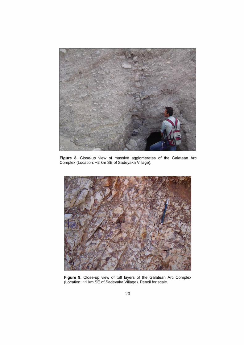
limestone lternation in the Taşlık Formation .................................17 FIGURE 8 Close-up view of massive agglomerates of the Galatean Arc
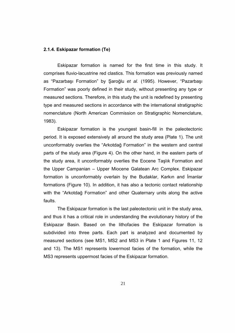
Complex ......................................................................................20 FIGURE 9 Close-up view of tuff layers of the Galatean Arc Complex............20 FIGURE 10 General view of the unconformable (AU) contact between the
Eskipazar formation (Te) and the Budaklar formation (TQb).......22 FIGURE 11 Gevrekler measured stratigraphical column ...............................23 FIGURE 12 Sarıahmetler measured stratigraphical column ..........................24 FIGURE 13 Ahmetci Hill measured stratigraphical column ........................................25 FIGURE 14 Close-up view of polygenetic conglomerates of the Eskipazar formation .....................................................................................26
xiii
FIGURE 15 Figure showing three types of fissures. Note that black areas are the central fissure travertines and they cut through the beded travertines flanking these fissures. ..............................................29
FIGURE 16 General view of unconformable contact (D) between the Budaklar
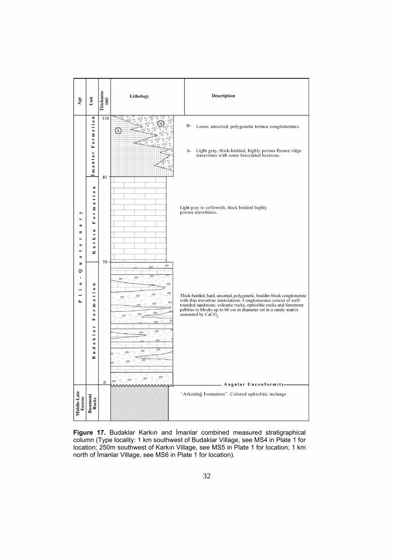
formation (TQb) and clastics of the İmanlar formation (TQi) .......30 FIGURE 17 Budaklar Karkın and İmanlar combined measured stratigraphical
column ........................................................................................32 FIGURE 18 Close-up view of well-lithified polygenetic conglomerates of the
Budaklar formation cemented by CaCO3 ....................................33 FIGURE 19 Close-up view of highly porous travertines of the Budaklar
formation .....................................................................................34 FIGURE 20 General View of the unconformable contact (AU) between the “Arkotdağ Formation” (KTa) and the Karkın formation (TQk) ......35 FIGURE 21 Close-up view of travertines of the Karkın formation ..................36 FIGURE 22 An example of a well preserved extensional fissure ridge
travertine comprising the Karkın formation..................................37 FIGURE 23 General view of fissure ridge travertines of the İmanlar formation .....................................................................................39 FIGURE 24 Close-up view of a brecciated horizon of the fissure ridge
travertines belonging to the İmanlar formation exposed on a quarry wall...................................................................................38
FIGURE 25 Close-up view of well cemented polygenetic conglomerates of the
İmanlar formation. .......................................................................41 FIGURE 26 A general view of an active thermal spring and hot water pools of
the İmanlar fissure ridge travertine deposits................................42 FIGURE 27 Sketch drawing illustrating structural relationship between local
principle stress directions and extensional fissure of a travertine body ............................................................................................46
FIGURE 28 Close-up view of the growth faults exposing on a road cut, within
Easkipazar formation. .................................................................48
xiv
FIGURE 29 Kinematic analysis of shear fractures within the Eskipazar formation at station 2...................................................................49
FIGURE 30 Structural map showing deformation of bedding planes within the
Upper Miocene –Lower Pliocene Eskipazar formation by folding.51 FIGURE 31 Histogram showing predominant dip amounts of bedding planes
belonging to the paleotectonic Eskipazar formation. ...................52 FIGURE 32 Histogram showing predominant dip directions of bedding planes
belonging to the paleotectonic Eskipazar formation. ...................52 FIGURE 33 Stereographic pole plots to bedding planes of the Eskipazar
formation. ....................................................................................55 FIGURE 34 A close-up view of slickenside of steeply dipping Acısu Fault ....60 FIGURE 35 Kinematic analysis data taken from the slip-planes of Acısu Fault. ............................................................................61 FIGURE 36 A general view of the scarp of the Acısu Fault with sulphurous
springs located on the trace of it. ................................................62 FIGURE 37 A general view of fault scarps of the Kadılar fault set. ................63 FIGURE 38 A general view of scarps and terraces of the Beytarla fault zone.66 FIGURE 39 General view of widespread travertine occurrences, exposed
within the limits of Budaklar fault set. ..........................................68 FIGURE 40 General view of western part of the Budaklar fault set and the
stepped topography shaped by the terraces of it. .......................69 FIGURE 41 General view of scarps of the Arslanlar fault set, the Dibek and
Karkın faults ................................................................................71 FIGURE 42 General view of travertine deposits of the Budaklar formation, cropping out within the stepover zone of the Arslanlar fault set ..71 FIGURE 43 General view of scarp of the Dibek fault. ....................................74 FIGURE 44 General view of scarp of the Karkın fault. KTa: “Arkotdağ
Formation”...................................................................................75 FIGURE 45 General view of the scarp of the Yeniköy fault. ..........................77
xv
FIGURE 46 General view of Pressure Ridge and outcrop of the “Arkotdağ
Formation” that is located 750 m SW of the Karkın Village. ........79 FIGURE 47 General view of the active İmanlar fissure ridge Travertines ......79 FIGURE 48 General view of the scarp of the Boztepe fault and alignment of
alluvial fans along it. ....................................................................81 FIGURE 49 Close-up cut-away view of the Karkın fissure ridge travertine (central part). ...............................................................82 FIGURE 50 A close-up view of brecciated travertines filled extensional
fissure belonging to the Karkın Fissure Sysytem ........................84 FIGURE 51 Close-up view of extensional fissure with a trend of N14W that is
exposed at ~ 100 m east of active fissure ridge travertines of the İmamlar formation .......................................................................86
FIGURE 52 A close-up view of the active extensional travertine fissure of belonging to the İmanlar fissure ridge travertines and İmanlar
fissure system. ............................................................................87 FIGURE 53 A close-up view of brecciated horizon of travertines within the
İmamlar formation on the quarry wall that is situated ~ 1 km North of İmanlar village. ........................................................................87
FIGURE 54 Seismotectonic map of the study area........................................91 FIGURE 55 Sketch block diagrams depicting evolution of Eskipazar
Basin…………………………………………………………………100
xvi
LIST OF TABLES
TABLE 1 Shear fracture measurements collected from Pazarbaşı Formation at station 2.......................................................................48 TABLE 2 Slip plane measurements collected from Acısu Fault at Station 1....................................................................................62 TABLE 3 Geometrical properties of extensional fissures of Budaklar, Karkın and İmanlar Formations exposed at different localities within the study area.........................................................................................84 TABLE 4 Seismic parameters of well-defined earthquakes occurred in the northwestern part of the NAFS .........................................................92 TABLE 5 Seismic parameters of the earthquakes occurred in the period of 1902-2003. Epicenter distribution of the Eskipazar-Gerede- Yeniçağa-Bolu region .....................................................................118
1
CHAPTER I
INTRODUCTION
1.1. Purposes and Scope
North Anatolian Fault System is one of the world’s well-known
dextral intracontinental transform fault system that lies within the Alpine-
Himalayan belt. Numerous basins have formed within this fault system that
extends from Karlıova triple junction where Northern Anatolian Fault
System meets with the East Anatolian Fault System, and extends along
the northern boundary of Anatolian platelet until it disappears in the
Aegean Sea. The basins within this fault system have different geometry
and evolutionary histories. The evolution pattern and the tectonic
complexities of these basins are governed by the westward escape of
Anatolian platelet due to post-collisional convergence between the Arabian
plate and the Eurasian plate. Neotectonic basins and their infills are the
best places where the style of deformation and relevant features are
recorded and well-preserved. In order to contribute to the tectonic
characteristics and evolution pattern of the NW-SE trending Eskipazar
Basin, located along western portion of the North Anatolian Fault System,
stratigraphical, structural and seismic characteristics of the basin is
analysed.
1.2. Method of Study
In order to achieve the above mentioned purposes, a research has
been carried out at three stages; 1) office work, 2) field work and 3)
laboratory to Office work.
2
During the Office work, first of all available literature were collected
and reviewed. Later on available borehole data were also compiled and
used for assessment of Plio-Quaternary sedimentary pile.
At the stage of field work, field geological mapping is carried out at
1/25.000 scale and lithological boundaries as well as related geological
structures are mapped. These features were also documented by
photography. During the field work faults were identified by their structural
data from and morphological properties. In addition, available data were
gathered from these faults as well as other available shear planes and
planar-linear elements were measured for the use of kinematic analysis.
Besides, detailed stratigraphy and deformational features of the latest
paleotectonic fill of the basin (Upper Miocene – Lower Pliocene rocks) are
studied in order to make a distinction between paleo- and neotectonic
periods. For these purposes, latest paleotectonic basin fill and neotectonic
units are studied and analysed by measured type sections. In addition, the
orientation of extensional fissures associated with travertine deposits of
dissimilar age the amount of opening are measured as well as their
opening amounts in order to find the principle stress orientation during the
deposition of these travertines.
In the next stage of this research, which is laboratory to office work,
some field data on the kinematic properties of the faults are analysed by
making use of data gathered in the field work. The includes dip amount,
dip direction, strike and rake of the faults and similar linear and planar
properties of shear planes. These data are analysed by using computer
program, ‘Tector’, developed by Angelier 1989; it provides stereographic
plots of fault planes and orientations of principle stress axes.
This thesis is prepared by using softwares “Freehand 11 MX”,
“Office Work 2000”, “Tector” and “Rockware – Rockworks 2002”.
3
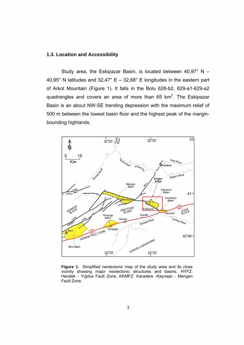
1.3. Location and Accessibility
Study area, the Eskipazar Basin, is located between 40,97° N –
40,95° N latitudes and 32,47° E – 32,68° E longitudes in the eastern part
of Arkot Mountain (Figure 1). It falls in the Bolu 628-b2, 629-a1-629-a2
quadrangles and covers an area of more than 65 km2. The Eskipazar
Basin is an about NW-SE trending depression with the maximum relief of
500 m between the lowest basin floor and the highest peak of the margin-
bounding highlands.
Figure 1. Simplified neotectonic map of the study area and its close vicinity showing major neotectonic structures and basins. HYFZ: Hendek - Yığılca Fault Zone, KKMFZ: Karadere -Kaynaşlı - Mengen Fault Zone.
4
The accessibility to the study area is provided by Gerede-Karabük
highway running through the study area. There are also some other
asphalt roads as well as stabilized and earthy roads cutting or joining to
the main road. By using these roads both northeastern margin and
southwestern margin of the basin are accessible.
1.4. Previous Works
Eskipazar Basin and its near surroundings have been studied by
both foreign and native researchers for different purposes over the last
century, and the gathered information has been published in Turkish and
foreign literatures. These works will be summarized in the following
paragraphs.
First study about the Eskipazar Basin was carried out by
Blumenthal (1941). He introduced different rock units and gave information
about the geology of the area. Within the study area, he identified mainly
six rock units. He also reported information about the general
characteristics of major structures within the Eskipazar Basin. Besides
these, he also investigated and studied the distribution and general
characteristics of travertines exposing throughout the study area, and
finally, he carried out some chemical analysis of the mineral waters of the
thermal springs of these travertines. He defined the Eskipazar Basin as a
closed basin that was probably connected to Ilgaz-Çerkeş Basin in the
past.
Tokay (1973) carried out some geological investigations along the
Gerede-Ilgaz portion of the North Anatolian Fault System by utilizing
twentyone 1/25.000 scale topographic sheets. In this study, he
investigated and reported some significant characteristics of the five
different rock units cropping-out within the study area. Besides these, he
5
also identified six different and major faults/fault sets that are exposed
within the study area or surrounding the study area. He documented some
important information about the characteristics, geometrical relations and
properties of these faults as well as their recent or past activities. These
faults are namely the Ulusu, Gerede, and Çerkeş, Dikmen, Kızılibrik,
Yılanlı faults. He explained that these faults are comprising the Gerede -
Ilgaz portion of the North Anatolia Fault System. He noted that the Ulusu
Fault is the most active fault of the system along which the recent seismic
activity has taken place and which can be identified as the Master Strand
of the North Anatolian Fault System. According to him, the Gerede faults
are the margin-bounding structures with the Gerede-Ilgaz portion of the
fault system; however, other faults such as the Çerkeş, Dikmen, Kızılibrik
and Yılanlı faults are the ones determining both northern and southern
walls of the zone of deformation controlling the morphology at these parts
of the fault system. He also dealt with the seismotectonics of the region
and seismicity along the fault system. Finally, he evaluated the previous
models on the origin of the NAFZS and discussed their reliability based on
his own observations.
Barka (1984) studied the Çerkeş-Kurşunlu-Ilgaz Basin situated
near east of the study area. He identified mainly two groups of rock units,
namely the “Lower Pontus” (Tortonian) and the “Upper Pontus” formations
(Pliocene-Early Pleistocene). He emphasized that understanding the
deformation pattern and time-dependent structural characteristics of these
formations cropping-out within the basin, would lead to understand the
emergence age of the latest tectonic period (neotectonic period). For this
purpose, he observed the fold axes orientations of the lower as well as
upper “Pontus formations” and identified three episodes of folding. Based
on his observations and structural and stratigraphical analyses, he claimed
that emergence of Neotectonic period took place in Early Pliocene. He
also claimed that the Çerkeş-Kurşunlu-Ilgaz basin is an intermountain
basin. Şengör et al. (1985) aggreed with this idea as well.
6
Another basin situated at relatively near west of the study area,
namely the Yeniçağa Basin, is identified to be a tectonically controlled
depression by Erinç (1961) as well as Şengör et al. (1985). Şengör and
Şaroğlu claimed that this basin is located at the point of bifurcation of the
North Anatolian Fault System and stated that this depression may be an
extensional fault wedge basin.
Kato et al. (1990) carried out radon measurements at İsmetpaşa
region, that is characterized by active tectonic creep, to find out traces and
activeness of the faults exposing at this locality. Unfortunately, the
measurements indicated no meaningfull results due to the wrong sampling
techniques conditions. The tectonic creep here was previously studied by
Aytun (1980) and he expressed that the average slip-rate of right-lateral
sense is estimated to be about 1 cm/year based on the instrumental data.
Şaroğlu et al. (1995) mapped the area between Yeniçağa and
Eskipazar at a scale of 1/25.000. They studied the geology of this area in
detail. They identified several rock units exposing within the study area
and subdivided them into two categories: the rock units on the northern
block and on the southern block of the North Anatolian Fault System. In
addition, they also focused on the geomorphology and the economical
geology of this region. Based on their analysis and observations, the North
Anatolian Fault System is Late Pliocene in age.
Yiğitbaş and Elmas (1997 and 2001) studied the Bolu-Eskipazar-
Devrek-Çaycuma region and they divided this region into mainly seven
subareas; namely the Sakarya Continent, Bolu-Eskipazar Zone, Karabük
Basin, Sünnice high, Ulus Basin, Devrek-Çaycuma lowland, and the
Western Blacksea coastal mountain chains. Within the Bolu-Eskipazar
Zone, they identified mainly eight rock units, as the Ağalar metamorphic
Group, the Bakacak metamorphics, the Ulumescit group, the Yayla
Granite, the Gölcük Group, the Apala Group, the Neogene units and the
Quaternary units. Based on their observations, the Neogene deposits
cover all other units with an angular unconformity and they are mainly
7
composed of fluvio-lacustrine deposits. Besides these, they identified units
such as Quaternary alluvium, slope scree and the fault-parallel exposing
travertine deposits. From the tectonic point of view, they identified the
WSW-ENE trending Bolu-Eskipazar zone to be a narrow zone confined by
the Sakarya Continent to the south and Sünnice high to the north.
Koçyiğit et al. (2001a) studied the İsmetpaşa-Kargı section of the
North Anatolian Fault System and identified mainly six subfault zones
within this section. These fault zones are namely the Eskipazar, the Ulusu,
the Tosya, the Çerkeş-Kurşunlu, the Devrez and the Dodurga fault zones.
In their study, for the first time in the literature, they named, defined and
focused on the Dodurga Fault Zone (DFZ), that is located about 35 km SE
of Eskipazar Basin. They identified its geometrical characteristics as well
as its age, total displacement and mechanism. Besides, they also gave
information about the seismic activity along this fault zone, before and
after the June 6 2000 Orta (Çankırı) earthquake. They also presented
information about the historical and recent seismicities that took place
along the İsmetpaşa-Kargı section of the NAFS.
1.5. Regional Tectonic Setting
Turkey is located in the Mediterranean-Himalaya Seismic zone.The
structures characterizing this belt are responsible for high seismicity.
Among the structures are mainly North Anatolian, East Anatolian and the
Dead Sea fault systems and the Hellenic-west Cyprus arc (Figure 2).
8
Figu
re 2
. Sim
plifi
ed m
ap s
how
ing
the
stud
y ar
ea a
nd m
ajor
tect
onic
stru
ctur
es in
Tur
key
and
adja
cent
reg
ions
. AK
T: A
ksu
Thru
st,
CA
FS:
Cen
tral
Ana
tolia
n Fa
ult
Sys
yem
, D
SFS
: D
ead
Sea
Faul
t S
yste
m,
EA
FS:
Eas
t A
nato
lian
Faul
t S
yste
m,
ES
CV
: E
rciy
es
ande
sitic
-bas
altic
stra
tovo
lcan
o co
mpl
ex,
GY
FS:
Gök
su-Y
akapın
ar F
ault
Sys
tem
, IA
ES
Z: İ
zmir-
Ank
ara-
Erz
inca
n Su
ture
Zon
e,
KMAT
Z: K
yren
ia-M
isis
-And
rın F
old-
Thru
st F
ault
Zone
, KTJ
: Kar
lıova
Trip
le J
unct
ion,
LS
FZ: L
ake
Sal
t Fau
lt Zo
ne, M
TJ: M
araş
Trip
le
Junc
tion,
MO
FZ:
Mal
atya
-Ova
cık
Faul
t Zo
ne,
NA
T: N
orth
Aeg
ean
Thro
ugh,
NA
FS:
Nor
th A
nato
lian
Faul
t S
yste
m,
NS
: N
orth
ern
Stra
nd o
f N
AFS
, S
F: S
alan
da F
ault,
SS
: S
outh
ern
Stra
nd o
f N
AFS
, 1.
Erc
iyes
Pul
l-Apa
rt B
asin
, 2.
Erz
inca
n P
ull-A
part
Bas
in,
3.
Mal
atya
Pul
l-Apa
rt B
asin
. Lar
ge b
lack
arr
ows
indi
cate
the
dire
ctio
n of
pla
te m
otio
n an
d La
rge
whi
te a
rrow
indi
cate
s th
e es
capi
ng
dire
ctio
n of
Ana
tolia
n pl
atel
et (m
odifi
ed fr
om K
oçyiği
t 199
6).
8
9
The Dextral North Anatolian intracontinental transform fault system
formes the contact between the Eurasian Plate and Anatolian platelet that
are situated in the north and south of the system, respectively. This fault
system is formed together with the sinistral East Anatolian Intracontinental
transform fault system at Late Early Pliocene, as natural response to the
post-collusional north-south directed convergence between the Arabian
plate and the Eurasian plate (Koçyiğit et al. 2001a). At eastern Anatolia,
this convergence produces N-S oriented compression. Today, the
westward escaping Anatolian platelet moves onto the oceanic lithosphere
of eastern-Mediterranean Sea, and the African plate has been subducting
northwards beneath the Anatolia platelet with a rate of 35 mm/yr
(McKenzie 1972; Le Pichon and Angelier 1979; Meulenkamp et al. 1998;
Kahle et al. 1998) along the active subduction zone of Hellenic – west
Cyprus arc. This subduction results in a roll-back geometry (Le Pichon and
Angelier 1979; Koçyiğit 1984; Royden 1993) which can be considered to
be the reason of nearly N-S extension and formation of nearly E-W, NW,
NE trending horst-graben system in western Anatolia. The westward
tectonic escape of Anatolian platelet along East Anatolian intracontinental
transform fault and North Anatolian intracontinental transform fault
continues since Late Pliocene and Late Pliocene is accepted to be the
initiation age of neotectonic period (2.6 Ma) (Tokay 1973; Hempton 1987;
Şaroğlu 1988; Koçyiğit and Beyhan 1998; Koçyiğit et al. 2001; Bozkurt
2001). Average rates of slip along the NAFS and EAFS are estimated at
10 mm/yr and 6 mm/yr, respectively, based on field observations (Tokay
1973; Tatar 1978; Barka and Hancock 1984; Barka and Gülen 1988;
Şaroğlu 1988; Koçyiğit 1988, 1989, 1990) while they appear to be 26
mm/yr and 13 mm/yr respectively, based on Global Positioning System
(GPS) and seismological data (Mckenzie 1972; Canıtez 1973; North 1974;
Reilinger et al. 1997b Stein et al. 1997, Kahle et al. 1998, 2000; McClusky
et al., 2000). In addition, Anatolian platelet is divided into four blocks by
the intracontinental transcurrent faults, namely Lake Salt, Salanda, Central
Anatolia, Göksu-Yakapınar, and the Malatya-Ovacık fault zones. The
10
blocks whose boundaries are identified by the above mentioned
transcurrent faults are; the Keban, Munzur, Adana-Sivas, and the Central
to West Anatolian Blocks (Figure 2) (Perinçek et al. 1987; Koçyiğit and
Beyhan 1998, Koçyiğit 1996).
The North Anatolian Fault System is an approximately 1500 km-
long and 10 to 110 km wide dextral shear zone trending first NW, and then
E-W and SW between Karlıova in the east and northern Agean Sea in the
west (Figure 2). The north western part of the fault system has a trend of
NE-SW, and is characterized by a number of fault zones, fault sets,
isolated faults and anastomosing and splay-type geometry of distribution
pattern of faults (Koçyiğit et al. 2001b). The anastomosing-type geometry
of master strand creates a series of lensoidal highlands (pressure ridges)
such as the Arkotdağ, Ilgaz Mountains and lowlands (basins) such as the
Yeniçağa, Dörtdivan, Eskipazar and the Çerkeş-Kurşunlu basins, whose
long axes are parallel to the general trend of the NAFS.
The Eskipazar Basin is located at the eastern end of the Arkotdağ
tectonic block. At close proximity to this basin, the Mengen Basin and the
İsmetpaşa basin are present at the NW and immediate south, respectively
(Figure 1). The Eskipazar Basin is an about 11 km long and 3 – 6 km wide
NW-SE trending actively growing depression controlled by strike-slip
faults. Within the Eskipazar Basin, two groups of rock units are exposed.
That are the paleotectonic and the neotectonic units and they will be given
to described in next chapter. A special emphasis will be put on the
stratigraphy of the latest paleotectonic and neotectonic units in order to
understand the evolutionary history of the Eskipazar Basin.
11
CHAPTER II
STRATIGRAPHY
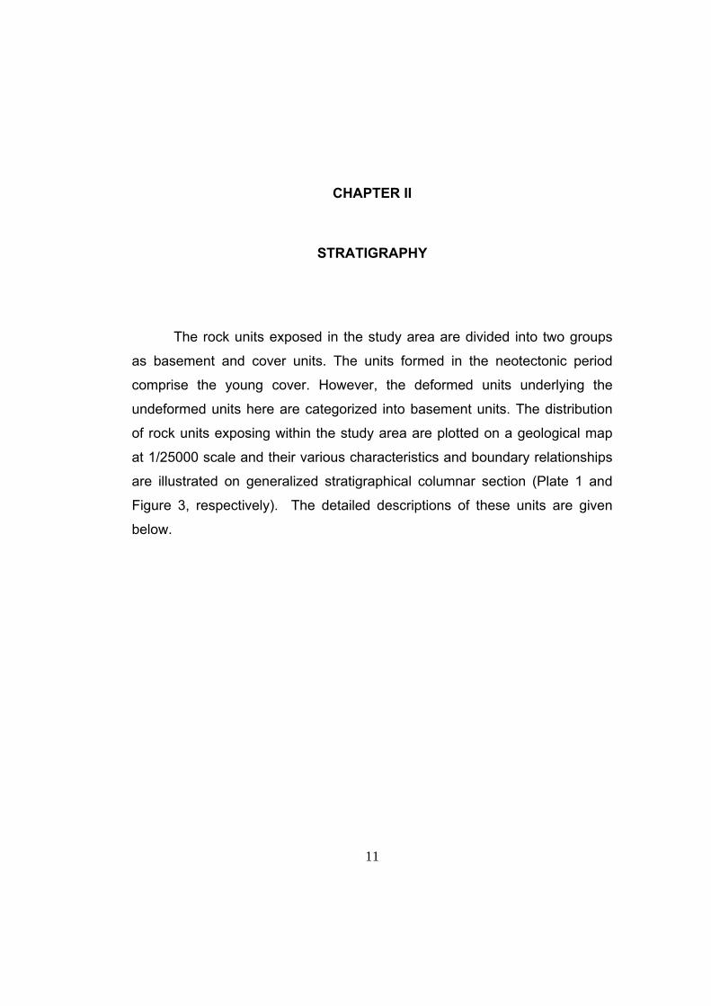
The rock units exposed in the study area are divided into two groups
as basement and cover units. The units formed in the neotectonic period
comprise the young cover. However, the deformed units underlying the
undeformed units here are categorized into basement units. The distribution
of rock units exposing within the study area are plotted on a geological map
at 1/25000 scale and their various characteristics and boundary relationships
are illustrated on generalized stratigraphical columnar section (Plate 1 and
Figure 3, respectively). The detailed descriptions of these units are given
below.
12
Figure 3. Generalized stratigraphical columnar section showing both paleotectonic and neotectonic units.

13
2.1. BASEMENT UNITS
The Basement units comprise Upper Cretaceous ophiolitic mélange
(“Arkotdağ Formation”), Lower – Middle Eocene red clastics (Taşlık
Formation) which laterally grades into Lower – Middle Eocene volcani-clastics
of the Galatean Arc Complex (GAC). Besides these Upper Miocene – Lower
Pliocene fluvial clastics (Eskipazar formation) comprises the youngest
paleotectonic unit exposing within the study area.
2.1.1. Arkotdağ Formation (KTa)
The “Arkotdağ Formation” was first named by Tokay (1973). It is
composed of a mélange, characterized by a chaotic assemblage of
sedimentary, metamorphic and intrusive igneous rocks. Although this rock
unit was termed as a formation, it is an informal usage; this rock unit is a
chaotic one and it does not have a well defined top and bottom boundaries. It
also does not have any certain type locality. Therefore it is not defined
according to international stratigraphic nomenclature (North American
Commission on Stratigraphic Nomenclature 1983), so in this study the name
of this unit will be used in quotations, indicating that the usage is informal.
Indeed, “Arkotdağ Tectonic Complex” may be a proper name for this rock
unit.
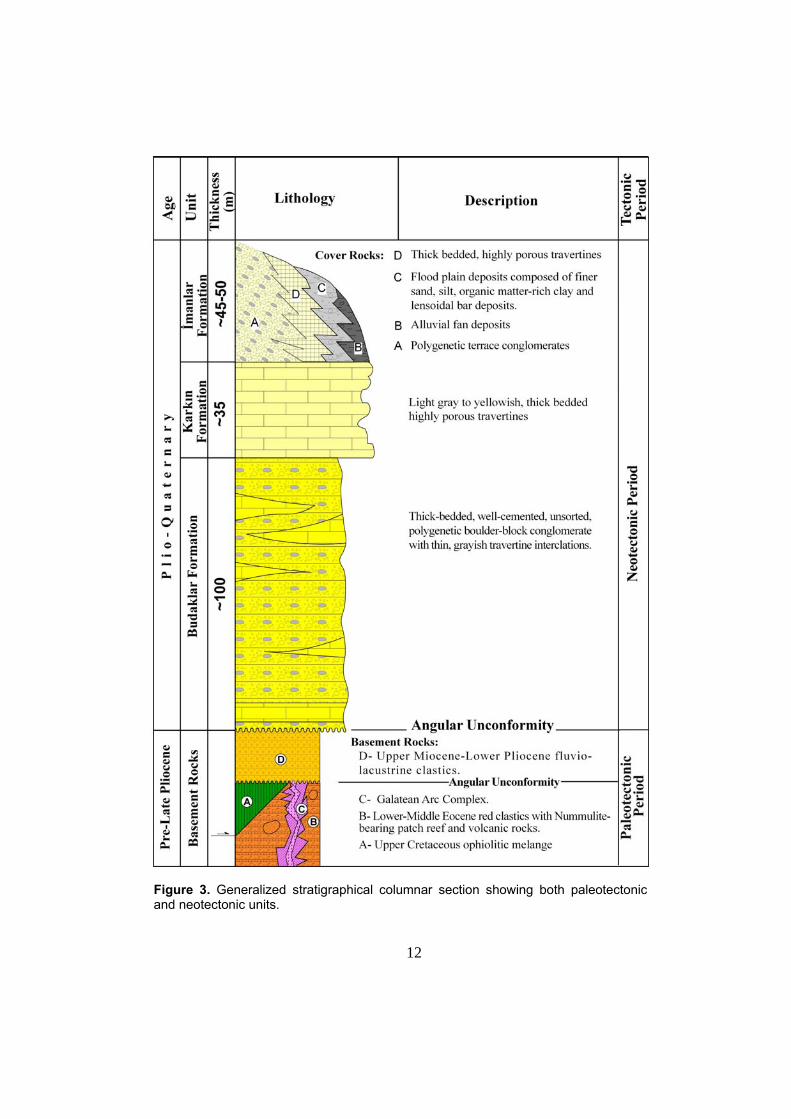
The “Arkotdağ Formation” is exposed mainly in the northern and the
southwestern part of the study area (Plate 1). Its bottom boundary is not
exposed within the study area, but it is unconformably overlain by the
Eskipazar formation (Figure 4) and the younger units. However the “Arkotdağ
Formation” tectonically overlies the Taşlık Formation of Early – Middle
14
Eocene age outside the study area. In addition, it has tectonic contact
relationship with the Upper Miocene – Lower Pliocene Eskipazar formation
(Plate 1) in places, within the NAFS.
Figure 4. General view of the unconformable contact (AU) between the “Arkotdağ Formation” (KTa) and the Eskipazar formation (Te). (Location: ~1 km NW of Budaklar Village, view towards NW). AU: Angular Unconformity.
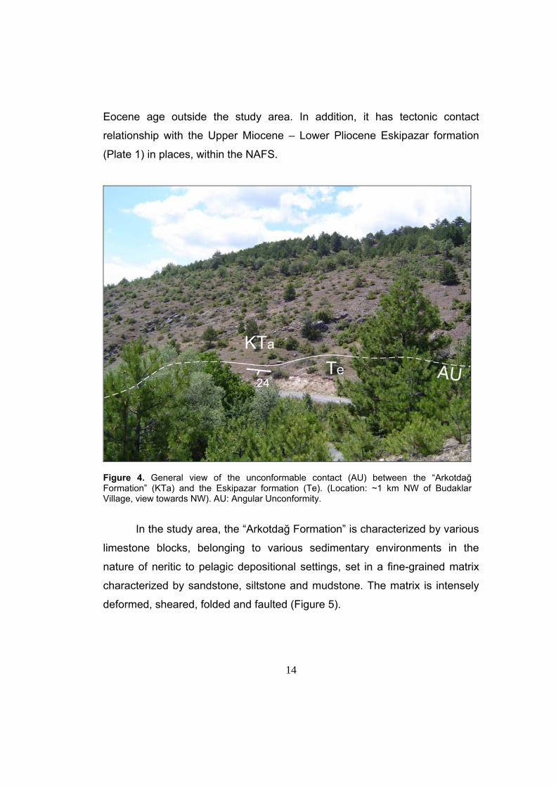
In the study area, the “Arkotdağ Formation” is characterized by various
limestone blocks, belonging to various sedimentary environments in the
nature of neritic to pelagic depositional settings, set in a fine-grained matrix
characterized by sandstone, siltstone and mudstone. The matrix is intensely
deformed, sheared, folded and faulted (Figure 5).
15
According to Tokay (1974), these units are part of the Upper
Cretaceous Ophiolitic Mélange exposing all around Turkey (Koçyiğit, 1991a).
It is correlated with the Mengen Complex of Serdar et al. (1989).
Figure 5. Close up view of intensely sheared and folded matrix of the “Arkotdağ Formation” (Location: ~4km North of Arslanlar Village). Hammer is 32 cm long. Hammer for scale.
2.1.2. Taşlık Formation (Tt)
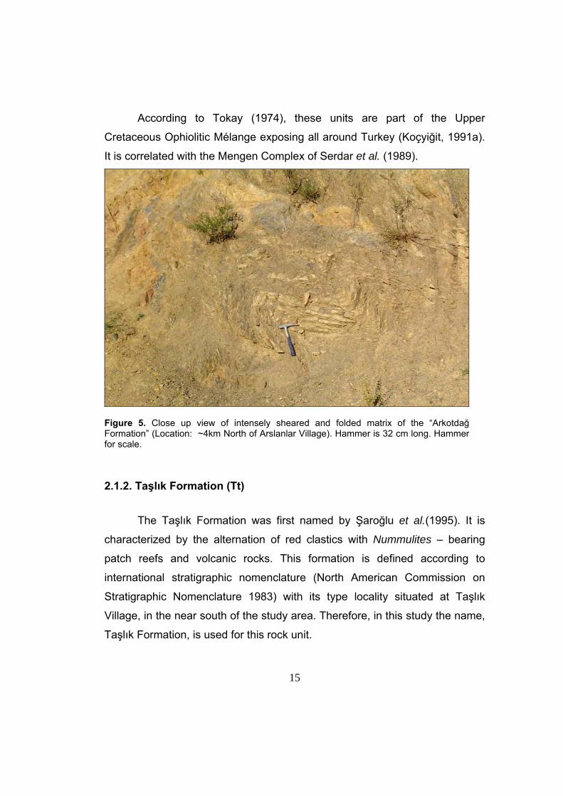
The Taşlık Formation was first named by Şaroğlu et al.(1995). It is
characterized by the alternation of red clastics with Nummulites – bearing
patch reefs and volcanic rocks. This formation is defined according to
international stratigraphic nomenclature (North American Commission on
Stratigraphic Nomenclature 1983) with its type locality situated at Taşlık
Village, in the near south of the study area. Therefore, in this study the name,
Taşlık Formation, is used for this rock unit.
16
The Taşlık Formation is exposed mainly in the southeastern part of the
study area (Plate 1). Its bottom boundary is not exposed within the study
area, but it is unconformably overlain by the Upper Miocene – Lower Pliocene
Eskipazar formation and the younger units. The Taşlık Formation displays
both lateral and vertical gradations with the Galatean Arc Complex of the
same age. In addition, it has tectonic contact with Quaternary units, in places,
along the active faults.
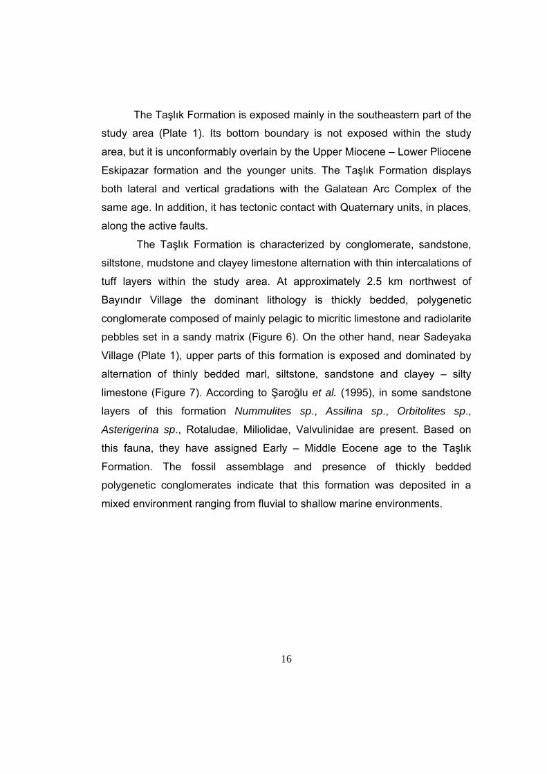
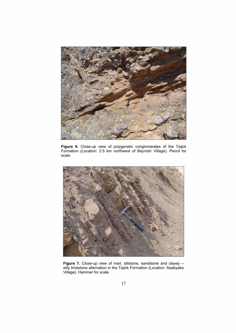
The Taşlık Formation is characterized by conglomerate, sandstone,
siltstone, mudstone and clayey limestone alternation with thin intercalations of
tuff layers within the study area. At approximately 2.5 km northwest of
Bayındır Village the dominant lithology is thickly bedded, polygenetic
conglomerate composed of mainly pelagic to micritic limestone and radiolarite
pebbles set in a sandy matrix (Figure 6). On the other hand, near Sadeyaka
Village (Plate 1), upper parts of this formation is exposed and dominated by
alternation of thinly bedded marl, siltstone, sandstone and clayey – silty
limestone (Figure 7). According to Şaroğlu et al. (1995), in some sandstone
layers of this formation Nummulites sp., Assilina sp., Orbitolites sp.,
Asterigerina sp., Rotaludae, Miliolidae, Valvulinidae are present. Based on
this fauna, they have assigned Early – Middle Eocene age to the Taşlık
Formation. The fossil assemblage and presence of thickly bedded
polygenetic conglomerates indicate that this formation was deposited in a
mixed environment ranging from fluvial to shallow marine environments.
17
Figure 6. Close-up view of polygenetic conglomerates of the Taşlık Formation (Location: 2.5 km northwest of Bayındır Village). Pencil for scale.
Figure 7. Close-up view of marl, siltstone, sandstone and clayey – silty limestone alternation in the Taşlık Formation (Location: Sadeyaka Village). Hammer for scale.
18
2.1.3. Galatean Arc Complex (KTg)
The sequence of volcanic rocks exposing between İzmir- Ankara –
Erzincan Suture Zone (IAESZ) in the south and North Anatolian Fault System
in the north have long been mapped and studied by many researchers
(Stchepinsky and Lahn 1941; Erol 1951, 1954, 1955; Akyol 1969; Fourquin
1970; Öngür 1977; Ach 1982; Akyürek 1984; Kazancı and Gökten 1988;
Tankut 1990; Türkecan 1991; Koçyiğit 1991a, b; Keller 1992; Gökten et al.
1996; Toprak et al. 1996; Wilson et al.1997; Koçyiğit et al. 2003a). Based on
geological mapping at 1/100.000 scale Erol (1951, 1954, 1955) used various
terms, such as the ‘Tertiary Volcanic Series’, ‘Köroğlu Volcanic Series’,
‘Köroğlu Complex’ to describe this sequence of volcanic rocks. Besides,
Tankut et al. (1990) studied the geochemistry of some spot samples collected
from the southeastern part of the outcrops of this sequence and renamed
these rocks as ‘Köroğlu (Galatia) Volcanic Complex’. However, Koçyiğit
(1991a) and Koçyiğit et al. (2003a) carried out some detailed studies at
southern part of this sequence. They defined top and bottom of the sequence,
measured several stratigraphical sections to define and describe these rock
units and to find out the tectonic significance of presence and spatial
distribution of these rocks. Stating that these rocks formed under multi-phase
magmatic arc evolution, Koçyiğit et al. (2003a) named this sequence of
volcanic rocks as, Galatean Arc Complex that is characterized by a very thick
volcano – sedimentary rock sequence. As this nomenclature provides a
broader and stratigraphically better stated description of the unit, in this study,
this volcano – sedimentary rock sequence is referred to as Galatean Arc
Complex (GAC).
A part of the Galatean Arc Complex is exposed mainly at southeastern
part of the study area (Plate 1). Its bottom boundary is not exposed within the
study area but it is seen along the Gerede – Kızılcahamam road, where the
19
unit is conformable with the Upper Campanian sedimentary sequence
(Koçyiğit 1991b). The top contact is unconformably overlain by the Upper
Miocene – Lower Pliocene Eskipazar formation and younger units. This
Formation laterally grades into the Lower – Middle Eocene Taşlık Formation.
In addition, at the southeastern most parts of the study area it has tectonic
contact relationship with Quaternary units along the active faults.
The small portion of the Galatean Arc Complex, exposing within the
study area, is characterized and dominated by massive agglomerates mainly
composed of cobble sized blasts of andesite and basalt set in a tuffaceous
matrix (Figure 8). Besides, this unit contains thinly bedded tuff layers in the
lower parts of the succession (Figure 9). No fossil have been found in the unit
during the field studies, however, it laterally grades into the Lower – Middle
Eocene Taşlık Formation. Accumulation of the volcano-sedimentary rocks of
GAC took place in a very long time period ranging from Late Cretaceous to
Late Miocene as previously stated by Koçyiğit (1991b) and Koçyiğit et al.
(2003a).
The Galatean Arc Complex comprises the Late Cretaceous to Early
Pliocene volcanic rocks mainly produced by pre- and post collisional
magmatic events. This magmatic activity is indeed related to the northward
subduction of floor of northern branch of Neotethys (Şengör and Yılmaz
1981) and development of Galatean Magmatic Arc at the north of the
subduction zone. Nevertheless, this subduction-related volcanic activity
(Galatean arc activity) did not take place in a single and continuous phase,
but it is indeed a polyphase volcanic activity. This polyphase volcanic activity
is mainly related to three stages of magmatic arc evolution, namely early
phase of arc evolution, late phase of arc evolution and post-collisional phase
of arc evolution. Thus, Galatean Arc Complex is developed by these three
stages starting from Late Cretaceous, up to Late Miocene (Koçyiğit 1991a;
Koçyiğit et al. 2003a).
20
Figure 8. Close-up view of massive agglomerates of the Galatean Arc Complex (Location: ~2 km SE of Sadeyaka Village).
Figure 9. Close-up view of tuff layers of the Galatean Arc Complex (Location: ~1 km SE of Sadeyaka Village). Pencil for scale.
21
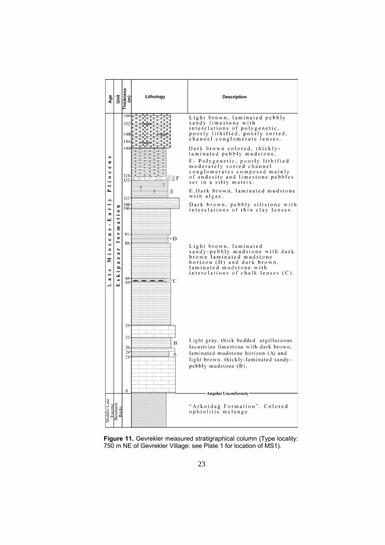
2.1.4. Eskipazar formation (Te)
Eskipazar formation is named for the first time in this study. It
comprises fluvio-lacustrine red clastics. This formation was previously named
as “Pazarbaşı Formation” by Şaroğlu et al. (1995). However, “Pazarbaşı
Formation” was poorly defined in their study, without presenting any type or
measured sections. Therefore, in this study the unit is redefined by presenting
type and measured sections in accordance with the international stratigraphic
nomenclature (North American Commission on Stratigraphic Nomenclature,
1983).
Eskipazar formation is the youngest basin-fill in the paleotectonic
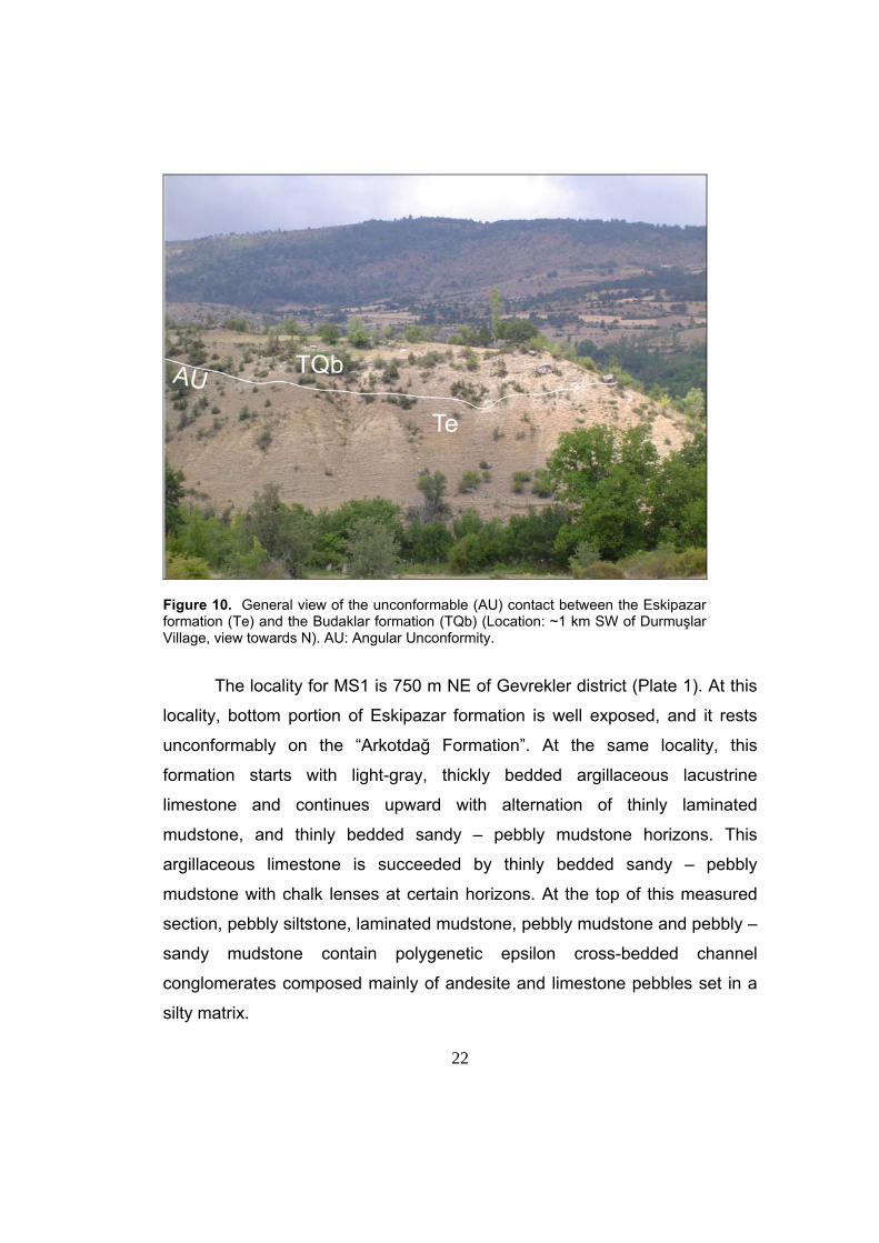
period. It is exposed extensively all around the study area (Plate 1). The unit
unconformably overlies the “Arkotdağ Formation” in the western and central
parts of the study area (Figure 4). On the other hand, in the eastern parts of
the study area, it unconformably overlies the Eocene Taşlık Formation and
the Upper Campanian – Upper Miocene Galatean Arc Complex. Eskipazar
formation is unconformably overlain by the Budaklar, Karkın and İmanlar
formations (Figure 10). In addition, it has also a tectonic contact relationship
with the “Arkotdağ Formation” and other Quaternary units along the active
faults.
The Eskipazar formation is the last paleotectonic unit in the study area,
and thus it has a critical role in understanding the evolutionary history of the
Eskipazar Basin. Based on the lithofacies the Eskipazar formation is
subdivided into three parts. Each part is analyzed and documented by
measured sections (see MS1, MS2 and MS3 in Plate 1 and Figures 11, 12
and 13). The MS1 represents lowermost facies of the formation, while the
MS3 represents uppermost facies of the Eskipazar formation.
22
Figure 10. General view of the unconformable (AU) contact between the Eskipazar formation (Te) and the Budaklar formation (TQb) (Location: ~1 km SW of Durmuşlar Village, view towards N). AU: Angular Unconformity.
The locality for MS1 is 750 m NE of Gevrekler district (Plate 1). At this
locality, bottom portion of Eskipazar formation is well exposed, and it rests
unconformably on the “Arkotdağ Formation”. At the same locality, this
formation starts with light-gray, thickly bedded argillaceous lacustrine
limestone and continues upward with alternation of thinly laminated
mudstone, and thinly bedded sandy – pebbly mudstone horizons. This
argillaceous limestone is succeeded by thinly bedded sandy – pebbly
mudstone with chalk lenses at certain horizons. At the top of this measured
section, pebbly siltstone, laminated mudstone, pebbly mudstone and pebbly –
sandy mudstone contain polygenetic epsilon cross-bedded channel
conglomerates composed mainly of andesite and limestone pebbles set in a
silty matrix.
23
Figure 11. Gevrekler measured stratigraphical column (Type locality: 750 m NE of Gevrekler Village: see Plate 1 for location of MS1).
24
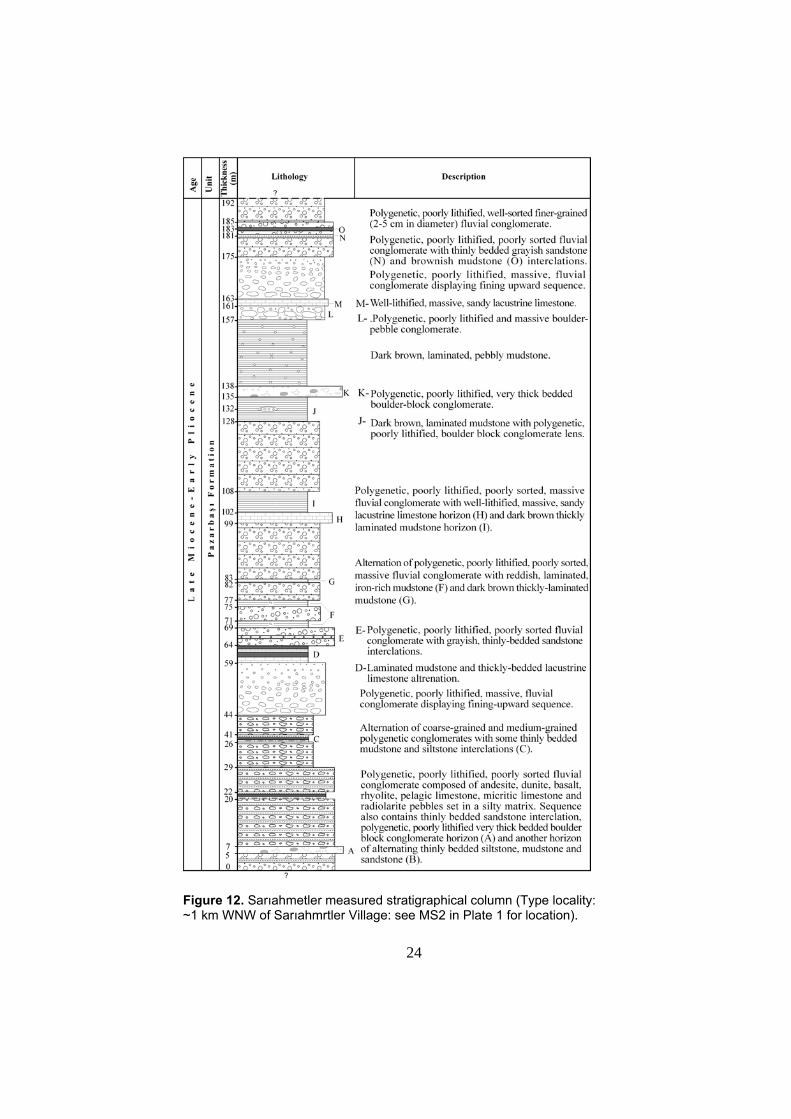
Figure 12. Sarıahmetler measured stratigraphical column (Type locality: ~1 km WNW of Sarıahmrtler Village: see MS2 in Plate 1 for location).
25
Figure 13. Ahmetci Hill measured stratigraphical column. (Type locality: ~750 m WNW of Ahmetci Hill: see MS3 in Plate 1 for location).
26
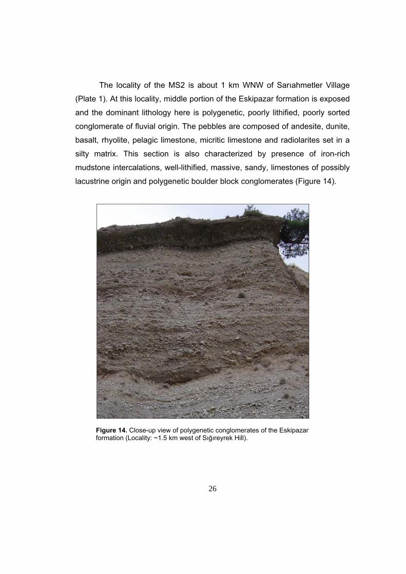
The locality of the MS2 is about 1 km WNW of Sarıahmetler Village
(Plate 1). At this locality, middle portion of the Eskipazar formation is exposed
and the dominant lithology here is polygenetic, poorly lithified, poorly sorted
conglomerate of fluvial origin. The pebbles are composed of andesite, dunite,
basalt, rhyolite, pelagic limestone, micritic limestone and radiolarites set in a
silty matrix. This section is also characterized by presence of iron-rich
mudstone intercalations, well-lithified, massive, sandy, limestones of possibly
lacustrine origin and polygenetic boulder block conglomerates (Figure 14).
Figure 14. Close-up view of polygenetic conglomerates of the Eskipazar formation (Locality: ~1.5 km west of Sığıreyrek Hill).
27
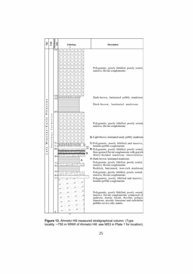
The locality of the MS3 is approximately 750 m WNW of Ahmetci Hill
(Plate 1). At this locality upper part of the Eskipazar formation is exposed.
Here the dominant lithology is polygenetic, poorly lithified, poorly sorted fluvial
conglomerates composed of pebbles derived from various volcanic rocks
including andesite, basalt, rhyolite, and dunite, pelagic limestone, micritic
limestone and radiolarite set in a silty matrix. In contrast to the MS2, the
conglomerates at this locality are massive and in general their vertical
continuity is interrupted by thick sequences of thinly bedded mudstones within
the sequence. There are also some polygenetic, poorly lithified and massive
boulder – pebble conglomerates at the lower and the middle parts of this
section.
The combined thickness of Eskipazar formation is about 520m and it
contains micro- and macro-mammalian fossil assemblages (Şaroğlu et al.
1995). Based on the mammalian fossil content of Miyomımus sp., Spalacidae
gen. et sp. indet, Talpidae sp. indet (Desmana or Dibolia), Şaroğlu et al.
(1995) assigned a Late Miocene – Early Pliocene age to the “Pazarbaşı
Formation” and Eskipazar formation of this study.
The limestones comprising the bottom part of the Eskipazar formation
(MS1, Figure 11) were possibly deposited in a lacustrine environment and the
conglomerates and mudstones in the upper parts of the succession were
possibly deposited in a fluvial environment. Thus, the Eskipazar formation
was deposited possibly in fluvio-lacustrine environment.
2.2. NEOTECTONIC UNITS
The neotectonic units comprise Plio-Quaternary travertine deposits
and their lateral correlatives of terrace and fluvial conglomerates (Budaklar,
İmanlar and Karkın formations). Since these units unconformably overlie the
28
paleotectonic units and are actively developing, they are attributed to the
neotectonic units. Here it is important to note that the travertines of these
units have not been directly dated by means of laboratory analysis, however
their geometrical and structural characteristics may give an idea about the
relative age of each travertine occurrence with respect to each other. In this
study, the travertines of the neotectonic units are dated relative to each other
based on the geometrical and structural criterion that was first proposed by
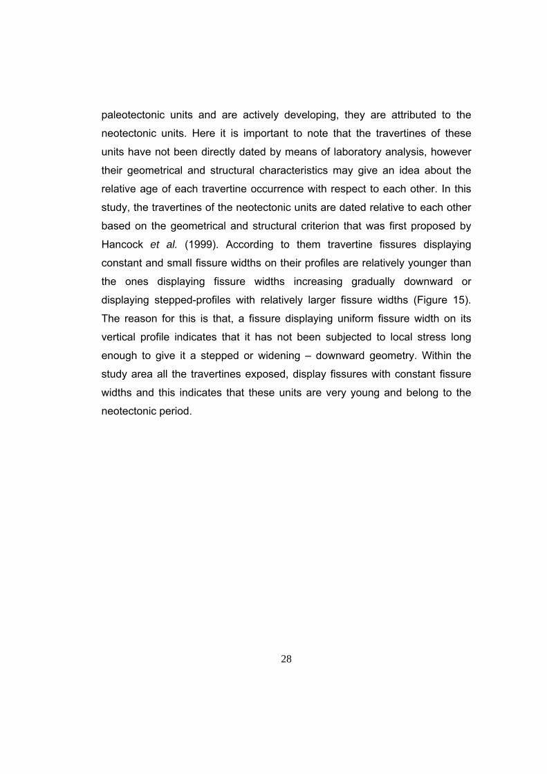
Hancock et al. (1999). According to them travertine fissures displaying
constant and small fissure widths on their profiles are relatively younger than
the ones displaying fissure widths increasing gradually downward or
displaying stepped-profiles with relatively larger fissure widths (Figure 15).
The reason for this is that, a fissure displaying uniform fissure width on its
vertical profile indicates that it has not been subjected to local stress long
enough to give it a stepped or widening – downward geometry. Within the
study area all the travertines exposed, display fissures with constant fissure
widths and this indicates that these units are very young and belong to the
neotectonic period.
29
Figure 15. Figure showing three types of fissures. Note that black areas are the central fissure travertines and they cut through the beded travertines flanking these fissures. (Modified from Hancock et al., 1999).
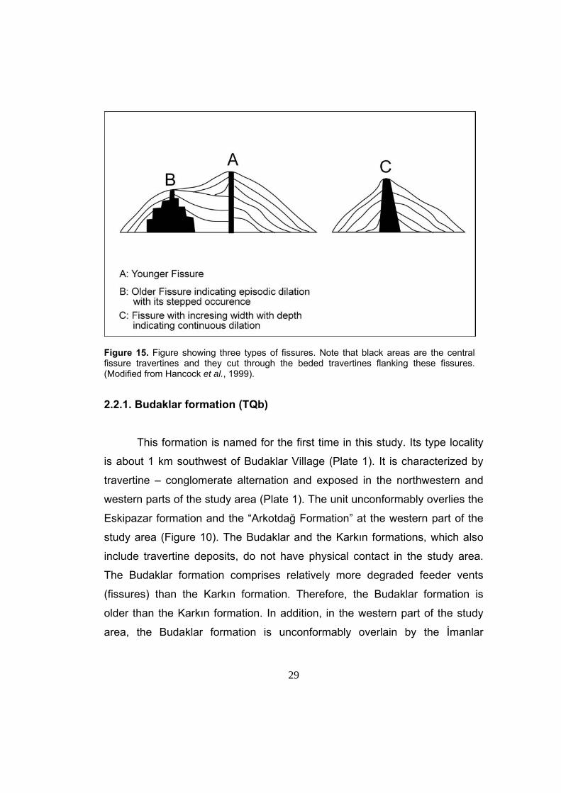
2.2.1. Budaklar formation (TQb)
This formation is named for the first time in this study. Its type locality
is about 1 km southwest of Budaklar Village (Plate 1). It is characterized by
travertine – conglomerate alternation and exposed in the northwestern and
western parts of the study area (Plate 1). The unit unconformably overlies the
Eskipazar formation and the “Arkotdağ Formation” at the western part of the
study area (Figure 10). The Budaklar and the Karkın formations, which also
include travertine deposits, do not have physical contact in the study area.
The Budaklar formation comprises relatively more degraded feeder vents
(fissures) than the Karkın formation. Therefore, the Budaklar formation is
older than the Karkın formation. In addition, in the western part of the study
area, the Budaklar formation is unconformably overlain by the İmanlar
30
formation (Figure 16) and recently developing flood plain deposits of the
Göksu stream.
Figure 16. General view of unconformable contact (D) between the Budaklar formation (TQb) and clastics of the İmanlar formation (TQi) (Location: ~500m NE of Eleler Village, view towards SE). D: Disconformity.
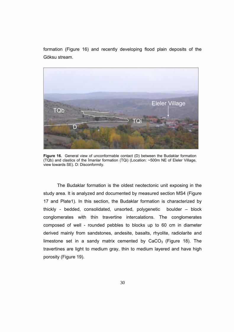
The Budaklar formation is the oldest neotectonic unit exposing in the
study area. It is analyzed and documented by measured section MS4 (Figure
17 and Plate1). In this section, the Budaklar formation is characterized by
thickly - bedded, consolidated, unsorted, polygenetic boulder – block
conglomerates with thin travertine intercalations. The conglomerates
composed of well - rounded pebbles to blocks up to 60 cm in diameter
derived mainly from sandstones, andesite, basalts, rhyolite, radiolarite and
limestone set in a sandy matrix cemented by CaCO3 (Figure 18). The
travertines are light to medium gray, thin to medium layered and have high
porosity (Figure 19).
31
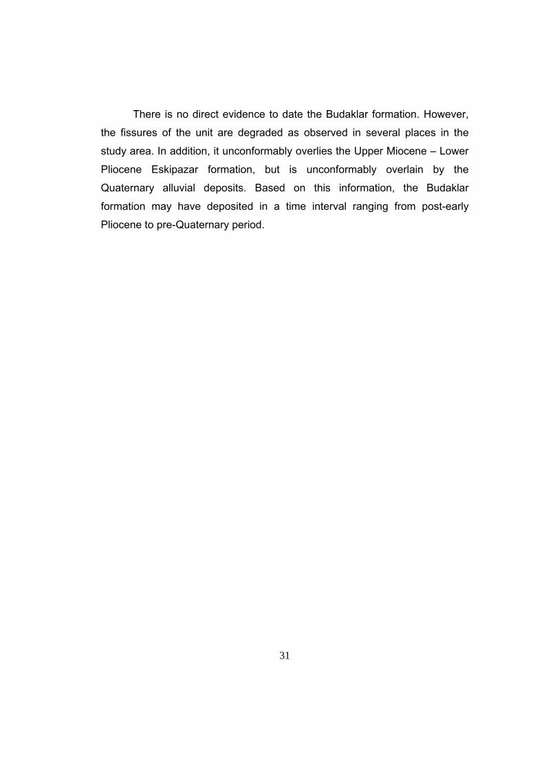
There is no direct evidence to date the Budaklar formation. However,
the fissures of the unit are degraded as observed in several places in the
study area. In addition, it unconformably overlies the Upper Miocene – Lower
Pliocene Eskipazar formation, but is unconformably overlain by the
Quaternary alluvial deposits. Based on this information, the Budaklar
formation may have deposited in a time interval ranging from post-early
Pliocene to pre-Quaternary period.
32
Figure 17. Budaklar Karkın and İmanlar combined measured stratigraphical column (Type locality: 1 km southwest of Budaklar Village, see MS4 in Plate 1 for location; 250m southwest of Karkın Village, see MS5 in Plate 1 for location; 1 km north of İmanlar Village, see MS6 in Plate 1 for location).
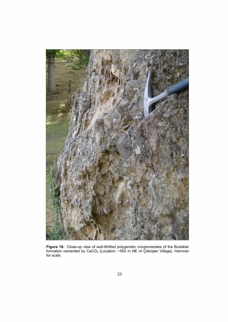
33
Figure 18. Close-up view of well-lithified polygenetic conglomerates of the Budaklar formation cemented by CaCO3 (Location: ~500 m NE of Çöküşler Village). Hammer for scale.
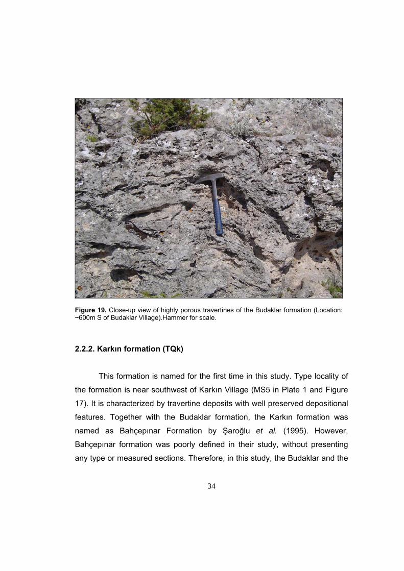
34
Figure 19. Close-up view of highly porous travertines of the Budaklar formation (Location: ~600m S of Budaklar Village).Hammer for scale. 2.2.2. Karkın formation (TQk)
This formation is named for the first time in this study. Type locality of
the formation is near southwest of Karkın Village (MS5 in Plate 1 and Figure
17). It is characterized by travertine deposits with well preserved depositional
features. Together with the Budaklar formation, the Karkın formation was
named as Bahçepınar Formation by Şaroğlu et al. (1995). However,
Bahçepınar formation was poorly defined in their study, without presenting
any type or measured sections. Therefore, in this study, the Budaklar and the
35
Karkın formations are redefined by presenting type and measured sections in
accordance with the international stratigraphic nomenclature (North American
Commission on Stratigraphic Nomenclature, 1983).
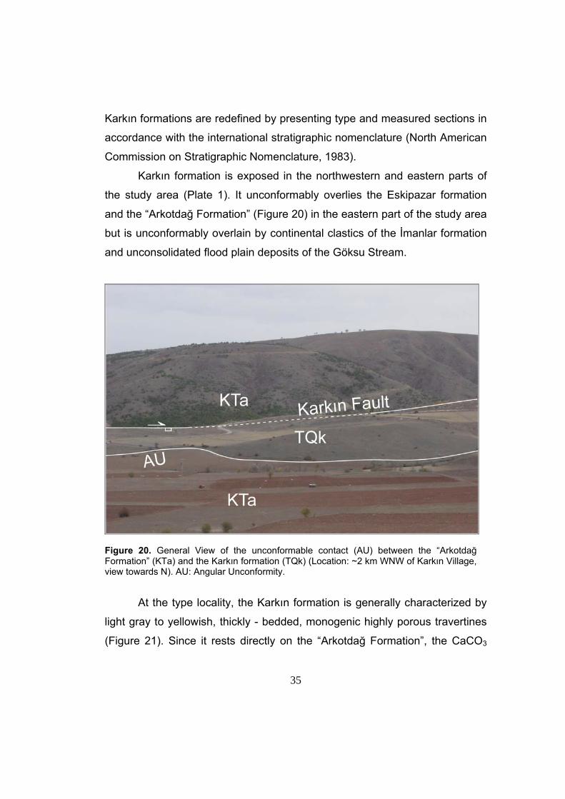
Karkın formation is exposed in the northwestern and eastern parts of
the study area (Plate 1). It unconformably overlies the Eskipazar formation
and the “Arkotdağ Formation” (Figure 20) in the eastern part of the study area
but is unconformably overlain by continental clastics of the İmanlar formation
and unconsolidated flood plain deposits of the Göksu Stream.
Figure 20. General View of the unconformable contact (AU) between the “Arkotdağ Formation” (KTa) and the Karkın formation (TQk) (Location: ~2 km WNW of Karkın Village, view towards N). AU: Angular Unconformity.
At the type locality, the Karkın formation is generally characterized by
light gray to yellowish, thickly - bedded, monogenic highly porous travertines
(Figure 21). Since it rests directly on the “Arkotdağ Formation”, the CaCO3
36
source for the travertines of Karkın formation is thought to be the limestone
blocks of the “Arkotdağ Formation”. Upper portions of the Karkın formation
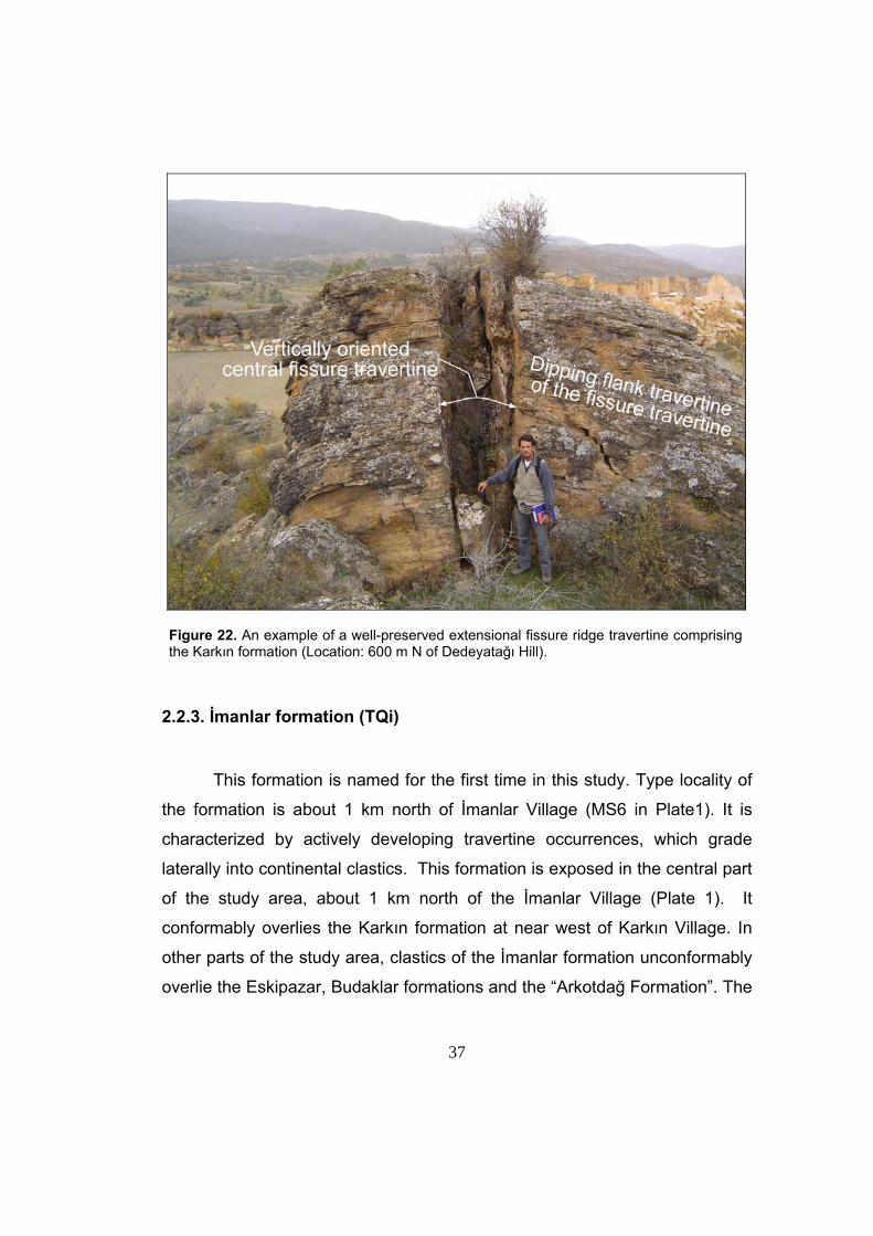
has well preserved fissures observed at approximately 600 m north of
Dedeyatağı Hill and near west of Karkın Village (Figure 22). Its
unconformable relationship with the Quaternary alluvium indicates that the
Karkın formation is younger than the Budaklar formation and older than
Quaternary alluvium. Based on this information, Plio-Quaternary age is
assigned to the Karkın formation. Both the Karkın formation, and the Budaklar
formation, can be correlated with Bahçepınar Formation of Şaroğlu et al.
(1995).
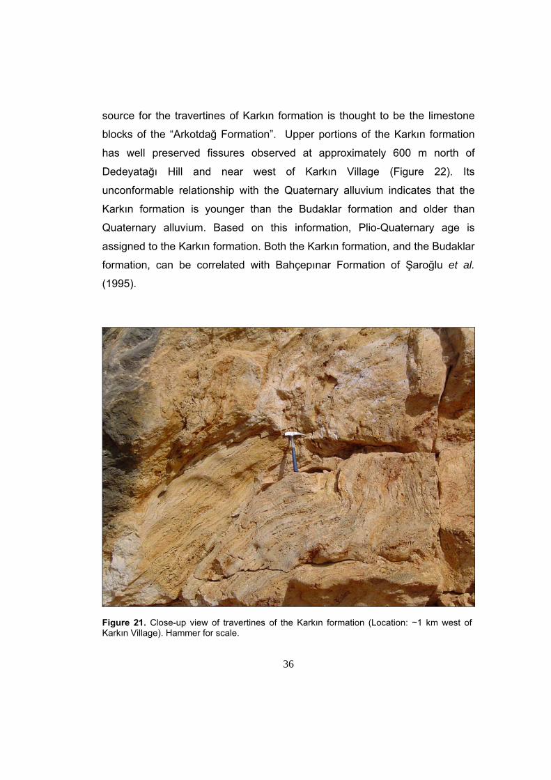
Figure 21. Close-up view of travertines of the Karkın formation (Location: ~1 km west of Karkın Village). Hammer for scale.
37
Figure 22. An example of a well-preserved extensional fissure ridge travertine comprising the Karkın formation (Location: 600 m N of Dedeyatağı Hill).
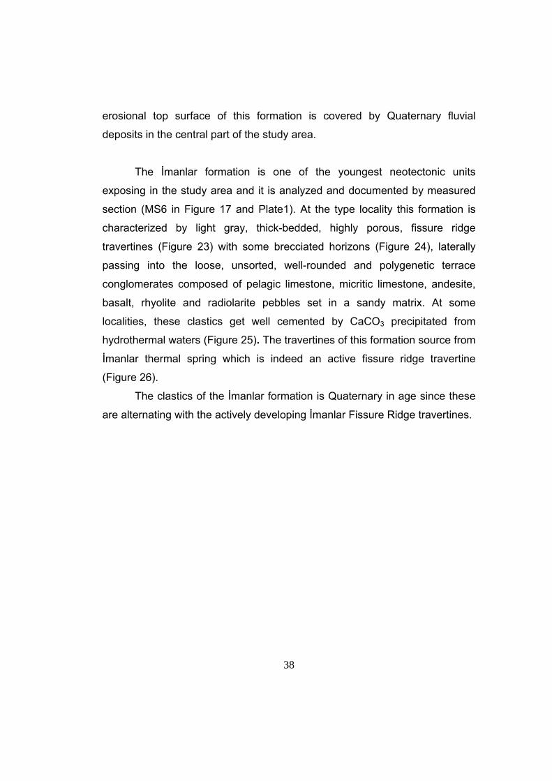
2.2.3. İmanlar formation (TQi)
This formation is named for the first time in this study. Type locality of
the formation is about 1 km north of İmanlar Village (MS6 in Plate1). It is
characterized by actively developing travertine occurrences, which grade
laterally into continental clastics. This formation is exposed in the central part
of the study area, about 1 km north of the İmanlar Village (Plate 1). It
conformably overlies the Karkın formation at near west of Karkın Village. In
other parts of the study area, clastics of the İmanlar formation unconformably
overlie the Eskipazar, Budaklar formations and the “Arkotdağ Formation”. The
38
erosional top surface of this formation is covered by Quaternary fluvial
deposits in the central part of the study area.
The İmanlar formation is one of the youngest neotectonic units
exposing in the study area and it is analyzed and documented by measured
section (MS6 in Figure 17 and Plate1). At the type locality this formation is
characterized by light gray, thick-bedded, highly porous, fissure ridge
travertines (Figure 23) with some brecciated horizons (Figure 24), laterally
passing into the loose, unsorted, well-rounded and polygenetic terrace
conglomerates composed of pelagic limestone, micritic limestone, andesite,
basalt, rhyolite and radiolarite pebbles set in a sandy matrix. At some
localities, these clastics get well cemented by CaCO3 precipitated from
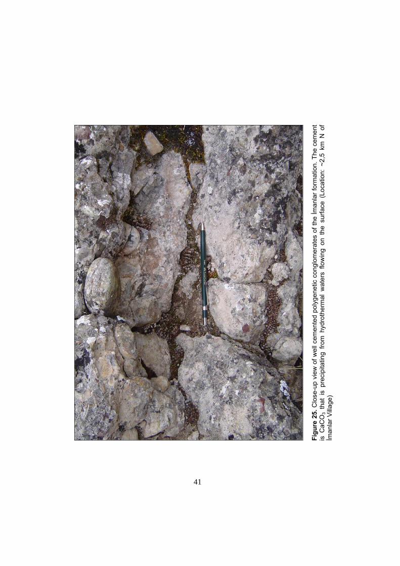
hydrothermal waters (Figure 25). The travertines of this formation source from
İmanlar thermal spring which is indeed an active fissure ridge travertine
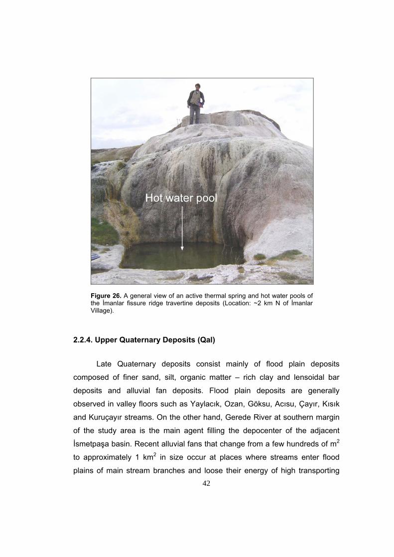
(Figure 26).
The clastics of the İmanlar formation is Quaternary in age since these
are alternating with the actively developing İmanlar Fissure Ridge travertines.
39
Figure 23. General view of fissure ridge travertines of the İmanlar formation (Location: ~2 km N of İmanlar Village, view towards E).
40
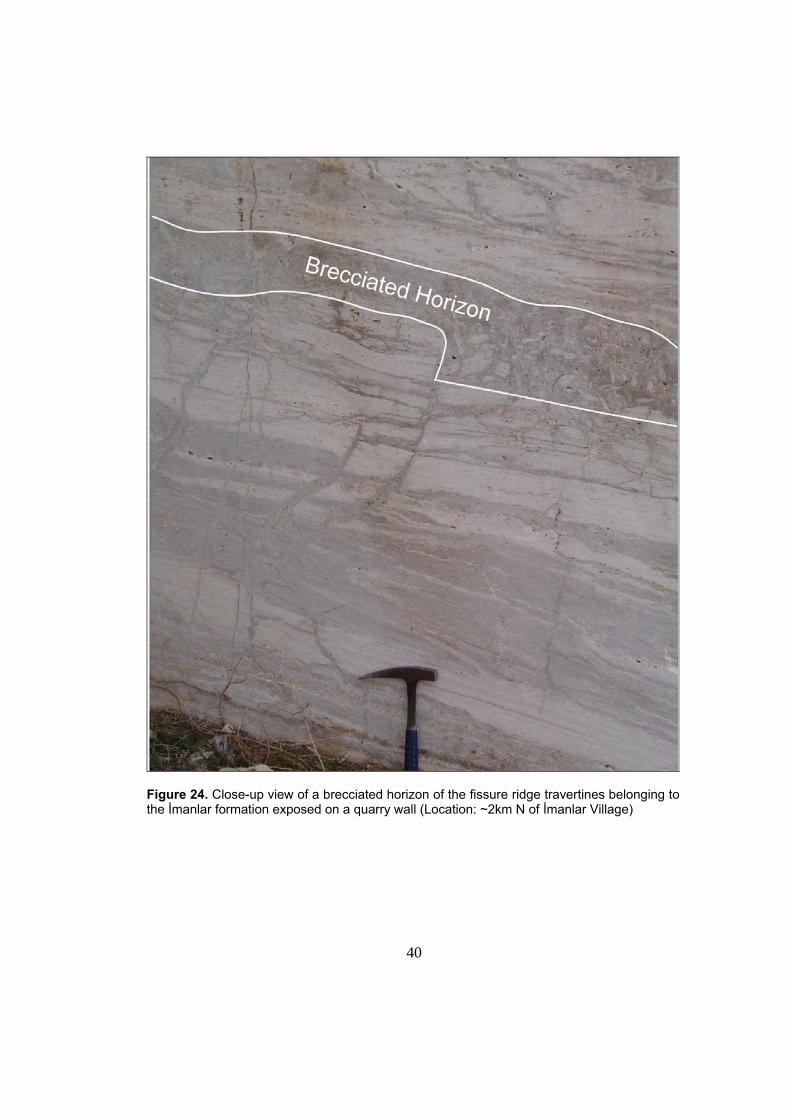
Figure 24. Close-up view of a brecciated horizon of the fissure ridge travertines belonging to the İmanlar formation exposed on a quarry wall (Location: ~2km N of İmanlar Village)
39
Figu
re 2
5. C
lose
-up
view
of w
ell c
emen
ted
poly
gene
tic c
ongl
omer
ates
of t
he İm
anla
r for
mat
ion.
The
cem
ent
is C
aCO
3 th
at i
s pr
ecip
itatin
g fro
m h
ydro
ther
mal
wat
ers
flow
ing
on t
he s
urfa
ce (
Loca
tion:
~2,
5 km
N o
f İm
anla
r Villa
ge)
41
42
Figure 26. A general view of an active thermal spring and hot water pools of the İmanlar fissure ridge travertine deposits (Location: ~2 km N of İmanlar Village).
2.2.4. Upper Quaternary Deposits (Qal)
Late Quaternary deposits consist mainly of flood plain deposits
composed of finer sand, silt, organic matter – rich clay and lensoidal bar
deposits and alluvial fan deposits. Flood plain deposits are generally
observed in valley floors such as Yaylacık, Ozan, Göksu, Acısu, Çayır, Kısık
and Kuruçayır streams. On the other hand, Gerede River at southern margin
of the study area is the main agent filling the depocenter of the adjacent
İsmetpaşa basin. Recent alluvial fans that change from a few hundreds of m2
to approximately 1 km2 in size occur at places where streams enter flood
plains of main stream branches and loose their energy of high transporting
43
capacity. A series of diverse-sized alluvial fans with apices adjacent to basin
margin bounding faults in the southern part of the study area are well
exposed (Plate 1), and they imply to the activeness of the related faults.
Besides this some fans are perched on flat topography without being able to
reach the flood plain floors. These fans are observed near Karkın Village and
about 1.7 km SE of Boncuklar Village (Plate 1), near Boz Hill.

44
CHAPTER III
STRUCTURAL GEOLOGY
This chapter deals with the description and analysis of the
geological structures including, beds, folds, unconformities, faults and
travertine fissures observed in the study area. Based on tectonic period
during which these structures formed, they can be divided into two
categories; 1) Paleotectonic structures and 2) Neotectonic structures.
Hence the Pre-Neogene structures, formed by deformation of Pre-
Neogene basement rocks lies out of the scope of this study, these
structures will not be discussed here. Indeed, as the Eskipazar formation
is the latest Paleotectonic unit of the study area and as it plays an
important role in analysing the evolution pattern of the Eskipazar basin,
only the above mentioned geological structures hosted by this unit will be
described and analysed in this study. Besides the structures formed by
deformation of these units, the neotectonic structures determining the
present day configuration and outline of the Eskipazar Basin will be
described and analysed. An important point that should be kept in mind is
that, not all the structures (such as faults) hosted by paleotectonic
Eskipazar formation are paleotectonic in origin but present day
morphology of land surface is the indication that some may have
neotectonic origin.
The database for the structural analysis is attained by field
geological mapping at 1/25.000 scale during field studies, attitudes of
various planar and linear structures such as strike, dip, trend-plunge, rake
were measured, and later on, the raw data sets were analysed by using
pole plots, histograms and computer software named as ‘Tector’ and its
sub-programs ‘Mesure’, and ‘Tensor’ (Angelier, 1989). Besides for visual
presentation of the results of the analysis of these raw data, sub-program
45
of ‘Tector’ that is named as ‘Diagra’ (Angelier, 1989) and ‘Rockware, 2002’
are utilized.
Basically the sub-programs ‘Mesure’ and ‘Tensor’ are the computer
softwares that provide the user, with the relation between the faults or
shear planes, principle stress directions. The sub-program ‘Diagra’
presents the results of the processed data (by sub-programs ‘Mesure’ and
‘Tensor’) on Stereographic projection and this projection includes slip-
planes and principle stress axes.
In addition to these softwares, basically the orientation and opening
amounts of the extensional travertine fissures developed in the
neotectonic units are utilized to interpret principle stress directions as well
as the age of the travertine deposits and time-dependent activity pattern of
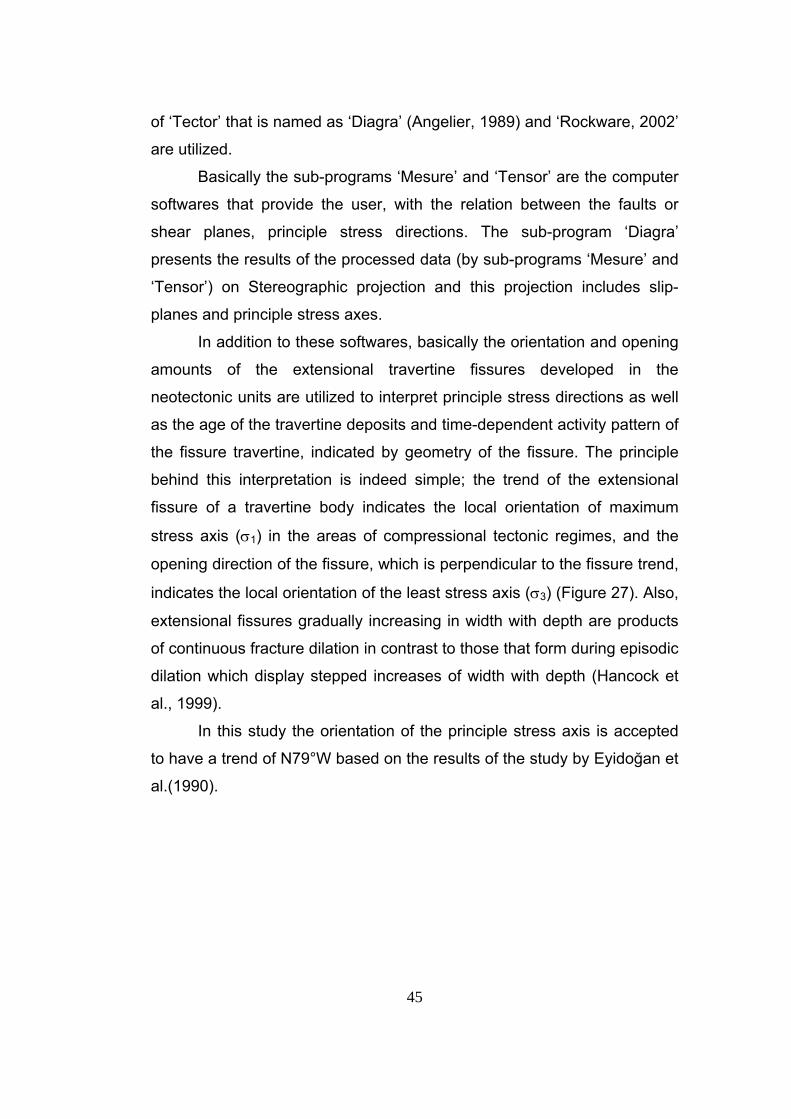
the fissure travertine, indicated by geometry of the fissure. The principle
behind this interpretation is indeed simple; the trend of the extensional
fissure of a travertine body indicates the local orientation of maximum
stress axis (σ1) in the areas of compressional tectonic regimes, and the
opening direction of the fissure, which is perpendicular to the fissure trend,
indicates the local orientation of the least stress axis (σ3) (Figure 27). Also,
extensional fissures gradually increasing in width with depth are products
of continuous fracture dilation in contrast to those that form during episodic
dilation which display stepped increases of width with depth (Hancock et
al., 1999).
In this study the orientation of the principle stress axis is accepted
to have a trend of N79°W based on the results of the study by Eyidoğan et
al.(1990).
46
Figure 27. Sketch drawing illustrating structural relationship between local principle stress directions and extensional fissure of a travertine body (fissure ridge) developed in the areas of compressional neotectonic regimes. 3.1. Paleotectonic Structures Paleotectonic structures that have a significant role in the evolution
history of the Eskipazar Basin are hosted by Upper Miocene-Lower
Pliocene Eskipazar formation. These structures can be named as well-
developed syn-depositional structures such as the growth faults and shear
fractures, tilted beds and folds. The analysis of the geological structures
will enlighten the tectonic history, namely the tectonic regime coeval with
sedimentation and phase(s) of deformation, prior to onset of neotectonic
regime.
47
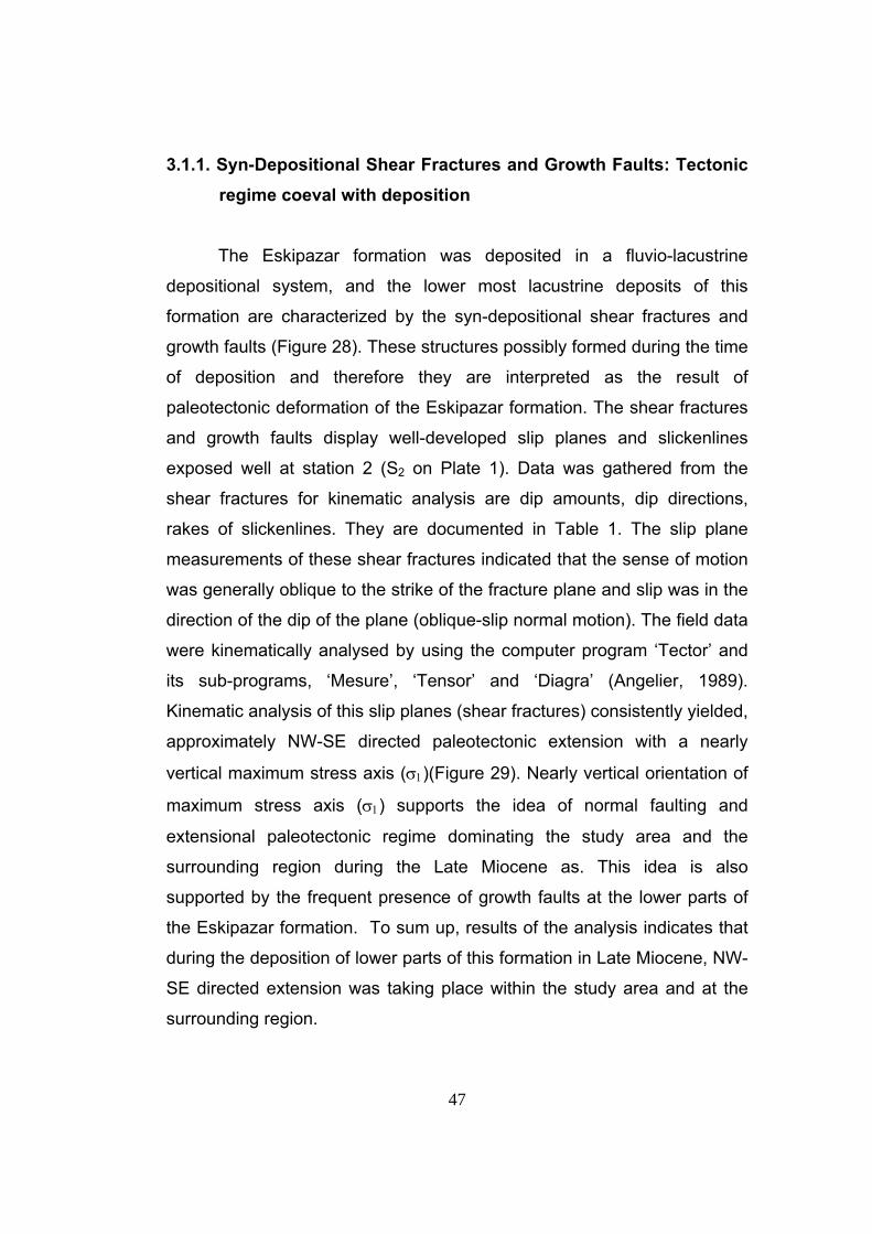
3.1.1. Syn-Depositional Shear Fractures and Growth Faults: Tectonic
regime coeval with deposition The Eskipazar formation was deposited in a fluvio-lacustrine
depositional system, and the lower most lacustrine deposits of this
formation are characterized by the syn-depositional shear fractures and
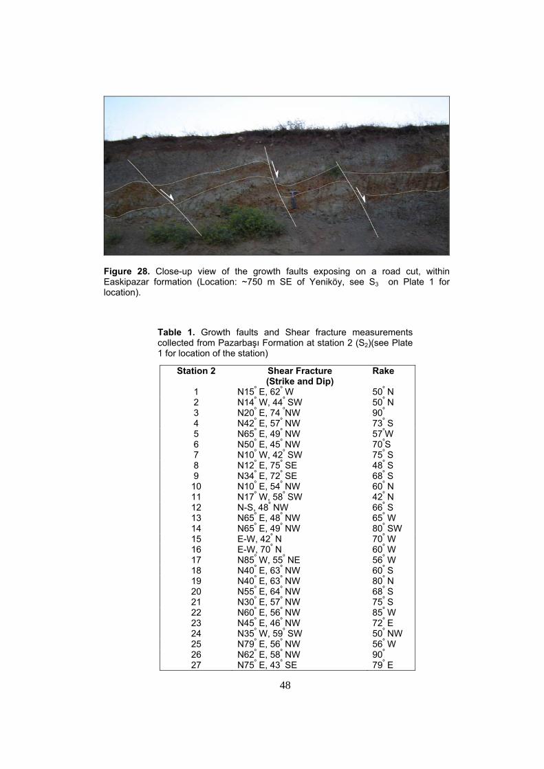
growth faults (Figure 28). These structures possibly formed during the time
of deposition and therefore they are interpreted as the result of
paleotectonic deformation of the Eskipazar formation. The shear fractures
and growth faults display well-developed slip planes and slickenlines
exposed well at station 2 (S2 on Plate 1). Data was gathered from the
shear fractures for kinematic analysis are dip amounts, dip directions,
rakes of slickenlines. They are documented in Table 1. The slip plane
measurements of these shear fractures indicated that the sense of motion
was generally oblique to the strike of the fracture plane and slip was in the
direction of the dip of the plane (oblique-slip normal motion). The field data
were kinematically analysed by using the computer program ‘Tector’ and
its sub-programs, ‘Mesure’, ‘Tensor’ and ‘Diagra’ (Angelier, 1989).
Kinematic analysis of this slip planes (shear fractures) consistently yielded,
approximately NW-SE directed paleotectonic extension with a nearly
vertical maximum stress axis (σ1)(Figure 29). Nearly vertical orientation of
maximum stress axis (σ1) supports the idea of normal faulting and
extensional paleotectonic regime dominating the study area and the
surrounding region during the Late Miocene as. This idea is also
supported by the frequent presence of growth faults at the lower parts of
the Eskipazar formation. To sum up, results of the analysis indicates that
during the deposition of lower parts of this formation in Late Miocene, NW-
SE directed extension was taking place within the study area and at the
surrounding region.
48
Figure 28. Close-up view of the growth faults exposing on a road cut, within Easkipazar formation (Location: ~750 m SE of Yeniköy, see S3 on Plate 1 for location).
Table 1. Growth faults and Shear fracture measurements collected from Pazarbaşı Formation at station 2 (S2)(see Plate 1 for location of the station)
Station 2 Shear Fracture (Strike and Dip)
Rake
1 N15º E, 62º W 50º N 2 N14º W, 44º SW 50º N 3 N20º E, 74 ºNW 90º
4 N42º E, 57º NW 73º S 5 N65º E, 49º NW 57ºW 6 N50º E, 45º NW 70ºS 7 N10º W, 42º SW 75º S 8 N12º E, 75º SE 48º S 9 N34º E, 72º SE 68º S 10 N10º E, 54º NW 60º N 11 N17º W, 58º SW 42º N 12 N-S, 48º NW 66º S 13 N65º E, 48º NW 65º W 14 N65º E, 49º NW 80º SW 15 E-W, 42º N 70º W 16 E-W, 70º N 60º W 17 N85º W, 55º NE 56º W 18 N40º E, 63º NW 60º S 19 N40º E, 63º NW 80º N 20 N55º E, 64º NW 68º S 21 N30º E, 57º NW 75º S 22 N60º E, 56º NW 85º W 23 N45º E, 46º NW 72º E 24 N35º W, 59º SW 50º NW 25 N79º E, 56º NW 56º W 26 N62º E, 58º NW 90º 27 N75º E, 43º SE 79º E
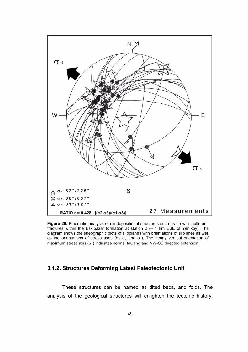
49
Figure 29. Kinematic analysis of syndepositional structures such as growth faults and fractures within the Eskipazar formation at station 2 (~ 1 km ESE of Yeniköy). The diagram shows the streographic plots of slipplanes with orientations of slip lines as well as the orientations of stress axes (σ1, σ2 and σ3). The nearly vertical orientation of maximum stress axis (σ1) indicates normal faulting and NW-SE directed extension.
3.1.2. Structures Deforming Latest Paleotectonic Unit
These structures can be named as tilted beds, and folds. The
analysis of the geological structures will enlighten the tectonic history,
σ 1 : 8 2 ° / 2 2 5 °
σ 2 : 0 8 ° / 0 3 7 ° σ 3 : 0 1 ° / 1 2 7 °
RATIO φ = 0.428 [(σ2-σ3)/(σ1-σ3)]
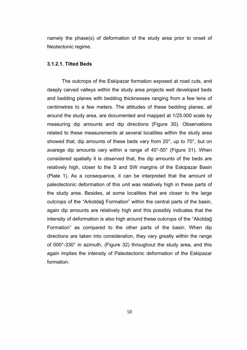
50
namely the phase(s) of deformation of the study area prior to onset of
Neotectonic regime.
3.1.2.1. Tilted Beds The outcrops of the Eskipazar formation exposed at road cuts, and
deeply carved valleys within the study area projects well developed beds
and bedding planes with bedding thicknesses ranging from a few tens of
centimetres to a few meters. The attitudes of these bedding planes, all
around the study area, are documented and mapped at 1/25.000 scale by
measuring dip amounts and dip directions (Figure 30). Observations
related to these measurements at several localities within the study area
showed that, dip amounts of these beds vary from 20°, up to 70°, but on
avarege dip amounts vary within a range of 40°-50° (Figure 31). When
considered spatially it is observed that, the dip amounts of the beds are
relatively high, closer to the S and SW margins of the Eskipazar Basin
(Plate 1). As a consequence, it can be interpreted that the amount of
paleotectonic deformation of this unit was relatively high in these parts of
the study area. Besides, at some localities that are closer to the large
outcrops of the “Arkotdağ Formation” within the central parts of the basin,
again dip amounts are relatively high and this possibly indicates that the
intensity of deformation is also high around these outcrops of the “Akotdağ
Formation” as compared to the other parts of the basin. When dip
directions are taken into consideration, they vary greatly within the range
of 000°-330° in azimuth, (Figure 32) throughout the study area, and this
again implies the intensity of Paleotectonic deformation of the Eskipazar
formation.
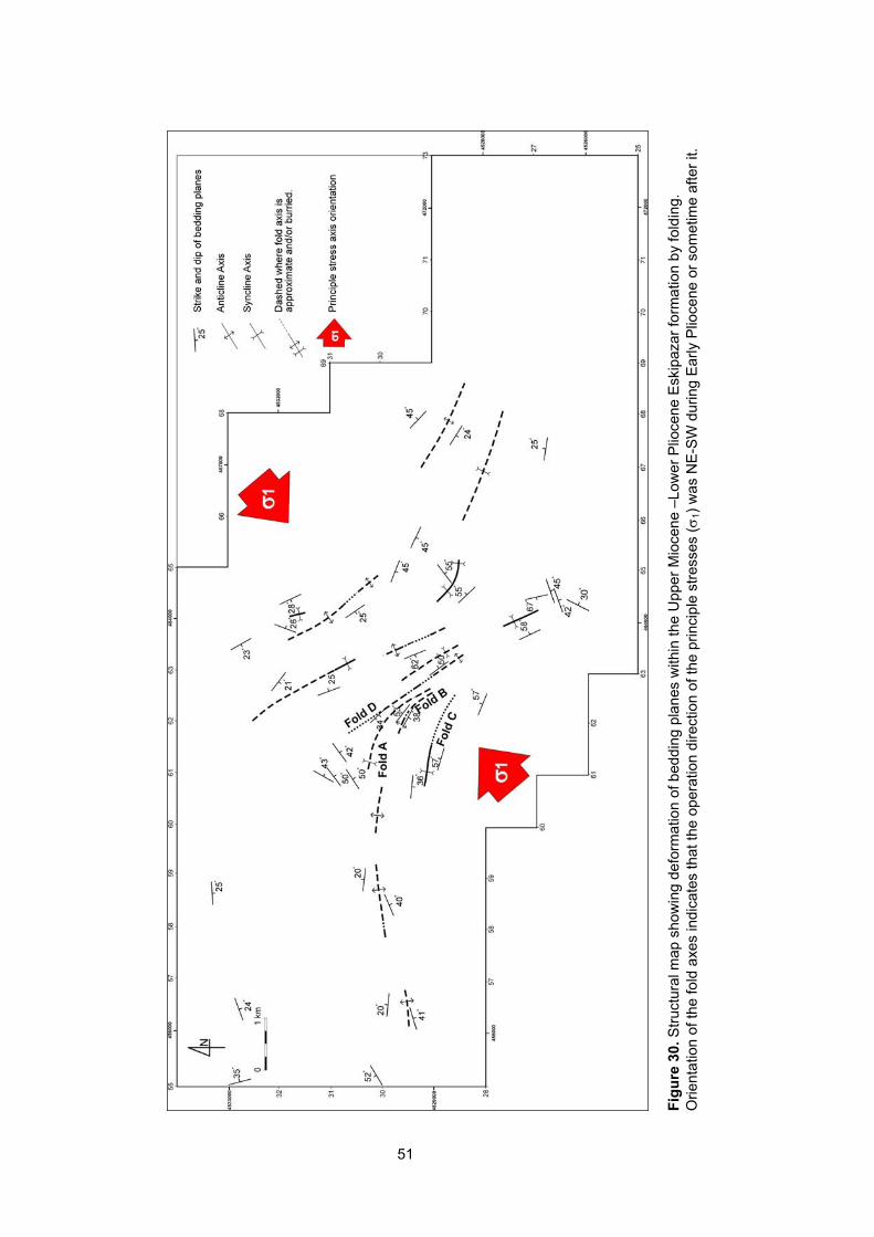
49
Fi
gure
30.
Stru
ctur
al m
ap s
how
ing
defo
rmat
ion
of b
eddi
ng p
lane
s w
ithin
the
Upp
er M
ioce
ne –
Low
er P
lioce
ne E
skip
azar
form
atio
n by
fold
ing.
O
rient
atio
n of
the
fold
axe
s in
dica
tes
that
the
oper
atio
n di
rect
ion
of th
e pr
inci
ple
stre
sses
(σ1)
was
NE
-SW
dur
ing
Ear
ly P
lioce
ne o
r som
etim
e af
ter i
t.
51
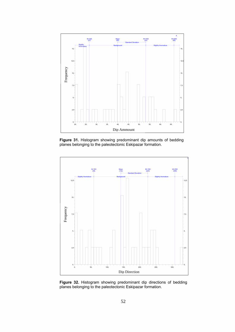
52
Figure 31. Histogram showing predominant dip amounts of bedding planes belonging to the paleotectonic Eskipazar formation.
Figure 32. Histogram showing predominant dip directions of bedding planes belonging to the paleotectonic Eskipazar formation.
0, 50, 100, 150, 200, 250, 300, 0, 0,
2,5 2,5
5, 5,
7,5 7,5
10, 10,
12,5 12,5
(58) M-1SD (142)Mean
(225)M+1SD
(308) M+2SD Standard Deviation
Slightly Anomalous Background Slightly Anomalous
s
Dip Direction
Freq
uenc
y
20, 25, 30, 35, 40, 45, 50, 55, 60, 65, 0, 0,
2,5 2,5
5, 5,
7,5 7,5
10, 10,
12,5 12,5
15, 15,
(27) M-1SD (40)
Mean(53)
M+1SD(66) M+2SD
Standard Deviation
Background Slightly Anomalous
A
Dip Ammount
Freq
uenc
y
Slightly Anomalous
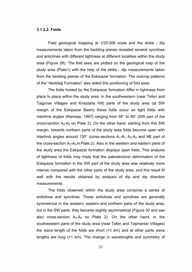
53
3.1.2.2. Folds Field geological mapping at 1/25.000 scale and the strike - dip
measurements taken from the bedding planes revealed several synclines
and anticlines with different tightness at different localities within the study
area (Figure 28). The fold axes are plotted on the geological map of the
study area (Plate1) with the help of the strike - dip measurements taken
from the bedding planes of the Eskipazar formation. The outcrop patterns
of the “Akotdağ Formation” also aided this positioning of fold axes.
The folds hosted by the Eskipazar formation differ in tightness from
place to place within the study area. In the southwestern (near Tefen and
Taşpınar Villages and Kıraçtarla Hill) parts of the study area (at SW
margin of the Eskipazar Basin) these folds occur as tight folds with
interlimb angles (Ramsay, 1967) ranging from 55° to 89° (SW part of the
cross-section A3-A3 on Plate 2). On the other hand, starting from this SW
margin, towards northern parts of the study area folds become open with
interlimb angles around 130° (cross-sections A1-A1, A2-A2 and NE part of
the cross-section A3-A3 in Plate 2). Also in the western and eastern parts of
the study area the Eskipazar formation displays open folds. This analysis
of tightness of folds may imply that the paleotectonic deformation of the
Eskipazar formation in the SW part of the study area was relatively more
intense compared with the other parts of the study area, and this result fit
well with the results obtained by analysis of dip and dip direction
measurements.
The folds observed within the study area comprise a series of
anticlines and synclines. These anticlines and synclines are generally
symmetrical in the western, eastern and northern parts of the study area,
but in the SW parts, they become slightly asymmetrical (Figure 30 and see
also cross-section A3-A3 on Plate 2). On the other hand, in the
southwestern parts of the study area (near Tefen and Taşmanlar Villages)
the wave length of the folds are short (<1 km) and at other parts wave
lengths are long (>1 km). The change in wavelengths and symmetry of
54
folds may be another indicator of intensity of deformation in the
southwestern part of the study area.
The axes of the anticlines and synclines display a parallel, sub-
parallel pattern with trends generally in NW-SE to NNW-SSE direction.
The axes of the folds are generally curvilinear and starting from SW parts
of the study area, their trend changes from NNW-SSE to nearly E-W
towards western parts. (Folds A, B and C on Figure 30). In the eastern
parts of the study area, the trend is nearly NW-SE, and in the western
parts, it is nearly E-W. Besides, linear alignment of small outcrops of the
“Akotdağ Formation” (near Tefen Village and South of Taşmanlar Village)
along the anticline axes for folds B and D in Figure 30 indicates that this
formation crops out at the core of anticlines; then revealing that the unit is
on the basement rock (Plate 1).This in turn also explain why the Eskipazar
formation is thinner in this part of the study area compared with the other
parts. The length of the fold axes range from few hundreds of meters to
few kilometres.
From the NNW-SSE to NW-SE trends of the fold axes is consistent
with a nearly NE-SW directed compression (Figure 30). In addition to this
stereographic pole plots of the 39 bedding planes from the Upper Miocene
- Lower Pliocene Eskipazar formation, have confirmed the NE-SW directed
compression during the latest phase of paleotectonic period (Figure 33).
Besides, at western parts of the study area the fold axes nearly becomes
E-W, which may imply that at the later phases of the deformation nearly N-
S directed compression took place causing refolding of the Eskipazar
formation at this part of the study area.
55
Figure 33. Stereographic pole plots to bedding planes of the Eskipazar formation, black arrows indicate the average operation direction of the compressive stresses during the latest phase of paleotectonic period. 3.2. Neotectonic Structures In this section, characteristics of the neotectonic structures exposed
within the study area will be dealt with. Here, neotectonic term is
considered as a period of time that has elapsed since the last major
wholesale tectonic reorganization in a region of interest (Şengör, 1980)
which started and this tectonic reorganization in Anatolia by the formation
of the North Anatolian Fault System in Early Pliocene (Barka, 1984) or
later (Late Pliocene) (Koçyiğit and Beyhan 1998). Under the light of this
56
information, structures that developed under the present day strike-slip
tectonic regime in the study area are defined as the neotectonic structures
which constitute beds, unconformities, faults and extensional fissures. The
field based study and analysis of these structures will enlighten the
characteristics of present-day deformation that takes place within the
study area and will be helpful in interpreting final stage of evolutionary
history of the Eskipazar Basin.
3.2.1. Beds Undeformed younger neotectonic units and infill of the Eskipazar
Basin occur as patches of Plio-Quaternary Budaklar, Karkın, İmanlar
formations and Holocene sediments in different localities throughout the
study area. They, except for Holocene sediments are characterized by
bedded to massive travertine deposits and the Budaklar, İmanlar
formations contain some clastic intercalations with in. Original dips of all
these formations are nearly 0°, meaning that the beds of these formations
are nearly flat lying. On the other hand, some travertine layers display dip
angles that are more than 20°, but this dip angle is the original dip angle of
these travertine layers and formed by precipitation of CaCO3 from down
slope flowing hydrothermal waters that are coming out from the fissures,
which have relatively high elevations due to the build-up of travertine
around them. During the field studies the dip amounts and directions of
these travertine layers were used to locate the positions of the travertine
fissures, from which these layers dip in radial pattern. The thicknesses of
travertine layers range from few millimetres up to few centimetres. On the
other hand, the thicknesses of these travertine layers do not remain
constant and decrease away from the source of hydrothermal waters
(fissures). Besides these, the clastic sediments of the neotectonic period
have thicknesses ranging from a few centimetres to a few tens of meters.
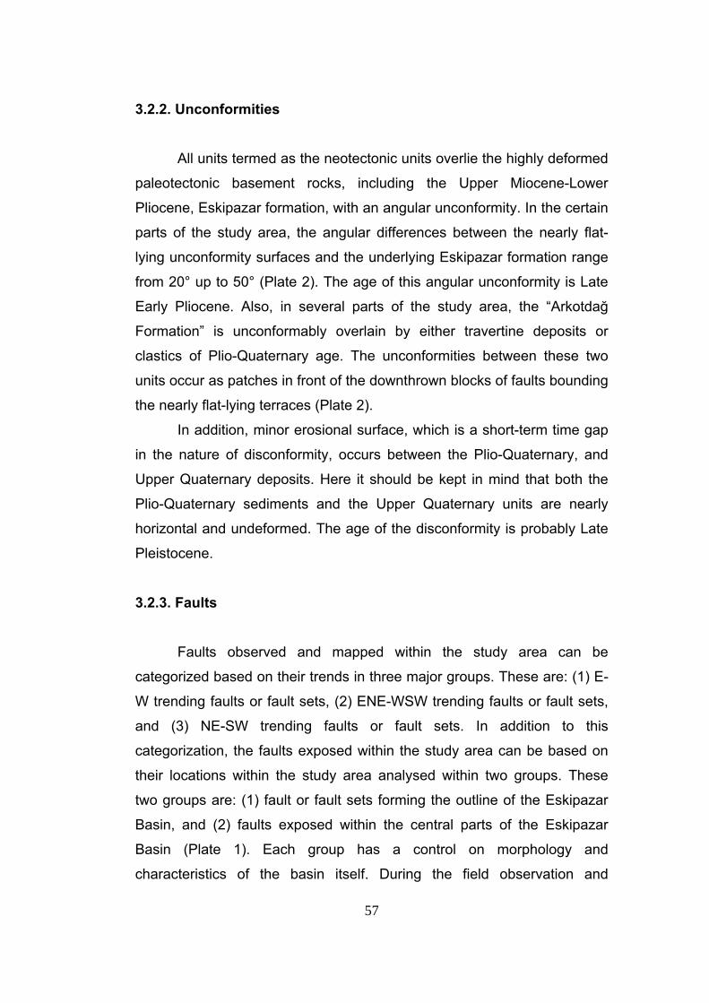
57
3.2.2. Unconformities All units termed as the neotectonic units overlie the highly deformed
paleotectonic basement rocks, including the Upper Miocene-Lower
Pliocene, Eskipazar formation, with an angular unconformity. In the certain
parts of the study area, the angular differences between the nearly flat-
lying unconformity surfaces and the underlying Eskipazar formation range
from 20° up to 50° (Plate 2). The age of this angular unconformity is Late
Early Pliocene. Also, in several parts of the study area, the “Arkotdağ
Formation” is unconformably overlain by either travertine deposits or
clastics of Plio-Quaternary age. The unconformities between these two
units occur as patches in front of the downthrown blocks of faults bounding
the nearly flat-lying terraces (Plate 2).
In addition, minor erosional surface, which is a short-term time gap
in the nature of disconformity, occurs between the Plio-Quaternary, and
Upper Quaternary deposits. Here it should be kept in mind that both the
Plio-Quaternary sediments and the Upper Quaternary units are nearly
horizontal and undeformed. The age of the disconformity is probably Late
Pleistocene.
3.2.3. Faults Faults observed and mapped within the study area can be
categorized based on their trends in three major groups. These are: (1) E-
W trending faults or fault sets, (2) ENE-WSW trending faults or fault sets,
and (3) NE-SW trending faults or fault sets. In addition to this
categorization, the faults exposed within the study area can be based on
their locations within the study area analysed within two groups. These
two groups are: (1) fault or fault sets forming the outline of the Eskipazar
Basin, and (2) faults exposed within the central parts of the Eskipazar
Basin (Plate 1). Each group has a control on morphology and
characteristics of the basin itself. During the field observation and
58
examinations these faults are mapped based on their geomorphologic
expressions. In general, these faults occur as nearly vertical, dextral or
sinistral strike-slip faults cutting through the pre-Pliocene basement rocks
and the pre-Quaternary cover units.
As is mentioned before, the outline and characteristics of the
Eskipazar Basin is determined by the faults surrounding it and occurring
within. In the southern part of the study area, Eskipazar Basin starts as a
depression, compared with its eastern and western highlands, and it is
separated from the adjacent, relatively lower İsmetpaşa Basin in the south
by gently rolling hills on the upthrown block of the E-W trending, south
dipping Acısu Fault (~7 km long long). Further to the North, the basin is
bounded by the WNW-ESE trending Karkın fault (~2 km long) and the
NW-SE trending Arslanlar fault set (~2 km long) together with E-W
trending Dibek (~3 km long) and Karkın (~2 km long) faults to the east of
the basin. On the other hand, the basin is bounded by NE-SW trending
Budaklar fault set (~4 km long) and E-W trending Beytarla fault zone (~4
km long) in the west (Plate 3). In addition to this, the eastern part of the
basin may be considered to be controlled by NNE-SSW trending Boztepe
fault (~1.2 km long).
The faults exposed within the central parts of the basin are
generally, relatively short, isolated and closely-spaced. Therefore, among
these faults only the Yeniköy (~3 km) and İmanlar faults are considered in
this study. The reason for this discrimination is that both the Yeniköy and
the İmanlar faults play important role in the evolution of the Eskipazar
Basin.
Morphologically the southern margin of the basin is fairly straight
because of the straight geometry of the Acısu Fault. In contrast to this, the
northern margin of the basin, that is determined by the Dibek fault and the
Aslanlar fault set, is curvilinear whereas the northwestern and western
margins of the basin are stepped in morphology because of the step-like
nature of the Budaklar, Beytarla and the Kadılar fault sets. In addition to
this, the geometric arrangement of faults surrounding the basin is also a
59
controlling factor for the distribution and geometry of drainage pattern and
flood plains of streams.
In the study area, existence and activeness of the faults are
indicated by sudden break in slope, juxtaposition of different units, down
cutting of streams through traces of faults, fault-parallel alignment of
springs, alignment of alluvial fans along to traces of faults, presence of hot
springs along the traces of faults, presence of young travertine deposits on
downthrown blocks of faults and presence of terraced Plio-Quaternary
units. Major faults taking part in the Neotectonic evolution of the Eskipazar
basin will be explained in more detail in the following sections.
3.2.3.1. Acısu Fault Acısu Fault, which was first named by Koçyiğit (2003), determines
the southern margin of the Eskipazar Basin. It comprises relatively straight
E-W trending southward facing oblique slip normal fault with minor amount
of dextral strike-slip component. This fault makes a left, restraining step-
over approximately 1.5 km east of Karaağaç Hill. The length of this fault is
approximately 7 km (Plate 3). Along the fault Quaternary infill of adjacent
İsmetpaşa Basin and Taşlık Formation are tectonically juxtaposed.
The Acısu fault does not display clear scarps at the western parts,
but at eastern parts the scarps of this fault is steep and clear. Especially in
the southern parts of the Acısu Hill and the Karaağaç Hill the fault scarp is
well exposed and displays well-preserved slickenside with striations on it (Figure 34). Slip plane data measured on this slickenside (Station 1, S1 on
Plate 1) and their kinematic analysis indicates that the Acısu Fault is an
oblique slip normal fault with minor amount of dextral strike-slip
component. The kinematic analysis also indicated that the local extension
direction is nearly N-S (NNE-SSW) (Figure 35 and Table 2).
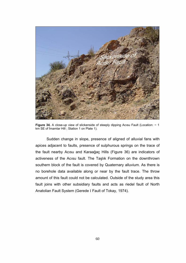
60
Figure 34. A close-up view of slickenside of steeply dipping Acısu Fault (Location: ~ 1 km SE of İmamlar Hill ; Station 1 on Plate 1).
Sudden change in slope, presence of aligned of alluvial fans with
apices adjacent to faults, presence of sulphurous springs on the trace of
the fault nearby Acısu and Karaağaç Hills (Figure 36) are indicators of
activeness of the Acısu fault. The Taşlık Formation on the downthrown
southern block of the fault is covered by Quaternary alluvium. As there is
no borehole data available along or near by the fault trace. The throw
amount of this fault could not be calculated. Outside of the study area this
fault joins with other subsidiary faults and acts as riedel fault of North
Anatolian Fault System (Gerede I Fault of Tokay, 1974).
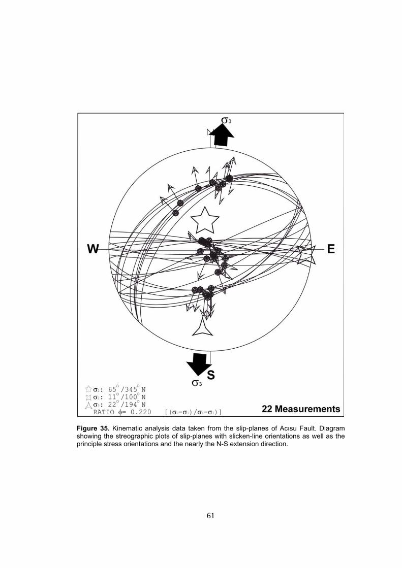
61
Figure 35. Kinematic analysis data taken from the slip-planes of Acısu Fault. Diagram showing the streographic plots of slip-planes with slicken-line orientations as well as the principle stress orientations and the nearly the N-S extension direction.
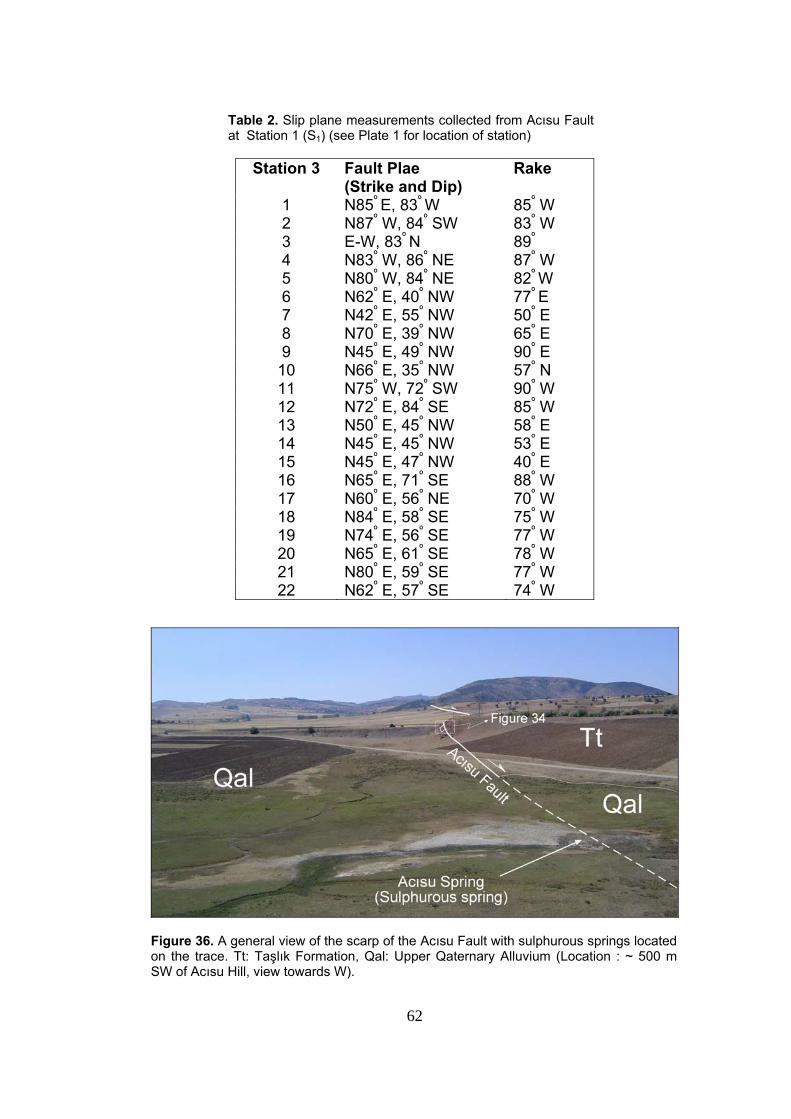
62
Table 2. Slip plane measurements collected from Acısu Fault at Station 1 (S1) (see Plate 1 for location of station)
Station 3 Fault Plae (Strike and Dip)
Rake
1 N85º E, 83º W 85º W 2 N87º W, 84º SW 83º W 3 E-W, 83º N 89º
4 N83º W, 86º NE 87º W 5 N80º W, 84º NE 82º W 6 N62º E, 40º NW 77º E 7 N42º E, 55º NW 50º E 8 N70º E, 39º NW 65º E 9 N45º E, 49º NW 90º E 10 N66º E, 35º NW 57º N 11 N75º W, 72º SW 90º W 12 N72º E, 84º SE 85º W 13 N50º E, 45º NW 58º E 14 N45º E, 45º NW 53º E 15 N45º E, 47º NW 40º E 16 N65º E, 71º SE 88º W 17 N60º E, 56º NE 70º W 18 N84º E, 58º SE 75º W 19 N74º E, 56º SE 77º W 20 N65º E, 61º SE 78º W 21 N80º E, 59º SE 77º W 22 N62º E, 57º SE 74º W
Figure 36. A general view of the scarp of the Acısu Fault with sulphurous springs located on the trace. Tt: Taşlık Formation, Qal: Upper Qaternary Alluvium (Location : ~ 500 m SW of Acısu Hill, view towards W).
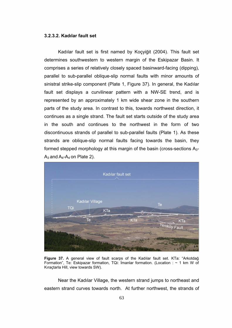
63
3.2.3.2. Kadılar fault set Kadılar fault set is first named by Koçyiğit (2004). This fault set
determines southwestern to western margin of the Eskipazar Basin. It
comprises a series of relatively closely spaced basinward-facing (dipping),
parallel to sub-parallel oblique-slip normal faults with minor amounts of
sinistral strike-slip component (Plate 1, Figure 37). In general, the Kadılar
fault set displays a curvilinear pattern with a NW-SE trend, and is
represented by an approximately 1 km wide shear zone in the southern
parts of the study area. In contrast to this, towards northwest direction, it
continues as a single strand. The fault set starts outside of the study area
in the south and continues to the northwest in the form of two
discontinuous strands of parallel to sub-parallel faults (Plate 1). As these
strands are oblique-slip normal faults facing towards the basin, they
formed stepped morphology at this margin of the basin (cross-sections A3-
A3 and A4-A4 on Plate 2).
Figure 37. A general view of fault scarps of the Kadılar fault set. KTa: “Arkotdağ Formation”, Te: Eskipazar formation, TQi: İmanlar formation. (Location : ~ 1 km W of Kıraçtarla Hill, view towards SW).
Near the Kadılar Village, the western strand jumps to northeast and
eastern strand curves towards north. At further northwest, the strands of
64
this fault set become more continuous and joins with each other
approximately 500 m ENE of Erentek Hill and continues further northwest
in the form of a single strand. The longest eastern strand of this fault set
measures approximately 6.5 km. The western strand of this fault comes
into contact with Beytarla fault zone towards northwestern parts of the
study area. Further northwestern continuation of this fault set comes into a
close relationship with Budaklar fault set (Plate 3). The travertine outcrops,
at these two localities where Beytarla fault zone and Budaklar fault set
nearly comes into contact with Kadılar fault set. The reason for this may
be development of joints and fractures by activation of both fault sets and
fault zone, thus forming conduits for hydrothermal waters to flow to the
surface and consequent deposition of travertines at these localities.
Western strand of the Kadılar fault set passes through Kadılar
Village and it juxtaposes the “Arkotdağ Formation” with the İmanlar
formation and in other localities it juxtaposes the Eskipazar formation with
the İmanlar formation or Quaternary units (at further northwestern parts of
the study area; Plate 1).
The Kadılar fault set displays clear scarps all along it’s trend but
they lack slickensides and striations that are necessary for kinematic
analysis. Nevertheless the topographic and morphological expressions of
this fault indicates that the fault set is composed of oblique-slip normal
faults with minor amount of sinistral strike slip component. This is also
indicated by the relationship between the general trend of the fault set and
the operation direction of the principal stresses.
Development of fault parallel alluvial fans at its eastern parts with
apices adjacent to faults, sudden change in the slope and deeply carved
valleys all together indicate both the existence and activeness of the
Kadılar fault set (Figure 37).
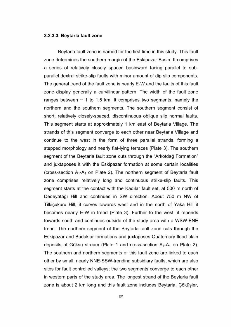
65
3.2.3.3. Beytarla fault zone
Beytarla fault zone is named for the first time in this study. This fault
zone determines the southern margin of the Eskipazar Basin. It comprises
a series of relatively closely spaced basinward facing parallel to sub-
parallel dextral strike-slip faults with minor amount of dip slip components.
The general trend of the fault zone is nearly E-W and the faults of this fault
zone display generally a curvilinear pattern. The width of the fault zone
ranges between ~ 1 to 1,5 km. It comprises two segments, namely the
northern and the southern segments. The southern segment consist of
short, relatively closely-spaced, discontinuous oblique slip normal faults.
This segment starts at approximately 1 km east of Beytarla Village. The
strands of this segment converge to each other near Beytarla Village and
continue to the west in the form of three parallel strands, forming a
stepped morphology and nearly flat-lying terraces (Plate 3). The southern
segment of the Beytarla fault zone cuts through the “Arkotdağ Formation”
and juxtaposes it with the Eskipazar formation at some certain localities
(cross-section A1-A1 on Plate 2). The northern segment of Beytarla fault
zone comprises relatively long and continuous strike-slip faults. This
segment starts at the contact with the Kadılar fault set, at 500 m north of
Dedeyatağı Hill and continues in SW direction. About 750 m NW of
Tilkiçukuru Hill, it curves towards west and in the north of Yaka Hill it
becomes nearly E-W in trend (Plate 3). Further to the west, it rebends
towards south and continues outside of the study area with a WSW-ENE
trend. The northern segment of the Beytarla fault zone cuts through the
Eskipazar and Budaklar formations and juxtaposes Quaternary flood plain
deposits of Göksu stream (Plate 1 and cross-section A1-A1 on Plate 2).
The southern and northern segments of this fault zone are linked to each
other by small, nearly NNE-SSW-trending subsidiary faults, which are also
sites for fault controlled valleys; the two segments converge to each other
in western parts of the study area. The longest strand of the Beytarla fault
zone is about 2 km long and this fault zone includes Beytarla, Çöküşler,
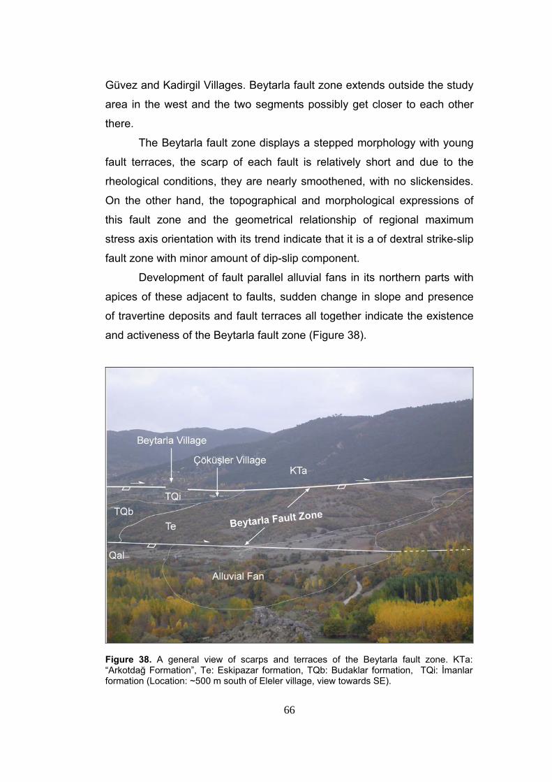
66
Güvez and Kadirgil Villages. Beytarla fault zone extends outside the study
area in the west and the two segments possibly get closer to each other
there.
The Beytarla fault zone displays a stepped morphology with young
fault terraces, the scarp of each fault is relatively short and due to the
rheological conditions, they are nearly smoothened, with no slickensides.
On the other hand, the topographical and morphological expressions of
this fault zone and the geometrical relationship of regional maximum
stress axis orientation with its trend indicate that it is a of dextral strike-slip
fault zone with minor amount of dip-slip component.
Development of fault parallel alluvial fans in its northern parts with
apices of these adjacent to faults, sudden change in slope and presence
of travertine deposits and fault terraces all together indicate the existence
and activeness of the Beytarla fault zone (Figure 38).
Figure 38. A general view of scarps and terraces of the Beytarla fault zone. KTa: “Arkotdağ Formation”, Te: Eskipazar formation, TQb: Budaklar formation, TQi: İmanlar formation (Location: ~500 m south of Eleler village, view towards SE).
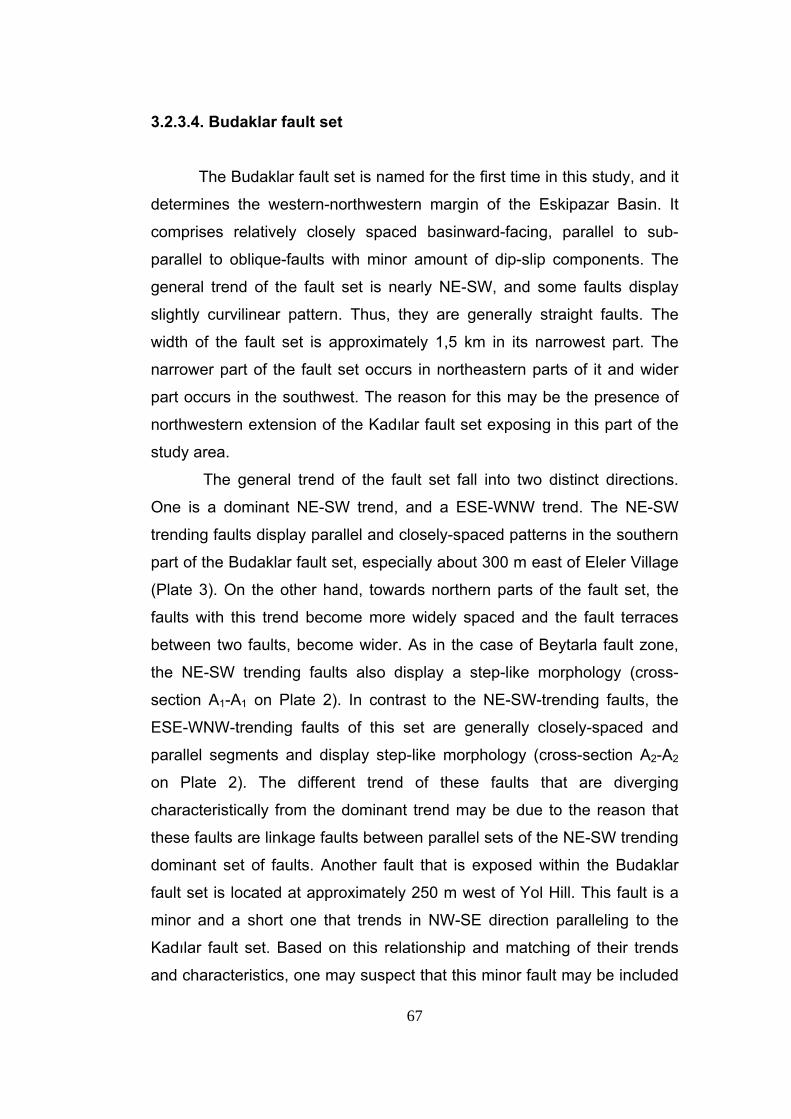
67
3.2.3.4. Budaklar fault set
The Budaklar fault set is named for the first time in this study, and it
determines the western-northwestern margin of the Eskipazar Basin. It
comprises relatively closely spaced basinward-facing, parallel to sub-
parallel to oblique-faults with minor amount of dip-slip components. The
general trend of the fault set is nearly NE-SW, and some faults display
slightly curvilinear pattern. Thus, they are generally straight faults. The
width of the fault set is approximately 1,5 km in its narrowest part. The
narrower part of the fault set occurs in northeastern parts of it and wider
part occurs in the southwest. The reason for this may be the presence of
northwestern extension of the Kadılar fault set exposing in this part of the
study area.
The general trend of the fault set fall into two distinct directions.
One is a dominant NE-SW trend, and a ESE-WNW trend. The NE-SW
trending faults display parallel and closely-spaced patterns in the southern
part of the Budaklar fault set, especially about 300 m east of Eleler Village
(Plate 3). On the other hand, towards northern parts of the fault set, the
faults with this trend become more widely spaced and the fault terraces
between two faults, become wider. As in the case of Beytarla fault zone,
the NE-SW trending faults also display a step-like morphology (cross-
section A1-A1 on Plate 2). In contrast to the NE-SW-trending faults, the
ESE-WNW-trending faults of this set are generally closely-spaced and
parallel segments and display step-like morphology (cross-section A2-A2
on Plate 2). The different trend of these faults that are diverging
characteristically from the dominant trend may be due to the reason that
these faults are linkage faults between parallel sets of the NE-SW trending
dominant set of faults. Another fault that is exposed within the Budaklar
fault set is located at approximately 250 m west of Yol Hill. This fault is a
minor and a short one that trends in NW-SE direction paralleling to the
Kadılar fault set. Based on this relationship and matching of their trends
and characteristics, one may suspect that this minor fault may be included
68
in Budaklar fault set. Keeping this in mind, the area, where the two fault
sets meet, is the site of thick and extensive deposits of travertines (Figure
39) formed due to conjugate fracturing and resulting conduit by which the
CaCO3-rich thermal water came out of the ground surface and precipitated
as travertines.
The Budaklar fault set cuts through the Eskipazar formation (Plate
1), and juxtaposes it with the “Arkotdağ Formation” in the northern parts of
the study area (Plate 1 and cross-section A1-A1 on Plate 2). Towards the
south, the Budaklar fault set also juxtaposes the Eskipazar formation with
the Budaklar formation (Plate 1, and cross-sections A1-A1 and A2-A2 on
Plate 2). The longest fault segment of the Budaklar fault set measures
more than 1,7 km in length.
Figure 39. General view of widespread travertine occurrences, exposed within the limits of Budaklar fault set. TQb: Budaklar formation. (Location : ~ 1 km SW of Budaklar village, view towards SE).
The Budaklar fault set displays distinct scarps where the faults are
long and widely spaced. At places, where the faults are closely spaced the
69
stepped morphology is narrow and the scarps become unclear. During the
field observation no slickensides and striations are recognized on the fault
scarps. Due to the lack of slickensides, kinematic analysis could not be
held for this fault set but topographical and morphological expressions of
the faults, and their geometrical relationship with the current direction of
principal stress, indicate that the fault set is a dextral strike-slip fault with
minor amount of dip slip component.
Sudden change in the slope, presence of relatively young travertine
deposits on hanging wall blocks of faults and tectonic juxtaposition of units
along straight and sharp lines, indicate both the existence and the
activeness of Budaklar fault set (Figure 40).
Figure 40. General view of western part of the Budaklar fault set and the stepped topography shaped by the terraces of it. TQb: Budaklar formation, TQi: İmanlar formation (Location : ~ 1,5 km SE of Büyükyayalar village, view towards NW).
70
3.2.3.5. Arslanlar fault set
Arslanlar fault set is named for the first time in this study. This fault
set determines the northeastern margin of the Eskipazar Basin together
with the Dibek fault set and the Karkın fault (Figure 41). It comprises
relatively closely-spaced, basinward-facing, parallel to sub-parallel sinistral
strike-slip faults with minor amount of dip-slip components. The general
trend of the fault set is NW-SE and the fault segments display curvilinear
to linear outcrop pattern. The width of the fault set is about 500 m. Within
the study area, only two faults of this set are observed. These two faults
make a left step-over approximately 300 m east of Arslanlar Village. The
width of the step over is about 500 m. Within the zone of this step-over,
the Eskipazar formation exposes. However on the other sides of this zone,
older “Arkotdağ Formation” crops out (Plate 1 and cross-section A3-A3 on
Plate 2). This step-over is a releasing step-over. Therefore, the area is
topographically lower than the surrounding parts. Presence of both the
Eskipazar formation and the travertines of the Budaklar formation along
the step-over located on the downthrown block of the NW-SE trending
fault of the Arslanlar fault set may form an evidence of a local extension,
that is being experienced by this step-over (Plate 1, Figure 42)
71
Figure 41. General view of scarps of the Arslanlar fault set, the Dibek and Karkın faults KTa: “Arkotdağ Formation”, TQk: Karkın formation, TQi: İmanlar formation (Location: ~ 1 km N of Ahırtaş Village, view towards NNE).
Figure 42. General view of travertine deposits of the Budaklar formation, cropping out within the step-over zone of the Arslanlar fault set (Location : ~ 1 km E of Arslanlar Village, view to SW).
72
The Arslanlar fault set mainly cuts through the “Arkotdağ Formation”
and it juxtaposes it with the Eskipazar formation (Plate 1), clastics of the
İmanlar formation, and travertines of the Budaklar formation (Plate 1 and
cross-section A3-A3 on Plate 2). The Arslanlar fault set is comes to end
very close to the western tip of the Dibek fault, however it possibly
continues for some distance outside of the study area in the northwest.
The longest fault segment measures about 2 km.
The Arslanlar fault set displays distinct and relatively straight fault
scarps in its northern and northeastern parts. The traces of the faults are
cut across by major stream valleys, in places. The kinematic indicators of
the motion sense along these faults have been eroded and removed away
leaving behind an uneven oxidized zone. On the other hand, topographic
and morphological expressions of the faults and geometric relationship
between faults and principal stresses indicate that the fault set is
composed of sinistral strike-slip faults with minor amount of dip slip
components.
Sudden change in the slope, presence of relatively young
travertines and Plio-Quaternary clastics on the hanging wall blocks of
faults, and the tectonic juxtaposition of units along straight and sharp fault
traces indicate both the existence and the activeness of the Arslanlar fault
set.
3.2.3.6. Dibek fault
Dibek fault is named for the first time in this study. This fault
determines the northern margin of the Eskipazar Basin together with the
Arslanlar fault set and the Karkın fault (Figure 41). It is a linear to
curvilinear dextral strike-slip fault with minor amount of dip-slip component.
The general trend of the fault is ESE-WNW.
The fault starts at approximately 750 m south-southeast of
Sığıreyrek Hill, and continues to the west in a straight manner in ESE-
WNW trend, for about 1 km (Plate 3). At a distance of 1 km SW of
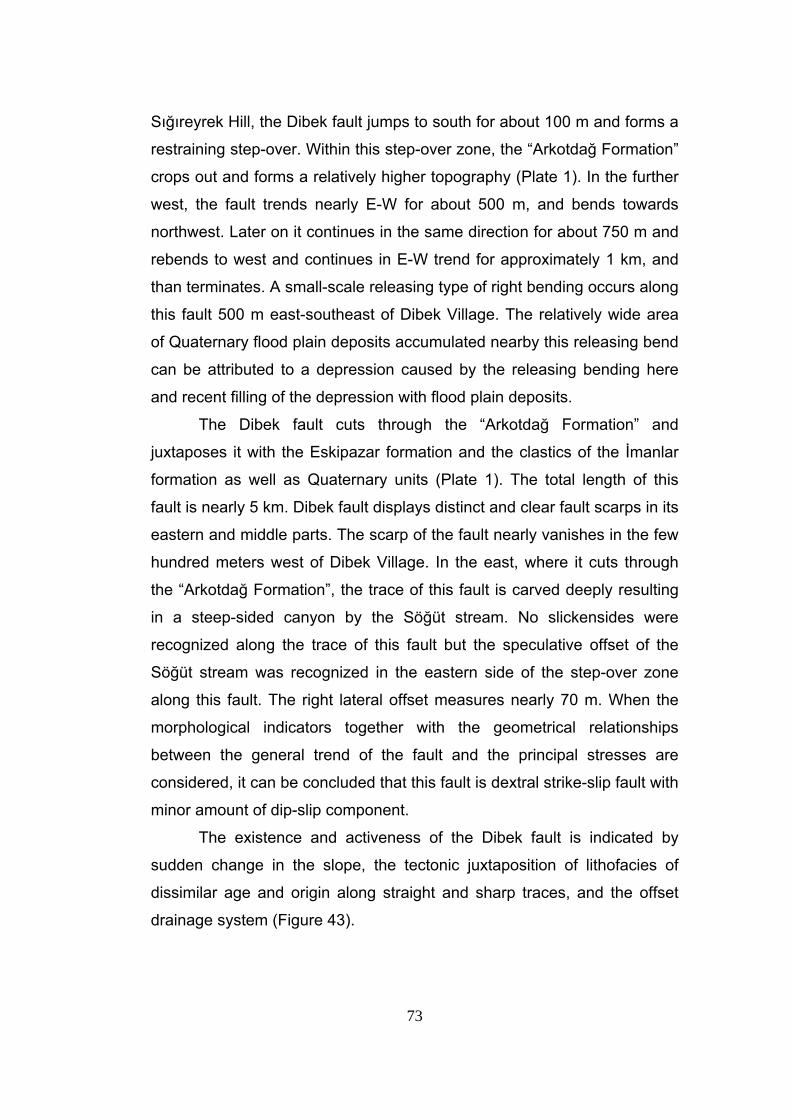
73
Sığıreyrek Hill, the Dibek fault jumps to south for about 100 m and forms a
restraining step-over. Within this step-over zone, the “Arkotdağ Formation”
crops out and forms a relatively higher topography (Plate 1). In the further
west, the fault trends nearly E-W for about 500 m, and bends towards
northwest. Later on it continues in the same direction for about 750 m and
rebends to west and continues in E-W trend for approximately 1 km, and
than terminates. A small-scale releasing type of right bending occurs along
this fault 500 m east-southeast of Dibek Village. The relatively wide area
of Quaternary flood plain deposits accumulated nearby this releasing bend
can be attributed to a depression caused by the releasing bending here
and recent filling of the depression with flood plain deposits.
The Dibek fault cuts through the “Arkotdağ Formation” and
juxtaposes it with the Eskipazar formation and the clastics of the İmanlar
formation as well as Quaternary units (Plate 1). The total length of this
fault is nearly 5 km. Dibek fault displays distinct and clear fault scarps in its
eastern and middle parts. The scarp of the fault nearly vanishes in the few
hundred meters west of Dibek Village. In the east, where it cuts through
the “Arkotdağ Formation”, the trace of this fault is carved deeply resulting
in a steep-sided canyon by the Söğüt stream. No slickensides were
recognized along the trace of this fault but the speculative offset of the
Söğüt stream was recognized in the eastern side of the step-over zone
along this fault. The right lateral offset measures nearly 70 m. When the
morphological indicators together with the geometrical relationships
between the general trend of the fault and the principal stresses are
considered, it can be concluded that this fault is dextral strike-slip fault with
minor amount of dip-slip component.
The existence and activeness of the Dibek fault is indicated by
sudden change in the slope, the tectonic juxtaposition of lithofacies of
dissimilar age and origin along straight and sharp traces, and the offset
drainage system (Figure 43).
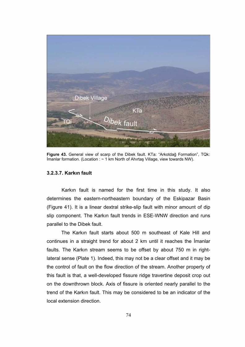
74
Figure 43. General view of scarp of the Dibek fault. KTa: “Arkotdağ Formation”, TQk: İmanlar formation. (Location : ~ 1 km North of Ahırtaş Village, view towards NW).
3.2.3.7. Karkın fault
Karkın fault is named for the first time in this study. It also
determines the eastern-northeastern boundary of the Eskipazar Basin
(Figure 41). It is a linear dextral strike-slip fault with minor amount of dip
slip component. The Karkın fault trends in ESE-WNW direction and runs
parallel to the Dibek fault.
The Karkın fault starts about 500 m southeast of Kale Hill and
continues in a straight trend for about 2 km until it reaches the İmanlar
faults. The Karkın stream seems to be offset by about 750 m in right-
lateral sense (Plate 1). Indeed, this may not be a clear offset and it may be
the control of fault on the flow direction of the stream. Another property of
this fault is that, a well-developed fissure ridge travertine deposit crop out
on the downthrown block. Axis of fissure is oriented nearly parallel to the
trend of the Karkın fault. This may be considered to be an indicator of the
local extension direction.
75
The Karkın fault mainly cuts across the “Arkotdağ Formation” and
juxtaposes it with the younger Eskipazar, Karkın and İmanlar formations.
The total length of the fault is about 2 km. The Karkın fault displays a
distinct and clear fault scarp. No slickensides or slickenlines could be
found on this fault scarp. The extension direction indicated by travertine
fissure located 250 m west of Karkın Village and offset of Karkın stream
along this fault, altogether, reveal that this fault is dextral strike-slip fault
with minor amount of dip-slip component.
The existence and activeness of the Karkın fault is indicated by the
sudden change in the slope, tectonic juxtaposition of different units along a
straight line, the offset streams and the large travertine deposits
accumulated on the hanging wall block of it (Figure 44).
Figure 44. General view of scarp of the Karkın fault. KTa: “Arkotdağ Formation, TQk: Karkın formation, TQi: İmanlar formation (Location: ~ 500 m NW of Karkın Village, view toward NE).
76
3.2.3.8. Yeniköy fault
Yeniköy fault is named for the first time in this study. This fault is a
major fault with a distinct morphological expression within the basin. It is a
curvilinear right-lateral strike-slip fault with minor amount of dip-slip
component. The fault trends SW-NE. The Yeniköy fault starts in about 500
m southwest of Durallar Village and terminates in about 300 m northeast
of Taşlık Hill, in the northeast. The Yeniköy fault has an important role in
the evolution of the Eskipazar Basin. It separates a highland in the
northwest from the lowland in the southeast. The hanging-wall block is the
site of nearly flat-lying widespread outcrops of the Plio-Quaternary
neotectonic units, such that this part is the depocenter of the very young
and active strike-slip basin.
The Yeniköy fault cuts across the “Arkotdağ Formation” and the
Eskipazar formation, and juxtaposes them in places. The total length of
this fault is approximately 3 km.
Yeniköy fault displays a distinct and clear fault scarp where it cuts
the “Arkotdağ Formation”. Unfortunately, no slickensides and slickenlines
could be observed along this fault but its topographical to morphological
expressions and the geometrical relationship with the principal stresses
indicate that it is a dextral strike-slip fault with minor amount of dip-slip
component.
The activeness and existence of the Yeniköy fault is indicated by
the sudden change in the slope and the tectonic juxtaposition of different
lithological units along a straight fault trace (Figure 45).
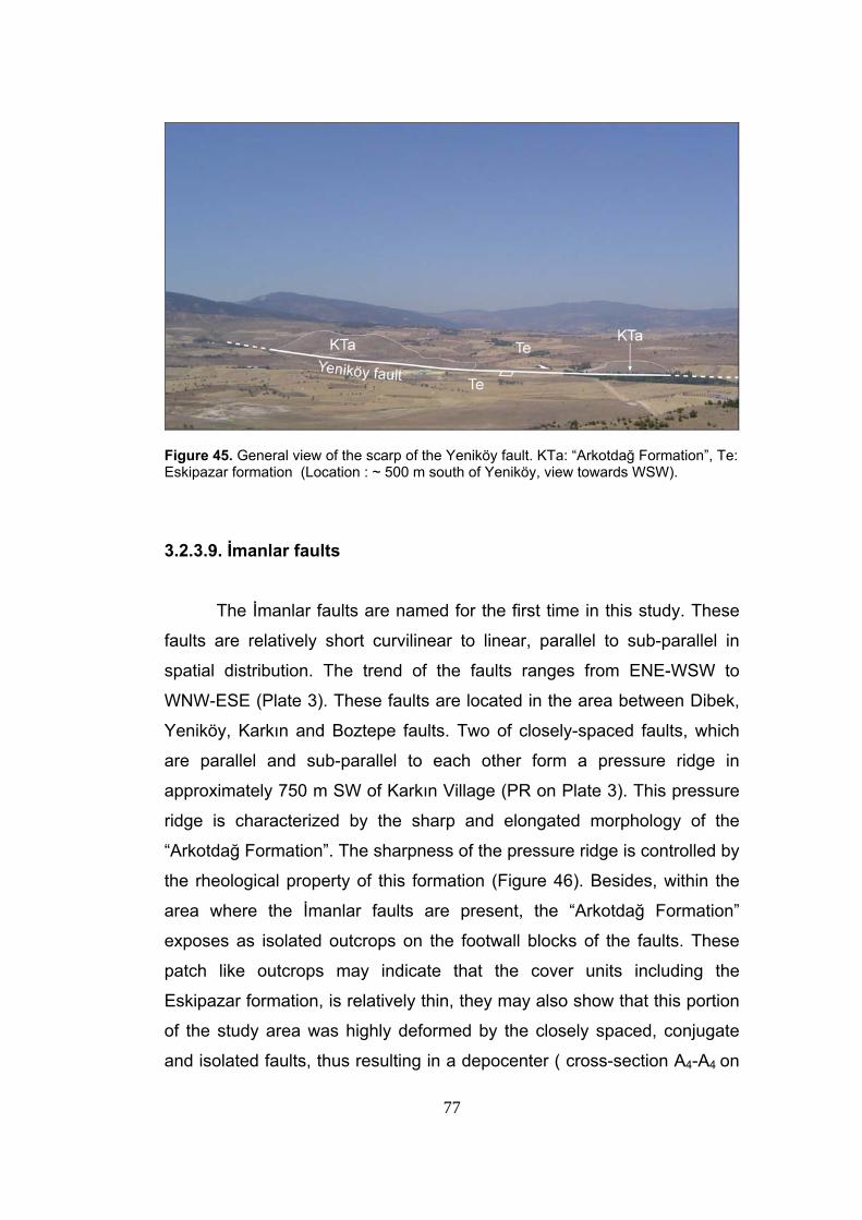
77
Figure 45. General view of the scarp of the Yeniköy fault. KTa: “Arkotdağ Formation”, Te: Eskipazar formation (Location : ~ 500 m south of Yeniköy, view towards WSW). 3.2.3.9. İmanlar faults
The İmanlar faults are named for the first time in this study. These
faults are relatively short curvilinear to linear, parallel to sub-parallel in
spatial distribution. The trend of the faults ranges from ENE-WSW to
WNW-ESE (Plate 3). These faults are located in the area between Dibek,
Yeniköy, Karkın and Boztepe faults. Two of closely-spaced faults, which
are parallel and sub-parallel to each other form a pressure ridge in
approximately 750 m SW of Karkın Village (PR on Plate 3). This pressure
ridge is characterized by the sharp and elongated morphology of the
“Arkotdağ Formation”. The sharpness of the pressure ridge is controlled by
the rheological property of this formation (Figure 46). Besides, within the
area where the İmanlar faults are present, the “Arkotdağ Formation”
exposes as isolated outcrops on the footwall blocks of the faults. These
patch like outcrops may indicate that the cover units including the
Eskipazar formation, is relatively thin, they may also show that this portion
of the study area was highly deformed by the closely spaced, conjugate
and isolated faults, thus resulting in a depocenter ( cross-section A4-A4 on
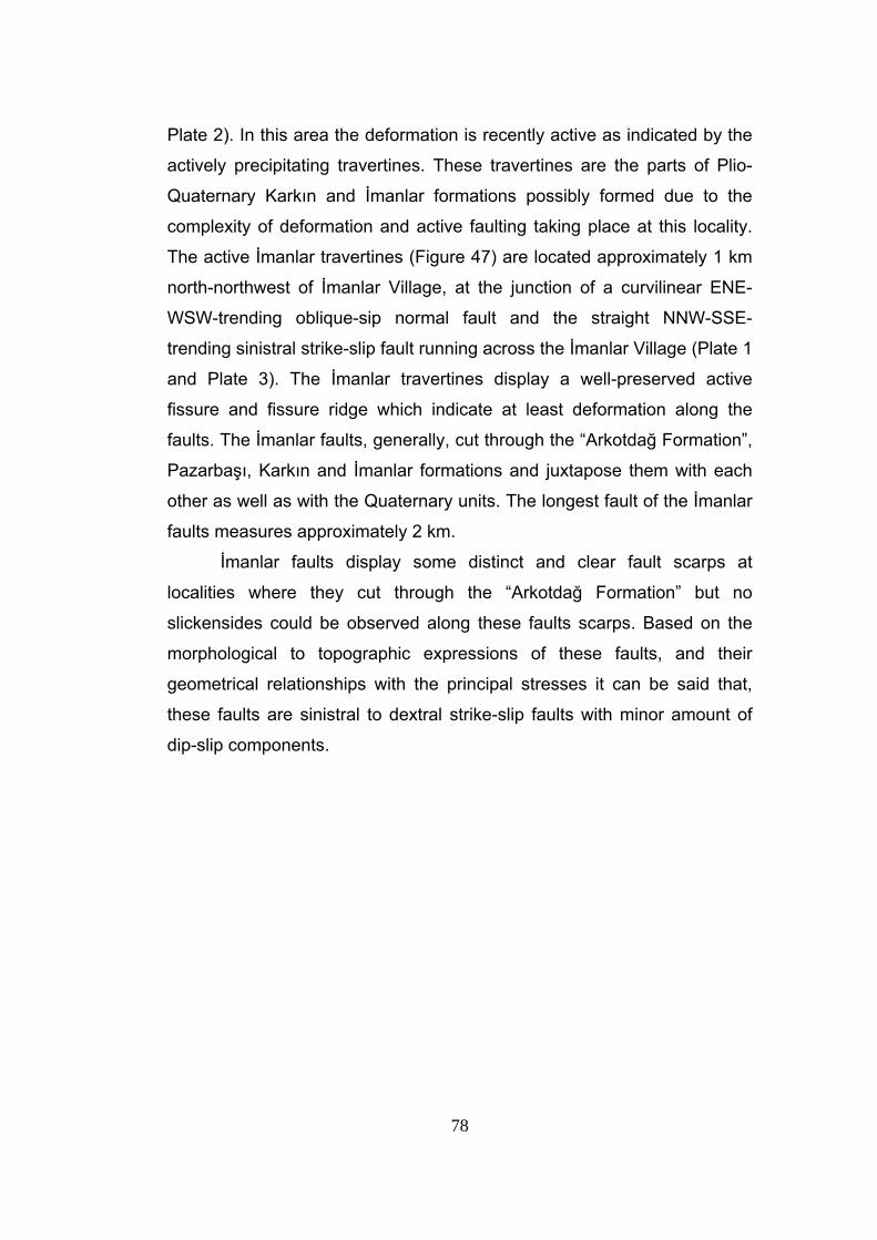
78
Plate 2). In this area the deformation is recently active as indicated by the
actively precipitating travertines. These travertines are the parts of Plio-
Quaternary Karkın and İmanlar formations possibly formed due to the
complexity of deformation and active faulting taking place at this locality.
The active İmanlar travertines (Figure 47) are located approximately 1 km
north-northwest of İmanlar Village, at the junction of a curvilinear ENE-
WSW-trending oblique-sip normal fault and the straight NNW-SSE-
trending sinistral strike-slip fault running across the İmanlar Village (Plate 1
and Plate 3). The İmanlar travertines display a well-preserved active
fissure and fissure ridge which indicate at least deformation along the
faults. The İmanlar faults, generally, cut through the “Arkotdağ Formation”,
Pazarbaşı, Karkın and İmanlar formations and juxtapose them with each
other as well as with the Quaternary units. The longest fault of the İmanlar
faults measures approximately 2 km.
İmanlar faults display some distinct and clear fault scarps at
localities where they cut through the “Arkotdağ Formation” but no
slickensides could be observed along these faults scarps. Based on the
morphological to topographic expressions of these faults, and their
geometrical relationships with the principal stresses it can be said that,
these faults are sinistral to dextral strike-slip faults with minor amount of
dip-slip components.
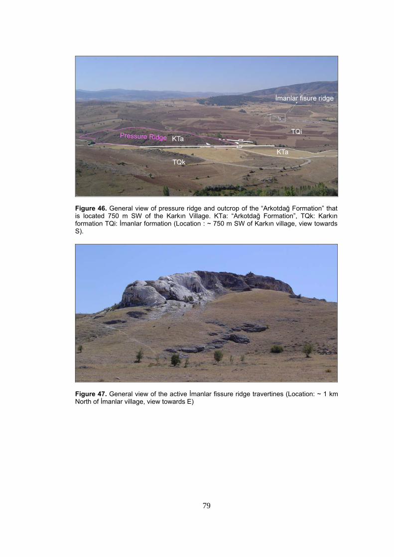
79
Figure 46. General view of pressure ridge and outcrop of the “Arkotdağ Formation” that is located 750 m SW of the Karkın Village. KTa: “Arkotdağ Formation”, TQk: Karkın formation TQi: İmanlar formation (Location : ~ 750 m SW of Karkın village, view towards S).
Figure 47. General view of the active İmanlar fissure ridge travertines (Location: ~ 1 km North of İmanlar village, view towards E)
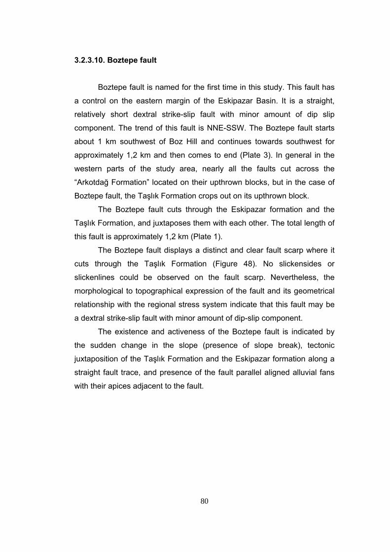
80
3.2.3.10. Boztepe fault
Boztepe fault is named for the first time in this study. This fault has
a control on the eastern margin of the Eskipazar Basin. It is a straight,
relatively short dextral strike-slip fault with minor amount of dip slip
component. The trend of this fault is NNE-SSW. The Boztepe fault starts
about 1 km southwest of Boz Hill and continues towards southwest for
approximately 1,2 km and then comes to end (Plate 3). In general in the
western parts of the study area, nearly all the faults cut across the
“Arkotdağ Formation” located on their upthrown blocks, but in the case of
Boztepe fault, the Taşlık Formation crops out on its upthrown block.
The Boztepe fault cuts through the Eskipazar formation and the
Taşlık Formation, and juxtaposes them with each other. The total length of
this fault is approximately 1,2 km (Plate 1).
The Boztepe fault displays a distinct and clear fault scarp where it
cuts through the Taşlık Formation (Figure 48). No slickensides or
slickenlines could be observed on the fault scarp. Nevertheless, the
morphological to topographical expression of the fault and its geometrical
relationship with the regional stress system indicate that this fault may be
a dextral strike-slip fault with minor amount of dip-slip component.
The existence and activeness of the Boztepe fault is indicated by
the sudden change in the slope (presence of slope break), tectonic
juxtaposition of the Taşlık Formation and the Eskipazar formation along a
straight fault trace, and presence of the fault parallel aligned alluvial fans
with their apices adjacent to the fault.
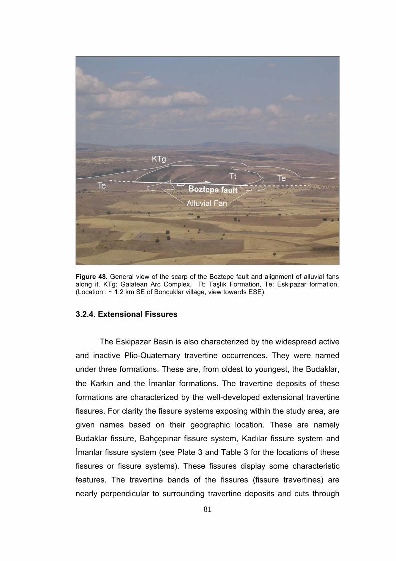
81
Figure 48. General view of the scarp of the Boztepe fault and alignment of alluvial fans along it. KTg: Galatean Arc Complex, Tt: Taşlık Formation, Te: Eskipazar formation. (Location : ~ 1,2 km SE of Boncuklar village, view towards ESE). 3.2.4. Extensional Fissures
The Eskipazar Basin is also characterized by the widespread active
and inactive Plio-Quaternary travertine occurrences. They were named
under three formations. These are, from oldest to youngest, the Budaklar,
the Karkın and the İmanlar formations. The travertine deposits of these
formations are characterized by the well-developed extensional travertine
fissures. For clarity the fissure systems exposing within the study area, are
given names based on their geographic location. These are namely
Budaklar fissure, Bahçepınar fissure system, Kadılar fissure system and
İmanlar fissure system (see Plate 3 and Table 3 for the locations of these
fissures or fissure systems). These fissures display some characteristic
features. The travertine bands of the fissures (fissure travertines) are
nearly perpendicular to surrounding travertine deposits and cuts through
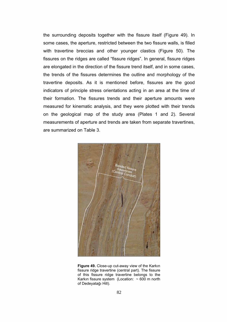
82
the surrounding deposits together with the fissure itself (Figure 49). In
some cases, the aperture, restricted between the two fissure walls, is filled
with travertine breccias and other younger clastics (Figure 50). The
fissures on the ridges are called “fissure ridges”. In general, fissure ridges
are elongated in the direction of the fissure trend itself, and in some cases,
the trends of the fissures determines the outline and morphology of the
travertine deposits. As it is mentioned before, fissures are the good
indicators of principle stress orientations acting in an area at the time of
their formation. The fissures trends and their aperture amounts were
measured for kinematic analysis, and they were plotted with their trends
on the geological map of the study area (Plates 1 and 2). Several
measurements of aperture and trends are taken from separate travertines,
are summarized on Table 3.
Figure 49. Close-up cut-away view of the Karkın fissure ridge travertine (central part). The fissure of this fissure ridge travertine belongs to the Karkın fissure system (Location: ~ 600 m north of Dedeyatağı Hill).
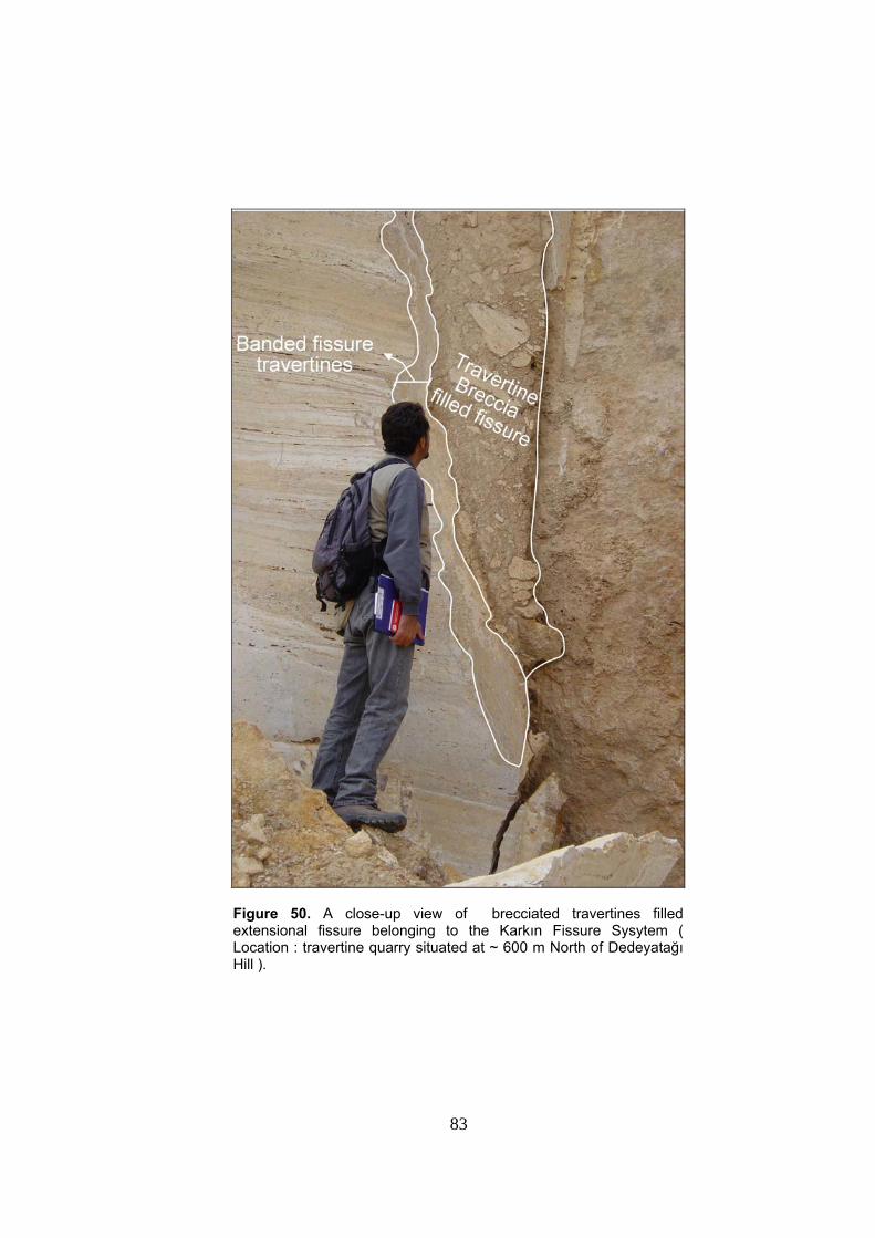
83
Figure 50. A close-up view of brecciated travertines filled extensional fissure belonging to the Karkın Fissure Sysytem ( Location : travertine quarry situated at ~ 600 m North of Dedeyatağı Hill ).
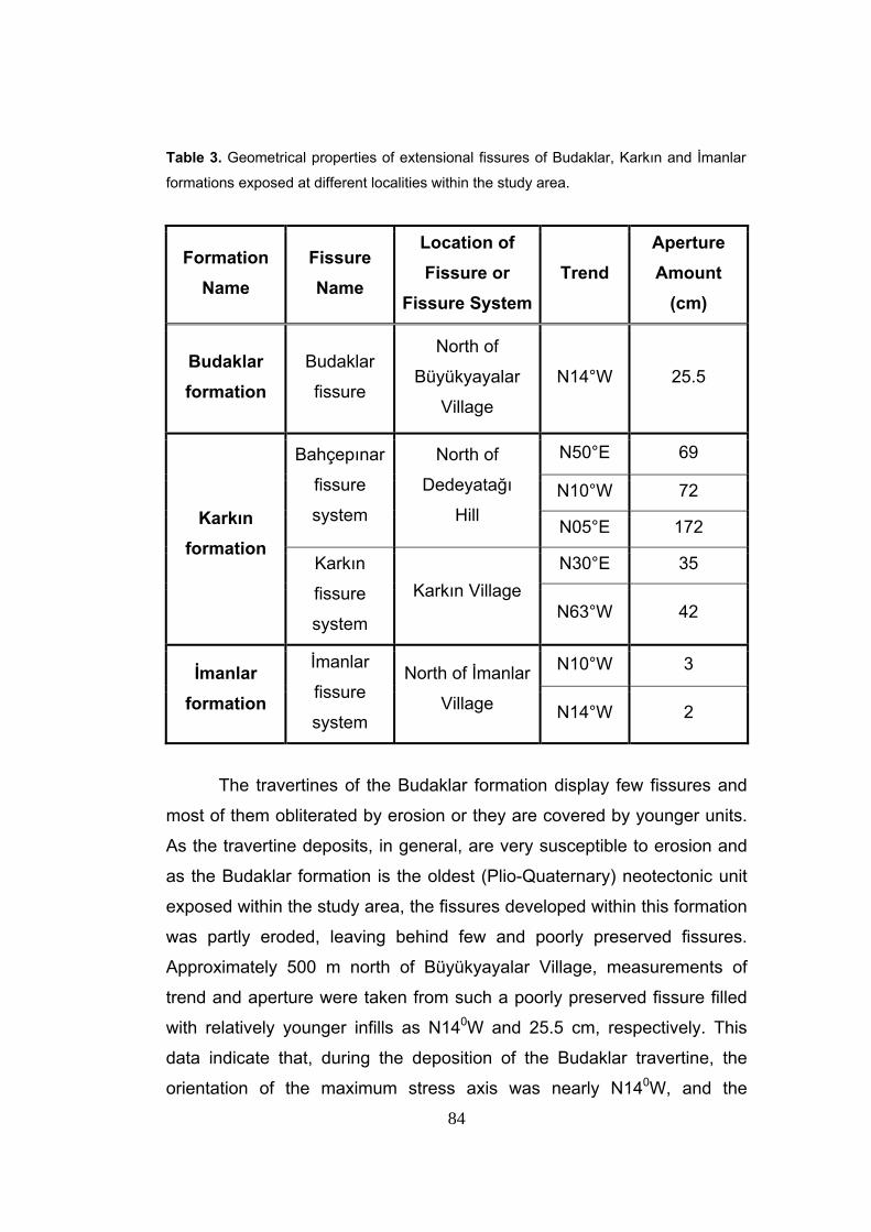
84
Table 3. Geometrical properties of extensional fissures of Budaklar, Karkın and İmanlar
formations exposed at different localities within the study area.
Formation Name
Fissure Name
Location of Fissure or
Fissure System Trend
Aperture Amount
(cm)
Budaklar formation
Budaklar
fissure
North of
Büyükyayalar
Village
N14°W 25.5
N50°E 69
N10°W 72
Bahçepınar
fissure
system
North of
Dedeyatağı
Hill N05°E 172
N30°E 35
Karkın formation
Karkın
fissure
system
Karkın Village N63°W 42
N10°W 3 İmanlar formation
İmanlar
fissure
system
North of İmanlar
Village N14°W 2
The travertines of the Budaklar formation display few fissures and
most of them obliterated by erosion or they are covered by younger units.
As the travertine deposits, in general, are very susceptible to erosion and
as the Budaklar formation is the oldest (Plio-Quaternary) neotectonic unit
exposed within the study area, the fissures developed within this formation
was partly eroded, leaving behind few and poorly preserved fissures.
Approximately 500 m north of Büyükyayalar Village, measurements of
trend and aperture were taken from such a poorly preserved fissure filled
with relatively younger infills as N140W and 25.5 cm, respectively. This
data indicate that, during the deposition of the Budaklar travertine, the
orientation of the maximum stress axis was nearly N140W, and the
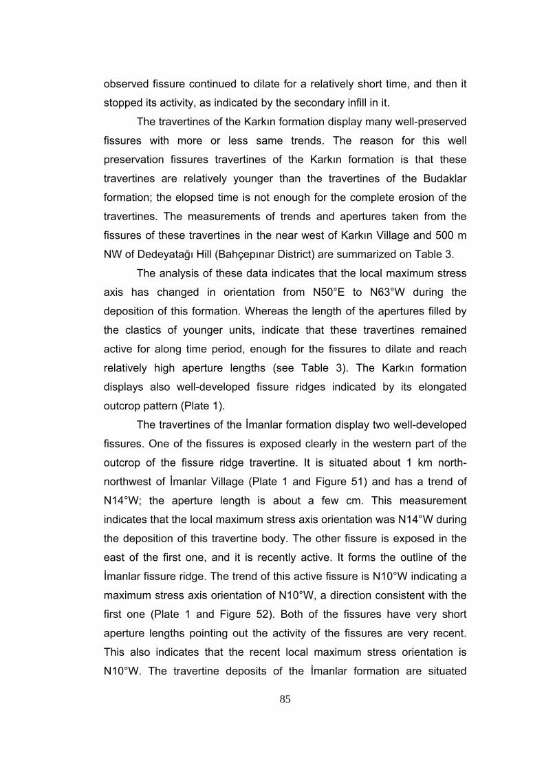
85
observed fissure continued to dilate for a relatively short time, and then it
stopped its activity, as indicated by the secondary infill in it.
The travertines of the Karkın formation display many well-preserved
fissures with more or less same trends. The reason for this well
preservation fissures travertines of the Karkın formation is that these
travertines are relatively younger than the travertines of the Budaklar
formation; the elopsed time is not enough for the complete erosion of the
travertines. The measurements of trends and apertures taken from the
fissures of these travertines in the near west of Karkın Village and 500 m
NW of Dedeyatağı Hill (Bahçepınar District) are summarized on Table 3.
The analysis of these data indicates that the local maximum stress
axis has changed in orientation from N50°E to N63°W during the
deposition of this formation. Whereas the length of the apertures filled by
the clastics of younger units, indicate that these travertines remained
active for along time period, enough for the fissures to dilate and reach
relatively high aperture lengths (see Table 3). The Karkın formation
displays also well-developed fissure ridges indicated by its elongated
outcrop pattern (Plate 1).
The travertines of the İmanlar formation display two well-developed
fissures. One of the fissures is exposed clearly in the western part of the
outcrop of the fissure ridge travertine. It is situated about 1 km north-
northwest of İmanlar Village (Plate 1 and Figure 51) and has a trend of
N14°W; the aperture length is about a few cm. This measurement
indicates that the local maximum stress axis orientation was N14°W during
the deposition of this travertine body. The other fissure is exposed in the
east of the first one, and it is recently active. It forms the outline of the
İmanlar fissure ridge. The trend of this active fissure is N10°W indicating a
maximum stress axis orientation of N10°W, a direction consistent with the
first one (Plate 1 and Figure 52). Both of the fissures have very short
aperture lengths pointing out the activity of the fissures are very recent.
This also indicates that the recent local maximum stress orientation is
N10°W. The travertine deposits of the İmanlar formation are situated
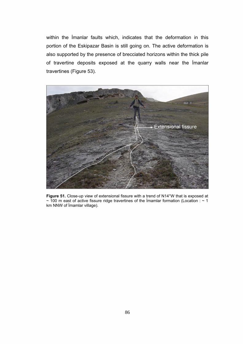
86
within the İmanlar faults which, indicates that the deformation in this
portion of the Eskipazar Basin is still going on. The active deformation is
also supported by the presence of brecciated horizons within the thick pile
of travertine deposits exposed at the quarry walls near the İmanlar
travertines (Figure 53).
Figure 51. Close-up view of extensional fissure with a trend of N14°W that is exposed at ~ 100 m east of active fissure ridge travertines of the İmamlar formation (Location : ~ 1 km NNW of İmamlar village).
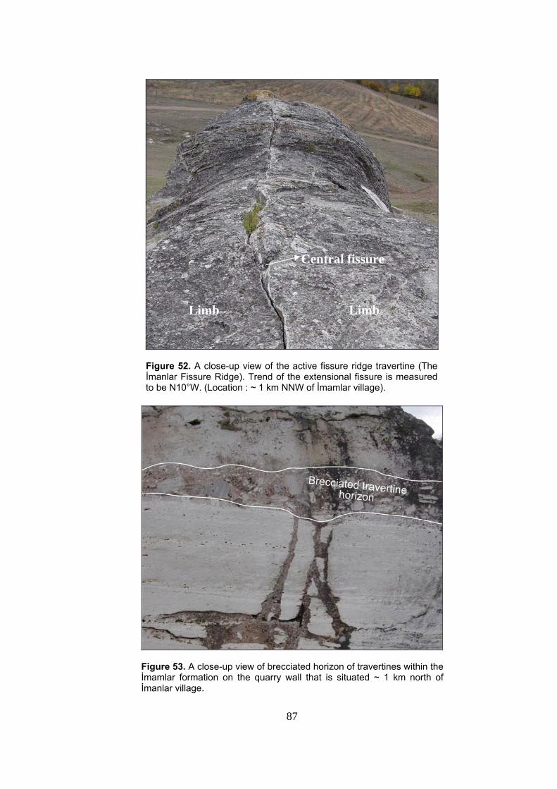
87
Figure 52. A close-up view of the active fissure ridge travertine (The İmanlar Fissure Ridge). Trend of the extensional fissure is measured to be N10°W. (Location : ~ 1 km NNW of İmamlar village).
Figure 53. A close-up view of brecciated horizon of travertines within the İmamlar formation on the quarry wall that is situated ~ 1 km north of İmanlar village.
Central fissure
Limb Limb
88
CHAPTER IV
SEISMICITY
High seismicity of the northwestern portion of the North Anatolian Fault
System that is indicated by major earthquakes (such as the 1944 Gerede-
Çerkeş Earthquake and the 1999 Düzce Earthquake) and their foreshocks
and after shocks is the most striking evidence for the complex and active
tectonics of the region. Both the instrumentally recorded data (Boğaziçi-
Kandilli Observatory Laboratory and Earthquake Research Institute, and
General Directorate of Disaster Affairs Earthquake Research Department-
Turkey) and the distribution of historical seismicity obtained from the available
literature (Ergin et al., 1967, Soysal et al., 1981, Ambraseys and Finkel, 1995;
Ambraseys and Jackson, 1998) clearly show an intracontinental simple
shearing caused by the dextral strike-slip faulting. In order to understand the
long-term behaviour of the potential seismic sources (faults) within the
Eskipazar Basin and their significance, earthquakes that occurred and
caused damage to settlements in and adjacent to the Eskipazar Basin will be
described below.
4.1. Historical Seismicity
Some major earthquakes took place in the northwestern portion of the
North Anatolian Fault System, in historical periods. Especially, six destructive
earthquakes (AD 109, AD 967, 1035, 1845, 1668, 1881) have been
documented and reported from the close vicinity of the study area
(Ambraseys and Finkel 1987, 1995; Ambraseys and Jackson 1998). Out of
89
this six major earthquakes the August 17, 1668 earthquake (Ms= 7.9)
(Ambrasseys and Jackson 1998) was the most devastative earthquake
originated from the Bolu – Ladik section of the NAFS. The earthquake killed
about 8000 people and formed a significant surface rupture that extends from
Kelkit valley to Bolu (Ambraseys and Finkel 1987). Unfortunately, the AD 109,
1845 and 1881 earthquakes are not well-documented due to the lack of
information and records about them. However, it has been reported that loss
of life and heavy damage to various structures were very high (Ambrseys and
Finkel 1995). The earthquakes of AD 967 and 1055 are relatively better
documented with the help of knowledge gained from the historical reports.
The epicenters of these earthquakes are reported to be located at close
vicinity of the study area. The epicenters of these better documented
earthquakes are located based on historical records, the knowledge of
damage distribution around the possible epicenter of the earthquake and the
assumed association of historical event with known Quaternary or recent
fault-break.
The epicenter of 967 September Earthquake is located at the
southeast of Yeniçağa Basin (coordinates: 40.8° N – 32.0° E) (Ambraseys
and Jackson 1998) (Figure 54). Based on the knowledge of the recent
seismic characteristics of this fault, the magnitude of the earthquake is
reported to be large by Ambraseys and Jackson (1998), and mechanisms
and attitude of the fault is reported to be the right-lateral strike-slip fault
The epicenter of 1035 May earthquake is located close to the Çerkeş
at southern bock of the master strand of the Gerede Fault Zone (coordinates:
40.8 N – 33.0°E) (Ambraseys and Jackson, 1998), based on the implicated
knowledge of surface faulting deduced from sources and field investigations
(Figure 54). The magnitude of the earthquake is reported to be medium by
Ambraseys and Jackson (1998) and right-lateral strike-slip mechanism is
attributed to the surface faulting caused by this earthquake.
90
4.2. Recent Seismicity
Recent and damaging seismic events such as the 1944 Gerede, the
1951 Kurşunlu and the 1999 Düzce earthquakes attracted attention of most of
researchers, and increased number of the seismotectonic study in the region.
The seismicity occurred in the period of 1900-2003 displays a remarkable
clustering of moderate-magnitude earthquakes. Available focal mechanism
solutions for some shallow focus earthquakes (depth< 15 km), and the
relevant published data by several authors (Canıtez and Büyükaşıkoğlu,
1984), (Canıtez and Üçer 1967, Harward CMT), are represented on Table 4.
The focal mechanism solutions of these earthquakes indicate
substantial evidence for dextral strike-slip faulting within and nearby the study
area. Besides, attitudes of the fault planes obtained by the focal mechanism
solutions fit well with the observable field attitude of the surface faulting
(Figure 54).
In this century, 249 shallow focus seismic events with magnitudes
between 1 - 5,9 took place at close proximity of the study area (Table 5 at
Appendices and Figure 54). Earthquakes, sourced from strike-slip faults of
the North Anatolian Fault System, caused considerable property damage and
affected the settlements located within the Yeniçağa and Eskipazar basins.
The most devastative earthquakes are the 1944.02.01, Gerede-Çerkeş
earthquake (Ms=7,6), the 1951.08.13 Kurşunlu earthquake (Ms=7,2) and the
1999.11.12 Düzce earthquake (Mw=7,2). The following sections deal with the
source parameters and felt effects of these three seismic events in
chronological order.
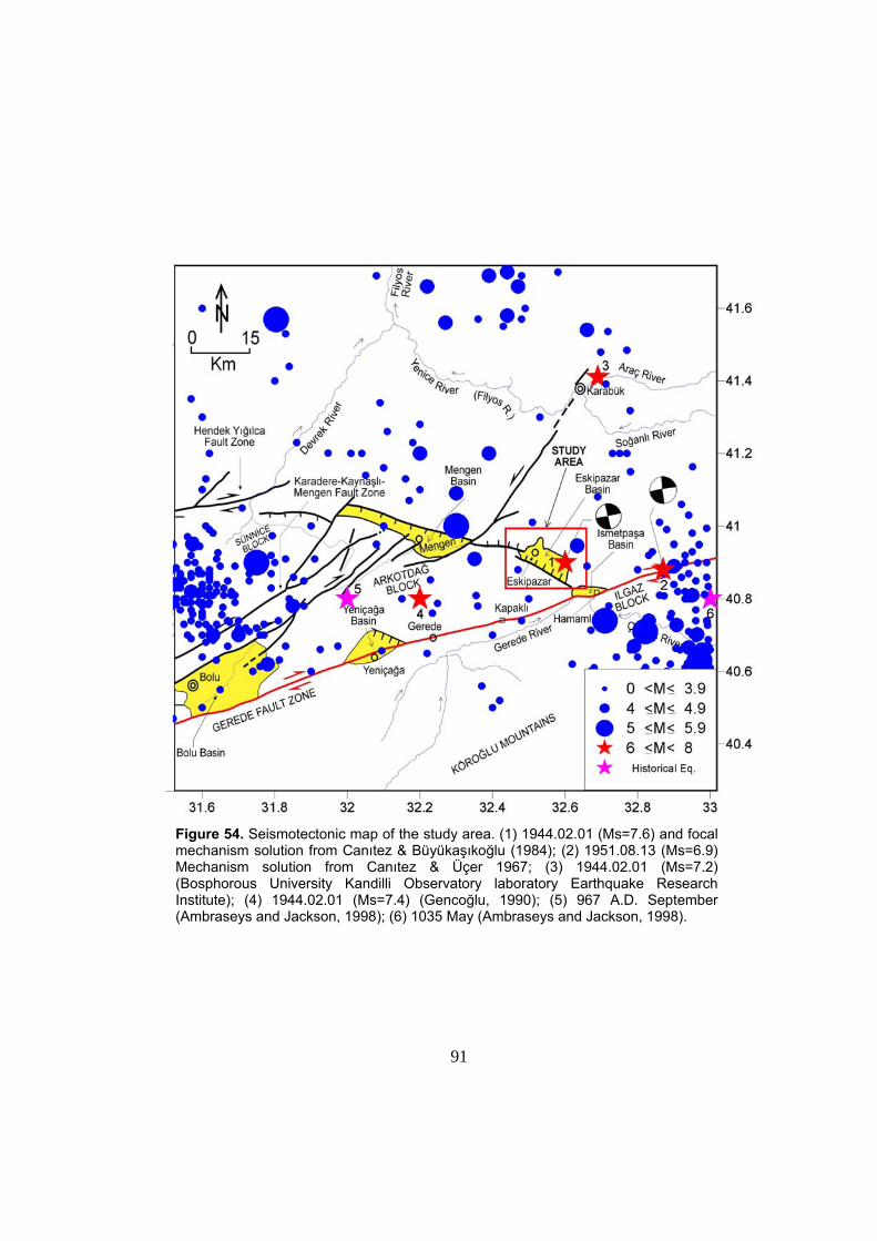
91
Figure 54. Seismotectonic map of the study area. (1) 1944.02.01 (Ms=7.6) and focal mechanism solution from Canıtez & Büyükaşıkoğlu (1984); (2) 1951.08.13 (Ms=6.9) Mechanism solution from Canıtez & Üçer 1967; (3) 1944.02.01 (Ms=7.2) (Bosphorous University Kandilli Observatory laboratory Earthquake Research Institute); (4) 1944.02.01 (Ms=7.4) (Gencoğlu, 1990); (5) 967 A.D. September (Ambraseys and Jackson, 1998); (6) 1035 May (Ambraseys and Jackson, 1998).
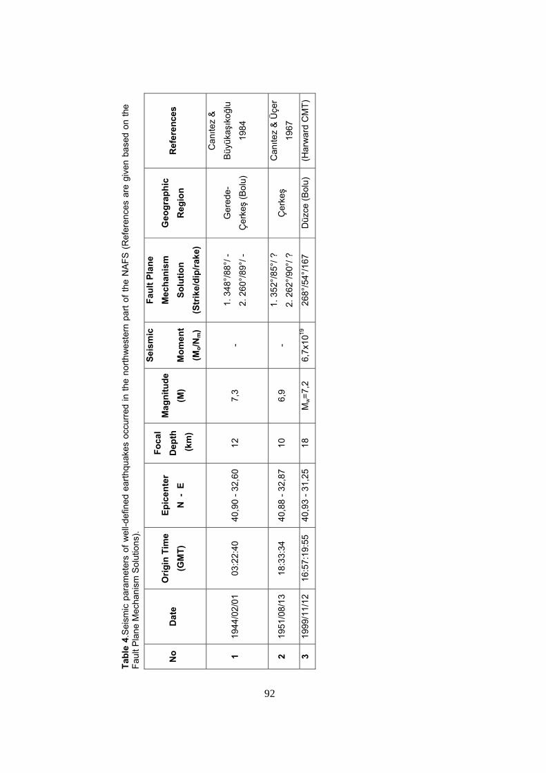
92
Tabl
e 4.
Sei
smic
par
amet
ers
of w
ell-d
efin
ed e
arth
quak
es o
ccur
red
in th
e no
rthw
este
rn p
art o
f the
NA
FS (
Ref
eren
ces
are
give
n ba
sed
on th
e Fa
ult P
lane
Mec
hani
sm S
olut
ions
).
No
Dat
e O
rigin
Tim
e (G
MT)
Ep
icen
ter
N -
E
Foca
l D
epth
(k
m)
Mag
nitu
de
(M)
Seis
mic
Mom
ent
(Mo/N
m)
Faul
t Pla
ne
Mec
hani
sm
Solu
tion
(S
trik
e/di
p/ra
ke)
Geo
grap
hic
Reg
ion
Ref
eren
ces
1 19
44/0
2/01
03
:22:
40
40,9
0 - 3
2,60
12
7,3
-
1. 3
48°/
88°/
-
2. 2
60°/
89°/
-
Ger
ede-
Çer
keş
(Bol
u)
Canıte
z &
Büyü
kaşı
koğl
u
1984
2 19
51/0
8/13
18
:33:
34
40,8
8 - 3
2,87
10
6,
9 -
1. 3
52°/
85°/
?
2. 2
62°/
90°/
?
Çer
keş
Canıte
z &
Üçe
r
1967
3 19
99/1
1/12
16
:57:
19:5
5 40
,93
- 31,
25
18
Mw=7
,2
6,7x
1019
26
8°/5
4°/1
67
Düz
ce (B
olu)
(H
arw
ard
CM
T)
92
93
4.2.1. 1944 February 1 Gerede-Çerkeş Earthquake (Ms=7,6)
The 1944 seismic event is one of the largest earthquakes that took
place along the western portion of the North Anatolian Fault System, in the
last century (1900-2000). It was sourced from the Master Strand of the North
Anatolian Fault System. The 1944 Gerede earthquake was felt over a very
wide region and caused serious damage to structures in some town and
counties of Bolu and Karabük (such as Gerede, Yeniçağa and Eskipazar).
This earthquake mainly struck Gerede County and caused a serious damage.
The earthquake killed totally 3954 people, injured thousands of them damage
and destruction of 20865 houses, asphaltic and stabilized roads and bridges
were characteristic. The total length of surface rupture of this earthquake was
reported to be 160 km (Ambrasseys and Jackson, 1998). In Gerede, some
other ground ruptures also took place in the north and south of the main
rupture and created vertical displacements of 10 cm to 40 cm (Taşman 1944).
The main rupture displayed en échelon pattern with small ruptures
constituting the en échelon array in the lengths ranging from 100 cm to 150 m
in the Gerede county. It was also reported by Taşman (1944) that the
downthrown side of the surface rupture was located in the northern blocks of
it. Several man-made structures, such as bridges, roads and houses on these
ruptures were offset by about 30 cm to 3 meters in right-lateral sense at
several places. This field evidence implies that the significant surface faulting
of right lateral strike-slip nature had occurred in and nearby Gerede. This is
confirmed by the observation of 5,5 m right-lateral strike-slip offset of the line
of Salix trees by the ground rupture of the 1944.02.01 Çerkeş – Gerede
earthquake in the near east of Gerede County.
94
4.2.2. 1951 August 13 Kurşunlu Earthquake (Ms=6,7)
On August 13, 1951 an earthquake of Ms 6,7 occurred along the
N790E-trending master strand of the North Anatolian Fault System. The
mainshock destroyed and damaged totally 3354 houses and resulted in 50
deaths. The earthquake is also felt over a wide region especially surrounding
towns and counties and it was affective mainly in Kurşunlu.
The earthquake resulted in a 32 km long surface rupture on which 60
cm of dextral strike-slip offset was measured. Besides, the vertical
displacement is observed to be 30 cm with downthrown northern block
(Ambraseys and Jackson, 1998). Focal mechanism solution of this
earthquake’s mainshock indicated that the fault here is nearly vertical and
displays a dextral strike-slip character fitting well with the field observations.
4.2.3. 1999 November 12 Düzce Earthquake (Mw=7,2)
In November 12, 1999 an earthquake of magnitude Mw 7,2 occurred
along the Kaynaşlı segment of the Karadere-Kaynaşlı-Mengen Fault Zone
(central strand of the NAFS). This earthquake was felt over a very wide region
and caused serious damage in settlements such as Gölyaka, Düzce and
Kaynaşlı located on and nearby the Kaynaşlı segment. Although the
epicenter of this earthquake is located away from the Eskipazar Basin, the
aftershocks of this earthquake are located very close to the study area. The
mainshock of this earthquake killed 792 people in total and severely damaged
and destroyed totally 7850 houses, viaducs, roads and industrial buildings.
The total length of the nearly E-W-trending surface rupture is ~60 km from the
northern exit of the Bolu Tunnel in the east to Gölyaka in the west (Koçyiğit et
95
al., 2003b). The abundance of man-made features, such as roads and fences
offset by the fault rupture, made it possible to measure the displacement very
accurately and frequently. The rupture is confined in a generally narrow
deformation zone (5-50 m). Considering its geometry and along the strike-slip
distribution, the rupture is divided into four sub-segments by Çakır et al.
(2003). Based on their observations, Çakır et al. (2003) reported that the
three segments in the east show almost pure right-lateral slip up to 5,5 m in
the middle one. Presence of aftershocks on the northern side of the fault, and
the focal mechanism solution of the mainshock indicated that the fault has a
significant northward dip.
Finally, based on the relationship between the epicentral distribution of
small and moderate earthquakes (3≤M≤5) and the faults, it can be concluded
that the Eskipazar Basin and its close vicinity is seismically active. In addition
to seismic activities within this region, there is also aseismic slip (fault creep)
going on at the İsmetpaşa region about 10 km east of Kapaklı (Aytun 1980).
This fault creep is best indicated by the right-lateral offset of masonry wall of
İsmetpaşa Maintenance Station at an average slip rate of 1 cm/year.
It is interesting that, within the frame of the study area and its close
vicinity, the epicenter distribution is relatively sparse in the area between
Yeniçağa and Eskipazar basins. Indeed, this lack of epicenter may be due to
the lack of fore- and after-shocks of 1944 Gerede and 1951 Kurşunlu
earthquakes, because of the fact that in that time the techniques and
instruments for locating epicenters of minor earthquakes were relatively
primitive or absent. Besides, the aseismic slip is taking place at İsmetpaşa
station. This may be a factor, by which the elastic strain energy is regularly
released in the form of continuous motion within the fault zone here, so the
accumulation of elastic strain energy is prohibited partially by this regular
release of energy and hence seismic activity along this portion of the North
Anatolian Fault System may be hindered or reduced by this aseismic slip.
96
CHAPTER V
DISCUSSION AND CONCLUSIONS
One of the main aims of this thesis is to explain the neotectonic
evolution of the Eskipazar Basin. In this part of the study, a tentative
evolutionary model will be formulated for the Eskipazar Basin under the
light of field and seismic data. In addition to this some other possible
structural contributions to the evolutionary history of the Eskipazar Basin
will be discussed.
5.1. Evolution of the Eskipazar Basin
New structural and stratigraphic data presented in foregoing
chapters have allowed us to refine the age chronology and reconstruct the
neotectonic evolution of the Eskipazar Basin. This Basin contains, indeed,
two infills; one is the highly deformed paleotectonic unit, the Eskipazar
formation and the other is the neotectonic unit, namely the Budaklar,
Karkın and İmanlar formations.
The paleotectonic fill displays two distinct phases of deformation.
The lower part of the Upper Miocene – Lower Pliocene Eskipazar
formation is characterized by outcrop-scale growth faults and conjugate
fractures. Their kinematic analysis yielded NW-SE directed extension and
indicated that an extensional tectonic regime was present during the
formation of these syn-depositional fractures and growth faults (Figure 29).
During the Late Miocene-Early Pliocene time interval, the Eskipazar
formation was actively deposited in a paleotectonic basin that is formed by
the NW-SE directed extension as indicated by the widespread presence of
growth faults all through the Eskipazar formation. Second phase of
deformation took place after Early Pliocene and all the sequence of the
97
Eskipazar formation underwent a NE-SW directed compression,
subsequently folded with axes trending in NW-SE; a direction
perpendicular to the maximum compression direction (σ1) (Figures 30 and
33). This compression was possibly due to the last phase of deformation
that took place along North Anatolia, prior to the initiation of the
neotectonic regime characterized by the formation of the North Anatolian
Fault System. As a result of this compression the paleotectonic fill of the
basin uplifted with the surrounding areas and it got thinner and thinner by
erosion. These deformation and erosional activity distorted the
configuration of the paleotectonic basin (Figure 55).
With the formation of the North Anatolian Fault System, and the
onset of the neotectonic regime several basins formed along the NAFS
with their long axes trending in E-W direction parallel to the fault system.
The basins are indeed, formed due to the strike-slip complexities along the
NAFS and considered to be pure strike slip basins (such as the
İsmetpaşa, Yeniçağa and Bolu basins). However, the case is totally
different for the Eskipazar Basin. The general characteristics of the
Eskipazar Basin seriously diverge from the other pure strike-slip basins
with its distinctive basin fill pattern, morphology and trend. The infill of the
Eskipazar Basin displays a patchy distribution of the Plio-Quaternary units
consisting of several sedimentary units such as the travertine deposits,
terrace conglomerates, the Upper Quaternary floodplain deposits and
alluvial fan deposits (Plate 1). However in the case of a typical pure strike-
slip basin the infill generally displays a relatively continuous pattern and
consists of floodplain, alluvial fan and apron deposits (e.g. The Yeniçağa
Basin). In addition, the morphology of the Eskipazar Basin displays an
irregular topography with deeply carved valleys and gently rolling hills
which contradicts with the flat and smooth topography of the pure strike-
slip basins. The Eskipazar Basin does not display a clear trend but the
latest paleotectonic fill of the basin bounded in the east and west by
oblique-slip normal faults and strike-slip faults, displays an NW-SE trend
98
(Plate 1). This trend looks like the trend of the basin, at a first glance but,
as this unit is the latest paleotectonic fill of the basin it does not represent
the neotectonic geometry and trend of the basin. Indeed this orientation of
the paleotectonic basin fill does not represent the paleotectonic
configuration of the basin either, as the original geometry and
configuration of the paleotectonic basin is distorted and intensely
deformed by the structures that are formed during the neotectonic period
within the study area. The neotectonic character of the basin is only
indicated by the neotectonic infill, overlying the paleotectonic infill
exposing as patches, within the basin (Plate 1 and 3). Actually, the
neotectonic trend of the basin can only be indicated by the trend of these
patches, as these are formed under the control of the strike-slip
deformation taking place during the recent strike-slip neotectonic regime.
The trend of the patches exposing within the Eskipazar Basin at central
and western parts displays nearly an E – W trend which fits well with the
recent configuration and trend of the pure strike-slip basins located along
the western part of North Anatolian Fault System; so the distribution of
patches is controlled by active strike-slip faults can be considered as sub-
basins exposing within the Eskipazar Depression.
The contradicting characteristics of infill pattern, morphology and
trend of the Eskipazar Basin indicate that it is not a pure strike-slip
neotectonic basin, such as the Yeniçağa or adjacent İsmetpaşa basins.
Indeed, presence of nearly E–W-trending patchy outcrops of the
neotectonic units (sub-basins of the Eskipazar Basin), overlying
unconformably on the paleotectonic fill of the basin, suggests that this
basin is a superimposed basin displaying extensive outcrops of latest
paleotectonic infill, namely the Eskipazar formation (Plate 1).
Nevertheless, this does not imply that the basin displays a totally
paleotectonic character. The sub-basin controlled by, and located in
between the Dibek, Karkın, İmanlar and Yeniköy faults is an actively
growing basin that is indicated by the presence of the active İmanlar
99
fissure ridge travertine deposits and recent food plain deposits of Çayır,
Acısu and Kısık streams. The same situation is also true for the E –W-
trending sub-basin in the west that is controlled by, and located in between
the Budaklar fault set and Beytarla fault zone where there is a continuous
sedimentation of flood plain deposits of the Göksu Stream. This indicates
that the basin development is still going on within the Eskipazar Region,
under the control of strike-slip neotectonic regime.
An important fault set that is exposing within the study area is the
Kadılar fault set. It is possible that this fault has a pure neotectonic origin
and control the development of sub-basins situated in the east of this fault
set and thus this structure may be an important one that will control the
future configuration of the Eskipazar Basin. Indeed, the Kadılar fault set is
the major structure that deforms and distorts the preserved outline of the
paleotectonic basin, making it very difficult to interpret the configuration of
this basin during the paleotectonic period. On the other hand, this fault
may be a reactivated oblique-slip normal fault that had possibly worked as
a reverse fault during the latest phase of the paleotectonic regime,
controlling the formation of tightly packed folds within the latest
paleotectonic fill of the basin and thus, controlling the paleotectonic
configuration of the basin.
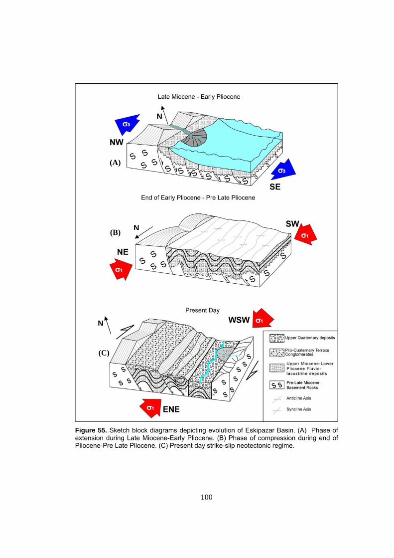
100
Figure 55. Sketch block diagrams depicting evolution of Eskipazar Basin. (A) Phase of extension during Late Miocene-Early Pliocene. (B) Phase of compression during end of Pliocene-Pre Late Pliocene. (C) Present day strike-slip neotectonic regime.
(A)
(B)
(C)
N
N
N
101
5.2. Conclusions
In the light of above mentioned discussion and the newly gathered
field and laboratory data presented in the forgoing chapters, the followings
are concluded.
1. Based on the analysis of data gathered during the field studies and
geological mapping of the study area at 1/25.000 scale, the Eskipazar
Basin is interpreted to be a superimposed basin composed of nearly E –
W trending patches of Plio-Quaternary and Upper Quaternary units. These
patches are considered to be sub-basins formed under the control of the
strike-slip neotectonic regime and actively growing in the present-day.
2. In this study the neotectonic characteristics of the Eskipazar Basin is
studied in detail. Indeed, neotectonic characteristics of this basin have
never been studied in such a detailed way previously by any scientists.
3. This study was focused on the neotectonic characteristics of the
Eskipazar Basin. However, one of the main aims of this study was to figure
out the evolutionary history of the basin and for this purpose the latest
paleotectonic unit exposing within the study area was also considered in
detail. Results of the analysis of the slip plane data gathered from the syn-
depositional shear fractures and growth faults of this unit indicated that it
had experienced NW–SE directed extension during Late Miocene–Early
Pliocene time interval, under the control of an extensional paleotectonic
regime. In addition, the analysis of the trend of fold axes of this unit
showed that, the extensional paleotectonic regime was than succeeded by
a compressional paleotectonic regime as a last phase of paleotectonic
period. Related NE–SW-directed compressional deformation resulted in
folding of the latest paleotectonic infill with fold axes trending in NW – SE
direction.
102
4. Geologically active nature of the faults, exposing within the study area is
indicated by the down cutting of streams, development o marginal alluvial
fans, well preserved fault scarps, fault terraces and presence of active and
inactive fissure ridge travertine deposits, nearby the faults.
5. The topographical to morphological expressions of the faults and their
geometrical relationships with the principal stresses indicate that these
faults, exposing within the study area are generally strike slip faults with
normal components. Here one exception is the Kadılar fault set whose
morphological expression indicates that it is an oblique-slip normal fault
with sinistral strike-slip component. This fault set is indeed a major one
that bounds the basin in the west and serves as the main fault controlling
the basin development.
6. In order to understand the long-term behavior of the potentially active
sources of seismicity in and adjacent to the Eskipazar Basin, seismic data
including both the historical and recent earthquakes were also examined.
In the light of this compiled data, it is possible to suggest that the area
surrounding the Eskipazar Basin is also seismically active. Nevertheless
recently, the area remaining between the Yeniçağa and Eskipazar Basins
is in a quiescence period since 1944 partially due to the continuous
releasing of elastic strain energy by tectonic creep activity that is taking
place at southern part of the study area at the Kapaklı–İsmetpaşa region.
Nevertheless the slip-rate measured at the creep site is 1 cm/year and the
slip rate along the North Anatolian Fault System is 2 cm/year, thus, this
shows that the continuously released elastic strain energy is not enough to
cause a total seismic quiescence within the region between the Yeniçağa
and Eskipazar Basins. Therefore it is possible that, there exists a seismic
gap at this portion of the NAFS, since 1944.
103
7. Most of the settlements are located on poorly consolidated fluvio-
lacustrine deposits of the Eskipazar formation that is susceptible to
landslides or nearby the active faults exposing within the basin (Plate 1).
Therefore these settlements are open to earthquake hazard. Best solution
of this problem is to construct structures at suitable places outside of the
landslide susceptible Eskipazar formation and major active faults.
104
References
Ach, J.A., 1982, The Petrochemistry of the Ankara Volcanics, Central Turkey,
MSc Thesis, State University of New York at Albany, USA.
Ambraseys, N.N., Finkel, C.F., 1987, Seismicity of Turkey and neighboring
regions, 1899-1915, Annales Geophysicae, 87, 701-725.
Ambraseys, N.N. and Finkel, C., 1995, The Seismicity of Turkey and
Adjacent Areas: A Historical Review,1500-1800, Eren Yayıncılık,
İstanbul, 240p
Ambraseys, N.N., Jackson, J.A., 1998, Faulting associated with historical and
recent earthquakes in the Eastern Mediterranean region,
Geophysical Journal International, 133, 390-406.
Angelier, J., 1989, Data Base For Tectonic Orientations "Tector" Version
5.42, aug87-oct88-dec88-aou89 Copyright 1987,1988,1989, J.
Angelier
Akyol, E., 1969, Ankara-Kızılcahamam-Çeltikçi Civarinda Bulunan Kömür
Zuhurlarının 1:25 000 Ölçekli Detay Jeolojik Etüdü Hakkında Rapor,
General Directorate for Mineral Research and Exploration (MTA),
Report No. 4405 [in Turkish].
Akyürek, B., Bilginer, E., Akbaş, B., Hepşen, N., Pehlivan, S., Sunu, D.,
Soysal, Y., Değer, Z., Çatal, E., Sözen, B., Yıldırım, H., Hakyemez,
Y., 1984, Ankara – Elmadağ – Kalecik dolayinin temel jeoloji
105
özellikleri, Jeoloji Mühendisliği Dergisi 20: 21–46 [in Turkish with
English abstract].
Aytun, A., 1980, Creep measurements in the İsmetpaşa region of the North
Anatolian Fault Zone. In Isıkura, A.M. and Vogel, A. (eds.),
Multidisciplinary approach to earthquake prediction, Friedr. Vieweg
and Sohn, Braunschweig/Wiasbaden, p.279-292.
Barka, A., and Hancock, P.L., 1984, Neotectonic deformation patterns in the
convex-northwards arc of the North Anatolian Fault Zone, In: Dixon,
J.E. Robertson, A.H.F. (Eds.), The Geological Evolution of the
Eastern Mediterranean. Geol. Soc. London, Special Pub., 17, 763-
774.
Barka, A., 1984, Kuzey Anadolu Fay Zonundaki Bazi Neojen-Kuvaterner
Havzalarinin Jeoloji ve Tektonik Evrimi, Ketin Simpozyumu, 209-227.
Barka, A.A., Gülen, L., 1988, New constraints on age and total offset of the
North Anatolian Fault Zone: Implications for tectonics of the Eastern
Mediterranean Region, In “1987 Melih Tokay Sympozyumu” . Spec.
Publ. Middle-East Techn. University, Ankara, Turkey, 39-65.
Blumenthal, M., 1941, Eskipazar Transversal Dağları Jeolojisi ve Maden Suyu
Menbaları (Çankırı Vilayeti), General Directorate for Mineral
Research and Exploration (MTA), 3/24 [in Turkish].
Bozkurt, E., 2001, Neotectonics of Turkey, Geodinamica Acta, 14, 3-30.
106
Canıtez, N., 1973, Yeni kabuk hareketlerine ilişkin çalışmalar ve Kuzey
Anadolu Fay problemi, Kuzey Anadolu Fayı ve Deprem Kuşağı
Simpozyumu. MTA Yayınları, Ankara, 35-58.
Canıtez, N., Üçer B., 1967, A catalogue of focal mechanism diagrams for
Turkey and adjoining areas, Istanbul Technical University, 25,
Istanbul.
Canıtez, N., Büyükaşıkoğlu, S., 1984, Seismicity of the Sinop Nuclear Power
Plant Site, Final Report, İstanbul Teknik Üniversitesi, İstanbul.
Çakır, Z., Barka, A.A., Chabalier, J.B., Armijo, R., Meyer, B., 2003,
Kinematics of the November 12, 1999 (Mw =7.2) Düzce Earthquake
Deduced from SAR interferometry, Turkish Journal of Erath
Sciences, 12, 105-118
Ergin, K., Güçlü, U., Uz, Z., 1967, Türkiye VE Civarinin Deprem Kataloğu
(Milattan sonar 11 Yılından 1964 Sonuna Kadar), [An Earthquake
Catalogue for Turkey and its Surroundings for the interial 11-1964]
İstanbul Teknik Üniversitesi, Maden Fakültesi, Arz Fiziği Enstitüsü
Yayınları 24, 169 p [in Turkish].
Erinç, S., Bilgin, T., Bener, M., 1961 Çağa Depresyonu ve Boğazı, İstanbul
Üniversitesi Coğrafya Enstitüsü Dergisi, 6, 7-13.
Erol, O., 1951, Ayaş Dağlari ve Mürted Ovasinin Kuzey Bölümü Hakkinda
Rapor, General Directorate for Mineral Research and Exploration
(MTA), Report No. 2456 [in Turkish].
107
Erol, O., 1954, Ankara ve Civarinin Jeolojisi Hakkinda Rapor, General
Directorate for Mineral Research and Exploration (MTA), Report
No.2491 [in Turkish].
Erol, O., 1955, Köroğlu-Işıkdağlari Volkanik Kütlesinin Orta Bölümleri ile
Beypazari-Ayaş Arasindaki Neojen Havzasının Jeolojisi Hakkında
Rapor, General Directorate for Mineral Research and Exploration
(MTA), Report No. 2279 [in Turkish].
Fourquin, C., Paicheler, J.C., Sauvage. J., 1970, Premiers donne´s sur la
stratigraphie dumassif galate d’ andesites: etude palynologique de
las base des diatomsMioce´enes de Beşkonak au NE Kızılcahamam
(Anatolie, Turque), Comptes rendus de l’academie des Sciences,
Paris 270: 2253–2259.
Gencoğlu, S., İnan, E., Güler, H., 1990. Türkiye’nin Deprem Tehlikesi
(Earthquake Hazard of Turkey). Publication of The Chamber of
Geophysical Engineers of Turkey, Ankara. 701p.
Gökten, E., Özaksoy, V., Karakuş, K., 1996, Tertiary volcanics and tectonic
evolution of the Ayaş-Güdül-Çeltikçi region, International Geology
Review 38: 926–934.
Hancock, P.L., Chalmers, R.M.L., Altunel, E., Çakır, Z., 1999. Travitonics:
using travertines in active fault studies, Journal of Structural Geology
21: 903-916.
108
Hempton, M.R., 1987, Constraints on Arabian plate motion and extensional
history of the Red Sea: Tectonics, 6, 687-705.
Kahle, H.G., Straub, C., Reilinger, R., McClusky, S., King, R., Hurst, K., Veis,
G., Kastens, K., Cross, P., 1998, The strain rate field in the eastern
Mediterranean region, estimated by repeated GPS measurements,
Tectonophysics, 294, 237-252.
Kahle, H.G., Cocard, M., Peter, Y., Geiger, A., Reilinger, R., Barka, A., Veis,
G., 2000, GPS- derived strain rate field within the boundary zones of
the Eurasian, African and Arabian plates, Journal of Geophysical
Research,105, 23353-23370
Kato, H., Katoh, K., Barka, A., Kuşçu, İ., 1990, Alpha track measurements for
faults in northern Turkey, Bulletin of the Geological Survey of Japan,
41 (3), 99-114.
Kazanci, N., Gökten, E., 1988, Lithofacies features and tectonic environments
of the continental Paleocene volcanoclastics in Ankara region,
METU Journal of Pure and Applied Sciences 21: 271–282.
Keller, J., Jung, D., Eckhardt, F.J., Kreuzer, H., 1992, Radiometric ages and
Chemical characterization of the Galatean andesite massif, Pontus,
Turkey, Acta Vulcanologica 2: 267–276.
Koçyiğit, A., 1984, Güneybatı Türkiye ve yakın dolayında levha içi yeni
Tektonik gelişim, Geological Society of Turkey Bulletin, 27, 1-16.
109
Koçyigit, A., 1988, Basic geologic characteristics and total offset of the North
Anatolian Fault Zone in Suşehri area, NE Turkey, METU Pure Appl.
Sci., 22, 43–68.
Kocyigit, A., 1989, Susehri basin: an active fault-wedge basin on the North
Anatolian Fault Zone, Turkey, Tectonophysics, 167, 13-29.
Koçyigit, A., 1990, Tectonic setting of the Gölova basin, total offset of the
North Anatolian Fault Zone, Eastern Pontide, Turkey, Annales
Tecton., 4, 155–170.
Koçyiğit, A., 1991a., An example of an accretionary forearc basin from
northern Central Anatolia and its implications for history of
subduction of Neo-Tethys in Turkey, Geological Society of America
Bulletin 103: 22–36.
Koçyiğit, A.,1991b, Changing stress orientation in progressive intracontinental
deformation as indicated by the Neotectonics of the Ankara region
(NW Central Anatolia), Turkish Association of Petroleum Geologists
Bulletin 3: 45–48.
Koçyigit, A., 1996, Superimposed Basins and Their Relations to the Recent
Strike-Slip Fault Zone : A case Study of the Refahiye Superimposed
Basin Adjacent to the North Anatolian Transform Fault, Northeastern
Turkey, International Geology Review, 4, 701-713.
Koçyiğit, A., Yılmaz, A., Adamia, S., Kuloshvili, S., 2001a, Neotectonics of
East Anatolian Plateau (Turkey) and Lesser Caucasus: implication for
110
transition from thrusting to strike-slip faulting, Geodinamica Acta, 14,
177-195.
Koçyiğit, A., Rojay, B., Cihan, M., Özacar, A., 2001b, The June 6, 2000, Orta
(Çankırı, Turkey) Earthquake: Source from a New Antithetic Sinistral
Strike-Slip Structure of the North Anatolian Fault System, the Dodurga
Fault Zone, Turkish Journal of Earth Sciences,10, 69-82.
Koçyiğit, A., Beyhan, A., 1998, A new intracontinental transcurrent structure:
the Central Anatolian Fault Zone, Turkey, Tectonophysics 284: 317–
336.
Koçyiğit, A., Winchester, J.A., Bozkurt, E., Holland, G., 2003a, Saraçköy
Volcanic Suite: Implications for the subductional phase of arc
evolution in the Galatean Arc Complex, Ankara, Turkey, Geological
Journal, 38, 1-14.
Koçyiğit, A., Ayhan, E., Demir, C., Lenk, O., Açıkgöz, M., Fırat, O., Çetin,H.,
Aytun, A., Günaydın, O., Biryol, C.B., Arca, M.S., 2003b, Kuzey
Anadolu Fay Sisyeminin (KAFS) İsmetpaşa – Gerede ve Mengen
arasındaki kesiminin depremselliği, 3. altı aylık gelişme raporu, The
Scientific and Technical Research Council of Turkey (TÜBİTAK)
Project, No. YDABAG 102- Y- 053, 20 p [unpublished, in Turkish].
Le Pichon, X., Angelier, J., 1979, The Hellenic arc and trench system: a key
to the neotectonic evolution of the eastern Mediterranean area,
Tectonophysics, 60, 1-42.
111
McClusky, S., Balassanian, S, Barka, A. Demir, C., Ergintav, S., Georgiev,
İ,Gurkan, 0., Hamburger, M., Hurst, K., Kahle, H., Kastens, K.,
Kekelidze, G., King, R., Kotzev, V., Lenk, O., Mahmoud, S., Mishin,,,
A., ,Nadariya, M Ouzounis, A., Paradissis, D., Peter, Y., Prilepin, M.,
Reilinger, R., Sanli, I., Seeger, H., Tealeb, A., Toksoz, M. N., Veis, G.
2000. Global Positioning System constraints on plate
kineniatics and dynamics in the eastern Mediterranean and
Caucasus, Journal of Geophysical Research,105, B3, 5695-5719.
McKenzie, D.P., 1972, Active tectonics of the Mediterranean region,
Geophysical Journal Astron. Soc., 55, 217-254.
Meulenkamp, J.E., Wortel, M.J.R., Van Wamal, W.A., Spakman, W.,
Hoogerduyn Strating, E., 1988, On the Hellenic subduction zone and
the geodynamic evolution of Crete since the late Middle Miocene,
Tectonophysics, 146, 203-215
The North American Commission on Stratigraphic Nomenclature Reprinted in
July, 1983 from The American Association of Petroleum Geologists
Bulletin Volume 67, Number 5 (May, 1983), p. 841-875,
North, R., 1974, Seismic slip rates in the Mediterranean and Middle East.,
Nature, 252, 560-563.
Öngür, T., 1977, Volcanologic and petrologic study of the SW Kızılcahamam,
Geological Society of Turkey Bulletin 20: 1–12 [in Turkish with
English abstract].
112
Perinçek, D., Günay, Y., Kozlu, H., 1987, Güneydoğu Anadolu Bölgesindeki
yanal atımlı faylar ile ilgili yeni gözlemler, in Türkiye 7. Petrol
Kongresi, 6-10 Nisan 1987, Ankara, Bildiriler, 89-103.
Ramsey, J.G., 1967, Folding and Fracturing of Rocks, McGraw-Hill Book
Company, New York, 560 p.
Reilinger, R.E., McClusky, S.C., Oral, M.B., King, W., Toksöz, M.N., 1997,
Global Positioning System measurements of present-day crustal
movements in the Arabian–Africa-Eurasia plate collision zone, J.
Geophy. Res. 102, 9983–9999.
Royden, L., 1993, Evolution of retreating subduction boundaries formed
during continental collision, Tectonics, 12, 303-325.
Soysal, H., Sipahioğlu, S., Koçak, D., Altinok, Y., 1981, Türkiye ve Çevresinin
Tarihsel Deprem Kataloğu (M.Ö. 2100-M.S. 1900) [A Historical
Earthquake Catalogue for Turkey and its Surrounding – 2100 BC to
1900]. Scientific and Technical Research Council of Turkey Project,
No. TBAG 341, 87 p [unpublished, in Turkish].
Serdar, H.S., Uğur, M.Ş., 1990, Mengen-Bolu-Abant-(Bolu ili) dolayının
Jeolojisi ve petrol olanakları, Turkish Petroleum Corporation (TPAO),
Report No. 1989 [in Turkish].
Stchepinsky, V., Lahn, E., 1941, Ankara-Çankırı-Gerede Arasındaki Mıntıka
Hakkinda Rapor, General Directorate for Mineral Research and
Exploration (MTA), Report No. 1312 [in Turkish].
113
Stein, R.S., Barka, A.A., Dieterich, J.H., 1997, Progressive failure on the
North Anatolian fault since 1939 by earthquake stress triggering,
Geophys. J. Inter., 128, 594–604.
Şaroğlu, F., 1988, The age and offset on the North Anatolian Fault, METU J.
Pure Appl. Sci. 21, 65–79.
Şaroğlu, F., Herece, E., Emre, Ö., Sarıaslan, M., 1995, Yeniçağa-Gerede-
Eskipazar arasının jeolojisi ve Kuzey Anadolu Fayı’nın genel
özellikleri, General Directorate for Mineral Research and Exploration
(MTA), Report No. 9873 [in Turkish].
Şengör, A.M.C., 1980, Türkiye’nin neotektoniğinin esasları, Türkiye Jeoloji
Kurultayı Konferans Serisi, No.2, 40p.
Şengör, A.M.C., Görür, N., and Şaroğlu, F., 1985, Strike-slip faulting and
related basin formation in zones of tectonic escape: Turkey as a
case study, in Strike-Slip Deformation, Basin formation and
Sedimentation, eds Biddle, K.T. and Christie-Blick, N., Soc. Econ.
Paleon. Mineral. Tulsa, spec. Publ., 37, 227-264.
Tankut, A., Akiman, O., Türkmenoğlu, A., Güleç, N., Göker, T.T., 1990,
Tertiary volcanic rocks in Northwest-Central Anatolia, In IESCA 1990
Proceedings 2, Savaşçın, Y., Eronat, A.H., (eds). 450–466.
Tatar, Y., 1978, Tectonic study of the Erzincan-Refahiye section of the North
Anatolian Fault Zone, Hacettepe Univ. Earth Sci., 4, 201–236 (in
Turkish with English abstract).
114
Taşman, C., 1944, Gerede-Bolu depremi, M.T.A. 1/31, 134-139, Ankara, [in
Turkish].
Tokay, M., 1973, Kuzey Anadolu Fay Zonunun Gerede ile Ilgaz arasındaki
kısmında jeolojik gözlemler, Kuzey Anadolu Fayı ve Depremler
Kuşağı Simpozyumu Tebliğleri, M.T.A. Enstitüsü Ankara, 12-29.
Toprak, V., Savaşçın Y, Güleç, N., Tankut, A., 1996, Structure of the
Galatean volcanic province, International Geology Review 38: 747–
758.
Türkecan, A., Hepşen, N., Papak, I., Akbaş, B., Dinçel, A., Karataş, S., Özgür,
I., Akay, E., Bedi, Y., Sevin, M., Mutlu, G., Sevin, D., Ünay, E.,
Saraç, G., 1991, Seben-Gerede (Bolu), Güdül-Beypazarı (Ankara)
ve Çerkeş-Orta-Kurşunlu (Çankırı) Yörelerinin (Köroğlu Dağları)
Jeolojisi ve Volkanik Kayaçlarin Petrolojisi, General Directorate for
Mineral Research and Exploration (MTA), Report No. 9193 [in
Turkish].
Wilson, M., Tankut, A., Güleç, N., 1997, Tertiary volcanism of the Galatia
province, north-west Central Anatolia, Turkey. Lithos 42: 105–121.
Yiğitbaş, E., Elmas, A., 1997, Bolu-Eskipazar Zonu’nun jeolojisi; Intra-Pontid
Sütur Zonu’nun gelişimine bir yaklaşım, Geosound, 30, 1-13 [in
Turkish].
Yiğitbaş, E., Elmas, A., 2001, Ophiolite emplacement by strike-slip tectonics
between the Pontide Zone and the Sakarya Zone in northwestern
Anatolia, Turkey, Int. J. Earth Sciences (Geol Rundsch), 90, 25-269.
115
116
117
118
Table 5. Seismic parameters of the earthquakes occurred in the period of 1902-2003. Epicenter distribution of the Eskipazar-Gerede-Yeniçağa-Bolu region between 31,50-32,91N 40,45-41,40E coordinates. Data source: Kandilli Observatory & Earthquake Research Institute and General Directorate of Disaster Affairs-Turkey. (See Figure 53 for locations of epicenters)
No. Date Origin (GMT)
Longitude (N)
Latitude (E) Depth (km) Magnitude
1 1902.10.00 00:00:00 40,7 31.6 0 3,7
2 1929.04.08 01:12:01 41,2 32,2 33 4,2
3 1929.04.08 01:12:01 41,2 32,2 0 4,6
4* 1944.02.01 03:22:40 40,9 32,76 12 7,4
5** 1944.02.01 03:22:40 40,8 32,2 12 7,4
6 1944.02.10 12:05:27 41 32,3 10 5,3
7 1947.12.19 17:31:18 40,71 32,82 10 5,1
8 1949.05.13 20:14:01 40,74 32,71 20 5,1
9*** 1951.08.13 18:33:34 40,88 32,87 10 6,9
10 1957.05.30 13:07:57 40,62 31,78 10 4,2
11 1959.01.05 04:54:02 40. 83 32,25 40 4,2
12 1961.12.05 01:21:15 40,62 32,62 1 1
13 1964.06.19 00:50:25 40,74 32,83 33 4,6
14 1971.05.16 10:23:31 40,9 31,8 0 3
15 1971.07.08 18:28:00 40,56 32,9 0 3,9
16 1973.10.21 22:50:31 40,7 32,4 5 3,1
17 1975.06.04 02:55:37 40,9 31,58 66 3,8
18 1975.06.04 02:57:05 41,09 32,3 0 4
19 1976.01.30 10:12:22 41,4 31,8 0 3,1
20 1976.02.19 02:42:46 41 32,1 0 0
21 1976.04.29 10:26:28 41,23 32,18 0 3,2
22 1977.11.15 22:16:51 41,1 32,2 23 3,6
23 1977.12.09 21:33:18 41,1 31,6 0 3
24 1978.06.11 03:16:13 40,5 31,6 0 3,3
25 1978.10.08 08:53:50 41,3 32,53 0 3,3
26 1978.11.03 09:35:03 40,91 32,35 10 4,2
27 1979.06.28 21:22:09 40,78 31,85 0 4,7
28 1980.08.03 15:17:42 40,6 31,5 0 3,1
29 1981.05.09 13:04:21 40,7 31,77 0 2,2
30 1981.09.18 05:24:33 40,64 32,8 0 2,6
31 1981.10.11 15:41:19 40,81 31,63 10 3,2
32 1981.10.12 08:05:21 40,74 31,7 10 3,4
33 1981.10.12 10:30:47 40,73 31. 69 0 2,6
34 1983.05.28 02:12:33 40,6 32,67 10 3,8
Continues
119
35 1986.10.17 10:33:06 41,2 32,39 12 4,4
36 1986.11.24 09:18:29 40,5 32,4 10 3,3
37 1986.12.15 18:12:02 41,6 32,49 10 1
38 1987.05.09 08:07:42 40,52 32,8 9 3,8
39 1990.02.09 18:20:00 41 31,9 10 3,7
40 1990.06.10 07:05:46 41,3 31,6 10 0
41 1990.11.11 22:06:00 40,6 31,74 14 3,2
42 1992.05.19 23:00:54 40,74 32,48 7 3,6
43 1992.07.01 11:29:09 40,8 32,5 6 1
44 1992.07.16 13:32:27 41,2 31,62 10 1
45 1992.07.20 07:46:23 40,72 31,7 10 1
46 1992.07.21 12:26:24 41,3 31,6 10 1
47 1993.03.15 13:24:19 41,23 31,86 10 3
48 1993.04.06 21:39:23 40,52 32,42 10 3,8
49 1993.07.18 16:29:12 40,72 31,72 10 3,1
50 1993.07.27 09:10:18 40,47 31,52 10 2,8
51 1993.07.31 20:45:51 40,8 31,84 10 3
52 1993.08.01 15:59:03 41,13 32,16 0 3,3
53 1995.11.10 05:22:36 40,89 32,66 0 3,4
54 1996.04.11 01:23:10 40,73 31,59 7 3,1
55 1996.04.22 22:17:30 40,54 32,78 9 3,6
56 1996.04.22 22:20:17 40,66 32,78 7 3,4
57 1996.07.02 06:25:59 40,56 32,68 10 3,5
58 1997.04.23 10:29:07 40,84 32,9 0 3,4
59 1997.06.09 13:59:31 41,35 31,57 4 3,8
60 1997.10.07 12:22:24 40,92 31,79 0 2,9
61 1997.12.09 08:02:05 40,56 32,37 0 3,2
62 1998.01.06 18:38:51 40,78 32,72 12 3,5
63 1998.01.06 18:38:51 40,78 32,72 12 3,5
64 1998.03.13 16:08:46 40,8 32,15 1 2,8
65 1998.03.13 16:08:46 40,8 32,15 1 2,8
66 1998.04.24 05:07:09 41,01 32,51 13 3,5
67 1998.04.24 05:07:09 41,01 32,51 13 3,5
68 1998.10.22 23:47:21 40,97 31,76 9 3,9
69 1998.10.22 23:47:21 40,97 31,76 9 3,9
70 1998.11.05 13:46:46 40,87 32,52 4 3,9
71 1998.11.05 13:46:46 40,87 32,52 4 3,9
72 1999.02.06 12:21 40,64 32,74 12 3,5
73 1999.03.17 21:19:02 40,67 31,97 18 3,6
Continues
120
74 1999.04.02 01:18:03 40,66 31,92 0.8 3,4
75 1999.04.06 16:03:20 41,31 32,77 29 3,4
76 1999.05.19 21:11:14 40,78 32,35 0.2 3,4
77 1999.05.30 00:10:26 41,39 32,71 7.5 3,1
78 1999.07.07 13:09:39 40,8 32,35 5.6 3
79 1999.11.12 18:05:00 40,7 31,7 10 4,7
80 1999.11.13 00:15:00 40,73 31,5 10 4,3
81 1999.11.13 08:33:41 40,77 31,5 1 4,1
82 1999.11.13 10:10:34 40,82 31,57 8 4,3
83 1999.11.13 18:43:43 40,85 31,5 1 3,9
84 1999.11.14 14:42:14 40,78 31,6 5 3,1
85 1999.11.14 09:26:24 40,8 31,55 4 3,2
86 1999.11.14 13:42:08 40,8 31,52 5 3
87 1999.11.14 13:22:53 40,81 31,66 4 3,2
88 1999.11.14 17:05:40 40,85 31,67 2 3,2
89 1999.11.14 13:22:04 40,86 31,5 4 3,1
90 1999.11.14 16:00:42 40,87 31,73 4 3,1
91 1999.11.14 21:37:34 40,89 31,65 2 3,2
92 1999.11.14 06:45:31 40,91 31,83 4 3,3
93 1999.11.14 22:57:58 40,97 31,56 5 3,2
94 1999.11.15 00:58:13 40,79 31,6 5 3,1
95 1999.11.15 20:37:33 40,8 31,53 4 3
96 1999.11.15 15:44:57 40,82 31,5 4 3,1
97 1999.11.15 08:06:25 40,87 31,54 5 3,3
98 1999.11.16 07:49:39 40,7 31,63 4 4
99 1999.11.16 18:03:31 40,7 31,76 1 3,3
100 1999.11.16 14:09:16 40,71 31,73 10 3,1
101 1999.11.16 10:09:55 40,73 31,64 5 3,5
102 1999.11.16 05:13:54 40,74 31,5 12 3,2
103 1999.11.16 20:50:01 40,74 31,5 5 3,4
104 1999.11.16 17:51:17 40,79 31,6 1 4,9
105 1999.11.16 03:56:58 40,81 31,69 5 3,2
106 1999.11.16 06:44:07 40,83 31,52 4 3
107 1999.11.16 18:40:33 40,87 31,59 8 3,3
108 1999.11.16 15:14:49 40,9 31,58 1 3,2
109 1999.11.17 06:00:04 40,7 31,56 15 3
110 1999.11.17 14:28:41 40,86 31,57 5 3,2
111 1999.11.17 04:50:58 40,88 31,51 1 3,4
112 1999.11.18 23:15:56 40,75 31,6 1 2,6
Continues

121
113 1999.11.19 08:28:37 40,95 31,52 4 2,8
114 1999.11.19 21:21:57 40,79 31,55 3 3,1
115 1999.11.19 22:09:48 40,88 31,59 1 3,1
116 1999.11.19 23:17:29 40,76 31,6 1 3
117 1999.11.20 00:24:55 40,79 31,69 4 3,2
118 1999.11.20 03:18:08 40,87 31,6 5 3
119 1999.11.20 09:35:40 40,95 32,08 3 3
120 1999.11.20 09:57:07 40,78 31,88 1 2,9
121 1999.11.20 11:17:04 40,73 31,61 1 3
122 1999.11.21 19:01:32 40,64 31,5 22 2,9
123 1999.11.21 20:40:19 40,86 31,54 5 2,9
124 1999.11.21 22:27:32 40,77 31,5 9 4,2
125 1999.11.21 23:18:04 40,81 31,68 5 3,1
126 1999.11.23 11:38:08 40,92 31,57 1 3,2
127 1999.11.24 10:56:06 40,77 31,54 12 2,9
128 1999.11.24 11:15:19 40,84 31,53 9 2,8
129 1999.11.24 11:43:10 40,79 31,57 12 2,7
130 1999.11.24 13:18:27 40,76 31,51 2 2,7
131 1999.11.25 05:30:53 40,85 31,55 1 3,1
132 1999.11.25 09:45:41 40,78 31,52 8 2,9
133 1999.11.26 11:26:50 40,83 31,66 8 3,1
134 1999.11.28 18:04:41 40,83 31,62 1 3,1
135 1999.11.29 08:41:15 40,88 31,52 5 2,9
136 1999.11.29 10:30:45 40,84 31,53 9 4
137 1999.11.29 10:32:11 41,05 31,71 1 2,9
138 1999.11.29 13:34:47 40,79 31,62 3 3,5
139 1999.11.29 22:08:38 40,67 31,67 1 3,1
140 1999.11.29 23:42:46 40,79 31,59 3 3
141 1999.12.021 13:17:12 40,64 31,6 1 3,3
142 1999.12.02 17:53:33 40,83 31,53 1 3,2
143 1999.12.02 19:40:50 40,74 31,57 1 3
144 1999.12.05 15:35:04 40,79 31,56 8 2,9
145 1999.12.05 23:52:12 40,73 31,51 5 3
146 1999.12.06 23:46:09 40,55 31,65 19 3
147 1999.12.11 21:21:09 40,87 31,57 1 2,8
148 1999.12.16 23:18:48 40,87 31,62 3 2,9
149 1999.12.17 12:16:57 40,74 31,67 1 2,9
150 1999.12.17 21:52:03 40,85 31,62 4 2,8
151 1999.12.17 23:58:59 40,76 31,6 4 2,6
Continues
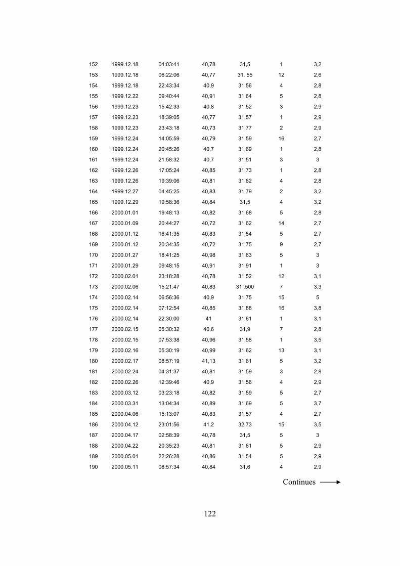
122
152 1999.12.18 04:03:41 40,78 31,5 1 3,2
153 1999.12.18 06:22:06 40,77 31. 55 12 2,6
154 1999.12.18 22:43:34 40,9 31,56 4 2,8
155 1999.12.22 09:40:44 40,91 31,64 5 2,8
156 1999.12.23 15:42:33 40,8 31,52 3 2,9
157 1999.12.23 18:39:05 40,77 31,57 1 2,9
158 1999.12.23 23:43:18 40,73 31,77 2 2,9
159 1999.12.24 14:05:59 40,79 31,59 16 2,7
160 1999.12.24 20:45:26 40,7 31,69 1 2,8
161 1999.12.24 21:58:32 40,7 31,51 3 3
162 1999.12.26 17:05:24 40,85 31,73 1 2,8
163 1999.12.26 19:39:06 40,81 31,62 4 2,8
164 1999.12.27 04:45:25 40,83 31,79 2 3,2
165 1999.12.29 19:58:36 40,84 31,5 4 3,2
166 2000.01.01 19:48:13 40,82 31,68 5 2,8
167 2000.01.09 20:44:27 40,72 31,62 14 2,7
168 2000.01.12 16:41:35 40,83 31,54 5 2,7
169 2000.01.12 20:34:35 40,72 31,75 9 2,7
170 2000.01.27 18:41:25 40,98 31,63 5 3
171 2000.01.29 09:48:15 40,91 31,91 1 3
172 2000.02.01 23:18:28 40,78 31,52 12 3,1
173 2000.02.06 15:21:47 40,83 31 .500 7 3,3
174 2000.02.14 06:56:36 40,9 31,75 15 5
175 2000.02.14 07:12:54 40,85 31,88 16 3,8
176 2000.02.14 22:30:00 41 31,61 1 3,1
177 2000.02.15 05:30:32 40,6 31,9 7 2,8
178 2000.02.15 07:53:38 40,96 31,58 1 3,5
179 2000.02.16 05:30:19 40,99 31,62 13 3,1
180 2000.02.17 08:57:19 41,13 31,61 5 3,2
181 2000.02.24 04:31:37 40,81 31,59 3 2,8
182 2000.02.26 12:39:46 40,9 31,56 4 2,9
183 2000.03.12 03:23:18 40,82 31,59 5 2,7
184 2000.03.31 13:04:34 40,89 31,69 5 3,7
185 2000.04.06 15:13:07 40,83 31,57 4 2,7
186 2000.04.12 23:01:56 41,2 32,73 15 3,5
187 2000.04.17 02:58:39 40,78 31,5 5 3
188 2000.04.22 20:35:23 40,81 31,61 5 2,9
189 2000.05.01 22:26:28 40,86 31,54 5 2,9
190 2000.05.11 08:57:34 40,84 31,6 4 2,9
Continues
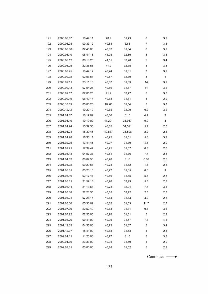
123
191 2000.06.07 18:49:11 40,9 31,73 6 3,2
192 2000.06.08 00:33:12 40,88 32,8 7 3,3
193 2000.06.08 02:46:06 40,82 31,64 6 3,2
194 2000.06.10 06:41:16 41,08 32,69 5 3,3
195 2000.06.12 06:18:25 41,15 32,78 5 3,4
196 2000.06.25 22:35:55 41,2 32,75 5 3,3
197 2000.08.25 10:44:17 40,74 31,81 7 3,2
198 2000.09.02 02:53:51 40,67 32,79 8 4
199 2000.09.11 23:11:10 40,67 31,83 14 3,2
200 2000.09.13 07:54:26 40,69 31,57 11 3,2
201 2000.09.17 07:05:25 41,2 32,77 5 3,3
202 2000.09.19 06:42:14 40,68 31,61 3 2,9
203 2000.10.19 05:06:20 40. 86 31,54 5 3,7
204 2000.12.12 10:20:12 40,65 32,09 0.2 3,2
205 2001.01.07 18:17:09 40,86 31,5 4.4 3
206 2001.01.10 10:19:02 41,201 31,947 9.9 3
207 2001.01.24 15:37:35 40,85 31,521 5.7 2,8
208 2001.01.24 15:39:45 40,837 31,506 2.2 2,8
209 2001.01.28 16:36:11 40,75 31,51 5.3 3,2
210 2001.02.05 13:41:45 40,97 31,79 4.8 2,9
211 2001.02.21 17:39:44 40,75 31,57 0.3 2,6
212 2001.03.13 04:57:33 40,61 31,76 7.7 2,8
213 2001.04.02 00:02:50 40,76 31,6 0.06 2,5
214 2001.04.02 00:29:53 40,78 31,52 1.1 2,6
215 2001.05.01 05:20:16 40,77 31,65 0.6 3
216 2001.05.10 02:17:47 40,86 31,85 5.3 2,8
217 2001.05.11 21:59:18 40,76 32,23 5.3 2,3
218 2001.05.14 21:13:53 40,78 32,24 7.7 3,1
219 2001.05.18 22:21:56 40,85 32,22 2.3 2,8
220 2001.05.21 07:26:14 40,63 31,63 3.2 2,8
221 2001.05.30 05:36:02 40,82 31,59 11.7 2,7
222 2001.07.09 22:52:40 40,63 31,81 9.1 3,1
223 2001.07.22 02:55:00 40,78 31,61 5 2,9
224 2001.08.26 00:41:00 40,95 31,57 7.8 4,6
225 2001.12.03 04:35:00 40,73 31,67 5 3,4
226 2001.12.07 15:41:00 40,68 31,63 5 2,3
227 2002.01.11 11:20:00 40,77 31,5 5 3,3
228 2002.01.30 23:33:00 40,94 31,59 5 2,9
229 2002.03.31 03:00:00 40,88 31,52 5 2,9
Continues
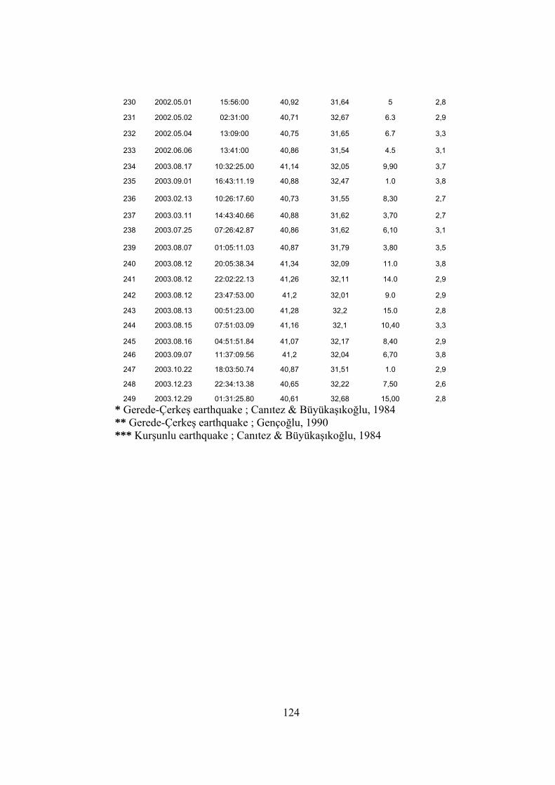
124
230 2002.05.01 15:56:00 40,92 31,64 5 2,8
231 2002.05.02 02:31:00 40,71 32,67 6.3 2,9
232 2002.05.04 13:09:00 40,75 31,65 6.7 3,3
233 2002.06.06 13:41:00 40,86 31,54 4.5 3,1
234 2003.08.17 10:32:25.00 41,14 32,05 9,90 3,7
235 2003.09.01 16:43:11.19 40,88 32,47 1.0 3,8
236 2003.02.13 10:26:17.60 40,73 31,55 8,30 2,7
237 2003.03.11 14:43:40.66 40,88 31,62 3,70 2,7
238 2003.07.25 07:26:42.87 40,86 31,62 6,10 3,1
239 2003.08.07 01:05:11.03 40,87 31,79 3,80 3,5
240 2003.08.12 20:05:38.34 41,34 32,09 11.0 3,8
241 2003.08.12 22:02:22.13 41,26 32,11 14.0 2,9
242 2003.08.12 23:47:53.00 41,2 32,01 9.0 2,9
243 2003.08.13 00:51:23.00 41,28 32,2 15.0 2,8
244 2003.08.15 07:51:03.09 41,16 32,1 10,40 3,3
245 2003.08.16 04:51:51.84 41,07 32,17 8,40 2,9
246 2003.09.07 11:37:09.56 41,2 32,04 6,70 3,8
247 2003.10.22 18:03:50.74 40,87 31,51 1.0 2,9
248 2003.12.23 22:34:13.38 40,65 32,22 7,50 2,6
249 2003.12.29 01:31:25.80 40,61 32,68 15,00 2,8 * Gerede-Çerkeş earthquake ; Canıtez & Büyükaşıkoğlu, 1984 ** Gerede-Çerkeş earthquake ; Gençoğlu, 1990 *** Kurşunlu earthquake ; Canıtez & Büyükaşıkoğlu, 1984