Embed Size (px)
Citation preview

#
#
####
ÊÚGuayaquil
0 100 KILOMETERS
PacificOcean
Peru
Ecuador
5
80
Neogene Pull-Apart BasinAssessment Unit 60830101
Progreso Basin Geologic Province 6083
Neogene Pull-Apart Basin Assessment Unit 60830101
Page 1
USGS PROVINCE: Progreso Basin (6083) GEOLOGIST: D.K. Higley TOTAL PETROLEUM SYSTEM: Neogene (608301) ASSESSMENT UNIT: Neogene Pull-Apart Basin (60830101) DESCRIPTION: The Progreso-Tumbes-Santa Elena Basin is located along the coast of northern Peru and southern Ecuador. The basin is divided from north to south into the Paleogene Santa Elena sub-basin, and the Neogene Progreso and Tumbes sub-basins. The Peru Bank is part of the Cretaceous-Paleogene assessment unit. Progreso-Tumbes has been described as a pull-apart sub-basin. Oil and gas production from this Neogene assessment unit is primarily from Miocene-age sandstones in the Tumbes sub-basin. Travis and others (1975) estimate offshore-undiscovered resources of 335 MMBO for this Neogene assessment unit. While they were not assessed as part of this study, offshore Ecuador and Peru exhibit excellent potential for gas hydrate resources (Miller and others, 1991). SOURCE ROCKS: The probable hydrocarbon source rocks are marine shales that are interbedded and overlie the reservoir intervals. No source rock geochemical studies have been published regarding which marine shales may have sourced oil and gas across this basin. Probable source rocks in the Progreso-Tumbes sub-basin are upper Oligocene to possibly early Miocene Heath Formation and the Miocene-age Cardalitos Formation (Zuniga-Rivero and others, 1998). MATURATION: Paleozoic through Tertiary source rocks across Colombia, Ecuador, and Peru became thermally mature for oil generation during Neogene phases of basin development (Pindell and Tabbutt, 1995). Miocene and younger is the probable timing of source rock maturation for Tertiary and older reservoirs across the basin (Jaillard and others, 1995; Pindell and Tabbutt, 1995). MIGRATION: Probable onset of migration is mid-Miocene time, after the opening of the Gulf of Guayaquil by movement along the Dolores-Guayaquil megashear and creation of the Progeso-Tumbes sub-basin. Close association of potential source and reservoir rocks suggests that emplacement of oil in reservoirs could have begun soon after the start of hydrocarbon generation. RESERVOIR ROCKS: Primary oil and gas reservoirs of the Progreso-Tumbes sub-basin are marine sandstones of the Miocene-age Zorritos and Subibaja Formations, and the upper Oligocene to possibly early Miocene Heath Formation. Thickness range of the sedimentary section in the Tumbes basin is 6,000 to 12,000 m (20,000 to 40,000 ft), increasing seaward (AIPC, no date). TRAPS AND SEALS: While the Progreso-Tumbes-Santa Elena Basin has been characterized as a forearc basin, it lies seaward of the Coastal range, which has been identified as a “trench-slope break” or “outer-arc ridge” environment; Kingston (1994) indicates a closer basin configuration might be named trench-slope basin. Evidence for growth faulting in the Progresso Basin is mostly in lower Miocene, Oligocene, Eocene, and Paleocene formations on top of the
Page 2
metamorphosed Pennsylvanian Amotape and Precambrian basement rocks (AIPC, no date). Some of the tectonic events that influenced hydrocarbon generation, migration, and trap formation are listed below: 1. Early-middle Eocene boundary–New fore-arc basins were created. This is attributed to
collision of coastal Ecuador with the Andean margin. 2. Eocene–Inca Orogeny–This is the period of erosion of the Cretaceous section in
Progreso and Tumbes that involves right-lateral and rotational movement associated with the Dolores-Guayaquil megashear and possibly the Troncho Mocho wrench fault. This Eocene event resulted in emergence of the southern coastline of Ecuador (Santa Elena peninsula) (Jaillard and others, 1995)
3. Upper Oligocene-Miocene time–Separation of the Nazca Plate from the South American Plate with active subduction at the Peru-Chile trench and creation of the Neogene (Tumbes, Progreso) fore-arc basins (Jaillard and others, 1995) and deposition of the thick Miocene section.
4. Middle Miocene–Block faulting across the Progreso and Talara basins and renewed growth of the Andes Mountains.
5. Mid-Pliocene–Horst and graben, gravity and basement-involved faulting, mostly in the Tumbes sub-basin (AIPC, no date).
Overlying and interbedded marine shales are the major reservoir seals, both for shallow and deepwater deposits. Lateral seals are (primarily normal) fault offsets, and lateral depositional or erosional pinchout of the mostly marine sandstones into shales. Sediment sources are mainly from the east, northeast, and southeast (Petroperu, 1999; Pindell and Tabbutt, 1995), depositional patterns associated with these fluvial, shoreline, turbidite, marine and other facies strongly influence types and locations of seals. REFERENCES: American International Petroleum Corporation, no date, A review of the petroleum potential of
the Tumbes Basin, Peru: Denver, Colorado American International Petroleum Corporation, 46 p.
Jaillard, E, Ordonez, M., Benitez, S., Berrones, G., Jimenez, N., Montenegro, G., and Zombrano, I.,1995, Basin development in an accretionary, oceanic-floored fore-arc setting–southern coastal Ecuador during Late Cretaceous-Late Eocene time, in Tankard, A.J., Suarez S., R., and Welsink, H.J., Petroleum basins of South America: American Association of Petroleum Geologists Memoir 62, p. 615-631.
Kingston, J., 1994, Undiscovered petroleum of southern South America: U.S. Geological Survey Open-File Report 94-559, 443 p.
Miller, J.J., Lee, M.W., and von Huene, R., 1991, An analysis of a seismic reflection from the base of a gas hydrate zone, offshore Peru: American Association of Petroleum Geologists Bulletin, v. 75, no. 5, p. 910-924.
Perupetro, 1999, International bidding round–offshore and coastal blocks: Lima, Perupetro information booklet, Av. Luis Aldana, 320 San Borja, Lima, Peru, 47 p.
Petroconsultants, 1996, Petroleum exploration and production database: Houston, Texas, Petroconsultants, Incorporated, P.O. Box 740619.

Page 3
Pindell, J.L., and Tabbutt, K.D., 1995, Mesozoic-Cenozoic Andean paleogeography and regional controls on hydrocarbon systems, in Tankard, A.J., Suarez S., R., and Welsink, H.J., Petroleum basins of South America: American Association of Petroleum Geologists Memoir 62, p. 101-128.
Travis, R.B., Gonzales, G., and Pardo, A., 1975, Hydrocarbon potential of coastal basins of Peru: American Association of Petroleum Geologists Memoir 25, p. 331-338
Zuniga-Rivero, F., Keeling, J.A., and Hay-Roe, H., 1998, Attractive potential seen in 10 sub- basins off Peru: Oil and Gas Journal, September 7, 1998, p. 117-122.
Zuniga-Rivero, F., Hay-Roe, H., and Vargas, T., 1999, Talara–A new look at an old petroleum basin: Exploration and exploitation of petroleum and Gas, Ingepet ’99 seminar, Lima, Peru, Oct. 26-29, 1 CD-ROM, EXPR-1-FZ-15.pdf, 9 p.

60830101
60830101Assessment unitcode and boundary
6085
6083
6083
Assessment Unit - 60830101Neogene Pull-Apart Basin
EXPLANATION
HydrographyShorelineGeologic province code and boundaryCountry boundaryGas field centerpointOil field centerpoint
Projection: Robinson. Central meridian: 0
50 KILOMETERS
81
4
3
2
6084
6082
Ecuador
Pacific Ocean
Peru
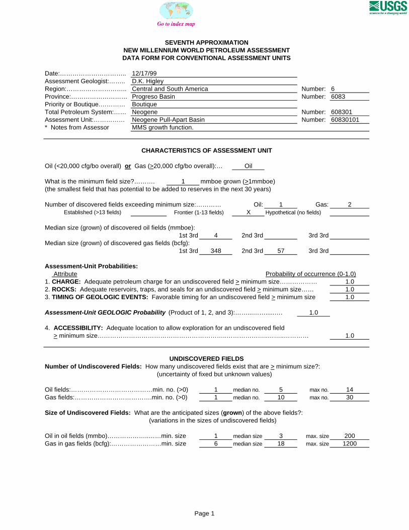
SEVENTH APPROXIMATIONNEW MILLENNIUM WORLD PETROLEUM ASSESSMENTDATA FORM FOR CONVENTIONAL ASSESSMENT UNITS
Date:………………………….. 12/17/99Assessment Geologist:…….. D.K. HigleyRegion:……………………….. Central and South America Number: 6Province:……………………… Progreso Basin Number: 6083Priority or Boutique.………… BoutiqueTotal Petroleum System:…… Neogene Number: 608301Assessment Unit:…………… Neogene Pull-Apart Basin Number: 60830101* Notes from Assessor MMS growth function.
CHARACTERISTICS OF ASSESSMENT UNIT
Oil (<20,000 cfg/bo overall) or Gas (>20,000 cfg/bo overall):… Oil
What is the minimum field size?………. 1 mmboe grown (>1mmboe)(the smallest field that has potential to be added to reserves in the next 30 years)
Number of discovered fields exceeding minimum size:………… Oil: 1 Gas: 2 Established (>13 fields) Frontier (1-13 fields) X Hypothetical (no fields)
Median size (grown) of discovered oil fields (mmboe):1st 3rd 4 2nd 3rd 3rd 3rd
Median size (grown) of discovered gas fields (bcfg):1st 3rd 348 2nd 3rd 57 3rd 3rd
Assessment-Unit Probabilities: Attribute Probability of occurrence (0-1.0)1. CHARGE: Adequate petroleum charge for an undiscovered field > minimum size……………… 1.02. ROCKS: Adequate reservoirs, traps, and seals for an undiscovered field > minimum size…… 1.03. TIMING OF GEOLOGIC EVENTS: Favorable timing for an undiscovered field > minimum size 1.0
Assessment-Unit GEOLOGIC Probability (Product of 1, 2, and 3):……...…….....…. 1.0
4. ACCESSIBILITY: Adequate location to allow exploration for an undiscovered field > minimum size……………………………………………………..………………..……..………… 1.0
UNDISCOVERED FIELDS
Oil fields:…………………………………min. no. (>0) 1 median no. 5 max no. 14Gas fields:……………………………….min. no. (>0) 1 median no. 10 max no. 30
Size of Undiscovered Fields: What are the anticipated sizes (grown) of the above fields?:
Oil in oil fields (mmbo)………………..……min. size 1 median size 3 max. size 200Gas in gas fields (bcfg):……………………min. size 6 median size 18 max. size 1200
(variations in the sizes of undiscovered fields)
(uncertainty of fixed but unknown values)Number of Undiscovered Fields: How many undiscovered fields exist that are > minimum size?:
Page 1

Assessment Unit (name, no.)Neogene Pull-Apart Basin, 60830101
AVERAGE RATIOS FOR UNDISCOVERED FIELDS, TO ASSESS COPRODUCTS
Oil Fields: minimum median maximum Gas/oil ratio (cfg/bo)………………………...……… 400 600 1000 NGL/gas ratio (bngl/mmcfg)…………………....…. 30 60 90
Gas fields: minimum median maximum Liquids/gas ratio (bngl/mmcfg)….…………..…….. 22 44 66 Oil/gas ratio (bo/mmcfg)………………………….…
SELECTED ANCILLARY DATA FOR UNDISCOVERED FIELDS(variations in the properties of undiscovered fields)
Oil Fields: minimum median maximum API gravity (degrees)…………………….…………. 20 35 45 Sulfur content of oil (%)………………………...….. 0.05 0.26 0.5 Drilling Depth (m) ……………...…………….…….. 100 1200 3400 Depth (m) of water (if applicable)……………...….. 0 200 1000
Gas Fields: minimum median maximum Inert gas content (%)……………………….....…… CO2 content (%)……………………………….....… Hydrogen-sulfide content (%)………………...……. Drilling Depth (m)…………………………………… 1500 2500 3500 Depth (m) of water (if applicable)…………………. 0 200 1000
(uncertainty of fixed but unknown values)
Page 2

Assessment Unit (name, no.)Neogene Pull-Apart Basin, 60830101
ALLOCATION OF UNDISCOVERED RESOURCES IN THE ASSESSMENT UNITTO COUNTRIES OR OTHER LAND PARCELS (uncertainty of fixed but unknown values)
1. Peru represents 88 areal % of the total assessment unit
Oil in Oil Fields: minimum median maximum Richness factor (unitless multiplier):……….…..… Volume % in parcel (areal % x richness factor):… 90 Portion of volume % that is offshore (0-100%)…… 85
Gas in Gas Fields: minimum median maximum Richness factor (unitless multiplier):…………..…. Volume % in parcel (areal % x richness factor):… 90 Portion of volume % that is offshore (0-100%)…… 85
2. Ecuador represents 12 areal % of the total assessment unit
Oil in Oil Fields: minimum median maximum Richness factor (unitless multiplier):……….…..… Volume % in parcel (areal % x richness factor):… 10 Portion of volume % that is offshore (0-100%)…… 90
Gas in Gas Fields: minimum median maximum Richness factor (unitless multiplier):…………..…. Volume % in parcel (areal % x richness factor):… 10 Portion of volume % that is offshore (0-100%)…… 90
Page 3

0
0.5
1
1.5
2
2.5
3
3.5
4
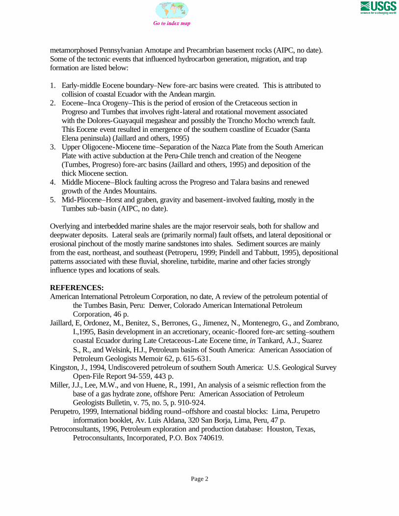
6-<12 12-<24 24-<48 48-<96 96-<192 192-<384 384-<768 768-<1536
1536-<3072
3072-<6144
GAS-FIELD SIZE (BCFG)
UN
DIS
CO
VE
RE
D G
AS
FIE
LD
S (
No
.)
Minimum field size: 6 BCFG
Mean number ofundiscovered fields: 11.1
Neogene Pull-Apart Basin, AU 60830101 Undiscovered Field-Size Distribution