Embed Size (px)
DESCRIPTION
basics
Citation preview

GEOPAK COGO: Back to Basics And BeyondFrank Nelson – Burns & McDonnell

Objective• Back to Basics - provide the “nuts and
bolts” of Coordinate Geometry (COGO), the basic building block of entire GEOPAK program.
• And Beyond - provide COGO tips, tricks, and tools that the presenter has learned, discovered, or stumbled across during his “going-on” 10 years of using GEOPAK

COGO = Coordinate Geometry
• XYZ Coordinates• Store Geometric
Elements−Points− Lines−Curves & Spirals−Chains−Profiles

Coordinate System
• Y = Northing (N)• X = Easting (E)• Z = Elevation (ELEV)• Users – Be aware of
the coord. system of the data & the system GEOPAK is using
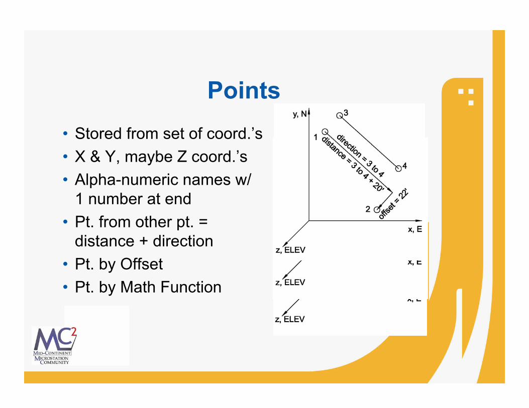
Points• Stored from set of coord.’s• X & Y, maybe Z coord.’s• Alpha-numeric names w/
1 number at end• Pt. from other pt. =
distance + direction• Pt. by Offset• Pt. by Math Function

Lines & Line Segments
• Line = location point + direction
• Infinite in length• Line Segment =
portion of line w/ beginning & ending pt.’s
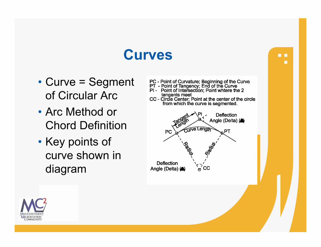
Curves
• Curve = Segment of Circular Arc
• Arc Method or Chord Definition
• Key points of curve shown in diagram

Spirals
• Spiral = transitional curve
• Transition from– Tangent to specified
radius defined by curve Or
– 2 specified radii defined by 2 curves
• Key points of spiral shown in diagram

Chains• Combination of other horizontal
elements− Points− Lines− Curves & Spirals− Chains
• Horizontal alignment• Have stationing• Station equation

Profiles• Vertical alignments
defined by stations & elevations
• Associated w/ horizontal chain
• Profiles w/o curves = existing ground profile or ditch profile
• Profile w/ vert. curve = prop. alignment profile

Let’s Get COGO’ing• COGO Icon or In Project
Manager, Pick Coordinate Geometry
• Start-Up Dialog Box−Project Name− Job Number−Operator Code−Subject− If Proj. Mgr.used, 1st 3 filled
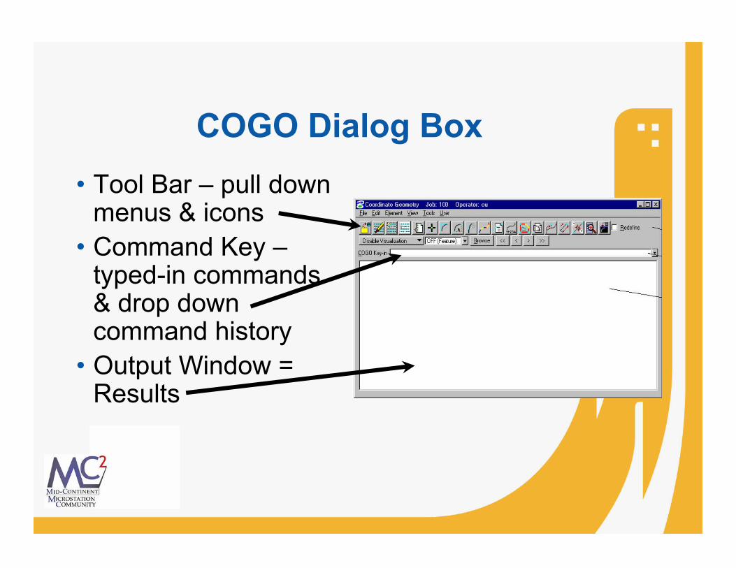
COGO Dialog Box • Tool Bar – pull down
menus & icons• Command Key –
typed-in commands & drop down command history
• Output Window = Results

File Commands
•Append (input files only)•Catalog•Delete•Load•Output – to *.ooc for print•Print
•Restore – ASCII to *.inp•Save – to *.ioc•Export – Survey Files•Import – Survey Files•Exit

Edit Commands
•Clear – empties memory w/o saving•Delete – deletes command lines•Editor – opens Geopak COGO Command Editor
•Insert – add a command line•Modify – change word in command line•Read – process output buffer•Type – displays current input file content

Point Pull-Down Menu
•Cell•Copy•Delete•Elevation•Equate•List/Print
•Store•Transformation•Compare Points to TIN•Set Elevation from TIN
Store Point Dialog Box

Curve Pull-Down Menu
•Copy•Data – calculates parameters•Delete•List/Print – names/data
•Segment – new curves•Station•Store (Next Slide)•Transpose – reverses curve direction

Store Curve Dialog Boxes
•Store Curve from Tangents
•Store Concentric Curves
•Store Curve from PC & PT

Chain Pull-Down Menu
•Area – calc.’s area of closed chain•Delete•Layout Offset – computes station & offset of pt. or chain on a given chain
•Describe/List/Print –displays chain info•Stationing – stationing & restationing•Station Equation•Store (Next Slide)

Store Chain Dialog Boxes
•Store Chain From Elements
•Store Transition Chain
•Store Offset Chain
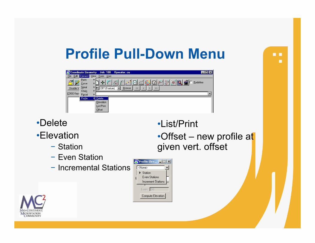
Profile Pull-Down Menu
•Delete•Elevation
− Station− Even Station− Incremental Stations
•List/Print•Offset – new profile at given vert. offset

Profile Generator
•Icon on Horiz. & Vert. Geometry Toolbar•Not In Accessible from COGO Dialog Box•Icon Opens Settings Dialog Box
•After Filling in Settings & Drawing Profile Cell, Click OK•Profile Generator Opens

Tools Commands Pull-Down Menu
•Intersect•Locate•Superelevation•Inverse•Navigator•Best Fit
•Translation & Rotation•Map Check – parcel edit•Roadway Intersection•Cul-de-sacs•Redraw Visualized Elements•Clear Vis. Elements (Temp.)•Clear Vis. Elements (All)

LocateTool Pull-Down Menu
•Traverse
•By Angle
•Ext/Int Tangent
•On Element
•Point On Curve•Along Element•Elevations By Profile

COGO Navigator•Tool to view & edit COGO data
•Access by Navigator Iconor Tools Pull Down Menu
•Navigator Dialog Box
•Elements− Added− Deleted− Modified− Identified− Visualized− Printed− Selected

Navigator Selection Menu•Select All•Invert Selection•Clear Selection•Selection Set•Fit View (Selection Set)•Show Selected Elements Only•Show All Elements
•Access by Navigator Iconor Tools Pull Down Menu

Navigator Tool Menu & Icons
Tools Pull Down Menu
•Add Element•Delete Element•Edit Element•Identify Element•Visualize Element•Print/Describe Element

Graphical COGO•Graphical COGO – Stores or Modifies Elements by Key-In or Mouse Click •Accessed by Iconor Application>>GeopakRoad>>Geometry>>Graphical Coordinate Geometry•Graphical COGO Dialog Box

Graphical COGO Dialog Boxes•Four Toolboxes
− Store Elements
− Modify Elements
− Manipulate Elements
− Groups

Store Elements Tools 1
• Store Point• Store Equally Spaced Points• Locate Point• Store Line• Store Line by 2 Points• Store Tangent Line

Store Elements Tools 2
• Store Curve by 3 Points• Store Curve by Center• Store Tangent Curve Constrained• Store Tangent Curve Unconstrained• Store Tangent Spiral

Modify Elements Tools 1
• Partial Delete• Extend Plan View Element• Trim Elements• Intersect Elements• Extend Element to Intersection

Modify Elements Tools 2
• Extend Elements to Intersection• Construct Circular Fillet• Construct Chamfer• Cut Element

Manipulate Elements & Groups Tools
• Manipulate Elements−Move Plan View Element−Rotate Plan View Element−Copy Parallel−Delete Element
• Groups−Store Chain−Store Parcel

Questions?

GEOPAK COGO: Back to Basics And BeyondFrank Nelson – Burns & McDonnell
Thanks!


