Embed Size (px)
Citation preview
NELSON COUNTY ZONING ORDINANCE
As amended through November 16, 2017
Adopted by
The Nelson County Board of Supervisors
January 11, 1977
APPENDIX A
ZONING*
Art. 1. Introduction, § 1-1 – 1-4
Art. 2. Definitions
Art. 3. Conservation District C-1, § 3-1 – 3-8
Art. 4. Agricultural District A-1, § 4-1 – 4-11-3
Art. 5. Residential District R-1, § 5-1 – 5-8
Art. 6. Residential District R-2, § 6-1 – 6-8
Art. 7. Residential Planning Community District RPC, § 7-1 – 7-11
Art. 8. Business District B-1, § 8-1 – 8-5
Art. 8A. Business District B-2, § 8A-1 – 8A-5-4
Art. 8B. Service Enterprise District SE-1, § 8B-1, 8B-2-10
Art. 9. Industrial District M-2, § 9-1 – 9-5
Art. 10. General Floodplain District FP, § 10.1 – 10.23
Art. 11. Nonconforming Uses, § 11-1 – 11-7
Art. 12. General Provisions, § 12-1 – 12-13
Art. 13. Site Development Plan, § 13-1 – 13-10-7
Art. 14. Board of Zoning Appeals, § 14-1 – 14-6-5
Art. 15. Violation and Penalty, § 15-1 – 15-2
Art. 16. Amendment and Rezoning, § 16-1 – 16-4-7
Art. 17. Administration and Interpretation, § 17-1 – 17-7
Art. 18. Limited Industrial M-1, § 18-1 – 18-10-1
Art. 19. Nuclear Waste Materials, § 19-1
Art 19A. (Reserved)
Art 19B. Planned Unit Development - Industrial PUD ID
Art 20. Communication Tower Ordinance, § 20-1 – 20-22
Art. 21. Cluster Housing Development, § 21-1 – 21-7
Art. 22. Small Wind Energy Ordinance, §22-1 – 22-8
Art. 23. Temporary Family Health Care Structures §23-1 – 23-9
Art. 24. Temporary Events, Festival Grounds, Out-Of-Doors Accessory Uses §24-1 – 24-3

ARTICLE 1. INTRODUCTION
1-1 Legislative Authority
This ordinance establishes comprehensive zoning regulations for Nelson County and
provides for the administration, enforcement, and amendment thereof, in accordance with the
provisions of Chapter 22, Code of Virginia, (1950), as amended.
*Editor's note- This appendix contains the zoning ordinance adopted on January 11, 1977,
as amended through September 14, 2010. Style and capitalization have been made uniform.
Obvious misspellings have been corrected without notation and material in brackets [ ] has been
added for clarity.
Cross references- Administration, Ch. 2; buildings, Ch. 4; licenses and business
regulations, Ch. 6; planning and development, Ch. 9; subdivisions, App. B; automobile graveyards,
ξ 7-131 et seq.
State law reference- Zoning, Code of Virginia, ξ 15.1-486 et seq.
1-2 Legislative Intent
It is the intention of the County to:
1-2a guide its future growth and development in accordance with a comprehensive plan of
land use and population density that represents the most beneficial and convenient
relationships among the residential, non-residential, and public areas within the County;
and
1-2b provide adequate light, air, and privacy, to preserve and protect lives and property from
fire, floods, and other dangers, and to prevent overcrowding of the land and undue
congestion of population; and
1-2c protect the character and the social and economic stability of all parts of the County, to
encourage the orderly and beneficial development of all parts of the County, and to
protect and conserve the value of land and buildings appropriate to the various districts
established by this comprehensive zoning ordinance; and
1-2d bring about the gradual conformity with the current Comprehensive Plan of Nelson
County through the comprehensive zoning ordinance set forth herein, and to minimize
conflicts among the uses of land and buildings; and
1-2e promote the most beneficial relationship between the uses of land and buildings and the
road system which serves these uses, having particular regard for the potential amount and
intensity of such land and building uses in relationship to the capacity of the road system,
so as to avoid congestion on the roads, and to promote safe and convenient vehicular and
pedestrian traffic movements appropriate to the various uses of land and buildings
throughout the County; and
1-2f provide a guide for public action in the orderly and efficient provision of public facilities
and services, and for private enterprise in building development, investment, and other
economic activity relating to uses of land and buildings throughout the County.
1-3 Interpretation, Purpose of Conflict
In their interpretation and application, the provisions of this ordinance shall be held to be
minimum requirements adopted for the promotion of health, safety, and the general
welfare of the citizens of the County.
1-4 Enumeration of Districts
For the purpose of this ordinance, the unincorporated areas of Nelson County, Virginia are
hereby divided into eleven (11) districts as follows:
Conservation C-1
Agricultural A-1
Residential R-1
Residential R-2
Residential Planned Community RPC
Industrial M-2
Limited Industrial M-1
Floodplain FP
Business B-1
Business B-2
Service Enterprise SE-1

ARTICLE 2. DEFINITIONS
For the purpose of this ordinance, certain words and terms are defined as follows: Words
used in the present tense include the future. Words in the singular include the plural, and the plural
includes the singular.
Abattoir: A commercial slaughterhouse.
Accessory use or structure: A subordinate use or building customarily incidental to and located
upon the same lot occupied by the main use or building.
Acreage: A parcel of land, regardless of area, described by metes and bounds which is not a
numbered lot on any recorded subdivision plat.
Activity center: An indoor facility used for athletic, recreational, therapeutic, and wellness
activities, including but not limited to a gym, health club, fitness club, racquet sports, aquatics,
yoga studio, dance studio, or martial arts studio. O2013-
07
Agricultural operations: Any operation devoted to the bona fide production of crops, or animals,
or fowl including the production of fruits and vegetables of all kinds; meat, dairy, and poultry
products; nuts, tobacco, nursery, and floral products; and the production and harvest of products
from silvicultural activity. The preparation, processing, or sale of food products in compliance
with subdivisions A 3, 4, and 5 of Virginia Code §3.2-5130 or related state laws and regulations
are accessory uses to an agricultural operation, unless otherwise specifically provided for in this
ordinance. When used in this ordinance, the words agricultural or agriculture shall be construed to
encompass the foregoing definition. O2014-
06
Agricultural Processing Facility: The preparation, processing, or sale of food products, or
accumulation for shipment or sale of crops and animals, in connection with an agricultural
operation when more than 20% of such crops or animals are not produced on an agricultural
operation on the same or contiguous parcel(s) owned or controlled by the operator of the facility.
O2014-
06
Agricultural Processing Facility, Major: An agricultural processing facility that, by virtue of its
size, shipping requirements, noise, or other characteristics, will have a substantial impact on the
health, safety, or general welfare of the public or adjoining landowners. A major agricultural
processing facility is one that either (i) has more than 10,000 square feet of enclosed space devoted
to agricultural processing operations or (ii) entails the preparation, processing, or sale of food
products, or accumulation for shipment or sale of crops and animals, in connection with an
agricultural operation when more than 50% of such crops or animals are not produced on an
agricultural operation on the same or contiguous parcel(s) owned or controlled by the operator of
the facility. O2014-
06
Agricultural equipment: Vehicles, machinery and tools used for farming purposes.
Airstrip, private: A runway for the landing and take-off of small aircraft on a noncommercial
basis, which shall be approved by the Federal Aviation Administrator and the Virginia Division of
Aeronautics.
Alteration: Any change in the total floor area, use, adaptability or external appearance of an
existing structure.
Antique motor vehicle: Antique means every motor vehicle, as defined in this section, which was
actually manufactured or designated by the manufacturer as a model manufactured in a calendar
year not less than 25 years prior to January 1 of each calendar year and is owned solely as a
collector’s item. The antique motor vehicle must display the appropriate license plates pursuant
to ξ46.2-730 of the Code of Virginia, as amended.
Apartment house: See Dwelling, multiple-family apartment.
Artist Community: A facility that provides resident artists with artist community residencies in a
rural setting. An artist community includes art studio(s), exhibition and presentation space(s),
and temporary lodging accommodations for resident artists; and includes the accompanying
office(s), kitchen and food service(s), communal space(s), and maintenance area(s) to service
the resident artists and staff. O2015-
02
Artist Community Residencies: time and space scheduled for resident artists to create work not
at the artists' home base; residencies are scheduled for a period not to exceed ninety-five (95)
consecutive days. O2015-
02
Automobile graveyard: See Junkyard.
Automobile graveyard, class A: Any rear yard or part of a rear yard upon which a maximum of
two (2) inoperative vehicles of any kind are located and which is screened by natural plantings or
by other reasonable means acceptable to the Administrator so that vehicles are not visible from the
roadway or adjacent residential, commercial, or agricultural properties. A "Class A Automobile
Graveyard" is considered to be an accessory use to single-family residential use.
Automobile graveyard, class B: Any place meeting setback side and rear yard requirements for
buildings upon which a maximum of five (5) inoperative vehicles of any kind are located and
which is screened by natural plantings or by other reasonable means acceptable to the administrator
so that such vehicles are not visible from the roadway or adjacent residential, commercial, or
agricultural properties.
Automobile graveyard, class C: Any place meeting setback side and rear yard requirements for
buildings upon which more than five (5) inoperative vehicles of any kind are located, and which
is screened by natural plantings or by other reasonable means acceptable to the Administrator, so
that such vehicles are not visible from the roadway or adjacent residential, commercial or
agricultural properties. O2008-
005
Banquet hall: A facility for hosting public and/or private events, including but not limited to
weddings, receptions, social events or parties, and/or workshops, which is used as a venue for
social, cultural, recreational, and/or educational activities. Banquet halls do not include lodging
accommodations. O2013-
07 Basement: A story having part but not more than one-half of its height below grade. A basement
shall be counted as a story for the purpose of height regulations, if it is subdivided and used for
business purposes, or for dwelling purposes by other than a janitor employed on the premises.
Bed and Breakfast, Class A: A use composed of transient lodging provided by the resident
occupants of a dwelling that is conducted within said dwelling and/or one or more structures that
are clearly subordinate and incidental to the single family dwelling, having not more than six (6)
guest rooms in the aggregate, and having not more than twelve (12) transient lodgers in the
aggregate, and which also may include rooms for dining and for meetings for use by transient
lodging guests of the class A bed and breakfast, provided that the dining and meeting rooms are
accessory to the class A bed and breakfast use. O2016-
02
Bed and Breakfast, Class B: A use composed of transient lodging provided within a single family
dwelling and/or one or more structures that are clearly subordinate and incidental to the single
family dwelling, having not more than ten (10) guest rooms in the aggregate, and having not more
than twenty-four (24) transient lodgers in the aggregate, and which also may include rooms for
dining and for meetings for use by transient lodging guests of the bed and breakfast provided that
the dining and meeting rooms are accessory to the bed and breakfast use. O2016-
02
Boardinghouse: A use composed of a single building in which more than one room is arranged or
used for lodging by occupants who lodge for thirty (30) consecutive days or longer, with or without
meals, for compensation. A boardinghouse may be occupied by the owner or operator, but may
not be operated on the same parcel as a bed and breakfast. O2016-
02
Borrow pit: Sand, soil, and gravel operation of a temporary nature.
Brewery: A facility for the production of brewed beverages, including beer or other fermented beverages.
O2014-06 / O2015-
06
Building: Any structure used or intended for supporting or sheltering any use or occupancy.
Building, accessory: A subordinate building, customarily incidental to and located upon the same
lot occupied by the main building. No such accessory building shall be used for housekeeping
purposes.
Building, height of: The vertical distance measured from grade to the highest roof beams of a flat
roof, or to the mean level of the highest gable or slope of a gable, hip, or other roof.
Building, main: The principal building or one (1) of the principal buildings on a lot, or the building
or one (1) of the principal buildings housing the principal use on the lot.
Camp, day: A tract of land devoted to primarily outdoor recreational uses not including overnight
accommodations for users.
Camp, summer: A tract of land used or designed to be used for seasonal accommodation of
individuals in tents or similar rustic structures and for use by such individuals for sports, handcrafts
and other outdoor-oriented activities and recreation.
Campground: Any place used for transient camping where compensation is expected in order to
stay in a tent, travel trailer, or motor home. Campgrounds require the provision of potable water
and sanitary facilities. O2016-
02
Cellar: A story having more than one-half of its height below grade and which may not be
occupied for dwelling purposes.
Cemetery: A privately or church-owned and/or operated place for burial of the dead where lots
may be sold and perpetual care of the grave may be furnished.
Church adjunct graveyard: An area one (1) acre or less, owned and operated by an adjoining
church.
Conference center: A facility for hosting public and/or private events, including but not limited
to weddings, receptions, social events or parties, workshops, and/or conferences, which is used as
a venue for social, cultural, recreational, and/or educational activities. Conference centers may
include lodging accommodations. O2013-
07
Commission, the: The Planning Commission of Nelson County, Virginia.
Community Center: A building and grounds used for recreation, social, educational, health, or
cultural activities open to the public or a portion of the public, owned and operated by a public or
private non-profit group or agency. The activities may involve leasing of space for the sale of
goods and services, offices, and Temporary Events in conjunction with Article 24 of this ordinance
and subject to applicable zoning district regulations. The sale of goods and services may be carried
on a for-profit basis or for charitable non-profit purposes by the owner or the owner’s approved
lessee or licensee. Community Center uses, structures, and activities are subject to site plan
approval. Signage conveying information about permissible Temporary Events and/or a permitted
Outdoor Entertainment Venue is permissible, subject to applicable regulations and approval
requirements contained elsewhere in this Ordinance. There can be no other exterior indication of
non-temporary commercial activities at the center, such as outside storage, sales area, or signage,
except for a principal sign identifying the center, a single changeable letter sign, and additional
small wayfinding and directional signs which may include identification of tenants. O2016-
04
Composting, Commercial: The process by which organic wastes are combined in proper ratios to
which might be added bulking agents, such as wood chips, to provide air space and by using
controlled temperature, moisture, and oxygen, to achieve accelerated decomposition, thereby
producing a stable humus material. “Organic waste” includes, but is not limited to, yard
trimmings, agricultural by-products, food wastes, and manures. O2011-
01
Country club: A nonprofit entity organized to provide recreational facilities such as golf,
swimming, and tennis to its membership.
Corporate Training Center: A commercial facility in which are offered instructional programs
addressing organizational leadership and fostering organizational cohesiveness. Such facility may
include lodging, dining and recreational amenities for those in attendance. (Res. of 5/11/04)
Cul-de-sac: A street with only one (1) outlet having an appropriate turn-around area for safe
and convenient reverse of traffic movement.
Dairy plant: A commercial establishment for the processing and sale of milk or milk products at
either wholesale or retail.
Distillery: A facility for the production of distilled spirits. O2014-
06
District: Districts as referred to in the State Code, Section 15.1-486.
Dwelling: Any building which is designed for residential purposes (except boardinghouses,
dormitories, hotels and motels). O2016-
02
Dwelling, multiple-family apartment: A building or portion thereof arranged or designed for the
purpose of providing three (3) or more separate dwelling units.
Dwelling, single-family attached: One (1) of three (3) or more dwelling units which are joined
together by a common or party wall and/or connecting permanent structures such as breezeways,
carports, garages, screening fences, or walls.
Dwelling, single-family detached: A building arranged or designed to contain one (1) dwelling
unit. O2016-
02
Dwelling, two-family detached: A building arranged or designed to contain two (2) dwelling units.
Dwelling unit: A single unit providing complete independent living facilities for one (1) or
more persons including permanent provisions for living, sleeping, eating, cooking and sanitation.
Dwelling, boardinghouse, tourist home: See Boardinghouse.
Dwelling, hotel: See Hotel.
Dwelling, motel: See Motel.
Family: One (1) or more persons occupying a premise and living in a single dwelling unit, as
distinguished from an unrelated group occupying a boardinghouse, hotel, or motel.
Farm Brewery, Limited: A brewery that manufactures no more than 15,000 barrels of brewed
beverages per calendar year, provided that (i) the brewery is located on a farm owned or leased by
such brewery or its owner and (ii) agricultural products, including barley, other grains, hops, or
fruit, used by such brewery in the manufacture of its brewed beverages are grown on the farm.
The on-premises sale, tasting, or consumption of brewed beverages during regular business hours
within the normal course of business of such licensed brewery, the direct sale and shipment of
brewed beverages and the sale and shipment of brewed beverages to licensed wholesalers and out-
of-state purchasers in accordance with law, the storage and warehousing of brewed beverages, and
the sale of limited farm brewery-related items that are incidental to the sale of brewed beverages
are permitted. O2014-06 / O2015-06
Farm winery: An establishment as defined in Va. Code ξ4.1-100 Subsection (i) and licensed by
the Commonwealth pursuant to Va. Code ξ4.1-207 where wine may be sold for on-premise
consumption and in closed containers for off-premise consumption. The serving of light snacks
(cheese, crackers, peanuts, etc.) is permitted at a farm winery, without regulation. Other food
prepared on-site shall be prepared in a facility in compliance with the Virginia State Building Code
requirements and licensed by the Virginia Department of Health. The sale of wine-related items
that are incidental to the sale of wine is permitted at a farm winery without regulation.
Farm winery permanent remote retail establishment: A permanent retail establishment located
off of the farm winery premise but associated with a farm winery as defined in Va. Code ξ4.1-100
Subsection (ii) and licensed by the Commonwealth pursuant to Va. Code ξ4.1-207 where wine
may be sold for on-premise consumption and in closed containers for off-premise consumption.
The serving of light snacks (cheese, crackers, peanuts, etc.) is permitted at a farm winery
permanent remote retail establishment, without regulation. Other food served on-site shall be
prepared in an off-site facility licensed by the Virginia Department of Health. The sale of wine-
related items that are incidental to the sale of wine is permitted at a farm winery permanent remote
retail establishment without regulation.
Farmers Market: Any structure, assembly of structures, or land used by multiple vendors for the
off-farm sale or resale of agricultural and/or horticultural products, goods, and services, including
value-added agricultural or horticultural products. Farmers Markets may include the sale or resale
of accessory products, including arts, crafts, and/or farm-related merchandise, as long as the
majority of products being offered for sale are, in the aggregate, comprised of agricultural or
horticultural products. O2016-
01
Flea Market: Any outdoor commercial offering of items for sale at any location. Merchandise
offered may include items purchased specifically for resale at a profit. Churches and other
nonprofit organizations are exempt from these requirements. Permitted by right in Business (B-1)
zone.
Fraternal lodges/community buildings: Places of assembly for clubs, community groups and/or
civic organizations, at which regularly scheduled fraternal or public meetings and other public
activities are conducted.
Frontage: The full length of a plot of land measured alongside the road onto which the plot fronts.
Funeral home: A building used for the preparation of a corpse for burial or the preparation of a
corpse for cremation, which may also be used for funeral services and/or cremation services.
Garage, private: Accessory building designed or used for the storage of not more than three (3)
automobiles owned and used by the occupants of the building to which it is accessory. On a lot
occupied by a multiple-unit dwelling, the private garage may be designed and used for the storage
of two (2) times as many automobiles as there are dwelling units.
Garage, public: A building or portion thereof, other than a private garage, designed or used for
servicing, repairing, equipping, renting, selling, or storing motor-driven vehicles.
General store: See Retail store, neighborhood.
Golf course: Any golf course, publicly or privately owned, on which the game of golf is played,
including accessory uses and buildings customary thereto, but excluding golf driving ranges as
defined herein and miniature golf courses.
Golf driving range: A limited area on which golf players do not walk, but onto which they drive
golf balls from a central driving tee.
Governing body: The Board of Supervisors of Nelson County, Virginia.
Grade: A reference plane representing the average of finished ground level adjoining the building
at all exterior walls. (Unless otherwise modified in the text, the use of this definition in determining
building height would apply height restrictions to entire building, not just front.)
Historical area: As defined on the zoning map in which the provisions of the ordinance apply for
protection of a historical heritage.
Home occupation, class A: An occupation carried on by the occupant of a dwelling as a secondary
use in connection with which there is no display, and not more than one (1) person is employed,
other than members of the family residing on the premises, such as the tailoring of garments, the
preparation of food products for sale, and similar activities, beauty parlors, professional offices
such as medical, dental, legal, engineering, and architectural offices conducted within a dwelling
or accessory building by the occupant. O2016-
02
Home occupation, class B: An occupation carried on by the occupant of a dwelling as a secondary
use in connection with which there is no display, and not more than four (4) persons are employed,
other than members of the family residing on the premises, such as the tailoring of garments, the
preparation of food products for sale, and similar activities, beauty parlors, professional offices
such as medical, dental, legal, engineering, and architectural offices conducted within a dwelling
or accessory building by the occupant. O2016-
02
Hospital: An institution rendering inpatient or outpatient medical, surgical, obstetrical, or
convalescent care, including nursing homes, homes for the aged and sanitariums, but in all cases
excluding institutions primarily for mental or feeble-minded patients, epileptics, alcoholics, or
drug addicts. (Certain nursing homes and homes for the aged may be "home occupations" if they
comply with the definition herein).
Hospital, special care: A special care hospital shall mean an institution rendering care primarily
for mental or feeble-minded patients, epileptics, alcoholics, or drug addicts.
Hotel: Any hotel, inn, hostelry, motel, or other place used for overnight lodging which is rented
by the room to transients, is not a residence, and where the renting of the structure is the primary
use of the property. O2016-
02
Inoperative motor vehicle: An inoperative motor vehicle shall mean one or more of the following:
(i) any motor vehicle which is not in operating condition; (ii) any motor vehicle which for a period
of 60 days or longer has been partially or totally disassembled by the removal of tires and/or
wheels, the engine, or other essential parts required for operation of the vehicle; or (iii) any motor
vehicle on which there are displayed neither valid license plates nor a valid inspection decal.
However, this definition shall not apply in connection with properties: (i) lawfully used as an
automobile dealership, public garage, automobile salvage operation or scrap processor; or (ii)
when a Special Use Permit provides for the storage of inoperative vehicles. O2010-
09
Intentional community: A tract of land developed or to be developed as a unit under single
ownership, including, but not limited to ownership by a group of people or a corporation, or unified
control which is to contain three (3) or more residential dwelling units.
Junkyard: The use of any area of land lying within one hundred (100) feet of a state highway or
the use of more than two hundred (200) square feet of land area in any location for the storage,
keeping, or abandonment of junk, including scrap metals or other scrap materials. The term
"junkyard" shall include the term "automobile graveyard" as defined in Chapter 304, Acts of 1938,
Code of Virginia.
Kennel: A place prepared to house, board, breed, handle, or otherwise keep or care for dogs, cats
or similar small animals for sale or in return for compensation.
Landfill, sanitary: A method of disposing of refuse on land without creating nuisances or hazards
to public health or safety, by confining the refuse to the smallest practical area, to reduce it to the
smallest practical volume, and to cover it with a layer of earth at the conclusion of each day's
operation, or at such more frequent intervals as may be necessary.
Livestock market: A commercial establishment wherein livestock is collected for sale and
auctioned off.
Lot: A parcel of land occupied or to be occupied by a main building or group of main buildings
and accessory buildings, together with such yards, open spaces, lot width, and lot areas as are
required by this ordinance, and having frontage upon a street either shown on a plat of record or
considered as a unit property and described by metes and bounds.
Lot, corner: A lot abutting on two (2) or more streets at their intersection. Of the two (2) sides of
a corner lot the front shall be deemed to be the shortest of the two (2) sides fronting on streets.
Lot of record: A lot which has been recorded in the clerk's office of the Circuit Court.
Manufacture and/or manufacturing: The processing and/or converting of raw, unfinished
materials, or products, or either of them, into articles or substances of different character, or for
use for a different purpose.
Manufactured home: A structure subject to federal regulation, which is transportable in one or
more sections; is eight (8) body feet or more in width and forty (40) body feet or more in length in
the traveling mode, or is three hundred twenty (320) or more square feet when erected on site; is
built on a permanent chassis, is designed to be used as a single-family dwelling, with or without a
permanent foundation, when connected to the required utilities; and includes the plumbing,
heating, air-conditioning, and electrical systems contained in the structure.
Micro-brewery: A brewery which is housed within and operated in conjunction with a restaurant,
and which manufactures no more than 15,000 barrels of beer per calendar year. A micro-brewery
is an accessory use to a Restaurant. O2014-
06
Mobile home: A mobile home is a dwelling which is eight (8) body feet or more in width and is
thirty-two (32) body feet or more in length, and which is designed for transportation, after
fabrication, on streets and highways on its own wheels or on flatbed or other trailers, and arriving
at the site where it is to be occupied as a dwelling complete and ready for occupancy; except for
minor and incidental unpacking and assembly operation, location on jacks or permanent
foundations, connection to utilities and the like. This dwelling is not subject to federal regulations.
(See Travel trailer.)
Mobile home park: One (1) or more contiguous parcels of land in which two (2) or more rental
lots are provided for mobile homes or upon which two (2) or more mobile homes are located. This
shall include mobile homes that are stored on property, but shall not include mobile homes for sale
by a bona fide licensed dealer.
Motel: One (1) or more buildings containing individual sleeping rooms designed for or used
temporarily by automobile tourists or transients, with garage or parking space conveniently located
to each unit. Cooking facilities may be provided for each unit.
Motor vehicle: A motor vehicle means any vehicle defined in this section that is self-propelled or
designed for self-propulsion. For the purpose of this ordinance, any device herein defined as a
bicycle, electric personal assistive mobility device, electric power-assisted bicycle, or moped shall
be deemed not to be a motor vehicle.
Nonconforming activity: The otherwise legal use of a building or structure or of a tract of land
that does not conform to the use regulations of this ordinance for the district in which it is located,
either at the effective date of this ordinance or as a result of subsequent amendments to the
ordinance.
Nonconforming lot: A lot of record that does not conform to the minimum area or width
requirements of this ordinance for the district in which it is located either at the effective date of
this ordinance or as a result of subsequent amendments to the ordinance.
Nonconforming structure: An otherwise legal building or structure that does not conform with the
lot area, yard, height, lot coverage, or other area regulations of this ordinance, or is designed or
intended for a use that does not conform to the use regulations of this ordinance, for the district in
which it is located, either at the effective date of this ordinance or as a result of subsequent
amendments to the ordinance.
Off-street parking space: Space provided for vehicular parking outside the dedicated street right-
of-way, of sufficient size and shape to park one (1) standard size automobile and containing not
less than three hundred (300) square feet.
Outdoor Entertainment Venue: The non-temporary use of any land, including the erection or use
of non-temporary structure(s) or the installation of non-temporary infrastructure, for the hosting
and operation of Category 1 and Category 2 Temporary Events, Exempt Events, or other
entertainment activities for cultural, artistic, social, or recreational purposes. O2016-
04 Parcel: A tract or plot of land for which a plat or description of record can be found.
Pen: See Agriculture.

Permanent foundation. Permanent foundations for manufactured homes or mobile homes include
any of the following types of foundations selected by the owner, dealer or contractors:
(1) Masonry piers and anchoring systems, specified by the manufacturer of the home in
the installation instructions, as required and approved in accordance with the Federal
Manufactured Housing Construction and Safety Standards.
(2) Concrete foundations or permanent wood foundation systems constructed in
compliance with the ANSI A225.1 Manufactured Home Installation Standard.
(3) Foundations meeting the requirements of the U.S. Department of Housing and Urban
Development Handbook 430.3, Permanent Foundations Guide for Manufactured
Housing.
(4) Foundation systems for manufactured homes over basements.
(5) Any other foundation system approved as a permanent foundation by the authority
having jurisdiction as outlined in Section 107.1 of the USBC. (Ord. of 5-18-90)
Public water and sewer systems: A central water or sewer system owned and/or operated by a
municipality, county or service authority or by an individual, partnership or corporation approved
by the governing body in accordance with Title 15.1 of the Code of Virginia, as amended.
Quarrying: The industry of extracting stone from an open excavation, including both the
extraction and processing of crushed stone for aggregate and related uses and the extraction of
stone in blocks for building monumental and related uses.
Required open space: Any space required in any front, side, or rear yard.
Resident Artists: professionals who create new work in literary, visual, musical, theatrical,
dance, and other forms, as evidenced by their education in said fields, training, and expenditure of
time in their studio endeavor, regardless of whether they make their living by it. O2015-
02
Residue. The part of an original lot remaining after a portion has been divided off pursuant to
Appendix B, Subdivisions, of the Code of Nelson County, as amended. The residue shall be treated
as one of the lots within the subdivision. For example, for a two acre parcel divided off a six acre
parcel, the new lot is identified as one parcel and the residue as the second parcel.
Restaurant: Any building in which for compensation, food or beverages are dispensed for
consumption on the premises, including among other establishments cafes, tea rooms,
confectionery shops, or refreshment stands. Dancing by patrons shall be considered as
entertainment accessory to a restaurant, provided the space made available for such dancing shall
not be more than one-eighth of that part of the floor area available for dining. Provisions for
dancing made available under this definition shall be subject to the permit requirements of Nelson
County.
Retail stores and services: Buildings for display and sale of merchandise at retail or for the
rendering of business and personal services (but specifically exclusive of coal, wood and lumber
yards) such as the following which will serve as illustration: bank, drugstore, laundromat,
newsstand, food store, candy shop, milk dispensary, dry goods and notions store, antique store and
gift shop, hardware store, household appliance store, furniture store, florist, optician, music and
radio store, tailor shop, barbershop, and beauty parlor.
Retail store, neighborhood: A single store, the total floor area of which is four thousand (4,000)
square feet or less and which offers for sale most of the following articles: bread, milk, cheese,
meat, produce, canned and bottled foods and drinks, tobacco products, candy, papers and
magazines, and general hardware articles. Gasoline may also be offered for sale but only as a
secondary activity.
Roadside Stand: Any use of land, vehicle(s), equipment, or facility(s) used by a single vendor for
the off- farm sale or resale of agricultural and/or horticultural products, goods, and services,
including value- added agricultural or horticultural products. Roadside Stands may include the sale
or resale of accessory products, including arts, crafts, and/or farm-related merchandise, as long as
the majority of products being offered for sale are, in the aggregate, comprised of agricultural or
horticultural products. The majority of products being offered for sale by the Roadside Stand
operator must have been cultivated, produced, processed, or created on an agricultural operation
owned or controlled by the operator or operator’s family. Roadside Stands shall not be located
within Virginia Department of Transportation right-of-way. O2016-
01
Roadside Stand, Class A: A Roadside Stand which accesses a Local or Secondary road, or other
road which is not functionally classified (as defined by the Virginia Department of Transportation).
O2016-
01
Roadside Stand, Class B: A Roadside Stand which accesses a Minor Collector, Major Collector,
Minor Arterial, Principal Arterial, or other road which is functionally classified (as defined by the
Virginia Department of Transportation), or located within three-hundred (300) feet of an
intersection with any such road. O2016-
01
Sale of new and used vehicles: Any lot and accompanying structure meeting the requirements of
the Virginia Department of Motor Vehicles, upon which new and/or used cars, trucks, or other
vehicles may be sold.
Sawmill, temporary: A portable sawmill located on a private property for the processing of timber
cut only from that property or from property immediately contiguous and adjacent thereto.
Schools of special instruction: A commercial school giving instruction in business, cultural or
dramatic subjects.
Setback: The minimum distance by which any building or structure must be separated from the
front lot line.
Sign: Any words, lettering, parts of letters, figures, numerals, phrases, sentences, emblems,
devices, designs, trade names or marks, or combinations thereof, by which anything is made
known, such as the designation of an individual, a firm, an association, a profession, a business, a
commodity, or product, which are visible from any public way and used as an outdoor display. A
display of less than one (1) square foot in area is excluded from this definition.
Sign area: The smallest square, rectangle, triangle, circle, or combination thereof encompassing
the entire advertising area, excluding architectural trim and structural supports.
Sign, business: A sign painted, electrical, or otherwise, erected for the purpose of conveying
information, knowledge, or ideas to the public about a subject related to the premises upon which
said sign is located.
Sign, directional: A directional sign is one (one (1) end of which may be pointed or on which an
arrow may be painted) indicating the direction to which attention is called giving only the name
of the firm or business responsible for the erection of same and distance.
Sign, home occupation: A sign directing attention to a product, commodity, or service available
on the premises; but which product, commodity, or service is clearly a secondary use of the
dwelling.
Sign, location: A sign which directs attention to the approximate location of an establishment
from which an advertised product or service may be obtained.
Sign, outdoor advertising: A structural poster panel or painted sign, either freestanding or attached
to a building, for the purpose of conveying information, knowledge, or ideas to the public about a
subject unrelated to the premises upon which it is located.
Sign structure: A structure, including the supports, uprights, bracing and framework be in single-
faced, double-faced, V-type, or otherwise, which is located on the ground or on top of another
structure and which supports no more than two (2) signs.
Sign structure facing: The surface of the sign upon, against, or through which the message of the
sign is exhibited, not including architectural trim and structural supports.
Sign, temporary: Any sign, banner, pennant, valance, or advertising display constructed of cloth,
canvas, light fabric, cardboard, wallboard, or other materials with or without frames intended to
be displayed for a period of not more than sixty (60) consecutive days.
Site Plan Review Committee: The Site Plan Review Committee shall consist of, but is not limited
to, representatives from Federal, State, and local governments, utility companies, other agencies
and departments, and other professionals as necessary to review, but not limited to, the site plan,
subdivision plat, Special Use Permit application, Rezoning application, zoning amendment, in
preparation of the Planning and Zoning Director’s comments and recommendations. O2010-
09
Store: See Retail store, neighborhood; Retail stores and services.
Story: That portion of a building, other than the basement, included between the surface of any
floor and the surface of the floor next above it.
Story, half: A space under a sloping roof, which has the line of intersection of roof decking and
wall face not more than three (3) feet above the top floor level.
Street or road: A thoroughfare which affords principal means of access to abutting property.
Street line: The dividing line between a street or road right-of-way and the contiguous property.
Structure: Anything constructed or erected, the use of which required permanent location on the
ground, or attachment to something having a permanent location on the ground. Fences are
excluded from this definition.
Subdivision. A parcel of land which has been subdivided into smaller parcels or lots for the
purpose, either immediate or future, of transfer of ownership or building development. The term
“subdivision” includes family division, “re-subdivision,” and, when appropriate to the context,
shall relate to the process of subdividing or to the land subdivided. O2009-
06
Tent: A structure or enclosure, constructed of pliable material, which is supported by poles or
other easily removed or disassembled structural apparatus. O2016-
02
Tourist court: See Motel.
Transient: A guest or boarder; one who stays for less than thirty (30) days and whose permanent
address for legal purposes is not the lodging or dwelling unit occupied by that guest or boarder.
O2016-
02
Transient lodging: Lodging in which the temporary occupant lodges in overnight
accommodations for less than thirty (30) consecutive days. O2016-
02
Travel trailer: A vehicular, portable structure built on a chassis, designed as a temporary dwelling
for travel, recreational, and vacation uses. The term "travel trailer" does not include mobile homes
or manufactured homes. O2016-02
Undertaking establishments: See Funeral homes.
Use, accessory: A subordinate use, customarily incidental to and located upon the same lot
occupied by the main use.
Vacation House: A house rented to transients. Rental arrangements are made for the entire
house, not by room. Vacation houses with more than five (5) bedrooms are subject to the
requirements contained in Article 13, Site Development Plan. O2016-02
Variance: A reasonable deviation from those provisions regulating the size or area of a lot or
parcel of land, or the size, area, bulk or location of a building or structure when the strict application
of the ordinance would result in unnecessary or unreasonable hardship to the property owner, and
such need for a variance is not contrary to the intended spirit and purpose of the ordinance, and
would result in substantial justice being done.
Vegetative rubbish recycling facility: A facility in which vegetative rubbish, as defined in Section
10-1.T. of the Solid Waste Ordinance, is received from off-site properties and temporarily stored
until converted on-site into firewood, and into mulch and compost, and where the resultant
firewood, mulch, compost, soil, and rocks are temporary stored prior to their removal.
Wildlife Rehabilitation Center: A facility whose purpose is the care, rehabilitation, and release of
orphaned and injured Virginia native wildlife. Wildlife rehabilitation centers are regulated by the
U.S. Fish and Wildlife Service, and the Virginia Department of Game and Inland Fisheries and
must be supervised by a wildlife rehabilitator with valid permits from each of these agencies.
O2011-06
Winery: An establishment where wine is made, bottled, and/or stored for distribution and which
may contain accessory facilities for retail sales and tastings. O2017-02
Wood yard: A parcel of land or portion thereof, used for the commercial storing and marketing
of logs. O2009-03
Yard: An open space on a lot other than a court, unoccupied and unobstructed from the ground
upward, except as otherwise provided herein.
Front: An open space on the same lot as a building between the front line of the building
(exclusive of steps) and the front lot or street line, and extending across the full width of a lot.
Rear: An open, unoccupied space on the same lot as a building between the rear line of the
building (exclusive of steps) and the rear line of the lot, and extending the full width of the lot.
Side: An open, unoccupied space on the same lot as a building between the side line of the
building (exclusive of steps) and the side line of the lot, and extending from the front yard line
to the rear yard line.
Yard sale: Any offering of household items or clothing for sale on the premises of a private
residence. Such sales shall be limited to not more than four (4) sale days in twelve (12) months
and any proceeds shall accrue to no more than six (6) individuals not residing in the same
household. No items offered shall have been purchased specifically for resale at a profit. Churches
and other nonprofit organizations are exempt from these requirements. To be permitted by right
in any residential yard.
Zoning Administrator, the: The official charged with the enforcement of the zoning ordinance.
He may be any appointed or elected official who is by formal resolution designated to the position
(Ord. of 9-13-88; Res. of 1-9-90; Res. of 9-11-90; Res. of 2-14-95)

by the governing body. He may serve with or without compensation as determined by the
governing body.
ARTICLE 3. CONSERVATION DISTRICT C-1
Statement of intent.
This district covers portions of the County which are occupied by various open spaces such
as steep slopes, forests, parks, farms, marshland, lakes or stream valleys. This district is
established for the specific purpose of facilitating existing and future farming operations,
conserving water and other natural resources, reducing soil erosion, protecting watersheds,
reducing hazards from flood and fire and preserving wildlife areas of the County.
3-1 Uses—Permitted by right.
3-1-1 Single-family detached dwellings
3-1-2 Agriculture
3-1-3 Public and semi-public uses such as churches, church adjunctive graveyards, schools
(not schools of special instruction), hospitals (not special care), parks, playgrounds,
and post offices
3-1-4 Conservation and preservation areas
3-1-4a Cluster housing development pursuant to Article 21 of this ordinance
3-1-5 Historical areas
3-1-6 Home occupations, class A
3-1-7 Accessory uses as defined.
3-1-8 Off-street parking as required by this ordinance
3-1-9 Public utilities generating, booster or relay stations, transformer substations,
transmission lines with support structures, pipes, meters and other facilities for the
provision and maintenance of public utilities, including railroads and facilities, water
and sewerage installations, and water storage tanks
3-1-10 Business signs advertising the sale or rent of premises, up to six (6) feet in total area
3-1-11 Church bulletin boards
3-1-12 Directional signs, up to two (2) square feet in total area
3-1-13 Home occupation signs, up to four (4) square feet in total area
3-1-14 Identification signs, up to four (4) square feet in total area
3-1-15 Automobile graveyards, classes A and B
3-1-16 Communication Towers subject to Article 20, Communication Tower Ordinance
3-1-17 Small wind energy system, per requirements in Article 22 of these regulations
O2009-
12
3-1-a Uses–Permitted by Special Use Permit only: O2010-
09
3-1-1a Two or more small wind energy systems on a single tract of land, per requirements in
Article 22 of these regulations. O2011-
04
3-1-1b Small wind energy system(s) on a parcel of land 20 acres or larger in size with a height
greater than 100 feet but less than 199 feet. O2011-
04
3-1-2a Borrow pit
3-1-3a Reserved for future use O2013-
07
3-1-4a Camp, day
3-1-5a Camp, summer
3-1-6a Campgrounds
3-1-7a Cemeteries
3-1-8a Country clubs
3-1-9a Golf courses (except driving ranges and miniature courses)
3-1-10a Hunting clubs
3-1-11a Lattice structure used to support a wind turbine O2009-
12
3-1-12a Location signs, up to fifteen (15) square feet in total area
3-1-13a Lodges, fraternal
3-1-14a Private airstrips
3-1-15a Sawmills, permanent
3-1-16a Sawmills, temporary
3-1-17a Wildlife Rehabilitation Center O2011-
06
3-1-18a Reserved for future use
3-1-19a Reserved for future use
3-2 Area regulations.
3-2-1 The minimum lot area shall be twenty (20) acres (871,200 sq. ft.) or more per
dwelling unit.
3-2-2 The minimum lot area shall be one (1) acre (43,560 sq. ft.) for a family
subdivision lot. The required area for any such use shall be approved by the
health official. The administrator may require a greater area if considered
necessary by the health official.
3-3 Setback regulations.
3-3-1a Front yard:
Lots 1 to 20 acres in size: Minimum of seventy-five (75) feet from the center of the
road or fifty (50) feet from the edge of the street right-of-way, whichever is the greater
distance.
Lots greater than 20 acres in size: Minimum of three hundred (300) feet from the edge
of the street right-of-way.
3-3-1b Internal lot without road frontage:
Lots 1 to 20 acres in size: Minimum of fifty (50) feet from the property line designated
as the front of the lot or parcel.
Lots greater than 20 acres in size: Minimum of three hundred (300) feet from the
property line designated as the front of the parcel.
3-3-2 Side yard:
Lots 1 to 20 acres in size: Minimum of ten (10) feet from the property line and the total
width of the required side yards shall be twenty-five (25) feet or more.
Lots greater than 20 acres in size: Minimum of three hundred (300) feet from the
property line on each side.
3-3-3 Rear yard:
Lots 1 to 20 acres in size: Minimum of twenty five (25) feet from the rear property
line.
Lots greater than 20 acres in size: Minimum of 300 feet from the rear property line.
3-3-4 Accessory structure: Minimum of fifteen (15) feet from property line, except no
accessory building shall be located within the required front yard setback.
3-3-5 Road frontage: Minimum of one hundred twenty five (125) feet fronting on a public
or private road built to State or County road standards.
3-4 Reserved for future use.
3-5 Reserved for future use.
3-6 Special provisions for corner lots.
3-6-1 Of the two (2) sides of a corner lot the front shall be deemed to be the shorter of the
two (2) sides fronting on streets.
3-6-2 The minimum side yard on the side facing the side street shall be thirty-five (35) feet
for both main and accessory building.
3-7 Height Limitations.
Any structure erected up to a height greater than thirty-five (35) feet from grade
requires a Special Use Permit with the following exceptions: Single family dwellings,
two family dwellings, boardinghouse, tourist home, wooden poles for electric,
telephone lines and similar lines/cables, public and semipublic uses such as churches,
libraries, museums, schools, hospitals, parks, playgrounds, and post offices,
agriculture, fire departments and rescue squad facilities, and water storage tanks.
O2011-
04
3-8 Site plan.
Before a building and zoning permit shall be issued for development to contain three
(3) or more dwelling units on one (1) lot or on one (1) parcel of land, a site plan of
proposed development shall be approved by the Commission in conformance with
Article 13.

Reserved for future use.
ARTICLE 4. AGRICULTURAL DISTRICT A-1
Statement of intent.
This district is designed to accommodate farming, forestry, and limited residential use.
While it is recognized that certain desirable rural areas may logically be expected to develop
residentially, it is the intent, however, to discourage the random scattering of residential,
commercial, or industrial uses in this district.
4-1 Uses – Permitted by right.
4-1-1 Single-family detached dwellings
4-1-2 Two-family detached dwellings
4-1-3 Boardinghouse O2016-
02
4-1-4 Public and semi-public uses such as churches, church adjunctive graveyards, libraries,
museums, schools (not schools of special instruction), hospitals (not special care),
parks, playgrounds and post offices.
4-1-5 Agriculture
4-1-6 Fire departments and rescue squad facilities
4-1-7 Forestry operations including necessary temporary buildings and uses incidental
thereto (not sawmills)
4-1-8 Home occupations, class A and B
4-1-9 Kennels
4-1-10 Off-street parking as required by this ordinance
4-1-11 Public utilities generating, booster or relay stations, transformer substations,
transmission lines with support structures, pipes, meters and other facilities for the
provision and maintenance of public utilities, including railroads and facilities, water
and sewerage installations, and water storage tanks
4-1-12 Accessory uses as defined.
4-1-13 Business signs advertising the sale or rent of premises up to thirty-two (32) square
feet in total area
4-1-14 Business signs, up to fifty (50) square feet in total area
4-1-15 Directional signs, up to two (2) square feet in total area
4-1-16 Home occupation signs, up to twelve (12) square feet in total area
4-1-17 Church bulletin boards
4-1-18 Automobile graveyards, class A and B
4-1-19 Yard sale
4-1-20 Manufactured homes
4-1-21 Intentional community
4-1-22 Communication Towers subject to Article 20, Communications Tower Ordinance
4-1-23 Cluster Housing Development pursuant to Article 21 of this Ordinance
4-1-24 Reserved
4-1-25 Farm winery
4-1-26 Small wind energy system, per requirements in Article 22 of these regulations
O2009-
12
4-1-27 Temporary placement and occupancy of a travel trailer not to exceed ten (10)
consecutive days.
4-1-28 Agricultural Processing Facility, provided that (i) all components of the facility shall
be located 250 feet or more from any boundary line or street, or located 125 feet or
more from any boundary line or street if screened by fencing and/or vegetation, and (ii)
no noise, unshielded lights, odors, dust, or other nuisance may be perceptible beyond
the property upon which the facility is located. O2014-
06
4-1-29 Farm Brewery, Limited O2014-
06
4-1-30 Bed and Breakfast, Class A O2016-
02
4-1-31 Bed and Breakfast, Class B O2016-
02
4-1-32 Vacation House O2016-
02
4-1-33 Agritourism Activity O2016-
04
4-1-34 Social Temporary Event, provided that there are no more than twelve such events in a
calendar year and that the event complies with the County Noise Ordinance O2016-
04
4-1-35 Category 1 Temporary Event O2016-
04
4-1-36 Category 2 Temporary Event O2016-
04 4-1-37 Category 3 Temporary Event in connection with a Festival Grounds Special Use
Permit O2016-
04
4-1-a Uses – Permitted by Special Use Permit only: O2010-
09
4-1-1a Two or more small wind energy systems on a single tract of land, per requirements in
Article 22 of these regulations O2011-
04
4-1-1b Small wind energy system(s) on a parcel of land 20 acres or larger in size with a height
greater than 100 feet but less than 199 feet O2011-
04
4-1-2a Antique, craft, or gift shops
4-1-3a Automobile graveyards, class C
4-1-4a Banquet hall
4-1-5a Blacksmith shop
4-1-6a Borrow pit
4-1-7a Agricultural Processing Facility, Major O2013-07 / O2014-
06
4-1-8a Camp, day
4-1-9a Camp, summer
4-1-10a Campground O2016-
02
4-1-11a Cemeteries
4-1-12a Commercial sale of agricultural equipment
4-1-13a Conference center
4-1-14a Corporate Training Center (Res. 05/11/04)
4-1-15a Dairy plant
4-1-16a Farm winery permanent remote retail establishment
4-1-17a Fraternal lodges and community buildings
4-1-18a Garage, public
4-1-19a Golf Courses
4-1-20a Labor camp facilities
4-1-21a Landfill, sanitary
4-1-22a Lattice structure used to support a wind turbine. O2009-
12
4-1-23a Location signs, up to twenty-five (25) square feet in total area
4-1-24a Mobile home parks
4-1-25a Motels, hotels
4-1-26a Multifamily dwellings
4-1-27a Natural resource extractions
4-1-28a Offices, professional, and services
4-1-29a Open storage area with or without gates
4-1-30a Outdoor firing range in conjunction with the County noise control ordinance
4-1-31a Private airstrip
4-1-32a Quarrying
4-1-33a Race track
(Res. of 8-8-89; Res. of 9-11-90; Res. of 9-14-93; Res. of 2-14-95; Res. of 6-18-99)
4-1-34a Restaurants
4-1-35a Retail store, neighborhood
4-1-36a Sale of new and/or used cars
4-1-37a Sawmills, permanent
4-1-38a Sawmill, temporary
4-1-39a Vegetative rubbish recycling facility
4-1-40a Veterinary hospital
4-1-41a Wood yard O2008-
10
4-1-42a Composting, Commercial O2011-
01
4-1-43a Wildlife Rehabilitation Center O2011-
06
4-1-44a Activity Center O2013-
07
4-1-45a Distillery O2014-
06
4-1-46a Artist Community, conditional upon the following limiting factors: O2015-
02
• Minimum property size of 20 acres;
• Maximum floor area of 40,000 square feet (cumulative / all facilities);
• Maximum of 25 resident artists at any time with each resident artist being
limited to a maximum duration of ninety-five (95) consecutive days;
• Maximum of 15 public events per year (monthly Open Houses/Open Studios
and infrequent fundraising events);
• Existing structures are adaptively reused (as applicable) and new structures
are designed to be compatible with rural character of surrounding area;
• Restrictions on future division of the property
4-1-47a Roadside Stand, Class B O2016-
01
4-1-48a Farmers Market O2016-
01
4-1-49a Festival Grounds O2016-
04
4-1-50a Social Temporary Event, in excess of twelve such events in a calendar year and
provided that the event complies with the County Noise Ordinance O2016-
04
4-1-51a Outdoor Entertainment Venue O2016-
04
4-2 Lots Allowed and Area Regulations O2009-
06
4-2-1 A parcel of record in the Clerk’s Office of the Circuit Court of Nelson County on the
effective date of this subsection (June 1, 2007) may be divided into no more lots than
are provided in the chart below. O2009-
06
No. of Acres No. of lots allowed
0-5 2
>5-10 3
>10-15 4
>15-20 5
>20-25 6
>25-35 7
>35-45 8
>45-55 9
>55-65 10
>65-75 11
>75
(> greater than)
A parcel of land larger than 75 acres has additional allowable lots, provided each additional lot created is 20 acres or more in size.
At the time of division, the owner of the parcel so divided shall designate the number
of lots into which each parcel so divided may be further divided pursuant to this section.
No such division or adjustment of boundary lines or any other reconfiguration of a
parcel shall increase the number of lots which may be created. O2009-
06
Each plat of survey reflecting a division or adjustment of boundary line or any other
reconfiguration of a parcel shall provide therein: (i) the original number of lots allowed
for the parcel, together with appropriate instrument number references; (ii) the number
of lots created in this division; (iii) the number of lots remaining; and (iv) the allocation
of remaining lot rights among the newly created lots. O2009-
06
4-2-1a The minimum lot area shall be two (2) acres (87,120 sq. ft) or more for single and two-
family detached dwellings. For family subdivisions lots the minimum lot area shall be
one (1) acre (43,560 sq. ft.) per dwelling unit. O2014-
04
4-2-1b For single family dwelling units utilizing the Nelson County public sewage disposal
system, the required area for such use shall be thirty thousand (30,000) sq. ft.
O2009-
13
4-2-1c For a two-family detached dwelling unit on a single lot utilizing the Nelson County
public sewage disposal system, the required area for such use shall be thirty thousand
(30,000) sq. ft. O2009-
13
4-2-2 For permitted uses utilizing individual sewage disposal systems, the required area for
any such use shall be approved by the health official. The administrator may require a
greater area if considered necessary by the health official.
4-3 Setback regulations.
4-3-1a Front yard:
Minimum of seventy-five (75) feet from the center of the road or fifty (50) feet from
the edge of the right-of-way, whichever is the greater distance.
4-3-1b Internal lot without road frontage:
Minimum of fifty (50) feet from the property line designated as the front yard.
4-3-2 Side yard:
Lots 1 to 5 acres in size: Minimum of ten (10) feet from the property line and the total
width of the required side yards shall be twenty five (25) feet or more.
Lots greater than 5 acres in size: Minimum of twenty (20) feet from the property line
and total width of the required side yards shall be fifty (50) feet or more.
4-3-3 Rear yard:
Lots 1 to 5 acres in size: Minimum of twenty-five (25) feet from the rear property line.
Lots greater than 5 acres in size: Minimum of fifty (50) feet from the rear property
line.
4-3-4 Accessory structure:
Minimum of fifteen (15) feet from property line, except no accessory building shall be
located within the required front yard setback.
4-3-5 Road frontage:
Minimum of one hundred twenty-five (125) feet fronting on a public or private road
built to State or County road standards.
4-4 Special provisions for corner lots.

4-4-1 Of the two sides of a corner lot, the front shall be deemed to be the shortest of the two
sides fronting on streets.
4-4-2 The minimum side yard on the side facing the side street shall be thirty (30) feet for
both main and accessory building(s).
4-5 Reserved for future use.
4-6 Height limitations.
Any structure erected up to a height greater than thirty-five (35) feet from grade
requires a Special Use Permit with the following exceptions: single family dwellings,
two family dwellings, boardinghouse, tourist home, wooden poles for electric,
telephone lines and similar lines/cables, public and semi-public uses such as churches,
libraries, museums, schools, hospitals, parks, playgrounds, and post offices,
agriculture, fire departments and rescue squad facilities and water storage tanks.
O2011-
004
4-7 Site plan.
Before a building and zoning permit shall be issued for any development for
commercial purposes or for development to contain three (3) or more dwelling units on
one (1) lot or parcel, a site plan of proposed development shall be approved by the
Commission in conformance with Article 13 of this ordinance.
(Ord. of 12-14-93)
4-8 Mobile home park lot size.
The owner or operator of any mobile home park shall provide no less than four
thousand (4,000) square feet of ground for each mobile home lot rented, inclusive of
the ground underneath the mobile home. There should be a minimum distance of
twenty-five (25) feet between each mobile home.
(Ord. of 12-14-93)
4-9 Oil and gas exploration and extraction.
The Board of Supervisors may authorize the issuance of a Special Use Permit for the
exploration and extraction of oil and gas provided the Board of Supervisors determines
that natural resource exploration and extraction are appropriate in the area in which the
activity is to be located. In addition to the guidelines and standards concerning
compatibility with existing uses in the neighborhood of the activity as set forth in
Section 12-3-6 of this ordinance, the Board of Supervisors shall determine that the
proposed activity will not constitute a significant threat to the environment. In order to
insure that the proposed activity will be carried out in a manner which will minimize
any environmental impact, the applicant shall have prepared an Environmental
Management Plan. This plan, to be prepared at the applicant's expense, shall address,
at a minimum, the following areas:
(1) The type, length, slope, and maintenance plans for any access roads or trails which
will be constructed in connection with the activity. The Board of Supervisors shall
require adherence to the guidelines set out for road construction in the Best
Management Practices Handbook of the Virginia State Water Control Board.
(2) The amount of land which will be disturbed as a result of the proposed activity and
in particular any changes in the topography which would alter natural drainage
patterns. The Board of Supervisors shall require adherence to the guidelines of the
Virginia State Water Control Board's Best Management Practices Handbook.
(3) The location of existing water wells and other existing or potential sources of water
supply in the area to be establish. The Board of Supervisors shall require
satisfactory proof that the proposed activity will not disturb the quality or
production of water sources. Data describing area water quality and quantity shall
be provided by the applicant.
(4) A plan for post drilling and post closure reclamation work. The Board of
Supervisors shall require a detailed plan describing the measures to be taken by the
applicant for the reclamation of the disturbed areas.
Prior to preparing the Environmental Management Plan, the applicant shall consult
with the Zoning Administrator, who in consultation with appropriate local, state, and
federal agencies and/or independent consultants, retained by the County, with
professional expertise in the applicable fields will determine the specific areas to be
addressed in the plan. Upon completion, copies of the plan shall be delivered to the
Zoning Administrator for review.
The above review shall be conducted by the Zoning Administrator in consultation with
the same parties conducting the original review. Based on this review, the Zoning
Administrator shall prepare a recommendation for the Planning Commission and the
Board of Supervisors.
The Board of Supervisors shall require a bond with surety or other approved security
to ensure that any of the above conditions which are imposed shall be complied with.
The amount of said bond shall be or an amount sufficient to complete all requisite
preparation, drilling, and reclamation projects as well as potential significant
environmental damage.
Prior to commencing any activity involving drilling for oil or gas, the operator of the
activity shall obtain a drilling permit from the Zoning Administrator. Such permit shall
be granted only after a state drilling permit has been issued to the applicant. The
County drilling permit shall be valid for a period of two (2) years. Renewal of the
permit shall require a reapplication.
Periodic inspection to determine the permittee's compliance with the approved plan
shall be conducted by the Zoning Administrator or his designee. Failure on the part of
the applicant to permit an inspection or failure to comply with any part of the plan
during the course of the activity shall constitute grounds for revocation of the permit.
(Ord. of 12-14-93)
4-10 Multifamily dwellings.
The Board of Supervisors may authorize the issuance of a Special Use Permit for
multifamily housing units of up to six (6) units and not more than two (2) stories,
provided that the gross density is not greater than one (1) unit per acre for the first four
(4) units and one-half acre for units thereafter up to six (6) units. Multifamily buildings
shall be located seventy-five (75) feet or more from any street or highway right-of-way
which is fifty (50) feet or greater in width or one hundred (100) feet or more from the
centerline of any street less than fifty (50) feet in width. The minimum frontage shall
be two hundred fifty (250) feet along a road built to County or State standards.
In addition to the guidelines and standards concerning compatibility with existing uses
in the neighborhood of the proposed multifamily housing units as outlined in Section
12-3-6 of this ordinance, the Board of Supervisors may require:
(1) Evidence from a qualified soil scientist that the soils at the proposed site are suitable
for septic fields.
(2) Evidence that adequate supplies of drinking water are available.
(3) An opinion from the Virginia Department of Highways that the traffic generated
will not occasion the need for road improvements.
(4) A detailed site plan showing landscaping and screening.
(Ord. of 12-14-93)
4-11 Administrative Approvals.
The Zoning Administrator may administratively approve a zoning permit for the
following uses, provided they are in compliance with the provisions of this Article.
4-11-1 Temporary placement of a travel trailer not to exceed three (3) years and temporary
occupancy not to exceed thirty (30) consecutive days at any one time. A zoning permit will
not be issued until a septic tank has been installed.
4-11-2 Roadside Stand, Class A, which provides one (1) year of approval. An approved Class A
Roadside Stand may be renewed annually; no renewal fee or site plan resubmission shall
be required with any request for annual renewal unless the layout, configuration, operation,
vehicular ingress/egress, and/or scale is substantially modified. O2016-
01
No Class A Roadside Stand permit may be approved or renewed unless the Planning and
Zoning Director reviews and approves the following operational details regarding the
safety and appropriateness of the proposed Roadside Stand:
(i) Signed affidavit declaring that the majority of products offered for sale at the
Roadside Stand are cultivated, produced, processed, or created on an agricultural
operation owned or controlled by the operator or operator’s family.
(ii) Location and type of proposed Roadside Stand equipment or facility:
a. All Roadside Stand structures or facilities must be located outside of VDOT right-
of-way
b. All permanent Roadside Stand structures must comply with the required front yard
setback areas of the applicable zoning district
(iii) Location and details of proposed signage:
a. Maximum of one sign allowed, which maybe double-sided
b. Maximum of twelve (12) square feet of signage
c. Must be located outside of VDOT right-of-way
(iv) Sketch site plan, including accurate locations and dimensions of:
a. property boundaries and right-of-way
b. proposed location of Roadside Stand equipment and/or facility(s)
c. proposed signage
d. proposed layout and provisions for safe vehicular ingress, egress, and parking
e. lighting plan and lighting details (for any Roadside Stand request involving any
proposed operation(s) after daylight hours)
(v) Review comments from Virginia Department of Transportation:
a. VDOT review comments must include a formal “recommendation for approval”
by VDOT before a Class A Roadside Stand permit can be approved by the Zoning
Administrator

Reserved for future use.
ARTICLE 5. RESIDENTIAL DISTRICT R-1
Statement of intent.
This district is composed of certain quiet, low density rural residential areas where similar
residential development appears likely to occur. The regulations for this district are designed to
stabilize and protect the essential characteristics of the district, to promote and encourage a suitable
environment for family life and to prohibit all activities of a commercial nature. To these ends,
development is limited to relatively low concentration and permitted uses are limited basically to
single unit dwellings providing homes for the residents plus certain additional uses, such as
schools, parks, and churches that serve the residents of the district.
5-1 Uses – Permitted by right.
5-1-1 Single-family detached dwellings
5-1-2 Two-family detached dwellings
5-1-2a Cluster Housing Developments pursuant to Article 21 of this Ordinance
5-1-3 Home occupations, class A
5-1-4 Public and semi-public uses such as churches, church adjunctive graveyards, libraries,
museums, schools (not schools of special instruction), hospitals (not special care),
parks, playgrounds and post offices
5-1-5 Accessory uses as defined; however, garages or other accessory structures attached to
the main building shall be considered part of the main building. No accessory building
may be closer than five (5) feet to any property line in the rear yard and ten (10) feet
from the property line on a side yard.
5-1-6 Off-street parking as required by this ordinance
5-1-7 Public utilities: lines, distribution transformers, pipes, meters and other facilities
necessary for the provision and maintenance of public utilities, including water and
sewage facilities, and water storage tanks O2011-
04
5-1-8 Business signs advertising the sale or rent of premises, up to six (6) feet in total area
5-1-9 Church bulletin boards
5-1-10 Directional signs, up to two (2) square feet in total area
5-1-11 Home occupation signs, up to four (4) square feet in total area
5-1-12 Identification signs, up to four (4) square feet in total area
5-1-13 Automobile graveyards, class A
5-1-14 Yard sales
5-1-15 Communication towers subject to Article 20, Communication Tower Ordinance
5-1-16 Small wind energy system, per requirements in Article 22 of these regulations
O2009-
12
5-1-17 Bed and Breakfast, Class A O2016-
02
5-1-18 Bed and Breakfast, Class B, the subject property contains more than one zoning
classification with a majority portion of the subject property zoned Agricultural A-1
O2016-
02
5-1-19 Vacation House, if the subject property contains more than one zoning classification
with a majority portion of the subject property zoned Agricultural A-1 O2016-
02
5-1-a Uses – Permitted by Special Use Permit only. O2010-
09
5-1-1a Additional small wind energy system(s), per requirements in Article 22 of these
regulations O2009-
12
5-1-2a Double-wide mobile home mounted on a permanent concrete or block foundation
5-1-3a Lattice structure used to support a wind turbine O2009-
12
5-1-4a Bed and Breakfast, Class B, if the provisions in 5-1-18 do not apply to the subject
property O2016-
02
5-1-5a Vacation House, if the provisions contained in 5-1-19 do not apply to the subject
property O2016-
02

5-1-6a Outdoor Entertainment Venue in connection with a permissible public or semi-public
use pursuant to 5-1-4 O2016-
04
5-2 Area regulations.
5-2-1 The minimum lot area shall be two (2) acres (87,120 sq. ft.) or more per dwelling unit
for lots being served by individual wells and septic systems. The required area for
any such use shall be approved by the health official. The Administrator may require
a greater area if considered necessary by the health official.
5-2-1a The minimum lot area shall be one (1) acre (43,560 sq. ft.) per dwelling for a family
subdivision lot. The required area for any such use shall be approved by the health
official. The Administrator may required a greater area if considered necessary by the
health official.
5-2-1b For single family dwelling units utilizing the Nelson County public sewage disposal
system, the required area for such use shall be thirty thousand (30,000) sq. ft.
O2009-
13
5-2-1c For a two-family detached dwelling unit on a single lot utilizing the Nelson County
public sewage disposal system, the required area for such use shall be thirty thousand
(30,000) sq. ft. O2009-
13
5-2-2 For permitted uses utilizing public sewage disposal systems, the required area for any
such use shall be thirty thousand (30,000) sq. ft.
5-3 Setback regulations.
5-3-1a Front yard: Minimum of seventy-five (75) feet from the center of the road or fifty (50)
feet from the edge of the right-of-way, whichever is the greater distance.
5-3-1b Internal lot without road frontage: Minimum of fifty (50) feet from the property line
designated as the front of the lot or parcel.
5-3-2 Side yard: Minimum of ten (10) feet from the property line and the total width of the
required side yards shall be twenty-five (25) feet or more.
5-3-3 Rear yard: Minimum of twenty-five (25) feet from the rear property line.
5-3-4 Accessory structure: Minimum of fifteen (15) feet from a property line. An
accessory structure shall not be located in the required front yard.
5-3-5 Road frontage: Minimum of one hundred twenty-five feet (125) fronting on a public
or private road built to State or County road standards.
5-4 Reserved for future use.
5-5 Reserved for future use.
5-6 Height regulations.
Buildings may be erected up to thirty-five (35) feet in height from grade except that:
5-6-1 The height limit for dwellings may be increased up to ten (10) feet and up to three (3)
stories provided there are two (2) side yards, each of which is ten (10) feet or more,
plus one (1) foot or more of side yard for each additional foot of building height over
thirty-five (35) feet.
5-6-2 A public or semi-public building such as a school, church, library, or hospital, may be
erected to a height of sixty (60) feet from grade provided that required front, side, and
rear yards shall be increased one (1) foot for each foot in height over thirty-five (35)
feet.
5-6-3 Church spires, belfries, cupolas, monuments, chimneys, flues, flagpoles, water storage
tanks, wooden poles for electric, telephone lines and similar lines/cables are exempt.
Television antennae, and radio aerials pursuant to the provisions of Article 20 are also
exempt. Parapet walls may be up to four (4) feet above the height of the building on
which the walls rest. O2011-
04
5-7 Special provisions for corner lots.
5-7-1 Of the two (2) sides of a corner lot, the front shall be deemed to be the shorter of the
two (2) sides fronting on streets.
5-7-2 The side yard on the side facing the side street shall be twenty (20) feet or more for
both main and accessory buildings.
5-7-3 For subdivisions platted after the enactment of this ordinance, each corner lot shall have
a minimum width at the setback line of one hundred (100) feet or more.
5-8 Site plan.
Before a building and zoning permit shall be issued where three (3) or more dwelling
units are to be placed on one (1) lot or parcel, a site plan of proposed development shall
be approved by the Administrator, in conformance with Article 13 of this ordinance.
ARTICLE 6. RESIDENTIAL DISTRICT R-2
Statement of intent.
This district is composed of certain quiet, medium density residential areas plus certain
open areas where similar residential development appears likely to occur and where public water
and/or sewer service is available. The regulations for this district are designed to stabilize and
protect the essential characteristics of the district, to promote and encourage a suitable environment
for family life and to prohibit most activities of a commercial nature. To these ends, development
is limited to concentrations of medium density single and multiple dwellings plus certain public
facilities that serve the residents of the districts.
6-1 Uses – Permitted by right.
6-1-1 Single-family detached dwellings
6-1-2 Two-family detached dwellings
6-1-3 Home occupations, class A
6-1-4 Multifamily dwellings
6-1-5 Public and semi-public uses such as churches, church adjunctive graveyards, libraries,
museums, schools (not schools of special instruction), hospitals (not special care),
parks, playgrounds and post offices
6-1-6 Accessory uses as defined; however, garages or other accessory structures attached to
the main building shall be considered part of the main building. No accessory building
may be closer than five (5) feet to any property line in the rear yard and ten (10) feet
from the property line on a side yard.
6-1-7 Off-street parking as required by this ordinance
6-1-8 Public utilities: lines, distribution transformers, pipes, meters and other facilitates
necessary for the provision and maintenance of public utilities, including water and
sewage facilities and water storage tanks O2011-
04
6-1-9 Business signs advertising the sale or rent of premises, up to six (6) feet in total area
6-1-10 Church bulletin boards
6-1-11 Directional signs, up to two (2) square feet in total area
6-1-12 Home occupation signs, up to four (4) square feet in total area
6-1-13 Identification signs, up to four (4) square feet in total area
6-1-14 Automobile graveyard, class A
6-1-15 Yard sales
6-1-16 Communication towers subject to Article 20, Communication Tower Ordinance
6-1-17 Small wind energy system, per requirements in Article 22 of these regulations
O2009-
12
6-1-a Uses – Permitted by Special Use Permit Only O2010-
09
6-1-1a Additional small wind energy system(s), per requirements in Article 22 of these
regulations O2009-
12
6-1-2a Lattice structure used to support a wind turbine O2009-
12
6-1-3a Boardinghouse O2016-
02
6-1-4a Bed and Breakfast, Class A O2016-
02
6-1-5a Vacation House O2016-
02
6-2 Area regulations.
6-2-1 For residential lots containing or intended to contain a single-family dwelling served
by public water and sewage disposal, the minimum lot area shall be ten thousand
(10,000) square feet.
6-2-2 For residential lots containing or intended to contain a single-family dwelling served
by public water systems, but having individual sewage disposal, the minimum lot area
shall be thirty thousand (30,000) square feet.
6-2-3 For residential lots containing or intended to contain more than a single-family
dwelling served by public water and sewage disposal systems, the minimum lot area
shall be:
Two (2) units – twelve thousand (12,000) square feet or more
Three (3) units – fifteen thousand (15,000) square feet or more
For each additional unit above three (3) – one thousand five hundred (1,500) square
feet
6-2-4 For residential lots containing or intended to contain more than a single-family
dwelling served by public water systems, but having individual sewage disposal
systems, the minimum lot area shall be:
Two (2) units – one (1) acre (43,560 square feet) or more
For each additional unit above three (3) – ten thousand (10,000) square feet
6-2-5 For permitted uses utilizing individual sewage disposal systems, the required area for
any such use shall be approved by the health official. The Administrator may require
a greater area if considered necessary by the health official.
6-3 Setback regulations.
Buildings shall be located thirty-five (35) feet or more from any street right-of-way
which is fifty (50) feet or greater in width, or fifty-five (55) feet or more from the
centerline of any street right-of-way less than fifty (50) feet in width, or eighty (80) feet
from the center point of the turnaround of a cul-de-sac with a radius of less than fifty
(50) feet. This shall be known as the "setback line".
6-4 Frontage regulations.
For single-family dwellings the minimum lot width shall be one hundred (100) feet or
more, and for each additional dwelling unit there shall be at least ten (10) feet of
additional lot width.
6-5 Yard regulations.
6-5-1 Side: The minimum side yard shall be ten (10) feet and the total width of the two (2)
required side yards shall be twenty-five (25) feet or more.
6-5-2 Rear: Each main building shall have a rear yard of twenty-five (25) feet or more.
6-6 Height regulations.
Buildings may be erected up to thirty-five (35) feet in height from grade except that:
6-6-1 The height limit for dwellings may be increased up to ten (10) feet and up to three (3)
stories provided there are two (2) side yards, each of which is ten (10) feet or more,
plus one (1) foot or more of side yard for each additional foot of building height over
thirty-five (35) feet.
6-6-2 A public or semi-public building such as a school, church, library, or hospital, may be
erected to a height of sixty (60) feet from grade provided that required front, side, and
rear yards shall be increased one (1) foot for each foot in height over thirty-five (35)
feet.
6-6-3 Church spires, belfries, cupolas, monuments, chimneys, flues, flagpoles and wooden
poles for electric, telephone lines and similar lines/cables are exempt. Television
antennas and radio aerials pursuant to the provisions of Article 20 are also exempt.
Parapet walls may be up to four (4) feet above the height of the building on which the
walls rest. O2011-
04
6-6-4 No accessory building which is within ten (10) feet of any property lot line shall be
more than one (1) story high. All accessory buildings shall be less than the main
building in height. O2010-6
6-7 Special provisions for corner lots.
6-7-1 Of the two (2) sides of a corner lot, the front shall be deemed to be the shorter of the
two (2) sides fronting on streets.
6-7-2 The side yard on the side facing the side street shall be twenty (20) feet or more for
both main and accessory buildings.
6-7-3 For subdivisions platted after the enactment of this ordinance, each corner lot shall have
a minimum width of one hundred (100) feet or more.
6-8 Site plan.
Before a building and zoning permit shall be issued where three (3) or more dwelling
units are to be placed on one (1) lot or parcel, a site plan of proposed development shall
be approved by the Administrator, in conformance with Article 13 of this ordinance.

Reserved for future use.
ARTICLE 7. RESIDENTIAL PLANNED COMMUNITY DISTRICT RPC
Statement of intent.
This district is intended to permit development in accordance with a master plan thereof of
cluster-type communities containing not less than three thousand (3,000) contiguous acres under
one (1) ownership or control, in a manner that will protect and preserve the natural resources, trees,
watershed, contours and topographic features of the land, protect and enhance the natural scenic
beauty and permit the greatest amount of recreational facilities by leaving as permanent open area
not less than twenty-five (25) percent of the total acreage. Within such communities, the location
of all improvement shall be controlled in such manner as to permit a variety of housing
accommodations in an orderly relationship to one another, with the greatest amount of open area
and the least disturbance to natural features. “Open area” shall include parks, lakes, roads,
roadways, walkways, trails, playground and recreation facilities, golf, skiing, and other sports
facilities, nonresidential clubhouse grounds and rights-of-ways and surface easement for drainage
and other utilities over areas not within the lines of any residential lot. (A planned residential
district may include a variety of residential accommodations with light commercial facilities and
light craft manufacturing facilities in Village Centers to an extent necessary to serve the needs of
the particular residential planned community and its visitors.)
Establishment.
7-1 Request and master plan.
Request for establishment of a residential planned community shall be made initially
to the Planning Commission and subsequently to the County Board of Supervisors
accompanied by a “Master Plan” for the proposed community of not less than three
thousand (3,000) contiguous acres under one (1) ownership or control.
7-2 Application.
7-2-1 The applicant shall furnish with his application for establishment of a Residential
Planned Community, ten (10) copies of a Master Plan prepared by a surveyor, engineer
or architect, duly authorized by the state to practice as such, upon which shall be shown
the approximate location of the open areas which shall comprise not less than twenty-
five (25) percent of the whole and the general location of the various types of land uses,
including the general location of any Village Centers and the residential density
classifications of each residential area.
7-2-2 The applicant shall further submit with his application, ten (10) copies of a set of
schematic preliminary plans which shall indicate a method by which the Master Plan
may be implemented and show the general location of all public and private roads, the
location and particular use of all open areas, the location and type of such proposed
improvements and buildings as are required to be shown on the Final Plan, and a
general sewer, storm drainage and water supply plan.
7-2-3 Upon approval by the County Board of Supervisors of the Master Plan, the Residential
Planned Community shall be deemed established. After approval, the Master Plan may
not be altered without approval of the County Board of Supervisors, but the preliminary
plans shall be superseded by the Final Plans hereinafter provided for.
Development.
7-3 Final plan.
7-3-1 Following the establishment of a Residential Planned Community by approval of the
Board of Supervisors of a Master Plan therefore, the applicant shall furnish to the
Planning Commission, ten (10) copies of a Final Plan of any part or section of the
community comprising not less than five (5) acres of land shown on the Master Plan
and from time to time thereafter, shall submit additional Final Plans comprising the
whole area of the Master Plan. The final plan shall be prepared or certified by a
surveyor, engineer or architect. The final plans shall be consistent with the Master Plan
as approved but may vary from the preliminary plans to any degree which the Planning
Commission believes does not vary the basic concept or character of the development.
7-3-2 The final plans shall show by metes and bounds the layout of all major and local roads,
public and private, the location of all buildings and improvements, other than single-
family dwellings (as to these buildings the general location for improvements within
the lines of each lot shall be shown) and other than school buildings or other buildings
to be built by public authority (as to which the site or lot shall be shown), all parking
areas, pedestrian ways, utility easements, lot lines, and shall show the different types
of open areas and other public or community amenities, the proposed use of all
buildings and of all areas dedicated for public or private common use.
7-3-3 The applicant shall furnish with a Final Plan a proposed deed of easement including
restrictions safeguarding the permanent use of open areas and preventing encroachment
thereupon.
7-3-4 When the Final Plan and deed of dedication shall have been approved by the Planning
Commission as being in conformity with this ordinance and the Master Plan as
approved by the County Board of Supervisors, and Final Plan submitted as provided
for in the original Final Plan.
7-4 Additional land.
Additional land area may be added to an existing Residential Planned Community if it
is adjacent (except for public roads) and forms a logical addition to the existing
Residential Planned Community and if it is under the same ownership or control.
The procedure for an addition shall be the same as if an original application were filed,
and all of the requirements of this ordinance shall apply except the minimum acreage
requirement of three thousand (3,000) acres.
7-5 Use regulations.
All uses permitted by right or by special permit in the Conservation District C-1,
Residential Districts R-1 and R-2, and Business District B-1 of the Nelson County
Zoning Ordinance shall be permitted in the Residential Planned Community District,
subject to the limitations hereinafter provided. In addition, the following land use
categories (sectors) shall apply to Residential Planned Community Districts. All land
use sectors shall be clearly indicated on the Master Plan and subsequent Final Plans,
including the area of each sector in areas, maximum floor areas used for commercial
or light craft manufacturing purposes, total numbers of dwelling units, and average
gross densities in dwelling units per acre.
7-5-1 Multiple Use Sector - MU
In Multiple Use Sectors, the following uses are permitted:
a). Commercial, public, civic, and light craft manufacturing and sales uses as
permitted in Business Districts B-1 and provided that the total floor areas used for
commercial or light craft manufacturing purposes shall not exceed those shown on the
Master Plan unless by special permit.
b). Residential, recreation, public, semi-public, community, and professional office
uses as permitted in Residential Districts R-1 and R-2, and Multiple-Family Residential
Sectors as provided hereinafter in Section 7-5-3, provided that the total number of
dwelling units shall not exceed that shown on the Master Plan unless by special permit.
The maximum allowable gross density shall not exceed twenty (20) dwelling units per
acre, including roads, streets, parking, and open spaces and recreational areas.
c). Ancillary recreation and public and private uses not specifically provided for in
the zoning ordinance shall be permitted, including:
1. Golf courses and country clubs.
2. Riding stables, horse show areas.
3. Indoor and outdoor recreation facilities.
4. Ski areas and facilities.
7-5-2 Single-Family Residential Sector – SR
In Single-Family Residential Sectors, the following uses will be permitted:
1. Single-family detached dwellings.
2. Single-family attached dwellings.
3. Other uses as permitted in Residential Districts R-1 and in Section 7-5-1(b);
except that Vacation House shall be a permissible by-right use in the
SR Sector of the RPC District and shall not require a Special Use Permit.
O2016-
02
The total number of dwelling units shall not exceed that shown on the Master Plan
unless by special permit. The maximum allowable gross density shall not exceed ten
(10) dwelling units per acre, including roads, streets, parking, open spaces and
recreational areas.
7-5-3 Multiple-Family Residential Sector- MR
In Multiple-Family Residential Sectors, the uses permitted in Residential Districts R-1
and R-2 and in Section 7-5-1(b) will be permitted. The total number of dwelling units
shall not exceed that shown on the Master Plan unless by special permit. The maximum
allowable gross density shall not exceed fifteen (15) dwelling units per acre, including
roads, streets, parking, open spaces and recreational areas.
7-6 Building location requirements.
The location of all structures shall be as shown on the Final Plan as required in Section
7-3 other than single-family dwellings as to which building restriction lines or
construction area limit shall be shown with respect to each lot. The proposed location
and arrangement of structures shall not be detrimental to the existing or prospective
adjacent dwellings or to the existing or prospective development of the neighborhood.
Open spaces between structures shall be protected where necessary by adequate
covenants running with the land, conveyances or dedications. There shall be no
minimum lot size, no minimum setback lines, no maximum percentage of lot coverage,
no minimum yard or side yard width and no frontage requirement on a public or private
street in a Residential Planned Community except as shown on the approved Final Plan.
7-7 Utilities.
Prior to approval of the Final Plan, the applicant must submit plans and specifications
of a public or private sewer and a public or private water supply system adequate to
serve the area covered by the Final Plan in conformity with standards of the Virginia
State Water Control Board and the Virginia State Health Department.
Approval may be granted to a Final Plan subject to the condition that no lot may be
sold or conveyed until assurances satisfactory to the Planning Commission have been
given by the applicant with respect to the timely extension of water and sewer to the
particular lot.
7-8 Street improvements.
7-8-1 All dedicated public streets shown on the Final Plan shall meet all requirements of the
Virginia Department of Highways Subdivision Standards. Before approval of any
Final Plan the Resident Engineer shall so certify. Such public streets shall be
coordinated with the Major Transportation Network shown in the County
Comprehensive Plan.
7-8-2 Private streets shown on the Final Plan shall be similarly coordinated with existing or
planned streets of both the Master Plan and the County Comprehensive Plan. Private
streets shown on the Final Plan need not meet the requirements of the Virginia
Department of Highways but shall meet all other requirements of the County
Subdivision Ordinance as these may be waived or modified by the Planning
Commission as set forth hereafter.
The following provisions of the subdivision ordinance as applicable to Residential
Planned Communities are modified as follows, subject to approval of the Final Plans
by the Planning Commission:
(a) There shall be no predetermined requirements for intersection or approach angles
for private streets.
(b) There shall be no predetermined maximum number of lots or units served by a cul-
de-sac. Cul-de-sac turnarounds will not be required if serving less than twenty (20)
lots, and if required, shall not be less than sixty (60) feet in diameter.
7-8-3 To the extent, streets are private rather than public, the applicant must also submit
assurances satisfactory to the Planning Commission that a property owners’ community
association or similar organization has been legally established under which the lots
within the area of the Final Plan will be assessed for the cost of maintaining private
streets, and that such assessments shall constitute a pro-rate [pro rata] lien upon the
individual lots shown on the Final Plan.
7-8-4 Approval may be granted to a Final Plan subject to the condition that no lot may be
sold or conveyed until assurances satisfactory to the Planning Commission have been
given by the applicant with respect to the timely extension of public or private roads to
the particular lot.
7-8-5 The uniqueness of each proposal for a Residential Planned Community requires that
the specifications for the width, surfacing, construction and geometric design of streets,
alleys, ways for public utilities, and the specifications for curbs, gutters, sidewalks,
streetlights, and stormwater drainage shall be subject to modification from the
specified, waive or modify the specifications otherwise applicable for a particular
facility where the Planning Commission finds that such specifications are not required
in the interests of the residents of the Residential Planned Community and that the
modifications of such specifications are not inconsistent with the interests of the entire
county, and conform to all other applicable ordinances and laws. O2015-
04
7-8-6 It shall be the responsibility of the applicant to demonstrate to the satisfaction of the
Planning Commission with respect to any requested waiver or modification:
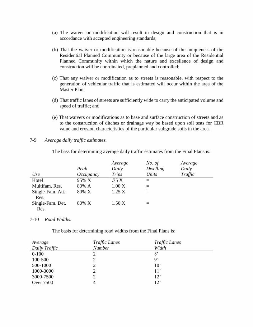
(a) The waiver or modification will result in design and construction that is in
accordance with accepted engineering standards;
(b) That the waiver or modification is reasonable because of the uniqueness of the
Residential Planned Community or because of the large area of the Residential
Planned Community within which the nature and excellence of design and
construction will be coordinated, preplanned and controlled;
(c) That any waiver or modification as to streets is reasonable, with respect to the
generation of vehicular traffic that is estimated will occur within the area of the
Master Plan;
(d) That traffic lanes of streets are sufficiently wide to carry the anticipated volume and
speed of traffic; and
(e) That waivers or modifications as to base and surface construction of streets and as
to the construction of ditches or drainage way be based upon soil tests for CBR
value and erosion characteristics of the particular subgrade soils in the area.
7-9 Average daily traffic estimates.
The bass for determining average daily traffic estimates from the Final Plans is:
Average No. of Average
Peak Daily Dwelling Daily
Use Occupancy Trips Units Traffic
Hotel 95% X .75 X =
Multifam. Res. 80% A 1.00 X =
Single-Fam. Att. 80% X 1.25 X =
Res.
Single-Fam. Det. 80% X 1.50 X =
Res.
7-10 Road Widths.
The basis for determining road widths from the Final Plans is:
Average Traffic Lanes Traffic Lanes
Daily Traffic Number Width
0-100 2 8’
100-500 2 9’
500-1000 2 10’
1000-3000 2 11’
3000-7500 2 12’
Over 7500 4 12’
7-11 Special Provisions:
The provisions hereof shall not be limited by any provisions of any other part of the
Nelson County Zoning or Subdivision Regulations herewith.
Temporary Events conducted wholly within the Residential Planned Community District
(RPC) shall be exempt from Temporary Event Permit requirements. Temporary Events
which involve event operations outside of the RPC District shall be required to comply
with the Temporary Event Permit policies and procedures contained in Article 24.
If following the establishment of a Residential Planned Community, a Final Plan shall be
submitted to the Planning Commission as hereinbefore provided, such Final Plan shall be
deemed approved by the Planning Commission if no action has been taken by the
Planning Commission within sixty (60) days after such submission.
Reserved for future use.

ARTICLE 8. BUSINESS DISTRICT B-1
Statement of intent.
Generally, this district covers that part of the community intended for the conduct of
general business to which the public requires direct and frequent access, but which is not
characterized by constant heavy trucking other than stocking and delivery of retail goods, or by
nuisance factors other than occasioned by incidental light and noise of congregation of people and
passenger vehicles.
8-1 Uses—Permitted by right:
8-1-1 Boardinghouse, hotel, motel
8-1-2 Retail drugstores, feed and seed stores, food sales and restaurants, wearing apparel
shops, auto and home appliance services, banks, barber and beauty shops, hardware
stores, offices and personal and professional services. Wholesale and processing
activities that would be objectionable because of noise, fumes, or dust are excluded.
8-1-3 Fire departments and rescue squad facilities
8-1-4 Funeral home/crematorium
8-1-5 Gasoline filling stations and/or the servicing and minor repairing of motor vehicles
when in an enclosed structure
8-1-6 Golf driving ranges and miniature golf courses
8-1-7 Public garages, for storage and/or repair of motor vehicles when in an enclosed space
8-1-8 Public and semi-public uses, such as churches, church adjunctive graveyards, libraries,
museums, schools, hospitals, post offices and recreational facilities
8-1-9 Schools of special instruction
8-1-10 Veterinarian hospital
8-1-11 Waterfront business activities: wholesale and retail marine activities such as boat
docks, piers, small boat docks, yacht clubs, and servicing facilities for the same;
activities primarily conducted on or about a waterfront. All such uses shall be
contiguous to a waterfront.
8-1-12 Accessory uses as defined
8-1-13 Off-street parking as required by this ordinance
8-1-14 Sale of new and/or used cars
8-1-15 Public utilities: lines, distribution transformers, pipes, meters and other facilities
necessary for the provision and maintenance of public utilities, including water and
sewerage facilities and water storage tanks O2011-
04
8-1-16 Business signs advertising for sale or rent of premises only, up to fifty (50) square feet
in total area
8-1-17 Business signs, up to one hundred fifty (150) square feet in total area. One sign less
than five (5) feet beyond building.
8-1-18 Directional signs, up to two (2) square feet in total area
8-1-19 Location signs, up to one hundred fifty (150) square feet in total area
8-1-20 Automobile graveyard, class A
8-1-21 Flea markets
8-1-22 Communication towers subject to Article 20, Communication Tower Ordinance
8-1-23 Small wind energy system, per requirements in Article 22 of these regulations
O2009-
12
8-1-24 Activity center O2013-
07
8-1-25 Roadside Stand, Class A and B O2016-
01
8-1-26 Farmers Market O2016-
01
8-1-27 Bed and Breakfast, Class A, if the subject property contains an existing non-
conforming dwelling or has an approved Special Use Permit for dwelling units pursuant
to 8-1-10a O2016-
02
8-1-28 Bed and Breakfast, Class B, if the subject property contains an existing non-conforming
dwelling or has an approved Special Use Permit for dwelling units pursuant to 8-1-10a
O2016-
02
8-1-29 Vacation House, if the subject property contains an existing non- conforming dwelling
or has an approved Special Use Permit for dwelling units pursuant to 8-1-10a
O2016-
02
8-1-30 Category 1 Temporary Event O2016-
04
8-1-31 Category 2 Temporary Event O2016-
04
8-1-a Uses—Permitted by Special Use Permit only. O2010-
09
8-1-1a Additional small wind energy system(s), per requirements in Article 22 of these
regulations O2009-
12
8-1-2a Borrow pit
8-1-3a Commercial amusement parks, theaters, commercial assembly halls, public billiard
parlors and pool rooms, bowling alleys, dance halls and similar forms of public
amusement
8-1-4a Farm winery permanent remote retail establishment
8-1-5a Fraternal lodges and community buildings
8-1-6a General advertising signs
8-1-7a Group homes
8-1-8a Hospitals, special care
8-1-9a Lattice structure used to support a wind turbine O2009-
12
8-1-10a Single family dwelling units, two family dwelling units, and multi-family dwelling
units
8-1-11a Distillery O2014-
06
8-1-12a Brewery O2014-
06
8-1-13a Campground O2016-
02
8-1-14a Outdoor Entertainment Venue O2016-
04
8-2 Height regulations.
8-2-1 Buildings may be erected up to thirty-five (35) feet in height from grade.
8-2-2 A public or semi-public building such as a school, church, library, or hospital may be
erected to a height of sixty (60) feet from grade provided that required front, side and
rear yards shall be increased one (1) foot for each foot in height over thirty-five (35)
feet.
8-2-3 Church spires, belfries, cupolas, monuments, chimneys, flues, flagpoles, water storage
tanks and wooden poles for electric, telephone lines and similar lines/cables are
exempt. Television antennae, and radio aerials pursuant to the provisions of Article 20
are also exempt. Parapet walls may be up to four (4) feet above the height of the
building on which the walls rest. O2011-
04
8-2-4 No accessory building which is within ten (10) feet of any property line shall be more
than one (1) story high. All accessory buildings shall be less than the main building in
height.
8-3 Setback regulations.
Buildings or portions of buildings, including porches, shall be located behind the street
right-of-way line. No porch in existence at the time of the adoption of this ordinance
which is between the street right-of-way line and the center of the street can be enclosed
or otherwise altered for any use. Porches must be kept in repair and in a safe condition.
A reasonable setback distance may be required where necessary to provide traffic sight
lines or to preserve or enhance the scenic character of a designed Virginia Scenic
Byway.
8-4 Yard regulations.
8-4-1 The minimum side and rear yards adjoining a boundary of a residential, agricultural or
conservation district shall be ten (10) feet or more.
8-4-2 Accessory uses, including parking areas, shall be located ten (10) feet or more from
side and rear lot lines adjoining a boundary of a residential, agricultural or conservation
district.
8-5 Site plan.
Before a building and zoning permit shall be issued for any use permitted in this district,
a site plan of proposed development shall be approved by the Commission in
conformance with Article 13 of this ordinance.

Reserved for future use.

ARTICLE 8A. BUSINESS DISTRICT B-2
Statement of intent.
Generally, this district in intended to provide for commercial uses, which by nature of their
associated traffic, noise production or lighting are less disruptive than those uses provided for in
B-1.
8A-1 Uses—Permitted by right.
8A-1-1 Boardinghouse
8A-1-2 Banks
8A-1-3 Fire departments and rescue squads
8A-1-4 Funeral homes
8A-1-5 Public and semi-public uses, such as churches, church adjunctive graveyards, libraries,
museums, schools, hospitals, post offices, and recreational facilities
8A-1-6 Veterinary hospital (indoor kennels only)
8A-1-7 Accessory uses as defined
8A-1-8 Off-street parking as required by this ordinance
8A-1-9 Fraternal lodges and community buildings
8A-1-10 Public utilities
8A-1-11 Professional office buildings
8A-1-12 Communication towers, subject to Article 20, Communication Tower Ordinance
8A-1-13 Small wind energy system, per requirements in Article 22 of these regulations
O2009-
12
8A-1-14 Activity center O2013-
07
8A-1-15 Roadside Stand, Class A and B O2016-
01
8A-1-16 Farmers Market O2016-
01
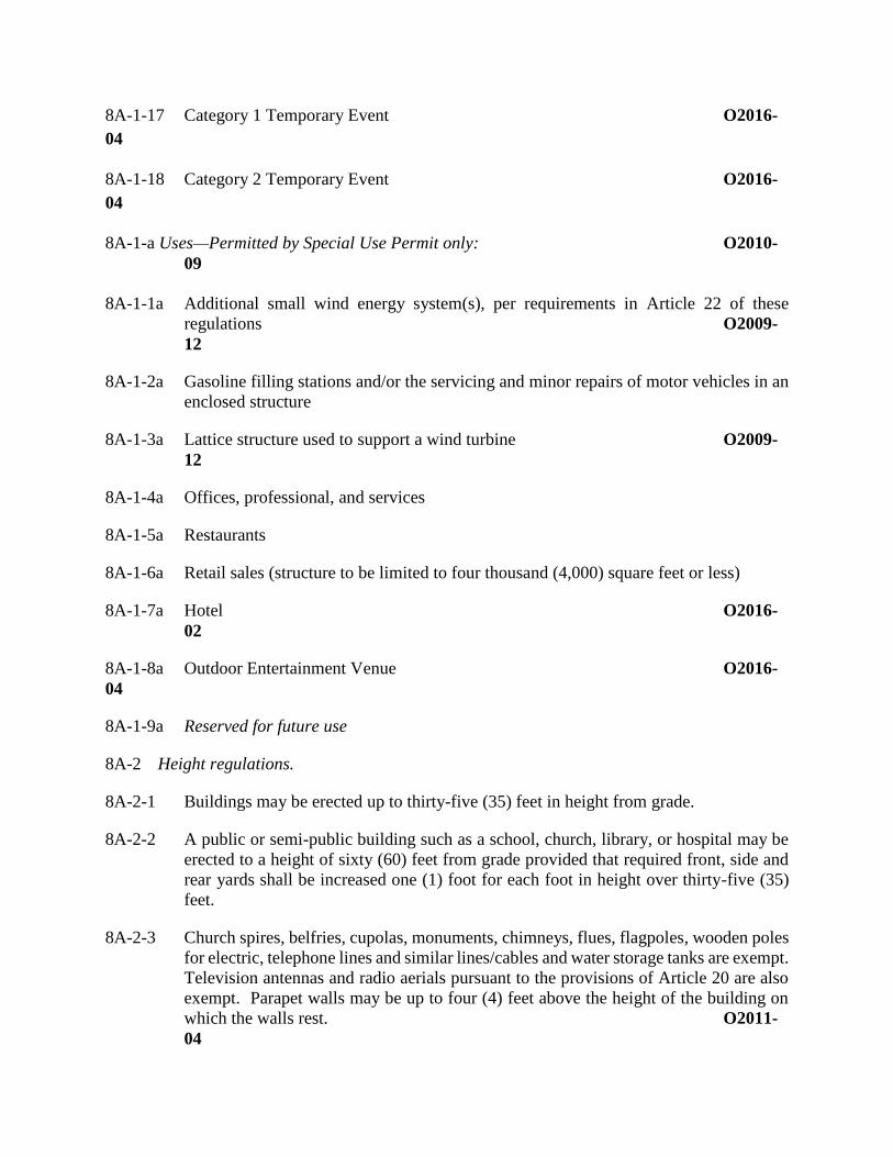
8A-1-17 Category 1 Temporary Event O2016-
04
8A-1-18 Category 2 Temporary Event O2016-
04
8A-1-a Uses—Permitted by Special Use Permit only: O2010-
09
8A-1-1a Additional small wind energy system(s), per requirements in Article 22 of these
regulations O2009-
12
8A-1-2a Gasoline filling stations and/or the servicing and minor repairs of motor vehicles in an
enclosed structure
8A-1-3a Lattice structure used to support a wind turbine O2009-
12
8A-1-4a Offices, professional, and services
8A-1-5a Restaurants
8A-1-6a Retail sales (structure to be limited to four thousand (4,000) square feet or less)
8A-1-7a Hotel O2016-
02
8A-1-8a Outdoor Entertainment Venue O2016-
04
8A-1-9a Reserved for future use
8A-2 Height regulations.
8A-2-1 Buildings may be erected up to thirty-five (35) feet in height from grade.
8A-2-2 A public or semi-public building such as a school, church, library, or hospital may be
erected to a height of sixty (60) feet from grade provided that required front, side and
rear yards shall be increased one (1) foot for each foot in height over thirty-five (35)
feet.
8A-2-3 Church spires, belfries, cupolas, monuments, chimneys, flues, flagpoles, wooden poles
for electric, telephone lines and similar lines/cables and water storage tanks are exempt.
Television antennas and radio aerials pursuant to the provisions of Article 20 are also
exempt. Parapet walls may be up to four (4) feet above the height of the building on
which the walls rest. O2011-
04
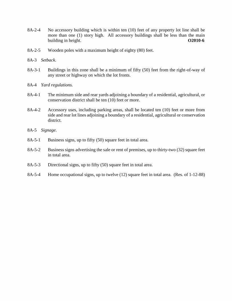
8A-2-4 No accessory building which is within ten (10) feet of any property lot line shall be
more than one (1) story high. All accessory buildings shall be less than the main
building in height. O2010-6
8A-2-5 Wooden poles with a maximum height of eighty (80) feet.
8A-3 Setback.
8A-3-1 Buildings in this zone shall be a minimum of fifty (50) feet from the right-of-way of
any street or highway on which the lot fronts.
8A-4 Yard regulations.
8A-4-1 The minimum side and rear yards adjoining a boundary of a residential, agricultural, or
conservation district shall be ten (10) feet or more.
8A-4-2 Accessory uses, including parking areas, shall be located ten (10) feet or more from
side and rear lot lines adjoining a boundary of a residential, agricultural or conservation
district.
8A-5 Signage.
8A-5-1 Business signs, up to fifty (50) square feet in total area.
8A-5-2 Business signs advertising the sale or rent of premises, up to thirty-two (32) square feet
in total area.
8A-5-3 Directional signs, up to fifty (50) square feet in total area.
8A-5-4 Home occupational signs, up to twelve (12) square feet in total area. (Res. of 1-12-88)
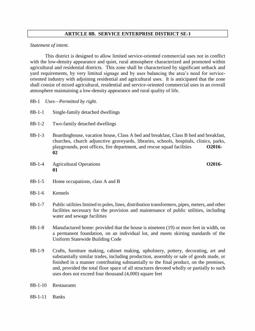
ARTICLE 8B. SERVICE ENTERPRISE DISTRICT SE-1
Statement of intent.
This district is designed to allow limited service-oriented commercial uses not in conflict
with the low-density appearance and quiet, rural atmosphere characterized and promoted within
agricultural and residential districts. This zone shall be characterized by significant setback and
yard requirements, by very limited signage and by uses balancing the area’s need for service-
oriented industry with adjoining residential and agricultural uses. It is anticipated that the zone
shall consist of mixed agricultural, residential and service-oriented commercial uses in an overall
atmosphere maintaining a low-density appearance and rural quality of life.
8B-1 Uses—Permitted by right.
8B-1-1 Single-family detached dwellings
8B-1-2 Two-family detached dwellings
8B-1-3 Boardinghouse, vacation house, Class A bed and breakfast, Class B bed and breakfast,
churches, church adjunctive graveyards, libraries, schools, hospitals, clinics, parks,
playgrounds, post offices, fire department, and rescue squad facilities O2016-
02
8B-1-4 Agricultural Operations O2016-
01
8B-1-5 Home occupations, class A and B
8B-1-6 Kennels
8B-1-7 Public utilities limited to poles, lines, distribution transformers, pipes, meters, and other
facilities necessary for the provision and maintenance of public utilities, including
water and sewage facilities
8B-1-8 Manufactured home: provided that the house is nineteen (19) or more feet in width, on
a permanent foundation, on an individual lot, and meets skirting standards of the
Uniform Statewide Building Code
8B-1-9 Crafts, furniture making, cabinet making, upholstery, pottery, decorating, art and
substantially similar trades, including production, assembly or sale of goods made, or
finished in a manner contributing substantially to the final product, on the premises,
and, provided the total floor space of all structures devoted wholly or partially to such
uses does not exceed four thousand (4,000) square feet
8B-1-10 Restaurants
8B-1-11 Banks
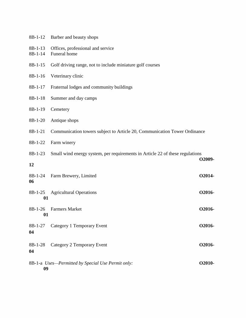
8B-1-12 Barber and beauty shops
8B-1-13 Offices, professional and service
8B-1-14 Funeral home
8B-1-15 Golf driving range, not to include miniature golf courses
8B-1-16 Veterinary clinic
8B-1-17 Fraternal lodges and community buildings
8B-1-18 Summer and day camps
8B-1-19 Cemetery
8B-1-20 Antique shops
8B-1-21 Communication towers subject to Article 20, Communication Tower Ordinance
8B-1-22 Farm winery
8B-1-23 Small wind energy system, per requirements in Article 22 of these regulations
O2009-
12
8B-1-24 Farm Brewery, Limited O2014-
06
8B-1-25 Agricultural Operations O2016-
01
8B-1-26 Farmers Market O2016-
01
8B-1-27 Category 1 Temporary Event O2016-
04
8B-1-28 Category 2 Temporary Event O2016-
04
8B-1-a Uses—Permitted by Special Use Permit only: O2010-
09

8B-1-1a Additional small wind energy system(s), per requirements in Article 22 of these
regulations O2009-
12
8B-1-2a Amusement park, theater, bowling alleys, dance halls, and similar forms of public
amusement
8B-1-3a Blacksmith shops (Res. of 9-11-
90)
8B-1-4a Convenience store
8B-1-5a Farm winery permanent remote retail establishment
8B-1-6a Gasoline filling stations and/or servicing and minor repair of motor vehicles in an
enclosed structure
8B-1-7a Hotel and motel
8B-1-8a Lattice structure used to support a wind turbine O2009-
12
8B-1-9a Multi-family dwelling
8B-1-10a Reserved for future use O2016-
01
8B-1-11a Activity center O2013-
07
8B-1-12a Distillery O2014-
06
8B-1-13a Brewery O2014-
06
8B-1-14a Campground O2016-
02
8B-1-15a Outdoor Entertainment Venue O2016-
04
8B-2 Regulations for SE-1 zone.
8B-2-1 Height: The maximum height of any building shall be thirty-five (35) feet from grade.
Church spires, belfries, cupolas, monuments, water storage tanks, chimneys, flues,
flagpoles and wooden poles for electric, telephone lines and similar lines, are exempt.
Television antennas and radio aerials pursuant to Article 20 are also exempt.
O2011-
04
8B-2-2 Setback: Commercial Residential
Buildings Buildings
8B-2-2a Front: 75 feet from the right of way 25 feet from the right
For public street, road or of way for a public or
Highway. Private road.
8B-2-2b Side: 25 feet 25 feet
8B-2-2c Rear: 25 feet 25 feet
8B-2-2d Corner Lot: (As defined in Article 2 “Definitions”)
8B-2-2e Front: 75 feet from the right of way 35 feet from the right
for public street, road. of way for a public,
private street or road.
8B-2-2f Side: 75 feet from the right of way 35 feet from the right
for a public street or road. of way for a public
private street or road.
8B-2-2g 25 feet from any side yard that 25 feet from any side
having no frontage on a public yard having no frontage on
street, or road. a public, private street or
road.
8B-2-3 Area: No lot shall be smaller than forty thousand (40,000) square feet.
8B-2-4 Frontage: No lot shall have less than one hundred twenty-five (125) feet of road
frontage.
8B-2-5 Yard: No side yard shall be less than twenty-five (25) feet. No rear yard shall be less
than twenty-five (25) feet.
8B-2-7 Parking: All parking areas shall be screened with vegetation where necessary to screen
the parking area from view from the street and adjoining lots. Not to be located in front
of the setback line.
8B-2-8 Signage: Signs within this zone shall be permitted and limited on a case-by-case basis,
as part of the “Site Review” process, except that no sign shall be larger than those
permitted in an Agricultural Zone.
8B-2-9 Non-conforming lots: Any lot not conforming with the regulations of this article as of
its effective date shall be exempt from conformance, except upon any change in use of
the lot requiring submission of a site plan.
8B-2-10 Site plan: A site plan shall be required upon any change in use from residential or
farming to any other use permitted by right or by special use permit under this article.
A site plan shall be required for any expansion of an existing nonresidential or non-
farm use entailing an increase of twenty (20) percent or more in square footage of any
building or buildings devoted in whole or in any part to such use. The site plan shall
conform to the requirements of Article 13 of this ordinance, shall show the intended
use of the property, and shall show compliance with the regulations of this Article.

Reserved for future use.
ARTICLE 9. INDUSTRIAL DISTRICT M-2
Statement of intent.
This district is established primarily for industrial operations and for heavy commercial
operations, which may create some nuisance, and which are not particularly compatible with
residential, institutional, or retail commercial uses.
9-1 Uses—Permitted by right.
9-1-1 Assembly of electrical appliances, electronic instruments and devices, radios and
phonographs. Also, the manufacture of small parts such as coils, condensers,
transformers, and crystal holders, and other similar manufacture.
9-1-2 Automobile assembling, painting, upholstering, repairing, rebuilding, reconditioning,
body and fender work, truck repairing or overhauling, tire retreading or recapping, or
battery manufacture
9-1-3 Blacksmith shop, welding or machine shop, excluding punch presses exceeding forty-
ton rated capacity and drop hammers
9-1-4 Fabrication of metal products
9-1-5 Laboratories, pharmaceutical and/or medical
9-1-6 Manufacture, compounding, processing, packaging or treatment of such products as
bakery goods, candy, cosmetics, dairy products, drugs, perfumes, pharmaceuticals,
perfumed toilet soap, toiletries, and food products other than a food or meat packing or
processing plant
9-1-7a Manufacture, compounding, assembling, or treatment of articles of merchandise from
the following previously prepared materials: bone, cellophane, canvas, cloth, cork,
feathers, felt, fiber, fur, glass, hair, horn, leather, paper, plastic, precious or
semiprecious metals or stone, shell, straw, textiles, tobacco, wood, yarn, and paint
9-1-7b Vegetative rubbish recycling facility
9-1-8 Manufacture of pottery and figurines or other similar ceramic products, using only
previously pulverized clay, and kilns fired only by electricity or gas
9-1-9 Manufacture of musical instruments, toys, novelties, and rubber and metal stamps
9-1-10 Building materials, plumbing supplies, storage yards with or without sales
9-1-11 Coal and wood yards, lumberyards, feed and seed stores
9-1-12 Contractors’ equipment storage yard or plant, or rental of equipment commonly used
by contractors
9-1-13 Cabinet, furniture and upholstery shops
9-1-14 Draying and freighting or trucking yard or terminal
9-1-15 Cotton spinning mills
9-1-16 Boat building
9-1-17 Stone works
9-1-18 Glass manufacture
9-1-19 Sawmill
9-1-20 Veterinary or dog or cat hospital, kennels
9-1-21 Wholesale businesses, storage warehouse
9-1-22 Public utility: Generating, booster or relay stations, transformer substations,
transmission lines with support structures, wooden poles for electric, telephone lines
and similar lines and other facilities for the provision and maintenance of public
utilities, including railroads and facilities, water and sewerage installations and water
storage tanks O2011-04
9-1-23 Business signs advertising sale or rent of premises only. Up to sixty-four (64) square
feet
9-1-24 Business signs. Up to sixty-four (64) square feet
9-1-25 Directional signs
9-1-26 Location signs
9-1-27 Automobile graveyard, class B
9-1-28 Communication towers subject to Article 20, Communication Tower Ordinance
9-1-29 Small wind energy system, per requirement in Article 22 of these regulations
O2009-12
9-1-30 Distillery O2014-06
9-1-31 Brewery O2014-06
9-1-32 Winery O2017-02
9-1-a Uses—Permitted by Special Use Permit only: O2010-09
9-1-1a Abattoir
9-1-2a Airport
9-1-3a Automobile graveyard, class C
9-1-4a Borrow Pit
9-1-5a Food or meat packing or processing plant
9-1-6a General advertising signs
9-1-7a Lattice structure used to support a wind turbine. O2009-12
9-1-8a Public and/or private penal, detention facilities
9-1-9a Quarrying
9-1-10a Restaurant
9-1-11a Two or more small wind energy systems(s), per requirements in Article 22 of these
regulations O2011-04
9-1-12a Composting, Commercial O2011-01
9-1-13 Small wind energy system(s) on a parcel of land 20 acres or larger in size with a height
greater than 100 feet but less than 199 feet O2011-04
9-1-14 Reserved for future use
9-1-14a Residential quarters for bona fide caretaker O2013-07
9-2 Requirements for permitted uses.
9-2-1 Permitted uses may be required to be conducted wholly within a completely enclosed
building or within an area enclosed on all sides by a solid board fence or an evergreen
hedge between six (6) and ten (10) feet in height.
9-2-2 Landscaping may be required within any established or required front setback area.
The plans and execution must take into consideration traffic hazards. Landscaping may
be permitted up to a height of three (3) feet, and to within fifty (50) feet from the corner
of any intersecting streets.
9-2-3 Sufficient area shall be provided to screen adequately permitted uses from adjacent
business and residential district and for off-street parking of vehicles incidental to the
industry, its employees and clients.
9-2-4 Automobile graveyards and junkyards in existence at the time of the adoption of this
ordinance are to be considered as non-conforming uses. They shall be allowed up to
three (3) years after adoption of this ordinance in which to screen completely, on any
open side, the operation or use by a masonry wall, a uniformly painted solid board
fence, or an evergreen hedge six (6) feet in height.
9-2-5 The Administrator shall act on any application received within thirty (30) days after
receiving the application. Failure on the part of the Administrator to act on the
application within the established time limit shall be deemed to constitute approval of
the application.
9-3 Setback regulations.
No setback required except that a reasonable distance may be required where necessary
to provide traffic sight lines or to preserve or to enhance the scenic character of a
designated Virginia Byway.
9-4 Yard regulations.
The minimum side and rear yards adjoining a boundary of a residential, agricultural or
conservation district shall be twenty (20) feet or more.
9-5 Site plan.
Before a building and zoning permit shall be issued, a site plan of proposed
development shall be approved by the Commission in conformance with Article 13 of
this ordinance.

ARTICLE 10. GENERAL FLOODPLAIN DISTRICT FP
10.1 Purpose.
This ordinance is adopted pursuant to the authority granted to localities by Va. Code
§15.2 – 2280. The purpose of these provisions is to prevent the loss of life and property, the
creation of health and safety hazards, the disruption of commerce and governmental services, the
extraordinary and necessary expenditure of public funds for flood protection and relief, and the
impairment of the tax base by:
A. Regulating uses, activities, and development which, alone or in combination with other
existing or future uses, activities, and development, will cause unacceptable increases in
flood heights, velocities, and frequencies.
B. Restricting or prohibiting certain uses, activities, and development from locating within
districts subject to flooding.
C. Requiring all those uses, activities, and developments that do occur in flood-prone
districts to be protected and/or flood-proofed against flooding and flood damage.
D. Protecting individuals from buying land and structures which are unsuited for intended
purposes because of flood hazards.
10.2 Applicability.
These provisions shall apply to all lands within the jurisdiction of Nelson County and
identified as being in the 100-year floodplain by the Federal Insurance Administration.
10.3 Compliance and liability.
A. No land shall hereafter be developed and no structure shall be located, relocated,
constructed, reconstructed, enlarged, or structurally altered except in full compliance with
the terms and provisions of this ordinance and any other applicable ordinances and
regulations, which apply to uses within the jurisdiction of this ordinance.
B. The degree of flood protection sought by the provisions of this ordinance is
considered reasonable for regulatory purposes and is based on acceptable engineering
methods of study. Larger floods may occur on rare occasions. Flood heights may be
increased by manmade or natural causes, such as ice jams and bridge openings restricted
by debris. This ordinance does not imply that districts outside the floodplain district or
that land uses permitted within such district will be free from flooding or flood damages.
C. Records of actions associated with administering this ordinance shall be kept on file and
maintained by the Floodplain Administrator.
D. This ordinance shall not create liability on the part of Nelson County or any officer or
employee thereof for any flood damages that result from reliance on this ordinance
or any administrative decision lawfully made hereunder.
10.4 Abrogation and greater restrictions.
This ordinance supersedes any ordinance currently in effect in flood prone districts.
However, any underlying ordinance shall remain in full force and effect to the extent that its
provisions are more restrictive than this ordinance.
10.5 Severability.
If any section, subsection, paragraph, sentence, clause, or phrase of this ordinance shall
be declared invalid for any reason whatever, such decision shall not affect the remaining portions
of this ordinance. The remaining portions shall remain in full force and effect and for this
purpose, the provisions of this ordinance are hereby declared to be severable.
10.6 Penalties.
A. Any person who fails to comply with any of the requirements or provisions of this
ordinance or directions of the F lo o d p la in A d m in is tr a to r or any other
authorized employee of Nelson County shall be guilty of a misdemeanor and subject to
the penalties as provided in Section 15-2 of the Zoning Ordinance.
B. In addition to the above penalties, all other actions are hereby reserved, including an
action of equity for the proper enforcement of this ordinance. The imposition of a fine or
penalty for any violation of, or noncompliance with, this ordinance shall not excuse the
violation or noncompliance to permit it to continue, and all such persons shall be required
to correct or remedy such violations or noncompliance within a reasonable time. Any
structure constructed, reconstructed, enlarged, altered or relocated in noncompliance with
this ordinance may be declared by the Board of Supervisors to be a public nuisance and
abatable as such. Flood insurance may be withheld from structures constructed in
violation of this ordinance.
10.7 Definitions.
For the purpose of this Article, words and terms are defined as follows:
Appurtenant or accessory structure: Accessory structures not to exceed 200 sq. ft.
Base flood: The flood having a one percent chance of being equaled or exceeded in any given
year.
Base Flood Elevations (BFE): The Federal Emergency Management Agency designated one
hundred (100)-year water surface elevation. The water surface elevation of the base flood in
relation to the datum specified on the community’s Flood Insurance Rate Map. For the purposes
of this ordinance, the one hundred (100) year flood or 1% annual chance flood.
Basement: Any area of the building having its floor sub-grade (below ground level) on all sides.
Board of Zoning Appeals: The board appointed to review appeals made by individuals with
regard to decisions of the zoning administrator in the interpretation of this ordinance, and to
review and approve Variances (as appropriate) as explicitly specified in this ordinance.
Building: Any structure having a roof supported by columns or walls and intended for the
shelter, housing, or enclosure of any individual, animal, process, equipment, goods, or equipment
of any kind.
Critical facilities: Structures, improvements, or uses that, by virtue of their importance to the
community and/or their sensitivity to the risks of flooding, are prohibited from being located
within any Special Flood Hazard Area unless a Variance is granted. Critical facilities include but
are not limited to: emergency services and rescue squads, schools, medical facilities, senior care
centers, evacuation centers, hazardous materials or fuel storage, and other similar improvements
and uses. See 10.14 and 10.15.
Development: Any man made change to improved or unimproved real estate, including, but not
limited to, buildings or other structures, mining, dredging, filling, grading, paving, excavation or
drilling operations, or storage of equipment or materials.
Drop-down Fence: A fence design that gives way under the pressure of flood flows to lay flat on
the ground, and which can be re-erected after the flood.
Elevated building: A non-basement building built to have the lowest floor elevated above the
ground level by means of fill, solid foundation perimeter walls, pilings, or columns (posts and
piers).
Encroachment: The advance or infringement of uses, plant growth, fill, excavation, buildings,
permanent structures or development into a floodplain, which may impede or alter the flow
capacity of a floodplain.
Existing construction: For the purposes of determining rates, structures for which the “start of
construction” commenced before August 1, 1978. “Existing construction” may also be referred
to as “existing structures.” O2010-4
Existing manufactured home park or subdivision: A manufactured home park or subdivision for
which the construction of facilities for servicing the lots on which the manufactured homes are to
be affixed (including, at a minimum, the installation of utilities, the construction of streets, and
either final site grading or the pouring of concrete pads) is completed before the effective date of
the floodplain management regulations adopted by a community. O2010-4
Expansion to an existing manufactured home park or subdivision: The preparation of additional
sites by the construction of facilities for servicing the lots on which the manufactured homes are
to be affixed (including the installation of utilities, the construction of streets, and either final site
grading or the pouring of concrete pads). O2010-4
Flood or flooding:
(a) A general or temporary condition of partial or complete inundation of normally dry land
areas from:
(1) the overflow of inland or tidal waters; or
(2) the unusual and rapid accumulation or runoff of surface waters from any source; or
(3) mudslides (i.e. mudflows) which are proximately caused by flooding as defined in
paragraph (a) (2) of this definition and are akin to a river of liquid and flowing mud
on the surfaces of normally dry land areas, as when earth is carried by a current of
water and deposited along the path of the current.
(b) The collapse or subsidence of land along the shore of a lake or other body of water as a
result of erosion or undermining caused by waves or currents of water exceeding
anticipated cyclical levels or suddenly caused by an unusually high water level in a
natural body of water, accompanied by a severe storm, or by an unanticipated force of
nature such as a flash flood, or by some similarly unusual and unforeseeable event which
results in flooding as defined in (a) (1) of this definition.
Flood-prone area: Any land area susceptible to being inundated by water from any source.
Flood Insurance Rate Map (FIRM): An official map of a community, on which the Federal
Emergency Management Agency has delineated both the special hazard areas and the risk
premium zones applicable to the community. A FIRM that has been made available digitally is
called a Digital Flood Insurance Rate Map (DFIRM).
Flood Insurance Study (FIS): a report by FEMA that examines, evaluates and determines flood
hazards and, if appropriate, corresponding water surface elevations, or an examination,
evaluation and determination of mudflow and/or flood-related erosion hazards.
Floodplain:
(a) A relatively flat or lowland area adjoining a river, stream or watercourse which is subject
to partial or complete inundation;
(b) An area subject to the unusual and rapid accumulation or runoff of surface water from
any source.
Flood-proofing: Any combination of structural and non-structural additions, changes, or
adjustments to structures which reduce or eliminate flood damage to real estate or improved real
property, water and sanitary facilities, structures and their contents.
Floodway: The channel of a river or other watercourse and the adjacent land areas that must be
reserved in order to discharge the base flood without cumulatively increasing the water surface
elevation more than one foot at any point within the community.
Freeboard: A factor of safety usually expressed in feet above a flood level for purposes of
floodplain management. “Freeboard” tends to compensate for the many unknown factors that
could contribute to flood heights greater than the height calculated for a selected size flood and
floodway conditions, such as wave action, bridge openings, and the hydrological effect of
urbanization in the watershed.
Functionally dependent use: A use which cannot perform its intended purpose unless it is located
or carried out in close proximity to water. This term includes only docking facilities, port
facilities that are necessary for the loading and unloading of cargo or passengers, and
shipbuilding and ship repair facilities, but does not include long-term storage or related
manufacturing facilities.
Highest adjacent grade: The highest natural elevation of the ground surface prior to construction
next to the proposed walls of a structure.
Historic structure: Any structure that is:
(a) listed individually in the National Register of Historic Places (a listing maintained by the
Department of Interior) or preliminarily determined by the Secretary of the Interior as
meeting the requirements for individual listing on the National Register;
(b) certified or preliminarily determined by the Secretary of the Interior as contributing to the
historical significance of a registered historic district or a district preliminarily
determined by the Secretary to qualify as a registered historic district;
(c) individually listed on a state inventory of historic places in states with historic
preservation programs which have been approved by the Secretary of the Interior; or
(d) individually listed on a local inventory of historic places in communities with historic
preservation programs that have been certified either:
(1) by an approved state program as determined by the Secretary of the Interior; or
(2) directly by the Secretary of the Interior in states without approved programs.
Hydrologic and Hydraulic Engineering Analysis: Analyses performed by a licensed professional
engineer, in accordance with standard engineering practices that are accepted by the Virginia
Department of Conservation and Recreation and FEMA, used to determine the base flood, other
frequency floods, flood elevations, floodway information and boundaries, and flood profiles.
Letters of Map Change (LOMC): A Letter of Map Change is an official FEMA determination, by
letter, that amends or revises an effective Flood Insurance Rate Map or Flood Insurance Study.
Letters of Map Change include Letters of Map Amendment (LOMA), Letters of Map Revision
(LOMR), and Conditional Letters of Map Revision.
Letter of Map Amendment (LOMA): An amendment based on technical data showing that a
property was incorrectly included in a designated Special Flood Hazard Area. A LOMA amends
the current effective Flood Insurance Rate Map and establishes that a land as defined by meets
and bounds or structure is not located in a Special Flood Hazard Area.
Letter of Map Revision (LOMR): A revision based on technical data that may show changes to
flood zones, flood elevations, floodplain and floodway delineations, and planimetric features. A
Letter of Map Revision Based on Fill (LOMR-F), is a determination that a structure or parcel of
land has been elevated by fill above the base flood elevation and is, therefore, no longer exposed
to flooding associated with the base flood. In order to qualify for this determination, the fill must

have been permitted and placed in accordance with the community’s floodplain management
regulations.
Conditional Letter of Map Revision (CLOMR): A formal review and comment as to whether a
proposed flood protection project or other project complies with the minimum NFIP
requirements for such projects with respect to delineation of Special Flood Hazard Areas. A
CLOMR does not
revise the effective Flood Insurance Rate Map or Flood Insurance Study.
Lowest adjacent grade: the lowest natural elevation of the ground surface next to the walls of a
structure.
Lowest floor: The lowest floor of the lowest enclosed area (including basement). An unfinished
or flood-resistant enclosure, usable solely for parking of vehicles, building access or storage in
an area other than a basement area is not considered a building’s lowest floor; provided, that
such enclosure is not built so as to render the structure in violation of the applicable non-
elevation design requirements of Federal Code 44CFR §60.3.

Manufactured home: A structure, transportable in one or more sections, which is built on a
permanent chassis and is designed for use with or without a permanent foundation when
connected to the required utilities. For floodplain management purposes the term “manufactured
home” also includes park trailers, travel trailers, and other similar vehicles placed on a site for
greater than 180 consecutive days.
Manufactured home park/subdivision: A parcel (or contiguous parcels) of land divided into two
or more manufactured home lots for rent or sale. O2010-4
New construction: For the purposes of determining insurance rates, structures for which the
“start of construction” commenced on or after August 1, 1978 (the effective date of the initial
FIRM) and includes any subsequent improvements to such structures. For floodplain
management purposes, new construction means structures for which the start of construction
commenced on or after the effective date of a floodplain management regulation adopted by a
community and includes any subsequent improvements to such structures. Such structure is also
referred to as “post-FIRM.” O2010-4
New manufactured home park or subdivision: A manufactured home park or subdivision for
which the construction of facilities for servicing the lots on which the manufactured homes are to
be affixed (including at a minimum, the installation of utilities, the construction of streets, and
either final site grading or the pouring of concrete pads) is completed on or after the effective
date of floodplain management regulations adopted by a community. O2010-4
Post-FIRM structures: A structure for which construction or substantial improvement occurred
after August 1, 1978.
Pre-FIRM structures: A structure for which construction or substantial improvement occurred on
or before August 1, 1978.
Recreational vehicle: A vehicle which is:
(a) built on a single chassis;
(b) four hundred (400) square feet or less when measured at the largest horizontal
projection;
(c) designed to be self-propelled or permanently towable by a light duty truck; and
(d) designed primarily not for use as a permanent dwelling but as temporary living quarters
for recreational camping, travel, or seasonal use.
Repetitive Loss Structure: A building covered by a contract for flood insurance that has incurred
flood-related damages on two occasions in a 10-year period, in which the cost of the repair, on
the average, equaled or exceeded 25 percent of the market value of the structure at the time of
each such flood event; and at the time of the second incidence of flood-related damage, the
contract for flood insurance contains increased cost of compliance coverage.
Severe repetitive loss structure: A structure that:
(a) is covered under a contract for flood insurance made available under the NFIP; and
(b) has incurred flood related damage –
(1) for which 4 or more separate claims payments have been made under flood insurance
coverage with the amount of each such claim exceeding $5,000, and with the
cumulative amount of such claims payments exceeding $20,000; or
(2) for which at least 2 separate claims payments have been made under such coverage,
with the cumulative amount of such claims exceeding the market value of the insured
structure.
Shallow flooding area: A Special Flood Hazard Area with base flood depths from one to three
feet where a clearly defined channel does not exist, where the path of flooding is unpredictable
and indeterminate, and where velocity flow may be evident. Such flooding is characterized by
ponding or sheet flow.
Special Flood Hazard Area: The land in the floodplain subject to a one (1%) percent or greater
chance of being flooded in any given year as determined in Section 10.8.A.1 of this ordinance.
O2010-4
Start of construction: The date the building permit was issued, provided the actual start of
construction, repair, reconstruction, rehabilitation, addition, placement, or other improvement
was within one hundred eighty (180) days of the permit date. The actual start means either the
first placement of permanent construction of a structure on a site, such as the pouring of slab or
footings, the installation of piles, the construction of columns, or any work beyond the stage of
excavation; or the placement of a manufactured home on a foundation. Permanent construction
does not include land preparation, such as clearing, grading and filling; nor does it include the
installation of streets and/or walkways; nor does it include excavation for a basement, footings,
piers, or foundations or the erection of temporary forms; nor does it include the installation on
the property of accessory buildings, such as garages or sheds not occupied as dwelling units or
not part of the main structure. For a substantial improvement, the actual start of construction
means the first alteration of any wall, ceiling, floor, or other structural part of a building, whether
or not the alteration affects the external dimensions of the building.
Structure: For floodplain management purposes, a walled and roofed building, including a gas or
liquid storage tank, that is principally above ground, as well as a manufactured home.
O2010-4
Substantial damage: Damage of any origin sustained by a structure whereby the cost of restoring
the structure to its predamaged condition would equal or exceed fifty (50) percent of the market
value of the structure before the damage occurred.
Substantial improvement: Any reconstruction, rehabilitation, addition, or other improvement of a
structure, the cost of which equals or exceeds fifty (50) percent of the market value of the
structure before the “start of construction” of the improvement. This term includes structures
which have
APPENDIX A - ZONING
incurred repetitive loss or substantial damage regardless of the actual repair work performed. The
term does not, however, include either:
(a) any project for improvement of a structure to correct existing violations of state or local
health, sanitary, or safety code specifications which have been identified by the local code
enforcement official and which are the minimum necessary to assure safe living
conditions; or
(b) any alteration of a “historic structure,” provided that the alteration will not preclude the
structures continued designation as a “historic structure.”
(c) Historic structures undergoing repair or rehabilitation that would constitute a substantial
improvement, as defined above, must comply with all ordinance requirements that do not
preclude the structure’s continued designation as a historic structure. Documentation that a
specific ordinance requirement will cause removal of the structure from the National
Register of Historic Places or the State Inventory of Historic places must be obtained from
the Secretary of the Interior or the State Historic Preservation Officer. Any exemption
from ordinance requirements will be the minimum necessary to preserve the historic
character and design of the structure.
Suspended cable fence: A steel cable or chain suspended across the waterway between two
secured posts. From the cable a fence made of galvanized chain, chain mesh, galvanized mesh or
prefabricated fencing or netting is attached. The suspended cable remains taut during the flood
while the flood gate fence remains flexible and rises with the flow. Some variations of the flood
gate fence have foam or plastic floats at the bottom of the fence to aid in flotation on the surface
of the flood flow.
Variance: For the purposes of this Article 10, a variance is a grant of relief by a community from
the terms of a floodplain management regulation.
Violation: The failure of a structure or other development to be fully compliant with the
community's floodplain management regulations. A structure or other development without the
elevation certificate, other certifications, or other evidence of compliance required in this
ordinance is presumed to be in violation until such time as that documentation is provided.
Watercourse: A lake, river, creek, stream, wash, channel, or other topographic feature on or
over which waters flow at least periodically. Watercourse includes specifically designated areas in
which substantial flood damage may occur.
10.8 Establishment of Floodplain Districts.
A. Description of districts.
1. Basis of districts. The various floodplain districts shall include special flood hazard
areas. The basis for the delineation of these districts shall be the Flood Insurance Study
(FIS) and the Flood Insurance Rate Maps (FIRM) for Nelson County, prepared by
the Federal Emergency Management Agency, Federal Insurance Administration, dated
June 18, 2010 and any subsequent revisions or amendments thereto.
The boundaries of the Special Flood Hazard Area and Floodplain Districts are
established as shown on the Flood Insurance Rate Map which is declared to be a part
of this ordinance and which shall be kept on file at the Nelson County Planning and
Zoning office.
APPENDIX A - ZONING
2. The Floodway District is delineated, for purposes of this ordinance, using the criterion
that certain areas within the floodplain must be capable of carrying the waters of the
one hundred (100)-year flood without increasing the water surface elevation of that
flood more than one (1) foot at any point. The areas included in this District are
specifically defined in Table 4 of the above-referenced Flood Insurance Study and
shown on the accompanying Flood Insurance Rate Map.
3. The Special Floodplain District shall be those areas identified as an AE Zone on the
maps accompanying the Flood Insurance Study for which one hundred (100)-year
flood elevations have been provided.
4. The Approximated Floodplain District shall be those areas identified as an A or A99
Zone on the maps accompanying the Flood Insurance Study. In these zones, no
detailed flood profiles or elevations are provided, but the one hundred (100)-year
floodplain boundary has been approximated. For these areas, the one hundred (100)-
year flood elevations and floodway information from federal, state, and other
acceptable sources shall be used, when available. Where the specific one hundred
(100)-year flood elevation cannot be determined for this area using other sources of
data, such as the U.S. Army Corps of Engineers Flood Plain Information Reports, U.S.
Geological Survey Flood-prone Quadrangles, etc., then the applicant for the proposed
use, development and/or activity shall determine this elevation in accordance with
hydrologic and hydraulic engineering techniques. Hydrologic and hydraulic analyses
shall be undertaken only by professional engineers or others of demonstrated
qualifications, who shall certify that the technical methods used correctly reflect
currently accepted technical concepts. Studies, analyses, computations, etc., shall be
submitted in sufficient detail to allow a thorough review by the governing body.
B. Overlay concept.
1. The floodplain districts described above shall be overlays to the existing underlying
districts as shown on the Official Zoning Ordinance Map, and as such, the provisions
for the floodplain districts shall serve as a supplement to the underlying district
provisions.
2. Any conflict between the provisions or requirements of the floodplain districts and
those of any underlying district, the more restrictive provisions and/or those
pertaining to the floodplain districts shall apply.
3. In the event any provision concerning a floodplain district is declared inapplicable as a
result of any legislative or administrative actions or judicial decision, the basic
underlying provisions shall remain applicable.
10.9 Official Zoning Map.
The boundaries of the floodplain districts are established as shown on the Flood Insurance
Rate Map dated June 18, 2010 which is declared to be a part of this ordinance and which shall be
kept on file at the Nelson County Planning and Zoning office.
APPENDIX A - ZONING
10.10 District boundary changes.
The delineation of any of the floodplain districts may be revised by the Board of
Supervisors where natural or manmade changes have occurred and/or where more detailed studies
have been conducted or undertaken by the U.S. Army Corps of Engineers or other qualified
agency, or an individual documents the need for such change. However, prior to any such change,
approval must be obtained from the Federal Insurance Administration.
10.11 Interpretation of district boundaries.
Initial interpretations of the boundaries of the floodplain districts shall be made by the
Floodplain Administrator. Should a dispute arise concerning the boundaries of any of the districts,
the Board of Zoning Appeals shall make the necessary determination. The person questioning or
contesting the location of the district boundary shall be given a reasonable opportunity to present
his case to the Board and to submit his own technical evidence if he so desires.
10.12 Submitting Technical Data.
A community’s base flood elevations may increase or decrease resulting from physical
changes affecting flooding conditions. As soon as practicable, but no later than six months after
the date such information becomes available, a community shall notify the Federal Insurance
Administrator of the changes by submitting technical or scientific data. Such a submission is
necessary so that upon confirmation of those physical changes affecting flooding conditions, risk
premium rates and flood plain management requirements will be based upon current data.
10.13 Permit and Application Requirements.
A. Permit requirement. All uses, activities, and development occurring within any floodplain
district, including placement of manufactured homes, shall be undertaken only upon the
issuance of a zoning permit. Such development shall be undertaken only in strict
compliance with the provisions of the ordinance and with all other applicable codes and
ordinances, as amended, such as the Virginia Uniform Statewide Building Code (VA
USBC) and the Nelson County Subdivision Ordinance. Prior to the issuance of any such
zoning permit, the Floodplain Administrator shall require all applications to include
compliance with all applicable state and federal laws, and shall review all sites to assure
they are reasonably safe from flooding. Under no circumstances shall any use, activity,
and/or development adversely affect the capacity of the channels or floodway of
any watercourse, drainage ditch, or any other drainage facility or system.
B. Alteration or relocation of watercourse. Prior to any proposed alteration or relocation of
any channels or of any watercourse, stream, etc., within this jurisdiction a permit shall be
obtained from the U.S. Corps of Engineers, the Virginia State Water Control Board, and
the Virginia Marine Resources Commission (a joint permit application is available from
any of these organizations). Furthermore, notification of the proposal shall be given by the
applicant to all affected adjacent jurisdictions, the Division of Soil and Water
Conservation (Department of Conservation and Recreation), and the Federal Insurance
Administration.
APPENDIX A - ZONING
C. Site plans and permits applications. All applications for zoning permit for development in
the floodplain district and all building permits issued for the floodplain shall incorporate
the information contained in subparagraph 1., 2., 3., 4., and 5., and the Floodplain
Administrator may require the applicant to furnish any and all of the following
information in subparagraphs 6 through 8. As deemed necessary for determining
the suitability of the particular site for the proposed use, the following is required:
1. Plans in triplicate drawn to scale showing the nature, location, dimensions, and
elevation of the lot, existing or proposed structures, fill, storage of materials, flood
proofing measures, and the relationship of the above to the location of the channel,
floodway, and the flood protection elevation.
2. For structures to be elevated, the elevation of the lowest floor (including basement).
3. For structures to be flood proofed (nonresidential only), the elevation to which the
structure will be flood proofed.
4. The elevation of the 100-year flood.
5. Topographic information showing existing and proposed ground elevations.
6. A typical valley cross section showing the channel of the stream, elevation of land
areas adjoining each side of the channel, cross sectional areas to be occupied by the
proposed development, and high water information.
7. Plans (surface view) showing elevations or contours of the ground; pertinent structure,
fill, or storage of all proposed and existing structures on the site; location and
elevations of streets, water supply, sanitary facilities; photographs showing existing
land uses and vegetation upstream and downstream, soil types, and other pertinent
information.
8. Specifications for building construction and materials, flood proofing, filling,
dredging, grading, channel improvement, storage of materials, water supply, and
sanitary facilities.
D. Permitted Uses in the Floodway District. The following non-structural uses and activities
are permitted in any floodplain district and the Floodplain Administrator may waive the
requirements for an application for a zoning permit, provided the uses are in compliance
with the zoning provisions of the underlying area and are not prohibited by any other
ordinance and further provided that they do not require structures, fill, or storage of
materials or equipment:
1. Agricultural uses, such as general farming, pasture, grazing, outdoor plant nurseries,
horticulture, truck farming, forestry, sod farming, and wild crop harvesting.
2. Public and private recreational uses and activities, such as parks, day camps, picnic
grounds, golf courses, boat launching and swimming area, horseback riding and hiking
trails, wildlife and nature preserves, game farms, fish hatcheries, trap and skeet game
ranges, and hunting and fishing areas, but excluding golf courses and other
recreational uses that cause change in land contours.
3. Accessory residential uses, such as yard areas, gardens, play areas, and pervious
loading areas.
4. Flood warning aids and water measurement devices.
10.14 General Standards.
APPENDIX A - ZONING
The following provisions shall apply to all permits:
A. New construction and substantial improvements shall be according to the VA USBC, and
anchored to prevent flotation, collapse or lateral movement of the structure.
B. Manufactured homes shall be anchored to prevent flotation, collapse, or lateral movement.
Methods of anchoring may include, but are not limited to, use of over-the- top or frame
ties to ground anchors. This standard shall be in addition to and consistent with applicable
State anchoring requirements for resisting wind forces.
C. New construction and substantial improvements shall be constructed with materials and
utility equipment resistant to flood damage.
D. New construction or substantial improvements shall be constructed by methods and
practices that minimize flood damage.
E. Electrical, heating, ventilation, plumbing, air conditioning equipment and other service
facilities, including duct work, shall be designed and/or located so as to prevent water
from entering or accumulating within the components during conditions of flooding.
F. New and replacement water supply systems shall be designed to minimize or eliminate
infiltration of flood waters into the system.
G. New and replacement sanitary sewage systems shall be designed to minimize or
eliminate infiltration of flood waters into the systems and discharges from the systems into
flood waters.
H. On-site waste disposal systems shall be located and constructed to avoid impairment to
them or contamination from them during flooding.
In addition to provisions A. – H. above, in all Special Flood Hazard Areas (SFHA), these
additional provisions shall apply:
I. Prior to any proposed alteration or relocation of any channels or of any watercourse,
stream, etc., within this jurisdiction a permit shall be obtained from the U. S. Corps of
Engineers, the Virginia Department of Environmental Quality, and the Virginia Marine
Resources Commission (a joint permit application is available from any of these
organizations). Furthermore, in riverine areas, notification of the proposal shall be given
by the applicant to all affected adjacent jurisdictions, the Department of Conservation and
Recreation (Division of Dam Safety and Floodplain Management) and the Federal
Insurance Administrator.
J. The flood carrying capacity within an altered or relocated portion of any watercourse shall
be maintained.
K. Fences shall be installed parallel to a waterway. When a fence crosses a waterway, it shall
be designed as a drop-down fence or a suspended cable fence.
L. No zoning permit shall be administratively issued by the Floodplain Administrator for any
proposed critical facilities as defined by this ordinance within any SFHA. See 10.7 and
10.15-E. Construction or operation of critical facilities within a SFHA requires a Variance
pursuant to 10.21.
M. No zoning permit shall be administratively issued by the Floodplain Administrator for the
storage of hazardous materials for any time period longer than 30 days within any SFHA.
See 10.7 and 10.15-F. Storage of hazardous materials within a SFHA requires a Variance
pursuant to 10.21.
N. No zoning permit shall be administratively issued by the Floodplain Administrator for the
placement of any non-native fill materials (such as fly ash or other waste by- products)
APPENDIX A - ZONING
within any SFHA. Only locally-borrowed mineral materials may be used as fill within a
SFHA, and all such uses must first obtain the necessary permit approval(s) as required by
this ordinance. Placement of non-native fill materials within a SFHA requires a Variance
pursuant to 10.21.
10.15 Specific Standards.
In all Special Flood Hazard Areas where Base Flood Elevations have been provided in the Flood
Insurance Study or generated according to Section 10.18, the following provisions shall apply:
A. Residential Construction
New construction or substantial improvement of any residential structure (including
manufactured homes) shall have the lowest floor, including basement, elevated eighteen
(18) inches or more above the Base Flood Elevation.
B. Non-Residential Construction
New construction or substantial improvement of any commercial, industrial, or non-
residential building (or manufactured/mobile home) shall have the lowest floor, including
basement, elevated eighteen (18) inches or more above the Base Flood Elevation.
Buildings located in all A1-30, AE, and AH zones may be flood-proofed in lieu of being
elevated provided that all areas of the building components below the elevation
corresponding to the BFE plus one foot are water tight with walls substantially
impermeable to the passage of water, and use structural components having the capability
of resisting hydrostatic and hydrodynamic loads and the effect of buoyancy. A registered
professional engineer or architect shall certify that the
standards of this subsection are satisfied. Such certification, including the specific
elevation (in relation to mean sea level) to which such structures are flood-proofed, shall
be maintained by the Floodplain Administrator.
C. Elevated Buildings – Space Below the Lowest Floor
Fully enclosed areas, of new construction or substantially improved structures, which are
below the regulatory flood protection elevation shall:
1. Not be designed or used for human habitation, but shall only be used for parking of
vehicles, building access, or limited storage of maintenance equipment used in
connection with the premises. Access to the enclosed area shall be the minimum
necessary to allow for parking of vehicles (garage door) or limited storage of
maintenance equipment (standard exterior door), or entry to the living area (stairway
or elevator);
2. Be constructed entirely of flood resistant materials below the regulatory flood
protection elevation;
3. Include, in Zones A, AO, AE, and A1-30, measures to automatically equalize
hydrostatic flood forces on walls by allowing for the entry and exit of floodwaters.
To meet this requirement, the openings must either be certified by a professional
engineer or architect or meet the following minimum design criteria:
a. Provide a minimum of two openings on different sides of each enclosed area
subject to flooding;
b. The total net area of all openings must be at least one (1) square inch for each
APPENDIX A - ZONING
square foot of enclosed area subject to flooding;
c. If a building has more than one enclosed area, each area must have openings to
allow floodwaters to automatically enter and exit;
d. The bottom of all required openings shall be no higher than one (1) foot
above the adjacent grade;
e. Openings may be equipped with screens, louvers, or other opening coverings
or devices, provided they permit the automatic flow of floodwaters in both
directions;
f. Foundation enclosures made of flexible skirting are not considered enclosures
for regulatory purposes, and, therefore, do not require openings. Masonry or
wood underpinning, regardless of structural status, is considered an enclosure
and requires openings as outlined above.
D. Standards for Manufactured Homes and Recreational Vehicles
1. All manufactured homes placed, or substantially improved, on individual lots or
parcels, in expansions to existing manufactured home parks or subdivisions, in a new
manufactured home park or subdivision or in an existing manufactured home park or
subdivision on which a manufactured home has incurred substantial damage as the
result of a flood, must meet all the requirements for new construction, including the
elevation and anchoring requirements in Section 10.13 A. and B. and Section 10.15 A.
2. All recreational vehicles placed on sites must either:
a. be on the site for fewer than 180 consecutive days, be fully licensed and ready
or highway use (a recreational vehicle is ready for highway use if it is on its
wheels or jacking system, is attached to the site only by quick disconnect type
utilities and security devices and has no permanently attached additions); or,
b. meet all the requirements for manufactured homes in Section 10.13 and
Section 10.15.D.1
E. Accessory structures in the Special Flood Hazard Area shall comply with the elevation
requirements and other requirements of Section 10.15.B or, if not elevated or dry flood-
proofed shall:
1. Not be used for human habitation;
2. Be limited to no more than 600 square feet in total floor area;
3. Be usable only for parking of vehicles or limited storage;
4. Be constructed with flood damage-resistant materials below the base flood elevation;
5. Be constructed and placed to offer the minimum resistance to the flow of floodwaters;
6. Be anchored to prevent flotation;
7. Have electrical service and mechanical equipment elevated to or above the base flood
elevation;
8. Shall be provided with flood openings which shall meet the following criteria:
a. There shall be a minimum of two flood openings on different sides of each
enclosed area; if a building has more than one enclosure below the lowest
floor, each such enclosure shall have flood openings on exterior walls.
APPENDIX A - ZONING
b. The total net area of all flood openings shall be at least 1 square inch for each
square foot of enclosed area (non-engineered flood openings), or the flood
openings shall be engineered flood openings that are designed and certified by
a licensed professional engineer to automatically allow entry and exit of
floodwaters; the certification requirement may be satisfied by an individual
certification or an Evaluation Report issued by the ICC Evaluation Service,
Inc.
c. The bottom of each flood opening shall be 1 foot or less above the higher of
the interior floor or grade, or the exterior grade, immediately below the
opening.
d. Any louvers, screens, or other covers for the flood openings shall allow the
automatic flow of floodwaters into and out of the enclosed area.
In addition, the following higher standards which go beyond National Flood Insurance Program
minimum requirements shall apply to all Special Flood Hazard Areas, pursuant to 44 CFR
60.1(d):
F. Higher Standards and Critical Facilities.
For some activities and uses, even a slight chance of flooding poses too great a threat to
public health, safety, and welfare. Critical facilities, as defined in this ordinance, are
examples of such activities and uses which require special regulation. Therefore, critical
facilities are prohibited from being constructed or operated within a SFHA unless a
Variance is granted pursuant to 10.21. The following list of critical facilities provides
examples of uses or improvements which are prohibited in a SFHA:
1. Structures or facilities that produce, use, store, or transport highly volatile, flammable,
explosive, toxic, and/or water-reactive materials.
2. Hospitals, nursing homes, or other housing likely to have occupants who may not be
sufficiently capable of avoiding injury or death during a flood.
3. Police stations, fire departments, rescue squads, and/or emergency operations centers
and equipment storage facilities which are needed for flood response activities before,
during, and after a flood.
4. Public and private utility facilities that are vital to maintaining or restoring normal
services to flooded areas before, during, and after a flood.
G. Higher Standards and Hazardous Materials.
Some items and products are extremely hazardous and vulnerable to flood conditions, and
would pose an unacceptable risk to public health, safety, and welfare during flooding.
Therefore, the following hazardous materials are prohibited as follows, unless a Variance
is granted pursuant to 10.21:
1. The storage of Acetone, Ammonia, Benzene, Calcium carbide, Carbon disulfide,
Celluloid, Chlorine, Hydrochloric acid, Magnesium, Nitric acid, Oxides of nitrogen,
Phosphorus, Potassium, Prussic acid, Sodium, and/or Sulfur is prohibited in a SFHA.
2. The storage of Acetylene gas containers, Storage tanks, Lumber/buoyant items,
Gasoline, Charcoal/coal dust, Petroleum products, and/or Natural gas for any time

APPENDIX A - ZONING
period longer than 30 days is prohibited in a SFHA.
10.16 Standards for the Floodway District.
The following provisions shall apply within the Floodway District:
A. Encroachments, including fill, new construction, substantial improvements and other
developments are prohibited unless certification such as hydrologic and hydraulic analyses
(with supporting technical data) is provided demonstrating that encroachments shall not
result in any increase in flood levels during occurrence of the base flood. Hydrologic and
hydraulic analyses shall be undertaken only by professional engineers or others of
demonstrated qualifications, who shall certify that the technical methods used correctly
reflect currently accepted technical concepts. Studies, analyses, computations, etc., shall
be submitted in sufficient detail to allow a thorough review by the Floodplain
Administrator.
Development activities which increase the water surface elevation of the base flood may
be allowed, provided that the property owner first applies and obtains the following:
1. Receives an endorsement from the State’s Floodplain Program Engineer;
2. Receives an endorsement from The Nelson County Board of Zoning Appeals for a
Conditional Letter of Map Revision (CLOMR); and
3. Receives the approval of the Federal Emergency Management Agency.
B. If Section 10.19 is satisfied, all new construction and substantial improvements shall
comply with all applicable flood hazard reduction provisions of this Article.
C. The placement of manufactured homes (mobile homes) is prohibited, except in an existing
manufactured homes (mobile homes) park or subdivision. A replacement manufactured
home may be placed on a lot in an existing manufactured home park or subdivision
provided the anchoring, elevation, and encroachment standards are met.
10.17 Standards for the Special Floodplain District.
The following provisions shall apply within the Special Floodplain District:
Until a regulatory floodway is designated, no new construction, substantial improvements, or
other development (including fill) shall be permitted within the areas of special flood hazard,
designated
as Zones A1-30 and AE on the Flood Insurance Rate Map, unless it is demonstrated that the
cumulative effect of the proposed development, when combined with all other existing and
anticipated development, will not increase the water surface elevation of the base flood more than
one foot at any point within Nelson County.
Development activities in Zones Al-30, AE, and AH, on the Nelson County’s Flood Insurance
Rate Map which increase the water surface elevation of the base flood by more than one foot may
be allowed, provided the property owner first applies, with the Nelson County Board of Zoning
APPENDIX A - ZONING
Appeal’s endorsement, for a Conditional Letter of Map Revision (CLOMR), and receives the
approval of the Federal Emergency Management Agency.
10.18 Standards for Approximated Floodplain.
The following provisions shall apply with the Approximated Floodplain District:
The Approximated Floodplain District shall be that floodplain area for which no detailed
flood profiles or elevations are provided, but where a one hundred (100)-year floodplain
boundary has been approximated. Such areas are shown as Zone A on the maps
accompanying the Flood Insurance Study. For these areas, the one hundred (100)-year
flood elevations and floodway information from federal, state, and other acceptable
sources shall be used, when available.
Where the specific one hundred (100)-year flood elevation cannot be determined for this
area using other sources of data, such as the U. S. Army Corps of Engineers Floodplain
Information Reports, U. S. Geological Survey Flood-Prone Quadrangles, etc., then the
applicant for the proposed use, development and/or activity shall determine this elevation.
For development proposed in the Approximated Floodplain District the applicant must use
technical methods that correctly reflect currently accepted technical concepts, such as
point on boundary, high water marks, or hydrologic and hydraulic analyses. Studies,
analyses, computations, etc., shall be submitted in sufficient detail to allow a thorough
review by the Floodplain Administrator.
The Floodplain Administrator reserves the right to require a hydrologic and hydraulic
analyses for any development.
When such base flood elevation data is utilized, the lowest floor shall be elevated to
eighteen (18) inches above the base flood elevation. During the permitting process, the
Floodplain Administrator shall obtain:
A. the elevation of the lowest floor (including the basement) of all new and substantially
improved structures; and,
B. the elevation (in relation to mean sea level) to which the structure has been flood-
proofed if the structure has been flood-proofed in accordance with the requirements of
this article.
10.19 Standards for Subdivision Proposals.
A. All subdivision proposals shall be consistent with the need to minimize flood damage;
B. All subdivision proposals shall have public utilities and facilities such as sewer, gas,
electrical and water systems located and constructed to minimize flood damage;
C. All subdivision proposals shall have adequate drainage provided to reduce exposure to
flood hazards; and
D. Base Flood Elevation data shall be provided for subdivision proposals and other
development proposals (including manufactured home parks and subdivisions) that
exceed eleven lots or five acres, whichever is the lesser.
APPENDIX A - ZONING
10.20 Design criteria for utilities and facilities.
A. Sanitary sewer facilities. All new or replacement sanitary sewer facilities and private
package sewage treatment plants (including all pumping stations and collector
systems) shall be designed to minimize or eliminate infiltration of flood waters into the
systems and discharges from the systems into the flood waters. In addition, they
should be located and constructed to minimize or eliminate flood damage and
impairment.
B. Water facilities. All new or replacement water facilities shall be designed to minimize
or eliminate infiltration of flood waters into the system and be located and constructed
to minimize or eliminate flood damages.
C. Drainage facilities. All storm facilities shall be designed to convey the flow of surface
waters without damage to persons or property. The systems shall ensure drainage away
from buildings and on site waste disposal sites. The Board of Supervisors may require
a primarily underground system to accommodate frequent floods and a secondary
surface system to accommodate large, less frequent floods. Drainage plans shall be
consistent with local and regional drainage plans. The facilities shall be designed to
prevent the discharge of excess runoff onto adjacent properties.
D. Utilities. All utilities, such as gas lines, electrical and telephone systems being placed
in flood prone areas should be located, elevated (where possible), and constructed to
minimize the chance of impairment during a flooding occurrence.
E. Streets and sidewalks. Streets and sidewalks should be designed to minimize their
potential for increasing and aggravating the levels of flood flow. Drainage openings
shall be required to sufficiently discharge flood flows without unduly increasing flood
heights.
10.21 Variances.
Variances shall be issued by the Board of Zoning Appeals upon:
A. A showing of good and sufficient cause;
B. Determination by the Board of Zoning Appeals that failure to grant the variance would
result in exceptional hardship to the applicant; and
C. Determination by the Board of Zoning Appeals that the granting of such Variance will
not result in:
1. Unacceptable or prohibited increases in flood heights;
2. Additional threats to public safety;
3. Extraordinary public expense;
4. Nuisances being created;
5. Fraud or victimization of the public; or
6. Conflict with local laws or ordinances.
While the granting of variances generally is limited to a lot size less than one-half acre, deviations
from that limitation may occur. However, as the lot size increases beyond one-half acre, the
technical justification required for issuing a variance increases. Variances may be issued by the
Board of Zoning Appeals for new construction and substantial improvements to be erected on a
lot of one-half acre or less in size contiguous to and surrounded by lots with existing structures
constructed below the base flood level, in conformance with the provisions of this section.
APPENDIX A - ZONING
Variances may be issued for new construction and substantial improvements and for other
development necessary for the conduct of a functionally dependent use provided that the criteria
of this section are met, and the structure or other development is protected by methods that
minimize flood damages during the base flood and create no additional threats to public safety.
In passing upon applications for Variances, the Board of Zoning Appeals shall satisfy all relevant
factors and procedures specified in other sections of the zoning ordinance and consider the
following additional factors:
A. The danger to life and property due to increased flood heights or velocities caused by
encroachments. No Variance shall be granted for any proposed use, development, or
activity within any floodway district that will cause any increase in the Base Flood
Elevation (BFE).
B. The danger that materials may be swept on to other lands or downstream to the injury
of others.
C. The proposed water supply and sanitation systems and the ability of these systems to
prevent disease, contamination, and unsanitary conditions.
D. The susceptibility of the proposed facility and its contents to flood damage and effect
of such damage on the individual owners.
E. The importance of the services provided by the proposed facility to the community.
F. The requirements of the facility for a waterfront location.
G. The availability of alternative locations not subject to flooding for the proposed use.
H. The compatibility of the proposed use with existing development and development
anticipated in the foreseeable future.
I. The relationship of the proposed use to the Comprehensive Plan and floodplain
management program for the area.
J. The safety of access by ordinary and emergency vehicles to the property in time of
flood.
K. The expected heights, velocity, duration, rate of rise, and sediment transport of the
floodwaters expected at the site.
L. The repair or rehabilitation of historic structures upon a determination that the
proposed repair or rehabilitation will not preclude the structure’s continued
designation as a historic structure and the variance is the minimum necessary to
preserve the historic character and design of the structure.
M. Such other factors which are relevant to the purposes of this ordinance.
The Board of Zoning Appeals may, at the applicant’s expense, refer any application and
accompanying documentation pertaining to any request for a Variance to any engineer or other
qualified person or agency for technical assistance in evaluating the proposed project in relation to
flood heights and velocities, and the adequacy of the plans for flood protection and other related
matters.
Variances shall be issued only after the Board of Zoning Appeals has determined that Variance
will be the minimum required to provide relief from any hardship to the applicant.
APPENDIX A - ZONING
The Board of Zoning Appeals shall notify the applicant for a Variance, in writing, that the
issuance of a Variance to construct a structure below the Base Flood Elevation: (a) increases the
risks to life and property: and (b) will result in increased premium rates for flood insurance.
A record shall be maintained of the above notification as well as all Variance actions, including
justification for the issuance of the variances. Any Variance which is issued shall be noted in the
annual or biennial report submitted to the Federal Insurance Administrator.
10.22 Existing Structures in Floodplain Districts.
A structure or use of a structure or premises which lawfully existed before the enactment of these
provisions but which is not in conformity with these provisions may be continued subject to the
following conditions:
A. Existing structures in the Floodway District shall not be expanded or enlarged unless it
has been demonstrated through hydrologic and hydraulic analyses performed in
accordance with standard engineering practice that the proposed expansion would not
result in any increase in the Base Flood Elevation.
B. Any modifications, alteration, repair, reconstruction, or improvement of any kind to a
structure and/or use, located in any floodplain area to an extent or amount of less than
fifty (50) percent of its market value, shall be elevated and/or flood-proofed to the
greatest extent possible.
C. The modifications, alteration, repair, reconstruction, or improvement of any kind to a
structure and/or use, regardless of its location in a floodplain area to an extent or
amount of fifty (50) percent or more of its market value, shall be undertaken only in
full compliance with the provisions of this ordinance and the Virginia Uniform
Statewide Building Code.
O2010-003
10.23 Administration.
A. Designation of the Floodplain Administrator. The Nelson County Planning & Zoning
Director (or authorized designee) shall be designated as the Floodplain Administrator
and is hereby appointed to administer and implement these regulations and is referred
to herein as the Floodplain Administrator. The Floodplain Administrator may:
1. Do the work themselves. In the absence of a designated Floodplain Administrator,
the duties are conducted by the chief executive officer for Nelson County.
2. Delegate duties and responsibilities set forth in these regulations to qualified
technical personnel, plan examiners, inspectors, and other employees.
3. Enter into a written agreement or written contract with another community or
private sector entity to administer specific provisions of these regulations.
Administration of any part of these regulations by another entity shall not relieve
the community of its responsibilities pursuant to the participation requirements of
the National Flood Insurance Program as set forth in the Code of Federal
Regulations at 44 C.F.R. Section 59.22.
B. Duties and Responsibilities of the Floodplain Administrator. The duties and
APPENDIX A - ZONING
responsibilities of the Floodplain Administrator shall include but are not limited to:
1. Review applications for permits to determine whether proposed activities will be
located in the Special Flood Hazard Area (SFHA).
2. Interpret floodplain boundaries and provide available Base Flood Elevation and
flood hazard information.
3. Review applications to determine whether proposed activities will be reasonably
safe from flooding and require new construction and substantial improvements to
meet the requirements of these regulations.
4. Review applications to determine whether all necessary permits have been
obtained from the Federal, State, or local agencies from which prior or concurrent
approval is required; in particular, permits from state agencies for any
construction, reconstruction, repair, or alteration of a dam, reservoir, or waterway
obstruction (including bridges, culverts, structures), any alteration of a
watercourse, or any change of the course, current, or cross section of a stream or
body of water, including any change to the 100-year frequency floodplain of free-
flowing non-tidal waters of the State.
5. Verify that applicants proposing an alteration of a watercourse have notified
adjacent communities, the Virginia Department of Conservation and Recreation
(Division of Dam Safety and Floodplain Management), and other appropriate
agencies (such as Virginia Department of Environmental quality and U.S. Army
Corps of Engineers), and have submitted copies of such notifications to FEMA.
6. Advise applicants for new construction or substantial improvement of structures
that are located within an area of the Coastal Barrier Resources System established
by the Coastal Barrier Resources Act that Federal flood insurance is not available
on such structures; areas subject to this limitation are shown on Flood Insurance
Rate Maps as Coastal Barrier Resource System Areas (CBRS) or Otherwise
Protected Areas (OPA).
7. Approve applications and issue zoning permits to develop in Special Flood Hazard
Areas if the provisions of these regulations have been met, or disapprove
applications if the provisions of these regulations have not been met.
8. Inspect or cause to be inspected, buildings, structures, and other development for
which permits have been issued to determine compliance with these regulations or
to determine if non-compliance has occurred or violations have been committed.
9. Review Elevation Certificates and require incomplete or deficient certificates to be
corrected.
10. Submit to FEMA, or require applicants to submit to FEMA, data and information
necessary to maintain FIRMs, including hydrologic and hydraulic engineering
analyses prepared by or for Nelson County, within six months after such data and
information becomes available if the analyses indicate changes in Base Flood
Elevations.
11. Maintain and permanently keep records that are necessary for the administration of
these regulations, including:
a. Flood Insurance Studies, Flood Insurance Rate Maps (including historic
studies and maps and current effective studies and maps) and Letters of Map
Change; and
b. Documentation supporting issuance and denial of zoning permits, Elevation
Certificates, documentation of the elevation (in relation to the datum on the
APPENDIX A - ZONING
FIRM) to which structures have been flood-proofed, inspection records, other
required design certifications, Variances, and records of enforcement actions
taken to correct violations of these regulations.
12. Enforce the provisions of these regulations, investigate violations, issue notices of
violations or stop work orders, and require permit holders to take corrective action.
13. Advise the Board of Zoning Appeals regarding the intent of these regulations and,
for each application for a Variance, prepare a staff report and recommendation.
14. Administer the requirements related to proposed work on existing buildings:
a. Make determinations as to whether buildings and structures that are located in
Special Flood Hazard Areas and that are damaged by any cause have been
substantially damaged.
b. Make reasonable efforts to notify owners of substantially damaged structures
of the need to obtain a permit to repair, rehabilitate, or reconstruct. Prohibit the
non-compliant repair of substantially damaged buildings except for temporary
emergency protective measures necessary to secure a property or stabilize a
building or structure to prevent additional damage.
15. Undertake, as determined appropriate by the Floodplain Administrator due to the
circumstances, other actions which may include but are not limited to: issuing
press releases, public service announcements, and other public information
materials related to permit requests and repair of damaged structures; coordinating
with other Federal, State, and local agencies to assist with substantial damage
determinations; providing owners of damaged structures information related to the
proper repair of damaged structures in Special Flood Hazard Areas; and assisting
property owners with documentation necessary to file claims for Increased Cost of
Compliance coverage under NFIP flood insurance policies.
16. Notify the Federal Emergency Management Agency when the corporate
boundaries of Nelson County have been modified and:
a. Provide a map that clearly delineates the new corporate boundaries or the new
area for which the authority to regulate pursuant to these regulations has either
been assumed or relinquished through annexation; and
b. If the FIRM for any annexed area includes Special Flood Hazard Areas that
have flood zones that have regulatory requirements that are not set forth in
these regulations, prepare amendments to these regulations to adopt the FIRM
and appropriate requirements, and submit the amendments to the governing
body for adoption; such adoption shall take place at the same time as or prior
to the date of annexation and a copy of the amended regulations shall be
provided to Department of Conservation and Recreation (Division of Dam
Safety and Floodplain Management) and FEMA.
17. Upon the request of FEMA, complete and submit a report concerning participation
in the NFIP which may request information regarding the number of buildings in
the SFHA, number of permits issued for development in the SFHA, and number of
Variances issued for development in the SFHA.
18. It is the duty of the Community Floodplain Administrator to take into account
flood, mudslide and flood-related erosion hazards, to the extent that they are
known, in all official actions relating to land management and use throughout the
entire jurisdictional area of the Community, whether or not those hazards have
been specifically delineated geographically (e.g. via mapping or surveying).
APPENDIX A - ZONING
C. Use and Interpretation of FIRMs. The Floodplain Administrator shall make
interpretations, where needed, as to the exact location of Special Flood Hazard Areas,
floodplain boundaries, and floodway boundaries. The following shall apply to the use
and interpretation of FIRMs and data:
1. Where field surveyed topography indicates that adjacent ground elevations:
a. Are below the base flood elevation, even in areas not delineated as a Special
Flood Hazard Area on a FIRM, the area shall be considered as Special Flood
Hazard Area and subject to the requirements of these regulations;
b. Are above the Base Flood Elevation, the area shall be regulated as a Special
Flood Hazard Area unless the applicant obtains a Letter of Map Change that
removes the area from the SFHA.
2. In FEMA-identified special flood hazard areas where Base Flood Elevation and
floodway data have not been identified and in areas where FEMA has not
identified SFHAs, any other flood hazard data available from a Federal, State, or
other source shall be reviewed and reasonably used.
3. Base Flood Elevations and designated floodway boundaries on FIRMs and in FISs
shall take precedence over Base Flood Elevations and floodway boundaries by any
other sources if such sources show reduced floodway widths and/or lower base
flood elevations.
4. Other sources of data shall be reasonably used if such sources show increased Base
Flood Elevations and/or larger floodway areas than are shown on FIRMs and in
FISs.
5. If a Preliminary Flood Insurance Rate Map and/or a Preliminary Flood Insurance
Study has been provided by FEMA:
a. Upon the issuance of a Letter of Final Determination by FEMA, the
preliminary flood hazard data shall be used and shall replace the flood hazard
data previously provided from FEMA for the purposes of administering these
regulations.
b. Prior to the issuance of a Letter of Final Determination by FEMA, the use of
preliminary flood hazard data shall be deemed the best available data pursuant
to Section 3.1.A.3. and used where no Base Flood Elevations and/or floodway
areas are provided on the effective FIRM.
c. Prior to issuance of a Letter of Final Determination by FEMA, the use of
preliminary flood hazard data is permitted where the preliminary Base Flood
Elevations or floodway areas exceed the Base Flood Elevations and/or
designated floodway widths in existing flood hazard data provided by FEMA.
Such preliminary data may be subject to change and/or appeal to FEMA.
D. Jurisdictional Boundary Changes. The Nelson County Floodplain Ordinance in effect
on the date of annexation shall remain in effect and shall be enforced by the
municipality for all annexed areas until the municipality adopts and enforces an
ordinance which meets the requirements for participation in the National Flood
Insurance Program. Municipalities with existing floodplain ordinances shall pass a
resolution acknowledging and accepting responsibility for enforcing floodplain
ordinance standards prior to annexation of any area containing identified flood
hazards.
APPENDIX A - ZONING
If the FIRM for any annexed area includes Special Flood Hazard Areas that have flood
zones that have regulatory requirements that are not set forth in these regulations,
prepare amendments to these regulations to adopt the FIRM and appropriate
requirements, and submit the amendments to the governing body for adoption; such
adoption shall take place at the same time as or prior to the date of annexation and a
copy of the amended regulations shall be provided to Department of Conservation and
Recreation (Division of Dam Safety and Floodplain Management) and FEMA.
In accordance with the Code of Federal Regulations, Title 44 Subpart (B) Section
59.22 (a) (9) (v) all NFIP participating communities must notify the Federal Insurance
Administration and optionally the State Coordinating Office in writing whenever the
boundaries of the community have been modified by annexation or the community has
otherwise assumed or no longer has authority to adopt and enforce floodplain
management regulations for a particular area.
In order that all Flood Insurance Rate Maps accurately represent the community’s
boundaries, a copy of a map of the community suitable for reproduction, clearly
delineating the new corporate limits or new area for which the community has
assumed or relinquished floodplain management regulatory authority must be included
with the notification.
E. District Boundary Changes. The delineation of any of the Floodplain Districts may be
revised by Nelson County where natural or man-made changes have occurred and/or
where more detailed studies have been conducted or undertaken by the U. S. Army
Corps of Engineers or other qualified agency, or an individual documents the need for
such change. However, prior to any such change, approval must be obtained from the
Federal Emergency Management Agency. A completed LOMR is a record of this
approval.
F. Interpretation of District Boundaries. Initial interpretations of the boundaries of the
Floodplain Districts shall be made by the Floodplain Administrator. Should a dispute
arise concerning the boundaries of any of the Districts, the Board of Zoning Appeals
shall make the necessary determination. The person questioning or contesting the
location of the District boundary shall be given a reasonable opportunity to present his
case to the Board and to submit his own technical evidence if he so desires.
G. Submitting Model Backed Technical Data. A community’s Base Flood Elevations may
increase or decrease resulting from physical changes affecting flooding conditions. As
soon as practicable, but not later than six months after the date such information
becomes available, a community shall notify the Federal Emergency Management
Agency of the changes by submitting technical or scientific data. The community may
submit data via a LOMR. Such a submission is necessary so that upon confirmation of
those physical changes affecting flooding conditions, risk premium rates and
floodplain management requirements will be based upon current data.
H. Letters of Map Revision. When development in the floodplain will cause or causes a
change in the Base Flood Elevation, the applicant, including state agencies, must
notify FEMA by applying for a Conditional Letter of Map Revision and then a Letter

APPENDIX A - ZONING
of Map Revision. Example cases:
1. Any development that causes a rise in the Base Flood Elevations within the
floodway.
2. Any development occurring in Zones A1-30 and AE without a designated
floodway, which will cause a rise of more than one foot in the Base Flood
Elevation.
3. Alteration or relocation of a stream (including but not limited to installing culverts
and bridges) 44 Code of Federal Regulations §65.3 and §65.6(a)(12)
APPENDIX A - ZONING
ARTICLE 11. NONCONFORMING USES
11-1 Continuation.
11-1-1 If at the time of enactment of this ordinance, any legal activity which is being pursued,
or any lot or structure legally utilized in a manner or for a purpose which does not
conform to the provisions of this ordinance, such manner of use or purpose may be
continued as herein provided.
11-1-2 If any change in title of possession or renewal of a lease of any such lot or structure
occurs, the use existing may be continued.
11-1-3 If any nonconforming use (structures or activity) is discontinued for a period exceeding
two (2) years after the enactment of this ordinance, it shall conform to the requirements
of this ordinance, except that, when a written notice of intent to continue the use of said
structure or activity after the expiration of the two (2) year period shall be submitted by
the owner of the property before the two (2) year discontinuance period shall expire,
which notice shall state that the use will be continued within the next two-year period,
the nonconforming activity may continue for an additional two years. The additional
two-year discontinuance period permitted by this subsection may neither be extended
nor renewed.
11-1-4 Whenever a nonconforming structure, lot or activity has been changed to a more limited
nonconforming use, such use may not return to the previous nonconforming use but may
only be changed to an even more limited use.
11-2 Permits.
11-2-1 All nonconforming uses shall obtain a certificate of occupancy. Such permits shall be
issued promptly upon the written request of the owner or operator of a nonconforming
use.
11-2-2 The construction or use of a nonconforming building or land area for which a permit
was issued legally prior to the adoption of this ordinance may proceed, provided such
building is completed within one (1) year, or such use of land established within thirty
(30) days after the effective date of this ordinance.
11-3 Changes in district boundaries. Whenever the boundaries of a district are changed, any
uses of land or buildings, which become nonconforming as a result of such change shall
become subject to the provisions of this article.
11-4 Expansion or enlargement.
11-4-1 A nonconforming use or structure to be expanded or enlarged more than fifty (50)
percent of the area occupied by such use or structure at the time of passage of this
ordinance, shall conform with the provisions of this ordinance, except that any
expansion of use or structure shall conform to Article 13 of this ordinance.
APPENDIX A - ZONING
11-4-2 A nonconforming activity may be extended throughout any part of a structure, which
was arranged or designed for such activity at the time of enactment of this ordinance.
11-5 Nonconforming lots. Any lot of record at the time of the adoption of this ordinance which
is less in area or width than the minimum required by this ordinance may be used when the
requirements of the Nelson County Zoning Ordinance regarding front setback, side and rear
yards are met.
11-6 Restoration or replacement.
11-6-1 Where a conforming structure devoted to a nonconforming activity or where a
nonconforming structure is damaged, either may be repaired or restored, provided any
such repair or restoration is started within twelve (12) months and completed within
twenty-four (24) months from the date of damage or destruction.
11-7 Mobile home park compliance with ordinance. That all persons operating, using, or
maintaining any mobile home lot or camp in Nelson County in existence as of January 1,
1971, shall comply with all restrictions of this ordinance and of the local and State Building
Code by January 1, 1979.

APPENDIX A - ZONING
ARTICLE 12. GENERAL PROVISIONS
12-1 Zoning Permits.
12-1-1 Improvements shall be started, reconstructed, enlarged, or altered only after a zoning
permit has been obtained from the Planning and Zoning Director. O2010-5
12-1-2 An application shall be made by all property owners, a contract purchaser with the
owners’ written consent, or the owners’ agent. Each application shall be accompanied
by three (3) copies of a Minor Site Plan or ten (10) copies of a Preliminary or Final Site
Plan, as the case may be, pursuant to Article 13, accompanied by a filing fee as provided
in Article 13. Upon approval of an optional Preliminary Site Plan, the applicant shall
submit a Final Site Plan for review before issuance of the permit. O2010-5
12-1-3 In the event of a proposed expansion or other material change to improvements for
which a zoning permit has been issued previously, the Planning and Zoning Director
may approve an amended Minor Site Plan or Final Site Plan, as the case may be, in
accordance with Section 13-2 of this Chapter. O2010-5
12-1-4 Where an individual septic system is to be used, the owner/agent must submit either a
bare application (an application for an individual lot submitted to the Virginia
Department of Health for which a representative of this Department will do the
required site evaluation to issue a sewage disposal system construction permit) or an
AOSE (Authorized Onsite Soil Evaluator) application for each lot to the Virginia
Department of Health. The soils work for either application shall show the primary
drainfield area together with a reserve area equal to:
(a) For Class 1 and 2 soils, a minimum of fifty (50) percent of the capacity of the
primary area and;
(b) For all other soil classes, a minimum of one hundred (100) percent capacity of the
primary area. O2008-08
12-1-5 Where an alternative waste treatment system is to be used, the developer/property
owner shall provide to the Building Official and Planning Director documented proof
that the soils and parent materials are satisfactory to the Department of Health, and
shall obtain approval of the alternative waste treatment system from the appropriate
state agencies, including the Virginia Department of Environmental Quality and the
Virginia Department of Health. Such documented proof and approval shall be filed at
the time a building permit and zoning permit are applied for.
In all zoning districts, the reserve area for an alternative waste treatment system shall
be sufficient to accommodate a minimum of one hundred (100) percent of the capacity
of the primary area. O2008-08
12-1-6 Any other information which the Planning and Zoning Director deems necessary for
consideration of the application may be required. Article 13 shall govern consideration
of the application.
APPENDIX A - ZONING
12-2 Certificate of occupancy.
The Planning and Zoning Director and the County’s Building Official shall develop joint
forms and procedures designed to streamline applications to their respective offices.
O2010-5
12-3 Special Use Permits.
12-3-1 For the purposes of this Article, the phrase “Special Use” shall mean either Conditional
Use or Special Use, as the case may be. O2010-5
12-3-2 General Standards and Criteria for Special Use Permit Review.
All applications for Special Use Permits shall be reviewed using the following criteria:
a. The use shall not tend to change the character and established pattern of development
of the area or community in which it proposes to locate;
b. The use shall be in harmony with the uses permitted by right in the zoning district
and shall not affect adversely the use of neighboring property;
c. The proposed use shall be adequately served by essential public or private services
such as streets, drainage facilities, fire protection and public or private water and
sewer facilities; and
d. The proposed use shall not result in the destruction, loss or damage of any feature
determined to be of significant ecological, scenic or historic importance. O2010-5
12-3-3 Special Conditions.
The Board of Supervisors may grant or deny the application either in part or in full and
may impose such modifications, regulations, or restrictions, including a limitation of the
time for which the permit shall be valid, which such Board in its discretion may
determine necessary or requisite in order that the general objectives and purpose of this
ordinance shall be complied with.
12-3-4 Application Requirements for Special Use Permits.
a. An application for a Special Use Permit shall be made by all property owners, a
contract purchaser with the owners’ written consent, or the owners’ agent. The
application shall be submitted to the Planning and Zoning Director, and shall be
accompanied by the required filing fee.
b. If the request for a Special Use Permit has been denied by the Board of Supervisors,
a request in substantially the same form shall not be resubmitted within one (1) year
of the date of denial.
c. The application shall include the following information:
1. A Minor Site Plan in accordance with Article 13 of this Ordinance.
2. A description of the proposed use and, where applicable, the hours of
operation and the proposed number of employees or patrons.
3. A written statement of proposed project compatibility with the following:
i. The Comprehensive Plan.
APPENDIX A - ZONING
ii. The applicable zoning district.
iii. The surrounding properties.
iv. Current and future neighborhood conditions.
v. Traffic patterns, on-site and off-site.
4. When requested by the Planning and Zoning Director, the Commission, or
the Board of Supervisors, the following information shall be provided by the
applicant:
i. The architectural elevations and floor plans of proposed building(s).
ii. Traffic impact analysis.
iii. Fiscal impact analysis.
iv. Parking and site circulation analysis.
v. Photographs of property and surrounding area.
vi. Environmental impact statement.
The Planning and Zoning Director shall not refer the application to the Commission
until the application contains all of the information required by this Article. O2010-5
12-3-5 Action by Planning Commission
a. No Special Use Permit shall be approved unless the proposal has been reviewed by
the Commission. The Commission shall conduct at least one (1) public hearing in
accordance with State law. Following the public hearing, the Commission shall
prepare and by motion, adopt its recommendations, which may include changes in
the applicant’s original proposal, and shall report such recommendations, together
with any explanatory material, to the Board of Supervisors.
b. Failure of the Commission to act within one hundred (100) calendar days of the first
meeting of the Commission after official submission of the proposal shall be deemed
approval, unless the proposed Special Use Permit has been withdrawn by the
applicant prior to the expiration of such time period or the time period has been
extended by mutual agreement by the County and the applicant. O2010-5
12-3-6 Action by Board of Supervisors.
Before approving a Special Use Permit, the Board of Supervisors will hold at least one
(1) public hearing in accordance with State law, after which such Board may make
appropriate changes to or impose appropriate conditions upon the proposed special use.
Nothing herein shall preclude the Board from holding a joint public hearing with the
Commission. Unless a longer period is agreed to by the applicant, the Board shall act
within one (1) year of the official submission of the application. O2010-5
12-3-7 Major Site Plan.
Upon approval of the application by the Board of Supervisors, a Preliminary and Final
Site Plan, if required, shall be filed with the Planning and Zoning Director and reviewed
by the Planning Commission pursuant to Section 13-5 of this Chapter. O2010-5
12-3-8 Renewal of SUP with Time Limits, Expiration, Revocation.
APPENDIX A - ZONING
a. Renewal of SUP with Time Limits.
1. A renewal shall be for the purpose of allowing a new period of time for the
operation of a currently valid Special Use Permit, provided, however, that
the Board of Supervisors shall not approve a renewal application for a use
which is no longer allowed as a Special Use Permit in the zoning district in
which the Special Use Permit is located.
2. The procedure for the renewal of a Special Use Permit shall be the same as
specified herein for the approval of the original permit, except that the
Planning and Zoning Director may waive any submission requirement if
such requirement is deemed not necessary for an adequate review of the
application.
3. Any Special Use Permit that is not renewed prior to the established time shall
expire without notice and become null and void.
b. Expiration
1. Whenever a Special Use Permit is approved by the Board of Supervisors, the
special use authorized shall be established, or any construction authorized
shall be commenced and diligently pursued, within such time as the Board
of Supervisors may have specified, or, if no such time has been specified,
then within twelve (12) months from the approval date of such permit.
2. If the special use or construction has not commenced in accordance with the
above provisions, then the Special Use Permit shall automatically expire
without notice and become null and void.
c. Revocation.
1. Unless a time limit is specified for a Special Use Permit, the same shall be
valid for an indefinite period of time, except that if the use or activity should
cease for any reason for a continuous period of two (2) years or more, the
permit shall automatically terminate without notice and become null and
void.
2. The approval of a new Special Use Permit shall be required prior to any
subsequent reinstatement of the use.
3. A Special Use Permit shall be revocable upon written order of the Board of
Supervisors at any time because of the failure of the owner or operator of the
use covered by the permit to observe all requirements with respect to the
maintenance and conduct of the use and all conditions in connection with the
permit that were imposed in issuing the same. A revoked permit shall
become null and void.
d. Official submission.
An “official submission” is an application or plan that has been filed in the correct
form in the proper office accompanied by the appropriate fee and containing all
information required by this Article. O2010-5
12-3-9 It shall be the duty of the Zoning Administrator to see that the decisions of the Board of
Supervisors are complied with.
APPENDIX A - ZONING
12-3-10 In enforcing the requirements of the Special Use Permit, the Planning and Zoning
Director shall give written notice of violation by certified mail, return receipt requested,
to the landowner and to any other person responsible for a violation and who shall be
allowed a period of thirty (30) days to correct the violations or to respond to the Planning
and Zoning Director seeking relief.
In addition to any other proceeding or remedy available, the Planning and Zoning
Director may initiate legal action to force compliance. The foregoing provisions shall
not be deemed to preclude the use of any other remedy prescribed by law with respect
to violations of the provisions of this ordinance. O2010-5
12-3-11 A Special Use Permit becomes void if the permit is not utilized within twelve (12)
months after approval, or in the event the use has been discontinued for a consecutive
twelve-month period. O2010-5
12-4 Reserved for future use. O2010-5
12-5 Reserved for future use. O2008-004
12-6 Widening of streets and highways.
Whenever there shall be plans in existence, approved by either the State Department of
Highways or by the governing body for the widening of any street or highway the
Commission may recommend additional front yard setbacks for any new construction
or for any structures altered or remodeled adjacent to the future planned right-of-way,
in order to preserve and protect the right-of-way for such proposed street or highway
widening.
12-7 Minimum off-street parking.
The purpose of the regulations set forth in this article is to set forth off-street parking
requirements for different permitted uses in this Appendix, to provide necessary parking
for the people using various facilities and services, and to reduce traffic hazards and
conflicts.
12-7-1 General Requirements.
Off-street automobile and vehicular storage or parking spaces shall be provided as
specified in this Section, except that an exemption from off-street parking requirements
is herein provided. Required storage and parking spaces shall be provided on the same
or an adjacent area within the County.
12-7-2 Meaning of “adjacent area of land.”
“Adjacent area of land”, as used in this Section shall mean any plat of land located not
more than six hundred (600) feet from any nonresidential building or other
nonresidential improvement served. Such distance shall be measured from the nearest
parking space along the shortest line of public pedestrian access to the building or
APPENDIX A - ZONING
improvement served. For the purposes of this article, such adjacent areas of land may
be leased from another owner if the Director of Planning approves such lease agreement.
12-7-3 Area exempt from the minimum off-street parking requirements.
The following area shall be exempt from the requirements of this Section except as
herein after provided: all property located east of the north lane of Thomas Nelson
Highway (Rt. 29) between the intersection of Front Street and Thomas Nelson Highway
(south Lovingston) and a point approximately six hundred and seventy-five (675) feet
north of the intersection of Northside Lane (north Lovingston) east to the intersection of
Front Street and Orchard Street to a line one hundred and fifty (150) feet east and parallel
to Front Street and all the property located on the north and south sides of Main Street
between Front and Court Street for a depth of one hundred and fifty (150) feet on each
side street of this portion of Main Street.
12-7-4 Conditions of exempt area.
12-7-4a Any new construction in the exempt area which replaces the existing floor area or
increases the existing floor area by less than ten (10) percent shall not be required to
meet the requirements of this section.
12-7-4b Any addition to the exempt area which increases the existing floor area by more than ten
(10) percent shall be required to provide one service space and at least one handicapped
space unless waived by the Director of Planning or Planning Commission due to site
space limitations or needs. Appeal from such a determination shall be the same as
outlined in Section 13-5-5.
12-7-4c Any new construction on a parcel of land in the exempt area totally vacant at the time
of adoption of this provision on March 10, 1998, shall be required to provide one service
space and at least one handicapped space.
12-7-4d “Existing floor area” in this Section refers to the total existing floor area at the time of this
provision on March 10, 1998.
12-7-5 Determination of conference.
Any use for which parking is approved as of March 10, 1998, shall be considered as
conforming, so long as the use of the building remains undamaged.
APPENDIX A - ZONING
12-7-6 Required spaces for specific uses.
The following chart sets forth the number of off-street parking spaces required for
specific uses:
USE NUMBER OF SPACES
12-7-6a Commercial
(1) Retail - Stores and other than 1 space for each 200 sq. ft. of public floor area.
commercial building not
specified.
(2) Shopping Centers or similar 1 space for each 225 sq. ft. of public floor area.
retail groups of buildings.
(3) Restaurants 1 space for each 100 sq. ft. of public floor area.
(4) Fast food and/or drive-in 2 spaces for each 100sq. ft. of public floor
restaurants. area, 15 spaces minimum.
(5) Kennel, commercial 1 space for each 500 sq. ft. of public floor area.
(6) Furniture and Appliance Store 1 space for each 750 sq. ft. of public floor area.
(7) Building Supply or Home Center 1 space for each 400 sq. ft. of public floor area
located within a building plus one space for
each 2,000 sq. ft. of storage outside main
building.
(8) Greenhouses, Nursery Centers, 1 space for each 200 sq. ft. of public floor area
Lawn and Garden Centers located within a building plus 1 space for each
700 sq. ft. of gross area located in greenhouses
or open storage/growing areas.
12-7-6b Educational
(1) Schools, Colleges and similar 2 spaces for each classroom and
establishments 1 space for each 300 sq. ft. of other teaching
space.
(2) Nursery Schools and Child Care 1 space for each 20 children plus
1 space for each employee
APPENDIX A - ZONING
12-7-6c Industrial
(1) Manufacturing and Industrial 1 space for each employee maximum shift
plants including warehouses
and storage.
12-7-6d Medical
(1) Hospitals, Rest Homes, Nursing 1 space for each 2 beds
homes, sanitariums
12-7-6e Office
(1) Office Buildings 1 space for each 300 sq. ft. of office floor area
12-7-6f Places of Assembly
(1) Churches and other places of 1 space for each 4 fixed seats public or fraction
worship thereof for the main public room(s) or 1 space
for each 100 sq. ft. of public assembly where
there are no fixed seats.
(2) Clubs, lodges and assembly halls 1 space for each 100 sq. ft. of area used for
and similar uses without fixed assembly.
seats.
(3) Theaters, Auditoriums and other 1 space for each 4 seats or 1 space for each
places of public assembly with 100 sq. ft. of public assembly where there are
fixed seats. no fixed seats.
12-7-6g Recreation
(1) Bowling Alley 5 spaces for each lane
(2) Golf Courses 5 spaces for each hole
(3) Driving Ranges 1 space for each driving tee
(4) Miniature Golf Courses 3 spaces for each hole
(5) Dance halls, skating rinks and 1 space for each 200 sq. ft. of public floor area.
other similar indoor commercial
facilities.
(6) Swimming Pools (membership) 1 space for each 90 sq. ft. of swimming area.
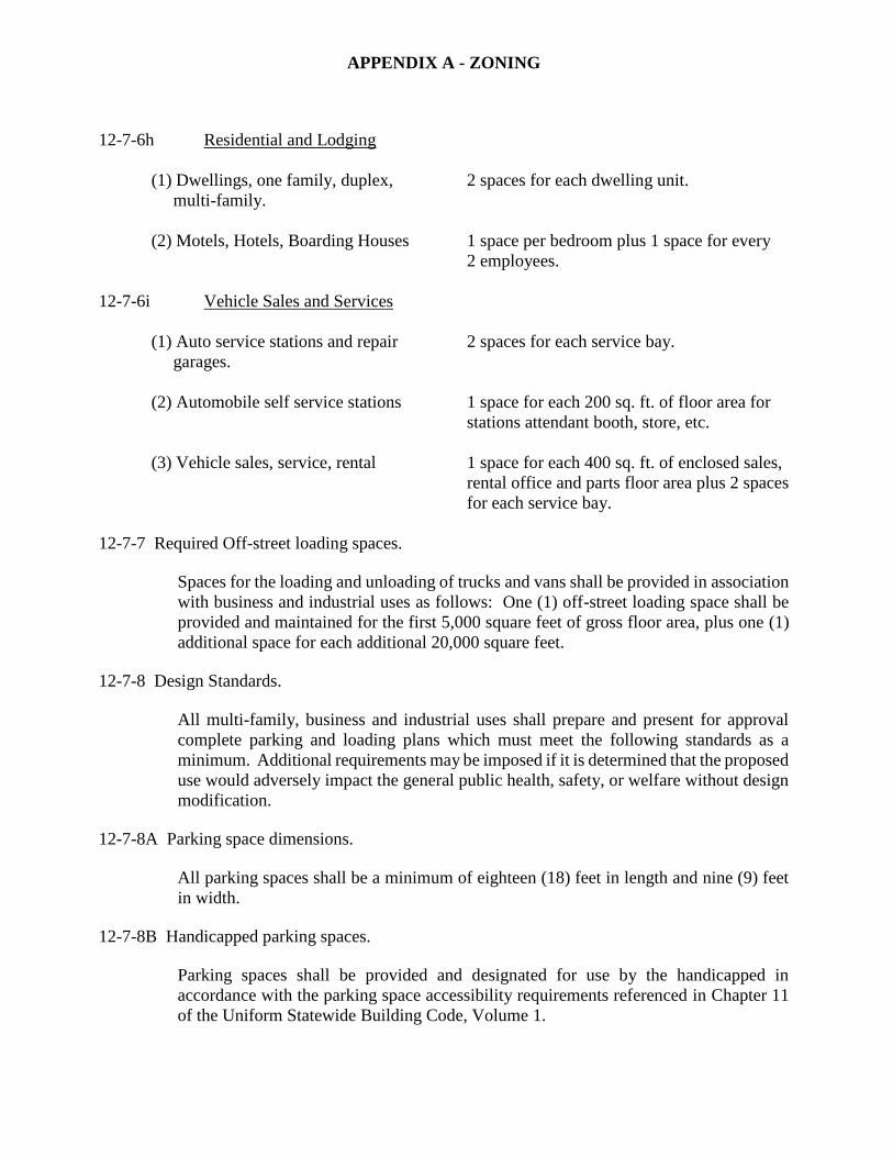
APPENDIX A - ZONING
12-7-6h Residential and Lodging
(1) Dwellings, one family, duplex, 2 spaces for each dwelling unit.
multi-family.
(2) Motels, Hotels, Boarding Houses 1 space per bedroom plus 1 space for every
2 employees.
12-7-6i Vehicle Sales and Services
(1) Auto service stations and repair 2 spaces for each service bay.
garages.
(2) Automobile self service stations 1 space for each 200 sq. ft. of floor area for
stations attendant booth, store, etc.
(3) Vehicle sales, service, rental 1 space for each 400 sq. ft. of enclosed sales,
rental office and parts floor area plus 2 spaces
for each service bay.
12-7-7 Required Off-street loading spaces.
Spaces for the loading and unloading of trucks and vans shall be provided in association
with business and industrial uses as follows: One (1) off-street loading space shall be
provided and maintained for the first 5,000 square feet of gross floor area, plus one (1)
additional space for each additional 20,000 square feet.
12-7-8 Design Standards.
All multi-family, business and industrial uses shall prepare and present for approval
complete parking and loading plans which must meet the following standards as a
minimum. Additional requirements may be imposed if it is determined that the proposed
use would adversely impact the general public health, safety, or welfare without design
modification.
12-7-8A Parking space dimensions.
All parking spaces shall be a minimum of eighteen (18) feet in length and nine (9) feet
in width.
12-7-8B Handicapped parking spaces.
Parking spaces shall be provided and designated for use by the handicapped in
accordance with the parking space accessibility requirements referenced in Chapter 11
of the Uniform Statewide Building Code, Volume 1.
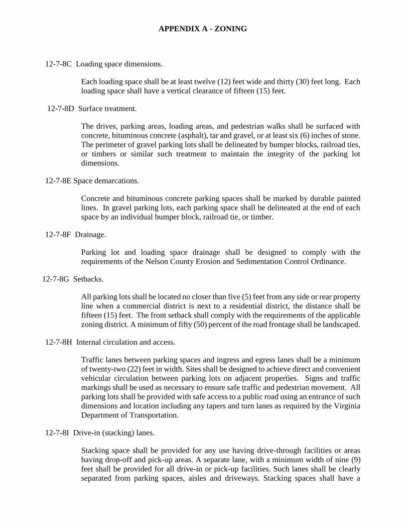
APPENDIX A - ZONING
12-7-8C Loading space dimensions.
Each loading space shall be at least twelve (12) feet wide and thirty (30) feet long. Each
loading space shall have a vertical clearance of fifteen (15) feet.
12-7-8D Surface treatment.
The drives, parking areas, loading areas, and pedestrian walks shall be surfaced with
concrete, bituminous concrete (asphalt), tar and gravel, or at least six (6) inches of stone.
The perimeter of gravel parking lots shall be delineated by bumper blocks, railroad ties,
or timbers or similar such treatment to maintain the integrity of the parking lot
dimensions.
12-7-8E Space demarcations.
Concrete and bituminous concrete parking spaces shall be marked by durable painted
lines. In gravel parking lots, each parking space shall be delineated at the end of each
space by an individual bumper block, railroad tie, or timber.
12-7-8F Drainage.
Parking lot and loading space drainage shall be designed to comply with the
requirements of the Nelson County Erosion and Sedimentation Control Ordinance.
12-7-8G Setbacks.
All parking lots shall be located no closer than five (5) feet from any side or rear property
line when a commercial district is next to a residential district, the distance shall be
fifteen (15) feet. The front setback shall comply with the requirements of the applicable
zoning district. A minimum of fifty (50) percent of the road frontage shall be landscaped.
12-7-8H Internal circulation and access.
Traffic lanes between parking spaces and ingress and egress lanes shall be a minimum
of twenty-two (22) feet in width. Sites shall be designed to achieve direct and convenient
vehicular circulation between parking lots on adjacent properties. Signs and traffic
markings shall be used as necessary to ensure safe traffic and pedestrian movement. All
parking lots shall be provided with safe access to a public road using an entrance of such
dimensions and location including any tapers and turn lanes as required by the Virginia
Department of Transportation.
12-7-8I Drive-in (stacking) lanes.
Stacking space shall be provided for any use having drive-through facilities or areas
having drop-off and pick-up areas. A separate lane, with a minimum width of nine (9)
feet shall be provided for all drive-in or pick-up facilities. Such lanes shall be clearly
separated from parking spaces, aisles and driveways. Stacking spaces shall have a
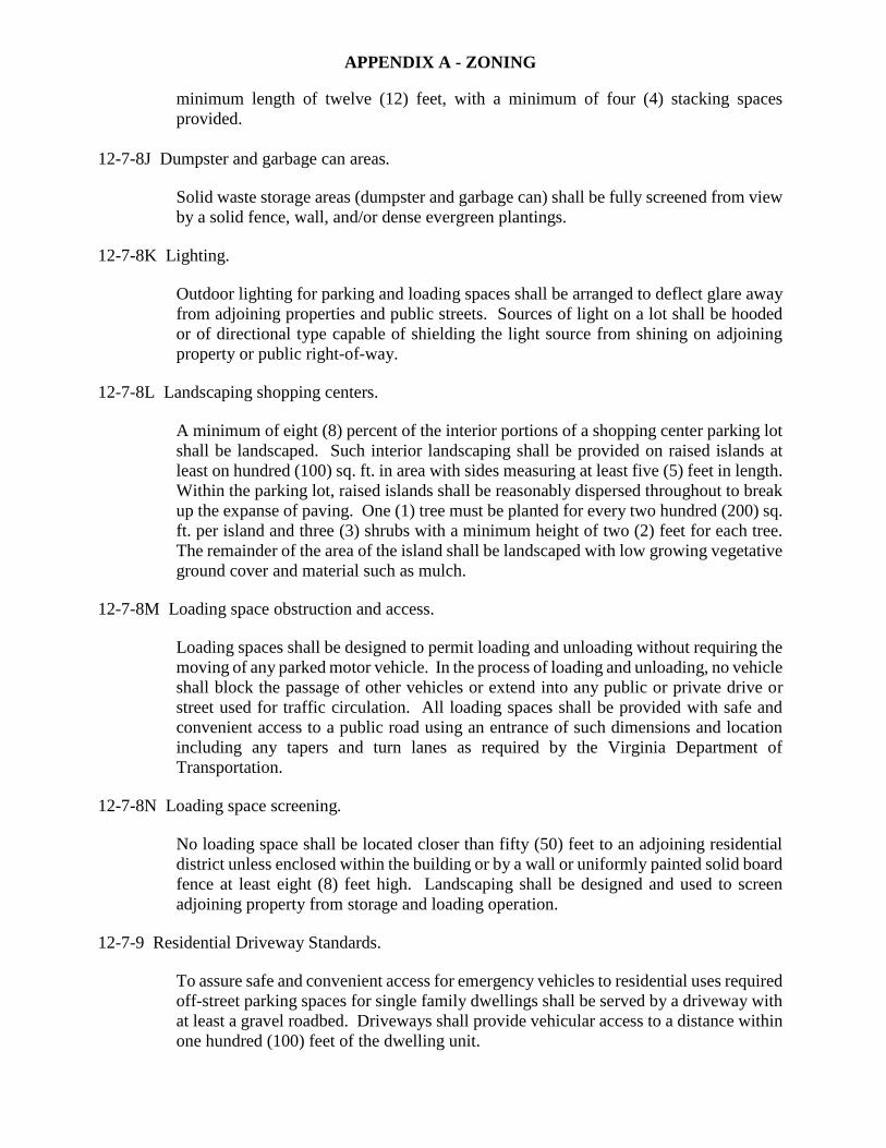
APPENDIX A - ZONING
minimum length of twelve (12) feet, with a minimum of four (4) stacking spaces
provided.
12-7-8J Dumpster and garbage can areas.
Solid waste storage areas (dumpster and garbage can) shall be fully screened from view
by a solid fence, wall, and/or dense evergreen plantings.
12-7-8K Lighting.
Outdoor lighting for parking and loading spaces shall be arranged to deflect glare away
from adjoining properties and public streets. Sources of light on a lot shall be hooded
or of directional type capable of shielding the light source from shining on adjoining
property or public right-of-way.
12-7-8L Landscaping shopping centers.
A minimum of eight (8) percent of the interior portions of a shopping center parking lot
shall be landscaped. Such interior landscaping shall be provided on raised islands at
least on hundred (100) sq. ft. in area with sides measuring at least five (5) feet in length.
Within the parking lot, raised islands shall be reasonably dispersed throughout to break
up the expanse of paving. One (1) tree must be planted for every two hundred (200) sq.
ft. per island and three (3) shrubs with a minimum height of two (2) feet for each tree.
The remainder of the area of the island shall be landscaped with low growing vegetative
ground cover and material such as mulch.
12-7-8M Loading space obstruction and access.
Loading spaces shall be designed to permit loading and unloading without requiring the
moving of any parked motor vehicle. In the process of loading and unloading, no vehicle
shall block the passage of other vehicles or extend into any public or private drive or
street used for traffic circulation. All loading spaces shall be provided with safe and
convenient access to a public road using an entrance of such dimensions and location
including any tapers and turn lanes as required by the Virginia Department of
Transportation.
12-7-8N Loading space screening.
No loading space shall be located closer than fifty (50) feet to an adjoining residential
district unless enclosed within the building or by a wall or uniformly painted solid board
fence at least eight (8) feet high. Landscaping shall be designed and used to screen
adjoining property from storage and loading operation.
12-7-9 Residential Driveway Standards.
To assure safe and convenient access for emergency vehicles to residential uses required
off-street parking spaces for single family dwellings shall be served by a driveway with
at least a gravel roadbed. Driveways shall provide vehicular access to a distance within
one hundred (100) feet of the dwelling unit.
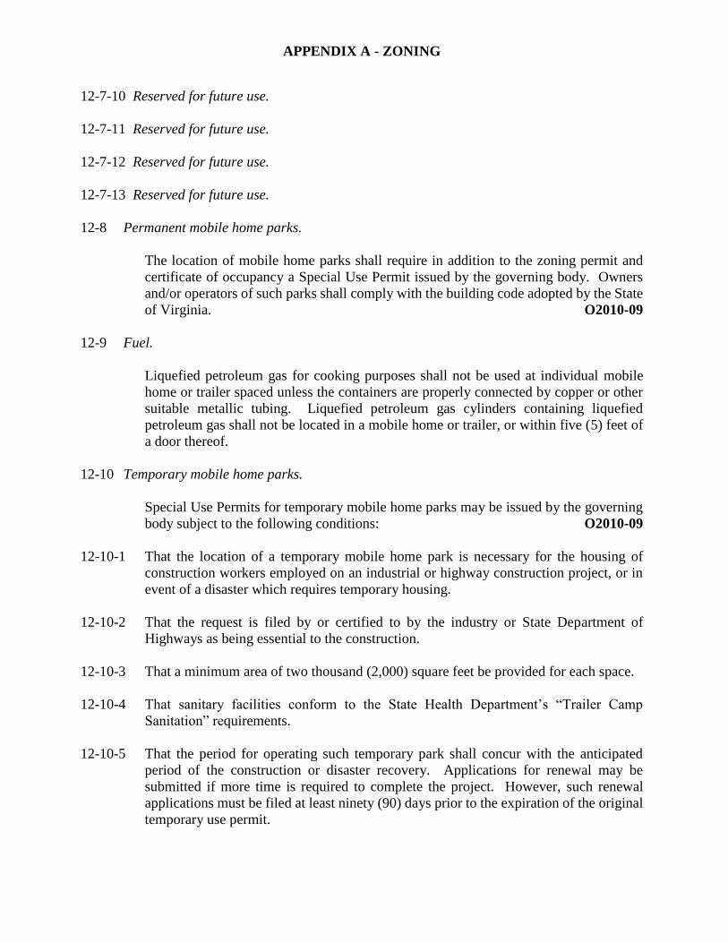
APPENDIX A - ZONING
12-7-10 Reserved for future use.
12-7-11 Reserved for future use.
12-7-12 Reserved for future use.
12-7-13 Reserved for future use.
12-8 Permanent mobile home parks.
The location of mobile home parks shall require in addition to the zoning permit and
certificate of occupancy a Special Use Permit issued by the governing body. Owners
and/or operators of such parks shall comply with the building code adopted by the State
of Virginia. O2010-09
12-9 Fuel.
Liquefied petroleum gas for cooking purposes shall not be used at individual mobile
home or trailer spaced unless the containers are properly connected by copper or other
suitable metallic tubing. Liquefied petroleum gas cylinders containing liquefied
petroleum gas shall not be located in a mobile home or trailer, or within five (5) feet of
a door thereof.
12-10 Temporary mobile home parks.
Special Use Permits for temporary mobile home parks may be issued by the governing
body subject to the following conditions: O2010-09
12-10-1 That the location of a temporary mobile home park is necessary for the housing of
construction workers employed on an industrial or highway construction project, or in
event of a disaster which requires temporary housing.
12-10-2 That the request is filed by or certified to by the industry or State Department of
Highways as being essential to the construction.
12-10-3 That a minimum area of two thousand (2,000) square feet be provided for each space.
12-10-4 That sanitary facilities conform to the State Health Department’s “Trailer Camp
Sanitation” requirements.
12-10-5 That the period for operating such temporary park shall concur with the anticipated
period of the construction or disaster recovery. Applications for renewal may be
submitted if more time is required to complete the project. However, such renewal
applications must be filed at least ninety (90) days prior to the expiration of the original
temporary use permit.
APPENDIX A - ZONING
12-10-6 Bond. The governing body, in granting such a Special Use Permit, shall require the
posting of a bond to assure that the temporary trailer court will be removed and the site
left in good order at the expiration of the permit. O2010-09
12-10-7 The governing body shall establish such additional requirements as are in the best
interest of the public.
12-11 Signs.
12-11-1 Intent. The purpose of the following sign requirements is to promote and protect the
public health, welfare, and safety by regulating existing and proposed outdoor
advertising, and outdoor signs of all types. It is intended to protect property values,
create a more attractive economic and business climate, and enhance and protect the
scenic and natural beauty of Nelson County. It is further intended to reduce sign or
advertising distraction and obstructions that may be caused by signs overhanging or
projecting over public right-of-way, provide more open space, curb the deterioration of
the natural environment and enhance community development.
12-11-2 General requirements.
12-11-3 Except as provided in Sections 12-11-21—12-11-31 below and in Section 33.1-351
through Section 33.1-370, Code of Virginia, 1950, as amended, no outdoor advertising
sign, or structure shall be erected without a Zoning and Building Permit. Failure to
adhere to the requirements of this ordinance automatically cancels such permit and said
structure shall be removed forthwith.
12-11-4 For the purpose of computing sign area only one (1) side of a “V-type” or double-faced
sign shall be considered.
12-11-5 Rooftop signs or rooftop sign structures shall not extend more than thirty (30) feet above
the roofline. Rooftop signs or sign structures shall not extend beyond or overhang any
exterior wall of the building upon which secured.
12-11-6 Certain advertisements or structures are prohibited. No advertisement or
advertising structure shall be erected, maintained, or operated:
(a) Within six hundred sixty (660) feet of nearest edge of the right-of-way of the Blue
Ridge Parkway;
(b) Within six hundred sixty (660) feet of any public cemetery, public park, public
playground, national forest, and state forest;
(c) Within fifteen (15) feet of the nearest edge of the pavement of any highway without
the written findings from the Commissioner of the Virginia Department of
Highways and Transportation, that the structure is anchored outside of the right-of-
way and it does not constitute a safety hazard or conflict with any other restrictions
contained in Section 33.1 of the Code of Virginia, 1950, as amended;
(d) Which advertise activities, which are illegal under state or federal laws or
regulations.
APPENDIX A - ZONING
12-11-7 No sign or sign structure shall be placed at any public road intersection in such manner
as would obstruct the clear vision in either direction between a point on the centerline
of the side road twenty (20) feet from the nearest edge of the pavement of the main road
and points on the main road four hundred (400) feet distant, measured along the nearest
edge of the pavement of the main road.
12-11-8 No sign or sign structure shall be placed at any grade intersection of a public road and a
railroad in such manner as would obstruct the clear vision in either direction within
triangular areas formed by: (a) a point at the center of the railroad-public road
intersection; (b) a point on the public road four hundred (400) feet from the center of the
railroad-public road intersection as measured along the center of the public road; and (c)
a point on the railroad five hundred (500) feet from the center of the railroad-public road
intersection as measured along the center of the railroad.
12-11-9 No sign or sign structure shall be placed at or near any curve in a road in such a manner
as to obstruct the clear vision of traffic from any one (1) point on such curve to any other
point not more than four hundred (400) feet apart, as measured between each point from
the nearest edge of the pavement.
12-11-10 No sign shall be erected, relocated, or maintained so as to prevent free ingress to or
egress from any door, window, or fire escape.
12-11-11 No portion of any sign structure except official road markers, which shall adhere to the
applicable state and local laws, shall be less than ten (10) feet above the level of any
adjacent sidewalk or other pedestrian thoroughfare, no less than sixteen (16) feet above
the level of an adjacent public driveway, alley or street.
12-11-12 All signs, whether permanent or temporary, shall comply with the applicable
requirements of the Building Code.
12-11-13 In the event any sign is to be relocated, it shall be required that the owner of said sign
obtain a new building permit.
12-11-14 All signs shall be subject to the setback requirements contained in Table 4, unless
otherwise regulated by state or federal regulations.
12-11-15 All sign structures may be erected up to a height of thirty-five (35) feet, except in the
business and industrial districts which may be erected up to a height of one hundred
(100) feet.
12-11-16 All signs coming within the jurisdiction of state and federal laws along interstate
highway and federal-aid primary highway systems shall conform to said laws in lieu of
any other sign regulations in this ordinance.
12-11-17 All signs in existence at the time of the passage of this ordinance, which do not conform
to this ordinance, shall be classified as nonconforming, but may be continued providing
they are properly maintained during the life of such advertisement or advertising
structure.
APPENDIX A - ZONING
12-11-18 Informational signs of a public or quasi-public nature identifying or locating a town,
planned community, hospital, community center, public building, or historic place
situated in Nelson County, Virginia, and also signs identifying or locating a school,
college, YMCA, YWCA, church or similar place of worship, board of trade, service
club, soil conservation activity, 4-H Club, Isaac Walton League, Chamber of
Commerce, or similar public or quasi-public activity for religious, civic, educational or
cultural purpose, and signs drawing attention to public parking lots, rest rooms, or to
other public convenience relating to such places or activities are permitted. Such signs
shall not exceed an area of six (6) square feet, shall not be illuminated, shall contain no
advertising matter, and shall be set back not less than five (5) feet from the fronting
highway. Nothing contained herein shall be construed to limit the effect of Section 12-
11-16.
12-11-19 Official notices or signs posted or displayed by or under the direction of any public or
court officer in the performance of his official or directed duties, or by trustees under
deeds of trust, deeds of assignment or other similar instruments. Such signs shall not
exceed an area of two (2) square feet, shall not be illuminated and shall contain no
advertising matter, other than that which may be required by law.
12-11-20 Permissible signs in all districts.
The following signs are allowed in all districts and shall be exempt from permit
requirements (12-11-21—12-11-31):
12-11-21 Real estate signs advertising sale, rental, or lease of the land or building upon which
signs are located, provided that:
a. In residential districts, real estate signs shall not be in excess of six (6) square feet;
b. In business districts, there shall be no sign in excess of thirty-two (32) square feet
and no more than three (3) such signs on any single lot;
c. In industrial districts, there shall be no sign in excess of ninety (90) square feet and
no more than three (3) such signs on any single lot;
12-11-22 Where multifamily dwellings are a permitted use, one (1) sign for identifying
multifamily dwellings of more than four (4) units, provided that such sign shall be
located only on the premises of the multifamily dwellings, shall not exceed one hundred
(100) square feet in area, shall indicate nothing other than the name and/or address of
the premises and the name of the management, and may be illuminated;
12-11-23 Directional signs for parks and playgrounds and other permitted nonresidential uses,
provided that such signs shall not exceed four (4) square feet in area;
12-11-24 Professional nameplates not exceeding two (2) square feet in area; such signs to be non-
illuminated;
12-11-25 One (1) sign or bulletin board indicating the name of the institution or civic association
not exceeding ten (10) square feet in area on premises of public or semi-public facilities;
APPENDIX A - ZONING
12-11-26 Signs located on the premises relating to active construction projects;
12-11-27 Memorial signs or tablets, including names of buildings and date of erection when cut
into masonry, bronze, or other materials;
12-11-28 Traffic or other public signs or notices posted or erected by or at the direction of a
governmental agency;
12-11-29 Customary signs, in conjunction with residential usage, including mailbox lettering,
names of residents, house number, names of farms and estates, and other similar usage
not exceeding ten (10) square feet;
12-11-30 One (1) subdivision identification sign at the main entrance or entrances to the
subdivision provided that such sign shall not exceed one hundred (100) square feet, may
be illuminated, shall be so designed as to be in the public interest, and shall make no
reference to the sale or lease of the lots or houses located within said identified
subdivision;
12-11-31 Temporary signs, including political advertisements:
a. Not allowed longer than sixty (60) days; and
b. Shall be removed by sign owner within five (5) days after the date of the event or
activity to which the sign makes reference, or if he fails to do so, by the Zoning
Administrator at the owner’s expense, five (5) days following registered notification
of the owner.
12-11-32 Permitted signs in all districts. Table 4 identifies the signs, which are permissible in all
districts, without a public hearing.
12-11-33 Signs as conditional uses. The following signs may be permitted as conditional or
special uses:
12-11-34 Signs related to conditional or special uses. Except as hereinafter provided, signs
relating to buildings and uses permitted conditionally or by special use permit, will be
in accordance with signs as permitted in the district in which the use is permitted.
12-11-35 Signs prohibited in all districts. The following signs are prohibited in all districts:
12-11-36 Any sign which uses the word “stop” or “danger” prominently displayed or which is a
copy imitation of official traffic-control signs;
12-11-37 Any sign which involves motion or rotation of any part of the structure or displays an
intermittent light or lights within one hundred (100) feet of the nearest edge of the
pavement of any highway; provided, however, that the prohibition of this subsection
shall not apply to moving or rotating parts of structures, or to displays of intermittent
lights, when such structures or displays are located along highways in this State, except
the interstate system, and when the moving or rotating parts of such structures, or such
displays, convey solely public service information. Public service information shall
include all or any of the following information: date, time, temperature, weather, and
APPENDIX A - ZONING
other similar information; and shall specifically exclude any advertisement as defined
in Section 33.1-351 of the Code of Virginia, 1950 as amended;
12-11-38 Any sign which is mobile and is designed to and effectively does distract the attention
of passing motorists on any highways by flashing lights, loud and blatant noises, or
movable objects;
12-11-39 Any sign which involves red, green, or amber lights or reflectorized material and which
resemble traffic signal lights or traffic-control signs and are within visible distance of
any highway.
12-11-40 Maintenance and removal of signs.
12-11-41 All signs and sign structures shall be kept in repair and in proper state of preservation
by the landowner. All signs must adhere to the provisions of the Building Code;
12-11-42 Signs which are no longer functional, or are abandoned, shall be repaired, removed, or
relocated at the landowner’s expense in compliance with the provisions of this ordinance
within thirty (30) days following dysfunction.
12-12 Electrical hookup for manufactured home, mobile home, recreational vehicle, or travel
trailer. It shall be unlawful for any electric company or cooperative to furnish electric
service for any manufactured home, mobile home, recreational vehicle, or travel trailer,
as the term applies, unless the owner produces a zoning permit issued by the Zoning
Administrator of Nelson County authorizing the placing of the manufactured home,
mobile home, recreational vehicle, or travel trailer at the location where electric service
is to be installed, which permit number may be checked against the records of Zoning
Administrator for the purpose of ascertaining the validity of the permit.
It shall be the duty of the owner to display in a prominent and visible place a good and
valid zoning permit at all times after requesting installation of electric service and until
such services have been installed.
It shall be unlawful for any person to provide electrical services to a manufactured home,
mobile home, recreational vehicle, or travel trailer in Nelson County when the
manufactured home, mobile home, recreational vehicle, or travel trailer is to be used
and/or equipped as a dwelling or residence unless the lessee or owner produces a valid
zoning permit. O2010-01
12-13 Reserved for future use.
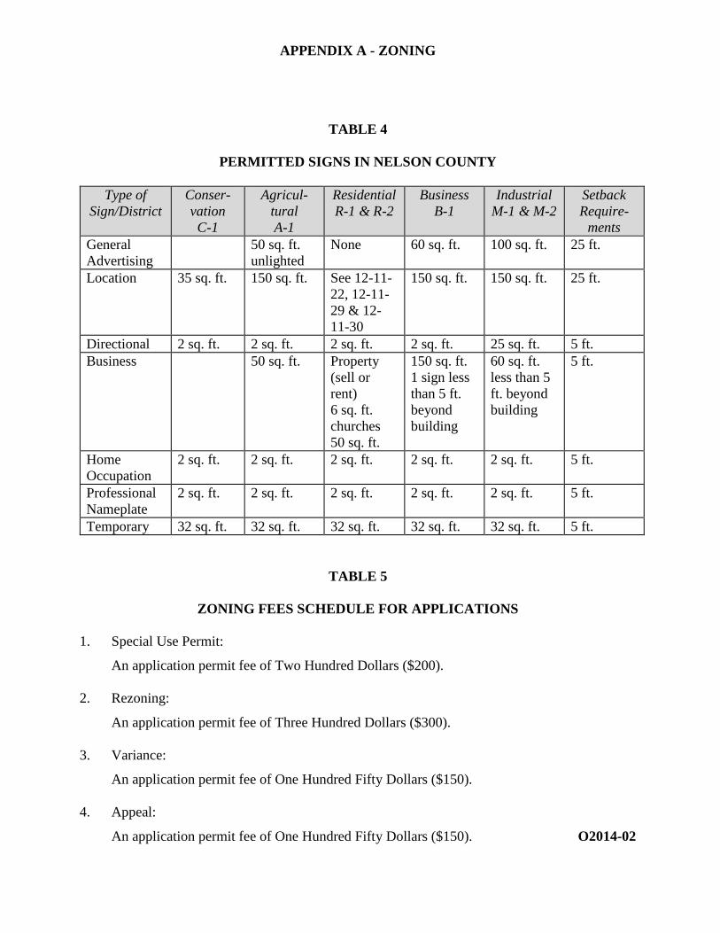
APPENDIX A - ZONING
TABLE 4
PERMITTED SIGNS IN NELSON COUNTY
Type of
Sign/District
Conser-
vation
C-1
Agricul-
tural
A-1
Residential
R-1 & R-2
Business
B-1
Industrial
M-1 & M-2
Setback
Require-
ments
General
Advertising
50 sq. ft.
unlighted
None 60 sq. ft. 100 sq. ft. 25 ft.
Location 35 sq. ft. 150 sq. ft. See 12-11-
22, 12-11-
29 & 12-
11-30
150 sq. ft. 150 sq. ft. 25 ft.
Directional 2 sq. ft. 2 sq. ft. 2 sq. ft. 2 sq. ft. 25 sq. ft. 5 ft.
Business 50 sq. ft. Property
(sell or
rent)
6 sq. ft.
churches
50 sq. ft.
150 sq. ft.
1 sign less
than 5 ft.
beyond
building
60 sq. ft.
less than 5
ft. beyond
building
5 ft.
Home
Occupation
2 sq. ft. 2 sq. ft. 2 sq. ft. 2 sq. ft. 2 sq. ft. 5 ft.
Professional
Nameplate
2 sq. ft. 2 sq. ft. 2 sq. ft. 2 sq. ft. 2 sq. ft. 5 ft.
Temporary 32 sq. ft. 32 sq. ft. 32 sq. ft. 32 sq. ft. 32 sq. ft. 5 ft.
TABLE 5
ZONING FEES SCHEDULE FOR APPLICATIONS
1. Special Use Permit:
An application permit fee of Two Hundred Dollars ($200).
2. Rezoning:
An application permit fee of Three Hundred Dollars ($300).
3. Variance:
An application permit fee of One Hundred Fifty Dollars ($150).
4. Appeal:
An application permit fee of One Hundred Fifty Dollars ($150). O2014-02
APPENDIX A - ZONING
ARTICLE 13. SITE DEVELOPMENT PLAN
13-1 Categories and Applicability of Site Plans. This Article provides the requirements and
applicability of the following site plans:
a. Major Site Plan
b. Minor Site Plan
Site Plans for Residential Planned Communities shall be governed by the provisions of
Article 7 of this ordinance. O2010-5
13-1-1 Requirements for site plans.
A site plan shall be required for any development on any site, in all zoning districts, in any
case in which construction or a change in use of the existing site increases the number of
on-site parking spaces or anything that causes a visible change in the site. A "visible change"
includes grading, removal of vegetation in preparation for future development of the site,
mining, digging, and riverbank removal, addition to a building that changes the traffic
circulation on the site, or any other change which the Planning and Zoning Director
determines to cause a significant impact to the public health, safety and welfare of the
citizens of the County.
Major Site Plan. A Major Site Plan shall be required when the project:
1. exceeds one acre of land-disturbed area and is commercial or industrial in nature, or is
a mobile home park, or contains three (3) or more dwelling units on one lot, or is an
Intentional Community; or
2. entails the erection of a structure or structures exceeding a total of 5000 square feet,
excluding agricultural and single family residential construction, on a single parcel.
Minor Site Plan. A Minor Site Plan must accompany zoning permit applications in those
undertakings which do not fall within the categories specified for Major Site Plans. A Minor
Site Plan must also accompany the initial application for a Special Use Permit and for a
rezoning request. For the purposes of this Article, the phrase “special use” shall mean either
Conditional Use or Special Use, as the case may be. O2010-5
13-1-2 Site plan exemptions.
The foregoing notwithstanding, no site plan shall be required for the following:
a. Construction of, or addition to, a single family dwelling on an individual lot.
b. Construction of, or addition to, a two-family dwelling on an individual lot.
c. Accessory structures to single-family dwellings (not meant for commercial use).
APPENDIX A - ZONING
d. Accessory buildings or structures on property used for the growing of agricultural crops,
livestock, or forestry timber when such buildings or structures are necessary for such
growing.
e. Harvesting of plants or trees growing on the site.
f. Clearing of a site for use for agricultural or pasture purposes.
g. Residential Planned Community O2010-5
13-2 Issuance of permits by County.
No building permit, or other County permit required prior to the initiation of construction
of any building or structure or development, shall be issued by any officer or employee of
the County for any development which is subject to the provisions of this article until a site
plan has been approved. Compliance with the terms contained on any site plan shall be
deemed a condition of each and every permit issued by the County. Any permit issued prior
to the approval of a site plan is automatically null and void. O2010-5
13-3 Amendment to final plans.
Any change to an approved Minor Site Plan or Final Site Plan shall require submission and
approval of a new plan, except that minor changes may be approved administratively by the
Planning and Zoning Director. A minor modification is one that, in the opinion of the
Planning and Zoning Director, will not substantially alter the terms of the original approval.
Applications for minor modifications of final approved plans made during periods of
validity of such plans shall not constitute a waiver of the provisions of this section, nor shall
the approval of minor modifications operate to extend the period of validity of any such
plans. Each application or submission for an amendment to a plan shall be accompanied by
the required fee. O2010-5
13-4 Site plan content.
The site plan, or any portion thereof, involving engineering, urban planning, landscape
architecture, architecture, or land surveying, shall be prepared by a qualified person. Final
Site Plans submitted for approval shall be certified by an architect, landscape architect,
engineer, or land surveyor licensed or certified to practice by the Commonwealth of Virginia
within the limits of his respective license or certification.
The Major Site Plan shall include:
A. The plan shall be prepared at a scale of not less than 1”=20’ except for the index sheet,
unless approved by the Planning and Zoning Director.
B. If the plan is prepared on more than one sheet, match lines shall clearly indicate where
the several sheets join.
C. Dimensions shall be in feet and decimals of feet to the closest one hundredth of a foot.
D. The proposed title of the project and the name of the owner(s), engineer, architect,
landscape architect, surveyor, and developer, as applicable.
E. A signature panel to indicate approvals from the following:
a. Planning and Zoning Director
b. Virginia Department of Transportation
c. Virginia Department of Health
d. Thomas Jefferson Soil and Water Conservation District

APPENDIX A - ZONING
e. Nelson County Service Authority
F. Tax Map and Parcel Number
G. Adjacent property owners
H. North arrow, scale graphic, and date.
I. Vicinity map.
J. Existing zoning and zoning district boundaries on the property in the development and
on immediately surrounding properties. All special zoning requirements attached
directly to the site as a result of the issuance of any Special Use Permit, variance, or
rezoning.
K. The boundaries of the property in the development, including bearings and distances.
L. All existing property lines, existing streets or rights-of-way opened or unopened;
buildings, watercourses, and lakes; and other existing physical features in or adjoining
the project. The physical features, such as watercourses, waterways and lakes on the
adjoining properties need only be shown in approximate scale and proportion;
M. Features of particular historic, cultural, scientific, or scenic significance as identified in
the Comprehensive Plan, by the Planning and Zoning Director, or by any County
department or state agency having site plan review responsibilities, or by the Virginia
Department of Historic Resources the Virginia Department of Conservation and
Recreation, or the Virginia Outdoors Foundation including, but not limited to, historic
features, archaeological features, and graveyards.
N. Building setback lines; the location of all proposed buildings and structures, accessory
and main; number of stories and height; proposed general uses for each building; and
the number, size, and type of dwelling units where applicable. Preliminary plans and
elevations for main and accessory buildings.
O. Type, location, height, and materials of all existing and proposed fences and walls.
P. Site coverage, showing percentage of site in buildings, parking, and open space.
Q. Existing and proposed topography and contour lines of the development site with a
contour interval of two (2) feet or less.
R. The location and size of sanitary and storm sewers, gas lines, water mains, required
stormwater management facilities, culverts, and other underground structures; all
overhead utilities and supporting poles in or affecting the development area, including
existing and proposed facilities; and easements for these facilities, including the width
of the easement. O2015-04
S. The location of all existing and proposed off-street parking and parking bays, loading
spaces, and pedestrian walkways, indicating types of surfacing, dimensions of stalls,
width of aisles and a specific schedule showing the number of parking spaces.
T. Final plan for all signs to be erected and/or placed on building. The plan shall show the
location and size of each sign along with the purpose of the sign. U. A final landscape plan.
V. Outdoor lighting information, including a photometric plan and location, description
and photograph or diagram of each type of outdoor luminary.
W. All paving, including, without limitation, gravel or other pervious surfaces, shall be of
a design and quality to support the traffic which can reasonably be expected to be
generated by the proposed use.
X. Limit of one-hundred-year floodplain, and floodway as defined in Article 10 of this
Ordinance.
Y. Location of any wetlands in compliance with applicable federal, state, and local
definition of wetlands.
APPENDIX A - ZONING
Z. The location and dimensions of proposed recreation or open space, and required
amenities and improvements, including details of disposition, in accordance with any
open space or recreation plan adopted by the County.
AA. Cul-de-sacs may not be construed or employed as a parking area. Suitable easements
for future public water and sewer facilities necessary to serve the property shall be
indicated on the plan.
BB. All new electrical, telephone, cable television, fiber optic, and other utility lines on
the site shall be installed underground.
CC. To the greatest extent possible, parking areas shall not be located between the
adjacent public right-of-way and the principal structure on the site unless
topographic features or vegetation provide effective screening.
DD. Site planning shall consider the future development of adjacent parcels as
recommended by the Nelson County Comprehensive Plan or other approved local
plan and as may be indicated by any filed site plan, whether approved or under
review. The site plan shall provide for safe and convenient vehicular and pedestrian
circulation between sites to be occupied by complementary uses.
EE. If phasing is planned, phase lines and proposed timing of development.
FF. A copy of the approved final Erosion and Sediment Control Plan and Stormwater
Management Plan, as applicable. O2015-04
GG. Documentation of approved Virginia Stormwater Management Program permit
coverage from Virginia Department of Environmental Quality, as applicable.
O2015-04
HH. Option: A Preliminary Major Site Plan may be submitted to the Planning
Commission for review and comment prior to submittal of the Final Site Plan for
review and approval.
Minor Site Plan. A Minor Site Plan must accompany zoning permit applications in those
undertakings which do not fall within the categories specified for Major Site Plans. A Minor
Site Plan must also accompany the initial application for a Special Use Permit and for a
rezoning request. For the purposes of this Article, the phrase “special use” shall mean either
Conditional Use or Special Use, as the case may be.
A Minor Site Plan shall consist of the following:
A. A vicinity map showing the location of the subject property.
B. Boundary lines of subject property.
C. General layout design of what is proposed on a scale not smaller than one (1) inch equals
twenty (20) feet, including the location of all proposed streets, pathways, easements,
and all proposed uses of the land. A different scale may be used provided it is approved
by the Planning and Zoning Director
D. Building setback lines.
E. Zoning of subject property and adjacent parcel.
F. Amount of land to be disturbed, including drain fields.
G. Tax map and parcel number.
H. Floodplains.
I. Wetlands, streams, rivers, etc.
J. Existing structures and roads.
APPENDIX A - ZONING
K. Existing and proposed topography and contour lines of the development site with a
contour interval of twenty (20) feet or less for Minor Site Plans, supplemented where
necessary by spot elevations.
L. The location of all existing and proposed utilities and easements including the width
of the easement.
M. A legend that shows:
Ownership (Name and Address)
North arrow
Graphic scale
Area in acres
N. A signature panel to indicate approvals from the following:
Planning and Zoning Director
Virginia Department of Transportation
Virginia Department of Health
Thomas Jefferson Soil and Water Conservation District
Nelson County Service Authority
O. Any other information which the Planning and Zoning Director deems necessary for the
proper consideration of the application. O2010-5
13-5 Validity of site plans.
a. An approved Minor Site Plan or Final Site Plan shall be valid for a period of five (5)
years from the date of approval, or for such longer period as the Planning and Zoning
Director may, at the time of approval, determine to be reasonable, taking into
consideration the size and phasing of the proposed site. A plan shall be deemed final
once it has been reviewed and approved by the Planning and Zoning Director or
Planning Commission, where the only requirement remaining to be satisfied in order to
obtain a building permit is the posting of required bonds and escrows.
b. Upon application filed prior to expiration of a plan, the Planning and Zoning Director
may grant one (1) or more extension of such approval for additional periods as he may
determine reasonable, taking into consideration the size and phasing of the proposed site
and the laws, ordinances and regulations in effect at the time of the request for an
extension.
c. For so long as the final approved plan remains valid, no change or amendment to any
local ordinance, map, resolution, rule, regulation, policy or plan adopted subsequent to
the date of approval shall adversely affect the right of the developer or his successor in
interest to commence and complete an approved development in accordance with the
lawful terms of the plan, unless: (1) the change or amendment is required to comply
with state law, or (ii) there has been a mistake, fraud or a change in circumstances
substantially affecting the public health, safety or welfare. O2010-5
13-6 Improvements.
13-6-1 All required improvements should be installed by the developer at his cost. In cases
where specifications have been established either by the Virginia Department of
Highways for streets, curbs, etc., or by local ordinances and codes, such specifications
APPENDIX A - ZONING
shall be followed. The developer’s bond shall not be released until construction has
been inspected and approved by the governing body. All improvements shall be in
accordance with the following requirements:
a. Streets. All streets in the proposed development shall be designed and constructed
by the developer at no cost to the locality.
b. Alignment and layout. The arrangement of streets in developments shall make
provision for the continuation of existing streets in adjoining areas and proposed
streets on adjacent approved site plans. The street arrangement must be such as to
cause no unnecessary hardship to owners of adjoining property when they plat their
land and seek to provide for convenient access to it. Where, in the opinion of the
Commission, it is desirable to provide for street access to adjoining property,
proposed streets shall be extended by dedication to the boundary line of such
property. Half streets along the boundary of land proposed for development will not
be permitted. Wherever possible, streets should intersect at right angles. In all
hillside areas streets running with contours shall be required to intersect at angles of
not less than sixty (60) degrees, unless approved by the Planning and Zoning
Director upon recommendation of the highway engineer.
c. Service drives. Whenever a proposed development contains or is adjacent to a
limited access highway or expressway, provision shall be made for a service drive
or marginal street approximately parallel to such right-of-way at a distance suitable
for an appropriate use of the land between such highway and the proposed
development. Such distances shall be determined with due consideration of the
minimum distance required for ingress and egress to the main thoroughfare. The
right-of-way of any major highway or street projected across any railroad, limited
access highway or expressway shall be of adequate width to provide for the cuts or
fills required for any future separation of grades.
d. Approach angle. Major streets shall approach major or minor streets at an angle of
not less than eighty (80) degrees, unless the Planning and Zoning Director, upon
recommendation of the highway engineer, shall approve a lesser angle of approach
for reasons of contour, terrain, or matching of existing patterns.
e. Minimum widths. The minimum width of proposed streets, measured from lot line
to lot line, shall be as shown on the major street plan, or if not shown on such plan
shall be as specified by the Virginia Department of Highways for acceptance into
the State Secondary System.
f. Construction requirements. All public streets shall be constructed to requirements
as specified by the Virginia Department of Highways for acceptance into the State
Secondary System.
g. Minimum street construction. Private streets will be so constructed as to alignment
and grade, that the minimum grade is no greater than the Virginia Department of
Highways Standards for the particular terrain. Road metal or base shall be of a
material and width acceptable to the Virginia Department of Highways. Proper
drainage shall be installed and maintained.
APPENDIX A - ZONING
h. Names. Proposed streets, which are obviously in alignment with other already
existing and named streets shall bear the names of the existing streets. In no case
shall the names of proposed streets duplicate existing street names irrespective of
the use of the suffix street, avenue, boulevard, driveway, place, lane, or court. Street
names shall be indicated on the preliminary and final plats, and shall be approved
by the Planning and Zoning Director. Names of existing streets shall not be changed
except by approval of the governing body.
i. Storm drainage facilities. The developer shall provide all necessary information
needed to determine what improvements are necessary to properly develop the
subject property, including contour intervals, drainage plans and flood control
devices. The developer shall also provide plans for all such improvements together
with a properly qualified certified engineer’s or surveyor’s statement that such
improvements when properly installed, will be adequate for proper development.
The highway engineer shall then approve or disapprove the plans. The developer
shall also provide any other information required by the highway engineer. The
developer shall install and maintain the approved storm drainage facilities and other
stormwater management facilities in accordance with applicable Virginia
Stormwater Management Program regulations. O2015-04
j. Fire protection. Adequate fire hydrants in a development at locations approved by
the Planning and Zoning Director shall be installed by the developer, provided
adequate public water is available. The location of the fire hydrants shall meet the
National Board of Fire Underwriters specifications.
k. Easements. The Commission may require that easements for drainage through
adjoining property be provided by the developer. Easements of not less than fifteen
(15) feet in width shall be provided for drainage, water, sewer, power lines and other
utilities in the subdivision when required by the Planning and Zoning Director.
l. Bond. Before any site plan will be finally approved the developer shall, in lieu of
construction, furnish bond, or other security acceptable to the governing body, in an
amount calculated by the Planning and Zoning Director to secure the required
improvements in accordance with specifications and construction schedules
established, which bond shall be payable to and held by the governing body. Bonds
required for Erosion & Sediment Control measures and/or stormwater management
facilities shall be provided as required by the respective programs and regulations.
O2015-04
m. Plans and specifications. Two (2) blue or black line prints of the plans and
specifications for all required physical improvements to be installed, shall be
prepared by a licensed surveyor or licensed engineer and shall be submitted to the
Planning and Zoning Director for approval or disapproval within sixty (60) days. If
approved, one (1) copy bearing certification of such approval shall be returned to
the developer. If disapproved, all papers shall be returned to the developer with the
reason for disapproval in writing. If no action in sixty (60) days, the plat shall be
deemed approved. O2010-5
APPENDIX A - ZONING
13-6-2 Where the developer can show that a provision of these standards would cause
unnecessary hardship if strictly adhered to, and where, because of topographical or other
conditions peculiar to the site, in the opinion of the Planning and Zoning Director a
departure may be made without destroying the intent of such provisions, the
Commission may authorize an exception. Any exception thus authorized is to be stated
in writing in the report of the Commission, with the reasoning on which the departure
was justified, set forth. No such variance may be granted by this ordinance which is
opposed in writing by the highway engineer or health official or which fails to conform
to all other ordinances and laws. O2015-04
13-7 Administration.
A. Administrative Authority.
1. The Board of Supervisors designates the Planning Commission to review and act to
approve or disapprove Final Site Plans within its jurisdiction.
2. The Planning and Zoning Director is designated to review and act to approve or
disapprove Minor Site Plans, provided however, that the Planning and Zoning
Director may refer any application within his jurisdiction to the Planning
Commission for review and action.
3. In the performance of its duties in the review of Final Site Plans, the Planning
Commission shall request and consider the review and comments of the Planning
and Zoning Director, the Site Plan Review Committee, selected County staff, and
other public agencies.
4. Approval Procedures.
a. The Planning and Zoning Director shall consult with the Virginia
Department of Highways and Transportation, the Department of Health, and
any other officials and professional representatives he deems necessary in
preparation of his comments and recommendations.
b. Upon the official submission of a Final Site Plan, the Planning Commission
shall complete action in accordance with Section 15.2-2259 of the Code of
Virginia as amended from time to time.
c. Upon the official submission of a plan requiring approval by the Planning
and Zoning Director, the Planning and Zoning Director shall complete action
in accordance with Section 15.2-2259 of the Code of Virginia as amended
from time to time.
d. An “official submission” is a plan that has been filed in the correct form in
the proper office accompanied by the appropriate fee and containing all
information required by this Article.

APPENDIX A - ZONING
B. Other Administrative Considerations.
1. The Planning and Zoning Director, as the designated agent of the Planning
Commission, shall be responsible for the receipt and processing of all site plan
applications, subject to the procedures provided in this chapter.
2. The Planning and Zoning Director may establish, from time to time, such proper
and reasonable administrative procedures, in addition to those provided herein, as
shall be necessary for the proper administration of this chapter.
3. County Staff and other designated public officials responsible for the supervision,
inspection, testing and enforcement of this chapter shall have the right to enter
upon any property subject to the provisions of this chapter and the Zoning
Ordinance at all reasonable times during the periods of plan review and
construction for the purpose of ensuring compliance with this chapter.
4. It shall be the responsibility of the applicant, owner or developer to notify the
Planning and Zoning Director when each stage of the development shall be ready
for field inspection for compliance with the approved site plan in accordance with
testing and inspection schedules and regulations promulgated by this chapter.
C. Waiver of Requirements for a Site Plan.
The Planning and Zoning Director, at his sole discretion, may waive the requirement for
a Minor Site Plan or any required element specified within it upon consideration of the
factors outlined below, provided that no such waiver shall be deemed to be a waiver of
any other ordinance provision or requirement. O2015-04
The Planning Commission, at its sole discretion, may waive the requirements for the
Major Site Plan or any required element specified within it upon consideration of the
following factors:
1. Where it can be clearly established by the applicant that the use will not require the
improvements subject to review in this chapter.
2. Where it can be clearly demonstrated by the applicant that a waiver from the
requirement to submit a site plan (or a portion thereof) will be in keeping with the
intent of this chapter.
3. Where it can be clearly shown that the application for a site plan and building permit
involves building and safety regulations which are not critical to the purpose and
intent of the Zoning Ordinance.
4. Where it can be clearly established by the applicant that such waiver will not have
an adverse effect on:
APPENDIX A - ZONING
a. the public health, safety, welfare, and convenience;
b. the planning for and provision of adequate public facilities, utilities,
drainage, environmental controls, and transportation facilities;
c. preservation of agricultural, forestry and conservation lands; and
d. other relevant considerations related to the Comprehensive Plan.
5. Where it can be demonstrated that any change in, or expansion of, a use that meets
the following criteria:
a. Such change or expansion does not occasion additional parking as
required by this ordinance, and
b. No additional ingress/egress to a public road or changed ingress/egress
is recommended by the Planning and Zoning Director based on
intensification or use, and
c. No additional ingress/egress or alteration of existing ingress/egress is
proposed, and
d. Disturbed land is less than 5000 square feet in area, and
e. It has been verified in writing by the Planning and Zoning Director that:
(a) availability and connection to water and sewer are attainable; or (b)
adequate private well and septic facilities can be provided where public
water and sewer are not available.
6. An applicant seeking a waiver from a requirement to submit a Major or Minor Site
Plan (or any portion thereof) shall, upon request, provide written documentation to
the Planning and Zoning Director addressing the applicable conditions for waiver.
For Final Site Plan waivers, the Planning and Zoning Director shall refer the request
and applicant’s supporting documentation to the Planning Commission for action at
its next regularly scheduled meeting. The applicant shall be notified in writing of
the outcome of such action by the Planning and Zoning Director within ten (10) days
upon action by the Planning Commission.
7. Notwithstanding any grant of waiver the applicant is not relieved by such grant of
having to obtain all necessary permits and approvals, including but not limited to a
building permit, erosion and sediment control plan approval, stormwater
management permit coverage, and, upon completion of improvements, a certificate
of occupancy. O2010-5/O2015-04
13-8 Reserved for future use.
13-9 Fees.
There shall be a charge for the examination and approval or disapproval of every site
plan. At the time of filing the site plan, the developer shall deposit with Nelson County
a check payable to the Treasurer of Nelson County in the amount of:
a. $500.00 – Major Site Plan Approval
APPENDIX A - ZONING
b. $100.00 – Planning Commission Review and Comment on Preliminary Major
Site Plan
c. $100.00 – Minor Site Plan
d. $100.00 – Site Plan Amendment O2010-5
13-10 Intentional Community.
13-10-1 Intentional Communities shall be subject to the provisions of Article 13 of the Zoning
Ordinance of Nelson County.
13-10-2 Density.
Intentional Communities shall have a density of no greater than one (1) dwelling per
two (2) acres, unless there is central water or sewer. If the Intentional Community is to
exceed the density of one (1) dwelling per two (2) acres, then the Intentional Community
shall construct either a central water or central sewer system. Clustering will be allowed
in an Intentional Community, but dwellings must be at least fifty (50) feet apart.
13-10-3 Road Standards.
For Intentional Communities that have private streets serving between three (3) and
twenty (20) dwellings, each private street must be constructed to the Class 1 road
standards described in the Subdivision Ordinance of Nelson County. For Intentional
Communities with private streets serving more than twenty (20) dwellings, each private
street must be constructed to the Class 2 road standards described in the Subdivision
Ordinance of Nelson County. All streets shall be named. Street names must be
approved by the County Administrator. Names of existing streets shall not be changed
except by approval of the County Administrator.
13-10-4 Fire Protection
Where public water is available, the developer shall install fire hydrants. The location
and number of fire hydrants shall comply with the regulations of the Nelson County
Service Authority. Where public water is not available and the Intentional Community
contains fifteen (15) or more dwellings, the Intentional Community shall provide both
dry hydrant with a natural or manmade water source meeting the specifications
contained in the National Fire Code and an all-weather access road to the same.
13-10-5 Open Space.
At least sixty (60) percent of the property must be unimproved land, which may consist
of any combination of open space, cultivated agricultural or forestall lands. This
requirement also applies to any future subdivision of the subject parcel.
13-10-6 Substandard Intentional Communities.
An existing Intentional Community, which is not in conformity with this ordinance, may
be further developed; however, any further development shall conform to the provisions
APPENDIX A - ZONING
of this ordinance and any other applicable local ordinances. If an Intentional
Community is developed in accordance with a previously approved plan, the provisions
of this ordinance do not apply. If an Intentional Community is developed beyond what
is included in a previously approved plan, then the provisions of this ordinance do apply.
If, in the opinion of the Planning Commission, total compliance is impractical, the
Planning Commission may approve further development of an Intentional Community
which is not in compliance with the provisions of this ordinance if such further
development will comply more closely to the existing local ordinances than does the
substandard Intentional Community. Any exception so authorized shall be set forth in
a written statement by the Planning Commission detailing the reason for the exception
and filed as an addendum to the site plan.
13-10-7 Subdivisions.
Any subdivision of property for the purpose of conveying parcels of land developed
under Section 13-8 can be subdivided only after meeting all provisions of the Nelson
County Subdivision Ordinance in effect at the time the subdivision is requested.
(Res. of 2-14-95)
APPENDIX A - ZONING
ARTICLE 14. BOARD OF ZONING APPEALS*
14-1 Board of Zoning Appeals, membership and organization.
14-1-1 A board consisting of five (5) members and one alternate shall be appointed by the
Nelson County Circuit Court. Members of the board of zoning appeals may receive
such compensation as may be authorized by the governing body. Appointments for
vacancies occurring otherwise than by expiration of term shall in all cases be for the
unexpired term. O2009-11
14-1-2 The term of office shall be for five (5) years, except that of the first five (5) members
appointed, one shall serve for five (5) years, one for four (4) years, one for three (3)
years, one for two (2) years, and one for one (1) year. One (1) of the five (5) appointed
members shall be an active member of the Planning Commission.
14-1-3 Members may be removed for cause by the appointing authority upon written charges
and after a public hearing.
14-1-4 Any member of the board shall be disqualified to act upon a matter before the board
with respect to property in which the member has an interest.
14-1-5 The board shall choose annually its own chairman and vice-chairman who shall act in
the absence of the chairman.
14-2 Powers and duties of Board of Zoning Appeals.
The Board of Zoning Appeals shall have the following powers and duties:
14-2-1 To hear and decide applications for Special Use Permits where authorized in this
ordinance.
14-2-1a To hear and decide applications for Special Use Permits to erect an accessory building
prior to the construction of the primary building on the same lot or parcel.
14-2-2 To hear and decide appeals from any order, requirement, decision, or determination
made by an administrative officer in the administration or enforcement of this article or
of any ordinance adopted pursuant thereto.
14-2-3 To hear and decide applications for interpretation of the district map where there is any
uncertainty as to the location of a district boundary. After notice to the owners of the
properties affected by any such question, and after public hearing with notice as required
by Section 15.2-2204 of the Code of Virginia, 1950, as amended, the board may interpret
the map in such way as to carry out the intent and purpose of the ordinance for the
particular district in question.
14-2-4 To authorize upon appeal in specific cases such variance from the terms of the
ordinance as will not be contrary to the public interest, when, owing to special
conditions a literal enforcement of the provisions will result in unnecessary hardship;
APPENDIX A - ZONING
provided that the spirit of the ordinance shall be observed and substantial justice
done, as follows:
When a property owner can show that his property was acquired in good faith and where
by reason of the exceptional narrowness, shallowness, size, or shape of a specific piece
of property at the time of the effective date of the ordinance, or where by reason of
exceptional topographic conditions or other extraordinary situation or condition of such
piece of property, or of the use or development of property immediately adjacent thereto,
the strict application of the terms of the ordinance would effectively prohibit or
unreasonably restrict the use of the property or where the board is satisfied, upon the
evidence heard by it, that the granting of such variance will alleviate a clearly
demonstrable hardship, as distinguished from a special privilege or convenience sought
by the applicant, provided that all variances shall be in harmony with the intended spirit
and purpose of the ordinance. O2009-09
The board shall authorize no such variance unless it finds:
(a) That the strict application of the ordinance would produce undue hardship;
(b) That such hardship is not shared generally by other properties in the same zoning
district and the same vicinity;
(c) That the authorization of such variance will not be of substantial detriment to
adjacent property and that the character of the district will not be changed by the
granting of the variance;
(d) That no rise will be created in the water level during flood conditions in a floodway,
as defined in Article 10, as a result of issuing a variance.
No such variance shall be authorized except after notice and hearing as required by the
Code of Virginia, 1950, as amended.
No variance shall be authorized unless the board finds that the condition or situation of
the property concerned or the intended use of the property concerned or the intended
use of the property is not of so general or recurring a nature as to make reasonably
practicable the formulation of a general regulation to be adopted as an amendment to
the ordinance.
In authorizing a variance the board may impose such conditions regarding the location,
character, and other features of the proposed structure for use as it may deem necessary
in the public interest, and may require a guarantee or bond to insure that the conditions
imposed are being and will continue to be complied with. Notwithstanding any other
provision of law, the property upon which a property owner has been granted a variance
shall be treated as conforming for all purposes under this ordinance; however, the use
or the structure permitted by the variance may not be expanded. (The Code of Virginia,
1950, as amended.)
14-3 Rules and regulations.
14-3-1 The Board of Zoning Appeals shall adopt such rules and regulations, as it may consider
necessary.
APPENDIX A - ZONING
14-3-2 The meeting of the board shall be held at the call of its chairmen or at such times as a
quorum of the board may determine.
14-3-3 The chairman, or in his absence, the acting chairman, may administer oaths and compel
the attendance of witnesses.
14-3-4 The board shall keep minutes of its proceedings, showing the vote of each member upon
each question, or if absent or failing to vote, indicating such fact. It shall keep records
of its examinations and other official actions, all of which shall be immediately filed in
the office of the board and shall be a public record. The board shall submit an annual
report of its activities to the governing body.
14-3-5 All meetings of the board shall be open to the public.
14-3-6 A quorum shall be at least three (3) members.
14-3-7 A favorable vote of three (3) members of the board shall be necessary to reverse any
order, requirement, decision, or determination of any administrative official or to decide
in favor of the applicant on any matter upon which the board is required to pass.
14-4 Appeal to the Board of Zoning Appeals.
An appeal to the board may be taken by any person aggrieved or by any officer,
department, board, or bureau of the county or municipality affected by any decision of
the Zoning Administrator. Such appeal shall be taken within thirty (30) days after the
decision appealed from by filing with the Zoning Administrator, and with the board, a
notice of appeal specifying the grounds thereof. The Zoning Administrator shall
forthwith transmit to the board all the papers constituting the record upon which the
action appealed was taken. An appeal shall stay all proceedings in furtherance of the
action appealed from unless the Zoning Administrator certifies to the board that by
reason of facts stated in the certificate a stay would in his opinion cause imminent peril
to life or property, in which case proceedings shall not be stayed otherwise, than by a
restraining order granted by the board or by a court of record, on application, and on
notice to the Zoning Administrator and for good cause shown.
14-5 Procedures on appeal or application to the Board of Zoning Appeals.
14-5-1 Appeals shall be mailed to the Board of Zoning Appeals c/o The Zoning Administrator,
and a copy of the appeal mailed to the secretary of the Planning Commission. A third
copy should be mailed to the individual, official, department, or agency concerned, if
any.
14-5-2 Appeals requiring an advertised public hearing shall be accompanied by a certified
check for one hundred fifty dollars ($150.00) payable to the County Treasurer for
deposit in the general fund. O2014-02
APPENDIX A - ZONING
14-5-3 The board shall give a reasonable time for the hearing of an appeal or application, give
public notice as required by Section 15.1-431 of the Code of Virginia, as well as give
due notice to the parties in interest, and decide the same within sixty (60) days.
14-5-4 In exercising its powers the board may reverse or affirm, wholly or partly, or may
modify the order, requirement, decision, or determination appealed from.
14-6 Decision of Board of Zoning Appeals.
14-6-1 Any person or persons jointly or severally aggrieved by any decision of the Board of
Zoning Appeals, or any taxpayer or any officer, department, board, or bureau of the
county or municipality, may present to the circuit court of the county a petition
specifying the grounds on which aggrieved within thirty (30) days after the filing of the
decision in the office of the board.
14-6-2 Upon the presentation of such petition, the court shall allow a writ of certiorari to review
the decision of the Board of Zoning Appeals and shall prescribe therein the time within
which a return thereto must be made and served upon the relater’s attorney, which shall
not be less than ten (10) days and may not be extended by the court. The allowance of
the writ shall not stay proceedings upon the decision appealed from, but the court may,
on application, on notice to the board and on due cause shown, grant a restraining order.
14-6-3 The Board of Zoning Appeals shall not be required to return the original papers acted
upon by it, but it shall be sufficient to return certified or sworn copies thereof or of such
portions thereof as may be called for by such writ. The return shall concisely set forth
such other facts as may be pertinent and material to show the grounds of the decision
appealed from and shall be verified.
14-6-4 If, upon the hearing, it shall appear to the court that testimony is necessary for the proper
disposition of the matter, it may take evidence or appoint a commissioner to take such
evidence as it may direct and report the same to the court with his findings of fact and
conclusions of law, which shall constitute a part of the proceedings upon which the
determination of the court shall be made. The court may reverse or affirm, wholly or
partly, or may modify the decision brought up for review.
14-6-5 Costs shall not be allowed against the board, unless it shall appear to the court that it
acted in bad faith or with malice in making the decision appealed from.
APPENDIX A - ZONING
ARTICLE 15. VIOLATION AND PENALTY
15-1 All departments, officials, and public employees of this jurisdiction which are vested
with the duty or authority to issue permits or licenses shall conform to the provisions of
this ordinance. They shall issue permits for uses, buildings, or purposes only when they
are in harmony with the provisions of this ordinance. Any such permit, if issued in
conflict with the provisions of this ordinance, shall be null and void.
15-2 Any person, firm, or corporation, whether as principal, agent, employed or otherwise,
violating, causing, or permitting the violation of any of the provisions of this ordinance
shall be guilty of a misdemeanor and upon conviction thereof, may be fined not less than
ten dollars ($10.00) nor more than one thousand dollars ($1,000.00). If the violation is
uncollected at the time of the conviction, the court shall order the violator to abate or
remedy the violation in compliance with the Zoning Ordinance within a time period
established by the court. Failure to remove or abate a zoning violation within the
specified time period shall constitute a separate misdemeanor offense punishable by a
fine of not less than ten dollars ($10.00) nor more than one thousand dollars ($1,000.00),
and any such failure during any succeeding thirty (30) day period shall constitute a
separate misdemeanor offense for each ten (10) day period punishable by a fine of not
less than one hundred dollars ($100.00) nor more than one thousand, five hundred
dollars ($1,500.00).
APPENDIX A - ZONING
ARTICLE 16. AMENDMENT AND REZONING
16-1 Procedures for amendment.
The regulations, restrictions and boundaries established in this ordinance may, from
time to time, be amended, supplemented, changed, modified, or repealed by the
governing body pursuant to Section 15.2-2285 of the Code of Virginia, as follows:
16-1-1 A petition for rezoning shall be made by all property owners, contract purchaser with
the owners’ written consent, or the owners’ agent. The petition shall be submitted to the
Planning and Zoning Director together with a Minor Site Plan pursuant to Article 13,
Section 13-1-2 of this Chapter and the required fee. O2010-5
16-1-2 By the adoption by the governing body of a resolution of intention to amend, which
resolution, upon adoption, shall be referred to the Planning Commission.
16-1-3 By the adoption by the Planning Commission of a resolution of intention to propose an
amendment.
16-2 Public hearing.
16-2-1 The Planning Commission shall hold at least one (1) public hearing on such proposed
amendment after notice as required by Section 15.2-2204 of the Code of Virginia, and
may make appropriate changes in the proposed amendment as a result of such hearing.
Upon the completion of its work, the Commission shall present the proposed
amendment to the governing body together with its recommendations and appropriate
explanatory materials.
16-2-2 No change shall be made by the governing body in the zoning ordinance or zoning map
unless the governing body has referred the proposed change to the Planning Commission
for its recommendations. Failure of the Commission to report sixty (60) days after the
first meeting of the Commission after the proposed change has been referred to the
Commission, shall be deemed approval.
16-2-3 Before approving and adopting any amendment, the governing body shall hold at least
one (1) public hearing thereon, pursuant to public notice as required by Section 15.2-
2204 of the Code of Virginia, after which the governing body may make appropriate
changes or corrections in the proposed amendment; provided, however, that no
additional land may be zoned to a different classification than was contained in the
public notice without an additional public hearing after notice required by Section 15.2-
2204 of the Code of Virginia. An affirmative vote of at least a majority of the members
of the governing body shall be required to amend the zoning ordinance.
16-3 Denial of petition to amend.
In the event that the governing body shall deny the petition of any property owner or
other petitioner to amend this ordinance, substantially the same petition shall not be
APPENDIX A - ZONING
reconsidered for a period of one (1) year from the date of the original denial by the
governing body.
16-4 Conditional zoning.
16-4-1 In order to provide for the orderly development of land in special situations where
existing zoning district regulations are inadequate to protect the community, rezoning
or amendments to the zoning map may be allowed subject to conditions voluntarily
proffered by the zoning applicant that are not generally applicable to land similarly
zoned.
16-4-2 The governing body may approve reasonable conditions in addition to existing zoning
district regulations as part of a rezoning or amendment of the zoning map, provided that
the conditions meet the following criteria:
(a) The rezoning itself must give rise to the need for conditions.
(b) All conditions shall have a reasonable relation to the rezoning.
(c) No condition shall include a cash contribution to the County.
(d) No condition shall include a mandatory dedication of real or personal property
for open space, parks, schools, fire stations or other public facilities except those
provided for by law.
(e) No condition shall include payment for or construction of off-site improvements
except those otherwise provided for by law.
(f) All conditions shall relate to the physical development or physical operation of
the property.
(g) All conditions shall be in conformity with the County’s comprehensive plan.
(h) No condition shall be used for the purpose of discrimination in housing.
16-4-3 The owner or owners of the property which is the subject of a conditional rezoning
request shall voluntarily proffer in writing such conditions as he deems appropriate at
the time of filing an application to rezone the property or by such later date as the
planning commission shall establish in its rules and regulations, but in any event before
the commission makes its recommendation to the governing body.
The governing body may consider additional proffers, deletions, and/or amendments to
all such conditions provided same have been voluntarily proffered in writing by the
owner of the property which is the subject of the rezoning request prior to the public
hearing before the governing body.
After the public hearing before the governing body has commenced, should additional
or modified conditions be proffered by the applicant, which conditions were discussed
at the public hearing before the planning commission, then a second public hearing
before the governing body shall be held before the application and the modified
conditions can be approved.
Should additional conditions be proffered by the applicant at the time of the public
hearing before the governing body, which conditions were not addressed at the public
APPENDIX A - ZONING
hearing before the planning commission, or if the proffered conditions are modified
beyond the scope of any conditions considered at the public hearing before the planning
commission, the application shall be the subject of a second public hearing before the
planning commission and governing body.
If the amendment to the zoning map is adopted subject to the conditions proffered by
the applicant as set forth above, then the property in question shall be appropriately
annotated on the zoning map and all other land records referencing the conditions as
adopted.
Such conditions shall become a part of the zoning regulations applicable to the property
in question, unless subsequently changed by an amendment to the zoning map, and such
conditions shall be in addition to the specific regulations set forth in this ordinance for
the zoning district in question.
Upon approval, any site plan, subdivision plat, or development plan thereafter submitted
for the development of the property in question shall be in substantial conformity with
all proffered statements, plans, profiles, elevations, or other demonstrative materials,
and no development shall be approved by any county official in the absence of said
substantial conformity.
For the purposes of this section, substantial conformity shall mean that conformity
which leaves a reasonable margin for adjustment due to final engineering data but
conforms with the general nature of the development, the specific uses, and the general
layout depicted by the plans, profiles, elevations, and other demonstrative materials
presented by the applicant.
Once conditions have been approved, and there is cause for an amendment, which would
not be in substantial conformity with the proffered conditions, then an application shall
be filed for an amendment. Such amendment shall be the subject of public hearing in
accordance with the provisions of Section 16-2 of this ordinance.
16-4-4 Proffered conditions shall be interpreted to include written statements, development
plans, profiles, elevations, photographs of models, and/or other demonstrative materials.
All such materials shall be annotated with the following statement signed by the owner
or owners of the subject property: “I (we) hereby proffer that the development of the
subject property of this application shall be in strict accordance with the conditions set
forth in this submission”.
16-4-5 The zoning map shall show by an appropriate symbol the existence of conditions
attaching to the zoning on the map.
The zoning administrator shall maintain a conditional zoning index, which shall be
available in his office for public inspection during regular office hours. The index shall
provide ready access to the ordinance creating such conditions in addition to the
regulations provided for in a particular zoning district.
APPENDIX A - ZONING
16-4-6 The zoning administrator shall be vested with all the necessary authority on behalf of
the governing body to administer and enforce conditions attached to such rezoning or
amendment of the zoning map, including:
(a) The ordering in writing of the remedy of any non-compliance with such
conditions.
(b) The bringing of appropriate legal action to insure compliance with such
conditions.
(c) The requiring of a guarantee or contract or both for construction of physical
improvements required by such condition(s).
(d) The denial of zoning certification with regard to the issuance of any required
use, occupancy or building permit.
16-4-7 Any zoning applicant who is aggrieved by the decision of the Planning and Zoning
Director under Section 16-4-5 may petition the governing body for review of such
decision(s).
Such petition shall be filed with the Planning and Zoning Director within thirty (30)
days after the decision. The Planning and Zoning Director may schedule an appeal
hearing by the governing body within forty-five (45) days of receipt of written notice of
appeal. The Planning and Zoning Director shall forward the petition and his justification
for his decision(s) to the governing body and aggrieved person no less than ten (10) days
prior to the next regularly scheduled meeting of the governing body. Written notice of
such meeting shall be given to all parties as required by Section 15.2-2204 of the Code
of Virginia.
APPENDIX A - ZONING
ARTICLE 17. ADMINISTRATION AND INTERPRETATION*
17-1 This ordinance shall be enforced by the Administrator who shall be appointed by the
governing body. The Administrator shall serve at the pleasure of that body.
Compensation for such shall be fixed by resolution of the governing body.
17-2 Nothing contained herein shall require any change in the plans or construction of any
building or structure for which a permit was granted prior to the effective date of this
ordinance. However, such construction must commence within thirty (30) days after
this ordinance becomes effective. If construction is discontinued for a period of six (6)
months or more, further construction shall be in conformity with the provisions of this
ordinance for the district in which the operation is located.
17-3 Interpretation.
Unless district boundary lines are fixed by dimensions or otherwise clearly shown or
described, and where uncertainty exists with respect to the boundaries of any of the
aforesaid districts as shown on the zoning map, the following rules shall apply:
17-3-1 Where district boundaries are indicated as approximately following or being at right
angles to the centerlines of streets, highways, alleys, or railroad main tracks, such
centerlines or lines at right angles to such centerlines shall be construed to be such
boundaries as the case may be.
17-3-2 Where a district boundary is indicated to follow a river, creek, branch, or other body of
water, said boundary shall be construed to follow the centerline of low water or at the
limit of the jurisdiction.
17-3-3 If no distance, angle, curvature description or other means is given to determine a
boundary line accurately and the foregoing provisions do not apply, the same shall be
determined by the use of the scale shown on said zoning map. In case of dispute in the
use thereof, the determination of the governing body shall be final.
17-4 Effective date.
The effective date of this ordinance shall be from and after its passage and legal
application, and its provisions shall be in force thereafter until repealed.
17-5 Severablility.
Should any section of provisions of this ordinance be decided by the courts to be
unconstitutional or invalid, such decision shall not affect the validity of the ordinance
as a whole, or any part thereof other than the part so held to be unconstitutional or
invalid.
APPENDIX A - ZONING
17-6 Conflicting ordinances, statutes, and regulations.
Whenever any section or provision of this ordinance or of any regulation adopted under
the authority of this ordinance requires a greater width of lot or size of lot or yard or
other open spaces, or requires a lower height of building or less number of stories,
requires a greater percentage of lot to be left unoccupied or imposes other higher
standards than are required in any state statute or other county ordinance or regulation,
the provision of this ordinance or of the regulation adopted under the authority of this
ordinance shall govern.
Whenever any section or provision of any state statute or other county ordinance or
regulation requires a greater width or size of yards, courts, or other open spaces, requires
a lower height of building or a less number of stories, requires a greater percentage of
lot to be left unoccupied or imposes other higher standards than are required by any
section or provision of this ordinance or of any regulation adopted under the authority
of this ordinance, the provisions of such state statute or other county ordinance or
regulation shall govern.
17-7 A certified copy of the foregoing zoning ordinance of Nelson County, Virginia, shall be
filed in the office of the Zoning Administrator of Nelson County, and in the office of
the clerk of the Circuit Court of Nelson County.
APPENDIX A - ZONING
ARTICLE 18. LIMITED INDUSTRIAL M-1
Statement of intent.
This district is intended to provide for and encourage limited industries to locate and/or
expand in order to foster development of the local economy. These industries are generally light
industrial which are office oriented or oriented toward the manufacturing, processing, assembly,
warehousing and/or distributing of goods and materials which are dependent upon previously
prepared raw materials refined or processed elsewhere. It is expected that uses in this district be to
be operated from within a building.
18-1 Uses—Permitted by right.
The following uses shall be permitted by right in Limited Industrial Districts subject to the
regulations of Article B.
18-1-1 Dwellings and agricultural uses existing at the time the land is zoned in this district
18-1-2 Manufacturing, assembly, data processing, computing, warehousing, research and
development, wholesaling, tele-marketing and similar industrial uses provided there is
no air discharge requiring smoke stack approval and the use complies with Section 18-
4
18-1-3 Office Complex - a minimum of 100,000 square ft. lot with a minimum aggregate in one
(1) or more building of 5,000 square ft. of gross floor area
18-1-4 Public utility: Generating, booster or relay stations, transformer substations,
transmission lines with support structures, and other facilities for the provision and
maintenance of public utilities, including railroads and facilities, water and sewage
installations, water storage tanks, and wooden telephone poles for electric, telephone
lines and similar lines O2011-04
18-1-4 Communication towers subject to Article 20, Communication Tower Ordinance
18-1-5 Small wind energy system, per requirements in Article 22 of these regulations
O2009-12
18-1-6 Distillery O2014-06
18-1-7 Brewery O2014-06
18-1-8 Winery O2017-02
18-2 Permitted accessory uses.
18-2-1 Residential quarters for bona fide caretakers; or
APPENDIX A - ZONING
18-2-2 Food service facilities expressly designed for use of an establishment or group of
establishments located in the district.
18-2-3 Recreational facilities for employees of establishments in the district.
18-2-4 Retail stores, planned and built as part of manufacturing or processing operations
dealing in the products produced in such operations, intended primarily for the
exhibition and promotion of those products as well as their sale.
18-2-5 Warehouses and storage facilities except as prohibited in subsection 18-5 below,
meeting other regulations of this section.
18-2-6 Offices planned and built as part of manufacturing or processing operation.
18-2-7 Public utilities: transform substations, transmission lines with support structures, pipes,
meters, and other facilities for the provision and maintenance of public utilities,
including railroads (except railroad yards), water and sewage installations, and water
storage tanks.
18-3 Uses—Permitted by Special Use Permit only. O2010-09
18-3-1 Any use requiring outside storage or displays
18-3-2 Any television antennas, radio antennas, microwave towers, and other public
communication facilities which exceed thirty-five (35) feet in height
18-3-3 Automobile service stations
18-3-4 Heliports, helistops, provided that such facilities meet all federal, state and local
regulations and are located at least one-half (1/2) mile from any residential district or
use
18-3-5 Lattice structure used to support a wind turbine O2009-12
18-3-6 Motels
18-3-7 Retail drug and food stores, wearing apparel shops, banks, barber shops, beauty shops,
hardware stores, printing shops for paper goods and newspapers, professional offices,
personal and professional services
18-3-8 Two or more small wind energy system(s), per requirements in Article 22 of these
regulations O2011-04
18-3-9 Small wind energy system(s) on a parcel of land 20 acres or larger in size with a height
greater than 100 feet but less than 199 feet O2011-04
18-3-10 Reserved for future use
APPENDIX A - ZONING
18-4 Special regulations.
18-4-1 Required setbacks and other open areas not needed for operations shall be landscaped
and such landscaping shall be maintained at all times.
18-4-2 No use shall be permitted which produces noise, smoke, unshielded lights, smell, dust
or other airborne nuisance, which is perceptible beyond the building.
18-4-4 Parking and/or support facilities shall be screened from any adjacent residential use or
district.
18-5 Reserved for future use. O2008-01
18-6 Area regulations.
18-6-1 The minimum lot size shall be thirty (30,000) thousand square feet.
18-6-2 For permitted uses utilizing individual sewage disposal systems; the health official shall
approve the required area for any such use. The administrator may require a greater area
if considered necessary by the health official.
18-7 Setback regulations.
Buildings shall be located forty (40) feet or more from any street right-of-way. This
shall be known as the "setback" line.
18-8 Frontage and yard regulations.
The minimum frontage shall be one hundred (100) feet. Each side and rear yard shall
be a minimum of thirty (30) feet for principal structures and accessory structures may
be located to within fifteen (15) feet of a side or rear property line. No structure shall
be constructed closer than one hundred (100) feet to any adjacent property line if that
property is a residential zoned district or contains a residential use; however, this
distance may be reduced to fifty (50) feet if a screen buffer consisting of opaque
screening is provided and the setback distance is reduced to fifty (50) feet, parking lots
may be permitted to abut such screening.
The side yard facing the side street of corner lots shall be forty (40) feet or more.
The front of a corner lot shall be the shorter of the two sides.
18-9 Height regulations.
18-9-1 Buildings may be erected up to a height of thirty-five (35) feet. Parapet walls may be
up to four (4) feet above the height of the building on which the walls rest. O2011-04
18-9-2 Water towers, chimneys, flues, and flagpoles, are exempt from height regulations.
APPENDIX A - ZONING
18-9-3 Accessory buildings shall be less than the main building in height.
18-10 Requirements for permitted uses.
18-10-1 Before any permit shall be issued or construction commenced on any permitted use in
this district, site plans and other documentation as requested by Article 13, shall be
submitted to the Zoning Administrator. The administrator shall refer these plans to the
Planning Commission for review and recommendation as provided in Article 13, except
that the Zoning Administrator shall have the right to review and approve site plans for
additions of five thousand (5,000) square feet or less to a main building, provided that
said addition is of less size than the existing structure to which it is being added.
However, in cases of disagreement or public interest, the applicant, the Planning
Director, or the chairman of the Planning Commission or any two members of the
Planning Commission may require that the site plan be reviewed by the Planning
Commission.

APPENDIX A - ZONING
Reserved for future use.

APPENDIX A - ZONING
ARTICLE 19. NUCLEAR WASTE MATERIALS
19-1 No lot, parcel, or tract of land lying within the boundaries of the County of Nelson shall
at any time be used as a permanent or temporary disposal site for the storage of nuclear
waste materials or any spent radioactive substance. This section shall be applicable to
all classes of land as defined in the Nelson County Zoning Ordinance.

APPENDIX A - ZONING
ARTICLE 19A. (RESERVED)

APPENDIX A - ZONING
ARTICLE 19B. PLANNED UNIT DEVELOPMENT – INDUSTRIAL PUD ID*
*Editor’s note – This section was repealed by the Board of Supervisors on February 11,
1997.
APPENDIX A - ZONING
ARTICLE 20. COMMUNICATION TOWER ORDINANCE
20-1 Title.
This section shall be known as the Communications Tower Ordinance of Nelson
County, Virginia.
20-2 Purpose.
The purpose of this article is to establish a clear guideline for siting all types of
communication towers in Nelson County so as to:
20-2-1 Protect the health, safety, and general welfare of residents and visitors in Nelson County.
20-2-2 Avoid potential damage to adjacent properties from Communication Tower failure
including but not limited to excessive wind or ice, and falling ice or debris.
20-2-3 Minimize potential hazards from Communication Towers to private aircraft, low-flying
law enforcement and medical aircraft, and helicopters.
20-2-4 Maximize the use of existing Communication Towers to reduce the collective number
of towers required in Nelson County for all varieties, types, and forms of wireless
service.
20-2-5 Regulate the placement, appearance, and construction of all varieties, forms, and types
of Communications Towers.
20-2-6 Restrict the location of communication towers that adversely impact the natural beauty
of the mountains in Nelson County.
20-2-7 Protect the view from the Blue Ridge Parkway, Appalachian National Scenic Trail, and
along designated Virginia Scenic Byways.
20-2-8 Protect the University of Virginia’s observatory on Fan Mountain from light pollution.
20-2-9 Promote and facilitate the availability of wireless telecommunication services to Nelson
County citizens, businesses, and visitors, in support of advancing educational goals,
attaining and maintaining a strong rural economy, and providing law enforcement and
emergency services.
20-3 Jurisdiction.
This ordinance shall apply to all areas of unincorporated Nelson County.
APPENDIX A - ZONING
20-4 Definitions.
For the purposes of this Article 20, the following definitions are provided:
ANSI: American National Standards Institute
Antenna: Any apparatus or device used for the purpose of collecting or transmitting
electromagnetic waves, including, but not limited to, directional antennas, such as
panels, microwave dishes and satellite dishes, and omni-directional antennas, such as
whip antennas. Antennas for receiving broadcast signals only for non-commercial use
and antennas for licensed amateur radio operators and citizens band operators are
excluded from this definition.
Antenna array: An orderly arrangement of antennas mounted at the same height on a
tower or other structure and intended to transmit a signal providing coverage over a
specific area.
Base station: The wireless service provider’s specific equipment used to transmit and
receive radio signals within and including cabinets, shelters, pedestals or similar
enclosures generally used to contain electronic equipment for said purpose.
Class A Personal Wireless Services: As defined in Section 20-6 of this Article.
Class B Communication Tower: A communication tower which is equal to or greater
than forty (40) feet in tower height and which is less than or equal to one hundred (100)
feet in tower height located in a Conservation District, C-1; Agricultural District, A-1;
Service Enterprise District, SE-1; Business, B-1; Business, B-2; Industrial, M-1; or
Industrial, M-2 zoning districts.
Class C Communication Tower: Any communication tower located in a Residential,
R-1; Residential, R-2; or Residential Planned Community, (RPC) District; or any
communication tower in any district that is greater than one hundred (100) feet in
tower height, to a maximum allowed height of 130 feet; or any communication tower
within three hundred (300) feet of an occupied dwelling, provided however, if the
owners of all such occupied dwellings affirm in writing to the applicant that they have
no objection to the proposed tower, then this final clause shall not, standing alone,
cause the proposed communication tower to proceed as a Class C communication
tower application. A communication tower greater than one hundred (100) feet in
tower height is a telecommunications facility for purposes of state law.
Co-location: The practice of installing and operating multiple wireless carriers, service
providers, and/or radio common carrier licensees on the same antenna support structure
or attached wireless communication facility using different and separate antennas, feed
lines, and radio frequency generating equipment.
APPENDIX A - ZONING
Complete Application: Is an application that has been filed in the correct form in the
proper office accompanied by the appropriate fee and all information required by this
Article.
EIA: Electronic Industries Association.
Existing Vegetative Canopy: The existing vegetative plants, trees, or shrubs at the site-
specific location of the proposed communication tower site that will provide natural
camouflage, concealment, or otherwise hide the communication tower after its
construction.
Existing structure: A lawfully constructed or established structure, but excluding (i)
existing Communication Towers and (ii) flagpoles.
Feed lines: Cables used as the interconnecting media between the
transmission/receiving base station and the antenna.
Final Approving Authority: The Nelson County Planning and Zoning Director or the
Board of Supervisors, as designated in this Article.
Least Visually Obtrusive Profile: The design of a wireless communication facility
intended to present a visual profile that is the minimum necessary for the facility to
function properly.
Mountain Ridge: A ridge with an elevation of one-thousand (1,000) feet or higher above
mean sea level and an elevation three hundred (300) feet or more above the elevation of
an adjacent valley floor.
Personal Wireless Services: Commercial mobile services, unlicensed wireless services,
common wireless exchange access services, and unlicensed wireless broadband internet
access.
Structure: Anything constructed or erected, the use of which required permanent
location on the ground, or attachment to something having a permanent location on the
ground. Fences are excluded from this definition.
Substantial increase in the size of a previously approved Communication Tower:
(i) The mounting of the proposed antenna on the tower would increase the
existing height of the tower by more than 10%, or by the height of one
additional antenna array with separation from the nearest existing antenna not
to exceed twenty feet, whichever is greater, except that the mounting of the
proposed antenna may exceed the size limits set forth in this paragraph if
necessary to avoid interference with existing antennas; or
(ii) The mounting of the proposed antenna would involve the installation of more
than the standard number of new equipment cabinets for the technology
involved, not to exceed four, or more than one new equipment shelter; or
APPENDIX A - ZONING
(iii) The mounting of the proposed antenna would involve adding an
appurtenance to the body of the tower that would protrude from the edge of
the tower more than twenty feet, or more than the width of the tower
structure at the level of the appurtenance, whichever is greater, except that
the mounting of the proposed antenna may exceed the size limits set forth in
this paragraph if necessary to shelter the antenna from inclement weather or
to connect the antenna to the tower via cable; or
(iv) The mounting of the proposed antenna would involve excavation outside the
current tower site, defined as the current boundaries of the leased or owned
property surrounding the tower and any access or utility easements currently
related to the site.
Telecommunication tower, communication tower: Any tower or structure, natural or
man-made, existing or erected, used to support one or more antennas, including self-
supporting lattice towers, guyed towers, or monopoles. This term includes radio and
television transmission towers, broadband towers, microwave towers, common carrier
towers, wireless telephone towers, alternative tower structures and the like.
Temporary Tower: A telecommunication tower, not exceeding one hundred (100) feet
in height, erected for a duration not to exceed thirty (30) days, located in a
Conservation District, C-1; Agricultural District, A-1; Service Enterprise District,
SE-1; Business, B-1; Business, B-2; Industrial, M-1; or Industrial, M-2 zoning
district. The duration of a temporary tower may be extended by the Planning and
Zoning Director for an additional thirty days if necessary to facilitate the intended use
of the tower.
Tower Height: The vertical distance from the finished grade to the uppermost point of
a communication tower including any antenna, beacon, light, lightning rod, or other
fixtures attached to the communication tower. In the event an antenna is attached to
a structure, the height of the structure shall be included in the tower height.
Tower Site: The real property, which an applicant(s) is required to have ownership of,
leasehold of, interest in, easement over, or any combination of the aforementioned to
locate a communication tower and any auxiliary buildings.
Unlicensed Wireless Service: The offering of telecommunication services using duly
authorized devices which do not require individual licenses from the Federal
Communications Commission, but does not mean the provision of direct-to-home
satellite services. This service is sometimes referred to “License-Exempt”. Users of the
license-exempt bands do not have exclusive use of the spectrum and are subject to
interference.
Viewshed (1) National Park System: An unobstructed sight or the range of one’s sight
while traveling, visiting, driving or otherwise, using the natural or man-made resources
of the Blue Ridge Parkway (BRP) or Appalachian National Scenic Trail (AT). For the
purposes of this ordinance, the viewshed distance is a minimum of one (1) air mile from
the outermost boundary line of the National Park System unit.
APPENDIX A - ZONING
Viewshed (2) Virginia Scenic Byway: An unobstructed sight or the range of one’s sight
while traveling, visiting, or driving along a highway that has been designated by the
State of Virginia as a Scenic Byway.
20-5 Telecommunication Facility Categories.
A. Class A Personal Wireless Services must comply with Section 20-6.
B. A Class B Communication Tower requires approval by the Planning and Zoning
Director and the issuance of a Class B Communication Tower Permit. For such
applications, the Planning and Zoning Director shall be the Final Approving
Authority.
C. A Class C Communication Tower requires approval by the Board of Supervisors
and the issuance of a Class C Communication Tower Permit. For such applications,
the Board of Supervisors shall be the Final Approving Authority.
D. Qualifying Permit Amendments and Temporary Tower permits require approval by
the Planning and Zoning Director.
E. Any antenna used exclusively for non-profit, non-broadcast, and non-commercial
applications including, but not limited to, residential broadcast reception, amateur
radio, citizens band radio, and public safety, local government, fire, rescue, police,
and non-profit medical radio services is exempt from the requirements of this
Article.
20-6 Class A Personal Wireless Service Facilities.
A. Class A personal wireless service facilities (“Class A Facility”) erected in
accordance with this Section 20-6 are permitted as a by-right use in all zoning
districts except as provided below.
B. A Class A Personal Wireless Service Facility is a facility that:
(i) is located within an existing structure but which may include a self-
contained ground equipment shelter not exceeding one hundred fifty (150)
square feet that is not within the building, or, a whip antenna that satisfies
the design standards below; or
(ii) consists of one or more antennas, other than a microwave dish, attached to
an existing structure and are flush mounted to the structure, together with
associated personal wireless service equipment; or
(iii) consists of a single attachment pole attached to an existing structure the
total height of which, together with a grounding rod, shall not exceed
twenty (20) feet above the top of the structure. An attachment pole may be
guyed to increase its stability; or
APPENDIX A - ZONING
(iv) is located within or camouflaged by an addition to an existing structure; or,
(v) is the placement of a freestanding monopole forty (40) feet or less in height
in the following zoning districts: Conservation C-1, Agricultural A-1,
Service Enterprise SE-1, Business B-1, Business B-2, Limited Industrial
M-1, and Industrial M-2.
20-6-1 Design Standards.
1. General Design. The Class A Facility shall be designed, installed, and maintained
as follows: (i) guy wires shall not be permitted except with attachment poles; (ii)
outdoor lighting for the Facility shall be permitted only during maintenance
periods; (iii) any cabinet or shelter not located within the existing structure shall be
screened from all lot lines either by terrain, existing structures, existing vegetation,
or by added vegetation; (iv) in connection with an existing structure or monopole,
a grounding rod, whose height shall not exceed two feet and whose width shall not
exceed one inch in diameter at the base and tapering to a point, may be installed at
the top of the structure and (v) a whip antenna less than six (6) inches in diameter
may exceed the height of the existing structure or monopole.
2. Antennas and associated equipment, existing structure exterior. Equipment shall
be attached to the exterior of an existing structure only as follows: (i) the total
number of arrays of antennas attached to the existing structure shall not exceed
three (3), (ii) each antenna shall not exceed one thousand one hundred fifty two
(1152) square inches; (iii) each array shall contain no more than three (3) antennas,
and (iv) no antenna shall project from the structure beyond the minimum required
by the mounting equipment, and in no case shall any point on the face of an
antenna project more than twelve (12) inches from the existing structure. These
standards shall not apply to antennas and associated equipment that are located
entirely within an existing structure.
3. Antennas and associated equipment, attachment pole. An attachment pole (i) shall
not exceed three inches in diameter; and (ii) the total number of antennas shall not
exceed three (3), and each antenna shall not exceed one thousand one hundred fifty
two (1152) square inches.
4. A freestanding monopole forty less than (40) feet in height.
a) shall be constructed of either wood, metal, or concrete;
b) shall not exceed a maximum base diameter of thirty (30) inches and a
maximum diameter at the top of eighteen (18) inches; and,
c) the total number of arrays of antennas attached to the monopole shall not
exceed three (3), each antenna shall not exceed one thousand one hundred
fifty two (1152) square inches, and each array shall contain no more than
three (3) antennas.
APPENDIX A - ZONING
20-6-2 Compliance.
Any existing Class A Facility, not otherwise in compliance with the other provisions of
the tower ordinance, shall be brought into compliance with the applicable provisions of
this Article 20.
20-7 Insurance.
In connection with any application required in this Article, an applicant shall provide at the
beginning of the permit application process a current Certificate of Insurance for general
liability insurance for a minimum amount of one million dollars ($1,000,000) per
occurrence. Annually, subsequent to approval of an application, evidence that such
insurance remains in force shall be provided to the Planning and Zoning Director. Failure
to maintain the required minimum insurance shall result in the automatic termination of the
permit.
20-8 Building Permits.
All plans for communication tower structures and auxiliary structures shall be approved by
the Nelson County Building and Inspections Department. The proper building and
inspection permit(s) shall be issued before construction begins. No building permit(s) will
be issued until a communication tower permit from the Nelson County Planning Department
has been issued to the applicant(s).
20-9 Standards for Location.
A. National Park System Notification.
No application for a communication tower permit to be located within the viewshed of
the Blue Ridge Parkway (BRP) or the Appalachian National Scenic Trail (AT) shall be
considered a Complete Application without first notifying the Virginia Department of
Historic Resources (DHR), the BRP Superintendent, and/or the AT Superintendent in
writing. Such notice shall:
1. be sent by certified mail, return receipt requested;
2. provide the location of the proposed communication tower;
3. describe the proposed communication tower, proposed antennas, and proposed
ground equipment, including a copy of the engineered drawings detailing the
proposed tower project; and
4. request the Superintendent(s) comment on the proposed communications tower
in writing.
APPENDIX A - ZONING
Comments received from DHR and/or the Superintendent(s) shall be submitted with the
application. In the event DHR and/or the Superintendent(s) do not provide written
comments within 60 days of receiving the applicant’s notification, a communication
tower permit application for review and comment may be submitted with evidence that
the notice was sent.
B. Required Minimum Setbacks – Viewsheds (1) and (2).
1. No communication tower shall be located within one hundred-twenty (120) feet
of any Virginia Scenic Byway.
2. No communication tower shall be located within one thousand three hundred
twenty (1,320) feet of the nearest boundary of the Blue Ridge Parkway or the
Appalachian National Scenic Trail.
20-10 Reserved.
20-11 Co-location.
Applicants for new communication tower permits must agree to allow additional
permitted uses of the tower by future applicants, provided: (a) that these future uses do
not interfere with use(s) of the tower by its owner(s) or other lessee(s); (b) space is
available on the tower for co-location; and (c) tower owner and co-locator agree to lease
terms. Design plans of a metal communication tower shall contain provisions to allow
additional sections to be added for possible co-location of other providers.
20-12 Application and Procedure for Approval of a Class B Communication Tower Permit.
A. Application Form: A Complete Application form, signed by the property owner(s), the
property owner’s agent or the contract purchaser, and the proposed facility’s owner. If
the owner’s agent signs the application, he shall also submit written evidence of the
existence and scope of the agency. If the contract purchaser signs the application, he
shall also submit the owner’s written consent to the application.
B. Property Description: A recorded plat or recorded boundary survey of the parcel on
which the facility will be located, provided that, if neither a recorded plat nor boundary
survey exists, a copy of the legal description of the parcel and the Nelson County Circuit
Court deed book and page number.
C. Plans and Drawings: A scaled plan and a scaled elevation view and other supporting
drawings, calculations, and other documentation required by the Planning and Zoning
Director, signed and sealed by an appropriate licensed professional. The plans and
supporting drawings, calculations and documentation shall show:
1. A design plan showing the communication tower, base, and the foundations for
all support structures, all proposed auxiliary buildings and other proposed
improvements, and the methods by which antennas shall be located on the
proposed communication tower. Metal communication towers shall meet all
requirements of federal, state, and local government regulations and EIA and
APPENDIX A - ZONING
ANSI standards. The Nelson County Building Official may request, at the
applicant’s expense, an independent engineer to confirm the safety of the tower.
2. The utility connections within and to the proposed site.
3. The location and dimensions of all existing and proposed improvements on the
parcel, including access roads and structures, that are within one thousand (1,000)
feet of the proposed tower site, and the maximum height above ground level of
the facility (also identified in height above sea level).
4. The benchmarks and datum used for elevations. The datum shall coincide with
the Virginia State Plane Coordinate System, South Zone, North American Datum
of 1983 (NAD83), United States Survey Feet North American Vertical Datum of
1988 (NAVD88), and the benchmarks shall be acceptable to the Planning and
Zoning Director.
5. Except where the facility would be attached to an existing structure, the
topography within three hundred (300) feet of the proposed facility, in contour
intervals not to exceed ten (10) feet for all lands within Nelson County and, in
contour intervals shown on United States Geological Survey topographic survey
maps or the best topographic data available, for lands not within Nelson County.
6. The location of any stream, wetland, as identified by Army Corps of Engineers
and/or the Virginia Department of Environmental Quality, and floodplain area
within one thousand (1,000) feet of the proposed tower.
7. The height, caliper and species of all trees where the drip line is located within
two hundred (120) feet of the facility that are relied upon to establish the
existing vegetative canopy and screening of the tower and all trees that will be
adversely impacted or removed during installation or maintenance of the
facility shall be noted.
8. Fall Area: The minimum distance from the tower’s base to the property line
shall be: (i) wood poles – 100% of tower height; (ii) metal monopole - 110% of
tower height; and (iii) lattice tower - 125% of tower height.
9. All existing and proposed setbacks, parking, fencing, and landscaping.
10. The proposed safety measure(s) at the base of the communication tower for the
safety and general welfare of the public.
11. Federal Aviation Administration (FAA) hazard determination report and
documentation that the request presents no hazard to any airport.
D. Design Standards:
1. The Final Approving Authority shall approve the color of each metal, wood, or
concrete monopole. The antennas, supporting brackets, and all other equipment

APPENDIX A - ZONING
attached to the tower shall be a color that closely matches that of the tower. The
ground equipment, the ground equipment cabinet, and the concrete pad shall be a
color that is consistent with the character of the area.
2. Each wood or concrete tower shall be constructed so that all feed lines, wiring,
and similar attachments are located within the tower structure or facing the
interior of the property away from public view as reasonably determined by the
Planning and Zoning Director.
3. The facility shall be designed, constructed and maintained as follows: (a) guy
wired towers shall not be permitted, and (b) lightning rod, whose width shall not
exceed one (1) inch in diameter at the base and tapering to a point, may be
installed at the top of facility or the structure.
4. Unless waived or modified by the Final Approving Authority, equipment shall be
attached to the tower as follows: (i) the total number of arrays of antennas
attached to the existing structure shall not exceed three (3), (ii) each antenna shall
not exceed one thousand one hundred fifty two (1152) square inches; (iii) each
array shall contain no more than three (3) antennas, and (iv) no antenna shall
project from the structure beyond the minimum required by the mounting
equipment.
5. No slopes associated with the installation of the facility and accessory uses shall
be created that are steeper than 2:1 unless proposed retaining walls, revetments,
or other stabilization measures are acceptable to the Final Approving Authority.
6. The site shall provide adequate opportunities for screening and the tower shall be
sited to have the Least Visually Obtrusive Profile from adjacent parcels and
streets, regardless of their distance from the tower. If the tower would be visible
from a state designated Scenic River, Scenic Byway, or a National Park or
National Forest, regardless of whether the site is adjacent thereto, the facility also
shall be sited to minimize its visibility from such River, Scenic Byway, Park, or
Forest. If the tower would be located on lands subject to or adjacent to a
conservation easement or an open space easement, the facility shall be sited so
that it is not visible from any resources specifically identified for protection in the
deed of easement.
7. Identification sign. A sign measuring six (6) square feet or less, clearly visible,
identifying the owner(s) and operator(s) of the communication tower site and a
local or toll free emergency phone number for each. The sign shall be posted at
the entrance to the proposed communication tower site.
8. Security Fencing. Towers shall be enclosed by security fencing no less than eight
(8) feet in height and shall also be equipped with an appropriate anti-climbing
device, however, the Final Approving Authority may modify or waive such
requirements.
APPENDIX A - ZONING
9. Landscaping. The following requirements shall govern the landscaping
surrounding the communication tower; however, the Final Approving Authority
may modify or waive such requirements.
a) Tower facilities shall be landscaped with a buffer of plant materials that
effectively screens the view of the support buildings at any time of year
from adjacent property. The standard buffer shall consist of a landscaped
strip at least four (4) feet wide outside the perimeter of the facilities.
b) Existing mature tree growth and natural land forms on the site shall be
preserved to the maximum extent possible. In some cases, such as towers
sited on large, wooded lots, the Final Approving Authority may determine
that the natural growth around the property perimeter is sufficient buffer.
c) Existing trees within one hundred-twenty (120) feet of the tower shall not
be removed except as may be authorized to permit construction of the
tower and installation of access for vehicles and utilities.
10. Lighting.
a) The communication tower shall be unlit unless required by a federal
agency.
b) A light installed on the outside of the building shall be a manually turned
on/off switch for use only when service representatives are present on the
site.
c) A light installed on an equipment cabinet shall be no more than one (1)
foot above the top of the cabinet.
E. The Final Approving Authority reserves the right to refer this documentation to a
telecommunication consultant for verification that the site selected is an appropriate site
to provide reasonable communication service to Nelson County and to locate other
alternative sites for consideration. The applicant will be responsible for the cost of this
review.
F. The Planning and Zoning Director shall review a Complete Application for compliance
with the foregoing requirements, the other provisions of this Article 20, and other
applicable law, and upon finding the application to be in compliance, shall issue a Class
B Communication Tower permit.
20-13 Application and Procedure for Approval of a Class C Communication Tower Permit.
A. A Class C Communication Tower may be established upon approval of a Class C
Communication Tower Permit by the Nelson County Board of Supervisors initiated
upon a Complete Application which satisfies the requirements for a Class B
Communication Tower Permit and the additional requirements in this subsection.
APPENDIX A - ZONING
B. Upon receipt by the Planning and Zoning Director of a Complete Application, the
Planning Commission shall conduct a review of the application to determine whether
the proposed communication tower is substantially in accord with the Comprehensive
Plan and communicate its determination together with any additional
recommendations to the Board of Supervisors. In connection with any such
determination, the Planning Commission may, and at the direction of the Board of
Supervisors shall, hold a public hearing, after notice as required by Section 15.2-2204
of the Code of Virginia. The Planning and Zoning Director shall mail by first class
mail a copy of the public hearing notice to landowners adjacent to the proposed site
and may rely upon the tax map and land books for purposes of determining such
landowners and their mailing addresses. The Planning Commission's actions shall
comply with the requirements of the Federal Telecommunications Act of 1996. Failure
of the Planning Commission to act on any such application within 90 days of such
submission shall be deemed approval of the application by the Planning Commission
unless the Board of Supervisors has authorized an extension of time for consideration
or the applicant has agreed to an extension of time. The Board of Supervisors may
extend the time required for action by the Planning Commission by no more than 60
additional days. If the Planning Commission has not acted on the application by the
end of the extension, or by the end of such longer period as may be agreed to by the
applicant, the application is deemed approved by the Planning Commission.
C. The Board of Supervisors shall hold at least one (1) public hearing on the application
after notice as required by Section 15.2-2204 of the Code of Virginia, and make its
decision on the application within one hundred fifty (150) days from the date the
Complete Application was submitted to the Planning and Zoning Director. This time
period may be extended by the Board of Supervisors provided the applicant consents
to the extension.
D. Balloon Test. For any proposed tower requiring a Class C Communication Tower
Permit, a balloon test shall be conducted as follows:
1. The applicant shall contact the Planning and Zoning Director within ten (10)
days after the date the Complete Application was submitted to schedule a date
and time when the balloon test will be conducted. The test shall be conducted
within forty (40) days after the date the Complete Application was submitted,
and the applicant shall provide the Planning and Zoning Director with at least
seven (7) days prior notice, provided that this deadline may be extended due to
inclement weather or by the agreement of the applicant and the agent. The
applicant shall cause to be published in a newspaper having general circulation
in the county notice of the time and place of the balloon test at least seven days
prior to such test.
2. Prior to the balloon test, the location of the access road, the lease area, and the
tower site of the proposed tower shall be surveyed and staked or flagged in the
field.
3. The test shall consist of raising one or more balloons from the site to a height
equal to the proposed tower.
APPENDIX A - ZONING
4. Photographs of the balloon test shall be taken from the nearest residence and
from appropriate locations on abutting properties, along each publicly used road
from which the balloon is visible, and other properties and locations as directed
by the Planning and Zoning Director and shall be superimposed to scale onto
the photographs. The photographs must be filed with the Planning and Zoning
Director before the application can be reviewed by the Planning Commission.
E. Alternative Site(s): No new Class C Communication Tower shall be permitted unless
the applicant demonstrates to the reasonable satisfaction of the Board of Supervisors
that:
1. No commercially reasonable co-location alternatives fulfill the applicant’s
desired coverage, or
2. The applicant’s proposed antenna would cause electromagnetic interference with
the antenna on existing towers or structures, or the antenna on the existing tower
or structure would cause interference with the applicant’s proposed antenna, or
3. The applicant demonstrates that there are other limiting factors that render
existing towers and structures unsuitable.
F. Factors considered in granting a Class C Communication Tower permit: The following
factors shall be used in determining whether to issue a Class C Communication Tower
Permit:
1. Height of the proposed tower or pole and proximity of the tower or pole to
residential structures and residential district boundaries;
2. Nature of the uses on adjacent and nearby properties, surrounding topography,
surrounding tree coverage and foliage, design of the tower or pole, with particular
reference to design characteristics that have the effect of reducing or eliminating
visual obtrusiveness;
3. Proposed ingress and egress;
4. Applicant’s co-location policy;
5. Consistency with the Comprehensive Plan and the purposes set forth in Section
20-2;
6. Proximity to commercial or private airports and heliports; and,
7. The results of the balloon test and subsequent photo simulations for compliance
with the purposes as set forth in Section 20-2.
G. The Board of Supervisors may impose as conditions for approval such requirements and
conditions as are necessary to satisfy or remedy the foregoing factors.
20-14 Completion Requirement.
APPENDIX A - ZONING
Unless a longer period of time is authorized in the permit by the Final Approving
Authority, construction of Class B and C tower structures shall be completed within
one year of the date of issuance of the permit. The completion deadline may be extended
for one additional year by the Planning and Zoning Director upon a showing by the
applicant of unforeseen circumstances. In the event that the tower structure is not
completed within the time specified, then the permit shall be void and any construction
completed shall be removed within ninety (90) days.
20-15 Removal and Reporting.
A. The facility shall be disassembled and removed from the site within ninety (90) days of
the date its use for wireless communication purposes is discontinued.
B. The applicant shall a report within thirty (30) days any change in the ownership of the
facility. Information to be provided is the new owner(s) name, address, telephone
number, e-mail address, and a 24 hour emergency telephone number and contact person
to the Planning and Zoning Director.
20-16 Access to Site.
Nelson County shall be provided reasonable access to a Communication Tower and other
permitted sites for the purpose of ensuring compliance with this ordinance.
20-17 Tower Permit Amendments, Temporary Towers.
A. Tower Permit Amendments
1. Policy. The Planning and Zoning Director may administratively review and
approve eligible applications for amendments or alterations to an approved
Communication Tower Permit, if the proposed amendment or alteration would not,
in the Director’s opinion, substantially affect or deviate from the terms or
conditions of the original approved permit. The following types of amendments or
alterations are eligible:
(i) the replacement or co-location of equipment that does not result in a
substantial increase in the size of an existing Communication Tower, as
defined; or
(ii) the replacement of a wooden monopole with a metal monopole of the
same height that does not exceed a maximum base diameter of thirty (30)
inches and a maximum diameter at the top of eighteen (18) inches; or
(iii) other amendments or alterations to an approved Communication Tower
Permit that do not, in the Planning & Zoning Director’s opinion,
substantially affect the terms or conditions of the original permit,
including but not limited to the replacement or alteration of equipment
and related ground equipment or other facilities within the lease area.
APPENDIX A - ZONING
2. Procedures. If an applicant’s proposal for a Tower Permit Amendment meets the
terms set forth in the Policy, the proposal requires a Complete Application
containing the following information:
(i) A Complete Application signed by the facility’s owner.
(ii) Specific information identifying the existing approved tower facility,
including:
a. Tower name, number, and/or location; and
b. Approved Tower Permit number.
(iii) The design of the facility, including the specific type of support structure
and the design, type, location, size, height, and configuration of all
existing and proposed antennas and other equipment. The method(s) by
which the antennas will be attached to the mounting structure shall be
depicted.
(iv) A scaled plan depicting fall area: The minimum distance from the
tower’s base to the property line shall be: (i) wood poles – 100% of tower
height; (ii) metal monopole – 110% of tower height; and (iii) lattice tower
– 125% of tower height.
(v) Any alterations to the facility’s setbacks, parking, fencing, and
landscaping, as applicable.
(vi) The requirements in items (iii) through (v) above may be waived by the
Planning and Zoning Director if an appropriate approved plan is already
on file with the County.
B. Temporary Tower Permit Applications
1. Policy. The Planning and Zoning Director may administratively review and
approve eligible permit applications for a Temporary Tower, as defined. The
Planning and Zoning Director may require a performance bond in an amount
determined by the Planning and Zoning Director as sufficient to effect removal.
The applicant shall comply with the applicable provisions of Section 20-8,
Building Permits and Section 20-9, Standards for Location.
2. Procedures. If an applicant’s proposal for a Temporary Tower Permit meets the
terms set forth in the Policy, the proposal requires a Complete Application
containing the following information:
(i) An application, signed by the parcel owner, the parcel owner’s agent or
the contract purchaser, and the proposed facility’s owner. If the owner’s
agent signs the application, he shall also submit written evidence of the
existence and scope of the agency. If the contract purchaser signs the
application, he shall also submit the owner’s written consent to the
application.
APPENDIX A - ZONING
(ii) The proposed duration for the Temporary Tower to be in place, including
specific dates for placement and removal, not to exceed a maximum total
duration of 30 days.
(iii) A sketch plan identifying the design of the Temporary Tower facility,
including the location of the lease area within the property, the location
of the Temporary Tower and other associated temporary equipment
within the lease area, and the specific type of support structure, guy
wires, and anchor.
(iv) A scaled, detailed drawing identifying the height of the Temporary
Tower and the design, type, location, size, height, configuration, and
method of mounting of all antennas and other equipment to be installed
on the Temporary Tower.
(v) A scaled plan depicting fall area. The minimum distance from the base of
a Temporary Tower to the property line(s) shall be a minimum of 150%
of the Temporary Tower height.
(vi) All existing and proposed setbacks, parking, fencing, and landscaping.
(vii) The requirements in items (iii) through (vi) above may be waived by the
Planning and Zoning Director if an appropriate approved plan is already
on file with the County.
20-18 Application Fee Schedule.
Class B Communication Towers:
An application fee of $1,000.00.
Class C Communication Towers:
An application fee of $2,000.00.
Tower permit amendment:
An application fee of $100.00.
Temporary tower:
An application fee of $500.00.
20-19 Exemption from Regulations Otherwise Applicable.
Except as otherwise exempted in this paragraph, each facility shall be subject to all
applicable regulations in this chapter.
A. The Final Approving Authority may authorize a metal communication tower to be
located closer in distance than the required fall zone of the tower or other mounting
structure to any lot line if the applicant obtains an easement or other recordable
APPENDIX A - ZONING
document showing agreement between the lot owners, acceptable to the County
Attorney, addressing development on the part of the abutting parcel sharing the common
lot line that is within the facility’s fall zone. If the right-of-way for a public street is
within the fall zone, the Virginia Department of Transportation shall be included in the
staff review, in lieu of recording an easement or other document. The fall area for a
metal monopole and lattice tower may be waived or modified by the Final Approving
Authority upon certification by a licensed professional engineer that the tower is
designed to collapse within the property lines of the subject property.
B. Except for towers subject to the location standards for View Shed (1) or View Shed (2)
the area and bulk regulations or minimum yard requirements of the zoning district in
which the facility will be located shall not apply.
C. Notwithstanding Zoning Ordinance Article 2, Definitions – Yard, a facility may be
located in a required yard.
20-20 Modification of Certain Regulations.
A. The Board of Supervisors may modify the location or height restrictions, or both, upon
a determination that (i) the strict application of the ordinance would produce undue
hardship or severely limit the provision of telecommunication services; (ii) there are
no commercially reasonable alternatives; and (iii) the authorization of the modification
will not be of substantial detriment to adjacent property and the character of the zoning
district will not be changed by the granting of the modification.
B. In authorizing a modification, the Board of Supervisors may impose such conditions
regarding the location, character, and features of the communication tower as it may
find necessary for compliance with the purposes set forth in Section 20-2.
C. No such modification shall be authorized except after notice and hearing as required
by Section 15.2-2204 of the Code of Virginia.
20-21 Authority of Planning and Zoning Director.
A. In addition to the foregoing provisions, the Planning and Zoning Director shall have
all necessary authority on behalf of the governing body to administer and enforce this
Communication Tower Ordinance, including written orders to remedy any condition
found in violation of this ordinance and the initiation of legal action to insure
compliance with the ordinance, including injunction, abatement, or other appropriate
action or proceedings.
B. If it should become necessary for an approved Communication Tower Permit to be
changed, the Planning and Zoning Director shall upon an applicant’s request either
administratively approve an amendment to the permit in accordance with this Article,
or, if the proposed change will substantially affect the terms of the original permit,
require that a new application be submitted for review and action in accordance with
this Article.
APPENDIX A - ZONING
20-22 Appeals.
A. A decision of the Planning and Zoning Director may be appealed to the Nelson
County Board of Supervisors. An appeal shall be submitted in writing to the office of
the Planning and Zoning Director within thirty (30) calendar days after the date of the
denial.
B. A decision of the Board of Supervisors may be appealed to the Nelson County Circuit
Court by filing a petition specifying the grounds for the appeal within thirty (30) days
after the Board’s final decision.
C. The denial of a permit shall be in writing and supported by substantial evidence
contained in a written record.

APPENDIX A - ZONING
Reserved for future use.
APPENDIX A - ZONING
ARTICLE 21. CLUSTER HOUSING DEVELOPMENT
21-1 Purpose.
This section offers the option of creating subdivision consisting of clusters of small lots and open
space by right in Conservation C-1, Agricultural A-1, and Residential, R-1, districts. The intent of
cluster developments is to preserve rural character, reduce the amount of land consumed by
development, and lower the cost of roads and other facilities. O2007-003
Cluster developments shall comply with the provisions of Article 13, Site Development Plan, of
this Appendix and Appendix B, Subdivisions, of the Code of Nelson County. The implementation
and approval of a cluster development shall be done by the Planning Director and without a public
hearing as required by the Code of Virginia, 1950 as amended.
21-2 Area and density.
A. Conservation, C-1, District
The minimum area for a cluster development shall be two hundred (200) acres. The overall density
of development shall not be greater than one dwelling unit per twenty (20) acres. A minimum of
forty (40) percent of the land area shall be reserved for agricultural, forestry, recreation, or open
space.
B. Agricultural, A-1, District
The minimum area for a cluster development shall be seventy-five (75) acres. The overall density
of development shall not be greater than one dwelling unit per six and eight tenths (6.8) acres and
one dwelling unit per twenty (20) acres for an area exceeding seventy-five (75) acres. A minimum
of forty (40) percent of the land area shall be reserved for agricultural, forestry, recreation, or open
space.
C. Residential, R-1, District
The minimum area for a cluster development shall be thirty (30) acres. The overall density of
development shall not be greater than one dwelling unit per two (2) acres. A minimum of forty
(40) percent of the land area shall be reserved for agriculture, forestry, recreation and/or open space.
21-3 Design of the development.
A cluster development shall consist of a reserved area, containing no less than forty (40) percent of
the total area, and a subdivided area, containing the residue. It is recommended that the unique
environmental features of the site, such as wetlands, streams, ridge tops, etc. are included in the
reserved area.
21-4 Subdivision street.
A subdivision street, in a right-of-way fifty (50) feet wide, shall provide access from each lot in the
subdivided area to a State maintained road or highway. The Planning Director is authorized to
APPENDIX A - ZONING
grant an exception to reduce the required fifty (50) foot right-of-way requirement for streets to no
less than forty (40) feet. The street may be maintained either by a property owners’ association or
by the Virginia Department of Transportation and shall be constructed in accordance with the
following specifications:
A. The street is constructed to the Virginia Department of Transportation Standards for
Residential Streets, and is incorporated into the State’s road system for maintenance.
B. Private streets shall consist of a minimum width of eighteen (18) feet of surface
roadway with shoulders constructed to VDOT standards on both sides of the roadway.
The road surface shall consist of a minimum of CBR #10 subgrade with six (6) inches
of compacted aggregate of CBR #21 or #21A with prime and double seal surface
treatment.
21-5 Lot standards.
A. The required lot area (square feet) shall be as follows:
1. Where no public water and sewer area provided: one acre (43,560 sq. ft.)
2. Where public sewer is provided: 30,000 sq. ft. per lot minimum, one acre
(43,560 sq. ft.) maximum per lot.
3. Where both public water and sewer are provided: 10,000 sq. ft. per lot
minimum, one acre (43,560 sq. ft.) maximum per lot.
B. The required setbacks shall be as follows:
1. The minimum street frontage shall be seventy (70) feet.
2. The minimum front yard setback shall be thirty-five (35) feet.
3. The minimum rear yard setback shall be twenty-five (25) feet.
4. The minimum side yard setback shall be ten (10) feet and the total of both
side yards shall equal twenty-five (25) feet or more.
5. The minimum side yard setback for a zero lot line development shall be
twenty-five (25) feet and there shall be at least a twenty-five (25) foot
separation between zero lot primary buildings. The side of the building
abutting the sideyard property must be constructed according to the Virginia
Uniform Building Code.
6. The minimum setback for an accessory structure will be a minimum of ten
(10) feet from a property line. An accessory structure shall not be located in
the required front yard.
C. Dwelling units per lot.
Only one (1) dwelling unit is permitted per lot in a residential cluster
development.
APPENDIX A - ZONING
21-6 Preservation of the reserved area.
A. The reserved area shall be preserved for agriculture, forestry, recreation or open
space, by any of the means stated in this section. The Planning Director shall issue no
zoning permit and the subdivision agent shall approve no plat that would violate the
terms or the intent of this article.
B. The reserved area may be leased for agriculture or forestry. The owner shall file
with the Clerk of the Circuit Court a declaration of covenant stating that, in consideration
of the County’s approval of the subdivision as a cluster development, the owner agrees
not to further subdivide or develop the reserved area, but to use it only for agriculture,
forestry, recreation, and open space. Such declaration shall run with the land and shall
be approved by the County Attorney and the Planning Director. Violation of the terms
of such covenant shall constitute a violation of this chapter.
C. The reserved area may be held by the original owner. The owner shall file with
the Clerk of the Circuit Court a declaration of covenant stating that, in consideration
of the County’s approval of the subdivision as a cluster development, the owner
agrees not to further subdivide or develop the reserved area, but to use it only for
agriculture, forestry, recreation and open space. Such declaration shall run with the
land and shall be approved by the County Attorney and the Planning Director.
Violation of the terms of such covenant shall constitute a violation of this chapter.
21-7 Procedure for approval.
A. A landowner who intends to develop a cluster subdivision must submit the required
number of development plans and subdivision plats to the Planning Director for review
and approval. In the performance of his/her duties, the Planning Director may request
opinions or decisions in writing from various departments or agencies of the
Commonwealth of Virginia, other departments of the Nelson County government, and
utility companies.
B. The Planning Director shall act on the final development plan and subdivision plat
within sixty (60) days after it has officially submitted for approval by either approving
or disapproving the plans. The sixty (60) day time period for action shall not apply to
cluster development plans and plats under the following circumstances:
1. If the subdivision plat and/or development has a feature(s) requiring approval by
a State agency, the Planning Director shall approve or disapprove the plans
within thirty-five (35) days, upon receipt of the approvals from all State
agencies.
2. Nothing contained in paragraph B shall require approval of the final subdivision
plat and development plan for a cluster housing development in less than sixty
(60) days.

APPENDIX A - ZONING
Reserved for future use.
APPENDIX A - ZONING
ARTICLE 22. SMALL WIND ENERGY ORDINANCE
22-1 Title.
This section shall be known as the Small Wind Energy Ordinance of Nelson County,
Virginia.
22-2 Purpose.
It is the purpose of this ordinance to promote the safe, effective and efficient use of small
wind energy systems for electrical generation.
22-3 Definitions.
Building-Mounted Small Wind Energy System: A small wind energy system that is directly
installed on a building or its roof.
Building-Mounted Small Wind Energy System Height: The height of the small wind energy
system above the point of attachment to the building or above the roof deck where the
system is placed.
Building-Mounted Small Wind Energy System Height, Extended: The vertical distance from
the point of attachment to the building or roof deck where the system is placed to the tip of
the wind turbine blade when it is at its highest point.
Flicker: The moving shadow created by the sun shining on the rotating blades of the wind
turbine.
Shadow: The outline created on the surrounding area by the sun shining on the small wind
energy system.
Small Wind Energy System: A wind energy conversion system consisting of a wind turbine
and associated control or conversion electronics which has a rated capacity of not more than
20 kW and which is intended to primarily reduce on-site consumption of utility power.
Tower: The monopole or lattice structure that supports a wind turbine.
Tower Height: The height above grade of the fixed portion of the tower, excluding the wind
turbine itself.
Tower Height, Extended: The vertical distance from ground level to the tip of the wind
turbine blade when it is at its highest point.
Tower, Lattice: A self-supporting three- or four-sided, open steel frame tower used to
support a wind turbine.
APPENDIX A - ZONING
Wind turbine: The blades and associated mechanical and electrical conversion components
mounted on top of the tower whose purpose is to convert kinetic energy of the wind into
rotational energy used to generate electricity.
22-4 Permitted Use.
A small wind energy system shall be permitted in all zoning districts, subject to certain
requirements as set forth below:
(1) Number of small wind energy systems permitted by right:
(a) Parcels less than one acre in size – one (1) building-mounted small wind energy
system.
(b) Parcels one (1) acre or greater in size – one (1) permitted. Special Use Permit
required for additional system(s). O2010-09
(2) Height: The maximum height of a small wind energy system shall be:
(a) Parcels 1-2 acres in size: Maximum tower height - 45 feet
(b) Parcels greater than 2 acres and less than 5 acres in size: Maximum tower height
- 60 feet
(c) Parcels 5 acres or greater in size: Maximum tower height - 100 feet
(d) Building-mounted small wind energy system: Maximum height – 15 feet above
point of attachment to the building or above the roof deck where the system is
placed.
(3) Setback: A small wind energy system shall be set back a minimum distance equal to
one-hundred and ten (110) percent of the extended tower height or the building-mounted
extended height from property lines, public and private roads, and overhead utility lines.
(4) Electrical Interconnections: All electrical interconnection or distribution lines shall be
underground and comply with all applicable codes and public utility requirements.
(5) Signal Interference: No small wind energy system shall cause interference with
television or other communication signals.
(6) Shadowing/Flicker: Small wind energy systems shall be sited in a manner that does not
result in significant shadowing or flicker impact on adjoining properties. The applicant
has the burden of proving that this effect does not have significant adverse impact on
neighboring or adjacent uses.
(7) Signs: All signs, both temporary and permanent, are prohibited on the small wind
energy system, except as follows:
(a) Manufacturer’s or installer’s identification on the wind turbine.
(b) Appropriate warning signs and placards.
(8) Visual Impacts: It is inherent that small wind energy systems may pose some visual
impacts due to the tower height needed to access the wind resources. The purpose of
this section is to reduce the visual impacts, without restricting the owner’s access to the
wind resources.

APPENDIX A - ZONING
(a) The applicant shall demonstrate through project site planning and proposed
mitigation that the small wind energy system’s visual impacts will be
minimized for surrounding neighbors and the community. This may include,
but not be limited to information regarding site selection, turbine design or
appearance, buffering, and screening of ground mounted electrical and control
equipment. All electrical conduits shall be underground.
(b) The color of the small wind energy system shall be a non-reflective,
unobtrusive color that blends in with the surrounding environment.
(c) A small wind energy system shall not be artificially lit unless such lighting is
required by the Federal Aviation Administration (FAA). If lighting is required,
the applicant shall provide a copy of the FAA determination to establish the
required markings and/or lights for the small wind energy system.
(9) Access:
(a) All ground mounted electrical and control equipment shall be labeled and
secured to prevent unauthorized access.
(b) The tower shall be designed and installed so as not to provide step bolts or a
ladder readily accessible to the public for a minimum height of 12 feet above
the ground.
(10) Code Compliance: A building permit is required for all small wind energy systems.
Building permit applications for a small wind energy system shall be accompanied
by standard drawings of the wind turbine structure, including the tower, base, and
footings. An engineering analysis of the tower and a structural analysis for a
building-mounted system showing compliance with the Virginia Uniform Statewide
Building Code and certified by a licensed professional engineer shall also be
submitted.
The applicant shall provide proof of adequate liability insurance for a small wind
energy system. Whether or not the applicant is participating in the net metering
program, the applicant will be required to meet the insurance coverage requirements
set forth in 20 VAC 5-315-60 (Virginia Administrative Code).
22-5 Noise.
Small wind energy systems shall comply with Chapter 8, Article II, Noise Control, of the
Nelson County Code.
22-6 Utility Notification.
No interconnected customer-owned wind generator shall be installed until evidence has
been given that the utility company has been informed of the customer’s intent. Off-grid
systems shall be exempt from this requirement.
APPENDIX A - ZONING
22-7 Permit Requirements.
(1) Zoning Permit:
A zoning permit approved by the Planning and Zoning Director shall be required for the
installation of a small wind energy system.
(2) Documents:
The zoning permit application shall be accompanied by a plat which includes the following:
(a) Property lines, physical dimensions, and acreage of the property
(b) Location, dimensions, and types of existing major structures on the property
(c) Location of the proposed wind system tower
(d) The right-of-way of any public and private road that is contiguous with or crossing
the property
(e) Any overhead utility lines
(f) Wind system specifications, including manufacturer and model, rotor diameter, tower
height
(g) Tower foundation blueprints or drawings
(h) Tower blueprint or drawing
(i) The proposed color of the small wind energy system.
(3) Zoning Permit Procedure:
(a) An owner shall submit an application to the Planning and Zoning Director for a
zoning permit for a small wind energy system. The application must be on a form
approved by the Planning and Zoning Director and must be accompanied by three
copies of the plat identified in 22-7 (2) above.
(b) The Planning and Zoning Director shall issue a permit or deny the application within
one month of the date on which the application is received.
(c) The Planning and Zoning Director shall issue a zoning permit for a small wind energy
system if the application materials show that the proposed small wind energy system
meets the requirements of this ordinance.
(d) If the application is approved, the Planning and Zoning Director will return one
signed copy of the application with the permit and retain the other copy with the
application and forward the third copy to the Building Official.
(e) If the application is denied, the Planning and Zoning Director will notify the
applicant in writing and provide a written statement of the reasons why the
application was denied. The applicant may reapply for a zoning permit if the
deficiencies specified by the Planning and Zoning Director are resolved or appeal
the Planning and Zoning Director’s decision to the Nelson County Board of Zoning
Appeals pursuant to Appendix A, Article 14 of the Code of the County of Nelson,
1989 as amended.
(4) Expiration:
A zoning permit issued pursuant to this Article shall expire if:
APPENDIX A - ZONING
(a) The small wind energy system is not installed and functioning within 24 months from
the date the permit is issued; or,
(b) The small wind energy system is out of service or otherwise unused for a continuous
12-month period.
22-8 Abandonment.
(1) A small wind energy system that is out of service for a continuous 12-month period will
be deemed to have been abandoned. The Planning and Zoning Director may issue a
Notice of Abandonment to the owner of a small wind energy system that is deemed to
have been abandoned. The owner shall have the right to respond to the Notice of
Abandonment within 30 days from notice receipt date. The Planning and Zoning Director
shall withdraw the Notice of Abandonment and notify the owner that the notice has been
withdrawn if the owner provides information that demonstrates the small wind energy
system has not been abandoned.
(2) If the small wind energy system is determined to be abandoned, the owner of a small
wind energy system shall remove the wind generator from the tower at the owner’s sole
expense within 3 months of receipt of Notice of Abandonment. If the owner fails to
remove the wind generator from the tower, the Planning and Zoning Director may pursue
a legal action to have the wind generator removed at the owner’s expense. O2009-12

APPENDIX A - ZONING
ARTICLE 23. TEMPORARY FAMILY HEALTH CARE STRUCTURES
23-1 Temporary family health care structures.
23-2 For purposes of this Article:
1 “Caregiver” means an adult who provides care for a mentally or physically impaired
person. A caregiver shall be either related by blood, marriage, or adoption to or the
legally appointed guardian of the mentally or physically impaired person for whom
he/she is caring.
2 “Mentally or physically impaired person” means a person who is a resident of Virginia
and who requires assistance with two (2) or more activities of daily living, as defined in
Code of Virginia §63.2-2200, as certified in a writing provided by a physician licensed
by the Commonwealth.
3 “Temporary family health care structure” means a transportable residential structure,
providing an environment facilitating a caregiver’s provision of care for a mentally or
physically impaired person, that (i) is primarily assembled at a location other than its
site of installation, (ii) is limited to one occupant who shall be the mentally or physically
impaired person, (iii) has no more than three hundred (300) gross square feet, and (iv)
complies with applicable provisions of the Industrialized Building Safety Law (Code of
Virginia §§36-70 through 36-85.1) and the Uniform Statewide Building Code (Code of
Virginia §§36-97 through 36-119.1).
23-3 Temporary family health care structures shall be allowed in the Conservation, C-1;
Agricultural, A-1; Residential, R-1; Residential, R-2; and Residential Planned Community, RPC
Zoning Districts as permitted accessory uses to single-family dwellings. Temporary family health
care structures shall be only (i) for use by a caregiver in providing care for a mentally or physically
impaired person and (ii) on property owned by or occupied by the caregiver as his or her residence.
23-4 Such structures shall comply with all setback requirements that apply to the primary structure.
Only one (1) family health care structure shall be allowed on a lot or parcel of land. Placement of
temporary family health care structures on a permanent foundation shall not be permitted.
23-5 A Zoning Permit to install a temporary family health care structure shall be obtained from
the Department of Planning and Zoning. A Building Permit is also required and shall be obtained
from the Department of Building Inspections. The applicant shall provide sufficient proof of
compliance with this section, initially and annually thereafter, for as long as the temporary health
care structure remains on the property. Such evidence may involve the inspection by the County of
the temporary family health care structure at reasonable times convenient to the caregiver, not
limited to any annual compliance confirmation.
23-6 Any temporary family health care structure installed pursuant to this section shall connect
any water, sewer, and electric utilities that are serving the primary residence on the property and
shall comply with all applicable requirements of the Virginia Department of Health.
APPENDIX A - ZONING
23-7 No signage advertising or otherwise promoting the existence of the structure shall be
permitted either on the exterior of the temporary family health care structure or elsewhere on the
property.
23-8 Any temporary family health care structure installed pursuant to this section shall be removed
no later than thirty (30) days after the mentally or physically impaired person is no longer receiving
or in need of the assistance provided in this section.
23-9 The Director of Planning and Zoning, on behalf of the County, may revoke the permit granted
pursuant to this section if the permit holder violates any provision of this section. The Planning and
Zoning Director is vested with all necessary authority on behalf of the Board of Supervisors to
ensure compliance with this section.
APPENDIX A - ZONING
ARTICLE 24. TEMPORARY EVENTS, FESTIVAL GROUNDS, OUT-OF-DOOR
ACCESSORY USES
Statement of Intent
This Article provides regulations designed to address temporary uses in districts where such uses
would not otherwise be permissible, establishes criteria for the approval or disapproval of such
temporary uses, and provides requirements for the permitting and conduct of such uses. The Article
also requires for the issuance of a Special Use Permit for properties where the intended use
envisions large scale events, and provides for the regulation of out-of-door activities conducted as
an accessory use to certain permitted commercial uses. The Article is not intended to regulate, and
does not regulate, the traditional non-commercial use of property by its owners; such use is subject
to other provisions of this Ordinance, the Noise Ordinance, and other applicable law.
24-1 Definitions
Agritourism Activity: any activity carried out on a farm or ranch engaged in bona fide Agricultural
Operations that allows members of the general public, for recreational, entertainment, or
educational purposes, to view or enjoy rural activities, including farming, wineries, ranching,
historical, cultural, harvest-your-own activities, or natural activities and attractions. An activity is
an agritourism activity whether or not the participant paid to participate in the activity.
Festival Grounds: The use of land for the hosting and operation of Category 3 Temporary Events,
and the construction, erection, or other use of structures or other improvements (temporary or
permanent) associated with Category 3 Temporary Events. The minimum acreage for a Festival
Grounds is 250 acres. Contiguous parcels under the same or different ownership or control may be
aggregated to attain the minimum acreage; if contiguous parcels are under different ownership or
control, the owner or agent for each parcel must formally authorize the application for a Festival
Grounds Special Use Permit.
Out-of-Door, Accessory Use: The following out-of-door activities are accessory uses to a Banquet
Hall, Conference Center, Corporate Training Center, Restaurant, Brewery, and Distillery:
receptions, dining, and entertainment, such as musical or other cultural performances, which (i) are
conducted in connection with the primary permitted use, (ii) do not involve amplified sound later
than 9:00 p.m. on Sundays through Thursdays or later than 10:00 p.m. on Fridays or Saturdays, and
(iii) host no more than 500 attendees at any one time during the activity. Unless otherwise specified
in (ii), all such accessory activities are limited to 10:00 p.m. on Sundays through Thursdays, and
are limited to 11:00 p.m. on Fridays and Saturdays.
Temporary Event: The temporary use of property that is not otherwise a by-right use or use
permitted by special or conditional use permit.
Temporary Event, Historical Property: An event such as historical reenactments, living history,
home tours, or similar activities which are conducted in connection with a property of historical or
natural value when there is either (i) no admission or (ii) a nominal admission dedicated to
preservation, restoration, or charitable purposes.
Temporary Event, Non-Profit: An event conducted by local non-profit community service
organizations such as fire departments, rescue squads, schools, fraternal organizations, faith-based
organizations, or community centers.

APPENDIX A - ZONING
Temporary Event, Social: A one day private social event, such as weddings, receptions, and
reunions, which is conducted on property not zoned for commercial uses and not a farm winery or
agritourism activity venue, which is not open to the general public, to which attendance does not
exceed 300 people, and for which the landowner charges a fee for the use of his property.
24-2 Temporary Event Permits
A Temporary Event Permit is required for Temporary Events defined in this subsection as either
Category 1, 2, or 3.
24-2-A Exempt Events
The following Temporary Events are exempt from Temporary Event Permit requirements and fees:
1. Private non-commercial functions conducted on the property of the host
2. Social Temporary Events where permitted by right
3. Historical Property Temporary Events
4. Non-Profit Temporary Events having or projecting no more than 500 attendees at any
time during the event
5. Athletic and sporting events conducted on sites approved for such events
6. Political gatherings
7. Religious gatherings
8. Out-of-Door Accessory Uses
9. Farm winery activities that, by virtue of the number of attendees, size and location of
property, or hours of conduct, do not cause any substantial impact(s) on the health,
safety, or general welfare of the public.
10. Agritourism activities that, by virtue of the number of attendees, size and location of
property, or hours of conduct, do not cause any substantial impact(s) on the health,
safety, or general welfare of the public.
11. Temporary Events which are conducted entirely within the Residential Planned
Community District (RPC).
24-2-B Temporary Event, Category 1
A Category 1 Temporary Event is any event which is neither an otherwise permitted use nor exempt
and:
(i) for which admission is charged or at which goods and services are sold, having or
projecting no more than 500 attendees at any time during the event, or,
(ii) Non-Profit Temporary Events having or projecting more than 500 attendees and less
than 1,000 attendees at any time during the event, or,
(iii) Farm winery activities or Agritourism activities which – by virtue of the number of
attendees, size and location of property, or hours of conduct – cause any substantial
impact(s) on the health, safety, or general welfare of the public, and having or
projecting less than 1,000 attendees at any time during the event.
Each such event may not exceed a maximum duration of four (4) consecutive days open to the
attending public, inclusive of an arrival day and a departure day. Amplified sound is not permitted
after 11:00 p.m. on any Sunday, Monday, Tuesday, or Wednesday night; nor after 11:59 p.m. on
APPENDIX A - ZONING
any Thursday night; nor after 1:00 a.m. on any Saturday or Sunday morning. A Category 1
Temporary Event Requires a Temporary Event Permit.
24-2-C Temporary Event, Category 2
24-2-C-1 A Category 2 Temporary Event is any event which is neither an otherwise permitted
use nor exempt:
(i) for which admission is charged or at which goods and services are sold, and having or
projecting more than 500 attendees but less than 10,000 attendees, or
(ii) Non-Profit Temporary Events having or projecting more than 1,000 attendees but less
than 10,000 attendees at any time during the event, or,
(iii) Farm winery activities or Agritourism activities which by virtue of the number of
attendees, size and location of property, or hours of conduct cause any substantial
impact(s) on the health, safety, or general welfare of the public, and having or
projecting more than 1,000 attendees but less than 10,000 attendees at any time during
the event
Each such event may not exceed a maximum duration of six (6) consecutive days open to the
attending public, inclusive of an arrival day and a departure day. Amplified sound is not permitted
after 11:00 p.m. on any Sunday, Monday, Tuesday, or Wednesday night; nor after 11:59 p.m. on
any Thursday night; nor after 1:00 a.m. on any Saturday or Sunday morning. A Category 2
Temporary Event Requires a Temporary Event Permit.
24-2-D Structures for Category 1 and 2 Temporary Events
The installation of temporary structures and facilities, such as tents and portable lavatories, is
permissible in connection with approved Temporary Event Permits, subject to all applicable laws
and regulations. All such temporary structures and facilities shall be lawfully removed within ten
(10) days of the approved end date.
No new non-temporary structure(s) used for either Category 1 or 2 Temporary Event(s) shall be
installed or constructed unless all required zoning permit approvals and building permit approvals
are obtained, as may be applicable.
Existing non-temporary structures proposed for use for either Category 1 or 2 Temporary Event(s)
(i) shall have been in existence on the date of adoption of this Article, provided that this requirement
shall not apply to accessory structures less than 150 square feet in size, and (ii) shall be a lawful
conforming properly permitted structure and shall support or have supported a lawful use of the
property.
24-2-E Temporary Event, Category 3
24-2-E-1 A Category 3 Temporary Event is any event having or projecting more than 10,000
attendees and requires a Special Use Permit for Festival Grounds land use to be obtained
pursuant to Article 12, Section 3 “Special Use Permits” and Article 13 “Site Development
Plan” and also a Temporary Event Permit. The erection of non-temporary structures
and/or the installation of permanent infrastructure used in connection with Category 3
APPENDIX A - ZONING
Temporary Events is permissible in connection with a Festival Grounds Special Use
Permit, and subject to all other required zoning permit approvals and building permit
approvals, including but not limited to Zoning Ordinance Article 13 “Site Development
Plan.”
24-2-E-2 A Festival Grounds Special Use Permit shall be automatically reviewed at a public hearing
conducted by the Board of Supervisors every five (5) years after the initial issuance, after
which hearing the Board may revoke or modify the terms and conditions of the Special
Use Permit in accordance with Article 12, Section 3 “Special Use Permits.”
24-2-E-3 A Category 3 Temporary Event may not exceed a maximum duration of six (6)
consecutive days open to the attending public, inclusive of an arrival day and a departure
day. Amplified sound is not permitted after 11:00 p.m. on any Sunday, Monday, Tuesday,
or Wednesday night; nor after 11:59 p.m. on any Thursday night; nor after 1:00 a.m. on
any Saturday and Sunday morning. Without limiting the general authority of the Board
of Supervisors under Article 12, the Board of Supervisors may impose additional
conditions or further modify the number of events, days, and times in granting a Special
Use Permit for Festival Grounds land use.
24-2-F For the purposes of this Article 24, “applicant” includes the members of an applicant’s
immediate family or an affiliated business entity relationship. An affiliated business entity
relationship exists when (i) one business entity has a controlling ownership interest in the
other business entity, (ii) a controlling owner in one entity is also a controlling owner in
the other entity, or (iii) there is shared management or control between the business
entities. Factors that may be considered in determining the existence of an affiliated
business entity relationship include that the same person or substantially the same person
owns or manages the two entities, there are common or commingled funds or assets, the
business entities share the use of the same offices or employees, or otherwise share
activities, resources or personnel on a regular basis, or there is otherwise a close working
relationship between the entities.
24-3 Issuance of Temporary Event Permits
24-3-A The Planning and Zoning Director shall evaluate Temporary Event Permit applications
to determine if any substantial impacts to public health, safety, or welfare would be
reasonably likely to occur, due to the proposed event’s operational details such as
location, size, or number of attendees; frequency of events; or hours of conduct.
Specifically, the following factors shall be considered when determining whether a
Temporary Event Permit will be issued:
1. The completeness of the Temporary Event Permit application as specified in Section
24-3-D;
2. If and how the proposed event would alter the character of the area or circumvent the
ordinance;
3. The relationship between the proposed event and the permitted primary use(s) of the
property;
APPENDIX A - ZONING
4. If and how the proposed event would result in undue interference with other planned
activities in the County;
5. The schedules of churches, schools, governmental operations, and similar public and
quasi-public entities;
6. The availability and provision of necessary resources such as transportation
infrastructure, law enforcement, emergency services, parking, and similar
considerations;
7. The location and operation(s) of other permitted Temporary Events during the same
time period as the proposed event; and
8. Compliance with the requirements of other agencies and departments; and
9. The prior history of compliance by the applicant or landowner with this article, the
zoning ordinance, and applicable conditions. Prior or existing non-compliance may
be grounds for the denial of a permit.
24-3-B In issuing the permit, the Planning and Zoning Director, may, after consideration of the
foregoing factors, modify the terms of approval as may be necessary to protect the
health, safety and welfare of attendees and residents of the County.
24-3-C The Director may issue a single Temporary Event Permit for more than one Temporary
Event if he determines that each Temporary Event is substantially similar in nature and
size and that a single set of conditions would apply to each Temporary Event.
24-3-D A Temporary Event Permit application requires the following submissions to be
considered a completed application:
1. Temporary Event Permit application signed by the property owner(s) and the event
promoter or sponsor, who shall collectively constitute the “Applicant”;
2. Temporary Event Permit application fee, as follows:
a. Category 1 Temporary Event Permit application = $100
b. Category 2 Temporary Event Permit application = $500
c. Category 3 Temporary Event Permit application = $2,500
3. Site Plan, drawn to scale and containing all necessary dimensions, annotation, and other
details regarding event layout and event operations; except that Category 3 Temporary
Event Permit applications require a Site Plan to be prepared in accordance with Article
13 “Site Development Plan” and Article 24-2-E-1 and submitted with the Festival
Grounds Special Use Permit application in accordance with Article 12, Section 3
“Special Use Permits.”
4. Transportation Plan, containing all necessary details regarding vehicular arrival,
departure, informational signage, and on-site circulation (as applicable);
5. Safety Plan, containing all necessary details regarding emergency preparedness and
emergency response plans, emergency services, medical services, law enforcement and
security services, and similar details necessary for ensuring the safety of attendees and
the general public; and
6. Any other event information deemed necessary by the Director of Planning and Zoning.

APPENDIX A - ZONING
24-3-E After formal approval of a Temporary Event Permit, and in the event of unforeseen
circumstances outside of the event promoter’s control or causation, the Planning & Zoning
Director has the authority to formally approve modifications to the Temporary Event
Permit and/or the various event plans specified in the preceding subsection, in consultation
with the applicable law enforcement and regulatory agencies and with the event
promoter(s).
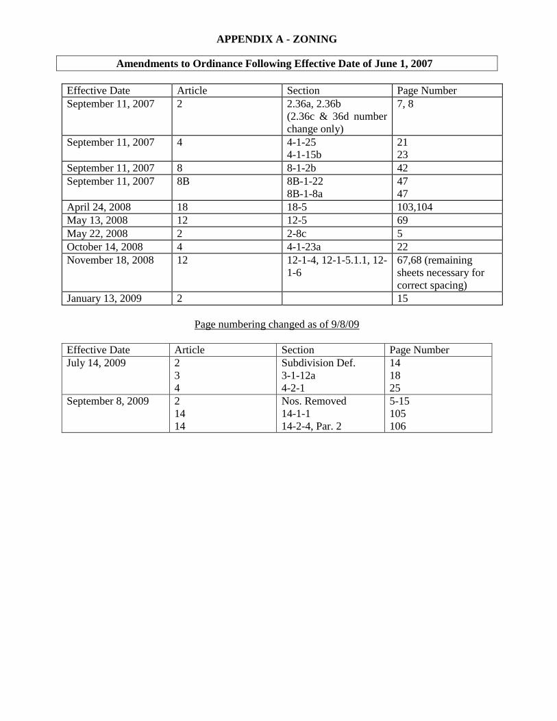
APPENDIX A - ZONING
Amendments to Ordinance Following Effective Date of June 1, 2007
Effective Date Article Section Page Number
September 11, 2007 2 2.36a, 2.36b
(2.36c & 36d number
change only)
7, 8
September 11, 2007 4 4-1-25
4-1-15b
21
23
September 11, 2007 8 8-1-2b 42
September 11, 2007 8B 8B-1-22
8B-1-8a
47
47
April 24, 2008 18 18-5 103,104
May 13, 2008 12 12-5 69
May 22, 2008 2 2-8c 5
October 14, 2008 4 4-1-23a 22
November 18, 2008 12 12-1-4, 12-1-5.1.1, 12-
1-6
67,68 (remaining
sheets necessary for
correct spacing)
January 13, 2009 2 15
Page numbering changed as of 9/8/09
Effective Date Article Section Page Number
July 14, 2009 2
3
4
Subdivision Def.
3-1-12a
4-2-1
14
18
25
September 8, 2009 2
14
14
Nos. Removed
14-1-1
14-2-4, Par. 2
5-15
105
106
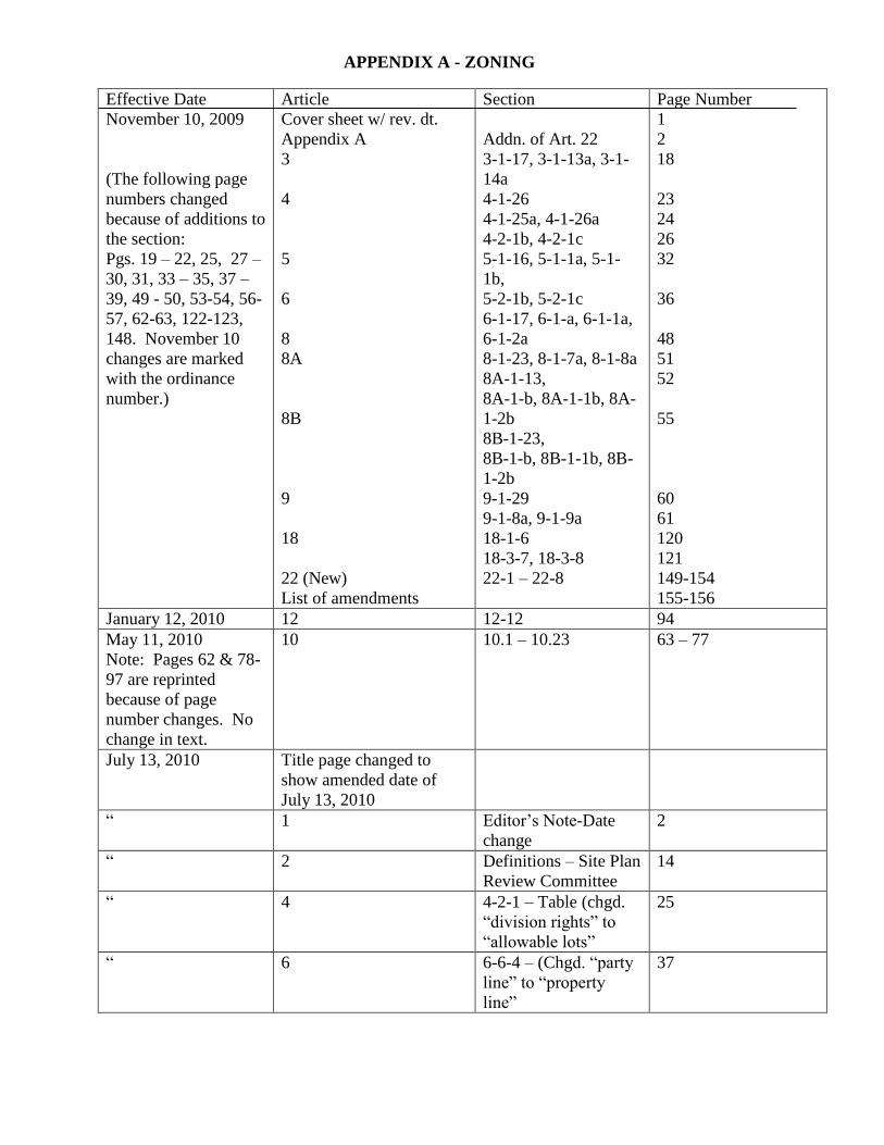
APPENDIX A - ZONING
Effective Date
November 10, 2009
(The following page
numbers changed
because of additions to
the section:
Pgs. 19 – 22, 25, 27 –
30, 31, 33 – 35, 37 –
39, 49 - 50, 53-54, 56-
57, 62-63, 122-123,
148. November 10
changes are marked
with the ordinance
number.)
Article
Cover sheet w/ rev. dt.
Appendix A
3
4
5
6
8
8A
8B
9
18
22 (New)
List of amendments
Section
Addn. of Art. 22
3-1-17, 3-1-13a, 3-1-
14a
4-1-26
4-1-25a, 4-1-26a
4-2-1b, 4-2-1c
5-1-16, 5-1-1a, 5-1-
1b,
5-2-1b, 5-2-1c
6-1-17, 6-1-a, 6-1-1a,
6-1-2a
8-1-23, 8-1-7a, 8-1-8a
8A-1-13,
8A-1-b, 8A-1-1b, 8A-
1-2b
8B-1-23,
8B-1-b, 8B-1-1b, 8B-
1-2b
9-1-29
9-1-8a, 9-1-9a
18-1-6
18-3-7, 18-3-8
22-1 – 22-8
Page Number
1
2
18
23
24
26
32
36
48
51
52
55
60
61
120
121
149-154
155-156
January 12, 2010 12 12-12 94
May 11, 2010
Note: Pages 62 & 78-
97 are reprinted
because of page
number changes. No
change in text.
10 10.1 – 10.23 63 – 77
July 13, 2010 Title page changed to
show amended date of
July 13, 2010
“ 1 Editor’s Note-Date
change
2
“ 2 Definitions – Site Plan
Review Committee
14
“ 4 4-2-1 – Table (chgd.
“division rights” to
“allowable lots”
25
“ 6 6-6-4 – (Chgd. “party
line” to “property
line”
37
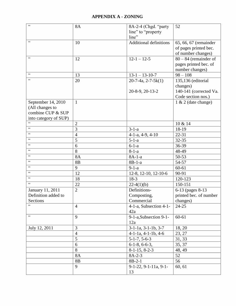
APPENDIX A - ZONING
“ 8A 8A-2-4 (Chgd. “party
line” to “property
line”
52
“ 10 Additional definitions 65, 66, 67 (remainder
of pages printed bec.
of number changes)
“ 12 12-1 – 12-5 80 – 84 (remainder of
pages printed bec. of
number changes)
“ 13 13-1 – 13-10-7 98 – 108
“ 20 20-7-4a, 2-7-5k(1)
20-8-9, 20-13-2
135,136 (editorial
changes)
140-141 (corrected Va.
Code section nos.)
September 14, 2010
(All changes to
combine CUP & SUP
into category of SUP)
1 1 & 2 (date change)
“ 2 10 & 14
“ 3 3-1-a 18-19
“ 4 4-1-a, 4-9, 4-10 22-31
“ 5 5-1-a 32-35
“ 6 6-1-a 36-39
“ 8 8-1-a 48-49
“ 8A 8A-1-a 50-53
“ 8B 8B-1-a 54-57
“ 9 9-1-a 60-61
“ 12 12-8, 12-10, 12-10-6 90-91
“ 18 18-3 120-123
“ 22 22-4(1)(b) 150-151
January 11, 2011
Definition added to
Sections
2 Definitions-
Composting,
Commercial
6-13 (pages 8-13
printed bec. of number
changes)
“ 4 4-1-a, Subsection 4-1-
42a
24-25
“ 9 9-1-a,Subsection 9-1-
12a
60-61
July 12, 2011 3 3-1-1a, 3-1-1b, 3-7 18, 20
4 4-1-1a, 4-1-1b, 4-6 23, 27
5 5-1-7, 5-6-3 31, 33
6 6-1-8, 6-6-3, 35, 37
8 8-1-15, 8-2-3 48, 49
8A 8A-2-3 52
8B 8B-2-1 56
9 9-1-22, 9-1-11a, 9-1-
13
60, 61
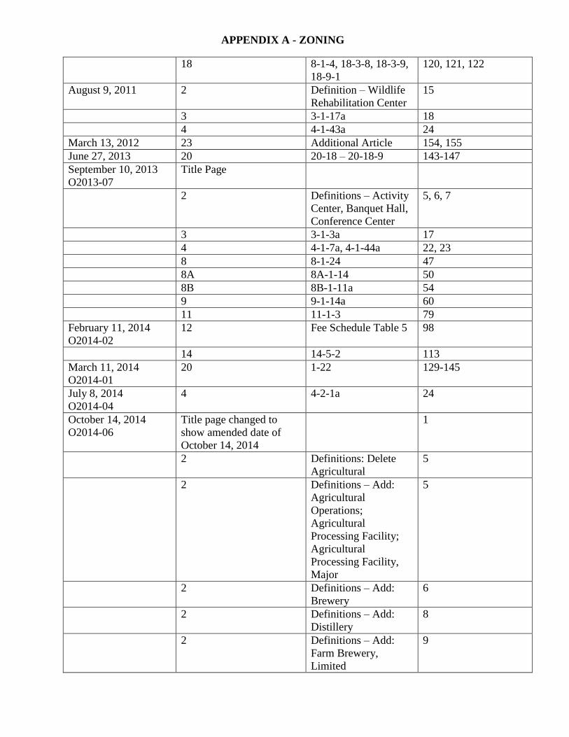
APPENDIX A - ZONING
18 8-1-4, 18-3-8, 18-3-9,
18-9-1
120, 121, 122
August 9, 2011 2 Definition – Wildlife
Rehabilitation Center
15
3 3-1-17a 18
4 4-1-43a 24
March 13, 2012 23 Additional Article 154, 155
June 27, 2013 20 20-18 – 20-18-9 143-147
September 10, 2013
O2013-07
Title Page
2 Definitions – Activity
Center, Banquet Hall,
Conference Center
5, 6, 7
3 3-1-3a 17
4 4-1-7a, 4-1-44a 22, 23
8 8-1-24 47
8A 8A-1-14 50
8B 8B-1-11a 54
9 9-1-14a 60
11 11-1-3 79
February 11, 2014
O2014-02
12 Fee Schedule Table 5 98
14 14-5-2 113
March 11, 2014
O2014-01
20 1-22 129-145
July 8, 2014
O2014-04
4 4-2-1a 24
October 14, 2014
O2014-06
Title page changed to
show amended date of
October 14, 2014
1
2 Definitions: Delete
Agricultural
5
2 Definitions – Add:
Agricultural
Operations;
Agricultural
Processing Facility;
Agricultural
Processing Facility,
Major
5
2 Definitions – Add:
Brewery
6
2 Definitions – Add:
Distillery
8
2 Definitions – Add:
Farm Brewery,
Limited
9
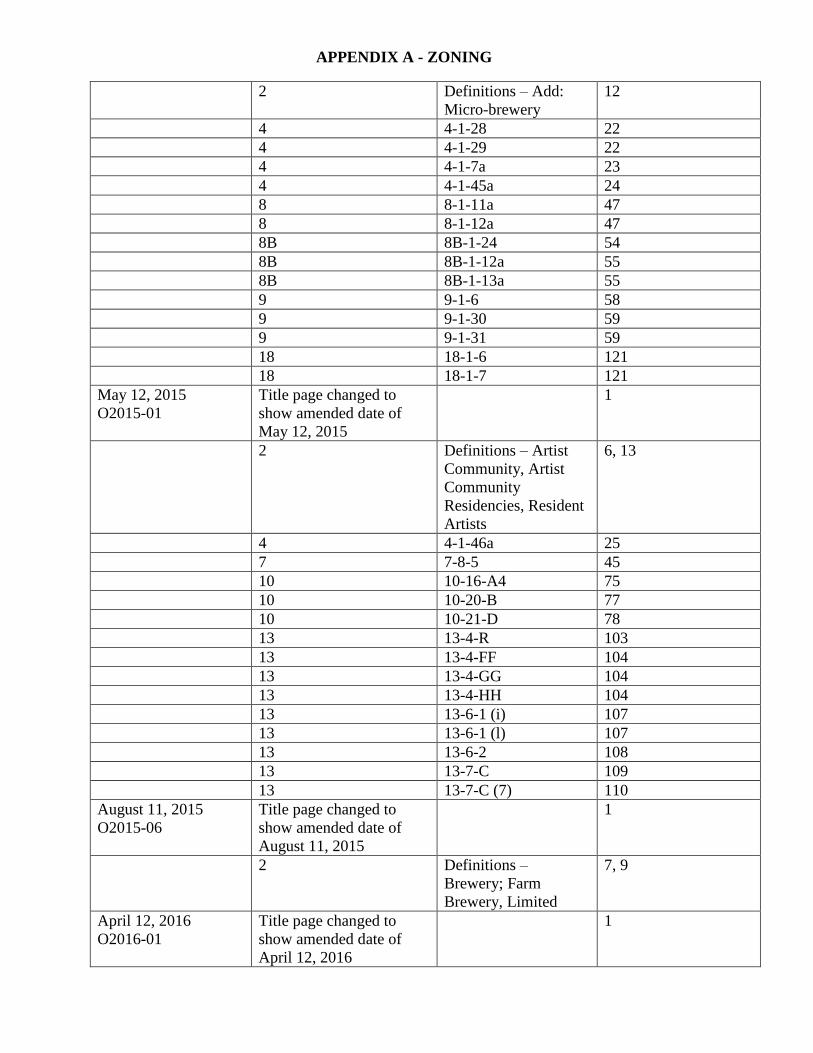
APPENDIX A - ZONING
2 Definitions – Add:
Micro-brewery
12
4 4-1-28 22
4 4-1-29 22
4 4-1-7a 23
4 4-1-45a 24
8 8-1-11a 47
8 8-1-12a 47
8B 8B-1-24 54
8B 8B-1-12a 55
8B 8B-1-13a 55
9 9-1-6 58
9 9-1-30 59
9 9-1-31 59
18 18-1-6 121
18 18-1-7 121
May 12, 2015
O2015-01
Title page changed to
show amended date of
May 12, 2015
1
2 Definitions – Artist
Community, Artist
Community
Residencies, Resident
Artists
6, 13
4 4-1-46a 25
7 7-8-5 45
10 10-16-A4 75
10 10-20-B 77
10 10-21-D 78
13 13-4-R 103
13 13-4-FF 104
13 13-4-GG 104
13 13-4-HH 104
13 13-6-1 (i) 107
13 13-6-1 (l) 107
13 13-6-2 108
13 13-7-C 109
13 13-7-C (7) 110
August 11, 2015
O2015-06
Title page changed to
show amended date of
August 11, 2015
1
2 Definitions –
Brewery; Farm
Brewery, Limited
7, 9
April 12, 2016
O2016-01
Title page changed to
show amended date of
April 12, 2016
1
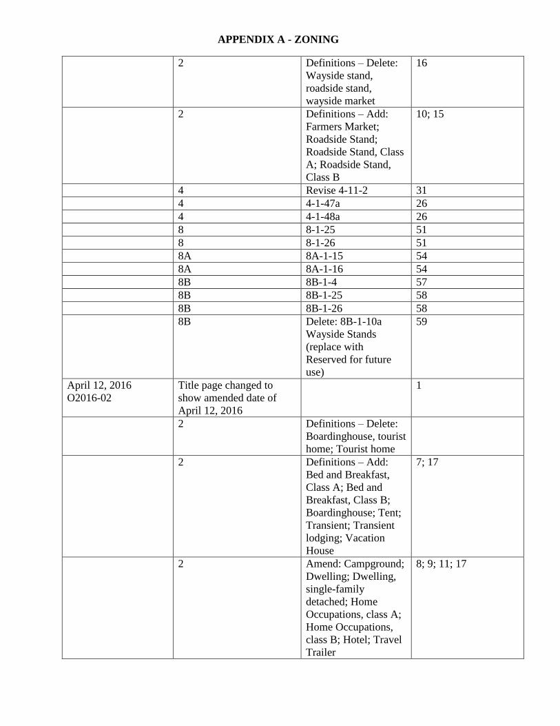
APPENDIX A - ZONING
2 Definitions – Delete:
Wayside stand,
roadside stand,
wayside market
16
2 Definitions – Add:
Farmers Market;
Roadside Stand;
Roadside Stand, Class
A; Roadside Stand,
Class B
10; 15
4 Revise 4-11-2 31
4 4-1-47a 26
4 4-1-48a 26
8 8-1-25 51
8 8-1-26 51
8A 8A-1-15 54
8A 8A-1-16 54
8B 8B-1-4 57
8B 8B-1-25 58
8B 8B-1-26 58
8B Delete: 8B-1-10a
Wayside Stands
(replace with
Reserved for future
use)
59
April 12, 2016
O2016-02
Title page changed to
show amended date of
April 12, 2016
1
2 Definitions – Delete:
Boardinghouse, tourist
home; Tourist home
2 Definitions – Add:
Bed and Breakfast,
Class A; Bed and
Breakfast, Class B;
Boardinghouse; Tent;
Transient; Transient
lodging; Vacation
House
7; 17
2 Amend: Campground;
Dwelling; Dwelling,
single-family
detached; Home
Occupations, class A;
Home Occupations,
class B; Hotel; Travel
Trailer
8; 9; 11; 17
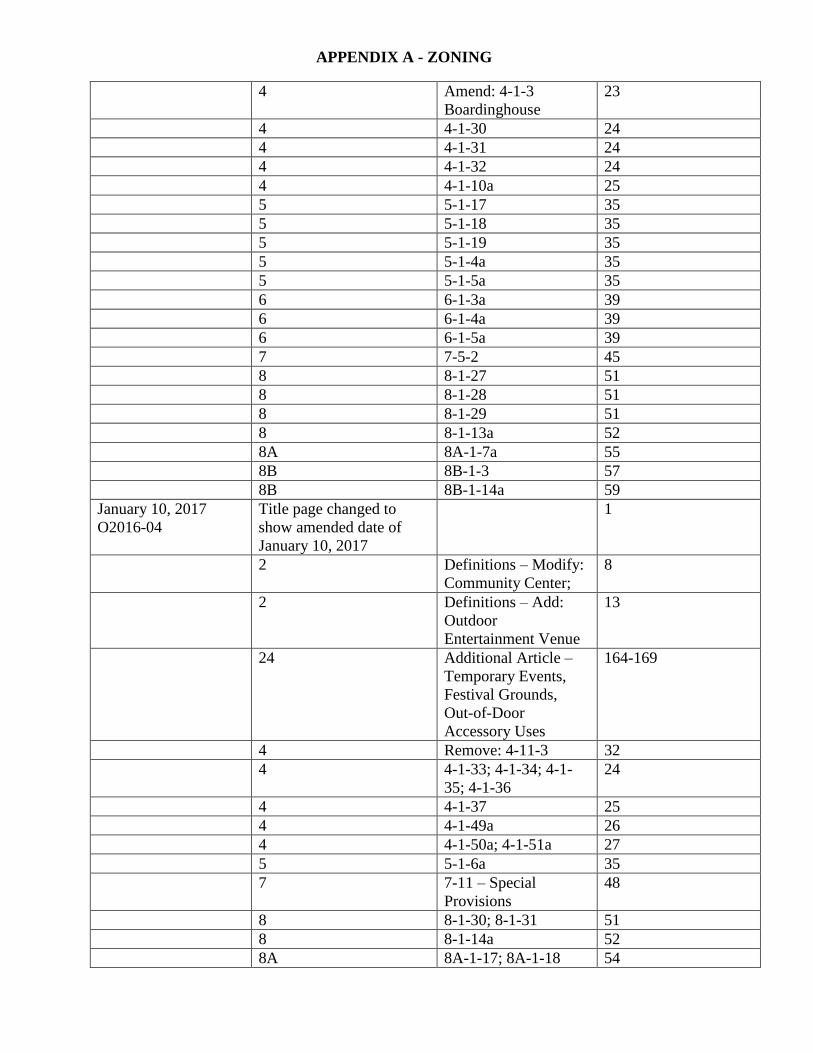
APPENDIX A - ZONING
4 Amend: 4-1-3
Boardinghouse
23
4 4-1-30 24
4 4-1-31 24
4 4-1-32 24
4 4-1-10a 25
5 5-1-17 35
5 5-1-18 35
5 5-1-19 35
5 5-1-4a 35
5 5-1-5a 35
6 6-1-3a 39
6 6-1-4a 39
6 6-1-5a 39
7 7-5-2 45
8 8-1-27 51
8 8-1-28 51
8 8-1-29 51
8 8-1-13a 52
8A 8A-1-7a 55
8B 8B-1-3 57
8B 8B-1-14a 59
January 10, 2017
O2016-04
Title page changed to
show amended date of
January 10, 2017
1
2 Definitions – Modify:
Community Center;
8
2 Definitions – Add:
Outdoor
Entertainment Venue
13
24 Additional Article –
Temporary Events,
Festival Grounds,
Out-of-Door
Accessory Uses
164-169
4 Remove: 4-11-3 32
4 4-1-33; 4-1-34; 4-1-
35; 4-1-36
24
4 4-1-37 25
4 4-1-49a 26
4 4-1-50a; 4-1-51a 27
5 5-1-6a 35
7 7-11 – Special
Provisions
48
8 8-1-30; 8-1-31 51
8 8-1-14a 52
8A 8A-1-17; 8A-1-18 54

APPENDIX A - ZONING
8A 8A-1-8a 55
8B 8B-1-27; 8B-1-28 58
8B 8B-1-15a 59
September 12, 2017
O2017-01
10 10.15.02 87
November 16, 2017
O2017-02
2; 9; 18 Definitions - Winery
9-1-32; 18-1-8
19, 70, 141